year 11 revision booklet - welcome | st patrick's rc high
TRANSCRIPT
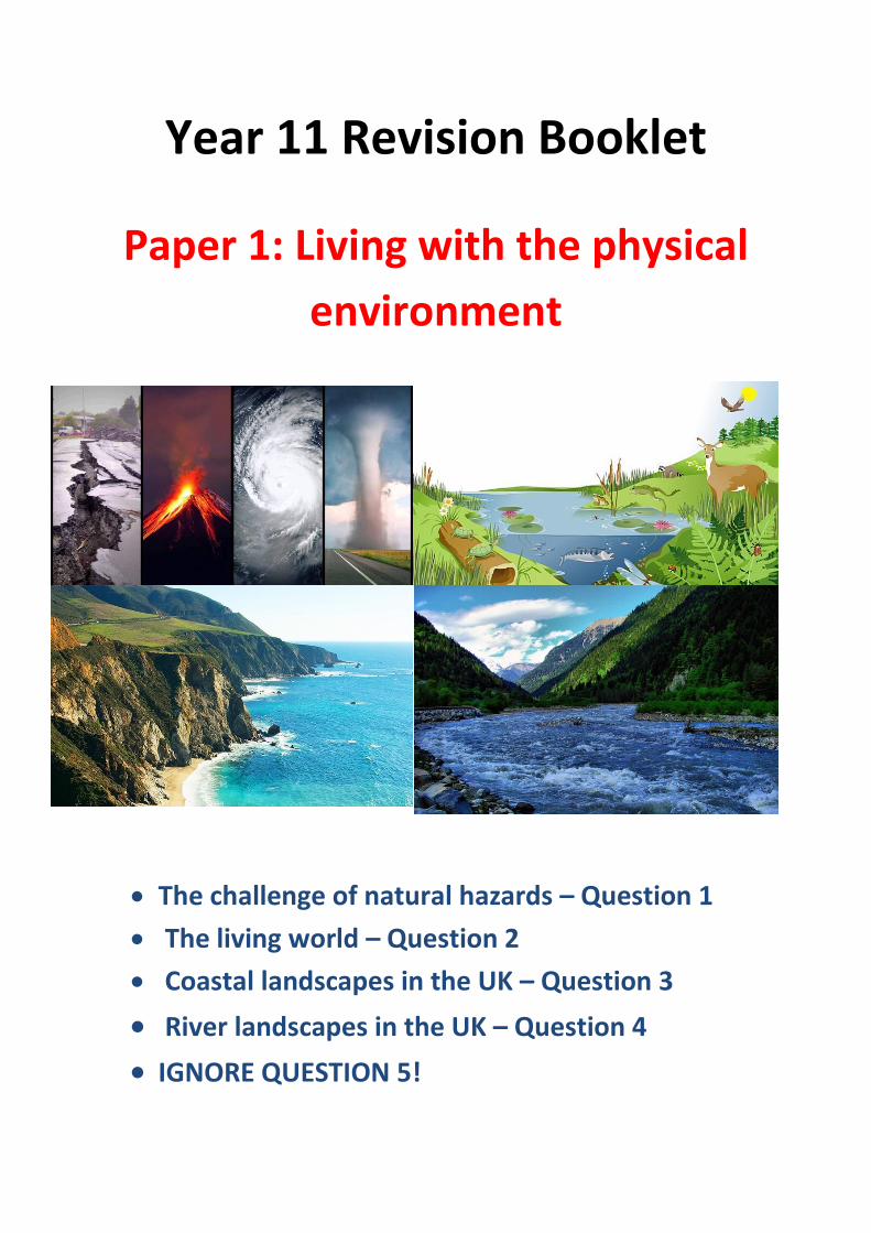
Year 11 Revision Booklet
Paper 1: Living with the physical
environment
The challenge of natural hazards – Question 1
The living world – Question 2
Coastal landscapes in the UK – Question 3
River landscapes in the UK – Question 4
IGNORE QUESTION 5!

The Challenge of Natural Hazards – Section A
Natural hazards pose major risks to people and property
What is a natural hazard?
…………………………………………………………………………………………………
………………………………………….……………………………………………………
……………………………………………………………………………………….………
…………………………………………………………………………………………………
………………………………….……………………………………………………………
What is hazard risk?
…………………………………………………………………………………………………………………………………………….
………………………………………………………………….……………………………………………………………………………
…………………………………………………………………………………………………………………………………………….
Why is the frequency and strength of natural hazards increasing? (Think about the world’s
population and what people are doing to make the problem worse).
…………………………………………………………………………………………………………………………………………….
…………………………………………………………………………………………………………………………………………….
…………………………………………………………………………………………………………………………………………….
…………………………………………………………………………………………………………………………………………….
…………………………………………………………………………………………………………………………………………….
…………………………………………………………………………………………………………………………………………….

Earthquakes and volcanic eruptions are the result of physical processes
Label the layers of the earth on the image below and give three differences between
oceanic and continental crust:
Describe the global distribution
of volcanoes and earthquakes,
i.e. where are they?
…………………………………………………
…………………………………………………
……………………………………….………
…………………………………………………
…………………………………………………
……………………………….………………………………………………………………………………………………………………
…………………………….…………………………………………………………………………………………………………………
…………………………………………………………………………………………………………………………………………….
…………………………………………………………………………………………………………………………………………….
Oceanic crust Continental crust

Draw and annotate the 4 different plate margins in the boxes below. Be sure to explain why
earthquakes and volcanoes occur at the plate margins.
Constructive Margin Destructive Margin
Conservative Margin Collision Margin

The effects of, and responses to, a tectonic hazard vary between areas of contrasting
levels of wealth (i.e. effects of earthquakes are different in rich and poor countries).
What are primary and secondary effects?
…………………………………………………………………………………………………………………………………………….
…………………………………………………………………………………………………………………………………………….
…………………………………………………………………………………………………………………………………………….
…………………………………………………………………………………………………………………………………………….
What are immediate and long-term responses?
…………………………………………………………………………………………………………………………………………….
…………………………………………………………………………………………………………………………………………….
…………………………………………………………………………………………………………………………………………….
…………………………………………………………………………………………………………………………………………….
Named example of an earthquake in a high income country (HIC) : Christchurch, New
Zealand, 2011
Outline the causes of the Christchurch
earthquake. Give the date and magnitude of the
earthquake.
…………………………………………………………………………
………………………………………………………………….………
…………………………………………………………………………
………………………………………………………….………………
…………………………………………………………………………………………………………………………….…………………
………………………………………………………………………………………………………………………….……………………
……………………………………………………………………………………………………………………….………………………
…………………………………………………………………………………………………………………….…………………………
………………………………………………………………………………………………………………….……………………………

Complete the tables below with 3 facts in each column – remember to include SPECIFIC
FACTS, i.e. facts that could only have happened in Christchurch, e.g. numbers, names, etc.
Primary effects Secondary effects
Immediate responses Long-term responses
Do you think primary effects or secondary effects were more significant in Christchurch?
…………………………………………………………………………………………………………………………………………….
…………………………………………………………………………………………………………………………………………….
…………………………………………………………………………………………………………………………………………….
…………………………………………………………………………………………………………………………………………….
Do you think immediate or long-term responses were more significant in Christchurch?
Why?
…………………………………………………………………………………………………………………………………………….
…………………………………………………………………………………………………………………………………………….
…………………………………………………………………………………………………………………………………………….
…………………………………………………………………………………………………………………………………………….

Named example of an earthquake in a low income country (LIC) : Haiti, 2010
Outline the causes of the Haiti earthquake. Give
the date, location and magnitude of the
earthquake.
…………………………………………………………………………
………………………………………………………………….………
…………………………………………………………………………
………………………………………………………….………………
…………………………………………………………………………………………………………………………….…………………
……………………………………………………………………………………………………………………………………………….
Complete the tables below with 3 facts in each column – remember to include SPECIFIC
FACTS, i.e. facts that could only have happened in Haiti, e.g. numbers, names, etc.
Primary effects Secondary effects
Immediate responses Long-term responses

Do you think primary effects or secondary effects were more significant in Haiti? Why?
…………………………………………………………………………………………………………………………………………….
…………………………………………………………………………………………………………………………………………….
…………………………………………………………………………………………………………………………………………….
…………………………………………………………………………………………………………………………………………….
…………………………………………………………………………………………………………………………………………….
Do you think immediate or long-term responses were more significant in Haiti? Why?
…………………………………………………………………………………………………………………………………………….
…………………………………………………………………………………………………………………………………………….
…………………………………………………………………………………………………………………………………………….
…………………………………………………………………………………………………………………………………………….
…………………………………………………………………………………………………………………………………………….
…………………………………………………………………………………………………………………………………………….
Explain why the effects and responses were so different in Christchurch and Haiti.
The effects were so different because…
…………………………………………………………………………………………………………………………………………….
…………………………………………………………………………………………………………………………………………….
…………………………………………………………………………………………………………………………………………….
…………………………………………………………………………………………………………………………………………….
…………………………………………………………………………………………………………………………………………….
…………………………………………………………………………………………………………………………………………….
…………………………………………………………………………………………………………………………………………….
…………………………………………………………………………………………………………………………………………….

The responses were so different because
…………………………………………………………………………………………………………………………………………….
…………………………………………………………………………………………………………………………………………….
…………………………………………………………………………………………………………………………………………….
…………………………………………………………………………………………………………………………………………….
…………………………………………………………………………………………………………………………………………….
…………………………………………………………………………………………………………………………………………….
…………………………………………………………………………………………………………………………………………….
…………………………………………………………………………………………………………………………………………….
Management can reduce the effects of a tectonic hazard
Give 4 reasons why people continue to live in areas at risk from a tectonic hazard:
…………………………………………………………………………………………………………………………………………
…………………………………………………………………………………………………………………………………………
…………………………………………………………………………………………………………………………………………
…………………………………………………………………………………………………………………………………………
Which is the biggest benefit and why?
…………………………………………………………………………………………………………………………………………….
…………………………………………………………………………………………………………………………………………….
…………………………………………………………………………………………………………………………………………….
…………………………………………………………………………………………………………………………………………….
…………………………………………………………………………………………………………………………………………….
…………………………………………………………………………………………………………………………………………….

What are the 3 Ps used to reduce the effects of earthquakes?
Prediction is
…………………………………………………………………………………………………………………………
…………………………………………………………………………………………………………………………
Protection is
…………………………………………………………………………………………………………………………
…………………………………………………………………………………………………………………………
Preparation/ Planning is
…………………………………………………………………………………………………………………………………………….
…………………………………………………………………………………………………………………………………………….
Which of the above three strategies is the most effective in reducing the effects of
earthquakes? Why?
…………………………………………………………………………………………………………………………………………….
…………………………………………………………………………………………………………………………………………….
…………………………………………………………………………………………………………………………………………….
…………………………………………………………………………………………………………………………………………….
…………………………………………………………………………………………………………………………………………….
…………………………………………………………………………………………………………………………………………….
Which of the above three strategies is the least effective in reducing the effects of
earthquakes? Why?
…………………………………………………………………………………………………………………………………………….
…………………………………………………………………………………………………………………………………………….
…………………………………………………………………………………………………………………………………………….
…………………………………………………………………………………………………………………………………………….
…………………………………………………………………………………………………………………………………………….
…………………………………………………………………………………………………………………………………………….

Global atmospheric circulation helps to determine patterns of weather and climate
On the model below, add the following features:
0˚ (equator), 30˚N and S, 60˚N and S and 90˚N and S
Polar, Ferrell and Hadley cells
Areas of high and low pressure with sun and rain
NE trade winds, SE trade winds, south-westerly winds, north-westerly winds and
polar easterly winds
What is the Coriolis Effect?
…………………………………………………………………………………………………………………………………………….
…………………………………………………………………………………………………………………………………………….
…………………………………………………………………………………………………………………………………………….
…………………………………………………………………………………………………………………………………………….

Tropical storms (hurricanes, cyclones, typhoons) develop as a result of particular physical
conditions
Describe the
distribution of
tropical storms.
Use lines of
latitude and key
terms in your
answer.
…………………………
…………………………
……………………………………………………………………………………….………………………………………………………
…………………………………………………………………………………………………………………………………………….
…………………………………………………………………………………………………………………………………………….
…………………………………………………………………………………………………………………………………………….
…………………………………………………………………………………………………………………………………………….
Give 2 conditions needed for tropical storms to form:
…………………………………………………………………………………………………………………………………………
…………………………………………………………………………………………………………………………………………
Write a paragraph to explain the sequence of formation of a tropical storm.
…………………………………………………………………………………………………………………………………………….
…………………………………………………………………………………………………………………………………………….
…………………………………………………………………………………………………………………………………………….
…………………………………………………………………………………………………………………………………………….
…………………………………………………………………………………………………………………………………………….
…………………………………………………………………………………………………………………………………………….
…………………………………………………………………………………………………………………………………………….
…………………………………………………………………………………………………………………………………………….
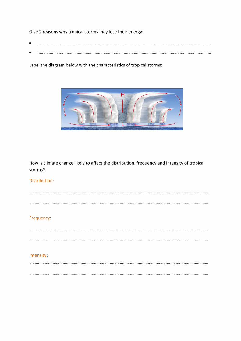
Give 2 reasons why tropical storms may lose their energy:
…………………………………………………………………………………………………………………………………………
…………………………………………………………………………………………………………………………………………
Label the diagram below with the characteristics of tropical storms:
How is climate change likely to affect the distribution, frequency and intensity of tropical
storms?
Distribution:
…………………………………………………………………………………………………………………………………………….
…………………………………………………………………………………………………………………………………………….
Frequency:
…………………………………………………………………………………………………………………………………………….
…………………………………………………………………………………………………………………………………………….
Intensity:
…………………………………………………………………………………………………………………………………………….
…………………………………………………………………………………………………………………………………………….

Named example of a tropical storm: Hurricane Katrina 2005
Describe the path of Hurricane Katrina.
…………………………………………………………………………
…………………………………………………………………………
…………………………………………………………………………
…………………………………………………………………………
…………………………………………………………………………
…………………………………………………………………………………………………………………………………………….
…………………………………………………………………………………………………………………………………………….
…………………………………………………………………………………………………………………………………………….
Complete the tables below with 3 facts in each column – remember to include SPECIFIC
FACTS, i.e. facts that could only have happened in Hurricane Katrina, e.g. numbers, names,
etc.
Primary effects Secondary effects
Immediate responses Long-term responses

Do you think primary effects or secondary effects were more significant in Hurricane
Katrina?
…………………………………………………………………………………………………………………………………………….
…………………………………………………………………………………………………………………………………………….
…………………………………………………………………………………………………………………………………………….
…………………………………………………………………………………………………………………………………………….
…………………………………………………………………………………………………………………………………………….
Do you think immediate or long-term responses were more significant in Hurricane Katrina?
…………………………………………………………………………………………………………………………………………….
…………………………………………………………………………………………………………………………………………….
…………………………………………………………………………………………………………………………………………….
…………………………………………………………………………………………………………………………………………….
…………………………………………………………………………………………………………………………………………….
How can you monitor, predict, protect against and prepare for tropical storms? Give some
examples of each in the table below:
Monitor Predict
Protect Prepare

The UK is affected by a number of weather hazards
What is extreme weather?
…………………………………………………………………………………………………………………………………………….
…………………………………………………………………………………………………………………………………………….
…………………………………………………………………………………………………………………………………………….
Annotate the photograph below describing the social, economic and environmental impacts
of severe snowfall in the UK (include impacts you might not be able to see in the image):
Extreme weather events in the UK have impacts on human activity
Named example of a recent extreme weather event in the UK: Boscastle Flood 2005
Outline the causes of the Boscastle flood
…………………………………………………………………………………………………………………………………………….
…………………………………………………………………………………………………………………………………………….
…………………………………………………………………………………………………………………………………………….
…………………………………………………………………………………………………………………………………………….
…………………………………………………………………………………………………………………………………………….
…………………………………………………………………………………………………………………………………………….

Complete the table below to show the social, economic and environmental impacts of
Boscastle Flood (be specific):
Social impacts Economic impacts Environmental impacts
What management strategies were used to reduce the risk to people and the environment?
Immediate responses Long-term responses
Give 3 pieces of evidence to prove that weather is becoming more extreme in the UK (use
your timeline and include facts to show why it was extreme):
……………………………………………………………………………………………………………………………………
……………………………………………………………………………………………………………………………………
……………………………………………………………………………………………………………………………………
……………………………………………………………………………………………………………………………………
……………………………………………………………………………………………………………………………………
……………………………………………………………………………………………………………………………………

Climate change is the result of natural and human factors and has a range of effects
Complete the table below to briefly explain how each factor provides evidence of climate
change:
Long-term evidence Recent evidence
Ice cores: Melting ice:
Tree rings: Seasonal changes:
Ocean sediments: Instrument readings:

Briefly explain how each of the following factors cause climate change:
Natural causes Human causes
Orbital changes (Milankovictch theory): Use of fossil fuels:
Volcanic activity: Agriculture:
Solar output: Deforestation:
Add 6 labels onto the map below to show the global effects of climate change on people
and the environment (they could be positive or negative):

Managing climate change involves both mitigation (reducing causes) and adaptation
(responding to change)
What is the definition of mitigation?
…………………………………………………………………………………………………………………………………………….
…………………………………………………………………………………………………………………………………………….
What is the definition of adaptation?
…………………………………………………………………………………………………………………………………………….
…………………………………………………………………………………………………………………………………………….
Complete the table below to show how we can mitigate and adapt to climate change and
briefly outline how each one helps to reduce the effects of climate change:
Mitigation methods Adaptation methods
What are the advantages and disadvantages of mitigation and adaptation?
Method Advantages Disadvantages
Mitigation
Adaptation

The Living World – Q2
Ecosystems exist at a range of scales and involve the interaction between biotic and
abiotic components
An example of a small scale ecosystem: Pond
Complete the key terms list below by adding the correct definitions:
Ecosystem:
…………………………………………………………………………………………………………………………………………….
…………………………………………………………………………………………………………………………………………….
Biotic components:
…………………………………………………………………………………………………………………………………………….
…………………………………………………………………………………………………………………………………………….
Abiotic components:
…………………………………………………………………………………………………………………………………………….
…………………………………………………………………………………………………………………………………………….
Describe the pond ecosystem shown
opposite
……………………………………………………………………
……………………………………………………………………
……………………………………………………………………
……………………………………………………………………
……………………………………………………………………
……………………………………………………………………
……………………………………………………………………
…………………………………………………………………………………………………………………………………………….
…………………………………………………………………………………………………………………………………………….
Complete the table below with the correct definitions and give an example for each that
would be found in a freshwater pond:
Term Definition Example
Producers
Consumers
Decomposers
Food chain
Food web
Nutrient cycling
Ecosystems are very fragile and if there is a change to one component it may well have a
knock-on effect on the rest of the ecosystem. Complete the natural and human causes of
change in an ecosystem:
Natural changes Changes due to human activity

Large-scale ecosystems are known as global ecosystems or biomes (see map below):
Explain why ecosystems
tend to form broad belts
across the world from east
to west, parallel to the
lines of latitude.
…………………………………………
…………………………………………
…………………………………………
…………………………………………
…………………………………………
…………………………………………………………………………………………………………………………………………….
…………………………………………………………………………………………………………………………………………….
…………………………………………………………………………………………………………………………………………….
…………………………………………………………………………………………………………………………………………….
Complete the table below outlining the location and characteristics of each biome:
Global ecosystem
Location Characteristics
Tropical rainforest
Desert
Polar
Deciduous and coniferous
forests

Temperate grasslands
Mediterranean
Tropical grasslands
Tundra
Tropical rainforest ecosystems have a range of distinctive characteristics
Where are tropical rainforests found?
…………………………………………………………………………………………………………………………………………….
…………………………………………………………………………………………………………………………………………….
What is the climate like?
…………………………………………………………………………………………………………………………………………….…
…………………………………………………………………………………………………………………………………………….
…………………………………………………………………………………………………………………………………………….
…………………………………………………………………………………………………………………………………………….
Why is the temperature constantly high in the rainforest?
…………………………………………………………………………………………………………………………………………….
…………………………………………………………………………………………………………………………………………….
Why is the rainfall high?
…………………………………………………………………………………………………………………………………………….
…………………………………………………………………………………………………………………………………………….
Why does the amount of rainfall vary throughout the year?
…………………………………………………………………………………………………………………………………………….
…………………………………………………………………………………………………………………………………………….

Give 2 reasons why the soils in tropical rainforests are infertile:
1) ……………………………………………………………………………………………
……………………………………………………………………………………………………
2) ……………………………………………………………………………………………
…………………………………………………………………………………………………………………………………………….
Annotate the photograph below to describe and explain how plants have adapted to the
rainforest:
Explain 3 animal adaptations that enable species to survive in tropical rainforests:
……………………………………………………………………………………………………………………………………
……………………………………………………………………………………………………………………………………
……………………………………………………………………………………………………………………………………
……………………………………………………………………………………………………………………………………
……………………………………………………………………………………………………………………………………
……………………………………………………………………………………………………………………………………

Deforestation has economic and environmental impacts
A case study of a tropical rainforest: Malaysia
What are the causes of deforestation in the Malaysian Rainforest? Complete the table
below to outline each of the causes:
Cause Information
Subsistence and commercial farming
Logging
Mineral extraction
Energy development
Settlement and population growth

What are the impacts of deforestation?
How does deforestation lead to soil erosion?
…………………………………………………………………………………………………………………………………………….
…………………………………………………………………………………………………………………………………………….
…………………………………………………………………………………………………………………………………………….
…………………………………………………………………………………………………………………………………………….
…………………………………………………………………………………………………………………………………………….
How does deforestation contribute to climate change?
…………………………………………………………………………………………………
…………………………………………………………………………………………………
…………………………………………………………………………………………………
…………………………………………………………………………………………………
…………………………………………………………………………………………………
…………………………………………………………………………………………………
Complete the table below to show how deforestation can have both economic gains and
economic losses:
Economic gains for the country Economic losses for the country

Tropical rainforests need to be managed to be sustainable
Complete a mind map below to explain why tropical rainforests are valuable to people and
the environment:
Rainforests need to be managed sustainably so that we can still use valuable resources but
without causing long-term damage for future generations. Complete the table below
outlining how rainforests can be managed sustainably – include specific facts where
possible:
Sustainable strategies How do they work?
Selective logging and
replanting
Conservation and
education
Ecotourism
International agreements

Hot environments have a range of distinctive characteristics
Annotate the photo and climate graphs below to describe the characteristics of the hot
desert

How have plants and animals adapted to the physical conditions of these hot environments?
Give four examples in the table below:
Animal / plant Adaptation How does it help it to survive?
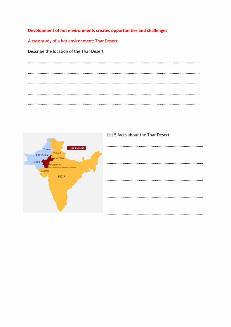
Development of hot environments creates opportunities and challenges
A case study of a hot environment: Thar Desert
Describe the location of the Thar Desert
…………………………………………………………………………………………………………………………………………….
…………………………………………………………………………………………………………………………………………….
…………………………………………………………………………………………………………………………………………….
…………………………………………………………………………………………………………………………………………….
…………………………………………………………………………………………………………………………………………….
List 5 facts about the Thar Desert:
………………………………………………………………………………
………………………………………………………………………………
………………………………………………………………………………
………………………………………………………………………………
………………………………………………………………………………

What are the opportunities for development in the Thar Desert?
Complete the table below describing the opportunities in the Thar Desert:
Mineral extraction Energy developments Farming Tourism

Similarly, below, complete the table describing the challenges of developing the Thar
Desert:
Extreme temperature Inaccessibility Water supply

causes
climate change
population growth
removal of fuel wood
overgrazing
overcultivation
soil erosion
Areas on the fringe of hot deserts are at risk of desertification
What is desertification?
…………………………………………………………………………………………………………………………………………….
…………………………………………………………………………………………………………………………………………….
…………………………………………………………………………………………………………………………………………….
…………………………………………………………………………………………………………………………………………….
Complete the spider diagram below to explain the causes of desertification.

Explain how the following strategies can reduce the risk of desertification:
Water and soil management
…………………………………………………………………………………………………………………………………………….
…………………………………………………………………………………………………………………………………………….
…………………………………………………………………………………………………………………………………………….
Tree planting
…………………………………………………………………………………………………………………………………………….
…………………………………………………………………………………………………………………………………………….
…………………………………………………………………………………………………………………………………………….
Use of appropriate technology …………………………………………………………………………………………………………………………………………….
…………………………………………………………………………………………………………………………………………….
…………………………………………………………………………………………………………………………………………….

Coastal Landscapes in the UK – Q3
The coast is shaped by a number of physical processes
What is a wave?
…………………………………………………………………………………………………………………………………………….
…………………………………………………………………………………………………………………………………………….
What causes a wave?
…………………………………………………………………………………………………………………………………………….
…………………………………………………………………………………………………………………………………………….
What is the fetch?
…………………………………………………………………………………………………………………………………………….
…………………………………………………………………………………………………………………………………………….
There are two types of waves: constructive and destructive. Complete the table below to
show the characteristics of each wave using the image to help you:
Constructive
Destructive

Why do you think the backwash is often weaker on a pebbly beach?
…………………………………………………………………………………………………………………………………………….
…………………………………………………………………………………………………………………………………………….
What is weathering?
…………………………………………………………………………
…………………………………………………………………………
…………………………………………………………………………
…………………………………………………………………………
…………………………………………………………………………
What is mechanical weathering?
…………………………………………………………………………………………………………………………………………….
…………………………………………………………………………………………………………………………………………….
Wave characteristic
Constructive wave Destructive wave
Wave height
Wave length
Strength of swash
Strength of backwash
Beach sediment – gain or loss

What is chemical weathering?
…………………………………………………………………………………………………………………………………………….
…………………………………………………………………………………………………………………………………………….
What is mass movement?
…………………………………………………………………………………………………………………………………………….
…………………………………………………………………………………………………………………………………………….
Complete four simple diagrams and four definitions to show the different types of mass
movement:
Rockfall Landslide
Mudflow Rotational slip

Complete the table below describing the four types of erosion found at the coast:
Hydraulic action Abrasion
Attrition Solution/ Corrosion
Do the same in the table below to describe the four types of transportation found at the
coast:
Traction Saltation
Suspension Solution
Destructive

Draw an annotated diagram in the box below to explain the process of longshore drift:
What is coastal deposition?
…………………………………………………………………………………………………………………………………………….
…………………………………………………………………………………………………………………………………………….
Give 3 reasons why coastal deposition occurs:
……………………………………………………………………………………………………………………………………
……………………………………………………………………………………………………………………………………
……………………………………………………………………………………………………………………………………
……………………………………………………………………………………………………………………………………
……………………………………………………………………………………………………………………………………
……………………………………………………………………………………………………………………………………

Distinctive coastal landforms are the result of rock type, structure and physical processes
Outline the two factors that influence coastal forms:
Rock type:
…………………………………………………………………………………………………………………………………………….
…………………………………………………………………………………………………………………………………………….
Geological structure:
…………………………………………………………………………………………………………………………………………….
…………………………………………………………………………………………………………………………………………….
Landforms resulting from erosion
Headlands and Bays
Explain how headlands and bays form using the
diagram to help you. Remember to use SPED
………………………………………………………………………………
………………………………………………………………………………
………………………………………………………………………………
………………………………………………………………………………
………………………………………………………………………………
………………………………………………………………………………
………………………………………………………………………………
………………………………………………………………………………
………………………………………………………………………………
…………………………………………………………………………………………………………………………………………….…
………………………………………………………………………………………………………………………………………….
…………………………………………………………………………………………………………………………………………….
…………………………………………………………………………………………………………………………………………….
…………………………………………………………………………………………………………………………………………….

Cliffs and wave-cut platforms
Complete annotated diagrams below to explain how a wave-cut platform is created:
Caves, arches, stacks and stumps
Annotate the diagram below to explain the formation of caves, arches, stacks and stumps.
Number your annotations to sequence the formation.

Landforms resulting from deposition
Beaches
Beaches are deposits of sand and shingle at the coast. Explain how both sandy and pebbly
beaches form:
Sandy:
…………………………………………………………………………………………………………………………………………….
…………………………………………………………………………………………………………………………………………….
Shingle/pebble:
…………………………………………………………………………………………………………………………………………….
…………………………………………………………………………………………………………………………………………….
Sand dunes
Explain the formation of
sand dunes from embryo
dunes to dune slacks.
………………………………………
………………………………………
………………………………………
………………………………………
…………………………………………………………………………………………………………………………………………….
…………………………………………………………………………………………………………………………………………….
…………………………………………………………………………………………………………………………………………….
…………………………………………………………………………………………………………………………………………….
…………………………………………………………………………………………………………………………………………….
…………………………………………………………………………………………………………………………………………….
…………………………………………………………………………………………………………………………………………….
…………………………………………………………………………………………………………………………………………….
…………………………………………………………………………………………………………………………………………….

Spits and Bars
Spits are long, narrow fingers of sand or shingle jutting out into the sea. A bar is a spit that
has grown across a bay.
Draw an annotated diagram in the box below to explain the formation of spits and bars:
An example of a section of coastline in the UK: Holderness Coast, Yorkshire
Describe the geology of the Holderness Coast.
………………………………………………………
………………………………………………………
………………………………………………………
………………………………………………………
………………………………………………………
………………………………………………………
…………………………………………………………
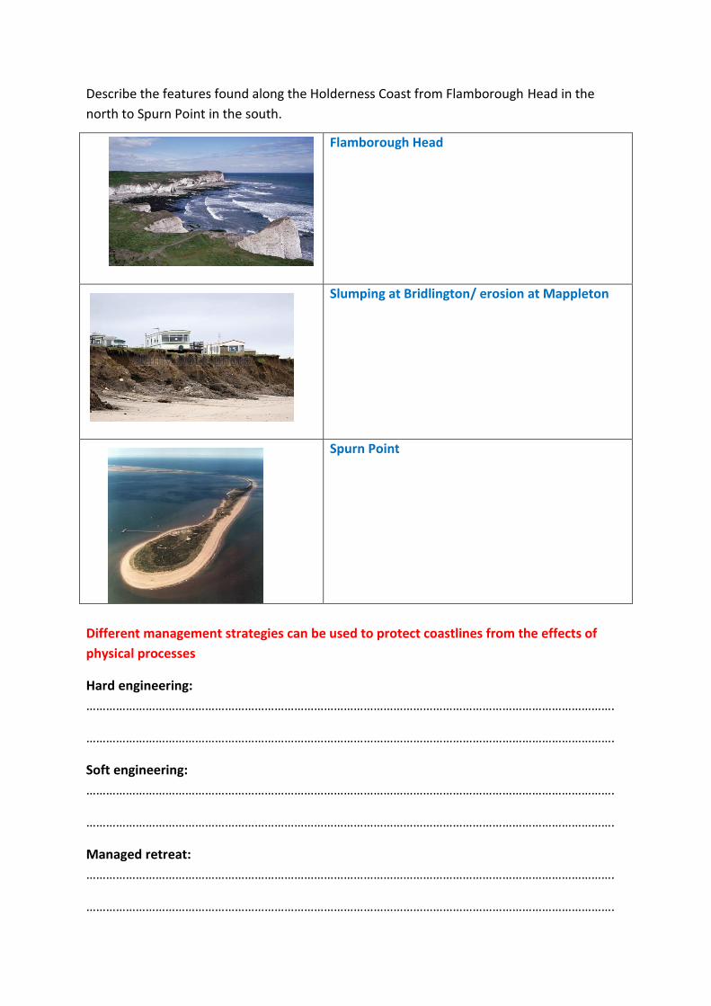
Describe the features found along the Holderness Coast from Flamborough Head in the
north to Spurn Point in the south.
Different management strategies can be used to protect coastlines from the effects of
physical processes
Hard engineering:
…………………………………………………………………………………………………………………………………………….
…………………………………………………………………………………………………………………………………………….
Soft engineering:
…………………………………………………………………………………………………………………………………………….
…………………………………………………………………………………………………………………………………………….
Managed retreat:
…………………………………………………………………………………………………………………………………………….
…………………………………………………………………………………………………………………………………………….
Flamborough Head
Slumping at Bridlington/ erosion at Mappleton
Spurn Point

Complete the table below showing the advantages and disadvantages of hard and soft
engineering methods:
Method Advantages Disadvantages
Sea wall
Groynes
Rock armour
Gabions
Beach
nourishment
Dune
regeneration
Managed
retreat
An example of a coastal management scheme in the UK: Holderness Coast
Why does the Holderness Coast need protecting?
…………………………………………………………………………………………………………………………………………….
…………………………………………………………………………………………………………………………………………….
…………………………………………………………………………………………………………………………………………….
…………………………………………………………………………………………………………………………………………….

List 5 strategies used in the Holderness Coast to protect the coastline:
……………………………………………………………………………………………………………………………………
……………………………………………………………………………………………………………………………………
……………………………………………………………………………………………………………………………………
……………………………………………………………………………………………………………………………………
……………………………………………………………………………………………………………………………………
What are the positive and negative impacts of the defences on the area?
Positive impacts Negative impacts
What groups of people might be in conflict over these defences and why?
Groups Conflict

River Landscapes in the UK – Q4
The shape of river valleys changes as rivers flow downstream
Using the images below, complete the description of the shape of the long and cross profiles
of a river valley:
In the upper course the
long profile is _______
and _______. The cross
profile is narrow and v-
shaped.
……………………………………
……………………………………
……………………………………
……………………………………
……………………………………
…………………………………………………………………………………………………………………………………………….
…………………………………………………………………………………………………………………………………………….
Complete the definitions of vertical and lateral erosion:
Vertical erosion is
…………………………………………………………………………………………………………………………………………….
Lateral erosion is
…………………………………………………………………………………………………………………………………………….
Complete the table below describing the four types of erosion found in a river:
Hydraulic action Abrasion

Attrition Solution
Do the same in the table below to describe the four types of transportation in a river:
Traction Saltation
Suspension Solution
Give 3 reasons why a river would deposit sediment (put material down):
……………………………………………………………………………………………………………………………………
……………………………………………………………………………………………………………………………………
……………………………………………………………………………………………………………………………………

Distinctive fluvial landforms result from different physical processes
Features formed by erosion in the upper course of a river
Explain the formation of interlocking spurs
…………………………………………………………………………
…………………………………………………………………………
…………………………………………………………………………
…………………………………………………………………………
…………………………………………………………………………
…………………………………………………………………………
…………………………………………………………………………
…………………………………………………………………………………………………………………………………………….
…………………………………………………………………………………………………………………………………………….
Draw an annotated diagram below to explain the formation of waterfalls and gorges:

Features formed by erosion and deposition in the middle course of a river
Draw annotated diagrams below to explain the formation of meanders and ox-bow lakes:
The fastest flow of the river occurs on the outside of a meander causing erosion. Deposition occurs on the inside of the bend.
Features formed by deposition in the lower course of a river
Draw annotated diagrams below to explain the formation of levees and floodplains:
A river is contained within its banks (normal)

Using the diagrams below, explain the formation of estuaries:
………………………………………………………………
………………………………………………………………
………………………………………………………………
………………………………………………………………
………………………………………………………………
………………………………………………………………
…………………………………………………………………………………………………………………………………………….…
………………………………………………………………………………………………………………………………………….
…………………………………………………………………………………………………………………………………………….
An example of a river valley in the
UK: River Tees, North-east
England
Describe the features of the River
Tees (waterfalls, gorges,
meanders, levees and estuaries).
Include place names. DO NOT
explain how the features were
formed, just say what they are
like.
…………………………………………………………………………………………………………………………………………….
…………………………………………………………………………………………………………………………………………….
…………………………………………………………………………………………………………………………………………….
…………………………………………………………………………………………………………………………………………….
…………………………………………………………………………………………………………………………………………….
…………………………………………………………………………………………………………………………………………….…
………………………………………………………………………………………………………………………………………….
…………………………………………………………………………………………………………………………………………….

Different management strategies can be used to protect river landscapes from the effects
of flooding
List some physical and human causes of flooding – make sure you can explain how each
leads to flooding:
Physical/Natural Human
State the characteristics of the two hydrographs below. An example has been done for you.
What is hard and soft engineering?
Hard engineering is
…………………………………………………………………………………………………………………………………………….
…………………………………………………………………………………………………………………………………………….
Soft engineering is
…………………………………………………………………………………………………………………………………………….
…………………………………………………………………………………………………………………………………………….
A
Impermeable rock
B
Permeable rock

Complete the table below showing the advantages and disadvantages of hard and soft
engineering:
Method Advantages Disadvantages
Hard: dams and reservoirs
Hard: straightening embankments
Hard: Flood relief channels
Soft: Flood warnings and preparation
Soft: Floodplain zoning
Soft: planting trees and river restoration
An example of a flood management scheme in the UK: Boscastle, Cornwall
Briefly outline why Boscastle needed a flood management project:
…………………………………………………………………………………………………………………………………………….
…………………………………………………………………………………………………………………………………………….
…………………………………………………………………………………………………………………………………………….
…………………………………………………………………………………………………………………………………………….
List 5 of the strategies used in Boscastle to reduce the risk of flooding:
……………………………………………………………………………………………………………………………………
……………………………………………………………………………………………………………………………………
……………………………………………………………………………………………………………………………………
……………………………………………………………………………………………………………………………………
……………………………………………………………………………………………………………………………………

Complete the table below showing the advantages/successes and disadvantages/failures of
the flood management scheme:
Successes Failures
Social
Economic
Environmental
Overall, to what extent do you think the flood management scheme in Boscastle was a
success? Why?
…………………………………………………………………………………………………………………………………………….
…………………………………………………………………………………………………………………………………………….
…………………………………………………………………………………………………………………………………………….
…………………………………………………………………………………………………………………………………………….
…………………………………………………………………………………………………………………………………………….
…………………………………………………………………………………………………………………………………………….
…………………………………………………………………………………………………………………………………………….
…………………………………………………………………………………………………………………………………………….
…………………………………………………………………………………………………………………………………………….