year two report - laguna de santa rosa · pdf filebegin at the bank and “creep”...
TRANSCRIPT
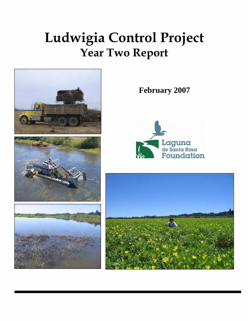
Ludwigia Control Project Year Two Report
February 2007

Executive Summary The Ludwigia Control Project (LCP) is a three-year effort (2005-2007) to reduce the extent and density of the non-native invasive aquatic plant Ludwigia sp. in two of the worst affected areas of the Laguna de Santa Rosa. Spearheaded by the Laguna Foundation, the general approach includes application of aquatic herbicide followed by mechanical removal of biomass. The second year of the control project is now complete. Vegetation monitoring completed prior to year two herbicide application and mechanical removal showed variable responses of Ludwigia depending on site conditions. Deeper and wider channels, present at the California Department of Fish and Game (CDFG) site near Sebastopol and the Sonoma County Water Agency (SCWA) site near Rohnert Park, showed very little regrowth. Ludwigia must root in sediment and is therefore forced to begin at the bank and “creep” across the channel. In shallower channels where rooting is possible across the entire channel base, Ludwigia regrowth was estimated at 54%. In the flooded wetlands of the CDFG site where vegetation could not be removed in year one, regrowth was widespread. However, the density of Ludwigia within this area was significantly reduced. Where 80% of the monitored plots had greater than 95% cover prior to year one, only 6% had the same cover in year 2. Greater species richness and open water were also observed following year one control activities. Year two control acreages were expanded at both sites. Control methods employed in year two again included application of herbicide followed by mechanical removal where necessary and where feasible. The herbicide triclopyr (Renovate®) appeared to have greater efficacy than glyphosate in controlling Ludwigia and was applied at one-third the rate of glyphosate. Mechanical removal was limited to expanded control areas and to the Bellevue Wilfred Channel near Rohnert Park. Post-season monitoring at the CDFG flooded wetland site indicated that regrowth did occur after the herbicide application but that in the drier areas there was a marked increase in species richness. Dense patches of non-Ludwigia species occupied significant areas. True evaluation of the effect of year two will only be possible after monitoring in late spring 2007. Year three plans include application of triclopyr to areas of regrowth. Mechanical removal will occur in select areas of the SCWA site. No mechanical removal is anticipated at the CDFG site. Ongoing and planned activities to address the issue and its causes include 1) mapping Ludwigia distribution throughout the watershed, 2) continued research into taxonomy and biology, 3) maintenance of control sites, 4) sediment removal, 5) thalweg survey, 6) monitoring storm drain outfalls, 7) installation of low flow channels, 8) riparian restoration, 9) Laguna Wildlife Area restoration planning, 10) education 11) publication of the Laguna Foundation restoration and management plan, 12) formation of a watershed stakeholder council, and 13) preparation of a Total Maximum Daily Load pollution plan for the Laguna.
Ludwigia Control Project: Year Two Report 1

1. Introduction The Ludwigia Control Project (LCP) is a three-year effort (2005-2007) to reduce the extent and density of the non-native aquatic plant Ludwigia sp. in two of the worst affected areas of the Laguna de Santa Rosa. The LCP is being carried out by the Laguna de Santa Rosa Foundation (Laguna Foundation) on behalf of the Sonoma County Water Agency (SCWA) and the California Department of Fish & Game (CDFG). Funding is provided by SCWA, the California Wildlife Conservation Board, the Marin Sonoma Mosquito & Vector Control District, and the Santa Rosa Subregional Wastewater Treatment Plant. This report provides a status update following the 2006 field season and provides recommendations for 2007, the final year of the LCP. For detailed background information on the LCP and the project locations, please see Invasive Ludwigia Management Plan for the Laguna de Santa Rosa, Sonoma County, California 2005-2010 and Ludwigia Control Project: Year One Report, both available from the Laguna Foundation’s website (www.lagunafoundation.org). The website also provides detailed water quality monitoring reports prepared for each site in compliance with the General NPDES Permit issued by the State Water Resource Control Board and a detailed end-of-season report by Clean Lakes Inc., the contractor for herbicide application and a portion of the vegetation removal. 2. Location and Description Project locations were generally the same as in 2005, though each site was expanded slightly (Figure 1). Sonoma County Water Agency Field Site (Rohnert Park): In 2005 the northern extent of the Bellevue Wilfred Channel treatment area was Millbrae Avenue. Noted patches of Ludwigia upstream of Millbrae prompted a 2,500 foot extension north to Highway 101. This brings the overall length of the project site, including the main Laguna channel, to approximately 15,000 feet or about 41 acres.1
CA Department of Fish & Game Field Laguna Wildlife Area Field Site: The Laguna Wildlife Area includes both channel and flooded wetlands. In 2006 the total treatment area was roughly 145 acres. Although the amount of flooded wetland was the same as in 2005, the total length of channel was increased by 3,500 feet for a total of 12,800 feet. The extension was included to ensure a clear channel from Occidental Road to Guerneville Road.
1 Forty-one acres is based on an average channel width of 120 feet.
Ludwigia Control Project: Year Two Report 2

© 2006
Figure 1Cartography: Amber Manfree Map ID: LdSR-361-A
City ofSebastopol
City ofSanta Rosa
City ofRohnert
Park
California Department of Fish & Game Treatment Area
Sonoma County Water Agency
Treatment Area
.within the Laguna de Santa Rosa
General Locator Map for Ludwigia Control Sites
SantaRosa
deLaguna
Belle
vue-
Wilfr
ed F
lood C
ontr
ol Chan
nel
H
inebau
gh Creek
Lab
ath
Creek
WILFRED
MILLBRAE
STO
NY
PO
INT
LAB
ATH
PRIM
RO
SE
WH
ISTL
ER
TAY
LOR DO
WD
ELL
LAN
GN
ER
ROHNERT PARK EXP Y
HA
RG
RAV
E
RED
WO
OD
BUSINESS PARK
AIRPORT
LAN
GN
ER
FREI
OCCIDENTAL
HWY 116
HALL
SCOTTS
BARCAGLIA
Laguna d
e S
anta
Rosa
SAN
FOR
D
ATKINSON
Town ofWindsor
£¤101
California Department of Fish & Game Treatment Area
City ofCotati
Sonoma CountyWater Agency
Treatment Area
Ludwigia Treatment Areas in the Laguna de
Santa Rosa Watershed
0 0.25 0.5 0.75 10.125Miles
0 0.25 0.5 0.75 10.125Miles
CDFGWildlife
Area
LegendTreatment area
Water
Incorporated areas
Laguna watershed boundary0 2.5 5 7.5 101.25
Miles
·|}þ12·|}þ12
·|}þ116
·|}þ29
City ofRohnert
Park
} }
Project extension
First treatment
2006
Project extensionFirst treatment
2006

3. Permitting In April 2006, SCWA and CDFG each submitted an Aquatic Pesticide Application Plan (APAP) to the North Coast Regional Water Quality Control Board (RWQCB). The APAP details the type and amount of herbicide to be applied. Each APAP was prepared jointly by staff from each respective agency and the Laguna Foundation. The RWQCB issued permits to SCWA (WDID No. 1B05047NSON) and CDFG (WDID No. 1B05082NSON) on June 16, 2006. Each agency also filed applications for a Waiver of Waste Discharge permit. Both SCWA (WDID No. 1B06082WNSO) and CDFG (WDID No. 1B06083WNSO) received notice of coverage on August 8, 2006 from the RWQCB. These permits require compensatory mitigation for impacts. Both projects will be mitigated through riparian restoration. The CDFG mitigation will be implemented along the Laguna between Highway 12 and Occidental Road as part of a larger restoration project underway by the Laguna Foundation. The SCWA mitigation will be implemented along the Bellevue Wilfred Flood Control Chanel. Both sites qualified for a categorical exemption under CEQA.
4. Public Notification Prior to commencement of work the Laguna Foundation issued press releases to the Press Democrat, Sonoma West Times, and the Community Voice. A public notice was published in the Press Democrat on June 5, 2006. During the active season, the Laguna Foundation emailed weekly progress updates to 111 individuals including members of the public, grantors, regulatory agency staff and local officials. More detailed reports prepared by the herbicide applicator were posted to the Laguna Foundation’s website. 5. Subcontracting The Laguna Foundation renewed its subcontract with Clean Lakes, Inc. for herbicide application at both sites and vegetation removal at the CDFG site. Manzoni Hauling and Excavating was subcontracted to remove and dispose of vegetation at the SCWA site. Blankinship & Associates was used briefly to train Laguna Foundation staff in water quality monitoring protocols. McCampbell Analytical, Inc. was used for chemical analyses of water samples. 6. Herbicide Application In 2005 both project areas were treated with Glypro®, a glyphosate-based herbicide registered for aquatic use. Glyphosate is in the EPA’s lowest toxicity category but is non-selective; it can impact both monocot and dicot plants. Because the glyphosate performed poorly in the CDFG flooded wetlands in 2005, a triclopyr-based herbicide (Renovate®) was selected to treat a portion of the wetland area in 2006. According to the label, Renovate® is broadleaf-specific and will not impact monocots (e.g. grasses, bulrushes, sedges, and cattails). Renovate® is also in the EPA’s lowest toxicity category. Initial treatment effects differed markedly according to herbicide type and local site conditions. While Ludwigia plants treated with glyphosate (3 quarts/acre) experienced
Ludwigia Control Project: Year Two Report 4

some yellowing and wilting of foliage in some areas, the plants remained vital and even produced flowers in other areas. In contrast, the Ludwigia plants treated with triclopyr (2 quarts/acre) began yellowing and wilting within 24 hours. Because such a rapid response could signal killing of the above-ground foliage without translocation to the roots, lower application rates (1.5 and 1 quart/acre) were tested in smaller areas. The lack of observed differences at each rate resulted in all subsequent applications being made at 1 quart/acre. Touch-up applications at both sites including areas initially treated with glyphosate were made with triclopyr at 1 quart/acre. These applications were generally made 3-5 weeks after the initial application. At the SCWA field site triclopyr was applied to missed or resprouting vegetation in the Bellevue Wilfred Channel following mechanical removal. Channel applications were made by airboat or truck. Flooded wetland applications were made with a MarshMog, a machine similar to a snow cat but designed for aquatic use. Both glyphosate and triclopyr were tank mixed with the surfactant Cygnet Plus®, the drift control agent Sta-Put®, and a blue dye to mark applications. 7. Vegetation Removal and Disposal At the SCWA field site vegetation removal was limited to the Bellevue Wilfred Channel. The work was performed using a long-reach excavator, with vegetation loaded directly into waiting dump trucks. Initially the excavator’s 48-inch wide bucket was fitted with bolted tines but these quickly broke off leaving a blunt-edged bucket which unavoidably dredged up too much sediment and water with each scoop despite having open slats on each side of the bucket. As a result trucks were forced to sit for up to 10 minutes to allow the water to drain, a method that ameliorated but did not solve the potential hazards of hauling of wet and muddy loads in unsealed trucks. After two days of hauling, work was halted to create a custom steel rake which was then bolted onto the bucket. The rake substantially reduced the volume of sediment and water and increased the precision, speed and safety of the removal and hauling. Because the 2005 disposal site was unavailable in 2006, initial truckloads of vegetation were hauled to the City of Santa Rosa’s Alpha Farm. Fortunately, an agreement was reached with a separate landowner for use of a field adjacent to the removal site. In exchange for use of the field, the landowner was compensated for lost agricultural income. The owner of the 2005 disposal site also requested that the windrowed materials from 2005 be hauled to the new site. The windrowed material had decomposed to 75% of its original mass, reducing the total cost of this unplanned expense. The total volume of vegetation removed in 2006 was 3,840 cubic yards compared to 16,001 cubic yards in 2005 (Table 1). Although these numbers are not indicative of overall regrowth (the 2006 removal included areas not cleared in 2005), it was possible to estimate percent regrowth in the Bellevue Wilfred Channel because it was cleared both years. This was done by calculating the average volume removed per unit area (cubic yards/acre) along the Bellevue Wilfred Channel in both years. In 2005, 441 cubic yards/acre were removed while 238 cubic yards/acre were removed in 2006. This represents 54% regrowth after one year. More positively, this represents 46% control.
Ludwigia Control Project: Year Two Report 5

While interim results are indicative of short-term trends, a full evaluation of the project’s results will not be available until after the third year’s work: the cumulative and sustained effect of the project over three years may be higher or lower than either year one or year two results initially suggest. In the CDFG Laguna Wildlife Area, the biomass removal areas from 2005 remained remarkably clear in 2006. All biomass removal at this site occurred in the 3,500-foot project extension area. Work was performed using a Cookie Cutter and Aquatic Harvester. Biomass was hauled to a nearby farm field and spread over a portion of the pasture. This was the same disposal site used in 2005. Table 1. Volume of Ludwigia biomass removed from field sites in 2005 and 2006.
2005 1
(cubic yards) 2006
(cubic yards)
SCWA Field Site
Bellevue Wilfred Channel 6,910 3,840
Main Laguna Channel 5,216 0
subtotal 12,126 3,840
CDFG Field Site
Flooded Wetlands and Main Laguna Channel 3,875 1,401
subtotal 3,875 1,401 Total 16,001 5,241
1 Each truckload carries 10 cubic yards. Previous reports estimated 14 cubic yards per truck. This accounts for differences in total cubic yards reported in this document versus previous reports.
Ludwigia Control Project: Year Two Report 6

8. Vegetation Monitoring 8.1 Transect monitoring In 2005 the entire CDFG field site was treated with glyphosate, making transect monitoring relatively straightforward. Four transects were established on an east-west bearing within the two flooded wetland areas and included a total of forty-three 20m2 plots (4m x 5m) (Figure 2A). In 2006 both glyphosate and triclopyr were used in the initial application to the CDFG Laguna Wildlife Area. Because the locations of the 2005 transects would not capture potential differences between treatments, new transects running on a north-south bearing were established in 2006 (Figure 2B). The new transects bisect both the north and south flooded fields and run through the main Laguna channel between the fields. Along each transect, 20m2 sampling plots were established every 10-15m for a total of 107 plots. The southwest corner of each plot was marked using a Garmin Vista GPS. Within each plot the absolute cover of each species was estimated and assigned a cover class (1: 1-5%, 2: 6-25%, 3: 26-50%, 4: 51-75%, 5: 76-95%, 6: 96-100%). Water depth was estimated by averaging three measurements taken at random points within the plot. Also established in 2006 were two cross channel transects in the extended treatment area (6 plots) and five non-target vegetation plots in the flooded wetlands. The non-target plots were established to specifically track impacts of the treatments on non-target vegetation, which was avoided wherever possible. Establishment of true control plots was difficult because there are no other areas in the Laguna that match the conditions found in the Laguna Wildlife Area. However, 5 quasi-control plots were established in a heavily infested floodplain area adjacent to but downstream of the Laguna Wildlife Area. All sampling was done June 8-14, 2006. Although the plots do not directly overlap between years, all are located in the flooded wetland area of the Laguna Wildlife Area and fall almost exclusively within areas where mechanical removal was logistically impossible. Therefore it is insightful to look at patterns between the two years. Figure 3 compares the distribution of Ludwigia cover classes in the flooded wetlands of the Laguna Wildlife Area in June 2005 and June 2006. The graphs represent a picture of the site before and after one season of glyphosate application and the associated impact of driving over the plants in the MarshMog. In June 2005, 80% of the 43 plots sampled fell within the 96-100% Ludwigia cover class. In June 2006 the same cover class was represented in only 6% of the 107 plots sampled while the largest percentage of plots (28%) fell within the 6-25% cover class. Notably, Ludwigia still occurred in 95% of all plots sampled in 2006 suggesting that the density of Ludwigia was significantly reduced but the overall distribution remained largely unchanged.
Ludwigia Control Project: Year Two Report 7

!(
!(
!(
!(
!(
!(
"!(
!(
!(
!(
!(
!(
!(
!(
!(
!(
!(
!(
!(
"!(
!(!(!(!(!(!(!(!(!("!(!(
"!(!("!(
!("!(!(!(!(!(!(!(!(!(!(!(!(!(!(!(!("!(!("!(
!(!(
!(
!(
!(
!(
!(
!(
!(
!(
"!(
!(
!(
!(
!(
!(!(!(!(!(!(!(!("!(!(!(!(!(!("!(!(!(!(
!(
!(
!(!(
!(
!(
XY
XY
XY
XYXY
!(!(!(!(!(!(!(!("!(!(
!(!(!(!(!(
!(!(
!(!(
"#"#"##*
XY
#*
!!i
!!i
!!i
CDFG Wildlife
Area
Stone Farm
SAN
FOR
D
OCCIDENTAL RD
HALL
JER
USALEM
WQ1
WQ3
WQ2
!!i
!!i
!!i
!(!( !(!(!(!(!(!(!(!( !(!(
!(!( !(!(!(!(!(!(!(!( !(!(
!(!( !(!(!(!(!(!(!( !( !(!(
!(!(!(!( !(!(!(!(!(!(!(!( !(!(
CDFG Wildlife
Area
StoneFarm
OCCIDENTAL RD
HALL
JER
USALEM
WQ1
WQ2
WQ3
Legend!( vegetation plot
"!( vegetation plot + biomass sample
#* vegetation control plot
"# vegetation control plot + biomass sample
XY non-target vegetation plot
!!i water quality monitoring point
Treatment area
Map ID
: LdSR 363-A
Figure 2. Location of vegetation monitoring transects (A) 2005 and (B) 2006, Laguna Wildlife Area.
2(A) 2(B)
.Ldsr-363A
0 1,500 3,000750Feet
0 1,500 3,000750Feet

0%10%20%30%40%50%60%70%80%90%
Absent 1-5% 6-25% 26-50%
51-75%
76-95%
96-100%
cover class
% o
f plo
ts w
ithin
eac
h co
ver
clas
s Jun-05Jul-06
Figure 3. Frequency distribution of Ludwigia cover classes in the Laguna Wildlife Area flooded wetlands in 2005 (n=43 plots) and 2006 (n=107 plots). The graphs show a decline in density in 2006.
In addition to the evaluation of overall Ludwigia cover, two additional measures of change were taken: species richness and open water cover. Although species richness increased in the 2006 plots (Table 2), the frequency of non-Ludwigia species was low and tended to be limited to the drier areas. It should be noted that the failure in 2006 to detect a species detected in 2005 does not mean that the species did not occur in 2006 (e.g. water plantain). Instead this may be a function of the non-overlapping plots between years. The cover of open water also increased between years (Figure 4). In June 2005, 77% of the 43 plots had between 1-5% open water. In 2006 the trend shifted toward more open water with 87% of 107 plots having greater than 25% open water, 66% having greater than 50% open water, 49% having greater than 75% open water and 29% having greater than 95% open water. This is despite a measured drop in water level from the same period in 2005 (average water level 10 cm lower, mode water level 20 cm lower). This further suggests that the density and stature of Ludwigia was reduced.
Ludwigia Control Project: Year Two Report 9

The 5 quasi-control plots not subject to herbicide or removal had significant Ludwigia cover: four of the five plots had 96-100% cover and the fifth plot had 76-95% cover. This suggests that the change in Ludwigia density in the Laguna Wildlife Area was attributable to the treatments and not to other factors.
lthough the non-target vegetation impact plots were established specifically to
ial insights into the cumulative effect of the 2005 and 2006 herbicide led in
0%10%20%30%40%50%60%70%80%90%
Absent
1-5%
6-25%
26-50
%
51-75
%
76-95
%
96-10
0%
cover class
% o
f plo
ts w
ithin
eac
h co
ver
clas
s Jun-05Jun-06
Figure 4. Frequency distribution of open water cover classes within the Laguna Wildlife Area flooded wetlands, June 2005 and June 2006.
Adocument the effects of the treatments on other species, Ludwigia was present in each of the five plots. Non-Ludwigia species included Azolla filliculoides, Schoenoplectus americanus, S. acutus, and Salix sp. The plots will be revisited in 2007 to evaluate impacts. To gain initapplication in the flooded wetlands, a subset of the 107 plots (n=19) were resampOctober 2006. Species richness increased over the period but the frequency of Ludwigiaremained very high, indicating again that while the density was reduced, overall cover remained substantial even after the second year of treatment (Table 3). This data applies only to the flooded wetlands. The results of the 2 years of herbicide application will be clearer in spring 2007.
Ludwigia Control Project: Year Two Report 10

Table 2. Frequency of plant species occurring in plots within the Laguna Wildlife Area flooded wetland in June 2005 (n=43 plots) and 2006 (n=107 plots).
Scientific Name Common Name Frequency of Occurrence (%)
Native
June 2005
June 2006
PTERIDOPHYTES
Azollaceace Mosquito fern family
Azolla filliculoides American water fern 7 Y
MONOCOTS
Alismataceae Water-plantain family
Alisma plantago aquatica water plantain 2 Y
Poaceae Grass family
Paspalum distichum knotgrass 4 Y
Unknown grass 1
Cyperaceae Sedge family
Cyperus eragrostis umbrella sedge 1 Y
DICOTS
Asteraceae Sunflower family
Xanthium strumarium cocklebur 2 1 Y
Convolvulaceae Morning glory family
Calystegia subacaulis morning glory 1 Y
Fabaceae
Lotus sp. 1
Haloragaceae Water-milfoil family
Myriophyluum aquaticum parrot feather 2 N
Lythraceae Loosestrife family
Lythrum hyssopifolia hyssop loosestrife 1 N
Onagraceae Evening primrose family
Ludwigia sp. water primrose 100 95 N
Polygonaceae Buckwheat family
Polygonum amphibium var. emersum swamp knotweed 7 7 Y
Rumex crispus curly dock 1 N
Salicaceae Willow family
Salix sp. willow 2 3 Y
Ludwigia Control Project: Year Two Report 11

Table 3. List of species occurring within a subset of the Laguna Wildlife Area flooded wetland plots (n=19) in June 2006 and October 2006.
Scientific Name Common Name Frequency of Occurrence (%)
Native?
June 2006
October 2006
PTERIDOPHYTES
Azollaceace Mosquito fern family Azolla filliculoides American water fern 2 3 Y
MONOCOTS
Alismataceae Water-plantain family Alisma plantago aquatica water plantain 1 Y
Poaceae Grass family
Unknown grass 6
Cyperaceae Sedge family
Cyperus eragrostis umbrella sedge 1 Y
Schoenoplectus americanus bulrush 2 Y
Typhaceae Cattail family
Typha latifolia cattail 1 Y
DICOTS
Asteraceae Sunflower family
Xanthium strumarium cocklebur 5 Y
Cuscutaceae Dodder family
Cuscuta californica California dodder 2 Y
Onagraceae Evening primrose family
Ludwigia sp. water primrose 100 100 N
Polygonaceae Buckwheat family
Polygonum amphibium var. emersum swamp knotweed 3 12 Y
Rumex crispus curly dock 3 N
Salicaceae Willow family
Salix sp. willow 1 Y
8.2 Biomass Sampling The 2006 Ludwigia biomass estimates were made by randomly locating at least three 0.25 m2 quadrats along each transect in the Laguna Wildlife Area and the adjacent Lynmar Winery property for a total of 15 samples (12 in the LWA and 3 in the Lynmar Winery). The sampling protocol included only aboveground growth, which was considered to be the primary stems only. Samples were cleaned and sorted, oven-dried for 24 hours at 70°C, and then weighed. This method differed from the 2005 method in which a serrated knife was used to remove all above-ground biomass including the tangle
Ludwigia Control Project: Year Two Report 12

of stems along the ground. The difference in sampling protocol makes it impossible to compare the 2005 and 2006 data. However, sampling in 2007 can follow both protocols enabling comparison to be made between the 2005 and 2007 data and between the 2006 and 2007 data. All sampling was done June 8-14, 2006. 8.3 Photo Monitoring Photo monitoring continued at stations around the Laguna Wildlife Area and the SCWA field site. Photo points were added at each site to account for the increased project area. Multiple pictures were taken at most sites for a total of 67 photos at the CDFG site and 27 photos at the SCWA field site. Photos were taken before herbicide treatment, one month after herbicide treatment and again after mechanical removal. Appendix 1 provides a subset of the photos taken over the course of the two field seasons. It is particularly revealing to look at the level of regrowth in June 2006, which provides a good indication of whether the 2005 treatment was successful. The most lasting results are in the deeper channels of both sites (Figs. A1, 4-6, 15-16). Regrowth was also quite limited in the lake area of the north field of the Laguna Wildlife Area (Figure A2). More abundant regrowth occurred in the shallow water channels exemplified by the Bellevue Wilfred Channel (Figs. A11-14). The results are less obvious in areas of the flooded wetlands where, despite significant regrowth in the spring of 2006, the triclopyr application appears to have exerted control over Ludwigia and allowed other species (Polygonum, Xanthium, Rumex, other graminoids) to colonize (Figs. A7, 9). This is not the case in all parts of the flooded wetland (Fig. A3). 9. Water Quality Water quality monitoring is an integral part of the LCP and is required as a condition of the NPDES permit and the Waiver of Waste Discharge permit. In 2005 all water quality monitoring was performed by consultants with the exception of turbidity which was performed by the Laguna Foundation. In 2006 the Laguna Foundation was trained by the consultants and the North Coast Regional Water Quality Control Board staff to perform all of the monitoring. This included operation of both continuous monitoring data sondes and grab sampling at specified times and locations. Laboratory analyses were performed by McCampbell Analytical, Inc. a Bay Area firm specializing in environmental and industrial chemistry. 9.1 Water quality data collection YSI 6600 data sondes were deployed at locations upstream and downstream of the CDFG Laguna Wildlife Area field site and downstream of the SCWA field site. The sondes were deployed roughly two weeks prior to the onset of in-channel work and continued until two weeks after completion at each site. Data sondes were equipped to sample temperature, dissolved oxygen, specific conductivity and pH. Data collection was set to a frequency of 15 minutes, and was downloaded every two weeks. Due to the highly eutrophic conditions in the Laguna, the sondes were pulled and cleaned every 3-5 days to clear algal and sediment accumulation on the probes. The sondes were recalibrated prior to each redeployment.
Ludwigia Control Project: Year Two Report 13

Grab samples of the aforementioned parameters plus turbidity were also taken at several locations to compare against sonde data throughout the project period. Samples were processed in the field using appropriate equipment. Grab samples requiring lab analysis were packaged according to protocol and sent by courier to a chemical analysis laboratory. Analyzed parameters included herbicide, herbicide metabolites, surfactant and water hardness. Presentation of the temperature, dissolved oxygen, specific conductivity and pH data is beyond the scope of this report. However, this data is available in the more detailed water quality reports prepared for the Regional Water Quality Control Board and are available at www.lagunafoudnation.org. A summary of results of the post-application herbicide laboratory results is presented here. • Glyphosate: This is the active ingredient in the herbicide Glypro®, used at both sites.
The water quality objective (WQO) as stated in the NPDES General Permit is 700µg/L. Post-application sampling at the downstream end of the SCWA field site measured 59µg/L at SCWA, and undetectable levels at CDFG. The LC50 (concentration lethal to 50% of the organisms) for rainbow trout is 86mg/L, a value 1,457 times higher than the measured level.
• Aminomethyl-phosphonic acid (AMPA): This is the principal metabolite of glyphosate after it has broken down. Because of the rapid degradation of glyphosate in the environment, AMPA is an important measure of chemical persistence. Post-application sampling revealed 54µg/L at the SCWA site, and no detectable levels at the CDFG site. No WQO has been established for AMPA.
• Limonene: This is the active ingredient in the surfactant Cygnet Plus®. Post-application sampling showed levels to be undetectable.
• Triclopyr: This is the active ingredient in the herbicide Renovate®. While the NPDES permit does not provide a WQO for triclopyr, the LC50 for this chemical is 117mg/L for rainbow trout. Post-application sampling showed 7µg/L, a level 16,000 times lower than the LC50.
• Oxamic acid: This is a primary metabolite of triclopyr after breakdown. As with AMPA, it is an important measure of the persistence of herbicides in the environment. There were no detectable levels of oxamic acid during post-application sampling.
Ludwigia Control Project: Year Two Report 14

10. Observations and Conclusions Judging by the results so far, the protocol that includes herbicide application followed by mechanical removal appears to be successful in controlling Ludwigia under some conditions and of limited value under others. The general conclusions provided in this section are derived from the monitoring data as well as anecdotal observations.
• Herbicide efficacy Glyphosate does not provide lasting control of Ludwigia in the Laguna de Santa Rosa. In fact, in many cases it has no visible effect on the plants at all. This may be a function of glyphosate’s tendency to bind to soil particles, a significant issue in highly turbid waters. Spray concentrations may also have been ineffective. Triclopyr is more effective but there is concern whether the plants have been affected systemically or simply burned back. This will become clearer after her 2007 vegetation monitoring. It is possible that both herbicides will be more effective in areas with reduced plant density because coverage by the herbicide will be more uniform. When spraying dense patches, shorter plants may be missed because they are sheltered by taller plants. This could be minimized by treating the plants early in the growing season before the density is high. However, restrictions imposed by NOAA Fisheries prohibit spraying until June 15. In a typical year warm temperatures will have allowed significant growth by this time. Reversing the order of operations could help. In dense Ludwigia areas biomass could be removed before herbicide application. Herbicide would then be applied at the first sign of regrowth resulting in more complete kill and lower volume of herbicide use. This method will be particularly useful at sites where the biomass has not been previously removed and density is very high. Fragments created by the removal can be captured by a cross channel boom with a silt curtain. These can then be gathered with an excavator, harvester or by hand depending on location. The recommendations for control east of the Bellevue Wilfred confluence are based on this thinking (See 11.1.2).
• Patterns of regrowth Regrowth in 2006 was most evident in three areas: the shallow, trapezoidal, sediment-choked Bellevue Wilfred Channel; the edges of the main Laguna channel east of its confluence with the Bellevue Wilfred Channel; and the shallow and relatively level flooded wetlands of the Laguna Wildlife Area. Observation of intact roots 4-6 weeks following herbicide application suggests that significant regrowth is from existing roots rather than fragments created during mechanical removal or from seed. Regrowth was minimal in the deeper main Laguna Channel downstream of the confluence with the Bellevue Wilfred Channel and in the entire CDFG Laguna Wildlife Area channel.
Ludwigia Control Project: Year Two Report 15

This suggests a relationship between water depth and regrowth. 3 The question is about thresholds. How deep or shallow must it be to slow or prevent Ludwigia from growing? Despite its ability to draw nutrients from the water column, Ludwigia must root in sediment. Apparently the deeper channels experience less regrowth because it takes longer to “creep” across the deeper water from the banks than it does to sprout from roots in shallow areas. Once established in a deeper channel, however, Ludwigia can capture sediment which then provides greater opportunity for plants to root in the mid-channel. This appears to be what happened throughout the project area in the years leading up to the control effort. Based on this pattern, long term control in the Laguna will be more successful either in deeper channels or in areas that dry out completely during the growing season.
• Competition Very few plants seem able to compete with Ludwigia under the growing conditions provided in the Laguna. In the flooded wetland, control appeared greatest in areas where the ground dried out. These areas sometimes remained as bare soil but more often they were colonized by ruderal species like cocklebur (Xanthium strumarium), swamp knotweed (Polygonum amphibium var. emersum), and various graminoids. These newly colonized areas gave the impression that Ludwigia regrowth and/or recolonization was being prevented through competition. While this may be true to some extent, many of these patches had a low growing carpet of Ludwigia beneath their canopy. Whether Ludwigia will regain dominance over the other species will be better understood in 2007.
• Wildlife Use One of the more encouraging observations has been the apparent increased usage of the newly opened areas by wildlife. Technicians monitoring water quality on a daily basis noted the frequent presence of river otters at both the CDFG Laguna Wildlife Area and the SCWA field site. The Laguna Wildlife Area was also frequented by osprey and kingfisher taking advantage of the open water to hunt. Great blue herons and egrets exploited the reduced stature of Ludwigia in the flooded fields to forage for abundant non-native crayfish. While some species may have enjoyed the cover provided by Ludwigia, river otters and others were previously excluded from using the sites.
• Mosquitoes According to the Marin Sonoma Mosquito and Vector Control District, the Ludwigia project has significantly increased the District’s ability to control mosquitoes at the project sites. At the SCWA field site the number of adult mosquitoes trapped by the District dropped 92% in the Bellevue Wilfred channel and 95% in the main Laguna Channel between 2005 and 2006. At the CDFG Laguna Wildlife Area, trapped adults increased by 63% between years. Mosquito District staff have suggested that the increase may be related to the increase in Ludwigia coverage in nearby flooded wetlands which are outside of the project area. In these areas the District is again having difficulty controlling larvae. 3Despite the suggested observation of a relationship between water depth and regrowth, actual monitoring showed no correlation. However, the data include a narrow range of water depths (0-50 cm). Confidence in the conclusion would be increased with a greater sample size and a wider range of depth values.
Ludwigia Control Project: Year Two Report 16

11. Recommendations The Invasive Ludwigia Management Plan calls for three years of herbicide application and mechanical removal at the SCWA and CDFG field sites. With two years now complete it is clear that substantial progress has been made in some areas and less progress in others. The larger lesson is that a blanket approach will not work for all sites; detailed plans must be tailored to local site conditions. As plans are made for year three, it is critical to assess how best to use the remaining funds to achieve lasting control. The following subsections present recommendations for year three. 11.1 Recommendations for SCWA field site The SCWA field site should be divided into distinct sections based on the variable conditions at each (Figure 5). 11.1.1 Bellevue Wilfred Channel The Bellevue Wilfred Channel received herbicide application and mechanical removal in both 2005 and 2006. By the end of the 2006 season the channel was once again clear after experiencing 54% regrowth since October 2005. Because channel conditions remain favorable to Ludwigia (i.e. shallow, warm water) regrowth is expected again. Predicting the level of regrowth is difficult because a new and seemingly more effective herbicide was used in 2006. Taking this into consideration, the 2007 work plan for the Bellevue Wilfred Channel includes application of triclopyr (Renovate®) herbicide beginning June 15. The herbicide will be applied at 1 quart/acre using a ditch bank truck rig or an Argo with mounted tanks. One month later, biomass will be removed from the densest areas using a long-reach excavator. If the control is highly effective, minimal removal will be necessary. A touch-up application will be applied at the end of the season to any regrowth. 11.1.2 Main channel east of Bellevue Wilfred confluence In 2005 this entire section of channel was treated with herbicide. Mechanical removal occurred only on the north half. In 2006 the entire section was again treated with herbicide but there was no mechanical removal. As a result, the southern half of the channel is still quite dense and may be limiting the efficacy of herbicide. The 2007 work plan includes application of triclopyr on the north bank at 1 qt/acre beginning June 15. This will control early season growth. On the south bank mechanical removal will precede herbicide application and will begin as soon as the road is accessible. Openings in the trees will also have to be made to enable the excavator access to the channel. Access points will be opened up by SCWA field crews. A cross channel boom with a silt curtain will be installed to capture any floating fragments. A touch-up application will occur at the end of the season to treat regrowth on both sides of the channel.
Ludwigia Control Project: Year Two Report 17

11.1.3 Main channel west of Bellevue Wilfred confluence In 2005 this section of channel was treated with herbicide and the biomass was removed using the cookie cutter and aquatic harvesters. In 2006 the limited regrowth was treated with herbicide. Mechanical removal was not warranted. The 2007 work plan includes triclopyr application to regrowth on or around June 15. If feasible, small patches will be removed by hand. 11.1.4 Gossage Creek and Hinebaugh Creek Gossage Creek and Hinebaugh Creek, tributaries located immediately upstream of the project site, both contain significant Ludwigia infestations. The Gossage Creek infestation has a clear upstream endpoint making for approximately 1,600 feet of densely infested channel. SCWA has agreed to use its own staff and equipment to remove the Ludwigia from this section. The Ludwigia will be hauled to the Laguna Foundation’s pre-arranged disposal site. The Laguna Foundation will work with its subcontractors to treat any regrowth with herbicide. Hinebaugh Creek is scheduled for sediment removal by SCWA. Because Ludwigia is abundant in this section, any regrowth should also be treated with herbicide. This will require outreach to the Rancho Verde Mobile Home Park. Disposal of the sediment and vegetation will be at a site arranged by SCWA. The Laguna Foundation will add these sites to its Aquatic Pesticide Application Plan. 11.2 Recommendations for CDFG site The CDFG field site is divided into channel and flooded wetland. 11.2.1 Main Channel The main channel received herbicide application followed by mechanical removal in 2005. In 2006 the channel was treated with herbicide. Mechanical removal was unnecessary due to minimal regrowth. In 2006 a new section of channel was treated with herbicide and had biomass removed. The 2007 work plan includes herbicide application by airboat to areas of regrowth throughout the channel. Assuming regrowth is minimal throughout the channel, there will be no mechanical removal. 11.2.2 Flooded wetland The flooded wetland consists of two fields, the north field and the south field. Both were treated with herbicide in 2005 and 2006. Mechanical removal was only possible in a several acre section of the north field. This area remained clear in 2006. Per the recommendation of the Ludwigia Task Force, areas of regrowth within both fields will be retreated with triclopyr in 2007 at 1 quart per acre. Application will begin on or around June 15. No mechanical removal is planned for 2007.
Ludwigia Control Project: Year Two Report 18

Map ID: LdSR-372A .
Be
lle
vu
e W
ilfre
d F
loo
d C
on
tro
l C
ha
nn
el
WILFRED
STO
NY
PO
INT
MILLBRAE
PRIM
RO
S E
WH
ISTL
E R
L AB
ATH
CO
MM
ERC
E
TAY
LOR
DO
WD
ELL
HA
RG
RA V
E
LAN
GN
ER
HELMAN
LAGUNA
ROHNERT PARK
LOWELL
AIRPORT
BUSINESS PARK
LAN
GN
ER
RED
WO
OD
LAB
ATH
Hin
e
bau
gh C
r eek
Laguna d
e S
an
ta
R
os
a
L ab ath C r eek
Go
lf C
r
Figure 5. Sonoma County Water Agency Ludwigia Control Area 2007
Ludwigia Control Area 2007Primary Ludwigia control area
Gossage Creek Ludwigia control area
Hinebaugh Creek sediment removal area
0 1,900 3,800950 Feet
Note: Project area outlines are approximate.

12. Beyond the Ludwigia Control Project One year remains of the three-year Ludwigia Control Project and it is essential that the momentum built over the last several years not be lost upon completion. The Ludwigia problem is still with us. Following the 2007 season will be an interim period in which our knowledge of Ludwigia distribution and biology continues to expand, the progress made so far in control is maintained, and future control and restoration efforts are prioritized. Section 13.1 outlines some of the interim actions both underway and proposed. Section 13.2 discusses active and proposed efforts to address the underlying causal factors of the Ludwigia invasion. 12.1 Interim and Ongoing Actions 12.1.1 Distribution of Ludwigia Although there were strong justifications for focusing the LCP on the two control sites, future management efforts should begin higher in the watershed and work downstream to reduce the likelihood of reinvasion. To inform the process of planning and prioritizing future efforts, the Laguna Foundation staff, interns and volunteers mapped the occurrence of Ludwigia along nearly 42 miles of the Laguna and its tributaries in summer 2006. Infestations were found in a substantial number of the tributary creeks surveyed. In addition to Ludwigia, the highly invasive water hyacinth (Eichhornia crassipes) and parrot feather (Myriophyllum aquaticum) were also found. The water hyacinth was removed. Although this baseline assessment will be completed in 2007, ongoing monitoring of the channel and tributaries will be important in identifying and removing new populations before they become major infestations. This is the central theme behind the “early detection/rapid response” system used in other areas of the country. The Laguna Foundation’s Research Director is currently on the steering committee for the development of an early detection/rapid response protocol for the Bay Area. The program will identify the roles of agencies, environmental organizations and citizen groups in tracking, reporting and removing invasive non-native species. Early detection of Ludwigia and other non-native invasive species will result in less expensive and less labor intensive management. For example, small populations can and should be removed and maintained by hand. 12.1.2 Taxonomy and Biology of Ludwigia Although pulling out small populations of non-native invasive Ludwigia sp. is essential, it is important to be able to distinguish it from other Ludwigia species occurring in the Laguna including the native species, Ludwigia peploides ssp. peploides. The key provided in the authoritative Jepson Manual is incorrect. In summer 2007 Dr. Brenda Grewell of the USDA-ARS will provide a half day workshop on Ludwigia identification for staff and volunteers.
Ludwigia Control Project: Year Two Report 20

The USDA-ARS is also engaged in ecological research to support the development of sustainable integrated weed management strategies for the rapidly expanding Ludwigia invasion problem facing land and resource managers throughout the Pacific west region of the United States. This work includes but is not limited to 1) experiments to understand the population and community ecology of the species and 2) research to support restoration of ecological structure and function of aquatic ecosystems invaded by exotic Ludwigia species. An important element of this work is to unravel weaknesses in the life cycle of Ludwigia so that management strategies, including potential biological control options, can target and exploit its biological vulnerabilities. Demographic research and experiments to determine mechanisms underlying Ludwigia success are underway. 12.1.3 Maintenance of LCP Project Sites By the end of 2007 nearly two million dollars will have been spent on Ludwigia control and associated activities in the Laguna. While addressing the Laguna’s impediments (sediment, nutrients, water temperature) will take time, the progress made at the sites should not be lost. This may require herbicide application, mechanical removal, hand pulling or other means. All of the LCP funding agencies should dedicate ongoing funding to this purpose until the issues are resolved. The Laguna Foundation or another organization could assist in directing the ongoing maintenance but the actual work should be carried out by the agencies. 12.1.4 Sediment Removal Following the 2006 New Year’s flood, several Sonoma County cities met with the County Board of Supervisors and Sonoma County Water Agency staff to develop a list of priority creeks for sediment removal. Although the primary purpose is flood control, removing sediment also removes Ludwigia. Planned sediment removal sites for 2007 include Hinebaugh Creek from Highway 101 to its confluence with the Laguna and Copeland Creek between Snyder Lane and Country Club Drive. These are both Ludwigia infested areas, particularly Hinebaugh Creek. There are discussions of extending the Copeland Creek work all the way to the Laguna, but there has been no work on permitting for this action. Removal work is also being scheduled for a 1,500-foot stretch of Santa Rosa Creek upstream of Willowside Road. This demonstration project is tentatively scheduled for 2008. In many cases the most densely infested Ludwigia areas are also high sediment accretion sites. Although SCWA has a long list of sediment removal priorities, the Laguna Foundation can use its mapping data to provide an overlay of Ludwigia distribution to further refine the list. As stated previously, it is advisable for SCWA to spot spray resprouting Ludwigia in the cleared creeks to prevent reinfestation. 12.1.5 Thalweg Survey History indicates that low flow and pooling are a natural part of the Laguna’s summer hydrology. Yet it is likely that modifications in the upper watershed, the floodplain and within the channel have altered the way the Laguna drains. Blockages may be preventing drainage in key areas and causing stagnant water to back up and promote Ludwigia growth. This seems to be the case in the main Laguna Channel around the Stony Point
Ludwigia Control Project: Year Two Report 21

Bridge. A cursory thalweg survey of the channel downstream of this ponded area indicated an elevation rise of several feet from upstream to downstream. It is possible that similar obstructions exist downstream of the Laguna Wildlife Area. SCWA plans to initiate a thalweg survey of the entire Laguna channel extending from Stony Point Road to the Russian River. 12.1.6 Storm drain outfalls Channels such as the Bellevue Wilfred Flood Control Channel are favorable to Ludwigia growth for a number of reasons including the presence of summertime water inputs. Summertime water in the Bellevue Wilfred Channel is likely provided by local storm drain outfalls. The outfalls are fed from over-irrigated lawns and golf courses, which likely have dense concentrations of fertilizers and perhaps other pollutants. Putting an end to these inflows is a critical step in stemming Ludwigia in non-perennial creeks. The first step to putting an end to this is to monitor the outfalls throughout the summer capturing data on volume and pollutants. 12.1.7 Low Flow Channel Installation For better or worse, many of the channels in the Laguna watershed have been engineered into water conveyance channels. As mentioned above, some of these channels retain year-round water (naturally or artificially) providing optimal conditions for Ludwigia growth across the entire channel base. One way to limit the extent of Ludwigia in these channels is to excavate narrow low-flow channels within the larger channel. In concept this should restrict the majority of summertime flow to a smaller area, thereby restricting the growth of Ludwigia and lowering maintenance costs.4 SCWA has tentative plans for low-flow channels in the Bellevue Wilfred Channel and the main Laguna Channel from Stony Point Road to the Santa Rosa Wastewater Treatment Plant. In the latter case, significant attention will need to be paid to the potential for disturbing existing habitat. Because planning and installation of low-flow channels is very costly, grants will be needed to match funds contributed by SCWA. 12.1.8 Riparian restoration Two primary ecological services provided by riparian forests include regulating water temperature by shading the channel and filtration of sediment, nutrients and other pollutants. Using satellite imagery from 2001, Laguna Foundation staff found that 51% of the channels in the Laguna watershed lack riparian vegetation. Consequently one of the major thrusts in the coming decade will be to restore this denuded and missing habitat. One such project extends between Highway 12 and Occidental Road, just upstream of the CDFG Laguna Wildlife Area. Planting will begin along this 1.8-mile stretch in spring 2007 and continue for at least 3 years. This project, led by the Laguna Foundation, is a great start but it is critical that both the Foundation and other organizations/agencies continue to identify and implement priority riparian restoration projects. 12.1.9 Laguna Wildlife Area Restoration Plan
4 It should be noted, however, that Ludwigia will be able to grow outside of the low flow channel as long as the soil is moist but the stature and density should be reduced.
Ludwigia Control Project: Year Two Report 22

The Laguna Wildlife Area has been a priority for restoration since the CDFG acquired the land in the mid-1990s. While excellent restoration opportunities do exist at the site, there are significant challenges and questions that must be addressed. Can we restore it with the ongoing threat of Ludwigia? What do we restore to? How do we include all of the surrounding lands that are integral to any successful effort? Can restoration be successful without first treating the watershed-level impairments? The Laguna Foundation believes that restoration of certain key sites like this one should proceed simultaneous to all the other efforts in the watershed. The progress made at the site during the three-year LCP should not be lost. Planning for restoration will require a feasibility analysis that compares several options. The first step is to form a restoration committee or technical advisory committee which can begin tackling the technical issues and defining goals. Adjacent landowners must be invited to participate in the planning of this restoration. 12.1.10 Education A lot of media attention has been given to the Ludwigia Control Project. As the project winds down it will be important to continue and expand public education on the topic. Important target audiences include homeowners, farmers, ranchers, golf courses, and aquatic nurseries. An effort to visit every aquatic nursery in the region should be a priority. Education should focus on Ludwigia’s causes and consequences and explain what people can do to reduce the threat. For example, linking over-irrigation to summertime flows in channels, which favors Ludwigia, will help people make the connections. 12.2 Long-Term Actions 12.2.1Publication of the Laguna Restoration and Management Plan One of the initial recommendations of the Ludwigia Task Force was to develop a restoration plan for the Laguna. In this pursuit, the Laguna Foundation has spent two years compiling information and charting a general course for watershed-wide restoration. The plan, Enhancing and Caring for the Laguna, was completed in late 2006. Although not a specific recipe for mile-by-mile restoration, the plan lays out a programmatic foundation for achieving this goal and will assist all organizations and agencies in the watershed in setting priorities and obtaining grant funding. 12.2.2 Formation of a stakeholder council Addressing the underlying causes of the Ludwigia infestation will require the cooperation and participation of environmental organizations, agencies, local government and citizens. The Laguna Foundation is working with SCWA to develop a Stakeholder Council to represent all the factions mentioned. Because no single group can effectively address all the problems in the Laguna, it is envisioned that the Council would subdivide into focus groups for particular issues. Focus groups would need to recruit technical expertise in order to make realistic recommendations. The groups may meet quarterly or more frequently when needed and the larger Stakeholder Council would meet two to three times annually. At the larger meetings each group would report on progress and plans and make sure that the efforts between groups are complimentary and not
Ludwigia Control Project: Year Two Report 23

duplicative. The final result is for the Council to bring forth a detailed, hands-on watershed-wide restoration plan. The Laguna Foundation would lead this effort. 12.2.3 TMDL and Water Quality Conceptual Model The RWQCB is initiating development of a TMDL (Total Maximum Daily Load) pollution plan to set numeric limits on stressors in the Laguna such as nitrogen, phosphorous, elevated temperature, elevated sediment loads and depressed dissolved oxygen. Determination of how much is too much requires substantial knowledge of baseline conditions. One of the first steps toward the TMDL is the creation of a conceptual model that defines 1) the stressors, 2) the sources of the stressors, and 3) the relative impacts of the stressors. This process inevitably points to major data gaps. Once these are identified work can be begin on filling the gaps. Under a grant from the City of Santa Rosa, the Laguna Foundation convened a technical advisory group to prepare the conceptual model, which is due to be completed in spring 2007. Following completion, work can begin on collecting the data and building the TMDL.
Ludwigia Control Project: Year Two Report 24

Appendix 1: Select Photo Monitoring Series from CDFG and SCWA
Treatment Areas 2005-2006

Pre-spray July 2005
Figure A1. CDFG Laguna Wildlife Area: Photo Point A-01
Post-removal October 2005
Series of Laguna channel just north of the flooded wetlands of the Laguna Wildlife Area. The channel remained open between years with some regrowth evident in June and October 2006. The darker green in the channel in the October 2006 photo is water fern (Azolla filliculoides). The herbicide application in 2006 included initial treatment with glyphosate and touch-up with triclopyr.
Pre-spray June 2006
Post-removal October 2006

Pre-spray July 2005
Figure A2. CDFG Laguna Wildlife Area: Photo Point B-05
Post-removal October 2005
Pre-spray June 2006
Post-spray October 2006
North field, flooded wetlands in the Laguna Wildlife Area. This shows the only large area within the fields where biomass could be removed; access prohibited removal elsewhere. Removal was not necessary in 2006 because of minimal regrowth. The edges were sprayed with triclopyr in 2006.

Pre-spray July 2005
Figure A3. CDFG Laguna Wildlife Area: Photo Point C-11
Post-removal October 2005
Pre-spray June 2006
Post-spray October 2006
North field, flooded wetlands in the Laguna Wildlife Area. This area was sprayed with glyphosate in 2005 and triclopyr in 2006. No biomass removal occurred.
Pre-spray July 2005
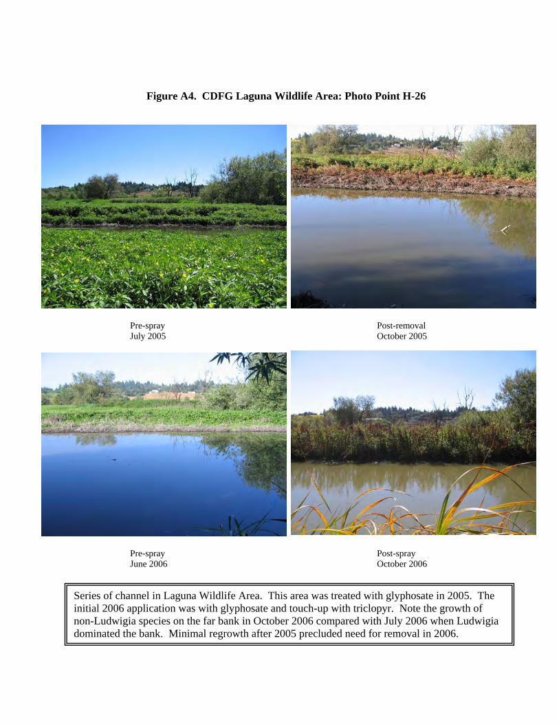
Figure A4. CDFG Laguna Wildlife Area: Photo Point H-26
Post-removal October 2005
Pre-spray June 2006
Post-spray October 2006
Series of channel in Laguna Wildlife Area. This area was treated with glyphosate in 2005. The initial 2006 application was with glyphosate and touch-up with triclopyr. Note the growth of non-Ludwigia species on the far bank in October 2006 compared with July 2006 when Ludwigia dominated the bank. Minimal regrowth after 2005 precluded need for removal in 2006.

Pre-spray July 2005
Figure A5. DFG Laguna Wildlife Area: Photo Point K-35
Post-removal October 2005
Pre-spray June 2006
Post-spray October 2006
Another series of channel in Laguna Wildlife Area also treated with glyphosate in 2005. The initial 2006 application was with glyphosate and touch-up with triclopyr. Negligible regrowth in 2006.

Pre-spray July 2005
Figure A6. CDFG Laguna Wildlife Area: Photo Point L-38
Post-removal October 2005
Pre-spray June 2006
Post-spray October 2006
Final series of channel in Laguna Wildlife Area. This area was treated with glyphosate in 2005. The initial 2006 application was with glyphosate and touch-up with triclopyr. Minimal regrowth after 2005 precluded need for removal in 2006.

Pre-spray July 2005
Figure A7. CDFG Laguna Wildlife Area: Photo Point Q-46
Post-removal October 2005
Pre-spray June 2006
Post-spray October 2006
South field, flooded wetlands in Laguna Wildlife Area. Significant regrowth in June 2006 was sprayed with triclopyr. No biomass could be removed. By October 2006 the canopy cover was almost exclusively curly dock (Rumex crispus) and swamp knotweed (Polygonum amphibium var. emersum).

Pre-spray July 2005
Figure A8. CDFG Laguna Wildlife Area: Photo Point T-54
Pre-spray June 2006
Post-spray October 2006
South field, flooded wetlands in Laguna Wildlife Area (new photo point in 2006). Significant regrowth in June 2006 was sprayed with triclopyr. It is unclear from these pictures whether the Ludwigia has died. The water depth may prevent species other than water fern (Azolla filliculoides) from colonizing.

Figure A9. CDFG Laguna Wildlife Area: Photo Point W-59
Pre-spray July 2006
Post-spray October 2006
South field, flooded wetlands in Laguna Wildlife Area (new photo point in 2006). Significant regrowth in June 2006 was sprayed with triclopyr. Canopy dominated by swamp knotweed (Polygonum amphibium var. emersum) and cocklebur (Xanthium strumarium).

Figure A10. CDFG Laguna Wildlife Area: Photo Point Z-63
Pre-spray July 2006
Post-removal October 2006
South field, flooded wetlands in Laguna Wildlife Area (new photo point in 2006). Significant regrowth in June 2006 was sprayed with triclopyr. Canopy dominated by swamp knotweed (Polygonum amphibium var. emersum) and cocklebur (Xanthium strumarium).

Pre-spray July 2005
Figure A11. SCWA Channels: Photo Point B-02
Post-removal October 2005
Post-spray August 2006
Post-removal September 2006
Bellevue Wilfred channel looking northeast off the Whistler Bridge. The 2006 pre-spray picture file was corrupted so the post glyphosate spray picture is shown. Significant regrowth occurred in 2006. Note the amount of water in the channel at the end of each season despite no precipitation for months. Water is likely from urban uses such as irrigation, car washing, etc.

Pre-spray July 2005
Figure A12. SCWA Channels: Photo Point C-04
Post-removal October 2005
Post-spray August 2006
Post-removal September 2006
Bellevue Wilfred channel looking north off the Wilfred Bridge. The 2006 pre-spray picture file was corrupted so the post glyphosate spray picture is shown. The amount of regrowth is still evident after the spraying. The channels were clear again after removal.

Pre-spray July 2005
Figure A13. SCWA Channels: Photo Point D-07
Post-removal October 2005
Pre-spray June 2006
Post-removal September 2006
Bellevue Wilfred channel looking north toward the Wilfred Bridge. The deeper water in the foreground appears to have limited regrowth while significant growth is visible in the background.

Pre-spray July 2005
Figure A14. SCWA Channels: Photo Point F-10
Post-removal October 2005
Pre-spray June 2006
Post-removal September 2006
Bellevue Wilfred channel looking north from Rohnert Park Expressway. Again, it appears that the deep water in the foreground prevented regrowth. On the far side of the cross bridge regrowth was heavier and continued even after the glyphosate application.

Pre-spray July 2005
Figure A15. SCWA Channels: Photo Point H-12
Post-removal October 2005
Pre-spray June 2006
Post-removal September 2006
Main Laguna channel looking east from Stony Point Road Bridge. Limited regrowth by June 2006. However, regrowth was heavier after the glyphosate application. Following the triclopyr application the growth was again controlled. No mechanical removal took place in the main channel.

Pre-spray July 2005
Figure A16. SCWA Channels: Photo Point I-13
Post-removal October 2005
Pre-spray June 2006
Post-removal September 2006
Main Laguna channel looking west from the north side of the Stony Point Road Bridge. Limited regrowth occurred in this relatively deep channel. No mechanical removal was required.

Pre-spray July 2005
Figure A17. SCWA Channels: Photo Point O-23
Post-removal October 2005
Pre-spray June 2006
Post-removal September 2006
Main Laguna channel looking west toward the Stony Point Road Bridge. Significant regrowth occurred in the shallow portions of the channel. Triclopyr provided excellent control in this section.
Photo point not yet
established