your use of this ontario geological survey document … · les utilisateurs sont tenus de vérifier...
TRANSCRIPT

THESE TERMS GOVERN YOUR USE OF THIS DOCUMENT
Your use of this Ontario Geological Survey document (the “Content”) is governed by the terms set out on this page (“Terms of Use”). By downloading this Content, you (the
“User”) have accepted, and have agreed to be bound by, the Terms of Use.
Content: This Content is offered by the Province of Ontario’s Ministry of Northern Development and Mines (MNDM) as a public service, on an “as-is” basis. Recommendations and statements of opinion expressed in the Content are those of the author or authors and are not to be construed as statement of government policy. You are solely responsible for your use of the Content. You should not rely on the Content for legal advice nor as authoritative in your particular circumstances. Users should verify the accuracy and applicability of any Content before acting on it. MNDM does not guarantee, or make any warranty express or implied, that the Content is current, accurate, complete or reliable. MNDM is not responsible for any damage however caused, which results, directly or indirectly, from your use of the Content. MNDM assumes no legal liability or responsibility for the Content whatsoever. Links to Other Web Sites: This Content may contain links, to Web sites that are not operated by MNDM. Linked Web sites may not be available in French. MNDM neither endorses nor assumes any responsibility for the safety, accuracy or availability of linked Web sites or the information contained on them. The linked Web sites, their operation and content are the responsibility of the person or entity for which they were created or maintained (the “Owner”). Both your use of a linked Web site, and your right to use or reproduce information or materials from a linked Web site, are subject to the terms of use governing that particular Web site. Any comments or inquiries regarding a linked Web site must be directed to its Owner. Copyright: Canadian and international intellectual property laws protect the Content. Unless otherwise indicated, copyright is held by the Queen’s Printer for Ontario. It is recommended that reference to the Content be made in the following form: <Author’s last name>, <Initials> <year of publication>. <Content title>; Ontario Geological Survey, <Content publication series and number>, <total number of pages>p. Use and Reproduction of Content: The Content may be used and reproduced only in accordance with applicable intellectual property laws. Non-commercial use of unsubstantial excerpts of the Content is permitted provided that appropriate credit is given and Crown copyright is acknowledged. Any substantial reproduction of the Content or any commercial use of all or part of the Content is prohibited without the prior written permission of MNDM. Substantial reproduction includes the reproduction of any illustration or figure, such as, but not limited to graphs, charts and maps. Commercial use includes commercial distribution of the Content, the reproduction of multiple copies of the Content for any purpose whether or not commercial, use of the Content in commercial publications, and the creation of value-added products using the Content. Contact:
FOR FURTHER INFORMATION ON PLEASE CONTACT: BY TELEPHONE: BY E-MAIL:
The Reproduction of Content
MNDM Publication Services
Local: (705) 670-5691 Toll Free: 1-888-415-9845, ext.
5691 (inside Canada, United States)
The Purchase of MNDM Publications
MNDM Publication Sales
Local: (705) 670-5691 Toll Free: 1-888-415-9845, ext.
5691 (inside Canada, United States)
Crown Copyright Queen’s Printer Local: (416) 326-2678 Toll Free: 1-800-668-9938
(inside Canada, United States)

LES CONDITIONS CI-DESSOUS RÉGISSENT L'UTILISATION DU PRÉSENT DOCUMENT.
Votre utilisation de ce document de la Commission géologique de l'Ontario (le « contenu ») est régie par les conditions décrites sur cette page (« conditions d'utilisation »). En
téléchargeant ce contenu, vous (l'« utilisateur ») signifiez que vous avez accepté d'être lié par les présentes conditions d'utilisation.
Contenu : Ce contenu est offert en l'état comme service public par le ministère du Développement du Nord et des Mines (MDNM) de la province de l'Ontario. Les recommandations et les opinions exprimées dans le contenu sont celles de l'auteur ou des auteurs et ne doivent pas être interprétées comme des énoncés officiels de politique gouvernementale. Vous êtes entièrement responsable de l'utilisation que vous en faites. Le contenu ne constitue pas une source fiable de conseils juridiques et ne peut en aucun cas faire autorité dans votre situation particulière. Les utilisateurs sont tenus de vérifier l'exactitude et l'applicabilité de tout contenu avant de l'utiliser. Le MDNM n'offre aucune garantie expresse ou implicite relativement à la mise à jour, à l'exactitude, à l'intégralité ou à la fiabilité du contenu. Le MDNM ne peut être tenu responsable de tout dommage, quelle qu'en soit la cause, résultant directement ou indirectement de l'utilisation du contenu. Le MDNM n'assume aucune responsabilité légale de quelque nature que ce soit en ce qui a trait au contenu. Liens vers d'autres sites Web : Ce contenu peut comporter des liens vers des sites Web qui ne sont pas exploités par le MDNM. Certains de ces sites pourraient ne pas être offerts en français. Le MDNM se dégage de toute responsabilité quant à la sûreté, à l'exactitude ou à la disponibilité des sites Web ainsi reliés ou à l'information qu'ils contiennent. La responsabilité des sites Web ainsi reliés, de leur exploitation et de leur contenu incombe à la personne ou à l'entité pour lesquelles ils ont été créés ou sont entretenus (le « propriétaire »). Votre utilisation de ces sites Web ainsi que votre droit d'utiliser ou de reproduire leur contenu sont assujettis aux conditions d'utilisation propres à chacun de ces sites. Tout commentaire ou toute question concernant l'un de ces sites doivent être adressés au propriétaire du site. Droits d'auteur : Le contenu est protégé par les lois canadiennes et internationales sur la propriété intellectuelle. Sauf indication contraire, les droits d'auteurs appartiennent à l'Imprimeur de la Reine pour l'Ontario. Nous recommandons de faire paraître ainsi toute référence au contenu : nom de famille de l'auteur, initiales, année de publication, titre du document, Commission géologique de l'Ontario, série et numéro de publication, nombre de pages. Utilisation et reproduction du contenu : Le contenu ne peut être utilisé et reproduit qu'en conformité avec les lois sur la propriété intellectuelle applicables. L'utilisation de courts extraits du contenu à des fins non commerciales est autorisé, à condition de faire une mention de source appropriée reconnaissant les droits d'auteurs de la Couronne. Toute reproduction importante du contenu ou toute utilisation, en tout ou en partie, du contenu à des fins commerciales est interdite sans l'autorisation écrite préalable du MDNM. Une reproduction jugée importante comprend la reproduction de toute illustration ou figure comme les graphiques, les diagrammes, les cartes, etc. L'utilisation commerciale comprend la distribution du contenu à des fins commerciales, la reproduction de copies multiples du contenu à des fins commerciales ou non, l'utilisation du contenu dans des publications commerciales et la création de produits à valeur ajoutée à l'aide du contenu. Renseignements :
POUR PLUS DE RENSEIGNEMENTS SUR VEUILLEZ VOUS
ADRESSER À : PAR TÉLÉPHONE : PAR COURRIEL :
la reproduction du contenu
Services de publication du MDNM
Local : (705) 670-5691 Numéro sans frais : 1 888 415-9845,
poste 5691 (au Canada et aux États-Unis)
l'achat des publications du MDNM
Vente de publications du MDNM
Local : (705) 670-5691 Numéro sans frais : 1 888 415-9845,
poste 5691 (au Canada et aux États-Unis)
les droits d'auteurs de la Couronne
Imprimeur de la Reine
Local : 416 326-2678 Numéro sans frais : 1 800 668-9938
(au Canada et aux États-Unis)

Ontario Geological Survey Mineral Deposits Circular 24
Gold Deposits of the Atikokan Area
byS.J. Wilkinson
A project funded by the Ontario Ministry of Northern Affairs.
1982
Ministry of Hon A|an wMinister
W.T.Foster ReSOUrceS Deputy Minister
Ontario

OMNR-OGS 1982 ISSN 0706-4551 Printed in Canada ISBN 0-7743-6768-7
Publications of the Ontario Ministry of Natural Resources and price list are available through the
Ministry of Natural Resources, Public Service Centre,Room 1640, Whitney Block, Queen's Park, Toronto,
Ontario, M7A 1W3 (personal shopping and mail orders),
and reports only from theOntario Government Bookstore,
Main Floor, 880 Bay St., Toronto (personal shopping).
Out-of-town customers may write to Ministry of Government Services, Publications Services Section, 5th Floor, 880 Bay St., Toronto, Ontario, M7A 1N8. Telephone: 965- 6015; toll-free long distance, 1-800-268-7540; or in Area Code 807, dial 0-Zenith 67200.
Orders for publications should be accompanied by cheque or money order payable to the Treasurer of Ontario.
This project was funded by the Ontario Ministry of Northern Affairs under the Atikokan Geological Survey program.
Every possible effort is made to ensure the accuracy of the information contained in this report, but the Ministry of Natural Resources does not assume any liability for er rors that may occur. Source references are included in the report and users may wish to verify critical information.
Parts of this publication may be quoted if credit is given. It is recommended that ref erence to this report be made in the following form: Wilkinson, S. J.1982: Gold Deposits of the Atikokan Area; Ontario Geological Survey, Mineral De
posits Circular 24,54p.
3000-1982-TP
11

FOREWORD
Gold deposits in granitoid rocks and metavolcanics in the Atikokan area have been known since the late 1800s. Small amounts of gold have been mined from a number of these deposits; for the most part this mining occurred around the turn of the century, al though the area produced gold as recently as 1966.
This report presents the results of a program initiated in 1978 to document the geologi cal settings of the gold mineralization and to assess the potential for more gold mineraliza tion in the Atikokan area, in order to stimulate further mineral exploration in the area. The project was part of the Atikokan Geological Survey program, funded by the Ontario Ministry of Northern Affairs.
E.G. Pye Director Ontario Geological Survey
m

IV
CONTENTS
Page ABSTRACT................................................................................................ viiINTRODUCTION........................................................................................... 1
Acknowledgments ..................................................................................... 1Previous Geological Work ............................................................................. 2Regional Geology...................................................................................... 5
GOLD MINERALIZATION ................................................................................. 6Introduction ............................................................................................ 6Marmion Lake Batholith Type.......................................................................... 6Contact Zone Type ....................................................................................13Metavolcanic-Hosted, Stratabound Type ............................................................13
DISCUSSION .............................................................................................17RECOMMENDATIONS FOR FUTURE EXPLORATION .................................................. 20
Marmion Lake Batholith Type....................,................................................... .20Contact Zone Type.................................................................................... 20Metavolcanic-Hosted, Stratabound Type ........................................................... .20
DESCRIPTIONS OF DEPOSITS ......................................................................... .211. Minto Mine .......................................................................................... 212. Reserve Island Occurrence........................................................................ 213. Sunbeam Mine ..................................................................................... 234. Roy Mine........................................................................................... .235. Pettigrew Mine...................................................................................... 246. Hawk Bay Occurrence ............................................................................. 267. Golden Winner Mine................................................................................ 268. Sawbill Mine (Upper Seine Mine) ................................................................. .289. Hammond Reef Mine......................,........................................................ 3010. PlatorGralouise Prospect........................................................................ .3311. Jack Lake Mine .................................................................................. .3312. Atiko (Sapawe) Gold Mine ....................................................................... .3413. Day Lake Occurrence ........................................................................... .3614. Snow Lake Occurrence.......................................................................... .3715. B.W. Tripp Claims (Blackfly Occurrence) ........................................................ 3916. New Golden Twins Occurrence .................................................................. 4117. Rebair Occurrence .............................................................................. .4118. Elizabeth Mine ................................................................................... .4219. Harold Lake Mine ................................................................................ .4420. Mayflower Mine .................................................................................. .4621. Red Paint Lake Occurrence (Sawdo Claims) ................................................... .47
REFERENCES ........................................................................................... .51INDEX .................................................................................................... .53
TABLES
1. List of previously published literature .................................................................. 32. Deposits of the Marmion Lake Batholith Type.......................................................... 63. Deposits of the Contact Zone Type..................................................................... 74. Deposits of the Stratabound Type ...................................................................... 75. Major and trace element composition of gneissic trondhjemites of the Marmion Lake Batholith ..... 96. Major and trace element composition of essentially unaltered massive trondhjemites
related to gold mineralization in the Marmion Lake Batholith ......................................... 107. Composition of progressively altered and sheared massive trondhjemites with
locations relative to lateral distance from mineralization ..............................................118. Trace metal compositions of quartz veins of the Marmion Lake Batholith Type mineralization ......129. Major element and trace metal compositions of representative rock types of the
Marmion Lake Batholith contact zone .................................................................1510. Major element and trace metal compositions of representative rock types of the
Dashwa Lake Batholith contact zone ................................................................1611. Trace metal compositions of quartz-carbonate veins of the Contact Zone Type mineralization ...1712. Trace metal compositions of Metavolcanic-Hosted, Stratabound Type mineralization ............18
FIGURES
1. Location of the Atikokan area ...........................................................................22. Locations of gold deposits.............................................................................. 23. Regional geology of the Atikokan area ................................................................. 54. Batholithic rocks and lineament structures of the Atikokan area ...................................... 85. Modred Lake area ..................................................................................... 146. Minto mine and vicinity .................................................................................227. Sunbeam mine ........................................................................................ .238. Roy mine .............................................................................................. .249. Pettigrew mine ......................................................................................... 2510. Hawk Bay mine ...................................................................................... .2711. Sawbill mine .......................................................................................... 2912. Hammond Reef mine ................................................................................ .3113. Plator Gralouise prospect ........................................................................... .3214. Jack Lake mine ...................................................................................... .3315. Atiko (Sapawe) mine................................................................................. .3516. Day Lake occurrence................................................................................. 3717. Snow Lake occurrence ............................................................................... 3818. Blackfly occurrence ................................................................................. .4019. Golden Twins occurrence ........................................................................... .4120. Elizabeth mine ....................................................................................... .4321. Harold Lake mine .................................................................................... .4522. Mayflower mine ...................................................................................... .4623. Metal occurrences in the Sawdo claim group ...................................................... .4824. Geology of the Sawdo claims ....................................................................... .49
vi

ABSTRACT
The Atikokan area, located 200 km west of Thunder Bay, contains several gold depos its. Seven past-producing deposits and fourteen prospects and occurrences were exam ined through a procedure of literature search, geological mapping, and sampling, followed by petrographic and geochemical studies.
Three types of gold mineralization are defined for the area:i) Marmion Lake Batholith Type occurs in the gneissic massif core of the batholithassociated with northeasterly trending regional lineaments and late trondhjemiteswhich are locally sheared. Shearing strikes parallel to the lineaments and occurredduring two or more episodes, the latest of which is related to the mineralization.ii) Contact Zone Type is contained by the plutonic rocks which border the gneissicbatholiths along the metavolcanic belt contact. Thin, discontinuous shear zones hostthe mineralization which is related to at least two eposides of shearing.iii) Metavolcanic-Hosted, Stratabound Type is associated with laterally extensivebeds of altered felsic tuffs and pyritiferous chemical sediments. The mineralization isdue to epigenetic enrichment of gold associated with, in one instance, the intrusion ofquartz-feldspar porphyry, and in the other, faulting and shearing.
Vll

Conversion Factors forMeasurements in Ontario Geological SurveyPublications
If the reader wishes to convert imperial units to SI (metric) units or SI units to imperial units the following multipliers should be used:
CONVERSION FROM SI TO IMPERIAL
SI Unit Multiplied by Gives
CONVERSION FROM IMPERIAL TO SI
Imperial Unit Multiplied by Gives
LENGTH
1 mm1 cm1 m1 m1 km
1 cm2 1 m2 1 km2 1 ha
1 cm31 m31m3
1 L 1 L 1 L
19 191kg 1 kg 1 1 1kg 1t
0.039370.393 703.280 840.049 709 70.621 371
0.1550 10.7639 0.38610 2.471 054
0.061 0235.3147
1 .308 0
1 .759 755 0.879 877 0.219969
0.03527396 0.03215075 2.20462 0.001 1023 1.102311 0.00098421 0.9842065
inchesinchesfeetchainsmiles (statute)
square inches square feet square miles acres
cubic inchescubic feetcubic yards
pints quarts gallons
ounces (avdp) ounces (troy) pounds (avdp) tons (short) tons (short) tons (long) tons (long)
1 inch1 inch1 foot1 chain1 mile (statute)
AREA
1 square inch 1 square foot 1 square mile 1 acre
VOLUME
1 cubic inch1 cubic foot1 cubic yard
CAPACITY
1 pint 1 quart 1 gallon
MASS
1 ounce (avdp) 1 ounce (troy) 1 pound (avdp) 1 ton (short) 1 ton (short) 1 ton (long) 1 ton (long)
25.42.540.3048
20.11681.609344
6.451 6 0.092903042.589988 0.404 685 6
16.3870640.028316850.764555
0.568 261 1.136522 4.546090
28.349 523 31.1034768 0.45359237
907.18474 0.90718474
1016.0469088 1.0160469088
mmcmmmkm
cm2 m2 km2 ha
cm3m3m3
LL L
g g kg kg tkg t
CONCENTRATION
ig/t
ig/t
0.0291666
0.58333333
ounce (troy)/ ton (short) pennyweights/ ton (short)
1 ounce (troy)/ ton (short) 1 pennyweight/ ton (short)
34.2857142
1.7142857
g/t
g/t
OTHER USEFUL CONVERSION FACTORS
1 ounce (troyj/ton (short) 1 pennyweight/ton (short)
20.0 0.05
pennyweights/ton (short) ounce (troyyton (short)
viii
NOTE Conversion factors which are in bold type are exact. The conversion factors have been taken from or have been derived from factors given in the Metric Practice Guide for the Canadian Mining and Metallurgical Industries published by The Mining Association of Canada in coop eration with the Coal Association of Canada.
Gold Depositsof the
Atikokan Area
by
S. J. Wilkinson1INTRODUCTION
The town of Atikokan is located approximately 200 km west of Thunder Bay, Ontario, in the District of Rainy River. The study area, Figure 1, occurs within a 45 km ra dius of Atikokan. It includes the townships of Tanner, As mussen, Baker, Freeborn, Schwenger, McCaul, Hutchin son, and Ramsay Wright, plus the region northeast to the Lumby Lake (or Red Paint Lake) area.
Iron, gold, and base metal deposits have been known to exist in the area since the late 1800s (Coleman 1895, p.58). Early operating mines were the Atikokan iron mine near Sapawe, Ontario, and the Harold Lake, Eliza beth, and Hammond Reef gold mines (Figure 2). The Steep Rock iron deposits were producing continuously from 1944 to 1979, and in 1967 the Atikokan area was Ontario's principal source of iron ore (Shklanka 1972).
Currently no mines are operating in the area but many deposits are being investigated. The Atikokan iron range is being examined for its cobalt potential, plus its copper, nickel, and iron content (Fenwick et al. 1980). Several gold deposits that had previously been mined or prospected are now being re-evaluated. The Atiko (for merly Sapawe), Jack Lake, and Elizabeth gold mines are notable examples of deposits under consideration.
A study of the mineral deposits of the Atikokan area was initiated in May of 1978 (MacRae 1978). Its purpose was to evaluate the mineral potential and to document the geological settings of mineralization with particular em phasis on gold deposits. The project was intended to stimulate mineral exploration and interest in the area by documenting the known occurrences and outlining po tential for future work.
Each of the 21 deposits (Figure 2) examined during 1978 and 1979 was investigated as follows:
* research of literature,* analysis of data from Assessment File Research
Office, Ontario Geological Survey, Toronto,
Geologist, Mineral Deposits Section, Ontario Geological Sur vey, Toronto.Manuscript approved for publication by Chief, Mineral Deposits Section, June 25,1980.This report is published with the permission of E.G. Pye, Director, Ontario Geological Survey.
* detailed geological mapping and sampling of the deposit and mineralization, and
* geochemical and petrographic studies of host and mineralized rock.
The literature search supplemented by data from the Assessment Files provided the basis for selection of mapping targets. All deposits which produced gold were chosen, as well as occurrences of known potential. Simi lar areas, but barren of gold mineralization, were investi gated for comparative purposes.
Geological mapping was carried out at both regional (1:15 840) and detailed (1:3 600 and 1:600) scales. Sam pling was done so that a representative suite of rock types was collected for each deposit.
The laboratory work consisted of petrographic stud ies and geochemical analyses. Samples of mineralization and host rocks were analyzed for their content of gold, sil ver, copper, lead, zinc, molybdenum, and tungsten; some samples were further analyzed for arsenic. Host rocks were also analyzed for 11 major element composi tions. All of the analytical work was done by the Geosci ence Laboratories of the Ontario Geological Survey, To ronto.
This report contains descriptions of the geological settings and diagnostic features of the gold mineraliza tion of the Atikokan area. A classification scheme is pro posed for the types of deposits in the area. A discussion of future exploration targets and techniques is given at the end of the report. Brief descriptions and background summaries for each deposit are contained in the Descriptions of Deposits.
Acknowledgments
Work done during the first year of the program was undertaken by W.E. MacRae who, in addition to visiting many of the deposits, compiled a thorough data base for the project from several sources: the Assessment File Re search Office, Ontario Geological Survey, Toronto; ex ploration company private files; and the published litera ture. The author was ably assisted by T. Trowell during the 1979 field season. Several people were instrumental in helping the author locate many of the deposits, namely P. Sawdo and family, M. Wicheruk, R. Bernatchez, B. Staines, and D. Beckett.

Figure 1—Location of the Atikokan area.
Figure 2—Locations of gold deposits of the Atikokan area. Refer also to Tables 2, 3, and 4.
Throughout the program, equipment, advice, and encouragement were provided by C.R. Larsen, and Min istry of Natural Resources personnel of the Atikokan and Thunder Bay District Offices, and the Thunder Bay Re gional Office (particularly K.G. Fenwick, Thunder Bay Re gional Office). The author would also like to thank J.B. Gordon, J.A. Robertson, and A.C. Colvine, of the Ontario Geological Survey in Toronto, who directed the writing of this manuscript.
Previous Geological Work
Several geologists have contributed to the know ledge of the geology of the Atikokan area (Table 1). Cole man (1895,1896a, 1896b, 1897) first described the gold deposits of the area. The first geological map of the area was completed by Mcinnes (1899). Subsequent descrip tions of the area's gold deposits are contained in the re ports of the Crown mining inspectors such as Bow (1898,
TABLE 1
DATE
1891
1894
1895
1896
1896
1897
LIST OF PREVIOUSLY PUBLISHED LITERATURE
REFERENCE
Smy the (1891)
Coleman (1895, p. 58)
Coleman (1896a, p. 68-72)
Coleman (1897. p. 74-79)
Coleman (1896b, p. 5)
Mcinnes (1899)
TITLE
Structural Geology of Steep Rock Lake
Gold in Ontario: Its Associated Rocks and Minerals
Second Report on the Gold Fields of Western Ontario
Third Report on the West Ontario Gold Region
The Gold Fields of Western Ontario, Canada
Report on the Geology of the Area
LOCATION (S)
Steep Rock Lake
Harold Lake mine
Atikokan area
Atikokan area
Harold Lake mine
Atikokan area
1899 Bow (1899, p. 87-93)
1899 De Kalb (1899, p. 4142)
1901 Carter (1901, p. 103-107)
1902 Carter (1902, p. 239-242)
1906 Corkill (1906, p. 48*50)
1907 Corkill (1907, p. 56, 57, 60)
1912 Lawson (1912, p. 7-15)
1925 Bruce (1925)
1929 Hawley (1930, p. 1-58)
1939 Gardiner (1939)
1939 Moore (1940)
1960 Woolverton (1960)
Covered by the Seine River and Lake Shebandowan Map Sheets
Mines of Northwestern Ontario
The Condition of Ontario Mines
Mines of Northwest Ontario: Part 2
Mines of Ontario
Mines of Ontario
Mines of Ontario
The Geology of Steep Rock Lake, Ontario
Gold Deposits of Kenora and Rainy River Districts
Geology of the Sapawe Lake Area, with Notes on Some Iron and Gold Deposits of Rainy River District
The Gold Deposits of the Atikokan Area, Ontario
Geology and Ore Deposits of the Atikokan Area
Atikokan area
Hammond Reef mine, Sawbill mine, and Roy mine
Atikokan area
Atikokan area
Minto mine and Sunbeam mine
White Lily mine and Minto mine
Steep Rock Lake
Atikokan area
East Half of the Atikokan area
Atikokan area
West Half of the Atikokan area
The Geology of the Lumby Lake Area Northeast part of Atikokan area

TABLE 1 Continued
DATE REFERENCE TITLE LOCATION (S)
1960 Young (1960)
1965 Pye and Fenwick (1965)
1971 Fenwick (1971)
1971 Ferguson, Groen, and Haynes (1971)
1972 Shklanka (1972)
1973 Mcilwaine and Chorlton (1973, p. 71-74)
1974
1974
1975
1976
1978
1978
1978
1979
Mcilwaine and Hillary (1974)
Mackasey, Blackburn, and Trowell (1974)
Grabowski (1975)
Fenwick (1976a)
MacRae (1978)
Morgan (1978)
Pirie (1978)
Fumerton (1979)
Geology of the Bennett-Tanner Area
Atikokan-Lakehead Sheet, Kenora, Rainy River, and Thunder Bay Districts
The Origin of a Stratabound Pyrite Deposit in Predominantly Volcanic Derived Strata in the Finlayson Lake Area, District of Rainy River, Ontario
Gold Deposits of Ontario, Part 1, Districts of Algoma, Cochrane, Kenora, Rainy River, and Thunder Bay
Geology of the Steep Rock Lake Area, District of Rainy River, Part 1
East Half of Sapawe Lake Area, District of Rainy River
West Half of Sapawe Lake Area, District of Rainy River
A Regional Approach to the Wabigoon- Quetico Belts and Its Bearing on Exploration in Northwestern Ontario
Geology and Geochemistry of the Atikokan Iron Mine
Geology of the Finlayson Lake Area, District of Rainy River
Geology of the Crooked Pine Lake Area, District of Rainy River, Ontario
The Righteye Lake Area, District of Rainy River
West side of Atikokan area
Atikokan area
Finlayson Lake
Atikokan area
Portions of Schwenger and Freeborn Townships
Portions of McCaul and Hutchinson Townships and area
Portions of McCaul and Hutchinson Townships and area
Arikokan area
Sapawe, Ontario
West central part of the Atikokan area
Mineral Deposits of the Atikokan Area Atikokan area
Structure of the Finlayson Lake Finlayson Lake Greenstone Belt
Trottier and Weaver Townships and area
Portions of Asmussen, Baker, and Freeborn Townships, and area
1979 Wilkinson (1979)
1980 Fenwick, Larsen, Scott, Mason, and Schnieders (1980)
Gold Mineralization of the Atikokan Area Atikokan area
1979 Report of the North Central Atikokan area Regional Geologist
1899, 1900), Carter (1901), and Corkill (1906,1907). The first detailed geological maps with descriptions of gold deposits are contained in the report by Bruce (1925). The geological maps and reports of Hawley (1930) and Moore (1940) are thorough and are of a high standard. Gardiner (1939) was the first more modern study of the area's deposits and introduced many concepts which are not yet disputed.
The subsequent geological reports such as Woolver
ton (1960), Young (1960), Shklanka (1972), Mackasey et al. (1974), Fenwick (1976a), and Pirie (1978) contain brief descriptions of gold deposits and occurrences based upon visits to the area and the previous literature.
Some information on gold deposits such as loca tions, ore grades, and geological settings are contained in the reports of Mcilwaine and Chorlton (1973), Mcil waine and Hillary (1974), MacRae (1978), Fumerton (1979), Wilkinson (1979), and Fenwick era/. (1980).
4

Regional Geology
The Atikokan area is underlain by early Precambrian rocks of the Superior Structural Province, including parts of the Wabigoon and Quetico Subprovinces (Figure 3). The east-trending Quetico Fault marks the boundary be tween the subprovinces (Mackasey era/. 1974).
The Wabigoon Subprovince, north of the fault, is composed of narrow metavolcanic belts and granitic batholiths. The metavolcanics aie mainly metamorp hosed varieties of mafic to intermediate flows interdigi- tated with felsic volcanic rocks and minor sedimentary units. The Marmion Lake Batholith in the east-central part of the study area is a complex of gneissic trondhjemites and monzonites (Pirie 1978). The Dashwa Lake Batholith in the western half of the area is composed of mainly biot ite and hornblende granite, quartz monzonite, quartz diorite, and granite gneiss (Fenwick 1976; Fumerton
1979). Minor granodiorite and trondhjemite occur in the contact zone between the metavolcanic belts and bathol iths.
South of the Quetico Fault, the dominantly metasedi- ments form a belt which is contiguous across the south ern part of the study area. The rocks consist of meta morphosed wackes, argillites, and carbonaceous sediments (Pirie 1978; Fumerton 1979). Small ultramafic sills and granitic stocks occur throughout the metasedi- mentary belt (Pye and Fenwick 1965).
The Quetico Fault is the dominant regional structure. It extends easterly across the area, marked by prominent lineaments, and bounded by zones of schistose to mylon itic rocks (Mcilwaine and Chorlton 1973; Mcilwaine and Hillary 1974; Fumerton 1979). Hawley (1930) demon strated that movement along the fault was primarily right- lateral horizontal displacement. East of Perch Lake, sev eral lineaments trend toward the northeast from the
LEGEND0 Felsic Intrusive Rocks EH Wabigoon Metavolcanic Belt 0 Quetico Metasedimentary Belt Quetico Fault- Faults fi* Lineaments
Figure 3—Regional geology of the Atikokan area, adapted after Hawley (1930), Moore (1940), Woolverton (1960), Pye and Fenwick (1965), Shklanka (1972), and Fenwick (1976a).
Quetico Fault. Some of these lineaments can be traced for distances of 80 km.
GOLD MINERALIZATION
IntroductionGold occurrences are common throughout the Atiko
kan area, but many of them are only recently documented (Fenwick etal. 1980; Wilkinson 1979; MacRae 1978). The deposits that were examined during the course of this study occur in a range of geological settings. Three gen eral types of mineralization are recognized in the study area:i) Marmion Lake Batholith Type quartz veins within
shear zones associated with northeast-trending linea ments in the batholith (Table 2);
ii) Contact Zone Type quartz-carbonate veins within narrow shear zones located at or near the contacts of batholiths and metavolcanic belts (Table 3); and
iii) Metavolcanic-Hosted, Stratabound Type concor dant lenses of chert or carbonate with associated quartz-carbonate veins, hosted by metavolcanics (Ta ble^.Figure 2 shows the locations of gold deposits; the
key for the location map is contained in Tables 2,3, and 4. Gold, in all three types of mineralization, is concen
trated in quartz and quartz-carbonate veins with subsidi ary silver, copper, lead, and zinc. The process of gold en richment into the veins is multi-stage and is a combination of some or all of the following:
* deposition or emplacement of the host granitic rock into the country rock;
* alteration of the host granitic rock by hydrothermal solutions and formation of the veins; and
* hydrothermal mobilization of gold and its ultimate deposition in the veins.
Marmion Lake Batholith TypeThe Marmion Lake Batholith (Figure 4) underlies a 25
km wide area that persists for 100 km east of Finlayson
TABLE 2 DEPOSITS OF THE MARMION LAKE BATHOLITH TYPE
NUMBER* NAME OF DEPOSIT
STATUS** ACCESSORY MINERALS* AVERAGE GRADE Auft REFERENCE(g/t) (ounce/ton)
1
2
3
4
5
6
7
8
9
10
11
Minto mine
Reserve Island occurrence
Sunbeam mine pp
Roy mine p
Pettigrew mine p
Hawk Bay occurrences p
Golden Winner mine pp
Sawbill mine pp
Hammond Reef mine pp
Plator Gralouise p prospect
Jack Lake mine p
ank, py, asp, cp. Au
py, gn, asp, Au'
ank, py, gn. Au
ank, py,gn
ank, py, cp, asp, gn
py, ank
ank, py
ank, py, cp, gn, asp, sp
py, ank, gn, cp, sp. Au
py, cp, gn. Au
ank, py, cp, gn, sp, cp. Au
N.D.
7.89
14.74
N.D.
N.D.
N.D.
9.94
8.57
10.29
N.D.
N.D.
0.23
0.43
N.D.
N.D.
N.D.
0.29
0.25
0.30
N.D.
MacRae (1978, p. 206)
Tremblay (1946, p. 20)
15.57 0.454
Tremblay (1946, p. 21)
Tremblay (1940, p. 22)
Tremblay (1940, p. 22)
Canadian Mines Handbook (1962, p. 93)
* Number: Occurrence located by number in Figure 12 ** Status : p s partially developed or prospected occurrence
pp s past producer t Accessory Minerals: ank z ankerite; py - pyrite; asp ~ arsenopyrite; cp ~ chalcopyrite; sp ** sphalerite; gn c galena;
mo ~ molybdenite; and Au ~ visible gold tt N.D. ~ no data

TABLE 3 DEPOSITS OF THE CONTACT ZONE TYPE
NUMBER* NAME OF DEPOSIT
STATUS** ACCESSORY MINERALSf AVERAGE GRADE Auft REFERENCE(g/t) (ounce/ton)
12
13
14
15
16
17
18
19
Atiko Gold mine Sapawe)
Day Lake occurrence
Snow Lake occurrence
Tripp claims
Golden Twins occurrence
Rebair occurrence
Elizabeth mine
Harold Lake mine
PP
o
o
P
P
P
PP
PP
ank, py, cp, sp, schee. Au
PV, cp, gn
py, cp,sp, gn
ank, py,gn
py, ank, cp, mo, gn, sp, asp
ank, py,cp
py, ank, cp, asp, schee
py, ank, asp, cp, sp, gn. Au
4.80 0.14 Riddell (1969, p. 52)
N.D.
N.D.
N.D.
N.D.
N.D.
13.72
20.23
N.D.
N.D.
N.D.
N.D.
N.D.
0.4
0.59
Tremblay (1940, p. 22)
Ferguson et al. (1971, p. 248)
* Number: Occurrence located by number in Figure 12 ** Status : 0= undeveloped occurrence
p ^ partially developed or prospected occurrence pp - past producer
t Accessory Minerals: ank s ankerite; py - pyrite; asp s arsenopyrite; cp = chalcopyrite; sp - sphalerite; gn - galena;mo s molybdenite; schee ~ scheelite; and Au - visible gold
tt N.D. * no data
TABLE 4 DEPOSITS OF THE METAVOLCANIC-HOSTED STRATABOUND TYPE
NUMBER* NAME OF DEPOSIT
STATUS** ACCESSORY MINERALS 1" AVERAGE GRADE Au ft REFERENCE(g/t) (ounce/ton)
20
21
Mayflower mine
Sawdo claims
p py, cp, sp, gn, asp
p ank, py, cp, sp, schee
N.D.
47.3
N.D.
1.38 Woolverton (1960, p. 47)
* Number: Occurrence located by number in Figure 12 ** Status : p = partially developed or prospected occurrencet Accessory Minerals: ank s ankerite; py z pyrite; asp E arsenopyrite; cp s chalcopyrite; sp s sphalerite; gn - galena;
and schee = scheelite tt N.D. - no data
Lake (Pirie 1978). The batholith is a complex of tron- dhjemites, monzonites, diorites, and amphibolites which are described in detail by Pirie (1978). In general, the ba tholith is divisible into two main components: a) principal massif of gneissic rocks and subsidiary
massive intrusions; and
b) variably sheared contact zone between the massif and metavolcanic belts (Figure 4). Morgan (1978, p. 18) similarly showed the batholith to
consist of a gneissic core and a marginal plutonic phase. The gold occurrences within the massif are associ
ated with north- to northeast-trending lineaments. These
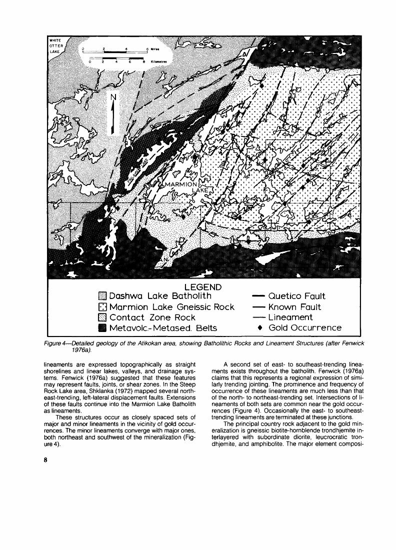
LEGEND Dashwa Lake BatholithMarmion Lake Gneissic Rock Contact Zone Rock Metavolc- Metased. Belts
Quetico Fault Known Fault Lineament * Gold Occurrence
Figure 4—Detailed geology of the Atikokan area, showing Batholithic Rocks and Lineament Structures (after Fenwick 1976a).
lineaments are expressed topographically as straight shorelines and linear lakes, valleys, and drainage sys tems. Fenwick (1976a) suggested that these features may represent faults, joints, or shear zones. In the Steep Rock Lake area, Shklanka (1972) mapped several north east-trending, left-lateral displacement faults. Extensions of these faults continue into the Marmion Lake Batholith as lineaments.
These structures occur as closely spaced sets of major and minor lineaments in the vicinity of gold occur rences. The minor lineaments converge with major ones, both northeast and southwest of the mineralization (Fig ure 4).
k second set of east- to southeast-trending linea ments exists throughout the batholith. Fenwick (1976a) claims that this represents a regional expression of simi larly trending jointing. The prominence and frequency of occurrence of these lineaments are much less than that of the north- to northeast-trending set. Intersections of li neaments of both sets are common near the gold occur rences (Figure 4). Occasionally the east- to southeast- trending lineaments are terminated at these junctions.
The principal country rock adjacent to the gold min eralization is gneissic biotite-hornblende trondhjemite in- terlayered with subordinate diorite, leucocratic tron dhjemite, and amphibolite. The major element composi-
8

tions of the biotite-hornblende trondhjemites are listed in Tables, plus their gold, arsenic, chromium, copper, lead, and zinc content. Oligoclase is the dominant mineral with quartz, biotite, hornblende, and minor microcline present, in order of decreasing abundance. Pirie (1978) stated that the gneissosity is defined by thin quartz-rich layers or lenses and the biotite flakes. Pirie (1978, p.39) went on to say:
Evidence of ductile crushing is ubiquitous. Quartz-rich areas consist of percrystalline aggregates of sutured grains showing undulose extinction and mortar texture in places, and are elon gated parallel to the gneissosity. The intensity of strain does not appear, however, to have been severe enough to affect the pla gioclase.
The unaltered equivalents of the rocks that host the gold mineralization are massive trondhjemites. Major and selected trace element compositions of two representa tive samples are shown in Table 6. These rocks are non- homogeneous in outcrop and vary from leucocratic oligo clase trondhjemites to biotite trondhjemites. Individual samples are medium grained; composed of idiomorphic oligoclase (An20-3o) with interstitial quartz, biotite, and trace hornblende. All of the primary minerals are some what altered with plagioclase partially replaced by seri cite, epidote, and trace carbonate. Mafic minerals are rimmed by or completely pseudomorphed by chlorite.
The massive trondhjemites are progressively altered with proximity to mineralization. The changes from unaf fected trondhjemites to chloritic schists are gradational
TABLE 5 MAJOR AND TRACE ELEMENT COMPOSITION OF GNEISSIC TRONDHJEMITES OF THE MARMION LAKE BATHOLITH
SAMPLE NO.
Rock Type
Oxide
Si02
AI203
Fe203
FeOMgO
CaO
Na20
K20
Ti02
MnO
C02
S
H20~
TOTAL
W32
Biotite- hornblende
Trondhjemite
69.8
15.2
0.901.83
0.66
2.964.641.21
0.32
0.10
0.03
0.20
0.02
0.590.26
98.7
W36
Biotite- hornblende
Trondhjemite
70.7
16.0
0.75
1.25
0.74
3.15
4.691.20
0.27
0.08
0.03
0.12
0.01
0.70
0.37
100.0
W68
Biotite- hornblende
Trondhjemite
70.916.0
0.54
1.33
0.72
2.964.751.37
0.22
0.10
0.03
0.10
0.01
0.57
0.32
99.9
Au(ppb)
As(ppm)
Cr(ppm)
Cu(ppm)
Pb(ppm)
Zn(ppm)
6
1
8
nd
12
54
8
2
8
5
12
40
nd
nd
nd
nd
10
44
nd ~ not detected
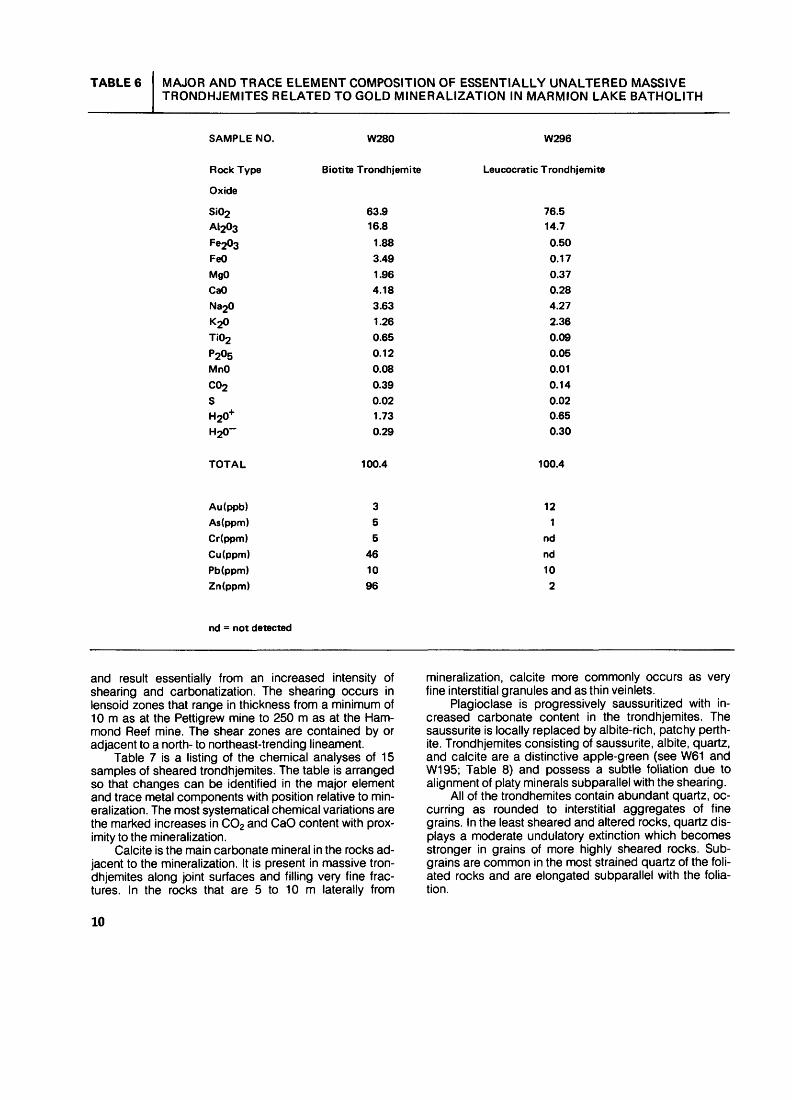
TABLE 6 MAJOR AND TRACE ELEMENT COMPOSITION OF ESSENTIALLY UNALTERED MASSIVE TRONDHJEMITES RELATED TO GOLD MINERALIZATION IN MARMION LAKE BATHOLITH
SAMPLE NO.
Rock Type
Oxide
Si02
A1203
Fe203FeOMgO
CaO
Na20
K20
Ti02
P205
MnO
C02
S
H20~
TOTAL
W280
Biotite Trondhjemite
63.916.8
1.88
3.491.96
4.18
3.63
1.26
0.65
0.12
0.08
0.390.02
1.73
0.29
100.4
W296
Leucocratic Trondhjemite
76.5
14.7
0.50
0.17
0.37
0.28
4.27
2.36
0.09
0.05
0.01
0.14
0.02
0.65
0.30
100.4
Au(ppb)
As(ppm)
Cr(ppm)
Cu(ppm)
Pb(ppm)
Zn(ppm)
nd = not detected
3
5
5
46
10
96
12
1
nd
nd
10
2
and result essentially from an increased intensity of shearing and carbonatization. The shearing occurs in lensoid zones that range in thickness from a minimum of 10 m as at the Pettigrew mine to 250 m as at the Ham mond Reef mine. The shear zones are contained by or adjacent to a north- to northeast-trending lineament.
Table 7 is a listing of the chemical analyses of 15 samples of sheared trondhjemites. The table is arranged so that changes can be identified in the major element and trace metal components with position relative to min eralization. The most systematical chemical variations are the marked increases in CO2 and CaO content with prox imity to the mineralization.
Calcite is the main carbonate mineral in the rocks ad jacent to the mineralization. It is present in massive tron dhjemites along joint surfaces and filling very fine frac tures. In the rocks that are 5 to 10 m laterally from
mineralization, calcite more commonly occurs as very fine interstitial granules and as thin veinlets.
Plagioclase is progressively saussuritized with in creased carbonate content in the trondhjemites. The saussurite is locally replaced by albite-rich, patchy perth ite. Trondhjemites consisting of saussurite, albite, quartz, and calcite are a distinctive apple-green (see W61 and W195; Table 8) and possess a subtle foliation due to alignment of platy minerals subparallel with the shearing.
All of the trondhemites contain abundant quartz, oc curring as rounded to interstitial aggregates of fine grains. In the least sheared and altered rocks, quartz dis plays a moderate undulatory extinction which becomes stronger in grains of more highly sheared rocks. Sub- grains are common in the most strained quartz of the foli ated rocks and are elongated subparallel with the folia tion.
10

o
LATIVE
Ulacinz0
H LOCAT
l-
5W UJh-2UJ }x oz o ccr- UJM ASS IV
HEARED
VI
Qz< goOCK UJ <!3N*r -JLIVELY)
MINERA
&S ^2CD OCo"-oc wQ. UJ
" zO lto p: Zeny Qt-lw < O ocQ. in2 H0< O -1
UJJ03f
ut y; oooc-i -i <HOO li.
life F2
28
^b! cco O QQ -IDC K 00
w X. O OGC-1 -1 <S 6zaz <i
E0
A
E o
EUt
E in
E
E in
E
Eo
E
E oA
E c 8.2"Sc22 a*M C
02
5
S
fS
r*.00
in rv -
to to5
fc
o
CO
*
to00
1inCO
i00en
inCM2
6zj a.S< to
ocococotDOCM^T-ooinococo CMCO^-OOOCMCOCMOOO'-OOO O 'O'OOO'O'O^- l^'- O C C C C CM
toincMcot-r-r'.r^corvr-oocoOCfttOCMCOCOtOf^CNOOtOO'-^- U)CN^-O'-T-T-CMCMOOO'-O'-O O 'OT-'DO-OOOr*-- occ*-c^-
OtOOOOCMtCMOOO'-OOO Q TJTJOO-OM-tO f* *- OCCCr-CO
^ CMCMCOCOOCfiOOtOCMOCMOO? ^
CO "- *~ *~ *~ O C r-cCM
^ ^'OOO'-CO'-OOO'-OOO CO T3tOOT3^*r^ T- co c c c CM
tOincOO'-COCOCMOOOCMO'-O O T3 "D CO in Cft Tf CO*- OCCtDr-CO
o-P55K^SSStS8S5oS5w totOCMO'-OCMCM'-OOO'-OOO O CMT3-OOO"OCMr^t- Ot-ccc^-
co *- *- *~ *- at f^oocMg 2 co
CMr^OT-eocNCMOOoO'-ooo o o^rtotoocM^- *- CM O CO ^t t CM
^CMCMOlOltOinCM'SFi^OCMOOOfO COCMtO'-CM'-COCOCMOOOCMO'-O CO tO-DinCM^CMto*~ CD c t co *~ r*
COCO^COtOO^'-CM^OCMOOOCO *-COIOOT-OCO^tCMOOOCMOOO O O T3 "D CO T3 OO
tooooinooooocMCMCMcnr^coCMCOOOOCM^-t-OOOCMOOO CO '-^ OTJOO
CO IO ^~ ^^ ^ ^f ^^ ^^ ^3 C3 ^5 lO ^^ ^5 O ^ ^3 00 ^^ tO ^3 (Oto*- OCOCOCMCCO
'-^ O'-O'-COCOOOO'-OOO O CO'-CO'OCOtOr*, i- o c co *t
totOT-cM'-co^: '-ddddd'-d co eM'-mw'oD!
JE?JE? m ^ 4-1 < 9-ao.o-aQ. N(CM?IOOO^O^I O) OCN tj o 1- 3raaaS3O qja)O)(0(DCMSpij^d) CMCM O 3w^3,QCw<u.u.Sozy:^-ci.5oOTII H- <<ooQ:N
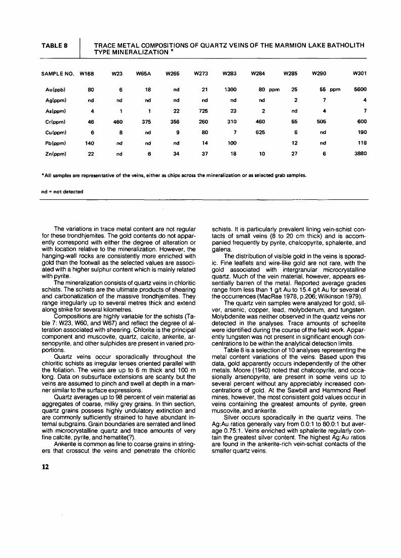
TABLE 8 TRACE METAL COMPOSITIONS OF QUARTZ VEINS OF THE MARMION LAKE BATHOLITH TYPE MINERALIZATION *
SAMPLE NO. W16B W23 W65A W265 W273 W283 W284 W285 W290 W301
Au(ppb)
Ag(ppm)
As(ppm)
Cr(ppm)
Cu(ppm)
Pb(ppm)
Zn(ppm)
80
nd
4
46
6
140
22
6
nd
1
460
8
nd
nd
18
nd
1
375
nd
nd
6
nd
nd
22
356
9
nd
34
21
nd
725
260
80
14
37
1300
nd
23
310
7
100
18
80 ppm
nd
2
460
625
10
25
2
nd
55
6
12
27
55 ppm
7
4
505
nd
nd
6
5600
4
7
600
190
118
3880
*AII samples are representative of the veins, either as chips across the mineralization or as selected grab samples,
nd ~ not detected
The variations in trace metal content are not regular for these trondhjemites. The gold contents do not appar ently correspond with either the degree of alteration or with location relative to the mineralization. However, the hanging-wall rocks are consistently more enriched with gold than the footwall as the selected values are associ ated with a higher sulphur content which is mainly related with pyrite.
The mineralization consists of quartz veins in chloritic schists. The schists are the ultimate products of shearing and carbonatization of the massive trondhjemites. They range irregularly up to several metres thick and extend along strike for several kilometres.
Compositions are highly variable for the schists (Ta ble 7: W23, W60, and W67) and reflect the degree of al teration associated with shearing. Chlorite is the principal component and muscovite, quartz, calcite, ankerite, ar senopyrite, and other sulphides are present in varied pro portions.
Quartz veins occur sporadically throughout the chloritic schists as irregular lenses oriented parallel with the foliation. The veins are up to 6 m thick and 100 m long. Data on subsurface extensions are scanty but the veins are assumed to pinch and swell at depth in a man ner similar to the surface expressions.
Quartz averages up to 98 percent of vein material as aggregates of coarse, milky grey grains. In thin section, quartz grains possess highly undulatory extinction and are commonly sufficiently strained to have abundant in ternal subgrains. Grain boundaries are serrated and lined with microcrystalline quartz and trace amounts of very fine calcite, pyrite, and hematite(?).
Ankerite is common as fine to coarse grains in string ers that crosscut the veins and penetrate the chloritic
schists. It is particularly prevalent lining vein-schist con tacts of small veins (8 to 20 cm thick) and is accom panied frequently by pyrite, chalcopyrite, sphalerite, and galena.
The distribution of visible gold in the veins is sporad ic. Fine leaflets and wire-like gold are not rare, with the gold associated with intergranular microcrystalline quartz. Much of the vein material, however, appears es sentially barren of the metal. Reported average grades range from less than 1 g/t Au to 15.4 g/t Au for several of the occurrences (MacRae 1978, p.206; Wilkinson 1979).
The quartz vein samples were analyzed for gold, sil ver, arsenic, copper, lead, molybdenum, and tungsten. Molybdenite was neither observed in the quartz veins nor detected in the analyses. Trace amounts of scheelite were identified during the course of the field work. Appar ently tungsten was not present in significant enough con centrations to be within the analytical detection limits.
Table 8 is a selection of 10 analyses representing the metal content variations of the veins. Based upon this data, gold apparently occurs independently of the other metals. Moore (1940) noted that chalcopyrite, and occa sionally arsenopyrite, are present in some veins up to several percent without any appreciably increased con centrations of gold. At the Sawbill and Hammond Reef mines, however, the most consistent gold values occur in veins containing the greatest amounts of pyrite, green muscovite, and ankerite.
Silver occurs sporadically in the quartz veins. The Ag:Au ratios generally vary from 0.0:1 to 80.0:1 but aver age 0.75:1. Veins enriched with sphalerite regularly con tain the greatest silver content. The highest Ag:Au ratios are found in the ankerite-rich vein-schist contacts of the smaller quartz veins.
12
Contact Zone Type
Morgan (1978, p.38) described the contact zone of the Marmion Lake Batholith as a felsic pluton "with a cres centic shape concave to the east." The zone between the batholith's gneissic core and metavolcanic belts is up to 14 km thick (Figure 4).
These plutonic rocks range from hornblende- and biotite-bearing quartz diorites to leucocratic trondhjem- ites. Plagioclase (An20-3o) is the main component of the contact zone rocks and it is always at least partially al tered to sericite and minor carbonate. Primary mafic min erals are variably replaced by green biotite and chlorite that are aligned to define a weak schistosity. Pirie (1978) related the alteration and accompanying foliation to the variably intense shearing which is contiguous within the contact zone of the Crooked Pine Lake map-area.
Xenoliths of metavolcanics are present throughout as lenticular blocks oriented subparallel with the trend of the zone. The relative proportion of xenolithic to bathol- ithic rock increases with nearness to the metavolcanic belt so that the contact zone ultimately consists of a com plex interdigitation of metavolcanics and plutonic rocks. Thus, a precise contact between the metavolcanic belt and Marmion Lake Batholith is indeterminable.
The xenoliths are dominantly the metamorphosed equivalents of mafic metavolcanics with minor intercal- cated felsic tuffs and flows. Primary features such as pil lows are rarely preserved. Rather, these rocks occur as chlorite or sericite schists, with the schistosity parallelling the foliation of the host trondhjemites. Fine porphyrob- lasts of plagioclase and hornblende are common along the margins of the xenoliths. Calcite, ankerite, and pyrite occur as accessories throughout.
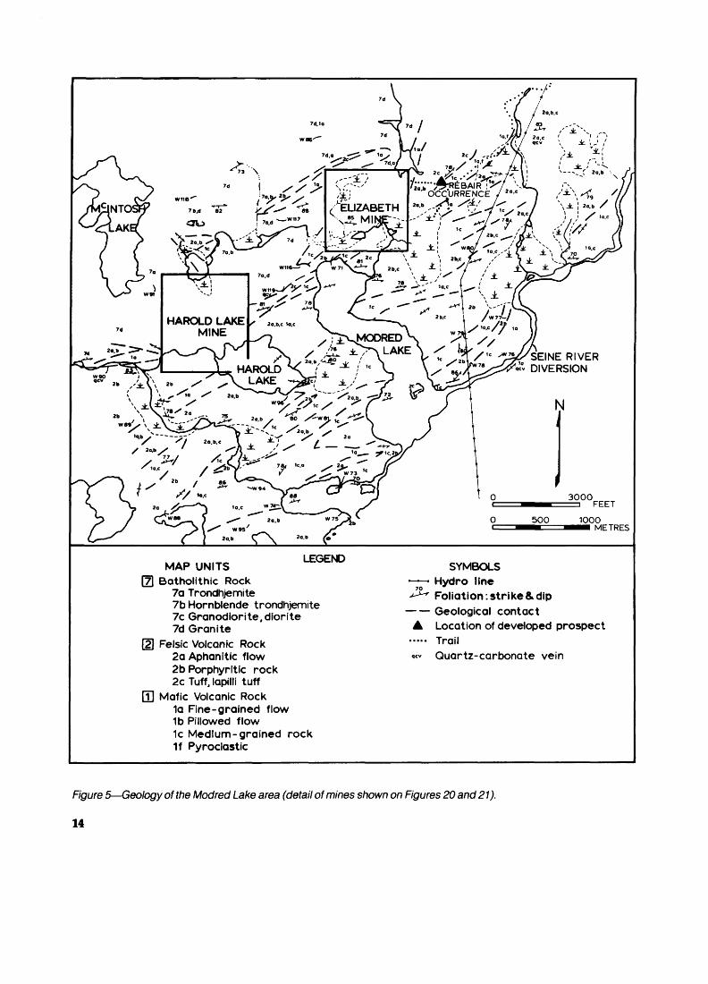
Similar contact zone intrusive rocks occupy embay- ments of the Dashwa Lake Batholith into the metavolcanic belts (Figures 4 and 5). These rocks occur as thin lensoid bodies of granodiorite, trondhjemite, and quartz monzon ite that are rarely more than 2 km in width or length. Xe noliths of the metavolcanics are not common. Rather, large blocks of the metavolcanics occur between the contact zone intrusions and the more granitic batholith.
Rocks associated with gold mineralization display lit tle textural or mineralogical variation from others of the contact zone. Thin, discontinuous shear zones host the mineralization. Only these sheared rocks appear altered to schists, the schists being composed of quartz, chlorite, muscovite, and occasionally albite with trace amounts of calcite, ankerite, and pyrite.
Tables 9 and 10 list the major element compositions and trace metal contents of representative samples of the contact zone rocks of the Marmion Lake and Dashwa Lake Batholiths, respectively. Due to the diversity of rock types no progressive changes or alterations are notable for associations with the mineralization, unlike the Mar mion Lake Batholith Type. In fact, there is little variation in chemistry for the samples which are megascopically sheared from those which are relatively unaffected.
The shear zones commonly trend parallel to local major lineaments but are rarely contained by such a
structure. Shearing is tracable along strike for distances of up to 1 km and commonly cuts several rock types. The maximum width ranges up to 10 m but averages 1 to 2 m.
Quartz-carbonate veins occur in the shear zones as ellipsoidal pods that measure up to 8 cm thick and 200 m long. Hawley (1930) was the first to note that the veins are commonly concentrated along the footwall of the shear zone at the interface between the schistose and relatively massive granitic rock. Angular fragments of both the schist and massive rocks are frequently contained by the vein and are intensely carbonated.
Grey to white quartz is the main constituent of the veins; present as aggregates of fine to coarse grains which display such classical strain textures as mortar structure and subgrain development. Microscopic string ers of secondary quartz crosscut the veins. This quartz is microcrystalline to very fine grained and is dusted with very fine opaque grains.
Ankerite and calcite are disseminated in the vein as fine- to medium-grained subhedra, and are also in string ers of fine grains with sericite, chlorite, and occasionally, arsenopyrite and sulphides. The stringers occur most abundantly near the hanging wall and give the vein a banded appearance. Pyrite, chalcopyrite, galena, and sphalerite are the principal sulphides and occupy up to 8 percent of the vein.
Metal content of the veins is irregular, as demon strated by the 10 analyses listed in Table 11. Gold occurs as very fine grains both in association with pyrite (Fenwick 1976a) and in the fine stringers of secondary quartz. Visible gold is rare but is found as fine leaflets along minute fractures in the veins. The silver content is apparently independent of the gold content, but is some what proportional to the amounts of galena, and occa sionally sphalerite.
Chromium is present in most of the veins in anoma lous to high amounts and is probably contained in a chrome-rich muscovite. Arsenopyrite is the only identified arsenic mineral, and like chromium, arsenic is commonly enriched in the vein. The presence of thse elements, how ever, is not a reliable indicator of a significant gold or sil ver content.
Metavolcanic-Hosted, Stratabound Type
The metavolcanic belts of the Atikokan area contain many occurrences of gold mineralization. Some occur rences are associated with chlorite-sericite-carbonate schists which contain small lenses of bedded chemical metasediments. The schists occur as stratiform, laterally continuous beds which pinch and swell along strike from a few metres to up to 300 m in thickness.
The relative abundance of sericite, chlorite, and car bonate varies considerably in the schists, with limited zones containing up to several percent pyrite, sphalerite, and chalcopyrite. Locally, the schists consist of lapilli- sized, sericite-rich fragments in a chlorite-carbonate ma trix; suggesting that the schists are highly carbonatized felsic tuffs or volcaniclastic sedimentary rocks.
13
SEINE RIVER DIVERSION
MAP UNITSLEGEND
Batholithic Rock 7a Trondhjemite 7b Hornblende trondhjemite 7c Granodiorite, diorite Td Granite
Felsic Volcanic Rock2a Aphanitic flow2b Porphyritic rock2c Tuff, lapilli tuff
Mafic Volcanic Rock1a Fine-grained flow1b Pillowed flow1c Medium-grained rock1f Pyroclastic
SYMBOLS ' —— - Hydro line
70
^^ Foliation. strike 8. dip — — Geological contact A Location of developed prospect
Quartz-carbonate vein
Figure 5—Geology of the Modred Lake area (detail of mines shown on Figures 20 and 21).
14

TABLE 9
SAMPLE NO.
Rock Type
Si02AI203Fe20sFeOMgOCaONa20K20Ti02P205MnOC02SH20"*"H 20~
TOTAL
Au(ppb)As(ppm)Cr(ppm)Cu(ppm)Pb(ppm)Zn(ppm)
MAJOR ELEMENT AND TRACE METAL COMPOSITIONS OF REPRESENTATIVE ROCK TYPES OF THE MARMION LAKE BATHOLITH CONTACT ZONE
W224
Diabasic Flow
46.415.03.296.493.092.104.830.000.880.110.110.320.172.570.28
99.4
51
320250
nd92
W202
Aphanitic Mafic Dike
48.812.83.00
11.95.815.991.980.001.390.120.243.490.072.370.42
100.7
nd1
45118nd
118
W237
Quartz Diorite
59.114.73.094.334.896.373.020.840.690.170.130.520.031.950.35
100.2
nd1
15574nd82
W225
Trondhjemite
73.212.90.722.250.981.735.290.500.380.050.081.260.020.950.25
100.5
ndnd66
nd36
TW30
Biotite Trondhjemite
69.915.8
1.421.331.102.784.321.730.360.150.040.100.020.790.29
100.1
ndnd95
1152
W205
Altered Diorite
56.116.32.224.664.193.185.750.740.610.090.113.980.042.420.36
100.7
30nd
1128
nd69
W201
Altered Trondhjemite
70.014.70.701.831.111.375.071.550.440.040.041.010.010.880.45
99.2
14ndnd
5nd28
nd = not detected
15
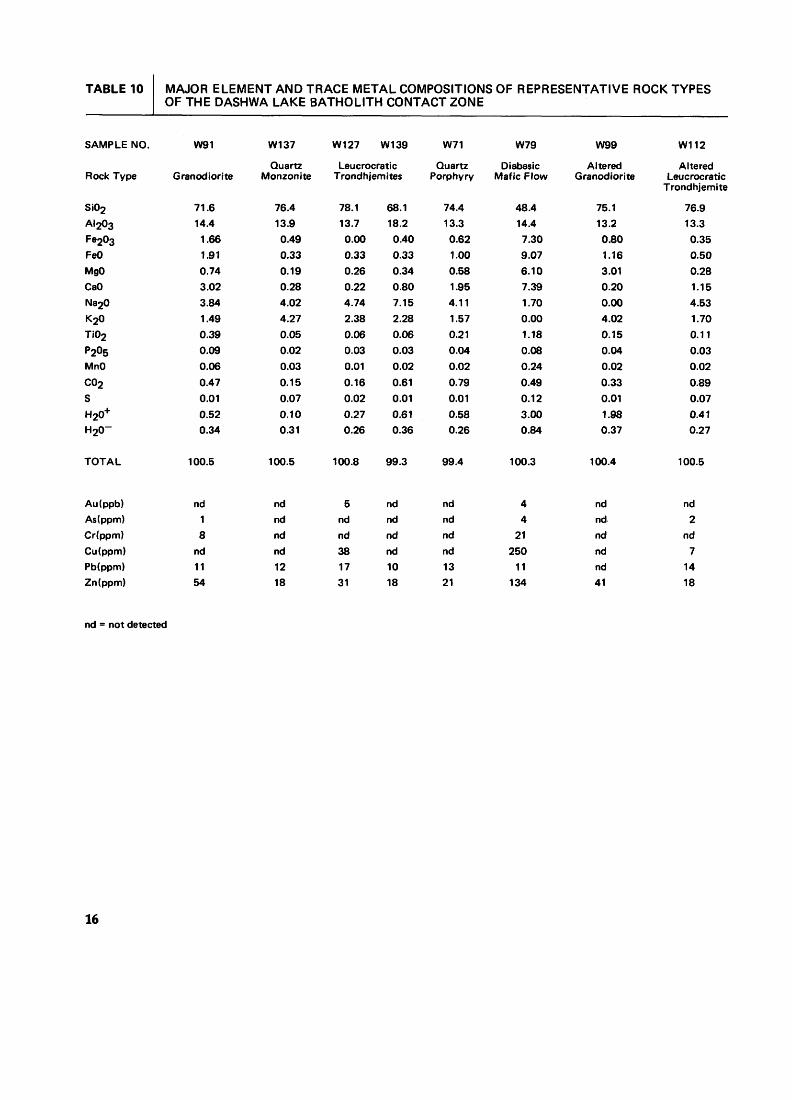
TABLE 10
SAMPLE NO.
Rock Type
Si02
AI203
Fe203
FeO
MgO
CaO
Na20
K20
Ti02
P205
MnO
C02
SH20"*"
H20~
TOTAL
Au(ppb)
As(ppm)
Cr(ppm)
Cu(ppm)
Pb(ppm)
Zn(ppm)
MAJOR ELEMENT AND TRACE METAL COMPOSITIONS OF REPRESENTATIVE ROCK TYPES OF THE DASHWA LAKE BATHOLITH CONTACT ZONE
W91
Granodiorite
71.6
14.4
1.66
1.91
0.74
3.02
3.84
1.49
0.39
0.09
0.06
0.47
0.01
0.52
0.34
100.5
nd
1
8
nd
11
54
W137
Quartz Monzonite
76.4
13.9
0.49
0.33
0.19
0.28
4.02
4.27
0.05
0.02
0.03
0.15
0.07
0.10
0.31
100.5
nd
nd
nd
nd
12
18
W127 W139
Leucrocratic Trondhjemites
78.1
13.7
0.00
0.33
0.26
0.22
4.74
2.38
0.06
0.03
0.01
0.16
0.02
0.27
0.26
100.8
5nd
nd
3817
31
68.1
18.2
0.40
0.33
0.34
0.80
7.15
2.28
0.06
0.03
0.02
0.61
0.01
0.61
0.36
99.3
nd
nd
nd
nd
10
18
W71
Quartz Porphyry
74.4
13.3
0.62
1.00
0.58
1.95
4.11
1.57
0.21
0.04
0.02
0.79
0.01
0.58
0.26
99.4
nd
nd
nd
nd
13
21
W79
Diabasic Mafic Flow
48.4
14.4
7.30
9.07
6.10
7.39
1.70
0.00
1.18
0.08
0.24
0.49
0.12
3.00
0.84
100.3
4
4
21
25011
134
W99
Altered Granodiorite
75.1
13.2
0.80
1.16
3.01
0.20
0.00
4.02
0.15
0.04
0.02
0.33
0.01
1.980.37
100.4
nd
nd
nd
nd
nd
41
W112
Altered Leucrocratic
Trondhjemite
76.9
13.3
0.35
0.50
0.28
1.15
4.53
1.70
0.11
0.03
0.02
0.89
0.07
0.41
0.27
100.5
nd
2
nd
7
14
18
nd = not detected
16
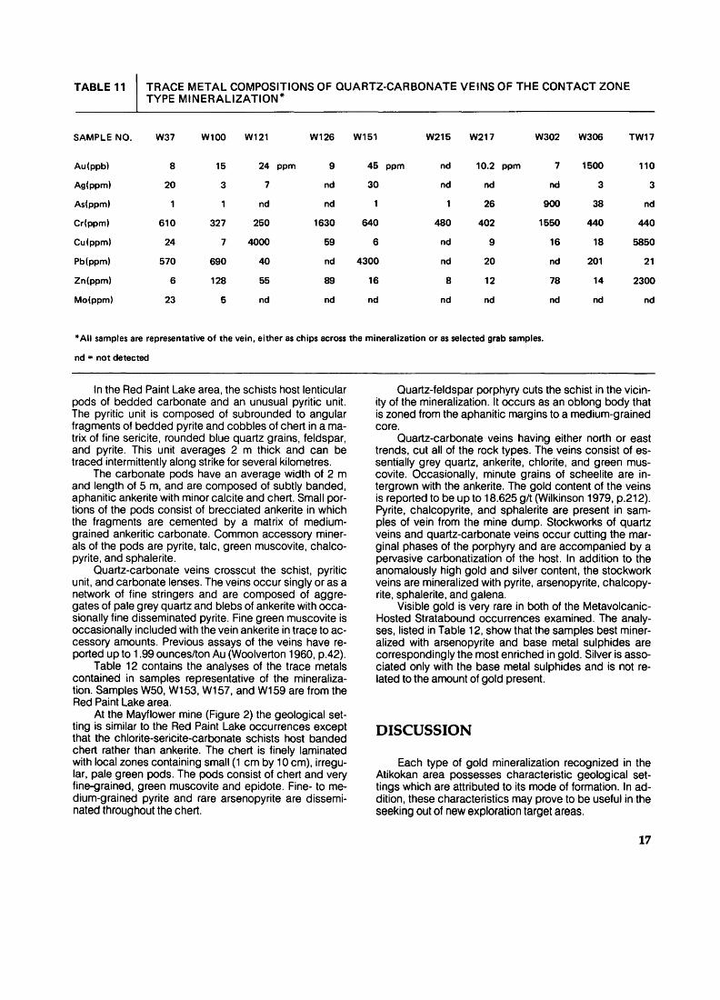
TABLE 11 TRACE METAL COMPOSITIONS OF QUARTZ-CARBONATE VEINS OF THE CONTACT ZONE TYPE MINERALIZATION*
SAMPLE NO. W37 W100 W121 W126 W151 W215 W217 W302 W306 TW17
Au(ppb)
Ag(ppm)
As(ppm)
Cr(ppm)
Cu(ppm)
Pb(ppm)
Zn(ppm)
Mo(ppm)
8
20
1
610
24
570
6
23
15
3
1
327
7
690
128
5
24 ppm
7
nd
250
4000
40
55
nd
9
nd
nd
1630
59
nd
89
nd
45 ppm
30
1
640
6
4300
16
nd
nd
nd
1
480
nd
nd
8
nd
10.2 ppm
nd
26
402
9
20
12
nd
7
nd
900
1550
16
nd
78
nd
1500
3
38
440
18
201
14
nd
110
3
nd
440
5850
21
2300
nd
*AII samples are representative of the vein, either as chips across the mineralization or as selected grab samples,
nd = not detected
In the Red Paint Lake area, the schists host lenticular pods of bedded carbonate and an unusual pyritic unit. The pyritic unit is composed of subrounded to angular fragments of bedded pyrite and cobbles of chert in a ma trix of fine sericite, rounded blue quartz grains, feldspar, and pyrite. This unit averages 2 m thick and can be traced intermittently along strike for several kilometres.
The carbonate pods have an average width of 2 m and length of 5 m, and are composed of subtly banded, aphanitic ankerite with minor calcite and chert. Small por tions of the pods consist of brecciated ankerite in which the fragments are cemented by a matrix of medium- grained ankeritic carbonate. Common accessory miner als of the pods are pyrite, talc, green muscovite, chalco pyrite, and sphalerite.
Quartz-carbonate veins crosscut the schist, pyritic unit, and carbonate lenses. The veins occur singly or as a network of fine stringers and are composed of aggre gates of pale grey quartz and blebs of ankerite with occa sionally fine disseminated pyrite. Fine green muscovite is occasionally included with the vein ankerite in trace to ac cessory amounts. Previous assays of the veins have re ported up to 1.99 ounces/ton Au (Woolverton 1960, p.42).
Table 12 contains the analyses of the trace metals contained in samples representative of the mineraliza tion. Samples W50, W153, W157, and W159 are from the Red Paint Lake area.
At the Mayflower mine (Figure 2) the geological set ting is similar to the Red Paint Lake occurrences except that the chlorite-sericite-carbonate schists host banded chert rather than ankerite. The chert is finely laminated with local zones containing small (1 cm by 10 cm), irregu lar, pale green pods. The pods consist of chert and very fine-grained, green muscovite and epidote. Fine- to me dium-grained pyrite and rare arsenopyrite are dissemi nated throughout the chert.
Quartz-feldspar porphyry cuts the schist in the vicin ity of the mineralization. It occurs as an oblong body that is zoned from the aphanitic margins to a medium-grained core.
Quartz-carbonate veins having either north or east trends, cut all of the rock types. The veins consist of es sentially grey quartz, ankerite, chlorite, and green mus covite. Occasionally, minute grains of scheelite are in- tergrown with the ankerite. The gold content of the veins is reported to be up to 18.625 g/t (Wilkinson 1979, p.212). Pyrite, chalcopyrite, and sphalerite are present in sam ples of vein from the mine dump. Stockworks of quartz veins and quartz-carbonate veins occur cutting the mar ginal phases of the porphyry and are accompanied by a pervasive carbonatization of the host. In addition to the anomalously high gold and silver content, the stockwork veins are mineralized with pyrite, arsenopyrite, chalcopy rite, sphalerite, and galena.
Visible gold is very rare in both of the Metavolcanic- Hosted Stratabound occurrences examined. The analy ses, listed in Table 12, show that the samples best miner alized with arsenopyrite and base metal sulphides are correspondingly the most enriched in gold. Silver is asso ciated only with the base metal sulphides and is not re lated to the amount of gold present.
DISCUSSION
Each type of gold mineralization recognized in the Atikokan area possesses characteristic geological set tings which are attributed to its mode of formation. In ad dition, these characteristics may prove to be useful in the seeking out of new exploration target areas.
17

TABLE 12 TRACE METAL COMPOSITIONS OF METAVOLCANIC-HOSTED STRATABOUND TYPE MINERALIZATION
Red Paint Lake occurrences (Figure 2)
SAMPLE NO. W50 W153 W157 W158 W159
Rock Type
Au(ppb)
Ag(ppm)
As(ppm)
Cr(ppm)
Cu(ppm)
Pb(ppm)
Zn(ppm)
Pyritic Unit
938
nd
80
292
44
13
22
Bedded Ankerite
12
nd
nd
335
14
nd
15
QuartzCarbonate
Vein
3
nd
nd
400
nd
nd
15
Chlorite-Sericite-Carbonate
Schist
343
nd
43
110
45
13
64
Bedded Ankerite
35
4
nd
257
190
12
7.85%
Mayflower mine (Figure 2)
SAMPLE NO. W243 W252 W256 W260 W263
Rock Type
Au(ppb)
Ag(ppm)
As(ppm)
Cr(ppm)
Cu(ppm)
Pb(ppm)
Zn(ppm)
nd - not detected
Chlorite- Sericite-Carbonate
Schist
19
nd
34
404
36
nd
38
Banded Chert
3
nd
310
225
10
11
6
Banded Chert
with Pale Green Pods
20
nd
62
700
32
15
32
Quartz Carbonate
Vein
38
4
28
364
1180
43
23
Prophyry with
Stockwork Quartz Vein
2100
4
405
277
490
290
25
The Marmion Lake Batholith Type mineralization is typified by its association with:
* north- to northeast-trending sets of lineaments,* massive (non-gneissic) trondhjemites, and* laterally extensive zones of shearing and alteration.The lineaments may or may not be the eroded ex
pression of faults as suggested by Fenwick (1976a) and Shklanka (1972). Zones of sheared or mylonitized rock are commonly associated with the lineaments but offsets are difficult, if not impossible, to identify within the gneis sic core of the batholith. However, the lineaments or lines of weakness were present during the formation of the
batholith, as evidenced by the massive trondhjemites. These trondhjemites form lenticular intrusions parallel to, or contained within, the lineaments.
The lineaments traverse the batholith both singly and as closely spaced sets. Gold mineralization is not neces sarily associated with all lineaments. Rather, it may be possible to delineate particular ones or sets which are re lated with gold. For example, the Reserve Island occur rence, and the Sunbeam and Roy mines occur along an extension of the same structure, as may the Sawbill, Hammond Reef, and Golden Winner mines.
The primary host of the gold mineralization is mas-
18
sive trondhjemite. The rock is always somewhat altered to be sericite- and epidote-bearing, but in association with mineralization it is completely saussuritized and carbona- tized. Associated with the alteration of these rocks are fracture and shear zones, which intensify with increasing proximity to the mineralization. Shearing has resulted in the physical and chemical transformation of massive trondhjemite into a chlorite-sericite-carbonate schist over distances ranging from 5 to 150 m.
The quartz veins in the shear zone schists contain the gold, frequently in economic concentrations. The vein quartz displays excellent mortar structure suggesting that the vein was sheared subsequent to its formation, however, carbonate and sulphide minerals in the veins possess few features to suggest that they underwent any shearing or mylonitization following their deposition.
Gold is present in the free state as fine to micro scopic grains in microcrystalline intergranular mortar- structured quartz. Grains of gold were not found in asso ciation with sulphides, despite the good analytical values of the metal. Thus, gold may also occur as submicro- scopic inclusions in the sulphides.
It is apparent from the field relations and vein petrog raphy that the formation of the Marmion Lake Batholith Type mineralization was a succession of three episodes:
1. opening of the lineaments in the batholith with subsequent intrusion of the massive trondhjem- ites,
2. shearing along the lineaments with accompanying hydrothermal activity and formation of the quartz veins, and
3. reshearing of the veins and subsequent deposi tion of base metal sulphides and gold.
The vein mineralization of the Contact Zone Type oc curs in the complex of felsic intrusive and metavolcanics which border the batholiths of the area. Morgan (1978), Fenwick (1976a), Woolverton (1960), and Moore (1940) interpreted the contact zone as a separate phase of the batholith. Wilkinson (1979) defined a separate mineraliza tion type hosted by these rocks.
The plutonic rocks are, on the average, more mafic than the massive trondhjemites that occur in the gneissic core of the batholith and consist primarily of quartz dior- ites and biotite trondhjemites with only subsidiary leucoc ratic trondhjemites and granites. This more mafic charac ter of the rocks is probably the result of partial assimilation of the mafic metavolcanic xenoliths which comprise significant portions of the contact zone (Pitcher and Berger 1972).
The common foliation of the metavolcanics and felsic plutonic rocks implies that these rocks were deformed after the intrusive event. Pirie (1978) suggested that the foliation developed as the batholith moved upward, rela tive to the more dense volcanic rocks during a period of isostatic readjustment. Local zones of weakness in the contact zone would have been more deformed during that period and would have resulted in linear zones of highly sheared rock.
The hydrothermal activity that accompanied the tec tonism produced regional saussuritization, chloritization, and carbonatization of the contact zone rocks. Pervasive
alteration and silicification occurred in the more highly sheared zones to produce the chloritic schists and asso ciated quartz veins.
The veins commonly occur along the interface be tween the hanging-wall chloritic schist and relatively un- sheared plutonic rock footwall. Fragments of the wall rocks, particularly of the footwall, occur within the quartz vein suggesting that the vein was deposited during a pe riod of deformation. The vein quartz also appears brecci ated or mylonitized, being highly fractured and possess ing mortar structure.
The sulphide minerals are most commonly concen trated along subparallel fractures, giving the veins a banded appearance. Many of the pyrite and arsenopyrite grains are broken or fractured.
Stringers of light grey, unstrained, fine-grained quartz, and occasionally ankerite, cut the quartz veins. Gold is associated with these stringers, and is occasion ally present along fine fractures in the veins. The gold is in the free state even where associated with pyrite and the other sulphides (Fenwick 1976a). It is rare to find visible gold occurring as fine leaflets in quartz and as fine wire with sulphides.
The Contact Zone Type mineralization, not unlike the Marmion Lake Batholith Type, can be related to a se quence of events:
1. intrusion of the felsic plutonic rocks into the vol canic pile,
2. diapiric upwelling of the batholith with subsequent deformation, alteration, and probably formation of the veins, and
3. continued deformation and hydrothermal activity producing late silicification and deposition of sul phides and gold in the veins.
The Volcanic-Hosted, Stratabound Type mineraliza tion occurs in the predominantly mafic, metavolcanic belts, in laterally extensive beds of chlorite-sericite-car bonate schist. The cherty or carbonate-rich lenses occur interbedded with the schist and pyrite-rich unit.
Locally, the chlorite-sericite-carbonate schist has the appearance of felsic tuff that has been extensively carbo- natized. The cherty and carbonate lenses are distinctly banded like chemical sediments. Pirie (1980) proposed that the carbonatization of the felsic tuffs occurred during a hiatus in the volcanism. Fumarolic activity would have taken place, leading to the deposition of the chemical sediments on the sea floor and penecontemporaneous alteration of the underlying rock. Gold and base metal sulphides would also have been concentrated in anoma lous but subeconomic amounts in the sediments, and al tered what is now the hosting schist.
The most interesting gold concentrations occur in the quartz and quartz-carbonate veins which crosscut the stratabound lenses and schists. These veins are epi genetic and can be related to events which postdate the formation of the host rocks. Woolverton (1960) showed that an extension zone of shearing at Red Paint Lake con tains many gold-bearing veins cutting the schist. At the Mayflower mine, the schist is cut by a quartz-feldspar porphyry; both rock types host auriferous quartz and quartz-carbonate veins.
19
The hydrothermal solutions generated by either the heat lost during crystallization of the porphyry or the dy namic metamorphism of the shearing could have con ceivably collected gold and base metals from the sur rounding rocks already enriched in the metals. The veins formed in fractures in the host rocks by deposition of quartz from the solutions simultaneously with subsidiary ankerite, sulphides, and gold. As a result, the veins con tain little (if any) visible or free state gold, but rather the best enrichment is associated with a high sulphide con tent. Similar mechanisms of ore formation have been pro posed by Karvinen (1980) and Pirie (1980) for the Tim mins and Red Lake mining camps, respectively.
In summary, the sequence of events which led to the formation of Metavolcanic-Hosted, Stratabound Type de posits in the Atikokan area is:
1. fumarolic activity on the ancient ocean floor pro duced penecontemporaneous deposits of chemi cal sediments and syngenetic alteration of sea floor rocks, with accompanying enrichment of gold and base metal sulphides,
2. burial by subsequent volcanism and/or sedimen tation,
3. an event such as shearing (faulting) and/or the in trusion of hypabyssal bodies of porphyry gener ated hydrothermal solutions, and
4. formation of the auriferous veins with base metal sulphides.
2. The geological mapping of outcrops adjacent to and within the lineaments is the most effective means of delineation of the massive trondhjem- ites. Occurrences of carbonatized and sheared trondhjemite would be indicative of possible nearby mineralization.
3. Since the lineaments contain few exposures of bedrock, geophysical and geochemical surveys might prove useful.
a) A detailed magnetometer survey could deli neate the linear zones of intense shearing and alteration. Such zones should be defined by magnetic depressions.b) The geochemical analyses of wall rock for trace gold, particularly hanging-wall rocks of shear zones, could be effective in determining the vicinity of mineralization. As shown previ ously the hanging-wall rocks are occasionally enriched in gold.c) Drilling through and sampling the overburden may be an effective means of detecting exten sions of known veins or discovering new ones. Chemical analysis of overburden for such met als as copper, lead, zinc, and silver has been suggested by Boyle (1979) for indications of gold mineralization.
RECOMMENDATIONS FOR FUTURE EXPLORATION
The search for gold in the Atikokan area was origi nally concentrated in the areas of granitic terrain. Conse quently, the productive deposits were largely associated with the batholithic rocks. Most of the deposits were prob ably discovered as a result of extensive ground work in search of quartz vein outcrops. Recent geological map ping of the area (e.g. Fenwick 1976a) and studies of other gold camps (e.g. Roberts 1980; Boyle 1979) have gener ated new concepts of genesis and geological settings on which to base exploration.
The following is a summary of suggestions for the ex ploration of new gold deposits in the Atikokan area. Each of the three types of deposit is dealt with separately since each possesses distinct characteristics in both geologi cal setting, and to a lesser extent, mineralization.
Marmion Lake Batholith Type
1. The mapping of the lineaments would be useful and is most effectively done by interpretation of large-scale air photographs. Particular emphasis should be placed on extensions of those linea ments already known to be associated with gold mineralization.
Contact Zone Type
1. The most effective exploration method requires geological mapping of batholith borders to locate the host shear zones.
2. Once found, the shear zones could be delineated with detailed magnetometer surveys. The aurifer ous veins are occasionally enriched in sulphide mineral and may, therefore, be located with de tailed electromagnetic surveys.
3. This type of deposit is not necessarily detectable using large-scale geophysical or geochemical means. It occurs as relatively small targets and rarely contains sufficient metallic minerals to regis ter on regional surveys. Detailed geochemical sur veys might be useful.
Metavolcanic-Hosted, Stratabound Type
1. The chlorite-sericite-carbonate schist, a very ex tensive unit, is the primary host for this type of min eralization. It is commonly rich in sulphides and therefore may be expressed as a regional electro magnetic anomaly.
2. Once established, anomalies should be mapped to locate favourable geological settings for gold mineralization (i.e. shear zones or porphyries which cut the schist).
20
DESCRIPTIONS OF DEPOSITS
1. MINTO MINE
COMMODITYGoldROCK ASSOCIATIONVariably sheared leucocratic trondhjemiteCLASSIFICATIONMarmion Lake Batholith TypeLOCATIONHutchinson Township; northeast cornerLatitude 480 49'12"N; Longitude 91 0 16'22"EACCESSMine site is 8.8 km north of Sapawe along theDomtar-Woodlands access road (Figure 6).DESCRIPTIONGeneral Geology: Country rocks are foliated and gneissic varieties of trondhjemites. Sheets, dikes, and stringers of massive leucocratic trondhjemite cut the country rocks. Diabase occurs crosscutting all other units in northeast trending dikes. A major lineament runs through the mine property and can be traced for 27 km northeast from Sa pawe Lake.Mineralization: Quartz veins occur in a shear zone associ ated with the regional lineament. The veins and shearing strike northeast with near vertical southeast dips. Two main veins are exposed on the property. South vein has a strike length of at least 60 m and a maximum width of 4.9 m. North vein is located 305 m northeast of south vein and is exposed for 15 m along strike with a maximum width of 8.5 m. Both veins are composed of coarse grey quartz with minor pyrite, arsenopyrite, and ankerite. Wall rocks are chloritic schists containing trace to abundant pyrite, arsenopyrite, chalcopyrite, ankerite, and quartz. One fleck of gold was found in a dump sample of chloritic wall rocks.Size and Grade: No data available. Assays of MineralizationSample Description Au(gA) Ag(gA)
W13 Grab sample of 12 cm wide rustyquartz vein. 0.040 nd
W16 Chip sample across south vein. 0.003 nd W17 Hanging wall, chloritic schist. 0.006 nd W23 Dump sample quartz vein. 0.080 nd W37 Chip sample across north vein. 0.006 nd
DEVELOPMENT HISTORYPrior to 1903: Little Rock Consolidated Mining and
Development Company Ltd. sank shaft to depth of 15 m inclined SO'WSW.
1905: Same company deepened shaft to 16 m.1930: Property staked by J. Lumby but no further de
velopment.CURRENT OWNERSHIPM. Wicheruk, Atikokan, Ontario REFERENCE MAPSMap 38e, Sapawe Lake Area (Hawley 1930)Map 2065, Atikokan-Lakehead Sheet (Pye and Fenwick1965)Map P.2388, Sapawe Lake Area, District of Rainy River,East Half (Mcilwaine and Larsen 1981 a)
Map P.2389, Sapawe Lake Area, District of Rainy River, West Half (Mcilwaine and Larsen 1981 b) SELECTED REFERENCESCarter (1904) Corkill (1906, p.48-50) Hawley (1930, p.39-40) Wilkinson (1979)
2. RESERVE ISLAND OCCURRENCE
COMMODITYGoldROCK ASSOCIATIONBiotite trondhjemite gneissCLASSIFICATIONMarmion Lake Batholith Type LOCATIONMarmion Lake areaLatitude 480 50'30"N; Longitude 91 0 19'24"EACCESSAccess is by small boat via Marmion Lake from launchsites on the Clearwater West Lake road.DESCRIPTIONGeneral Geology: The Reserve Island property lies within a biotite trondhjemite gneiss. The gneiss is typically me dium grained granoblastic with the mafic minerals and the quartz and feldspar vaguely outlining the gneissic fol iation. A mafic dike appears to be intimately associated with the vein.Mineralization: The veins are composed of quartz with chlorite and some sulphides. The quartz encloses a mafic dike in places and is enclosed in the same dike at other locations. In some pits the dike is not present with the vein. The vein contains visible amounts of pyrite, galena, arsenopyrite, and visible gold.
The veins appear very similar to those that occur at the Sunbeam mine and are probably in an extension of the same shear zone.Size and Grade: Average grade is 7.89 g/t Au (MacRae 1978, p.206). -Assays of MineralizationSample Description Au(gA)
WM-080 Grab sample of vein quartz with minorchlorite and pyrite. 0.090
WM-081 Grab sample of vein quartz. 0.090 WM-082 Grab sample of vein quartz with trace
pyrite and visible gold. 0.030 WM-083 Grab sample of vein quartz with trace galena. 0.070 WM-084 Grab sample of vein quartz with trace
pyrite and visible gold. 0.140 WM-085 Grab sample of vein quartz with trace
pyrite, chalcopyrite, galena, arsenopyrite,and visible gold. 6.565
DEVELOPMENT HISTORY1898: Test pits and trenches excavated. 1899: Shaft sunk to 63 feet.
REFERENCE MAPSMap 38e, Sapawe Lake Area (Hawley 1930)Map 2065, Atikokan-Lakehead Sheet (Pye and Fenwick1965)SELECTED REFERENCESBow (1898,1899)
21

x l1000 FEET
250 METRES
LEGENDMAP UNITS
[s] Mafic Dike
\7] Batno(ithk: Ftock (non-fofarted) 7a trondhjemite
[e] Felsic Intrusive Rock (gneissic or foliated)
6a hornblende trondhjemite 6b trondhjemite 6c amphibolite, hornblende gneiss
SYMBOLS
\Sf Shaft and mine dump ^,—— Geological contactIT Test pit ,^'j;* Area of many outcrops
6123 Trench cs Large outcropQ BuiWing x s,^ outcrop'"" J^"^ ^- Foliation:strike S.dip—— Road ^ g^
——— Pipeline^. —^ Lineament qv Quartz vein
Figure 6—Geology of the Minto mine and vicinity.
22
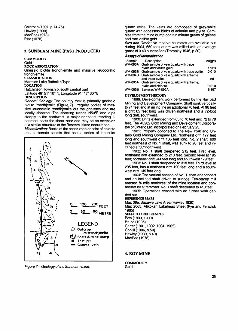
Coleman (1897, p.74-75) Hawley (1930) MacRae(1978) Pirie (1978)
3. SUNBEAM MINE (PAST PRODUCER)
COMMODITYGoldROCK ASSOCIATIONGneissic biotite trondhjemite and massive leucocratic trondhjemiteCLASSIFICATIONMarmion Lake Batholith Type LOCATIONHutchinson Township; south central part Latitude 480 51' 10"N; Longitude 91 0 17'30"E DESCRIPTIONGeneral Geology: The country rock is primarily gneissic biotite trondhjemite (Figure. 7). Irregular bodies of mas sive leucocratic trondhjemite cut the gneisses and are locally sheared. The shearing trends N500E and dips steeply to the northwest. A major northeast-trending li neament hosts the shear zone and may be an extension of a similar structure at the Reserve Island occurrence. Mineralization: Rocks of the shear zone consist of chlorite and carbonate schists that host a series of lenticular
0^
o1OO 20O
30 60FEET
METRE
LEGEND'*x Outcrop ^j^ 7a trondhjemite JJ/ Shaft 4. mine dump B Test pit —- Quartz vein
Figure 7—Geology of the Sunbeam mine.
quartz veins. The veins are composed of grey-white quartz with accessory blebs of ankerite and pyrite. Sam ples from the mine dump contain minute grains of galena and rare visible gold.Size and Grade: No reserve estimates are available but during 1904, 650 tons of ore was milled with an average grade of 0.43 ounces/ton (Tremblay 1946, p.20)Assays of Mineralization
Sample Description Au(gA) WM-093A Grab sample of vein quartz with trace
pyrite and visible gold. 1.923 WM-093B Grab sample of vein quartz with trace pyrite. 0.010 WM-094B Grab sample of vein quartz with ankerite
and trace pyrite. nd WM-095A Grab sample of vein quartz with ankerite,
pyrite and chlorite. 0.010 WM-095B Same as WM-095A. 6.367
DEVELOPMENT HISTORY1899: Development work performed by the Railroad
Mining and Development Company. Shaft sunk vertically to 71 feet and at an incline an additional 70 feet. At 96 feet a drift 65 feet long was driven northeast and a 72-foot long drift, southwest.
1900: Drifts extended from 65 to 70 feet and 72 to 78 feet. The AL282 Gold Mining and Development Corpora- ton of Ontario Ltd. incorporated on February 23.
1901: Property optioned to The New York and On tario Gold Mining Company Ltd. Northeast drift 177 feet long and southwest drift 105 feet long. No. 2 shaft, 600 feet northeast of No. 1 shaft, was sunk to 20 feet and in clined at 500 northwest.
1902: No. 1 shaft deepened 212 feet. First level, northeast drift extended to 210 feet. Second level at 195 feet; northeast drift 244 feet long and southwest 179 feet.
1903: No. 1 shaft deepened to 318 feet. Third level at 295 feet, has a northeast drift 120 feet long and a south- west drift 145 feet long.
1904: The vertical section of No. 1 shaft abandoned and an inclined shaft driven to surface. Ten-stamp mill erected 34 mile northwest of the mine location and con nected by a tramroad. No. 1 shaft deepened to 410 feet.
1905: Operations ceased with no further work car ried out.REFERENCE MAPSMap 38e, Sapawe Lake Area (Hawley 1930)Map 2065, Atikokan-Lakehead Sheet (Pye and Fenwick1965)SELECTED REFERENCESBow (1899,1900)Bruce (1925)Carter (1901,1902,1904,1905)Corkill (1906, p.50)Hawley (1930, p.40)MacRae(1978)
4. ROY MINE
COMMODITYGold
23
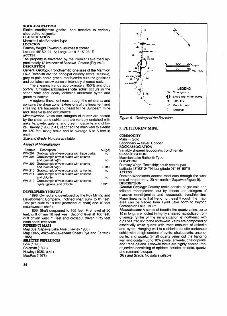
ROCK ASSOCIATIONBiotite trondhjemite gneiss, and massive to variably sheared trondhjemiteCLASSIFICATIONMarmion Lake Batholith Type LOCATIONRamsay Wright Township; southeast corner Latitude 480 52'24"N; Longitude 91 0 16'03"E ACCESSThe property is traversed by the Premier Lake road ap proximately 13 km north of Sapawe, Ontario (Figure 8). DESCRIPTIONGeneral Geology: Trondhjemitic gneisses of the Marmion Lake Batholith are the principal country rocks. Massive, grey to pale apple green trondhjemite cuts the gneisses and contains narrow zones of intensely sheared rock.
The shearing trends approximately N500E and dips 550NW. Chlorite-carbonate-sericite schist occurs in the shear zone and locally contains abundant pyrite and green muscovite.
A regional lineament runs through the mine area and contains the shear zone. Extensions of the lineament and shearing are traceable southeast to the Sunbeam mine and Reserve Island occurrence. Mineralization: Veins and stringers of quartz are hosted by the shear zone schist and are variably enriched with ankerite, pyrite, galena, and green muscovite and chlor ite. Hawley (1930, p.41) reported the main vein to extend for 450 feet along strike and to average 6 to 8 feet in width. Size and Grade: No data available.Assays of Mineralization
Sample Description Au(gA) WM-207 Grab sample of vein quartz with trace pyrite. nd WM-208 Grab sample of vein quartz with chlorite
and tou rmal i ne(?). nd WM-209 Grab sample of vein quartz with chlorite
and tourmaline(?). 0.010 WM-210 Grab sample of vein quartz with ankerite. nd WM-211 Grab sample of vein quartz with ankerite
and chlorite. nd WM-212 Grab sample of vein quartz with ankerite,
pyrite, galena, and chlorite. 0.320
DEVELOPMENT HISTORY1898: Owned and developed by the Roy Mining and
Development Company. Inclined shaft sunk to 81 feet. Test pits sunk to 18 feet (northeast of shaft) and 10 feet (southwest of shaft).
1899: Shaft deepened to 105 feet. First level at 50 feet, drift driven 10 feet west. Second level at 100 feet, drift driven west 71 feet and crosscut driven 17V2 feet north and 9 feet south.REFERENCE MAPSMap 38e, Sapawe Lake Area (Hawley 1930)Map 2065, Atikokan-Lakehead Sheet (Pye and Fenwick1965)SELECTED REFERENCESBow (1898)Coleman (1898)Hawley (1930, p.41)MacRae(1978)
- ll ±
100
30
20OFEET
60 1=3 METRES
WM-212-^7aJ li. Nj l i 7a
LEGEND7a Trondhjemite
I^J Shaft and mine dump m Test pit X Quartz vein
O Outcrop
F/'gure 8—Geology of the Roy mine.
5. PETTIGREW MINE
COMMODITYMain — GoldSecondary — Silver, CopperROCK ASSOCIATIONVariably sheared leucocratic trondhjemiteCLASSIFICATIONMarmion Lake Batholith Type LOCATIONRamsay Wright Township; south central part Latitude 480 53' 24"N; Longitude 91 0 16' 50"E ACCESSDomtar-Woodlands access road cuts through the west end of the property, 20 km north of Sapawe (Figure 9).DESCRIPTIONGeneral Geology: Country rocks consist of gneissic and foliated trondhjemites, cut by sheets and stringers of massive trondhjemites and leucocratic trondhjemites. Major lineaments that trend northeast through the map- area can be traced from Tyrell Lake north to beyond Companion Lake, 19 km.Mineralization: A series of boudin-like quartz veins, up to 15m long, are hosted in highly sheared, epidotized tron dhjemite. Strike of the mineralization is northeast with dips of 450 to 650 to the northwest. Veins are composed of essentially white quartz with trace amounts of ankerite and pyrite. Hanging wall is a chlorite-sericite-carbonate schist with a high content of pyrite, chalcopyrite, arseno pyrite, and quartz. Small quartz veins cut the hanging wall and contain up to 10^o pyrite, ankerite, chalcopyrite, and trace galena. Footwall rocks are highly altered tron dhjemites consisting of epidote, sericite, chlorite, quartz, and remnant feldspar. Size and Grade: No data available.
24
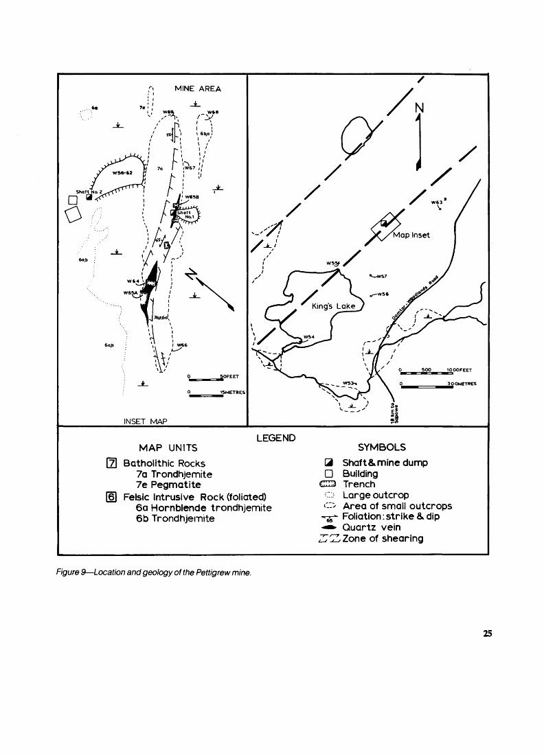
MINE AREA
INSET MAP
/
MAP UNITSLEGEND
Batholithic Rocks7a Trondhjemite7e Pegmatite
Felsic Intrusive Rock (foliated)6a Hornblende trondhjemite6b Trondhjemite
SYMBOLS3 Shaft8, mine dumpD Building
TrenchLarge outcrop Area of small outcrops Foliation: strike b. dip Quartz vein Zone of shearing
Figure 9—Location and geology of the Pettigrew mine.
25
Assays of MineralizationSample Description Au(g7t) Ag(gA)
W64 Chip sample across southern vein. 0.040 ndW65A Chip sample across southern vein. 0.018 ndW65B Chip sample across northern vein. 0.017 nd
79-LPG-1 Grab sample of quartz-carbonatevein from mine dump. 0.343 nd
79-LPG-4Grab sample of quartz-carbonatevein from mine dump. 2.058 5
DEVELOPMENT HISTORYPrior to 1898: Veins discovered by prospector
named King. No. 1 shaft declined to depth of 25 feet at angle of 650NW. Pettigrew obtained property from King.
1899: No. 2 shaft developed vertically to depth of 33 m with 19.4 m crosscut at the 30 m level.
1940: Property re-examined by Sylvanite Gold Mines Ltd., but no further development.CURRENT OWNERSHIPGovernment of OntarioREFERENCE MAPMap 2065, Atikokan-Lakehead Sheet (Pye and Fenwick1965)SELECTED REFERENCESBow (1900, p.79-80)Hawley (1930, p.41)Wilkinson (1979)
6. HAWK BAY OCCURRENCE
COMMODITYGoldROCK ASSOCIATIONBiotite trondhjemite gneiss and minor massive to variably sheared trondhjemiteCLASSIFICATIONMarmion Lake Batholith TypeLOCATIONMarmion Lake area, immediately east of Ramsay WrightTownshipLatitude 480 54' 00"N; Longitude 91 0 22' 18"EACCESSHawk Bay is accessible using a small boat launched on Marmion Lake from sites on the Clearwater West Lake road (Figure 10).DESCRIPTIONGeneral Geology: Biotite trondhjemite gneisses are the principal country rocks. The massive to variably sheared trondhjemite and leucocratic trondhjemite occur locally to the mineralization and contain two parallel zones of shearing approximately 40 m apart. The shearing trends N250E and is traceable for up to 3.2 km along strike (Bow 1898).Mineralization: Quartz veins occur in each of the shear zone chloritic schists. The veins are irregular in outline but average 0.6 m in width and are abundant over the en tire length of the shear zone. The veins consist essentially of grey quartz with occasionally ankerite and pyrite pres ent. Size and Grade: No data available.
-Assays of MineralizationSample Description Au(gTt)
WM-086 Grab sample of vein quartz with ankeritepyrite and chlorite. 0.040
WM-087 Grab sample of barren vein quartz. 0.730 WM-088 Grab sample of vein quartz with ankerite
and pyrite. 0.280
DEVELOPMENT HISTORY1898: Two shafts completed by The Hawk Bay Gold
Mining Company Ltd. Shafts achieved final depths of 25 m and 27 m, and were located 130 m apart. Work sus pended in September of the same year.REFERENCE MAPSMap 38e, Sapawe Lake Area (Hawley 1930)Map 2065, Atikokan-Lakehead Sheet (Pye and Fenwick1965)Map 2298, Marmion Lake (Fenwick 1976a)SELECTED REFERENCESBow (1898)Coleman (1898, p. 132)Fenwick (1976a)Hawley (1930, p.42)MacRae(1978)
7. GOLDEN WINNER MINE (PAST PRODUCER)
COMMODITYGoldROCK ASSOCIATIONGneissic biotite trondhjemites and massive to variably sheared leucocratic trondhjemiteCLASSIFICATIONMarmion Lake Batholith TypeLOCATIONNorway Lake area; 4 km southeast of Red Paint Lake Latitude 490 00' 18"N; Longitude 91 0 22'06"E ACCESSLogging roads of Domtar-Woodlands run through the original claim group, extending from the Premier Lake road, approximately 38 km north of Sapawe.DESCRIPTIONGeneral Geology: The main host rock of the mineraliza tion is leucocratic trondhjemite which cuts the gneisses of the Marmion Lake Batholith. The trondhjemite is exten sively altered to epidote and sericite, with considerable carbonate locally. A northeast-trending lineament tran sects the mine area and extends south to the Hammond Reef and Sawbill mines. The sheared zone contained by the lineament consists of a chlorite-carbonate schist that strikes N250E and dips east at 450 . Mineralization:The quartz vein contained within the shear zone averages 1.5 m in width and crops out for approxi mately 100 m along strike. Ankerite, pyrite, and chlorite are contained in the quartz vein in trace to accessory amounts.Size and Grade: During 1900, 15 tons of ore were milled with an average grade of 0.29 ouncesAon Au (Tremblay 1946, p.21).
26

f
N
x-7a l (V
om O
1OOZZH30
200z^60
FEET
METRES
7aLEGEND
Trondhjemite
Shaft fi. mine dump
Quartz vein
Outcrop
wM-oee
HAWK BAY
Figure 10—Geology of the Hawk Bay mine.
27

Assays of MineralizationSample Description Au(g7t)
WM-096 Grab sample of vein quartz with traceankerite and pyrite. 0.120
WM-097 Grab sample of vein quartz withankerite and chlorite 0.020
WM-098 Same. 0.090 WM-099 Same. 0.030 WM-100 Same. 0.030
DEVELOPMENT HISTORY1899: The Gold Winner Mining Company of Ontario
Ltd., incorporated on December 13. Seven test pits sunk and a 150-foot crosscut stripped. Shaft started to be de veloped.
1900. Shaft sunk to 62 feet with first level at 62 feet and crosscut north 15 feet and south 80 feet. At 74 feet south, drifts 42 feet east and 38 feet west were driven. Five-stamp mill erected; operation ceased in October.REFERENCE MAPMap P. 1227, Gold Deposits of Ontario, West Central Sheet (Gordon 1977)SELECTED REFERENCESCarter (1901, p. 105) Fenwick (1976a) MacRae(1978)
8. SAWBILL MINE (UPPER SEINE MINE) (PAST PRODUCER)
COMMODITYMain — Gold Seconday — Silver ROCK ASSOCIATIONGneissic trondhjemites and amphibolites, and massive trondhjemitesCLASSIFICATIONMarmion Lake Batholith TypeLOCATIONMarmion Lake area; Sawbill BayLatitude 480 57' 04"N; Longitude 91 0 25' 46"EACCESSMine area (Figure 11) is accessible using a small boat launched on Marmion Lake from sites along the Clearwa ter West Lake road. Float-equipped plane could be used for landing on Sawbill Bay.DESCRIPTIONGeneral Geology: The mine is located approximately 3 km east of the batholith-metavolcanic belt contact in rocks of the Marmion Lake Batholith. Principal country rocks are gneissic trondhjemites, diorites, and amphibol ites that are cut by irregular dikes and sheets of massive biotite trondhjemite.
Two northeast-trending lineaments cross the mine area and contain zones of sheared rock. Intensity of shearing is variable, occurring over widths of approxi mately 5 to 100 m. In the cores of the sheared zones the rocks consist of chlorite-sericite-quartz and chlorite-seri- cite-carbonate schist. Mineralization: The mineralization consists of three quartz
veins contained with the shear zone schists. In addition to the grey milky quartz, the veins contain variable amounts of ankerite, pyrite, chalcopyrite, arsenopyrite, galena, and sphalerite.
The three veins are:a) Main or Sawbill vein strikes N25C E and dips 750SE.
It has a length of 245 m and averages approximately 1 m in width.
b) Sawbill Junior Vein is located 100 m west of the Main vein and strikes N160E with an 800E dip. This vein is 90 m long with an average width of 30 cm.
c) Williams vein is 300 m northeast of No. 1 shaft and strikes S650E with a vertical dip. The vein is 60 m long and has an average thickness of 60 cm. Size and Grade: From 1897 lio 1899, a total of 2,416 tons of ore was milled, with an average grade of 0.25 ounces/ ton Au (Tremblay 1940, p.22). During 1940-1941, another 2,952 tons of ore were milled (Ferguson et al. 1971, p.258).
Assays of Mineralization
Sample Description Au(gA) Ag(gA) WM-60 Grab sample of vein quartz. 2.025 nd WM-61 Same. 2.020 nd WM-62 Grab sample of vein quartz with
pyrite and trace galena. 0.855 nd WM-64 Grab sample of vein quartz. 0.120 nd W-282 Grab sample of vein quartz with
trace arsenopyrite. 0.900 nd W-283 Chip sample of quartz-carbonate
veins and chloritic schist withtrace arsenopyrite. 1.300 nd
W-284 Chip sample across main vein withtrace pyrite and galena. 80.000 nd
W-289 Grab sample of vein quartz. 2.900 nd W-290 Grab sample of vein quartz with trace
pyrite and visible gold. 55.000 2
DEVELOPMENT HISTORY1895: Vein discovered by Wiley brothers.1896: The Sawbill Lake Gold Mining Company Ltd.
incorporated. Shaft sunk to 145 feet, levels cut at 60 feet and 120 feet.
1897: Shaft deepened to 205 feet, 60-foot level ex tended. Air shaft sunk 186 feet south of main shaft.
1898: Shaft deepened to 230 feet.1899: Shaft deepened to 245 feet, 60-foot level ex
tended, 120-foot level extended. Sublevel established at 220 feet with a 9-foot winze; third level at 243 feet estab lished with winze 50 feet deep. Mine closed in fall.
1936: Upper Seine Gold Syndicate formed.1937: Upper Seine Gold Mines Ltd. incorporated.1938: Dewatered mine and sampled; 320 feet of
drifting done on third level.1939:600 feet of surface trenching.1940: Shaft dewatered and retimbered to 60-foot lev
el. 138 feet of drifting done on first level. Fifty ton amalga mation in mill put into operation at a rate of 20 tons per day.
1941: Drifting on all levels: first level -130 feet; sec ond level -100 feet; and third level - 42 feet. 150 feet of surface trenching. Mine closed on September 24.
28

SAWBILL BAY
J
LEGEND
N
200FEET
METRES
7a Trondhjemite Mafic dike
Property boundary Trail
Shaft^mine dump O Outcrop Test pit Trench Quartz vein
F/gure 7 f—Geology of the Sawbill mine.
29
PRODUCTION SUMMARYYear Au(g) Ag(g) Total Milled (t)
1897-1899 13 246 — 2 6621940 5 793 1 235 1 1811941 5 584 1 235 2 072
Total 24 623 2 470 5 915
Average Grade Au(g7t)
4.98 4.90 2.70 4.16
REFERENCE MAPSMap 2065, Atikokan-Lakehead Sheet (Pye and Fehwick1965)Map 2298, Marmion Lake (Fenwick 1976a)Map P. 1227, Gold Deposits of Ontario, West CentralSheet (Gordon 1977)SELECTED REFERENCESBow (1900, p.77-79) Bruce (1925, p. 1-34) Fenwick (1976a) Gardiner (1939) MacRae(1978) Wilkinson (1979)
9. HAMMOND REEF MINE (PAST PRODUCER)
COMMODITYMain — Gold Secondary — SilverROCK ASSOCIATIONBiotite trondhjemite gneisses and minor massive to vari ably sheared trondhjemiteLOCATIONMarmion Lake area; 0.25 km south of Sawbill Bay Latitude 480 56' 42"N; Longitude 91 0 26' 36"E ACCESSThe mine area is reached by small boat across Marmion Lake (Figure 12). Launch sites are on the Clearwater West Lake road.DESCRIPTIONGeneral Geology: Like the Sawbill Bay mine, the country rocks are composed of gneisses of the Marmion Lake Ba tholith. Shear zones cut the gneisses trending N250E and range up to 155 m thick. Lenticular bodies of leucocratic trondhjemites are associated with the shear zones and vary from weakly foliated to schistose. Minor lineaments contain the shear zones and converge to the south with a major northeast-trending lineament. This major structure continues north through the Sawbill mine area and possi bly the Golden Winner mine.Mineralization: The most intensely sheared rock consists of a chlorite-carbonate-sericite schist that ranges up to 9 m thick. Numerous quartz veins are hosted by these schists and range up to 2 m thick and 50 m long. Ankerite is the most common accessory in veins, and pyrite, gale na, chalcopyrite, and sphalerite are present sporadically. Visible gold is not uncommon in vein quartz samples. Size and Grade: In 1897, 977 tons of ore were milled with an average grade of 0.30 ounces/ton Au (Tremblay 1940, p.22).
Assays of Mineralization
Sample Description Au(gXt) Ag(g7t) WM-067 Grab sample of chlorite-
carbonate schist. 2.000 — WM-069 Grab sample of quartz-carbonate
stringer in chlorite schist. 0.140 — WM-072 Grab sample of vein quartz
with ankerite. 0.030 — WM-073 Grab sample of vein quartz. 0.140 — WM-074 Grab sample of vein quartz
with pyrite. 0.400 — WM-075 Same as WM-074. 0.030 —
W-299 Chip sample across quartz vein withtrace ankerite and pyrite. 0.360 2
W-301 Chip sample across quartz vein withankerite, sphalerite, chalcopyrite,and trace arsenopyrite. 5.600 4
DEVELOPMENT HISTORY1895: Discovered by an Indian named Kabascong
(or Joe Mistahasen).1896: Property taken by Mr. James Hammond and
Mr. Henry Folger. Property explored by 14 shafts, open cuts, and adits.
1897: The Hammond Gold Reef Mining Company Ltd. was formed on March 17.The Folger Hammond Mines Company Ltd. was formed on October 7, No. 3 open cut excavated 300 feet long and 20 feet deep. South of No. 3 open cut a trench 97 feet long, 40 feet wide and 38 feet deep was dug. On claim 338X a test shaft was sunk to 80 feet. At 60 feet a drift was driven east for 20 feet and west for 17 feet. No. 2 open cut, 47 feet long, 9 feet wide, and 12 feet deep, was exca vated. Shaft sunk 50 feet on vein 800 feet north of open cut No. 3. Inclined shaft sunk to 127 feet, 100 feet west of No. 3 open cut. Ten-stamp mill installed in October.
1898: No. 2 open cut enlarged to 60 feet long, 20 feet wide and 10 to 20 feet deep. No. 1 open cut 80 feet long, 25 feet wide, and 15 feet deep, excavated on claim 338X.
1898: The Hammond Gold Reef Mining Company Ltd. and Folger Hammond Gold Reef Mining Company amalgamated to form The Hammond Reef Consolidated Mining Company Ltd. New hydroelectric plant built and mill increased to 40 stamps.
1900: New mill damaged by lightning and because of low ore grade ceased operating. Shaft sunk 60 feet from bottom of No. 1 open cut. Two adits driven from 50 to 100 feet into the mineralized zone.
1925: Property sampled in detail by Noranda Mines Ltd.
1928: Became Rossmoore mine owned by Copper Zinc Mines of Sudbury Ltd.
1961: Some time prior to this year Ventures Ltd. ob tained Rossmoore mine.
1962: Ventures Ltd. absorbed by Falconbridge Nickel Mines Ltd.CURRENT OWNERSHIPFalconbridge Nickel Mines Ltd.

N
SAWBILL
BAY
om
O
100—""i
30
200:ZD60
FEET
METRES
LEGEND7a Trondhjemite^ Mafic dike
SJJ Shaft 8, mine dumpO Test pit— TrenchS Quartz vein— Property boundaryo Claim post
—••* Trail
O Outcrop
Figure 12—Geology of the Hammond Reef mine.

NMARMION
LAKE
o
o
30
100
LEGEND 7a^a Trondhjemite
k-4
Mafic dikehaft and mine dump
TrenchFault or shear zone Quartz vein Outcrop
60
7a,6a|
•y /7a,6a ^
Figure 13—Geology of the Plator Gralouise prospect.
32

REFERENCE MAPSMap 2298, Marmion Lake (Fenwick 1976a)Map P.1227, Gold Deposits of Ontario, West CentralSheet (Gordon 1977)SELECTED REFERENCESBow (1898,1899,1900)Bruce (1925)Coleman (1897; 1898, p. 130-131)Fenwick (1976a)Gardiner (1939)MacRae(1978)Moore (1940)Tower era/. (1942)Tower et al. (1946)Tremblay (1946)
10. PLATOR GRALOUISE PROSPECT
COMMODITYGoldROCK ASSOCIATIONVariably sheared gneissic and massive trondhjemitesCLASSIFICATIONMarmion Lake Batholith Type LOCATIONMarmion Lake areaLatitude 480 53' 30"N; Longitude 91 0 31' 00"EACCESSThe occurrence is reached by boat launched on Marmion Lake from sites on the Clearwater West Lake road (Figure 13). DESCRIPTIONGeneral Geology: The country rock is grey massive to well foliated trondhjemite that locally is well epidotized (Fenwick 1976a). A 1 m thick mafic dike strikes N70E and is traceable for 45 m along strike. The dike is sheared along its eastern flank. Two directions of shearing, N70E and N640E, occur in the area related to a prominent north east-trending lineament.Mineralization: The shear zones host veins and stringers of quartz with minor carbonate and sulphides. Samples from the mine dump contain trace to abundant pyrite, ga lena, and chalcopyrite. Gold is best enriched in samples with abundant pyrite. Size and Grade: No data available. Assays of MineralizationSample Description Au(gA) WM-47 Grab sample of vein quartz with chlorite
and abundant pyrite. 16.600 WM-51 Grab sample of vein quartz with inclusions of
altered feldspar and minor chlorite. nd WM-55 Grab sample of vein quartz with minor chlorite. 0.040DEVELOPMENT HISTORY
1948: Plator Gralouise Gold Mines Ltd. was incorpo rated to succeed Plator Porcupine Gold Mines Ltd.
1953: Two-compartment vertical shaft FF3704 to 83.82 m with levels at 38.1 m and 77.11 m.
1954: Shaft dewatered and sampled. Fifteen dia mond-drill holes (1111.61 m) drilled from underground.
1966: Ontario charter cancelled.
1967: Mine property (6 patented claims) returned to Crown. REFERENCE MAPSMap 2065, Atikokan-Lakehead Sheet (Pye and Fenwick1965)Map 2298, Marmion Lake (Fenwick 1976a)SELECTED REFERENCESFenwick (1976a) MacRae(1978)
11. JACK LAKE MINE
COMMODITYMain — Gold Secondary — SilverROCK ASSOCIATIONGneissic biotite trondhjemites and amphibolites, and massive biotite trondhjemiteCLASSIFICATIONMarmion Lake Batholith Type LOCATIONMcCaul Township; north central partLatitude 480 49' 30"N; Longitude 91 0 25' 00"EACCESSForestry access road ends on the southwest corner of Ty-rell Lake. The mine site on the southeast corner of TyrellLake (Figure 14) is reached by small boat.DESCRIPTIONGeneral Geology: Principal country rocks are gneissic trondhjemites of the Marmion Lake Batholith. Massive biotite trondhjemites cut the gneisses in irregular sheets, dikes, and stringers.
100 200FEET
METRES
LEGEND7a Trondhjemite, f * l
f^f Shaft and mine dump
O Test pit
--**" Quartz vein
L J Outcrop
Figure 14—Geology of t he Jack Lake mine.
33

A northeast-trending lineament runs through the mine area and extends northward for approximately 30 km.Mineralization: Quartz veins are hosted in two northeast- trending shear zones of which one can be traced along strike for approximately 1 km. The veins measure up to 4 m wide and 25 m long and are composed essentially of grey quartz and subsidiary ankerite. Pyrite, sphalerite, chalcopyrite, and galena are common in samples of vein material found in the mine dump. Visible gold and minor arsenopyrite are present in selected samples. Size and Grade: 99,050 tons averaging 0.454 ounces/ton Au (Canadian Mines Handbook 1962, Northern Miner Press, p.93)Assays of Mineralization
Sample Description Au(gA) Ag(gA) WM-059 Grab sample of vein quartz with
trace pyrite. 17.700 nd WM-213 Grab sample of vein quartz with
pyrite and arsenopyrite. 2.600 nd WM-215 Grab sample of vein quartz with
pyrite and ankerite. 0.540 nd WM-216 Grab sample of vein quartz with
ankerite and pyrite. 0.070 nd WM-217 Grab sample of vein quartz with
pyrite and ankerite. 0.040 nd WM-218 Grab sample of vein quartz with
pyrite, ankerite, and arsenopyrite. 4.400 nd W-272 Chip sample across quartz vein
with pyrite and arsenopyrite. 0.460 nd W-273 Chip sample across chlorite-sericite-
carbonate schist with arsenopyriteand pyrite. 0.021 nd
DEVELOPMENT HISTORY1899: Property discovered and owned by Mr. J.S.
Steel, Mr. Ezra Rust, and Mr. G.W. Weadock. Open cut 28 feet long, 5 feet wide, and 5 feet deep excavated. Shaft sunk to 45 feet.
1900: The Jack Lake Gold Mining Company Ltd. in corporated on February 7. Shaft deepened to 192 feet, first 140 feet vertical and the remaining inclined 800SE. First level, 102 feet, northeast drift 30 feet. Second level, 187 feet, southwest drift 350 feet.
1901: Mining suspended as of April 1. Men and equipment moved to a more promising mine near Stur geon Lake.
1935: Property owned by Central Canada Mines Ltd.1945: Property acquired by Jack Lake Mines Ltd.
Thirty-two diamond-drill holes put down totalling 20,000 feet. 99,050 tons indicated grading 0.454 ounces/ton Au (Canadian Mines Handbook 1962, Northern Miner Press, p.93).
1961: Ground acquired by Fidelity Mining Invest ments Ltd. Seven diamond-drill holes drilled totalling 2,300 feet.PRESENT OWNERSHIPM. Wicheruk, Atikokan REFERENCE MAPSMap 38e, Sapawe Lake Area (Hawley 1930)Map 2065, Atikokan-Lakehead Sheet (Pye and Fenwick1965)Map 2298, Marmion Lake (Fenwick 1976a)
SELECTED REFERENCESBow (1900)Canadian Mines Hand book (1962, p.93)Carter (1901, p. 106-107; 1902, p.242)Fenwick (1976a)Hawley (1930, p.38-39)MacRae(1978)Pirie (1978)Wilkinson (1979)
12. ATIKO (SAPAWE) GOLD MINE (PAST PRODUCER)
COMMODITYMain — Gold Seconday — SilverROCK ASSOCIATIONLeucocratic trondhjemite, diorite, and mafic and felsic volcanic rocksCLASSIFICATIONContact Zone TypeLOCATIONMcCaul Township; east central partLatitude480 47'22"N; Longitude91 0 23'13"EACCESSThe mine site is accessible by vehicle via the road that runs north from Highway 11, approximately 5 km west of the Highway 623 intersection (Figure 15).DESCRIPTIONGeneral Geology: The mine area is underlain by irregular to lensoid bodies of trondhjemites and diorites of the Mar mion Lake Batholith. Large lenticular blocks of mainly mafic volcanic rocks with minor felsic units are interfi- ngered with the intrusive rocks. The trondhjemites are variably sheared from fractured, mildly sericitized rocks to schists composed of chlorite, muscovite, quartz, and carbonate. Relic feldspar laths and eyes of blue quartz are recognizable on the weathered surface of sheared trondhjemite and give the rock the appearance of a quartz-feldspar porphyry.
The mafic volcanic rocks are typically fine grained and porphyritic; consisting of sericitized feldspar laths in a chloritic ground mass. Felsic volcanic rocks occur as fine-grained sericitic schists with occasional feldspar phenocryst^ and fine quartz blebs. North-trending mafic dikes cut the volcanic and intrusive rocks. The dikes are composed of subrounded feldspar, glomeroporphyritic in a very fine-grained ground mass of chlorite and feldspar.
The trend of the rock units, foliations, and shearing is easterly which is subparallel to lineaments that occur north of the mine area.Mineralization: Most of the mining was conducted about five quartz veins of the Sapawe Mine Gold Zone (Fergu son etal. 1971, p.251-252). None of the mineralization is presently exposed. The Lindsay vein is reported to be 14.6 m long with an average width of 1.8 m. Dump mate rial suggests that the veins are composed of milky grey quartz with blebs and stringers of pale grey quartz, ank erite, calcite, chlorite, and pyrite. Chalcopyrite, sphaler ite, scheelite, and tourmaline are common trace vein
34
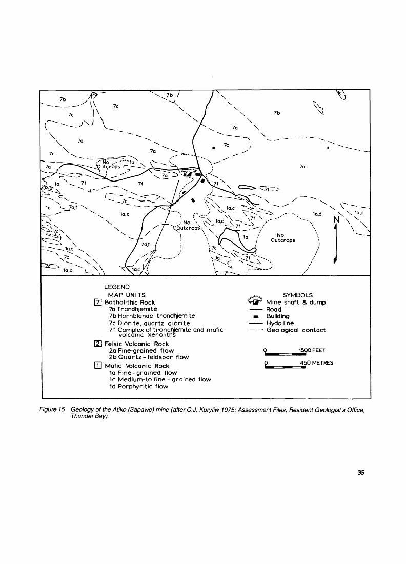
LEGENDMAP UNITS
3 Batholithic Rock 7a Trondhjemite 7b Hornblende trondhjemite 7c Diorite, quartz diorite 7f Complex of trondhjemite and mafic
volcanic xenoliths~2\ Felsic Volcanic Rock
2a Fine-grained flow2b Quartz-feldspar flow
j] Mafic Volcanic Rock1a Fine-grained flow1c Medium-to fine - grained flow1d Porphyritic flow
SYMBOLSMine shaft 8. dump Road Building Hydo line Geological contact
15QO FEET
450 METRES
Figure 15—Geology of the Atiko (Sapawe) mine (after C. J. Kuryliw 1975; Assessment Files, Resident Geologist's Office, Thunder Bay).
35
components. Visible gold is reported as also present (Re gional Geologist's Files, Ministry of Natural Resources, Thunder Bay).Size and Grade: From 1964 to 1966, 33,016 tons of ore were milled, averaging 0.14 ounces/ton Au (Riddell 1959, p.52).Assays of MineralizationSample Description Au(g/!) Ag(gA) W305 Grab sample of quartz vein with
trace pyrite and chalcopyrite. nd nd W306 Grab sample of quartz vein with
stringers of pyrite and chlorite. 1.500 3 W307 Grab sample of quartz-carbonate-
sericitevein. 0.130 nd W308 Grab sample of quartz-carbonate
vein with black chlorite. 0.023 nd W309 Grab sample of chlorite schist
with quartz-carbonate veinlet. 0.003 nd W31OA Grab sample of chlorite schist
with quartz-carbonate veinlet. 0.029 nd W311 Grab sample of highly sheared
trondhjemite with 2"y0 arsenopyrite. 0.010 nd
DEVELOPMENT HISTORYCirca 1900: Quartz veins discovered by unknown
party. Claim and vein are shown on Map 38e (Hawley 1930).
1950: E. Corrigan and D.R. Young staked the occur rence and undertook to test the mineralization. Ten shal low diamond-drill holes were completed to establish the mineralization over an 80 m strike length.
1960: Lindsay Explorations Ltd. obtained an option on the property. Twenty-eight diamond-drill holes were completed for a total length of 2216 m over a strike length of 166 m. A vertical shaft was put down to a depth of 8 m.
1961: Same company continued the shaft to a depth of 107 m with drifts at the 52 m and 98 m levels. The lat eral work totalled 150 m. Twelve diamond-drill holes were completed to a total depth of 1344 m.
1962: Same company completed a total of 214 m of lateral and 72 m of raising work. Fourteen diamond-drill holes achieved a total length of 1608 m. Surface work consisted of 10 m of trenching.
1963: Same company changed name to Sapawe Gold Mines Ltd. Underground work consisted of 76 m of drifting and 110 m of raising. A mill, crusher, assaying offi ce, and ore refinery were installed on the site. One dia mond-drill hole was completed to a depth of 56 m.
1964: Same company continued underground work with 55 m of drifts, 120 m of crosscuts, and 100 m of rais es. Seventeen diamond-drill holes were completed un derground for a total of 1072 m. Gold and silver were first produced.
1965: Same company extended shaft to a depth of 310 m. Levels were established at depths of 158 m, 219 m, and 280 m. In addition, 168 m of drifts and 418 m of raises were completed. Two diamond-drill holes totalling 57 m were done.
1966: Same company culminated mining operations with 631 m of drifting, 16 m of crosscutting, and 447 m of raising. There were 119 diamond-drill holes completed underground, totalling 1321 m.
PRODUCTION SUMMARY TO THE END OF 1966 Year Au(g) Ag(g) Total Milled(t) Average
1963 —1964 834691965 90311966 49594Total 142094
216881813
1759341094
162719190
1 1031608938009
Grade Aufe/t)
4.0108.1873.0825.093
1974: Atiko Gold Mines Ltd. leased the property from Sapawe Gold Mines Ltd. Magnetic and detailed geologi cal surveys were conducted.
1975: Twenty-eight additional claims were staked east and west of the mine property by the same compa ny. The miners' residence and mine office buildings were renovated.
1977: A very detailed, outcrop geology map was produced by the same company.CURRENT OWNERSHIPAtiko Gold Mines Ltd., by lease from Sapawe Gold Mines Ltd.REFERENCE MAPSMap 38e, Sapawe Lake Area (Hawley 1930)Map 2065, Atikokan-Lakehead Sheet (Pye and Fenwick1965)Map P. 1227, Gold Deposits of Ontario, West CentralSheet (Gordon 1977)Map P. 1522, Ontario Mineral Potential, Quetico Sheet(Springer 1978)SELECTED REFERENCESFenwick (1976b)Ferguson etal. (1971, p.251-252)Hawley (1930)MacRae(1978)Mcilwaine and Chorlton (1973)Wilkinson (1979)
13. DAY LAKE OCCURRENCE
COMMODITYGoldROCK ASSOCIATIONComplex of felsic intrusive rocks and mafic volcanic rocksCLASSIFICATIONContact Zone TypeLOCATIONMcCaul Township; central partLatitude 480 47' 21 "N; Longitude 91 0 25' 00"EACCESSAccess is via a summer road which connects with theAtiko gold mine road, approximately 1.6 km west of themine area (Figure 16).DESCRIPTIONGeneral Geology: Variably sheared trondhjemites and mafic volcanic rocks occur as a complex of interdigitated lenticular units. The rocks trend easterly with near-vertical dips. The trondhjemites vary from hornblende-bearing to leucocratic, and from massive to intensely sheared.
The mafic volcanic rocks are fine- to medium- grained schists composed of chlorite with relic feldspar phenocrysts.
36
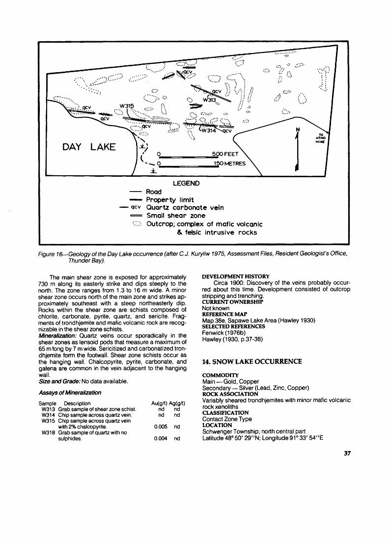
DAY LAKE
LEGENDRoad
—— Property limit — gcv Quartz carbonate vein
—— Small shear zone O Outcrop; complex of mafic volcanic
81 felsic intrusive rocks
Figure 16—Geology of the Day Lake occurrence (after C.J. Kuryliw 1975, Assessment Files, Resident Geologist's Office, Thunder Bay).
The main shear zone is exposed for approximately 730 m along its easterly strike and dips steeply to the north. The zone ranges from 1.3 to 16 m wide. A minor shear zone occurs north of the main zone and strikes ap proximately southeast with a steep northeasterly dip. Rocks within the shear zone are schists composed of chlorite, carbonate, pyrite, quartz, and sericite. Frag ments of trondhjemite and mafic volcanic rock are recog nizable in the shear zone schists. Mineralization: Quartz veins occur sporadically in the shear zones as lensoid pods that measure a maximum of 65 m long by 7 m wide. Serialized and carbonatized tron dhjemite form the footwall. Shear zone schists occur as the hanging wall. Chalcopyrite, pyrite, carbonate, and galena are common in the vein adjacent to the hanging wall. Size and Grade: No data available.
Assays of Mineralization
Sample Description Au(gA) Ag(grt) W313 Grab sample of shear zone schist. nd nd W314 Chip sample across quartz vein. nd nd W315 Chip sample across quartz vein
with 2'fc chalcopyrite. 0.005 nd W318 Grab sample of quartz with no
sulphides. 0.004 nd
DEVELOPMENT HISTORYCirca 1900: Discovery of the veins probably occur
red about this time. Development consisted of outcrop stripping and trenching.CURRENT OWNERSHIPNot knownREFERENCE MAPMap 38e, Sapawe Lake Area (Hawley 1930)SELECTED REFERENCESFenwick (1976b) Hawley (1930, p.37-38)
14. SNOW LAKE OCCURRENCE
COMMODITYMain —Gold, CopperSecondary — Silver (Lead, Zinc, Copper)ROCK ASSOCIATIONVariably sheared trondhjemites with minor mafic volcanic rock xenolithsCLASSIFICATIONContact Zone Type LOCATIONSchwenger Township; north central part Latitude 480 50' 29"N; Longitude 91 0 33' 54"E
37

TW~^ x'~^
M \^ 7a i 11 i x^8a
) i ^ l
^ \ 7a i*"i i '
3b^^3-r V/15^/Y TwV . TV
y /7a ..--la
/' / '
1 1/' TW-6^-TW-35 f7c
' , y#6Q i ' A/
TW-9-j^xQa j) / 7a
X' '^8a TW-7-7 /'
^ ::-"""' //7a 8I^:^ —— —— _ - — ̂ -"iy ^ ——— ̂ *^ —— ̂ —— —— —— ——— -JL.*"1 \ t f, s — ^? P
/' 7a ^^N \ ^x ^t'^/S t ^cv vot^ /A' ^ - * x^ ( /^c v \ /'" X^^^ X 7a /TW-rTvt-^ ; ; — ̂ x
8aV(x , '^.^^ -, ^-TW-25
^ X 8a^-^ " ^ ^^X /^ ~7ci' ' /^D
vx
(^ _ J90— —20O FEET
p 30 60 METRES
LEGEND 8 Mafic Dikes
8a Aphanitic 8b Porphyritic
7 Felsic Intrusive Rocks w/* 7a Trondhjemite
1 Mafic Volcanic Rocks y 1a Fine-grained (xenolith)
T\A/ Ofi ** 1 W-tO. QQ TW-11
^ /J ^.X/y/ ^^ /"TQcv AA/' ^:^-QQ 3-^/ TW-28 qCV ^
x/ y^cv.7q.
X7a/ 17^ ' ,7
/8b \\ 7a \ r TW-29T7V : ta TW-3O"). l
TW-31 j. , A, TW-327 ' -iK-
3
TW-33X';
-~*- JC.TW-23 .-•' .-•'^r
^jss^.ea TW-21^?s:"^
TW-2CXT; '7a
xx Geological contact i? Area of many outcrops c Large outcrops
. 'X Foliation;(a)with dip, (b)vertical.
^cv Quartz carbonate vein
Figure 17— Geology of the Snow Lake occurrence. Geology by T. Trowell (field assistant, 1979).
38
ACCESSThe occurrence (Figure 17) is located in the construction trailer park of Ontario Hydro thermal generating project. It is accessible via the trailer park road.DESCRIPTIONGeneral Geology: The trondhjemites in the area of the oc currence are nonfoliated rocks containing rarely more than 150Xo biotite and hornblende. Adjacent to mineraliza tion, these rocks are sheared and altered to sericite-, chlorite-, and epidote-bearing. The most intensely sheared trondhjemites are composed of chlorite, sericite (or muscovite), quartz, and carbonate. Xenoliths consist of fragments of mafic volcanic rocks and gneissic rocks which are similar to early phases of the Marmion Lake Ba tholith.
North-trending mafic dikes cut the intrusive rocks. The dikes are fine grained, and glomeroporphyritic, with coarse plagioclase phenocryst^. The shearing is subpar- allel with local northeast-trending lineaments. Mineralization: Quartz veins occur in the most intensely sheared trondhjemite. The major vein measures approxi mately 47 m long and up to 1.8 m wide. The veins consist primarily of milky grey quartz with subsidiary ankerite. Sphalerite, galena, chalcopyrite, and pyrite occasionally make up to 12"fc of the vein but are irregularly distributed.
Pyrite and chalcopyrite occur as fine disseminated grains and along fractures in the trondhjemites. Distribu tion of these sulphide minerals is sporadic. The host rocks contain sericitized and epidotized feldspars and chloritized mafic minerals in zones of disseminated min eralization.Size and Grade: No data available. Assays of MineralizationSample Description Au(gA) Ag(gA) TW03 Grab sample of quartz vein. 0.150 nd TW09 Grab sample of quartz vein with
trace sulphides. 0.190 nd TW13 Chip sample across quartz-carbonate
vein with 3*X( chalcopyrite. 0.018 nd TW17 Grab sample of quartz-carbonate vein
with 5*fc chalcopyrite and sphalerite. 0.110 3DEVELOPMENT HISTORY
1979: Occurrence was discovered during construc tion of Ontario Hydro generating station. Area withdrawn from staking. SELECTED REFERENCE Wilkinson (1979)
15. B.W. TRIPP CLAIMS (BLACKFLY OCCURRENCE)
COMMODITYGoldROCK ASSOCIATIONMassive to sheared trondhjemites and diorite, and mafic metavolcanicsCLASSIFICATIONContact Zone TypeLOCATIONFreeborn Township; northeast corner
Latitude 480 50' 12"N: Longitude 91 0 39' 24"E ACCESSThe claims (Figure 18) are traversed by a summer road which extends south from the Clearwater West Lake road.DESCRIPTIONGeneral Geology: The contact between the Marmion Lake Batholith and the Finlayson Lake metavolcanic belt is marked by a north- to northeast-trending lineament along the west side of the property. The intrusive rocks are massive to sheared trondhjemites, mafic trondhjem ites, and diorites. The mafic volcanic rocks are fine grained and occasionally porphyritic, and occur interdigi- tated with the intrusive rocks.
Shearing is sporadic, trending approximately N300E with near-vertical dips, and can be traced for up to 1.3 km along strike. Widths of the sheared zone range up to 5 m. A fine-grained massive mafic dike occurs irregularly in the shear zone.Mineralization: Six quartz-carbonate veins occur in the sheared zone, exposed in pits and trenches over a 300 m strike length. The veins average 30 cm in width and are up to 15 m in length. Grey quartz is the main vein compo nent with subsidiary ankerite and abundant pyrite. Ga lena is present in accessory amounts. Size and Grade: No data available.Assays of Mineralization
Sample Description Au(gA) Ag(gA) WM-089 Grab sample of vein quartz with
abundant pyrite. 7.780 nd WM-090 Same with abundant ankerite. 0.030 nd WM-091 Same. 2.450 nd WM-092 Same. 0.010 nd WM-093 Same. 1.920 nd WM-094 Same. 0.360 nd WM-095 Same. 0.060 nd
W-212 Chip sample across quartz-carbonatevein. 0.011 nd
W-215 Grab sample of vein quartz. nd nd W-217 Chip sample across quartz-carbonate
vein with trace pyrite andarsenopyrite. 11.000 nd
W-219 Grab sample of vein quartz withtrace pyrite. 0.031 nd
DEVELOPMENT HISTORYCirca 1897: Vein discovered.1938: Property owned by Rebair Gold Mines Ltd.
Prior to this date some trenching and a 45-foot vertical shaft sunk.
1940: Property owned by Mr. Scheider of Thunder Bay.PRESENT OWNERSHIP B.W. Tripp, Thunder Bay, Ontario REFERENCE MAPSMap 48a, Atikokan Area (Moore 1940) Map 2217, Steep Rock Lake Area (Shklanka 1972) Map 2297, Finlayson Lake (Fenwick 1976a) SELECTED REFERENCESFenwick (1976a)MacRae(1978)Regional Geologist's Files, Ministry of Natural Resources,Thunder BayWilkinson (1979)
39
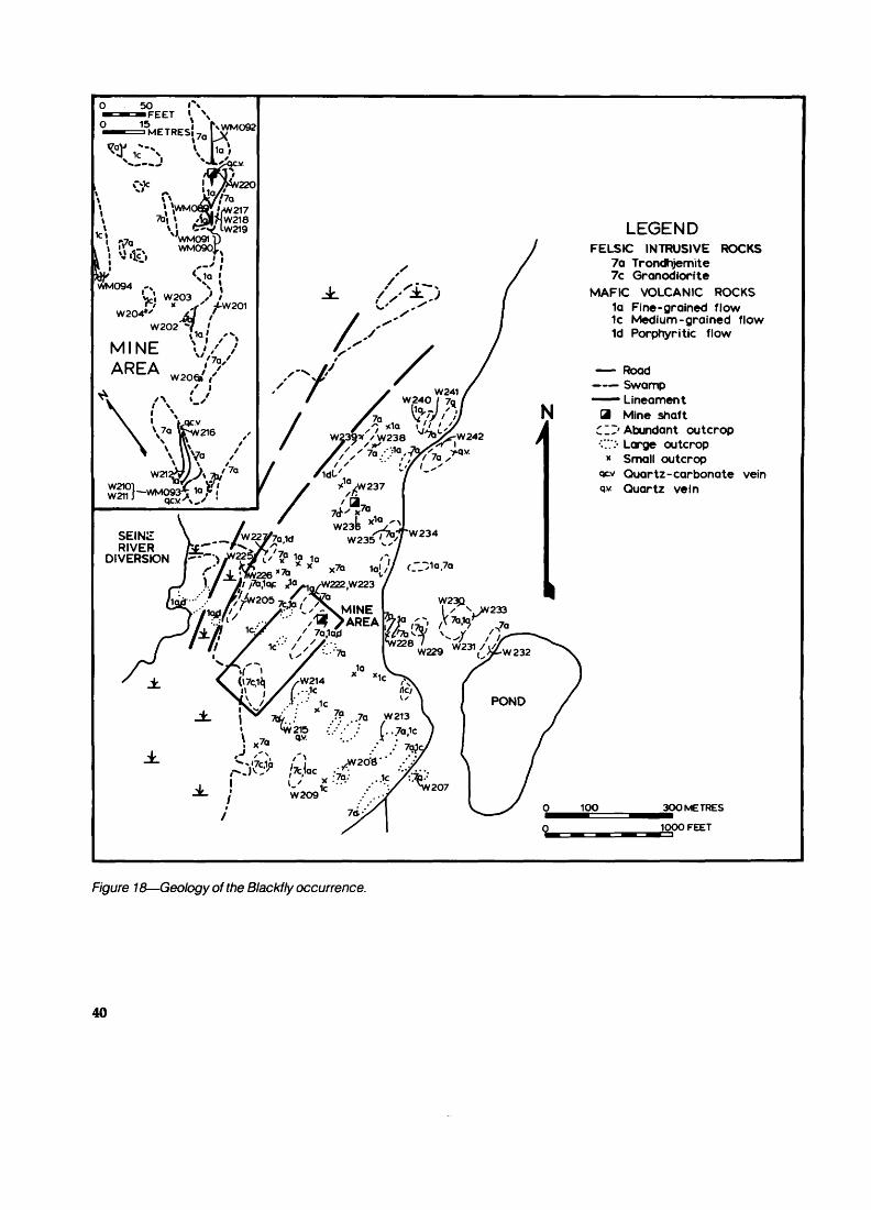
LEGENDFELSIC INTRUSIVE ROCKS
7a Trondhjemite 7c Granodiorite
MAFIC VOLCANIC ROCKS 1a Fine-grained flow 1c Medium-grained flow 1d Porphyritic flow
—— Road—— Swamp
1 Lineament B Mine shaft
C "'Abundant outcrop C.':- Large outcrop
* Small outcropQuartz-carbonate vein
q.v. Quartz vein
30O METRES
1000 FEET
F/gt/re 18—Geology of the Blackfly occurrence.
40

16. NEW GOLDEN TWINS OCCURRENCE
COMMODITYMain — Gold Secondary — Silver ROCK ASSOCIATIONMafic metavolcanicsCLASSIFICATIONContact Zone Type LOCATIONFinlayson Lake area; central partLatitude 480 55' 17"N; Longitude 91 0 36' 06"EACCESSThe occurrence is located on Mesuba Bay, on Finlayson Lake, and can be reached by small boat launched from sites on Clearwater West Lake road (Figure 19).DESCRIPTIONGeneral Geology: Country rocks consist essentially of metamorphosed mafic volcanic rocks with minor interca lated sedimentary rocks. The volcanic rocks are mainly massive to pillowed flows with interfingered tuffaceous beds. The massive flows are regularly jointed in a pattern similar to columnar jointing. The sediments are massive, thick-bedded argillites, locally pyrite-rich, and graphitic (Fenwick 1976a). Rare cherty ankeritic horizons are ex posed in lakeshore outcrops and are interbedded with the metasediments.Mineralization: The vein is located approximately 150 m west of Mesuba Bay. The vein is hosted in a zone 35 m wide, of intensely sheared mafic volcanic rocks. The shearing and vein strike northeast with a near-vertical
LEGEND4c Chlorite-carbonate schist 2a Fine-grained felsic flow 1a Fine-grained mafic flow 1b Pillowed mafic flow 1c Medium-coarse grained flow qcv quartz-carbonate vein
— — geological contact
Figure 19—Geology of the Golden Twins occurrence (from Fenwick 1969).
dip. The width of the vein achieves a maximum of 10 m at its most northerly exposure. Rusty grey quartz is the main component of the vein. Accessory minerals are pyrite, ankerite, chlorite, chalcopyrite, and galena. Trace sphal erite, molybdenite, and arsenopyrite are present locally. Size and Grade: No data available. -Assays of MineralizationSample Description Au(gA) Ag(gA)
W37 Chip sample across north end of vein. 0.008 20 W40 Grab sample from dump of south shaft. nd nd
DEVELOPMENT HISTORY1897: The Golden Twins Mining Company of Lon
don, England, started development following the discov ery of the vein with stripping of the mineralized outcrops. The north shaft was completed to depth of 83 feet with a 22-foot crosscut at the 43-foot level.
1899: The same company continued work with the completion of the southern shaft to a depth of 16 feet (Bow 1899). CURRENT OWNERSHIPNoneREFERENCE MAPSMap 48a, Atikokan Area (Moore 1940)Map 2297, Finlayson Lake (Fenwick 1976a)SELECTED REFERENCESBow (1899, p.92)Fenwick (1976a)Moore (1940, p.33)Wilkinson (1979)
17. REBAIR OCCURRENCE
COMMODITYGoldROCK ASSOCIATIONMetamorphosed felsic volcanic and volcaniclastic sedi mentary rocksCLASSIFICATIONContact Zone TypeLOCATIONFreeborn Township; west central part Latitude 480 47' 58"N; Longitude 91 0 43' 29"EACCESSThe main showing is 0.6 km east of the Elizabeth mine. A clearly defined trail runs between the Elizabeth mine area and the Rebair occurrence.DESCRIPTIONGeneral Geology: In the vicinity of the mineralization, there are felsic volcanic rocks and volcaniclastic rocks which are cut by 1 to 3 m thick, north-trending diabase dikes.
The felsic volcanic rocks are porphyritic with fine ser- icitized feldspar laths and occasionally blue quartz blebs within a groundmass of fine-grained sericite and quartz. Pyrite and chalcopyrite are common accessories.
The volcaniclastic rocks are composed of subround ed, coarse sand to pebble-sized fragments of felsic vol canic material. The groundmass is a fine-grained matrix of quartz, chlorite, sericite, and trace pyrite. Graded beds are recognizable in some outcrops. The bedding strikes northeast and dips steeply to the east.
41

Mineralization: Several quartz veins are located within the original property, occurring either in the volcanic or sedi mentary units. The veins are hosted by minor shear zones that are recognizable over lengths of 30 to 40 m and aver age widths of a few metres. The shearing trends north to northeast and is essentially vertical.
The largest vein, the Dome vein, is located on the east side of the property. This vein is exposed for 13 m and has a maximum width of 0.3 m.
White-grey quartz is the main vein component with chlorite and ankerite as secondary minerals. Pyrite is present as an accessory mineral occurring with chlorite. Size and Grade: No data available. Assays of MineralizationSample Description Au(gA) Ag(g/)
W144 Chip sample across quartz with 4^ocarbonate and pyrite. 0.085 nd
W147 Chip sample across quartz vein, northend of Dome vein. 0.011 nd
W148 Chip sample across quartz vein, middleof Dome vein. 0.012 nd
W149 Chip sample across quartz vein, southend of Dome vein. 0.035 nd
DEVELOPMENT HISTORY1937: Rebair Gold Mines Ltd. constructed the mining
camp on property. Large areas of outcrop were stripped and trenches were dug. Six shallow diamond-drill holes were completed to a total depth of 38 m. An exploration shaft was started and achieved a final depth of 4 m.
1939: Same company continued development of the shaft to 38 m. Seven diamond-drill holes were completed to a total depth of 241 m.CURRENT OWNERSHIPM. Wicheruk and B. Moffat, Atikokan, OntarioREFERENCE MAPSMap 48a, Atikokan Area (Moore 1940)Map 2065, Atikokan-Lakehead Sheet (Pye and Fenwick1965)SELECTED REFERENCESFumerton (1979)Moore (1940, p.27-28)Wilkinson (1979)
18. ELIZABETH MINE (PAST PRODUCER)
COMMODITYMain — Gold Secondary — SilverROCK ASSOCIATIONLeucocratic trondhjemite, and mafic and felsic metavol- canicsCLASSIFICATIONContact Zone TypeLOCATIONFreeborn Township; west central part Latitude 480 47' 48"N; Longitude 91 0 44' 04"E ACCESSMine site (Figure 20) is located approximately 1.2 km north-northeast of Modred Lake which is accessible by small boat launched in Perch Lake, downstream on the Seine River.
DESCRIPTIONGeneral Geology: Rocks of the Dashwa Lake Batholith and the metavolcanic belt occur in the mine area as at the Harold Lake mine. The intrusive rocks consist mainly of granodiorite with lesser pink granite and trondhjemite. Metavolcanics are composed of interdigitated mafic and felsic varieties. Mafic rocks are chiefly fine to medium grained and massive. Pillowed flow rocks occur only in one isolated outcrop south of the mine area. The felsic volcanic rocks are fine-grained sericite-chlorite schists and commonly contain fine, blue quartz blebs and felds par laths.
An antiformal fold trends across the mine area sub- parallel to the contact of the batholith and metavolcanic belt. Several northeast-trending lineaments cross the area.Mineralization: Quartz veins occur at or near the batholithic-metavolcanic belt contact and are contained within short discontinuous shear zones. The shearing oc curs within either batholithic rocks or metavolcanics.
Two distinct varieties of quartz vein are present. The prominent type is composed of coarse aggregates of grey quartz with ankerite, pyrite, chalcopyrite, and rare scheelite concentrated along the vein walls. The host rocks for this type of vein are chlorite schists, rich in ank erite and pyrite, with trace arsenopyrite.
The second type of vein consists of fine saccharoidal grey-white quartz with bands and stringers of fine chlor ite, carbonate, and pyrite. These veins are hosted by chloritic schist along the hanging wall and an epidote trondhjemite footwall.
The main vein of mineralization at No. 2 shaft was mined over a length of 23 m to a depth of 46 m with an av erage width of 1.5 m. Underground drilling located a con tinuation of this vein approximately 76 m below surface and the width averaged 1.5 m.Size and Grade: During 1912, 50 tons of ore averaging 0.4 ounce/ton Au were milled (Tremblay 1940, p.22).
Assays of Mineralization
Sample Description Au(gA) Ag(gA) W120 Chip sample across rusty
quartz-carbonate vein. 0.014 nd W121 Chip sample across chalcopyrite-rich
quartz vein. 24.000 7 W123 Chip sample across quartz vein. 0.150 nd W126 Grab sample of sheared, carbonaceous
mafic flow. 0.009 nd W128 Grab sample of quartz-carbonate
vein from dump of No. 2 shaft. 0.017 nd W129 Same. 0.011 nd W130 Same. nd nd W131 Chip sample across quartz vein. nd nd W132 Chip sample across quartz vein
stockwork in epidote trondhjemite. 0.007 nd W136 Chip sample across quartz vein
with trace pyrite. 0.008 nd W138 Grab sample of quartz vein
stockwork in granodiorite. nd nd W140 Chip sample of quartz vein. 0.006 nd W141 Grab sample of stringer quartz vein
in epidote trondhjemite. 0.004 nd
42
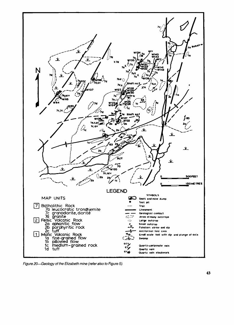
500FEET
15OMETRES
LEGENDMAP UNITS
Batholithic Rock7a leucocratic trondhjemite7c granodiorite, diorite^d granite
Felsic Volcanic Rock2a aphanitic flow2b porphyritic rock2c tuff
Mafic Volcanic Rock1a fine-grained flow1b pillowed flow1c medium-grained rock1d tuff
^^ SYMBOLSI4**jt Shaft and mine dump* Test pit
...... trail•—^™* Lineament— —— Geological contactC-"-'' Area of many outcrops•v.:;:- Large outcropx Small outcrop
* ' r Foliation: strike and dip— \ " Antiformal fold axis^5^ Small scale fold with dip and plunge of axis
Swamp
Quartz-carbonate veinQuartz veinQuartz vein stockwork
Figure 20—Geology of the Elizabeth mine (refer also to Figure 5).
43

DEVELOPMENT HISTORYCirca 1900: Discovery of quartz veins by Anglo-Ca
nadian Gold Estates Ltd., was followed by trenching and sinking of test pits. Some diamond-drill holes were initiat ed.
1902: Same company started construction of a ten- stamp mill.
1903: Same company completed twelve diamond- drill holes to a total depth of 573 m, to block off an esti mated 20,000 tons of ore averaging 0.25 ounce/ton to 0.32 ounce/ton.No. 1 shaft was completed to a depth of 34 m with 34 m of drifting at the 24 m level.No. 2 shaft was under construction on the main mineral ized vein.
1913: Elizabeth Gold Mines Ltd. initiated mining op erations. No. 2 shaft achieved a final depth of 82 m with 367 m of total lateral work at 20 m, 37 m, and 72 m levels.
1935-1976: Same company dewatered the shafts and re-examined the mineralization. Seven diamond-drill holes were completed for a total depth of 485 m. A 25-ton mill was constructed.CURRENT OWNERSHIPM. Wicheruk and B. Moffat, Atikokan, OntarioREFERENCE MAPSMap 48a, Atikokan Area (Moore 1940)Map 2065, Atikokan-Lakehead Sheet (Pye and Fenwick1965)Map P. 1227, Gold Deposits of Ontario, West CentralSheet (Gordon 1977)Map P. 1522, Ontario Mineral Potential, Quetico Sheet(Springer 1975)SELECTED REFERENCESBruce (1925, p.30-31)Canadian Mines Register, Northern Miner Press (1960)Carter (1902, p.240-241)Corkill (1912, p.103; 1913, p.99)Ferguson etal. (1971, p.249-250)Fumerton (1979)Gibson (1901, p.40-41; 1912, p.54)Miller (1903, p.82)Moore (1940, p.24-27)Tanton (1925)Wilkinson (1979)
19. HAROLD LAKE MINE (PAST PRODUCER)
COMMODITYMain — Gold Secondary — SilverROCK ASSOCIATIONLeucocratic trondhjemites, and felsic and mafic metavol- canicsCLASSIFICATIONContact Zone TypeLOCATIONBaker Township: southeast cornerLatitude 480 46' 58"N; Longitude 91 0 45' 28"EACCESSMine site (Figure 21) is located on the northwest corner of
Harold Lake and is reached by trail from the northwest corner of Modred Lake. Modred Lake is too shallow to land a float-equipped plane but can be reached by a small boat, launched in Perch Lake downstream on the Seine River.DESCRIPTIONGeneral Geology: Rocks of the Dashwa Lake Batholith within the Harold Lake mine area include granites, grano- diorites, and minor leucocratic trondhjemites. The meta- volcanics are felsic flows and tuffs, metamorphosed to very fine-grained sericitic schists with or without quartz and feldspar phenocrysts. The mafic volcanic rocks lo cated southwest of the mine site are present as fine grained chlorite schists.
North- to northwest-trending shear zones occur in the intrusive rocks. In the vicinity of the open stope and lakeshore shaft, the shearing is most intensive and rocks in the zone are composed of sericite, epidote, chlorite, al bite, quartz, and carbonate.Mineralization: Moore (1940) reported that 18 veins are located on the original property. With only one exception, the veins occur within narrow, discontinuous shear zones in the granitic rocks. Quartz is the principal vein compo nent, ankerite and pyrite are secondary. Accessory min erals are arsenopyrite, galena, sphalerite, and chalcopy rite. Visible gold was reported as common in the main vein of the open stope (Coleman 1896a, p.69) and it oc curred as fine leaflets in the quartz. Size and Grade: From 1895 to 1896,1,131 tons of ore av eraging 0.59 ounce/ton Au were milled (Ferguson et at. 1971,p.248).Assays of MineralizationSample Description Au(gA) Ag(gA) W100 Chip sample across quartz vein with
trace galena. 0.015 3 W102 Chip sample across quartz vein with
abundant ankerite. 0.005 1 W103 Chip sample across barren quartz vein. 0.008 nd W106 Chip sample across stringer quartz
vein in chlorite schist. 0.005 nd W107 Chip sample across quartz vein with
Wo pyrite. 0.034 nd W110 Chip sample across quartz vein with
trace sphalerite. 0.014 nd W111 Grab sample of stockwork quartz vein. 0.038 nd W114 Grab sample of ankerite-rich
quartz vein. 0.018 nd W151 Grab sample of rusty quartz vein. 45.000 30 W152 Grab sample of rusty chlorite-schist
footwall. 0.200 nd
DEVELOPMENT HISTORYCirca 1894: Discovery of vein and initial examination
of property by Wiley brothers of Port Arthur.1895-1896: Harold Lake Gold Mines Company Ltd.
developed two shafts, two adits, and an open stope on quartz veins. Most production was from the open stope which achieved a maximum size of 30 m long, 3 m wide, and 10 m deep. The lakeshore exploration shaft was completed to a depth of 12 m with lateral work at the 8 m level. A five-stamp mill was constructed on the lake south of the open stope.
44
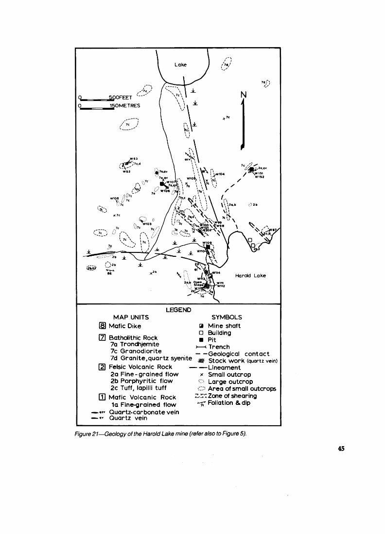
)OFEET 150METRES
'-rr')-tc.4 -V'
W1O8 - -' lv-;.-' 7c:-: 7e
N
7V U W109. ' \ Li ,, V;7* ^W107\' \ x ' \ X*, **
4 X," .-.•V*** 1,^ \ \\ --' '..w 7^^4 w\x ^ /vVv]\\\ ^
' ' .^ ' i \ \\ l 2 "- 6
' /^^H. - \ ^v \ l^.
/
te20**\W151
W1S2
W103
Hardd Lake
LEGENDMAP UNITS
Mafic Dike
(7J Batholithic Rock 7a Trondhjemite 7c Granodiorite 7d Granite,quartz syenite
[2] Felsic Volcanic Rock - 2a Fine-grained flow 2b Porphyritic flow 2c Tuff, lapilli tuff
Q] Mafic Volcanic Rock 1a Fine-grained flow
.qc* Quartz-carbonate vein *v Quartz vein
SYMBOLS a Mine shaft a Building m Pit
)—i Trench— -Geological contact 48# StOCk work (quartz vein)
-—Lineament x Small outcrop
- - Large outcrop o Area of small outcrops
z,z:iZone of shearing ^ Foliation fi. dip
Figure 21—Geology of the Harold Lake mine (refer also to Figure 5).
45

1937: Canadian Longyear Ltd. re-examined the property with some additional trenching and sampling of surface showings.
1975: Sol Cowan restaked the mine area and strip ped some outcrops.CURRENT OWNERSHIPNot known REFERENCE MAPSMap 48a, Akikokan Area (Moore 1940)Map 2065, Atikokan-Lakehead Sheet (Pye and Fenwick1965)Map P. 1227, Gold Deposits of Ontario, West CentralSheet (Gordon 1977)SELECTED REFERENCESBruce (1925, p.31-32) Coleman (1896a, p.69-70; 1896b) Ferguson etal. (1971, p.248) Fumerton (1979) Moore (1940, p.28-31) Wilkinson (1979)
20. MAYFLOWER MINE
COMMODITYMain — GoldSecondary — Silver (Copper, Lead, Zinc)ROCK ASSOCIATIONMetamorphosed felsic tuff, quartz-feldspar prorphyry, and mafic volcanic rocksCLASSIFICATIONMetavolcanic-Hosted, Stratabound TypeLOCATIONFactor Lake area; northeast corner Latitude 48" 43' 48"N; Longitude 920 07' 42"E ACCESSThe mine area is 335 m north of Highway 11 (Figure 22). It is reached via a skid road that intersects the highway ap proximately 2.5 km west of the Flander's Station road. DESCRIPTIONGeneral Geology:The property occurs between two east- trending branches of the Quetico Fault that converge just
LEGENDMAP UNITS
[4l Metasedimentary 4b banded chert 4e chlorite-sericite-quartz -carbonate schist
[D Felsic Volcanic Rocks2a fine-grained felsic volcanic rock2c tuff2d quartz-feldspar porphyry
O 2Om
O
5OFEETmm
15 METRES
SYMBOLS
C3/ Shaft and mine dump C3 Trench ^-* Road——^ Foliation: striked dip— — Geological contact
:.V- Outcrop—— Sheared rock
Quartz-carbonate vein Quartz vein stockwork
Figure 22—Geology of the Mayflower mine.
46
east of the mine. Host rocks are banded chert, carbona- tized felsic tuff, and chlorite-sericite-carbonate schist.
Quartz-feldspar porphyry occurs cutting the host rocks just west of the shaft. The banded chert occurs as lenticular, strataform pods up to 2 m thick and 10m long. The banding consists of subtle alternation of grey and buff chert, 1 to 3 cm thick. Irregular green pods of chert, sericite, and epidote occur interbedded in the banded chert.
Chlorite-sericite-carbonate schist hosts the banded chert and is laterally continuous for several hundred me tres. Locally, the schist contains recognizable felsic frag ments that are composed of sericite and carbonate in a chloritic matrix. Thus, this unit is believed to be an altered felsic tuff.
The quartz-feldspar porphyry underlies the west half of the mine area. It is zoned from aphanitic margin to me dium-grained granitic core.
A small shear cuts the rocks just north of the shaft and trends approximately 750 , dipping 850N. No offset is apparent.Mineralization: Quartz and quartz-carbonate veins are exposed in the trenches and strike irregularly north. The veins contain the most consistent gold values but anoma lous gold content is apparent in the host rocks. The por phyry is locally intensely carbonatized and cut by numer ous stockworks of quartz and carbonate. The stockwork veins contain significant pyrite, chalcopyrite, sphalerite, galena, and arsenopyrite, in addition to high gold values. Size and Grade: No data available. Assays of MineralizationSample Description Au(gA) Ag(grt)
W243 Chlorite-sericite-carbonate schist. 0.019 nd W254 Quartz vein chip sample with
trace pyrite. nd nd W256 Banded chert with trace pyrite
and arsenopyrite. 0.020 nd W258 Quartz-feldspar porphyry. 0.015 nd W260 Quartz-carbonate vein with
chalcopyrite, pyrite, arsenopyrite,and sphalerite. 0.046 nd
W262 Quartz-feldspar porphyry with finestockwork veins and abundantarsenopyrite. 0.090 nd
W263 Quartz-feldspar porphyry with finestockwork veins with abundantchalcopyrite, pyrite, arsenopyrite,galena, and sphalerite. 3.000 4
DEVELOPMENT HISTORYCirca 1900: Mayflower Mining Company completed
the shaft to a depth of 32 m with crosscuts of 14 m at 14 m level, and 38 m at the 30 m level. Work terminated De cember, 1900.
1928: H.J. Hoover of Fort William dewatered shaft. Underground work consisted of 11 m of crosscutting at the 14 m level and 2 m at the 30 m level. Surface show ings were stripped and trenched.
1945: Andowan Mines Ltd. drilled two holes for a to tal depth of 100 m.
1946: Freeport Exploration Company dewatered shaft and completed four diamond-drill holes to a total depth of 965 m.
1979: Ken McTavish trenched the surface showings and resampled the mineralization and mine dump.REFERENCE MAPSMap P. 1227, Gold Deposits of Ontario, West Central Sheet (Gordon 1977)Map 2115, Kenora-Fort Frances Sheet (Davies and Prys lak 1966)SELECTED REFERENCESBeard and Garratt (1976) Bow (1900) Fenwick et al. (1980) Hawley (1930, p.51-52) Wilkinson (1979)
21. RED PAINT LAKE OCCURRENCE (SAWDO CLAIMS)
COMMODITYMain — GoldSecondary — Copper, Zinc, SilverROCK ASSOCIATIONMafic metavolcanics and minor felsic pyroclastic and porphyritic rocksCLASSIFICATIONMetavolcanic-Hosted, Stratabound TypeLOCATIONNorway Lake area; east side of Red Paint Lake Latitude 490 02' 55"N; Longitude 91 0 22' 06"E ACCESSThe claim group is traversed by several logging roads and skid trails of the Domtar logging operation, east of Red Paint Lake (Figure 23). Access to the logging roads is via the main Domtar-Woodlands road at Franklin Lake.DESCRIPTIONGeneral Geology: Principal country rocks are pillowed to massive mafic volcanic rocks. Flow breccias are occa sionally exposed and indicate stratigraphic top to the north. Felsic pyroclastic rocks such as tuffs and lapilli tuff are intercalated with the mafic volcanic rocks. A marker horizon occurs trending easterly across the central part of the property and is composed of a pyrite-rich unit en closed within a sericite-chlorite-carbonate schist (Figure 24).
Southern parts of the claim group are underlain by a complex of volcanic rocks interfingered with trondhjem- ites of the Marmion Lake Batholith. The east-trending Lumby Lake shear zone crosses the south end of the claim group. A northeast-trending shear zone exposed on the east shore of Red Paint Lake is estimated by Wool verton (1960) to be up to 2,000 feet wide. Fenwick (1976a) shows the shear zone to extend southwest in Schwenger Township.Mineralization: Primary hosts of gold mineralization are the sericite-chlorite-carbonate schist, lenses of carbo nate, and quartz-carbonate veins. The carbonate lenses range up to 15 feet long and 6 feet wide, and are com posed of an iron-rich carbonate (ankerite). The carbonate occurs as fragments, subtly banded and aphanitic in a matrix of finely crystalline carbonate. Pyrite, chert, green mica, and talc occur within the lenses as disseminations
47
MILES45km to Sapawe
LEGEND A Metal occurrences
•— Trail— RoadO Claim group outline(end of 1979)
See geological map oPSawdo claims"(Fig.24)
Figure 23—Metal occurrences in the Sawdo claim group.
48

X 1Q
^ ri53 t *-)*ro ''•'. *J1dW51,52 W[1|4^V ^71
Cv Ja*"*^ '*S\ x lo :**J;*x ..f* S S lb^-7,*"" \*C^ ***^, /""~ •^J^/^W.SOx"'' v^e^C**"*"1^ 7 ^QPb v -1|v ^ibd"'~"
Y — ^ p^,."1 .^ * : x.jX V t-^J'^' ^^•flc.v. /8 " ^* ^ — ~^* i "^^ *\ V^ V*1o,W ^i(^-^ i*"""*
- — j^s^.- " n*?^./// ^' -f -s?-^ -~#;:;w's 7 .x-''--^)N
* B *'-'.X !
.1*,^
LAKExx^...-16g/^' *" x-'*""""
x1did
1 e^ x ;-Vr //b,0.*1300 ME T RE S
LEGENDSEDIMENTARY ROCKS
4e Sericite-chlorite - carb, schist FELSIC VOLCANIC ROCKS
2b Porphyritic flow2c Tuff, lapilli tuff
MAFIC VOLCANIC ROCKS1a Fine-grained flow '1b Pillowed flow; flow breccia1c Medium-to coarse-grained flow1d Porphyritic flow1e Variolitic flow1f Tuff
Geological contact Trail Pit
r RoadBedd ing: ( STRIKE * DI p) Foliation: (STRIKE a, D i P)Abundant outcrop Large outcrop Small outcrop Quartz vein Quartz-car b. vein
Figure 24—Geology of the Sawdo c/a/ms (shows detail of part of Figure 23).
49
and fine stringers. Quartz-carbonate veins cut the lenses and micaceous schist as a stockwork of variably sized veins. Pyrite and chalcopyrite comprise up to 3*fc of the veins. In the southeast corner of the property, several oc currences of disseminated chalcopyrite and sphalerite are located in sheared felsic porphyries. Size and Grade: No tonnage available. Assay values, as released, range from 0.07 to 1.99 ounce/ton Au (Woolver ton 1960, p.47)./Assays of MineralizationSample Description Au(grt) Ag(gA) W50 Grab sample of pyrite-rich tuff. 0.938 -ci W51 Grab sample of carbonate lens. 0.003 ^ W52 Grey quartz of stockwork veins. 0.003 *c1 W153 Chlorite-sericite schist (adjacent
to carbonate lens). 0.012 'd W154 Pyrite-rich portion of carbonate lens. 0.012 -ci W156 Quartz-carbonate vein. 0.015 *c1 W157 Quartz-carbonate vein. 0.003 *C1 W158 Quartz-carbonate vein with
approximately 5'fc pyrite. 0.313 "d W159 Cherty position of carbonate lens. 0.035 *C1
DEVELOPMENT HISTORY1895-1900: Woolverton (1960) made several refer
ences to prospecting being done on the property.1938-1940: Red Cedar Lake Gold Mines Ltd. staked
a group of (50?) claims immediately west of Lumby Lake. Trenching was undertaken on rusty shear zone rocks and four diamond-drill holes were completed. Assays ranged from 0.001 to 0.18 ounce/ton Au; and Q.9% to 7.420Xo Cu (Assessment Files, Resident Geologist's Office, Ministry of Natural Resources, Thunder Bay).
1946: C.A. Alcock staked 13 mining claims east of Red Paint Lake. Six test pits and some outcrop stripping were completed over quartz-carbonate veins in a rusty micaceous schist. Assays reported ranged from 0.07 to 1.99 ounces/ton Au; Cu up to Q.48% (Woolverton 1960, p.47).
1948: L.C. Anderson restaked the group of claims which included the original Red Cedar Lake Gold Mines property. During 1951, Newkirk and Company Ltd. and Noranda Mines Ltd. jointly undertook a program of map
ping and trenching. Nine diamond-drill holes were com pleted to a total depth of 2,417 feet. Woolverton (1960, p.46) reported a compilation of assays done by Noranda Mines over a 20-foot width as: Au, 0.034 ounces/ton; Ag, 0.57 ounces/ton; Cu, Q.25%; Zn, Q.22%.
1954: Balacen Mines Ltd. held three claims at the west end of Lumby Lake. One diamond-drill hole was completed to a depth of 500 feet.
1960: Little Long Lac Gold Mines Ltd. held by option, 32 chains east of the Anderson property. Trenching was done across the rusty shear zone. Woolverton (1960, p.48) assayed a grab sample from the trench which yield ed: Au, 0.05 ounce/ton; Ag, trace; Cu, Q.29%; Zn, e.74%; Pb, 1.750Xo.
1970: L.E. Giles staked 20 claims over part of the original Anderson property. During 1972, Oja Ltd. under took a magnetometer and electromagnetic surveys over two claims and delineated an anomaly beneath Bufo Lake. During this period, Univex Mining Corporation Ltd. commissioned Oja Ltd. to conduct similar surveys on their claims along the north shore of Lumby Lake. Several anomalies were detected and seven diamond-drill holes were completed to a depth of 1,705 feet (for five holes re ported). Disseminated pyrite and chalcopyrite were dis covered in sheared felsic porphyry.
1976: Kerr Addison Mines Ltd. held 14 claims be tween Bufo and Spoon Lakes. The company undertook geophysical surveys and a detailed geochemical survey. A zone of disseminated chalcopyrite and sphalerite was delineated west of Lumby Lake.CURRENT OWNERSHIPMr. P. Sawdo, Kawene, OntarioREFERENCE MAPSMap 2065, Akikokan-Lakehead Sheet (Pye and Fenwick1965)Map 1960g, Lumby Lake Area, West Half (Woolverton1960)SELECTED REFERENCESFenwick (1976a)Wilkinson (1979)Woolverton (1960)
50
REFERENCES
Beard, B.C., and Garratt, G.L.1976: Gold Deposits of the Kenora-Fort Frances Area; Ontario
Division of Mines, Mineral Deposits Circular 16, 46p. Ac companied by Preliminary Map P.452 (revised) and Chart A, Scale 1:253 440 or 1 inch to 4 miles.
Bow, J. A.1898: Mines of Northwestern Ontario; Ontario Bureau of Mines,
Annual Report for 1898, Volume 7, Part 1, p.35-84.1899: Mines of Northwestern Ontario; Ontario Bureau of Mines,
Annual Report for 1899, Volume 8, Part 1, p.49-99.1900: Mines of Northwestern Ontario; Ontario Bureau of Mines,
Annual Report for 1900, Volume 9, p.35-88.Boyle, R.W.1979: The Geochemistry of Gold and Its Deposits; Geological
Survey of Canada, Bulletin 280,584p.Bruce, E.L1925: Gold Deposits of Kenora and Rainy River Districts; Ontario
Department of Mines, Volume 34, Part 6, p.1-42. Accom panied by Map 34h, Scale: 1 inch to 200 feet.
Carter, W.E.H.1901: Mines of Northwest Ontario: Part 2; Ontario Bureau of
Mines, Annual Report for 1901, Volume 10, p.90-112.1902: The Mines of Ontario; Ontario Bureau of Mines, Annual Re
port for 1902, Volume 11, p.231 -298.1904: Mines of Western Ontario; Ontario Bureau of Mines, An
nual Report for 1904, Volume 13, Part 1, p.58-87.1905: Mines of Western Ontario; Ontario Bureau of Mines, An
nual Report for 1905, Volume 14, Part 1, p.43-75.Coleman, A.P.1895: Gold in Ontario: Its Associated Rocks and Minerals; On
tario Bureau of Mines, Annual Report for 1894, Volume 4, p.35-100.
1896a: Second Report on the Gold Fields of Western Ontario; Ontario Bureau of Mines, Annual Report for 1895, Volume 5.P.47-106.
1896b: The Gold Fields of Western Ontario, Canada; Ontario Bu reau of Mines, Bulletin 1, 8p.
1897: Third Report on the West Ontario Gold Region; Ontario Bu reau of Mines, Annual Report for 1896, Volume 6, p.71- 124.
1898: Fourth Report on the West Ontario Gold Region; Ontario Bureau of Mines, Annual Report for 1898, Volume 7, Part 2, p.109-145.
Corkill, E.T.1906: Mines of Ontario; Ontario Bureau of Mines, Annual Report
for 1906, Volume 15, Part 1, p.47-107.1907: Mines of Ontario; Ontario Bureau of Mines, Annual Report
for 1907. Volume 16, Part 1, p.55-91.1912: Mines of Ontario; Ontario Bureau of Mines, Annual Report
for 1912, Volume 21, Part 1, p. 100-168.1913: Mines of Ontario; Ontario Bureau of Mines, Annual Report
for 1913, Volume 22, Part 1, p.98-145.Davies, J.C., and Pryslak, A.P.1966: Kenora-Fort Francis Sheet; Ontario Department of Mines,
Geological Compilaton Series, Map 2115, Scale 1:253 440 or 1 inch to 4 miles.
De Kalb, Courtenay1899: The Condition of Mines; Ontario Bureau of Mines, Volume
8, Part1,p.29-48.Fenwick, K.G.1969: Finlayson Lake Area, West Half, District of Rainy River, On
tario; Ontario Department of Mines, Preliminary Map P.542, Scale 1:15 840 or 1 inch to V* mile.
1971: The Origin of a Stratabound Pyrite Deposit in Predomi nantly Volcanic Derived Strata in the Finlayson Lake Area, District of Rainy River, Ontario; Unpublished M.Sc. Thesis, Michigan Technical University, 90p.
1976a: Geology of the Finlayson Lake Area, District of Rainy Riv er; Ontario Division of Mines, Geoscience Report 145, 86p. Accompanied by Maps 2297 and 2298, Scales 1:31 680 or 1 inch to Vz mile.
1976b:The Property of Atiko Gold Mines Limited, in McCaul Township, Rainy River District, Ontario; on file at the Re gional Geologist's Office, Ministry of Natural Resources, Thunder Bay, Ontario.
Fenwick, K.G., Larsen, C.R., Scott, J.F., Mason, M.K., and Schnieders, B.R. *
1980:1979 Report of North Central Regional Geologist; p.38-61 in Annual Report of the Regional and Resident Geologists, 1979, edited by C.R. Kustra, Ontario Geological Survey, Miscellaneous Paper 91,143p.
Ferguson, S.A., Groen, H.A., and Haynes, R.1971: Gold Deposits of Ontario, Part 1, Districts of Algoma, Co
chrane, Kenora, Rainy River, and Thunder Bay; Ontario Department of Mines and Northern Affairs, Mineral Re sources Circular 13,315p.
Fumerton, S.L.1979: The Righteye Lake Area, District of Rainy River; p.38-40, in
Summary of Field Work, 1979, by the Ontario Geological Survey, edited by V.G. Milne, O.L. White, R.B. Barlow, and C.R. Kustra, Ontario Geological Survey, Miscellaneous Paper 90,245p.
Gardiner, M.C.1939: The Gold Deposits of the Atikokan Area, Ontario; Unpub
lished M.A. Thesis, University of Toronto, Toronto, 48p.Gibson, T.W.1901: Statistics for 1900; Ontario Bureau of Mines, Annual Re
port for 1901, Volume 10, p.9-60.1912: Statistical Review; Ontario Bureau of Mines, Annual Report
for 1913, Volume 22, Part 1, p.5-61.Gordon, J. B.1977: Gold Deposits of Ontario, West Central Sheet, Districts of
Kenora (Patricia Portion), Thunder Bay, Algoma, and Co chrane; Ontario Geological Survey, Preliminary Map P.1227, Mineral Deposits Series, Scale 1:1 013 760 or 1 inch to 16 miles. Compilation 1974,1975,1976.
Grabowski, G.P.B.1975: Geology and Geochemistry of the Atikokan Iron Mine; Un
published B.Sc. Thesis, Lakehead University, 82p.Hawley, J. E.1930: Geology of the Sapawe Lake Area, With Notes on Some
Iron and Gold Deposits of Rainy River District; Ontario De partment of Mines, Annual Report for 1929, Volume 38, Part 6, p.1-58. Accompanied by Map 38e, Scale 1:47 520 or 1 inch to ^4 mile.
Karvinen, W. O.1980: Geology and Evolution of Gold Deposits, Timmins Area;
p. 1-43 in Genesis of Archean, Volcanic-Hosted Gold De posits, edited by R.G. Roberts, Ontario Geological Survey, Open File Report 5293,387p.
Lawson, A.C.1912: The Geology of Steeprock Lake, Ontario; Geological Sur
vey of Canada, Memoir 28, p.1-15.Mackasey, W.O., Blackburn, C.E., and Trowell, N.F.1974: A Regional Approach to the Wabigoon-Quetico Belts and
Its Bearing on Exploration in Northwestern Ontario; On tario Division of Mines, Miscellaneous Paper 58,29p.
51
MacRae, W.1978: Mineral Deposits of the Atikokan Area; p.206-209 in Sum
mary of Field Work, 1978, by the Ontario Geological Sur vey, edited by V.G. Milne, O.L. White, R.B. Barlow, and J.A. Robertson, Ontario Geological Survey, Miscellaneous Paper 82,235p.
Mcilwaine, W.H., and Chorlton, L.B.1973: East Half of Sapawe Lake Area, District of Rainy River;
p.71-75 in Summary of Field Work, 1973, by the Geologi cal Branch, edited by V.G. Milne, D.F. Hewitt, and W.J. Wolfe, Ontario Division of Mines, Miscellaneous Paper 56, 202p.
Mcilwaine, W.H., and Hillary, E.M.1974: West Half of Sapawe Lake Area, District of Rainy River;
p.65-69 in Summary of Field Work, 1974, by the Geologi cal Branch, edited by V.G. Milne, D.F. Hewitt, and K.D. Card, Ontario Division of Mines, Miscellaneous Paper 59, 206p.
Mcilwaine, W.H., and Larsen, C.R.1981 a: Sapawe Lake Area, East Part, Rainy River District; On
tario Geological Survey, Preliminary Map P.2388 (Re vised), Geological Series, Scale 1:15 840 or 1 inch to VA mile. Geology 1973,1974.
1981 b: Sapawe Lake Area, West Part, Rainy River District; On tario Geological Survey, Preliminary Map P.2389 (Re vised), Geological Series, Scale 1:15 840 or 1 inch to VA mile. Geology 1973,1974.
Mcinnes, W.1899: Report on the Geology of the Area Covered by the Seine
River and Lake Shebandowan Map-Sheets; Geological Survey of Canada, Annual Report for 1897, Volume 10, Part H, 65p.
Miller, W.G.1903: Mines of Northwestern Ontario; Ontario Bureau of Mines,
Annual Report for 1903, Volume 12, p.73-107.Moore, E.S.1940: Geology and Ore Deposits of the Atikokan Area; Ontario
Department of Mines, Annual Report for 1939, Volume 48, Part 2, p.1-34. Accompanied by Map 48a, Scale 1:63 360 or 1 inch to 1 mile.
Morgan, J.1978: Structure of the Finlayson Lake Greenstone Belt; Unpub
lished M.Se. Thesis, Department of Geology, University of Toronto, 95p.
Pirie, James1978: Geology of the Crooked Pine Lake Area, District of Rainy
River, Ontario; Ontario Geological Survey, Report 179, 73p. Accompanied by Map 2405, Scale 1:31 360 or 1 inch to V2 mile.
1980: Regional Geological Setting of Gold Mineralization in the Red Lake Area, NW Ontario; p.303-358 in Genesis of Ar chean, Volcanic-Hosted Gold Deposits, edited by R.G. Roberts, Ontario Geological Survey, Open File Report 5293, 387p.
Pitcher, W.S., and Berger, A.R.1972: The Geology of Donegal: A Study of Granite Emplacement
and Uproofing; John Wiley and Sons, Inc., Wiley-lntersci- ence, New York, 435p.
Pye, E.G., and Fenwick, K.G.1965: Atikokan-Lakehead Sheet, Kenora, Rainy River, and
Thunder Bay Districts; Ontario Department of Mines, Map 2065, Geological Compilation Series, Scale 1:253 440 or 1 inch to 4 miles. Geology 1962,1963.
Riddell, G.S.1969: Statistics of the Mineral Industry and Mining Operations in
Ontario for 1967; Ontario Department of Mines, Annual Re port for 1967, Volume 77,192p.
Roberts, R.G. (editor)1980: Genesis of Archean, Volcanic-Hosted Gold Deposits:
eleven papers submitted to a symposium held at the Uni versity of Waterloo, March 7, 1980; Ontario Geological Survey, Open File Report 5293,387p.
Shklanka, R.1972: Geology of the Steep Rock Lake Area, District of Rainy
River, Part 1; Ontario Department of Mines and Northern Affairs, Geological Report 93, 114p. Accompanied by Map 2217, Scale 1:12 000 or 1 inch to 1.000 feet.
Smythe, H.L.1891: Structural Geology of Steeprock Lake; American Journal
of Science, Volume 42, Third Series, p.317-331.Springer, Janet1978: Ontario Mineral Potential, Quetico Sheet, Districts of Thun
der Bay and Rainy River; Ontario Geological Survey, Pre liminary Map P. 1522, Mineral Deposits Series, Scale 1:250 000. Compilaton 1977,1978.
Tanton, T. L.1927: Mineral Deposits of the Steeprock Lake Map-Area, Ontar
io; Geological Survey of Canada, Summary Report for 1925, Part C, p. 1-11.
Tower, W.O., Cave, A.E., Taylor, J.B., Little, E.S., Hargrave,W.G., Bayne, A.S., Cooper, D.F., Weir, E.B., and Douglass, D.P.1942: Mines of Ontario in 1940; Ontario Department of Mines,
Annual Report for 1941, Volume 50, Part 1, p. 1-166.Tower, W.O., Smith, R.L., Cave, A.E., Cooper, D.F., Taylor, J.B.,Bawden, W.E., Little, E.S., Weir, E.B., and Douglass, D.P.1946: Mines of Ontario in 1941; Ontario Geological Survey, An
nual Report for 1942, Volume 51, Part 1, p.64-236.Tremblay, Maurice1940: Statistical Review of the Mineral Industry for 1938; Ontario
Department of Mines, Annual Report for 1939, Volume 48, Parti, p. 1-54.
1946: Statistical Review of the Mineral Industry of Ontario from 1941; Ontario Department of Mines, Annual Report for 1942, Volume 51, Part 1, p. 1-48.
Wilkinson, S.J.1979: Gold Mineralization of the Atikokan Area; p.208-212, in
Summary of Field Work, 1979, by the Ontario Geological Survey, edited by V.G. Milne, O.L. White, R.B. Barlow, and C.R. Kustra, Ontario Geological Survey, Miscellaneous Paper 90,2^5p.
Woolverton, R.S.1960: Geology of the Lumby Lake Area; Ontario Department of
Mines, Annual Report for 1960, Volume 69, Part 5, 52p. Accompanied by Map 1960g, Scale 1:31 680 or 1 inch to Vz mile.
Young, W.L.1960: Geology of the Bennet-Tanner Area; Ontario Department
of Mines, Volume 69, Part 4, 17p. Accompanied by Map 1960b, Scale 1:31 680 or 1 inch to Vfe mile.
52

INDEX
PAGEAL282 Gold Mining and Development
Corp. of Ontario Ltd. . . . . . . . . . . 23Alcock, C. A. . . . . . . . . . . . . . . . . . . 50Anderson, L. C. . . . . . . . . . . . . . . . . 50Andowan Mines Ltd. . . . . . . . . . . . . . 47Anglo-Canadian Gold Estates Ltd. . . . . 44Ankerite . . . . . 6,7,12,13,17,21,23,24,26,
28,30,34,39,41,42,44,47 Anomaly, electromagnetic. . . . . . . . . . 20Argillite. . . . . . . . . . . . . . . . . . . . . .41Arsenic . . . . . . . . . . . . . . 1,9-18 passimArsenopyrite . . . . 6,7,12,13,17,19,21,28,
34,36,39,41,42,44,47 Asmussen Tp.. . . . . . . . . . . . . . . . 1,2,5Atiko (Sapawe) gold mine. . . . . 1,7,34-36
Geology; figure. . . . . . . . . . . . . . . 35Atiko Gold Mines Ltd.. . . . . . . . . . . . 36
B. W. Tripp claims (Blackflyoccurrence) . . . . . . . . . . . . . . . .7,39
Geology;figure. . . . . . . . . . . . .40Baker Tp. . . . . . . . . . . . . . . . . 1,2,5,44Balacen Mines Ltd. . . . . . . . . . . . . . . 50Batholiths:
Dashwa Lake . . I . . . . . . 5,8,13,42,44Marmion Lake . . . . . . 5,8,13,24,26,28
33,34,39,47Blackfly occurrenceSee: B. W. Tripp claims.Bufo Lake . . . . . . . . . . . . . . . . . . . . 50
Canadian Longyear Ltd.. . . . . . . . . . . 46Central Canada Mines Ltd. . . . . . . . . . 34Chalcopyrite. . . . . . . . . 6,7,12,13,17,21,
28-5 O passim Chert . . . . . . . . . . . . . . . 6,17,19,47,50Chromium . . . . . . . . . . . . . .9-18 passimClearwater West Lake. . . . . . 21,26,28,30,
33,39,41 Cobalt (mineral) . . . . . . . . . . . . . . . . .1Companion Lake. . . . . . . . . . . . . . . . 24Copper . . . . . . 1,6,9-24 passim, 37,46,47Copper Zinc Mines of Sudbury Ltd. . . . 30Corrigan, E. . . . . . . . . . . . . . . . . . . . 36Cowan, Sol. . . . . : . . . . . . . . . . . . . . 46Crooked Pine Lake . . . . . . . . . . . . . . 13
Dashwa Lake Batholith. . . . . 5,8,13,42,44Day Lake occurrence . . . . . . . . . 7,36-37
Geology; figure. . . . . . . . . . . . . . . 37Dome vein (Rebair occurrence) . . . . . .42Domtar . . . . . . . . . . . . . . . . . . . . . . 47Domtar-Woodlands . . . . . . . . . . . . . . 26Domtar-Woodlands road. . . . . . .21,24,47
Electromagnetic anomaly . . . . . . . . . . 20Electromagnetic surveys . . . . . . . . . . . 20Elizabeth mine . . . . . . . . . . 1,7,41,42-44
Geology; figure. . . . . . . . . . . . . . . 43Elizabeth Gold Mines Ltd. . . . . . . . . . 44Epidote. . . . . .9,17,19,24,26,39,42,44,47Eye Lake. . . . . . . . . . . . . . . . . . . . . . 5
Factor Lake . . . . . . . . . . . . . . . . . . . 46Falconbridge Nickel Mines Ltd. . . . . . . 30Fault, Quetico . . . . . . . . . . . . . 5,6,8,46
PAGEFidelity Mining Investments Ltd. . . . . . 34Finlayson Lake. . . . . . . . . . . . . . 5,6,41Finlayson Lake metavolcanic belt. . . . .39Flanders Station . . . . . . . . . . . . . . . . 46Folger, Henry. . . . . . . . . . . . . . . . . . 30Folger Hammond Mines Co. Ltd., The. . 30 Franklin Lake. . . . . . . . . . . . . . . . . . 47Freeborn Tp. . . . . . . . . . . . . 1,2,5,39,41Freeport Exploration Co. . . . . . . . . . . 47
Galena. . . . . . . 6,7,12,13,17,21,23,24,28,30,33,34,37,39,41,44,47
Giles, G. E.. . . . . . . . . . . . . . . . . . . . 50Golden Twins Mining Co., The. . . . . . .41Golden Twins occurrence . . . . . . . . . . . 7Golden Winner Mine . . . . . 6,18,26,28,30Gold Winner Mining Co. of
Ontario Ltd.. . . . . . . . . . . . . . . . . 28Gold, visible. . . . . . . . . 6,7,12,13,19,21,
23,28,30,34,44 Gold deposits, location of; figure . . . . . . 2Graphite . . . . . . . . . . . . . . . . . . . . .41
Hammond, James . . . . . . . . . . . . . . . 30Hammond Gold Reef Mining Co.
Ltd., The. . . . . . . . . . . . . . . . . . . 30Hammond Reef Consolidated Mining
Co. Ltd., The . . . . . . . . . . . . . . . . 30Hammond Reef Mine. . . . . .1,6,10,12,18,
26,30,31,33Geology;figure. . . . . . . . . . . . . . .31
Harold Lake. . . . . . . . . . . . . . . . . . . 44Harold Lake Gold Mines Co. Ltd. . . . . 44Harold Lake mine . . . . . . . . 1,7,42,44-46
Geology;figure. . . . . . . . . . . . . . .45Hawk Bay Gold Mining Co. Ltd., The . . 26 Hawk Bay occurrence. . . . . . . . . . . .6,26
Geology; figure. . . . . . . . . . . . . . . 27Hematite . . . . . . . . . . . . . . . . . . . . . 12Highway 11 . . . . . . . . . . . . . . . . .34,46Highway 623 . . . . . . . . . . . . . . . . . . 34Hoover, H. J. . . . . . . . . . . . . . . . . . . 47Hutchinson Tp. . . . . . . . . . . 1,2,5,21,23
Iron .1,47
Jack Lake Gold Mining Co. Ltd., The . . 34 Jack Lake Mine. . . . . . . . . . . . 1,6,33-34Jack Lake Mines Ltd. . . . . . . . . . . . . 34
Kabascong (prospector) . . . . . . . . . . . 30Kerr Addison Mines Ltd. . . . . . . . . . . 50King (prospector) . . . . . . . . . . . . . . . 26
Lead. . . . . . . . . . 1,6,9-20passim, 37,46Lindsay Explorations Ltd. . . . . . . . . . 36Lindsay vein (Atiko gold mine) . . . . . . 34Little Long Lac Gold Mines Ltd. . . . . . 50Little Rock Consolidated Mining and
Development Co. Ltd. . . . . . . . . . . 21Lumby, J. . . . . . . . . . . . . . . . . . . . . 21Lumby Lake. . . . . . . . . . . . . . . . . .1,50Lumby Lake shear zone . . . . . . . . . . . 47
McCaul Tp. . . . . . . . . . . . 1,2,5,33,34,36McTavish, Ken . . . . . . . . . . . . . . . . . 47
53

PAGEMagnetometer surveys . . . . . . . . . . . . 20Main vein (Sawbill mine). . . . . . . . . . . 28Marmion Lake . . . . . . . 5,21,26,28,30,33Marmion Lake Batholith. . . .5,8,13,24,26,
28,33-34,39,47 Mayflower mine . . . . . . . . 7,17,19,46-47Mayflower Mining Co. . . . . . . . . . . . .47Mesuba Bay . . . . . . . . . . . . . . . . . . . 41Metasedimentary belt, Quetico. . . . . . . . 5Metavolcanic belts:
Finlayson Lake. . . . . . . . . . . . . . . 39Wabigoon. . . . . . . . . . . . . . . . . . . .5
Minto mine . . . . . . . . . . . . . . . . . .6,21Geology;figure. . . . . . . . . . . . . . 22
Mistahasen, Joe. . . . . . . . . . . . . . . . . 30Modred Lake . . . . . . . . . . . . . . . .42,44Modred Lake area; figure . . . . . . . . . . 14Moffat, B. . . . . . . . . . . . . . . . . . .42,44Molybdenite. . . . . . . . . . . . . . 6,7,12,41Molybdenum . . . . . . . . . . . . . . 1,12,17
New Golden Twins occurrence. . . . . . .41Newkirk and Co. Ltd. . . . . . . . . . . . . 50New York and Ontario Gold Mining
Co. Ltd., The. . . . . . . . . . . . . . . . 23Nickel. . . . . . . . . . . . . . . . . . . . . . . . lNoranda Mines Ltd. . . . . . . . . . . . 30,50Norway Lake . . . . . . . . . . . . . . . . 26,47
Oja Ltd. . . . . . . . . . . . . . . . . . . . . . 50Ontario Hydro generating station . . . . . 39
Perch Lake. . . . . . . . . . . . . . . . . .42,44Pettigrew, W. D. . . . . . . . . . . . . . . . . 26Pettigrew Mine . . . . . . . . . . . 6,10,24-26
Geology; figure. . . . . . . . . . . . . . . 25Plator Gralouise Gold Mines Ltd. . . . . . 33Plator Gralouise prospect . . . . . . . . .6,33
Geology; figure. . . . . . . . . . . . . . . 32Plator Porcupine Gold Mines Ltd. . . . . 33Premier Lake . . . . . . . . . . . . . . . .24,26Pyrite . . . . . . . . . 6,7,12,13,17-50 passim
Quetico Fault. . . . . . . . . . . . . . 5,6,8,46Quetico metasedimentary belt. . . . . . . . 5Quetico Subprovince . . . . . . . . . . . . . . 5
Railroad Alining and Development Co. . 23 Rainy River, District of . . . . . . . . . . . . lRamsay Wright Tp. . . . . . . . . 1,2,5,24,26Rebair Gold Mines Ltd. . . . . . . . . .39,42Rebair occurrence . . . . . . . . . . . 7,41-42Red Cedar Lake Gold Mines Ltd. . . . . . 50Red Paint Lake. . . . . .1,5,17,19,26,47,50Red Paint Lake occurrence
(Sawdo claims). . . . . . . . . . . . .47-50Geology; figure. . . . . . . . . . . . . . . 49Metal occurrences; figure . . . . . . . . 48
Reserve Island occurrence. . 6,18,21,23,24 Rossmoore Mine . . . . . . . . . . . . . . . . 30Roy Mine. . . . . . . . . . . . . . . 6,18,23-24
Geology; figure. . . . . . . . . . . . . . . 24Roy Mining and Development Co. . . . . 24Rust, Ezra . . . . . . . . . . . . . . . . . . . . 34
PAGESapawe (post office) . . . . . . . . .21,24,26Sapawe Gold Mine. . . . . . . . . . . . . . 1,7See also: Atiko Gold Mine.Sapawe Gold Mines Ltd. . . . . . . . . . . 36Sapawe Lake . . . . . . . . . . . . . . . . . . 21Sapawe Mine Gold Zone. . . . . . . . . . . 34Sawbill Bay . . . . . . . . . . . . . . . . .28,30Sawbill Lake Gold Mining Co. Ltd., The 28 Sawbill Junior vein (Sawbill mine) . . . . 50Sawbill mine. . . . . . . . . 6,12,18,26,28-30
Geology; figure . . . . . . . . . . . . . . . 29Sawbill vein (Sawbill mine). . . . . . . . . 28Sawdo, P. . . . . . . . . . . . . . . . . . . . . 50Sawdo claims . . . . . . . . . . . . . . . . . . . 7See also: Red Paint Lake occurrence Scheelite . . . . . . . . . . . . . 7,12,17,34,42Scheider (claim owner). . . . . . . . . . . . 39Schwenger Tp. . . . . . . . . . . . 1,2,5,37,47Seine River. . . . . . . . . . . . . . . . . .42,44Shear zone, Lumby lake . . . . . . . . . . . 47Silver . . . 1,6,12,13,17-42 pass/m, 46,47,50 Snow Lake occurrence . . . . . . . . 7, 37-39
Geology; figure . . . . . . . . . . . . . . . 38Sphalerite . . . . . . . . 6,7,12,13,17,28,30,
34,39,41,44,47,50 Spoon Lake . . . . . . . . . . . . . . . . . . . 50Steel, J. S. . . . . . . . . . . . . . . . . . . . . 34Steep Rock Lake. . . . . . . . . . . . . . . . .8Sturgeon Lake . . . . . . . . . . . . . . . . . 34Sunbeam mine . . . . . . . . . 6,18,21,23,24
Geology; figure . . . . . . . . . . . . . . . 23Superior Structural Province . . . . . . . . . 5Surveys:
Electromagnetic . . . . . . . . . . . . . . 20Magnetometer. . . . . . . . . . . . . . . . 20
Sylvanite Gold Mines Ltd. . . . . . . . . . 26
Talc . . . . . . . . . . . . . . . . . . . . . . 17,47Tanner Tp. . . . . . . . . . . . . . . . . . 1,2,5Tourmaline . . . . . . . . . . . . . . . . .24,34Tripp, B. W.. . . . . . . . . . . . . . . . . . . 39Tripp, B. W., claims . . . . . . . . . . . . .7,39
Geology; figure. . . . . . . . . . . . . . . 40Tungsten . . . . . . . . . . . . . . . . . . . .1,12Tyrell Lake . . . . . . . . . . . . . . . . .24,33
Univex Mining Corp. Ltd. . . . . . . . . . . 50Upper Seine MineSee: Sawbill Mine.Upper Seine Gold Mines Ltd. . . . . . . . 28Upper Seine Gold Syndicate . . . . . . . . 28
Ventures Ltd. . . . . . . . . . . . . . . . . . 30
Wabigoon metavolcanic belt . . . . . . . . . 5Wabigoon Subprovince. . . . . . . . . . . . .5Weadock, G. W. . . . . . . . . . . . . . . . . 34Wicheruk, M. . . . . . . . . . . . 21,34,42,44Wiley brothers (prospectors) . . . . . .28,44Williams vein (Sawbill mine) . . . . . . . . 50
Young, D. R. . . . . . . . . . . . . . . . . . . 36
Zinc . . . . . . . . 1,6,9-20 passim, 37,46,47
54