z-32-16 zoning 2812 hillsborough st & 06 bagwell ave rezoning
TRANSCRIPT

SRPOD
HillsboroughSt
Dan
Alle
nD
rFrie
ndly
Dr
Founders Dr
Dix
ie T
rl
Bag
wel
l Ave
NX-5-UG-CU
NX-4-SH
OX-3-UG
OX-3-CU
OX-3-GR
R-6
NX-5-UL-CU
NX-3-UG NX-3
R-6
OX-3-UG
OX-3-DE
NX-4-SH
OX-12
0 50 100 150 20025Feet
HILLSBOROUGH
DIX
IE
HILLSBOROUGH
EVERETT
THURMAN
DA
ISY
CLARK
GA
RD
NER
BR
OO
KS
BA
GW
ELL
VALS
DA
N A
LLEN
VANDERBILT
SHEP
HERD
STANHOPEPILLSBURY
M E VALENTINE
CLARK
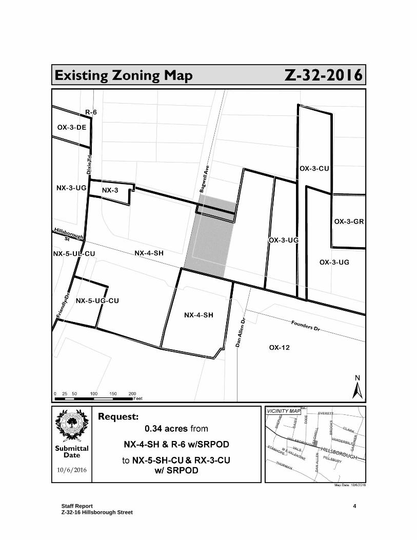
Existing Zoning Map Z-32-2016
±VICINITY MAP
10/6/2016
SubmittalDate
Request:0.34 acres from
NX-4-SH & R-6 w/SRPOD
to NX-5-SH-CU
Map Date: 10/6/2016
w/ SRPOD& RX-3-CU

Certified Recommendation Raleigh Planning Commission
CR#
Case Information: Z-32-16 Hillsborough Street
Location Hillsborough Street, north side, at its intersection with Bagwell Street Address: 2812 Hillsborough Street and 6 Bagwell Avenue PIN: 0794-62-4441 and 0794-62-4551
Request Rezone property from NX-4-SH and R-6, both w/SRPOD to NX-5-SH-CU and RX-3-CU, both with SRPOD
Area of Request .34 acres
Property Owner Kathleen C. Hammon
Applicant Ted Van Dyk, New City Design
Citizens Advisory Council (CAC)
Wade CAC
PC Recommendation
Deadline
February 20, 2017
Comprehensive Plan Consistency The rezoning case is Consistent Inconsistent with the 2030 Comprehensive Plan.
Future Land Use Map Consistency The rezoning case is Consistent Inconsistent with the Future Land Use Map.
Comprehensive Plan Guidance
FUTURE LAND USE Neighborhood Mixed Use (2812 Hillsborough) and Low Density Residential (6 Bagwell)
URBAN FORM Main Street Corridor Transit Emphasis Corridor
CONSISTENT Policies Policy LU 1.2—Future Land Use Map and Zoning Consistency Policy LU 1.3–Conditional Use District Consistency Policy H 1.8–Zoning for Housing Policy UD 1.10–Frontage. Policy UD 6.1—Encouraging Pedestrian-Oriented Uses Policy UD 7.3—Design Guidelines
INCONSISTENT Policies Policy LU 5.6—Buffering Requirements Policy H 1.6—Housing Preservation Policy HP 1.2—Cultural and Historic Resource Preservation
Summary of Proposed Conditions
1. Units will have three or fewer bedrooms; no more than half the units will have three bedrooms.
2. Three bedroom units will have no more than two full bathrooms. 3. Maximum building height of 62’ as measured from northern portion of 2812 Hillsborough. 4. No new vertical building improvements on Bagwell parcel other than landscaping, a wall, or
similar screening structure.
Staff Report Z-32-16 Hillsborough Street
2
5. Parking screened along Bagwell Avenue. 6. Building materials specified (no EIFS or vinyl siding, minimum of 75 percent of siding to be
brick/masonry.
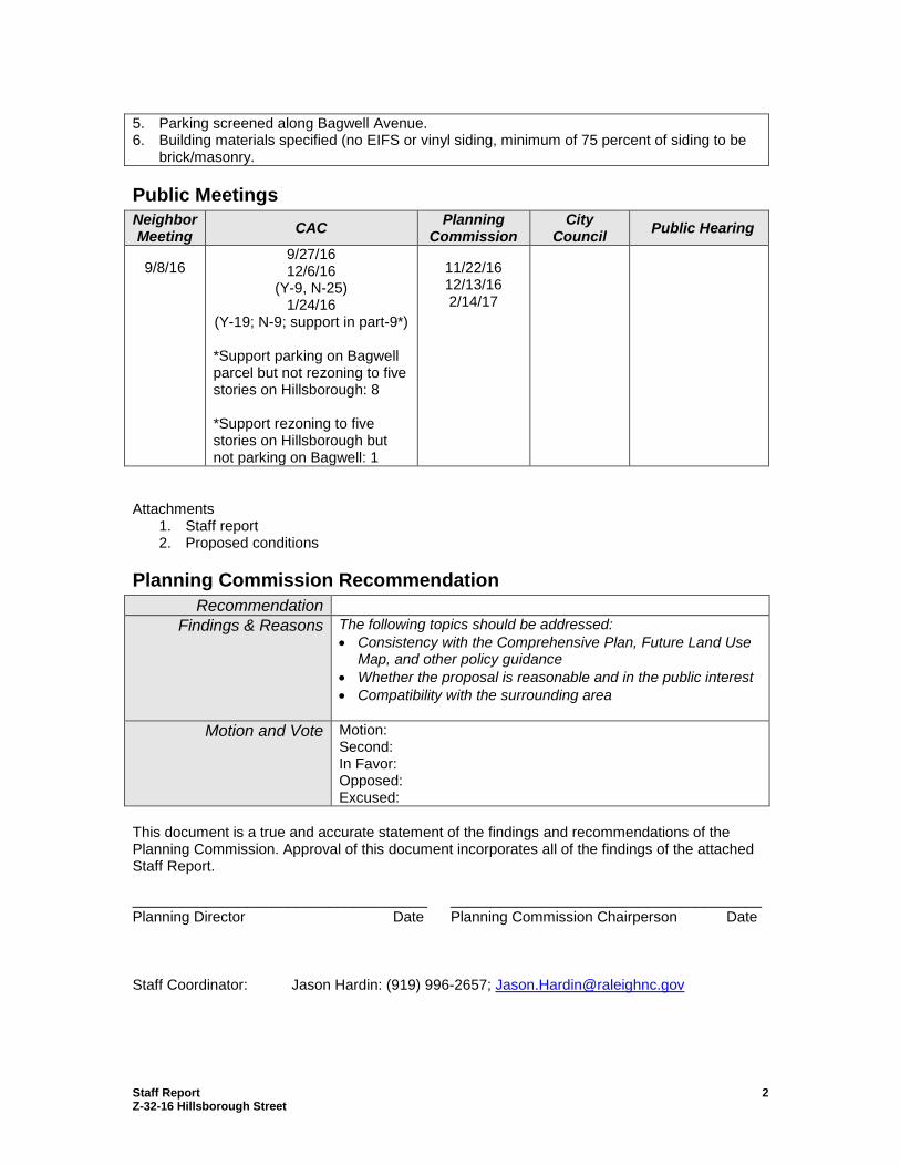
Public Meetings
Neighbor Meeting
CAC Planning
Commission City
Council Public Hearing
9/8/16 9/27/16 12/6/16
(Y-9, N-25) 1/24/16
(Y-19; N-9; support in part-9*)
*Support parking on Bagwell parcel but not rezoning to five stories on Hillsborough: 8 *Support rezoning to five stories on Hillsborough but not parking on Bagwell: 1
11/22/16 12/13/16 2/14/17
Attachments 1. Staff report 2. Proposed conditions
Planning Commission Recommendation
Recommendation
Findings & Reasons The following topics should be addressed:
Consistency with the Comprehensive Plan, Future Land Use Map, and other policy guidance
Whether the proposal is reasonable and in the public interest
Compatibility with the surrounding area
Motion and Vote Motion: Second: In Favor: Opposed: Excused:
This document is a true and accurate statement of the findings and recommendations of the Planning Commission. Approval of this document incorporates all of the findings of the attached Staff Report. ____________________________________ ______________________________________ Planning Director Date Planning Commission Chairperson Date Staff Coordinator: Jason Hardin: (919) 996-2657; [email protected]

Staff Report Z-32-16 Hillsborough Street
3
Case Summary
Overview
This rezoning request involves property at the northeast corner of the intersection of Hillsborough Street and Bagwell Avenue. The subject property consists of two contiguous parcels totaling .34 acres. The southern parcel fronts on both Hillsborough Street and Bagwell Avenue; a smaller parcel to the north fronts on Bagwell Avenue. The southern parcel is currently occupied by an auto repair business, while the northern parcel is occupied by a detached house. Commercial uses exist to the east and west of the subject properties, while the property to the south is occupied by apartments over commercial uses. Both the Future Land Use Map and current zoning designations for the two parcels reflect the differing uses noted above. The southern parcel is in an area designated as Neighborhood Mixed Use on the FLUM, as are areas to the west, south, and east. The northern parcel is in an area designated as Low Density Residential, as are adjacent parcels to the north. The request involves rezoning the southern parcel from Neighborhood Mixed Use-Four Stories-Shopfront (NX-4-SH) to Neighborhood Mixed Use-Five Stories-Shopfront-Conditional Use (NX-5-SH-CU) and rezoning the northern parcel from Residential-6 (R-6) to Residential Mixed Use-Three Stories-Conditional Use (RX-3-CU). No new vertical construction would be allowed on the Bagwell parcel with the exception of a wall or landscaping. However, rezoning it to a mixed-use category would allow for scale and use transitions required on the Hillsborough Street parcel to shift northward. The request includes a number of proposed conditions. These include limiting units to three or fewer bedrooms and limiting three-bedroom units to no more than 50 percent of all units; limiting building height; and specifying materials to be used.
Outstanding Issues
Outstanding Issues
1. Building height may not be consistent with the Plan, particularly with respect to the transition to residential area to the north.
2. Changes to the conditions are needed. Condition 2 must refer to building height in accordance with the UDO. Condition 4 is prohibited by the UDO, as it repeats existing code.
Suggested Mitigation
1. Consider means of lowering overall height and providing increased step down on the north side of 2812 Hillsborough.
2. Revise condition language.
Zoning Staff Report – Case Z-32-16
Conditional Use District
Staff Report Z-32-16 Hillsborough Street
4

Staff Report Z-32-16 Hillsborough Street
5
Rezoning Case Evaluation
1. Compatibility Analysis
1.1 Surrounding Area Land Use/ Zoning Summary
Subject Property
North South East West
Existing Zoning
NX-4-SH / R-6
R-6 NX-4-SH NX-4-SH NX-4-SH / R-6
Additional Overlay
SRPOD SRPOD SRPOD SRPOD SRPOD
Future Land Use
Neighborhood Mixed Use / Low Density Residential
Low Density Residential
Neighborhood Mixed Use
Neighborhood Mixed Use
Neighborhood Mixed Use / Low Density Residential
Current Land Use
Vehicle repair / detached house
Detached residential
Apartments over commercial
Commercial Commercial
Urban Form (if applicable)
Main Street/Transit Emphasis Corridor
None
Main Street/Transit Emphasis Corridor
Main Street/Transit Emphasis Corridor
Main Street/Transit Emphasis Corridor
1.2 Current vs. Proposed Zoning Summary Existing Zoning Proposed Zoning
Residential Density (max.): 65.6 units/acre 93.8 units/acre
Setbacks (2802 Hillsborough) Front: Side Street: Side: Rear:
0’-15’ build-to 0’-15’ build-to
0’ or 6’ 0’ or 6’
0’-15’ build-to 0’-15’ build-to
0’ or 6’ 0’ or 6’
Setbacks (6 Bagwell.): Front: Side: Rear:
10’ 5’ 20’
N/A (no new buildings)
N/A N/A
Retail Intensity Permitted: 7,463 sf 8,667 sf
Office Intensity Permitted: 9,808 sf 14,009 sf

Staff Report Z-32-16 Hillsborough Street
6
1.3 Estimated Development Intensities
Existing Zoning Proposed Zoning* Total Acreage NX-4-SH & R-6, both w/SRPOD NX-5-SH-CU & RX-3-CU, both w/SRPOD
Zoning .34 acres .34 acres
Max. Gross Building SF (if applicable)
25,041 30,665
Max. # Residential Units 21 30
Max. Gross Office SF 9,808 14,009
Max. Gross Retail SF 7,463 sf 8,667 sf
Max. Gross Industrial SF - -
Potential F.A.R. 1.8 2.2
*These development intensities were estimated using an impact analysis tool. The estimates presented are only to
provide guidance for analysis.
The proposed rezoning is:
Compatible with the property and surrounding area.
Incompatible. Analysis of Incompatibility:
The proposal is partly compatible. Nearby properties along Hillsborough Street are zoned for similar uses and heights. The proposed conditions would assist in creating a transition between the subject property and residential properties to the north. However, the request would allow additional height and, by rezoning 6 Bagwell, would allow for the height transition required by the UDO to occur farther to the north than currently allowed. Additional efforts to reduce the additional height that would be above the currently allowed four stories, to step down height on the north end of the site, and to and otherwise improve the transition on the northern end of the property could improve compatibility.

Staff Report Z-32-16 Hillsborough Street
7

Staff Report Z-32-16 Hillsborough Street
8
Staff Report Z-32-16 Hillsborough Street
9
2. Comprehensive Plan Consistency Analysis 2.1 Comprehensive Plan Determination of the conformance of a proposed use or zone with the Comprehensive Plan includes consideration of the following questions: A. Is the proposal consistent with the vision, themes, and policies contained in the
Comprehensive Plan? B. Is the use being considered specifically designated on the Future Land Use Map in the area
where its location is proposed? C. If the use is not specifically designated on the Future Land Use Map in the area where its
location is proposed, is it needed to service such a planned use, or could it be established without adversely altering the recommended land use and character of the area?
D. Will community facilities and streets be available at City standards to serve the use proposed for the property?
A. The proposal is largely consistent with the vision and themes and several specific policies of
the plan. The request is consistent with the Future Land Use Map and Urban Form Map and with themes and policies that encourage density along corridors served by transit and that encourage pedestrian-friendly development. The primary inconsistency involves whether the proposed height, as discussed below, is consistent with plan guidelines.
B. The Future Land Use map designates the Hillsborough Street parcel as Neighborhood Mixed Use. NX is an appropriate zoning category for this designation. In areas designated as Neighborhood Mixed Use, the Plan envisions heights of five stories in “Core/Transit” areas, three stories in “Edge” areas, and four stories in between. The southern section of the site qualifies as a “Core/Transit” area due to the presence of frequent bus transit along Hillsborough Street, but the northern end fits the description of “Edge,” as it is within 150’ of lower-density residential. In this case, a proposed condition would limit height to 62’ as measured from the northern edge of 2812 Hillsborough. Due to a change in grade, this appears to translate to approximately 70’ at the southern edge of the property, or 5’ lower than typically permitted with five stories. Five stories could be seen as appropriate for the southern end of the property, but additional efforts to reduce overall height and to transition it down to the residential properties to the north could improve consistency. The Plan recommends that heights in edge areas should generally match the surrounding area. In this case, nearby structures to the north are one story, making the potential transition abrupt. The FLUM designates the Bagwell Avenue parcel as Low Density Residential. The conditions restricting any new vertical building improvements are consistent with this designation. However, as the UDO requires scale and use transitions between mixed use and residential zones, by changing this zoning on this lot to RX, the transitions mentioned above would occur farther north, closer to other low-density residential structures. Therefore the issues mentioned above with respect to the Hillsborough parcel are relevant to this parcel as well.
C. Not applicable, as the use is designated on the Future Land Use Map.
D. Existing infrastructure is sufficient to serve development permitted by the proposed rezoning.

Staff Report Z-32-16 Hillsborough Street
10
2.2 Future Land Use Future Land Use designation: Neighborhood Mixed Use (Hillsborough parcel) and Low Density Residential (Bagwell parcel) The rezoning request is:
Consistent with the Future Land Use Map.
Inconsistent Analysis:
2.3 Urban Form Urban Form designation: Main Street; Transit Emphasis Corridor
Not applicable (no Urban Form designation) The rezoning request is:
Consistent with the Urban Form Map.
Inconsistent Analysis of Inconsistency:
2.4 Policy Guidance The rezoning request is consistent with the following policies:
Policy LU 1.2—Future Land Use Map and Zoning Consistency. The requested zoning, in conjunction with the proposed conditions, is consistent with the FLUM. Policy LU 1.3–Conditional Use District Consistency. The conditions assist in establishing consistency and are themselves consistent with the Plan. Policy H 1.8–Zoning for Housing. The request would help supply the market with housing. Policy UD 1.10–Frontage. The retention of the Shopfront frontage is the same as or similar to adjacent parcels, establishing a consistent frontage. Policy UD 6.1—Encouraging Pedestrian-Oriented Uses. The proposal promotes pedestrian-oriented uses and form. Policy UD 7.3—Design Guidelines. The Shopfront frontage, which ensures the street is lined by buildings rather than parking lots and which provides visual interest for pedestrians, supports this policy.
The retention of the Shopfront frontage is consistent with the Urban Form Map.
The southern parcel is in an area designated on the Future Land Use Map as Neighborhood Mixed Use, which is compatible with the proposed NX zoning. The northern parcel is in an area designated as Low Density Residential on the FLUM. While the Plan does not envision applying RX zoning to these areas, the proposed conditions on this portion of the area to be rezoned eliminate inconsistency.
Staff Report Z-32-16 Hillsborough Street
11
The rezoning request is inconsistent with the following policies:
Policy LU 5.6—Buffering Requirements. The conditions on the Bagwell parcel assist in establishing the transition envisioned by this policy. However, additional efforts to reduce height on the northern end of the Hillsborough parcel would assist in achieving consistency. Policy H 1.6—Housing Preservation. The proposal would eliminate an existing house on Bagwell Avenue. Policy HP 1.2—Cultural and Historic Resource Preservation. The proposal would remove two contributing buildings, a former gas station and a detached house, from the West Raleigh National Register Historic District.
2.5 Area Plan Policy Guidance
No approved Area Plan currently exists. However, the jointly produced Cameron Village and Hillsborough Street Small Area Plans, which are available in draft form, did not include this portion of Hillsborough Street in the listing of areas where increased height is recommended.
3. Public Benefit and Reasonableness Analysis
3.1 Public Benefits of the Proposed Rezoning
The proposal will provide additional housing in an area well-served by transit.
The proposal will help meet demand in the housing market.
The proposal will make this section of Hillsborough Street more accommodating to pedestrians by eliminating an existing surface parking lot along the street.
3.2 Detriments of the Proposed Rezoning
Two contributing structure in the West Raleigh National Register Historic district, a house and a former gas station, would be removed to accommodate a new building and parking and to create a transition area.
4. Impact Analysis
4.1 Transportation The site is located in the northeast quadrant of Hillsborough Street and Bagwell Avenue. Hillsborough Street (SR 3007) is maintained by the NCDOT; Bagwell Avenue is maintained by the City of Raleigh. Hillsborough Street is classified as a mixed-use street in the UDO Street Plan Map (Avenue, 3-Lane, Parallel Parking). Bagwell Avenue is a local street. This segment of Bagwell Avenue currently has a two-lane cross section with curbs but no sidewalks.
Staff Report Z-32-16 Hillsborough Street
12
The Hillsborough Street Revitalization project is underway; it will install a center median along Hillsborough Street in front of the Z-32-2016 site.
Offers of cross access to adjacent parcels shall be made in accordance with the Raleigh UDO section 8.3.5.D. There are no public street stubs abutting the eastern boundary of the Z-32-2016 parcels.
Site access will be determined upon completion of the Hillsborough Street Revitalization project and upon submission of a site plan to the Raleigh Development Services Department. Driveway access on Hillsborough Street will be limited to Right-In/Right-Out.
In accordance with UDO section 8.3.2, the maximum block perimeter for NX-5 zoning is 2,500 feet. The block perimeter for Z-32-2016, as defined by public rights-of-way for Hillsborough Street, Bagwell Avenue, Everett Avenue and Brooks Avenue is 3,020 feet.
The existing land uses are a single-family dwelling and an automotive repair shop; these uses generate very little traffic. Current zoning allows for 17 multifamily dwellings and approximately 7,500 sf of retail use. Approval of case Z-32-2016 would allow a modest increase in these uses (22 multifamily dwellings and 8,700 sf of retail); average peak hour trip volumes will increase by 10 veh/hr while daily trip volume will increase by 124 veh/day. A traffic impact analysis report is not needed for Z-32-2016.
Impact Identified: Block perimeter exceeds UDO standard.
4.2 Transit Impact Identified: None
4.3 Hydrology
Floodplain No FEMA Floodplain present.
Drainage Basin Rocky
Stormwater Management Subject to Part 10, Chapter 9
Overlay District None.
Impact Identified: No major impacts identified.
4.4 Public Utilities
Maximum Demand
(current use)
Maximum Demand
(current zoning)
Maximum Demand (proposed zoning)
Water 1,250 gpd 5,250 gpd 7,500 gpd
Wastewater 1,250 gpd 5,250 gpd 7,500 gpd
The proposed rezoning would add approximately 6,250 gpd to the wastewater collection and water distribution systems of the City. There are existing sanitary sewer and water mains adjacent to the proposed rezoning area At the time of development plan submittal, a Downstream Sewer Capacity Study may be required to determine adequate capacity to support the proposed development. Any improvements identified by the study would be required to be permitted prior to the issuance of building permit and constructed prior to release of a Certificate of Occupancy
Staff Report Z-32-16 Hillsborough Street
13
Verification of water available for fire flow is required as part of the building permit process. Any water system improvements recommended by the analysis to meet fire flow requirements will also be required of the developer.
Impact Identified: No major impacts identified; sewer and fire flow analysis needed..
4.5 Parks and Recreation
The site contains no greenway corridors, trails, easements, or connectors. Closest trail access is 0.4 miles, Rocky Branch Trail. Recreation services are provided by Isabella Cannon Park, located 0.5 miles distance. Impact Identified: No major impacts identified.
4.6 Urban Forestry 1. UDO 9.1 tree conservation does not apply to this rezoning. 2. The Hillsborough Street Improvement Project will address the streetscape along
Hillsborough Street and the corner with Bagwell Avenue. 3. UDO 8.5.1.applies.
Impact Identified: None.
4.7 Designated Historic Resources
The site is within the West Raleigh National Register Historic District. 6 Bagwell Avenue is a house constructed ca. 1925 and is classified as a Contributing Building. 2812 Hillsborough Street is a gas station constructed ca. 1952, and is classified as a Contributing Building. It is described as a one-story, gas station, with enamel panels that cover the exterior, a flat roof, plate glass windows, a rounded southwest comer, and three garage bays. Based on a deed and plat, H. B. and Ella Bagwell sold this parcel to Standard Oil in 1925 but the existing building does not date from that period. The Raleigh Historic Landmark Milton Small & Associates Office Building (105 Brooks Avenue) is on the other side of the block and the Raleigh Historic Landmark NC Agricultural Experiment Station Cottage (2714 Vanderbilt Avenue) is within 1,000 feet. Impact Identified: Possible visual impacts. RDHC is providing a memo with additional information.
4.9 Impacts Summary Sewer and fire flow matters may need to be addressed upon redevelopment.
4.10 Mitigation of Impacts Address sewer and fire flow capacities at the site plan stage.
Staff Report Z-32-16 Hillsborough Street
14
5. Conclusions
The proposal is consistent with the Future Land Use Map and Urban Form Map. It would add housing along a corridor served by transit and would facilitate improved conditions for pedestrians. The primary question involves the requested height. The question involves whether the site is best described as a “Core/Transit” area (five stories permitted); or, given the presence of lower density residential structures to the north, a “General” area (four stories permitted); or a hybrid of the two. While the request includes a condition that restricts the height to approximately 70’ at Hillsborough Street, less than the 75’ allowed by code in five-story districts, additional efforts to reduce overall height and step the building down to the north may improve consistency. Overall, while the proposal is consistent with several policies, as proposed it is inconsistent with the Comprehensive Plan. The proposed conditions also need revisions to address issues of redundancy of a code provision and to reflect how height is measured in the code.

Dcp11rtment of City Pl~nning 11 Exchange Plaza, Suite 300 I Raleigh, NC 27601 I 919-996-2626
D General Use 1:§1 Conditional Use D Master Plan
Existing Zoning Classification: NX-4-SH and R-6 all with SRPOD
Proposed Zoning Classification Base District: NX Height::§ Frontage: -SH Overlay: SRPOD Proposed Zoning Classification Base District: RX Height:::;! Frontage: None Overlay: SRPOD
If the property has been previously rezoned, provide the rezoning case number: Not Applicable
OCT 5 2016 Pfl 4,05 ·
Transaction #
Provide all previous transaction numbers for Coordinated Team Reviews, Due Diligence Sessions, or Pre-Submittal Conferences:
486762 (Rezoning Pre-Application)
Property Address: 2812 Hillsborough Street and 6 Bagwell Street Date
Property PIN: 0794-62-4441 and 0794-62-4551
Nearest Intersection: Hillsborough Street and Bagwell Street
Property Owner/Address: Kathleen C. Hammon 1102 E. Franklin Street Chapel Hill, NC 27514
Project Contact Person/Address: Ted Van Dyk, New City Design 1304 Hillsborough Street Raleigh, NC 27605
Owner/Agent Signature
Deed Reference (book/page): DB 3402, PG 451 and DB 3490, PG 028
Property Size (acres): 0.34 acres
Phone Fax
Phone: 919.831.1308 Fax: 919.831.9737
mail: [email protected]
A rezoning application will not be considered complete until all required submittal components listed on the Rezoning Checklist have been received and approved.
PAGEIOF6 WWW.RALEIGHNC.GOV REVISION 04.05.16

Comprehensive Plan Analysis >-------------·------·-----------------!
The applicant Is asked to analyze the Impact of the rezoning request. State Statutes require that the rezoning either be consistent with the adopted Comprehensive Plan, or that the request be reasonable and in the public interest.
OFFICE USE ONLY
Transaction II
Rezoning Case II
Provide brief statements regarding whether the rezoning request Is consistent with the fu{l,lre land use designation, the urban form map, and any applicable policies contained within the 2030 Comprehensive Plan.
1. The 2812 Hillsborough Street parcel is designated "Neighborhood Mixed Use" on the Future land Use Map, which reccmmends mixed use projects with upper-story housing. Also, the NMU description states that NX is the most appropriate zoning district for property designated NMU. Therefore, the rezoning to NX Is ccnsistent with the NMU designation. The 6 Bagwell parcel is designated "low Density Residential" on the Future Land Use Map, which applies to property where single.family is planned. The rezoning request to RX with a condition limiting development on this parcel to a single-family detached structure or parking Is consistent with this guidance.
2. The properties rront along Hillsborough Street, which Is designated a Transit Emphasis Corridor and Main Street on the Urban Form Map. Also, these properties are within the halr·rnile transit buffer. This guidance encourages the application of an urban frontage. The application of the Shoplront frontage is consistent with this guidance. Also, Table LU-2 Recommended Height Designations table states that a maximum of five stortes Is appropriate for property designated NMU on the Future Land Use Map and located within a Core/Transit Area. Given lhe property's location along a Transit Emphasis Corridor and within the transit buffer, the property is located within a Core/Transit Area. Thererore, the request for a height of five stories is consistent wilt, the Urban Form Map and Comprehensive Plan guidance.
-~-.. -----·-------------3. The rezoning request Is consistent with Comprehensive Plan policies LU 1.2, LU 1.3, LU 2.2, LU 4.4, LU 4.7, LU 4.9, LU 5.1, LU
5A, LU 5.6, LU 7.4, LU 7.6, LU 10.1, UD 2.1 and UD 2.3 because itis consistent with the Future Land Use Map and Urban Form Map and facilitates the redevelopment of an under-utilized site for a mixed.use building 1hat provides appropriate transition to the surrounding low density neighbomood.
Provide brief statements regarding the public benefits derived as a result of the rezoning request.
1. The rezoning reques1 provides the public benefit of redeveloping an under-utilized and auto-orlen1ed site for a mixed·use, pedestrian-oriented use that will activate this segment of Hillsborough Street and provide an approprla1e transition to the nearby residential neighborhood.
~------------------.. --·-------------------------~
PAGEJOF6 WWW.RALEIGHNC.GOV REVISION 04.05.16
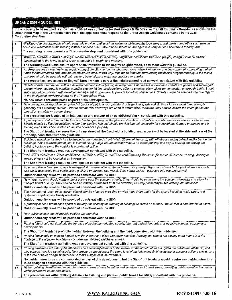
URBAN DESIGN GUIDELINES
If the property to bo rezoned is shown as a "mJxed use center" or located along a Main Street or Transit Emphasis Corridor as shown on the-Urban Form Map in the Comprehensive Plan, the applicant must respond to the Urban Design Guldelines contained in the 2030 Comprehensive Plan.
----------·--------------------- ------~--------------------- ·---·· 1. All Mixed-Use developments should generally provide retail (such as eating establishments, food stores, and banks), and other such uses as
office and residenliai within walking distance of each other. Mixed uses should be arranged in a compact and pedestrian friendly form, The rezoning request permits a mixed-use development consistent with this guideline.
2. Within afl Mixed-Use Aroas buildings that are adjacelit to lowef'.density neighborhoods should transition (height, design, distance and/or landscaping) to the lower heights or be comparable in height and massing, The rezoning conditions ensure approprlate transition to the nearby neighborhood, consistent with thls guideline.
3. A mixed use area's road net\vork should connect directly Into the neighborhood f'Oad netwofk of the si.iffoundlflg ·communit}', providing multiple paths for movemenl to and through the mixed use area. In this way, trips made from the surrounding residenlial nefghborhood(s) Jo the mixed use area should ba possible without requiring travel along a major thoroughfare or arterial. The properties have access to Bagwell Street, which is part of the neighborhood road network, consistent with this guideline. --- - --· ·------- - ---------:--
4. Streets should interconnect within a development and with adjoining development. Cul-de-sacs or dead-end streets are generally discouraged except where topographic conditions and/or exterior Jot line configurations offer no practical aftematlves for connection or through traffic. Street stubs should be provided with development adjacent to open land to provide for future connections. Streets should be planned with due regard to the designated corridors shown on the Thoroughfare Plan. No new streets are anticipated as part of this development.
5. New development should be comprised of blocks of public and/or priwite streets (including sidewalks). Block faces should have a length generally not exceeding 660 feet. Where commercial driveways are used to create block structure, they should include the same pedestrian amenities as public or private streets. The ptopertles aro located at an intersection and are part of an established block, consistent with this guideline.
··--6. A primary task of all urban archiiectUre and landscape design is tho physical definition of streets and public spaCes as places of shared use.
Streets should be Jined by buildings rather than parking lots and should provide interest especially for pedestrians. Garage entrances and/or loading areas should be located at the side or rear of a property. The Shopfront frontagn ensures the primary street will be Uned with a building, and access wm be located at the side and rear of the property. consistent with this guideline.
7. Buildings Should be located close to the pedestrian-Oriented stfOot (within 25 feet of (ho curb), wifh off~stroet parking behind end/or beside the buildings. When a development plan fs located along a high volume oorridor wUhouJ on-street parking, one bay of parking separating the building frontage along the corridor is a preferred option. The Shopfront frontage requires development consistent with this guldeUn&.
8. ff the site is located at a street lntersectfon, the main building or main part of the building shOu!d be placed ac the· comer. P8rkfng, loading or service should not be located at an intersection. The Shopfront frontage requires development consistent with this guideUne.
9. To ensure that urban open spEu;e is well-used, it is essential to locate and design it carefully. The space should be located where it is visible and easily accessibfe from public areas {building entrances, &dewaJks). Tako views and sun exposure into account as well. Outdoor amenity areas wm be provided consistent with the UDO.
-· 10. New urban spaces should contain diroct access from the adjacent streets, They should be open along the adjacent sidewalks and allow for
muliiple points of entry, They should also be visually permeable from the sidewalk, allowing passersby to see direclly into tho space. Outdoor amenity areas wm be provided conslstent with the UDO.
11. The perimeter of urbaii open spDCCs should consist of active uses that provide pedestrian traffic ·ror the spa·ce iflcludi(ig retail, caf6s, and restaurants and higher-density residential. Outdoor amenity areas will be provlded consistent with the UDO,
12, i properly d6fined urban open space is visually enc10Sed by ihe fronting of buifdings to create an outdoor "room"' that is comfortable to users. Outdoor amenity areas will be provided consistent with the UDO,
13, New public spaces should provide sealing opportunities. Outdoor amenity areas will be provided consistent with the UDO.
14. Parking lots should not dominate the frontage of pedestrian-oriented streets, interrupt pedestrian routes, or negatively Impact suriounding developments. The Shopfront frontage prohibits parking between the building and the road; consistent with this guideline.
15. Parking lots should be located behind or in the lntelior of a block whenever possible. Parking lots should no! occupy more than 1/3 of the frontage of the adjacenl building or not more than 64 feel, whichever is less. The Shopfront frontage guideline requires development consistent with this guideline.
16. Parking structures are clearly an important and necessary element of the overell urban infrastructure but, given their utilitarian elements, can give serious negative visual effects. New structures should merit the same level of materials and finishes as that a principal buffding would, care in the use of basfc design elements cane make a signfflcant improvement. No parking structures are contemplated as part of this development, but the Shopfront frontage would require any parking structure to be designed consistent with this guideline.
17. Higher bUifding den.Silios and inore intenSivo Jand uSes should be within \valking diifanc-e of ti8nsit stops:· pormiJtinij public tmllsit to bocome a viable allernaJive to the automobile. The properties are within walking distance to existing and planned public transit facllities 1 consistent with this guideline.
PAGE50F6 WWW.RALEIGHNC.GOV REVISION 04.05.16

~
-· Convenient, comforlable f)Odestn·an access between the transit stop and fhe building entrance should be planned as part of the overall --18.
pedestrian network, Pedestrian access exists by way of Hillsborough Street to nearby public transit stops, consistent with this guideline, - ··Afl development should respect natural rOsources aS an essen.tial component of the human environment. The most sensitive landscape areas, 19. both environmentally and visually, are stoop slopes greater than 15 percent, watercourses, and floodplains. Any development in these areas should minimize inleNenfion and maintain the natural conditiDn except under extreme circumstances. Where practical, these featums should be conserved as open space amenmes and incorporated in the overall sNe design. There are no known sensltlve envlronrnental features on the property.
20. It is the intent of these guideJines to build streets that are integral components of community design. Public and private streets, as weJJ as commercial driveways that serve as primary pedestrian pathways to building entrances, should be designed as the main public spaces of the City and should be scaled for pedestrians, No new streets aro contemplated as part of this development, and a commercial driveway wiU comply with the UDO and Street Design Ma~mal. ... -· ... "' -· -·· ... -··- ... -··- ···-
21. Sidewalks should be 5-8 feet wide in residential areas and located on both sides of the street. Sidewalks in commercial areas and Podestnan Business Overlays should be a minimum of 14~1B feet wide to accornmodate sidewalk uses such as vendors, merchandising and outdoor sealing, Sidewalks wm be provfded ln accordance with the UDO.
22. Streets should be-des;gned ·With street trees planted In 11 manner appropriate to their function. Commercial streets should have trees which compfemrmf the face of the buildings and whfch shade the sidewalk. Residential streets should provide (or an appropriate canopy, which shadows both the street and sidewalk, and se,ves as a visual buffer between (he street and the home. The typical width of the street landscape strip ts 6·8 feet. This width ensures healthy street trees, precludes troe roots from breaking the sidewalk, and provides adequate pedestrian buffering. Street frees should be at least 6 114• caliper and should be consistent with the City's landscaping, lightfng and street s;ght distance requirements. Street trees and other landscaping wlll be provided in accordance with the UDO.
23. Buildi/1gs should define the streets spatialJy, Pro/Jer spatiaFdefinifton Should be 8chieved With buildings or other archilectuml elements (including cortain tree plentfngs) fhat make up the slreet edges aligned in a disciplined manner with an appropriate ratio of height to width. The Shopfront frontage requires development consistent with this guideline.
···-----·- --·--------- -- ·-------·--------------· --·- --·-------·-·------24. The primary entmnce should be both architecturally and functionally on the front facade of any building facing the primary public street, Such
entrances shall be designed to convey their prominence on the (ranting facade. The Shopfront frontage requires development consistent with this guideline. ·---··-----·--- . . -----·-- --- - --------
25. The ground level of the bui1dlng should offer pedestrian interest along sidewalks. This includes windows entrances, and archilecturel details, Signage, awnings, and omamentafion are encouraged. The Shopfront frontage requires development consistent with this guideline.
26. The sidewalks should be the principal place of pedestrian movement and casual social interoctfon. Designs and uses should be complementary lo that function. The Shopfront frontage requires development consistent with this guideline.
PAGE60F6 WW\V.RALEIGHNC.GOV REVISION 04.05.16

1304HillsboroughS!reet I Raleigh,NC 27605 I tel919.831.1308 I fax919.831.9737
Neighborhood Meeting Report 2812 Hillsborough, 06 Bagwell
www.newcitydesign.com
A meeting was held at the offices of New City Design Group, 1304 Hillsborough Street, on September 8, 2016 at 6 pm.
No members of the community attended. The development team discussed the project and adjourned at approximately 6:45 pm.
Note that the development team presented the case to the Wade CAC as a courtesy- no vote was to be taken- on September 27, 2016.
Project parameters, conditions, and details were discussed.
Neighborhood input included requesting assurances that conditions such as prohibiting 4 bedroom units, and offering a variety of unit types. Other input included a request for use of high quality materials for parking and landscaping areas, screening of parking, and possible inclusion of small site amenities such as special plantings in landscape areas.
Respectfully submitted,
Ted Van Dyk, AIA New City Design Group, PLLC
new city 1304 Hillsborough Street Raleigh, North Carolina 27605
design group P) 919.831.1308 F) 919.831.9737
August 19, 2016
Neighbors,
We contacted you some ago concerning 2812 Hillsborough Street and 06 Bagwell Ave. We proposed zoning 2812 Hillsborough Street from NX 4SH to NX 5SH, and 06 Bagwell to RX3.
We have restarted this effort, and since many months have passed, and we have some new information to offer, we invite you to a neighborhood meeting to learn more about our plans and offer your input.
The meeting will be held at new City Design Group, 1304 Hillsborough Street, 6 pm., Thursday, September 8th·
If you have questions in the meantime, please contact me at 919 831 1308, and I will be happy to speak with you or:
Contact information for Raleigh Department of City Planning: Phone: 919-996-2626 Email: Web:
rezoni n g(a),ralei ghnc. gov www.raleighnc.gov
Thanks for your consideration;
Sincerely,
Ted Van Dyk, AIA
www.newcitydesign.com

0794624441
HAMMON, KATHLEEN C
5905 JEFFREYS GROVE SCHOOL RD
RALEIGH NC 27612-2228
0794507874
UNITED STATES OF AMERICA
310 NEW BERN AVE
RALEIGH NC 27601-1441
0794507874
NORTH CAROLINA STATE OF
HOLLADAY HALL- ROOM A
PO BOX 7008
RALEIGH NC 27695-7001
RALEIGH NC 27695-7001
0794507874
WAKE COUNTY
WAKE COUNTY ATIORNEY'S OFFICE
PO BOX 550
RALEIGH NC 27602-0550
RALEIGH NC 27602-0550
0794507874
ETA UPSILON HOUSE CORP OF KAPPA
DELTA SORORITY
HAMILTON FINANCIAL
3710 UNIVERSITY DR STE 330
3710 UNIVERSITY DR STE 330
DURHAM NC 27707-6204
0794507874
NORTH CAROLINA STATE OF
HOLLADY HALL-ROOM A
CAMPUS PO BOX 7008
RALEIGH NC 27695-7001
RALEIGH NC 27695-7001
0794507874
NCSU
HALLADAY HALL - ROOM A
PO BOX 7008
RALEIGH NC 27695-7001
RALEIGH NC 27695-7001
0794507874
NORTH CAROLINA STATE OF
HALLADAY HALL-ROOM A
PO BOX 7008
RALEIGH NC 27695-7001
RALEIGH NC 27695-7001
0794507874
USDA PLANT RESEARCH
HOLLADAY HALL - ROOM A
CAMPUS PO BOX 7008
RALEIGH NC 27695-7001
RALEIGH NC 27695-7001
0794507874
BETA TAU CHAPTER OF SIGMA NU
FRATERNITY HOUSE CORP ...
C/0 HOWARD PICKETI
1021 GOODWORTH DR
1021 GOODWORTH DR
APEX NC 27539-3869

0794622276
CAPETANOS HOLDINGS LLC
3608 PINNACLE DR
CARY NC 27518-8922
0794623538
FERGUSON PROPERTIES LLC
2230 WHITMAN RD
RALEIGH NC 27607-6649
0794624201
FMW AT 2811 HILLSBOROUGH LLC
132 BREVARD CT
CHARLOTIE NC 28202-1927
0794624575
DOBSON, LOLO A DOBSON, LORRAINE R
138 TETBURY AVE NE
CONCORD NC 28025-3172
0794625441
MOSELEY, CHARLES V
1128 IVY LN
RALEIGH NC 27609-4761
0794623404
FERGUSON PROPERTIES LLC
2230 WHITMAN RD
RALEIGH NC 27607-6649
0794623654
PLW BAGWELL LLC
11 BAGWELL AVE
RALEIGH NC 27607-7136
0794624551
HAMMON, KATHLEEN C
1102 E FRANKLIN ST
CHAPEL HILL NC 27514-3221
0794624589
ROCKFISH REAL ESTATE LLC
707 EVANVALE CT
CARY NC 27518-2806
0794625654
HASSLER, WILLIAM T DOROTHY L
HASSLER TRUST
5708 33RD ST NW
WASHINGTON DC 20015-1643
WASHINGTON DC 20015-1643

0794626430
NORTH CAROLINA STATE OF
STATE PROPERTY OFFICE
116 W JONES ST
RALEIGH NC 27603-1300
RALEIGH NC 27603-1300