zimbabwe - home | amnesty international...zimbabwe: quantifying destruction 3 amnesty international...
TRANSCRIPT

AI Index: AFR 46/014/2006 Amnesty International 8 September 2006
Zimbabwe
Quantifying destruction - satellite images of forced evictions
Introduction Between May and July 2005 some 700,000 people in Zimbabwe lost their homes, their
livelihoods or both as a direct consequence of the government’s Operation Murambatsvina1, a
programme of mass forced evictions and demolitions of homes and informal businesses. In
some areas entire settlements were razed to the ground. While the demolitions took place
right across the country, the majority of the destruction occurred in high density urban areas
in Harare, Chitungwiza, Bulawayo, Mutare, Kariba and Victoria Falls. In these areas tens of
thousands of poor families lived in what are known as backyard cottages or extensions - these
were small, often brick, structures built on residential plots around the main house, sometimes
attached to the main house, and sometimes a little way separate from it. They varied in size
from one to several rooms. In urban areas these backyard structures were the only source of
accommodation for poor people, who could not afford to buy a plot of land and build their
own home. The government and local authorities in Zimbabwe provide almost no cheap rental
accommodation.
Operation Murambatsvina occurred countrywide. This report contains “before” and “after”
satellite images of four sites affected by Operation Murambatsvina: Porta Farm settlement and
portions of both Hatcliffe and Chitungwiza, all located around the capital, Harare, and
Killarney, an informal settlement on the outskirts of Bulawayo in the south of Zimbabwe.2
These images, which represent only a fraction of the demolitions, provide compelling visual
evidence of the scale of the destruction and human rights violations which took place in
Zimbabwe during 2005. Using satellite technology it has also been possible to count the
number of structures destroyed at these sites, providing quantitative evidence of the
demolitions. In just the four areas covered by the satellite images more than 5,000 structures
were destroyed.
The government of Zimbabwe maintains that all of the homes demolished were “illegal”
structures. However, the homes and settlements destroyed included informal settlements of
1 Operation Murambatsvina means ‘drive out rubbish’ in Shona. 2 Amnesty International researchers visited Porta Farm, Chitungwiza and Hatcliffe in August 2005 and witnessed
the visible evidence of demolitions and evictions at all these sites. Interviews were conducted with residents of
Porta Farm, Chitungwiza, Hatcliffe and Killarney, also in 2005. The residents of Porta Farm and Killarney, both of
which were destroyed, were interviewed in various locations to which they had moved in the aftermath of
Operation Murambatsvina, including churches and a holding camp set up by the government. Amnesty
International researchers subsequently visited Porta Farm, Hatcliffe and Killarney in April and May 2006, and
interviewed people who had returned to Killarney and Hatcliffe. Porta Farm was deserted and access was restricted
by wildlife officers who claimed they were there to prevent poaching of fish from the nearby lake.

2 Zimbabwe: Quantifying destruction
Amnesty International 8 September 2006 AI Index: AFR 46/014/2006
long standing where the government itself had placed people, homes on sites where people
held government leases, and areas where court orders existed prohibiting the evictions.3
Despite the claims of the government of Zimbabwe, forced evictions and demolitions without
due process, even of structures deemed to be “illegal”, are not permitted under international
law. The United Nations (UN) Commission on Human Rights considers that "the practice of
forced evictions constitutes a gross violation of human rights, in particular the right to
adequate housing",4 while the UN Committee on Economic, Social and Cultural Rights,
which monitors compliance with the International Covenant on Economic Social and Cultural
Rights, to which Zimbabwe is a state party, has stated that "instances of forced eviction are
prima facie incompatible with the requirements of the Covenant and can only be justified in
the most exceptional circumstances, and in accordance with the relevant principles of
international law."5 The mass evictions of Operation Murambatsvina were carried out without
adequate notice, court orders, due process, legal protection, redress or appropriate relocation
measures. They resulted in hundreds of thousands of people being made homeless in winter. About this report
The satellite images in this report were commissioned by Amnesty International and were
analysed by the American Association for the Advancement of Science, with funding from
the MacArthur Foundation in the United States.
3 Report of the Fact-Finding Mission to Zimbabwe to assess the Scope and Impact of Operation Murambatsvina by
the UN Special Envoy on Human Settlement Issues in Zimbabwe, 22 July 2005. See also: Amnesty International,
“Zimbabwe: shattered lives – the case of Porta Farm”, AI Index AFR 46/004/2006, 31 March 2006. 4 UN Commission on Human Rights, Resolution 1993/77, para 1. 5 CESCR General Comment No. 4 on right to adequate housing (1991), para. 18.

Zimbabwe: Quantifying destruction 3
Amnesty International 8 September 2006 AI Index: AFR 46/014/2006
Porta Farm Image Analysis Early in the morning of 28 June 2005 a convoy of vehicles and police descended on the
informal settlement of Porta Farm, which had been established in 1991, and in 2005 was
estimated to be home to between 6,000 and 10,000 people. The police were heavily armed.
They began evicting residents and destroying buildings. Residents watched helplessly as
bulldozers and police officers in riot gear reduced their homes to rubble. Many people lost
their personal possessions, including food stocks, during the demolitions. The destruction of
Porta Farm went on all day – only ending when darkness fell. Thousands of people were
forced to sleep outside in the rubble in mid-winter. On 29 June the police returned to continue
with the demolitions. They also began to forcibly load people on to the back of trucks. Many
were obliged to leave furniture and other items behind at Porta Farm because there was not
room on the trucks for their possessions. They were taken to a holding camp and then a camp
for internally displaced people in Harare, where many remain, living in make-shift shelters.
Two QuickBird satellite images were obtained covering the area of Porta Farm, including a
“before” image from 22 June, 2002 and an “after” image from 6 April 2006 (see Figure 1).6
The satellite images clearly show Porta Farm in 2002 as a vibrant settlement while only some
of its roads and vegetation remain in 2006.
6 The two QuickBird satellite images were obtained from Digital Globe. Specifically, one cloud free image of
Porta Farm from 22 June 2002 was ordered from the Digital Global archives via the MapMart company.
Unfortunately, no suitable archive image of Porta Farm was available from Digital Globe for the period following
Operation Murambatsvina. A new image task was ordered via MapMart so as to capture the site as it appears
currently. This order was placed on 20 March 2006. The QuickBird satellite carries a multispectral sensor
measuring reflected electromagnetic radiation in the red, green, blue, and near-infrared wavelengths. Its spatial
resolution is about 0.65 meters for the panchromatic product, making it suitable for assessing individual structures
as small as a few meters on a side. It has a nominal overpass frequency of three days, though in practice about one
image a week seems to be the most that can be expected. As with any spectral sensor it cannot penetrate clouds,
further degrading its availability.

4 Zimbabwe: Quantifying destruction
Amnesty International 8 September 2006 AI Index: AFR 46/014/2006
Figure 1: Porta Farm Before and After Operation Murambatsvina
High resolution satellite imagery of the Porta Farm settlement in Zimbabwe. More than 850 structures are visible in the before (left hand) image, practically all of which are absent from the after (right hand) image. Note that the significant difference in colour between the images is due to seasonality as the
before image was captured during the dry season while the after image was acquired during the rainy season. Images (C) COPYRIGHT 2006 DigitalGlobe, Inc. ALL RIGHTS RESERVED.
Processing and Analysis Visual analysis of the 2002 image was undertaken to determine the approximate number of
structures removed during the interim period. Specifically, the 2002 image was loaded in
ArcView GIS and individual visible structures were counted (see Figure 2). A total of 870
structures were counted. The majority are absent from the “after” image. Based on image
analysis, more than 850 structures were apparently removed during Operation
Murambatsvina.
The dimensions of the settlements and its structures were also measured, indicating a long
axis of 1017 meters and a short axis of 257 metres for Porta Farm. The size of the structures
themselves varied quite widely, with small structures measuring four meters on a side and
larger structures measuring up to 40 square meters and more.

Zimbabwe: Quantifying destruction 5
Amnesty International 8 September 2006 AI Index: AFR 46/014/2006
Figure 2: Porta Farm Structure Count
The Porta Farm settlement with centre points of destroyed structures. Images (C) COPYRIGHT 2006 DigitalGlobe, Inc. ALL RIGHTS RESERVED
***
Hatcliffe Extension Image Analysis The Hatcliffe Extension settlement, comprising Hatcliffe Extension Holding Camp and
Hatcliffe Extension New Stands, outside Harare, was destroyed as part of Operation
Murambatsvina.
Starting on the night of Thursday 26 May 2005, up to 10,000 people were forcibly driven
from their homes in Hatcliffe Extension in northern Harare. Police destroyed these homes,
leaving the settlement’s families destitute and sleeping in the open during Zimbabwe’s winter.
Many of those evicted had originally been settled at Hatcliffe Extension New Stands and

6 Zimbabwe: Quantifying destruction
Amnesty International 8 September 2006 AI Index: AFR 46/014/2006
Hatcliffe Extension Holding Camp by the government. In Hatcliffe Extension New Stands
many also had lease agreements.
For weeks afterwards people slept in the ruins of their former homes. They were repeatedly
threatened by police and told they had to leave the area, although they were not offered any
alternative accommodation. Some were forcibly relocated to rural areas, and some to a transit
camp in Harare. In July 2005 they were told they could return to Hatcliffe Extension New
Stands, to the rubble of their former homes. Thousands of people have since returned to try to
rebuild their homes and their lives.
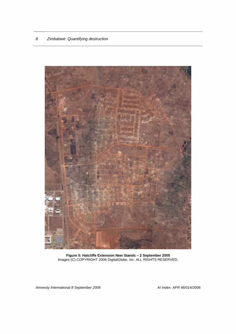
Four QuickBird images were obtained.7 The first set of images (Figure 3) shows a “before”
image from 14 May 2004 and an “after” image from 2 September 2005 of the area of
Hatcliffe Extension known as Hatcliffe Extension New Stands. The satellite imagery clearly
shows the settlement in 2004 while the 2005 image shows most homes removed.
Figure 3: Hatcliffe Extension New Stands Before and After Operation Murambatsvina
High resolution satellite imagery of the Hatcliffe Extension New Stands settlement in Zimbabwe. More than 700 structures are visible in the before (left hand) image, most of which are absent from the after
(right hand) image. Note that the significant difference in colour between the images is due to seasonality as the before image was captured during the dry season while the after image was acquired
during the rainy season. Images (C) COPYRIGHT 2006 DigitalGlobe, Inc. ALL RIGHTS RESERVED.
7 The QuickBird satellite images of Hatcliffe were found and acquired from the Digital Globe archives via the
MapMart company.

Zimbabwe: Quantifying destruction 7
Amnesty International 8 September 2006 AI Index: AFR 46/014/2006
Figure 4: Hatcliffe Extension New Stands – 14 May 2004
Images (C) COPYRIGHT 2006 DigitalGlobe, Inc. ALL RIGHTS RESERVED.
8 Zimbabwe: Quantifying destruction
Amnesty International 8 September 2006 AI Index: AFR 46/014/2006
Figure 5: Hatcliffe Extension New Stands – 2 September 2005
Images (C) COPYRIGHT 2006 DigitalGlobe, Inc. ALL RIGHTS RESERVED.

Zimbabwe: Quantifying destruction 9
Amnesty International 8 September 2006 AI Index: AFR 46/014/2006
Figures 6 and 7: Hatcliffe Extension Holding Camp Before and After Operation Murambatsvina
These images show a “before” image from 14 May 2004 and an “after” image from 2 September 2005 of Hatcliffe Extension Holding Camp.
10 Zimbabwe: Quantifying destruction
Amnesty International 8 September 2006 AI Index: AFR 46/014/2006
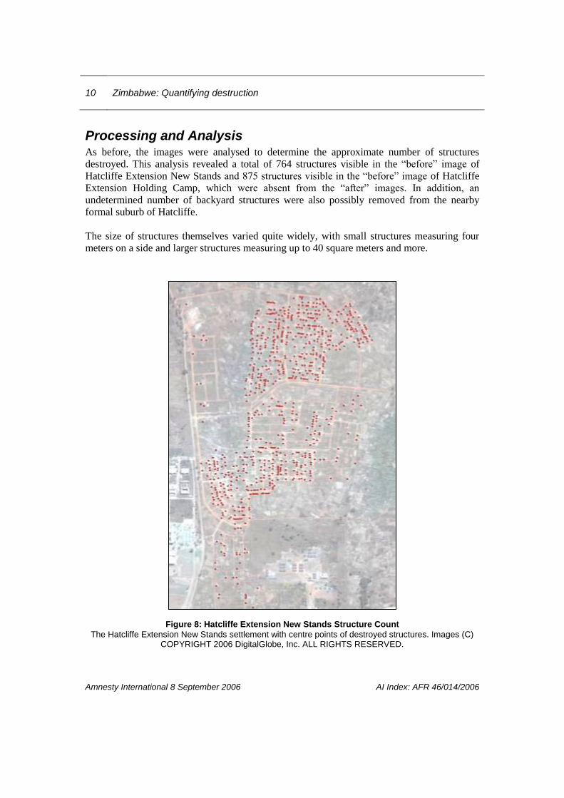
Processing and Analysis As before, the images were analysed to determine the approximate number of structures
destroyed. This analysis revealed a total of 764 structures visible in the “before” image of
Hatcliffe Extension New Stands and 875 structures visible in the “before” image of Hatcliffe
Extension Holding Camp, which were absent from the “after” images. In addition, an
undetermined number of backyard structures were also possibly removed from the nearby
formal suburb of Hatcliffe.
The size of structures themselves varied quite widely, with small structures measuring four
meters on a side and larger structures measuring up to 40 square meters and more.
Figure 8: Hatcliffe Extension New Stands Structure Count
The Hatcliffe Extension New Stands settlement with centre points of destroyed structures. Images (C) COPYRIGHT 2006 DigitalGlobe, Inc. ALL RIGHTS RESERVED.

Zimbabwe: Quantifying destruction 11
Amnesty International 8 September 2006 AI Index: AFR 46/014/2006
Chitungwiza Image Analysis In June 2005 the sprawling town of Chitungwiza, outside Harare, witnessed widespread
demolition of so called “backyard” homes as part of Operation Murambatsvina. To quantify
and illustrate the destruction two QuickBird satellite images, showing a portion of St Mary’s
suburb in Chitungwiza, were obtained and analyzed. The “before” image is from 25 August
2004; the “after” image is from 22 June 2005.8 The featured location covers an area
approximately 3 km long by 2 km wide. The centre of the location is at 31.04° East latitude
and -17.99° South longitude.
Analysis of the images indicates widespread demolition of backyard homes. Backyard homes
were essentially built on small patches of land leased to renters by owners of larger, permitted
structures (see Figure 9). Amnesty International researchers visited the St. Mary’s area in
August 2005, at which time the evidence of the demolitions was widespread. Almost every
house in St. Mary’s was surrounded by the brick rubble of destroyed backyard structures.
Foundation slabs were clearly visible in many cases, and people were evidently living in the
gardens and on verandas.
Figure 9: Chitungwiza Before and After Operation Murambatsvina A subset of the high-resolution satellite imagery of Chitungwiza town in Zimbabwe. Backyard homes are visible in the left-hand (before) image and are the smaller structures found on the periphery and in the alleys of larger structures,
which are absent from the right-hand (after) image. In addition, what appears to be a marketplace seen in the “before” image is absent from the after image.
Images (C) COPYRIGHT 2006 DigitalGlobe, Inc. ALL RIGHTS RESERVED.
8 The QuickBird satellite images of Chitungwiza were found and acquired from the Digital Globe archives via the
MapMart company.

12 Zimbabwe: Quantifying destruction
Amnesty International 8 September 2006 AI Index: AFR 46/014/2006
Processing and Analysis Analysis of the satellite images shows more than 2,000 backyard structures were removed in
the portion of Chitungwiza captured by the satellite image. In addition, at least one
marketplace in Chitungwiza was destroyed during the operation. In total, analysis of the
satellite imagery indicates that 2470 structures were removed from this portion of
Chitungwiza during Operation Murambatsvina. The size of structures themselves varied quite
widely, with small backyard homes measuring 4 meters on a side and larger market structures
measuring up to 40 square meters and more.
Figure 10: Chitungwiza Structure Count
Chitungwiza on 22 June 2005 with centre points of the 2470 removed structures. Images (C) COPYRIGHT 2006 DigitalGlobe, Inc. ALL RIGHTS RESERVED.

Zimbabwe: Quantifying destruction 13
Amnesty International 8 September 2006 AI Index: AFR 46/014/2006
Killarney Image Analysis
The informal settlement at Killarney, outside Bulawayo, was destroyed in June 2005 as part
of Operation Murambatsvina. Two QuickBird images were obtained covering the area
including a “before” image from 22 August 2004 and an “after” image from 7 September
2005.9 The satellite imagery clearly shows the settlement in 2004 while the 2005 image shows
most homes removed.
Figure 11: Killarney Before and After Operation Murambatsvina
A subset of the high resolution satellite imagery of the Killarney settlement in Zimbabwe. Note that the entire settlement of Killarney that was destroyed measured more than three kilometers from north to
south and 1.6 kilometres east to west. Given the small size of the structures, they would not be visible were the full extent of the image shown. Some of the more than 465 Killarney structures are visible in
the before (left hand) image, most of which are absent from the after (right hand) subset image. Images (C) COPYRIGHT 2006 DigitalGlobe, Inc. ALL RIGHTS RESERVED.
9 The QuickBird satellite images of Killarney were found and acquired from the Digital Globe archives via the
MapMart company.
14 Zimbabwe: Quantifying destruction
Amnesty International 8 September 2006 AI Index: AFR 46/014/2006
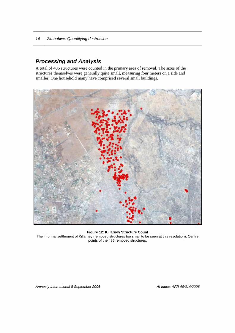
Processing and Analysis A total of 486 structures were counted in the primary area of removal. The sizes of the
structures themselves were generally quite small, measuring four meters on a side and
smaller. One household many have comprised several small buildings.
Figure 12: Killarney Structure Count
The informal settlement of Killarney (removed structures too small to be seen at this resolution). Centre points of the 486 removed structures.