© 2011 autodesk ci3222 – surveying and base mapping standards and practices dino lustri, p.e.,...
TRANSCRIPT

© 2011 Autodesk
CI3222 – Surveying and Base Mapping Standards and Practices
Dino Lustri, P.E., P.S.Civil Engineering, Surveying & Mapping Consultant
© 2011 Autodesk
Introduction
Dino Lustri, P.E., P.S., (dual licensed in Ohio and Florida). Started using AutoCAD® in 1987 Hydrologic and hydraulic engineer Acted as City engineer Professional witness Educator Author: SSA(Storm and Sanitary Analysis) President of the Professional Land Surveyors of Ohio - Cleveland Chapter 2011

© 2011 Autodesk
Surveying and Base Mapping Standards and Practices
You have probably been base mapping the same way for a decade. In this class, you will learn different ways to complete the same tedious task, but take advantage of the tools and functions at your disposal in Civil 3D.
We will discuss improvements to Civil 3D and describe how you can leverage those improved tools to expedite your base mapping process.
You will learn about out-of-the box functionality that should increase your productivity by leaps and bounds.

© 2011 Autodesk
Class Summary
In this class you will explore how AutoCAD® Civil 3D software can handle data from numerous data collectors via a Survey Database.
You will learn about Description Keys, Figure Prefix Libraries, and Linework Code Sets to help facilitate your fieldwork processing.
You will learn a data management methodology that will allow for sharing of data while protecting it from accidental modification.

© 2011 Autodesk
Learning Objectives
At the end of this class, you will be able to:
Import or convert a data collector file to a coordinate file
Create and edit a Description Key File
Create and modify a Figure Prefix Library
Recognize the codes necessary for line work
Understand project data management workflow

© 2011 Autodesk
Data Collector Files
RAW, JOB, DC, TXT, ASC, RW5, FBK…

© 2011 Autodesk
Description Key Files
Tips:1) Don’t make ‘every’ code2) Logical and practical3) Two character minimum

© 2011 Autodesk
Figure Prefix Libraries
aka ‘description keys for lines’

© 2011 Autodesk
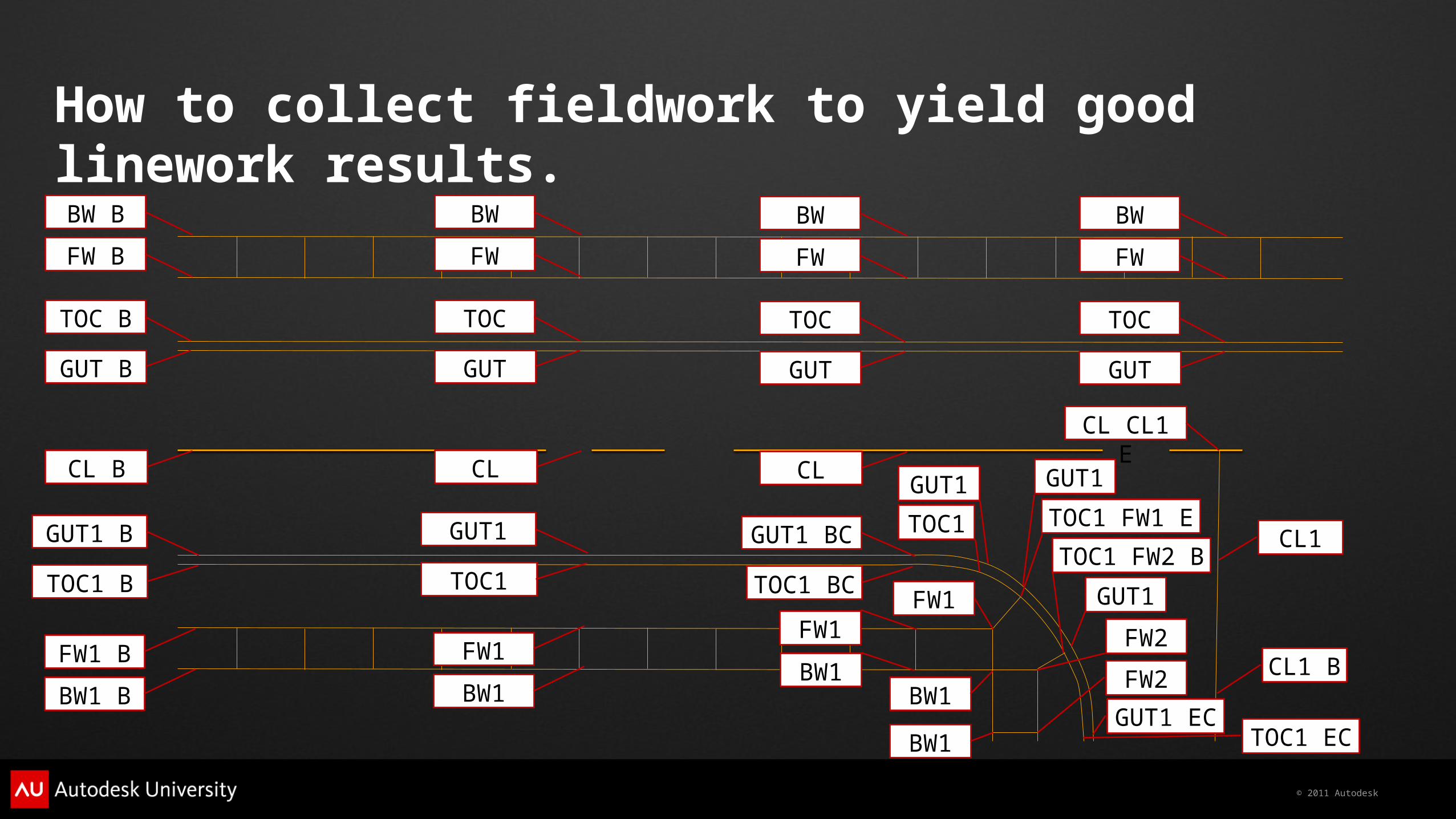
Linework Code Sets
B, E, BC, EC, and sometimes CLS

© 2011 Autodesk
Survey Database

© 2011 Autodesk
ReviewCivil 3D Template Local System Database File
Description Key Files
Figure Prefix Database Linework Code Set
© 2011 Autodesk
How to collect fieldwork to yield good linework results.
BW B
FW B
TOC B
GUT B
CL B
GUT1 B
TOC1 B
FW1 B
BW1 B
BW
FW
TOC
GUT
CL
BW
FW
TOC
GUT
CL
GUT1 BC
TOC1 BC FW1
BW1
GUT1
TOC1
GUT1
TOC1 FW1 E
FW1
BW1
BW1
GUT1
TOC1 FW2 B
FW2
FW2
CL CL1 E
CL1
CL1 B
BW
FW
TOC
GUT
GUT1
TOC1
FW1
BW1GUT1
EC TOC1 EC

© 2011 Autodesk
PLAN PRODUCTION DWG’s[DESCRIPTION KEY FILE]
Data Management Methodology(The Dino Method!)
RAW, JOB, DC, FBK, TXT…
EXISTING or BASE DWG’s[DESCRIPTION KEY FILE]
EXISTING SURFACESEXISTING ALIGNMENTS
EXISTING PIPE NETWORKS
PROPOSED SURFACESPROPOSED ALIGNMENTS
PROPOSED PIPE NETWORKS
PLAN & PROFILESCROSS SECTIONSLABELS & TABLES
PROPOSED SURFACESPROPOSED ALIGNMENTS
PROPOSED PIPE NETWORKS
EXISTING SURFACESEXISTING ALIGNMENTS
EXISTING PIPE NETWORKS
DATA SHORTCUTDATA SHORTCUT
DATA SHORTCUT
PROPOSED or DESIGN DWG’s[DESCRIPTION KEY FILE]
IMP
OR
T
EXISTING SURFACESEXISTING ALIGNMENTS
EXISTING PIPE NETWORKS
SURVEY DATABASE[FIGURE PREFIX DATABASE]
[LINEWORK CODE SET]POINTSFIGURES
IMPORTIMPORT

© 2011 Autodesk
Benefits:
1) More than one person working on a project at a given time,
2) Update survey work without interrupting design,
3) Maintain control of point data,
4) Utilize the many benefits of data shortcuts,
5) Re-create drawings easily.

© 2011 Autodesk
Autodesk, AutoCAD* [*if/when mentioned in the pertinent material, followed by an alphabetical list of all other trademarks mentioned in the material] are registered trademarks or trademarks of Autodesk, Inc., and/or its subsidiaries and/or affiliates in the USA and/or other countries. All other brand names, product names, or trademarks belong to their respective holders. Autodesk reserves the right to alter product and services offerings, and specifications and pricing at any time without notice, and is not responsible for typographical or graphical errors that may appear in this document. © 2011 Autodesk, Inc. All rights reserved.