cggamgati.funai.gov.brcggamgati.funai.gov.br/files/2214/8839/3461/20161116_gati_tt_pgta... · and...
TRANSCRIPT

ArticulaçãoMATO GROSSO
ARTICULAÇÃO DOS POVOS E ORGANIZAÇÕES INDÍGENAS DO NORDESTE, MINAS GERAIS E ESPÍRITO SANTO
www.theGEF.orgEmpoderando vidas.Fortalecendo nações.
The Experience of the GATI Project in Indigenous Lands
Instruments forTerritorial andEnvironmental Management
The Project for Indigenous Territorial and Environmental Management (GATI) contributed to the recognition of Indigenous Lands (ILs) as protected areas essential for biodiversity conservation in Brazilian biomes, and strengthened traditional indigenous practices regarding management, sustainable use, and conservation of natural resources. In addition, it fostered indigenous leadershipin the construction of public policies for environmental and territorial management of ILs.
The Project was a joint effort of the Brazilian indigenous movement, the National Foundation for Indigenous Peoples (Funai), the Ministry of Environment (MMA), The Nature Conservancy(TNC), the United Nations Development Programme (UNDP), and the Global Environment Facility (GEF).

Cataloguing in-Publication Data (CIP)(eDOC BRASIL, Belo Horizonte / MG)
M152i Maciel, Ney José Brito
Instruments for territorial and environmental management / Ney José Brito Maciel. – Brasilia (DF): IEB, 2016. - (The experience of the GATI Project in Indigenous Lands) 43 p. : 20.4 x 27.4 cm ISBN 978-85-60443-50-5 1. Territorial and environmental management. 2. Indigenous peoples - Brazil. 4.Project for Indigenous Environmental and Territorial Management. I. Title. II. Series.
CDD-980.41
PRESIDENCY OF THE NATIONAL FOUNDATION FOR INDIGENOUS PEOPLESArtur Nobre Mendes
TERRITORIAL PROTECTION DIRECTORATE - DPTWalter Coutinho Jr.
SUSTAINABLE DEVELOPMENT DIRECTORATE - DPDSPatricia Chagas Neves
ADMINISTRATION AND MANAGEMENT DIRECTORATE - DAGESJanice Queiroz de Oliveira
GATI PROJECT MANAGEMENT UNIT
NATIONAL PROJECT DIRECTOR - DPDS/FUNAIPatricia Chagas Neves
NATIONAL PROJECT COORDINATOR - CGGAM/FUNAIFernando de Luiz Brito Vianna
UNDP PROJECT OFFICERRose Diegues
TECHNICAL COORDINATOR OF THE PROJECT - UNDPRobert Pritchard Miller
PGTA COORDINATOR - UNDPNey José Brito Maciel
FINANCIAL COORDINATOR OF THE PROJECT - CGGAM/FUNAIValéria do Socorro Novaes de Carvalho
ADMINISTRATIVE ASSISTANTS - CGGAM/FUNAI Caio César de Sousa de OliveiraSofia Morgana Siqueira Meneses


photo base for previous page:Márcio Kokoy speaks of environmental and territorial management of
the Mangueirinha IL during the event “Territorial Dialogues” (2014)©Venícius Mendes
The use of images of indigenous individuals of Reference Areas of the GATI Project for dissemination purposes was agreed under Terms of Commitment signed by participating communities during the clarification process, when the responsibilities of the parties were established.
Technical Data
Organization of systematizationAndreia Bavaresco - IEB Marcela Menezes - IEB Robert Miller - GATI
TranslationCristiane Feitosa
PhotosGATI Project collectionFunai collectionCollaborators
ArtworkNina Coimbra
EditingDemian Nery and Tiago Trigo (support)

Instruments for Territorial and Environmental Management
Ney José Brito Maciel1
1 Anthropologist, PGTA Coordinator at the GATI Project.
Introduction 4
From Emergence to Consolidation as Public Policy Instruments 8
Support to Management Instruments in Gati Project Reference Areas 22
Challenges of Implementation 36

Introduction

The Instruments for Territorial and Environmental Management on Indigenous Lands are tools for planning actions for the protection, conservation and use of the environment, environmental resources and biodiversity in different Indigenous Lands (ILs) in Brazil. Examples of such instruments include: “Territorial Management Plans”, “Environmental Management Plan”, “Ethno-mapping”, “Ethno-zoning”, “Ethno-environmental Participatory Assessments”, “Territorial Protection Plans”, “Life Plans”, “Action
Plans”, “Management Programs”, etc. They result from organized processes of reflection carried out by specific indigenous groups - people, groups, village or groups of villages - about their territories and environments to increase the sustainability of the conservation and use of natural and environmental resources present in Indigenous Lands; and also to help them expand and substantiate the dialogue and actions of government and civil society partners in the adequate implementation of indigenous and environmental policies.

6
The Experience of the GATI Project in Indigenous Lands
Complementarily, Management Instruments also have other objectives, namely: to increase knowledge about the territory; to encourage the exchange of knowledge between indigenous peoples and society as whole; to encourage the exchange of knowledge among segments within indigenous societies, especially the exchange of knowledge between indigenous elderly and youth; to give visibility to rights and duties, especially those related to claim, defense and protection of territories and environmental resources; to serve as dissemination material for actions and ideas related to environmental conservation and the use of environmental resources on Indigenous Lands.
Management Instruments are grounded on two general principles. The first one is of an ethical nature: based on the principles of indigenous leadership, participation and autonomy. And the second is of a methodological nature: prepared in collective processes of reflection and dialogue about the environmental reality of a given indigenous land, on the use of environmental resources, and on future projects intended
for such land. Under these parameters, the GATI Project, together with its partners, produced and / or supported a number of actions related to the preparation, review and publication of these instruments, either directly in the “Reference Areas” of the Project, or supporting broader government initiatives, in the development and implementation of management instruments on Indigenous Lands in general.
This text is divided into three major parts. The first part presents an overview of the processes related to the management instruments and the role of GATI Project in supporting the public policy for the development of such instruments; the second part presents significant experiences of the GATI Project, showing part of the diversity of the situations encountered, emphasizing certain characteristics of management instruments; and the third and final part presents a brief reflection on the challenges for the consolidation of territorial and environmental management instruments as effective instruments of indigenous and environmental policies.

Instruments for Territorial and Environmental Management
7
©Roselis M
azurek
Ethno-zoning in the Santa Izabel village, Uaçá Indigenous Land (2014)

From Emergence to Consolidation as Public
Policy Instruments

Historically, the first “Territorial and Environmental Management Instruments” of Indigenous Lands in Brazil emerged in the early 2000s in many Indigenous Lands in the Amazon and around it. Roughly speaking, they were part of training processes related to the staggering challenge of creating the conditions necessary to live in demarcated lands, surrounded by internal and external demographic pressures.
Some processes are considered as foundational for the configuration of management instruments as known today. They include: the implementation of training courses by the Native Amazon Operation
(OPAN) for the Nambikuara, Parecís, Manoki/Menki, Apurinã, Marubo, and Matis indigenous peoples located in the states of Amazonas, Rondonia, and Mato Grosso; the work of the Indigenous Work Center (CTI) among the Timbira people of Maranhão and Tocantins; the alliance between the Social-Environmental Institute (ISA) and the peoples of the upper Rio Negro and Xingu Park, such as the Kaiabi, Ikpeng, Yudja and Kinsêdjê, and with the Panará people of the Panará Indigenous Land; and the indigenous teacher training process carried out by the Pro-Indigenous Commission of Acre (CPI-AC), mainly with the Huni Kuin (Kaxinawa) and Ashaninka peoples.
The Partnership Between Indigenous Peoples and Civil Society Organizations: the origin of management instruments

10
The Experience of the GATI Project in Indigenous Lands
The first management instruments were a kind of a consequence of the training processes mentioned in the previous paragraph. Those considered foundational include: the processes of preparation and publication of Management Plans of the Menki, Manoki and Nambiquara peoples in Mato Grosso, supported by OPAN; the ethno-zoning of the Sete de Setembro and Igarapé Lourdes Indigenous Lands, inhabited by the Suruí, Araras and Gavião from Rondonia, supported by the Kanindé Association; the Life Plan of indigenous peoples and organizations of Oiapoque, Galibi, Palikur, Marwomo and Karipuna and the Action Plan of the Wajãpi Indigenous Land, both supported by the Institute for Indigenous Research and Training (IEPE) and The Nature Conservancy (TNC); the preparation of the Management Plans of the Ashaninka people of the Amônea River, and the Huni Kuin people of the Jordão and Breu Rivers, conducted by CPI-AC with local indigenous organizations.
In these early experiences, the role of territorial and environmental management instruments was basically to support indigenous people to conduct their own actions, decisions, plans, and strategies for conservation and use of their environment. They were generally supported by mapping processes2 and satellite images, providing indigenous peoples with new information and perceptions - “holding the land in their own hands” - presenting them with a cartographic materiality of their knowledge about the environment and territory.
2 Called “ethno-mapping” or “ethno-zoning”, or “participatory mapping”.

Instruments for Territorial and Environmental Management
11
The most recurrent themes in these processes were those related to traditional activities and the environment, such as hunting, fishing, collection / extractivism and crops; and also issues related to territorial strategies, such as territory protection, surveillance, land regularization, and expansion. In addition to environmental and territorial issues, they included issues such as: valuing identity and cultural revitalization; the right to protection of traditional knowledge; differentiated school education, food security, traditional healthcare with the strengthening / rescuing of indigenous medicine.

12
The Experience of the GATI Project in Indigenous Lands
Environmentalism and Ethnic Rights as Foundations of the Public Policy
The processes of preparation of management instruments undertaken by indigenous peoples and their allies from the organized civil society in various parts of the Brazilian Amazon, echoed in the official indigenous policy, which saw in its heuristical dimensions and programmatic bias, the possibility of being used as auxiliary tools in the implementation of the official indigenous and environmental public policies.
This arrangement was driven by a convergence of factors related to the emergence of environmentalism and ethnic rights in the national and international scenarios. In Brazil, the 1988 Constitution presented the new bases for dialogue between indigenous peoples and the national State, which made a correlation between “physical and cultural survival” of indigenous peoples and the protection of environmental and natural resources present in their demarcated territories. In the international arena, indigenous territories in the Amazon forest were in evidence, driven by the emergence of environmentalism supported by an international network of local, regional, and transnational governmental and non-governmental organizations.
Thus, Indigenous Lands started to be seen as important territories to address global problems of environmental degradation, deforestation, climate change and loss of
biodiversity. The United Nations Conference on Environment and Development (ECO 92) was a milestone, after which environmentalism began to gain increased space in the public sphere and in the policies of different governments. This Conference also marks a time when forest areas occupied by indigenous peoples, recognized and demarcated by the State, started to be imagined by environmentalists as “protected areas”, working at the local level as barriers to major environmental threats.
These international and transnational environmentalist parameters were added to the global agenda related to the rights of “traditional populations” within national States. The main landmark of this agenda is Convention Nr. 169 of the International Labour Organization (ILO), of 1989, promulgated in Brazil in 2004. This Convention provides that governments must consult the peoples concerned, through appropriate procedures and through representative institutions, whenever legislative or administrative measures may affect them directly. This agenda gives a new political status to indigenous peoples. Based on this agenda new parameters emerge in the relations between indigenous peoples and the national State, which began to be mediated by principles such as “participation”, “leadership”, “collaborative processes”, “consultation”, and “autonomy”.

Instruments for Territorial and Environmental Management
13
In this context of multiple scales, management instruments started to be seen as reference documents that could bring these new principles into effect. By proposing and funding these initiatives, the government would confer these management instruments with the power to inform public officials about the demands and projects of a particular Indigenous Land.
The first government actions related to support to development and implementation of indigenous territorial and environmental management instruments occurred at the state level. The first experience was carried out in the government of the state of Acre, in the middle of last decade - inspired by the processes carried out jointly by the CPI-AC and the Kaxinawá and Ashaninka Peoples. Such government funded ethno-zoning processes and the development of “management plans” in most of the ILs in the state as part of its environmental policy and official pro-indigenous policy. The first experiences occurred as of 2004 with the ethno-zoning of the following Indigenous Lands: Mamoadate, Kaxinawa of Igarapé do Caucho, Yawanawá of Rio Gregório, Kaxinawa of Colônia 27, Jamianawa of Caeté River, and Shanennawa/Kaxinawa of Feijó. In subsequent years, this policy was consolidated, and today, virtually all ILs in the state have Management Plans. The state of Para also supported some specific actions through its State Secretariat for the Environment (SEMA) in partnership with
non-governmental institutions, such as the ethno-mapping of the Indigenous Lands of Kayapó, Baú, Menkragnotí, Bajokore and Capoto-Jarina; the ethno-zoning of the Para portion of the Trombetas-Mapuera and Nhamundá Indigenous Lands; and more recently the ethno-zoning of the Alto Rio Guama Indigenous Land. Early this decade, at the federal level, the National Foundation for Indigenous Peoples (Funai), through its General Coordination of Territorial Monitoring (CGMT), held the ethno-mapping of Indigenous Lands of Potiguara Monte Mor, Jacaré de São Domingo and Potiguara, in Paraíba; and the Management Plan for the Pataxó Indigenous Land of Aguas Belas and Barra Velha, in the state of Bahia.
However, the importance of management instruments in the federal sphere has only been demonstrated more strikingly in the discussions and consultations for the construction of the National Policy for Territorial and Environmental Management of Indigenous Land (PNGATI), which occurred in several regions of the country between 2009 and 2011. With the promulgation of PNGATI’s originating decree3, ethno-mapping and ethno-zoning were conceptualized and formalized as part of the indigenous and environmentalist public policy at the national level, and raised to the status of important references for its implementation at the local level.
3 Decree Nr. 7747, June 5th, 2012.

14
The Experience of the GATI Project in Indigenous Lands
In the Decree establishing the PNGATI, ethno-mapping and ethno-zoning are defined as tools for territorial and environmental management of Indigenous Lands:
I – Ethno-mapping: participatory mapping of the areas of environmental, socio-cultural and productive relevance for indigenous peoples, based on indigenous knowledge; and
II - Ethno-zoning: participatory planning instrument for the categorization of areas of environmental, socio-cultural and productive relevance for indigenous peoples, developed based on ethno-mapping.
After the formalization of ethno-zoning and ethno-mapping as “tools for territorial and environmental management of Indigenous Lands”, the government institutions started to use the name “Plans for Territorial and Environmental Management” (PGTAs) for completed or not completed management instruments including in their methodology
and objectives, ethno-mapping and/or ethno-zoning processes, the formulation of agreements for the use of environmental resources, and the presentation of demands to public policy operators.
Reiterating this view, in 2013 FUNAI published the document “Guidelines for Development of Plans for Territorial and Environmental Management of Indigenous Lands”, which started to be distributed to indigenous and pro-indigenous partners, and to be attached to all public call notices issued to finance the development of management instruments.
Funai's Publication (2013) containing guidelines for the preparation of PGTAs

Instruments for Territorial and Environmental Management
15
GATI Project Support to PGTAs as a Government Goal4
4 I would like to thank the Technical Team of the Office for the Coordination of Planning of Territorial and Environmental Management (COPLAN / CGGAM) for the collection of data and information provided.
The development and implementation of PGTAs became goals of the federal government. In the Government’s Multi Year Plan (PPA) for the 2012-2015 period, in the context of PNGATI implementation, a shared goal was defined for Funai and the Ministry of Environment for the development and / or implementation of 51 PGTAs. The current Multi Year Plan, 2016/2019, includes support to the development and implementation of another 27 PGTAs. To fulfill these goals, strategies were established for government action, among which, the definition of general guidance for the preparation of PGTAs, already mentioned in the previous item, and the consolidation of administrative and financial mechanisms for their development and implementation.
These mechanisms were particularly focused on public notices, whose preparation relied on technical and / or financial support by the GATI Project, and on direct support by Funai, with its own budget funds. In this context, three Public Notices were announced, ensuring the transfer of funds to indigenous, pro-indigenous and social-environmentalist organizations, as follows:
• Public call announced by the Ministry of Environment for projects to develop PGTAs in indigenous territories in the Legal Amazon region, under the Indigenous Peoples Demonstration Project (PDPI);
• Public call announced by FUNAI under PNGATI implementation with funds from the National Climate Change Fund (“Climate Fund”); and
• Public call launched by BNDES for projects to support the implementation and development of PGTAs with funds from the Amazon Fund / BNDES
These experiences are presented below.
PDPI Call NoticeThe PDPI was a project to support activities of indigenous communities in the Legal Amazon region, run by the Ministry of Environment with the support of the German Technical Cooperation Agency (Deutsche Gesellschaft fur Internationale Zusammenarbeit / GIZ) under the PPG7 Pilot Program, in partnership with the Coordination of Indigenous Organizations of the Brazilian Amazon (COIAB). This project started in 2001 and ended in 2015, aimed at valuing the culture and ways of life of indigenous peoples as crucial to environmental conservation. In its last action, it launched Public Call for projects to develop plans for territorial and environmental

16
The Experience of the GATI Project in Indigenous Lands
management in Indigenous Lands in the Legal Amazon Region, providing financial5 and technical support to 14 projects for formulation of PGTAs of Indigenous Lands in the Legal Amazon Region.
Table of projects supported:
5 The 2013 notice call for PDPI (Indigenous Peoples Demonstration Projects / MMA), was targeted at ILs in the Amazon, allocating R$ 4,000,000.00 to 16 projects for the development of complete PGTAs - ethno-mapping + management indications - or parts of them.
Project Applicant
Revising our PGTA and training (Kaxinawá of the Igarapé do Caucho IL)
Association of Hunikui Producers and Agro-extractivists of Caucho
Plan for Territorial and Environmental Management of the Rio Negro Indigenous Land
Federation of Indigenous Organizations of Rio Negro
Plan for Territorial and Environmental Management of the Kotiria and Kubeo peoples of Alto Uaupés (AM)
Khumunu Wuu Kotiria School Association
Atha Kama - Management Plan of the Caititu IL Federation of Indigenous Organizations and Communities of the Middle Purus
Our Earth, Our Way: participatory assessment and ethno-mapping of the Camicuã Indigenous Land
International Institute for Education in Brazil
Building our PGTAs: mobilization and environmental diagnosis of ILs of Tumucumaque Park, Paru d’Este, Trombetas/Mapuera and Nhamundá/Mapuera
Association of Tiriyó, Kaxuyana and Txikuyana Indigenous Peoples
Consolidating Plans for Territorial and Environmental Management in Indigenous Lands in the State of Amapa
Institute for Indigenous Research and Training
Territorial and Environmental Management in the Perspective of Autonomous Development of the Caru Indigenous Land
Wirazu Community Indigenous Association of the Guajajara people of the Mararanduba, Santa Rita, Canoa, Nova villages
Jande ru hã há ka’a – our forest is our life plan (Alto Turiaçu IL) Ka’apor ta hury Association of the Gurupi River
Me ejcytji him pex txy: The rescue of territorial protection made by the elders of the Pyhcop Catiji Gavião People (Governador IL)
Indigenous Community Association of the Nova village, Municipality of Amarante do Maranhão
Recognizing to recover. Ethno-mapping as Environmental and Territorial Management Tool in the Marãiwatsédé Indigenous Land
Native Amazon Operation
Cultural mapping of the AKAMU APIAKÁ, KAYABI and MUNDURUKU (Apiaká-Kayabi IL)
Apiaká, Kayabi and Munduruku Indigenous Women Association
Preparation of the PGTA of Las Casas Indigenous Land Protected Forest Association
Territorial Management Plan of the Karipuna Indigenous Land Association of the Karipuna Indigenous Peoples
Planning the Management of the Zoró Indigenous Land Association of the Zoró Indigenous People
Plan of Territorial and Environmental Management of the Manoá-Pium Indigenous Land
Indigenous Council of Roraima

Instruments for Territorial and Environmental Management
17
Climate Fund Call Notice
In 2013, the National Fund on Climate Change (“Climate Fund”), made funds available6 to support the development of PGTAs on Indigenous Lands located in the Caatinga and Cerrado, considered the most vulnerable areas to desertification and deforestation7. The proposal was presented to the Climate Fund Steering Committee based on a document comprising the guidelines of the National Policy on Climate Change - PNMC and PNGATI, establishing a relation of these instruments with climate change mitigation and adaptation on Indigenous Lands.
This call was jointly coordinated by Funai and the Ministry of Environment with technical and financial support of the GATI Project. It was launched in August 2014 under the Technical Cooperation of Funai and the United Nations Development Programme (UNDP)8, and targeted at civil society organizations of public interest, indigenous and pro-indigenous organizations, environmentalist and social-environmentalist organizations, and private foundations with proven experience in ILs fully or partially located in the Caatinga and Cerrado.
Table of Projects supported:
6 The “Climate Fund” call notice (resources managed by a FUNAI / UNDP technical cooperation project) held in 2014 supported the development of PGTAs in ILs in the Caatinga and Cerrado with R$ 2,800,000.00.
7 According to the Action Plan for Prevention and Control of Deforestation in the Caatinga - PPCaatinga and for Prevention and Control of Deforestation and Fires in the Cerrado - PPCerrado.
8 Project: Implementation of the National Policy for Environmental and Territorial Management of Indigenous Lands (BRA13 / 019)
Applicant organization Indigenous Land(s)
Residents Association of the Cabeceira Village - AMAC
Nioaque/MS
Teribre Institute São Domingos, municipality of Luciara / MT
Xavante Norotsu’rã Indigenous Association- ASIXNOR
Parabubure, Ubuwawe and Chão Preto, municipalities of Campinápolis, Santo Antônio do Leste, Água Boa and Nova Xavantina/MT
Yukamaniru Institute for the Kura Bakairi indigenous women
Baikiri, municipality of Parantininga / MT, and Santana, municipality of Nobres / MT
Eloy Ferreira da Silva Document Centre- CEDEFES Caxixó, municipalities of Pompéu and Martinho Campos / MG
Native Amazon Operation - OPAN Marãiwatsédé

18
The Experience of the GATI Project in Indigenous Lands
Amazon Fund / BNDES Call Notice
The Public Call by the “Amazon Fund” for implementation and development of PGTAs was published in May 20149, resulting from arrangements involving Funai, Ministry of Environment, BNDES and COIAB under the Amazon Fund Steering Committee (COFA). The primary goal was to support the implementation of PGTAs and also the development of these instruments. The focus was on Indigenous Lands located wholly or partially within the Amazon biome.
9 The amount in the Notice was R$ 70 million.
Organização Proponente Terra(s) Indígena(s)
Association for Co-produced Local Development - ADELCO
Tapeba, municipality of Caucaia / CE
Luiz Freire Cultural Center - CCLF Kapinawá, municipality of Buíque / PE
National Association of Indigenous Action - Anai Xakriabá and Xakriabá Rancharia, both in Minas Gerais
Verde Village Ethno-environmental and Multicultural Institute - IEMAV
Tremembé da Barra do Mundaú, municipality of Itapipoca / CE (villages of São José and Buriti)
Prehistory and Anthropology Institute of the State of Goiás at PUC / GO
Carretão I and II, located in the municipalities of Nova América and Rubiataba, both in Goiás
Tremembé do Córrego das Telhas Indigenous Council - CITCT
Córrego João Pereira and Queimadas, municipalities of Acaraú and Itarema, both in the state of Ceará
Ktepo Xerente Village Indigenous Organization - OIAKX
Xerente, municipality of Tocantínia / TO
Tronco Velho Pankararu Indigenous Organization Pankararu, in the municipalities of Jatobá, Petrolândia and Tacaratu, all in Pernambuco
Kekleeini-so Fulni-ô Indigenous Art-Culture Association
Fulni-ô, in the municipality of Águas Belas / PE
Dois Irmãos Park Association Kambiwá, in the municipality of Ibimirim / PE
Center for Social Environmental Studies and Rural Advisory of the State of Maranhão- CEMEAAR
Araribóia, southwest state of Maranhão

Instruments for Territorial and Environmental Management
19
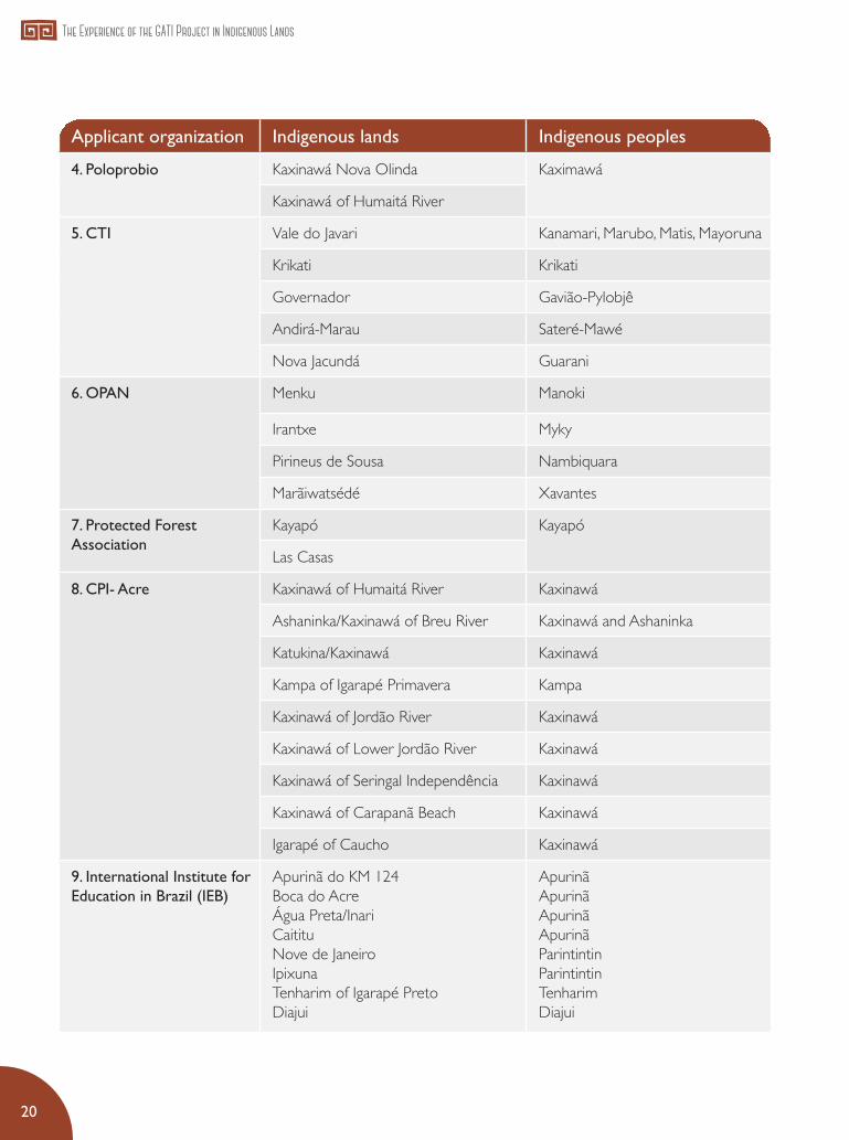
The preparation of the notice was supported technically and financially by the GATI Project, as well as the dissemination workshops, held in the cities of Rio Branco / AC (July / 2014), Belém / PA (August / 2014) and Manaus / AM (August / 2014), attended by the institutions interested in participating in the bid. In total, 13 proposals were enabled and 9 were supported, comprising 40 Indigenous Lands and 73 peoples.
List of proposals approved:
Applicant organization Indigenous lands Indigenous peoples
1. Kanindé Igarapé Lourdes (Rebio Jaru) Gavião and Arara
Zoró Zoró
Rio Guaporé Aikanã, Arikapu, Aruá, Djeoromitxi, Kanoé, Kujubim, Makurap, Sakirabiat, Tupari, Wajuru and Wari
Rio Negro Ocaia Wari
2. Socio-Environmental Institute
Xingu Indigenous Park
PIX Kawaiweté, Kayapó, Kisêdjê, Waurá, Naruvôte, Paraná, Ikepeng, Tapayuna, Yudja, Metuktire, Trumai, Kamaiurá, Mapitu, Yawalapiti, Kikuro, Kalapalo
Batovi
Wawi
Pequizal do Narovôtu
Upper Rio Negro Region
Upper Rio Negro Kubeo, Desana, Tukano, Miriti-tapuya, Arapaso, Tuyuka, Makuna, Bará, Siriano, Karapanã, Wanano, Yuruti, Pira-tapuya, Tariano, Baniwa, Kuripako, Werwkena, Baré, Hupda, Yuhupda, Nadeb, Dow.
Rio Apapóris
Balaio
Cué Cué- Marabitanas
Middle Rio Negro I
Middle Rio Negro II
Rio Téa
Yanomami Yanomami
3. Iepé Tumucumaque Park Tiriyó, Kaxuyana, Wayana, Apalai
Paru Dést River
Zo’é Zo’é
20
The Experience of the GATI Project in Indigenous Lands
Applicant organization Indigenous lands Indigenous peoples
4. Poloprobio Kaxinawá Nova Olinda Kaximawá
Kaxinawá of Humaitá River
5. CTI Vale do Javari Kanamari, Marubo, Matis, Mayoruna
Krikati Krikati
Governador Gavião-Pylobjê
Andirá-Marau Sateré-Mawé
Nova Jacundá Guarani
6. OPAN Menku Manoki
Irantxe Myky
Pirineus de Sousa Nambiquara
Marãiwatsédé Xavantes
7. Protected Forest Association
Kayapó Kayapó
Las Casas
8. CPI- Acre Kaxinawá of Humaitá River Kaxinawá
Ashaninka/Kaxinawá of Breu River Kaxinawá and Ashaninka
Katukina/Kaxinawá Kaxinawá
Kampa of Igarapé Primavera Kampa
Kaxinawá of Jordão River Kaxinawá
Kaxinawá of Lower Jordão River Kaxinawá
Kaxinawá of Seringal Independência Kaxinawá
Kaxinawá of Carapanã Beach Kaxinawá
Igarapé of Caucho Kaxinawá
9. International Institute for Education in Brazil (IEB)
Apurinã do KM 124Boca do AcreÁgua Preta/InariCaitituNove de JaneiroIpixunaTenharim of Igarapé PretoDiajui
Apurinã ApurinãApurinã ApurinãParintintinParintintin Tenharim Diajui

Instruments for Territorial and Environmental Management
21
Funai Work Plans and Technical Cooperation AgreementsIn addition to public notices, resources for the development and review of PGTAs are also executed directly through Funai’s financial and technical support. The focus is supporting the projects approved in public notices and of some PGTAs development processes.
The primary means for decentralization of direct resources is the Work Plan, which is the annual planning instrument of Funai’s Regional Coordination Offices (RCOs), through which RCOs propose, within the budget and strategic limits of the institution, the actions they intend to develop, consolidated in the Multi-Year Plan of the Federal Government - PPA. The funds allocated through these work plans are often to support mobilization workshops, field activities, events for the presentation of results, and occasionally for the purchase of food, fuel and office supplies to be used during workshops.
Technical Cooperation Agreements (TCAs) constitute another important instrument. They do not provide for the application of funds, rather, they are an institutional partnership. Under the PNGATI, TCAs establish the bases and rules for technical cooperation among indigenous peoples, partner institutions and the federal indigenous agency, with a view to the accomplishment of training
activities, cultural and political strengthening, and fostering forms of community and collective management for the sustainability of indigenous communities, conferring legal security to these partnerships. Technical Cooperation Agreements are organized to contribute to the targets of the Multi Year Plan, under the “Programme for the Protection and Promotion of Indigenous Peoples”; the execution of actions is defined and agreed under a joint work plan describing the objectives, targets, activities, means of verification, outputs, and the implementation schedule. The monitoring of TCAs on Indigenous Lands occurs through FUNAI’s Regional Coordination Offices (RCOs). Technical Cooperation Agreements entail the establishment of spaces for dialogue, information exchange, evaluation, and analysis10.
10 Technical Cooperation Agreements in force: Institute for Indigenous Research and Training (IEPE), until 2019; Native Amazon Operation (OPAN), until 2020; Socio-Environmental Institute (ISA) - Federation of Indigenous Peoples of Rio Negro(FOIRN), until 2019; The Nature Conservancy in Brazil (TNC), until 2019; International Institute for Education in Brazil (IEB), until 2019; Indigenous Work Center (CTI), until 2019.

Support to Management Instruments in Gati
Project Reference Areas

The GATI Project carried out work related to Management Instruments in all its Regional Centers, coming across diverse interethnic, socio-historical and environmental situations in Reference Areas. In general, it considered Indigenous Lands and peoples with little, recent, or in some cases, no experience with management instruments, mainly located in the Regional Centers of the South Atlantic Forest, Southeast, Northeast 1, Northeast 2, and Pantanal-Cerrado; and also Indigenous Lands and Peoples already involved in such instruments, such as those in virtually all areas of the Regional Centers of Central / Eastern Amazon and Western Amazon.
Please find below a list of direct actions of the GATI Project in its Reference Areas and a presentation - without the intention of being descriptive - of some emblematic or representative cases of the diversity of situations encountered in the process of supporting the development of management instruments on Indigenous Lands.

24
The Experience of the GATI Project in Indigenous Lands
• Preparation and publication of Ethno-mapping and Plan of Action on Indigenous Lands of Entre Serras/ PE and Caiçara / Ilha de São Pedro / SE in partnership (Letter of Agreement)11 with the National Association of Indigenous Action (Anai);
• Organization of the workshop: “Environmental and Territorial Management with Indigenous Peoples in the Northeast,” to discuss experiences with management instruments in the Northeast, in April 2015, in Paulo Afonso / BA, in partnership with the National Association of Indigenous Action (Anai);
• Ethno-mapping of Trincheira Bacajá / PA Indigenous Land, in partnership (Letter of Agreement) with The Nature Conservancy (TNC) and support of Funai’s Regional Coordination Office in Altamira / PA;
• Support to the revision of the Ethno-zoning of Indigenous Lands of Uaçá, Galibi and Juminã in the Oiapoque / AP region, through a Letter of Agreement with the TNC and the work of the Regional Advisor of the Project;
• Updating and publication of PGTA of Mamoadate / AC Indigenous Land, in partnership (Letter of Agreement) with the Pro-Indigenous Commission of the state of Acre (CPI / Acre);
11 A Letter of Agreement is an instrument that allows the transfer of financial resources from the GATI Project to partner institutions for specific goals.
• Preparation and publication of PGTA of Guarani Bracuí / RJ Indigenous Land ;
• Production of ethno-mapping workshops on Indigenous Lands of Mangueirinha / PR, Taunay-Ipegue / MS, Lalima / MS and Cachoeirinha / MS, through direct action of the PGTA Coordination of the Project;
• Production of ethno-mapping workshops on Indigenous Lands of Sassoró / MS Jaguapiré / MS and Pirakuá / MS, in partnership (Letter of Agreement) with the Cultural Association of Indigenous Producers (ASCURI);
• Meetings, and information and awareness-raising events on Indigenous Lands of Andirá Marau / AM, Bakairi / MT, Córrego João Pereira / CE, and Ibirama / SC, through direct action of the PGTA Coordination of the Project;
• Support to indigenous organizations of the Reference Areas of Andirá Marau / AM, Xacriabá / MG, Bakairi / MT, Córrego João Pereira / CE and Xerente / TO to access public notices for development and implementation of PGTAs, through direct action of the PGTA Coordination of the Project and Regional Advisers.
Direct actions of the GATI Project include:

Instruments for Territorial and Environmental Management
25
Management Instruments supported by the GATI Project in Brazil

26
The Experience of the GATI Project in Indigenous Lands
Inaugural Experiences in the Caatinga Biome: PGTAs of ILs of Entre Serras/Pe and Caiçara/Ilha de São Pedro/SE12
The development of instruments for territorial and environmental management of Indigenous Lands in the Northeast Region is a recent process. Only two ILs in the area have a management instrument, both in the Atlantic Forest: the Ethno-mapping of the Potiguara Indigenous Lands of Monte Mor, Jacaré de Santo Domingo and Potiguara, in the state of Paraiba; and the Management Plan of the Pataxó Indigenous Lands of Aguas Belas and Barra Velha, in the state of Bahia.
Before those two, there used to be no process related to management instruments on Indigenous Lands in the Caatinga Biome. In this context, the GATI Project and APOIME proposed to ANAÍ to help support the development of PGTAs in the Entre Serras/ PE and Caiçara / Ilha de São Pedro / SE Indigenous Lands, inhabited respectively by the Pankararu and Xokó Peoples: the first experiences in the Caatinga Biome. The preparation of PGTAs in the two ILs took place between June 2014 and May 2015.
Despite substantive differences, these ILs share common characteristics, which can also be extended to large part of the Indigenous Lands in the Caatinga Biome: the level of conservation of environmental resources - such as flora and fauna, soil and water resources - is fragile, being in highly degraded areas dominated by current and past pastures and / or monoculture; virtually all of their respective demarcated areas are appropriated and fragmented, with few areas and environmental resources free from direct ownership; and, despite this situation, they have few but important areas of remaining caatinga.
Taking into account that local experiences with management instruments are incipient, the emphasis was on the stages of mobilization, presentation of concepts and functions of management instruments, in order to attract to debate representative actors of communities. The core participants were the school community and the leaders.
12 The 8,100 hectares of the Entre Serras / PE Indigenous Land is inhabited by approximately 1500 Pankararu; and Caiçara / Ilha de São Pedro / SE Indigenous Land, with 4,316 hectares, is inhabited by approximately 450 Xokó. Both are located in the Caatinga, in the São Francisco river watershed.
Thematic Experiences

Instruments for Territorial and Environmental Management
27
The ethno-mapping process was considered the highlight of the work, with the production of a set of thematic maps for each Indigenous Land, creating a unique cartographic representation of the territory for their inhabitants. The cartographic production accounted for living spaces, productive activities, forms of management and use of natural resources, cosmology, historical aspects, as well as environmental characterization of their surroundings, including impacts, liabilities and threats. In addition, elements of the natural landscape were located and shown, such as ponds, streams, mountains and forests; as well as strategic places, such as the places of camps, workspaces, impacted areas, and areas susceptible to invasions.
This whole process was also accompanied by workshops on audiovisual activities (photos and video)13, which recorded the ethno-mapping and the survey of management indications. This audiovisual record of the whole process increased the involvement and awareness of the wider community, with active participation of young people in the production of films, which were shown in videos for the community in general.
The problematization of the concept and unit “Indigenous Land” and “Indigenous Territory” allowed the inclusion of territory-specific issues such as the intense migratory flow, especially to the city of São Paulo, which is of fundamental importance to be studied and mapped out in the context of the Northeast Region in general, and in the two ILs in particular. Issues related to the surroundings were also discussed, such as solid waste management, the silting of the São Francisco River, the use of pesticides that pollute the springs of rivers crossing Indigenous Lands, and the protection of land rights.
The workshops for mapping exercises in the villages were consolidated as a space for debate, where several issues were discussed related to the situation of Indigenous Lands and the challenges of tackling environmental issues with new environmental management strategies; uses and appropriation of spaces; the social-environmental situation, and associated regional environmental conflicts.
13 The material produced is available at: https://www.youtube.com/watch?v=yD-G1a414g8 and https://www.youtube.com/watch?=zibsBHw4Gk8 .
©Anaí`s collection
Ethno-mapping in the Pankararu IL of Entre Serras

28
The Experience of the GATI Project in Indigenous Lands
Pilot Experience with the Guarani People in Serra do Mar Mountains: PGTA of the Indigenous Land of Guarani do Bracuí/RJ
The Guarani do Bracuí / RJ Indigenous Land is located in the Serra do Mar Mountain Range, a remnant piece of the Atlantic Forest between Rio de Janeiro and Sao Paulo. This Indigenous Land14 is an example similar to many other Indigenous Lands occupied by Guarani groups, particularly those in the Serra do Mar, in the region encompassing the boundaries of the states of Rio de Janeiro and São Paulo: a tiny area, located near large urban centers, with severe exogenous pressures.
In the Guarani do Bracuí / RJ IL, only 10% of the small territory is habitable and it is subject to impacts brought about by its location, approximately 3 km from the BR-101 highway and 20 kilometers from the Angra dos Reis Nuclear Facility, between the touristic cities of Angra dos Reis and Paraty. They live with a growing occupation of the region, intensified every year, with the installation of condominiums and illegal occupations; constant threats of invasion; reduction of economically important species, such as wood and straw; and soil impoverishment because of plantations.
Similar to the Xokó and Pankararu, the Guarani also had no experience with the development of management instruments in a participatory manner. However, since they are involved in environmental restoration projects under the GATI Project, the guiding themes of their PGTA were reforestation / restoration of natural environments, management of environmental resources, reflections on the surrounding threats, implementation of agroforestry systems; added to the worrying territorial scenario for the medium and long terms, with constant pressures and threats to the territory and environmental resources.
The work lasted from 2014 to 2016 with consistent and representative presence of the Guarani people, with the participation of teachers, traditional leaders, health workers, and representatives of all Jopyguas (territorialized family groups). The work was financially supported by indigenous Micro-projects - small contracts under the GATI Project - and also by direct contributions by Funai. The funds were used in information surveys, ethno-mapping workshops, expeditions to the IL boundaries, training workshops for the use of audiovisual recording equipment and preparation for publication, hiring geo-referencing services, purchase of audiovisual recording equipment, as well as translation, editing and publication services for the PGTA.
14 The Guarani do Bracuí / RJ Indigenous Land covers an area 2400 ha of Atlantic Forest located in the Serra do Mar, inhabited by about 380 Guarani individuals. Located in the municipality of Angra dos Reis / RJ in the border of São Paulo and Rio de Janeiro.

Instruments for Territorial and Environmental Management
29
Updating a training nature of PGTA elaboration processes, much of the efforts were targeted at indigenous training/ capacity-building. There were courses on the use of recording tools and equipment, assessments, interviews, videos, GPS, satellite images, and topographic maps.
This process resulted in the production and publication of the Guarani PGTA in a book format, and three videos relating to reforestation, the history of occupation, and the relationship of the Guarani with their surroundings. Both the Plan for Territorial and Environmental Management and the videos produced are considered by the Guarani people as the recording of a collective process able to support the people of the Indigenous Land to reflect on the environmental resources and their scarcity, also contributing to the understanding of environmentalist categories and important issues regarding the local sustainability of the Guarani Indigenous Land.
©Dafran M
acário
Ethno-mapping workshop in the Guarani IL of Bracuí

30
The Experience of the GATI Project in Indigenous Lands
Internal Agreements as Conflict Resolution Tools: review of the PGTA of the Mamoadate/AC IL
Unlike previous examples, the Jaminawa and Manchineri peoples of the Mamoadate15 Indigenous Land have been relatively familiar with management instruments for some time. The Mamoadate Indigenous Land was the first one in Acre to carry out an Ethno-zoning exercise, and they have had a Management Plan since 2008. These facts reversed the logic of demand, as compared to previous cases. In the case of the Mamoadate IL, it was the Jaminawa and Manchineri counselors themselves, representatives in the GATI Local Council, who established as a priority to review and update their PGTA.
The region is of extremely difficult access, and over 90% of the IL area consists of preserved native forest, and borders several conservation units16. The west boundaries are contiguous to the border of Peru; it is inhabited by more than two indigenous peoples, each with their own different linguistic, socio-cultural and territorial conceptions.
The activities took place between 2015 and 2016 and were advised by CPI-AC and supported by MAPKAHA (Organization of the Manchineri People of the Iaco River) and AMAAIAC (Association of the Movement of Indigenous Agroforestry Agents). The work was basically to assess existing environmental resources in the IL, based on the observation of changes occurred in the last 10 years, including the intensification of the presence of isolated indigenous individuals.
The topics discussed by representatives of the two peoples were mainly related to the use of environmental resources, namely: 1) Forest Resources; 2) Fishing; 3) Hunting; 4) Raising Wild Animals; 5) Raising Domestic Animals; 6) Plantations; 7) Environmental Health; 8) Surveillance and Monitoring; 9) Relationship with the surroundings; 10) Education; 11) Culture and etc.; they were driven by the factors of scarcity and abundance. In addition, the maps (ethno-zoning) and use agreements were updated, with the definition of new strategic actions to be implemented in the short and medium terms, in dialogue with governmental and non-governmental partners.
15 The Land is located on the Iaco River, right bank tributary of the Purus River, in the municipalities of Assis Brasil and Sena Madureira, and inhabited by the Manchineri people, the Jaminawa people, and “isolated peoples”. It is the largest Indigenous Land of the state of Acre, with an area of 314,647 ha and 1200 inhabitants.
16 The southern part borders the Acre River Ecological Station, and the southeastern part shelters the Acre River headwaters. To the north, lies the Chandless State Park. The Chico Mendes Extractive Reserve is close to the Mamoadate IL, but does not border it

Instruments for Territorial and Environmental Management
31
The result of these discussions were the development of internal agreements for the use of resources, defined by the Jaminawas and Manchineri peoples, and also taking into account the isolated peoples, called “brabos”. These internal use agreements are an important feature, showing that PGTAs comprise issues pertinent exclusively to indigenous peoples as territorial and environmental managers of their Indigenous Land.
©CPI-Acre
Reviewing the PGTA of the Mamoadate IL (2015)

32
The Experience of the GATI Project in Indigenous Lands
Internal Protected Areas: ethno-zoning of Oiapoque Indigenous Lands
The ILs Uaçã, Juminã and Galibi are located in Oiapoque, northern state of Amapá, home to the Galibi Kalin’a, Karipuna, Palikur and Galibi Morworno peoples17. As in the Mamoadate IL, they have a history of addressing the management of their environmental, social and economic resources, systematized in the Life Plan for Indigenous Peoples of the Oiapoque, published in 2009 and, more recently, in the Program for Territorial and Environmental Management of Indigenous Lands of the Oiapoque, of 2013.
Between 2013 and 2014, their Life Plan was updated, through a set of institutions led by IEPE, supported by the GATI Project and TNC. This work focused on the processes of change, settlement patterns, use of environmental resources, changes in consumption patterns, and population growth in recent years. The purpose was to map out the use of the territory and its intensity according to current socioeconomic and cultural needs; however, in this case one can highlight a focus on the creation of areas with a conservation function stricto sensu, and the regulation of uses of natural resources, and strategies required for these areas, defined as zones.
The zones and possible uses mapped out in the ethno-zoning of these Indigenous Lands were defined as follows: Protection Zones (hardly used); Use Zones specifically protecting a local species, or fully protecting one or more species, but allowing the use of other species; Use Zones in the winter (hunting and fishing); Use Zones in the summer (hunting and fishing); Hunting zones for parties, with occasional pressure over resource use; Zone for supernatural beings / Sacred Zones, areas associated to houses and / or the presence of beings from another world, or enchanted places.
This Ethno-zoning implies social agreements, but of a different nature as compared to direct use agreements, as in the case of the Mamoadate IL. They are more specific, as they include differentiation of landscape units in relation to their possible uses, forms of management, cultural importance, etc. Many Plans for Territorial and Environmental Management include both types of agreements, with emphasis on one or the other. This ethno-zoning process requires a previous stage, a historical relationship with environmental categories and also with the genuine perception of the importance of self-regulation based on territorial and environmental knowledge.
17 Together they cover 518,545 ha - Uaçá (470,164 ha), Galibi (6,690 ha) and Juminã (41,601 ha). They are inhabited by 7000 people, who speak three different languages: Patoá (Karipuna and Galibi Marworno), Palikur (Palikur), and Kalin’a, spoken by the Galibi Kalin’a besides Portuguese and French. They border with the Cabo Orange National Park and the Amapá State Forest.

Instruments for Territorial and Environmental Management
33
Mental map of the Kumenê Village, Uaçá Indigenous Land

34
The Experience of the GATI Project in Indigenous Lands
Internal Protected Areas
The ‘Internal Protected Areas’ are specific portions of an Indigenous Land safeguarded for different purposes and that are directly or indirectly associated to the objectives of conservation of resources and / or landscapes and / or biodiversity. These areas are defined by social agreements and consensuses and have degrees of protection and restrictions18.
In a survey of around 60 ILs19 with different management instruments, one found 27 types of internal protected areas, divided into 08 broad categories of management and / or stewardship:
• Forests that protect water resources (springs, banks of waterways, etc.);• Sacred cultural areas (particular landscape or geographical feature);• Refuge areas for protection and reproduction of wildlife populations;• No-hunting areas for a specified time;• Water bodies reserved for fish reproduction (lakes and / or streams), with a ban on fishing
activities;• Water bodies with a temporary ban, during the fish-spawning season;• Water bodies with a temporary ban, for recovery of fish stocks;• Turtle nesting beaches.
18 Permanent restrictions, for a fixed or indefinite periods, by activity, by species or group of species, etc.19 Survey and categorization carried out jointly with Robert Miller, Technical Coordinator of the GATI Project.

Instruments for Territorial and Environmental Management
35
Reference Area Internal Protected Areas
Igarapé Lourdes IL • Full protection zone;• Sacred zone;• Recovery zone.
Uaça, Juminá e Galibi ILs • Species Protection Zones (protecting a site-specific species, or fully protecting one or more species, but allowing the use of other species in the same location);
• Zone of supernatural beings / sacred zones.
Mamoadate IL • Protection of riparian vegetation;• Areas of wildlife refuge; • Spring protection areas.
Lalima IL • Spring protection area.
Wajãpi IL • Indications of areas reserved for wildlife reproduction;• Stretches of river reserved for fish reproduction.
Caiçara/Ilha de São Pedro IL • Forest recovery areas;• Caatinga regeneration areas;• Spaces for sacred rituals (Ouricuri Ritual) .
Entre Serras IL • Croá conservation areas .
Taunay-Ipegue IL • Spring recovery areas.
Potiguara IL • Terreiro sagrado;• Áreas de recuperação;• Áreas preservadas.
Mangueirinha IL • Área de Mata Preservada
Internal Protected Areas in the Reference Areas
20
21
22
20 Indigenous Lands of the Oiapoque region / AP that have a joint ethno-zoning. 21 Located in a secret place in the Caatinga. Because of its symbolic importance, this area is considered by the Xokó people as a
priority in protection and conservation actions. 22 Also called caroá (Neoglaziovia variegatta), it is the most important plant in the cultural universe of the Pankararu people, closely
linked to the worldview and spirituality of this indigenous people.

Challenges of Implementation

Currently, there is a debate among operators of pro-indigenous public policies, non-governmental organizations, and indigenous representatives, about the effectiveness of management instruments in assisting pro-indigenous and environmental public policy. Based on the experiences of the GATI Project and to contribute to the debate, we point out some challenges and suggestions for an analysis on this subject.
Diversity of actors and situations: The Instruments of Territorial and Environmental Management in Indigenous Lands take place in an inter-ethnic environment, with different perceptions about their objectives and even their concept. In addition to the indigenous peoples, each with their peculiarities and different degrees of adherence to environmentalist and environmental issues, there is the presence of government representatives of the municipal, state and federal levels, representatives of civil society institutions, representatives of bilateral and international organizations, all trying to confer the process with their imprints and exercise their options.
In addition to this variety of actors and agents, the very diversity of Indigenous Lands and Peoples in Brazil is a challenge for the implementation of actions proposed in Ethno-zoning processes and PGTAs. They include material conditions, such as the variable sizes of the ILs, from a few hundred to millions of hectares; the number of villages in the IL, ranging from one single village to a hundred villages; those inhabited by one indigenous people and those with two or more peoples living together, or one indigenous people occupying several different Indigenous Lands. They also include factors inherent to the social organizations of indigenous peoples, many of them reluctant to the creation of broad and compulsory social agreements, as those who have factionalism as a feature inherent to their social organization; or peoples with a complex political power system. Furthermore, there are exogenous issues related to historical and inter-ethnic factors, such as the issue of the surroundings and the different histories of inter-ethnic relations.

38
The Experience of the GATI Project in Indigenous Lands
To face this reality, we propose further diversification of the funding mechanisms currently available, the Public Call Notices, which today are especially directed to a certain Biome - Amazon, Caatinga and Cerrado. Although they constitute an open path, these calls do not cater for the enormous diversity present in indigenous Brazil. We propose increased diversification, so as to encourage call notices for PGTA preparation and implementation to take place at the regional or even state level. Also, to encourage and invest in thematic PGTAs, so as to concentrate on certain themes considered important for specific Indigenous Lands and Peoples, such as protection of springs, forest recovery, or protection and surveillance.
Social agreements and consensus: Management Instruments, especially Ethno-zoning instruments and PGTAs, imply the existence of agreements over the use of environmental resources and the presentation of agreed demands. As regards internal agreements for the use of resources, in the course of the Project, we noted that in ILs with experience in territorial and environmental management processes, whose people have had a relationship with pro-indigenous and socio-environmentalist partners for decades, use agreements constitute the registration of pre-existing processes, already in place in the usual practice of peoples. These structural and inherent rules - on housing, hunting, fishing, territorial division of villages, etc. - depend less on government actions. As for ILs where dwellers have a more recent contact with management instruments, the agreements eventually in place are closer to reflections on the environment and on environmental issues, having greater effectiveness as a reference.
As for the agreements relating to the demands presented and which need governmental and non-governmental technical and financial investments, these demands go through very variable and circumstantial internal negotiations, in addition to being presented in publications as general indications or proposals. Therefore, even if demands and agreements are approved collectively and locally, they are not binding, and their implementation require consultation and submission of further information, more specific and detailed.
Indigenous organization and leadership: Another challenge for the development and implementation of PGTAs is the requirement for indigenous organizations to be formalized, bureaucratized and operational. They would be responsible for dialogue with governmental and non-governmental sectors in charge of public policy implementation. However, many formalized indigenous organizations show clear difficulties to adjust to the required operating protocols. Moreover, despite their importance as legal representatives in the management of public funds, it is not the presence of a formal indigenous association that materializes indigenous leadership. Behind a formal organization there is a traditional indigenous organization, which, ultimately, is the one to establish minimum parameters of compliance to commitments made in a management plan, including the demands presented. Take the example of the Guarani people of the Bracuí / RJ IL. They have a formal organization called Indigenous Community Association of Bracuí (ACIBRA), but the real social power comes from their Joapyguás organization and the strength of traditional leaders, who have the monopoly of the “Guarani way of life”. These

Instruments for Territorial and Environmental Management
39
leaders are the ones to approve any inter-ethnic activity so that it does not interfere with their cherished cultural integrity.
Hence the importance of institutional strengthening of local indigenous organizations and also specialized indigenous organizations - such as organizations
of agro-forestry agents, firefighter’s organizations, etc. - with their own forms of internal coordination. In addition, we recommend investment in strengthening partner civil society organizations, especially those with local knowledge, which can assist indigenous organizations in the many actions that require knowledge of governmental
Tekoa Sapukai, Guarani Indigenous
Land of Bracuí

40
The Experience of the GATI Project in Indigenous Lands
bureaucracy (calls, notices, submission of demands and proposals, etc.), as it is still an insurmountable obstacle for many peoples. This association between indigenous peoples and civil society organizations has been tested positively on several occasions, including during the creation of management instruments.
Training and building a social base of support: The implementation of the actions contained in PGTAs - whether internal or external agreements or demands - requires a local social base of support. The effective political force for the implementation of a plan derives from such base, both in internal spheres and regarding State obligations. The formation of this support base is gradual, resulting from mobilization efforts by leaders, families, villages and communities, through provision of adequate information and internal discussions. This entails continuous pedagogical work, which can be carried out by leaders, agents of indigenous governance, environmental agents, and other agents with repertoires on environmental themes and issues.
That is why there needs to be investment in training and capacity-building processes of indigenous environmental agents - environmental agents, environmental managers, agro-forestry agents, stewardship agents, indigenous researchers, etc. It is understood that the training and participation of these indigenous environmental agents are essential in environmental management processes. They are the ones who can take forward the actions internally defined and associate them with the demands to be presented externally.
The exchange visits and the sharing of experiences are included in this training. They both help consolidate a consensus around the categories of indigenous environmental and territorial management and also help familiarize indigenous peoples with the various existing processes, perspectives and limitations.
The institutionalization of PGTAs: The implementation of a PGTA is carried out in several ways and not all of them, necessarily, by reflected action. The famous proposition that PGTAs should leave the realm of written documents is more related to the function of PGTAs as auxiliary tools of indigenous and environmental public policy, and less to the actions contained in PGTAs, which are under exclusive responsibility of indigenous peoples. It is a complex issue indeed, however, it does not exhaust the positive nature of the processes of institutionalization of Instruments for Territorial and Environmental Management on Indigenous Lands.
The first aspect corroborating this positive nature is the fact that, in the same way that indigenous peoples implement territorial and environmental management actions without referring to the management instrument, sometimes unintelligible in written form; many public policy actions - generally those related to ethno-development actions, environmental recovery, and protection and surveillance - occur in line with the PGTAs, even if authorities do not consult them to check their correspondence. The ex-post analysis shows there is ad-hoc correspondence between the demands presented in PGTAs and their implementation through public policy actions.

Instruments for Territorial and Environmental Management
41
However, to increase the degree of correspondence between demands presented by PGTAs and projects effectively supported by public policies, one needs to resolve some considerations regarding the complex inter-institutional relations and management, related to deficient dialogue among government spheres (local, state and federal) and inside government (departments, ministries, etc.).
Thus, we suggest the need for specific training of government officials in the different spheres, so that they are informed and participate in the different experiences, including exchange activities, development of methodologies for ethno-mapping, ethno-zoning and management plans. In this context, Funai and civil society organizations have an important role in establishing communication parameters among different spheres of government. With this, one expects greater awareness so that the ‘work plans’ drawn up by the institutions are conducted jointly with indigenous organizations or representatives, and so that these work plans reflect what was discussed and defined in PGTAs.
I conclude by stating that the preparation and implementation of management instruments are mainly dialogic processes of intra-ethnic, inter-ethnic and inter-institutional dialogue, in which the search for agreements and consensuses is the bases of relations, despite the various ethnocentric positions. To that effect, the instruments of territorial and environmental management on Indigenous Lands can fulfill the role of materializing the influence and participation of indigenous peoples in public policies affecting them. The remaining obstacles are inherent of inter-ethnic relations, and can be resolved, not preventing the dialogical relations of reciprocity, and the different possibilities of alliances able to link environmental issues to the joint demands of indigenous peoples and indigenous and environmentalist policies.

©M
ário
Vile
la
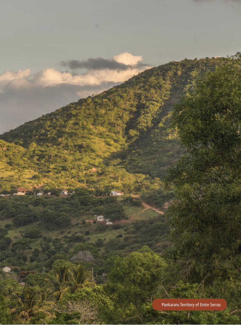
Pankararu Territory of Entre Serras


Cataloguing in-Publication Data (CIP)(eDOC BRASIL, Belo Horizonte / MG)
M152i Maciel, Ney José Brito
Instruments for territorial and environmental management / Ney José Brito Maciel. – Brasilia (DF): IEB, 2016. - (The experience of the GATI Project in Indigenous Lands) 43 p. : 20.4 x 27.4 cm ISBN 978-85-60443-50-5 1. Territorial and environmental management. 2. Indigenous peoples - Brazil. 4.Project for Indigenous Environmental and Territorial Management. I. Title. II. Series.
CDD-980.41
PRESIDENCY OF THE NATIONAL FOUNDATION FOR INDIGENOUS PEOPLESArtur Nobre Mendes
TERRITORIAL PROTECTION DIRECTORATE - DPTWalter Coutinho Jr.
SUSTAINABLE DEVELOPMENT DIRECTORATE - DPDSPatricia Chagas Neves
ADMINISTRATION AND MANAGEMENT DIRECTORATE - DAGESJanice Queiroz de Oliveira
GATI PROJECT MANAGEMENT UNIT
NATIONAL PROJECT DIRECTOR - DPDS/FUNAIPatricia Chagas Neves
NATIONAL PROJECT COORDINATOR - CGGAM/FUNAIFernando de Luiz Brito Vianna
UNDP PROJECT OFFICERRose Diegues
TECHNICAL COORDINATOR OF THE PROJECT - UNDPRobert Pritchard Miller
PGTA COORDINATOR - UNDPNey José Brito Maciel
FINANCIAL COORDINATOR OF THE PROJECT - CGGAM/FUNAIValéria do Socorro Novaes de Carvalho
ADMINISTRATIVE ASSISTANTS - CGGAM/FUNAI Caio César de Sousa de OliveiraSofia Morgana Siqueira Meneses
ArticulaçãoMATO GROSSO
ARTICULAÇÃO DOS POVOS E ORGANIZAÇÕES INDÍGENAS DO NORDESTE, MINAS GERAIS E ESPÍRITO SANTO
www.theGEF.orgEmpoderando vidas.Fortalecendo nações.
The Experience of the GATI Project in Indigenous Lands
Instruments forTerritorial andEnvironmental Management
The Project for Indigenous Territorial and Environmental Management (GATI) contributed to the recognition of Indigenous Lands (ILs) as protected areas essential for biodiversity conservation in Brazilian biomes, and strengthened traditional indigenous practices regarding management, sustainable use, and conservation of natural resources. In addition, it fostered indigenous leadershipin the construction of public policies for environmental and territorial management of ILs.
The Project was a joint effort of the Brazilian indigenous movement, the National Foundation for Indigenous Peoples (Funai), the Ministry of Environment (MMA), The Nature Conservancy(TNC), the United Nations Development Programme (UNDP), and the Global Environment Facility (GEF).