- icma.org - initial city... · ∙ columbia university, 2880 broadway, new york, ny 10025 ∙ +1...
TRANSCRIPT


1
www.uccrn.org∙Columbia University, 2880 Broadway, New York, NY 10025 ∙ +1 212-678-5626
Executive Summary
This report summarizes the key findings of a diagnostic trip to Semarang City, Indonesia in
December 15-20, 2015 conducted by the International City/County Management Association
(ICMA) CityLinks team, together with climate experts from the Urban Climate Change Research
Network (UCCRN). The purpose of the trip was to advance a city-to-city exchange program between
Semarang, Indonesia and Gold Coast, Australia on climate adaptation and resilience. Identifying the
key challenges of climate change adaptation and a set of key issues in technical exchange between
the two cities were the focus of the program.
Semarang is a city located in the north of Central Java Province, Indonesia. More than twenty of its
villages lie along the coast and suffer from persistent tidal flood, leading to coastal inundation and
exacerbating land subsidence. The tidal flood is induced by interrelated factors, viz., land subsidence,
intensifying marine activity, coastal erosion, and climate change.
Despite the numerous ecosystem- and structure-based prevention and mitigation efforts, land
subsidence in Semarang prevails. The failure in decreasing the number of loss explicably comes
from the ripple effect of unorganized database. The existing dataset is lack of availability and
reliability, which leads to more difficulties in depicting and understanding the coastal problems in
Semarang accurately.
For this reason, the CityLinks program is concerned with providing available coastal data and
examining the appropriate methods for mangrove protection. The program includes several activities,
namely:
1. Collecting data sources (from every local governmental agency),
2. Developing model (university and governor),
3. Initiating investigative steps,
4. Collecting experimental knowledge on mangrove (interviews or FGDs), and
5. Determining the appropriate methods for mangrove protection against destructive waves.
CityLinks team will cooperate with the city councils of Semarang and Gold Coast, universities in
Indonesia and Australia, and several governmental agencies in Semarang, namely the Marine and
Fisheries Office (Dinas Kelautan dan Perikanan), Agricultural Office (Dinas Pertanian), and Public
Works Office (Dinas Pekerjaan Umum). The program will be complete in July 2016 and aims to
address the coastal problems and climate change challenges in Semarang successfully.

1
www.uccrn.org∙Columbia University, 2880 Broadway, New York, NY 10025 ∙ +1 212-678-5626
Table of Content
Executive Summary ............................................................................................................................... 1
Table of Content .................................................................................................................................... 1
List of Figures ........................................................................................................................................ 2
List of Tables ......................................................................................................................................... 2
I. Brief Introduction of Semarang Coastal Area ................................................................................ 3
II. Coastal Problems in Semarang City ............................................................................................... 6
III. Discussion Summary .................................................................................................................... 10
IV. Project Suggestion from Gold Coast ........................................ Error! Bookmark not defined.11
V. Problems and Workflows ............................................................................................................. 13
VI. Related Agencies .......................................................................................................................... 14
VII. Timetable ...................................................................................................................................... 14
REFERENCES .................................................................................................................................... 17

2
www.uccrn.org∙Columbia University, 2880 Broadway, New York, NY 10025 ∙ +1 212-678-5626
List of Figures
Figure 1. The Administrative Map of Semarang, Central Java Province, Indonesia .......... 3
Figure 2. The Morphological Cross-Section of Semarang…………………………………………... 4
Figure 3. The Geomorphological Map of Semarang: (a) lineaments of faults and folds in yellow lines, (b) the landforms in the northern part, and (c) the landforms in the southern part ………………………………………………………………………………….. 5
Figure 4. Coastline Recession in Semarang ………………………………………………………………. 6
Figure 5. Tanjung Mas Harbor ………………………………………………………………………………… 7
Figure 6. Mud-filled car tires for wave breakers and mangrove protection ……………….. 8
Figure 7. Wave breaker in Trimulyo………………………………………………………………………... 8
Figure 8. Land subsidence in Tambak Rejo ………………………………………………………………. 9
Figure 9. Land subsidence in Tambak Lorok ……………………………………………………………. 9
Figure 10. The framework of the projects suggested by the Gold Coast’s representative 11
List of Tables
Table 1. Land subsidence rate in Semarang………………………………………………………......... 10
Table 2. Project and Output Recommendation ……………………………………………………….. 12
Table 3. Time Table………………………………………………………........................................................ 15

3
www.uccrn.org∙Columbia University, 2880 Broadway, New York, NY 10025 ∙ +1 212-678-5626
Initial City Assessment Report: Semarang City, Indonesia
December 2015
I. Brief Introduction of Semarang Coastal Area Semarang is one of coastal cities in the north of Central Java Province, Indonesia. It
is located on 6°50’-7°10’ N, 109°35’-110°50’ E along the strategic economic route of Indonesia. Administratively, it is bordered by Kendal Regency on the west, Semarang Regency on the south, Demak Regency on the east, and Java Sea on the north. Semarang covers an area of 373.7 km2, divided into 16 sub-districts and 177 villages. Figure 1 shows the administrative location of Semarang.
Figure 1. The Administrative Map of Semarang, Central Java Province, Indonesia
Legally, Semarang City was formed in 1950 under the Constitution No. 16/1950.
Historically, it began to grow in the fifteenth century, i.e., when Ki Pandan Arang of Demak merged the small, scattered settlements in Gisikdrana, Semarang Selatan, Gajahmungkur, Borgota, Pleburan, and the surroundings into one governed area named Semarang (Maskur, 2008) with a central government in Bubukan, close to the Port of Semarang. Furthermore, Tome Pires in his book “Suma Oriental” described that in 1513 the inhabitants of Semarang consisted of Arabian, Chinese, Persian, Gujarati, Malay ethnics, etc (Tourism Office of Semarang City, 2006). Meanwhile, during the colonization era, in 1753, this city was developed northward. Hence, since the nineteenth century, the development of Semarang has centered in the north.

4
www.uccrn.org∙Columbia University, 2880 Broadway, New York, NY 10025 ∙ +1 212-678-5626
Semarang City in Figure shows that the population of Semarang was 1,572,105 in 2013; most of which stayed in the center of the development –i.e. coastal area, with a population density of 4,206 people/km2. According to the statistics in 2005-2013, the population in Semarang increased by 1.4% per year. Natality and migration dominantly influence the population growth. Developing in industry, Semarang attracts more and more people to migrate and work in the city. Most of them work in industrial sector: 53,610 entrepreneurs, 176,635 industrial workers, and 86,766 traders in 2013 (BPS, 2015), while the rest of them work in agricultural sector as farmers and anglers.
The sun shines all the year in Semarang. This tropical climate is characterized by monsoonal rain that consists of one peak for each rainy and dry season, as influenced by the monsoonal wind that blows from Himalaya in Asia to the north coast of Australia. Based on the 30-year dataset of Ahmad Yani Meteorological Station, organized by the Bureau of Meteorology, Climatology, and Geophysics (BMKG) Semarang, the average annual rainfall is 1,684 mm. The peak of rainy and dry season is from December to February and from June to August, respectively. The driest observed rainfall is 1 mm at the lowest temperature, 240C. Hence, according to Koeppen’s Climate Classification, the climate in Semarang is wet dry tropical (Aw).
Topographically, Semarang has different variation of elevation: from 0.4 to 348 masl with a distance of 27.5 km between the lowland (coastal area) and highland (hilly area) (Figure 2). The slope of the coastal area varies from 00 to 20 with a flat-to-gently-undulating morphology (e.g. in Semarang Utara, Tugu, and Genuk Sub-Districts), while the slope of the hilly area varies from 150 to 400 with a hilly-to-very-hilly morphology (e.g. in Mijen, Candisari, Banyumanik, and Gunungpati Sub-Districts).
Figure 2. The Morphological Cross-Section of Semarang (Source: Helmi, 2014)
Based on the Geological Map of Magelang and Semarang (Thaden, et al., 1996),
Semarang is composed of alluvium (Qa), Gajahmungkur volcanic stone (Qhg), Kaligesikvolcanic stone (Qpk), JongkongFm (Qpj), DamarFm (Qtd), KaligetasFm (Qpkg), KalibengFm (Tmkl), and KerekFm (Tmk). The lowland is composed of sedimented alluvium material, consisting of sand-silt-clay layers and some volcanic sand and gravel. Meanwhile, the highland is mostly composed of igneous rock. In addition, the geological structures consist of several types of faults that are mostly found in Kerek, Kalibeng, and DamarFm: a West-East normal fault with a Northwest-Southeast convex and North-South and Northwest-Southeast transverse faults. Another transverse fault is located along Kali

5
www.uccrn.org∙Columbia University, 2880 Broadway, New York, NY 10025 ∙ +1 212-678-5626
Garang, bordered by Bukit Gombel, lying northward from Ondorante to Bendan Duwur. The Geomorphological Map of Semarang, presented in Figure 3, shows the lineaments of the geological structures as well as the landforms of Semarang. The landforms of the northern part are different from those of the southern part. The northern part varies from sedimentation on the river mouth, coastal alluvial plain, floodplain, to alluvial plain, while the southern part varies from structural-denudational hill, volcanic slope, to volcanic foot slope.
Figure 3. The Geomorphological Map of Semarang: (a) lineaments of faults and folds in yellow lines, (b) the landforms in the northern part, and (c) the landforms in the southern
part (Source: Helmi (2014) and Marfai (2003))
There are more than 15 rivers flowing through Semarang. Some of them are Babon, Banger, Semarang, Baru, Kreo, Kripik, Garang, Silandak, Mangkang, and Sringin. Garang River, flowing from Ungaran Volcano to the Java Sea, has the highest discharge, which is around 53% of the total discharge flow in Semarang (Pemerintah Kota Semarang, 2015). Therefore, it becomes the most influencing river in Semarang, i.e., it controls the water supply and even the river flood hazard in the city.
The northern part of Semarang, especially along the alluvial plain, has a higher groundwater potential than the southern part. The hilly area on the southern part has limited groundwater discharge (Marfai, 20013). Unconfined groundwater (3-18 meters deep) has less discharge potential than confined groundwater (50-90 meters deep) (Pemerintah Kota Semarang, 2015). Recently, people use confined groundwater for water supply due to the scarcity of unconfined groundwater.
b c
a
a

6
www.uccrn.org∙Columbia University, 2880 Broadway, New York, NY 10025 ∙ +1 212-678-5626
II. Coastal Problems in Semarang City Climate change has been affecting almost every coastal city in the world, including
Semarang. Semarang, the capital of Central Java Province, has been experiencing serious issues due to climate change impacts, for instance, coastal erosion, land subsidence, and flooding. According to Marfai et al. (2008), Semarang is classified as the fifth largest city in Indonesia due to the increasing population (1.5 million) and population density as well as flourishing economic activities in industry and fishery. This city is located along the northern coast of Java, which is mainly composed of young alluvial swampy deposits with clay and fine sand. This type of materials is originated from marine and river sedimentation (Said and Sukrisno, 1982).
The CityLinks’ discussion on November 18-20, 2015 listed several problems faced by Semarang. The problems are as follows: a. Coastline recession due to coastal erosion
The coastline in Semarang has been receding, as proven by the distance between the present and the former coastline (Figure 4), due to coastal erosion. Large materials on the coastline are eroded, causing excessive land loss in Semarang. Consequently, anglers, as the most affected livelihood in the coastal area, have been losing their fish ponds to land recession.
Figure4. Coastline Recession in Semarang
(Source: Helmi, 2014)
Together with the government, the local people built wave breakers and sea wall as a structural protection against high tides and longshore currents. However, the rate and the extent of coastal erosion in Semarang are still high. Therefore, they apply different methods, which are mangrove tree planting and sediment trapping using hybrid technology. These methods are expected to provide a long-lasting coastline protection as well as coastal area restoration.
b. The construction of Tanjung Mas Harbor
The Tanjung Mas Harbor was constructed extending the main land as a groin or cape (Figure 5). Unfortunately, the structure of the harbor acts as a barrier, i.e., it

7
www.uccrn.org∙Columbia University, 2880 Broadway, New York, NY 10025 ∙ +1 212-678-5626
prevents longshore current from transporting sediments to the east side of the harbor and, therefore, deposits the sediments on the west side. A prolonged process potentially leads to silting on the west side and extensive erosion on the east side. However, the future condition depends on the movements of the longshore current. Therefore, further research on predicting the foreseeable movements become necessary.
Figure 5. Tanjung Mas Harbor (red line)
c. Mangroves destruction due to high tides
Natural mitigation to prevent coastal erosion includes restoring the mangrove ecosystem in the coastal area. Mangrove trees provide a number of advantages, namely absorbing the energy of wind and tide as well as purify polluted water. The local government of Semarang, together with the local people and NGOs, had planted mangrove trees along the coastline before they were damaged by strong wind and high tides during the west monsoon. Regarding the urgency of mangrove protection, the Ministry of Marine Affairs and Fisheries has been developing a hybrid-engineering model whose functions are not only as wave breaker but also as sediment trap. This model is designed to trap sediment from offshore and store it into the hybrid-engineering system. When the amount of the trapped sediment is accumulated enough, the sediment is used for mangrove tress planting.
The local people also built wave breakers made of mud-filled car tires (Figure 6). These wave breakers are placed in front of the mangrove trees in order to reduce the energy of wave and high tide. However, the unstable structure makes them damaged easily. Therefore, these wave breakers need to be reconstructed every 5 years.

8
www.uccrn.org∙Columbia University, 2880 Broadway, New York, NY 10025 ∙ +1 212-678-5626
Figure 6. Mud-filled car tires for wave breakers and mangrove protection
The government also built wave breakers as a structural protection against
coastal erosion (Figure 7) and intensive energy from waves and longshore currents. However, the structure is damaged because of inadequate construction plans.
Figure 7. Wave breaker in Trimulyo
d. Land subsidence
Land subsidence in Semarang is naturally triggered by tectonic process and soil consolidation. At the same time, this coastal city experiences a rapid population growth and economic development in industrial sector. The development of industrial sector in

9
www.uccrn.org∙Columbia University, 2880 Broadway, New York, NY 10025 ∙ +1 212-678-5626
the area potentially exacerbate the existing land subsidence due to increasing structural loads and groundwater over-extraction for industrial activities. The movements of the Earth’s material causes land to subside gradually (Marfai et al., 2007). Consequently, several houses subside over time (Figure 8 and 9).
Figure 8. Land subsidence in Tambak Rejo
Figure 9. Land subsidence in Tambak Lorok
The rate of land subsidence in Semarang is up to 5.8 cm/year (Helmi, 2014).
This rate of subsidence occurs due to compression between aquifer layers and unconsolidated materials, consisting of clay or silt materials (easily collapsed), rock dissolution, and oxidation of organic soils. Nevertheless, it mostly occurs because of groundwater withdrawal. Identifying the main problem that causes land subsidence becomes important in determining the best solution. The rate of land subsidence in Semarang is shown in Table 1.

10
www.uccrn.org∙Columbia University, 2880 Broadway, New York, NY 10025 ∙ +1 212-678-5626
Table 1. Land subsidence rate in Semarang
(Source: PWD, 2000 in Marfai,et al., 2007)
III. Discussion Summary
The main purpose of the Regional Development Planning Agency (Bappeda), as written in the city’s master plan, is restoring the coastline and developing the coastal area of Semarang for tourism purposes as well as conservation area. The calibration for the developed model requires several data, such as:
1. Tide information along the Java Sea in order to understand the global current, 2. Data from marine gauge stations for calibrating the results of global current
modelling, 3. Bathymetry data of the Java Sea, 4. The topography of the catchment area (extracted from DEM data), 5. A set of data for modelling flood in the catchment area: rainfall, land use,
bathymetry of the river, and water level (SPAS) for calibrating the model, 6. A set of data for coastal modelling: tides, waves, and currents, 7. Images of Semarang in order to understand the history of Semarang, 8. Bathymetry of the coast of Semarang, 9. Coastline change (extracted from images of Semarang), and 10. More detailed data on Semarang.
Intensive observation, discussion and experience sharing with related parties lead to the following recommendations:
1. Regular survey for coastline to monitor the changing of coastal morphology,

11
www.uccrn.org∙Columbia University, 2880 Broadway, New York, NY 10025 ∙ +1 212-678-5626
2. Monitoring from images, 3. For mangrove:physical modelling to decide the right place for planting mangrove, 4. Reviewing the regulation in Gold Coast after the second visit (which regulation is
applicable for Semarang), 5. Consolidations with the help of the universities, 6. Building capacity of the society, 7. Conceptual modelling for spatial planning in 2100, and 8. Calculating the budget for Planning.
IV. Project Suggestion
Regarding the overviews on the problems in the coastal area of Semarang City, Gold Coast, as representative, suggested several projects that can solve the problems. The suggested projects are based on the main problem of Semarang City, i.e., the lowest basis level of problems in development: lack of data. Therefore, data should be maintained firstly so that, later, the city is able to run some predictive models to investigate and establish the actual condition in Semarang City. By the end, the results of the investigations can provide a strong basic reason for mitigation and decision-making. Figure 10 shows the framework of these suggested projects.
Figure 10. The framework of the projects suggested by the Gold Coast’s representative
There are four projects recommended by Gold Coast. Every project is related to each other. Those projects are written in Table 2.

12
www.uccrn.org∙Columbia University, 2880 Broadway, New York, NY 10025 ∙ +1 212-678-5626
Table 2. Project and Output Recommendation Suggested Projects
Purposes Outputs
1 – Base-line study
1. To establish current state of affair.
2. To collate all available data.
3. To list all the challenges and research questions.
1. List of questions. 2. All available data accessible for work
programs 2 and 3 3. Stakeholders: all agencies 4. Lead agency: City of Semarang
2 – Modelling 1. To establish the reason for losing inter-tidal lands.
2. To predict effectiveness of various mitigation scenarios.
1. A suite of models of the Java Sea (and possibly of the City of Semarang) to be handed over to the City of Semarang.
2. Capacity building in the City of Semarang.
3. Stakeholders: all agencies 4. Lead agency: City of Gold Coast (this
project is subject to availability of required data).
3 – Mangrove
1. To answer research questions that may arise from project 1 about mangroves.
1. Stakeholders: all agencies 2. Lead agency: Semarang
4 – Constraint Mapping
1. To develop relevant policy, constraint maps such flood planning level map, surface water quality control, preloading (land subsidence management) policy, to prepare adaptation plan to enable sustainable development, etc.
1. Relevant constraint maps and policies, and plans.
2. Stakeholders: all agencies 3. Lead agency: Semarang (help from
Gold Coast)

13
www.uccrn.org∙Columbia University, 2880 Broadway, New York, NY 10025 ∙ +1 212-678-5626
V. Problems and Workflows
The above discussion leads to conclusions that the most concerning problem in Semarang is Coastal Erosion. Therefore, the main objective is to create Urban Coastal Protection in Semarang. The coastal erosion in Semarang involves two sub-problems, which are: Sub Problem 1: Lack of understanding of the root causes
Most of the mitigation efforts in Semarang City failed to prevent further coastline recession. The main reason of this failure is the lack of understanding of the root causes. Several data are not available, such as sea current, sea tide, precipitation, etc. Lack of available data may lead to under- or over-estimating the coastal characteristics of Semarang City. Here are several solutions for this sub-problem: 1. Collecting data sources (from every local governmental agency),
2. Developing model (university and governor), and
3. Initiating investigative steps.
Sub Problem 2: Need to develop appropriate methods for mangrove protection Mangrove ecosystem is the best solution for natural mitigation in the coastal area
of Semarang. However, it requires appropriate protection in order to optimize its function as natural wave breaker. Nowadays, the mangrove-protecting structure cannot last for a long time, only 1 to 2 years. At the same time, a mangrove tree needs a minimum time of 5 to 10 years to grow and provide its protective service. Here are several solutions for this sub-problem: 1. Collecting experimental knowledge on mangrove (interviews or FGDs) and 2. Determining the appropriate methods for mangrove protection against destructive waves.
These two sub-problems are divided into five (5) workflows, which have to be
conducted consecutively. - Workflow 1: Developing mangrove report (Opt: for Mercy Corp and Fishery Agencies)
1. Developing questionnaire 2. Identifying stakeholders 3. Consolidating answers 4. Feeding into the overall report 5. Sharing with Gold Coast
- Workflow 2: Understanding the source of the problem
1. Identifying the required data - Hamid a. Tide data along the Java Sea, wave, bathymetric and current, and precipitation
data (collecting from stakeholders) b. Air photos (time series spatial data) c. Changes along the coastline
2. Identifying the data organizers - Safrinal and Aris 3. Collecting all relevant data – Safrinal and Aris
- Workflow 3: Developing the model
1. Preparing the source students (research assistants? Informants?) 2. Preparing the source of the modelling software 3. Developing and calibrating the model

14
www.uccrn.org∙Columbia University, 2880 Broadway, New York, NY 10025 ∙ +1 212-678-5626
4. Reporting and feeding into overall report
- Workflow 4: Capacity Building of Model (Establishing the capacity building of the model? Disseminating/introducing the model? Building the capacity of the model?)
1. Preparing the source student from university to maintain the model 2. Establishing a relationship between Semarang and the university 3. Developing an MoU (Memorandum of Understanding) between the university and
the City of Semarang 4. Bringing the model from Gold Coast and training the university and the employees
of the City of Semarang 5. Hosting a conference to gain an insight from the community regarding the model
- Workflow 5: Developing the final report
1. Completing the first draft of the final report 2. Finishing the final report 3. Presenting the final report to the City of Semarang
VI. Related Agencies
Semarang City has many governmental agencies that are responsible of the problems in its coastal area. Some of them have bigger influences on developing the coastal area according to their area of works and functions, which are: a. Marine and Fisheries Office (Dinas Kelautan dan Perikanan) b. Agricultural Office (Dinas Pertanian) c. Public Works Office (Dinas Pekerjaan Umum)
In order to meet every objective of this project, contribution from and
coordination/cooperation between these three offices, the Regional Development Planning Agency, and the City Council of Semarang become necessary.
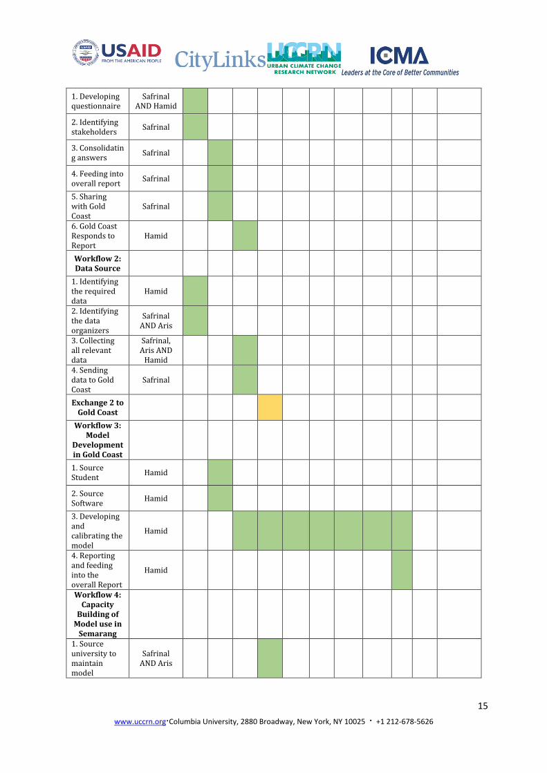
VII. Timetable
Each activity in every workflow is scheduled for the rest of the 9 months. The 10-month project is shown in Table 3. The people in charge are described as follows: a. Safrinal : as the representative of Semarang City b. Hamid : as the representative of Gold Coast c. Aris : as climate expert *Team: people, organizations, institutions, and agencies contributing in this project
Table 3. Time Table
Workflows Person in
Charge
Month
Nov Dec Jan Feb Mar Apr May Jun Jul Aug NOTES
Exchange 1 X
Workflow 1: Mangrove
report
15
www.uccrn.org∙Columbia University, 2880 Broadway, New York, NY 10025 ∙ +1 212-678-5626
1. Developing questionnaire
Safrinal AND Hamid
2. Identifying stakeholders
Safrinal
3. Consolidating answers
Safrinal
4. Feeding into overall report
Safrinal
5. Sharing with Gold Coast
Safrinal
6. Gold Coast Responds to Report
Hamid
Workflow 2: Data Source
1. Identifying the required data
Hamid
2. Identifying the data organizers
Safrinal AND Aris
3. Collecting all relevant data
Safrinal, Aris AND
Hamid
4. Sending data to Gold Coast
Safrinal
Exchange 2 to Gold Coast
Workflow 3: Model
Development in Gold Coast
1. Source Student
Hamid
2. Source Software
Hamid
3. Developing and calibrating the model
Hamid
4. Reporting and feeding into the overall Report
Hamid
Workflow 4: Capacity
Building of Model use in
Semarang
1. Source university to maintain model
Safrinal AND Aris

16
www.uccrn.org∙Columbia University, 2880 Broadway, New York, NY 10025 ∙ +1 212-678-5626
2. Establishing a relationship between Semarang and the university
Safrinal and Aris
3. Developing an MOU between the university and the City of Semarang
Safrinal and Aris
4. Bringing the model and hosting a training to university students and city employees
Hamid, Safrinal
AND Aris
Safrinal to
provide room for training
5. Hosting a conference to gain an insight from the community regarding the model
Asris AND Safrinal
Exchange 3 to Semarang
Workflow 5: Report
Development with
Recommendations
1. Completing the first draft
Team
2. Final draft Team
3. Presenting the report to the City of Semarang
Team

www.uccrn.org∙Columbia University, 2880 Broadway, New York, NY 10025 ∙ +1 212-678-5626
REFERENCES
BPS, 2014, Semarang in Figure 2014, Semarang: Badan Pusat Statistik Kota Semarang.
Bappeda Kota Semarang, 2010, Rencana Pembangunan Jangka Menengah Daerah (RPJMD) Kota Semarang Tahun 2010-2015. Semarang: Bappeda Kota Semarang.
Dinas Pariwisata Kota Semarang, 2006, Semarang Pesona Asia, Brosur Festival Semarang Pesona Asia (SPA))
Helmi. 2014. Geospatial Approach for Eco-DRR Laboratory of Ocean Modeling and Marine Information System Universitas Diponegoro. Presented in Training on Ecosystem-Based Disaster Risk Reduction Universitas Gadjah Mada Yogyakarta on 11 June 2015
Marfai, 2003, GIS Modelling of River and Tidal Flood Hazardz in a Water Front City. Case Study: Semarang City, Central Java, Indonesia. Thesis. Enschede: ITC.
Marfai, M.A. and King L. 2007. Monitoring Land Subsidence in Semarang, Indonesia. Environmental Geology. Vol. 53: 651-659. DOI. 10.1007/s00254-007-0680-3
Marfai, M.A. Almohammad H., Dey, S., Susanto, B., and King, L. 2008. Coastal Dynamic and Shoreline Mapping: Multisources spatial data analysis in Semarang, Indonesia. Environmental Monitoring and Assessment. Vol. 142: 297-308.
Maskur, 2008, Rekonstruksi Pengaturan Hukum Reklamasi Pantai di Kota Semarang, Tesis, Semarang: Program Magister Ilmu Hukum Program Pascasarjana Universitass Diponegoro.
Said, H.D. and Sukrisno. 1982. Hydrogeological Map of Indonesia: Semarang. Bandung: Directorate of Environmental Geology.

www.uccrn.org∙Columbia University, 2880 Broadway, New York, NY 10025 ∙ +1 212-678-5626
Appendix
1. Discussion session with Semarang - Climate Change Adaptation Task Force (City Team)
Date : November 16th, 2015
Place : Development and Planning Board Office
www.uccrn.org∙Columbia University, 2880 Broadway, New York, NY 10025 ∙ +1 212-678-5626
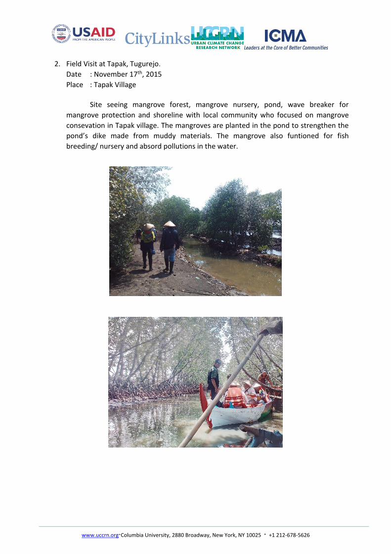
2. Field Visit at Tapak, Tugurejo.
Date : November 17th, 2015
Place : Tapak Village
Site seeing mangrove forest, mangrove nursery, pond, wave breaker for
mangrove protection and shoreline with local community who focused on mangrove
consevation in Tapak village. The mangroves are planted in the pond to strengthen the
pond’s dike made from muddy materials. The mangrove also funtioned for fish
breeding/ nursery and absord pollutions in the water.
www.uccrn.org∙Columbia University, 2880 Broadway, New York, NY 10025 ∙ +1 212-678-5626
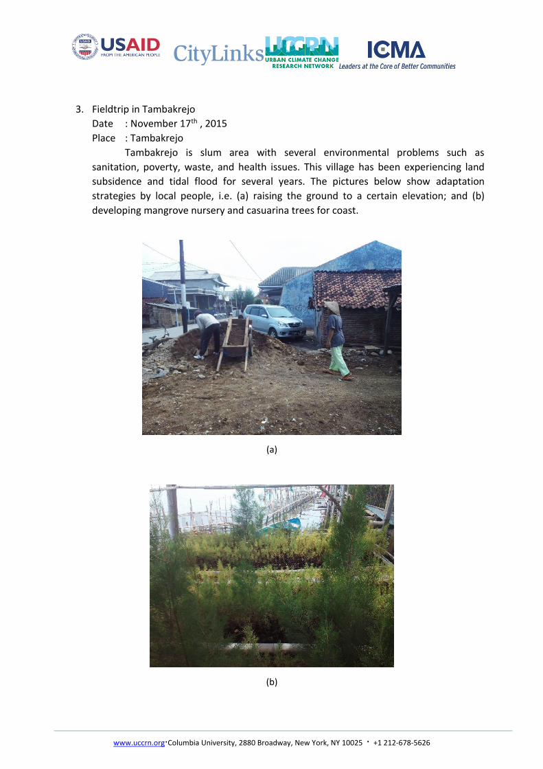
3. Fieldtrip in Tambakrejo
Date : November 17th , 2015
Place : Tambakrejo
Tambakrejo is slum area with several environmental problems such as
sanitation, poverty, waste, and health issues. This village has been experiencing land
subsidence and tidal flood for several years. The pictures below show adaptation
strategies by local people, i.e. (a) raising the ground to a certain elevation; and (b)
developing mangrove nursery and casuarina trees for coast.
(a)
(b)

www.uccrn.org∙Columbia University, 2880 Broadway, New York, NY 10025 ∙ +1 212-678-5626
4. Fieldtrip to Trimulyo
Date : November 17th, 2015
Place : Trimulyo
Surveying wave breaker and hybrid engineering developed by Marine Agency

www.uccrn.org∙Columbia University, 2880 Broadway, New York, NY 10025 ∙ +1 212-678-5626
5. Conclusion and Closure
Date : November 19th,2015
Place : Development and Planning Board Office
Discussion and sharing with related institutions.