~--· miamisburg, oh 45343-0750 - us department of … closure project u.s. department of energy 175...
TRANSCRIPT

• CH2MHILL
~--·
Mr. Don Pfister, Director Miamisburg Closure Project U.S. Department of Energy 175 Tri-County Parkway Springdale, OH 45246
ATTENTION: Paul lucas
CH2M HILL Mound, Inc.
1075 Mound Road
P.O. Box 750
Miamisburg, OH 45343-0750
SM0-101/06 February 8, 2006
SUBJECT: Contract No. DE-AC24-030H20152: Deliverable #39 Potential release site and removal action documentation; Section C.2.3.1.3 Remaining Response Actions; PRS 75 OSC Report, Final
Dear Mr. Pfister:
Attached is the following Final document for your records:
• PRS 75 OSC Report, Final
If you or members of your staff have any questions regarding the document, or if additional support is needed, please contact Dave Rake! at 937-865-4203.
Sincerely,
Michael D. Ebben Site Manager
JL!jg
Enclosures
cc: T. Fischer, USEPA, (1) w/attachments · B. Nickel, OEPA, (1} w/attachments R. Vandegrift, ODH, (1) w/attachments
· J. Webb, ODH, (1) w/attachments M. Wojciechowski, Tetra Tech, (1) w/attach G. Gorsuch, DOE/MCP, (1) w/attachments R.-Tormey, DOE/OH, (1) w/attachments G. Desai, DOE/HQ, (1} w/attachments C. Kline, CH2M Hill, (1} w/attachments F. Bullock, MMCIC (2) w/attachments Public Reading Room (1) w/attachments Admin Records, CH2M Hill, (2) w/attachs
ER Records, CH2M Hill, (1) w/attachs DCC (1) w/attachments M. Ebben, CH2M Hill, w/o attachments K. Armstrong, CH2M Hill, w/o attachments D. Rake!, CH2M Hill, w/o attachments D. Kramer, CH2M Hill, w/o attachments J. Fontaine, CH2M Hill, w/o attachments MOAT Coordinator, CH2M Hill, w/o attachs S. Barr; CH2M Hill, w/o attachments M. McDougal, CH2M Hill, w/o attachments file, CH2M Hill, w/o attachments

...
. PRS 75 REMOVAL ACTION
OSC REPORT
February 2006
Final
Department of Energy Miamisburg Closure Project
CH2MHILL
C:\Documents and Settingslkramdc\Local Settings\Temp\75 OSC Final 08february06.doc 02/08/06@ 10:47 AM

Authorization
PRS 75
'CRA indudes '· ; additional PRSs nol ~ • · · · · '. shown on this sheet. .'
Contingent ,<~ Action~~·~
~~!\~-. . {1'<:!\ ~emova_l
c~\ctlon: SoilS*
~~-Fact Sheet._·, ~ ')'-;
:v~· ~~~-~~~
l(l)WRS75
v 1,.---~---'
Planning & Execution
Completion
SUD = Survey Unit Design per Std VSAP
8Feb06dck
. : No Data Report was prepared for PRS 75 · . .--D-t-RL---:tt-1tli.'\~ : because no excavation or additional soil sampling :
a a ~\.ec;;.•· : was indicated. See OSC Report. :
Q\~~~S 75
. : On 3/1/05, the Core Team binned PRS 441 a . ~ :Removal Action; PRS 441 includes the west portion:
·.. of what was originally designated as PRS 75. . . ·
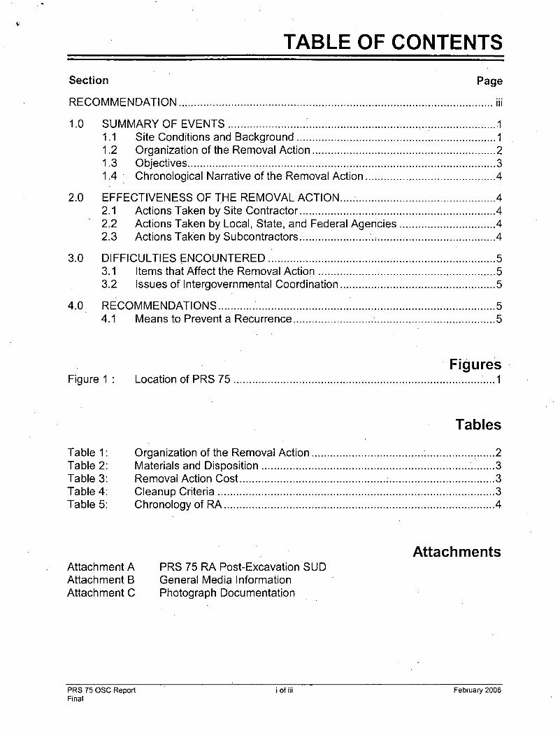
TABLE OF CONTENTS
Section Page
RECOMMENDATION ..................................................................................................... iii
1.0 SUMMARY OF EVENTS ......................... : ............................................................ -1 1.1 Site Conditions and Background ................................................................ 1 1.2 Organization of the Removal Action ........................................................... 2 1.3 Objectives ................................................................................................... 3 1.4 · Chronological Narrative of the Removal Action .......................................... 4
2.0 EFFECTIVENESS OF THE REMOVAL ACTION ................................................. .4 2.1 Actions Taken by Site Contractor .............................................................. .4 2.2 Actions Taken by Local, State, and Federal Agencies .............................. .4 2.3 Actions Taken by Subcontractors ...................... ~., ...................................... 4
3.0 DIFFICULTIES ENCOUNTERED ......................................................................... 5 3.1 Items that Affect the Removal Action ......................................................... 5 3.2 Issues of Intergovernmental Coordination .................................................. 5
. 4.0 RE.COMMENDATIONS ......................................................................................... 5 4.1 Means to Prevent a Recurrence .............. , .................................................. 5
Figure 1 :
Table 1: Table 2: Table 3: Table 4: Table 5:
Attachment A Attachment B Attachment C
· Figures Location of PRS 75 ............................................................................... : .... 1
Tables
Organization of the Removal Action .................................... : ............... : ...... 2 Materials and Disposition ........................................................................... 3 Removal Action Cost ............................................... : .................................. 3 Cleanup Criteria ......................................... : ............................................... 3 Chronology of RA ....................................................................................... 4
PRS 75 RA Post-Excavation SUD General Media Information Photograph Documentation
Attachments
PRS 75 OSC Report Final
i of iii February 2006

CERCLA co .
·COC DOE OEPA osc ou pCi/g PRS RA RCRA SUD USEPA voc
TABLE OF CONTENTS (continued)
Acronyms
Comprehensive Environmental Response, Compensation, and Liability Act cleanup objective contaminant of concern Department of Energy Ohio Environmental Protection Agency On-Scene Coordinator Operable Unit picoCuries per gram Potential Release Site Removal Action Resource Concervation and Recovery Act Survey Unit Design United States Environmental Protection Agency volatile organic compound
·PRS 75 OSC Report Final
ii of iii February 2006

\.'
Pt)tef'ltiat. t~~el,E:1a~e Sits {?RS) 75)·; the histone :rail·sfdih~ {rerro.\'ed l.n the. 19oO$) thEit st!(!tporlsd t.:1p<~ratlo11o a.LPRS. 76- (ft}rtn~r VVarehoL(::;e ~~-·PHS 76 warehouse. op_eratitms. indwde!:i •:!rv1ii storage, loa.ding, arid rs.packag!ng .. utt!!zln_g tl1.e PRS 75 ratf slcJtng for trcitlSi)Ottatiqri (k;?qf~g!.untoadii1g). of: nfa~lf;riais · enci W3st£s fqr the .pntbolqrn. thorium, i~nd !j!l)Jcin\:Jrt1 prr;Jj$cts in tneiSi50s~ eqsf and 70s .
. A RBrni::P.ia\4 ~~\otlo0. <RA) was p?rforrr}e~ $ff.h~ PR$ 16 wan;;hq0$e. due ttl t,e pres€l~ce or i$01?i:e.d -.,~olatilb arganlc. comppun~.s (VOGS) above ~ccepttlbk~ leV§~~: AlthoUgh .rbsidil~\! i'aqisfkm at PRS 76 Vitirenow~e wa.s belov~ the cleanup criteria; th$ potential r-Ji·es~;iit":e of reskiil~Lr~cljbactive $1)\1 $long the. PRS 75 ran $1dihg \from an.rn!-·'~lated Qp~r(jtior:ts t:r;soctattd v~ith PR:$ 76)uv#s the basis fcrPRS ff;. ···
Aftdr the ~ni:\zil pl~mf}ii}.g fcrthC! PV\S/~ R~ W?S comph?te, tf!e nearby Soil~t4giryg {\r~a wz:;s. desi~fli~t!ed Pf1S 44t; Be~~~.~s.e>t~e \.Vent end~ ~f PRS 75 is. ?O,rnP!eteJy~ '-~Jt~lrr th,e are~ .o~s:gnate~ as Pr~$441, \Df:It P0¥"}1011 ofRR.$ 7.b was P~~movecl from pRS I5 and !S DO'-Y induder.;! In PHS 441. l·!i~ibt:ic sarpple results in the east(:'lnd (fernaining portion) of PHS 75 'll'.it:lr'e evAiua~~St:L SeNeral results $l:•OV~ 6litrn11t cle~hup criteria ¢_ixist wittiin ttH~ lirnit$ qfPf?S 7!)·; l'JCi~t.f?Vnr. all v:ere pr~viou$ly qisp(;>Sittoned as part qfthe PRS 1:6; PRS. 30(}, or OU'"iB (Qp$r~~ble Qriit6Jprt5jeC\s,
Thl~ tecornrrtenrJatloniorRA cf.PRS i5 was based em sq1rnpie n$stlits in the yvc.st ::.1.ras tte'; \vC~s sqGst~quen~y moved iC~ PRS! 441 , .or s;;tnplfi results in the east $re~ thatwere pr~viously d4sposmoned (by o~tit;.~ pnJ}eqts). Therefqre; no R,A; Ocourr~d related to PRS Yb, ·~. . . . . .
i OH?rac:;teriiatiori s;lmpiin9 lh 2004 ~nt:;llld(;~rj colle~tion of samr.;~te·s for J$dionut;;Hde analysis In a lin¢ar p§itt~ri1 <ploog the center(1ne·of:th~ forrn~f. rail (t;iding. AI! s~mpie iesvlt~ were .t;e!OYI cleanup criteria./ Asid:e from the pr~vio1.1s1y i:!isposlrlhb.ed result..::; det:.crlt?~d 5;fj(j1/e, there 1:1te ho s;.1mpi~ f~~suits.~/:)bV$.Gieaht~p objective within the Ctirr¢nt timlt$ of!tiRS 70: · !
,~ilt~f' tl thcrou~ih rovis<.v of d·1ri f'!-<.S ·{5 01:1-'Scene Cuordiriator (OS.C.) H(?port; th~ Core Tc<nrt:;!~~_~ref,~~ thr±it tiy .. 1 PG:s f(i Relf10val<.fo,ction i$: t;omplete, andL that_ all previous'!;/ exiS'Hno e!TVlrr:mmental iss!Jes ast~ociated with FRS ?5 have bean resolved; ·
_(i-J,}~~J~ <:;{~.<-c.•;-·•,,••o;_ _____ ••.... ·-.-~:.:":"·-.-~ .. ·-·····--I . . . . .......... ·.. . ... /:f,_)/0<~: ' .--:..:-......~.
PaurL.ucas., osc U,.S, Df;patihi¢nt of En.er~1y 1
Mlamlsb~, Ohio.·· ·· · -~' .•
:~~. l /til;'H(.::-fA· tJ · ·~:/-'~ ~~~.~~;.-:;~~ ::;_;:"k..,,, -~. :;~ ·.· ,<;v·~·,:-.. """'-~-·..,;. ·_..;;;........;....'"l;T!_,(?thl ,J, .rl...:.cho,, ~ • .,.rn d~.~~ Prc.l.;;r,:r M0nablt::r IJSEPA . . .. · ..
-c-:~--~ ~d~.·.-. --··~-.. -. ~.., __ .,;._....,_;....,..._, .·,. 8rtan K. hocK'<:H, Pn:'.ljB:!~t tvmnc:~~~et OEP/\ . fJ:?y;con,-QNo

1.0 SUMMARY OF EVENTS
This section describes the site background and events leading up to the Removal Action (RA), parties involved in responding to the RA, contaminant of concern (COC) ~etermination, chronological narrative of the RA, and resources committed to complete the project.
1.1 Site Conditions and Background
Background. Potential Release Site (PRS) 75 is the historic rail siding (removed in the 1980s) that supported operations at PRS 76 (former Warehouse 9). PRS 76 warehouse operations included drum storage, loading, and repackaging, and used· PRS 75 rail siding for transportation. The location of the siding is shown on Figure 1 below. The siding was used for loading/unloading materials and wastes for the polonium, thorium, and plutonium projects in the 1950s, 60s, and 70s.
PRS 75 OSC Report Final
Legend Cii:)" ·-- - - •• - ·-_, ·:::-.c·:.:.c·.-·- -IWW.. ----. ' •=m •:.,.,!'7 ... m ,,.
1 of 5
,..,.. c Ux:atian of PRB 75
February 2006

A RA occurred at the PRS 76 warehouse location due to the presence of isolated volatile organic compounds (VOCs) above acceptable levels. Although residual radiation at PRS 76 warehouse was below the cleanup criteria, the potential prese.nce of residual radiation along the PRS 75 rail siding from ·drum-related operations associated with PRS 76 required evaluation, and is the basis for PRS 75.
The PRS 75 RA was authorized by the Core Team via the PRS 75 Fact Sheet (Final, October 2003), in conjunction with . the Contingent Action Memo (Action Memorandum/Engineering Evaluation/Cost Analysis, Contingent Removal Action for Contaminated Soil, Final, June 2002). A copy of the PRS 75 Fact Sheet is included in Attachment B. · ·
The west end of PRS 75 is within the limits of PRS 441, and has been removed from PRS 75 and added to PRS 441. Historic sample results in the east end (remaining portion) of PRS 75 were evaluated. Several results above current cleanup criteria exist within the limits of PRS 75; however, all were previously dispositioned as part of PRS 76, PRS 300, or OU-6 (Operable Unit 6).
The level of soil contamination present at PRS 75 does not warrant a RA under CERCLA (Comprehensive Environmental Response, Compensation, and Liability Act). This OSC Report documents the completion of all aspects of the RA activities authorized via the Contingent Action Memo and Fact Sheet, including additional evaluations that demonstrate that the remaining soil meets the Cleanup Criteria.
Removal Action. PRS 75 RA consisted of additional evaluation of existing information and re-assigning the western end of PRS 75 to PRS 441. Verification sampling was proposed in accordance with the Standard Verification Sampling & Analysis Plan, Final, August 2004, as documented in the PRS 75 RA Post-Excavation SUD. Final verification samples were not required as no RA occurred. PRS 75 Characterization sample locations are shown on Figure 2 (A36/36).
1.2 Organization of the Removal Action
Table 1 lists the parties responding to the removal action, and their responsibilities.
PRS 75 OSC Report Final
2of 5 February 2006

Table 1: Organization of the Removal Action
US Environmental Protection Agency Timothy J. Fischer
Federal agency responsible for oversight 77 W. Jackson Street,.SFR-5J Chicago, IL 60604 312-353-2000
Ohio Environmental Protection Agency 401 E. Fifth Street Brian K. Nickel
State agency responsible for oversight
Dayton, OH 45402-2911 937-285-6357
Department of Energy, Miamisburg Closure Project Paul Lucas
On-scene Coordinator (OSC) responsible for 175 Tri-County Parkway oversight and success Springdale, OH 45246 513-246-0071
CH2M HILL Mound, Inc., Jim Fontaine
Provide OSC with technical assistance, 1 Mound Road, P. 0. Box 3030 administrative support, field oversight, sample Miamisburg, OH 45342-3030 management, site safety, photo, site documentation, 937-608-8220 and preparation of the OSC Report
1.3 Objectives
Documentation Objective. The objectives of this OSC Report are to describe the RA fieldwork and document successful completion of the project. Material quantities and disposition locations are presented in Table 2. The cost breakdown of the RA is presented in Table 3.
Table 2: Materials and Disposition
Type of Material Quantity Disposal Method Disposal Location
Contaminated soil None* Not applicable Not applicable
• No so1l removal was performed
Table 3: Removal Action Cost
Cost Category Cost
CH2M Hill support including Sample Plan, work plan, and OSC Report $15,000
Estimated Total Project Cost $15,000
Cleanup Objective. Contaminants of concern and their corresponding cleanup objectives (COs) identified in the Fact Sheet are as follows:
PRS 75 OSC Report Final
Table 4: Cleanup Criteria
coc Thorium-232
Plutonium-238
Radium-226
Uranium-238
3 of 5
CO (pCi/g)
2.1
55
2.9
2.2
February 2006

All characterization results (see A33/36) for PRS 75 were below their respective CO.
Removal Action Objectives: The objectives of the removal action included: • Project Planning, • Public Notification, • Site Preparation, • Excavation, • Verification, • Site Restoration, and • Documentation of Completion.
1.4 Chronological Narrative of the Removal Action
The. following is a chronological narrative of events surrounding the PRS 75 RA:
Table 5: Chronology of RA
Timeframe Activity
November 1996 Removal Action authorized
October 2003 Fact Sheet issued as Final
April2004 Characterization sampling performed
January 2005 Pre-Excavation SUD issued as final with Work Plan
May 2005 West end of PRS 75 redefined as part of the PRS 441 RA
June 2005 Post-Excavation SUD approved
June 2005 PRS 75 OSC Report prepared
2.0 EFFECTIVENESS OF THE REMOVAL ACTION
Characterization sample results for PRS 75 are presented in Attachment A. All results are below their respective COs. No soil excavation was necessary.
2.1 Actions Taken by Site Contractor
CH2M Hill Mound, Inc. performed project oversight, evaluation, and documentation.
Photographic documentation is presented in Attachment C.
The project met the RA objectives as outlined in the approved Action Memo/Fact Sheet. CH2M Hill Mound, Inc. personnel prepared this OSC Report, which shows that the Removal Action objectives were achieved.
PRS 75 OSC Report Final
4 of5 February 2006

2.2 Actions Taken by Local, State, and Federal Agencies
The Department of Energy (DOE)/MCP, the United States Environmental Protection Agency (USEPA), and Ohio EPA (OEPA) had oversight responsibility for the removal action. The DOE/MCP was the lead agency for the RA and provided the funding and oversight fcir the RA. The US~PA and OEPA had oversight responsibility for the RA and review of the Action Memorandum and OSC Report to ensure that the objectives were met.
2.3 Actions Taken by Subcontractors
Subcontractors involved in the project included the following:
0 None
3.0 DIFFICULTIES ENCOUNTERED
3.1 Items that Affect the Removal Action
No difficulties were encountered during the RA activities.
3.2 Issues of Intergovernmental Coordination
All DOE/USEPA/OEPA interactions were good. The agencies were updated informally on a regular basis, and formally at monthly Core Team meetings. The Mound 2000 Process worked well.
4.0 RECOMMENDATIONS
4.1 Means to Prevent a Recurrence
The spread of contamination is prevented due to the absence of contaminated soil. After the RA and the CERCLA process for the parcel is complete, the area will be transferred from Federal to private ownership. All State and Federal disposal rules will apply.
PRS 75 OSC Report Final
5 of 5 February 2006

ATTACHMENT A
POST EXCAVATION SUD
~
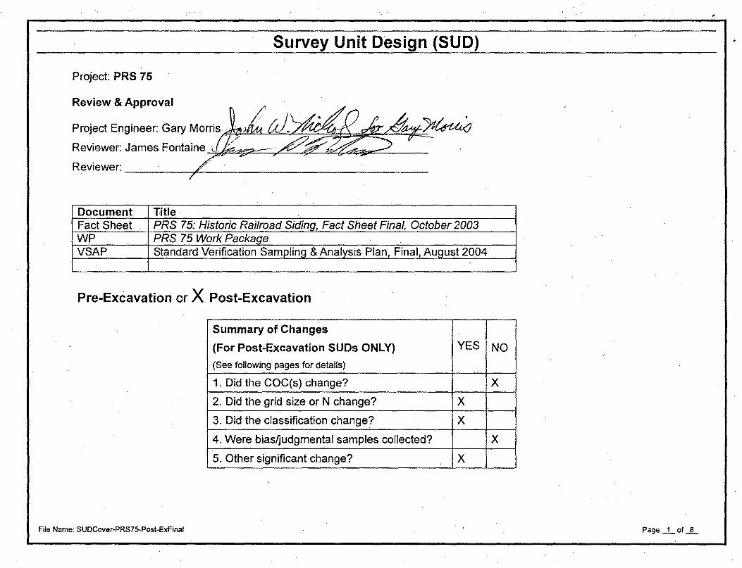
Survey Unit Design (SUD)
Project: PRS 75
Review & Approval
Proj~ct Engineer: Gary ~orris.r:~~c Rev1ewer: James Fonta1~ ... . ~ R~e~~ . · ? · · ,
Document Title· Fact Sheet PRS 75: Historic Railroad Siding, Fact Sheet Final, October 2003 WP PRS 75 Worl< Package VSAP Standard Verification Sampling & Analysis Plan, Final, August 2004
Pre-Excavation or X Post-Excavation
Summary of Changes
(For Post-Excavation SUDs ONLY) . YES NO
(See following pages for details)
1. Did the COC(s) change? X
2. Did the grid size or N change? X
3. Did the classification change? X
4. Were bias~udgmental samples collected? X
5. Other significant change? X .
File Name: SUDCover-PRS75-Post-Exfinal Page _1_ of .JL

AM co COG Chem dev I so EPA FSS HS MARSSIM MD MDC MEIMS ml N Nal NAor N/A NC ou pCi/g PRS Pu-238 QNQC RA RadCon RASS RP SPF RECON RSDS RSS (s) or s SPUR std su SUD TBD Th U-232
Acronyms
Action Memorandum Cleanup Objective Contaminant of Concern Chemical .deviation Isotopic Environmental Protection Agency Final Status Survey Hot Spot
SUD Worksheet
Multi- Agency Radiation Survey and Site Investigation Manual Mound Document Minimum Detectable Concentration Mound Environmental Information Management System mili liters number Sodium Iodine Non-applicable No Change operable unit pico-Curie(s) per gram Potential Release Site Plutonium-238 Quality Assurance/Quality Control Remedial Action/Removal Action Radiological Control Remedial Action Support Survey Removal Plan Survey Plan Form reconnaissance Radiological Survey Data Sheet Radiological Site Survey effective standard deviation (MARSSIM) refers to the rail spur standard Survey Unit Survey Unit Design To Be Determined Thorium Uranium-232
File Name: SUOCover-PRS75-Post-ExFinal
..
Page _1_ of _!L

vs VSAP VSP WP wrs
verification sampling Verification Sampling and Analysis Plan Visual Sample Plan Work PackageNVork Plan waste transfer system
SUD Worksheet
Item I Summary of historic information relevant to SU: 1
Potential Release Site (PRS) 75, also known as the Historic Railroad Siding, is located on the central portion of the site as shown on Figure 1. Process history of the PRS indicated the potential for the presence of radioactive material from drum storage, loading, and repackaging operations at the former location of Warehouse 9 at the east end of the siding. The siding was once used for loading and unloading materials and wastes for the polonium, thorium, and plutonium projects in the 1950s, 60s, & 70s. Between 1982 and 1986 a long section of track leading to the former location of Warehouse 9 was removed as a part of another project.
Item I Summary of historic data relevant to SU: 2
Item 3a
Sampling, relevant to PRS 75 is contained in the PRS 75, Potential Release Site package, November 1996 and associated references contained within this report. Data relevant to this SUD is contained in the following sampling events; OU6 Recon, RSS, USTBMI, WTSVS, SCRDATA, PRS76, PRS76C, Spur2002, Area 14/19, PRS75_2004 .
Most recent sampling results are summarized in Attachment A
Changes if any, from Pre-Ex SUD: Datapreviously disposltioned (see Item 5) were included in the work package an:d Pre-Ex SUD in error. This info was p·resented to the Tech Review Team March 16, 2005 and it was agreed that SU-1 and SU-2 data previously dispositioned would not be considered as part of PRS 75. SU-3 [and a portion of SU-4] were added to PRS 441 for remediation. The balance of PRS 75 is evaluated as new SU-1. Data for new SU-1 are presented in Attachment C.
Offsite Analysis & (pCi/g) Compendium Method
COC BASIS co HS gamma· lso Pu I lso Th I lso U
MAX (A-015) . (A-012) (A-012) (A-012)
Pu-238 I Historic results > CO 55 165.13 79 X I I
U-238 I Historic results> CO 2.2 4.2 1.87 I I X
2.6 4.8 14.9 I I I X I
Th-228 I Historic results > CO
File Name: SUDCover-PRS75-Post-ExFinal Page..d_of _L

Th-230 Historic results > CO 2.8 4.6 11.5 X
Th-232 Historic results > CO 2.1 3.5 4.5 X
Ra-226 Historic results > CO 2.9 4.7 5.1 X
Analyses are to be performed per Mound Methods Compendium and COs (for surface samples/analysis i.e., bedrock, asphalt, concrete) as applicable. Compendium Method A-012 is Isotopic Uranium, Isotopic Plutonium, and lsotopicThorium by Alpha Spectrometry and Compendium Method A-015 is Gamma Spectrometry. Surface samples/analysis are to be in accordance with MD-8003.6 OP 30005, 30007, and 30040. Hard surfaces will be swiped and gross alpha and beta measurements will be performed and compared to the most restrictive COC in Mound 2000 Work Plan Appendix A Table 1 (NUREG 1.86 Regulatory Guide). If the location fails to meet the most restrictive criteria then it will be sent to alpha spec for determination of the COC so the applicable, instead of the most restrictive, criteria can be applied.
Changes if any, from Pre-Ex SUD: No further sampling or analysis is planned.
' Item 3b.
Chern basis for std dev, AM COCs/New COCs No chemical COCs
Item 4
Classify Areas & provide justification Selection Class Scan Coverage guidelines
' ' SU1, SU2, and SU3 (figure 2) are class 1 because they are being remediated X 1 100% due to know contamination (based on previous radiological surveys). SU4 (figure 3) is class 2 because it has a potential for radioactive contamination of known contamination, but are not expected to exceed the DCGLw. It also is the area in which the haulers will be loaded with contaminated materials from X 2 10-90% SU1, SU2, and SU3.
-
Changes if any, from Pre-Ex SUD: SU-1,SU-2, SU-3, and part of SU-4 are no longer evaluated as part of PRS 75 (see Item 5). The balance of PRS 75 is known as new SU-1 and is a Class 3 area.
File Name: SUDCover-PRS75-Post-ExFinal Page _L of_§_

Item I Subdivide areas into SUs 5 .
See Attachment A for Data
See Attachment 8 for SUs
SU1 is approximately 1,200 sq. ft., SU2 is approximately 100 sq. ft., SU3 is approximately 8,600 sq. ft., and SU4 is approximately 16,903 sq. ft. Since the work area (area in which the haulers will be loaded) is anticipated to fall within SU4 it is not necessary to create a specific SU for this. Should conditions dictate otherwise, any deviations will be contained in the post-excavation SUD.
Changes if any, from Pre-Ex SUD: SU-3 and a portion of SU-4 (area west of the roadway) has been incorporated into PRS 441 and will be remediated and verified as part of PRS 441 work plan and SUD. PRS 76 has been remediated and verified and is not included in this evaluation, but referenced due to its proximity to PRS 75. Historic sample results above current cleanup criteria that were the basis for SU-1 and SU-2 were previously dispositioned as part of PRS 300 closeout. The balance of PRS 75 is now referred to as new SU-1. See Figure 1 of Attachment C for corrected surface areas.
No remediation is planned for new SU-1.
File Name: SUDCover-PRS75-Post-ExFinal Page _.L of _lL
..
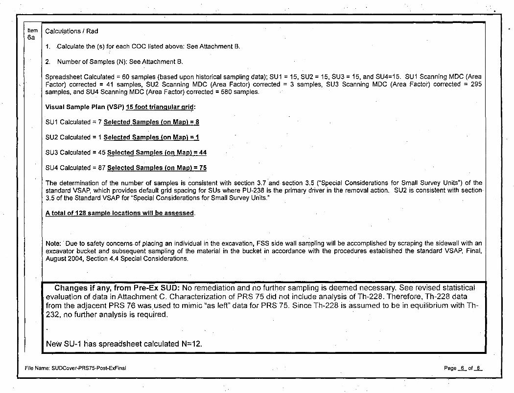
Item I Calculptions I Rad 6a
1. .Calculate the (s) for each COC listed above: See Attachment B.
2. Number of Samples (N): See Attachment B.
Spreadsheet Calculated = 60 samples (based upon historical sampling data); SU 1 = 15, SU2 = 15, SU3 = 15, and SU4=15. SU 1 Scanning MDC (Area Factor) corrected = 41 samples, SU2 Scanning MDC (Area Factor) corrected = 3 samples, SU3 Scanning MDC (Area Factor) corrected = 295 samples, and SU4 Scanning MDC (Area Factor) corrected = 580 samples.
Visual Sample Plan (VSP) 15 foot triangular gri~:
SU1 Calculated= 7 Selected Samples (on Map)= 8
SU2 Calculated = 1 Selected Samples (on Map)= 1
SU3 Calculated = 45 Selected Samples (on Map) = 44
SU4 Calculated = 87 Selected Samples (on Map) = 75
The determination of the number of samples is consistent with section 3. 7 and. section 3.5 ("Special Considerations for Small Survey Units") of the standard VSAP, which provides default grid spacing for SUs where PU-238 is the primary driver in the removal action. SU2 is consistent with section 3.5 of the Standard VSAP for "Special Considerations for Small Survey Units."
A total of 128 sample locations will be assessed.
Note: ·Due to safety concerns of placing an individual in the excavation, FSS side wall sampling will be accomplished by scraping the sidewall with an excavator bucket and subsequent sampling of the material in the bucket in accordance with the procedures established the standard VSAP, Final, August 2004, Section 4.4 Special Considerations.
Changes if any, from Pre-Ex SUD: No remediation and no further sampling is deemed necessary. See revised statistical evaluation of data in Attachment C. Characterization of PRS 75 did not include analysis of Th-228. Therefore, Th-228 data from the adjacent PRS 76 was,used to mimic "as left" data for PRS 75. Since Th-228 is assumed to be in equilibrium with Th-232, no further analysis is required.
NeW SU-1 tias spreadsheet calculated N=12.
File Name: SUDCover-PRS75-Post-ExFinal Page __§__ of .JL

,.---
Item 1 Calculations/Chem, Std dev, Number of Samples 6b
6b • Changes if any, from Pre-Ex SUD: N/A
Item !"Grid spacing 7
NA, See Item 2
From Attachment B. Triangular 15 foot grid, laid out by Visual Sample Plan.
Changes if any, from Pre-Ex SUD: Grid used in characterization sampling was 30' linear grid, consistent with spreadsheet calculated grid length of 28.2 ft.
Item I QNQC: 8
1/20 via field duplicate in accordance with section 3.9 of the Standard VSAP.
Q-002 Chain-of-Custody Procedures
Q-003 Documentation Requirements
Q-004 Laboratory Data Reduction
Q-006 Validation of Laboratory Data Packages
Q-007 Data Assessment
Q-008 Data Integrity Verification
Q-010 Electronic Data Deliverable Format Specifications- MEIMS Std ....
S-001 General Instructions for Field Personnel
S-002 Soil Sampling With a Spade and Scoop
S-028 Sample Control and Documentation .
S-029 Guide to Handling, Packaging, and Shipping of Samples and Method Q-002
Item I Bias/judgement samples 9
(Additional bias samples are always within the discretion of the File Name: SUDCover-PRS75-Post-Exfinal
No bias samples are planned by CH2M Hill at this time.
Page ....L_ of .JL

EPA.)
Item I Not otherwise covered .. ./ comments 10
Site policy requires performance of onsite soil screening (Nal or germanium) on verification samples slated for offsite analysis and evaluation of the results prior to shipment. This analysis will generally be performed on a split of the verification sample containerized in an EPA dish (approximately 500 ml) but may be performed on the actual verification sample as long as containerization requirements are maintained for the offsite lab. Count time of the analysis will be sufficient to meet the cleanup objectives (COs) of the contaminants of concern (COCs) requiring verification.
If there is an insufficient volume of material to fill an EPA dish within a 1m x 1m square centered on the proposed sample location, due to bedrock or obstruction (such as a structure, foundation, concrete, pavemenVasphalt, large rock formations, utility bank, etc. which is not to be removed), then sedimenVsoil analysis will not be performed.. In lieu of a sedimenVsoil analysis result, RadCon will survey the surface per COs and provide documentation thereof in an RSDS. Potentially impacted work area atop the excavation, where excavated sedimenVmaterial was loaded into haulers, and are not hard surfaces (e.g., concrete and asphalt) are shown as an additional SU. Potentially impacted work area atop the excavation, where excavated materials were loaded into haulers, and are hard surfaces (e.g., concrete and asphalt) will be surveyed and released per RadCon procedures. The RSDS(s) will be included as. documentation. Any final sample location that does not meet the surface release criteria will be submitted to the Core Team for concurrence or determination of further action.
Accessibility for sampling is a constraining factor. Sampling of the excavation walls may be impeded due to excavation wall accessibility by both personnel and equipment. Sidewall s~mpling will be performed via excavator sampling. Accessibility to the excavation floor by personnel may be impeded due to the width of the excavation not being sufficient to use a man-box for access. Where sufficient volume of soil exists and is accessible with an excavator a soil sample will be taken otherwise a surface survey (swipe and direct) will be performed utilizing methods available from atop the excavation. Potentially impacted work area atop the excavation, where excavated materials were loaded into haulers, and are not hard surfaces (i.e., concrete and asphalt) are shown as part of the SU .. Potentially impacted work area atop the excavation, where excavated materials were loaded into haulers, and are hard surfaces (i.e., concrete and asphalt) will be surveyed and released per RadCon procedures in accordance with DOE Order 5400.5 and Mound 2000 Work Plan Appendix A Table 1.
In-process sar:npling events (Characterization and Remedial Action Support Survey (RASS) samples) were conducted during the entire PRS remediation. Those samples underwent gamma spectrometry analysis to guide actions. RASS sampling of the remediated areas were used to determine if the FSS (verification) sampling could be conducted.
Changes if any, from Pre-Ex SUD: No excavation was necessary following re-evaluation of historical and characterization· data and inclusion of portion of PRS 75 in RA of PRs· 441.
File Name: SUDCover-PRS75-Post-ExFinal Page ....§..._ of....§..._
.

Attachment A
Pre-Ex SUD Information Replaced with Attachment C

Historic Sample Locations around PRS 75
········.·········-··················· ~-------·~--~-~--~--~--------- /'·
/ .
5u3 Dig Area: Pu-238@3'=i9 pCi/g Th-230@4'= 11.5 pCi/g Th-228@3'=14.9 pCi/g Ra-226@1'=5.1 pCitg
L--- .·· \ . // /
/
J): ---/-/
.......... ; ~;----~· o: ! /
! // ·~--
··-- .... ---
a 'DIIJIT.'hl"!'~ts_o:s::,<>O<r:::-;;------
su.. z_
Su.:L Dig Area:
. Th-228@22'=4.2 pCi/g Th-232@7'=4.5 pCi/g
/I / /
m Sample Detect l!i Sample Detect 0 Sample Nondetect / / / /
/site do'ar;,a..Je.
Jl/.} A cu.· I r~ ,, d.,
~
0 J;
·-- I I ~~~~25~~50~~==~~~m·~.· N 75 . <• ;:,'<" • \ <oo ''" . " : > MOUND
I I ----- ·+ iiJ Fi '-) (/.l .. ,-;-n . ' 1§f
I I
~
'
I ~- -- I

,_J • ..:~.; .... _.;:. ·~ •
. ?RS l5 Results> CO
Result Date Result Analysis Start Ending Depth Project ld Sample ld Station CAS Number CAS Name Result
Unit Collected Type Description Sample Sample
Units X Coord Y Coord
Depth Depth
OU5RECON 5100-0002 MND14-5100 13981-15-3 Plutonlum-238 68.0 PCI/G 08/04/1989 REG Radiological 3.0 FT 1454939.800 598142.580
AREA 14/19 120020 19-3L 1427 4-82-9 Thorium-228 4.2 PCI!G 09/24/1993 REG Radiological 20.0 220 FT 1455304.800 5981 n.780
AREA14119 140001 19-3N 14274-82-9 Thorium-228 4.2 PCI!G 09/27/1993 REG Radiological 0.5 2.5 FT 1455085.500 598149.510
AREA14119 150001 19-30 14274-82-9 Thorium-228 14.9 PCI!G 09/27/1993 REG Radiological 1.0 3.0 FT 1454981.300 598136.240
VVTSVS 316 31 7440-29-1 Thorfum-232 4:5 PCI/G 08/01/1985 SCR Radiological 6.0 7.0 FT 1455295.800 598179.570
VVTSVS 522 52 1398f-16-3 Plutonlum-238 79.0 PCI/G 07/30/1986 REG Radiological 2.0 3.0 FT 1464943.400 598130.440
VVTSVS 552 55 7440-29-1 Thorfum-232 . 2.7 PCI/G 08/05/1985 SCR Radiological 2.0 3.0 FT 1465279.100 59817~
.VVTSVS 562 56 7440-29-1 Thorium-232 2.5 PCI/G 08/06/1986 SCR Radiological 2.0 3.0 FT i 465293.500 598166.770
wrsvs 563 56 7440-29-1 Thorlum-232 3.0 PCI/G 08/06/1986 SCR Radiological 3.0 4.0 FT 1465293.600 598166.770
~- 000040 804 127-18-4 Tetrachloroethene 260160.0 UG/KG 10/11/1999 OIL Volatile Organics 12.0 16.0 FT 1465129.879 5981 18.140
SPUR2002 004852 004852 14259-53-7 Thorfum-230 11.6 PCI/G 09/11/2002 SCR R adlologfcal 4.0 FT 1464859.335 598145.961
SPUR2002 004851 004851 14269-63-7 Thorium-230 11.1 PCIIG 09/11/2002 SCR Radiological 4.0 FT 1464885.895 598140.433
SPUR2002 004850 004850 13982-63-3 Radium-226 5.1 PCI/G 08/29/2002 SCR Radiological 1.0 FT 1464833.861 598127.061
*Remediation with PRS 76
:.:
.::0 ·:-:'
rJ .......__ __, ()

::D
l>J .....__ \)
Summary Statistics for Raw Data su bes1~'\l Do..~
From File \\Er\common\SHARED\ER\PRS 075\WP & SUD\prs75 all.xls
Variable name NumObs Minimum Maximum Mean Median Sd cv Skewness Variance
Pu-238 83 0.33 52 22.05687 21.73 9.077031 0.411529 0.629298 82.39249 Ra-226 51 0.38 2.27 1.364314 1.3 0.404921 0.296795 0.107385 0.163961 Th-228 7 0.46 2.58 . 1.17 0.87 0.725052 0.619702 1.388192 0.5257 Th-230 · 95 0.35 2.57 0.632821 0.516 0.388393 0.613748 3.513124 0.150849 Th-232 66 0.17 1.9 0.698485 0.645 0.331654 0.47482 1.474098 o, 109995 U-238 24 0.72 1.87 0.995 0.885 0.277818 0.279214 1.623093 0.077183
...
Page 1

Sheet1
Pu-238 Ra-226 Th-228 Th-230 Th-232 U-238 0.33 1.00E+31 1.35 0~350000 1.81 1_.12
2.5 1.00E+31 0.87 0.358000 1.46 0.72 2.91 1.00E+31 2.58 0.362000 0.58 1.00E+31 3.01 1.00E+31 0.69 0.365000 1.00E+31 0.85
3.1 1.00E+31 0.73 0.370000 1.9 1.00E+31 6.82 1.00E+31 1.51 0.377000 1:00E+31 0.74
7 1.00E+31 0.46 0.384000 0.58 1.00E+31 9.53 0.83 1.00E+31 0.385000 1.00E+31 0.75
14 1.00E+31 1.00E+31 0.385000 0.28 1.00E+31 15.81 0.84 1.00E+31 0.391000 1.2 0.8 15.97 0.93 1.00E+31 0.394000 0.31 0.81 16.53 0.98 1.00E+31 0.410000 0.35 0.86 16.66. 1 1.00E+31 0.411000 0.4 0.88 17.42 1.04 1.00E+31 0.418000 0.41 0.89 17.71 1.04 1.00E+31 0.421000 0.41 1.04 17.73 1.06 1.00E+31 0.438000 0.41 1.06 18.03 1.06 1.00E+31 0.440000 0.42 1.06 18.15 1.1 1.00E+31 0.442000 0.42 1.22 18.19 1.11 1.00E+31 0.451000 0.43 1.27 18.23 1.11 1.00E+31 0.451000 0.44 1.48 18.38 1.12 1.00E+31 0.456000 0.45 1.87 18.65 1.17 1.00E+31 0.458000 0.47 1.00E+31 19.09 1.18 1.00E+31 0.463000 0.49 1.00E+31 19.38 1.21 1.00E+31 0.466000 0.51 1.00E+31 19.57 1.26 1.00E+31 0.468000 0.54 1.00E+31 19.63 1.28 1.00E+31 0.468000 0.55 1.00E+31
20 1.00E+31 1.00E+31 0.471000 0.57 1.00E+31 20.16 1.28 1.00E+31 0.474000 0.8 t.OOE+31 20.18 1.00E+31 1.00E+31 0.475000 0.57 1.09 20.27 1.3 1.00E+31 0.476000 0.57 1.00E+31 20.34 1.38 1.00E+31 0.477000 0.59 1.00E+31 20.39 1.41 1.00E+31 0.479000 0.63 1.00E+31 20.42 1.46 1.00E+31 0.488000 0.63 1.00E+31 20.99 1.5 1.00E+31 0.490000 0.66 1.00E+31
21 1.00E+31 1.00E+31 0.493000 0.67 1.00E+31 . 21 1.00E+31 1.00E+31 0.493000 1.00E+31 1.00E+31 21 ·1.00E+31 1.00E+31 0.494000 1.00E+31 1.00E+31
21.13 1.51 1.00E+31 0.495000 1.00E+31 1.00E+31 21.14 1.56 1.00E+31 0.495000 0.68 1.00E+31 21.36 1.57 1.00E+31 0.499000 0.68 1.00E+31 21.54 1.61 1.00E+31 0.500000 0.68 1.00E+31 21.73 1.62 1.00E+31 . 0.500000 0.71 1.00E+31
22 1.00E+31 1.00E+31 0.504000 0.77 1.00E+31 22 1.00E+31 1.00E+31 0.505000 1.00E+31 1.00E+31 22 1.00E+31 1.00E+31 0.505000 1.00E+31 1.00E+31 22 1.00E+31 1.00E+31 0.508000 1.00E+31 1.00E+31 22 1.00E+31 1.00E+31 0.510000 1.00E+31 1.00E+31
22.3 1.71 1.00E+31 0.516000 1.0DE+31 1.00E+31 22.43 1.72 1.00E+31 0.522000 0.78 1.00E+31 22.53 1.8 1.00E+31 0.527000 0.85 1.00E+31
Page 1

Sheet1
23 1.00E+31 1.00E+31 0.529000 0.85 1.00E+31 23 1.00E+31 1.00E+31 0.531000 1.00E+31 1.00E+31 23 1.00E+31 1.00E+31 0.535000 1.00E+31 1.00E+31
23.24 1.97 1.00E+31 0.537000 1.00E+31 1.00E+31 23.76 2.03 1.00E+31 0.538000 0.89 1.00E+31
24 1.00E+31 1.00E+31 0.540000 0.93 1.00E+31 24 1.00E+31 1.00E+31 0.542000 1.00E+31 1.00E+31 24 1.00E+31 1.00E+31 0.548000 1.00E+31 1.00E+31
24.58 2.07 1.00E+31 0.549000 1.00E+31 1.00E+31 25 1.00E+31 1.00E+31 0.558000 1.02 1.00E+31 25 1.00E+31 1.00E+31 0.560000 1.00E+31 1.00E+31
25.41 2.27 1.00E+31 0.568000 1.00E+31 1.00E+31 26 1.00E+31 1.00E+31 0.569000 1.03 1.00E+31 26 1.00E+31 1.00E+31 0.578000 1.00E+31 1.00E+31 26 1.00E+31 1.00E+31 0.580000 1.00E+31 1.00E+31 26 1.00E+31 1.00E+31 0.582000 1.00E+31 1.00E+31 26 1.00E+31 1.00E+31 0.590000 1.00E+31 1.00E+31 26 1.00E+31 1.00E+31 0.612000 1.00E+31 1.00E+31 26 1.00E+31 1.00E+31 0.618000 1.00E+31 1.00E+31 26 1.00E+31 1.00E+31 0.624000 1.00E+31 i.OOE+31 27 1.00E+31 1.00E+31 0.624000 1.00E+31 1.00E+31 28 1.00E+31 1.00E+31 0.630000 1.00E+31 1.00E+31
28.51 1.2 1.00E+31 0.631000 1.00E+31 1.3 29 1.00E+31 1.00E+31 ·o.634ooo 1.21 1.00E+31 29 1.00E+3.1 1.00E+31 0.647000 1.00E+31 1.00E+31 31 1.00E+31 1.00E+31 0.662000 1.00E+31 1.00E+31
31.98 1.00E+31 1.00E+31 0.678000 1.00E+31 . 0.73 35 1.00E+31 1.00E+31 0.685000 0.7 1.00E+31 38 1.00E+31 1.00E+31 0.685000 1.00E+31 1.00E+31 41 1.00E+31 1.00E+31 0.700000 1.00E+31 1.00E+31 50 1.00E+31 1.00E+31 0.731000 1.00E+31 1.00E+31 50 1.00E+31 1.00E+31 0.735000 1.00E+31 1.00E+31 52 1.00E+31 1.00E+31 -0.770000 1.00E+31 1.00E+31
1.00E+31 1.00E+31 1.00E+31 0.820000 1.1 1.00E+31 1.00E+31 0.38 1.00E+31 0.840000 0.22 1.00E+31 1.00E+31 0.59 1.00E+31 0.880000 0.4 1.00E+31 1.00E+31 0.83 1.00E+31 1.000000 0.5 1.00E+31 1.00E+31 1.01 1.00E+31 1.090000 0.37 1.00E+31 1.00E+31 1.1 1.00E+31 1.310000 0.87 1.00E+31 1.00E+31 1.41 1.00E+31 1.320000 0.77 1.00E+31 1.00E+31 1.48 1.00E+31 1.480000 0.77 1.00E+31 1.00E+31 1.57 1.00E+31 1.350000 0.73 1.00E+31 1.00E+31 . 1.59 1.00E+31 2.170000 0~79 1.00E+31 1.00E+31 1.65 1.00E+31 2.510000 0.78 1.00E+31 1.00E+31 1.73 1.00E+31 2.570000 1.06 1.00E+31 1.00E+31 1.91 1.00E+31 1.00E+31 0.98 1.00E+31 1.00E+31 1.95 1.00E+31 1.00E+31 0.76 1.00E+31 1.00E+31 2.09 1.00E+31 1.00E+31 t.OOE+31 1.00E+31 1.00E+31 1.00E+31 1.00E+31 1.00E+31 0.17 1.00E+31 1.00E+31 1.00E+31 1.00E+31 1.00E+31 0.44 0.87 1.00E+31 1.00E+31 1.00E+31 1.00E+31 0.44 0.9
Page2
A S/10

'·
Sheet1
1.00E+31 1.00E+31 1.00E+31 1.00E+31 0.6 0.77 1.00E+31 1.00E+31 1.00E+31 1.00E+31 0.88 1.00E+31 1.00E+31 1.00E+31 1.00E+31 1.00E+31 1.18 0.8
Page3 0 •
~ & Ito
:r:> _J
----6
~ample
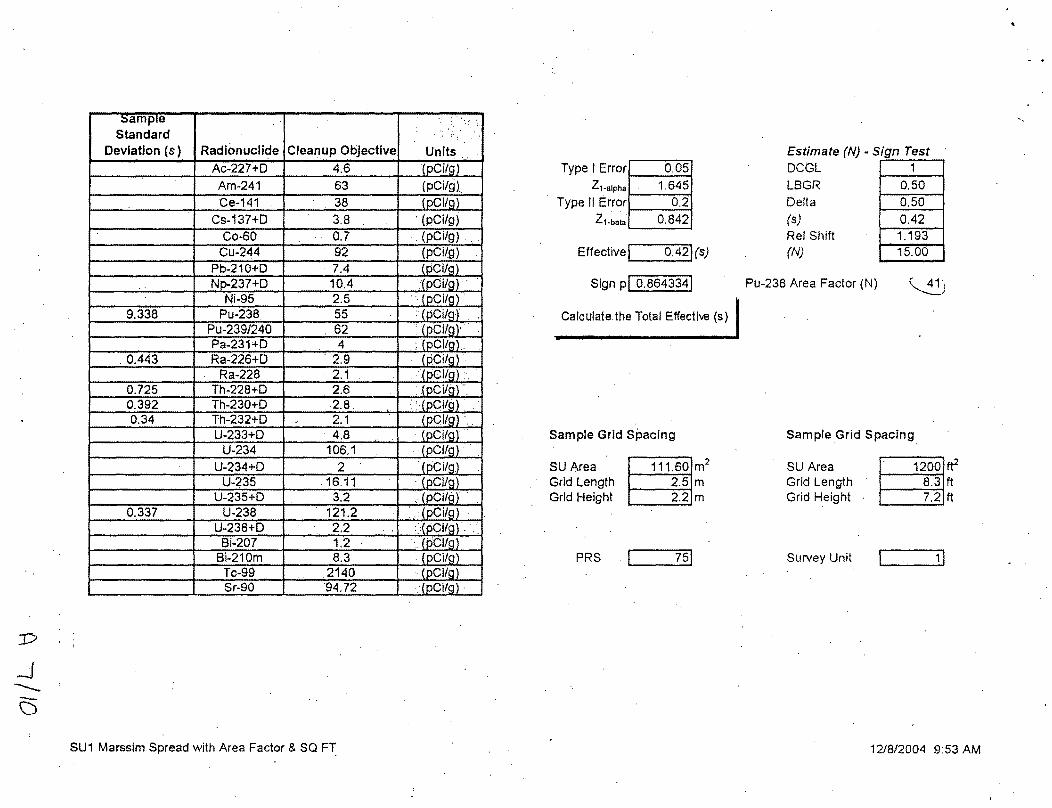
Standard Deviation (s) Radionuclide Cleanup Objective
Ac-227+0 4.6 Am-241 63 Ce-141 . 38
Cs-137+0 3.8 Co-60 0.7
Cu-244 92 Pb-210+0 7.4 Np.237+0 '10.4
Ni-95 2.5 9.338 Pu-238 55
Pu-239/240 . 62 Pa-231+0 4
. 0.443 Ra-226+0 . 2.9 Ra-228 . 2.1
0.725 Th-228+0 . 2.6 0.392 Th-230+0 2.8. 0.34 Th-232+0 J 2.1
U-233+0 4.8 U-234 106.1
U-234+0 2 U-235 .16.11
U-235+0 . 3.2 0.337 U-238 121.2
U-238+0 2.2 Bi-207 1.2
Bi-210m 8.3 Tc-99 .2140 Sr-90 94.72
SU1 Marssim Spread with Area Factor & SQ FT
Units. [pCi/g) (pCi/g)
(pCi/g) · (pCi/g} .! . (pCilg) .... (pCi/g)
1
. (pCilg) :(pCi/g) '
. ·. pCI/g) . :· pCi/g··
... pCi/g ·• pCI/g.
. (pCi/g) · . (pCI/g) :· ...
. {pCi/g). : : _(pCilfl .
(pCI/g) . (pCi/g) .
. · (pCI/g} · ..
. [pCI/g · (pCi/g) I
pCI/g. .. pCi/g
:. pCi/g ·. !
.. pCI/g. [pCi/g
·. ~pCI/g ·. [pCI/g ·
Type I Error 0.05 Z1-alpha 1.645
Type If Error 0.2
Z1-bata 0.842
Effectivej 0.42J(s)
Sign PI 0.8643341
Calculate the Total Effectiw (s)
Sample Grid Spacing
SU Area Grid Length Grid Height
PRS
~m2
m m
I t5]
Estimate (N) - Sign Test DCGL LBGR Delta (s) Rei Shift
Pu-238 Area Factor (N)
1 0.50 0.50 0.42 1.193 15.00
--·-····-
~)
Sample Grid Spacing
SU Area Grid Length Grid Height B tf
ft ft
Survey Unit c···~-1]
1218/2004 9:53AM
',

:0
~ ~
()
~am pre Standard
Deviation (s) Radionuclide CJeaniJp Objective
Ac-227+0 4.6 Am-241 63 Ce-141 .38
Cs-137+0 . 3.8
Co-60 0.7 Cu-244 92
Pb-210+0 7.4 Np-237+0 10.4
Ni-95 '. 2.5 9.338 Pu-238 . 55
Pu-239/240 . ' 62 Pa-231+0 · 4
0.443 Ra-226+0 ·.2.9 Ra-228 2.1
0.725 Th-228+0 . 2.6 . 0.392 Th-230+0 . , .2.8 0.34 Th-232+0 . 2.1 .
U-233+0 4.8 U-234 106.1
U-234+0 . 2
U-235 16.11 ·., ·.
U-235+0 3.2 0.337 U-238 121.2
U-238+0 . 2.2' Bi-207 1.2
Bi-210m ' 8.3 ,, .
Tc-99 2140 Sr-90 94.72
SU2 Marssim Spread with Area Factor & SQ FT
. : .. :.:·: · ...
· Units .. ·.
(pCitg:. . (pCI/9) _(pCilg_ • (pCi/g) (pCi/g) (pCi/g)
. pCi/g. · :pcitg •
·. 'pCi/g • [pCi/gl [pCi/g) . [pCi/g)
.. [pCi/g) · [pCi/g. (pCi/g .
·. (pCi/g .· (pCi/g. [pCi/g).
· (pCilg: .. (pCi/g;·: .. [pCi/g;. (pCitg;.
[pCi/g} :.[pCi/g_ ·· . · [pCi/g) [pCilg)
. . [pCi/g) [pCi/g)
\
Type I Error· 0.05
z1-alpha 1.645 Type II Error 0.2
Z1-beta 0.842
Effective r===o.42] (s)
Sign pi 0.864334)
Calculate the Total Effective (s)
Sample Grid Spacing
SU Area B9.30 m2
Grid Length 0. 7 m Grid Height · 0.6 m
PRS 1- --75]
Estimate (N) - Sign Test OCGL -
LBGR Delta (s) Rei Shift (N)
Pu-238 Area Factor (N)
1 0.50 0.50 0.42 1.193 15.00
Sample Grid Spacing
3
SU Area Grid Length Grid Height B ft2
ft ft
Survey Unit c··· n71
12/8/2004 9:53 AM
' .

J)
__D --0
~amp1e
Standard Deviation (s) Radionucllde Cleanup Objective
Ac-227+0 · .. 4.6 Am-241 ... ' 63 Ce-141 38
Cs-137+0 3.8 Co-60 0.7 Cu-244 92
Pb-210t0 •... 7.4 . Np-237+0 ·. 10.4
Ni-95 •. · 2.5 9.338 Pu~238 . · .. 55
Pu-239/240 · . 62 Pa-231+0 . ··::-., 4
0.443 Ra-226+0 2.9 Ra-228 . 2.1
0.725 Th-228+0 2.6 . 0.392 Th-230+0 . 2.8 '0.34 Th-232+0 2.1
U-233+0 4.8 U-234 106.1 ..
U-234+0 2· U-235 16.11
U-235+0 . 3.2 0.337 U-238 121'.2
U-238+0 2.2 . Bi-207 1.2
Bi-210m 8.3 Tc-99 ' 2140
L__ ____ -·-
Sr-90 94.72
SU3 Marssim Spread with Area Factor & SQ FT
..
Units,, _·· (pCi/g (pCi/g) .. (pCitg: • .
.· (pCi/g) ·_•··. (pCi/g), ·. ;(pCi/g)_··. :(pCi/g). ·
-··(pCi/g)'·· (pCilg)'·
.(pCi/g) _ .. ·. 0: pCi/g: . .·.· pCi/g:: · : R_Citg: (pCi/g)' (pCi/g)
· •.(pCitg: · (pCilg .·.· (pCi/g ·. (pCi/g .
'(pCi/g) . (pCi/g) .(pCi/g' ,·
. : (pCitg:·· (pCi/g
: (pCi/g · .(pCi/g · .. : (pCi/g'. ··.(pCi/g)
Type I Errorj 0.05j z1·alpha 1.645
Type II Error 0.2
Z1-beta 0.842
Effective ~----YA2) (s)
Sign pj 0.8643341
~~lculate the Total Effective (s)
Sample Grid Spacing
SU Area Grid Length Grid Height
PRS
799.80 m2
6.8 m 5.9 m
r 751
Estimate (N) - Sign Test OCGL -
LBGR Delta (s) Rei Shift (N)
Pu-238 Area Factor (N)
1 0.50 0.50 0.42 1.193 15.00
295
Sample Grid Spacing
SU Area Grid Length Grid Height
. Survey Unit
8600 rf 22.3 ft 19.3 ft
[ n ----Yl
12/8/2004 9:54 AM
. .

=P
-Q ()
samp1e Standard
Deviation ( s) Radlonucllde Cleanup Objective
Ac-'227+0 4.6 Am-241 . 63
Ce-141 38 Cs-137+0 3.8
Co-60 0.7 Cu-244 92
Pb-210+0 7.4 Np-237+0 - 10.4
Ni-95 2.5 9.338 Pu-238 . 55
Pu-239/240 . . ' 62 Pa-231+0 4
0.443 Ra-226+0 •. 2.9 Ra'-228 2.1
0.725 Th-228+0 2.6 .• 0.392 Th-230+0 2.8 0.34 Th-232+0 2.1
U-233+0 4.8 U-234 106.1
U-234+0 2 U-235 16.11
U-235+0 '3.2 0.337 U-238 121.2
U-238+0 . 2.2 .. Bi-207 ·, 1.2.
Bi-210m. 8.3 Tc-99 2140 .
-- - __ §r:~Q. ---· 94.72
SU4 Marssim Spread with Area Factor & SQ FT
• ;, :\, L~ ;:::
'' '
• Units .. {pCi/f.:J)
.. · (pqi/g) •. (pCi/g) .
. (pOi/g) ·. (pCl/g) .
(pCi/g) . >(pCi/g) (pCi/g) :(pCIIg:
. (pCi/g) · .. '(pCi/g.) •·.
(pCi/g: (pCi/g: (pCi/g: .
. {pCi/g) >tpCI/g) · .. · (pCi/g) . (pCI/g: · (pCi/g) ; (pCi)g . (pCi/g)
.· .• [pCIIg) .· [pCi/g)
·•. :pCi/g .. pCi/g . 'pCi/g ..
· [pCi/g) · (pCi/g)
Type I Error 0.05
z1-alpha 1.645
Type II Error 0.2
zl.beta 0.842
Effective! · b.4~(s)
Sign PI 0.8643341
Calculate the Total Effective (s)
Sample Grid Spacing
SU Area Grid Length Grid Height
PRS
1 571.94 m2
9.5 m 8.2 m
I ---J51.
Estimate (N) - Sign Test DCGL LBGR
Delta (s) Rei Shift (N)
Pu-238 Area Factor (N)
r-_1
0.50
0.50 0.42 1.193 15.00
------·-···········-
580
Sample Grid Spacing
SU Area Grid Length Grid Height
Survey Unit
16902.58 tt2
31.3 ft 27.1 tt
c -~ 4]
12/8/2004 9:52AM
•
' .

. .
Attachment B
Pre-·Ex SUD Information Replaced with Attachment C

. .
I j j j
~
j &
0 j
~
j '
' 0
j N
0
j j j j
' j j j
~.· j
~
v j
~
~
~
·~
j
0 '0
~
~
~
~
~
~
~
~
-~~
0 ~
s j
~
j
0
. j j j j j
. j j j j j j
w
w
d
j
' j
-· '
j
B lA
j j

aJ
"' ......_ ~
Area: Area 1
X Coord
1465278.4 776 1465293.4 776 1465308.4776 1465285.9776 1465300.9776 1465278.4776 1465293.4 776 1465308.4 776
SUi. Y Coord
598186.2602 59.8186.2602 598186.2602 598173:2698 598173.2698 598160.2794 598160.2794 598160.2794
. . ' :
Label Value IY.ee Historical
0 Hotspot 0 Hotspot 0 Hotspot 0 Hotspot 0 Hotspot 0 Hotspot 0 Hotspot 0 Hotspot
..)


I •
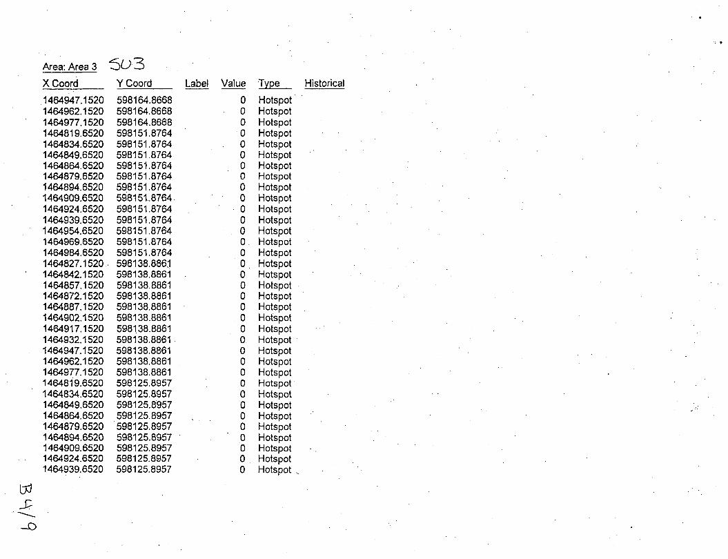
Area: Area 3 (cont.) 5U3 X Coord Y Coord Label Value T~Qe Historical
1464954.6520 . 598125.8957 0 Hotspot 1464969.6520 598125.8957 0 Hotspot 1464984.6520. 598125.8957 0 Hotspot 1464827.1520 598112.9053 0 Hotspot 1464842.1520 59811 ~.9053 0 Hotspot 1464857.1520 598112.9053 0 Hotspot 1464872.1520 598112.9053 0 Hotspot 1464887.1520. 598112.9053 0 Hotspot 1464902.1520 598112.9053 . 0 Hotspot
cP
~ .....s>


J •
suL\ G\a..ss Z Area: Area 10
X Coord Y Coord Label Value T~~e Historical
1464809.6732 . 598107.0425 0 Hots'pot 1464869.6732 598107.0425 0 Hotspot 1464884.6732 598107.0425 0 Hotspot 1464899.6732 598107.0425 0 Hotspot 1464914.6732 598107.0425 0 Hotspot 1464929.6732 598107.0425 0 Hotspot 1464817.1732 598120.0329 0 Hotspot 1464997.1732 598120.0329 0 · Hotspot 1465012.1732 . 598120.0329 0 Hotspot 1465027.1732 598120.0329 0 · Hotspot 1465042.1732 598120.0329 0 Hotspot 1464809.6732 596133.0233 0 Hotspot 1465004.6732 . 598133.0233 0 Hotspot 1465019.6732 598133.0233 0 Hotspot 1465034.6732 598133.0233 0 Hotspot 1465049.6732 598133.0233. 0 Hotspot 1465064.6732 598133:0233 0 Hotspot 1465079.6732 598133.0233 0 Hotspot 1465094.6732 598133.0233 0 Hotspot 1465109.6732 •598133.0233 0 Hotspot 1465169.6732 598133.0233 0 Hotspot 1465184.6732 598133.0233 0 Hotspot 1464997.1732 598146.0137 0 Hotspot 1465012.1732 598146.0137 0 Hotspot 1465027.1732 598146.0137 0 Hotspot 1465042.1732 598146.0137 0 Hotspot 1465057.1732 598146.0137 0 Hotspot 1465072.1732 598146.0137 0 Hotspot 1465102.1732 598146.0137 0 Hotspot 1465117.1732 598146.0137 0 Hotspot 1465132.1732 598146.0137 0 Hotspot 1465162.1732 598146.0137 0 Hotspot 1465177.1732 598146.0137 0 · .Hotspot 1465192.1732 598146.0137 ·o Hotspot 1465207.1732 598146.0137 0 Hotspot
oJ -f
~

•

txJ -D
""'()-
Area: Area 10 (cont.} suL\ X Coord Y Coord
1465252.1732 598171.9945 1465267.1732 . 598171.9945 1465327.1732 598171.9945 1465342.1732 598171.9945 1465312.1732 . 598197.9752
•
.. L \a..6S L
Label Value T~~e Historical
0 Hotspot 0 Hotspot 0 Hotspot 0 Hotspot 0 Hotspot

• •
Attachment C
Post-Ex SUD Information
Revised Figure 1. Revised MARSSIM Spreadsheet
Actual "As Left Data"
Clt.p

~
N ---~
::sample Standard
Deviation (s) Radionuclide Cleanup Objective Units Ac-227+0 4.6 (pCi/g) Am-241 63 (pCi/g) Ce-141 38 (pCi/g)
Cs-137+0 3.8 (pCi/g) Co-60 0~7 (pCi/g) Cu-244 92 (pCi/g)
Pb-210+0 7.4 (pCi/g) Np-237+0 1.0.4 (pCi/g
Ni-95 . 2.5 (pCi/g 2.824 Pu-238 55 _(pCi/g
Pu-239/240 62 (pCilg) Pa-231+0 .4 (pCi/g)
0.390 Ra-226+0 2.9 _(pCi/g) Ra-228 2.1 (pCi/g:
0.131 Th-228+0 2.6 (pCi/g) 0.893 Th-230+0 2.8 (pCi/g: 0.219 Th-232+0 2.1 {pCilg)
U-233+0 4.8 (pCi/g) U-234 106.1 (pCilg)
U-234+0 2 (pCi/g) U-235 16.11 (pCi/g:
U-235+0 3.2 (pCi/g) 0.217 U-238 121.2 (pCi/g) ·
U-238+0 2.2 (pCi/g) Bi-207 1.2 (pCilg:
Bi-210m 8.3 (pCi/g: Tc-99 2140 (pCi/g) Sr-90 94.72 (eCilg}
PRS 75 Post-Ex SU 1 Marssim Spread with Area Factor (042705) (
PRS 75 Post Excavation SUD MARSSIM Sheet
Type I Error 0.05
z1-alpha 1.645 Type II Error 0.2
z1-beta 0.842
Effective! 0.37](s)
Sign Pi-0.9031991
Calculate the Total Effecti...e (s)
Sample Grid Spacing
SU Area 1,025.78 m2
Grid Length 8.6 m Grid f:ieight 7.5 m
PRS I 751
Estimate (N) - Sign Test DCGL -
LBGR Delta (s) Rei Shift (N)
Pu-238 Area Factor (N)
1 0.50 0.50 0.37 1.357 12.00
379
Sample Grid Spacing
SU Area 11,029.89 ft2
Grid Length 28.2 ft Grid Height 24.4 ft
Survey Unit I 11
4/27/2005 3:58 PM
•

• PRS 75 Post-Ex
Actuai"AsLett"Data- Or~c;ite cho,rod.ef\~itoo rt!>v~lts Uto.. 3a.mMa. ~pi'
LOCATION_N SDG_NUMBER 13.5N15 H3 H1 H9 H12 H2 H12 H3 H2 H4 H1 H9 H4 H10 H11 H11 H5A H5A H6 H10 H6
H2 H4 H1 H10 H1 H6 H11 H9 H2 H4 H3 H6 H5A H5A H1.0 H3 H11 H12 H9 H12
H1 H11 H9 H12 H1 H3 H2 H3 H4 H5A H5A H11 H12 H9 H2 H10 H6 H4 H10 H6
GL01246 GL01244 GL01233 GL01255 GL01226 GL01236 GL01227 GL01245 GL01247 GL01225 GL01252 GL01228 GL01234 GL01235 GL01254 GL05643. GL05644 GL01230
· GL01253 GL01249
GL01245 GL01247 GL01244 GL01234 GL01225 GL01230 GL01235 GL01252 GL01226 GL01228 GL01?46 GL01249 GL05643 GL05644 GL01253 GL01227 GL01254 GL01236 GL01233 GL01255
GL01244 GL01254 GL01233 GL01236 GL01225 GL01227 GL01245 GL01246 GL01228 Gl05643 GL05644 GL01235 GL01255 GL01252 GL01226
. GL01253 GL01249 GL01247 GL01234 GL01230
COLLECTION_Date START_DEPT END_DEPTH DEPTH_UNIT 19940915 0.000000 1.500000 FT 20040419 0.000000 4.000000 FT 20040419 0.000000 4.000000 FT 20040419 4.000000 8.000000 FT 20040419 0.000000 4.000000 FT 20.040419 4.000000 8.000000 FT 20040419 4.000000 8.000000 FT 20040419 4.000000 8.000000 FT 20040419 0.000000 4.000000 FT 20040419 0.000000 4.000000 FT 20040419 4.000000 8.000000 FT 20040419 0.000000 4.000000 FT 20040419 4.000000 8.000000 FT 20040419 4.000000 8.000000-FT 20040419 4.000000 8.000000 FT 20040419 0.000000 4.000000 FT 20050418 0.000000 4.000000 FT 20050418 4.000000 8.000000 FT 20040419 4.000000 8.000000 FT 20040419 0.000000 4.000000 FT 20040419
20040419 20040419 20040419 20040419 20040419 20040419 20040419 20040419 20040419 20040419 20040419 20040419 20050418 20050418 20040419 20040419 20040419 20040419 20040419 20040419
20040419 20040419 20040419 20040419 20040419 20040419 20040419 20040419 20040419 20050418 20050418 20040419 20040419 20040419 20040419 20040419 20040419 20040419 20040419 20040419
0.000000
0.000000 0.000000 0.000000 4.000000 4.000000 4.000000 4.000000 0.000000 4.000000 4.000000 0.000000 0.000000 0.000000 4.000000 0.000000 4.000000 0.000000 4.000000 4.000000 0.000000
0.000000 0.000000 4.000000 4.000000 4.000000 4.000000 0.000000 0.000000 4.000000 0.000000 4.000000 4.000000 0.000000 0.000000 4.000000 0.000000 0.000000 0.000000 4.000000 4.000000
4.000000 FT
4.000000 FT 4.000000 FT 4.000000 FT 8.000000 FT 8.000000 FT 8.000000 FT 8.000000 FT 4.000000 FT 8.000000 FT 8.000000 FT 4.000000 FT 4.000000 FT 4.000000 FT 8.000000 FT 4.000000 FT 8.000000 FT 4.000000 FT 8.000000 FT 8.000000 FT 4.000000 FT
4.000000 FT 4.000000 FT 8.000000 FT 8.000000 FT 8.000000 FT 8.000000 FT 4.000000 FT 4.000000 FT 8.000000 FT 4.000000 FT 8.000000 FT 8.000000 FT 4.000000 FT 4.000000 FT 8.000000 FT 4.000000 FT 4.000000 FT 4.000000 FT 8.000000 FT 8.000000 FT
VALUE_NAME MEASURED_V DETECTION_'VALUE_UNIT Plutonium-238 20.000000 20.000000 PCI/G Plutonium-238 16.530000 16.530000 PCI/G Plutonium-238 . 16.660000 16.660000 PCI/G Plutonium-238 17.420000 17.420000 PCI/G Plutonium-238 17.730000 17.730000 PCI/G Plutonium-238 18.030000 18.030000 PCI/G Plutonium-238 18.150000 18.·150000 PCIIG Plutonium-238 18.380000 18.380000 PCI/G Plutonium-238 18.650000 18.650000 PCI/G P'lutonium-238 19.090000 19.090000 PCI/G Plutonium-238 19.630000 19.630000 PCI/G Plutonium-238 20.270000 20.270000 PCI/G Plutonium-238 20.340000 20.340000 PCI/G Plutonium-238 20.420000 20.420000 PCIIG Plutonium-238 21.140000 21.140000 PCIIG Plutonium-238 21.540000 21.540000 PCI/G Plutonium-238 14.500000 14.500000 PCI/G Plutonium-238 15.500000 15.500000 PCI/G Plutonium-238 23.760000 23.760000 PCI/G Plutonium-238 24.580000 24.580000 PCI/G Plutonium-238 25.410000 25.410000 PCI/G Count 21 Std Dev 2.824
Radium-226 Radium-226 Radium-226 Radium-226 Radium-226 Radium-246 Radium-226 Radium-226 Radium-226 Radium-226 Radium-226 Radium-226 Radium-226 Radium-226 Radium-226 Radium-226 Radium-226 Radium-226 Radium-226 Radium-226 Count Std Dev
Thorium-230 Thorium-230 Thorium-230 Thorium-230 Thorium-230 Thorium-230 Thorium-230 Thorium-230 Thorium-230 Thorium-230 Thorium-230 Thorium-230 Thorium-230 Thorium-230 Thorium-230 Thorium-230 Thorium-230 Thorium-230 Thorium-230 Thorium-230 Count Std Dev
0.840000 1.000000 1.040000 1.040000 1.060000 1.110000 1.110000 1.210000 1.260000 1.280000 1.380000 1.460000 1.390000 1.220000 1.560000 1.610000 1.720000 2.030000 2.070000 2.270000
20 0.390
5.330000 6.460000 6.830000 7.110000 7.150000 7.170000 7.200000 7.340000 7.680000 7.480000 8.270000 7.840000
. 7.850000 7.870000 8.020000 8.080000 8.260000 8.350000 9.010000 9.390000
20' 0.893
0.760000 PCI/G 1.000000 PCI/G 0.510000 PCI/G 0.830000 PCI/G 1.060000 PCI/G 1.110000 PCI/G 1.110000 PCI/G 1.070000 PCI/G 1.020000 PCIIG 0.710000 PCI/G 0.900000 PCI/G 0.840000 PCI/G 0.700000 PCIIG 0.970000 PCI/G 1.260000 PCI/G 0.740000 PCI/G 0.640000 PCI/G 0.970000 PCI/G 0.830000 PCI/G 0.870000 PCI/G
5.330000 PCI/G 6.460000 PCI/G 6.830000 PCI/G 7.110000 PCI/G 7.150000 PCI/G 7.170000 PCI/G LA 7.200000 PCI/G t.A 7.340000 PCI/G liL 7.680000 PCI/G 7.480000 PCI/G 8.270000 PCI/G 7.840000 PCI/G 7.850000 PCI/G 7.870000 PCI/G 8.020000 PCI/G 8.080000 PCI/G \A 8.260000 PCI/G V 8.350000 PCI/G lA 9.010000 PCI/G "" 9.390000 PCI/G &A-
All data is from sampling effort PRS75_2004, with the exception of location name 13.5N15 that was collected in 1994 and is included for completeness.
prs75_032305edit-post (042705).xls

• PRS 75 Post-Ex
Actual "As Left" Data
LOCATION_N SDG_NUMBER COLLECTION_Date START_DEPT END_DEPTH DEPTH_UNIT VALUE_NAME MEASURED_V DETECTION VALUE_ UNIT 13.5N15 19940915 0.000000 1.500000 FT Thorium-232 0.800000 0.800000 PCI/G H12 GL01236 20040419 4.000000 8.000000 FT Thorium-232 0.280000 0.210000 PCI/G H9 GL01252 20040419 0.000000 4.000000 f:T Thorium-232 0.310000 0.310000 PCI/G
·H1 GL01244 20040419 0.000000 4.000000 FT Thorium-232 0.410000 0.080000 PCI/G H12 GL01255 20040419 0.000000 4.000000 FT Thorium-232 0.410000 0.270000 PCI/G H3 GL01246 20040419 0.000000 4.000000 FT Thorium-232 0.420000 0.280000 PCI/G H9 GL01233 . 20040419 4.000000 8.000000 FT Thorium-232 0.420000 0.210000 PCI/G H10 GL01234 20040419 4.000000 8.000000 FT Thorium-232 0.450000 0.140000 PCI/G H11 GL01254 20040419 0.000000 4.000000 FT Thorium-232 0.490000 0.120000 PCI/G H4 GL01247 20040419 0.000000 4.000000 FT Thorium-232 0.540000 0.230000 PCI/G H2 GL01245 20040419 0.000000 4.000000 FT Thorium-232 0.570000 0.120000 PCI/G H6 GL01249 20040419 0.000000 4.000000 FT Thorium-232 0.660000 0.150000 PCI/G H2 GL01226 20040419 4.000000 8.000000 FT Thorium-232 0.680000 0.300000 PCI/G H11 GL01235 20040419 4.000000 8.000000 FT Thorium-232 0.680000 0.240000 PCI/G H4 GL01228 20040419 4.000000 8.000000 FT Thorium-232 0.710000 0.120000 PCI/G H1 GL01225 20040419 4.000000. 8.000000 FT Thorium-232 0.770000 0.240000 PCI/G H3 GL01227 20040419 4.000000 8.000000 FT Thorium-232 0.850000 0.130000 PCI/G H5A GL05643 20050418 0.000000 .4.000000 FT Thorium-232 0.330000 0.220000 PCIIG H5A GL05644 20050418 4.000000 8.000000 FT Thorium-232 0.680000 0.220000 PCI/G H6 GL01230 20040419 4.000000 8.000000 FT Thorium,232 1.020000 0.240000 PCIIG H10 GL01253 20040419 0.000000 4.000000 FT Thorium-232 1.030000 0.270000 PCI/G
Count 21 Sid Dev 0.219
H1 GL01244 20040419 0.000000 4.000000 FT Uranium-238 0.750000 0.330000 PCI/G H9 GL01233 20040419 4.000000 8.000000 FT Uranium-238 0.800000 0.460000 PCI/G H2 GL01245 20040419 0.000000 4.000000 FT Uranium-238 0.880000 0.380000 PCI/G H11 GL01254 20040419 0.000000 4.000000 FT Uranium-238 0.890000 0.350000 PCI/G H3 GL01227 20040419 4.000000 8.000000 FT Uranium-238 1.040000 0.440000 PCI/G H4 GL01228 20040419 4.000000 8.000000 FT Uranium-238 1.220000 0.410000 PCI/G H6 GL01230 20040419 4.000000 8.000000 FT Uranium-238 1.270000 0.490000 PCI/G H6 GL01249 20040419 0.000000 4.000000 FT Uranium-238 1.870000 0.430000 PCI/G
Count 8 Sid Dev 0.367
Simulated "As Left" Data from PRS 76.
802 WE9176 19991013. 16.000000 20.000000 FT Thorium-228 0.337000 0.057500 PCI/G 803 WE9176 19991015 16.000000 20.000000 FT Thorium-228 0.359000 0.037400 PCI/G 802 WE9176 19991013 20.000000 24.000000 FT Thorium-228 0.378000 0.046400 PCI/G BQ3 WE9176 19991015 12.000000 16.000000 FT Thorium-228 0.414000 0.056700 PCI/G 814 WE9330 19991015 16.000000 20.000000 FT Thorium-228 0".474000 0.017800 PCI/G 805 WE9330 19991013 20.000000 24.000000 FT Thorium-228 0.488000 0.053000 PCI/G 809 WE9248 19990928 16.000000 20.000000 FT Thorium-228 0.501000 0.048900 PCI/G BOB WE9330 .19991014 16.000000 20.000000 FT Thorium-228 0.557000 0.018100 PCI/G 812 WE9284 19990927 16.000000 20.000000 FT Thorium-228 0.610000 0.055700 PCI/G 809 WE9332 19990928 20.000000 21.000000 FT Thorium-228 0.662000 0:037100 PCI/G 812 WE9284 19990927 16.000000 20.000000 FT Thorium-228 0.671000 0.069400 PCI/G 811 WE9330 19991014 16.000000 20.000000 FT Thorium-228 0.678000 0.058000 PCI/G 815 WE9284 19990923 16.000000 20.000000 FT Thorium-228 0.681000 0.054000 PCI/G 812 WE9284 19990927 20.000000 24.000000 FT Thorium-228 0.685000 0.060000 PCI/G
Count 14 Sid Dev 0.131
prs75_032305edit-post (042705).xls

.3
2 ,/ / ' '' / I / /
I / /
"
A
B
c
D
Approximate Surface Area (sq. ft.)
\
SU-1 SU-2 SU-3 SU-4 PRS-76
25x50 1,250 10x10 100
170x40 6,800 560x60 33,600
55x30 1,650
-\ . ! I [ I / I I .......
/ ,_. .... 1
j·" ,-, : j
\ : r- 4-4'1' l •• • 1. //
r--'···--.. • • ·i \ \ . I I •
\--··"·' / ' . \ . I • . .
/ . .... ,,.. ..... _
./" .. /
,./
ff ... · ... ---u
.. . . --···-· __ .. / : -·· ... •; ..... ,•
• •• . i ... --~--- ! !
--··" .-·
..-' \ \.~
_ ..... -.,.~ ...
.. -···-·-·
.-·· -~-- ..... ~-· .. ·--
,. . .---· , .. -~·r·""" •
... ... _../""
/'
~-·-- ... -----J· ..... ~--
SU-4
~"' ,.....,.. ... ~ __....-,..- ..
J
76
'-....
............ _.-/'
. __ ,....... ............. ·~·
. .......... •""'' -----·---·· ... -"""
0 10 20
.... ~, ~- ~ ...............
_..., .. .... ,_.,.-'
\ , ... ~ ... .. >·
\-·"-------~·~·-·-"t ... ···--·---··-· -... ----·~·····---..: I -;
·• ' > t ·\
40 60 10
Scole In FMt
IQO
' '
soar ISSll[
Sial
ISSll[
,.., .. ·
"""'- Environmental
, .. ,.· ...
.....
/
/ -~... ,..~
' / /'.;1 ,. .....
/ / ,.~- .// /
J'_, J
( I -\ ! '· ' ·-·-.,_ -... ,., !i .... ... ...
', ~, I
.. ~ ................... .
·······
,, ...... ~/ •··
SU-i'," '1
. ' I ....... ' ........... ' -, '
I {
/
.,.... .. ,. .. ·-"' ....
,···
........
/
...........
Q ~ iJ ;r... "- Restoration IIJII•u \1 ' Geogr hie ll!ll~v~l!.£!;\eJeuu uo=
106/08/051 ISSFj I I I I · lnlorm~on I DIG ,,. S TE I'- ER-G S · jC.telt pcu "f;W 1 IS 1 ssT DAit · T ...- lBT ICM<IITDG l""cl-1 • . System lsurus un-A~' -n"-/M,/nt; """'"' uc; 'A' nN ' 1
B
c
, I 2 I .3 l " _j

1 , 2 3 4 ~ •
A
--
8
--
c
--
0
()
.. -· ,.,.,..... .. ,. ....... ~
.·'' .···
~···-·-"
.-·
.. · .... -··
./.·
·., ··,,
I
.-/ _./
,/ ~/ ' ...
,.r
. ../·
.. ~?· _,_ .. ~·
'\\
'· ... ,_ •.,_
·· ............ '-, • .• ," j
/
... ;'
i 1
I I
I
f I
I
....... , ·-.4. ·~--'11---1-L..f- -~~----·-·-····--·- .. ·---· ... ··-·------,------·-- ---·· --· ·--····-···------·········--··· ..... -- 7 5 / .
\ ----------·-----------.--,_,.. ____ ... -· ..... ···: ... ~ '----------------------- ... ---------- --- ---·--------------),..------------
·-, .. ·., .... ----.-I '\•
....... -·-·-·~ ) '
'\.~ .. ,/
' . . . / ' i ·. I •
H3 H2 -·-.._ H1 r· I . . -..... .--- ' I I
- - - - - - - - -··!!
./'
('··· .... i
1 i .Are · \' // 13.5N15 -·-·····..-1 a
1
.ncorporated 1} Hl2 H11 ' H10···-··"g--·-- •····••· -· -·· "H6 ··· ......... -·--,:r.: 1 m PRS 44l • • ..... • ------' • eHS •
' I ' '
_ ............. \ ,,. ~ ', //l / I \ I
, ______________ _
---
~-------------------_,( ________________ 1
' I / I I . -··· . ft ,/ / New SU-l , r- / ·-41 __ (a.!'l.''0!f,ll1,775 sq fit··)-··--·--
. ./ ............... .
,:. \ / ........ ....... \\ ... ·~
' ' \ \ ~ \ ·~ ........
~,.....,. ...... ~ .... -~ .........
......... ..-····
, .... ---
, ·- / / .. . ~' ..... ~ ... ~ - •• - •• l
~0 __ .....
--··
. ··"' . ~"' -~· ....
..... ./
\ . , . : #
\ \ ·' \ , '--··· .... , ·\ ,
\ ·' ' ,
•'
; , /.i ,'
/ ,:l
;
- ..... #,
_ .......... . t'
i f
(
........
\ \ ' ·,,
... --- -· --{ i·· ~ ~'
T
.......... ,/
.~-"""· .. ~· ........
0 10 20
r:t .. l ... l'"'cl ... l. 2
-.....
,_ ......... 1 J ' ~--·..ll
---~ . -- -: ·- ···-· ..... , ,_
co 10 10 100
Scale In Feet
1
.. ....
~· .... \. ... l_ ....
~ .... ·.•
~·
\ .. ~·" /
........................ ,.
iJ Environmental Restoration
~Ta~:li~~c System
3
::IT lg l~l"lalul .. lei"TI·I~I 2TTTT·I~I 21 1 2 ' -· I. I I I I I I :: I, 1 2 1 3 1 4 1~1b Figure 2: •iA'f-CLASSif'CATiDN. Characterization Locations
~~~~~~~~~~~~~~~~~~~~~~· 1 ~ 1
l 4
A
1---
B
l--
c
1---
0
~
•

• ...
ATTACHMENT B .
GENERAL MEDIA INFORMATION
(Public Fact Sheet}

# •
This Fact Sheet satisfies the Public Notification requirement set forth in the Contingent Action Memorandum 1.
Background. Potential Release Site (PRS) 75, also known as the Historic Railroad Siding, is located on the central portion of the site as shown on Figure 1. Process history of the PRS indicated the potential for the presence of radioactive material from drum storage, loading, and repackaging operations at the former location of Warehouse 9 at the east end of the siding. The siding was once used for loading and unloading materials and wastes for the polonium, thorium, and plutonium projects in the 1950s, 60s, & 70s. Between 1982 and 1986 a long section of track leading to the former location of Warehouse 9 was removed as a part of another project.
Characterization. ·Various. sampling events revealed elevated results of thorium-232, · plutonium-238, radium-226, and uranium-238. The maximum concentrations are included in the following table (unit = pCi/g).
Analyte Bkgd** Maximum Cleanup Concentration Objective*
Thorium-232 1.4 107 2.1 Plutonium-238 0.13 573 55 Radium-226 2.0 14 2.9 Uranium-238 1.2 13.5 2.2 • nsk cntena **background so1l concentration
Based on the above results, the Core Team recommended a Removal Action (RA) per the Contingent Action Memo 1• RA COGs are those listed in the table above.
The Work Plan for Contingent Removal Actions2,
supplemented by the Unique Work Package, includes procedures, instructions, and applicable permits and notifications required to safely conduct the work. Erosion and runon/runoff controls will be · managed per the SWP33
.
· The RA will consist of excavation of contaminated soils in the area of the historic railroad siding indicated by sample results above the cleanup objectives and shipping of these soils to an approved disposal facility. Post-excavation sampling will be performed within the excavations
PUBLIC FACT SHEET PRS 75: Historic Railroad Siding
per the Core Team-approved Verification Sampling & Analysis Plan (VSAP).
Schedule. This Fact Sheet will be in public review for 30 days, ending October 8, 2003. The RA is planned for Summer 2004. A summary of the RA & the verification data will be included in the OnScene Coordinator (OSC) Report. The OSC Report will be placed in the public reading room after the conclusion of the verification sampling and approval by the Core Team.
Excavation of approximately 1 ,667 yd3 ( 1 ,27 4 m3
) & verification are expected to cost less than
. $200,000.
Additional information can be found in the public reading room, or by contacting Danny Punch at 84 7-8350 ext. 301. I
legend r:E:J .........,.. --· ...... _, =,....,..... -·--- .... ,...,.,.
• ·a,,. ~:. •. ,,_ •v ·-
' I •
1: Action Memorandum/Engineering Evaluation/Cost Analysis. Contingent Removal Action for Contaminated Soil. June 2002. Final 2: Standard Work Package for Contingent Removal Actions, November 2001. Final 3: Storm Water Pollution Prevention Plan
Public comments were received (see reverse side of Fact Sheet). No changes were required. No response was required. October 20013;1 1 2._
vo· ~ f'J.
;._~,··\)11*,".1\.~- ••
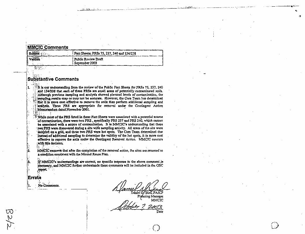
~~~:,,~~:nments ! F&t S"-; PMo 75, 237, 240 and 1541238 V~~ :. I Public Review Draft -·---· ... ...l.. . :. I September 2003 __
I . "" .,.., •
I :;;. "· .... --. ~ . ; :-.. .. ' .. , ..
I ~ ""'"'t •
S~[~antlve Comments
1. ., ;!q ~ .~s (\ut undemanding from tho review 'of the PubUc Fact Sheets for PR.Ss 75, 237, 240 '·l: ; md. 1541.238 that each. ot these PRSs ·ae small areas ot' paten. tially contaminated SC?ib.
. i !Although previous ilunplinJ and analysis showed ~levatcd levels of contamination, the . 1· ~~tina results may or mny not be accurate. However, the Core Team has determined
; · · ~l:,dii.t fi ia mbre cost effee'tive to rea'IOVe the soils than perform additional sampling and ~ ill~. These . PltS . are appropriate for removal under the ·Contingent Action . · r JMem~date.dNovember2001. ~
'-(.. t·· '1: : , .
·:··;·
~ .. ,
2.
' "·
!.\';!·I , . . . . \'·f.·)Vhile most ofthe PRS listed in these Fact Sheeu were a.nociated with a potential source
"otCc:mta:mination. there were two PRS, 'Peeffically PRS 237 md PRS 240, which cannot be usoeillted with. a ~ of ~tion. It ia MMcrc•a undcrstmcfing that these
J;wo-PRS were. di.sCo'YI:I.'ed during a site wid'e sampling activity. AU areas of the site were 'sampled On a Jrid,aud theie two PRS 'Were hot spots. The Core Team determined that :'#aSfead 10f.idditi~ samplfns to deto:rmh:te tho validity of the hot spots, it is more cost · crlfe:ctiVe to remove the IOi1s under the Qontingent Removal Action. MMCIC coneun ~Wi~ tb;is decision: 6 ·t .. MMCiC~ell$ that after the ~pletion of the removal action, the sites :are returned to • a cOndition <XmSistent with the Mound Reuse Plan. . . . . .
irMMCrbs'undemandmss are cori"cct. no Jpecific response to the above eommenU• :~. and MMCIC fUrlber tmderstands these comments v.ill be ineluded in th~ OSC -~·~·~· . " . ,.... '.
errata
l .:, .. ~·- :· . . · N,o Comments •
.. . . :---~·
I
l
Daruel Plmming Managet
c-- MMCIC
~?2¢t8 . . ..,;. ~> .
(,,,~
.. .J
···" ... ~
<·)·. :-:,. j
"'-'•

...
ATTACHMENT C
PHOTOGRAPH DOCUMENTATION

I ~··
. . •.
<
c 1/1