€¦ · web viewa sudden movement sends out shock waves ... moves vertically downwards through...
TRANSCRIPT

GeographyRevision
Guide
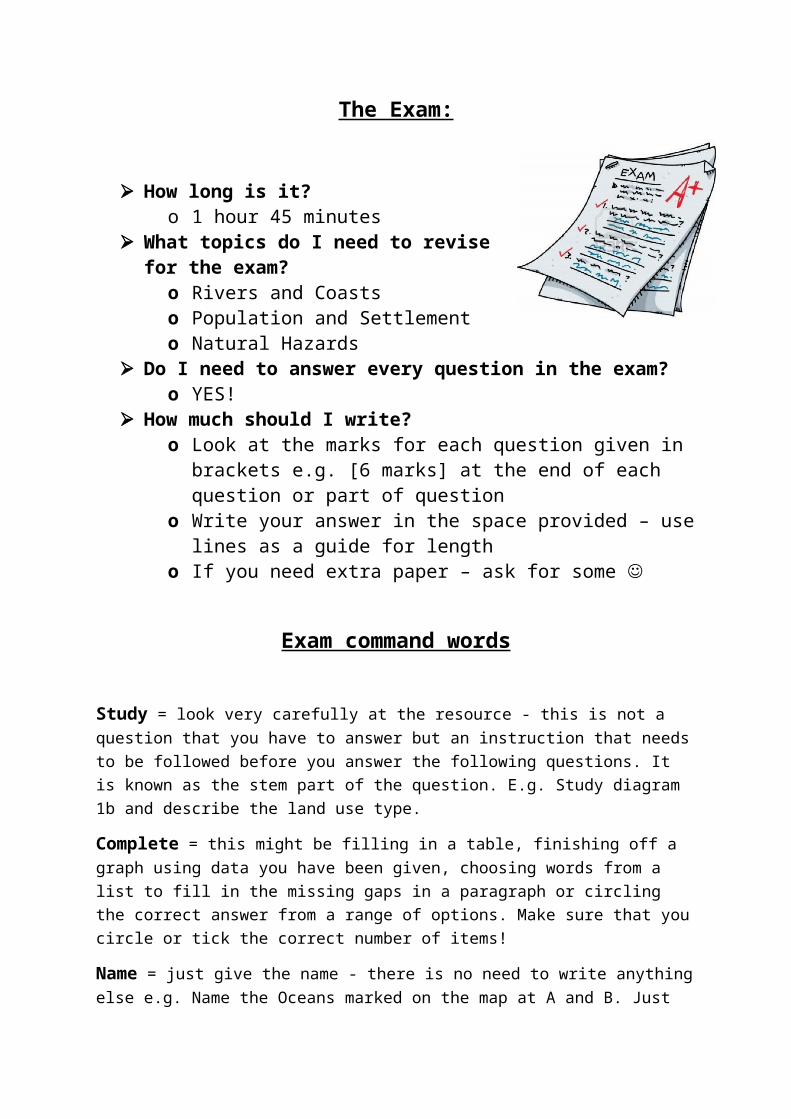
The Exam:
How long is it? o 1 hour 45 minutes
What topics do I need to revise for the exam?o Rivers and Coastso Population and Settlemento Natural Hazards
Do I need to answer every question in the exam?
o YES! How much should I write?
o Look at the marks for each question given in brackets e.g. [6 marks] at the end of each question or part of question
o Write your answer in the space provided – use lines as a guide for length
o If you need extra paper – ask for some
Exam command words
Study = look very carefully at the resource - this is not a question that you have to answer but an instruction that needs to be followed before you answer the following questions. It is known as the stem part of the question. E.g. Study diagram 1b and describe the land use type.
Complete = this might be filling in a table, finishing off a graph using data you have been given, choosing words from a list to fill in the missing gaps in a paragraph or circling the correct answer from a range of options. Make sure that you circle or tick the correct number of items!
Name = just give the name - there is no need to write anything else e.g. Name the Oceans marked on the map at A and B. Just write 'Pacific Ocean and Atlantic Ocean' (or whatever they are!) not 'The ocean named on the map at A is the Pacific Ocean and the ocean named on the map at B is the Atlantic Ocean' as this wastes time.
Label = this kind of question often asks you to add a name, description or explanation to a text-box on a photograph or diagram.
Describe = say what you see (without giving reasons) - are there any patterns or trends? If you are describing a graph, make sure that you include figures in your answer.

Describe the location = say where something is - try to include distance and direction from other places e.g. Describe the location of Southampton. Southampton is a city in Hampshire, on the south-coast of England. It is 25km north-west of Portsmouth and 40 km north-east of Bournemouth.
Describe the distribution = say how something is spread out over space e.g. Describe the distribution of tropical storms. Tropical storms occur in warm oceans between the Tropics of Cancer and Capricorn, for example in the Bay of Bengal, the Arafuna Sea the Arabian Sea and the Caribbean Sea.
Suggest the cause = give reasons for why something happened e.g. Suggest the cause of the earthquake in California. The Pacific Plate and North American Plate are moving past each other at a conservative margin. As they move, they snag and tension builds. A sudden movement sends out shock waves, which causes an earthquake.
Explain / Give reasons / Suggest reasons = give reasons for why something happens and include all the specific detail as to why they lead to it happening; useful words to use in an 'explain' question include: therefore, so, because, as a result of, consequently, this means that.
Give effects / Suggest impacts = this type of question asks you to look into the future and write about the consequences of something happening.
Use examples = you must use real-life examples to gain full marks! You have studied a wide variety of examples in lessons. You can use your own general knowledge too. Make sure you give specific detail and you include the name and location!
Identify evidence / Use map evidence = this means that you must include information taken from the resources that you have been provided with. Don't forget to interpret the evidence that you give! E.g. Use map evidence to suggest why the area is vulnerable to coastal flooding. The land is very flat and wet so if the sea broke through large areas would be flooded. I can tell that the land is flat because the only contour line shown on the map extract is at 10 metres. The land in squares 4126 and 4127 is 'Hempstead Marshes'. Great Moss Fen is in 4225 and 4226. Marshes and Fens are flat.
Compare = describe the similarities and differences between things - words that will force you into a comparison are 'whereas' and 'in comparison to' 'alternatively' and 'on the other hand'; words ending in '- er' are also useful (eg. taller, richer, stronger); words such as 'less than' and 'more than' are also useful.
Annotate = this means add labels to a diagram, photograph or map. Annotate questions will also ask you to do something else e.g. describe or explain. This additional command word tells you what type of statements to write in your annotations. When explaining, you will need to give detailed reasons. E.g. annotate the photograph to explain some of the possible impacts on the natural environment of a large scale tourist development in the area.
4-8 mark question levels:
Level 1: Basic
Knowledge of basic information
Simple understanding
Few links; limited detail; uses a limited range of specialist terms
Limited evidence of sentence structure
Frequent spelling, punctuation and grammatical errors
Level 2: ClearKnowledge of accurate information
Clear understanding
Answers have some linkages; occasional detail/exemplar; uses some specialist terms where appropriate
Clear evidence of sentence structure
Some spelling, punctuation and grammatical errors
Level 3: DetailedKnowledge of accurate information appropriately contextualised and/or at correct scale Detailed understanding, supported by relevant evidence and exemplars
Well organised, demonstrating detailed linkages and the interrelationships between factors Range of ideas in logical form; uses a range of specialist terms where appropriate
Well-structured response with effective use of sentences
Few spelling, punctuation and grammatical errors
Volcanic activity occurs around the Pacific Ring of Fire because many destructive plate boundaries are located here. One example is the destructive boundary between the continental South American plate and the oceanic Pacific plate which has formed the Andes Mountains. The denser oceanic plate is subducted underneath the continental plate and melts as it falls into the hot mantle. Magma then rises up through the continental plate and is erupted through volcanoes at the surface. The destructive boundaries all around the Pacific Ring of Fire are the reason for high volcanic activity.

Using examples you have studied, explain the challenges of overpopulation? (6)
D or below:Overpopulation is when there are too many people in an area which present many challenges. Diseases are spread and there are not enough jobs for people.
C-B answer:Overpopulation is when there are too many people in an area and there is not enough resources for them. Overpopulation can put pressure on healthcare and water systems and people struggle to find jobs. In china the population was growing so quickly that the government had to introduce a one child policy to the country to slow the growth down.
A-A* Answer:Overpopulation is when there are too many people in comparison to space and resources to support a satisfactory quality of life. When people move from rural to urban areas in search of work and a better life, there may not be housing available for them and in many developing countries this is a common feature. As a result of this movement, resources, such as food, shelter and water become increasingly stretched, as well as healthcare and sanitation provisions. Diseases are easily spread and essential amenities like water systems become polluted. In the long run, infant mortality rates and the death rate increase as people become exposed to the terrors of overpopulated areas. An example of an overpopulated area can be seen in China, where a One Child policy was initiated in the late 1970s due to concerns related to their rising population and in the hope to slow down the population growth. In theory this worked with a reduction in the birth rate from 33 per 1000 to 16 per 1000, however it caused long-term socio-economic issues. China has become unbalanced with 110 males to every 100 female, causing men issues with finding a wife. Also, due to a reduced birth rate, China will have to deal with the dependency issues associated with an ageing population in the future.
Useful web links:
Virtual Learning - http://www.paigntononline.com/

Revision sites:
http://www.s-cool.co.uk/gcse/geography
http://www.bbc.co.uk/schools/gcsebitesize/geography/
http://revisionworld.com/gcse-revision/geography
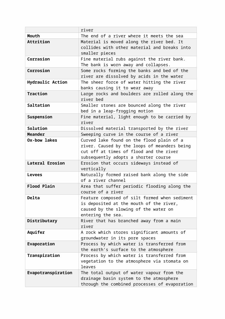
RiversTerm DefinitionHydrological Cycle The cycle by which water moves between the earth's surface and
the atmosphere

Closed System No loss occurs from the system. The cycle does no lose any water, it has a fixed amount
Open System Loss of water occurs from the system, water lost from drainage basin system
Drainage Basin The area of land drained by a river and its tributariesWatershed Boundary of the drainage basin. A ridge of high land. It separates
one drainage basin from neighbouring drainage basins.Inputs Water enters system through precipitationOutputs Water is lost from system by rivers carrying it to the sea or by
evapotranspirationPrecipitation Process by which water is transferred from the atmosphere to the
earth's surface in the form of rain, snow, sleet or hailInterception Incoming precipitation is trapped by vegetation and/or buildingsOverland Flow or surface run-off
Process by which water moves downslope over the earth's surface
Infiltration Process by which water enters the earth's surfacePercolation Process by which water moves vertically downwards through soil
and rockThrough flow Process by which water moves downslope through the soil under
the influence of gravityWater table The line marking the upper limit of saturation in the groundGroundwater Water filling all pore spaces below the water table Groundwater Flow Process by which groundwater moves downslope below the water
table under the influence of gravityTransfers Water moves through the system from one place to anotherStorage Water is held within the systemSource A point at which a river beginsTributary A small stream or river flowing into a main riverConfluence A place where a tributary joins the main riverMouth The end of a river where it meets the seaAttrition Material is moved along the river bed. It collides with other
material and breaks into smaller piecesCorrasion Fine material rubs against the river bank. The bank is worn away
and collapses.Corrosion Some rocks forming the banks and bed of the river are dissolved by
acids in the waterHydraulic Action The sheer force of water hitting the river banks causing it to wear
awayTraction Large rocks and boulders are rolled along the river bedSaltation Smaller stones are bounced along the river bed in a leap-frogging
motionSuspension Fine material, light enough to be carried by riverSolution Dissolved material transported by the riverMeander Sweeping curve in the course of a riverOx-bow lakes Curved lake found on the flood plain of a river. Caused by the loops
of meanders being cut off at times of flood and the river subsequently adopts a shorter course
Lateral Erosion Erosion that occurs sideways instead of verticallyLevees Naturally formed raised bank along the side of a river channel

Flood Plain Area that suffer periodic flooding along the course of a riverDelta Feature composed of silt formed when sediment is deposited at
the mouth of the river, caused by the slowing of the water on entering the sea.
Distributary River that has branched away from a main riverAquifer A rock which stores significant amounts of groundwater in its pore
spacesEvaporation Process by which water is transferred from the earth's surface to
the atmosphereTranspiration Process by which water is transferred from vegetation to the
atmosphere via stomata on leavesEvapotranspiration The total output of water vapour from the drainage basin system
to the atmosphere through the combined processes of evaporation and transpiration
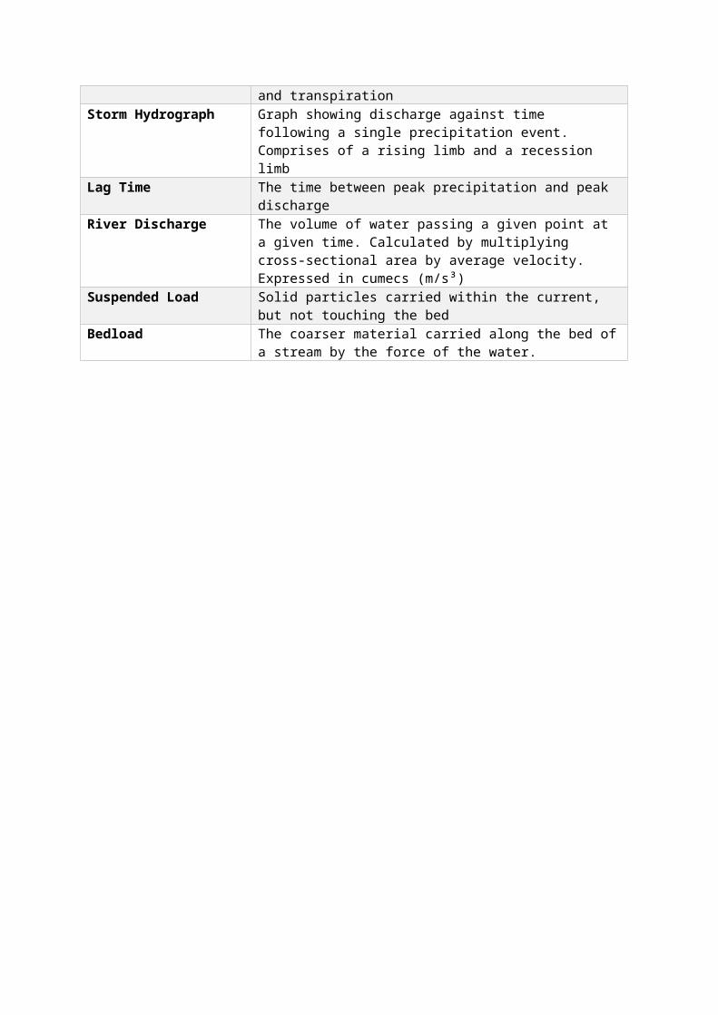
Storm Hydrograph Graph showing discharge against time following a single precipitation event. Comprises of a rising limb and a recession limb
Lag Time The time between peak precipitation and peak discharge
River Discharge The volume of water passing a given point at a given time. Calculated by multiplying cross-sectional area by average velocity. Expressed in cumecs (m/s³)
Suspended Load Solid particles carried within the current, but not touching the bedBedload The coarser material carried along the bed of a stream by the force
of the water.
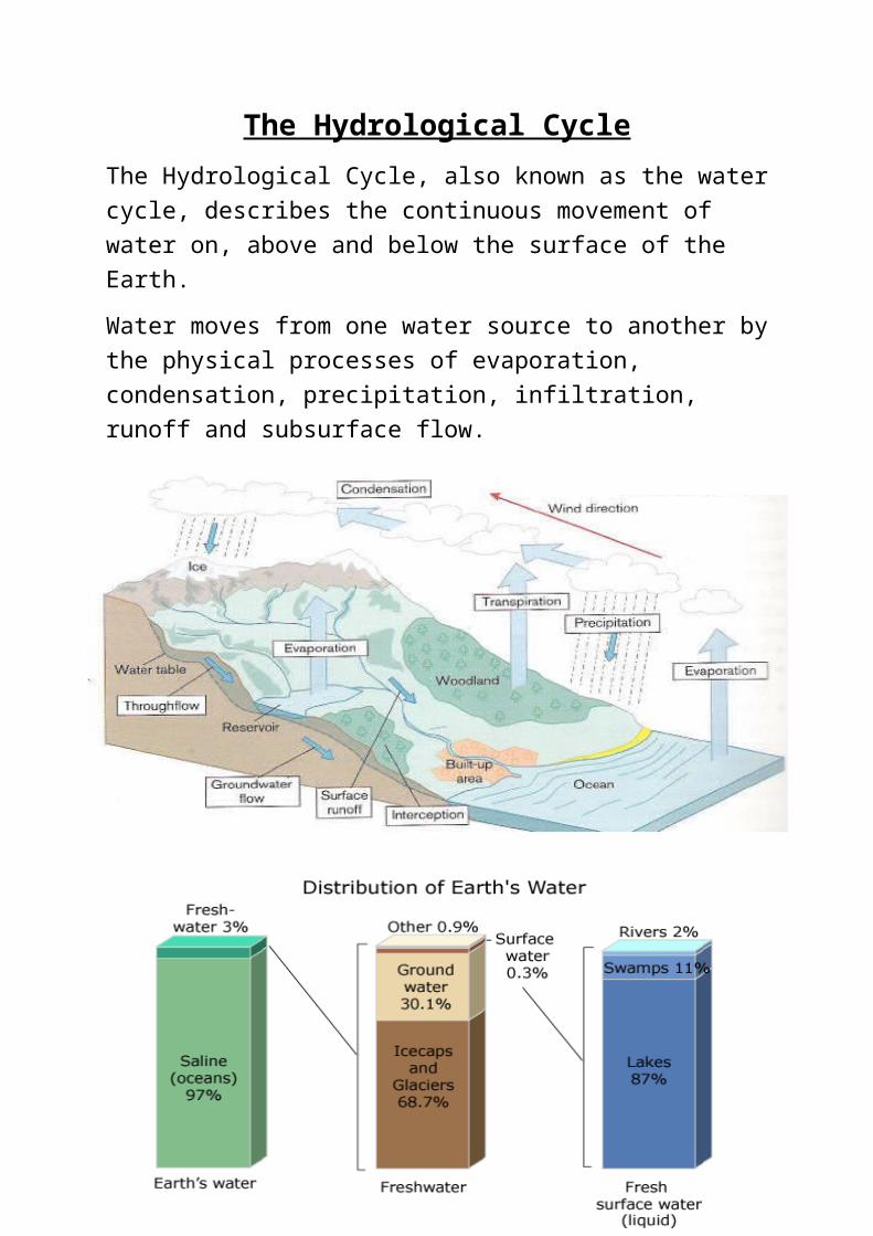
The Hydrological CycleThe Hydrological Cycle, also known as the water cycle, describes the continuous movement of water on, above and below the surface of the Earth.
Water moves from one water source to another by the physical processes of evaporation, condensation, precipitation, infiltration, runoff and subsurface flow.
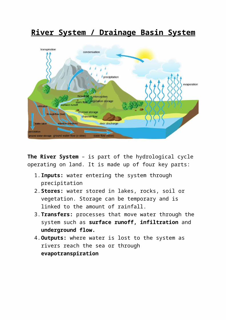
River System / Drainage Basin System
The River System – is part of the hydrological cycle operating on land. It is made up of four key parts:
1. Inputs: water entering the system through precipitation2. Stores: water stored in lakes, rocks, soil or vegetation. Storage can be
temporary and is linked to the amount of rainfall. 3. Transfers: processes that move water through the system such as
surface runoff, infiltration and underground flow. 4. Outputs: where water is lost to the system as rivers reach the sea or
through evapotranspiration
Revision Tip
Draw the flow diagram opposite from memory and try to colour code the stores, inputs, outputs and transfers.
Features of a Drainage Basin
River Processes - Erosion
Involves the wearing a way of rocks and particles being carried by a river. There are four types:
1. Hydraulic action - the force of the river against the banks can cause air to be trapped in cracks and crevices. The pressure weakens the banks and gradually wears it away.
2. Abrasion - rocks carried along by the river wear down the river bed and banks.
3. Attrition - rocks being carried by the river smash together and break into smaller, smoother and rounder particles.
4. Solution - soluble particles are dissolved into the river.
Source: The beginning of the River
Confluence: Where two rivers meet
Watershed: An area of high land between two drainage basinsMouth: Where a river flows into a lake or the sea
Tributary: A small river or stream that flows into a larger river.Estuary: Part of a river that is tidal.
River Processes – Transportation
Rivers pick up and carry material as they flow downstream. There are four different river transport processes:
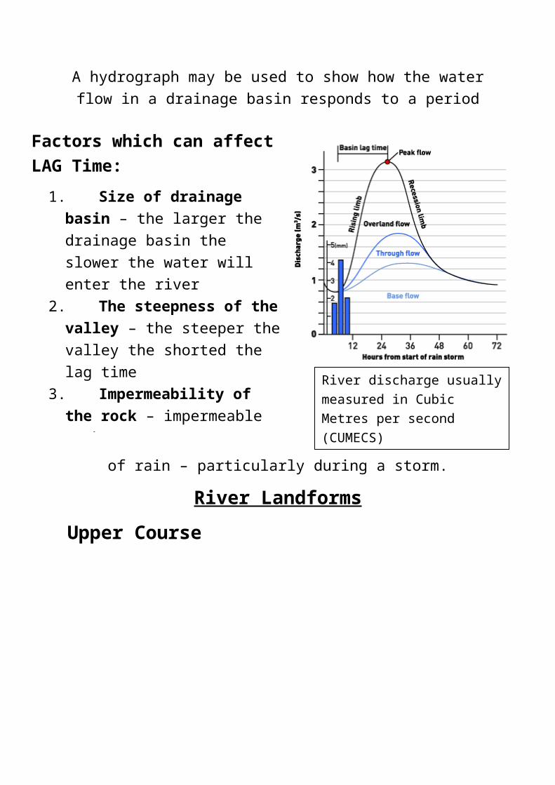
Storm HydrographA hydrograph may be used to show how the water flow in a drainage
basin responds to a period of rain – particularly during a storm.
Factors which can affect LAG Time:
1. Size of drainage basin – the larger the drainage basin the slower the water will enter the river
2. The steepness of the valley – the steeper the valley the shorted the lag time
3. Impermeability of the rock – impermeable rock means water enters the river quicker
4. Vegetation vs concreate – vegetation intercepts water meaning that the lag time is longer; concrete speeds up the rate of water entering the river.
River discharge usually measured in Cubic Metres per second (CUMECS)

River Landforms
Upper CourseIn the upper course of a river, gradients are steep and river channels are narrow. Vertical erosion at its greatest. Typical features include: steep sided valleys, interlocking spurs, rapids, gorges and waterfalls.
Formation of a waterfall:
1. Soft rock is undercut. 2. This leaves a layer of hard rock which overhangs the layer of
soft rock. 3. The water flows over the overhang and creates a plunge pool in
the soft rock below.4. Eventually the overhang will collapse due to the erosion of the
soft rock beneath it. The waterfall then retreats up stream. This creates a steep, gorge-like valley.
Example: High Force was formed where the River Tees crosses the Whin Sill – a hard layer of Rock

Middle CourseThe middle course of a river has more energy and volume. The gradient is more gentle and lateral erosion has widened the channel; also deeper.
Formation of a Meander – winding curve or bend in a river:
1. Meanders are created by lateral erosion that the river undertakes
2. Water flows around the bend in the river and as it does so, it swings to the outside of the bend – this means the fastest flowing and highest volume of water is concentrated on the outside of the bend causing it to erode the bank at this point.
3. On the inside of the bend, the flow is extremely slow and because of this lack of energy, the river is depositing.
Cross-section of a Meander – HINT: A good diagram to remember for the Exam!

Formation of an Ox-Bow Lake- when meanders get larger over time they can eventually turn into an ox-bow lake:
1. Erosion causes the outside bends to get closer2. Until there’s only a small bit of land left between the bends
(called the neck) 3. The river breaks through this land, usually during a flood4. And the river flows along the shortest course. 5. Deposition eventually cuts off the meander6. Forming an ox-bow lake.
Flood plains are flat areas of land that flood:
Flood plain is the wide valley floor on either side of a river which occasionally gets flooded. When a river floods onto the flood plain, the water slows down and deposits the eroded material that its transporting which builds the flood plain.
FloodingFlooding happens when the level of a river gets so high that it spills over its banks onto the flood plain. Flooding can be caused by both physical and human factors:
Physical - Precipitation:
- Frequent cause of flooding = heavy rainfall over a long period of time (days, weeks)
- Ground becomes saturated and water runs over surface – can’t infiltrate – flash floods after a hot summer
- Most serious flooding usually after short intense storms- Water held as snow also can cause floods when melts as
temperature rises
Physical- Soil/Underlying Rock (Geology):
- Permeable rock – lets water through – risk of flooding is lower- Impermeable rock- doesn’t let water through = surface runoff
and a higher risk of flooding- River basin with impermeable rock has a higher risk of flooding-
Physical – Relief/Vegetation:
- Steep-sided valleys allow water to reach the river channel faster = can cause flooding
- River basins with little vegetation cover – less absorbent - Forested basins have a lower risk of flooding – absorb water
Human:- Deforestation – trees intercept rainwater by its leaves as well
as absorbs water from the ground; cutting down trees stops this
- Urbanisation – urban areas have lots of buildings made from impermeable materials like concrete = increases surface run-off

Flood Management
Floods can be devastating, but there are a number of different strategies to stop them or lessen the blow. Hard options tend to be more expensive and have a greater impact on the river and the surrounding landscape. Soft options are more ecologically sensitive.Hard- Dam Construction
Dams are built across the rivers, usually in the upper course, in order to control the amount of discharge. Water is held back by the dam and released in a controlled way – reduce flooding.
+ Can be used to generate hydroelectric power or for recreation purposes.- Expensive- Sediment is often trapped behind the wall of the dam, leading to erosion further downstream. Agricultural land/Settlement may be lost when river valley is flooded from reservoir behind the dam.
Hard- River Engineering
The river channel may be widened or deepened allowing it to carry more water. A river channel may be straightened so that water can travel faster along the course. The channel course of the river can also be altered, diverting floodwaters away from settlements.
Altering the river channel may lead to a greater risk of flooding downstream, as the water is carried there faster.
Soft- Afforestation
Trees are planted near to the river. This means greater interception of rainwater and lower river discharge.
+ Relatively low cost option+ Enhances the environmental quality of the drainage basin
Soft- Preparation
Buildings are modified to reduce the amount of damage a flood could cause.Local authorities and the national government introduce policies to control urban development close to or on the floodplain.
+ reduces the chance of flooding and the risk of damage to property.- Resistance to development- Enforcing planning regulations can be hard especially in LEDCS
Soft- Managed Flooding
The river is allowed to flood naturally in places, to prevent flooding in other areas e.g. near settlement
- Reduce flooding risk and impacts of flooding
Soft- Flood Plain Zoning
Restricting prevent building on parts of a flood plain that are likely to be affected by a flood.
+ The risk of flooding reduced- expansion of an urban area is limited is there aren’t any other suitable areas.

CoastsTerm DefinitionAbrasion Wearing a way of cliffs by sediment flung into cliffs by storm
waves, chipping bits off the cliff.Angle of Dip The angle of the bedding planes which affects the shape of the
cliff.Arch Wave-eroded passage through a small headland, which begun
as a cave formed in a headland. Processes of abrasion and hydraulic action widened and deepen until the waves cut through the cliff face.
Attrition Erosion causes when rocks and boulders transported by waves bump into each other and break up into smaller pieces and become smoother.
Backwash After the wave has hit the coast, the water runs back down the beach - this is called Backwash
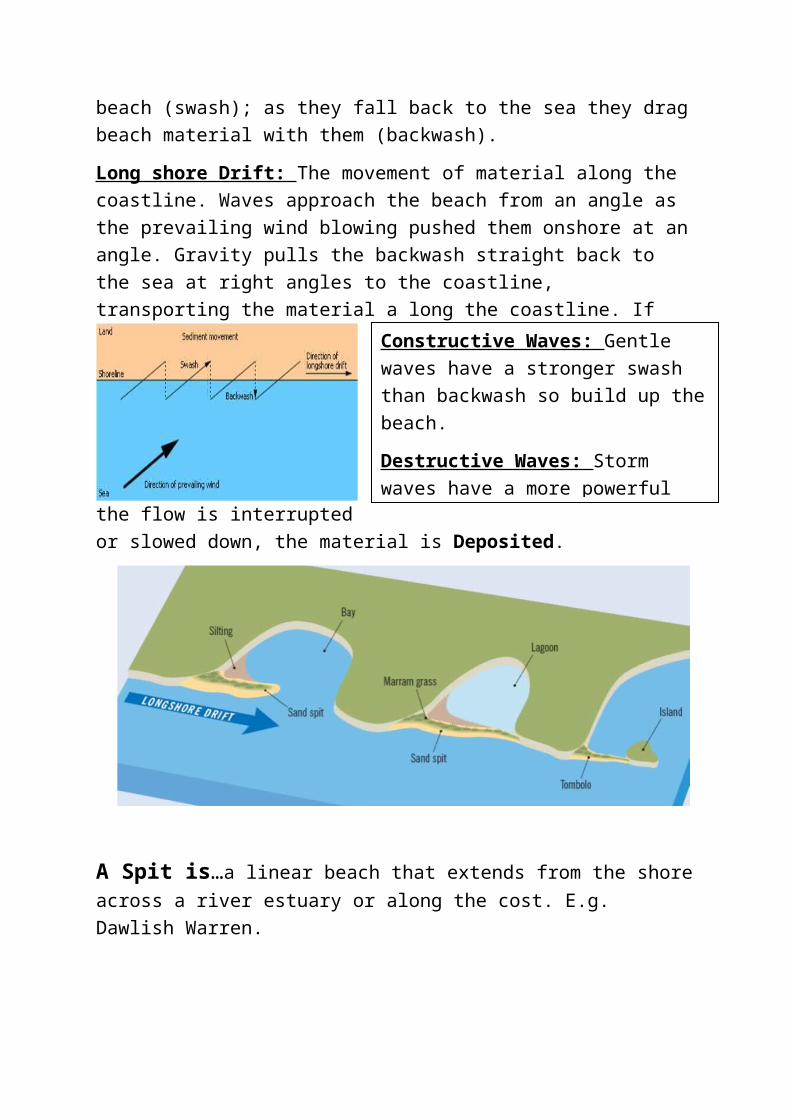
Bar Where a spit continues, eventually joining the land at both the distal and proximal end, across a bay.
Bay Found between headlands where there are alternating outcrops of resistant (hard) rock and less resistant (soft) rock. Waves erode the areas of softer rock more rapidly to form bays.
Bedding Plane The line found in rocks separating two different layers: one usually more resistant to erosion than another - create angle of dip.
Beach Nourishment
Replacing beach material lost through erosion by the sea, with sand and shingle.
Biological weathering
The breakdown of rock through the action of plants and animals e.g. rabbits burrowing.
Cave Found in coasts formed of resistant rock. Solution, Abrasion and Hydraulic action widen any weakness within the rock e.g. joint, eventually forming a cave.
Chemical Weathering
The decomposition (rotting) of rock caused by a chemical change within that rock e.g sea water causes chemical weathering of cliffs - solution
Cliff Collapse Steep cliffs made of hard, resistant rock, fall down when there is a loss of supporting rock underneath caused by wave attack.
Constructive waves
Found on low-angled beaches and responsible for coastal deposition. Gentle breaking waves, with a stronger swash than backwash.
Deposition When the sea loses energy, it drops the sand, rock particles and pebbles it has been carrying. It happens in shallow water, in a sheltered area where there is little wind and a good supply of material. E.g. Torbay.
Destructive Waves
Found on steep beaches, are steeply breaking and responsible for coastal erosion. The backwash is much stronger than the swash and removes sediment as the water retreats.
Erosion The wearing away of land by waves and wind.Fetch The maximum distance of water over which winds can blow.
Connects to prevailing winds.

Freeze-Thaw weathering
Water enters cracks in rocks during warmer days and freezes during cold nights. As the water turns into ice it expands and exerts pressure on the surrounding rock - eventually pieces of rock break off.
Gabions Steel wire mesh filled with boulders used in coastal defencesGroyne A barrier of wood or concrete, built from the high tide mark, out
across the beach to help reduce longshore drift and encourage deposition of sand to make the beach higher.
Headland Areas of land protruding out to sea formed of resistant (harder) rock. They help protect the bay which forms between them from wave attack.
Hydraulic Action The process by which breaking waves compress pockets of air in cracks in a cliff face. The pressure may cause the crack to widen, breaking off rock.
Impermeable Rock
A rock that will not allow water to pass through it e.g. clay.
Joints Vertical fractures or cracks in rock layers caused by rocks cooling, expanding or drying out over long periods of time.
Lagoon A former bay cut off from the sea by a bar e.g. Slapton Ley.Longshore drift The movement of beach sediments along the shore. Waves
approaching the beach at an angle will carry material up and across the beach. Sediment is moved along the beach in the direction of the prevailing wind.
Mass Movement The downhill movement of weather material under the force of gravity - soil creep, slumps, slides and mudflows.
Mud flows or Slides
Occur after periods of heavy rain when loose surface material becomes saturated and the extra weight causes the material to become unstable and move rapidly downhill.
Permeable rocks Rocks which allow water to pass through e.g. sandstone, chalkPhysical Weathering
The disintegration of rock into smaller pieces without any chemical change in the rock - bare rock where there is no vegetation to protect the rock from extreme weathers
Prevailing winds The direction from which winds in an area most commonly blow e.g. Torbay has prevailing winds from the SW
Revetments Wooden, steel or concreate fence-like structures that allow sea water and sediment to pass through, but the structures absorb wave energy. Beach can build up behind the revetment to protect cliff.
Rip-Rap Large boulders dumped on the beach as part of coastal defences - slow down erosion rate
Sea Walls Aim to prevent erosion of the coast by providing a barrier which reflects wave energy. Re-curve sea walls used most commonly.
Slumping Involves a whole segment of the cliff moving down-slope along a saturated shear-place.
Soil Creep The slowest of downhill movements, occurring on very gentle and well-vegetated slopes.
Solution Where acids and salts in sea-water or sea-spray cause rocks to dissolve or disintegrate.
Spit A long, narrow build-up of sand and shingle formed by longshore

drift and deposited where the coastline abruptly changes direction in relation to the wind. Distal end of a spit is where it meets the sea, whereas the proximal end is connected to land.
Stack Rock left standing out at sea after wave erosion has separated it from the mainland, when an arch has been undercut and has collapsed.
Stump Formed by continuing wave action attacking a stack causing wave-cut notches and the top of the stack becoming too heavy, thus collapsing.
Swash The movement of water up the beach after a wave has broken on the shore.
Tombolo Where a spit forms and joins an island to the mainland.Wave cut notch and Platform
Erosion at the base of the cliff face between high and low tide, creates a wave cut notch. As the base undercuts the cliff, the top part becomes too heavy causing it to collapse. This creates a wave-cut platform - a gently sloping, rocky platform exposed at low tide

Coastal Weathering and ErosionWeathering is the breakdown of rocks where they are. There are three types of weathering:
Mechanical Weathering Breakdown of rocks without changing it chemical composition e.g. Freeze-thaw weathering
Chemical Weathering Breakdown of rock by changing its chemical composition – rainwater has C02 dissolved in it, which makes it a weak carbonic acid. This reacts with rock and dissolves them.
Biological Weathering Breakdown of rocks by living things e.g. rabbits burrowing
Erosion is when the rocks are broken down and carried away by something e.g. the sea.
Hydraulic Action
Where air is compressed into a joint as a wave breaks against a cliff, then expands explosively as the wave recedes – vibrating the
rock, making joints wider
Corrasion (Abrasion)
Where chunks of rock are flung into cliffs by storm
waves chipping bits off the cliff
Rubs like sandpaper
Attrition When rocks and pebbles on the shore wear each other down and smooth off rough edges as they roll against
each other as waves roll them Rocks turn smoothSolution
(Corrosion)When acids and salts in sea-
water or sea-spray cause rocks to dissolve or
disintegrate
Dissolves like sugary tea

Cliff retreat as a result of Erosion, Weathering and Mass Movements
1. Waves cause most erosion at the foot of a cliff – forms a wave-cut notch that has been enlarged as erosion continues. This makes the cliff above unstable.
2. Cliff above sea level is also affected by mechanical and chemical weathering processes. Further impacts the cliff stability – eventually collapses.
3. Collapsed material is washed away and a new wave-cut notch starts to form. Repeated collapses results in cliff retreat.
4. A wave-cut platform is the platform that’s left behind as the cliff retreats.
5. Cliff collapses are mass movements – force of gravity acting on the slope is greater than the force supporting it. Examples are slides, slumps and rock falls.
Rock Fall Land Slips
MudflowSoil Creep

Features of Erosion
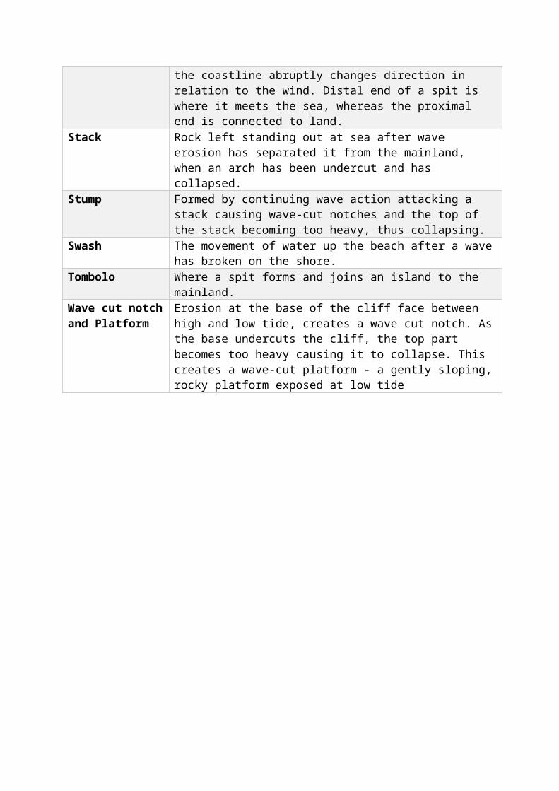
Processes of Deposition / Transportation of materialWaves are the main movers of material eroded from cliffs. As waves break they push material up the beach (swash); as they fall back to the sea they drag beach material with them (backwash).
Long shore Drift: The movement of material along the coastline. Waves approach the beach from an angle as the prevailing wind blowing pushed them onshore at an angle. Gravity pulls the backwash straight back to the sea at right angles to the coastline, transporting the material a long the coastline. If the flow is interrupted or slowed down, the material is Deposited.
Constructive Waves: Gentle waves have a stronger swash than backwash so build up the beach.
Destructive Waves: Storm waves have a more powerful backwash than swash, so remove more material from a beach.

A Spit is…a linear beach that extends from the shore across a river estuary or along the cost. E.g. Dawlish Warren.
Sandy spits form as a result of dominant constructive waves, whereas shingle spits are a result of dominant destructive waves.
For a spit to form…
1. Sediment from an eroded cliff
2. Longshore drift
3. Change in direction of the coastline – creating the curved shape.
A Bar is… a spit which goes right across a bay and joins onto a shore at the other side – usually where there is no strong river current trying to get to the sea e.g. Slapton Ley, Dorset.
A Tombolo is… when a spit forms and joins an island offshore.
Coastal ManagementHard Engineering: man-made strategies build to control the flow of the sea and reduce flooding and erosion. These are usually costly and can stand out.
Soft Engineering: schemes set up using knowledge of the sea and its processes to reduce the effects of flooding and erosion.
Hard Engineering Strategies:Sea Wall – wall made of hard material (concrete) that reflects waves back to sea.
+ It prevents erosion of the coast.+ Flood barrier.+ Lasts a long time.+Effective.
- Creates strong backwash erodes under the wall.
- Expensive to build/ maintain.

Rip rap – boulders that are piled up along the coast.
+ The boulders absorb wave energy and so reduce erosion and flooding.+ popular option – seen to be effective
- Boulders can be moved around by strong waves = maintenance costs.
Groynes – wooden or stone fences that are built at right angles to the coast. They trap material transported by longshore drift.
+ Create a wider beach which slows the waves removing sediment elsewhere.+ Greater protection for coastline from erosion and flooding.
- Starve beaches further down the coast of sand = narrower beaches that leads to greater erosion and flooding.
Revetments- Slanted structures made of concrete, wood or rocks built at the foot of cliffs.
+ Absorb wave energy thus reduce erosion.+ Easily installed+Cheaper than sea wall.
- Expensive
- Create strong backwash - erodes under the barrier.
Gabions – rock-filled cages, built at the foot of cliffs.
+Absorb wave energy thus reduce erosion.+ Easily installed+ Cheaper than sea wall
- They look ugly.
- Need frequent checking and repair
Breakwaters -concrete blocks or boulders deposited on the sea bed off the coast.
+ Force waves to break offshore so their erosive power is reduce before they reach the shore.+ Calmer waters = encourages tourism.
- Expensive and easily damaged by storms.
- Leads to faster cliff erosion down the coast
Soft Engineering Strategies:Beach Replenishment- Sand and shingle from elsewhere that’s added to the beach.
+ Creates wider beaches which slow the waves from eroding the coastline.+ Greater protection from erosion and flooding.
- Taking material from the seabed can kill organisms like sponges and coral or
increases rate of erosion elsewhere.
- Very expensive
Managed retreat – Removing an existing defence and allowing the land behind it to flood.
+ Over time the land will become marshland – creating new habitats and sometimes new land+ Flooding and erosion reduced behind marshland+Fairly cheap
- People may disagree over what land is allowed to flood e.g. farmland
- Not suitable for most coastal areas, especially built up areas.
Some strategies for coastal management are more sustainable than others. Hard engineering strategies are usually less sustainable than soft engineering strategies because they generally cost more money to build and maintain, and they damage the environment more.
Population and SettlementTerms DefinitionBirth Rate The amount of babies born per 1000 of the population per year
Death Rate The amount of deaths per 1000 of the population per yearNatural Increase/Decrease
The difference between the birth and death rates
Immigrants People moving into a countryEmigrants People moving out of a country
Migration Movement of people into and out of an area or country
Positive Migration More immigrants than emigrants = increase population size
Negative Migration Less immigrants than emigrants = decrease population sizeRefugees Are people who've been forced to leave their country due to things
like war, persecution or a natural disasterPro-natalist policies A population policy that tries to encourage births to increase the
population sizeAnti-natlalist policies A population policy that tries to reduce the birth rate and therefore
reduce population growthPopulation Decline Death rate is greater than the birth ratePopulation Increase Death rate is less than the birth rateDemographic Transition Model
A model showing population growth over time at different stages of development. There are five different stages that countries go through.
Population Structure Is how many people there are of each age group in the population and how many there are of each sex. Population structure is show using a population pyramid.
Youthful Population When there is a very high percentage of people under the age of 15Ageing Population When a country has a large number of people over the age of 65Overpopulation Where there are too many people and not enough resources to
support a satisfactory quality of life - high population densityUrbanisation Population shift from rural to urban areas - common in LEDCsCounter urbanisation People move from urban areas to rural areas, usually occurs in MEDCsPush Factors The negative things about a person's place of origin that make them
want to leavePull Factors The positive things about a person's destination that attract them to
the destination.CBD- Central Business District
The commercial centre of the city with shops and offices
The Suburbs These are housing areas found towards the edge of the cityThe Inner City The part found around the CBD - it has a mix of poorer quality housing
and older industrial buildings
The Rural-Urban Fringe The part right at the edge of a city where there are both urban land uses e.g. factories and rural land uses e.g. farming
Sustainable Doing things in a way that lets the people living now have the things they need but without stopping people in the future meeting their needs too.
Carbon-neutral homes Building that generate as much energy as they use e.g. by using solar panels to produce energy.
Brownfield site Area that has been built on previouslyGreenfield site Green space that has not been built on beforeHigh Order Goods These are goods that are only brought occasionally and are usually
more expensive. Usually called comparison goods as you compare before you buy.
Low Order Goods These are goods that are bought frequently and are usually quite cheap e.g. milk, bread. These are known as convenience goods.

Population Decline – when the death rate is greater than the birth
rate.
Population Increase- when the death rate is less than the birth
rate.
Threshold Population The minimum population needed to support a shop
Sphere of Influence The area that people come from to visit a shop or an area. Convenience goods have a small sphere of influence.
Range Distance people will travel for a particular good or service
Population numbers change over time, influenced by births, deaths and migration into or out of an area. Global population levels, having grown slowly for most of human history, are now rising.
Population pyramids- show the structure of a population by comparing relative numbers of people in different age groups. Population structures differ markedly between LEDCs and MEDCs.
A broad-based pyramidbirth rate and high death rate resulting in a youthful population. Indicates first stages of development e.g. Kenya.

Demographic Transition ModelCountries go through five stages of population growth; these are shown by the Demographic Transition Model. The DTM shows population change over time and marked differences between LEDCs and MEDCs.
- As countries become more developed, birth and death rates change, affecting population growth. For example, as a country develops and improves its healthcare services, the death rate reduces, especially infant mortality. This increase the population.
- So as countries become more developed the population changes and the country moves through the stages of the DTM.
- LEDCs are in the earlier stages of the DTM and MEDCs are in the later stages of the DTM.
Reasons for high birth and death rates in developing countries
Reasons for low birth and death rates in developed countries
- Work on land/farms – hard work and many deaths
- Care for family when ill/old
- Excellent standard of living- Don’t need lots of children to work- Children survive so don’t have to

Temperate climate not too hot not too cold and able to grow crops/farm e.g. the UKLow lying flat fertile land able to easily farm land e.g Bangladesh Delta which is full of nutrientsGood supply of natural resources e.g. building resources needed for basic human needs
Factors attracting Settlement
Extreme climates too hot or too cold – cannot grow crops or survive in conditions e.g. Sahara desertMountainous or highland areas hard to farm and get supplies e.g. Scottish highlandsDense vegetation e.g. Amazon Rainforest.
Factors Discouraging Settlement
- High infant mortality due to disease- Children regarded as insurance -
children go to city to earn money and can care for elderly
- Religious beliefs against birth control – spread of HIV and lots of births (women die In child birth)
- Tradition of having large families – believed to give status.
have more- Excellent healthcare- Excellent family planning – access to
variety and can have children when they are wanted
- Children live free from disease- Want to spend money on other
things – leisure activities- Pensions – reduce dependency- Want careers- Better education
Variations in Population SizePeople are unevenly distributed around the world. The difference in distribution is measured by comparing population density – the number of people per square kilometre.
People live in different areas due to various factors such as the following:

Overpopulation
Where there are too many people and not enough resources to support a satisfactory quality of life. Usually caused by rapid population growth
Youthful Population
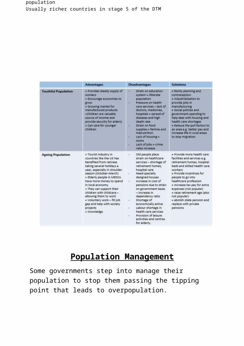
There are lots of people under the age of 15 that are dependent on the working populationLow life expectancy together with a high birth rate leads to youthful populationHigh dependency ratioLikely to happen in LEDCs (Gambia) in stages 2 and 3 of the DTM
Ageing population
The population structure of an ageing population has more older people (over 65) than younger peopleLower birth rate and life expectancy getting olderHigher proportion of old people dependent on working populationUsually richer countries in stage 5 of the DTM
Population ManagementSome governments step into manage their population to stop them passing the tipping point that leads to overpopulation.
When a population is experiencing population increase, usually extremes such as overpopulation, Anti-natalist policies are used. This a policy installed by the government to slow the population growth by attempting to limit the number of births.
For example: China’s ‘One Child Policy’
When a population is experiencing population decline, Pro-natalist policies are used. This is a policy installed by the government to encourage the bearing of children to increase the birth rate.
For example: Singapore’s ‘Graduates Mother Scheme’ and ‘Have Three or More’.
MigrationIs the movement of people. Migration can be voluntary, forced, permanent or temporary.
When people move into an area, this is called Immigration.
When people exit an area, its called Emigration.
People can move to different countries – this is known as International Migration. It might be across the world, or just a few miles across a border. For example: Mexico to USA.
People can move between different regions within countries. This is known as Internal Migration.

Push Factors
Overpopulated in urban areasGreater wealth – ability to move / afford larger house on outskirtsTraffic congestionPolitical unrestCrime in urban environmentQuiet life wanted
Pull Factors
Better surroundings and open areasBetter quality of lifeImproves transport links making it easier to commuteLarger housesGood for bringing up children and for retirees
Rural to Urban Migration: is the movement of people from rural areas such as the countryside to urban areas such as cities like London. Also known as Urbanisation.
Urban to Rural Migration: is the movement of people from urban areas to rural areas. Also known as Counter-Urbanisation.
Push Factors
UnemploymentLow wagesNatural DisastersPoor farming conditions
Pull Factors
Greater job opportunitiesHigher wagesBetter social servicesBetter medical facilitiesHopes for “better life”Join relatives who have already moved – chain migration

Land-UseThe ways that land is used are broadly the same in all towns and cities. The land use, for example, consists of areas for houses, businesses, leisure and transport. Areas with the same types of land used are called zones.
Burgess Model - Aka Concentric Zone Model
This model is based on the idea that land values are highest in the centre of a town/city. This leads to high-rise, high-density buildings being found near the Central Business District (CBD), with low-density, sparse developments on the edge of the town/city.

Another urban model is the Hoyt Model. This is based on the circles on the Burgess model, but adds sectors of similar land uses concentrated in parts of the city. Some zones e.g. factories/industry zone, radiate out from the CBD.
Sustainable CitiesMany people are working towards trying to make cities more Sustainable. A sustainable city offers a good quality of life to current residents but doesn’t reduce the opportunities for future residents to enjoy.
Key features of a sustainable city:
- Resources and services in the city are accessible to all- Public transport is seen as a viable alternative to cars, is safe and
reliable.- Walking and cycling is better for health and safer.- Areas of open space are safe, accessible and enjoyable- Renewable resources are used where possible- Waste is seen as a resource – recycling when possible- New homes are energy efficient and affordable- Community links are strong – work together- Cultural and social amenities are accessible to all- Inward investment
LEDC Example: Curitiba, Brazil
Sometimes the land use of each part does not match the model – real cities are all slightly different. LEDCs are almost reverse e.g. Rio de Janerio, Brazil is good example.

Capital city of the Parana state in Brazil with nearly two million people living there. There have been many changes since 1968:
- Parks were created and retained – green spaces beside the river and acts as floodplain.
- Green spaces being dedicated to different ethnic/immigrant groups – stop conflict
- Urban growth is restricted to corridors of growth – along key transport routes. Tall buildings along bus routes.
- A bus rapid transit system operates – cheaper to run than tube system and 80% of travellers use it = more economic. Also uses triple section bendy buses carrying two million passengers a day.
- Free educational and internet cafes.
- Green exchange programme – urban poor bring their waste to neighbourhood centres and exchange waste for bus tickets and food.
- COHAB- public housing programme that provides 50,000 homes for urban poor.
MEDC Example: Beddington Zone Energy Development (BedZED)- Is the largest UK eco-community project experimenting in sustainable living.
- Homes are design to cope with temperature rises predicted by 2080, conserve water and minimise energy.
- The homes have no central heating or air conditioning but instead make full use of natural heating and lighting.
- Community boasts its own eco-friendly single generator for electricity and is able to capture rainwater which is used for flushing toilets.
- Walking and cycling is preferred but community cars are available to loan and are shared between the community.
- Grow as much food as they can
Changing Retail Services

Retail services change over time:
- Changes to transport (car ownership increases and commuting to locations more popular)
- Changing market forces (supply and demand changes over time due to taste and different wants/needs).
- Social patterns and Work patterns – people have less time to shop (convenience shopping increased)
The sorts of changes that have occurred in the UK over time:
1. People used to travel into their local town to the butchers, green grocers, corner shop etc for all their daily needs (and this usually happened on a daily basis too)
2. Technology improvements resulted in fridges and freezers – allowed people to buy in bulk
3. Supermarkets grew in numbers 4. Car ownership increased so people can travel further for their shopping5. Out-of-town shopping centres increased in number and size (cheaper
and accessible). People can get everything in one place and with reduced shopping time now, it is favoured.
C/S: Torbay- What has changed in Torbay over the last 20 years:
- Car ownership increased and people commuting for work further away- People are not shopping at the local butchers, greengrocers etc anymore
– increase in supermarkets- Big shops such as Rosetters and Woolworths closed down and replaced
by £ shops. Lots of high street shops closed down in Torquay town centre as Exeter and Plymouth build large shopping centres where you have more variety and branded shops.
- Rise in clone shops such as new look, H&M, Pandora etc. (its what people want) and Coffee shops such as Costa overtaking high street café’s – people go to them as they know what they can get (reliable)
- Revamp to out-of-town shopping area ‘The Willows’ with Marks and Spencer increasing its size to allow for furniture and homeware department, as well as a new outlet shop, large Boots, Next and Mothercare. Following the rise In the number of houses built around the area.
Hazards

Terms DefinitionsNatural Hazard A naturally occurring event that has the potential to affect people's
lives or property e.g. earthquake
Natural Disaster When natural hazards do affect people's lives or property
Boundary/Plate Margins
The places where plates meet
Destructive Margins Are where two plates are moving towards each other - can result in a subduction zone or collision zone
Constructive Margins Where two plates are moving away from each other. Magma rises from the mantle to fill the gap and new crust is created
Conservative Margins Where two plates are moving sideways past each other, or are moving in the same direction but at different speeds.
Subduction Zone The area where lighter plate descends into the mantle and is destroyed.
Collision Zone Areas where two plates, both with continental crust meet and form fold mountains.
Earthquakes Is the result of a sudden release of energy in the Earth's crust that creates seismic waves.
Focus The point in the Earth where the earthquake startsEpicentre is the point on the Earth's surface straight above the focus -
shockwaves are strongest at this pointVolcanoes When magma from within the Earth's upper mantle works its way to
the surface. At the surface, it erupts to form lava flows and ash deposits. Over time, as the volcano continues to erupt, the layers of lava will make it bigger and bigger.
Hot Spot An area of volcanic activity usually away from a plate margin.Ring of Fire Is an area where a large number of earthquake and volcanic eruptions
occur in the basin of the Pacific OceanMid- Atlantic Ridge Is a mid-ocean ridge, a divergent tectonic plate, constructive plate
boundary located along the floor of the Atlantic Ocean. North American and Eurasian plates more apart forming a ridge in the sea floor.
Shield Volcanoes They are low volcanoes with gently sloping sides, formed by eruptions of thing, runny lava. Usually found at constructive boundaries.
Composite Volcanoes Made up of alternating layers of lava and ash formed from pyroclastic flows. Usually found at destructive boundaries.
Fold Mountains Are mountains formed by the folding of the earth's crust when two plates collide.
Dormant Volcano A volcano that has not erupted for a long time but is not extinctExtinct Volcano A volcano that has not erupted since records began and is no longer in
area of volcanic activity e.g Scotland
Pyroclastic Flow A mixture of hot steam, ash, rock and dust which can roll down the sides of a volcano at very high speeds and with temperatures of over 400 degrees.

Primary effects The immediate effects e.g. earth shaking during an earthquake will make plates fall off the wall
Secondary effects Effects that happen later on e.g. tsunamiAftershocks Smaller earthquakes that happen after the main oneTropical Storms Are huge storms with strong winds and torrential rain caused by
intense low pressure systems? Named hurricanes, typhoons and tropical cyclones
Eye of the storm Centre of the storm - very low pressure, light winds, no clouds and no rain in the eye
Eyewall Wall of spiralling rising air with very strong winds that surrounds the calmer centre
Drought A drought is a long period when rainfall is below average.
Tectonic HazardsA natural hazard is a naturally occurring event that has the potential to affect people’s lives or property e.g. earthquakes and volcanic eruptions. When natural hazards do affect people’s lives or property they’re called natural disasters.
The earth’s surface is separated into tectonic plates – two types: continental and oceanic.
- Continental crust is thicker and less dense- Oceanic crust is thinner and more dense
There are three types of plate margins:

Destructive margins are where two plate are moving towards each other. Where an oceanic plate meets a continental place, the denser oceanic plate is forced down into the mantle and destroyed. This often creates volcanoes and ocean trenches.
E.g. Where the Nazca plate is forced under the South American Plate.
Constructive margins are where two plates are moving away from each other. Magma rises from the mantle to fill the gap and cools, creating new crust.
E.g. Mid-Atlantic Ridge
Conservative margins are where two plates are moving sideways past each other, or are moving in

the same direction but at different speeds. Crust isn’t created or destroyed.
E.g. San Andres Fault in California.
EarthquakesEarthquakes occur at all three types of plate margins and are caused
by the pressure that builds up:
Destructive margins – pressure builds up when one plate gets stuck as it’s moving down past the other into the mantle.
Constructive margins – pressure builds up along cracks within the plates as they move away from each other.
Conservative margins – pressure builds up when plates that are grinding past each other get stuck. When released, these cause huge earthquakes.
Amount of energy released by an earthquake is measured using the Richter Scale. In order to record earth movements, we use a Seismomoters. Level of damage is based on cost of damage; lives lost; number of buildings/homes destroyed; area covered etc.
Volcanoes

A Volcano is an opening in the Earth’s crust. It allow hot magma, ash and gases to escape from below the surface. Volcanoes are found at destructive and constructive plate margins.
At destructive plate margins the oceanic plate goes under the continental plate because its more dense. This is melted and destroyed and turned into magma. As pressure in the magma rises, it pushes it up through cracks called the vent. When it erupts onto the surface, its forms a volcano.
At constructive plate margins the magma rises up into the gap created by the plates moving apart, forming a volcano – usually creating new land.
Some volcanoes also form over part of the mantle that are really hot – aka hotspots e.g. Hawaii.
Impacts of Earthquakes
Primary Impacts Secondary Impacts Buildings and bridges collapse People are injured or killed by
buildings collapsing Road, railways, ports and airports
damaged Electricity cables are damaged,
cutting off supplies Gas pipes are broken, causing leaks
and cutting off supplies Telephone poles and cables are
destroyed Underground water and sewage
pipes are broken, causing leaks and cutting off supplies
Earthquakes can trigger landslides and tsunamis- these destroy more buildings and cause more injuries and deaths
Leaking gas can be ignited, starting fires
People are left homeless People may suffer psychological
problems if they knew people who died/ suffered loss of homes etc
Shortage of clean water and lack of proper sanitation- disease
Roads are blocked so aid and emergency vehicles can’t get through
Impacts of Volcanoes
Primary Impacts Secondary Impacts Buildings and roads are destroyed
by lava flows and pyroclastic flows – buildings also collapse is enough ash falls on them
People and animals are injured or killed, mainly by pyroclastic flows but also by lava flows and falling rocks
Crops are damaged and water supplies are contaminated when ash falls on them
People, animals and plants are suffocated by CO2
Mudflows form when volcanic material mixes with water e.g. from heavy rainfall or snow melt. Mudflows cause more destruction, deaths and injuries.
Fires are started by lava flows and pyroclastic flows, which then spreads
People may suffer psychological problems if they knew people who died or if they lost their homes etc.
People are left homeless There’s a shortage of food because
crops are damaged Shortage of clean water-
contaminated Roads blocked so aid and
emergency vehicles cannot get through
Sulphur dioxide released into the atmosphere causes acid rain.
Climatic Hazards

Tropical storms are intense low pressure weather systems – hurricanes, typhoons and tropical cyclones.
Tropical storms are huge storms with strong winds and torrential rain that develop over sea water that’s 27 degrees c or higher. They happen when sea temperatures are at their highest.
- Warm, moist air rises and condensation occurs. This releases huge amounts of energy, which makes the storms really powerful.
- They move west because of easterly winds near the equator. - They lose strength as they move over land as warm water is cut
off.
Cross section diagram of a hurricane.
1. Tropical Storms spin anti-clockwise and more north-west (in the northern hemisphere)
2. They’re circular in shape and can be hundreds of kilometres wide3. They usually last between 7 and 14 days4. The centre of the storms called the eye – its up to 50km across and is caused by
descending air. There’s very low pressure, light winds, no clouds and no rain in the eye.
5. The eye is surrounded by the eyewall where there’s spiralling rising air, very strong winds (around 160km p/h), storm clouds and torrential rain
6. Towards the edges of the storm the wind speed falls, the clouds become smaller and more scattered, and the rain becomes less intense.

Impacts of Tropical storms are more severe in LEDCS
- There’s more poor quality housing in LEDCs – easily destroyed by strong winds and flooding
- Infrastructure is often poorer in LEDCs – poor quality roads make it harder for emergency services to rescue people, which leads to more deaths
- More people in LEDCs depend on farming – if crops and livestock is destroyed lots of people will lose their livelihoods and low food supplies can lead to famine
- LEDCs don’t have much money to protect against tropical storms e.g. by building flood defences. They also don’t have much money or resources to react straight away to tropical storms, so more people are affected by secondary impacts
- Healthcare is often worse in LEDCs. Many hospitals in LEDCs don’t have enough supplies to deal with the large numbers of casualties after a tropical storm, so more people die from treatable injuries.
Drought
A drought is a long period when rainfall is below average. Water supplies e.g. lakes and rivers, are depleted during a drought because people keep using them but they aren’t replenished by rainfall. Also, droughts are often accompanied by high temperatures which increase the rate of evaporation – depleted faster.
Caused when:
- Changes in atmospheric circulation mean it doesn’t rain much in area for years e.g. Ethiopia
- Changes in atmospheric circulation can also make the annual rains fail – monsoon rains don’t come
- High pressure weather systems (anticyclones) block depressions (weather systems that cause rain) e.g. this happens in the UK.

Droughts are also often caused by the activity of humans as well. Human activities that can help trigger droughts include:
Widespread cutting down of trees for fuel. This reduces the soil's ability to hold water and dries out the ground, triggering desertification, leading eventually drought.
Construction of a dam on a large river. This may help provide electricity and water to irrigate farmland near the reservoir: however, it may also cause drought downstream by severely reducing the flow of water.
Effects of drought Droughts endanger lives and livelihoods through thirst, hunger (due to crops
dying from lack of water) and the spread of disease. Millions of people died in the 20th century due to severe drought and famines.
One of the worst hit areas was the Sahel region of Africa, which covers parts of Eritrea, Ethiopia and the Sudan.
Droughts and famines can have other geographical impacts. If drought forces people to migrate to a new home it could put pressure on resources in neighbouring countries.
Droughts can have a severe impact on MEDCs as well as LEDCs. Droughts have caused deaths in Europe in recent years, especially among the elderly. During the UK summer of 2006 there were hose pipe bans and campaigns to make people save water.