01 hydrology 101 - water...
TRANSCRIPT

Hydrology 101 April 9, 2014
Dr. Sandoval. Ms. Anzulai 1
University of California, DavisDepartment of Land, Air, and Water Resources
Samuel Sandoval Solis, PhDAssistant Professor
Hydrology 101
ESM-121 Water Science and Management
Lecture 1
Hydrology 101 : Surface and Groundwater- Hydrologic Cycle- Surface water principles- Groundwater Principles

Hydrology 101 April 9, 2014
Dr. Sandoval. Ms. Anzulai 2
Precipitation
Evaporation
Evapo-Transpiration
Infiltration
Runoff

Hydrology 101 April 9, 2014
Dr. Sandoval. Ms. Anzulai 3
A key concept of surface water hydrology- Mass Balance (Continuity Equation)
Accounts for addition, internal transfer, storage, and loss of water from a land unit
P = ET + RO + GW + ΔS
http://stream2.cma.gov.cn/pub/comet/HydrologyFlooding/RunoffProcessesInternationalEdition/comet/hydro/basic_int/runoff/print.htm#page_1.0.0
A drainage basin is an extent or an area of land where surface water from rain, melting snow, or ice converges to a single point at a lower elevation, usually the exit of the basin, where the waters join another waterbody, such as a river, lake, reservoir, estuary, wetland, sea, or ocean.

Hydrology 101 April 9, 2014
Dr. Sandoval. Ms. Anzulai 4
Convective Orographic
Stratiform

Hydrology 101 April 9, 2014
Dr. Sandoval. Ms. Anzulai 5
Orographic
Atmospheric Rivers(Video)
Mediterranean Climate-Dry Summers-Wet Winters
http://www.latimes.com/science/la-me-atmospheric-rivers-20150119-story.html

Hydrology 101 April 9, 2014
Dr. Sandoval. Ms. Anzulai 6
Intensity (I)- Intensity (I) = Precipitation (P) / time (t)- I = P/t i.e. in/hour, mm/hour, etc.
Frequency ( Pr (x) )- Frequency = Event / ( Total Events + 1 )- Pr(x) = m/(n+1) i.e. 0.30 or 30%
Return Period (T)- Return Period =
1 / Frequency- T = 1 / Pr(x)- i.e. 2 years, 5 years, …
Intensity-Duration-Frequency Curvestells you how rare a given rain storm is

Hydrology 101 April 9, 2014
Dr. Sandoval. Ms. Anzulai 7

Hydrology 101 April 9, 2014
Dr. Sandoval. Ms. Anzulai 8
Part of the precipitation which wets or adheres to above ground objects until return to the atmosphere through evaporation or sublimation
SteamflowCanopy DripThroughfall

Hydrology 101 April 9, 2014
Dr. Sandoval. Ms. Anzulai 9
EvaporationTransfer of water from land and water masses to the atmosphere
TranspirationThe process by which the plant extract water from the soil, utilize it, and expel it to the atmosphere
Evapotranspiration is dependent upon many factors including: soil cover, vegetation, solar radiation, humidity, wind, etc.

Hydrology 101 April 9, 2014
Dr. Sandoval. Ms. Anzulai 10
TranspirationThe process by which the plant extract water from the soil, utilize it, and expel it to the atmosphere
FactorsWeather parametersCrop FactorsMngmt and Env. Conditions
Penman-Monteith(PM) equation
CIMIS
* FAO (1998). “Crop Evapotranspiration – Guidelines for computing crop water requirements” <http://www.fao.org/docrep/X0490E/x0490e00.htm#Contents>

Hydrology 101 April 9, 2014
Dr. Sandoval. Ms. Anzulai 11
* CIMIS (2012). “ETo Map” <http://wwwcimis.water.ca.gov/cimis/cimiSatRptMap.jsp?urlVCR=hforward&urlImg=eto>
Jan/15/2013
Feb/15/2013
Mar/15/2013
Apr/15/2013
May/15/2013
Jun/15/2013
Jul/15/2013
Aug/15/2013
Sep/15/2013
Oct/15/2012
Nov/15/2012
Dec/15/2012
* CIMIS (2012). “ETo Map” <http://wwwcimis.water.ca.gov/cimis/cimiSatRptMap.jsp?urlVCR=hforward&urlImg=eto>
Jan/2013
Feb/2013
Mar/2013
Oct/2012
Nov/2012
Dec/2012
Apr/2013
May/2013
Jun/2013
Jul/2013
Aug/2013
Sep/2013
Jan/2011
Feb/2011
Mar/2011
Oct/2010
Nov/2010
Dec/2010
Apr/2011
May/2011
Jun/2011
Jul/2011
Aug/2011
Sep/2011
Dry Wet

Hydrology 101 April 9, 2014
Dr. Sandoval. Ms. Anzulai 12
Hydrology 101 April 9, 2014
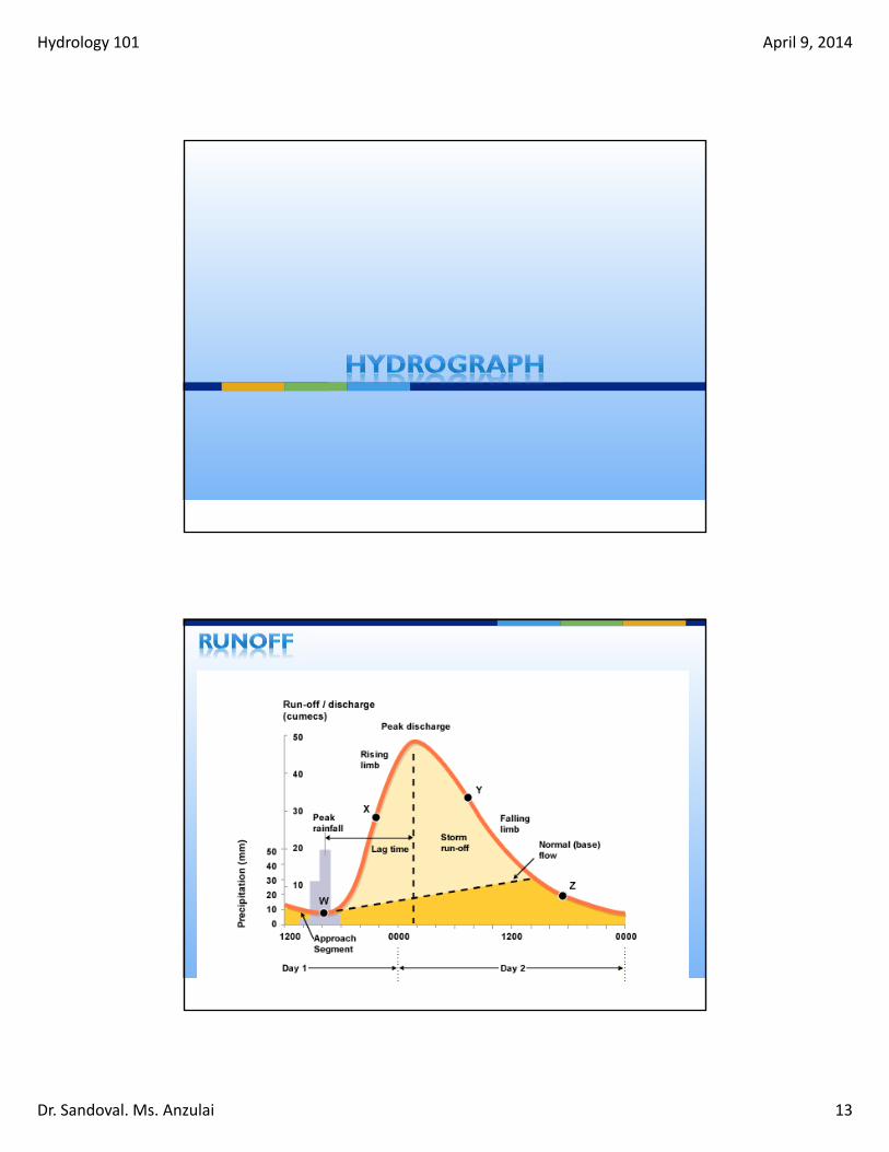
Dr. Sandoval. Ms. Anzulai 13
Hydrology 101 April 9, 2014
Dr. Sandoval. Ms. Anzulai 14
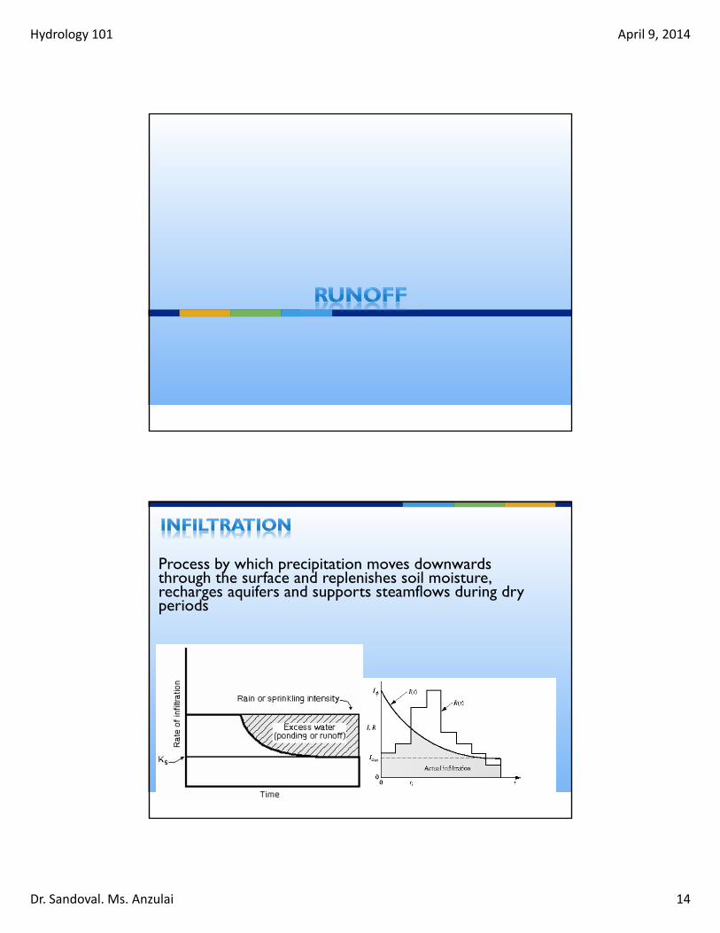
Process by which precipitation moves downwards through the surface and replenishes soil moisture, recharges aquifers and supports steamflows during dry periods

Hydrology 101 April 9, 2014
Dr. Sandoval. Ms. Anzulai 15
http://stream2.cma.gov.cn/pub/comet/HydrologyFlooding/RunoffProcessesInternationalEdition/comet/hydro/basic_int/runoff/print.htm#page_1.0.0

Hydrology 101 April 9, 2014
Dr. Sandoval. Ms. Anzulai 16
0
2
4
6
8
10
12
14
16
18
20
0.01 0.1 1 10 100 1000 10000 100000
Hei
ght
(fee
t)
Streamflow (cfs)
Rating Curve

Hydrology 101 April 9, 2014
Dr. Sandoval. Ms. Anzulai 17
Drainage Area (A) acresRunoff Coefficient (C) Intensity(i) in/hr
Q=C*i*A
* CA Department of Transportation (2008). “Highway Design Manual” Chapter 810 Hydrology<http://www.dot.ca.gov/hq/oppd/hdm/pdf/chp0810.pdf>

Hydrology 101 April 9, 2014
Dr. Sandoval. Ms. Anzulai 18

Hydrology 101 April 9, 2014
Dr. Sandoval. Ms. Anzulai 19
Groundwater = Water Completely filling Pores/Fractures

Hydrology 101 April 9, 2014
Dr. Sandoval. Ms. Anzulai 20
Saturated Zone
Unsaturated Zone
AKA Vadose zone (“Zone of aeration”) above the water table soil pores contain either
air or water

Hydrology 101 April 9, 2014
Dr. Sandoval. Ms. Anzulai 21
Aquifers: Water bearing properties; this is the “saturated zone”
Confined: Soil or rock below the land surface that is saturated with water. There are layers of impermeable material both above and below it and it is under pressure
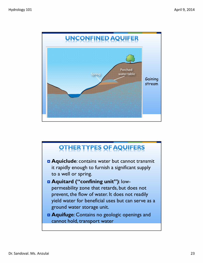
Unconfined: aquifer whose upper water surface (water table) is at atmospheric pressure, and thus is able to rise and fall

Hydrology 101 April 9, 2014
Dr. Sandoval. Ms. Anzulai 22
Losingstream
Hydrology 101 April 9, 2014
Dr. Sandoval. Ms. Anzulai 23
Gaining stream
Aquiclude: contains water but cannot transmit it rapidly enough to furnish a significant supply to a well or spring.
Aquitard (“confining unit”): low-permeability zone that retards, but does not prevent, the flow of water. It does not readily yield water for beneficial uses but can serve as a ground water storage unit.
Aquifuge: Contains no geologic openings and cannot hold, transport water

Hydrology 101 April 9, 2014
Dr. Sandoval. Ms. Anzulai 24
To be a good aquifer…1 - good porosity (space between grains)2 - good permeability (connection btwnpores)
Cross contamination concerns Subsurface contaminant transport
Hydrology 101 April 9, 2014
Dr. Sandoval. Ms. Anzulai 25
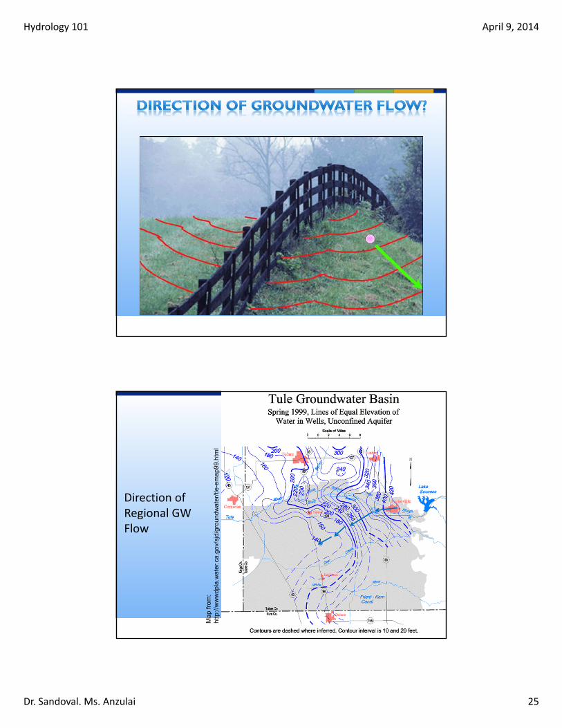
Direction of Regional GW Flow
Map
from
: ht
tp://
ww
wdp
la.w
ater
.ca.
gov/
sjd/
grou
ndw
ater
/tle-
emap
99.h
tml

Hydrology 101 April 9, 2014
Dr. Sandoval. Ms. Anzulai 26
GW flow velocity is proportional to the slope of the water table – steeper slope result in larger pressure difference between two points
Hydraulic conductivity – Corrects fro permeability difference between materials & viscosity of the solution
Volume of Water (Flow rate)
Cross-sectionalarea of flow
Hydraulic Conductivity
Vertical Drop
Flow Distance
300200
Unconfined Aquifer

Hydrology 101 April 9, 2014
Dr. Sandoval. Ms. Anzulai 27
from: U.S. Geological Survey, ‘Ground Water and the Rural Homeowner’

Hydrology 101 April 9, 2014
Dr. Sandoval. Ms. Anzulai 28
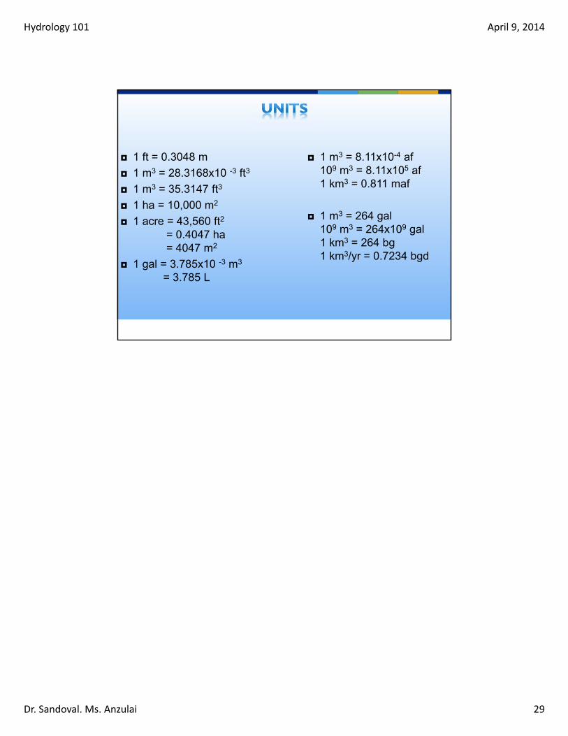
Hydrology 101 April 9, 2014
Dr. Sandoval. Ms. Anzulai 29
1 ft = 0.3048 m
1 m3 = 28.3168x10 -3 ft3
1 m3 = 35.3147 ft3
1 ha = 10,000 m2
1 acre = 43,560 ft2
= 0.4047 ha= 4047 m2
1 gal = 3.785x10 -3 m3
= 3.785 L
1 m3 = 8.11x10⁻⁴ af109 m3 = 8.11x10⁵ af1 km3 = 0.811 maf
1 m3 = 264 gal109 m3 = 264x109 gal1 km3 = 264 bg1 km3/yr = 0.7234 bgd