0.2% aep - wcma.vic.gov.au
TRANSCRIPT
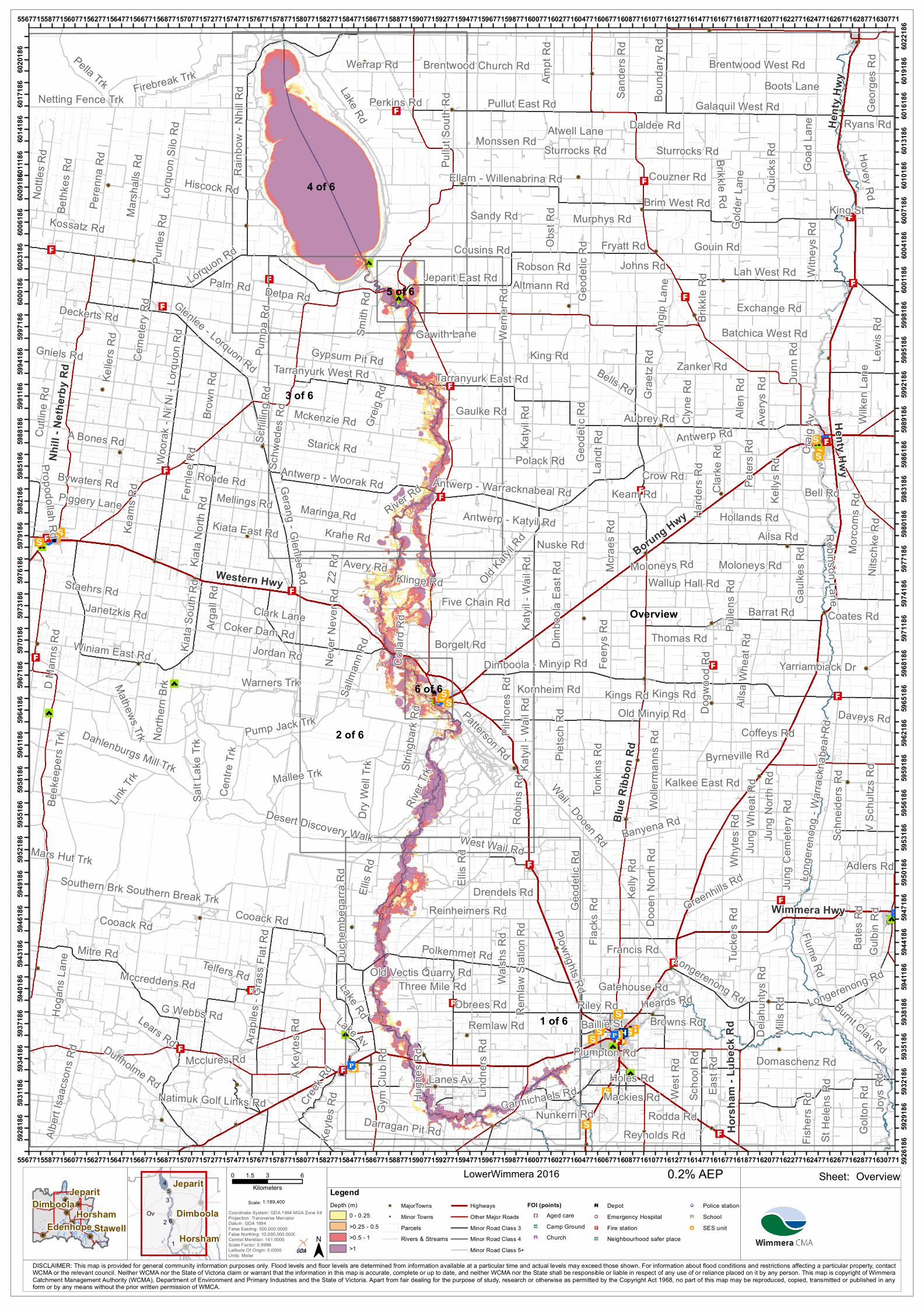
Overview
2 of 6
4 of 6
3 of 6
1 of 6
5 of 6
6 of 6
Lake Rd
Dogw
ood R
d
River Rd
Ailsa Rd
King Rd
Geod
etic R
d
Old Minyip Rd
Aubrey Rd
Barrat Rd
Obrees Rd
Coker Dam RdJordan Rd
Flack
s Rd Greenhills Rd
Wail - Dooen Rd Banyena Rd
Dimboola - Minyip Rd
Gaulk
es R
d
Brim West Rd
Sturrocks Rd
Polkemmet Rd
Lah West Rd
Rainb
ow - N
hill R
d
Starick Rd
Moloneys Rd
Dahlenburgs Mill Trk
Five Chain Rd
Sandy Rd
Ellis
RdOld K
atyil R
d
Lorquon Rd Gouin Rd
Remlaw Rd
Peren
na R
d
Jeparit East Rd
Mitre Rd
Antwerp Rd
Southern Brk
Antwerp - Woorak Rd
Galaquil West Rd
Dimbo
ola E
ast R
d
Cutlin
e Rd
Brikk
le Rd
Krahe Rd
Lindn
ers R
d
Cooack Rd
Wallup Hall Rd
Avery
s Rd
Kornheim Rd
Rohde RdWa
lshs R
d
Pella Trk
East
Rd
Quick
s Rd
River
Trk
Exchange RdZ2
Rd
Keam Rd
Borgelt Rd
Maringa Rd
Long
ereno
ng - W
arrac
knab
eal R
dPump Jack Trk
Pullut East Rd
Reinheimers Rd
Ampt
Rd
Gerang - Glenlee Rd
Werne
r Rd
Dry W
ell Tr
k
Daveys Rd
Kelly
Rd
Polack Rd
Goad
Lane
Brentwood West Rd
Dooe
n Nort
h Rd
Allen
Rd
Yarriambiack Dr
Lanes Av
Tonk
ins R
d
Jung
Nort
h RdKa
tyil -
Wail R
d
Grae
tz Rd
Scho
ol Rd
Zanker Rd
Firebreak Trk
Johns Rd
Three Mile Rd
Winiam East Rd
Lake Av
Greig
Rd
Monssen Rd
Jung
Cem
etery
Rd
Marsh
alls R
d
Antwerp - Katyil Rd
Ellam - Willenabrina RdSa
lt Lak
e Trk
Golto
n Rd
Brentwood Church RdWerrap Rd
Brow
n Rd
West Wail Rd
Drendels Rd
Kiata
North
Rd
Mathews Trk
Reml
aw S
tation
Rd
Kelle
rs Rd
Kalkee East Rd
Tarranyurk East Rd
Clyne
Rd
Detpa Rd
Bywaters Rd
Katyi
l Rd
Antwerp - Warracknabeal Rd
Ailsa
Whe
at Rd
Lewis
Rd
Plowrights Rd
Sand
ers R
d
Mckenzie Rd
Murphys Rd
Fryatt Rd
Colla
rd Rd
Centr
e Trk
Pulle
ns R
d
Palm Rd
West
Rd
Batchica West Rd
Burnt Clay Rd
Kiata
South
Rd
Domaschenz Rd
Hollands Rd
Patterson Rd
Lorqu
on S
ilo R
d Daldee Rd
Whyte
s Rd
Gypsum Pit RdPump
a Rd
Nottle
s Rd
Boun
dary
Rd
Hiscock Rd
Netting Fence Trk Georg
es R
d
Bells Rd
Feery
s Rd
Keyte
s Rd
Bates
Rd
Duffholme Rd
Arap
iles -
Gras
s Flat
Rd
Creek R
d
Warners Trk
St He
lens R
d
Tuck
ers R
d
Gaulke Rd
Robson Rd
Delah
untys
Rd
Mellings Rd
Desert Discovery Walk
Kiata East RdOb
st Rd
Kelly
s Rd
Flume Rd
Southern Break Trk
Land
t Rd
Thomas Rd
Francis Rd
Fishe
rs Rd
Glenlee - Lorquon Rd
Couzner Rd
Ryans Rd
Pilmo
res R
d
Link T
rk Mallee Trk
Duch
embe
garra
Rd
Browns Rd
Byrneville Rd
Mackies Rd
Altmann Rd
Witne
ys R
d
Clarke
Rd
North
ern B
rk
Mcrae
s Rd
Nuske Rd
Woora
k - N
i Ni -
Lorqu
on R
d
Arga
ll Rd
Jung
Whe
at Rd
Avery Rd
Robin
s Rd
Schw
edes
Rd
Wilke
n Lan
e
Cousins Rd
Adlers Rd
Perkins Rd
Fernl
ee R
d
Janetzkis Rd
Bethk
es R
d
V Sch
ultzs
Rd
Purtle
s Rd
Reynolds RdDarragan Pit Rd
A Bones Rd
Crow Rd
Boots Lane
Dunn
Rd
Bell Rd
Longerenong Rd
Nitsc
hke R
d
Albert
Isaa
cson
s Rd
Mcclures Rd
Mills
Rd
Angip
Lane
Natimuk Golf Links Rd
Deckerts Rd
Klinge Rd
Gulbi
n Rd
Gym
Club
Rd
Kossatz Rd
Smith
Rd
Piggery Lane
Rodda Rd
Golde
r Lan
e
Kings Rd
Riley Rd
Nunkerri Rd
Mccreddens Rd
Schn
eiders
Rd
Gniels Rd
Robinson Lane
Morco
ms R
d
Carmichaels Rd
Lears Rd
Beek
eepe
rs Trk
Old Vectis Quarry Rd
Ceme
tery R
d
Propodollah Rd
Sallm
ann R
d
Coffeys Rd
Harde
rs Rd
Heards Rd
Joys
Rd
Atwell Lane
A Key
tes R
d
Holes Rd
Telfers Rd
Keam
s Rd
Tarranyurk West Rd
Pietsc
h Rd
Coates Rd
Neve
r Nev
er Rd
Pullu
t Sou
th Rd
Wolle
rman
ns R
d
D Ma
nns R
d
Gatehouse Rd
Gawith Lane
Craig
Av
King St
Schil
ling R
d
Plumpton Rd
Hugh
es R
d
Hovey Rd
G Webbs Rd
Staehrs Rd
String
bark
Rd
Mars Hut Trk
Hoga
ns La
ne
Clark Lane
Peter
s Rd
Baillie St
Sturrocks Rd
Geod
etic R
d
Brikkle Rd
Moloneys Rd
Ellis
Rd
Lake Rd
Katyi
l - Wa
il Rd
Geod
etic R
d
Cooack Rd
Kings Rd
Longerenong Rd
Henty Hwy
Western Hwy
Borung Hwy
Blue
Ribb
on R
d
Nhill
- Neth
erby R
d
Wimmera Hwy
Hors
ham
- Lub
eck R
d
Hent
y Hwy
556771
556771
558771
558771
560771
560771
562771
562771
564771
564771
566771
566771
568771
568771
570771
570771
572771
572771
574771
574771
576771
576771
578771
578771
580771
580771
582771
582771
584771
584771
586771
586771
588771
588771
590771
590771
592771
592771
594771
594771
596771
596771
598771
598771
600771
600771
602771
602771
604771
604771
606771
606771
608771
608771
610771
610771
612771
612771
614771
614771
616771
616771
618771
618771
620771
620771
622771
622771
624771
624771
626771
626771
628771
628771
630771
630771 5926
18659
2818
6
5929
18659
3118
6
5932
18659
3418
6
5935
18659
3718
6
5938
18659
4018
6
5941
18659
4318
6
5944
18659
4618
6
5947
18659
4918
6
5950
18659
5218
6
5953
18659
5518
6
5956
18659
5818
6
5959
18659
6118
6
5962
18659
6418
6
5965
18659
6718
6
5968
18659
7018
6
5971
18659
7318
6
5974
18659
7618
6
5977
18659
7918
6
5980
18659
8218
6
5983
18659
8518
6
5986
18659
8818
6
5989
18659
9118
6
5992
18659
9418
6
5995
18659
9718
6
5998
18660
0018
6
6001
18660
0318
6
6004
18660
0618
6
6007
18660
0918
6
6010
186
6011
186 60
1318
6
6014
186 60
1618
6
6017
186 60
1918
6
6020
186 60
2218
6
OverviewLowerWimmera 2016
1:189,400Scale:
!!
!!
!!!!
!!
!!Stawell
Horsham
JeparitDimboola
EdenhopeCoordinate System: GDA 1994 MGA Zone 54Projection: Transverse MercatorDatum: GDA 1994False Easting: 500,000.0000False Northing: 10,000,000.0000Central Meridian: 141.0000Scale Factor: 0.9996Latitude Of Origin: 0.0000Units: Meter
0 3 61.5Kilometers
Ov2
4
1
3 5
6
Horsham
Jeparit
Dimboola
DISCLAIMER: This map is provided for general community information purposes only. Flood levels and floor levels are determined from information available at a particular time and actual levels may exceed those shown. For information about flood conditions and restrictions affecting a particular property, contactWCMA or the relevant council. Neither WCMA nor the State of Victoria claim or warrant that the information in this map is accurate, complete or up to date, and neither WCMA nor the State shall be responsible or liable in respect of any use of or reliance placed on it by any person. This map is copyright of WimmeraCatchment Management Authority (WCMA), Department of Environment and Primary Industries and the State of Victoria. Apart from fair dealing for the purpose of study, research or otherwise as permitted by the Copyright Act 1968, no part of this map may be reproduced, copied, transmitted or published in anyform or by any means without the prior written permission of WMCA.
Sheet:0.2% AEPLegendDepth (m)
0 - 0.25>0.25 - 0.5>0.5 - 1>1
!! MajorTowns!! Minor Towns
ParcelsRivers & Streams
HighwaysOther Major RoadsMinor Road Class 3Minor Road Class 4Minor Road Class 5+
FOI (points)"³#) Aged carenq Camp Ground"̄Ë Church
®n Depot!& Emergency Hospital"< Fire stationm̄ Neighbourhood safer place
!P Police stationÚ¹ Schoolcc SES unit
Obrees Rd
Polkemmet Rd
Lindn
ers R
d
Remlaw Rd
Walsh
s Rd
Ellis
Rd
Reinheimers Rd
Lanes Av
Three Mile Rd
West Wail Rd
Drendels Rd
Rudolphs Rd
Reml
aw S
tation
Rd
Lake Rd
Wail - Polke
mmet Rd
Plowrights RdDahlen Quarry Rd
Quan
tong C
emete
ry Rd
Vecti
s Stat
ion R
d
Boehms Rd
Quantong - Polkemmet Rd
Banyena Rd
Bakers Rd
Aspli
ns R
d
Nattra
ss R
d
Pimpinio West RdGy
m Cl
ub R
d
Darragan Pit Rd
Carmichaels Rd
Three Bridges Rd
Court
neys
Rd
Oconnors Rd
Pelch
ens R
d
Old Vectis Quarry Rd
Tuck
ers R
d
Nunkerri Rd
Sand
ers R
d
Charcoal Flat Trk
Frew
Rd
Rules West Rd
Moody School Rd
Pelchen Av
South
ern B
rk
Hobbs Rd
Lights
Lane
Hutch
inson
s Rd
Jost AvBrowns Rd
Jenkinsons Rd
Barrs
Rd
Hateleys Rd
Eltze Dr
Hugh
es R
d
Lake Av
K Sudholzs Rd
Ivess
Rd
Mackleys RdBlo
cks R
d
J Sudholzs Rd
Meyers Rd
Mans
on R
dLig
num
Lane
Keati
ngs R
d
Mervy
n Rd
Polke
mmet
East
Scho
ol Rd
Desert Discovery Walk
Fishe
r St
Hateley Rd
Jory St
Netherway Dr
Ball R
d
Munro
Rd
Miller St
Stran
ge R
d
Natimuk East Rd
Old Duchembegarra School Rd
Robertson Av
Samp
sons
Rd
Gitshams Lane Three Mile Rd
Walsh
s Rd
Tuck
ers R
d
Southern Brk
Ellis RdEllis Rd
Wimmera Hwy
Weste
rn H
wy
Horsham - Noradjuha Rd
584066
584066
585066
585066
586066
586066
587066
587066
588066
588066
589066
589066
590066
590066
591066
591066
592066
592066
593066
593066
594066
594066
595066
595066
596066
596066
597066
597066
598066
598066
599066
599066
600066
600066
601066
601066
602066
602066
603066
603066
604066
604066 5927
130
5928
130
5928
130
5929
130
5929
130
5930
130
5930
130
5931
130
5931
130
5932
130
5932
130
5933
130
5933
130
5934
130
5934
130
5935
130
5935
130
5936
130
5936
130
5937
130
5937
130
5938
130
5938
130
5939
130
5939
130
5940
130
5940
130
5941
130
5941
130
5942
130
5942
130
5943
130
5943
130
5944
130
5944
130
5945
130
5945
130
5946
130
5946
130
5947
130
5947
130
5948
130
5948
130
5949
130
5949
130
5950
130
5950
130
5951
130
5951
130
5952
130
5952
130
5953
130
5953
130
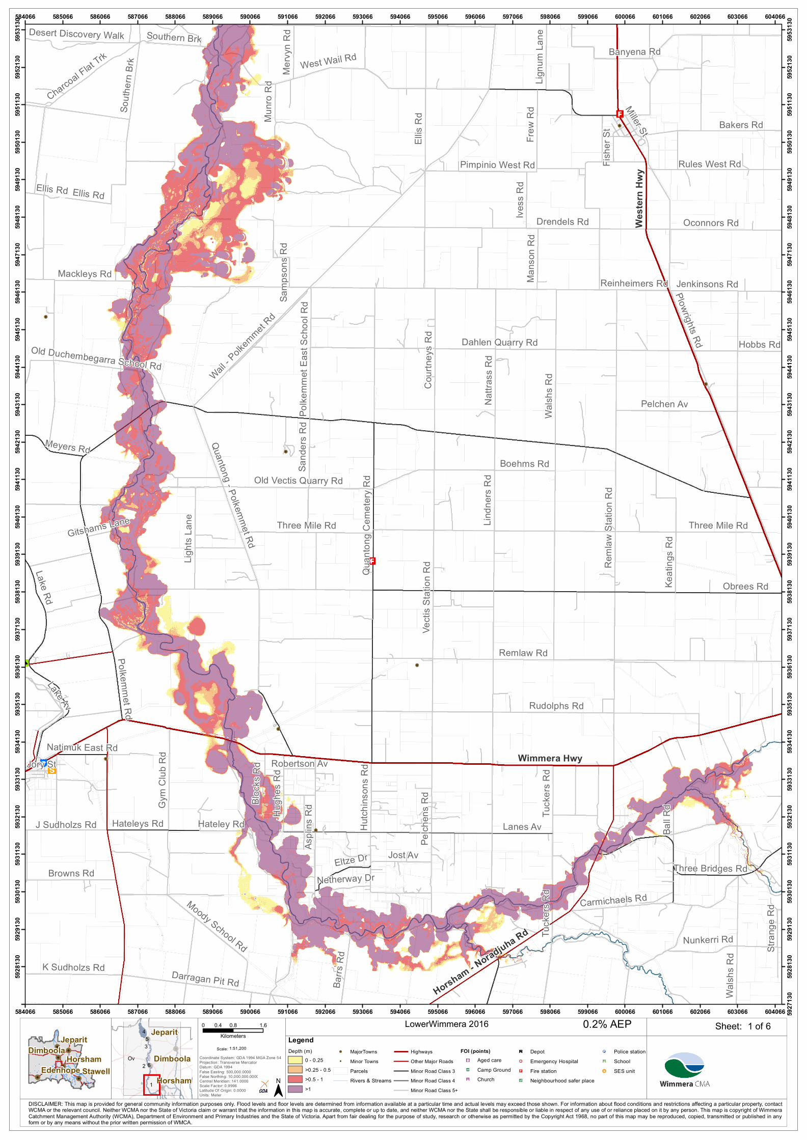
1 of 6LowerWimmera 2016
1:51,200Scale:
!!
!!
!!!!
!!
!!Stawell
Horsham
JeparitDimboola
EdenhopeCoordinate System: GDA 1994 MGA Zone 54Projection: Transverse MercatorDatum: GDA 1994False Easting: 500,000.0000False Northing: 10,000,000.0000Central Meridian: 141.0000Scale Factor: 0.9996Latitude Of Origin: 0.0000Units: Meter
0 0.8 1.60.4Kilometers
Ov2
4
1
3 5
6
Horsham
Jeparit
Dimboola
DISCLAIMER: This map is provided for general community information purposes only. Flood levels and floor levels are determined from information available at a particular time and actual levels may exceed those shown. For information about flood conditions and restrictions affecting a particular property, contactWCMA or the relevant council. Neither WCMA nor the State of Victoria claim or warrant that the information in this map is accurate, complete or up to date, and neither WCMA nor the State shall be responsible or liable in respect of any use of or reliance placed on it by any person. This map is copyright of WimmeraCatchment Management Authority (WCMA), Department of Environment and Primary Industries and the State of Victoria. Apart from fair dealing for the purpose of study, research or otherwise as permitted by the Copyright Act 1968, no part of this map may be reproduced, copied, transmitted or published in anyform or by any means without the prior written permission of WMCA.
Sheet:0.2% AEPLegendDepth (m)
0 - 0.25>0.25 - 0.5>0.5 - 1>1
!! MajorTowns!! Minor Towns
ParcelsRivers & Streams
HighwaysOther Major RoadsMinor Road Class 3Minor Road Class 4Minor Road Class 5+
FOI (points)"³#) Aged carenq Camp Ground"̄Ë Church
®n Depot!& Emergency Hospital"< Fire stationm̄ Neighbourhood safer place
!P Police stationÚ¹ Schoolcc SES unit
Old K
atyil R
d
Five Chain Rd
River
Trk
River
Rd
Borgelt Rd
Dry W
ell Tr
k
Katyi
l - Wa
il Rd
Z2 R
d
Mccabes Hut Trk
Collard Rd
Jensz Rd
Jordan Rd
Coker Dam Rd Thom
sons
Rd
Nursery Rd
Arkona - Katyil Rd
Pilmo
res R
d
Lil Lil
Dam Rd
Avery Rd
Robins Rd
Kornheim Rd
Eagle
Swa
mp Tr
k
Desert Discovery Walk
North
ern B
rk
Hinnebergs Rd
Ellis
Rd
Riggs Rd
Wail -
Polk
emme
t Rd
Charcoa
l Flat Trk
Klinge Rd
Old Racecourse Rd
Breta
g Rd
Pump Jack Trk
Dimbo
ola N
orth R
dBottlebrush Trk
Albrecht Rd
Hartw
ig Rd
Barbers Rd
Ellerman St
Old Minyip Rd
Sallm
ann Rd
Plantation Trk
Neve
r Nev
er Rd
One Tree Hill Trk
Dimboola - Minyip Rd
Wail Nursery Rd
Barry
Rd
Glatz Rd
Faith St
West Wail Rd
String
bark
Rd
Pine Av
Gierke Rd
Lawson
Rd
Warne
r Rd
Ey Rd
Golf C
ourse
Rd
Bothe Rd
Mervy
n Rd
Petschels Rd
Hutchinsons Rd
Conn Rd
Riverside
Lignu
m La
ne
Church St
Pomponderoo Hill Rd
Horseshoe Bend Rd
Bushby LaneHowland Rd
Anderson St
Liddle Lane
Katyi
l - Wa
il Rd
Pine Av
Desert Discovery Walk
Howland Rd
Weste
rn H
wy
Borung Hwy
Dimb
oola
- Rain
bow
Rd
High St
Horsham Rd
580130
580130
581130
581130
582130
582130
583130
583130
584130
584130
585130
585130
586130
586130
587130
587130
588130
588130
589130
589130
590130
590130
591130
591130
592130
592130
593130
593130
594130
594130
595130
595130
596130
596130
597130
597130
598130
598130
599130
599130
600130
600130 5951
779
5952
779
5952
779
5953
779
5953
779
5954
779
5954
779
5955
779
5955
779
5956
779
5956
779
5957
779
5957
779
5958
779
5958
779
5959
779
5959
779
5960
779
5960
779
5961
779
5961
779
5962
779
5962
779
5963
779
5963
779
5964
779
5964
779
5965
779
5965
779
5966
779
5966
779
5967
779
5967
779
5968
779
5968
779
5969
779
5969
779
5970
779
5970
779
5971
779
5971
779
5972
779
5972
779
5973
779
5973
779
5974
779
5974
779
5975
779
5975
779
5976
779
5976
779
5977
779
5977
779
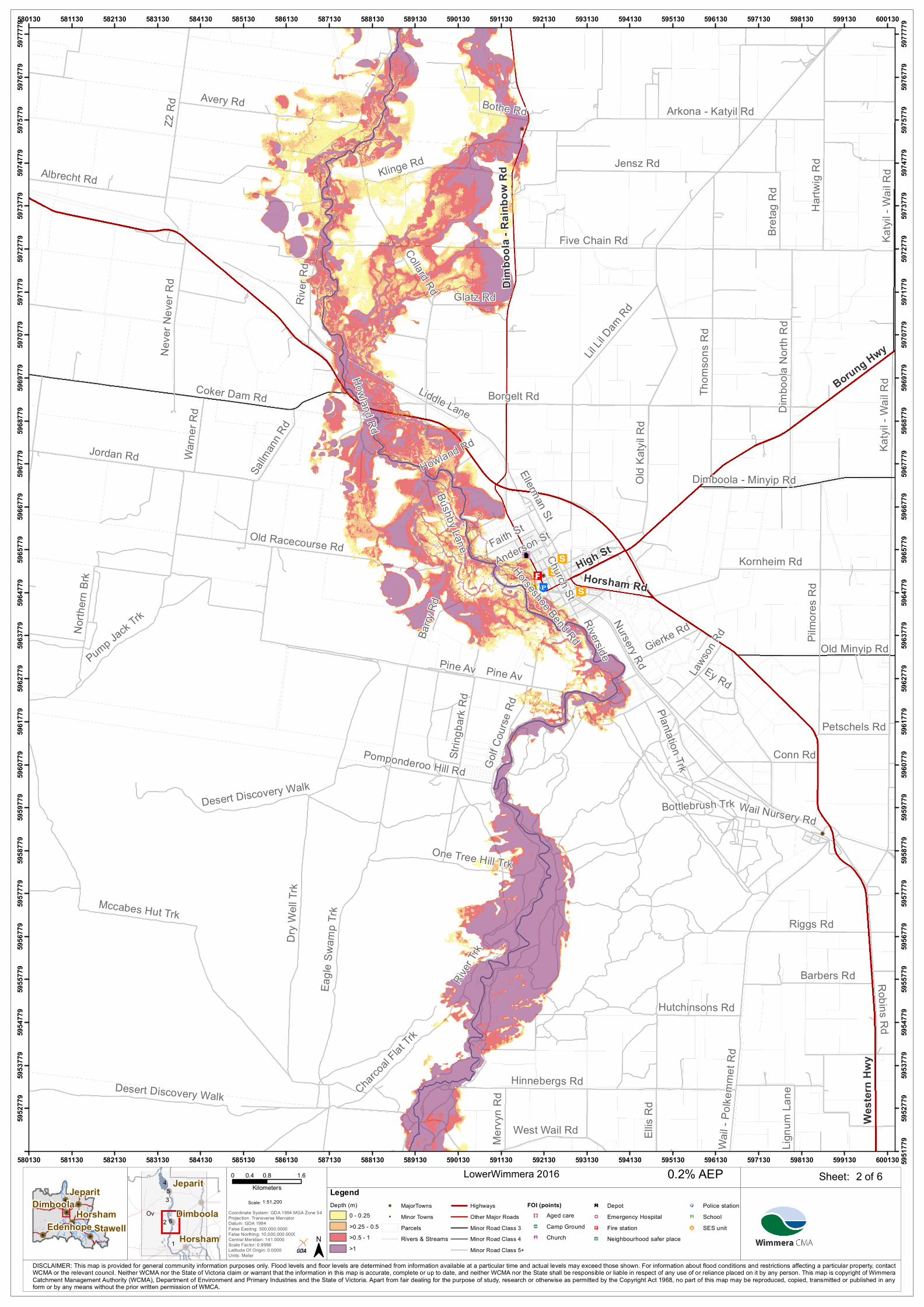
2 of 6LowerWimmera 2016
1:51,200Scale:
!!
!!
!!!!
!!
!!Stawell
Horsham
JeparitDimboola
EdenhopeCoordinate System: GDA 1994 MGA Zone 54Projection: Transverse MercatorDatum: GDA 1994False Easting: 500,000.0000False Northing: 10,000,000.0000Central Meridian: 141.0000Scale Factor: 0.9996Latitude Of Origin: 0.0000Units: Meter
0 0.8 1.60.4Kilometers
Ov2
4
1
3 5
6
Horsham
Jeparit
Dimboola
DISCLAIMER: This map is provided for general community information purposes only. Flood levels and floor levels are determined from information available at a particular time and actual levels may exceed those shown. For information about flood conditions and restrictions affecting a particular property, contactWCMA or the relevant council. Neither WCMA nor the State of Victoria claim or warrant that the information in this map is accurate, complete or up to date, and neither WCMA nor the State shall be responsible or liable in respect of any use of or reliance placed on it by any person. This map is copyright of WimmeraCatchment Management Authority (WCMA), Department of Environment and Primary Industries and the State of Victoria. Apart from fair dealing for the purpose of study, research or otherwise as permitted by the Copyright Act 1968, no part of this map may be reproduced, copied, transmitted or published in anyform or by any means without the prior written permission of WMCA.
Sheet:0.2% AEPLegendDepth (m)
0 - 0.25>0.25 - 0.5>0.5 - 1>1
!! MajorTowns!! Minor Towns
ParcelsRivers & Streams
HighwaysOther Major RoadsMinor Road Class 3Minor Road Class 4Minor Road Class 5+
FOI (points)"³#) Aged carenq Camp Ground"̄Ë Church
®n Depot!& Emergency Hospital"< Fire stationm̄ Neighbourhood safer place
!P Police stationÚ¹ Schoolcc SES unit
River Rd
Starick Rd
Krahe Rd
Maringa Rd
Greig
Rd
Antwerp - Woorak Rd
Tully
vea C
hurch
Rd
King Rd
Mckenzie Rd
Lorquon Rd
Gypsum Pit Rd
Schu
lz Rd
Schw
edes
Rd
Gaulke Rd
Mille
r Rd
Gerang - Glenlee Rd
Lake Rd
Detpa Rd
Tullyvea Bus Route Rd
Antwerp - Katyil Rd
Smith
Rd
Kelm
Rd
Flavel Rd Smiths Quarry Rd
Tarranyurk East Rd
Kellers Rd
Tarranyurk West Rd
Z2 R
d
Robertsons Rd
Gawith Lane
Perki
ns La
ne
Antwerp - Warracknabeal Rd
Horsedip Rd
Wage
nkne
cht R
d
Spears Crossing Rd
Pearc
es D
am R
dBin
ns R
d
Mill St
Kiata East Rd
Four
Mile
Beac
h Rd
Tarranyurk West RdNhill
- Jep
arit R
d
Jeparit - Warracknabeal Rd
577437
577437
578437
578437
579437
579437
580437
580437
581437
581437
582437
582437
583437
583437
584437
584437
585437
585437
586437
586437
587437
587437
588437
588437
589437
589437
590437
590437
591437
591437
592437
592437
593437
593437
594437
594437
595437
595437
596437
596437
597437
597437 5977
153
5978
153
5978
153
5979
153
5979
153
5980
153
5980
153
5981
153
5981
153
5982
153
5982
153
5983
153
5983
153
5984
153
5984
153
5985
153
5985
153
5986
153
5986
153
5987
153
5987
153
5988
153
5988
153
5989
153
5989
153
5990
153
5990
153
5991
153
5991
153
5992
153
5992
153
5993
153
5993
153
5994
153
5994
153
5995
153
5995
153
5996
153
5996
153
5997
153
5997
153
5998
153
5998
153
5999
153
5999
153
6000
153
6000
153
6001
153
6001
153
6002
153
6002
153
6003
153
6003
153
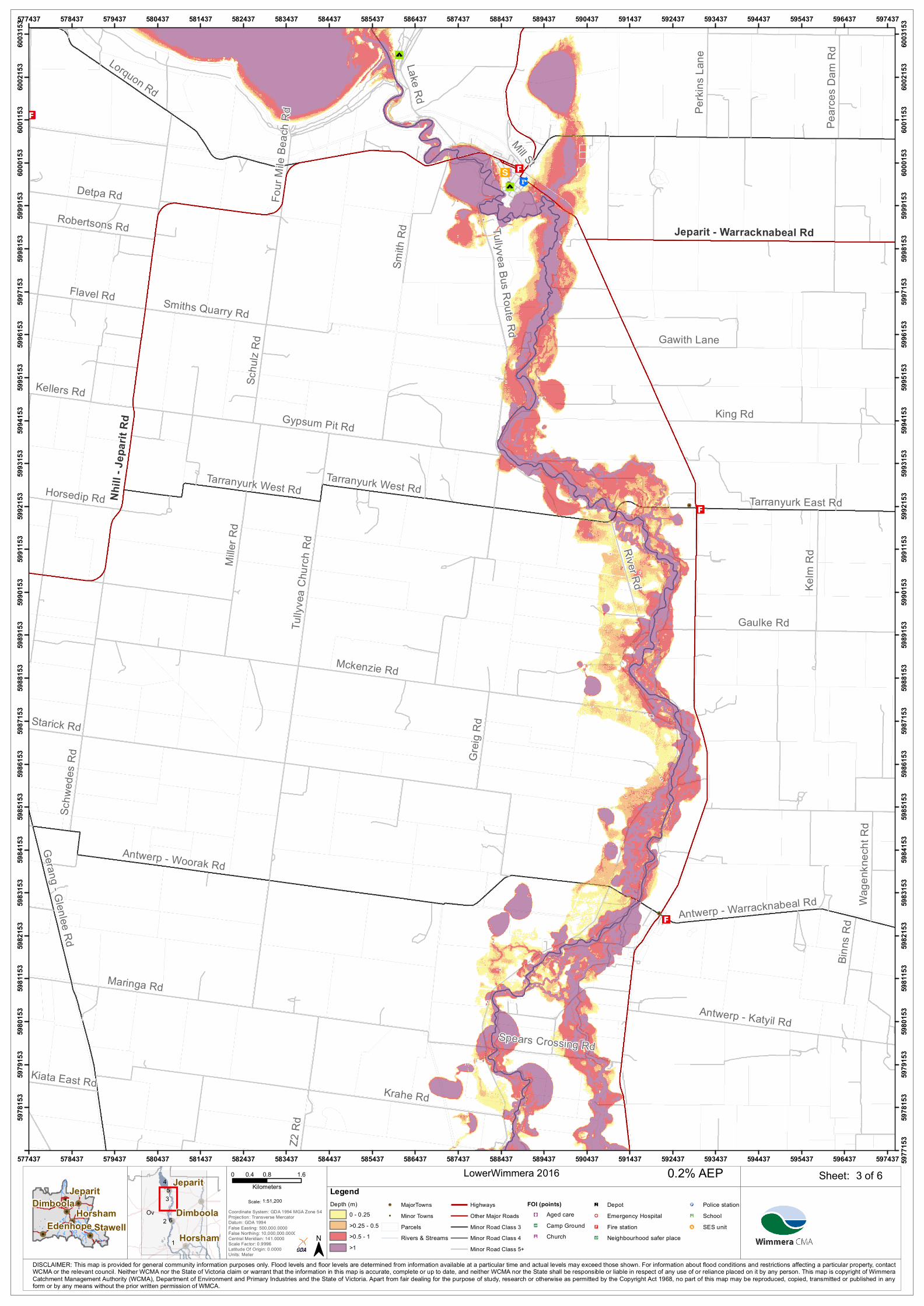
3 of 6LowerWimmera 2016
1:51,200Scale:
!!
!!
!!!!
!!
!!Stawell
Horsham
JeparitDimboola
EdenhopeCoordinate System: GDA 1994 MGA Zone 54Projection: Transverse MercatorDatum: GDA 1994False Easting: 500,000.0000False Northing: 10,000,000.0000Central Meridian: 141.0000Scale Factor: 0.9996Latitude Of Origin: 0.0000Units: Meter
0 0.8 1.60.4Kilometers
Ov2
4
1
3 5
6
Horsham
Jeparit
Dimboola
DISCLAIMER: This map is provided for general community information purposes only. Flood levels and floor levels are determined from information available at a particular time and actual levels may exceed those shown. For information about flood conditions and restrictions affecting a particular property, contactWCMA or the relevant council. Neither WCMA nor the State of Victoria claim or warrant that the information in this map is accurate, complete or up to date, and neither WCMA nor the State shall be responsible or liable in respect of any use of or reliance placed on it by any person. This map is copyright of WimmeraCatchment Management Authority (WCMA), Department of Environment and Primary Industries and the State of Victoria. Apart from fair dealing for the purpose of study, research or otherwise as permitted by the Copyright Act 1968, no part of this map may be reproduced, copied, transmitted or published in anyform or by any means without the prior written permission of WMCA.
Sheet:0.2% AEPLegendDepth (m)
0 - 0.25>0.25 - 0.5>0.5 - 1>1
!! MajorTowns!! Minor Towns
ParcelsRivers & Streams
HighwaysOther Major RoadsMinor Road Class 3Minor Road Class 4Minor Road Class 5+
FOI (points)"³#) Aged carenq Camp Ground"̄Ë Church
®n Depot!& Emergency Hospital"< Fire stationm̄ Neighbourhood safer place
!P Police stationÚ¹ Schoolcc SES unit
Lake Rd
Rainb
ow - N
hill R
d
Lorquon Rd
Werrap Rd
Detpa Rd
Three Chain Rd
Flavel Rd
Miatke Rd
Perkins Rd
Liesfield Rd
Perki
ns La
ne
Dunn
Rd
Jeparit East Rd
Sleep
Rd
Sandy Rd
Smith
Rd
Schu
lz RdDe
tpa - G
lenlee
Rd
Pullut West Rd
Pullu
t Sou
th Rd
Brentwood Church Rd
Robertsons Rd
Pump
a Rd
Palm Rd
Fires
hed R
d
Tullyvea Bus Route Rd
Pioneer Rd
Mill St
Amy J
ohns
on R
d
Schulzes Beach Rd
Four
Mile
Beac
h Rd
Sleep
Rd
Dimboola - Rainbow Rd
Nhill - Jeparit Rd
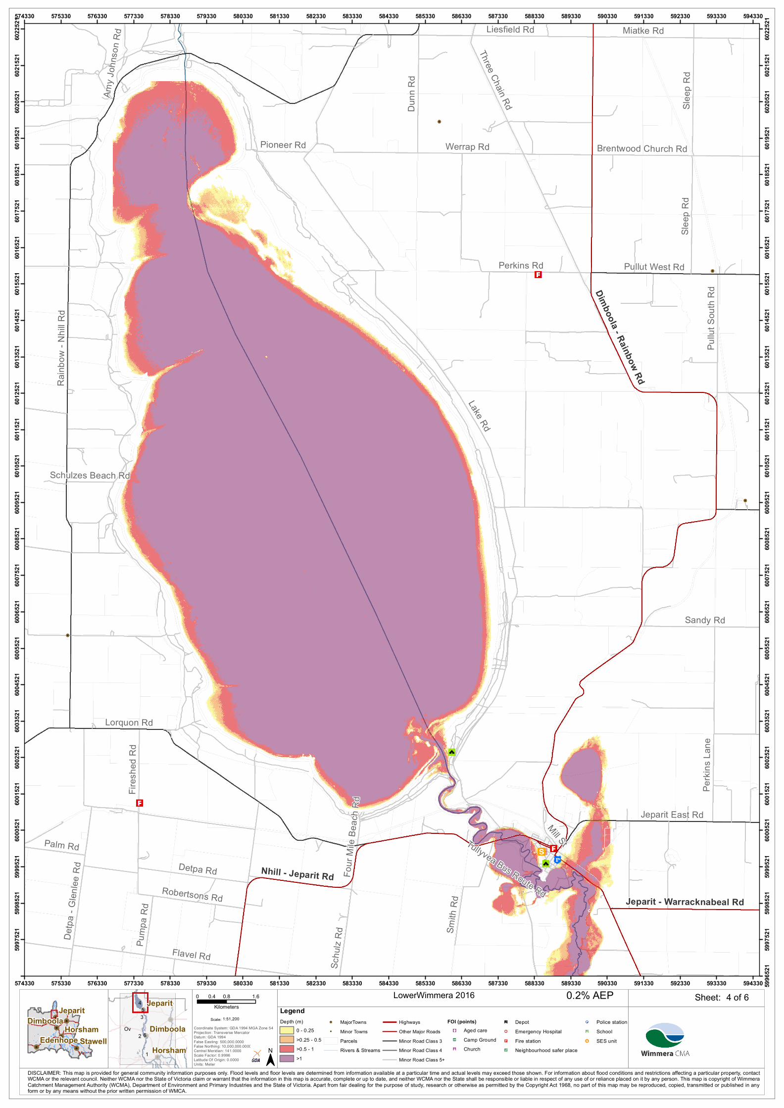
Jeparit - Warracknabeal Rd
574330
574330
575330
575330
576330
576330
577330
577330
578330
578330
579330
579330
580330
580330
581330
581330
582330
582330
583330
583330
584330
584330
585330
585330
586330
586330
587330
587330
588330
588330
589330
589330
590330
590330
591330
591330
592330
592330
593330
593330
594330
594330 5996
521
5997
521
5997
521
5998
521
5998
521
5999
521
5999
521
6000
521
6000
521
6001
521
6001
521
6002
521
6002
521
6003
521
6003
521
6004
521
6004
521
6005
521
6005
521
6006
521
6006
521
6007
521
6007
521
6008
521
6008
521
6009
521
6009
521
6010
521
6010
521
6011
521
6011
521
6012
521
6012
521
6013
521
6013
521
6014
521
6014
521
6015
521
6015
521
6016
521
6016
521
6017
521
6017
521
6018
521
6018
521
6019
521
6019
521
6020
521
6020
521
6021
521
6021
521
6022
521
6022
521
4 of 6LowerWimmera 2016
1:51,200Scale:
!!
!!
!!!!
!!
!!Stawell
Horsham
JeparitDimboola
EdenhopeCoordinate System: GDA 1994 MGA Zone 54Projection: Transverse MercatorDatum: GDA 1994False Easting: 500,000.0000False Northing: 10,000,000.0000Central Meridian: 141.0000Scale Factor: 0.9996Latitude Of Origin: 0.0000Units: Meter
0 0.8 1.60.4Kilometers
Ov2
4
1
3 5
6
Horsham
Jeparit
Dimboola
DISCLAIMER: This map is provided for general community information purposes only. Flood levels and floor levels are determined from information available at a particular time and actual levels may exceed those shown. For information about flood conditions and restrictions affecting a particular property, contactWCMA or the relevant council. Neither WCMA nor the State of Victoria claim or warrant that the information in this map is accurate, complete or up to date, and neither WCMA nor the State shall be responsible or liable in respect of any use of or reliance placed on it by any person. This map is copyright of WimmeraCatchment Management Authority (WCMA), Department of Environment and Primary Industries and the State of Victoria. Apart from fair dealing for the purpose of study, research or otherwise as permitted by the Copyright Act 1968, no part of this map may be reproduced, copied, transmitted or published in anyform or by any means without the prior written permission of WMCA.
Sheet:0.2% AEPLegendDepth (m)
0 - 0.25>0.25 - 0.5>0.5 - 1>1
!! MajorTowns!! Minor Towns
ParcelsRivers & Streams
HighwaysOther Major RoadsMinor Road Class 3Minor Road Class 4Minor Road Class 5+
FOI (points)"³#) Aged carenq Camp Ground"̄Ë Church
®n Depot!& Emergency Hospital"< Fire stationm̄ Neighbourhood safer place
!P Police stationÚ¹ Schoolcc SES unit
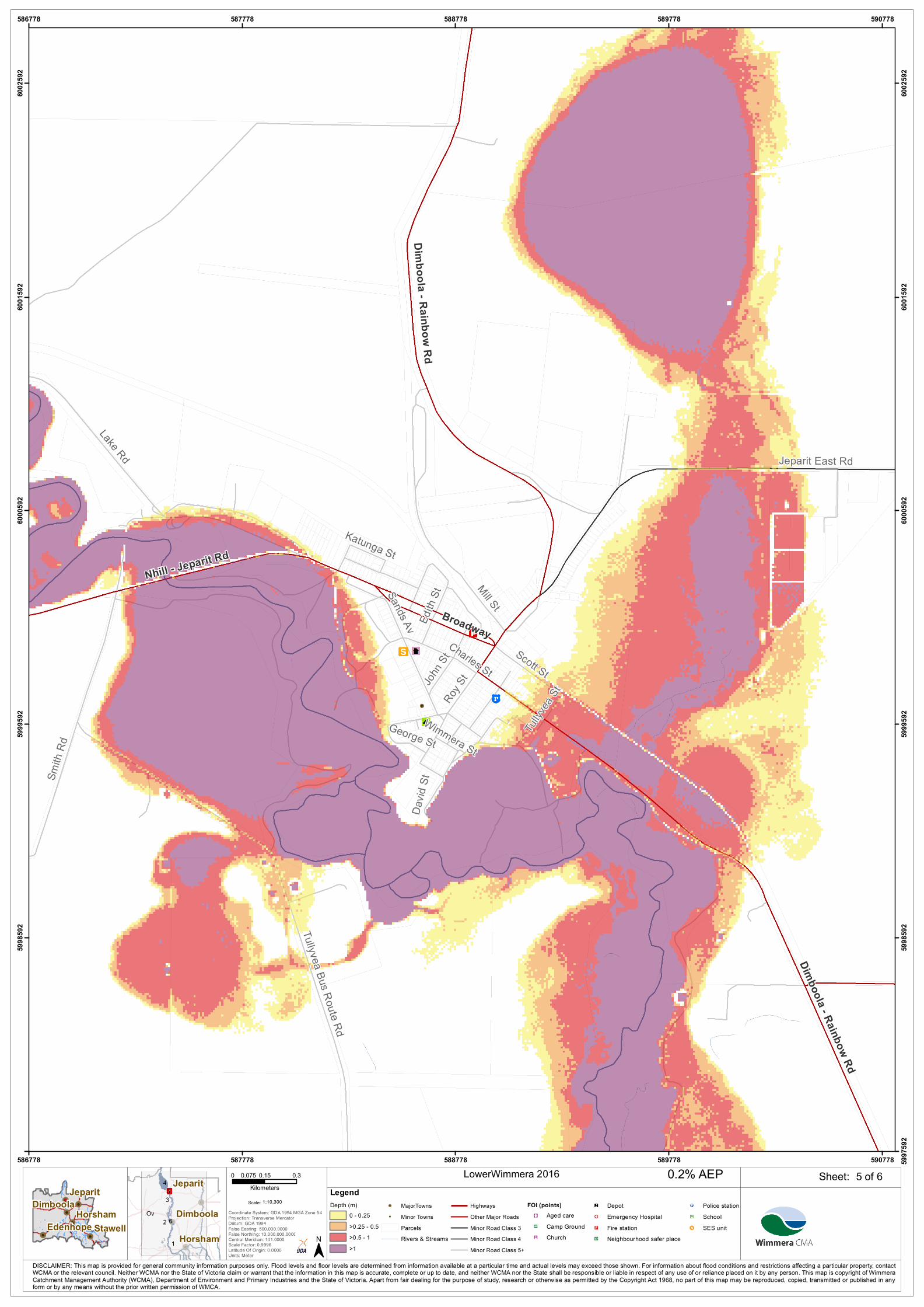
Lake Rd
Smith
Rd
Mill St
Jeparit East Rd
Tullyvea Bus Route Rd
Sands Av
Scott StJohn S
t
Charles St
Edith
StRoy
St
David
St
George St
Tullyv
ea St
Katunga St
Wimmera St
Dimboola - Rainbow Rd
Nhill - Jeparit Rd
Broadway
Dimboola - Rainbow Rd
586778
586778
587778
587778
588778
588778
589778
589778
590778
590778 5997
592
5998
592
5998
592
5999
592
5999
592
6000
592
6000
592
6001
592
6001
592
6002
592
6002
592
5 of 6LowerWimmera 2016
1:10,300Scale:
!!
!!
!!!!
!!
!!Stawell
Horsham
JeparitDimboola
EdenhopeCoordinate System: GDA 1994 MGA Zone 54Projection: Transverse MercatorDatum: GDA 1994False Easting: 500,000.0000False Northing: 10,000,000.0000Central Meridian: 141.0000Scale Factor: 0.9996Latitude Of Origin: 0.0000Units: Meter
0 0.15 0.30.075Kilometers
Ov2
4
1
3 5
6
Horsham
Jeparit
Dimboola
DISCLAIMER: This map is provided for general community information purposes only. Flood levels and floor levels are determined from information available at a particular time and actual levels may exceed those shown. For information about flood conditions and restrictions affecting a particular property, contactWCMA or the relevant council. Neither WCMA nor the State of Victoria claim or warrant that the information in this map is accurate, complete or up to date, and neither WCMA nor the State shall be responsible or liable in respect of any use of or reliance placed on it by any person. This map is copyright of WimmeraCatchment Management Authority (WCMA), Department of Environment and Primary Industries and the State of Victoria. Apart from fair dealing for the purpose of study, research or otherwise as permitted by the Copyright Act 1968, no part of this map may be reproduced, copied, transmitted or published in anyform or by any means without the prior written permission of WMCA.
Sheet:0.2% AEPLegendDepth (m)
0 - 0.25>0.25 - 0.5>0.5 - 1>1
!! MajorTowns!! Minor Towns
ParcelsRivers & Streams
HighwaysOther Major RoadsMinor Road Class 3Minor Road Class 4Minor Road Class 5+
FOI (points)"³#) Aged carenq Camp Ground"̄Ë Church
®n Depot!& Emergency Hospital"< Fire stationm̄ Neighbourhood safer place
!P Police stationÚ¹ Schoolcc SES unit
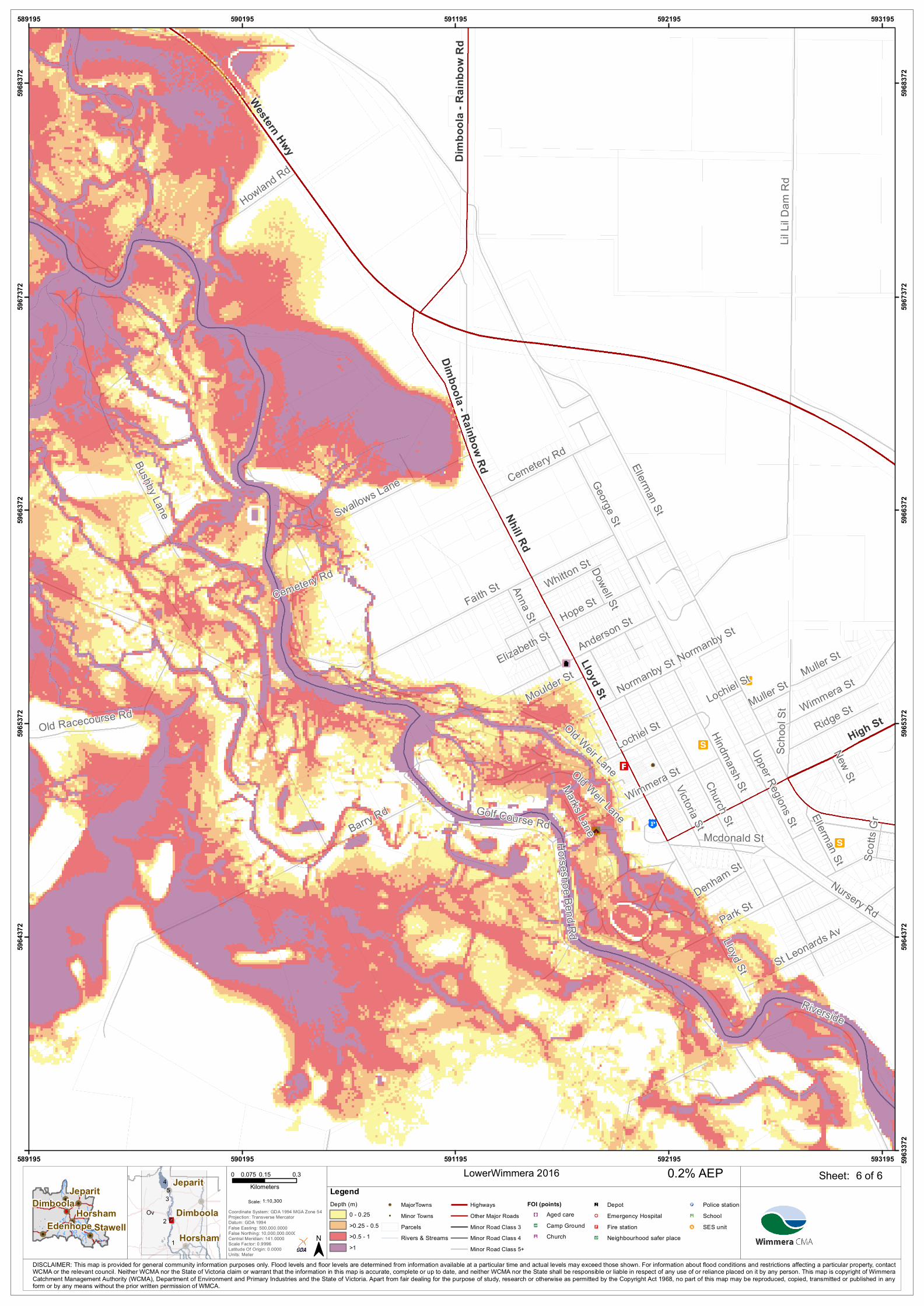
Ellerman St
Barry Rd
Faith St
Lil Li
l Dam
Rd
Church St
Park St
George St
Lloyd St
Bushby Lane
Riverside
Nursery Rd
Howland RdUpper Regions St
Anderson St
Victoria St
Horseshoe Bend Rd
Wimmera St
Lochiel St Ridge St
Anna St Hope St
Hindmarsh St
Swallows Lane
Normanby St
Cemetery Rd
St Leonards Av
Old Racecourse Rd
Scho
ol St
Golf Course RdMcdonald St
Muller St
Old Weir Lane
Moulder St
Whitton St
Denham St
New St
Scott
s Gr
Elizabeth St
Marks LaneDowell St
Lochiel St
Ellerman St
Normanby St
Cemetery Rd
Wimmera St
Muller St
Old Weir Lane
Western Hwy
Lloyd St
High St
Nhill Rd
Dimb
oola
- Rain
bow
RdDimboola - Rainbow Rd
589195
589195
590195
590195
591195
591195
592195
592195
593195
593195 5963
372
5964
372
5964
372
5965
372
5965
372
5966
372
5966
372
5967
372
5967
372
5968
372
5968
372
6 of 6LowerWimmera 2016
1:10,300Scale:
!!
!!
!!!!
!!
!!Stawell
Horsham
JeparitDimboola
EdenhopeCoordinate System: GDA 1994 MGA Zone 54Projection: Transverse MercatorDatum: GDA 1994False Easting: 500,000.0000False Northing: 10,000,000.0000Central Meridian: 141.0000Scale Factor: 0.9996Latitude Of Origin: 0.0000Units: Meter
0 0.15 0.30.075Kilometers
Ov2
4
1
3 5
6
Horsham
Jeparit
Dimboola
DISCLAIMER: This map is provided for general community information purposes only. Flood levels and floor levels are determined from information available at a particular time and actual levels may exceed those shown. For information about flood conditions and restrictions affecting a particular property, contactWCMA or the relevant council. Neither WCMA nor the State of Victoria claim or warrant that the information in this map is accurate, complete or up to date, and neither WCMA nor the State shall be responsible or liable in respect of any use of or reliance placed on it by any person. This map is copyright of WimmeraCatchment Management Authority (WCMA), Department of Environment and Primary Industries and the State of Victoria. Apart from fair dealing for the purpose of study, research or otherwise as permitted by the Copyright Act 1968, no part of this map may be reproduced, copied, transmitted or published in anyform or by any means without the prior written permission of WMCA.
Sheet:0.2% AEPLegendDepth (m)
0 - 0.25>0.25 - 0.5>0.5 - 1>1
!! MajorTowns!! Minor Towns
ParcelsRivers & Streams
HighwaysOther Major RoadsMinor Road Class 3Minor Road Class 4Minor Road Class 5+
FOI (points)"³#) Aged carenq Camp Ground"̄Ë Church
®n Depot!& Emergency Hospital"< Fire stationm̄ Neighbourhood safer place
!P Police stationÚ¹ Schoolcc SES unit