1 4.5 take of the california tiger salamander · california department of water resources chapter...
TRANSCRIPT

California Department of Water Resources
Chapter 4. Effects Analysis
California Incidental Take Permit Application for the California WaterFix and its operation as part of the State Water Project
4-789 October 2016
ICF 00408.12
4.5 Take of the California Tiger Salamander 1
Appendix 4.B Terrestrial Impact Analysis Methods, describes the methods and assumptions used 2
to analyze the effects of the PP on wildlife species. Appendix 2.A Status of the Species, Sections 3
2.5.4, Species Habitat Suitability Model and 2.5.5, Suitable Habitat Definition, define suitable 4
habitat and describe the habitat model for California tiger salamander. 5
Activities associated with geotechnical exploration, Clifton Court Forebay modification, power 6
supply and grid connections, and habitat restoration may affect California tiger salamander, as 7
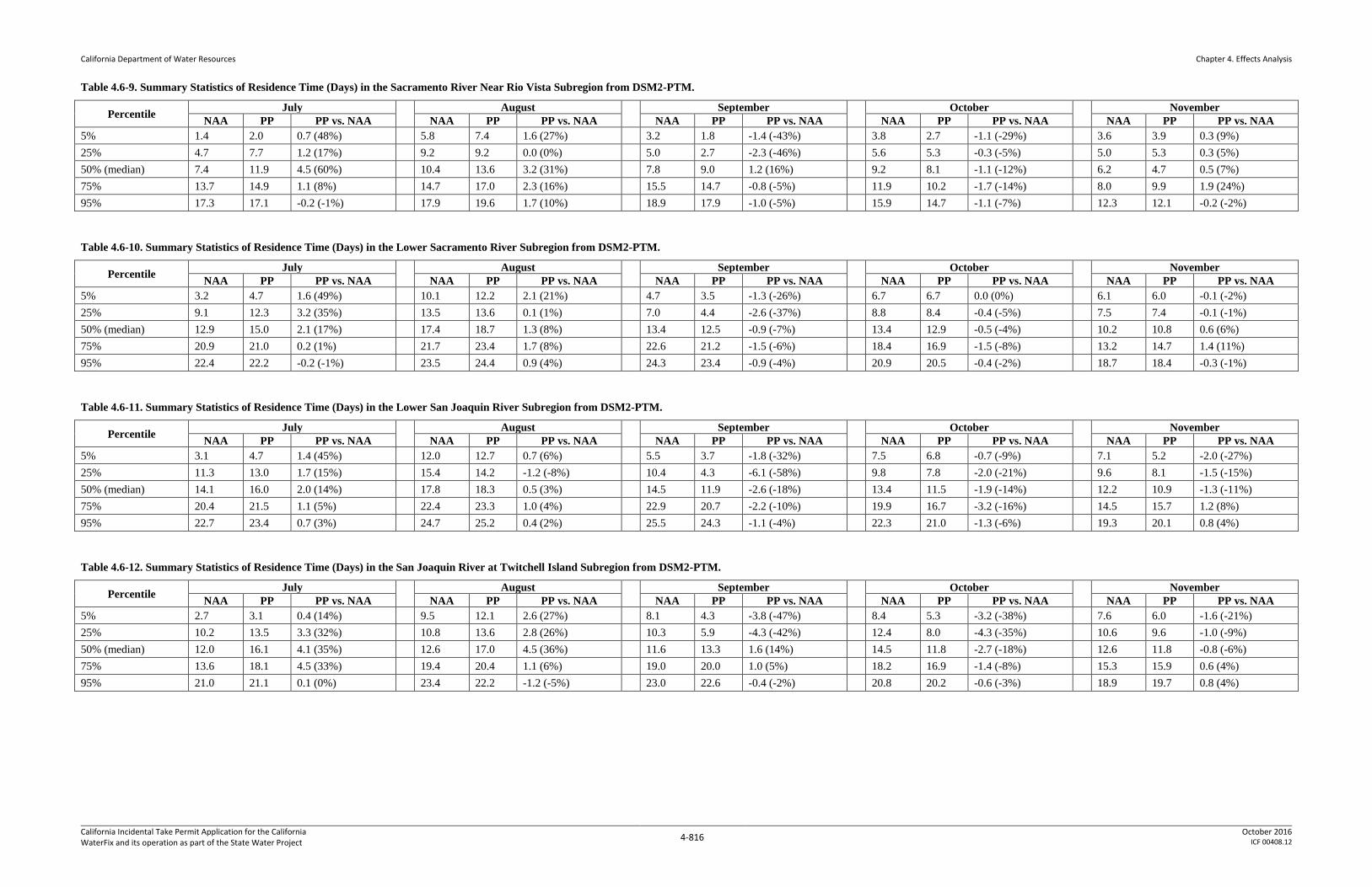
described below. Figure 4.5-1 provides an overview of the locations of surface impacts relative 8
to California tiger salamander modeled habitat and occurrences. There are 12,724 acres of 9
modeled California tiger salamander habitat in the legal delta. An estimated 50 acres (<1% of 10
total modeled habitat in the legal delta) of California tiger salamander modeled habitat will be 11
lost as a result of project implementation, including 47 acres within the construction footprint 12
and 3 acres that may be affected by activities generating vibrations. Table 4.5-1 and Table 4.5-2 13
summarize the total estimated habitat loss of California tiger salamander modeled habitat. Only 14
terrestrial cover and aestivation habitat loss is expected to occur; the PP would not entail loss of 15
any aquatic breeding habitat. 16

California Department of Water Resources
Chapter 4. Effects Analysis
California Incidental Take Permit Application for the California WaterFix and its operation as part of the State Water Project
4-790 October 2016
ICF 00408.12
Table 4.5-1. Maximum Habitat Loss on Modeled Habitat for California Tiger Salamander by Activity Type (Acres) 1
California
Tiger
Salamander
Modeled
Habitat
Total
Modeled
Terrestrial
Cover and
Aestivation
Habitat in the
Legal
Delta
Permanent Habitat Loss Temporary Habitat Loss
Safe
Haven
Work
Areas
North
Delta
Intakes
Tunneled
Conveyance
Facilities
Clifton Court
Forebay
Modifications
Head of
Old River
Gate
Reusable
Tunnel
Material
Power Supply
and Grid
Connections
Total
Maximum
Habitat
Loss
Geotechnical
Exploration
Power
Supply and
Grid
Connections
Terrestrial
Cover and
Aestivation
12,724 0 0 0 49 0 0 1 50 0 6
2
3
Table 4.5-2. Maximum Direct Effects on and Conservation of Modeled Habitat for California Tiger Salamander 4
California Tiger Salamander
Modeled Habitat
Permanent Habit Loss Compensation Ratios Total Compensation (Acres)
Total Maximum Habitat Loss (Acres) Protection Restoration Protection Restoration
Terrestrial Cover and Aestivation 501 3:1 150
Notes 1 Includes 47 acres within the construction footprint and 3 acres within 75 feet of project activities that may generate vibrations affecting California tiger salamander.
5

California Department of Water Resources
Chapter 4. Effects Analysis
California Incidental Take Permit Application for the California WaterFix and its operation as part of the State Water Project
4-791 October 2016
ICF 00408.12
4.5.1 Effects on California Tiger Salamander from the Proposed Project
4.5.1.1 Geotechnical Exploration
4.5.1.1.1 Habitat Loss and Fragmentation
The only permanent loss of California tiger salamander habitat resulting from geotechnical
exploration will be boreholes, which will be grouted upon completion. These holes are very
small (approximately 8 inches in diameter) and their filling would have no or negligible effects
on the California tiger salamander.
4.5.1.1.2 Construction Related Effects
Geotechnical exploration activities will will not affect any areas that will not be permanently
impacted by the construction of features related to the conveyance facility (less than one acre of
temporary impact in the location that a canal will be constructed).
4.5.1.1.3 Operations and Maintenance
There will be no ongoing operations and maintenance associated with the geotechnical activities,
resulting in no effect on California tiger salamander.
4.5.1.2 Safe Haven Work Areas
Safe haven work areas are not expected to occur in California tiger salamander habitat. Activities
in these areas will not affect the species.
4.5.1.3 North Delta Intake Construction
The north Delta intake construction area does not overlap with California tiger salamander
modeled habitat. Activities in this area will not affect the species (Figure 4.5-1).
4.5.1.4 Tunneled Conveyance Facilities
Tunneled conveyance facilities construction does not overlap with California tiger salamander
modeled habitat. Activities in this area will not affect the species (Figure 4.5-1).
4.5.1.5 Clifton Court Forebay Modification
4.5.1.5.1 Habitat Loss and Fragmentation
An estimated 46 acres of California tiger salamander modeled terrestrial cover and aestivation
habitat overlaps with the mapped canal modifications at Clifton Court Forebay (Figure 4.5-2),
where land will be cleared for permanent facilities and temporary work areas. The activities that
will result in habitat loss include canal construction that will remove terrestrial cover and
aestivation habitat at the southern end of the Clifton Court Forebay. Another 3 acres of upland
habitat may be affected by construction related vibrations, as described in Section 4.5.1.5.2,
Construction Related Effects.

California Department of Water Resources
Chapter 4. Effects Analysis
California Incidental Take Permit Application for the California WaterFix and its operation as part of the State Water Project
4-792 October 2016
ICF 00408.12
The loss of California tiger salamander terrestrial cover and aestivation habitat will be offset
through protection at a 3:1 ratio (Table 4.5-2). As described in Section 5.3.5.2.1, Activities with
Fixed Locations, workers will confine ground disturbance and habitat removal to the minimal
area necessary to facilitate construction activities. As detailed in Section 5.4.5.2, Siting Criteria
for Compensation for Effects, these conservation lands will be sited in locations that provide high
habitat values for the species, consisting of large, contiguous blocks of habitat suitable for
California tiger salamander. As detailed in Section 5.4.5.3, Management and Enhancement, these
conservation lands will be protected and managed for the species in perpetuity.
4.5.1.5.2 Construction Related Effects
Construction activities at the canal work area south of Clifton Court Forebay include vegetation
clearing, excavation, pile driving, dredging, and cofferdam and embankment construction. The
duration of construction in this area will be approximately six years, although construction of the
outlet canal, the only component that will affect California tiger salamander, will be
approximately 18 months in duration. For complete details on construction activities and
phasing, see Section 3.2.6 Connections to Banks and Jones Pumping Plants; for more details on
schedule, see Appendix 3.D Construction Schedule for the Proposed Project.
Vehicles and heavy equipment used at the construction site could injure or kill California tiger
salamanders if individuals are present within the construction footprint. Other effects related to
construction within the construction footprint may include entanglement in erosion control
materials or contamination because of toxic substances such as fuels. Effects within the
construction footprint. However, this effect will be unlikely to occur because exclusion fencing
will be installed no more than 14 days prior to any site clearing and these areas will be monitored
to minimize the potential for California tiger salamanders to enter the work area.
DWR will implement measures to minimize effects on California tiger salamander that could
result from initial ground clearing activities, as described in Section 5.3.5.2.1, Activities with
Fixed Locations, under Site Preparation and Initial Clearance/Ground Disturbance. To
minimize effects on California tiger salamander during the initial clearing, a CDFW-approved
biologist will conduct preconstruction surveys within the construction footprint (after installing
amphibian exclusion fencing along the perimeter) and will relocate any California tiger
salamanders found in accordance with a CDFW-approved relocation plan. The initial ground
disturbance and clearing within suitable California tiger salamander habitat will be then be
confined to the dry season, and all such activities will be limited to periods of no or low rainfall.
Ground disturbing activities in suitable California tiger salamander terrestrial cover and
aestivation habitat will cease on days with a 40% or greater forecast of rain from the closest
National Weather Service (NWS) weather station, however, ground disturbing work may
continue if a CDFW-approved biologist surveys the worksite before construction begins each
day rain is forecast and is present during ground disturbing work. Ground disturbing activities
may continue after the rain ceases and the work areas is surveyed by the CDFW-approved
biologist. If rain exceeds 0.5 inches during a 24-hour period, work will cease until the NWS
forecasts no further rain. Modifications to this timing may be approved by CDFW based on site
conditions and expected risks to California tiger salamanders as described in Section 5.3.5.2,
Take Minimization Measures. With these measures in place, the potential for injury or mortality
of California tiger salamander will be minimized but there will still be potential for mortality of

California Department of Water Resources
Chapter 4. Effects Analysis
California Incidental Take Permit Application for the California WaterFix and its operation as part of the State Water Project
4-793 October 2016
ICF 00408.12
any individuals not detected during preconstruction surveys within the 46 acres of habitat in the
construction footprint. There is also the potential for California tiger salamanders found within
the construction footprint to be harassed through the relocation process. Potential for injury,
mortality, or harassment is low because the likelihood of California tiger salamander occurrence
in this area is low.
During initial site clearing and ongoing construction, DWR will implement measures to prevent
injury, mortality, or harassment of individuals that could otherwise result from degradation of
adjacent habitat from run-off and siltation. This will include implementation of a Stormwater
Pollution Prevention Plan (AMM3) and an Erosion and Sediment Control Plan (AMM4),
described in Appendix 3.F General Avoidance and Minimization Measures. With
implementation of these measures, take associated with run-off or siltation will be avoided.
During initial site clearing and ongoing construction, DWR will implement measures to prevent
injury or mortality of individuals that could otherwise result from erosion control materials. To
prevent California tiger salamander from becoming entangled, trapped, or injured by erosion
control structures, erosion control measures that use plastic or synthetic monofilament netting
will not be used within areas designated to have suitable California tiger salamander habitat and
the perimeter of construction sites will be fenced with amphibian exclusion fencing. With this
measure in place, take associated with erosion control measures will be avoided.
During initial site clearing and ongoing construction, DWR will implement measures to prevent
injury or mortality of individuals that could otherwise result from toxic substances such as fuels.
With implementation of AMM5, Spill Prevention, Containment, and Countermeasure Plan,
described in Appendix 3.F General Avoidance and Minimization Measures, take associated with
toxic substances will be avoided.
Because dusk and dawn are often the times when the California tiger salamander is most actively
moving and foraging, to the greatest extent practicable, earthmoving and construction activities
will cease no less than 30 minutes before sunset and will not begin again prior to 30 minutes
after sunrise within suitable California tiger salamander habitat. Except when necessary for
driver or pedestrian safety, to the greatest extent practicable, artificial lighting at a worksite will
be prohibited during the hours of darkness within California tiger salamander aquatic habitat or
as determined in coordination with the US Fish and Wildlife Service. If night working and
lighting is necessary, all lighting will be directed away and shielded from California tiger
salamander habitat outside the construction area to minimize light spillover to the greatest extent
possible. If light spillover into adjacent California tiger salamander habitat occurs, a CDFW-
approved biologist will be present during night work to survey for burrows and emerging
California tiger salamanders in areas illuminated by construction lighting. If California tiger
salamander is found above-ground the CDFW-approved biologist has the authority to terminate
the project activities until the light is directed away from the burrows, the California tiger
salamander moves out of the illuminated area, or the California tiger salamander is relocated out
of the illuminated area by the CDFW-approved biologist.
Although measures will be applied to minimize the risk of harassing or displacing California
tiger salamanders outside the construction footprint during construction, some individuals may
be harassed or displaced from habitat with these measures in place, as described below.

California Department of Water Resources
Chapter 4. Effects Analysis
California Incidental Take Permit Application for the California WaterFix and its operation as part of the State Water Project
4-794 October 2016
ICF 00408.12
California tiger salamander could be impacted by construction disturbance outside the project
footprint if they occur in the vicinity. The potential concern is from sound-induced vibration
through the soil, which could cause the species to emerge from upland burrows during a non-rain
event. One research paper and one known incident provide background information regarding
induced emergence.
Dimmit and Ruibal (1980) found that spadefoot toads relied primarily on vibration from rain
falling on the ground at their burrows, rather than increased moisture in the soil from rain, as the
signal to emerge from burrows. They were able to induce emergence by setting an off-balance
test tube spinner within 1 meter of the burrow, which vibrated the soil in close proximity to the
animals, and observed almost 100% emergence. The researchers noted that sound-induced
vibration from violent, rainless thunder storms, would also produce the emergence
response. Spadefoot toads also emerge from their burrows without any inducement to feed. This
research has been assumed relevant to California tiger salamander, although no similar study has
been applied to those species.
More specific to California tiger salamander was an incident at a SMUD project site in South
Sacramento County in the 2000s. The subject project site was determined to not support
California tiger salamander, but when a water truck began spraying heavy amounts of water for
dust control, California tiger salamanders began to emerge from their burrows. Using Dimmit
and Ruibal (1980) as the bases for emergence, it seems reasonable that the water falling on the
burrows provided the appropriate vibration to cause emergence.
Given the evidence described above, it is reasonable to assume that mechanical construction
activities such as tracked bulldozers moving from point to point, and excavators digging, could
cause vibration that California tiger salamanders could confuse for rainfall, and induce
emergence. Three factors need to be considered in evaluating the level and area of impact to the
species: the extent that mechanical vibration mimics rainfall vibration at distance, the reaction
of the species to vibration that does not mimic rainfall, and the effect on the two species of
“accidental” emergence. The extent of the vibration is determined based on the likely ground-
disturbing machinery used at the construction site: bulldozers, excavators, and scrapers; the
likely closest machine to the edge of the footprint, and thus producing vibration at the greatest
distance outside the footprint, would be a tracked machine like a bulldozer; the primary cause of
ground vibration would be from its tracks hitting the ground. A bulldozer produces perceivable
vibration to 135 feet [Caltrans 2013, Table 17]. It is also based on the attenuation coefficient for
competent soils: most sands, sandy clays, silty clays, gravel, silts, weathered rock.
It is unlikely that California tiger salamanders would emerge from burrows from all perceivable
vibration. Dimmit and Ruibal (1980) created a significant ground-vibration directly over the
burrowing animal, and rainfall on the ground above the animal would produce significant
immediate-area vibration. Most California tiger salamanders occur in grasslands grazed by
cattle. Cattle moving over a California tiger salamander burrow would produce vibration. But
California tiger salamanders have been known to thrive in uplands grazed by cattle, so either all
vibrations are not perceived by the species the same way, or accidental emergence is not
detrimental, e.g. once at the opening to the burrow, the species recognizes that the vibration was
not caused by rain, and they retreat back into the lower areas of the hole. Additionally,

California Department of Water Resources
Chapter 4. Effects Analysis
California Incidental Take Permit Application for the California WaterFix and its operation as part of the State Water Project
4-795 October 2016
ICF 00408.12
California tiger salamanders occur and thrive in areas with wind generators of various sizes,
which also produce significant sound and vibration.
Potential continual emergence caused by ongoing construction may be detrimental to the
species. Based on data regarding the distance vibration travels for the project-related activities, it
is assumed that vibrations will affect areas within 75 feet of activities related to Clifton Court
Forebay modifications (Dave Buehler pers comm). Therefore, 3 acres of California tiger
salamander upland habitat could be affected by vibrations.
4.5.1.5.3 Operations and Maintenance
The operational components of the modified Clifton Court Forebay include the pumping plant,
control structures, and siphons. These features will not be operated in or near California tiger
salamander habitat and are not expected to affect the species.
The forebay and canals will need control of vegetation and rodents, and perhaps embankment
repairs. Maintenance of control structures could include removal or installation of roller gates,
radial gates, and stop logs. Maintenance requirements for the spillway will include the removal
and disposal of any debris blocking the outlet culverts. After construction, however, these areas
will no longer consist of suitable California tiger salamander habitat, therefore this species is not
expected to be affected by these activities.
4.5.1.6 Power Supply and Grid Connections
4.5.1.6.1 Habitat Loss and Fragmentation
To conservatively assess impacts from transmission line placement, a 50-foot wide permanent
disturbance area along the transmission line corridor was assumed (see Appendix 4.B,
Terrestrial Effects Analysis Methods for additional details about the impact assessment method).
Based on this method, an estimated 6 acres of California tiger salamander aestivation and cover
habitat along the east side of the Delta-Mendota canal may be temporarily lost as a result of the
construction of temporary transmission lines (Table 4.5-1). Temporary impacts are incurred from
activities that will not last more than one year and include access routes (vehicles driving over
ground to access the site), temporary staging areas for poles or placement, and reconductoring
areas. Ongoing vegetation management around the poles and under the lines will be limited to
small scale mechanical mowing, if any, in California tiger salamander habitat because aquatic
and grassland areas typically do not need to be cleared to maintain transmission line corridors.
Up to one acre may be permanently removed as result of placement of power poles.
Because transmission line effects are primarily short-term and temporary, specific compensation
for the 6 acres of California tiger salamander habitat disturbance will be offset by returning these
areas to pre-project conditions. The acre to be permanently lost will be offset at a 3:1 ratio.

California Department of Water Resources
Chapter 4. Effects Analysis
California Incidental Take Permit Application for the California WaterFix and its operation as part of the State Water Project
4-796 October 2016
ICF 00408.12
4.5.1.6.2 Construction Related Effects
New temporary power lines to power construction activities will be built prior to construction of
permanent transmission lines to power conveyance facilities. These lines will extend existing
power infrastructure (lines and substations) to construction areas, generally providing electrical
capacity of 12 kV at work sites.
Construction of new transmission lines will require site preparation, tower or pole construction,
and line stringing. For 12 kV and 69 kV lines, cranes will be used during the line-stringing
phase; for stringing transmission lines between 230 kV towers, cranes and helicopters will be
used. Construction-related activities will be largely concentrated in a 100- by 50-foot area around
pole or tower placement areas, and, in the case of conductor pulling locations, in a 350-foot
corridor (measured from the base of the tower or pole); conductor pulling locations will occur at
any turns greater than 15 degrees and/or every 2 miles of line. Construction will also require
vehicular access to each tower or pole location. Vehicular access routes will use existing routes
to the greatest extent practicable, but some overland travel will likely be necessary. The duration
of transmission line construction activities will not be more than one year at any one location.
See Section 3.2.7.2, Construction, for a full description of the construction activities.
The operation of equipment during construction of the transmission lines could injure or kill
California tiger salamander within the 7 acres (6 acres temporary and 1 acre permanent) of
habitat if individuals are present. The construction related effects and measures to minimize them
are similar to those described above for construction at the canal work area near Clifton Court
Forebay in Section 4.5.1.5.2, Construction Related Effects, with the exception that activities will
be restricted to the daytime so that no artificial lighting is necessary. Additionally, because noise
and vibrations from the transmission line activities are not expected to reach the levels they
would under Clifton Court Forebay construction, harassment or displacement of individuals
beyond the 7-acre disturbance footprint is not anticipated.
4.5.1.6.3 Operations and Maintenance
Ongoing vegetation management around the poles and under the lines will be limited to small
scale mowing, if any, in California tiger salamander habitat because aquatic and grassland areas
seldom if ever need to be cleared to maintain transmission line corridors. Effects on California
tiger salamander from transmission line operations and maintenance, if any, are expected to be
negligible, and are not expected to result in take of California tiger salamander.
4.5.1.7 Head of Old River Gate
The HOR gate construction area does not overlap with California tiger salamander modeled
habitat (Figure 4.5-1). Activities in this area will not affect the species.
4.5.1.8 Reusable Tunnel Material
The RTM sites do not overlap with California tiger salamander modeled habitat (Figure 4.5-1).
Activities in this area will not affect the species.

California Department of Water Resources
Chapter 4. Effects Analysis
California Incidental Take Permit Application for the California WaterFix and its operation as part of the State Water Project
4-797 October 2016
ICF 00408.12
4.5.1.9 Restoration
4.5.1.9.1 Habitat Loss and Fragmentation
Restoration activities will avoid effects on California tiger salamander and its habitat with the
exception of vernal pool complex restoration, which may result in loss of 11 acres of California
tiger salamander terrestrial cover and aestivation habitat. While the exact location of vernal pool
restoration is not known, it is likely that it will be in the region directly west, north, or south of
CCF where California tiger salamander modeled habitat exists. Although vernal pool restoration
in grasslands will result in some loss of California tiger salamander habitat, protection and
management of surrounding grasslands associated with the vernal pools is expected to benefit
California tiger salamander.
4.5.1.9.2 Construction Related Effects
Vernal pool restoration will involve use of heavy equipment to excavate areas within grasslands
to create topographic depressions. California tiger salamanders could be injured or killed by
heavy equipment or struck by vehicles associated with vernal pool construction. The types of
effects and measures to minimize these effects are as described in Section 4.5.1.5.2, Construction
Related Effects. Although measures will be applied to minimize the risk of injuring or California
tiger salamander during construction, and to minimize the risk of disrupting behavior through
noise or lighting, some potential remains for these effects to occur with all the minimization
measures in effect.
4.5.1.9.3 Operations and Maintenance
A variety of management actions to be implemented within restored vernal pool complex may
result in localized ground disturbances within California tiger salamander habitat. Ground-
disturbing activities such as removal of nonnative vegetation and road and other infrastructure
maintenance activities are expected to have minor effects on available California tiger
salamander. Management activities could result in the injury or mortality of California tiger
salamanders if individuals are present in work sites or if dens occur near habitat management
work sites. Noise and visual disturbances could also affect California tiger salamanders use of
the surrounding habitat. These effects are expected to be minor, and will be minimized with
implementation of the worker awareness training, monitoring, and best management practices
described in Section 5.3.5.2 Take Minimization Measures. Furthermore, the management and
enhancement of vernal pool complexes are expected to benefit the species.
4.5.2 Take Analysis
The PP may result in mortality to California tiger salamanders inhabiting or utilizing the up to
104 acres of California tiger salamander terrestrial cover and aestivation habitat expected to be
lost. The risk of mortality will be minimized through the mitigation measures described in
Section 5.3.3.2.1 Project Activities with Known Locations.

California Department of Water Resources
Chapter 4. Effects Analysis
California Incidental Take Permit Application for the California WaterFix and its operation as part of the State Water Project
4-798 October 2016
ICF 00408.12
4.5.3 Analysis of Impacts in the Project Area
There are 1,003 CNDDB California tiger salamander occurrences throughout California, none of
which are in the project area. There are at least eleven (<1% of range-wide) in the legal delta,
just west of Clifton Court Forebay, but no known occurrences within the project construction
footprint. None of the aquatic habitat associated with these occurrences will be affected by the
PP.
There are approximately 12,724 acres of modeled terrestrial cover and aestivation habitat for
California tiger salamander in the legal delta. Covered activities are projected to permanently
affect a total of 50 acres (<1%) of modeled terrestrial cover and aestivation habitat in the legal
delta.
Shaffer and Trenham (2005) suggest that 50% of the subadult and adult California tiger
salamander population occurs within 150 meters (approximately 500 feet) of breeding habitat,
and that 90% occurs within 490 meters (approximately 1,600 feet) and 95% occurs within 630
meters (approximately 2,065 feet). Also, construction, restoration, and enhancement activities in
areas with higher population densities (such as breeding habitat and uplands within 1,600 feet of
breeding habitat) have greater potential to encounter individuals (i.e., 90% of the population).
Based on dispersal distances, the probability of killing individuals dispersing or using uplands
drops substantially the farther away the project activity is from the breeding habitat because
individuals are less likely to be present at greater distances. Except for the intakes, the proposed
water conveyance and transmission construction activities occur more than 600 meters from
modeled California tiger salamander breeding habitat and more than 700 meters from the nearest
extant record for the species (which is near CCF). For the intakes, there is no modeled habitat
within the project construction footprint, and no known California tiger salamander occurrences
in the nearby modeled habitat, in Stone Lakes. Based on this information, no mortality is
expected for salamander eggs or metamorphs found in aquatic breeding habitat. Furthermore, the
likelihood of take of adults or juveniles from water conveyance and transmission line
construction is low due to the distance these impacts will be from occupied breeding sites and
low likelihood of individuals being present where construction activities will occur. However, a
few individuals might occur in upland areas that will be cleared during project activities. In
addition, the species model may be missing aquatic habitat within 600 meters of project
activities, with the potential for take of adults or juveniles in these areas.
Covered activities will minimize take of California tiger salamander to the maximum extent
practicable; however, mortality may occur as a result of construction and activities occurring as a
result of enhancement and management actions on preservation lands. Mortality will be
minimized and fully mitigated through the measures described in Section 5.3.5.2 Take
Minimization Measures.
Overall the impacts on California tiger salamander will not be substantial when considering the
relative amount of habitat affected in the legal delta, which will be <1% (50 acres) of the
terrestrial cover and aestivation habitat, and when considering the take minimization measures
that are presented in Section 5.3.5.2.1 Activities with Fixed Locations, which will minimize take
to the maximum extent practicable. Furthermore, the proposed mitigation presented Section 5.4.5
California Tiger Salamander, which includes the protection, enhancement, and management of

California Department of Water Resources
Chapter 4. Effects Analysis
California Incidental Take Permit Application for the California WaterFix and its operation as part of the State Water Project
4-799 October 2016
ICF 00408.12
up to 150 acres of terrestrial cover and aestivation habitat with suitable aquatic habitat, will fully
mitigate the loss of habitat if all potential impacts on modeled habitat occur. Mitigation will be
implemented prior to or concurrent with the impact.
4.5.4 Analysis of Potential for Jeopardy
4.5.4.1 Cumulative Effects
The projects and programs that have been considered as part of the cumulative analysis have
been drawn primarily from Draft EIR/EIS Appendix 3D, Defining Existing Conditions, No
Action Alternative, No Project Alternative, and Cumulative Impact Conditions (California
Department of Water Resources, U.S. Bureau of Reclamation, U.S. Fish and Wildlife Service,
and National Marine Fisheries Service 2013). Those projects and programs that could impact
terrestrial resources in the legal delta are presented in Appendix 4.B, Terrestrial Methods. The
list of past, present and reasonably foreseeable future projects and programs has been evaluated
to determine which of these activities may have effects on California tiger salamander. Most of
the local, state and federal land use and land management programs that are affecting or will
affect the legal delta are designed to preserve open space and agricultural lands, and to manage
the resources of the area for multiple uses, including agriculture, recreation, fish and wildlife
habitat, flood protection and water management. Most of these projects and programs have a
conservation or restoration component and thus could ultimately be beneficial to California tiger
salamander. These programs include the Yolo Natural Heritage Program Plan, Yolo Bypass
Wildlife Area Land Management Plan, Solano County Multispecies Habitat Conservation Plan,
Stone Lakes National Wildlife Refuge Comprehensive Conservation Plan, South Sacramento
Habitat Conservation Plan, San Joaquin County Multi-Species Habitat Conservation and Open
Space Plan, and California EcoRestore.
The PP’s impacts on California tiger salamander habitat will be minor, affecting <1% of the
modeled habitat in the legal delta. The take minimization and mitigation measures will ensure
that the loss of habitat will be fully mitigated and that take will be minimized. The project
activities’ effect on California tiger salamander will not be cumulatively considerable.
4.5.4.2 Potential to Jeopardize the Existence of the Species
The issuance of the ITP is not expected to jeopardize the continued existence of California tiger
salamander for the following reasons.
Level of Take – The overall potential for take is low. Covered activities have a low likelihood of
resulting in mortality of individuals. The covered activities will result in permanent impacts on
up to 50 acres of terrestrial cover and aestivation habitat (<1% of modeled habitat in the legal
delta). These habitat losses are small and are not expected to have a population level effect.
Take Minimization Measures – The proposed TMMs described in Section 5.3.5.2.1, Activities
with Known Locations, greatly reduce the potential for mortality of individuals, which makes it
unlikely that activities will affect reproductive rates of the population or survivorship of
individuals.

California Department of Water Resources
Chapter 4. Effects Analysis
California Incidental Take Permit Application for the California WaterFix and its operation as part of the State Water Project
4-800 October 2016
ICF 00408.12
Mitigation – Mitigation is expected to fully offset habitat loss and any loss of individuals
because higher-quality, intact habitat will be acquired, enhanced, and managed in perpetuity.
While existing California tiger salamander populations appear to be in decline (California
Department of Fish and Game 2010), the project’s activities will not exacerbate this decline and
are not expected to result in significant losses of individuals of the species or its habitat. The
applicant’s take minimization measures will ensure impacts on habitat and individuals are
minimized, and the mitigation will ensure occupied habitat is protected.
For the California tiger salamander, the primary threats to its survival include habitat loss,
conversion, and fragmentation, as well as species hybridization. The proposed project will not
threaten the survival of the California tiger salamander because the covered activities will not
result in significant losses of individuals of the species or habitat. The covered activities will also
not substantially contribute to the fragmentation of remaining habitat because most of the
covered activities will be outside of the species’ habitat and will not create barriers to movement.
Also, covered activities will not contribute to the impact of hybridization because covered
activities will not result in the translocation of hybrids or introduction of non-native tiger
salamanders.
Considering the low potential for take relative to these factors, the take minimization measures in
Section 5.3.5.2.1, Activities with Known Locations, and that the loss of habitat will be fully
mitigated, the PP will not adversely affect the reproduction and survival of the California tiger
salamander, and the issuance of the ITP will not jeopardize the continued existence of the
species.
4.5.5 References
California Department of Fish and Game. 2010. Report to the Fish and Game Commission: A
status review of the California Tiger Salamander (Ambystoma californiense). Wildlife
Branch Nongame Wildlife Program Report 2010-4.California Department of Water
Resources, U.S. Bureau of Reclamation, U.S. Fish and Wildlife Service, and National
Marine Fisheries Service. 2013. Draft Environmental Impact Report/Environmental
Impact Statement for the Bay Delta Conservation Plan. Prepared by ICF International.
Sacramento, CA.
Caltrans 2013. Transportation and Construction Vibration Guidance Manual. Division of
Environmental Analysis. September.
Dave Buehler. 2016.06.28. ICF International noise analyst. Email to Ellen Berryman.
Dimmitt, Mark A. and Rodolfo Ruibal. 1980. Environmental correlates of emergence in
spadefoot toads (Scaphiopus). Journal of Herpetology 14(1):1-29.
Shaffer, H. B., and P. C. Trenham. 2005. Ambystoma californiense. Pages 1093–1102 in M. J.
Lannoo (ed.), Status and Conservation of U.S. Amphibians. Volume 2: Species Accounts.
Berkeley, CA: University of California Press.

California Department of Water Resources
Chapter 4. Effects Analysis
California Incidental Take Permit Application for the California WaterFix and its operation as part of the State Water Project
4-801 October 2016
ICF 00408.12
4.6 Take of the Giant Garter Snake
Appendix 4.B Terrestrial Impact Analysis Methods, describes the methods and assumptions used
to analyze the effects of the PP on terrestrial species. Section 2.6.4 Species Habitat Suitability
Model describes the habitat model for giant garter snake, and Section 2.6.5 Suitable Habitat
Definition defines suitable habitat for this species.
Activities associated with geotechnical exploration, safe haven work areas, NDD construction,
tunneled conveyance facilities, Clifton Court Forebay modifications, power supply and grid
connections, the HOR Gate, reusable tunnel material, and habitat restoration have the potential to
affect giant garter snakes, as described below. Figure 4.6-1 provides an overview of the locations
of surface impacts relative to giant garter snake modeled habitat and occurrences. There are
88,947 acres (26,328 acres of aquatic habitat and 62,619 acres of upland habitat) of modeled
giant garter snake habitat in the Delta. An estimated 775 acres (<1% of total modeled habitat in
the Delta) of modeled giant garter snake habitat will be lost as a result of project implementation.
This includes 205 acres of modeled aquatic habitat (<1% of modeled aquatic habitat in the Delta)
and 570 acres of modeled upland habitat (<1% of modeled upland habitat in the Delta). Effects
from these activities are detailed below. Table 4.6-1 and Table 4.6-2 summarize the total
estimated loss of giant garter snake modeled habitat.

California Department of Water Resources
Chapter 4. Effects Analysis
California Incidental Take Permit Application for the California WaterFix and its operation as part of the State Water Project
4-802 October 2016
ICF 00408.12
Table 4.6-1. Maximum Loss of Giant Garter Snake Modeled Habitat by Activity Type (Acres)
Giant
Garter
Snake
Modeled
Habitat
Total
Modeled
Habitat in
the Delta
Permanent Habitat Loss Temporary Habitat Loss
Safe
Haven
Work
Areas
North
Delta
Intakes
Tunneled
Conveyance
Facilities
Clifton Court
Forebay
Modifications
Head
of Old
River
Gate
Reusable
Tunnel
Material
Power
Supply and
Grid
Connections
Total
Maximum
Habitat
Loss
Geotechnical
Exploration
Power
Supply and
Grid
Connections
Aquatic 26,328 0 12 93 16 1 83 0 205 01 01
Upland 62,619 0 62 127 219 2 159 1 570 98 67
Total 88,947 0 74 220 235 3 242 1 775 98 67 1 Geotechnical exploration and power supply and grid connections will avoid suitable aquatic giant garter snake habitat; see Section 5.3.6, Giant Garter Snake.

California Department of Water Resources
Chapter 4. Effects Analysis
California Incidental Take Permit Application for the California WaterFix and its operation as part of the State Water Project
4-803 October 2016
ICF 00408.12
Table 4.6-2. Maximum Direct Effects on and Conservation of Modeled Habitat for Giant Garter Snake
Permanent Habitat
Loss Compensation Ratios Total Compensation
Total Maximum
Habitat Loss (Acres) Protection Restoration Protection2 Restoration2
Aquatic Total 205
3:1 or 2:11
615 or 410
Upland Total 570 1,710 or 1,140
TOTAL 775 2,325 or 1,550 1 The 3:1 mitigation ratio will be applied when “in-kind” mitigation is used. In-kind mitigation is mitigation that replaces a habitat of similar
quality, character, and location as that which was lost within the known range of the giant garter snake as described in Section 2.6.4 Species
Habitat Suitability Model. DWR will mitigate at a rate of 2:1 for each acre of lost aquatic and upland habitat if the mitigation is
created/protected in a high-priority conservation location for giant garter snake agreed upon by CDFW5, such as the eastern protection area
between Caldoni Marsh and Stone Lakes 2 Compensation can be achieved through restoration or protection. The protection component of habitat compensation will be limited to up to 1/3
of the total compensation.
4.6.1 Effects on Giant Garter Snake from the Proposed Project
4.6.1.1 Geotechnical Exploration
4.6.1.1.1 Habitat Loss and Fragmentation
The only permanent loss of giant garter snake habitat resulting from geotechnical exploration
will be boreholes, which will be grouted upon completion. These holes are very small
(approximately 8 inches diameter) and this permanent loss is not expected to result in incidental
take of giant garter snake. Temporary habitat disturbance that is expected to occur during the
exploration is described below in Section 4.6.1.1.2 Construction Related Effects.
4.6.1.1.2 Construction Related Effects
Geotechnical exploration will avoid effects on giant garter snake aquatic habitat but may
temporarily affect up to 98 acres of upland habitat during geotechnical exploration (see
Appendix 4.B, Terrestrial Impact Analysis Methods for a description of the methods applied to
develop this estimate). Except for the habitat loss associated with boreholes described above, this
temporary effect will consist of driving overland to access the boring sites, and storing
equipment for short time periods (a few hours to 12 days). The operation of equipment during
construction could result in injury or mortality of giant garter snakes associated with the 98 acres
of upland habitat, if any are present. The potential for this effect will be minimized by confining
activities within giant garter upland habitat to the active season, confining movement of heavy
equipment to existing access roads or to locations outside giant garter snake upland habitat, and
requiring that all construction personnel receive worker awareness training, as described in
Section 5.3.6.2.2 Activities with Flexible Locations.
4.6.1.1.3 Operations and Maintenance
There will be no ongoing operations or maintenance associated with geotechnical exploration,
therefore no potential for incidental take of giant garter snake.

California Department of Water Resources
Chapter 4. Effects Analysis
California Incidental Take Permit Application for the California WaterFix and its operation as part of the State Water Project
4-804 October 2016
ICF 00408.12
4.6.1.2 Safe Haven Work Areas
As described in Section 5.3.6.2.2 Activities with Flexible Locations, safe haven work areas will
avoid giant garter snake habitat. Therefore, construction and operation of safe haven work areas
will not cause incidental take of giant garter snake.
4.6.1.3 North Delta Diversion Construction
4.6.1.3.1 Habitat Loss and Fragmentation
An estimated 74 acres of giant garter snake modeled habitat overlaps with the NDD footprint
(Figures 4.6-2, 4.6-3, and 4.6-4), where land will be cleared for permanent facilities and
temporary work areas. The 74 acres of modeled habitat includes 12 acres of aquatic habitat and
62 acres of upland habitat. Of the estimated 74 acres of modeled habitat to be removed, 47 acres
(3 acres of aquatic and 44 acres of upland) will result from construction of permanent facilities
such as the NDDs and associated electrical buildings and facilities, and permanent access roads.
The remaining 27 acres (9 acres of aquatic and 18 acres of upland) of loss will result from use of
the work areas, which will last for approximately five years at each NDD site: because the
duration of this effect is greater than one year, this effect will be compensated as if it were a
permanent effect.
As shown on Figures 4.6-2, 4.6-3, and 4.6-4, the modeled habitat to be lost as a result of NDD
construction is modeled upland habitat along the Sacramento River. Per the Draft 2015 Recovery
Plan for Giant Garter Snake, the Sacramento River at the NDD sites does not meet the definition
of either aquatic habitat or a corridor (U.S. Fish and Wildlife Service 2015). Therefore, neither
the NDDs nor their construction are likely to obstruct giant garter snake movement in the
Sacramento River. Table 4.6-2 shows the compensation acreage to offset the total loss of giant
garter snake habitat.
4.6.1.3.2 Construction Related Effects
Construction activities at each NDD site that may affect giant garter snake include ground
clearing and grading, construction of the NDDs and associated facilities, vehicular use including
transport of construction equipment and materials, in-water construction of crib walls, and in-
water pile driving. It is unlikely that the in-water activity will affect giant garter snakes because
the activities will occur in the Sacramento River, where the species is very unlikely to be present,
based on the definitions of aquatic and corridor habitat presented in the Draft 2015 Recovery
Plan for Giant Garter Snake (U.S. Fish and Wildlife Service 2015).
The duration of construction at each NDD site will be approximately 5 years. Implementation of
intake construction at each location will be staggered by approximately 6 months. Construction
for Intake 3, the middle intake, will begin first; approximately 6 months later, construction will
begin at intake 5, the southernmost intake. Construction at intake 2, the northernmost intake, will
begin approximately 1 year after having begun at intake 5. The result is that construction will
overlap at all three sites for approximately 4 years.
Vehicles and heavy equipment used to clear the construction sites and transport equipment and
material could injure or kill giant garter snakes if individuals are present within the construction

California Department of Water Resources
Chapter 4. Effects Analysis
California Incidental Take Permit Application for the California WaterFix and its operation as part of the State Water Project
4-805 October 2016
ICF 00408.12
footprint. This effect would be most likely to occur during site clearing (up to several days at
each location) because thereafter, exclusion fencing will be installed, and these areas will be
monitored to minimize the potential for giant garter snakes to enter the work area. To avoid
crushing giant garter snakes in their burrows during brumation (cold-weather hibernation), site
clearing within suitable giant garter snake habitat will occur during the active season, and the site
will be fenced with exclusionary fencing to prevent snakes from entering the work area. A
biological monitor will inspect the construction area prior to and during construction, and if a
giant garter snake is encountered during surveys or construction, activities that may kill the
snake will cease until appropriate corrective measures have been completed, it has been
determined that the giant garter snake will not be harmed, or the giant garter snake has left the
work area (or actively relocated if needed, consistent with provisions in Section 5.3.6.2.1,
Activities with Fixed Locations). Additional measures to minimize this effect include limiting
vehicle speed to 10 miles per hour within and in the vicinity of giant garter snake habitat where
practical and safe to do so, visually checking for giant garter snakes under vehicles and
equipment prior to moving them, and checking crevices or cavities in the work area including
stockpiles which have been left for more than 24 hours where cracks or crevices may have
formed. Equipment will be stored in designated staging areas, and these staging areas will have
exclusion fencing where giant garter snakes have potential to occur. These measures are
described in detail in Section 5.3.6.2.1 Activities with Fixed Locations. With these measures in
place, there is still potential for giant garter snakes to be injured or killed within the 62 acres of
upland habitat if, for example, vehicles are unable to avoid giant garter snakes or if a snake is
able to get through the exclusion fencing and is undetected by the biological monitor.
Giant garter snakes could potentially become entangled, trapped, or injured as a result of erosion
control measures that use plastic or synthetic monofilament netting in construction areas within
the construction footprint. This effect is not likely given that the construction area will be fenced
and monitored after the biological monitor has relocated any giant garter snakes found in the
construction area. This effect will be further avoided as described in Appendix 3.F General
Avoidance and Minimization Measures, AMM2 Construction Best Management Practices and
Monitoring by prohibiting use of these materials and limiting erosion control materials silt
fencing. Giant garter snakes might also be trapped in pipes or other structures used for
construction. To minimize this risk, as described in Section 5.3.6.2.1 Activities with Fixed
Locations, workers will inspect any conduits or other features where giant garter snakes may be
trapped, and workers will properly contain and remove all trash and waste items generated
during construction.
Giant garter snakes might be injured or killed, or their habitat may be contaminated, as a result of
the use of toxic materials during construction. To minimize this risk, all construction equipment
will be maintained to prevent leaks of fuel, lubricant, or other fluids, and workers will exercise
extreme caution when handling or storing materials. Workers will keep appropriate materials on
site to contain and clean up any spills as described in Appendix 3.F General Avoidance and
Minimization Measures, AMM5 Spill Prevention, Containment, and Countermeasure Plan.
Construction related effects on aquatic habitat outside the development footprint include
decreased water quality during construction activities due to runoff, dewatering, and minor
ground disturbance. The risk of construction-related water quality effects will be minimized
through standard water quality protection measures as described in Appendix 3.F General

California Department of Water Resources
Chapter 4. Effects Analysis
California Incidental Take Permit Application for the California WaterFix and its operation as part of the State Water Project
4-806 October 2016
ICF 00408.12
Avoidance and Minimization Measures, AMM3 Stormwater Pollution Prevention Plan and
AMM4 Erosion and Sediment Control Plan.
Construction related light is not expected to affect giant garter snakes because they are diurnal
and spent nighttime hours in burrows. Additionally, all lighting within construction areas will be
screened and directed away from habitat areas.
Noise and vibrations in and near habitat could result in harm and/or harassment of giant garter
snakes by interfering with normal activities such as feeding, sheltering, movement between
refugia and foraging grounds, and other essential behaviors. Little is known regarding the effects
noise and vibrations on giant garter snakes. Giant garter snakes might avoid otherwise suitable
habitat close to construction sites where intense vibrations were being created, but are unlikely to
be affected by noise alone. Snake ear anatomy only allows them to detect vibrations from the
ground, requiring noise that creates ground vibration. Typical construction activities that would
occur close to the edge of the construction footprint and create enough vibration for snakes to
perceive would be dozing and grading of staging areas and access roads and use of trucks to
transfer construction materials to and from the construction sites. These construction activities
are unlikely to transmit vibration at an intensity perceptible to giant garter snakes at distances
greater than 50 feet, though it is unknown if the species would avoid suitable habitat because of
vibration. In addition, the level of potential disturbance at the edge of the construction footprint
will vary by construction activity, from period to period, from no disturbance to the estimated
maximum. Construction-related vibration, if it caused giant garter snake avoidance of suitable
habitat, would be a temporary habitat loss, typically episodic for periods of hours, days or weeks,
followed by periods of no disturbance. Noise effects will be minimized as described in Appendix
3.F General Avoidance and Minimization Measures, AMM13 Noise Abatement. However, since
these measures will only be implemented where practicable, some residual effects resulting from
noise and vibrations are anticipated near giant garter snake habitat. Due to the long-term nature
of the activities, giant garter snakes may habituate to these disturbances. DWR will monitor giant
garter snake habitat immediately adjacent to the construction footprint prior to and during
construction activities that could produce significant vibration outside the project footprint to
determine if giant garter snakes are present and if they appear to be affected and report those
findings to CDFW.
4.6.1.3.3 Operations and Maintenance
4.6.1.3.3.1 Maintenance
Ongoing maintenance activities at the NDDs include intake dewatering, sediment removal,
debris removal, and biofouling and corrosion removal. These activities will occur from water-
based equipment approximately annually. These activities are not expected to affect giant garter
snake or its habitat because, as stated above, giant garter snakes are not likely to be present in the
open water portion of the Sacramento River.
4.6.1.3.3.2 Operations
4.6.1.3.3.2.1 Microcystis
NDD operation has potential to affect streamflows, temperature, and residence times, all of
which may affect the occurrence of Microcystis blooms. Microcystis is a toxic blue-green alga
shown to have negative effects on the aquatic foodweb of the Delta (Brooks et al. 2012), with

California Department of Water Resources
Chapter 4. Effects Analysis
California Incidental Take Permit Application for the California WaterFix and its operation as part of the State Water Project
4-807 October 2016
ICF 00408.12
blooms generally occurring from between June to October, when water temperature is 19°C or
more. The sensitivity to microcystins, the toxins produced by Microcystis, varies by species and
life stage (Butler et al. 2009; Schmidt et al. 2013). During Microcystis blooms, microcystins may
accumulate in tissues of small planktivorous (plankton-eating) fish through the consumption of
Microcystis or through foodweb transfer, i.e., consumption of prey that have consumed
Microcystis (Schmidt et al. 2013); to a lesser extent, microcystins may be absorbed directly from
the water (Butler et al. 2009). Microcystins are actively absorbed into the tissues and organs of
vertebrates, particularly the liver, where they disrupt cellular activity (Butler at al. 2009; Schmidt
et al. 2013). Although microcystins have been found in various aquatic organisms, including
phytoplankton, zooplankton, crayfish, shrimp, mussel, snail, fish, and frogs, and are known to
accumulate in several fish species (Schmidt et al. 2013; Smith and Haney 2006), some research
indicates that the toxins may be excreted by the kidneys or metabolized into less toxic forms
(Gupta and Guha 2006; Schmidt et al. 2013; Smith and Haney 2006). A study on sunfish found
microcystin concentrations decreased after exposure, however, some persisted in organs.
The potential operational effects of the PP on Microcystis were assessed using two approaches.
First, the frequency of flow conditions conducive to Microcystis occurrence (as defined by
Lehman et al. 2013) was assessed in the San Joaquin River past Jersey Point (QWEST) and in
the Sacramento River at Rio Vista (QRIO), based on DSM2-HYDRO modeling. Second, DSM2-
QUAL water temperature modeling and DSM2-PTM for estimates of residence time (BA
Appendix 6.A, Quantitative Methods for Biological Assessment of Delta Smelt, Section 6.A.4.3
Microcystis (DSM2-PTM Residence Time) [Reclamation 2016]) were used to inform the
potential for Microcystis occurrence, given the importance of water temperature and the probable
importance of residence time (although there are no published relationships between Microcystis
occurrence and residence time in the Delta). Note that more weight is placed on the analysis
based on the published flow conditions at which Microcystis occurs (Lehman et al. 2013),
because there are no published analyses of the relationship between Microcystis occurrence and
residence time. Both sets of quantitative analyses (i.e., the flow analysis and the residence
time/temperature analysis) focused on the summer/fall (July–November) period because it is
during this time of the year that Microcystis blooms are likely to occur. Note that other
environmental factors, such as nutrients, also affect the abundance of Microcystis (Lehman et al.
2014), but these factors are not readily predictable for comparison of the NAA and PP scenarios.
This introduces some uncertainty to results based only on flow or residence time/temperature.
The first analysis examined the frequency of years during July–November in which mean
monthly flows were within the range at which Microcystis has been shown to occur, per Lehman
et al. (2013: 155): -240 to 50 m3/s (approx. -8,500 to 1,800 cfs) for QWEST, and 100-450 m3/s
(approx. 3,500 to 15,900 cfs) for QRIO1. This analysis suggested that flow conditions conducive
to Microcystis bloom occurrence would tend to occur less frequently under the PP than NAA in
the San Joaquin River, based on QWEST. For NAA, the percentage of years with QWEST
within the range for Microcystis occurrence ranged from 89% in October to 98% in August,
whereas for PP, the range was from 9% of years in October to 99% of years in August (Table
4.6-3). Neither the NAA nor the PP yielded mean monthly flows below the range noted for
Microcystis occurrence, whereas for the PP there were substantially more years above the range
1 The DSM2-HYDRO output locations used for estimating QWEST were RSAN018 + SLTRM004 + SLDUT007;
and for QRIO was RSAC101.

California Department of Water Resources
Chapter 4. Effects Analysis
California Incidental Take Permit Application for the California WaterFix and its operation as part of the State Water Project
4-808 October 2016
ICF 00408.12
than for NAA. The results reflected greater mean QWEST flows under the NAA compared to
PP, with monthly means under the PP ranging from just under 0 m3/s (-100 cfs) in August
(compared to -168 m3/s or -5,900 cfs under NAA) to 245 m3/s (8,600 cfs) in October (compared
to 16 m3/s or 570 cfs under NAA). These results are attributable to less south Delta export
pumping under the PP than under the NAA.

California Department of Water Resources
Chapter 4. Effects Analysis
California Incidental Take Permit Application for the California WaterFix and its operation as part of the State Water Project
4-809 October 2016
ICF 00408.12
Table 4.6-3. Percentage of Modeled Years (1922-2003) in Which Mean Monthly Flow in the San Joaquin River Past Jersey Point (QWEST) Was Below,
Within, and Above the Range for Microcystis Occurrence (Lehman et al. 2013).
NAA Proposed Project
Below Range
(< -240 m3/s)
Within
Range (-240
to 50 m3/s)
Above Range
(> 50 m3/s)
Mean Flow,
m3/s (cfs)
Below Range
(< -240 m3/s)
Within Range
(-240 to 50 m3/s)
Above Range
(> 50 m3/s)
Mean Flow,
m3/s (cfs)
July 0% 95% 5% -162 (-5,714) 0% 78% 22% 68 (2,384)
August 0% 98% 2% -168 (-5,931) 0% 99% 1% -3 (-103)
September 0% 96% 4% -128 (-4,531) 0% 52% 48% 191 (6,729)
October 0% 89% 11% 16 (568) 0% 9% 91% 245 (8,637)
November 0% 91% 9% -39 (-1,391) 0% 53% 47% 178 (6,281)

California Department of Water Resources
Chapter 4. Effects Analysis
California Incidental Take Permit Application for the California WaterFix and its operation as part of the State Water Project
4-810 October 2016
ICF 00408.12
Implementation of north Delta export pumping under the PP would result in reduced Sacramento
River flow compared to the NAA, as reflected in the examination of QRIO (Table 4.6-3). The
percentage of years within the range at which Microcystis has been noted to occur ranged from
59% in September to 89% in August under NAA, compared to a range from 48% in September
to 96% in July for PP (Table 4.6-4). Given that Lehman et al.’s (2013) suggested mechanism for
the importance of flow was lower flows leading to sufficiently long residence time to allow
Microcystis colonies to accumulate into blooms, flows below the range noted for Microcystis
occurrence by Lehman et al. (100–450 m3/s) could also be favorable for bloom occurrence,
whereas flows above the range may reduce residence time sufficiently to limit bloom formation.
The percentage of years in which mean monthly flow was above the range that Lehman et al.
(2013) found for Microcystis occurrence was less under PP than NAA in July (0%, compared to
10% under NAA), September (0%, compared to 29% under NAA), and November (10%,
compared to 16% under NAA). On the basis of differences in QRIO flow, therefore, there could
be greater potential for Microcystis occurrence in the lower Sacramento River under the PP than
NAA. However, this is currently not an area of intense Microcystis blooms and if it remains
turbid in the future, it is expected that current conditions will continue.

California Department of Water Resources
Chapter 4. Effects Analysis
California Incidental Take Permit Application for the California WaterFix and its operation as part of the State Water Project
4-811 October 2016
ICF 00408.12
Table 4.6-4. Percentage of Modeled Years (1922-2003) in Which Mean Monthly Flow in the Sacramento River at Rio Vista Was Below, Within, and
Above the Range for Microcystis Occurrence (Lehman et al. 2013).
NAA Proposed Project
Below
Range
(< -100 m3/s)
Within Range
(-100 to 450 m3/s)
Above Range (>
450 m3/s)
Mean Flow,
m3/s (cfs)
Below Range
(< -100 m3/s)
Within Range
(-100 to 450 m3/s)
Above Range (>
450 m3/s)
Mean Flow,
m3/s (cfs)
July 5% 85% 10% 702 (24,793) 4% 96% 0% 396 (13,984)
August 11% 89% 0% 462 (16,331) 11% 89% 0% 282 (9,942)
September 12% 59% 29% 754 (26,612) 52% 48% 0% 457 (16,136)
October 15% 84% 1% 420 (14,839) 15% 84% 1% 291 (10,275)
November 7% 77% 16% 769 (27,162) 0% 90% 10% 541 (19,097)
California Department of Water Resources
Chapter 4. Effects Analysis
California Incidental Take Permit Application for the California WaterFix and its operation as part of the State Water Project
4-812 October 2016
ICF 00408.12
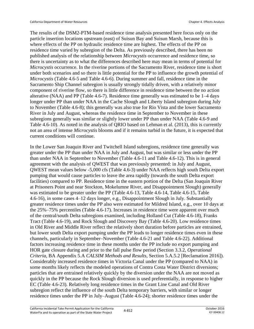
The results of the DSM2-PTM-based residence time analysis presented here focus only on the
particle insertion locations upstream (east) of Suisun Bay and Suisun Marsh, because this is
where effects of the PP on hydraulic residence time are highest. The effects of the PP on
residence time varied by subregion of the Delta. As previously described, there has been no
published analysis of the relationship between Microcystis occurrence and residence time, so
there is uncertainty as to what the differences described here may mean in terms of potential for
Microcystis occurrence. In the riverine portions of the Sacramento River, residence time is short
under both scenarios and so there is little potential for the PP to influence the growth potential of
Microcystis (Table 4.6-5 and Table 4.6-6). During summer and fall, residence time in the
Sacramento Ship Channel subregion is usually strongly tidally driven, with a relatively minor
component of riverine flow, so there is little difference in residence time between the no action
alterative (NAA) and PP (Table 4.6-7). Residence time generally was estimated to be 1–4 days
longer under PP than under NAA in the Cache Slough and Liberty Island subregion during July
to November (Table 4.6-8); this generally was also true for Rio Vista and the lower Sacramento
River in July and August, whereas the residence time in September to November in these
subregions generally was similar or slightly lower under PP than under NAA (Table 4.6-9 and
Table 4.6-10). As noted in the analysis of QRIO based on Lehman et al. (2013), this is currently
not an area of intense Microcystis blooms and if it remains turbid in the future, it is expected that
current conditions will continue.
In the Lower San Joaquin River and Twitchell Island subregions, residence time generally was
greater under the PP than under NAA in July and August, but was similar or less under the PP
than under NAA in September to November (Table 4.6-11 and Table 4.6-12). This is in general
agreement with the analysis of QWEST that was previously presented: in July and August,
QWEST mean values below -5,000 cfs (Table 4.6-3) under NAA reflects high south Delta export
pumping that would cause particles to leave the area rapidly (towards the south Delta export
facilities) compared to PP. Residence time in the eastern portion of the Delta (San Joaquin River
at Prisoners Point and near Stockton, Mokelumne River, and Disappointment Slough) generally
was estimated to be greater under the PP (Table 4.6-13, Table 4.6-14, Table 4.6-15, Table
4.6-16), in some cases 4–12 days longer, e.g., Disappointment Slough in July. Substantially
greater residence times under the PP also were estimated for Mildred Island, e.g., over 10 days at
the 25%–75% percentiles (Table 4.6-17). Increases in residence time were apparent over much
of the central/south Delta subregions examined, including Holland Cut (Table 4.6-18), Franks
Tract (Table 4.6-19), and Rock Slough and Discovery Bay (Table 4.6-20). Low residence times
in Old River and Middle River reflect the relatively short duration before particles are entrained,
but lower south Delta export pumping under the PP leads to longer residence times even in these
channels, particularly in September–November (Table 4.6-21 and Table 4.6-22). Additional
factors increasing residence time in these months under the PP include no export pumping and
HOR gate closure during and prior to the fall pulse flow period (Section 3.3.2, Operational
Criteria, BA Appendix 5.A CALSIM Methods and Results, Section 5.A.5.2 [Reclamation 2016]).
Considerably increased residence times in Victoria Canal under the PP (compared to NAA) in
some months likely reflects the modeled operations of Contra Costa Water District diversions;
particles that are entrained relatively quickly by the diversion under the NAA are not moved as
quickly in the PP because the Rock Slough diversion is used preferentially, in response to higher
EC (Table 4.6-23). Relatively long residence times in the Grant Line Canal and Old River
subregion reflect the influence of the south Delta temporary barriers, with similar or longer
residence times under the PP in July–August (Table 4.6-24); shorter residence times under the

California Department of Water Resources
Chapter 4. Effects Analysis
California Incidental Take Permit Application for the California WaterFix and its operation as part of the State Water Project
4-813 October 2016
ICF 00408.12
PP in October/November are a result of differing assumptions regarding the fall operations of the
HOR gate under the PP compared to the rock barrier under the NAA. In general, there were
relatively small differences in residence time for the Upper San Joaquin River subregion (Table
4.6-25).

California Department of Water Resources
Chapter 4. Effects Analysis
California Incidental Take Permit Application for the California WaterFix and its operation as part of the State Water Project
4-814 October 2016
ICF 00408.12
This page intentionally left blank.

California Department of Water Resources
Chapter 4. Effects Analysis
California Incidental Take Permit Application for the California WaterFix and its operation as part of the State Water Project
4-815 October 2016
ICF 00408.12
Table 4.6-5. Summary Statistics of Residence Time (Days) in the Upper Sacramento River Subregion from DSM2-PTM.
Percentile July August September October November
NAA PP PP vs. NAA NAA PP PP vs. NAA NAA PP PP vs. NAA NAA PP PP vs. NAA NAA PP PP vs. NAA
5% 0.4 0.7 0.3 (65%) 0.6 1.2 0.6 (107%) 0.5 0.7 0.3 (57%) 0.5 1.1 0.7 (148%) 0.4 0.8 0.4 (99%)
25% 0.5 1.1 0.7 (135%) 0.6 1.5 0.8 (126%) 0.5 1.0 0.5 (83%) 0.8 1.4 0.7 (87%) 0.6 1.1 0.4 (69%)
50% (median) 0.5 1.2 0.7 (124%) 0.7 1.8 1.1 (164%) 1.2 2.2 1.0 (89%) 1.0 1.7 0.6 (63%) 1.0 1.4 0.4 (45%)
75% 0.8 1.4 0.6 (76%) 1.8 2.0 0.2 (14%) 2.4 2.7 0.4 (15%) 1.6 1.9 0.2 (13%) 1.8 1.7 0.0 (-2%)
95% 2.4 2.7 0.2 (9%) 3.2 3.1 0.0 (-1%) 20.1 11.5 -8.7 (-43%) 2.3 2.3 0.0 (0%) 16.2 10.6 -5.5 (-34%)
Table 4.6-6. Summary Statistics of Residence Time (Days) in the Sacramento River Near Ryde Subregion from DSM2-PTM.
Percentile July August September October November
NAA PP PP vs. NAA NAA PP PP vs. NAA NAA PP PP vs. NAA NAA PP PP vs. NAA NAA PP PP vs. NAA
5% 0.3 0.4 0.1 (33%) 0.5 0.9 0.4 (69%) 0.5 0.6 0.1 (29%) 0.3 0.6 0.3 (76%) 0.4 0.7 0.3 (85%)
25% 0.5 0.8 0.4 (80%) 0.6 1.1 0.5 (89%) 0.5 0.7 0.2 (33%) 0.6 1.2 0.5 (83%) 0.5 0.9 0.4 (78%)
50% (median) 0.5 1.0 0.5 (89%) 0.7 1.3 0.6 (89%) 0.7 1.5 0.8 (113%) 0.9 1.5 0.6 (65%) 0.8 1.3 0.6 (72%)
75% 0.7 1.2 0.5 (65%) 1.3 1.8 0.5 (40%) 1.7 2.1 0.5 (29%) 1.4 1.7 0.2 (16%) 1.1 1.5 0.4 (32%)
95% 1.8 1.7 -0.1 (-6%) 2.4 2.7 0.2 (10%) 2.5 2.5 0.0 (0%) 2.1 2.3 0.2 (12%) 1.9 1.9 0.0 (-1%)
Table 4.6-7. Summary Statistics of Residence Time (Days) in the Sacramento River Ship Channel Subregion from DSM2-PTM.
Percentile July August September October November
NAA PP PP vs. NAA NAA PP PP vs. NAA NAA PP PP vs. NAA NAA PP PP vs. NAA NAA PP PP vs. NAA
5% 43.3 43.4 0.1 (0%) 43.2 43.1 0.0 (0%) 43.2 43.2 0.0 (0%) 42.5 42.5 0.0 (0%) 39.8 39.7 -0.1 (0%)
25% 43.4 43.5 0.0 (0%) 43.3 43.4 0.1 (0%) 43.3 43.3 0.0 (0%) 43.4 43.3 0.0 (0%) 42.3 42.2 0.0 (0%)
50% (median) 43.6 43.6 0.0 (0%) 43.7 43.8 0.1 (0%) 43.7 43.7 0.1 (0%) 43.7 43.6 0.0 (0%) 43.1 43.1 0.0 (0%)
75% 44.0 44.1 0.0 (0%) 44.0 44.1 0.0 (0%) 43.9 44.0 0.0 (0%) 43.9 43.9 0.0 (0%) 44.1 44.0 0.0 (0%)
95% 44.3 44.3 0.0 (0%) 44.2 44.2 0.0 (0%) 44.3 44.3 0.1 (0%) 44.4 44.4 0.0 (0%) 44.3 44.3 0.0 (0%)
Table 4.6-8. Summary Statistics of Residence Time (Days) in the Cache Slough and Liberty Island Subregion from DSM2-PTM.
Percentile July August September October November
NAA PP PP vs. NAA NAA PP PP vs. NAA NAA PP PP vs. NAA NAA PP PP vs. NAA NAA PP PP vs. NAA
5% 20.4 22.5 2.1 (10%) 16.5 19.5 3.0 (18%) 13.1 14.2 1.1 (8%) 11.4 13.8 2.4 (21%) 8.3 9.6 1.3 (15%)
25% 21.3 23.3 2.0 (9%) 17.2 20.8 3.6 (21%) 14.7 17.5 2.7 (18%) 14.7 17.1 2.4 (17%) 11.5 13.1 1.6 (14%)
50% (median) 22.0 23.8 1.8 (8%) 18.3 21.1 2.8 (15%) 16.1 18.7 2.7 (16%) 15.9 18.2 2.2 (14%) 13.4 14.5 1.2 (9%)
75% 22.7 25.1 2.4 (11%) 20.6 22.1 1.5 (7%) 18.2 21.1 2.9 (16%) 17.6 18.6 1.0 (6%) 14.9 15.6 0.7 (5%)
95% 25.8 27.0 1.2 (5%) 22.3 23.7 1.4 (6%) 22.5 22.3 -0.2 (-1%) 19.0 19.5 0.5 (3%) 16.7 16.4 -0.3 (-2%)
California Department of Water Resources
Chapter 4. Effects Analysis
California Incidental Take Permit Application for the California WaterFix and its operation as part of the State Water Project
4-816 October 2016
ICF 00408.12
Table 4.6-9. Summary Statistics of Residence Time (Days) in the Sacramento River Near Rio Vista Subregion from DSM2-PTM.
Percentile July August September October November
NAA PP PP vs. NAA NAA PP PP vs. NAA NAA PP PP vs. NAA NAA PP PP vs. NAA NAA PP PP vs. NAA
5% 1.4 2.0 0.7 (48%) 5.8 7.4 1.6 (27%) 3.2 1.8 -1.4 (-43%) 3.8 2.7 -1.1 (-29%) 3.6 3.9 0.3 (9%)
25% 4.7 7.7 1.2 (17%) 9.2 9.2 0.0 (0%) 5.0 2.7 -2.3 (-46%) 5.6 5.3 -0.3 (-5%) 5.0 5.3 0.3 (5%)
50% (median) 7.4 11.9 4.5 (60%) 10.4 13.6 3.2 (31%) 7.8 9.0 1.2 (16%) 9.2 8.1 -1.1 (-12%) 6.2 4.7 0.5 (7%)
75% 13.7 14.9 1.1 (8%) 14.7 17.0 2.3 (16%) 15.5 14.7 -0.8 (-5%) 11.9 10.2 -1.7 (-14%) 8.0 9.9 1.9 (24%)
95% 17.3 17.1 -0.2 (-1%) 17.9 19.6 1.7 (10%) 18.9 17.9 -1.0 (-5%) 15.9 14.7 -1.1 (-7%) 12.3 12.1 -0.2 (-2%)
Table 4.6-10. Summary Statistics of Residence Time (Days) in the Lower Sacramento River Subregion from DSM2-PTM.
Percentile July August September October November
NAA PP PP vs. NAA NAA PP PP vs. NAA NAA PP PP vs. NAA NAA PP PP vs. NAA NAA PP PP vs. NAA
5% 3.2 4.7 1.6 (49%) 10.1 12.2 2.1 (21%) 4.7 3.5 -1.3 (-26%) 6.7 6.7 0.0 (0%) 6.1 6.0 -0.1 (-2%)
25% 9.1 12.3 3.2 (35%) 13.5 13.6 0.1 (1%) 7.0 4.4 -2.6 (-37%) 8.8 8.4 -0.4 (-5%) 7.5 7.4 -0.1 (-1%)
50% (median) 12.9 15.0 2.1 (17%) 17.4 18.7 1.3 (8%) 13.4 12.5 -0.9 (-7%) 13.4 12.9 -0.5 (-4%) 10.2 10.8 0.6 (6%)
75% 20.9 21.0 0.2 (1%) 21.7 23.4 1.7 (8%) 22.6 21.2 -1.5 (-6%) 18.4 16.9 -1.5 (-8%) 13.2 14.7 1.4 (11%)
95% 22.4 22.2 -0.2 (-1%) 23.5 24.4 0.9 (4%) 24.3 23.4 -0.9 (-4%) 20.9 20.5 -0.4 (-2%) 18.7 18.4 -0.3 (-1%)
Table 4.6-11. Summary Statistics of Residence Time (Days) in the Lower San Joaquin River Subregion from DSM2-PTM.
Percentile July August September October November
NAA PP PP vs. NAA NAA PP PP vs. NAA NAA PP PP vs. NAA NAA PP PP vs. NAA NAA PP PP vs. NAA
5% 3.1 4.7 1.4 (45%) 12.0 12.7 0.7 (6%) 5.5 3.7 -1.8 (-32%) 7.5 6.8 -0.7 (-9%) 7.1 5.2 -2.0 (-27%)
25% 11.3 13.0 1.7 (15%) 15.4 14.2 -1.2 (-8%) 10.4 4.3 -6.1 (-58%) 9.8 7.8 -2.0 (-21%) 9.6 8.1 -1.5 (-15%)
50% (median) 14.1 16.0 2.0 (14%) 17.8 18.3 0.5 (3%) 14.5 11.9 -2.6 (-18%) 13.4 11.5 -1.9 (-14%) 12.2 10.9 -1.3 (-11%)
75% 20.4 21.5 1.1 (5%) 22.4 23.3 1.0 (4%) 22.9 20.7 -2.2 (-10%) 19.9 16.7 -3.2 (-16%) 14.5 15.7 1.2 (8%)
95% 22.7 23.4 0.7 (3%) 24.7 25.2 0.4 (2%) 25.5 24.3 -1.1 (-4%) 22.3 21.0 -1.3 (-6%) 19.3 20.1 0.8 (4%)
Table 4.6-12. Summary Statistics of Residence Time (Days) in the San Joaquin River at Twitchell Island Subregion from DSM2-PTM.
Percentile July August September October November
NAA PP PP vs. NAA NAA PP PP vs. NAA NAA PP PP vs. NAA NAA PP PP vs. NAA NAA PP PP vs. NAA
5% 2.7 3.1 0.4 (14%) 9.5 12.1 2.6 (27%) 8.1 4.3 -3.8 (-47%) 8.4 5.3 -3.2 (-38%) 7.6 6.0 -1.6 (-21%)
25% 10.2 13.5 3.3 (32%) 10.8 13.6 2.8 (26%) 10.3 5.9 -4.3 (-42%) 12.4 8.0 -4.3 (-35%) 10.6 9.6 -1.0 (-9%)
50% (median) 12.0 16.1 4.1 (35%) 12.6 17.0 4.5 (36%) 11.6 13.3 1.6 (14%) 14.5 11.8 -2.7 (-18%) 12.6 11.8 -0.8 (-6%)
75% 13.6 18.1 4.5 (33%) 19.4 20.4 1.1 (6%) 19.0 20.0 1.0 (5%) 18.2 16.9 -1.4 (-8%) 15.3 15.9 0.6 (4%)
95% 21.0 21.1 0.1 (0%) 23.4 22.2 -1.2 (-5%) 23.0 22.6 -0.4 (-2%) 20.8 20.2 -0.6 (-3%) 18.9 19.7 0.8 (4%)

California Department of Water Resources
Chapter 4. Effects Analysis
California Incidental Take Permit Application for the California WaterFix and its operation as part of the State Water Project
4-817 October 2016
ICF 00408.12
Table 4.6-13. Summary Statistics of Residence Time (Days) in the San Joaquin River at Prisoners Point from DSM2-PTM.
Percentile July August September October November
NAA PP PP vs. NAA NAA PP PP vs. NAA NAA PP PP vs. NAA NAA PP PP vs. NAA NAA PP PP vs. NAA
5% 2.7 3.0 0.3 (10%) 4.3 8.4 4.1 (95%) 4.4 5.3 0.9 (20%) 7.5 6.5 -1.0 (-14%) 3.9 4.7 2.7 (68%)
25% 4.9 9.7 4.7 (96%) 5.0 10.5 5.5 (109%) 5.4 7.7 2.3 (43%) 9.8 8.3 -1.5 (-15%) 7.4 8.4 1.0 (14%)
50% (median) 6.0 10.7 4.7 (79%) 6.3 11.0 4.7 (74%) 7.4 11.0 3.7 (50%) 10.7 11.0 0.3 (3%) 8.6 10.6 2.0 (24%)
75% 7.3 12.2 4.9 (66%) 12.5 13.3 0.9 (7%) 10.9 15.0 4.1 (38%) 14.1 14.7 0.7 (5%) 11.1 12.4 1.3 (11%)
95% 13.6 14.7 1.2 (9%) 18.7 16.2 -2.5 (-13%) 16.8 16.7 -0.1 (-1%) 16.5 17.2 0.7 (4%) 14.7 15.0 0.4 (3%)
Table 4.6-14. Summary Statistics of Residence Time (Days) in the North and South Forks Mokelumne River Subregion from DSM2-PTM.
Percentile July August September October November
NAA PP PP vs. NAA NAA PP PP vs. NAA NAA PP PP vs. NAA NAA PP PP vs. NAA NAA PP PP vs. NAA
5% 4.9 8.7 3.8 (79%) 3.0 6.7 3.7 (126%) 3.9 5.8 1.9 (50%) 6.3 7.5 1.2 (18%) 5.6 5.3 -0.2 (-4%)
25% 12.6 15.6 3.0 (24%) 4.2 8.9 4.7 (112%) 6.7 8.7 2.0 (30%) 9.4 8.7 -0.7 (-7%) 7.1 9.7 2.6 (36%)
50% (median) 20.8 20.8 0.0 (0%) 8.3 11.9 3.6 (44%) 11.4 12.4 1.0 (9%) 10.0 10.7 0.7 (7%) 8.9 10.3 1.4 (16%)
75% 26.1 24.7 -1.5 (-6%) 17.2 17.9 0.7 (4%) 17.0 17.7 0.7 (4%) 13.6 14.0 0.4 (3%) 11.1 12.5 1.3 (12%)
95% 34.2 31.5 -2.7 (-8%) 27.2 20.1 -7.1 (-26%) 24.7 22.2 -2.5 (-10%) 21.5 14.7 -4.9 (-23%) 16.5 14.2 -2.3 (-14%)
Table 4.6-15. Summary Statistics of Residence Time (Days) in the Disappointment Slough Subregion from DSM2-PTM.
Percentile July August September October November
NAA PP PP vs. NAA NAA PP PP vs. NAA NAA PP PP vs. NAA NAA PP PP vs. NAA NAA PP PP vs. NAA
5% 12.1 15.5 3.4 (29%) 10.9 18.2 7.2 (66%) 10.8 15.2 4.4 (40%) 13.2 9.5 -3.7 (-28%) 14.7 15.1 0.3 (2%)
25% 17.9 26.7 8.9 (50%) 20.8 20.9 0.1 (1%) 16.8 18.4 1.6 (9%) 15.8 17.8 2.0 (13%) 18.6 17.9 -0.6 (-3%)
50% (median) 25.0 36.9 11.8 (47%) 25.7 29.9 4.2 (16%) 20.6 23.0 2.4 (12%) 19.6 22.9 3.3 (17%) 24.7 21.0 -3.8 (-15%)
75% 34.0 39.4 5.5 (16%) 29.3 33.0 3.8 (13%) 23.3 25.1 1.8 (8%) 23.7 28.7 5.0 (21%) 29.0 29.6 0.7 (2%)
95% 38.2 41.9 3.7 (10%) 34.2 35.6 1.4 (4%) 27.5 29.3 1.8 (7%) 27.5 30.8 3.3 (12%) 34.9 33.2 -1.7 (-5%)
Table 4.6-16. Summary Statistics of Residence Time (Days) in the San Joaquin River Near Stockton Subregion from DSM2-PTM.
Percentile July August September October November
NAA PP PP vs. NAA NAA PP PP vs. NAA NAA PP PP vs. NAA NAA PP PP vs. NAA NAA PP PP vs. NAA
5% 1.3 1.5 0.2 (12%) 3.2 3.9 0.7 (22%) 4.1 4.3 0.1 (4%) 3.0 3.5 0.5 (17%) 2.8 3.1 0.4 (13%)
25% 5.8 7.8 2.0 (35%) 6.5 8.0 1.5 (23%) 5.9 6.8 0.9 (16%) 4.1 5.1 1.0 (25%) 4.4 5.0 0.6 (14%)
50% (median) 13.9 11.7 -2.3 (-16%) 9.7 9.8 0.1 (1%) 6.7 8.6 1.9 (29%) 5.2 6.2 1.1 (21%) 5.7 6.8 1.1 (19%)
75% 18.1 13.0 -5.0 (-28%) 12.1 10.9 -1.1 (-9%) 8.7 9.8 1.1 (13%) 6.4 7.4 1.1 (17%) 7.5 7.6 0.2 (2%)
95% 29.2 23.0 -6.2 (-21%) 15.1 14.4 -0.7 (-5%) 10.0 11.0 1.1 (11%) 8.3 9.0 0.7 (8%) 8.7 9.3 0.6 (7%)

California Department of Water Resources
Chapter 4. Effects Analysis
California Incidental Take Permit Application for the California WaterFix and its operation as part of the State Water Project
4-818 October 2016
ICF 00408.12
Table 4.6-17. Summary Statistics of Residence Time (Days) in the Mildred Island Subregion from DSM2-PTM.
Percentile July August September October November
NAA PP PP vs. NAA NAA PP PP vs. NAA NAA PP PP vs. NAA NAA PP PP vs. NAA NAA PP PP vs. NAA
5% 3.0 7.1 4.1 (138%) 1.8 5.0 3.3 (183%) 2.0 7.4 5.4 (270%) 2.9 8.9 6.0 (205%) 2.1 4.1 2.0 (93%)
25% 4.4 15.5 11.1 (255%) 2.2 8.1 5.8 (262%) 3.2 9.2 6.0 (188%) 3.7 11.6 7.9 (215%) 3.0 6.1 3.1 (106%)
50% (median) 6.9 23.4 16.5 (238%) 3.7 9.5 5.9 (160%) 4.7 10.7 6.0 (127%) 5.2 13.0 7.8 (150%) 4.7 13.9 9.3 (205%)
75% 11.1 27.1 16.0 (144%) 13.6 11.9 -1.7 (-12%) 6.9 14.9 8.0 (115%) 9.5 16.5 7.0 (73%) 15.9 15.7 -0.2 (-1%)
95% 25.1 30.0 4.9 (20%) 19.3 19.6 0.3 (2%) 15.4 16.8 1.4 (9%) 21.6 22.6 1.0 (4%) 21.1 21.5 0.4 (2%)
Table 4.6-18. Summary Statistics of Residence Time (Days) in the Holland Cut Subregion from DSM2-PTM.
Percentile July August September October November
NAA PP PP vs. NAA NAA PP PP vs. NAA NAA PP PP vs. NAA NAA PP PP vs. NAA NAA PP PP vs. NAA
5% 1.4 3.8 2.4 (169%) 1.2 3.7 2.4 (198%) 1.5 4.7 3.3 (225%) 2.5 6.5 3.9 (156%) 1.8 3.3 1.5 (81%)
25% 2.0 4.2 2.2 (114%) 1.6 5.1 3.5 (226%) 1.8 5.5 3.7 (208%) 3.4 8.0 4.7 (134%) 2.6 4.0 1.4 (52%)
50% (median) 2.5 4.7 2.3 (95%) 2.4 5.7 3.3 (139%) 3.0 7.5 4.5 (154%) 3.9 8.6 4.7 (123%) 3.3 5.8 2.5 (75%)
75% 3.5 6.0 2.5 (73%) 5.4 4.7 1.1 (21%) 5.7 8.8 3.1 (55%) 5.8 9.1 3.3 (57%) 4.9 8.5 3.7 (76%)
95% 5.6 6.8 1.2 (22%) 9.8 7.8 -2.0 (-21%) 9.7 9.7 -0.1 (-1%) 7.5 9.8 2.3 (31%) 6.9 9.6 2.8 (41%)
Table 4.6-19. Summary Statistics of Residence Time (Days) in the Franks Tract Subregion from DSM2-PTM.
Percentile July August September October November
NAA PP PP vs. NAA NAA PP PP vs. NAA NAA PP PP vs. NAA NAA PP PP vs. NAA NAA PP PP vs. NAA
5% 9.4 10.7 1.2 (13%) 10.0 11.1 1.1 (11%) 9.0 8.2 -0.8 (-9%) 9.1 8.6 -0.5 (-5%) 8.1 8.0 -0.1 (-1%)
25% 10.9 12.2 1.3 (12%) 10.9 13.2 2.4 (22%) 10.3 9.4 -0.8 (-8%) 11.1 9.7 -1.5 (-13%) 11.2 10.3 -0.9 (-8%)
50% (median) 11.6 14.4 2.8 (24%) 11.9 16.1 4.3 (36%) 11.8 14.1 2.3 (20%) 13.9 12.5 -1.4 (-10%) 12.3 12.0 -0.3 (-3%)
75% 12.8 14.7 3.8 (30%) 17.0 17.8 0.8 (5%) 16.2 17.4 1.1 (7%) 15.4 13.8 -1.6 (-10%) 14.4 15.1 0.7 (5%)
95% 16.9 17.5 0.6 (3%) 18.0 19.9 1.9 (10%) 18.7 18.5 -0.2 (-1%) 18.6 17.0 -1.7 (-9%) 18.1 18.0 -0.1 (-1%)
Table 4.6-20. Summary Statistics of Residence Time (Days) in the Rock Slough and Discovery Bay Subregion from DSM2-PTM.
Percentile July August September October November
NAA PP PP vs. NAA NAA PP PP vs. NAA NAA PP PP vs. NAA NAA PP PP vs. NAA NAA PP PP vs. NAA
5% 4.7 7.4 2.6 (54%) 3.9 8.5 4.7 (119%) 4.7 11.0 6.3 (135%) 5.4 8.4 3.0 (55%) 5.0 6.9 1.9 (37%)
25% 5.6 8.8 3.3 (59%) 5.3 9.7 4.4 (84%) 5.6 14.7 8.9 (159%) 7.3 10.0 2.8 (38%) 5.9 8.2 2.3 (39%)
50% (median) 6.4 10.0 3.7 (57%) 5.7 11.9 6.2 (109%) 6.8 17.5 10.7 (158%) 8.8 15.2 6.4 (72%) 7.5 9.8 2.2 (29%)
75% 7.3 11.4 4.1 (56%) 10.1 15.9 5.9 (58%) 14.7 19.3 2.7 (17%) 12.1 17.1 5.0 (42%) 10.8 12.1 1.3 (12%)
95% 10.7 13.9 3.1 (29%) 19.2 22.3 3.1 (16%) 19.8 25.2 5.4 (27%) 20.6 19.2 -1.4 (-7%) 12.2 13.6 1.5 (12%)

California Department of Water Resources
Chapter 4. Effects Analysis
California Incidental Take Permit Application for the California WaterFix and its operation as part of the State Water Project
4-819 October 2016
ICF 00408.12
Table 4.6-21. Summary Statistics of Residence Time (Days) in the Old River Subregion from DSM2-PTM.
Percentile July August September October November
NAA PP PP vs. NAA NAA PP PP vs. NAA NAA PP PP vs. NAA NAA PP PP vs. NAA NAA PP PP vs. NAA
5% 0.5 1.5 1.0 (212%) 0.4 1.4 1.0 (275%) 0.6 1.7 1.1 (199%) 0.6 2.5 1.9 (304%) 0.7 1.3 0.6 (82%)
25% 0.7 1.8 1.1 (164%) 0.6 1.6 1.1 (189%) 0.8 2.5 1.7 (208%) 1.0 3.4 2.3 (228%) 0.9 1.7 0.8 (89%)
50% (median) 1.0 2.3 1.3 (131%) 1.0 2.0 1.0 (102%) 1.1 3.5 2.5 (231%) 1.3 5.9 4.7 (363%) 1.1 1.9 0.7 (64%)
75% 1.4 2.8 1.4 (101%) 2.0 2.5 0.5 (23%) 1.9 6.4 4.5 (243%) 1.7 8.0 6.4 (382%) 1.8 7.2 5.4 (299%)
95% 4.2 3.8 -0.3 (-8%) 4.1 4.7 0.7 (17%) 2.7 12.0 9.3 (347%) 2.4 12.0 9.6 (393%) 2.8 8.6 5.8 (205%)
Table 4.6-22. Summary Statistics of Residence Time (Days) in the Middle River Subregion from DSM2-PTM.
Percentile July August September October November
NAA PP PP vs. NAA NAA PP PP vs. NAA NAA PP PP vs. NAA NAA PP PP vs. NAA NAA PP PP vs. NAA
5% 0.5 0.8 0.3 (62%) 0.4 0.7 0.3 (78%) 0.4 1.1 0.7 (180%) 0.5 1.5 1.0 (196%) 0.4 0.7 0.3 (58%)
25% 0.6 1.1 0.6 (101%) 0.4 0.9 0.5 (114%) 0.4 1.2 0.7 (177%) 0.6 2.0 1.4 (228%) 0.6 0.9 0.3 (51%)
50% (median) 0.7 1.3 0.6 (93%) 0.5 1.0 0.5 (99%) 0.5 1.4 0.8 (155%) 0.7 2.8 2.1 (292%) 0.7 1.1 0.4 (63%)
75% 0.8 1.6 0.8 (100%) 0.9 1.1 0.3 (29%) 0.8 1.6 0.8 (95%) 1.0 7.9 7.0 (727%) 0.8 10.9 10.1 (1,218%)
95% 2.4 4.5 2.1 (88%) 1.9 1.7 -0.2 (-13%) 1.3 2.4 1.1 (84%) 1.2 18.0 16.8 (1351%) 1.1 11.8 10.7 (979%)
Table 4.6-23. Summary Statistics of Residence Time (Days) in the Victoria Canal Subregion from DSM2-PTM.
Percentile July August September October November
NAA PP PP vs. NAA NAA PP PP vs. NAA NAA PP PP vs. NAA NAA PP PP vs. NAA NAA PP PP vs. NAA
5% 0.3 2.5 2.2 (713%) 0.2 0.5 0.3 (116%) 0.3 0.7 0.4 (170%) 0.3 3.7 3.4 (1082%) 0.3 0.5 0.2 (51%)
25% 0.3 7.4 7.0 (2074%) 0.3 2.2 2.0 (731%) 0.3 4.1 3.8 (1339%) 0.4 5.4 5.1 (1353%) 0.4 0.6 0.2 (57%)
50% (median) 1.3 13.0 11.7 (939%) 4.7 7.6 3.0 (64%) 1.2 7.2 5.9 (480%) 0.6 10.5 9.9 (1734%) 0.6 7.1 6.5 (1052%)
75% 10.0 19.9 9.9 (99%) 14.5 14.2 -0.3 (-2%) 10.6 11.6 1.0 (10%) 3.9 14.7 10.8 (278%) 4.9 11.1 6.2 (126%)
95% 16.8 25.4 8.7 (52%) 26.4 21.1 -5.3 (-20%) 20.4 19.9 -0.5 (-3%) 15.7 17.8 2.1 (13%) 12.3 14.1 1.8 (15%)
Table 4.6-24. Summary Statistics of Residence Time (Days) in the Grant Line Canal and Old River Subregion from DSM2-PTM.
Percentile July August September October November
NAA PP PP vs. NAA NAA PP PP vs. NAA NAA PP PP vs. NAA NAA PP PP vs. NAA NAA PP PP vs. NAA
5% 2.2 3.0 0.8 (35%) 9.3 9.3 -0.1 (-1%) 2.7 6.2 3.4 (125%) 3.6 3.1 -0.5 (-14%) 4.4 5.4 1.0 (23%)
25% 29.3 29.6 0.3 (1%) 20.2 23.5 3.2 (16%) 8.5 10.0 1.5 (18%) 6.7 4.3 -2.4 (-36%) 8.2 8.1 -0.1 (-1%)
50% (median) 38.7 40.0 1.4 (4%) 27.3 29.1 1.8 (6%) 16.9 23.3 6.4 (38%) 13.6 10.1 -3.4 (-25%) 11.8 9.2 -2.7 (-22%)
75% 40.4 41.0 0.6 (1%) 36.2 35.5 -0.7 (-2%) 32.9 35.8 3.0 (9%) 19.5 14.7 -4.7 (-24%) 14.4 11.2 -3.3 (-23%)
95% 42.8 42.0 -0.9 (-2%) 40.8 37.0 -3.8 (-9%) 38.1 38.0 -0.1 (0%) 24.2 24.7 0.6 (3%) 21.2 13.1 -8.0 (-38%)

California Department of Water Resources
Chapter 4. Effects Analysis
California Incidental Take Permit Application for the California WaterFix and its operation as part of the State Water Project
4-820 October 2016
ICF 00408.12
Table 4.6-25. Summary Statistics of Residence Time (Days) in the Upper San Joaquin River Subregion from DSM2-PTM.
Percentile July August September October November
NAA PP PP vs. NAA NAA PP PP vs. NAA NAA PP PP vs. NAA NAA PP PP vs. NAA NAA PP PP vs. NAA
5% 0.2 0.2 0.0 (0%) 0.2 0.2 0.0 (-1%) 0.4 0.4 0.0 (-2%) 0.3 0.3 0.0 (16%) 0.3 0.3 0.0 (-8%)
25% 0.8 0.7 -0.1 (-11%) 0.9 0.8 -0.1 (-16%) 0.7 0.7 -0.1 (-10%) 0.5 0.6 0.1 (23%) 0.4 0.3 0.0 (-6%)
50% (median) 2.0 1.4 -0.7 (-33%) 1.5 1.2 -0.3 (-18%) 1.0 0.8 -0.1 (-13%) 0.6 0.7 0.1 (25%) 0.5 0.5 0.0 (-8%)
75% 3.3 1.8 -1.5 (-46%) 1.9 1.6 -0.3 (-15%) 1.2 1.1 -0.2 (-14%) 0.7 0.8 0.2 (27%) 0.6 0.6 0.0 (-7%)
95% 13.5 6.7 -6.8 (-50%) 2.8 2.4 -0.4 (-15%) 1.5 1.3 -0.2 (-16%) 0.8 0.9 0.1 (18%) 0.6 0.6 0.0 (-1%)

California Department of Water Resources
Chapter 4. Effects Analysis
California Incidental Take Permit Application for the California WaterFix and its operation as part of the State Water Project
4-821 October 2016
ICF 00408.12
The extent to which giant garter snakes occur within the Delta is unknown, though population
concentrations are known to occur along the periphery of the Delta in the Yolo Basin-Willow
Slough, Yolo Basin Liberty Farms, and Caldoni Marsh-White Slough regions (U.S. Fish and
Wildlife Service 1999). The giant garter snake diet consists primarily of frogs (chiefly American
bullfrog [Rana catesbeiana]) and western chorus frog [Pseudacris triseriata]) and fish, with
preference given to frogs (Halsted and Ersan pers. comm). American bullfrog tadpoles eat algae,
aquatic plant matter, and some insects. Adult bullfrogs are opportunistic predators, consuming a
wide-range of terrestrial and aquatic prey including invertebrates, mammals, birds, fish, reptiles,
and amphibians, including other bullfrogs. The western chorus frog has a primarily land-sourced
diet of slugs, spiders, isopods, centipedes, earthworms, and insects (Morey 2008), and thus has
low potential exposure to microcystin. Bullfrogs forage within the terrestrial and aquatic
foodwebs, and may ingest microcystins through the consumption of fish and other aquatic
organisms, or through consumption of other bullfrogs.
The streamflow and temperature modeling results suggest there is potential for increased
frequency of Microcystis blooms during the summer and fall months where giant garter snakes
occur in portions of the Sacramento River system in the Delta. Microcystis toxicity has been
shown to cause deleterious effects on fish and bird species (Butler et al. 2009), but sensitivity to
microcystins varies by species and life stage (Table 4.6-3; Butler et al. 2009). The effects of
Microcystis blooms on giant garter snakes or the prey of giant garter snakes are unknown. Small
fish and bullfrogs consumed by giant garter snakes during or after Microcystis blooms could be
sources of microcystins for giant garter snakes. In the northern portion of the Delta, Microcystis
blooms are currently not common; if water in this region remains turbid in the future, current
conditions are expected to continue.
In the south and central portions of the Delta, residence time would be increase under the PP
relative to the NAA, which would increase the potential of giant garter snakes exposure to
microcystin through the consumption of fish and bullfrogs. This would give greater potential for
adverse effects of Microcystis under the PP relative to the NAA; however, under the NAA, lower
residence time would reflect zooplankton and other food web materials being more susceptible to
entrainment because of greater south Delta export pumping, so the overall effect is uncertain;
and, as stated previously, the potential effect of Microcystis blooms on giant garter snakes is
unknown, especially given their preference for American bullfrogs and western chorus frogs.
There is potential for increased occurrence of Microcystis blooms in the Sacramento and San
Joaquin Delta and therefore increased potential for giant garter snake exposure to microcystins.
However, because giant garter snakes preferentially prey upon frogs, which forage in both the
terrestrial and aquatic foodweb, and because the effects of current Microcystis blooms on giant
garter snake are not well understood, the effects of potential increased occurrence of Microcystis
blooms on giant garter snakes is also unknown.
4.6.1.3.3.2.2 Selenium
4.6.1.3.3.2.2.1 Baseline Exposure
A current mass balance of selenium, as a function of source and conveyance, is not available for
the San Francisco Estuary (Presser and Luoma 2010). Annual and seasonal variations of
selenium concentrations in the Delta and estuary are influenced by discharges in rivers and

California Department of Water Resources
Chapter 4. Effects Analysis
California Incidental Take Permit Application for the California WaterFix and its operation as part of the State Water Project
4-822 October 2016
ICF 00408.12
anthropogenic sources (Presser and Luoma 2006). Water inflow to the Delta comes primarily
from the Sacramento and San Joaquin rivers of which the Sacramento River provides the largest
water volume contribution and dilution of selenium inputs from other sources. Factors affecting
selenium contribution and dilution include the total river inflow, water diversions and/or exports,
the proportion of the San Joaquin River that is diverted south before entering the Estuary, and
total outflow of the Estuary to the Pacific Ocean (Presser and Luoma 2010).
Selenium contamination in soils and water of the Sacramento Valley is not high and thus not
considered a threat in this part of the giant garter snake’s range (Seiler et al. 2003). In the San
Joaquin River basin implementation of both regulatory controls and the Grassland Bypass
Project, which manages agricultural drainage south and west of the Grassland Ecological Area,
have significantly improved water quality in the San Joaquin River and adjacent channels.
However, irrigation drainage into Mud Slough and the San Joaquin River results in non-
compliance with the selenium water quality objective. Achieving water quality compliance for
this segment of the river is not anticipated until 2019 or later. Continued inputs from
precipitation runoff from selenium-laden soils, irrigation drainage, and existing riverbed loads
still provide inputs of selenium to the Delta where giant garter snakes are potentially exposed to
selenium through their diet consisting principally of amphibians and small fish.
Modification of Delta inflow via construction of the North Delta diversions and water operations
changes for the SWP and CVP may interact with selenium fate and transport. Conceptually,
exports of San Joaquin River selenium-laden water out of the Delta and into Delta Mendota
Canal and California Aquaduct will be reduced under the PP. In addition, less Sacramento River
water will be available for dilution of San Joaquin River. Meseck and Cutter (2006) developed a
biogeochemical modeling of the estuary to simulate salinity, total suspended material,
phytoplankton biomass, and dissolved and particulate selenium concentrations. They modeled an
increase in discharge from the San Joaquin River and varying sources of refinery inputs to
investigate how it would affect the dissolved and particulate selenium in the San Francisco Bay.
They found that when river flow was low (i.e., November, 70-day residence time) total
particulate selenium (the bioavailable form) concentrations could increase. These results suggest
that bioavailable selenium and associated food web accumulation could increase because of
increased San Joaquin River flow and reduced south Delta exports (Meseck and Cutter 2006).
4.6.1.3.3.2.2.2 Known Effects of Selenium on Snakes and Reptiles
Dietary uptake is the principal route of toxic exposure to selenium in wildlife, including giant
garter snake (Beckon et al. 2003). Our current understanding is that selenium does not
biomagnify and the majority of food web enrichment occurs at the lowest trophic levels. Scaled
reptiles, such as giant garter snake generally do not secrete an albumin layer, as do birds,
crocodilians, and turtles (Unrine et al. 2006). As a result, selenium may be transported through
serum to the egg from the liver as vitellogenin, whereas in birds, crocodilians, and turtles,
additional oviductal contributions of selenium occur post-ovulation (Unrine et al. 2006, Janz et
al. 2010). Therefore, a dietary selenium toxicity threshold, rather than an egg concentration
threshold, appears appropriate for assessing selenium effects to giant garter snake.
Elevated selenium through diet or maternal transfer to offspring can affect vertebrates when
selenium is substituted for sulfur during protein synthesis. Improperly folded proteins and
dysfunctional enzymes can result, with consequences including oxidative stress and embryo

California Department of Water Resources
Chapter 4. Effects Analysis
California Incidental Take Permit Application for the California WaterFix and its operation as part of the State Water Project
4-823 October 2016
ICF 00408.12
toxicity. Toxicity thresholds are established by identifying concentrations of selenium that result
in an observable effect on an organism (e.g., altered metabolism, mortality, deformity,
reproductive failure). No information is available on the toxicity thresholds or indirect effects of
selenium for giant garter snake or other snakes. However, information on the risk of selenium
exposure on other species may be useful in predicting general effects on giant garter snakes.
Laboratory and field study on giant garter snake and terrestrial snakes have documented
selenium bioaccumulation from through prey consumption.
A single laboratory study dosed female terrestrial brown house snakes (Lamprophis falginosus)
with selenium, as selanomethonine, injected into their food items at ~1 (control), 10, and 20 µg/g
(dry weight) doses. The investigators selected these dosages because they represented the range
of exposures used in prior avian and mammalian studies. No significant effects on survival or
reproduction were observed at any dose (Hopkins et al. 2004). However, in the two treatment
groups selenium was transferred to eggs in concentrations that exceeded all suggested
reproduction thresholds for birds and fish (24.25 ±0.49 µg/g dry weight in the 20 µg/g treatment
group) (Hopkins et al. 2004). No information was available on the consequences of the egg
selenium burdens for post-hatch survival.
Wylie et al. (2009) measured selenium and other trace elements in 23 dead giant garter snakes
collected from 1995 to 2004 at sites in Colusa National Wildlife Refuge, the Natomas Basin, and
other sites in northern California. Giant garter snake liver selenium concentrations ranged from
1.24 to 6.98 µg/g (dry weight) with a geometric mean of 3.06 µg/g. Current science does not
provide information about the consequences of these selenium body burdens to the health or
survival of individuals or populations of giant garter snake.
4.6.1.3.3.2.2.3 Effects of the Proposed Project
There are currently no predictive modeling tools, nor is there an understanding of effects
thresholds, that would enable predicting direct effects of dietary selenium exposure on giant
garter snakes. However, inferences about the effects of selenium exposure are possible using
Delta Smelt as a surrogate for giant garter snakes’ prey.
In the Delta Smelt effects analysis (Section 4.1, Effects on Delta Smelt) DSM2 volumetric
fingerprinting was used to estimate the source water contribution of the Delta water sources
including the San Joaquin River that are the primary source of selenium loading to the Delta.
Aqueous and Delta Smelt selenium tissue concentrations were modeled at five sites: San Joaquin
River at Prisoners Point, Cache Slough at Ryer Island, Sacramento River at Emmaton, San
Joaquin River at Antioch, and Suisun Bay at Mallard Island. Modeling results indicated that, of
these five sites, the highest proportion of San Joaquin River water and its selenium load (and
thus resulting fish tissue selenium) occurred at Prisoners Point. Thus, of the Delta sites modeled
for Delta Smelt, Prisoners Point represents the worst-case scenario for selenium exposure.
Results for the PP selenium bioaccumulation modeling for Delta Smelt at Prisoners Point
showed increases of as much as twice the modeled tissue concentration, in Delta Smelt foraging
at that location. Despite the predicted increases, all but 0.7% of modeled tissue concentrations
were below the effects threshold for fish deformities. Based on these modeling results, the PP is
unlikely to increase tissue concentrations significantly enough to result in detrimental effects to
Delta Smelt. The PP would be expected to have similar effects on fishes with diets and habitat

California Department of Water Resources
Chapter 4. Effects Analysis
California Incidental Take Permit Application for the California WaterFix and its operation as part of the State Water Project
4-824 October 2016
ICF 00408.12
preferences similar to Delta Smelt (e.g., silversides). However, this assumption would not apply
to young sunfishes or Sacramento Splittail whose parental diet may include other fish or bivalves
that bioaccumulate selenium at substantially higher rate than crustaceans. Our surrogate Delta
Smelt tissue modeling also does not represent the risk to giant garter snake foraging in locations
upstream of Prisoners Point that have higher San Joaquin River water and selenium
contributions.
Residence times could provide an additional line of evidence in evaluating the risk of selenium
effects from the PP. A significant factor in the bioavailability of selenium is water residence
time. Biogeochemical modeling suggests that increasing the San Joaquin River discharge could
result in increased bioavailable selenium during “low flow” conditions (Meseck and Cutter
2006). Low flow conditions modeled were 70-day residence times.
For the PP, residence times were estimated using DSM2-PTM to evaluate the effects of water
operations on water quality. Residence time changes under for the PP varied greatly by model
site. The highest residence times for the both the NAA and the PP occurred at Grant Line Canal
and Old River sites. The modeling predicted for the PP a 95% percentile, July water residence
time of 42.8 days, a reduction of 0.8 days compared to the NAA. Residence time estimates did
not meet or exceed the 70-day residence times used in the Meseck and Cutter (2006)
biogeochemical modeling that predicted increased selenium bioavailability. This would suggest
that the PP and would not result in the same increase of bioavailable, particulate selenium
predicted by their hydrologic conditions modeling of Meseck and Cutter (2006).
4.6.1.3.3.2.2.4 All Life Stages
4.6.1.3.3.2.2.4.1 Individual-Level
Two modeling efforts suggest the potential for increases in San Joaquin River water and its
associated selenium load to the Delta. We lack information about effects thresholds or exposure
risk directly to giant garter snake. Using Delta Smelt as a surrogate for giant garter snake fish
prey, selenium bioaccumulation modeling suggests that reductions in fish prey for fish feeding at
the same tropic level as Delta Smelt are unlikely to result from the PP. Prey fishes that feed on
bivalves or at a higher trophic level may represent an increased risk. Project effects on giant
garter snake, either directly to the snake via increased dietary selenium, indirectly through
reduced fish prey availability are currently unquantifiable. If risk were increased because of the
PP, it would most likely occur for giant garter snakes residing and feeding in the South Delta and
the San Joaquin River upstream from Prisoners Point to Vernalis or from snakes that consumed
Sacramento splittail or piscivorous fish species.
4.6.1.3.3.2.2.4.2 Population-Level
There is inadequate information available to assess the risk to giant garter snake individuals or
populations from selenium. If giant garter snakes were affected by a selenium increase caused by
the PP it would be most likely to occur in the South Delta and the San Joaquin River upstream
from Prisoners Point to Vernalis. Giant garter snakes reside in areas of the Delta and lower San
Joaquin River (Kesterson and Grasslands Bypass) where selenium has been historically elevated.
Population effects were not documented as a result of those historic exposures.

California Department of Water Resources
Chapter 4. Effects Analysis
California Incidental Take Permit Application for the California WaterFix and its operation as part of the State Water Project
4-825 October 2016
ICF 00408.12
4.6.1.3.3.2.3 Methylmercury
The PP could potentially expose giant garter snake to methylmercury by the following
mechanisms:
Changes in the ambient water column concentrations of methylmercury attributable to
operations of the proposed conveyance facilities.
Exposure of ambient methylmercury in sediments during in-water construction or
maintenance work.
Biogenic production of methylmercury within restoration wetlands.
4.6.1.3.3.2.3.1 Changes in the ambient water column concentrations of methylmercury attributable to operations of the proposed conveyance facilities
As described in the FEIR/FEIS for WQ Impact 13, operational modeling does not show any
meaningful changes in mercury as a result of operations. To quote from that analysis:
The effects of Alternative 4A on waterborne concentrations of mercury
(Appendix 8I, Mercury, Table I-17) and methylmercury (Appendix 8I, Table I-
18), and fish tissue mercury concentrations for largemouth bass fillet (Appendix
8I, Tables I-20a and I-20b) were evaluated for nine Delta locations.
Increases in long-term average mercury concentrations relative to Existing
Conditions and the No Action Alternative (ELT) would be very small, 0.3 ng/L or
less. Also, use of assimilative capacity for mercury relative to the 25 ng/L
ecological threshold under Alternative 4A, relative to Existing Conditions and the
No Action Alternative (ELT), would be very low, about 2% or less, as a long-
term average, for all Delta locations (Appendix 8I, Mercury, Table I-23). These
concentration changes and small changes in assimilative capacity for mercury are
not expected to result in adverse (or positive) effects to beneficial uses.
Changes in methylmercury concentrations in water also are expected to be very
small. The greatest annual average methylmercury concentration under
Alternative 4A would be 0.166 ng/L for the San Joaquin River at Buckley Cove,
for the drought period modeled, which would be slightly higher than Existing
Conditions (0.161 ng/L) and slightly lower than the No Action Alternative (ELT)
(0.168 ng/L) (Appendix 8I, Mercury, Table I-18). All methylmercury
concentrations in water were estimated to exceed the TMDL guidance objective
of 0.06 ng/L under Existing Conditions and, therefore, no assimilative capacity
exists.
Fish tissue estimates for largemouth bass fillet show small or no increases in
mercury concentrations under Alternative 4A relative to Existing Conditions and
the No Action Alternative (ELT) based on long-term annual average
concentrations for mercury at the Delta locations (Appendix 8I, Mercury, Tables
I-20a and I-20b). Concentrations expected for Alternative 4A with Equation 1
show increases of 6% or less relative to Existing Conditions and the No Action

California Department of Water Resources
Chapter 4. Effects Analysis
California Incidental Take Permit Application for the California WaterFix and its operation as part of the State Water Project
4-826 October 2016
ICF 00408.12
Alternative (ELT) (Appendix 8I, Table I-20a). Concentrations expected for
Alternative 4A with Equation 2 show increases of 8% or less relative to Existing
Conditions and the No Action Alternative (ELT) (Appendix 8I, Table I-20b).
Concentrations expected for Alternative 4A with Equation 1 show decreases of
1% relative to Existing Conditions at the North Bay Aqueduct at Barker Slough
Pumping Plant in all years and 1% relative to the No Action Alternative at San
Joaquin River at Buckley Cove in all years and the drought period (Appendix 8I,
Mercury, Table I-20a). Concentrations expected for Alternative 4A with Equation
2 show decreases in the North Bay Aqueduct at Barker Slough relative to Existing
Conditions in all years of 1%, and a decrease of 2% relative to the No Action
Alternative (ELT) in all years and the drought period (Appendix 8I, Table I-20b).
Because the increases are relatively small, and it is not evident that substantive
increases are expected at numerous locations throughout the Delta, these changes
are expected to be within the uncertainty inherent in the modeling approach, and
would likely not be measurable in the environment. See Appendix 8I, Mercury,
for a complete discussion of the uncertainty associated with the fish tissue
estimates. Briefly, the bioaccumulation models contain multiple sources of
uncertainty associated with their development. These are related to analytical
variability; temporal and/or seasonal variability in Delta source water
concentrations of methylmercury; interconversion of mercury species (i.e., the
non-conservative nature of methylmercury as a modeled constituent); and limited
sample size (both in number of fish and time span over which the measurements
were made), among others. Although there is considerable uncertainty in the
models used, the results serve as reasonable approximations of a very complex
process. Considering the uncertainty, small (i.e., < 20–25%) increases or
decreases in modeled fish tissue mercury concentrations at a few Delta locations
(i.e., 2–3) should be interpreted to be within the uncertainty of the overall
approach, and not predictive of actual adverse effects. Larger increases, or
increases evident throughout the Delta, can be interpreted as more reliable
indicators of potential adverse effects.
In the LLT, the Delta source water fractions may be different from those
occurring in the ELT due to changes in upstream hydrology and Delta
hydrodynamics from additional climate change and sea level rise. These effects
would occur independent of the alternative and, thus, the alternative-specific
effects on mercury in the LLT are expected to be similar to those described above.
4.6.1.3.3.2.3.2 Exposure of ambient methylmercury in sediments during in-water construction or maintenance work
It is possible that methylmercury could be exposed in sediments during in-water work (primarily,
dredging) during conveyance facility construction or maintenance (note, however, that the 2081
application does not seek authorization for take occurring as a result of in-water maintenance).
As detailed in the effects analysis for each fish species, this risk will be minimized by
implementing TMM6 Disposal of Spoils, Reusable Tunnel Material, and Dredged Material. In
particular, TMM6 requires preparing a sampling and analysis plan (SAP) prior to dredging in
order to ascertain the risk of encountering toxics (methylmercury among them), and then requires

California Department of Water Resources
Chapter 4. Effects Analysis
California Incidental Take Permit Application for the California WaterFix and its operation as part of the State Water Project
4-827 October 2016
ICF 00408.12
a variety of best management practices such as use of silt curtains, adherence to approved in-
water work windows, etc. to minimize the risk of those toxics affecting aquatic life, including
giant garter snake.
4.6.1.3.3.2.3.3 Biogenic production of methylmercury within restoration wetlands
It is possible that methylmercury could be created by natural biogenic processes in mitigation
wetlands constructed pursuant to the PP (note, however, that the PP does not seek take
authorization for construction of such wetlands). The potential for methylmercury generation in
mitigation wetlands would be minimized by implementation of TMM10 Methylmercury
Management, which prescribes wetland siting, design, and construction measures intended to
minimize the risks of methylmercury generation in mitigation wetlands.
4.6.1.3.3.2.3.4 Conclusion
In view of these results, and in consideration of the proposed minimization measures, there is an
insignificant risk of incidental take of giant garter snake as a result of the PP via any mechanism
involving exposure to or generation of methylmercury.
4.6.1.4 Tunneled Conveyance Facilities
The water conveyance facilities that overlap with giant garter snake habitat include a tunnel work
area, the intermediate forebay and spillway, two road interchanges, barge unloading facilities, a
concrete batch plant on Bouldin Island, a retrieval shaft on Bason Island, and access roads.
4.6.1.4.1 Habitat Loss and Fragmentation
The mapped water conveyance facilities overlap with 220 acres of giant garter snake modeled
habitat, including 127 acres of upland habitat and 93 acres of aquatic habitat.
The 220 acres of giant garter snake habitat to be removed because of conveyance facility
construction consist of multiple small areas spread out across the Delta, and this loss is not
expected to appreciably fragment or isolate patches of giant garter snake habitat in the Delta.
Table 4.6-2 provides the compensation acreage to offset giant garter snake habitat loss resulting
from water conveyance facility construction. As described in Section 5.3.6.2.1 Activities with
Fixed Locations, workers will confine ground disturbance and habitat removal to the minimal
area necessary to facilitate construction activities.
4.6.1.4.2 Construction Related Effects
Construction activities associated with the conveyance facilities will include short-term segment
storage, fan line storage, crane use, dry houses, settling ponds, daily spoils piles, use of power
supplies, air, and water treatment. These activities will occur within the permanent construction
footprint for the project. There will also be slurry wall construction at some sites, and associated
slurry ponds. RTM handling and permanent spoils disposal will be necessary, as discussed in
Section 3.2.10.6 Dispose Spoils. Access routes and new permanent access roads will be
constructed for each shaft site. Twin Cities Road provides access to the intermediate forebay and
their associated shafts, but for all other shafts, access roads will be constructed (within the

California Department of Water Resources
Chapter 4. Effects Analysis
California Incidental Take Permit Application for the California WaterFix and its operation as part of the State Water Project
4-828 October 2016
ICF 00408.12
existing impact footprint). To minimize effects, DWR will install exclusion fencing around the
work area before the beginning of any construction activity and maintain that fencing for the
duration of the project activities, even if there is a significant gap between the time of site
clearing and initiation of major construction activity.
Construction of the intermediate forebay first entails excavating the embankment areas down to
suitable material, then constructing the embankment, and then building the inlet and outlet shafts
(which also serve as TBM launch shafts). Then the interior basin is excavated to design depth (-
20 feet), and the spillway is constructed.
To allow time for soil consolidation and pad curing at the tunnel work areas and the intermediate
forebay, fill pad construction significantly precedes other work at the shaft site; at the
intermediate forebay, for instance, earthwork begins 2.5 years prior to ground improvement, and
is then followed by a 9-month period of ground improvement, before the site is ready for
construction. The result is that the entire footprint will be cleared very early in the construction
schedule. The duration of active tunnel construction is expected to be approximately eight years.
The duration of construction activity at the intermediate forebay is expected to be approximately
five years. See Section 3.2.3 Tunnel Conveyance and Appendix 3.D, Construction Schedule for
the Proposed Project for complete construction activity and timing details.
The construction related effects and measures to minimize them are similar to those described
above for construction at the NDD sites under Section 4.6.1.3.2 Construction Related Effects.
4.6.1.4.3 Operations and Maintenance
Permanent water conveyance facilities, including the pumping plant and the intermediate
forebay, will require operation and maintenance. Routine maintenance of the tunnel facility will
likely include some weed control around the structure which may result in injury or mortality of
giant garter snakes. There is also a potential for giant garter snakes to be injured or killed if, for
example, vehicles traveling to or from the facilities must travel greater than 10 miles per hour
and are unable to avoid giant garter snakes. These effects will be minimized by restricting
vegetation control to the active season and confining the use of heavy equipment to outside
suitable garter snake habitat unless it is needed for travel to the site as described in Section
5.3.6.2.2 Activities with Flexible Locations. With these measures in place, operations and
maintenance activities are expected to avoid take of giant garter snake.
4.6.1.5 Clifton Court Forebay Modification
4.6.1.5.1 Habitat Loss and Fragmentation
An estimated 235 acres of giant garter snake modeled habitat overlaps with the mapped Clifton
Court Forebay modifications (Figures 4.6-26 through 4.6-29), where land will be cleared for
permanent facilities and temporary work areas. The 235 acres of modeled habitat includes 16
acres of aquatic habitat and 219 acres of upland habitat. Construction of the shelf on the east and
south side of Clifton Court Forebay expansion area were included in the analysis, which
determined no impacts to giant garter snake habitat in this area.

California Department of Water Resources
Chapter 4. Effects Analysis
California Incidental Take Permit Application for the California WaterFix and its operation as part of the State Water Project
4-829 October 2016
ICF 00408.12
As shown on Figures 4.6-26 through 4.6-29, construction related activities near Clifton Court
Forebay will remove upland and aquatic habitat for giant garter snake. These activities include
construction of a barge unloading facility, fuel station, a concrete batch plant, a new forebay
overflow structure and work area, and shaft location, which will result in loss of natural wetlands
providing aquatic habitat and adjacent upland habitat at the northern end of Clifton Court
Forebay. Also, construction of the tunnel conveyor facility will remove upland habitat in this
area, and construction of the new forebay will remove upland habitat at the southern end of the
Clifton Court Forebay. Construction of access roads, a control structure with associated work
area, forebay embankment, and canal work areas will result in loss of aquatic and upland habitat
on the west side of Clifton Court Forebay.
As shown on Figure 4.6-26, the forebay dredging area and construction of the new forebay,
forebay embankment area, and control structure work area will remove upland habitat around
Clifton Court Forebay, Old River, and Delta-Mendota Canal.
Table 4.6-2 provides the compensation acreage to offset giant garter snake habitat loss resulting
from Clifton Court Forebay modifications. As described in Section 5.3.6.2.1 Activities with
Fixed Locations, workers will confine ground disturbance and habitat removal to the minimal
area necessary to facilitate construction activities.
4.6.1.5.2 Construction Related Effects
Construction activities at Clifton Court Forebay include vegetation clearing, pile driving,
excavation, dredging, and coffer dam and embankment construction. Construction at Clifton
Court Forebay will be phased by location and the duration of construction will be approximately
six years. For complete details on construction activities and phasing, see Section 3.2.5 Clifton
Court Forebay, for more details on schedule, see Appendix 3.D, Construction Schedule for the
Proposed Project.
The construction related effects and measures to minimize them are the same as described above
for construction at the NDD sites under Section 4.6.1.3.2 Construction Related Effects.
4.6.1.5.3 Operations and Maintenance
The operational components of the modified Clifton Court Forebay include the pumping plant,
control structures, and siphons. The features will are not located in giant garter snake habitat and
are not expected to affect the species.
All maintenance of new facilities will be contained within the defined project construction
footprint. The forebay and the canals will require erosion control. Giant garter snake could
potentially become entangled, trapped, or injured as a result of erosion control measures that use
plastic or synthetic monofilament netting in construction areas. These activities will occur in
areas already included in the permanent impact footprint for the project. This effect will be
avoided as described in Appendix 3.F General Avoidance and Minimization Measures, AMM2
Construction Best Management Practices and Monitoring, by requiring the use of silt fencing.
The forebay and canals will also require control of vegetation and rodents, and embankment
repairs. These activities will occur in areas already included in the permanent impact footprint

California Department of Water Resources
Chapter 4. Effects Analysis
California Incidental Take Permit Application for the California WaterFix and its operation as part of the State Water Project
4-830 October 2016
ICF 00408.12
for the project. Maintenance of control structures could include removal or installation of roller
gates, radial gates, and stop logs. Maintenance requirements for the spillway will include the
removal and disposal of any debris blocking the outlet culverts. Use of heavy equipment for
maintenance may injure or kill giant garter snakes: these effects and associated minimization
measures are as described in Section 4.6.1.3.2 Construction Related Effects. Additionally,
removal of vegetation, embankment repairs, and rodent control measures may result in injury or
mortality of giant garter snakes, or may degrade habitat by removing cover. These effects will be
minimized by restricting vegetation control to the active season, avoiding the use of poison bait,
and confining the use of heavy equipment to outside 200 feet of the banks of potential garter
snake habitat as described in Section 5.3.6.2.2 Activities with Flexible Locations.
Maintenance dredging is not expected to be necessary to remove sediments in the forebays.
4.6.1.6 Power Supply and Grid Connections
4.6.1.6.1 Habitat Loss and Fragmentation
To conservatively asses temporary impacts from transmission line placement due to the
flexibility of the final alignment, a 50-foot wide permanent disturbance area along the
transmission line corridor was assumed (see Appendix 4.B Terrestrial Impact Analysis Methods
for additional details about the impact assessment method). Based on this method, an estimated
85 acres of giant garter snake habitat may be temporarily impacted, including 18 acres of aquatic
and 68 acres of upland habitat, as a result of the construction of both temporary and permanent
transmission lines (Table 4.6-1). Relocation of transmission lines for construction of the shelf on
the east and south side of Clifton Court Forebay expansion area were included in the analysis,
which determined no impacts to giant garter snake habitat in this area.
Temporary impacts are incurred from activities that will not last more than one year and include
access routes (vehicles driving over ground to access the site), temporary staging areas for poles
or placement, and reconductoring areas. Temporary disturbances will be restored to pre-project
conditions using suitable vegetation agreed upon in writing by CDFW as described in section
5.3.6.2.2 Activities with Flexible Locations.
Permanent habitat loss consists only of the footprints of pole and towers, but this permanent loss
is very small (upland habitat only, and less than one acre for all land cover types in the Project
Area). Ongoing vegetation management around the poles and under the lines will be minimal in
giant garter snake habitat because aquatic and grassland areas typically do not need to be cleared
to maintain transmission line corridors.
Because this disturbance is primarily from short-term, temporary effects, specific compensation
for the 67 acres of giant garter snake habitat disturbance will be offset by returning these areas to
pre-project conditions. Also, the placement of poles will be sufficiently flexible to avoid
sensitive wetlands, including giant garter snake aquatic habitat such as canals and irrigation
ditches. It may be impractical to place poles or towers in waters or wetlands because of the need
to build large, costly pads to accommodate these locations. The permanent loss of up to 1 acre of
upland habitat will be compensated at a 2:1 or 3:1 ratio (Table 4.6-2). As detailed in Section

California Department of Water Resources
Chapter 4. Effects Analysis
California Incidental Take Permit Application for the California WaterFix and its operation as part of the State Water Project
4-831 October 2016
ICF 00408.12
5.4.0.1 Restoration and Protection Site Management Plans, these conservation lands will be
protected and managed for the species.
4.6.1.6.2 Construction Related Effects
New temporary power lines to power construction activities will be built prior to construction of
permanent transmission lines to power conveyance facilities. These lines will extend existing
power infrastructure (lines and substations) to construction areas, generally providing electrical
capacity of 12 kV at work sites. Main shafts for the construction of deep tunnel segments will
require the construction of 69 kV temporary power lines. An existing 500kV line, which crosses
the area proposed for expansion of the Clifton Court Forebay, will be relocated to the southern
end of the expanded forebay in order to avoid disruption of existing power facilities. No
interconnection to this existing line is proposed.
Temporary substations will be constructed at each of the NDD sites, at the IF, and at each of the
launch shaft locations. To serve permanent pumping loads, a permanent substation will be
constructed adjacent to the pumping plants at CCF, where electrical power will be transformed
from 230 kV to appropriate voltages for the pumps and other facilities at the pumping plant site.
For operation of the NDDs, existing distribution lines will be used to power gate operations,
lighting, and auxiliary equipment at these facilities.
Construction of new transmission lines will require site preparation, tower or pole construction,
and line stringing. For 12 kV and 69 kV lines, cranes will be used during the line-stringing
phase; for stringing transmission lines between 230 kV towers, cranes and helicopters will be
used. Construction-related activities will be largely concentrated in a 100- by 50-foot area around
pole or tower placement areas, and, in the case of conductor pulling locations, in a 350-foot
corridor (measured from the base of the tower or pole); conductor pulling locations will occur at
any turns greater than 15 degrees and/or every 2 miles of line. Construction will also require
vehicular access to each tower or pole location. Vehicular access routes will use existing routes
to the greatest extent practicable, but some overland travel will likely be necessary. The duration
of transmission line construction activities will not be more than one year at any one location.
The construction related effects and measures to minimize them are the same as described above
for construction at the NDD sites under Section 4.6.1.3.2 Construction Related Effects.
4.6.1.6.3 Operations and Maintenance
The temporary transmission lines will be in place for the duration of conveyance facility
construction (approximately ten years); the permanent transmission lines will remain to supply
power to the pumping plant. Maintenance activities at the transmission lines will include
vegetation management and overland travel for some emergency repairs. Vegetation control
along the transmission line alignment is not expected to adversely affect the giant garter snake
because this species typically occurs in open upland areas such as grasslands, and grassland
removal is not typically done for transmission line maintenance. Maintenance vehicles could
injure or kill giant garter snakes as they travel to and from maintenance sites.

California Department of Water Resources
Chapter 4. Effects Analysis
California Incidental Take Permit Application for the California WaterFix and its operation as part of the State Water Project
4-832 October 2016
ICF 00408.12
4.6.1.7 Head of Old River Gate
4.6.1.7.1 Habitat Loss and Fragmentation
Construction of the HOR gate will result in loss of an estimated 3 acres of giant garter snake
habitat, including 1 acre of aquatic habitat and 2 acres of associated uplands (Figure 4.6-33).
Table 4.6-2 provides the compensation acreage to offset giant garter snake habitat loss resulting
from construction of HOR gate. eAs described in Section 5.3.6.2.1 Activities with Fixed
Locations, workers will confine ground disturbance and habitat removal to the minimal area
necessary to facilitate construction activities.
4.6.1.7.2 Construction Related Effects
HOR gate construction has two major components: dredging and construction. Dredging to
prepare the channel for gate construction will occur along 500 feet of channel, from 150 feet
upstream to 350 feet downstream from the proposed barrier. Dredging will occur at a time
between August 1 and November 30, lasting approximately 15 days, and will otherwise occur as
described in Section 3.2.10.8 Dredging and Riprap Placement. Dredging equipment will be
operated from a barge in the channel. Giant garter snakes could be injured or killed by dredging
equipment during this activity. As described in Section 5.3.6.2.2 Activities with Fixed Locations
and Appendix 3.F General Avoidance and Minimization Measures,, this effect will be minimized
by dewatering of habitat prior to construction to encourage giant garter snakes to move out of
aquatic habitat, and by installation of construction fencing and monitoring to exclude giant garter
snakes from the work area. There is still a chance that giant garter snakes occur in the work areas
and be missed by monitors, therefore the potential remains for injury or killing of giant garter
snakes in this area.
During HOR gate construction, a cofferdam will be erected to create a dewatered construction
area for ease of access and egress. Construction will occur in two phases. The first phase will
include construction of half of the operable barrier, masonry control building, operator’s
building, and boat lock. The second phase will include construction of the second half of the
operable barrier, the equipment storage area, and the remaining fixtures, including the
communications antenna and fish passage structure. The construction duration is estimated to be
up to 32 months. Site access roads and staging areas used in the past for rock barrier installation
and removal will be used for construction, staging, and other construction support facilities for
the proposed barrier. The construction of the cofferdam and the foundation for the HOR gate will
require in-water pile driving, performed as described in Section 3.2.10.11 Pile Driving. Sheet
piles will be installed starting with a vibratory hammer, then switching to an impact hammer if
refusal is encountered before target depths. Installing the foundation for the operable barrier will
require 100 14-inch steel pipe or H-piles to be set with 1 pile driver on site. Approximately 15
piles will be set per day with up to 1,050 strikes per pile over an estimated 7-day period.
The operable barrier construction site has for many years been used for seasonal construction and
removal of a temporary rock barrier, and this disturbance at the site renders it less likely that
giant garter snakes occur in the area to be affected. If giant garter snakes are present during
construction, however, they may potentially be killed or injured by construction equipment or
vehicles. These effects and measures to minimize them are as described in Section 4.6.1.3.2

California Department of Water Resources
Chapter 4. Effects Analysis
California Incidental Take Permit Application for the California WaterFix and its operation as part of the State Water Project
4-833 October 2016
ICF 00408.12
Construction Related Effects. With these measures in place, there is still potential for giant garter
snakes to be injured or killed if, for example, if vehicles must travel greater than 10 miles per
hour and are unable to avoid giant garter snakes or if a snake is able to get through the
construction fencing and is undetected by the biological monitor.
Giant garter snakes may potentially be affected by vibrations from the pile drivers. This could
cause giant garter snakes to move out of suitable habitat near construction.
4.6.1.7.3 Operations and Maintenance
Maintenance of the motors, compressors, and control systems will occur annually and require a
service truck. Maintenance dredging around the gate will be necessary to clear out sediment
deposits. Dredging around the gates will be conducted using a sealed clamshell dredge.
Depending on the rate of sedimentation, maintenance will occur every 3 to 5 years, removing no
more than 25% of the original dredged amount. This dredging will have similar effects and be
subject to the same minimization measures as those described for dredging in Section 4.6.1.3.2
Construction Related Effects.
4.6.1.8 Reusable Tunnel Material
4.6.1.8.1 Habitat Loss and Fragmentation
An estimated 242 acres of giant garter snake modeled habitat overlaps with the mapped RTM
sites, where reusable tunnel material will be placed. The 242 acres of modeled habitat includes
83 acres of aquatic habitat and 159 acres of upland habitat.
The habitat to be removed at several RTM sites, and the extent to which RTM placement at each
site may fragment the remaining habitat, is described below.
4.6.1.8.1.1 RTM Site near Intake 2
The RTM site near Intake 2 overlaps with a strip of giant garter snake upland habitat along
Morrison Creek that consists of riparian vegetation. Giant garter snakes tend to use open areas
rather than shaded riparian areas for upland habitat. It is therefore unlikely that giant garter
snakes use this area frequently if at all. The RTM site will only remove a sliver of the upland
habitat in this area and the remaining upland and aquatic habitat along Morrison Creek will
remain intact, therefore the RTM placement and storage will not result in fragmentation or
isolation of giant garter snake habitat.
4.6.1.8.1.2 RTM Site South of Lambert Road
The RTM site just south of Lambert Road overlaps with two narrow stretches of drainage ditch
providing aquatic giant garter snake habitat, however they are bordered by cultivated lands that
are regularly disked and therefore do not provide upland habitat for giant garter snake. The RTM
site is south of a large, contiguous block of habitat in the Stone Lakes area and does not fragment
this habitat or isolate it from contiguous habitat to the east and south of the RTM site. It may,
however, contribute to fragmentation by diminishing the existing string of small habitat patches
between the larger Mokelumne and the Stone Lakes habitat blocks. Additionally, loss of a small
amount of aquatic habitat at the south end of the RTM site could diminish connectivity between
Snodgrass Slough and the agricultural ditch east of the slough. Aquatic connectivity between the

California Department of Water Resources
Chapter 4. Effects Analysis
California Incidental Take Permit Application for the California WaterFix and its operation as part of the State Water Project
4-834 October 2016
ICF 00408.12
ditch and Snodgrass Slough will not be severed, however, as the access road to the RTM will
bridge over the ditch and the drainage ditches that surround the RTM will remain.
4.6.1.8.1.3 RTM Site on Zacharias Island
The RTM site on Zacharias Island overlaps with giant garter snake modeled upland habitat along
the western edge and southern end of the island, adjacent to Snodgrass Slough. The
aquatic/wetland habitat located at the southern tip of Zacharias Island on the inside portion of the
levees, which could serve as suitable habitat for giant garter snake, will be fully avoided by
project-related construction activity, as described in Section 5.3.6.2.1 Activities with Fixed
Locations.
The RTM site is located between giant garter snake habitat along Snodgrass Slough, to the west,
and giant garter snake habitat along a tributary to Snodgrass Slough, to the east. Placement of the
RTM may impede overland travel of giant garter snakes between these two tributaries, although
during the period of active use of the RTM site, the impediment would not be greater than that
imposed by cultivated land, which is not classified as dispersal habitat under the Draft 2015
Recovery Plan for Giant Garter Snake (U.S. Fish and Wildlife Service 2015). The RTM site
currently consists of cultivated lands that are regularly disked, with a patch of riparian habitat at
the southern tip: giant garter snakes are not likely to be traveling overland through these land
cover types for dispersal. Connectivity will remain via agricultural ditches to the north and where
the drainage ditch to the east of Zacharias Island meets Snodgrass Slough, south of Zacharias
Island.
4.6.1.8.1.4 Northernmost Triangular RTM Site
This RTM site overlaps with giant garter snake modeled aquatic habitat and adjacent upland
habitat. The aquatic habitat consists of an open borrow pit and the surrounding uplands are
sparsely vegetated with riparian species. Removal of this habitat will remove an isolated habitat
block in this area. The remaining habitat within this block will consist of narrow drainage ditches
and associated uplands. The RTM placement will not create any barriers to movement from the
remaining habitat, as there is no habitat present immediately to the east of the RTM site. It may,
however, contribute to fragmentation by diminishing the existing string of small habitat patches
between the larger Mokelumne and the Stone Lakes habitat blocks.
4.6.1.8.1.5 RTM Site, Second Triangular RTM Site from the North
This RTM site overlaps with giant garter snake modeled aquatic habitat and associated modeled
upland habitat. The aquatic habitat consists of an open borrow pit and the surrounding uplands
are open and sparsely vegetated. Removal of this habitat may contribute to fragmentation by
diminishing the existing string of small habitat blocks between the larger Mokelumne and the
Stone Lakes habitat blocks.
4.6.1.8.1.6 RTM Site North and South of Twin Cities Road
This RTM site and conveyor overlaps with giant garter snake modeled aquatic habitat and
associated modeled upland habitat. The aquatic habitat consists of two open borrow pits (one
north and one south of Twin Cities Road) and the surrounding uplands are open and sparsely
vegetated. As described above, the RTM placement may contribute to fragmentation by
diminishing the existing string of small habitat patches between the larger Mokelumne and the
Stone Lakes habitat blocks.

California Department of Water Resources
Chapter 4. Effects Analysis
California Incidental Take Permit Application for the California WaterFix and its operation as part of the State Water Project
4-835 October 2016
ICF 00408.12
4.6.1.8.1.7 RTM Site on Bouldin Island
This RTM site overlaps with giant garter snake modeled aquatic habitat consisting of shallow
ponded areas surrounded by regularly disked cultivated lands. The RTM placement will remove
several patches of giant garter snake habitat, including aquatic habitat associated with regularly
disked lands that do not provide suitable upland habitat. As shown on The RTM placement will
also remove high quality aquatic and upland habitat along Potato Slough and Little Potato
Slough. The RTM placement in this location will diminish connectivity between the sloughs and
the agricultural ditches in the southeast portion of Bouldin Island, and connectivity between
habitat where giant garter snakes have been found in the Bouldin Island area and the Caldoni
Marsh/White Slough area. However, agricultural ditches that remain on the island will continue
to provide east-west and north-south connectivity on the island. Furthermore, the RTM is not
expected to significantly alter the ability for giant garter snakes to move across the island once
the material is in place.
4.6.1.8.1.8 RTM West of Clifton Court Forebay
This RTM site will result in the removal of a small amount of upland habitat associated with a
small, isolated aquatic feature west of Clifton Court Forebay. Most of the upland habitat
associated with this aquatic feature will remain. The RTM site will result in removal of aquatic
and upland habitat west of Clifton Court Forebay, and aquatic and upland habitat near the
northwest corner of Clifton County Forebay. Additionally, the RTM site and access road will
impact moderate quality aquatic and high quality upland habitat west of Clifton Court Forebay.
4.6.1.8.1.9 Summary of Habitat Loss Resulting from RTM Storage
RTM storage will result in the loss of an estimated 159 acres of upland habitat and 83 acres of
aquatic habitat for giant garter snake. Table 4.6-2 provides the compensation acreage to offset
giant garter snake habitat loss resulting from RTM placement. As described in Section 5.3.6.2.1
Activities with Fixed Locations, workers will confine ground disturbance and habitat removal to
the minimal area necessary to facilitate construction activities but will not extend beyond the
project footprint.
4.6.1.8.2 Construction Related Effects
RTM areas will be constructed, as needed, depending on location. The RTM storage site at
Clifton Court Forebay will be the first to be constructed and filled (Appendix 3.D, Assumed
Construction Schedule for the Proposed Project) with all other RTM storage sites beginning
construction within two years. The RTM storage site at Bouldin Island will be the last to begin
construction. RTM storage area construction and placement will occur almost continuously
during tunnel excavation, approximately 10 years.
Construction activities at each RTM site will include the use of heavy equipment for ground
clearing and grading and soil tilling and rotation. Material will be moved to the site using a
conveyor belt and on-site, long-term storage is assumed. The movement of the material to
another site is not an activity covered in the assessment. For more details about the activities
associated with RTM placement see Section 3.2.10.6 Dispose Soils.
Vehicles and heavy equipment used to clear the RTM sites and transport equipment and material
could injure or kill giant garter snakes if individuals are present within the RTM footprint. This

California Department of Water Resources
Chapter 4. Effects Analysis
California Incidental Take Permit Application for the California WaterFix and its operation as part of the State Water Project
4-836 October 2016
ICF 00408.12
effect would be most likely to occur during site clearing (up to several days at each location)
because thereafter, exclusion fencing will be installed, and these areas will be monitored to
minimize the potential for giant garter snake to enter the work area. Other effects related to
placement of RTM may include entanglement in erosion control materials, contamination as a
result of toxic substances such as fuels, degradation of aquatic habitat from run-off and siltation,
and behavioral changes as a result of noise, lighting, or vibration. These effects and measures to
minimize them are similar to those described above for construction at the NDD sites under
Section 4.6.1.3.2 Construction-Related Effects.
4.6.1.8.3 Operations and Maintenance
There are no operations and maintenance activities associated with the RTM sites and therefore
no effects to giant garter snake. While reuse of the RTM is possible, future uses for the material
have not yet been identified. It is likely that the material will remain in designated storage areas
for a period of years before a suitable use is identified, and any such use or disturbance of the site
that could result in take of giant garter snake will be subject to environmental evaluation and
permitting independent of the PP. Therefore disposition of RTM is assumed to be permanent and
future reuse of this material is not part of the PP.
4.6.2 Habitat Restoration/Mitigation
Habitat restoration to mitigate effects of the PA could affect giant garter snake, as described
below. However, take of giant garter snake resulting from habitat restoration will not be
authorized through this 2081, and will require separate permitting. Therefore, these acreages are
not included in Tables 4.6-1 or 4.6-2.
4.6.2.1 Habitat Conversion
Tidal, nontidal, and riparian restoration and channel margin enhancement to offset the effects on
species habitat and wetlands will result in conversion of giant garter snake habitat to other
habitat types. All restoration sites will be selected by DWR, subject to approval by the
jurisdictional fish and wildlife agencies (CDFW, NMFS, USFWS). The acres to be lost as a
result of restoration were estimated as described in Appendix 4.B Terrestrial Impact Analysis
Methods.
4.6.2.1.1.1 Tidal Restoration
DWR will restore 305 acres of tidal wetlands to benefit Delta Smelt and other aquatic species to
meet habitat restoration requirements. Tidal wetland restoration will include restoration for the
loss of wetland types such as emergent wetland and tidal channels. This tidal restoration is likely
to occur in the east, north, or west Delta. Potential locations of tidal and wetland restoration
include Grizzly Slough, Lower Yolo Ranch, Zacharias Island, and Sherman Island. In the Delta,
wetland and riparian habitats are typically restored by the conversion of currently leveed,
cultivated land. Such wetland restoration typically involves grading and contouring of the
previously cultivated land within the levees, and breaching of the levees in one or more places.
Permanent effects on giant garter snake aquatic habitat are likely to occur when agricultural
ditches are modified and flooded as part of the restoration process. The conversion of rice to tidal

California Department of Water Resources
Chapter 4. Effects Analysis
California Incidental Take Permit Application for the California WaterFix and its operation as part of the State Water Project
4-837 October 2016
ICF 00408.12
habitat would be a permanent loss, however, rice is not common the portions of north slough,
Cache Slough, or Sherman Island where tidal restoration would likely be placed. Other aquatic
features that have potential to occur on cultivated lands converted to wetlands include natural
channels and topographic depressions. Tidal aquatic edge habitat where open water meets the
levee edge will also be permanently lost in those reaches where the levee is breached. Temporary
effects on aquatic edge habitat are also likely to occur during the time of construction, though
these effects would not be expected to last more than 2 years. Permanent effects on upland
habitat will primarily occur where upland basking habitat (levees) are removed to create tidal
connectivity. If small, interior levees exist on the property, these features could be graded to
achieve topographical or elevational design requirements, though in many cases, these features
are allowed to persist as they foster the formation of mixed plant communities and high-tide
refugial habitat for wetland species.
Tidal restoration will result in the loss of an estimated 154 acres of giant garter snake habitat,
including an estimated 118 acres of upland habitat and 36 acres of aquatic habitat. See Appendix
4.B, Terrestrial Impact Analysis Methods, for details about the method used to calculate the
effects of tidal restoration to giant garter snake.
4.6.2.1.1.2 Nontidal Restoration
DWR will restore 625 acres of nontidal wetlands to benefit giant garter snake and other species
that rely upon nontidal wetlands (e.g., greater sandhill crane). Nontidal restoration for these
species may also contribute to mitigation required as compliance with Section 404 of the Clean
Water Act. Of the 625 acres that will be restored, 521 acres will be restored to benefit giant
garter snake. The remaining 104 acres of nontidal restoration will benefit the greater and lesser
sandhill crane. Nontidal wetland restoration projects for giant garter snake, when constructed,
will increase the available, high quality, aquatic and upland habitat for giant garter snake. Habitat
loss associated with nontidal wetland restoration projects for giant garter snake is assumed to be
temporary and result in a net benefit to the species. Temporary effects will be related to the use
and staging of construction equipment on the tops of levees where giant garter snakes are known
to bask. There is also potential for canal and ditch aquatic habitat for giant garter snake will be
converted to nontidal wetland.
4.6.2.1.1.3 Riparian Restoration
DWR will restore 79 acres of riparian natural community to benefit the valley elderberry
longhorn beetle and Swainson’s hawk. Riparian restoration is likely to occur in the north Delta,
Cache Slough, Cosumnes-Mokelumne, or along the Sacramento River. Riparian restoration in
this region will likely be accomplished in one of two ways. One way is to reconnect subsided,
cultivated lands to flood flows and allow the upland areas (often around the edges of levees)
within the parcel to recruit riparian vegetation types, riparian planting will also likely be used to
enhance recruitment. Grading could be used in this scenario to increase the amount of area that is
at the proper elevations for riparian habitats. Riparian restoration could also be accomplished
through levee setbacks. This kind of restoration will require building a new levee behind the
existing levee, grading and contouring the existing levee to create the desired habitat types which
will likely be a mix of wetland, vegetated edge, and riparian. This kind of riparian restoration
will likely occur in a matrix of channel margin enhancement and/or floodplain restoration.

California Department of Water Resources
Chapter 4. Effects Analysis
California Incidental Take Permit Application for the California WaterFix and its operation as part of the State Water Project
4-838 October 2016
ICF 00408.12
Riparian restoration projects will likely occur on lands that are currently in cultivation. Giant
garter snake aquatic habitat in the cultivated regions of Cache Slough, north Delta, Cosumnes-
Mokelumne, or the Sacramento River is primarily vegetated edge of tidal habitat or irrigation
canals or ditches. Upland habitat in these regions is primarily the tops of levees. For riparian
projects where parcels of land are flooded, the primary giant garter snake habitat type that will be
lost is the aquatic habitat provided by irrigation canals and ditches. Vegetated tidal edge will be
permanently lost wherever levee sections are removed. Canals and ditches will be flooded, at
least during some times of the year, and may be graded to increase topographic diversity.
Additional vegetated edge could be created on the internal sides of the levees however, these are
the regions where riparian restoration will be targeted. Riparian restoration through levee setback
may have greater potential to benefit giant garter snake because these types of projects will likely
also include channel margin enhancement components that could benefit giant garter snake by
restoring sections of vegetated edge habitat.
4.6.2.1.1.4 Channel Margin Enhancement
DWR will enhance approximately 5 miles of channel margins between open water and upland
areas to provide improved habitat for migrating salmonids. Channel margin enhancement
activities are likely to occur near the NDD sites on the mainstem of the Sacramento River or on
one of the nearby connected tidal sloughs (e.g., Steamboat Slough, Elk Slough, or Snodgrass
Slough). Channel margin enhancement has the potential to be combined with riparian restoration
to meet multiple goals on one restoration site.
Channel margin enhancement will target degraded aquatic edge habitat to improve habitat
conditions for migrating salmon and other aquatic species such as Delta Smelt. Enhanced
channel margin sections will seek to replace “hardened”, riprap edge habitat with more emergent
wetland and riparian habitat. This can be achieved by creating a “bench” of sediment (or other
material) at the aquatic edge onto which vegetation can be planted or naturally recruited. This
approach to channel margin enhancement is likely to be used to create emergent wetland habitat.
More complex channel margin enhancement, where riparian restoration is likely to be a
component, will be achieved using levee setbacks.
4.6.2.2 Construction Related Effects
The construction related effects and measures to minimize them are the same as described above
for construction at the NDD sites under Section 4.6.1.3.2 Construction Related Effects.
4.6.2.3 Operations and Maintenance
Management activities in restored giant garter snake habitat may affect the species. Management
activities may include invasive species control or hydrologic modifications. These management
activities are not expected to result in take of giant garter snake with the implementation of
measures defined in Section 5.3.6.2.1 Activities with Fixed Locations, which would avoid and
minimize effects on the species.

California Department of Water Resources
Chapter 4. Effects Analysis
California Incidental Take Permit Application for the California WaterFix and its operation as part of the State Water Project
4-839 October 2016
ICF 00408.12
4.6.3 Take Analysis
The PP may result in mortality of individuals as a result of construction activities within habitat
affected by covered activities. Mortality will be avoided and minimized through the measures
described Section 5.3.6.2 Take Minimization Measures.
4.6.4 Analysis of Impacts in the Project Area
There are 268 extant California Natural Diversity Database (CNDDB) occurrences of the giant
garter snake range-wide, of which 24 are in the Delta (California Department of Fish and
Wildlife 2015). There are also 13 non-CNDDB extant occurrences for this species in the Delta.
The Delta includes two of the 13 giant garter snake subpopulations identified in the draft
recovery plan for this species: the two subpopulations are in the Yolo Basin/Willow Slough and
Coldani Marsh-White Slough areas. Recent sightings of giant garter snakes in the Central Delta
on Webb and Empire Tracts (Eric Hansen pers. comm.) suggest giant garter snakes are using
portions of the Central Delta previously thought to be unoccupied. The Delta is therefore
important for the long-term survival and conservation of the giant garter snake.
Based on modeled habitat for the giant garter snake, the Delta supports approximately 26,328
acres of aquatic and 62,619 acres of upland modeled habitat for the giant garter snake. Covered
activities are projected to permanently affect up to 205 acres of modeled aquatic habitat (<1% of
modeled aquatic habitat in the Delta) and up to 570 acres of modeled upland habitat (<1% of
modeled upland habitat in the Delta). In addition, up to 67 acres of upland habitat will be
temporarily affected.
Without take minimization measures, the operation of construction equipment could result in
mortality of giant garter snakes. The risk of mortality will be minimized through planning and
preconstruction surveys and the installation of exclusion fencing between the work area and
suitable habitat, as described in Section 5.3.6.2 Take Minimization Measures.
Overall the impacts on giant garter snake will not be substantial when considering the relative
amount of habitat affected in the Delta, and when considering the take minimization measures
that are presented in Section 5.3.6.2 Take Minimization Measures, which will avoid take to the
maximum extent practicable. Furthermore, the proposed mitigation presented above in Table
4.6-2, which includes the protection of restoration of 410 to 615 acres of aquatic habitat (some of
which may be achieved through protection) and the protection of 1,140 to 1,710 acres of upland
habitat, would fully mitigate the impact. Mitigation will be implemented prior to or concurrent
with the impact. If habitat is protected after the impact occurs, to offset the temporal loss of
habitat the mitigation amount will be increased by 5% for every year protection is delayed (e.g.,
if protection occurs two years after the impact occurs, mitigation will be 10% greater than
required if protection occurs prior to or concurrent with the impact).
4.6.5 Analysis of Potential for Jeopardy
Giant garter snake’s capability to survive and reproduce is based on the availability of suitable
aquatic habitat and adjacent upland refugia. Information on population trends and known threats
to the species are presented in Section 2.6 Giant Garter Snake, and the cumulative effects and
jeopardy analyses in light of these factors are provided below.

California Department of Water Resources
Chapter 4. Effects Analysis
California Incidental Take Permit Application for the California WaterFix and its operation as part of the State Water Project
4-840 October 2016
ICF 00408.12
4.6.5.1 Climate Change
Climate change threatens to modify annual weather patterns, which may result in reduction of
giant garter snake aquatic habitat. Climate change may result in a loss of giant garter snake
and/or prey, and/or increased numbers of their predators, parasites, and disease.
4.6.5.2 Cumulative Effects
The projects and programs that have been considered as part of the cumulative analysis have
been drawn primarily from Appendix 4.C Information to Support Cumulative Effects Analysis.
Those projects and programs that could impact terrestrial resources in the Delta are presented in
Appendix 4.B Terrestrial Impact Analysis Methods. The list of past, present and reasonably
foreseeable future projects and programs has been evaluated to determine which of these
activities may affect giant garter snakes. Most of the local, state and federal land use and land
management programs that are affecting or will affect the Delta are designed to preserve open
space and agricultural lands, and to manage the resources of the area for multiple uses, including
agriculture, recreation, fish and wildlife habitat, flood protection and water management. This
list includes several programs that will be beneficial to giant garter snake, which includes the
Yolo Natural Community Conservation Plan/Habitat Conservation Plan, Yolo Bypass Wildlife
Area Land Management Plan, Solano County Multispecies Habitat Conservation Plan, Stone
Lakes National Wildlife Refuge Comprehensive Conservation Plan, South Sacramento Habitat
Conservation Plan, San Joaquin County Multi-Species Habitat Conservation and Open Space
Plan, and California EcoRestore. On the upland fringes of the Delta, plans exist for small
expansions of urban development that would remove primarily agricultural land uses.
The PP’s take minimization and mitigation measures will ensure that the loss of habitat will be
fully mitigated and that take will be minimized. The effect of the PP and other closely related
actions on giant garter snake will not be cumulatively considerable.
4.6.5.3 Potential to Jeopardize the Existence of the Species
The issuance of the ITP is not expected to jeopardize the continued existence of giant garter
snake for the following reasons.
Level of Take – The overall potential for take is low. Covered activities have a low likelihood of
resulting in mortality of individuals. The covered activities will result in permanent impacts on
up to 205 acres of aquatic habitat and up to 570 acres of upland habitat. These habitat losses are
relatively small and are not expected to have a population level effect.
Take Minimization Measures – The proposed TMM take minimization measures described in
Section 5.3.6.2 Take Minimization Measures greatly reduce the potential for mortality of
individuals, which makes it unlikely that covered activities will affect reproductive rates of the
population or survivorship of individuals.
Mitigation – Mitigation is expected to fully offset habitat loss and any loss of individuals
because high-quality, larger-scale, habitat will be restored, protected, managed, and enhanced for
the benefit of giant garter snake.

California Department of Water Resources
Chapter 4. Effects Analysis
California Incidental Take Permit Application for the California WaterFix and its operation as part of the State Water Project
4-841 October 2016
ICF 00408.12
Giant garter snake populations are still in a state of decline relative to historic abundance and
available habitat (Wood et al. 2015). The Yolo and Delta Basin (Badger Creek and White
Slough) clusters are represented by only a few populations and ensuring the continued existence
of these populations may be critical for maintaining overall genetic diversity within the species
(Wood et al. 2015). The primary threats to survival of the giant garter snake include habitat loss,
conversion, and fragmentation, as well as flood control activities, changes in agricultural and
land management practices, and water pollution. The PP will not threaten the survival of the
giant garter snake because it will not result in significant losses of individuals of the species or
habitat. The covered activities will also not substantially contribute to the fragmentation of
remaining habitat because most of the covered activities will be outside of areas of high quality
habitat and will not create barriers to movement.
Considering the low potential for take relative to these factors, the protection afforded by the
take minimization measures in Section 5.3.6.2 Take Minimization Measures, and that the loss of
habitat will be fully mitigated, the covered activities will not adversely affect the reproduction
and survival of the giant garter snake, and the issuance of the ITP will not jeopardize the
continued existence of the species.
4.6.6 References
4.6.6.1 Written References
Beckon W. N., M. C. S. Eacock, A. Gordus, and J. D. Henderson. 2003. Biological effects of the
Grassland Bypass Project. Ch. 7 in Grassland Bypass Project Annual Report 2001–2002.
San Francisco Estuary Institute.
Brooks, M., E. Fleishman, L. Brown, P. Lehman, I. Werner, N. Scholz, C. Mitchelmore, J.
Lovvorn, M. Johnson, D. Schlenk, S. van Drunick, J. Drever, D. Stoms, A. Parker, and R.
Dugdale. 2012. Life Histories, Salinity Zones, and Sublethal Contributions of
Contaminants to Pelagic Fish Declines Illustrated with a Case Study of San Francisco
Estuary, California, USA. Estuaries and Coasts 35(2):603-621.
Butler, N., J. C. Carlisle, R. Linville, B. Washburn. 2009. Microcystins: A brief overview of their
toxicity and effects with special reference to fish, wildlife, and livestock. Prepared for the
Department of Water Resources, Resources Agency. Accessed November 3, 2015.
Available online: http://oehha.ca.gov/ecotox/documents/Microcystin031209.pdf.
California Department of Fish and Wildlife. 2015. California Natural Diversity Database,
RareFind 3, Version 3.1.0. October.
California Department of Water Resources, U.S. Bureau of Reclamation, U.S. Fish and Wildlife
Service, and National Marine Fisheries Service. 2013. Draft Environmental Impact
Report/Environmental Impact Statement for the Bay Delta Conservation Plan.
November. (ICF 00674.12.) Prepared by ICF International, Sacramento, CA
Gutpa, U.S. and S. Guha. 2006. Microcystin toxicity in freshwater fish, Heteropneustes fossilis
(Bloch). Current Science, 91:9, 1261-1271.

California Department of Water Resources
Chapter 4. Effects Analysis
California Incidental Take Permit Application for the California WaterFix and its operation as part of the State Water Project
4-842 October 2016
ICF 00408.12
Hopkins, W. A., B. P. Staub, J. A. Baionno, B. P. Jackson, J. H. Roe, and N. B. Ford. 2004.
Trophic and maternal transfer of selenium in brown house snakes (Lamprophis
fuliginosus). Ecotoxicology and Environmental Safety 58:285–293.
Janz, D. M., D. K. DeForest, M. L. Brooks, P. M. Chapman, G. Gilron, D. Hoff, and M.
Wayland. 2010. Selenium toxicity to aquatic organism. Pages 141–232 in Peter M.
Chapman, William J. Adams, Marjorie Brooks, Charles G. Delos, Samuel N. Luoma,
William A. Maher, Harry M. Ohlendorf, Theresa S. Presser, Patrick Shaw, editors.
Ecological assessment of selenium in the aquatic environment. Society for Environmental
Toxicology and Chemistry Workshop on Ecological assessment of selenium in the aquatic
environment. Pensacola, FL. Boca Raton, FL CRC Press.
Lehman, P. W., C. Kendall, M. A. Guerin, M. B. Young, S. R. Silva, G. L. Boyer, and S. J. Teh.
2014. Characterization of the Microcystis Bloom and Its Nitrogen Supply in San
Francisco Estuary Using Stable Isotopes. Estuaries and Coasts 38:165-178.
Lehman, P. W., K. Marr, G. L. Boyer, S. Acuna, and S. J. Teh. 2013. Long-term trends and
causal factors associated with Microcystis abundance and toxicity in San Francisco
Estuary and implications for climate change impacts. Hydrobiologia 718:141-158.
Meseck, S. L. and G. A. Cutter. 2006. Evaluating the biogeochemical cycle of selenium in San
Francisco Bay through modeling. Limnology and oceanography 51(5):2018-2032
Morey, S. 2008. California Wildlife Habitat Relationship (CWHR) System – Life history
account for Pacific Treefrog. California Department of Fish and Game, California
Interagency Wildlife Task Group.
Presser T. S., and S. N. Luoma. 2006. Forecasting selenium discharges to the San Francisco
Bay–Delta Estuary: ecological effects of a proposed San Luis Drain extension. U.S.
Geological Survey Professional Paper 1646. 196 pp. http://pubs.usgs.gov/pp/p1646
Presser, T. S., and S. N. Luoma. 2010. Ecosystem-Scale Selenium Modeling in Support of Fish
and Wildlife Criteria Development for the San Francisco Bay-Delta Estuary, California.
U.S. Geological Survey, Menlo Park. Available:
http://www3.epa.gov/region09/water/ctr/selenium-modeling_admin-report.pdf
Schmidt, J.R., M. Shaskus, J.F. Estenik, C. Oesch, R. Khidekel, and G.L. Boyer. 2013.
Variations in the microcystin content of different fish species collected from a eutrophic
lake. Toxins, 5, 992-1009.
Seiler, R., J. Skorupa, D. Naftz, and B. Nolan. 2003. Irrigation-induced contamination of water,
sediment, and biota of the western United States - Synthesis of data from the National
Irrigation Water Quality Program. USGS Professional Paper 1655.
Smith, J. L. and J. F. Haney. 2006. Foodweb transfer, accumulation, and depuration of
microcystins, a cyanobacterial toxin, in pumpkinseed sunfish (Lepomis gibbosus).
Toxicon, 48, 580-589.

California Department of Water Resources
Chapter 4. Effects Analysis
California Incidental Take Permit Application for the California WaterFix and its operation as part of the State Water Project
4-843 October 2016
ICF 00408.12
Unrine, J., B. Jackson, W. Hopkins, and C. Romanek. 2006. Isolation and partial characterization
of proteins involved in the western fence lizard (Sceloporus occidentalus). Environmental
Toxicology and Chemistry 25(7):1864–1867.
U. S. Fish and Wildlife Service. 1999. Draft Recovery Plan for the giant garter snake
(Thamnophis gigas). Portland, OR.
U.S. Fish and Wildlife Service. 2005. Recovery Plan for Vernal Pool Ecosystems of California
and Southern Oregon. Available:
http://www.fws.gov/sacramento/es/recovery_plans/vp_recovery_plan_links.htm
U.S. Fish and Wildlife Service. 2014. Species Account Giant Garter Snake (Thamnophis gigas).
Sacramento Fish and Wildlife Office, CA.
Wood, D.A., Halstead, B.J., Casazza, M.L., Hansen, E.C., Wylie, G.D., and Vandergast, A.G.,
2015, Defining population structure and genetic signatures of decline in the giant
gartersnake (Thamnophis gigas) —Implications for conserving threatened species within
highly altered landscapes: Conservation Genetics, doi:10.1007/s10592-015-0720-6.
Wylie, G. D., R. L. Hothem, D. R. Bergen, L. L. Martin, R. J. Taylor and B. E. Brussee. 2009.
Metals and trace elements in giant garter snakes (Thamnophis gigas) from the
Sacramento Valley, California, USA. Archives of environmental contamination and
toxicology 56(3):577–587.
4.6.6.2 Personal Communications
Halsted, B. Research Wildlife Biologist (Associate Researcher) and J.S. Martins Ersan
Biological Science Technician (Student Trainee). U.S. Geological Survey, Dixon Field
Station, CA. November 4, 2015 – Giant garter snake diet summary submitted to Rebecca
Sloan, Senior Associate, Conservation Planning, ICF International, San Jose, CA, via
email.
Hansen, Eric. Consulting Herpetologist. December 5, 2007—Phone conversation with Chris
McColl (SAIC). October 22, 2008 and multiple dates in 2009—Phone conversations with
Jim Estep on comments on draft species account.
Patterson, Laura, pers. comm. 2015. Comment during July 2, 2015 California WaterFix
Terrestrial Technical Team meeting.

California Department of Water Resources
Chapter 4. Effects Analysis
California Incidental Take Permit Application for the California WaterFix and its operation as part of the State Water Project
4-844 October 2016
ICF 00408.12
This page intentionally left blank.

California Department of Water Resources
Chapter 4. Effects Analysis
California Incidental Take Permit Application for the California WaterFix and its operation as part of the State Water Project
4-845 October 2016
ICF 00408.12
4.7 Take of the Swainson’s Hawk
Appendix 4.B, Terrestrial Effects Analysis Methods, describes the methods and assumptions
used to analyze the effects of the PP on wildlife species. Section 2.7.4 Species Habitat
Suitability Model provides a description of the habitat model for Swainson’s hawk.
Activities associated with geotechnical exploration, safe haven work areas, North Delta intake
construction, tunneled conveyance facility construction, Clifton Court Forebay modifications,
power supply and grid connections, Head of Old River (HOR) gate, and reusable tunnel material
(RTM) storage areas may affect Swainson’s hawk, as described below. Figure 4.7-1 provides an
overview of the locations of surface impacts relative to Swainson’s hawk modeled habitat. There
are 443,059 acres of modeled Swainson’s hawk habitat in the Delta, including 433,972 acres of
foraging habitat and 9,087 acres of nesting habitat. An estimated 3,791 acres (<1% of total
modeled habitat in the Delta) of Swainson’s hawk modeled habitat, including 3,769 acres of
foraging habitat and 22 acres of nesting habitat, will be permanently lost as a result of the PP.
Table 4.7-1 summarizes the total estimated loss of Swainson’s hawk modeled habitat.
The Swainson’s hawk effects analysis uses the terms defined below in reference to nesting
habitat.
Suitable nesting habitat. Suitable nesting habitat is defined in Section 2.7.5, Suitable
Habitat Definition. Suitable nesting habitat will be delineated through site-level surveys
during implementation by an Approved Biologist2 to quantify and track impacts.
Modeled nesting habitat. Modeled nesting habitat is based on existing vegetation data
that primarily identifies patches of existing forests that include tree types that are known
to be used by Swainson’s hawk for nesting. The nesting model does not include
individual trees that are known to be used to Swainson’s hawk for nesting. However, the
model is considered to be adequately conservative to provide an estimate of total acres of
nesting habitat loss. Modeled Swainson’s hawk nesting habitat is described in Section
2.7.4, Species Habitat Suitability Model. Effects to modeled nesting habitat were
determined by intersecting the model and the construction footprint in GIS. Modeled
habitat is used to conservatively estimate maximum habitat loss to set the incidental take
permit take limit; suitable habitat will be delineated by the Approved Biologist to
quantify actual habitat loss during implementation as described above.
Affected nest site. An affected nest site is a 125-acre area where more than 50% of the
suitable nest trees (20 feet or taller) will be removed; the method and associated
assumptions used to derive this definition are described in Appendix 4.B, in Section
4.B.4.1.4, Swainson’s Hawk Analysis of Affected Nest Sites. Figure 4.7-39 illustrates how
such 125-acre areas are distributed across the project area.
2 The qualifications for an Approved Biologist include direct or contractual employment by DWR, and approval of suitability for
work on the PP as stated in writing by representatives of CDFW and USFWS.

California Department of Water Resources
Chapter 4. Effects Analysis
California Incidental Take Permit Application for the California WaterFix and its operation as part of the State Water Project
4-846 October 2016
ICF 00408.12
Active nest/active nest tree. An active nest is a nest that was used for Swainson’s hawk
nesting during one or more of the last five years (California Department of Fish and
Game 1994). An active nest tree is a tree supporting an active nest.
Occupied nest/occupied nest tree. An occupied nest is a nest being used by a Swainson’s
hawk during the breeding season, and thus requiring avoidance and minimization
measures during the breeding season to avoid Swainson’s hawk injury or mortality. An
occupied nest tree is a tree supporting an occupied nest. The Approved Biologist, in
coordination with CDFW, will make determinations regarding the occupancy of
Swainson’s hawk nests.

California Department of Water Resources
Chapter 4. Effects Analysis
California Incidental Take Permit Application for the California WaterFix and its operation as part of the State Water Project
4-847 October 2016
ICF 00408.12
Table 4.7-1. Maximum Habitat Loss on Modeled Habitat for Swainson’s Hawk by Activity Type (Acres)
Swainson’s
Hawk
Modeled
Habitat
Total
Modeled
Habitat in
the Delta
Permanent Habitat Loss Temporary Habitat Loss
Safe Haven
Work Areas
(Atmospheric)
North
Delta
Intakes
Tunneled
Conveyance
Facilities
Clifton Court
Forebay
Modifications
Power
Supply and
Connection
Head of
Old River
Gate
RTM
Storage
Area
Total
Permanent
Habitat
Loss
Geotechnical
Exploration
Power
Supply and
Connection
Safe Haven
Work Areas
(Pressurized)
Foraging 433,972 66 280 445 778 0 1 2,199 3,769 710 270 134
Nesting 9,087 0 8 2 0 2 0 10 22 0b 0 0
Total 443,059 66 288 447 778 2 1 2,209 3,791 710 270 134 a Permanent restoration effects have been estimated conservatively to inform the jeopardy analysis. Restoration activities will be addressed under a separate incidental take permit. b Although the GIS analysis indicates 6 acres of nesting habitat loss from geotechnical exploration, the take minimization measures require that geotechnical exploration activities avoid removal of
Swainson’s hawk nesting habitat.
Table 4.7-2. Maximum Direct Effects on and Conservation of Modeled Habitat for Swainson’s Hawk
Swainson’s Hawk
Modeled Habitat
Permanent Habit Loss Compensation Ratios Total Compensation (Acres)
Total Maximum Habitat Loss (Acres)a Protection Restoration Protection Restoration
Foraging 3,769a 1:1 0 3,769 0
Nesting 22 1:1 1:1b 22 22
Total 3,791 3,791 22
a. Total maximum habitat loss does not include the permanent effects estimated from restoration activities. Those effects will be addressed under a separate incidental take permit.
b. In addition to the 1:1 restoration, mature trees will be transplanted in associated with additional sapling plantings as described in Sections 5.4.7.2 and 5.4.7.3.

California Department of Water Resources
Chapter 4. Effects Analysis
California Incidental Take Permit Application for the California WaterFix and its operation as part of the State Water Project
4-848 October 2016
ICF 00408.12
4.7.1 Effects on Swainson’s Hawk from the Proposed Project
4.7.1.1 Geotechnical Exploration
4.7.1.1.1 Habitat Loss and Fragmentation
Geotechnical exploration activities will result in the temporary loss of up to 710 acres of
Swainson’s hawk foraging habitat. Geotechnical exploration will fully avoid Swainson’s hawk
nesting habitat as described in Section 5.3.7.2.2 Activities with Flexible Locations. The
temporary impact will consist of driving overland to access the geotechnical exploration sites,
and storing equipment at the sites for short time periods (2 to 21 days). The only permanent loss
of foraging habitat will be from the bore holes, which will be grouted upon completion. Bore
holes are very small (approximately 8 inches in diameter) and will have no or negligible effects
on Swainson’s hawk foraging habitat. Temporarily disturbed areas where vegetation is removed
will be restored to pre-project conditions using suitable vegetation, determined in consultation
with CDFW, as described in section 5.3.7.2.2 Activities with Flexible Locations. This will likely
not be necessary for most of the temporarily disturbed areas, however, as the disturbance
primarily consists of driving over agricultural areas or grassland for 2 to 21 days.
4.7.1.1.2 Construction Related Effects
Geotechnical exploration that occurs when Swainson’s hawks are absent from the project area
(from September 15 to March 1) will have no effects on the species. Without the take
minimization measures, activity during the breeding season (March 1 to September 15) near
occupied nests could disturb breeding Swainson’s hawks. The take minimization measures
described in Section 5.3.7.2, Take Minimization Measures, including preconstruction surveys,
establishment of no-disturbance buffers, and biological monitoring, will be used to minimize
disturbance of nesting Swainson’s hawks. These measures include establishing a 650-foot-radius
no-disturbance buffer around each occupied Swainson’s hawk nest tree. No construction activity
will be allowed in the buffer while a nest is occupied by Swainson’s hawk during the breeding
season, unless otherwise approved in writing by CDFW and addition avoidance measures are
implemented as stipulated in Section 5.3.7.2 Take Minimization Measures. With these measures,
mortality will be avoided.
4.7.1.1.3 Operations and Maintenance
There will be no operations and maintenance associated with geotechnical activities.
4.7.1.2 Safe Haven Work Areas
4.7.1.2.1 Habitat Loss and Fragmentation
Construction of atmospheric (emergency access) safe haven shafts will result in the permanent
loss of an estimated 66 acres of foraging habitat, based on 22 atmospheric access shafts at three
acres each. Emergency access shafts will avoid nesting habitat. Habitat loss from emergency
shafts is considered permanent because they will likely be used longer than one year.

California Department of Water Resources
Chapter 4. Effects Analysis
California Incidental Take Permit Application for the California WaterFix and its operation as part of the State Water Project
4-849 October 2016
ICF 00408.12
Construction of pressurized safe haven shafts will result in the temporary disturbance of an
estimated 134 acres, based on 134 safe haven shafts at one acre each. Habitat disturbance from
pressurized safe haven shafts is considered temporary because they will be used for less than a
year, and disturbed areas will be returned to pre-project conditions within a year of disturbance.
Once surface drilling and treatment operations are completed (8 weeks to 24 months), all
equipment will be removed and the surface features reestablished. Construction of safe haven
work areas will fully avoid Swainson’s hawk occupied nests during the breeding season and take
of individuals as described in Section 5.3.7.2.2 Activities with Flexible Locations.
4.7.1.2.2 Construction Related Effects
The surface drilling and treatment operation will take from 8 weeks to 24 months. Construction
related actions are not expected to injure or kill Swainson’s hawk individuals. Foraging
Swainson’s hawks are highly mobile and would avoid direct injury or mortality from
construction equipment. Furthermore, Swainson’s hawks frequently forage in the vicinity of
operating farm equipment, therefore the presence of construction equipment and its associated
noise is not expected to disrupt Swainson’s hawk foraging behavior. In the absence of take
minimization measures, construction of safe haven work areas in the vicinity of Swainson’s
hawk nests could cause hawks to abandon nests, resulting in mortality of eggs or chicks. The
take minimization measures described in Section 5.3.7.2 Take Minimization Measures, including
preconstruction surveys, establishment of no-disturbance buffers, and biological monitoring, will
be used to minimize disturbance of nesting Swainson’s hawks. These measures include
establishing a 650-foot-radius no-disturbance buffer around each occupied Swainson’s hawk nest
tree. No construction activity will be allowed in the buffer while a nest is occupied by
Swainson’s hawk during the breeding season, unless otherwise approved in writing by CDFW
and additional avoidance measures are implemented as stipulated in Section 5.3.7.2 Take
Minimization Measures. With these measures, mortality will be avoided.
4.7.1.2.3 Operations and Maintenance
There will be no operations and maintenance associated with safe haven work areas.
4.7.1.3 North Delta Diversion Construction
4.7.1.3.1 Habitat Loss and Fragmentation
NDD construction will result in permanent loss of 280 acres of Swainson’s hawk foraging
habitat and 8 acres of Swainson’s hawk nesting habitat. In addition, up to six affected nest sites
could be lost as the result of NDD construction (Figure 4.7-2). The removal of active nest trees
will be minimized, and the removal of occupied nest trees will be avoided, as described in
Section 5.3.7.2.1, Activities with Known Locations. For the methods and assumptions used to
estimate the loss of nest sites, see Appendix 4.B, Section 4.B.4.1.4, Swainson’s Hawk Analysis of
Affected Nest Trees3. Loss of nest sites will be offset through transplanting of mature trees as
3 Based on the analysis, there is potential for four affected nest sites as a result of NDD construction. The take
estimate was increased by two nest sites to provide a conservative estimate of potentially affected nest sites. The
actual number of affected nest sites will be determined during project implementation.

California Department of Water Resources
Chapter 4. Effects Analysis
California Incidental Take Permit Application for the California WaterFix and its operation as part of the State Water Project
4-850 October 2016
ICF 00408.12
described in Section 5.4.7.2 Transplant Mature Trees, and additional saplings will be planted in
association with these trees as described in Section 5.4.7.3 Plant Tree Saplings.
4.7.1.3.2 Construction Related Effects
Construction activities at each intake that may affect Swainson’s hawk include grading,
construction of the intakes and associated facilities, vehicular use including transport of
construction equipment and materials, in-water construction of crib walls, and in-water pile
driving.
The duration of construction at each intake facility will be approximately five years.
Implementation of intake construction at each location will be staggered by approximately six
months. Construction for intake 3, the middle intake, will begin first; approximately six months
later, construction will begin at intake 5, the southernmost intake. Construction at intake 2, the
northernmost intake, will begin approximately one year after having begun at intake 5. The result
is that construction will overlap at all three sites for approximately four years.
Construction related actions are not expected to injure or kill Swainson’s hawk individuals.
Foraging Swainson’s hawks are highly mobile and would avoid direct injury or mortality from
construction equipment. Furthermore, Swainson’s hawks frequently forage in the vicinity of
operating farm equipment, therefore the presence of construction equipment and its associated
noise is not expected to disrupt Swainson’s hawk foraging behavior. In the absence of take
minimization measures, construction in the vicinity of Swainson’s hawk nests could cause hawks
to abandon nests, resulting in mortality of eggs or chicks. The take minimization measures
described in Section 5.3.7.2 Take Minimization Measures, including preconstruction surveys,
establishment of no-disturbance buffers, and biological monitoring, will be used to minimize
disturbance of breeding Swainson’s hawks. The removal of active nest trees will be minimized,
and the removal of occupied nest trees will be avoided during the breeding season, as described
in Section 5.3.7.2.1 Activities with Known Locations. These measures include establishing a 650-
foot-radius no-disturbance buffer around each occupied Swainson’s hawk nest tree. No
construction activity will be allowed in the buffer while a nest is occupied by Swainson’s hawk
during the breeding season, unless otherwise approved in writing by CDFW and addition
avoidance measures are implemented as stipulated in Section 5.3.7.2 Take Minimization
Measures. With these measures, mortality will be avoided.
4.7.1.3.3 Operations and Maintenance
Ongoing NDD maintenance activities include intake dewatering, sediment removal, debris
removal, and biofouling and corrosion removal. These activities will occur from water-based
equipment approximately annually. These activities are not expected to affect Swainson’s hawk
or its habitat because they will only affect the open water portion of the Sacramento River and
areas within the facility.

California Department of Water Resources
Chapter 4. Effects Analysis
California Incidental Take Permit Application for the California WaterFix and its operation as part of the State Water Project
4-851 October 2016
ICF 00408.12
4.7.1.4 Tunneled Conveyance Facilities
4.7.1.4.1 Habitat Loss and Fragmentation
Tunneled conveyance facility activities include construction of the intermediate forebay (IF) and
overflow area, barge unloading areas, shaft locations, and the pumping plant. These activities
will result in permanent removal of up to 447 acres of modeled Swainson’s hawk habitat in the
north and central Delta and in the area around Clifton Court Forebay (CCF). This total consists
of a loss of up to 445 acres of foraging habitat and 2 acres of nesting habitat for Swainson’s
hawk. Effects on foraging habitat will occur primarily on cultivated land, in an area with
numerous Swainson’s hawk occurrences in the vicinity. The removal of active nest trees will be
minimized, and the removal of occupied nest trees will be avoided during the breeding season, as
described in Section 5.3.7.2.1 Activities with Known Locations.
4.7.1.4.2 Construction Related Effects
The duration of active tunnel construction areas is expected to be approximately eight years. See
Section 3.2.3 Tunneled Conveyance and Appendix 3.D Construction Schedule for the Proposed
Project, for complete construction activity and timing details.
Construction noise up to 60 dBA (the standard noise threshold for avian species; Dooling and
Popper 2007) will occur within 1,200 feet of the footprints for tunnel work areas, tunnel
conveyors, and vent shafts. Construction and pile driving noise up to 60 dBA will occur up to
2,000 feet from the edge of the barge unloading facilities. Light associated with nighttime
activities is also possible.
Construction related actions are not expected to injure or kill Swainson’s hawk individuals.
These effects are as described above in Section 4.7.1.3.2 Construction Related Effects.
4.7.1.4.3 Operations and Maintenance
Maintenance of the above-ground water conveyance facilities could result in ongoing but
infrequent, periodic post-construction noise and visual disturbances that could affect Swainson’s
hawk use of surrounding habitat. These effects may include vehicle use along the conveyance
corridor, and inspection and maintenance of above-ground facilities. These potential effects will
be minimized with implementation of the take minimization measures in Section 5.3.7.2 Take
Minimization Measures, which include establishment of no-disturbance buffers around occupied
nests, and biological monitoring. With these measures, ongoing operation and maintenance
activities are not expected to result in take of Swainson’s hawk.
4.7.1.5 Clifton Court Forebay Modification
4.7.1.5.1 Habitat Loss and Fragmentation
CCF modification includes dredging, the expansion of the forebay through the creation of a new
embankment, and the creation of two new canals and siphon, roads, an overflow structure,
conveyor belt, control structures, and work areas. These activities will result in the permanent
loss of 778 acres of Swainson’s hawk foraging habitat. The removal of active nest trees will be

California Department of Water Resources
Chapter 4. Effects Analysis
California Incidental Take Permit Application for the California WaterFix and its operation as part of the State Water Project
4-852 October 2016
ICF 00408.12
minimized, and the removal of occupied nest trees will be avoided during the breeding season, as
described in Section 5.3.7.2.1 Activities with Known Locations.
4.7.1.5.2 Construction Related Effects
Construction activities at Clifton Court Forebay include pile driving, excavation, dredging, and
cofferdam and embankment construction. Construction at Clifton Court Forebay will be phased
by location, and the duration of construction will be approximately six years. The duration of
dredging is expected to be approximately four years. Noise produced by the combined use of the
six loudest pieces of construction equipment and pile driving will be no more than 60 dBA at
2,000 feet from the edge of CCF. For complete details on construction activities and phasing, see
Section 3.2.5 Clifton Court Forebay; for more details on schedule, see Appendix 3.D
Construction Schedule for the Proposed Project.
Construction related actions are not expected to injure or kill Swainson’s hawk individuals.
These effects are as described above in Section 4.7.1.3.2 Construction Related Effects.
4.7.1.5.3 Operations and Maintenance
The operational components of the modified Clifton Court Forebay include the control structures
and the siphons. The forebay and the canals will require erosion control, and control of
vegetation and rodents. Maintenance of control structures could include roller gates, radial gates,
and stop logs. Maintenance requirements for the spillway will include the removal and disposal
of any debris blocking the outlet culverts. Operations and maintenance related actions are not
expected to injure or kill Swaison’s hawk individuals with implementation of the take
minimization measures, for the same reasons described under Section 4.7.1.3.2 Construction
Related Effects.
4.7.1.6 Power Supply and Grid Connections
4.7.1.6.1 Habitat Loss and Fragmentation
Assuming a 50-foot wide disturbance area along the transmission line corridor for pole and tower
placement, access roads, and ongoing operations and maintenance, up to 270 acres of Swainson’s
hawk foraging habitat will be temporarily disturbed and up to 2 acres of nesting habitat will be
permanently affected. Most of the disturbance will consist of construction-related work areas and
overland travel and will be limited to the duration of construction, which is not expected to be
longer than one year in any one location. The loss of foraging habitat is therefore considered to
be temporary. Temporarily disturbed areas will be restored to pre-project conditions using
suitable vegetation, selected in consultation with CDFW, as described in Section 5.3.7.2.2
Activities with Flexible Locations.
The loss of 2 acres of modeled nesting habitat is considered permanent because of the time it will
take for replaced nest trees to reach a size that is suitable for Swainson’s hawk nesting. There
will also be permanent loss of foraging habitat where poles and towers are placed, but this
permanent loss is very small (less than one acre for all land cover types) and will be subsumed
within the total foraging habitat acreage loss estimated for the incidental take permit. See Table
4.B-1 in Appendix 4.B Terrestrial Methods, for a description of the disturbance acres associated

California Department of Water Resources
Chapter 4. Effects Analysis
California Incidental Take Permit Application for the California WaterFix and its operation as part of the State Water Project
4-853 October 2016
ICF 00408.12
with transmission line construction. The permanent loss of nesting habitat will be offset through
protection and restoration of riparian habitat (Table 4.7-2).
The removal of active nest trees will be minimized, and the removal of occupied nest trees will
be avoided during the breeding season, as described in Section 5.3.7.2.2 Activities with Flexible
Locations.
4.7.1.6.2 Construction Related Effects
New temporary power lines to power construction activities will be built prior to construction of
permanent transmission lines to power conveyance facilities. These lines will extend existing
power infrastructure (lines and substations) to construction areas, generally providing electrical
capacity of 12 kV at work sites. Main shafts for the construction of deep tunnel segments will
require the construction of 69 kV temporary power lines. An existing 500kV line, which crosses
the area proposed for expansion of the CCF, will be relocated to the south of the expanded
forebay in order to avoid disruption of existing power facilities. No interconnection to this
existing line is proposed.
Temporary substations will be constructed at each intake, at the IF, and at each of the launch
shaft locations. To serve permanent pumping loads, a permanent substation will be constructed
adjacent to the pumping plants at CCF, where electrical power will be transformed from 230 kV
to appropriate voltages for the pumps and other facilities at the site. For operation of the NDDs,
existing distribution lines will be used to power gate operations, lighting, and auxiliary
equipment.
Construction of new transmission lines will require site preparation, tower or pole construction,
and line stringing. For 12 kV and 69 kV lines, cranes will be used during the line-stringing
phase; for stringing transmission lines between 230 kV towers, cranes and helicopters will be
used. Construction-related activities will be largely concentrated in a 100- by 50-foot area around
each pole or tower placement site, and, in the case of conductor pulling locations, in a 350-foot
corridor (measured along the alignment from the base of the tower or pole); conductor pulling
locations will occur at any turns greater than 15 degrees and/or every 2 miles of line.
Construction will also require vehicular access to each tower or pole location. Vehicular access
routes will use existing routes to the greatest extent practicable, but some overland travel will
likely be necessary. The duration of transmission line construction activities will not be more
than one year at any one location. See Section 3.2.7.2 Construction for a full description of the
construction activities.
Construction activities are not expected to injure or kill Swainson’s hawk individuals. These
effects are as described above in Section 4.7.1.3.2 Construction Related Effects.
4.7.1.6.3 Operations and Maintenance
The temporary transmission lines will be in place for the duration of conveyance facility
construction (approximately ten years); the permanent transmission lines will remain to supply
power to the pumping plant (Figures 4.7-31 through 4.7-37). Maintenance activities at the
transmission lines will include vegetation management and overland travel for some emergency
repairs. Ongoing vegetation management around the poles and under the lines is expected to be

California Department of Water Resources
Chapter 4. Effects Analysis
California Incidental Take Permit Application for the California WaterFix and its operation as part of the State Water Project
4-854 October 2016
ICF 00408.12
minimal in Swainson’s hawk habitat because grassland and/or cropland areas seldom if ever
need to be cleared to maintain transmission line corridors. Therefore, maintenance activities for
transmission lines will not affect Swainson’s hawk foraging habitat.
New transmission lines will increase the risk for bird strikes on transmission lines. Swainson’s
hawk is expected to be at low risk of bird strike. The Swainson’s hawk has long, narrow, tapered
wings; a body size that allows for efficient soaring flight; highly developed aerial
maneuverability; highly developed eyesight; and fair-weather flight behavior. These factors
result in a low relative risk for transmission line collision mortality. The existing network of
8,472 miles of transmission and distribution lines in the Delta poses a small risk for Swainson’s
hawk. The addition of up to approximately 9.3 miles of permanent and temporary transmission
lines in the project area is expected to incrementally increase this low risk of collision and
mortality. To minimize this incremental increase in risk, bird strike diverters will be placed on all
new temporary and permanent transmission lines as described in Section 5.3.7.2.2 Activities with
Flexible Locations. Bird strike diverters are devices attached to power lines and are designed to
make the lines more visible to birds as they fly. Enhancing the visibility of lines involves
marking the lines with one or more of the diverters to minimize the potential for a bird strike. To
mitigate for this effect, bird strike diverters will also be placed on existing transmission lines as
described in Section 5.4.7.4 Install Bird Strike Diverters on Existing Transmission and
Distribution Lines. Any mortality associated with transmission line collision, if it occurs at all, is
not anticipated to affect the population of Swainson’s hawks in the Delta; the placement of bird
diverters on new and existing transmission lines will further minimize and fully mitigate the
potential for bird strike.
4.7.1.7 Head of Old River Gate
4.7.1.7.1 Habitat Loss and Fragmentation
Head of Old River gate (HOR gate) construction will result in the loss of one acre of foraging
habitat (Figure 4.7-38). No Swainson’s hawk nesting habitat will be removed as a result of HOR
gate construction.
4.7.1.7.2 Construction Related Effects
HOR gate construction will include dredging along 500 feet of channel to prepare it for gate
construction, which will last approximately 15 days (Section 3.2.10.8 Dredging and Riprap
Placement). Dredging equipment will be operated from a barge in the channel. It will also
include construction of a cofferdam and foundation for the HOR gate, which will require in-
water pile driving and will last up to 32 months (Section 3.2.10.11 Pile Driving). The installation
of the cofferdam will require up to 700 strikes per pile over an estimated 40-day period. The
installment of the foundation for the operable barrier will require 15 piles to be set per day with
up to 1,050 strikes per pile over an estimated 7-day period. Noise produced by this activity,
including the combined use of the six loudest pieces of construction equipment along with pile
driving, will not exceed 60 dBA at 2,000 feet from the edge of the project footprint. Noise, light,
or vibration effects on Swainson’s hawk foraging habitat in the vicinity of the HOR gate
construction footprint are expected to be insignificant. Construction related actions are not

California Department of Water Resources
Chapter 4. Effects Analysis
California Incidental Take Permit Application for the California WaterFix and its operation as part of the State Water Project
4-855 October 2016
ICF 00408.12
expected to injure or kill Swainson’s hawk individuals. These effects are as described above in
Section 4.7.1.3.2 Construction Related Effects.
4.7.1.7.3 Operations and Maintenance
The new HOR gate will replace the temporary rock barrier that is typically installed at the same
location. Because the HOR gate is replacing an existing temporary barrier, no adverse effects to
nesting habitat are expected.
Periodic maintenance of the HOR gates would occur every 5 to 10 years. Maintenance dredging
around the gate would be necessary to clear out sediment deposits. Noise generated by the
service truck and the dredging machinery will not exceed 60 dBA (standard threshold for avian
species; Dooley and Popper 2007) at 1,200 feet from the activity (See Section 3.3 Operations
and Maintenance of New and Existing Facilities for further detail). These operations and
maintenance related actions are not expected to injure or kill Swainson’s hawk individuals.
4.7.1.8 Reusable Tunnel Material
4.7.1.8.1 Habitat Loss and Fragmentation
The mapped construction footprints for the RTM sites overlap with 2,199 acres of Swainson’s
hawk modeled foraging habitat and 10 acres of Swainson’s hawk modeled nesting habitat
(Figures 4.7-2, 4.7-6, 4.7-16, 4.7-17, 4.7-18, 4.7-22, 4.7-23, 4.7-24, 4.7-32, 4.7-34, 4.7-35). In
addition, up to three Swainson’s hawk nest sites could be lost as the result of RTM placement.
For the methods and assumptions used to estimate the loss of nest trees, see Table 4.B-2 in
Section 4.B.4.4 Summarizing Effects on Wildlife and Plants. The loss of an occupied nest tree
will be avoided as described in Section 5.3.7.2.1 Activities with Known Locations. Removal of an
active nest tree outside the breeding season (i.e., prior to egg laying and after post-hatching) will
be minimized to the extent possible as described in Section 5.3.7.2.1 Activities with Known
Locations.
4.7.1.8.2 Construction Related Effects
Each RTM storage area will be operational for five to eight years. RTM storage areas will be
constructed as needed, depending on location. RTM storage area construction and placement will
occur almost continuously through tunnel excavation, for approximately 10 years. Construction
activities at each RTM site will include the use of heavy equipment for ground clearing and
grading and soil tilling and rotation. Material will be moved to the site using a conveyor belt and
on-site, permanent storage is assumed. Any subsequent movement of the material to another site
is not part of the PP and would require separate environmental evaluation and permitting. For
more details about the activities associated with RTM placement see Section 3.2.10.6 Dispose
Soils.
Activities associate with construction and filling of RTM storage areas are not expected to injure
or kill Swainson’s hawk individuals. Effects will be as described above in Section 4.7.1.3.2
Construction Related Effects.

California Department of Water Resources
Chapter 4. Effects Analysis
California Incidental Take Permit Application for the California WaterFix and its operation as part of the State Water Project
4-856 October 2016
ICF 00408.12
4.7.1.8.3 Operations and Maintenance
There are no operations and maintenance activities associated with the RTM storage areas and
therefore no effects on Swainson’s hawk.
4.7.1.9 Restoration
4.7.1.9.1 Habitat Loss and Fragmentation
Tidal and nontidal wetland restoration will result in the permanent loss of up to an estimated 305
acres of suitable Swainson’s hawk foraging habitat4. The tidal and nontidal wetland restoration
has not yet been sited; however, the tidal restoration will likely be sited in the Cache Slough,
North Delta, east Delta, or west Delta region. Mortality of Swainson’s hawk will be avoided
during tidal restoration as described in Section 5.3.7.2 Take Minimization Measures. Take
minimization measures include preconstruction surveys, establishment of no-disturbance buffers,
no removal of occupied nest trees during the breeding season, and biological monitoring.
Riparian natural community restoration will result in the permanent removal or conversion of up
to 102 acres of Swainson’s hawk foraging habitat. Mortality of Swainson’s hawks will be
avoided or minimized during riparian restoration, as described in Section 5.3.7.2 Take
Minimization Measures. Take minimization measures include preconstruction surveys,
establishment of no-disturbance buffers, removal of active nest trees outside of the breeding
season, and biological monitoring.
Take of Swainson's hawk as a result of restoration activity, and mitigation for the take, will be
addressed through a future 2081 application with CDFW.
4.7.1.9.2 Construction Related Effects
The construction related effects of habitat restoration, and measures to minimize them, are the
same as described above under Section 4.7.1.3.2 Construction Related Effects.
4.7.1.9.3 Operations and Maintenance
Management activities in restored riparian (nesting) habitat may affect the species. Management
activities may include invasive species control. This management would have minimal effect on
the species due to the implementation of measures prescribed in Section 5.3.7.2.1 Activities with
Fixed Locations to minimize effects on the species and avoid nesting birds.
4.7.2 Take Analysis
In the absence of the proposed take minimization measures, the operation of construction
equipment could result in mortality of Swainson’s hawk eggs or nestlings, which are susceptible
to vegetation-clearing activities, parent nest abandonment, or increased exposure to the elements
4 Tidal restoration of 305 acres will provide mitigation for effects to covered fish. To conservatively estimate
effects, it is assumed that all 305 acres of tidal restoration will occur on cultivated lands that have habitat value to
Swainson’s hawk.

California Department of Water Resources
Chapter 4. Effects Analysis
California Incidental Take Permit Application for the California WaterFix and its operation as part of the State Water Project
4-857 October 2016
ICF 00408.12
or to predators. Mortality of adults is not expected to occur because they are mobile and are able
to avoid construction equipment. Noise and visual disturbances associated with construction
could temporarily displace Swainson’s hawks, or temporarily reduce the use of suitable habitat
adjacent to construction areas. With implementation of the measures described in Section 5.3.7.2
Take Minimization Measures, these activities are not expected to result in abandonment of an
active nest, and otherwise to avoid mortality of individuals.
4.7.3 Analysis of Impacts in the Project Area
The Swainson’s hawk population in the Delta is large and widely distributed, with over 400
reported breeding records (California Department of Fish and Wildlife 2013). At least 300 of
these are considered independent breeding territories that are potentially active in any given year,
representing about 14% of the statewide population (California Department of Fish and Wildlife
2013). Therefore, the Delta constitutes an important portion of the species’ California range. The
Project Area overlaps with at least 27 of the documented breeding records from the Delta
(California Department of Fish and Wildlife 2013).
The Delta supports 443,059 acres of modeled habitat for the Swainson’s hawk, including 9,087
acres of nesting habitat and 433,972 acres of foraging habitat. Sustainability of the Swainson’s
hawk population in the Delta depends on providing and maintaining suitable breeding sites
interspersed in sufficient acreage of compatible agricultural and grassland landscapes that
support abundant, accessible prey. The PP will permanently affect an estimated 3,738 acres
(0.9% of habitat in the Delta) of foraging habitat and an estimated 23 acres (0.2% of habitat in
the Delta) of nesting habitat. There will also be up to 9 affected nest sites resulting from the PP.
In addition, an estimated 980 acres of foraging habitat will be temporarily lost.
Without the take minimization measures, the operation of construction equipment could result in
mortality of Swainson’s hawk eggs or nestlings, which are susceptible to site clearing, parent
nest abandonment, or increased exposure to the elements or to predators. Mortality of adults and
fledged juveniles who are no longer dependent on the adults is not expected because they are
mobile and are able to evade construction equipment. Mortality will be minimized and largely
avoided through planning and preconstruction surveys and the establishment of a no-disturbance
buffer around each active Swainson’s hawk nest site, as described in Section 5.3.7.2 Take
Minimization Measures, although there is still potential for some mortality to occur with full
implementation of these measures.
Construction activities within 0.25 mile of occupied Swainson’s hawk nests could disturb
breeding Swainson’s hawks and potentially cause them to be abandon a nest, in the absence of
take minimization measures. Construction activities with known and uncertain locations will
minimize or avoid effects from noise within ¼ mile of an occupied nest by identifying occupied
nests through preconstruction surveys, establishing a non-disturbance buffer, and monitoring
occupied nests for evidence of disturbance as described in Section 5.3.7.2 Take Minimization
Measures.
Take in the form of mortality as a result of enhancement and management actions on
preservation lands will be avoided through the measures described in Section 5.3.7 Swainson’s
Hawk.

California Department of Water Resources
Chapter 4. Effects Analysis
California Incidental Take Permit Application for the California WaterFix and its operation as part of the State Water Project
4-858 October 2016
ICF 00408.12
Overall the impacts of the PP on Swainson’s hawk will not be substantial when considering the
relative amount of habitat affected in the Delta, which will be 0.9% of the modeled foraging
habitat and 0.2% of the modeled nesting habitat, and when considering the take minimization
measures (Section 5.3.7.2 Take Minimization Measures), which will minimize take and largely
avoid injury or mortality.
4.7.4 Analysis of Potential for Jeopardy
Swainson’s hawk’s ability to survive and reproduce is based on the availability of nesting habitat
and its proximity to high quality foraging habitat. Information on population trends and known
threats to Swainson’s hawk in the Delta are presented in Section 2.7 Swainson’s Hawk.
Cumulative effects and jeopardy analyses in light of these factors are provided below.
4.7.4.1 Cumulative Effects
The projects and programs that have been considered as part of the cumulative effects analysis
have been drawn primarily from Appendix 4.C, Information to Support Cumulative Effects
Analysis. The list of past, present and reasonably foreseeable future projects and programs has
been evaluated to determine which of these activities may affect Swainson’s hawk. Most of the
local, state and federal land use and land management programs that are affecting or will affect
the Delta are designed to preserve open space and agricultural lands, and to manage the resources
of the area for multiple uses, including agriculture, recreation, fish and wildlife habitat, flood
protection and water management. This list includes several programs that will be beneficial to
Swainson’s hawk, which include the Yolo Natural Heritage Program Plan, Yolo Bypass Wildlife
Area Land Management Plan, Solano County Multispecies Habitat Conservation Plan, Stone
Lakes National Wildlife Refuge Comprehensive Conservation Plan, South Sacramento Habitat
Conservation Plan, San Joaquin County Multi-Species Habitat Conservation and Open Space
Plan, and California EcoRestore. On the upland fringes of the Delta, plans exist for small
expansions of urban development that would remove primarily agricultural land uses. These
cumulative programs and projects will generally result in beneficial outcomes for Swainson’s
hawks.
The PP will affect foraging and nesting habitat for Swainson’s hawk; however, these habitats
represent only 1% and 0.4% of available modeled habitat in the Delta, respectively. Take
minimization and mitigation measures will ensure that the loss of habitat will be minimized and
fully mitigated, and that injury or death of individuals will be largely avoided. Thus, the PP will
not have a cumulatively considerable effect on Swainson’s hawk.
4.7.4.2 Climate Change
Changes in precipitation patterns and hydrology of drainages could reduce the amount of
Swainson’s hawk nesting habitat in the Delta. Changes in water availability could result in
changing cropping patterns, which may diminish alfalfa, the Swainson’s hawk’s primary
foraging habitat in the Delta. Changing precipitation may also result in a reduction of rodent prey
for Swainson’s hawk. Sea level rise may diminish Swainson’s hawk foraging habitat through
inundation. Audubon’s climate model predicts a 43% decrease in the breeding range for
Swainson’s hawk throughout its United States range by 2080.

California Department of Water Resources
Chapter 4. Effects Analysis
California Incidental Take Permit Application for the California WaterFix and its operation as part of the State Water Project
4-859 October 2016
ICF 00408.12
4.7.4.3 Potential to Jeopardize the Existence of Species
The issuance of the ITP is not expected to jeopardize the continued existence of Swainson’s
hawk for the following reasons.
4.7.4.3.1 Level of Take
Injury or mortality of Swainson’s hawks will be largely avoided. The PP will result in permanent
loss of up to 3,738 acres of modeled foraging habitat and 23 acres of breeding modeled habitat,
representing a total impact of up to 3,761 acres, or 0.8% of total modeled habitat in the Delta.
4.7.4.3.2 Take Minimization Measures
The proposed take minimization measures in Section 5.3.7.2 Take Minimization Measures,
largely avoid the potential for mortality of individuals and minimize effects on the species,
which makes it unlikely that the PP will affect reproductive rates of the population or
survivorship of individuals.
4.7.4.3.3 Mitigation
Mitigation is expected to fully offset habitat loss because high value foraging habitat and suitable
breeding habitat will be managed in perpetuity. Nesting habitat will be restored at a 1:1 ratio and
protected at a 1:1 ratio. In addition, to mitigate the temporal loss of up to 9 affected nest sites,
mature trees will be transplanted and additional saplings will be planted in association with the
transplanted trees. Additionally, trees for nesting will be planted on protected cultivated lands as
needed to provide nest trees at a rate of one tree per 10 acres of protected cultivated lands. The
establishment and sustainability of Swainson’s hawk prey populations will be supported by
establishing 20- to 30-foot-wide hedgerows along field borders and roadsides at a minimum rate
of 400 linear feet per 100 acres of protected cultivated lands. Removal of occupied nests will be
avoided through the implementation of measures described in Section 5.3.7.2 Take Minimization
Measures, which include preconstruction surveys, establishment of no-disturbance buffers, no
removal of occupied nest trees during the breeding season, and biological monitoring.
4.7.4.3.4 Conclusion
The primary threats to the continued survival of Swainson’s hawk include habitat loss,
conversion, and fragmentation. Agricultural cover types in the Delta that are suitable for
Swainson’s hawk are increasingly being converted to cover types unsuitable for the species. The
proposed mitigation will increase the extent of protected suitable foraging habitats and these
protected habitats will be managed and enhanced to maximize their value for Swainson’s hawk.
Considering the potential for injury or mortality will be largely avoided and the loss of habitat
will be minimized and fully mitigated, the PP will not adversely affect the reproduction and
survival of Swainson’s hawk, and the issuance of the ITP will not jeopardize the continued
existence of the species.

California Department of Water Resources
Chapter 4. Effects Analysis
California Incidental Take Permit Application for the California WaterFix and its operation as part of the State Water Project
4-860 October 2016
ICF 00408.12
4.7.5 References
California Department of Fish and Game. 1994. Staff report regarding mitigation for impacts to
Swainson’s hawks (Buteo swainsoni) in the Central Valley of California. Sacramento,
CA.
California Department of Fish and Wildlife. 2013. California Natural Diversity Database.
California Department of Water Resources, U.S. Bureau of Reclamation, U.S. Fish and Wildlife
Service, and National Marine Fisheries Service 2013. Draft Bay-Delta Conservation Plan.
December.

California Department of Water Resources
Chapter 4. Effects Analysis
California Incidental Take Permit Application for the California WaterFix and its operation as part of the State Water Project
4-861 October 2016
ICF 00408.12
4.8 Take of the Tricolored Blackbird
Appendix 4.B, Terrestrial Effects Analysis Methods, describes the methods and assumptions
used to analyze the effects of the PP on wildlife species. Section 2.8.4 Species Habitat Suitability
Model, provides a description of the suitable habitat model for tricolored blackbird. Section 2.8.5
Suitable Habitat Definition, provides a definition of suitable tricolored blackbird habitat.
Activities associated with geotechnical exploration, safe haven work areas, North Delta intake
construction, tunneled conveyance facility construction, Clifton Court Forebay modifications,
power supply and grid connections, the HOR gate, and RTM storage areas may affect tricolored
blackbird, as described below. Figure 4.8-1 provides an overview of the locations of surface
impacts relative to tricolored blackbird modeled habitat. An estimated 3,873 acres (less than
1 percent of total modeled habitat in the Delta) of tricolored blackbird modeled habitat will be
permanently lost as a result of the PP, including both breeding and nonbreeding habitat. Table
4.8-1 and Table 4.8-2 summarize the total estimated loss of tricolored blackbird modeled habitat.

California Department of Water Resources
Chapter 4. Effects Analysis
California Incidental Take Permit Application for the California WaterFix and its operation as part of the State Water Project
4-862 October 2016
ICF 00408.12
Table 4.8-1. Maximum Habitat Loss on Modeled Habitat for Tricolored Blackbird by Activity Type (Acres)
Tricolored
Blackbird
Modeled
Habitat
Total
Modeled
Habitat
in the
Delta
Permanent Habitat Loss Temporary Habitat Loss
Safe Haven
Work Areas
(Atmospheric)
North
Delta
Intakes
Tunneled
Conveyance
Facilities
Clifton Court
Forebay
Modifications
Head of
Old
River
Gate
RTM
Storage
Area
Power
Supply and
Connection
Total
Maximum
Habitat
Loss
Geotechnical
Exploration
Power
Supply and
Connection
Safe Haven
Work Areas
(Pressurized)
Foraging
Habitat -
Breeding
163,012 66 76 267 780 3 870 1 2,063 18 147
134
Foraging
Habitat-
Nonbreeding
231,026 0 164 173 1 0 1,435 1 1,774 229 148
0
Nesting 1,935 0 0 14 2 0 0 0 16 0 0 0
Roosting 28,096 0 8 4 0 0 8 0 20 0 0 0
Total 424,069 66 249 458 782 3 2,313 2 3,873 247 307 134

California Department of Water Resources
Chapter 4. Effects Analysis
California Incidental Take Permit Application for the California WaterFix and its operation as part of the State Water Project
4-863 October 2016
ICF 00408.12
Table 4.8-2. Maximum Direct Effects on and Conservation of Modeled Habitat for Tricolored Blackbird
Tricolored
Blackbird
Modeled Habitat
Permanent Habit Loss Compensation Ratios Total Compensation (Acres)
Total Maximum Habitat
Loss (Acres) Protection Restoration Protection Restoration
Breeding Habitat
– Foraging 2,063 1:1 0 2,063
Breeding Habitat
- Nesting 16 3:1 48
Nonbreeding
Habitat –Foraging 1,774 1:1 1,774
Nonbreeding
Habitat - Roosting 20 2:1 40
Total 3,873 3,925
4.8.1 Effects on the Tricolored Blackbird from the Proposed Project
4.8.1.1 Geotechnical Exploration
4.8.1.1.1 Habitat Loss or Disturbance and Fragmentation
Geotechnical exploration activities will result in the temporary disturbance of up to 247 acres of
tricolored blackbird habitat (<0.1 percent of modeled habitat in the Delta), including up to 18
acres of breeding season foraging habitat and 159 acres of non-breeding season foraging habitat.
Geotechnical activities will avoid nesting and roosting habitat. The only permanent effects will
be the bore holes, which will be grouted upon completion. Bore holes are very small
(approximately 8 inches in diameter) and will have no or negligible effects on tricolored
blackbird modeled foraging habitat. Most of the temporary impact will consist of driving
overland to access the boring sites, and storing equipment at the boring sites for short time
periods (2 to 21 days). Temporary disturbances where vegetation is removed will be restored to
pre-project conditions using suitable vegetation as needed agreed upon in writing by CDFW as
described in Section 5.3.8.2.2 Activities with Flexible Locations, although vegetation removal is
not expected to occur as a result of overland travel on grasslands or agricultural areas.
4.8.1.1.2 Construction Related Effects
Without the avoidance and minimization measures, operation of geotechnical exploration
equipment during the breeding season could result in mortality of tricolored blackbird eggs or
nestlings, which are susceptible to land-clearing activities, parent nest abandonment, or increased
exposure to the elements or to predators. Geotechnical exploration, however, will avoid nesting
and roosting habitat, as described in Section 5.3.8.2.2 Activities with Flexible Locations.
Furthermore, the take minimization measures described in Section 5.3.8 Tricolored Blackbird,
including preconstruction surveys, establishment of no-disturbance buffers, and biological
monitoring, will be used to avoid disturbance of breeding tricolored blackbirds, if present in the
vicinity of geotechnical activities. Due to the relatively small extent of individual borings and
short duration of the activity, and the implementation of take minimization measures, effects on
tricolored blackbirds from geotechnical exploration will be minimal. With implementation of the

California Department of Water Resources
Chapter 4. Effects Analysis
California Incidental Take Permit Application for the California WaterFix and its operation as part of the State Water Project
4-864 October 2016
ICF 00408.12
measures described in Section 5.3.8.2 Take Minimization Measures, geotechnical boring
activities are not expected result in take of tricolored blackbird.
4.8.1.1.3 Operations and Maintenance
There will be no operations and maintenance associated with geotechnical activities.
4.8.1.2 Safe Haven Work Areas
4.8.1.2.1 Habitat Loss and Fragmentation
Construction of atmospheric (emergency access) safe haven shafts will result in the permanent
loss of an estimated 66 acres of foraging habitat, based on 22 atmospheric access shafts at three
acres each. Emergency access shafts will avoid nesting habitat. Habitat loss from emergency
shafts is considered permanent because they will likely be used longer than one year.
Construction of pressurized safe haven shafts will result in the temporary disturbance of an
estimated 134 acres, based on 134 safe haven shafts at one acre each. Habitat disturbance from
pressurized safe haven shafts is considered temporary because they will be used for less than a
year, and disturbed areas will be returned to pre-project conditions within a year of disturbance.
Once surface drilling and treatment operations are completed at each safe haven work area (8
weeks to 24 months), all equipment will be removed and the surface features reestablished.
4.8.1.2.2 Construction Related Effects
The surface drilling and treatment operation will take from 8 weeks to 24 months. Construction
related actions are not expected to injure or kill tricolored blackbird individuals with the
implementation of Section 5.3.8.2 Take Minimization Measures, which requires that no activity
take place within 300 to 1,300 feet of an active nesting colony during the breeding season. With
implementation of these measures, construction activities are not expected result in take of
tricolored blackbird.
4.8.1.2.3 Operations and Maintenance
There will be no operations and maintenance associated with safe haven work areas.
4.8.1.3 North Delta Diversion Construction
4.8.1.3.1 Habitat Loss and Fragmentation
NDD construction will result in the permanent loss of an estimated 249 acres of tricolored
blackbird habitat (<0.1 percent of modeled habitat in the Delta), including 76 acres of breeding
season foraging habitat, 164 acres of nonbreeding season foraging habitat, and eight acres of
roosting habitat. No nesting habitat will be affected by NDD construction. Figures 4.8-2, 4.8-3,
and 4.8-4 show where habitat will be lost as a result of NDD construction.

California Department of Water Resources
Chapter 4. Effects Analysis
California Incidental Take Permit Application for the California WaterFix and its operation as part of the State Water Project
4-865 October 2016
ICF 00408.12
4.8.1.3.2 Construction Related Effects
Construction activities at each intake will include ground clearing and grading, in-water
construction of sheet pile walls, in-water pile driving, excavation, and drilling. These activities
will require the use of loud, heavy equipment within the construction site as well as along the
access roads to the site. Pile driving will create noise and vibration effects. The duration of the
effect will be approximately five years as each intake will take approximately five years to
construct. Intake 3, the middle intake, will begin construction first; approximately six months
later, construction will begin at intake 5, the southernmost intake. Construction at intake 2, the
northernmost intake, will begin approximately one year after having begun at intake 5.
Construction will overlap at all three sites for approximately four years.
Noise is the construction-related effect with potential to reach furthest from the project footprint.
The standard noise disturbance threshold for avian species is 60 dBA (Dooling and Popper
2007). The combined use of the six loudest pieces of construction equipment with concurrent
pile driving will be no louder than 60 dBA at 2,000 feet from the edge of the project footprint.
Construction related effects on tricolored blackbird will be avoided by establishing 300 to 1,300-
foot setbacks between intake construction and nesting tricolored blackbird colonies during the
breeding season, if colonies are present at the time of site clearing for construction. Although
some residual noise may exist within 2,000 feet of the construction equipment, these are not
expected to result in take. These buffers will be consistent with CDFW standards, as described in
Section 5.3.8 Tricolored Blackbird. There are, however, no records of tricolored blackbird
colonies in the vicinity of the proposed north Delta intake sites other than a historic record at
Stone Lakes National Wildlife Refuge (CNDDB occurrence #480; this historic 1989 record is
not shown on Figure 4.8-1). With implementation of the measures described in Section 5.3.8.2
Take Minimization Measures, construction activities are not expected result in take of tricolored
blackbird.
4.8.1.3.3 Operations and Maintenance
Periodic maintenance activities at the intakes include intake dewatering, sediment removal,
debris removal, and biofouling and corrosion removal. These activities will be performed using
water-based equipment approximately annually. Noise and lighting effects from maintenance
activities and permanent facility lighting are not expected to adversely affect tricolored blackbird
if they use habitat in the vicinity, with the establishment of setbacks from active colonies during
the breeding season as described in Section 5.3.8.2 Take Minimization Measures. As stated
above, no records of tricolored blackbird colonies in the vicinity of the NDD sites.
4.8.1.4 Tunneled Conveyance Facilities
4.8.1.4.1 Habitat Loss and Fragmentation
Water conveyance facility construction will result in the permanent removal of 458 acres of
tricolored blackbird modeled habitat (<0.1 percent of modeled habitat within the Delta),
including 267 acres of breeding season foraging habitat, 167 acres of nonbreeding season
foraging habitat, 4 acres of roosting habitat, and 14 acres of nesting habitat (Tables 4.8-1 and
4.8-2).

California Department of Water Resources
Chapter 4. Effects Analysis
California Incidental Take Permit Application for the California WaterFix and its operation as part of the State Water Project
4-866 October 2016
ICF 00408.12
4.8.1.4.2 Construction Related Effects
Operation of construction equipment could result in injury or mortality of tricolored blackbirds.
Without avoidance measures, risk would be greatest to eggs and nestlings susceptible to land
clearing activities, nest abandonment, or increased exposure to the elements or to predators.
Injury to adults and fledged juveniles is less likely as these individuals are mobile and have the
ability to avoid contact with construction equipment. Injury or mortality will be avoided through
planning and preconstruction surveys, and avoidance of active nesting colonies during the
breeding season as described in Section 5.3.8.2 Take Minimization Measures. With
implementation of these measures, construction activities are not expected result in take of
tricolored blackbird.
4.8.1.4.3 Operations and Maintenance
Operations and maintenance of the conveyance facilities, such as ground disturbance to control
nonnative vegetation, could result in local adverse habitat effects, injury or mortality of
tricolored blackbird, and temporary noise and disturbance effects, if habitat or individuals are
present in work sites during the activity. These effects will be avoided with implementation of
the measures described in Section 5.3.8.2 Take Minimization Measures.
4.8.1.5 Clifton Court Forebay Modification
4.8.1.5.1 Habitat Loss and Fragmentation
Clifton Court Forebay (CCF) Modification includes dredging, the expansion of the forebay
through the creation of a new embankment, and the creation of a new canal and siphon. These
changes will result in the permanent loss of 782 acres of tricolored blackbird habitat
(<0.1 percent of modeled habitat within the Delta), including 780 acres of breeding season
foraging habitat, 1 acre of nonbreeding season foraging habitat, and 2 acres of nesting habitat
(Figures 4.8-28 and 4.8-29). There are no records of a nesting colony at the location where the
two acres of nesting habitat will be removed: the nearest recorded breeding occurrence is
approximately 2.5 miles.
4.8.1.5.2 Construction Related Effects
Construction activities at Clifton Court Forebay include pile driving, excavation, dredging, and
cofferdam and embankment construction. Construction at Clifton Court Forebay will be phased
by location and the duration of construction will be approximately six years. The duration of
dredging is expected to be approximately four years. For complete details on construction
activities and phasing, see Section 3.2.5 Clifton Court Forebay; for more details on schedule, see
Appendix 3.D Construction Schedule for the Proposed Project.
Construction activities are not expected to injure or kill tricolored blackbirds. If a bird were to
forage in a region where construction, dredging, or drilling activities were occurring, the bird
would be expected to avoid the equipment. Injury or mortality of eggs, nestlings, or fledglings
will be avoided through planning and preconstruction surveys, and avoidance of active nesting
colonies during the breeding season as described in Section 5.3.8.2 Take Minimization Measures.
Noise generated by the combined use of the six loudest pieces of construction equipment and

California Department of Water Resources
Chapter 4. Effects Analysis
California Incidental Take Permit Application for the California WaterFix and its operation as part of the State Water Project
4-867 October 2016
ICF 00408.12
pile driving will be no more than 60 dBA at 2,000 feet from the edge of CCF: a 300 to 1,300-foot
buffer will be established between these activities and active colonies during the breeding
season, as described in Section 5.3.8 Tricolored Blackbird. With implementation of these
measures, construction activities are not expected result in take of tricolored blackbird.
4.8.1.5.3 Operations and Maintenance
The operational components of the modified Clifton Court Forebay include the control structures
and the siphons. Maintenance activities at forebay and the canals will include erosion control,
control of vegetation and rodents, embankment repairs, and monitoring of seepage flows.
Maintenance at control structures will include repair or replacement of roller gates, radial gates,
and stop logs. Maintenance at the spillway will include removal and disposal of any debris
blocking the outlet culverts. Dredging is not expected to be needed, since the forebay is designed
to hold 50 years of sediment.
Operations and maintenance are not expected to injure or kill tricolored blackbirds with
implementation of the measures described in Section 5.3.8.2 Take Minimization Measures.
Because these activities generate small levels of noise, any potential effect on tricolored
blackbird would be insignificant and undetectable. Therefore, no noise related effects on
tricolored blackbird are anticipated from the operations and maintenance associated with Clifton
Court Forebay.
4.8.1.6 Power Supply and Grid Connections
4.8.1.6.1 Habitat Loss or Disturbance and Fragmentation
Assuming a 50-foot wide disturbance area along the transmission line corridor for pole and tower
placement, access roads, and ongoing operations and maintenance, up to 295 acres of modeled
tricolored blackbird habitat (>0.01 percent of modeled tricolored blackbird habitat in the project
area) will be temporarily disturbed for the power supply and grid connections. This includes 147
acres of breeding season foraging habitat and 148 acres of nonbreeding season habitat. Roosting
and nesting habitat will be avoided as described in Section 5.3.8.2.2 Activities with Flexible
Locations. Most of the disturbance will consist of construction-related work areas and will be
limited to the duration of construction, which is not expected to be longer than one year in any
one location. Temporary disturbances will be restored to pre-project conditions using suitable
vegetation agreed upon in writing by CDFW as described in Section 5.3.8.2.2 Activities with
Flexible Locations. Ongoing vegetation management around the poles and under the lines is not
expected to affect tricolored blackbird foraging habitat because grassland and/or cropland areas
seldom if ever need to be cleared to maintain transmission line corridors. Up to one acre of
breeding season foraging habitat and one acre of nonbreeding season foraging habitat loss may
result from access road construction and pole and tower placement. The actual amount of
impacted habitat will be determined during preconstruction surveys as detailed in the take
minimization measures for tricolored blackbird in Section 5.3.8.1 Suitable Habitat Definition.
4.8.1.6.2 Construction Related Effects
Construction related actions are not expected to injure or kill tricolored blackbirds. If a bird were
to forage in a region where transmission line construction was occurring, the bird would be

California Department of Water Resources
Chapter 4. Effects Analysis
California Incidental Take Permit Application for the California WaterFix and its operation as part of the State Water Project
4-868 October 2016
ICF 00408.12
expected to avoid the equipment and the construction area. Injury or mortality of eggs, nestlings,
or fledglings, as well as disturbance resulting from noise or lighting, will be avoided through
surveys and setbacks from active nests as described in Section 5.3.8.2 Take Minimization
Measures. With implementation of these measures, construction activities are not expected result
in take of tricolored blackbird.
4.8.1.6.3 Operations and Maintenance
The temporary transmission lines will be in place for the duration of conveyance facility
construction (approximately ten years); the permanent transmission lines will remain to supply
power to the pumping plant. Maintenance activities at the transmission lines will include
vegetation management and overland travel for some emergency repairs. Maintenance of
vegetation is not expected to affect foraging habitat because clearing is seldom if ever required in
grasslands and agricultural lands. Therefore, operations and maintenance activities for
transmission lines will not result in any additional adverse effects on the species.
4.8.1.7 Head of Old River Gate
4.8.1.7.1 Habitat Loss and Fragmentation
The construction of the HOR gate will result in the permanent loss of 3 acres (<0.1 percent of
modeled breeding season foraging habitat in the Delta) of modeled tricolored blackbird breeding
season foraging habitat (Figure 4.8-33).
4.8.1.7.2 Construction Related Effects
HOR gate construction will include approximately 15 days of dredging along 500 feet of channel
to prepare it for gate construction (Section 3.2.10.8 Dredging and Riprap Placement). Dredging
equipment will be operated from a barge in the channel. Construction of a cofferdam and
foundation for the HOR gate will require in-water pile driving and will last up to 32 months
(Section 3.2.10.11 Pile Driving). The installation of the cofferdam will require up to 700 strikes
per pile over an estimated 40-day period. The installment of the foundation for the operable
barrier will require 15 piles to be set per day with up to 1,050 strikes per pile over an estimated
7-day period.
Construction is not expected to injure or kill tricolored blackbirds with implementation of the
measures described in Section 5.3.8.2 Take Minimization Measures. Noise is the construction-
related effect with potential to reach furthest from the project footprint. The standard noise
disturbance threshold for avian species is 60 dBA (Dooling and Popper 2007). The combined use
of the six loudest pieces of construction equipment and pile driving will be no louder than 60
dBA at 2,000 feet from the edge of the project footprint. With implementation of the measures
described in Section 5.3.8.2 Take Minimization Measures, construction activities are not
expected result in take of tricolored blackbird.

California Department of Water Resources
Chapter 4. Effects Analysis
California Incidental Take Permit Application for the California WaterFix and its operation as part of the State Water Project
4-869 October 2016
ICF 00408.12
4.8.1.7.3 Operations and Maintenance
The HOR gate will replace the temporary rock barrier that is typically installed at the same
location. Because the HOR gate is replacing an existing temporary barrier, no adverse effects to
potentially suitable habitat from hydrological changes are expected.
Maintenance dredging around the HOR gate will occur to clear out sediment deposits.
Depending on the rate of sedimentation, maintenance will occur every 3 to 5 years. Noise
generated by this activity will not exceed 60 dBA (standard noise disturbance threshold for avian
species; Dooley and Popper 2007) at 1,200 feet (See Section 3.3 Operations and Maintenance of
New and Existing Facilities for further detail).
Operations and maintenance related actions are not expected to injure or kill tricolored blackbird
individuals with implementation of the measures described in Section 5.3.8.2 Take Minimization
Measures. Noise, light, or vibration effects on tricolored blackbird modeled habitat in the
vicinity of the HOR gate construction footprint, if any, are expected to be insignificant because
the species is very unlikely to occur at this location: the nearest known nesting colony is
approximately two miles from the site. With implementation of the measures described in
Section 5.3.8.2 Take Minimization Measures, operations and maintenance activities are not
expected to result in take of tricolored blackbird.
4.8.1.8 Reusable Tunnel Material
4.8.1.8.1 Habitat Loss and Fragmentation
RTM placement will result in loss of an estimated 2,313 acres of modeled tricolored blackbird
habitat (<0.1 percent of modeled habitat in the Delta), including 870 acres of breeding season
foraging habitat, 1,435 acres of nonbreeding season foraging habitat, and eight acres of roosting
habitat.
4.8.1.8.2 Construction Related Effects
Each RTM storage area will take five to eight years to construct and fill. RTM storage area
construction and placement will occur almost continuously through tunnel excavation,
approximately 10 years. Construction activities at each RTM storage area will include the use of
heavy equipment for ground clearing and grading and soil tilling and rotation. Material will be
moved to the site using a conveyor belt and on-site, long-term storage is assumed. The
movement of the material to another site is not an activity covered in the assessment. For more
details about the activities associated with RTM placement see Section 3.2.10.6 Dispose Soils.
Operation of equipment during the breeding season could result in mortality of tricolored
blackbird eggs or nestlings, which are susceptible to land-clearing activities, parent nest
abandonment, or increased exposure to the elements or to predators. RTM placement will avoid
active tricolored blackbird nesting colonies and associated habitat during the breeding season
(generally March 15–July 31). The take minimization measures described in Section 5.3.8.2 Take
Minimization Measures, including preconstruction surveys, establishment of no-disturbance
buffers, and biological monitoring, will be used to avoid disturbance of breeding or roosting
tricolored blackbirds, if present. With implementation of the measures described in Section

California Department of Water Resources
Chapter 4. Effects Analysis
California Incidental Take Permit Application for the California WaterFix and its operation as part of the State Water Project
4-870 October 2016
ICF 00408.12
5.3.8.2 Take Minimization Measures, construction activities are not expected result in take of
tricolored blackbird.
4.8.1.8.3 Operations and Maintenance
There are no operations and maintenance activities associated with the RTM storage areas and
therefore no effects on tricolored blackbird.
4.8.2 Take Analysis
The operation of construction equipment could result in mortality of tricolored blackbird eggs or
nestlings, which are susceptible to vegetation-clearing activities, parent nest abandonment, or
increased exposure to the elements or to predators. Mortality of adults is not expected to occur
because they are mobile and are able to flee from construction equipment. Noise and visual
disturbances associated with construction could temporarily displace tricolored blackbird,
temporarily reduce the use of suitable habitat adjacent to construction areas, and/or result in
abandonment of an active nest. These outcomes will be avoided through the measures described
in Section 5.3.8.2 Take Minimization Measures.
4.8.3 Analysis of Impact in the Project Area
Tricolored blackbird is a colonial nesting passerine that is largely restricted to California. More
than 95 percent of the California breeding population of tricolored blackbirds occurs in the
Central Valley (Kyle and Kelsey 2011), many of which are breeding in milo and grain fields.
Breeding also occurs in the foothills of the Sierra Nevada south to Kern County, the coastal
slopes from Sonoma County to the Mexican border, and sporadically in the Modoc Plateau. A
relatively small portion of the species’ total range falls within the Delta. While the overall range
of the tricolored blackbird is largely unchanged since the 1930s (Neff 1937; DeHaven et al.
1975; Beedy et al. 1991; Hamilton 1998), large gaps now exist in the species’ former range.
Surveys during the 1990s (Hamilton et al. 1995; Beedy and Hamilton 1997; Hamilton 2000)
indicated a significant declining trend in California populations since the 1930s. Recent surveys
suggest the rate of decline in the number of tricolor blackbirds increased through the 2000s.
From 2008 to 2011 the number of tricolors dropped by 34 percent, from 395,000 to 258,000
birds (Kyle and Kelsey 2011); from 2011 to 2014 the number of tricolors dropped by 44 percent,
from 258,000 to 145,000 birds (Meese 2014). Although there are few reported historical nesting
records of tricolored blackbirds nesting in the vicinity of the project (Neff 1937; Beedy et al.
1991; California Department of Fish and Wildlife 2013), more recent surveys have documented
occasional nesting colonies along the fringe of Suisun Marsh, in the Yolo Bypass, and along the
southwestern perimeter of the project area, (Meese 2014.). While breeding colonies are
uncommon, the Delta is recognized as a major wintering area for the species (Hamilton 2004,
Beedy 2008).
The Delta supports 424,069 acres of modeled habitat for the tricolored blackbird. The PP will
permanently affect an estimated 3,813 acres (<0.1 percent of total modeled habitat in Delta) of
tricolored blackbird modeled habitat, including 3,777 acres of foraging habitat (>.01 percent of
foraging habitat in the Delta), 20 acres of roosting habitat (>.01 percent of roosting habitat in the
Delta, and 16 acres of nesting habitat (>.01 percent of nesting habitat in the Delta). Some habitat

California Department of Water Resources
Chapter 4. Effects Analysis
California Incidental Take Permit Application for the California WaterFix and its operation as part of the State Water Project
4-871 October 2016
ICF 00408.12
may also be lost as a result of habitat restoration, but take for this activity will not be authorized
under this 2081. There are no recorded occurrence of tricolored blackbird nesting colonies in or
near the nesting habitat that will be removed.
Without avoidance measures, the operation of construction equipment could result in mortality
of tricolored blackbird eggs or nestlings, which are susceptible to site clearing, parent nest
abandonment, or increased exposure to the elements or to predators. Mortality of adults and
fledged juveniles is not expected because they are mobile and are able to evade construction
equipment. The risk of mortality will be minimized through planning and preconstruction
surveys and construction activities under the proposed project will be avoided within 300 to
1,300 feet of an active nesting colony as described in Section 5.3.8.2 Take Minimization
Measures.
Overall the impacts of the Proposed Project on tricolored blackbird will not be substantial when
considering the relative amount of habitat affected in the Delta, and when considering the take
minimization measures presented in Section 5.3.8.2 Take Minimization Measures, which will
avoid injury or mortality and minimize disturbances to the species. Furthermore, the proposed
mitigation presented Section 5.4.8.1 Compensation for Effects, which includes the protection of
up to 2,004 acres of breeding season foraging habitat and another 1,773 acres of non-breeding
season foraging habitat, plus protection of 20 to 40 acres of roosting habitat (depending on
whether the habitat is occupied) and protection or restoration of 48 acres of nesting habitat, will
fully mitigate the loss of modeled habitat. Mitigation will be implemented prior to or concurrent
with the impact.
4.8.4 Analysis of Potential for Jeopardy
4.8.4.1 Cumulative Effects
The projects and programs that have been considered as part of the cumulative effects analysis
have been drawn primarily from Appendix 4.C Information to Support Cumulative Effects
Analysis. The list of past, present and reasonably foreseeable future projects and programs has
been evaluated to determine which of these activities may affect tricolored blackbird. Most of the
local, state and federal land use and land management programs that are affecting or will affect
the Delta are designed to preserve open space and agricultural lands, and to manage the resources
of the area for multiple uses, including agriculture, recreation, fish and wildlife habitat, flood
protection and water management. This list includes several programs that will be beneficial to
tricolored blackbird, which include the Yolo Natural Heritage Program Plan, Yolo Bypass
Wildlife Area Land Management Plan, Solano County Multispecies Habitat Conservation Plan,
Stone Lakes National Wildlife Refuge Comprehensive Conservation Plan, South Sacramento
Habitat Conservation Plan, San Joaquin County Multi-Species Habitat Conservation and Open
Space Plan, and California EcoRestore. On the upland fringes of the Delta, plans exist for small
expansions of urban development that would remove primarily agricultural land uses. In the
main, however, these cumulative programs and projects will result in beneficial outcomes for
tricolored blackbirds.
The covered activities’ impacts on tricolored blackbird habitat will affect suitable breeding and
non-breeding habitat; however, these habitats comprise less than 0.1 percent of the available

California Department of Water Resources
Chapter 4. Effects Analysis
California Incidental Take Permit Application for the California WaterFix and its operation as part of the State Water Project
4-872 October 2016
ICF 00408.12
modeled habitat in the Delta. Take minimization and mitigation measures will ensure that the
loss of habitat will be minimized and fully mitigated. Thus, the covered activities’ cumulative
effect on tricolored blackbird will not be cumulatively considerable.
4.8.4.2 Potential to Jeopardize the Existence of the Species
The issuance of the ITP is not expected to jeopardize the continued existence of tricolored
blackbird for the following reasons.
Level of Take – The overall potential for take of individuals is low in consideration of the take
minimization measures that will be implemented. Covered activities will result in permanent
impacts on up to 2,004 acres of breeding season foraging habitat, 1,773 acres of nonbreeding
season foraging habitat, 20 acres of roosting habitat, and 16 acres of nesting habitat. This
represents a very small proportion of the habitat in the Delta, and the Delta is a small proportion
of the species’ statewide range.
Take Minimization Measures – The proposed take minimization measures in Section 5.3.8.2
Take Minimization Measures, greatly reduce the potential for mortality of individuals, which
makes it unlikely that covered activities will affect reproductive rates of the population or
survivorship of individuals.
Mitigation – Mitigation is expected to fully offset habitat loss and any loss of individuals
because high value foraging habitat and suitable breeding habitat will be managed in perpetuity
within the project area. Foraging habitat will be protected at a 1:1 ratio, nesting habitat will be
restored and protected at a ratio of 3:1, and roosting habitat will be protected or restored at a 1:1
to 2:1 ratio (depending on whether it is occupied). Take of active nest colonies will be avoided
through the implementation of measures described in Section 5.3.8.2 Take Minimization
Measures, which include preconstruction surveys and establishment of no-disturbance buffers.
The primary threats to the continued survival of tricolored blackbird include habitat loss,
conversion, and fragmentation. The proposed mitigation will increase the extent of protected
suitable breeding and non-breeding habitats and these protected habitats will be managed and
enhanced to maximize their value for tricolored blackbird.
Considering the potential for take will be avoided and minimized and that the loss of habitat will
be fully mitigated, the covered activities will not adversely affect the reproduction and survival
of tricolored blackbird, and the issuance of the ITP will not jeopardize the continued existence of
the species.
4.8.5 References
Beedy, E.C. 2008. Tricolored Blackbird. In: Shuford, W. D., and T. Gardali. 2008. California
Bird
Beedy, E. C., and W. J. Hamilton III. 1997. Tricolored Blackbird Status Update and
Management Guidelines. (Jones & Stokes Associates, Inc. 97-099.) Sacramento, CA:
Prepared for U.S. Fish and Wildlife Service, Portland, OR and California Department of
Fish and Game, Sacramento, CA.

California Department of Water Resources
Chapter 4. Effects Analysis
California Incidental Take Permit Application for the California WaterFix and its operation as part of the State Water Project
4-873 October 2016
ICF 00408.12
Beedy, E. C., S. D. Sanders, and D. Bloom. 1991. Breeding Status, Distribution, and Habitat
Associations of the Tricolored Blackbird (Agelaius tricolor) 1850–1989. Jones & Stokes
Associates, Inc., 88-197. Sacramento, CA: Prepared for the U.S. Fish and Wildlife
Service.
California Department of Fish and Wildlife. 2013. California Natural Diversity Database,
RareFind 3, Version 3.1.0. June.
DeHaven, R. W., F. T. Crase, and P. D. Woronecki. 1975. Breeding Status of the Tricolored
Blackbird, 1969–1972. California Fish and Game 61: 166–180.
Dooling RJ, Popper AN, (2007). The effects of highway noise on birds. Environmental
BioAcoustics LLC for the California Department of Transportation, Division of
Environmental Analysis.
Hamilton, W. J., III. 1998. Tricolored Blackbird Itinerant Breeding in California. Condor
100:218–226.
Hamilton, W. J., III. 2000. Tricolored Blackbird 2000 Breeding Season Census and Survey --
Observations and Recommendations. Prepared for the U.S. Fish and Wildlife Service,
Portland, OR
Hamilton, W.J. 2004, Tricolored blackbird management recommendations and 2005 Survey
priorities. California Resource Management Institute, Sacramento, CA
Hamilton, W. J., III, L. Cook, and R. Grey. 1995. Tricolored Blackbird Project, 1994.
Unpublished report. Portland, OR: U.S. Fish and Wildlife Service.
Kyle, K. and R. Kelsey. 2011. Results of the 2011 Tricolored Blackbird Statewide Survey.
Audubon California, Sacramento, CA. Available:
Meese, R.J. 2014. Results of the 2014 Tricolored Blackbird Statewide Survey. University of
California, Davis. July 31.
Neff, J. A. 1937. Nesting Distribution of the Tricolored Red-Wing. Condor 39: 61–81.
4.9 Take of Mason’s Lilaeopsis
Appendix 4.B Terrestrial Effects Analysis Methods describes the methods and assumptions used
to analyze the effects of the covered activity on plant and wildlife species. Section 2.9.5 Suitable
Habitat Definition provides a definition of suitable Mason’s lilaeopsis habitat.
Activities associated with tunneled conveyance facility construction may affect Mason’s
lilaeopsis as described below. Figure 4.9-1 provides an overview of the locations of surface
impacts relative to Mason’s lilaeopsis habitat, and Figures 4.9-2 through 4.9-10 show the
locations of areas surveyed and suitable habitat within the project area. An estimated 800 linear
feet of Mason’s lilaeopsis habitat will be permanently lost as a result of the covered activities.
Table 4.9-2 summarizes the total estimated loss of Mason’s lilaeopsis habitat.
California Department of Water Resources
Chapter 4. Effects Analysis
California Incidental Take Permit Application for the California WaterFix and its operation as part of the State Water Project
4-874 October 2016
ICF 00408.12
Table 4.9-1. Loss of Suitable Habitat for Mason’s Lilaeopsis by Activity Type (Linear Feet)
Mason’s Lilaeopsis
Modeled Habitat
Permanent Habitat Loss (Linear Feet) Temporary Habitat Loss
Safe
Haven
Work
Areas
North
Delta
Intakes
Tunneled
Conveyance
Facilities
Clifton Court
Forebay
Modifications
Head of
Old River
Gate
Reusable
Tunnel
Material
Restoration
Total
Maximum
Habitat Loss
Geotechnical
Exploration
Power Supply
and Connection
Mason’s Lilaeopsis
Habitat 0 0 800a 0 0 0 0 800 0 0
aUp to 10 of these 800 feet may be occupied (although this species was not present during project surveys, small numbers of the plant could potentially establish
in the impact area prior to the impact.
Table 4.9-2. Direct Effects on and Conservation of Mason’s Lilaeopsis Suitable Habitat and Occurrences
Mason’s Lilaeopsis Modeled
Habitat
Permanent Habit Loss Compensation Ratios Total Compensation
(Linear Feet)
Total Maximum Habitat Loss (Linear Feet) Restoration Restoration
Mason’s lilaeopsis habitat 800 1:1 800
Mason’s lilaeopsis occurrences
1 occurrence (or portions of several occurrences, not
to exceed 10 linear feet, all occurring within the 800
linear feet of habitat impact.
3:1
30 linear feet, all occurring
within the 800 linear feet of
habitat compensation

California Department of Water Resources
Chapter 4. Effects Analysis
California Incidental Take Permit Application for the California WaterFix and its operation as part of the State Water Project
4-875 October 2016
ICF 00408.12
4.9.1 Effect on Mason’s Lilaeopsis from the Proposed Project 1
4.9.1.1 Geotechnical Exploration 2
Geotechnical exploration is not expected to be needed in Mason’s lilaeopsis suitable habitat, 3
therefore this activity is not expected to affect Mason’s lilaeopsis. 4
4.9.1.2 Safe Haven Work Areas 5
Safe haven work area are not expected to be needed in Mason’s lilaeopsis suitable habitat, 6
therefore this activity is not expected to affect Mason’s lilaeopsis. 7
4.9.1.3 North Delta Diversion Construction 8
NDD construction is not expected to affect any Mason’s lilaeopsis suitable habitat, therefore this 9
activity is not expected to affect Mason’s lilaeopsis 10
4.9.1.4 Tunneled Conveyance Facilities 11
4.9.1.4.1 Habitat Loss and Fragmentation 12
Water conveyance facility construction has potential to cause the permanent loss of 300 feet of 13
suitable habitat for Mason’s lilaeopsis at the barge landing site at Bacon Island and 500 feet of 14
suitable habitat at the barge landing site at Victoria Island. There are no known, extant 15
occurrences of Mason’s lilaeopsis that overlap with the conveyance facility construction 16
footprint. 17
4.9.1.4.2 Construction Related Effects 18
Erosion and sedimentation due to ground disturbing activities during construction may 19
potentially affect Mason’s lilaeopsis suitable habitat. AMM4, Erosion and Sedimentation Plan, 20
will minimize impacts on sensitive terrestrial and aquatic habitats due to construction related 21
effects. Also, when possible, construction activities will be conducted on the landside of the 22
levee away from Mason’s lilaeopsis habitat. 23
Ground disturbances could also introduce propagules of nonnative invasive plant species or 24
cause existing populations of nonnative invasive plant species to expand, potentially reducing 25
habitat suitability for Mason’s lilaeopsis. Adverse effects caused by nonnative plant introduction 26
will be minimized with implementation of take minimization measures in Section 5.3.9 Mason’s 27
Lilaeopsis, which include identifying areas of invasive plants prior to ground disturbance 28
adjacent to suitable habitat and targeting those areas for invasive species control or eradication. . 29
4.9.1.4.3 Operations and Maintenance 30
Effects to Mason’s lilaeopsis suitable habitat impacted by construction of the facility described 31
above are considered permanent and no additional effects are expected due to operations and 32
maintenance activities that occur at these sites. Therefore operation and maintenance activities 33
are not expected to have additional effects on Mason’s lilaeopsis. 34
California Department of Water Resources
Chapter 4. Effects Analysis
California Incidental Take Permit Application for the California WaterFix and its operation as part of the State Water Project
4-876 October 2016
ICF 00408.12
4.9.1.5 Clifton Court Forebay Modification 1
Clifton Court forebay modification is not expected to be needed in Mason’s lilaeopsis suitable 2
habitat, therefore this activity is not expected to affect Mason’s lilaeopsis. 3
4.9.1.6 Power Supply and Grid Connections 4
Assuming a 50-foot-wide permanent disturbance area along the transmission line corridor for 5
pole and tower placement, access roads, and ongoing operations and maintenance, it is expected 6
that no occurrences of Mason’s lilaeopsis will be affected because transmission lines will likely 7
span tidal wetland areas, with no on-ground facilities sited in such areas. However, the potential 8
to affect occurrences will be determined during preconstruction surveys. AMM 30 Transmission 9
Line Design and Alignment Guidelines (Appendix 3.F General Avoidance and Minimization 10
Measures), will minimize impacts on sensitive terrestrial and aquatic habitats when siting poles 11
and towers. Additionally, as described in Section 5.3.9.2 Project Activities with Uncertain 12
Locations, transmission line construction will fully avoid Mason’s lilaeopsis habitat. Therefore 13
this activity is not expected to affect Mason’s lilaeopsis. 14
4.9.1.7 Head of Old River Gate 15
Head of Old River gate activities are not expected in any areas of Mason’s lilaeopsis suitable 16
habitat, therefore this activity is not expected to affect Mason’s lilaeopsis. 17
4.9.1.8 Reusable Tunnel Material 18
Reusable tunnel material is not expected to be placed in Mason’s lilaeopsis suitable habitat, 19
therefore this activity is not expected to affect Mason’s lilaeopsis. 20
4.9.2 Take Analysis 21
The operation of construction equipment could result in take of Mason’s lilaeopsis plants by 22
crushing individuals or disturbing the soil near occurrences. Construction activities could also 23
result in growth inhibition, life cycle changes, and loss of Mason’s lilaeopsis plants from 24
sedimentation or erosion. A total of 800 feet of suitable habitat is expected to be impacted. Take 25
will be minimized through the mitigation measures described in Section 5.3.9 Mason’s 26
Lilaeopsis, which include conducting preconstruction surveys, installation of silt fences between 27
work areas and plants, and implementing measures to avoid and minimize the introduction of 28
invasive species. 29
4.9.3 Analysis of Impacts in the Project Area 30
Mason’s lilaeopsis is endemic to California, with all range-wide occurrences entirely within the 31
state. Currently, there are 197 presumed extant occurrences of Mason’s lilaeopsis (California 32
Department of Fish and Wildlife 2013; Delta Habitat Conservation and Conveyance Program 33
2011). Of these occurrences, 160 (81 percent) are located in the legal Delta. Fifty-three 34
occurrences in the legal Delta (29 percent) are located partly or entirely on existing conservation 35
lands. 36

California Department of Water Resources
Chapter 4. Effects Analysis
California Incidental Take Permit Application for the California WaterFix and its operation as part of the State Water Project
4-877 October 2016
ICF 00408.12
A total of 800 linear feet of suitable habitat loss will occur, with a loss of no more than one 1
occurrence occupying up to 10 linear feet of habitat. Preconstruction surveys, construction 2
monitoring, and other measures will be implemented to minimize loss of this plant during 3
construction, as described in Section 5.3.9 Mason’s Lilaeopsis. 4
Overall the impacts on Mason’s lilaeopsis will not be substantial when considering the small 5
amount of habitat affected in the project area and the lack of known occurrences affected 6
(although the take analysis assumes one occurrence occupying up to ten linear feet may be 7
affected, if plants become established in the project area), and when considering the take 8
minimization measures that are presented in Section 5.3.9 Mason’s Lilaeopsis. Furthermore, the 9
proposed mitigation presented in Section 5.4.0.3.1 Tidal Wetland Restoration, which includes the 10
restoration of 800 linear feet of habitat as a component of the tidal restoration, will fully mitigate 11
the loss of habitat. An additional 30 linear feet of habitat will be restored to mitigate for loss of 12
up to 10 linear feet of occupied habitat, and DWR will attempt to transplant plants from the 13
impact area into the restored habitat. Mitigation will be implemented prior to or concurrent with 14
the impact. 15
4.9.4 Analysis of Potential for Jeopardy 16
Mason’s lilaeopsis’ ability to survive and reproduce is based on the availability of suitable tidal 17
emergent wetland and mudflat habitat. Information on population trends and known threats are 18
presented in Chapter 2, and cumulative effects and jeopardy analyses in light of these factors are 19
provided below. 20
4.9.4.1 Cumulative Effects 21
The projects and programs that have been considered as part of the cumulative analysis have 22
been drawn primarily from Appendix 4.C, Information to Support Cumulative Effects Analysis. 23
Those projects and programs that could impact terrestrial resources in the project area are 24
presented in Appendix 4.B Terrestrial Methods. The list of past, present and reasonably 25
foreseeable future projects and programs has been evaluated to determine which of these 26
activities may have effects on Mason lilaeopsis. Most of the local, state and federal land use and 27
land management programs that are affecting or will affect the Delta are designed to preserve 28
open space and agricultural lands, and to manage the resources of the area for multiple uses, 29
including agriculture, recreation, fish and wildlife habitat, flood protection and water 30
management. This list includes several programs that will be beneficial to Mason’s lilaeopsis, 31
which includes the Yolo Natural Heritage Program Plan, Yolo Bypass Wildlife Area Land 32
Management Plan, Solano County Multispecies Habitat Conservation Plan, Stone Lakes National 33
Wildlife Refuge Comprehensive Conservation Plan, South Sacramento Habitat Conservation 34
Plan, San Joaquin County Multi-Species Habitat Conservation and Open Space Plan, and 35
California EcoRestore. 36
The project activities’ impacts on Mason’s lilaeopsis will be relatively minimal and the take 37
minimization and mitigation measures will ensure that the loss of habitat and effects on the 38
species are fully mitigated. The project activities’ cumulative effect on Mason’s lilaeopsis will 39
not be cumulatively considerable. 40

California Department of Water Resources
Chapter 4. Effects Analysis
California Incidental Take Permit Application for the California WaterFix and its operation as part of the State Water Project
4-878 October 2016
ICF 00408.12
4.9.4.2 Potential to Jeopardize the Existence of the Species 1
The issuance of a rare plant permit is not expected to jeopardize the continued existence of 2
Mason’s lilaeopsis for the following reasons. 3
Level of Take – The overall take of Mason’s lilaeopsis is minimal when considering that no 4
more than one occurrence will be affected in the project area, if any. Covered activities will 5
potentially result in permanent impacts on up to 800 linear feet of suitable habitat. 6
Take Minimization Measures – The proposed take minimization measures in Section 5.3.9 7
Mason’s Lilaeopsis greatly reduce the potential for mortality of individuals, which makes it 8
unlikely that activities will affect populations or survivorship of individuals. 9
Mitigation – Mitigation is expected to fully offset habitat loss and any loss of individuals. 10
Restoration will occur at 1:1 for loss of suitable habitat and an additional 3:1 for loss of up to ten 11
linear feet of occupied habitat. DWR will attempt to transplant Mason’s lilaeopsis plants from 12
the impact area to the restored habitat. Restoration will be based on the amount of linear feet of 13
suitable or occupied habitat impacted, which will be determined in preconstruction surveys 14
conducted as one of the measures identified in Section 5.3.9 Mason’s Lilaeopsis. The current 15
estimate is 800 linear feet of habitat affected. Restored habitat is expected to be of very high 16
value primarily because of the topographic improvements that will be made in restored areas and 17
the proximity of restored habitat to existing occurrences that will be necessary to provide 18
vegetative propagules and seed for colonization. All restored Mason’s lilaeopsis habitat is 19
expected to provide for the expansion of existing occurrences as well as the colonization of new 20
ones. Restored habitat will be monitored annually to determine whether or not occurrences 21
naturally colonize and establish. 22
Mason’s lilaeopsis populations are considered to be stable to declining. The Proposed Project 23
will not alter this status and is not expected to result in significant losses of individuals of the 24
species or its habitat. The take minimization measures will ensure impacts on habitat and 25
individuals are minimized, and the mitigation will help ensure occupied habitat is protected. 26
The primary threats to survival of the Mason’s lilaeopsis include habitat loss, conversion, and 27
fragmentation, as well as the introduction of nonnative species. The covered activities will not 28
threaten the survival of the Mason’s lilaeopsis because the activities will not result in significant 29
losses of individuals of the species or habitat. Take minimization measures will also reduce the 30
threat of the introduction of nonnative species. 31
Considering the level of take in light of the proposed take minimization and mitigation measures, 32
the implementation of the take minimization measures, and that the loss of habitat will be fully 33
mitigated, the covered activities will not adversely affect the reproduction and survival of 34
Mason’s lilaeopsis, and the issuance of a rare plant permit will not jeopardize the continued 35
existence of the species. 36

California Department of Water Resources
Chapter 4. Effects Analysis
California Incidental Take Permit Application for the California WaterFix and its operation as part of the State Water Project
4-879 October 2016
ICF 00408.12
4.9.1 References 1
California Department of Fish and Wildlife. 2013. California Natural Diversity Database, 2
RareFind 3, Version 3.1.0. June. 3
Delta Habitat Conservation and Conveyance Program. 2011. 2009 to 2011 Bay Delta 4
Conservation Plan EIR/EIS Environmental Data Report. Review Draft 1. December. 5
6
7