1 visible c0 gas killing trees at mammoth mountain, california · 1 visible c02 gas killing trees...
TRANSCRIPT
('~Do~~~~~~========~~~~~~~~~~~~~~~~~~
r:: 3~7 ~t)~~-t7). 1 visible C02 Gas Killing Trees at
Mammoth Mountain, California Since 1980, scientists
have monitored geologic unrest in Long Valley Caldera and at adjacent Mammoth Mountain, California. After a persistent swarm of earthquakes beneath Mammoth Mountain in 1989, earth scientists discovered that large volumes of carbon dioxide (C02) gas were seeping from beneath this volcano. This gas is killing trees on the mountain and also can be a danger to people. The USGS continues to study the C02 emissions to help protect the public from this invisible potential hazard.
Mammoth Mountain is a young volcano on the southwestern rim of Long Valley Caldera, a large volcanic depression in eastern California. The Long Valley area, well known for its superb skiing, hiking, and camping, has been volcanically active for about 4 million years. The most recent
EXPLANATION
Earthquakes magnitude 1.5 and higher (1989-95) -Fault
iJ Locations of tree kill areas as of 1995
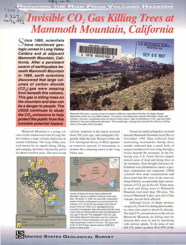
Mammoth Mountain, a young volcano in eastern California, rises above the floor of a large volcanic depression known as Long Valley Caldera. The scenic Long Valley area, popular with skiers, hikers, and campers, has been volcanically active for about 4 million years. High concentrations of C02 gas have been detected in the soil on Mammoth Mountain. This invisible gas, seeping from beneath the volcano, is killing trees on the sides of the mountain.
volcanic eruptions in the region occurred about 200 years ago, and earthquakes frequently shake the area. Because of this, the U.S. Geological Survey (USGS) operates an extensive network of instruments to monitor the continuing unrest in the Long Valley area.
Areas of dead and dying trees at Mammoth Mountain volcano in eastern California total more than 100 acres. In 1990, the year after a persistent swarm of small earthquakes occurred beneath the volcano, U.S. Forest Service rangers first noticed areas of tree kill. When U.S. Geological Survey scientists investigated, they discovered that the roots of the trees are being killed by high concentrations of C02 gas in the soil. The seepage of this C0
2 gas
from below Mammoth Mountain and the continued occurrence of local earthquakes are signs of the ongoing geologic unrest in the area. The upper part of the 11,027-ft-high volcano (above 9,500 ft) is shown in dark green.
Numerous small earthquakes occurred beneath Mammoth Mountain from May to November 1989. Data collected from monitoring instruments during those months indicated that a small body of magma (molten rock) was rising through a fissure beneath the mountain. In the following year, U.S. Forest Service rangers noticed areas of dead and dying trees on the mountain. After drought and insect infestations were eliminated as causes, a geologic explanation was suspected. USGS scienti sts then made measurements and discovered that the roots of the trees are being killed by exceptionally high concentrations of C0
2 gas in the soil. Today areas
of dead and dying trees at Mammoth Mountain total more than 100 acres. The town of Mammoth Lakes, just east of this volcano, has not been affected.
Although leaves of plants produce oxygen (0 ) from C0
2 during photosynthe
sis, their roots need to absorb 02
directly. The high C0
2 concentrations in the soil on
Mammoth Mountain are killing trees by denying their roots 0
2 and by interfering
with nutrient uptake. In the areas of tree kill, C0
2 makes up about 20 to 95% of the
fl:muNITEo STATEs GEoLoGicAL SuRvEv

C02 gas seeping from the ground at Mammoth Mountain likely was derived from magma (molten rock) beneath the volcano. In 1989, rising magma may have opened cracks, allowing large amounts of trapped C0
2 gas to leak
upward along faults. High concentrations of C02 in soil can kill the roots of trees. C02 gas is heavier than air, and when it leaks from the soil it can collect in snowbanks, depressions, and poorly ventilated enclosures, such as cabins and tents, posing a potential danger to people.
gas content of the soil; soil gas normally contains 1% or less C0
2•
When C02
from soil leaves the ground, it normally mixes with the air and dissipates rapidly. C0
2 is heavier than air, however, and
it can collect at high concentrations in the lower parts of depressions and enclosures, posing a potential danger to people. Breathing air with more than 30% C0
2 can very
quickly cause unconsciousness and death. Therefore, poorly ventilated areas above and below ground can be dangerous in areas of C0
2 seepage. Where thick snowpacks accu
mulate in winter, the C02
can be trapped within and beneath the snow. Dangerous levels of C0
2 have been measured in pits dug in
the snowpack in tree-kill areas on Mammoth Mountain, and snow-cave camping in such areas is not advised.
Geologists have detected C02
emissions, like those at Mammoth Mountain, on the flanks of other volcanoes, including Kilauea in Hawaii and Mount Etna in Sicily.
C02 GAS
Above ground
Measuring the rate of such gas emissions on the flanks of volcanoes or within calderas is difficult and labor intensive. Readings must be made at many locations using small gascollection instruments placed on the soil.
A preliminary estimate of the current rate of C0
2 gas emission at Mammoth Moun
tain is 1,300 tons per day. Similar rates of C0
2 emission have been measured from the
craters of Mt. St. Helens (Washington) and Kilauea (Hawaii) volcanoes during periods of low-level eruptive activity. Past eruptions at Mammoth Mountain, such as the phreatic (steam-blast) eruptions that occurred about 600 years ago on the volcano's north flank, may have been accompanied by C0
2 emis
sions. Scientists think that the current episode of high C0
2 emission is the first large
scale release of the gas on the mountain for at least 250 years, because the oldest trees in the active tree-kill areas are about that age.
The characteristics of C02
and other gases seeping from Mammoth Mountain in-
In 1989-90, trees in this area on the south side of Mammoth Mountain volcano began dying from high concentrations of C02
gas in the soil. Although leaves of plants produce oxygen (0) from C0
2 during photosynthesis, their
roots need to absorb 02
directly. High C0
2 concentrations in the soil
kill plants by denying their roots 0 2
and by interfering with nutrient uptake. In the areas of tree kill at Mammoth Mountain, C02 makes up about 20 to 95% of the gas content of the soil. Inset shows U.S. Geological Survey scientists taking samples of soil gas in this tree kill area.
dicate that they were originally derived from magma. Large amounts of these gases probably were trapped beneath the volcano until 1989. In that year the magma rising through a fault may have opened cracks, allowing the gases to leak upward. Although infrequent small earthquakes continue to occur below the mountain, there is no evidence of current magma movement.
Earthquakes and C02
seepage beneath Mammoth Mountain are only two signs of volcanic unrest in the Long Valley area. Mammoth Mountain is the southernmost volcano in the Mono-In yo Craters volcanic chain, and over the past 4,000 years, small eruptions have occurred somewhere along this chain every few hundred years.
Scientists with the USGS Volcano Hazards Program are closely monitoring C0
2
emissions and other geologic hazards at Mammoth Mountain. Their continued studies in the Long Valley area of eastern California and in other volcanic regions of the United States, including Hawaii, the Pacific Northwest, Wyoming, and Alaska, are helping to protect the citizens of our Nation from geologic hazards.
Michael L. Sorey, Christopher D. Farrar, William C. Evans, David P Hill, Roy A. Bailey,
James W. Hendley II, and Peter H. Stauffer
Graphic design by
Susan Mayfield and Sara Boore
COOPERATING ORGANIZATIONS
Mammoth Mountain Ski Area
Town of Mammoth Lakes
U.S. Department of Agriculture, U.S. Forest Service
For more information contact: Earthquake Information Hotline (415) 329-4085
U.S. Geological Survey, Mail Stop 977 345 Middlefield Road, Menlo Park, CA 94025 http://quake.wr.usgs.govNOLCANOES/LongValley/
See also Living With a Restless Caldera-Long Valley, California (USGS Fact Sheet 1 08-96).
U.S. Geological Survey Fact Sheet-172-96 1996
U.S. DEPARTMENT OF THE INTERIOR • U.S. GEOLOGICAL SURVEY