113 phase 2, final draft mt victoria station curtilage
TRANSCRIPT
113 Phase 2, Final Draft
________________________________________________________________________________ Casey & Lowe Corridor Options, Historic Heritage
Mt Victoria to Lithgow
Mt Victoria Station Curtilage
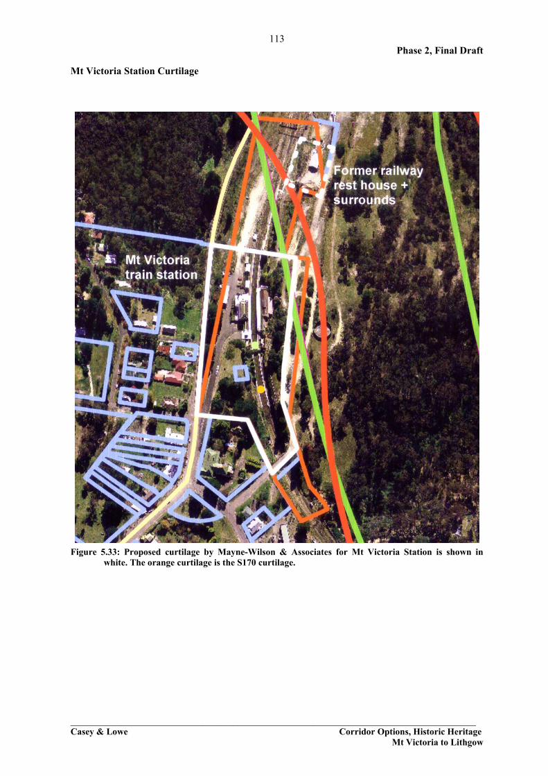
Figure 5.33: Proposed curtilage by Mayne-Wilson & Associates for Mt Victoria Station is shown in white. The orange curtilage is the S170 curtilage.

114 Phase 2, Final Draft
________________________________________________________________________________ Casey & Lowe Corridor Options, Historic Heritage
Mt Victoria to Lithgow
5.3.2 Berghofers Pass Berghofers Pass is on the SHR and on the DECC S170 register as an important walking track in the Blue Mountains. Berghofer was primarily responsible for the construction, between 1907 and 1912, of a new pass bearing his name. At the top the new route started on Mount York Road, directly opposite the start of Lawsons Long Alley. Unlike Lawson, Berghofer headed south and then turned west, more or less parallel to Victoria Pass, but across the gully which Victoria Pass skirted to the south (Fig. 2.9). This new road wound around the cliffs with sheer drops beyond the post-and-rail fencing, but it avoided the more severe gradients of the 1832 pass and was quite popular with motorists. It use discontinued around 1934 as car engines became more powerful. The road is terraced into the edge of the slope and descends steadily from Mt York until it links up with the Highway near Little Hartley (Fig. 5.33). There is a steep drop to the western side with remains of retaining walls, some visible and other obscured by overgrowth. There are occasional views from the road but generally it is screened by overgrowth. Elements of interest are a two small culverts and water trough (WP4), large culvert with more than 20 courses of stone (WP8), a rock overhang with graffiti (WP12), and graffiti identifying the names of the road (WP12+30m). Evidence for road construction techniques consists of small culverts with concrete drains, packed rubble and earth pavement, occasional drill marks, and horizontal timber framework for the rubble construction. One section of the road has been washed out (Fig. 5.41, WP10) but generally it is in reasonable condition.
Figure 5.34: Plan showing the location of Berghofers Pass (arrowed) in relation to the Modified Orange (Option 1 and 2) and Modified Red (Option 1 and 2) corridors. The waypoint yellow stars (WP0001 to WP0012) are points of interest along the pass and are described below.

115 Phase 2, Final Draft
________________________________________________________________________________ Casey & Lowe Corridor Options, Historic Heritage
Mt Victoria to Lithgow
Figure 5.35: Berghoffers Pass is a narrow line of road descending from Mt York.
Figure 5.36: Occasionally there is some rock cutting on the outer edge of the road but this is rare.
Figure 5.37: Typical culvert along the track with concrete drain. WP4.
Figure 5.38: Large stone built culvert, WP8.
Figure 5.39: Extensive section of rubble retaining wall near the graffiti rock overhang. WP6 to WP7

116 Phase 2, Final Draft
________________________________________________________________________________ Casey & Lowe Corridor Options, Historic Heritage
Mt Victoria to Lithgow
Figure 5.40: Section of rubble walling with timber posts projecting outwards, WP5.
Figure 5.41: ‘Berghofer Pass’ inscription which was recarved after it was damaged, WP8.
Figure 5.42: Section of collapsed track showing the rubble stone and compacted earthen road base. WP10
Figure 5.43: Rock overhang with graffiti.
Figure 5.44: Detail of graffiti.
Figure 5.45: Graffiti indicating the boundary between Blue Mountains and Blaxland Shires.

117 Phase 2, Final Draft
________________________________________________________________________________ Casey & Lowe Corridor Options, Historic Heritage
Mt Victoria to Lithgow
Figure 5.46: One of a number of interpretative signs along the route.
Figure 5.47: View towards Little Hartley and the Mt Victoria Stockade site.
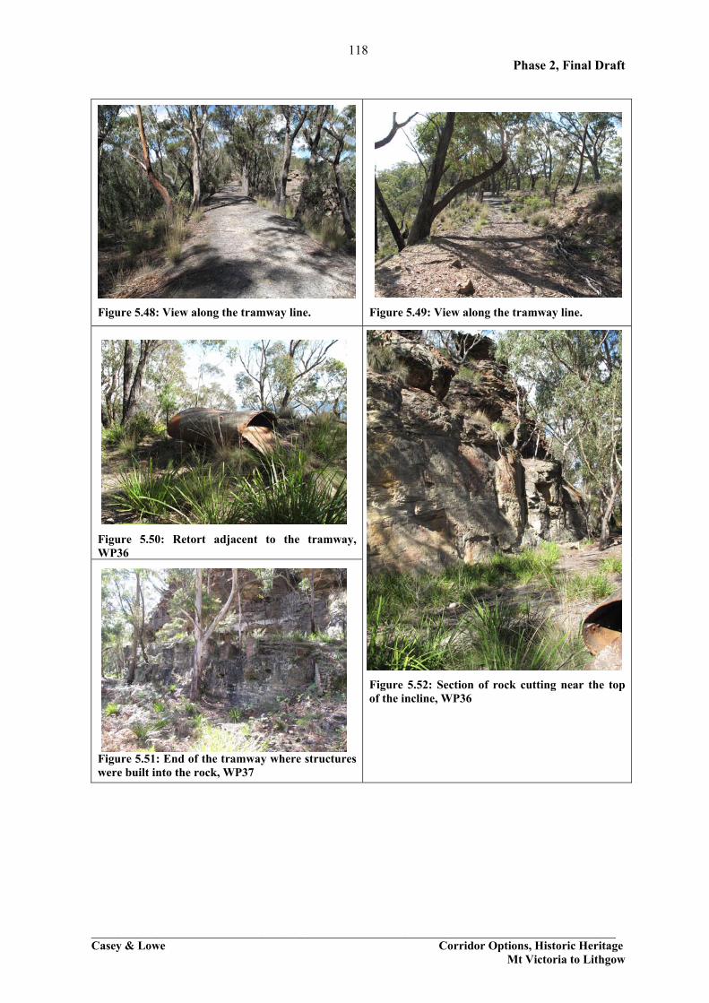
5.3.3 Hartley Vale Shale Mine Tramway and Incline Please note that this section only discusses the tramway and incline. See section 6.3 for information on the mining operations. The Hartley Vale Shale Mine operated from the 1860s to 1913. The main part of the shale mine extends either side of Mid Hartley Road (Bells Line of Road) (Fig. 2.24). The tramway and incline were listed on the State Heritage Register, along with Berghofers Pass, and sections of Coxs Road, Lawsons Long Alley, Lockyers Road, short tracks around Mt York and monuments as they are the elements which constitute the Mt York Road Complex. The list is for old lines of roads which form part of a series of walking tracks. The main evidence for the listing of the tramway and incline is because they are on DECCs S170 register list as part of this complex. The items in the SHR listing came from DECC and is based on information provided by DECC in 1999 to the Heritage Branch. No specific curtilages were provided for these tracks. In the case of the tramway and incline they are both clearly defined ‘tracks’ (Figs 5.47-5.52). The tramway and incline were both substantial engineering achievements designed by Norman Selfe, an important nineteenth-century engineer. The tramway and incline were built between 1868 to 1870 and operated until 1913 when the mine was abandoned. The incline operate as a single-rope pull to take loaded rail tram trucks to the top of the mountain where they were taken along the tramway to the Hartley Vale station site on the Darling Causeway and transported shale oil on the main western railway line. The technology of the tramway included raised bed for the tramway to obtain a level surface for the tramline between Darling Causeway and the top of the incline. Details relating to the relationship between the tramway and incline, and the mine and village will be dealt with below in Section 6.3.
118 Phase 2, Final Draft
________________________________________________________________________________ Casey & Lowe Corridor Options, Historic Heritage
Mt Victoria to Lithgow
Figure 5.48: View along the tramway line. Figure 5.49: View along the tramway line.
Figure 5.50: Retort adjacent to the tramway, WP36
Figure 5.51: End of the tramway where structures were built into the rock, WP37
Figure 5.52: Section of rock cutting near the top of the incline, WP36

119 Phase 2, Final Draft
________________________________________________________________________________ Casey & Lowe Corridor Options, Historic Heritage
Mt Victoria to Lithgow
Figure 5.53: Top of incline which leads down to the mining area.
Waypoint Description Figures 33 Rock cutting in the tramway embankment 34 Cutting for tramway alignment, beginning 35 End of cutting 36 Horizontal retort and detailed rock cutting 5.50 37 Set of 3 tanks and brick buildings 5.51, 5.52 39 End of tramway at Darling Causeway
Figure 5.54: Map showing the location of the Hartley Vale Shale Mine tramway and incline, indicated by
the orange line.

120 Phase 2, Final Draft
________________________________________________________________________________ Casey & Lowe Corridor Options, Historic Heritage
Mt Victoria to Lithgow
5.3.4 Historic Hartley The old village of Hartley has been listed as being of State significance, and the subject of several studies. However, the curtilage shown on the aerial below (outlined in orange) (Fig. 5.55) does not include some items which obviously should be included, while it includes some areas for which the reason is not clear. The CMP has been reviewed (by Mayne-Wilson & Associates) but it does not shed any light on this process. Second, there are no heritage markings for several pieces of land included within the orange lines on the left hand side and near the top of the image. A ground inspection (from the road) of these pieces of land revealed little physical evidence as to why these apparent ‘curtilages’ were so drawn. Third, a physical inspection – and reading of the Lithgow Heritage Inventory Sheets - revealed no apparent reason for the exclusion from the village curtilage of the St. John the Evangalist’s Church and the residence Bungaribee. Though it is understood they are privately owned rather than owned by DECC and this is probably the reasoning behind this decision. All the items in the orange lines are owned by DECC.
Figure 5.55: Historic Hartley Village: the arrows indicate the viewing points from which the following
photos were taken.

121 Phase 2, Final Draft
________________________________________________________________________________ Casey & Lowe Corridor Options, Historic Heritage
Mt Victoria to Lithgow
Figure 5.56: Aerial 1 – The existing SHR boundary for Hartley is shown in orange.

122 Phase 2, Final Draft
________________________________________________________________________________ Casey & Lowe Corridor Options, Historic Heritage
Mt Victoria to Lithgow
Figure 5.57: H1 - The entry from the Great Western Highway into the old village of Hartley. The back of the former Royal Hotel is visible at the centre of the image. The original road into the town is arrowed. Warwick Mayne-Wilson
Figure 5.58: H2 - View from the old Court House of Old Trahlee (left) and former Post Office (centre right) with Pine windbreak marking the ridge behind. Warwick Mayne-Wilson

123 Phase 2, Final Draft
________________________________________________________________________________ Casey & Lowe Corridor Options, Historic Heritage
Mt Victoria to Lithgow
Figure 5.59: Historic image 1 - Sign at the old Court House showing the layout of the Hartley historic site and village. Warwick Mayne-Wilson
Figure 5.60: H3 - The old Court House, SHI No. 1960157. Warwick Mayne-Wilson
Figure 5.61: H4 - The central group of the village, with the Post Office (far left), Farmers Inn (centre left), Shamrock Inn (centre right), and woolshed (far right, upslope). Warwick Mayne-Wilson

124 Phase 2, Final Draft
________________________________________________________________________________ Casey & Lowe Corridor Options, Historic Heritage
Mt Victoria to Lithgow
Figure 5.62: H5 - St John the Evangelists’ Church, high on the eastern ridge. (SHI No. 1960150). Warwick Mayne-Wilson
Figure 5.63: H6 - The Royal Hotel, downslope from St John’s, and the first building on the entry to the town from the early road to Bathurst (SHI No. 1960151). Warwick Mayne-Wilson

125 Phase 2, Final Draft
________________________________________________________________________________ Casey & Lowe Corridor Options, Historic Heritage
Mt Victoria to Lithgow
Figure 5.64: H7 - Bungaribee (SHI No. 1960152) also faces the old road entry into the Village. Warwick Mayne-Wilson
Figure 5.65: H8 - Old Trahlee (SHI No. 1960153) the first building encountered when entering the present main street. Warwick Mayne-Wilson

126 Phase 2, Final Draft
________________________________________________________________________________ Casey & Lowe Corridor Options, Historic Heritage
Mt Victoria to Lithgow
Figure 5.66: H9 - Old Post Office, SHI No. 1960154. Warwick Mayne-Wilson
Figure 5.67: H10 - The Catholic Presbytery (left) and St Bernard’s Catholic Church (right) – SHI Nos. 1960155 and 1960156. Warwick Mayne-Wilson

127 Phase 2, Final Draft
________________________________________________________________________________ Casey & Lowe Corridor Options, Historic Heritage
Mt Victoria to Lithgow
Figure 5.68: H11 - Hartley village, seen from the south-west. Corney’s garage is at the centre, and Corney’s Cottage at far left, downslope. Note the enclosed character of the village, nestled halfway down the west-facing slope, a short distance away from the River Lett (just beyond the far left of the image). Warwick Mayne-Wilson
Figure 5.69: H12 - Old cottage (not identified) to west of Hartley village, just upslope of the River Lett. Warwick Mayne-Wilson

128 Phase 2, Final Draft
________________________________________________________________________________ Casey & Lowe Corridor Options, Historic Heritage
Mt Victoria to Lithgow
Figure 5.70: H13 - The eastern half of Hartley village - in the centre middle-distance, seen from Hassans Walls Lookout. The River Lett winds through the land between the Great Western Highway and the foreground. Beyond to the east is rolling pastoral land, which has a high visual absorption capacity and low visual sensitivity. The village itself is a distinctive, self-contained cultural landscape with components of high historical and architectural integrity, able to demonstrate well the social and daily life of this important rural village. Warwick Mayne-Wilson

129 Phase 2, Final Draft
________________________________________________________________________________ Casey & Lowe Corridor Options, Historic Heritage
Mt Victoria to Lithgow
Historic Hartley Curtilage Figure 5.71: Proposed curtilage by Mayne-Wilson & Associates for historic Hartley is shown in white.

130 Phase 2, Final Draft
________________________________________________________________________________ Casey & Lowe Corridor Options, Historic Heritage
Mt Victoria to Lithgow
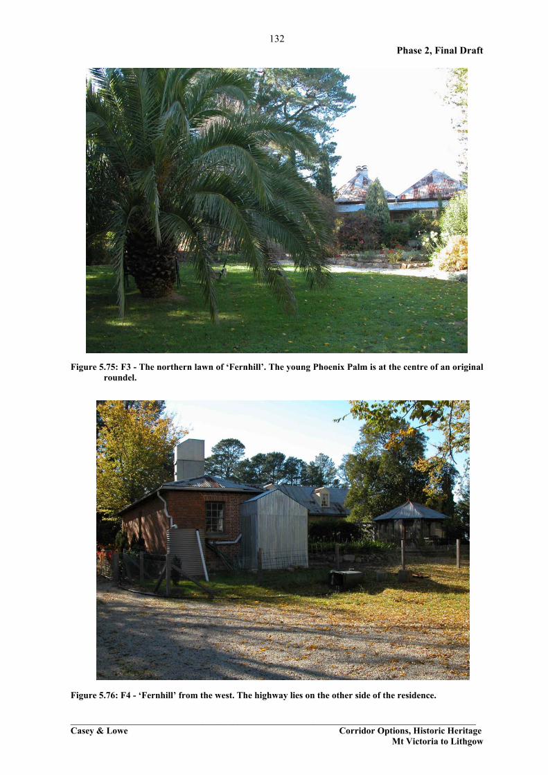
5.3.5 Fernhill The former inn, ‘Fernhill’, is situated right on the edge of the Great Western Highway at the foot of Hassans Walls as one approaches the old village of South Bowenfels. It is listed on the SHR, with the listing applying to the whole lot. It also happens to be the point at which all four corridors converge.
Figure 5.72: ‘Fernhill’ precinct: the arrows indicate the viewing points from which the following photos were taken.

131 Phase 2, Final Draft
________________________________________________________________________________ Casey & Lowe Corridor Options, Historic Heritage
Mt Victoria to Lithgow
Figure 5.73: F1 – Approaching ‘Fernhill’ (SHI No. 1960161) from the south, with the southernmost arm of Hassans Walls and the Great Western Highway at extreme right.
Figure 5.74: F2 - ‘Fernhill’ (SHI No. 1960161) seen from the eastern side of the Great Western Highway.
132 Phase 2, Final Draft
________________________________________________________________________________ Casey & Lowe Corridor Options, Historic Heritage
Mt Victoria to Lithgow
Figure 5.75: F3 - The northern lawn of ‘Fernhill’. The young Phoenix Palm is at the centre of an original roundel.
Figure 5.76: F4 - ‘Fernhill’ from the west. The highway lies on the other side of the residence.
133 Phase 2, Final Draft
________________________________________________________________________________ Casey & Lowe Corridor Options, Historic Heritage
Mt Victoria to Lithgow
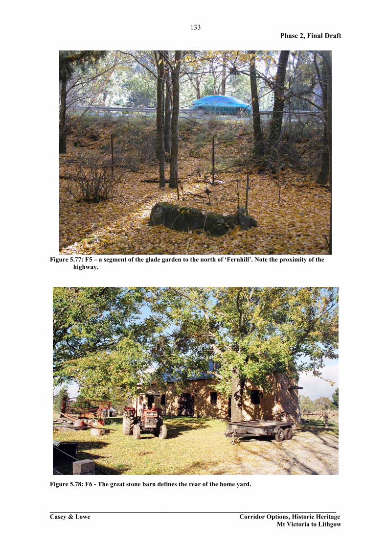
Figure 5.77: F5 – a segment of the glade garden to the north of ‘Fernhill’. Note the proximity of the highway.
Figure 5.78: F6 - The great stone barn defines the rear of the home yard.

134 Phase 2, Final Draft
________________________________________________________________________________ Casey & Lowe Corridor Options, Historic Heritage
Mt Victoria to Lithgow
Figure 5.79: F7 - View along the rear of the homeyard, with cow pastures to the west of it. A curtilage could follow the fenceline at the centre, or possibly the rear of the stone barn.
Figure 5.80: F8 - Looking south-east back past the stone barn toward the highway, showing how the
highway sweeps around the property. It is understood that the RTA has already resumed an acre of land in the location arrowed.

135 Phase 2, Final Draft
________________________________________________________________________________ Casey & Lowe Corridor Options, Historic Heritage
Mt Victoria to Lithgow
Figure 5.81: F9 - Stone outbuilding to the south of the barn at ‘Fernhill’.
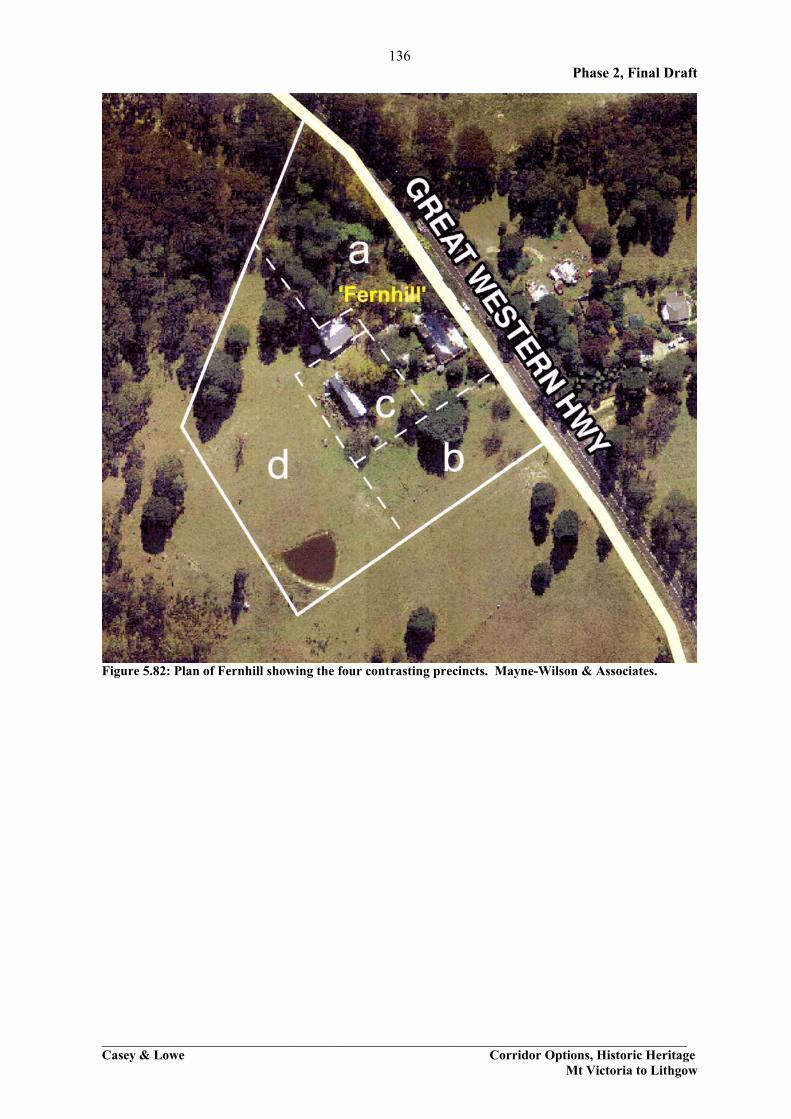
‘Fernhill’ comprises four contrasting landscapes, or precincts (Fig. 5.82), namely:
a. The enclosed, densely planted and well maintained eastern and northern sector, in which most of the historic plantings and landscape layouts (including the roundel) are contained.
b. The rear of the home yard in which the old stone barn, privy, other outbuildings and old trees are located; and
c. The much more open south-eastern sector containing an old garage and a scatter of old trees, which can be viewed by travellers along the Great Western Highway.
d. The grazing paddocks to the rear of the home yard, in which a dam is located for the benefit of the cattle. These paddocks are mostly open, grassed areas, but their perimeter is graced with indigenous trees
In terms of landscape values, we would rate
• precinct a. as very important (exceptional) • precinct b. as very important (exceptional); and • precinct c. as moderately important (high) • precinct d. is rated as of some importance (low to moderate), because it contributes to the
use and earning capacity of the place.
136 Phase 2, Final Draft
________________________________________________________________________________ Casey & Lowe Corridor Options, Historic Heritage
Mt Victoria to Lithgow
Figure 5.82: Plan of Fernhill showing the four contrasting precincts. Mayne-Wilson & Associates.

137 Phase 2, Final Draft
________________________________________________________________________________ Casey & Lowe Corridor Options, Historic Heritage
Mt Victoria to Lithgow
Forty Bends Road, Curtilages
Figure 5.83: Proposed curtilage by Mayne-Wilson & Associates for ‘Fernhill’ and Forty Bends properties is shown in white.

138 Phase 2, Final Draft
________________________________________________________________________________ Casey & Lowe Corridor Options, Historic Heritage
Mt Victoria to Lithgow
5.3.6 National School Group, Old Bowenfels This is part of the Old Bowenfels group of buildings which will be discussed in more detail in Section 6.7 as part of the analysis of the heritage land and curtilage questions. The school is listed on the SHR as it was the first school over the mountains and is an intact group of buildings. This group and the nearby houses at Old Bowenfels were by-passed by the highway some years ago.
Figure 5.84: National School, Headmasters Residence (SHI No. 1960165) edge of Old Bathurst Road at South Bowenfels. Figure 5.85: School building, National School Group (SHI No. 1960165).

139 Phase 2, Final Draft
________________________________________________________________________________ Casey & Lowe Corridor Options, Historic Heritage
Mt Victoria to Lithgow
Old Bowenfels Curtilages Figure 5.86: Proposed curtilage by Mayne-Wilson & Associates for properties at the western end of Old
Bowenfels are shown in white.