curtilage study - wollondilly.nsw.gov.au
TRANSCRIPT

CURTILAGE STUDY
ABBOTSFORD 1 ABBOTSFORD ROAD
PICTON NSW 2571
APRIL 2013

NBRS + PARTNERS Pty Ltd Level 3, 4 Glen Street Milsons Point NSW 2061 Australia Telephone +61 2 9922 2344 - Facsimile +61 2 9922 1308 ABN: 16 002 247 565 Nominated Architects Graham Thorburn: Reg No.5706; Geoffrey Deane: Reg No.3766; Garry Hoddinett: Reg No 5286; Andrew Duffin: Reg No 5602
This report has been prepared under the guidance of the Expert Witness Code of Conduct in the Uniform Civil Procedure Rules and the NSW Land & Environment Court Practice Directions relating to the provision of evidence by expert witnesses. The opinions in the report represent the professional opinions of the author based on an assessment of the available information cited in the report. This document remains the property of NBRS + PARTNERS Pty Ltd. The document may only be used for the purposes for which it was produced. Unauthorised use of the document in any form whatsoever is prohibited.

CURTILAGE STUDY: Abbotsford, Picton
P:\JOBS\12\12280\06_Reports\12280_Abbotsford_curtilage_130403.docx i
ABBOTSFORD 1 ABBOTSFORD ROAD
PICTON NSW 2571
CURTILAGE STUDY
EXECUTIVE SUMMARY ................................................................................................ 1 Major Recommendations 1
1.0 SUMMARY DESCRIPTION ................................................................................ 2
2.0 INTRODUCTION ................................................................................................. 4 2.1 Introduction 4 2.2 Definition of the Study Area 4 2.3 Study Objectives 4 2.4 Methodology 5 2.5 Identification of Authors 5 2.6 Sources 5 2.7 Acknowledgments 5
3.0 DOCUMENTARY EVIDENCE ............................................................................. 6 3.1 Pre European History 6 3.2 Early European History 6 3.3 Abbotsford, Picton 8 3.4 Persons Associated with the site 22
3.4.1 George Harper 22 3.4.2 William Redfern Antill 23
3.5 Bibliography 23 3.5.1 Primary Sources 23 3.5.2 Secondary Sources 24 3.5.3 Internet Sources 24 3.5.4 Other 24
4.0 PHYSICAL EVIDENCE ..................................................................................... 25 4.1 Generally 25 4.2 Setting and Physical Context 25 4.3 The Cultural Landscape 26 4.4 Identification of Existing Fabric 28
4.4.1 Built Fabric 28 4.4.2 Modifications & Adaptations 30 4.4.3 Fabric Condition 30
5.0 ANALYSIS OF CULTURAL HERITAGE SIGNIFICANCE LEADING TO A RECOMMENDED CURTILAGE ................................................................................... 33
5.1 Basis of Cultural Heritage Assessment 33 5.2 Evaluation Criteria 33 5.3 Statement of Significance 34 5.4 Analysis of Existing Fabric 35
5.4.1 Gradings of Significance 35 5.5 Archaeological Potential 36

CURTILAGE STUDY: Abbotsford, Picton
P:\JOBS\12\12280\06_Reports\12280_Abbotsford_curtilage_130403.docx ii
6.0 DEFINING A CURTILAGE FOR ABBOTSFORD .............................................. 37 6.1 Introduction 37 6.2 Curtilage types 37 6.3 Historical Allotments 38 6.4 Design Style & Taste 38 6.5 Functional Uses & Relationships 39 6.6 Visual Links — Significant Views & Vistas 39 6.7 Scale 41 6.8 Significant Features 41 6.9 Significant Vegetation 41 6.10 Curtilages in Colonial Landscapes of the Cumberland Plain and
Camden 43
7.0 DEVELOPMENT OF CURTILAGE AND CONSERVATION POLICY ............... 44 7.1 Introduction 44 7.2 Constraints & Opportunities arising from the statement of significance 44 7.3 Constraints & Opportunities arising from the physical condition of the
Site 45 7.4 Constraints & Opportunities arising from Commonwealth, State and
Local Government Requirements. 46 7.5 Opportunities and Constraints on Future Development 46 7.6 Archaeological Potential 47 7.7 Consideration of potential for further future development — where/ why 48 7.8 Preparation of interpretation strategy 48 7.9 Recommendations 49
8.0 APPENDICES ................................................................................................... 50 8.1 Appendix B – State Heritage Inventory Listing 50
ABBOTSFORD ............................................................................................................ 50 8.1.1 Statement of significance: 50 8.1.2 Description 51 8.1.3 History 54 8.1.4 Historic themes 54 8.1.5 Recommendations 56 8.1.6 Procedures /Exemptions 56 8.1.7 Listings 56 8.1.8 Study details 57 8.1.9 References, internet links & images 57

CURTILAGE STUDY: Abbotsford, Picton
P:\JOBS\12\12280\06_Reports\12280_Abbotsford_curtilage_130403.docx iii
LIST OF FIGURES Figure 1 — Map of Picton showing the location of the ruins and gardens of Abbotsford ............... 4
Figure 2 — Extract from Parish of Picton, County of Cumberland, 1886 edition ............................ 9
Figure 3 — To let advertisement for estate of Abbotsford. ........................................................ 10
Figure 4 — To let advertisement for Abbotsford. ....................................................................... 11
Figure 5 — Extract from Plan of Road from the Southern Road within Rumkin’s 1000 acres ..... 12
Figure 6 — Abbotsford, Picton, 1891. ........................................................................................... 13
Figure 7 — Abbotsford, Picton, about 1910. ................................................................................. 14
Figure 8 — Byrne’s Exhibition Dairy Moves to Rich Pastures at Picton. ...................................... 16
Figure 9 – Extract from 1949 aerial survey of Picton district showing subject site. ...................... 17
Figure 10 — Auction sale notice. ................................................................................................ 18
Figure 11 — Sketch plan of “Abbotsford”, Picton subdivision accompanying brochure. ............ 19
Figure 12 — “Abbotsford”, Picton brochure, 1952. ..................................................................... 20
Figure 13 — Block plan accompanying Certificate of Title Vol 12014 Fol 100. .......................... 21
Figure 14 — Photograph taken c1996 a showing the avenues leading up to Abbotsford ............ 21
Figure 15 — view of Abbotsford from Abbotsford Road. . ........................................................... 25
Figure 16 — view looking east from the former home garden ...................................................... 27
Figure 17 — the northern (side) elevation of the homestead ........................................................ 29
Figure 18 — view looking east towards the centre of the former homestead ............................... 29
Figure 19 — view inside the ruined homestead. ........................................................................... 30
Figure 20 — 2012 view of the ruined homestead’s north-east corner. ......................................... 31
Figure 21 — part of the home garden east of the former homestead. .......................................... 32
Figure 22 — the timber log and sawn framed shed to the west of the homestead ruins .............. 32
Figure 23 — Key views with heritage value from the site of the ruined homestead ..................... 40
Figure 24 — view from Abbotsford Road looking up the vista of the original driveway ................ 40
Figure 25 — vista from the front veranda of Abbotsford ............................................................... 42
Figure 26 — key landscape features of Abbotsford’s cultural landscape. . ................................. 42
Figure 27 — the critical minimum curtilage around Abbotsford, suitable for listing ...................... 43

CURTILAGE STUDY: Abbotsford, Picton
P:\JOBS\12\12280\06_Reports\12280_Abbotsford_curtilage_130403.docx 1
EXECUTIVE SUMMARY
This Curtilage Study confirms the heritage significance of the site, and recommends an enlarged curtilage around the ruined homestead to encompass the concentration of nineteenth-century works at Abbotsford. This evaluation is based on an analysis of documentary evidence of the site’s origins, construction, and additions to the buildings, as well as a detailed examination of the physical fabric of the wider landscape. Following the assessment of the significance of the place, the procedures for retaining and enhancing fabric and other aspects of identified heritage value are established and set down, together with appropriate constraints and opportunities for the future management of the place. The methodology adopted for use in this report follow the established guidelines of the NSW Heritage Council publication, Heritage Curtilages and The Conservation Management Plan by Dr James Semple Kerr (6th Edition, 2004) published by the National Trust of Australia (NSW), and the Australia ICOMOS Charter for the Conservation of Places of Cultural Significance (The Burra Charter) 1999.
Major Recommendations
Abbotsford has cultural significance covering historic, aesthetic and particularly research values at State, and Local levels of importance. The principal cultural significance of Abbotsford includes its historical values as an early homestead, its aesthetic value for the landmark plantings and site works around the ruined homestead, and the archaeological research value of the ruins. The major recommendation of this report is that this Curtilage Study be accepted as the guiding document for future preliminary planning of actions to the place. A Conservation Management Plan should be prepared to guide any works within the curtilage of Abbotsford.
ROBERT STAAS Director / Heritage Consultant NBRS+PARTNERS April 2013

CURTILAGE STUDY: Abbotsford, Picton
P:\JOBS\12\12280\06_Reports\12280_Abbotsford_curtilage_130403.docx 2
1.0 SUMMARY DESCRIPTION
Name Abbotsford
Address 1 Abbotsford Road, Picton
Land Title part of Lot 1 DP 1086066
Original Owner George Harper
Present Owner The Ziems Family
Local Government Area
Wollondilly Shire Council
Construction Date Ca.1827, additions at various periods
Architect Not known
Builder Not known
Summary History The property was taken up in 1822 by George Harper, natural history collector, settler, noted Scottish government official and surveyor. The main block of the house may have been built before Harper made his trip to England in 1827. The ornamental plantings include relatively rare species of horticultural interest and are thought to have been planted by George Harper. The rest of the house was built before his death at Abbotsford in 1841. Purchased by William Redfern Antill, local Magistrate and prominent early settler in 1865. The property remained with the Antill family until 1952. The house was considered to be a remarkable survival of a farmhouse from an early period of Australia's settlement. Neglect and two separate fires over the following decade led to its dereliction.
Heritage Status The ruined remains of the homestead and water tank are listed on the State Heritage Register. The SHR listed curtilage does not include the driveway, avenue of trees, other plantings or agricultural lands. The Wollondilly Local Environmental Plan lists the Site / Grounds / Garden and several components separately.
The main components of the group are: House (now ruins) (WO0108)
Trees, Gardens & Grounds (WO0109)
Underground Water Storage Tank (WO110)
Cottage & Brick Outhouse (now ruins) (WO0111).
Summary Description
Abbotsford contains the ruins of a brick Georgian homestead and outbuildings: maids’ quarters, smoke house and footings of a demolished gaol. Landscape works including avenue plantings and drainage works date from this early period. Many timber-framed sheds remain from around the

CURTILAGE STUDY: Abbotsford, Picton
P:\JOBS\12\12280\06_Reports\12280_Abbotsford_curtilage_130403.docx 3
Federation period. A solid brick and concrete dairy was built in the late 1930s. The site is on a large rural holding to the west of Picton township.
Summary Statement of Cultural Significance
The Abbotsford property is significant for its associations with the early settlement of the Picton area and its links with prominent colonial figure, George Harper and later, the Antill family. The site has the potential to yield further evidence of the working of this important pastoral estate through archaeological investigation. The ruins of the main farmhouse are significant for their associations with the settlement of the area and the links with the Harper and Antill families. The architectural value and intactness of the house as an early homestead has been lost. The ruins, together with the other components of the property, provide an opportunity to interpret an early pastoral property through archaeological investigation. The ruins are a landmark in the rural surrounds of Picton. The mature trees and remnants of the gardens and grounds of the Abbotsford property have scientific significance as a collection of rare species of horticultural interest and their association with George Harper who was a noted natural history collector. The plantings provide evidence of the structure and layout of the farm estate. In a wider context, the surviving plantings also illustrate the horticultural practice of plant collecting which was to remain an important influence in the development of gardens of the colony for a substantial period of time. Today, the trees are a landmark and contribute to the character of the rural landscape north-west of Picton. The mid-19th century cottage and brick outbuilding are significant to understand the function and layout of the homestead group. The underground water tank is significant as a potential source for archaeological research into the occupation phases of the site. Other sites may also have archaeological significance, particularly into the earliest phases of the development of the property and the role of convicts (LEP, 1991). The location of the earlier Abbotsford bridge and crossing is significant because knowledge of its position contributes to the understanding of the siting of Abbotsford House and its driveway avenue plantings in relation to the Oaks Rd and Abbotsford Rd.(Heritage Study, 1992).

CURTILAGE STUDY: Abbotsford, Picton
P:\JOBS\12\12280\06_Reports\12280_Abbotsford_curtilage_130403.docx 4
2.0 INTRODUCTION
2.1 Introduction
This Curtilage Study was prepared by NBRS+PARTNERS Architects for the Cove Group, responding to the Planning Proposal of Specialist Study Requirements at Abbotsford for the rezoning of land at 1 Abbotsford Roca Picton, prepared by Wollondilly Shire Council. This Curtilage Study report responds to the requirements of section 5.5 European Heritage.
2.2 Definition of the Study Area
The site is located at 1 Abbotsford Road, Picton (part of Lot 1 DP 1086066) and is shown in Figure 1.
Figure 1 — Map of Picton showing the location of the ruins and gardens of Abbotsford within the red oval. (Source: Google Maps)
2.3 Study Objectives
This Curtilage Study is intended to be a practical working document to guide future action to Abbotsford, and includes the following objectives:
Identify appropriate zone boundary definitions and development control recommendations to conserve significant items, settings and to manage possible land use conflicts.
Examine the Abbotsford group and make a recommendation for an acceptable curtilage.

CURTILAGE STUDY: Abbotsford, Picton
P:\JOBS\12\12280\06_Reports\12280_Abbotsford_curtilage_130403.docx 5
2.4 Methodology
This report generally follows the format set out in the document entitled Heritage Curtilages by the Heritage Office and Department of Urban Affairs & Planning (1996). The term Curtilage means, The geographical area that provides the physical context for an item, and which contributes to its heritage significance. Land title boundaries and heritage curtilages do not necessarily coincide. The terms fabric, place, preservation, reconstruction, restoration, adaptation and conservation used throughout this report have the meaning given them in Australia ICOMOS Charter for the Conservation of Places of Cultural Significance (Burra Charter)1999.
2.5 Identification of Authors
This report was prepared by Brad Vale, Senior Heritage Consultant under the direction of Robert Staas, Heritage Consultant and Director of NBRS+ PARTNERS. The history was researched and written by Léonie Masson, Historian, of NBRS+PARTNERS.
2.6 Sources
The main documentary sources consulted in the research for this report are listed below:
Draft Biodiversity Study for a Planning Proposal for Part of the Abbotsford Property no. 1 Abbotsford Road, Picton dated February 2013, by ACS Environmental Pty Ltd;
Aboriginal Cultural Heritage Assessment for the Abbotsford Group, by the Tharawal Local Aboriginal Land Council;
Mitchell Library: State Library of NSW – Maps, Plans and Small Pictures File
NSW Land & Property Information
http://www.nationaltrusttas.org.au/aftermac/morris/morris.htm
http://collection.hht.net.au/firsthht/searchColonialPlants.jsp
Colonial Landscapes of the Cumberland Plain and Camden, NSW, prepared August 2000 by Colleen Morris and Geoffrey Britton (Morris & Britton Report)
An Inquiry into the making of a Permanent Conservation Order in Respect of Abbotsford, Picton, August 1983, by Dr Alan Gilpin.
Wollondilly Shire Council Growth Management Strategy 2011
A complete Bibliography is contained in section 3.5 of this report.
2.7 Acknowledgments
The Author gratefully acknowledges the assistance of Geoff Borst of Borst & Conacher Architects, Balgownie in the preparation of this report:

CURTILAGE STUDY: Abbotsford, Picton
P:\JOBS\12\12280\06_Reports\12280_Abbotsford_curtilage_130403.docx 6
3.0 DOCUMENTARY EVIDENCE
3.1 Pre European History
The original inhabitants of the Wollondilly area were the Gundangurr (also spelt Gundungara) Aboriginal people. They ranged over a wide territory which encompassed the towns of Burragorang, Katoomba, Picton, Berrima, Taralga and Goulburn, with the intervening country. According to Norman Tindall, their tribal name incorporates terms meaning 'west' and 'east.'1 Explorer Francis Barrallier encountered the Gundungara people in 1802 as his party moved through "The Cowpastures" southwest of Sydney, through the Nattai to the Wollondilly River and up to the heights above the present Yerranderie. Barrallier noted in his journal that the Gundungara "themselves build huts for the strangers they wish to receive as friends."2 However by this date the number of Gundangurr was probably lower than at the beginning of European colonisation as much of the Sydney Aboriginal populations were decimated in the 1789 smallpox epidemic.3
3.2 Early European History
The following history, Picton NSW - The Early Years, was written by local historian, Liz Vincent, in ca.2005, and is reproduced from the IFHAA Local History Library (http://www.historyaustralia.org.au/ifhaa/towns/picton.htm). The first explorers to come through the Picton area were a party led by ex-convict John Wilson in 1798. Other parties followed in the next 20 years including George Caley in 1802, collecting botanical specimens. Picton has a long European history, being one of Australia's earliest settlements. First contained in the area known as the Cowpastures, then as Stonequarry, Picton as we know it today was not the chosen site for the town. It was in fact, originally, a private town. The area for a government town, just south of the Picton we know today was first set aside in November 1821. This area is now known as Upper Picton or Redbank. It is on the Redbank Reserve, its southern boundary, Redbank Creek, Stonequarry Creek on the east, Prince Street on the north side and Rumker Street its western boundary. In the early days of settlement in the colony, a number of cattle went missing from the settlement at Sydney Cove. These were found in 1795 near the Nepean River. The herd had grown and were seen as a hope for the cattle breeding future of the colony. The government decided to leave them in that area. The area was defined by Surveyor General Oxley as lying between the Bargo River on the south, the Nepean and Warragamba Rivers in the north, westerly to the Nattai Mountains and on to the east to the Nepean River. This area was sealed off to allow the cattle to continue breeding without disturbance. This lasted until the 1820s.
1 Gandangara people, http://en.wikipedia.org/wiki/Gandangara_people, accessed 13 December 2012.
2 Tranter, David, Fragments of a Song - A Brief Search for Historical Truth, http://dazed.org/npa/scraps/tranter.htm,
accessed 13 December 2012. 3 Attenbrow, Val, Sydney’s Aboriginal Past, University of New South Wales Press, 2010.

CURTILAGE STUDY: Abbotsford, Picton
P:\JOBS\12\12280\06_Reports\12280_Abbotsford_curtilage_130403.docx 7
Picton was contained in this area and so was first called the Cowpastures, then Stonequarry, until 1841 when the small settlement was re-named Picton. It should be noted that the district was called Picton from as early as 1822 when the grants were made as being in "the district of Picton". Major Henry Colden Antill received the first land grant in 1822. Though much discussion has been held over the years as to who named Picton and for whom, it is believed the name was probably decided on by Governor Brisbane perhaps in honour of an old soldier friend Sir Thomas Picton. In 1840 George Harper decided to take advantage of the natural development of the private town on Major Antill's land. He advertised in April 1840 that 45 building allotments in the township of Stonequarry would soon be for sale by auction. They would be from one half to one acre in size and situated on his land on the southern side of Stonequarry Creek on either side of the main road. His private town never took off. Mr Harper unfortunately died in March 1841 and the property was leased in full. George Harper's property "Abbotsford" extended from the Stonequarry Bridge out along the road that led to The Oaks. The remains of the house are still on the property just past the Abbotsford Bridge. Major Antill, in July 1841 advertised in the Sydney papers, the auction of his sub-division to be called the “Village of Picton, late Stonequarry” in August that year. He stressed that many blocks had frontages to the main road up which all the wealthy owners from the south travelled with their wool clips. In 1845 the government made moves to lay out its own town just south of the private town. Surveyor Galloway was employed to survey the area and make half acre blocks for purchase. These blocks were first offered for sale in 1847. They were all sold by 1855. Land was reserved for churches, the school and courthouse. The government town was also called Picton. This led to confusion and it was re-named Upper Picton in 1847. A petition was made to the government to name its village Redbank but the government decided it was to be called Upper Picton. Even to this day, over 150 years later, local residents still often refer to the area as Redbank. On a number of occasions when money was allocated for a public building, arguments developed on where it was to be located. It seemed each time the government called tenders on a site in its town, the Antill family would offer land in its private town and that was where the building would ultimately be erected. The Upper Picton residents who had purchased land in Upper Picton naturally felt cheated. Unfortunately they had no friends in government and though they fought for the government's support in its own town they were unsuccessful.4
4 Vincent, Liz, Picton NSW – The Early Years, IFHAA Local History Library,
http://www.historyaustralia.org.au/ifhaa/towns/picton.htm, accessed 19 November 2012.

CURTILAGE STUDY: Abbotsford, Picton
P:\JOBS\12\12280\06_Reports\12280_Abbotsford_curtilage_130403.docx 8
3.3 Abbotsford, Picton
George Harper was granted 400 acres in the Parish of Picton, County of Cumberland on 1 November 1822. He called the property “Abbotsford” in recognition of Sir Walter Scott’s patronage but does not appear to have built immediately. Some have speculated the house was built as early as 1824, but may have been erected as late as 1829. Very little documentary evidence exists to establish a firm date for construction of the house, nor occupation of the property. Shortly after Harper’s arrival in the Colony in 1821 he was appointed a storekeeper in the Commissariat. However in 1826, an investigation into irregularities in the bonded store under his control led to his arrest on a charge of larceny. Though Harper was later acquitted “it was clear that there had been, at best, considerable laxity in his conduct of the store”.5 Shortly thereafter he resigned from the service and departed for England on the Portland on 7 February 1829. Harper, now married, returned to Australia on the Camden on 29 December, 1829. He immediately took up residence at “Abbotsford” as the birth of his first child is recorded there in the same year. In the 1830s he earned a fine reputation as a horse breeder.6 Harper was also known as a dairy farmer and for growing wheat, “we have likewise seen a sample of Red Wheat from NSW grown at Abbotsford”7. As early as 1830 Harper advertised in the Sydney Gazette and New South Wales Advertiser on 6 March for “a dairyman who understands his business”. George Harper added to his landholdings in the district by purchase and lease, including 1630 acres (Portion 144) granted in trust to John Werge Howey in July 1840 and confirmed in 1844 (Figure 2) as well as the 1000 acre farm of Robert Crawford (“Milton”, Portion 138) sold to Harper in January 1832.8
5 L. F. Fitzhardinge, 'Harper, George (1802–1841)', Australian Dictionary of Biography, National Centre of Biography,
Australian National University, http://adb.anu.edu.au/biography/harper-george-2157/text2757, accessed 22 November 2012. 6 Binney, Keith Robert, Horsemen of the First Frontier (1788-1900) and The Serpents Legacy, p367. At least one of his
horses, Waverly, won a medal prize at the Agricultural and Horticultural Show at Parramatta in 1833. In 1837 several horses were sold “part of the stock of George Harper of Stonequarry – the character of the horses attracted a great number of buyers and spirited competition” (Sydney Herald, 6 February 1837, p2). A noble Cleveland Entire horse “the admired breed of George Harper of Abbotsford, Stonequarry” was sold at auction sale on 21 September 1840; the horse was “from the celebrated stud of George Harper of Abbotsford, which is too well known to the sporting world (Sydney Morning Herald, 12 August 1840, p4). 7 “Wheat exportation of to London”, Sydney Monitor, 9 June 1832, p3.
8 Primary Application 17758, NSW Land & Property Information.

CURTILAGE STUDY: Abbotsford, Picton
P:\JOBS\12\12280\06_Reports\12280_Abbotsford_curtilage_130403.docx 9
Figure 2 — Extract from Parish of Picton, County of Cumberland, 1886 edition. Shows Portion 136 granted to George Harper, “Abbotsford” outlined in red and the adjoining 1630 acre block being Portion 144. In other parish plans John Werge Howey’s name is noted as the grantee on that latter portion. (Source: NLA: MAP RM 3033)
In 1829, Harper unsuccessfully attempted to lay out a township at Stonequarry, but his offer of land for a church, school and courthouse, was rejected in favour of a site a mile away. Over a decade later, in August 1840, he advertised the auction sale of 45 allotments in the Township of Stonequarry. The allotments were situated on his land on the southern side of Stonequarry Creek on either side of the main road and ranged from one half to one acre in size.
9 Despite the glowing description furnished and the many advantages laid out for potential buyers, the sale appears to have yet again failed.
9 “Important Sale by Public Auction”, The Sydney Monitor and Commercial Advertiser, 17 July 1840, p3.

CURTILAGE STUDY: Abbotsford, Picton
P:\JOBS\12\12280\06_Reports\12280_Abbotsford_curtilage_130403.docx 10
Figure 3 — To let advertisement for estate of Abbotsford. (Source: Sydney Herald, 15 July 1841, p4)
Within a month of the unsuccessful auction sale, several newspapers reported that George Harper was to leave for England shortly, anticipating an impending sale of “the beautiful estate of “Abbotsford”, Stonequarry comprising 7,000 acres of land, with the whole of the livestock, numerous buildings, and improvements thereon”10. No further information on the sale was furnished at this date, so the sale may have been abandoned, or the planned trip, or both. In any event, George Harper died on 23 March the following year at Abbotsford, aged 38 years. He was survived by his wife, Margaret Eleanor Harper nee Howey, and their five children. Probate of the will was granted to his widow in May the same year. Shortly thereafter she advertised the auction sale of her husband’s horse stock comprising “first rate mares, fillies and colts”11. Simultaneously the property was advertised to let and a full description was furnished therein (Figure 3). It was readvertised to let in October for a term of seven years, care of “J.W. Howey, Abbotsford, by Cawdor”.12
10
“News of the Day”, The Sydney Monitor and Commercial Advertiser, 14 September 1840, p2. “Domestic Intelligence”, Sydney Herald, 14 September 1840, p3. 11
“By order of the executrix”, Sydney Gazette and New South Wales Advertiser, 20 July 1841, p3. 12
John Werge Howey was the brother of Margaret Eleanor Harper. He received the land grant of 1630 acres adjoining Harper’s Abbotsford in 1844.

CURTILAGE STUDY: Abbotsford, Picton
P:\JOBS\12\12280\06_Reports\12280_Abbotsford_curtilage_130403.docx 11
Figure 4 — To let advertisement for Abbotsford. (Source: Sydney Herald 25 October 1841, p3)
Abbotsford was subsequently leased to a number of farmers including James Templeton and George Beresford Christmas. According to Geoff Borst and Steven Jones in their 1981 report on Abbotsford, Anne W. Templeton and W.R. Templeton scratched their names in the glass of the French door to the large northern room, on or before 1849. The subsequent tenant, Captain Christmas, was resident around 1852 as he was appointed to revise the electoral lists for Picton and simultaneously involved in the maintenance of roads to and from the district.
Abbotsford was advertised to let yet again in consecutive years 1857 and 1858. There is no available information on the tenants of the property at this date, and it is possible that the Harper’s leased the property to a number of small farmers.13 The following year Abbotsford House was offered to let “furnished or unfurnished...10 good rooms, kitchen, stable, etc. detached, large and well stocked garden, and about 10 acres of grass paddocks”14. The tenant at that date was Mr Meymott, as the following January there was an auction sale at Abbotsford House Picton, [of] the whole of Mr F.W Meymott’s household furniture and effects, horses, pigs, poultry, etc.15
13
Sydney Morning Herald, 20 January 1859, p7. Mr Balgowan advertised an auction sale of his stock as “he was about to leave his present farm at Abbotsford”. 14
“To let”, Sydney Morning Herald, 23 March 1860, p8. 15
“To sell by auction”, Sydney Morning Herald, 4 January 1861, p7.
CURTILAGE STUDY: Abbotsford, Picton
P:\JOBS\12\12280\06_Reports\12280_Abbotsford_curtilage_130403.docx 12
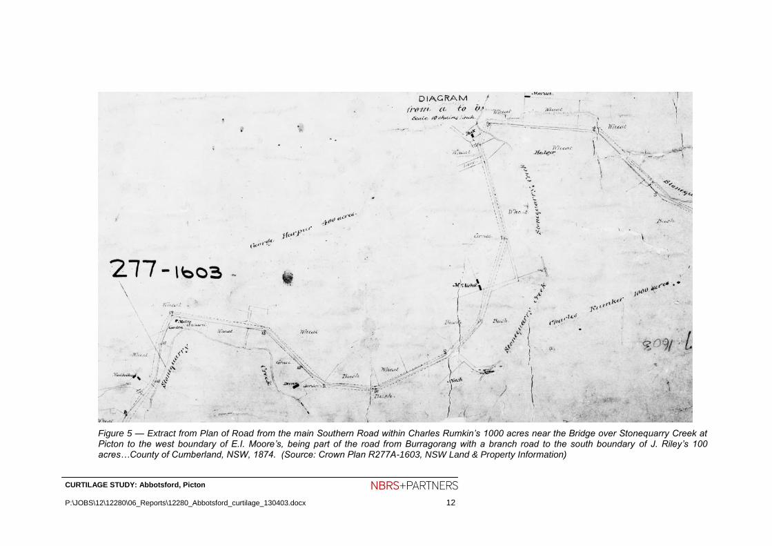
Figure 5 — Extract from Plan of Road from the main Southern Road within Charles Rumkin’s 1000 acres near the Bridge over Stonequarry Creek at Picton to the west boundary of E.I. Moore’s, being part of the road from Burragorang with a branch road to the south boundary of J. Riley’s 100 acres…County of Cumberland, NSW, 1874. (Source: Crown Plan R277A-1603, NSW Land & Property Information)

CURTILAGE STUDY: Abbotsford, Picton
P:\JOBS\12\12280\06_Reports\12280_Abbotsford_curtilage_130403.docx 13
Harper’s real estate was bequeathed in equal shares to his five children. George Gibson Harper acquired all of his sibling’s shares by 1863. Two years later he sold the Abbotsford property, 400 acres therein, to William Redfern Antill in December 1865. A further 1000 acres and 1630 acres were sold to Antill later the same month.16 He and his family moved into Abbotsford immediately. He continued to lease parts of the Abbotsford estate to various farmers. One of the farmers on the property was a Mr McIntyre whose intended departure in 1865 was deeply lamented by Antill: “I lose one of my best tenants, and the district one of its most worthy members”.17 According to the 1872 Greville Post Office Directory, Antill is listed as a grazier at Abbotsford, Picton. There is a paucity of information on Abbotsford in this period, but what is known is that Antill and family continued to live in Abbotsford House and he leased parts of the extensive property to small farmers. In 1885 the following people were identified at “Abbotsford” in a list of landholders in the Post Town of Picton: A. Bateup, M. Cunningham, T.M. Dunn, H. Evans, J. and William Fairley, M. and M. Junr Mulholland and B. Niel.
Figure 6 — Abbotsford, Picton, 1891. (State Library of NSW: PXA 1380, Pockley and Antill Family Photo Albums Volumes 2-3)
William Redfern Antill died at Abbotsford on 5 September 1905 aged 77 years. Accordingly Antill devised his real and personal estate in equal portions to his seven daughters; they notified the trustees of their intention to let Abbotsford. Robert Henry Antill of “Jarvisfield” Picton and George Bradbury of “Leigham Holme” Picton, Trustees of the Will of the late William Redfern Antill, converted his property, comprising 3213 acres (1300 hectares), to Torrens title in 1912.18 The property comprised the whole of Harper’s 400 acres (portion 136) and Howey’s 1630 acres (portion 144), part of Robert Crawford’s 1000 acres
16
Primary Application 17758, NSW Land & Property Information. 17
“Picton”, Sydney Morning Herald, 5 January 1865, p2. 18
Primary Application 17758, NSW Land & Property Information.

CURTILAGE STUDY: Abbotsford, Picton
P:\JOBS\12\12280\06_Reports\12280_Abbotsford_curtilage_130403.docx 14
(portion 138) and Henry Colden Antill’s 800 acres (portion 137). In total the estate was valued at £29,372. The property was then in the occupation of several tenants, namely Walter and Percy Hanger (621 acres), Fairley (583 acres), Dunn (189 acres), Dymock (196 acres), Stace (201 acres), McKinnon (397 acres), Brookes (157 acres), Larkin (278 acres), O’Brien (18 acres), Boardman (11 acres) and Wedlock (562 acres). Of that list of farmer tenants, Abbotsford house and adjoining land was at that date in the occupation of the last named gentleman, Alfred Wedlock, a dairyman. In 1906, Alfred Wedlock leased the “well-known Abbotsford property from the Antill family”19 to where he removed his dairy and family from Marrickville. He enjoyed much success with his Ayrshire dairy cows, winning the annual Royal Champion Butter Fat prize several years in a row at the Royal Agricultural Society Show. The following description of the property during Wedlock’s occupation was furnished in the Sydney Morning Herald on 21 February 1908 on page 4:
The homestead at Abbotsford, the residence of the late William Antill, is comfortable and nicely situated, looking towards Picton over a pleasant prospect of rich flats. The property is well watered, and cleaned up. Some of the steading is on the old side, although there is probably sufficient accommodation for carrying on the farm. The dairy and bails are cool and clean.
Figure 7 — Abbotsford, Picton, about 1910. (Source: Wollondilly Library, Picture Wollondilly, P00\P00001)
19
“Dairying in the Picton District: A fine dairy herd”, Australian Town and Country Journal, 25 July 1906, p34.

CURTILAGE STUDY: Abbotsford, Picton
P:\JOBS\12\12280\06_Reports\12280_Abbotsford_curtilage_130403.docx 15
Wedlock vacated Abbotsford in 1919 whereupon a “clearing-out sale of all building material, wire netting, plant of a most up-to-date, poultry farm, choice poultry, and sundries” was held on 29 November.20 The subsequent tenancy of the house and immediate land is not known, however in 1937 the Trustees for the Will of the late William Redfern Antill leased Abbotsford to the NSW Fresh Food and Ice Company Limited. A newly formed subsidiary company, Byrne’s Exhibition Dairy Pty Ltd was formed to purchase the business of H. Byrne Pty Ltd, whereupon “the popular 60 year old establishment” relocated from Rosebery to Abbotsford, Picton.21 The present dairy building was reportedly built on the subject site at this date for the sum of £18,000.22 Simultaneously “Abbotsford” house underwent maintenance — painted externally, wall-papered internally and electricity connected. The Antill family appointed Edgar Davies manager in 1939, and he supervised the repair of the front veranda and picket fences and painted the metal ceilings in the house.
20
“Picton”, Sydney Morning Herald, 22 November 1919, p10. 21
“NSW Fresh Food, Larger Profit, Dividend Increased”, Sydney Morning Herald, 4 Ferbuary 1939, p8. Also 22
Borsch…op. cit., p31.

CURTILAGE STUDY: Abbotsford, Picton
P:\JOBS\12\12280\06_Reports\12280_Abbotsford_curtilage_130403.docx 16
Figure 8 — Byrne’s Exhibition Dairy Moves to Rich Pastures at Picton. (Source: Sydney Morning Herald, 12 April 1939, p10)

CURTILAGE STUDY: Abbotsford, Picton
P:\JOBS\12\12280\06_Reports\12280_Abbotsford_curtilage_130403.docx 17
Figure 9 – Extract from 1949 aerial survey of Picton district showing subject site. (Source: Geoscience Australia via United Photos and Graphics Services: Camden NSW SVY 547 Run 5 Print 5093)
The NSW Fresh Food and Ice Co Ltd vacated Abbotsford farm, Picton in 1951 upon the expiration of the lease in June that year.23 Three years earlier the Perpetual Trustee Co (Ltd) advised the surviving members of the Antill family to sell the property, owing to increasing maintenance and upkeep costs. Following an incident where a child fell though the rotting floor of the old gaol building into the basement, nearly drowning, the Council ordered the demolition of this building in 1951. It is likely that the homestead was not used as a dwelling again.
The Perpetual Trustee Co (Ltd) advertised the Abbotsford property, 1887 acres (763 hectares), subdivided into five blocks, for auction sale on 16 August 195224 (Figure 11 and Figure 12). Arthur Thurston Ziems, Charles Julius Ziems and Benjamin Robert Ziems, all of Corrimal, master butchers, purchased several blocks at this date “and later on, the house and further 500 acres”.25 The house and immediate land was likely Block 3: the homestead block. The Monds share-farmed the dairy until 1976-77 when Charles, the surviving Ziems brother closed the dairy. The property continued in operation as a beef, cattle and pig
23
“£13,399 Loss by N.S.W.F.Fd.”, Sydney Morning Herald, 5 November 1951, p5. 24
“Abbotsford, Picton”, Stock and Country Properties, Sydney Morning Herald, 18 July 1951, p9. 25
Borst, Geoff and Jones, Steven, Abbotsford 1822 …1981: a conservation report (1981), p35. Given that the auction sale brochure describes the property as comprising 1887 acres, the Ziems Brothers appear to have purchased the entire estate.

CURTILAGE STUDY: Abbotsford, Picton
P:\JOBS\12\12280\06_Reports\12280_Abbotsford_curtilage_130403.docx 18
run for the R & F Ziems Butchery, Corrimal. A fire on 50July 1981 partly destroyed the roof leaving the joinery in the rooms quite intact. This is time that Borst & Jones investigated the fabric. A second fir on 14 April 1983 burnt down the flooring and most of the interior joinery, leaving the remains exposed to the elements.
Figure 10 — Auction sale notice. (Source: Sydney Morning Herald, 18 July 1952, p9)

CURTILAGE STUDY: Abbotsford, Picton
P:\JOBS\12\12280\06_Reports\12280_Abbotsford_curtilage_130403.docx 19
Figure 11 — Sketch plan of “Abbotsford”, Picton subdivision accompanying brochure, 1952. (Source: State Library of New South Wales)

CURTILAGE STUDY: Abbotsford, Picton
P:\JOBS\12\12280\06_Reports\12280_Abbotsford_curtilage_130403.docx 20
Figure 12 — “Abbotsford”, Picton brochure, 1952. (Source: State Library of New South Wales)

CURTILAGE STUDY: Abbotsford, Picton
P:\JOBS\12\12280\06_Reports\12280_Abbotsford_curtilage_130403.docx 21
Figure 13 — Block plan accompanying Certificate of Title Vol 12014 Fol 100. (Source: NSW Land & Property Information)
Figure 14 — Photograph taken c1996 and published by the Department of Urban Affairs and Planning in ‘Heritage Curtilages’ showing the avenues leading up to Abbotsford homestead. Many of these trees have since gone.
CURTILAGE STUDY: Abbotsford, Picton
P:\JOBS\12\12280\06_Reports\12280_Abbotsford_curtilage_130403.docx 22
3.4 Persons Associated with the site
3.4.1 George Harper
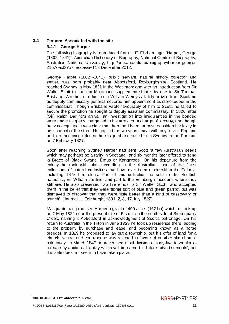
The following biography is reproduced from L. F. Fitzhardinge, 'Harper, George (1802–1841)', Australian Dictionary of Biography, National Centre of Biography, Australian National University, http://adb.anu.edu.au/biography/harper-george-2157/text2757, accessed 13 December 2012. George Harper (1802?-1841), public servant, natural history collector and settler, was born probably near Abbotsford, Roxburghshire, Scotland. He reached Sydney in May 1821 in the Westmoreland with an introduction from Sir Walter Scott to Lachlan Macquarie supplemented later by one to Sir Thomas Brisbane. Another introduction to William Wemyss, lately arrived from Scotland as deputy commissary general, secured him appointment as storekeeper in the commissariat. Though Brisbane wrote favourably of him to Scott, he failed to secure the promotion he sought to deputy assistant commissary. In 1826, after (Sir) Ralph Darling's arrival, an investigation into irregularities in the bonded store under Harper's charge led to his arrest on a charge of larceny, and though he was acquitted it was clear that there had been, at best, considerable laxity in his conduct of the store. He applied for two years leave with pay to visit England and, on this being refused, he resigned and sailed from Sydney in the Portland on 7 February 1827. Soon after reaching Sydney Harper had sent Scott 'a few Australian seeds which may perhaps be a rarity in Scotland', and six months later offered to send 'a Brace of Black Swans, Emus or Kangaroos'. On his departure from the colony he took with him, according to the Australian, 'one of the finest collections of natural curiosities that have ever been made within the Colony', including 1675 bird skins. Part of this collection he sold to the Scottish naturalist, Sir William Jardine, and part to the Edinburgh museum, where they still are. He also presented two live emus to Sir Walter Scott, who accepted them in the belief that they were 'some sort of blue and green parrot', but was dismayed to discover that they were 'little better than a kind of cassowary or ostrich'. (Journal … Edinburgh, 1891, 2, 8, 17 July 1827). Macquarie had promised Harper a grant of 400 acres (162 ha) which he took up on 2 May 1822 near the present site of Picton, on the south side of Stonequarry Creek, naming it Abbotsford in acknowledgment of Scott's patronage. On his return to Australia in the Triton in June 1829 he took up residence there, adding to the property by purchase and lease, and becoming known as a horse breeder. In 1829 he proposed to lay out a township, but his offer of land for a church, school and court-house was rejected in favour of another site about a mile away. In March 1840 he advertised a subdivision of forty-five town blocks for sale by auction at 'a day which will be named in future advertisements', but this sale does not seem to have taken place.

CURTILAGE STUDY: Abbotsford, Picton
P:\JOBS\12\12280\06_Reports\12280_Abbotsford_curtilage_130403.docx 23
Harper died at Abbotsford on 23 March 1841 aged 38. In 1828 he had married, during his visit to Scotland, Margaret Eleanor Howey, who survived him. They had three sons and two daughters.26
3.4.2 William Redfern Antill
William Redfern Antill (1828–1905), farmer, Justice of the Peace and local magistrate, was born on 3 January 1828 at “Jarvisfield”, Picton, the third son of Eliza Spencer and Henry Colden Antill. He was christened on 3 February 1828 in St Peter's Church of England, Campbelltown. Antill followed in his father’s footsteps when he was appointed a justice of the peace in the District of Picton about 1852. He was promoted to Assistant District Registrar then District Registrar in 1856 and 1857 respectively, culminating in his appointment as Magistrate of Picton in 1858. On 29 November 1860 at St Peter’s Church of England, Campbelltown, he married Mary Susannah Bell. He settled at Abbotsford, Picton in 1866 where he settled down as a grazier and managed his extensive estates in the district. He also continued to perform his role as justice of the peace and his myriad role of magistrate, coroner, and licensing magistrate and official member of the licensing court for the District of Picton. Additionally he was appointed a member of the Lower Picton Public School Board. He died at Abbotsford on 5 September 1905 and was buried in the family vault on Vault Hill next to his wife who predeceased him by a few weeks on 30 September 1858, and was buried beside him. Two sons and two daughters predeceased them, but they were survived by seven daughters.
3.5 Bibliography
3.5.1 Primary Sources
Primary Application 17758, NSW Land & Property Information
Certificate of Title Vol 14488 Fols 221A, B and C, NSW Land & Property Information
Certificate of Title Vol 12014 Fol 100, NSW Land & Property Information
Certificate of Title Vol 9179 Fol 181, NSW Land & Property Information
Deposited Plans, 207960, 1086066 and 24460, NSW Land & Property Information
Crown Plan 277A-1603, NSW Land & Property Information
Greville’s Post Office Directory 1872
Pockley and Antill family photograph albums, 1868-1890 and 1921-1925 / various commercial photographers and unidentified family photographer(s), Mitchell Library, State Library of New South Wales, PXA 1380
New South Wales Parliamentary Votes and Proceedings, Landholders in the Post Town of Picton, 1885
26
L. F. Fitzhardinge, 'Harper, George (1802–1841)', Australian Dictionary of Biography, National Centre of Biography, Australian National University, http://adb.anu.edu.au/biography/harper-george-2157/text2757, accessed 19 November 2012.

CURTILAGE STUDY: Abbotsford, Picton
P:\JOBS\12\12280\06_Reports\12280_Abbotsford_curtilage_130403.docx 24
Parish of Picton maps, NSW Land & Property Information
3.5.2 Secondary Sources
Picton – An Historic Southern Township, Australian Town and Country Journal, 8 February 1905, pp29, 32
Borst, Geoff and Jones, Steven, Abbotsford 1822…1981: a conservation report, Vols 1 & 2 [1981?]
Gilpin, Dr Alan, Report of the Honourable Eric Bedford, B.A., M.P., Minister for Planning and Environment: An Inquiry pursuant to Section 41 of the Heritage Act, 1977; Into an objection to the making of a permanent conservation order in respect of the building and site known as “Abbotsford”, Picton, 1983
Steele, Rev. James, “Early days of Picton”, in Royal Australian Historical Society Journal and Proceedings, Vol 1 pt IX, 1904, pp155-16?
Vincent, Liz, A brief history of Picton, Picton and District Historical Society, 1996
Vincent, Liz, The Forgotten Village of Picton: Introducing Upper Picton (Redbank), 2005 (reprinted)
Colonial Landscapes of the Cumberland Plain and Camden, NSW, prepared August 2000 by Colleen Morris and Geoffrey Britton (Morris & Britton Report)
Wollondilly Shire Council Growth Management Strategy 2011
3.5.3 Internet Sources
National Library of Australia – Trove databases
Vincent, Liz, Picton NSW - The Early Years, IFHAA Local History Library, http://www.historyaustralia.org.au/ifhaa/towns/picton.htm
Listings, Heritage Branch of the Office of Environment and Heritage, www.heritage.nsw.gov.au
L. F. Fitzhardinge, 'Harper, George (1802–1841)', Australian Dictionary of Biography, National Centre of Biography, Australian National University, http://adb.anu.edu.au/biography/harper-george-2157/text2757, accessed 19 November 2012
Wikipedia, Picton, New South Wales, 29 November 2012, http://en.wikipedia.org/wiki/Picton,_New_South_Wales
3.5.4 Other
Wollondilly Library Local Studies Collection
National Trust of Australia (New South Wales)
Mitchell Library, State Library of New South Wales

CURTILAGE STUDY: Abbotsford, Picton
P:\JOBS\12\12280\06_Reports\12280_Abbotsford_curtilage_130403.docx 25
4.0 PHYSICAL EVIDENCE
4.1 Generally
A survey of the fabric of the building and the wider landscape of the site was carried out by Brad Vale, Senior Heritage Specialist of NBRS+Partners in November 2012. This research was carried out without excavation or physical intervention into the fabric.
4.2 Setting and Physical Context
Abbotsford is located on the western outskirts of the town of Picton, on rolling hills on the far side of Stonequarry Creek, approximately 1.5km north-west of the town centre. The Abbotsford homestead, farm buildings and gardens lie on the east-facing side of a hill, looking over the valley drained by Stonequarry Creek towards Vault Hill. The valleys are fertile land; the hilltops are drier with less fertile land. The vast majority of the indigenous forest has long-since been cleared, leaving a cultural landscape of pastures surrounding the large suburban allotments where the township of Picton has expanded.
Site / Grounds: Abbotsford was constructed on a mid-rise knoll at the base of a steeper hill with predominant eastwards views. The vista from the homestead is defined and strengthened by the driveway and avenue of trees. Originally, the straight line of the driveway led across Stonequarry Creek via Abbotsford Bridge, towards Barkers Lodge Road. This latter road follows a contour above another tributary of Racecourse Creek and leads to a terminus at the George IV Inn, close to the centre of Picton. The timber trestle bridge over Stonequarry Creek stood until 1986 when it was replaced with the present reinforced concrete road bridge located further south off the Abbotsford axis.
Figure 15 — view of Abbotsford from Abbotsford Road. The main driveway shown here is likely to date from the inter-war period. The remains of the original avenue of trees lie to the left of this driveway. The building seen at the end of the driveway is the former dairy; the homestead lies to the left of this concealed by overgrowing trees. The land owner intends to reinstate the original driveway alignment.

CURTILAGE STUDY: Abbotsford, Picton
P:\JOBS\12\12280\06_Reports\12280_Abbotsford_curtilage_130403.docx 26
4.3 The Cultural Landscape
Elements within the cultural landscape with heritage significance pertaining to the nineteenth-century form of Abbotsford include minor earth works, plantings remaining from past agricultural uses and plantings that were made for pleasure.
The road leading up the hill from the former Abbotsford Bridge is on its nineteenth-century alignment, although the presence of reinforced concrete pipes for drainage under the roadway on the lower section indicates more recent upgrading work. A trench dug north-south on the up-hill slope above the house (on the western side) is likely to be a very early work because redirecting stormwater falling off the hill away from the homestead would have been very important since construction. The excavated flat land south-east of the ruined homestead appears to have been a croquet lawn. This land is approximately 25 x 18m, slightly larger than the minimum 17.5 x 14m for a croquet lawn. Croquet was popular in the late Nineteenth Century.
Several thorn trees are likely remnants from hedges planted to contain cattle as fence substitutes. Building fences to contain cattle in the colonial era from timber was laborious, and barbed wire was not invented until the 1860s. Two groves of osange trees (Maclura pomifera) grow in a row on the northern side of the driveway, within 60m of the homestead. This tree is indigenous to Texas and can grow up to 18m, has edible seeds in its fruit, and thorny branches growing in a coppiced form that lends itself to hedging as a windbreak and barrier to livestock. There are many thickets of blackthorn (Bursaria Spinosa). This Cumberland woodland species can proliferate after clearing of the woodland trees if the land is not burnt.
The plantings presumed to have been made for pleasure include a discontinuous row of trees approximately 600m long from near the front gate, rising to the hilltop behind the homestead to the west. Several of these trees have been dated to the lifetime of George Harper and it is most likely that he planted them as part of this interest in natural history. Many other trees and shrubs were planted around the house as a pleasure garden. Several of the remnant garden trees demonstrate a symmetrical arrangement. Several shrubs mentioned as being near the homestead in the 1981 Commission of Enquiry appear to be no longer alive, including the hydrangeas and peach trees.
The original carriageway to the homestead is likely to have begun at the Chinese funeral cypress (Cupressus funebris) south of the present entrance gate and continued in a line parallel to the present drive. This line is marked by a regular linear depression in the grass and a double line of European trees. The main avenue of trees extends from the funeral cypress to include (in order after a wide gap heading west) a kurrajong (Brachychiton populneus), another cypress, a large field elm (Ulmus minor), a Bunya pine (Araucaria bidwillii), a further large gap then linking with quince in the home garden, in line with the northern gable extension to the homestead. A wide gap in the avenue planting behind the house still leads to the wan specimen of a Norfolk Island pine (Araucaria heterophylla) on the summit of the hill. The Norfolk Island pine is not thriving as much as other araucarias in the region due to the poor soils and drier conditions on the hilltop. This pine is a local
CURTILAGE STUDY: Abbotsford, Picton
P:\JOBS\12\12280\06_Reports\12280_Abbotsford_curtilage_130403.docx 27
landmark, typical of the Colonial habit of planting araucarias on hilltops near homesteads. Field elms are indigenous to southern Europe and Asia Minor. They can grow to 30m tall over many centuries in climates preferably cooler than Picton. The Chinese funeral cypress is indigenous to southern China and northern Vietnam. It grows up to 35m tall and was commonly planted around temples there.
A southern avenue of trees grows along the current property boundary south of the driveway. This avenue has fewer specimens and consists of a camphor laurel (Cinnamomum camphora), (two Lombardy poplars (Populus nigra 'Italica'), then this avenue intersects with a perpendicular row of English oaks (Quercus robur). The camphor laurel is indigenous to China and Japan, where it was grown for timber and camphor production, useful in making such diverse things as medicine, gunpowder, insecticide and celluloid. It was introduced to Australia in 1822 as a parkland tree. The Lombardy poplar is a male clone developed in northern Italy in the Seventeenth Century. Specimens can grow to over 30m but are not especially long lived. The specimens at Abbotsford may be the suckered remnants of larger trees that have collapsed.
The ornamental plantings include tree species of horticultural interest and are thought to have been planted by George Harper. None of the detailed planting of the garden (small-scale decorative plants) remains. The homestead ruins are almost taken over by broad-leafed privet, Allamanda and cat’s claw creeper.
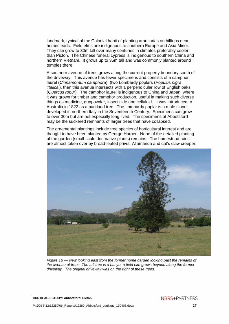
Figure 16 — view looking east from the former home garden looking past the remains of the avenue of trees. The tall tree is a bunya; a field elm grows beyond along the former driveway. The original driveway was on the right of these trees.

CURTILAGE STUDY: Abbotsford, Picton
P:\JOBS\12\12280\06_Reports\12280_Abbotsford_curtilage_130403.docx 28
4.4 Identification of Existing Fabric
4.4.1 Built Fabric
The following description of the house was written by Clive Lucas for the National Trust in March 1978 and serves as a historical record of the house before the fires of the early 1980s.
Abbotsford is a Colonial Georgian homestead in its traditional form with front veranda, the main block being flanked by a slightly late gable pavilions which at the back form a U-shaped vernadered court with the centre block. The whole is raised on a high terrace which is unusual. The main block is a double pile plan and the elevation is 5 bays wide all under a hipped roof. There are pairs of French doors under the gables of the side pavilions. The entrance hall and verandas are flagged. The doors are 6-paneled, the windows 12-paned and once shuttered; all chimney pieces are Georgian in character and in the main 3 rooms there are dado rails. The house is of face brick now painted on a rubble foundation and the shingled roof has long been covered with corrugated iron. Behind the house is a small weatherboard cottage and brick outhouse of mid nineteenth-century date. In the area around the house are many mature trees. The listing includes the land from the road to the hill behind.
The property was taken up by George Harper (1802?–1841), natural history collector and settler, in 1822 and the main block may have been built before he returned to England in 1827. The rest of the house was built before his death at Abbotsford in 1841.
The ruins of the main Abbotsford farmhouse are significant for their associations with the settlement of the area and the links with the Harper and Antill families. The architectural value and intactness of the house as an early homestead has been lost. The ruins provide an opportunity to interpret an early pastoral property through archaeological investigation. The ruins are also an evocative part of the Abbotsford group which is a landmark in the rural surrounds of Picton.
Maids’ Quarters and Smoke House The maids’ quarters and smoke house are the more intact early brick buildings on the site. The cottage was used as maids' quarters and the brick outhouse as a smokehouse. These domestic buildings are likely to be mid nineteenth-century.
Timber Barns A timber barn stands to the west of the homestead constructed of log posts to which a sawn timber frame has been attached for the corrugated steel cladding. It has a simple gable form with openings and some timber cladding on the longer sides. It is likely to date from the Federation period.
Convict Barracks/Old Gaol (demolished) A sandstone gaol was constructed to the west of the homestead forming an enclosed rear courtyard with other buildings, reflecting a deliberate axial relationship to the hill, the driveway and selected trees. The footings of the gaol can be seen.
Underground Water Storage Tank A large brick tank about 3m in diameter. It is internally rendered, capped with a brick dome and still holds water.

CURTILAGE STUDY: Abbotsford, Picton
P:\JOBS\12\12280\06_Reports\12280_Abbotsford_curtilage_130403.docx 29
Figure 17 — the northern (side) elevation of the homestead showing the general condition of the ruins.
Figure 18 — view looking east towards the centre of the former homestead showing the growth of privet in the ruins.
CURTILAGE STUDY: Abbotsford, Picton
P:\JOBS\12\12280\06_Reports\12280_Abbotsford_curtilage_130403.docx 30
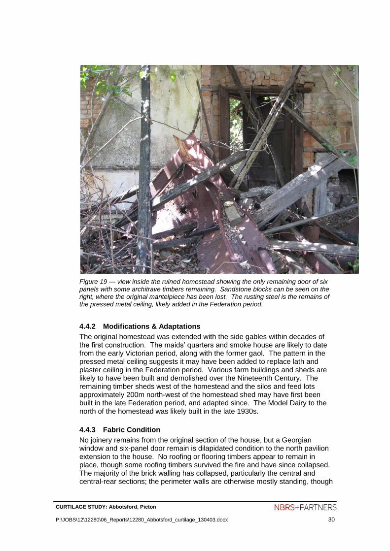
Figure 19 — view inside the ruined homestead showing the only remaining door of six panels with some architrave timbers remaining. Sandstone blocks can be seen on the right, where the original mantelpiece has been lost. The rusting steel is the remains of the pressed metal ceiling, likely added in the Federation period.
4.4.2 Modifications & Adaptations
The original homestead was extended with the side gables within decades of the first construction. The maids’ quarters and smoke house are likely to date from the early Victorian period, along with the former gaol. The pattern in the pressed metal ceiling suggests it may have been added to replace lath and plaster ceiling in the Federation period. Various farm buildings and sheds are likely to have been built and demolished over the Nineteenth Century. The remaining timber sheds west of the homestead and the silos and feed lots approximately 200m north-west of the homestead shed may have first been built in the late Federation period, and adapted since. The Model Dairy to the north of the homestead was likely built in the late 1930s.
4.4.3 Fabric Condition
No joinery remains from the original section of the house, but a Georgian window and six-panel door remain is dilapidated condition to the north pavilion extension to the house. No roofing or flooring timbers appear to remain in place, though some roofing timbers survived the fire and have since collapsed. The majority of the brick walling has collapsed, particularly the central and central-rear sections; the perimeter walls are otherwise mostly standing, though

CURTILAGE STUDY: Abbotsford, Picton
P:\JOBS\12\12280\06_Reports\12280_Abbotsford_curtilage_130403.docx 31
some are in a perilous condition, particularly the east facade of the southern pavilion. The perimeter walls are three bricks thick, laid in English bond and were rendered up to approximate waist height on the exterior and later painted. Several studs of timber used to fix the window joinery into the walls remain with charcoal exteriors. There are remains of the (later) pressed metal ceilings collapsed on the ground in the northern rooms of the original section of the homestead. The ruins have become overgrown with broad-leafed privet, cats’ claw creeper and wisteria, making it difficult to photograph the ruins with a wide view.
Figure 20 — 2012 view of the ruined homestead’s north-east corner becoming overgrown in wisteria.

CURTILAGE STUDY: Abbotsford, Picton
P:\JOBS\12\12280\06_Reports\12280_Abbotsford_curtilage_130403.docx 32
Figure 21 — part of the home garden east of the former homestead, showing a Photinia serrulata in the foreground and an Irish strawberry tree (Arbutus inedo) behind it.
Figure 22 — the timber log and sawn framed shed to the west of the homestead ruins, on higher ground

CURTILAGE STUDY: Abbotsford, Picton
P:\JOBS\12\12280\06_Reports\12280_Abbotsford_curtilage_130403.docx 33
5.0 ANALYSIS OF CULTURAL HERITAGE SIGNIFICANCE LEADING TO A RECOMMENDED CURTILAGE
This section addresses the cultural landscape values of Abbotsford. This includes the assessments on the State Heritage Register, Wollondilly local listings on the State Heritage Inventory and the findings of reports written by Clive Lucas for the National Trust and the Borst & Jones dissertation of 1981.
5.1 Basis of Cultural Heritage Assessment
This assessment of heritage is based on the methodology and guidelines set down by the NSW Heritage Branch, and considers the standard values or criteria which arise from the history, construction and use of the building and its site as well as any levels of esteem by recognised groups for the site.
5.2 Evaluation Criteria
Heritage significance, cultural significance and cultural value are all terms used to describe an item’s value or importance to our own society. This value may be contained in the fabric of an item, its setting and its relationship to other items, the response that the item stimulates to those who value it now and in the historical record that allow us to understand it in its own context. An assessment of what is significant is not static. Significance may increase as more is learnt about the past and as items become rare, endangered or are found to document or illustrate aspects that achieve a new recognition of importance. Determining cultural value is the basis of all planning for places of historic value. Determination of significance permits informed decisions or future planning that ensures that the expressions of significance are retained, enhanced or at least minimally impacted upon. A clear understanding of the nature and degree of significance will determine the parameters for flexibility of future planning and development. The historical analysis provides the context for assessing significance, which is made by applying standard evaluation criteria to the development and associations of an item. The NSW Heritage Manual has produced standard evaluation criteria that are compatible with the criteria used by the Australian Heritage Council, and with those included in The Burra Charter.

CURTILAGE STUDY: Abbotsford, Picton
P:\JOBS\12\12280\06_Reports\12280_Abbotsford_curtilage_130403.docx 34
5.3 Statement of Significance
The following Statement of Significance is taken from the State Heritage Register. The Abbotsford property is significant because of its associations with the early settlement of the Picton area and its links with prominent colonial figure, George Harper and later, the Antill family. In addition to its historical significance the site has the potential to yield further evidence of the working of this important pastoral estate through archaeological investigation. The Abbotsford cottage and brick outbuilding are significant for their contribution to the understanding of the function and layout of the group as a whole. The ruins of the main farmhouse are significant for their associations with the settlement of the area and the links with the Harper and Antill families. The architectural value and intactness of the house as an early homestead has been lost. The ruins, together with the other components of the property, provide an opportunity to interpret an early pastoral property through archaeological investigation. The ruins are also an evocative part of the Abbotsford group which is a landmark in the rural surrounds of Picton. The mature trees and remnants of the gardens and grounds of the Abbotsford property have scientific significance as a collection of rare species of horticultural interest and their association with George Harper who was a noted natural history collector. Together with the other components of the Abbotsford group, the plantings provide evidence of the structure and layout of the farm estate. In a wider context, the surviving plantings also illustrate the horticultural practice of plant collecting which was to remain an important influence in the development of gardens of the colony for a substantial period of time. Today, the trees are a landmark and contribute to the character of the rural landscape north-west of Picton. The mid-19th century cottage and brick outbuilding are significant from their contribution to the understanding of the function and layout of the homestead group (LEP, 1991). The underground water tank at Abbotsford is significant through its contribution to our understanding of the group as a whole. It is considered to be a potential source for archaeological research into the occupation phases of the site as domestic artefacts are often dropped into wells. Other sites are also considered to have archaeological significance, particularly into the earliest phases of the development of the property and the role of convicts (LEP, 1991). The location of the earlier Abbotsford bridge and crossing is significant because knowledge of its position contributes to the understanding of the siting of Abbotsford House and its driveway avenue plantings in relation to the Oaks Rd and Abbotsford Rd.

CURTILAGE STUDY: Abbotsford, Picton
P:\JOBS\12\12280\06_Reports\12280_Abbotsford_curtilage_130403.docx 35
5.4 Analysis of Existing Fabric
Abbotsford was a remarkably representative of a late Georgian homestead in New South Wales until the fires in the early 1980s. A minority part of early fabric remains above ground, including the sandstock brickwork with some sandstone trim remaining. A very small quantity of original joinery remains in a fragile state. Before the fires, the house was comparable with other colonial homesteads such as Kelvin at Bringelly, Rose Farm at Ermington, the Grange at Bathurst, Lansdowne at Goulburn, Lumley Park at Goulburn, and Meadowvale at Appin. Landscape The mature trees and remnants of the gardens and grounds of the Abbotsford property have scientific significance as a collection of rare species of horticultural interest and their association with George Harper who was a noted natural history collector. Together with the other components of the Abbotsford group, the plantings provide evidence of the structure and layout of the farm estate. In a wider context, the surviving plantings also illustrate the horticultural practice of plant collecting which was to remain an important influence in the development of gardens of the colony for a substantial period of time. The remaining trees are a landmark and contribute to the character of the rural landscape north-west of Picton.
5.4.1 Gradings of Significance
Different components of a place may make a different relative contribution to its heritage value. Loss of integrity or condition may diminish significance. In some cases it may be useful to specify the relative contribution of an item or its components.
GRADING JUSTIFICATION STATUS
Exceptional Rare or outstanding item of local or State significance. High degree of intactness. Item can be interpreted relatively easily.
Fulfils criteria for local or State listing.
High High degree of original fabric. Demonstrates a key element of the item’s significance. Alterations do not detract from significance.
Fulfils criteria for local or State listing.
Moderate Altered or modified elements. Elements with little heritage value, but which contribute to the overall significance of the item.
Fulfils criteria for local or State listing.
Little Alterations detract from significance. Difficult to interpret.
Does not fulfil criteria for local or State listing.
Intrusive Damaging to the item’s heritage significance.
Does not fulfil criteria for local or State listing.

CURTILAGE STUDY: Abbotsford, Picton
P:\JOBS\12\12280\06_Reports\12280_Abbotsford_curtilage_130403.docx 36
Of the remaining elements the most significant are the nineteenth-century structures, works and plantings which have Exceptional heritage significance. The twentieth-century farm buildings, including the brick Model Dairy and timber stump fencing have Moderate heritage significance. The 1937 Model Dairy to the north-east of the Abbotsford homestead is not essential to an understanding of the State heritage significance of Abbotsford.
5.5 Archaeological Potential
The State Heritage Register identifies a small curtilage around the ruined homestead that appears to have been drawn to capture the main archaeological resources of the site to include the sites of the homestead, former gaol and other out-buildings. The rough timber-framed shed behind, higher up the hill is likely to have archaeological potential to find relics relating to the shed’s uses, its construction and possibly drainage works. There is potential to uncover the spoon drains that lined the circular drive in front of the homestead in the Federation period. The sites of former privies and rubbish dumps are not known, but would have high archaeological potential if they become known.

CURTILAGE STUDY: Abbotsford, Picton
P:\JOBS\12\12280\06_Reports\12280_Abbotsford_curtilage_130403.docx 37
6.0 DEFINING A CURTILAGE FOR ABBOTSFORD
6.1 Introduction
Heritage Curtilage is defined as the area surrounding a building of heritage significance which is essential for retaining and interpreting its heritage significance. This assessment of an appropriate reduced curtilage for Abbotsford has been undertaken to ensure that any subdivision of its allotment results in an acceptable level of heritage impact, while allowing a reasonable form of subdivision of the larger site and the consideration of construction of appropriate structures for any appropriate alternate land use.
The assessment follows principles that are set out in the NSW Heritage Council publication, Heritage Curtilages. The owners of Abbotsford are looking at options for their management of the property. In defining a curtilage for Abbotsford it is necessary to investigate a range of issues that contribute to maintaining an appropriate setting for the built heritage items and those significant aspects of the existing landscape. These are the matters listed in the NSW Heritage Branch Guidelines on determining heritage curtilage. In this instance it is necessary to identify an area that is sufficient to maintain the identified heritage significance of the item. In assessing the essential curtilage the following questions should be satisfied: Has the significance of the original relationship of the heritage item to its site and locality been conserved?
6.2 Curtilage types
Lot Boundary Heritage Curtilage. The most common type of heritage curtilage comprises the boundary of the property containing the heritage item as shown on the historic lot plan. In the case of Abbotsford, Lot 1 of DP 1086066 is an enormous parcel of rural grazing land with a thin distribution of heritage value across the allotment, concentrated around the ruined homestead. The continuation of cleared land and several roadways has some heritage value for demonstrating early agricultural and settlement patterns, but these are not of sufficient heritage value to justify inclusion in a curtilage to a heritage item. Reduced Heritage Curtilage. A reduced curtilage is less than the lot boundary of the property. It arises where the significance of an item may not relate to the total lot, but to a lesser area, and is often defined when development occurs. An example is when a large estate containing a heritage item is to be subdivided or when a second dwelling is to be constructed on land containing a heritage item. In these cases it is necessary to identify a heritage curtilage which is less than the property boundary but is still sufficient to maintain the heritage significance of the item. It arises where the significance of the item may not relate to the total lot, but to a lesser area. The concentration of heritage value at a State level is concentrated on the ruined homestead and the positive remains of its cultural

CURTILAGE STUDY: Abbotsford, Picton
P:\JOBS\12\12280\06_Reports\12280_Abbotsford_curtilage_130403.docx 38
landscape from the Nineteenth Century including its avenue planting and driveway. The Model Dairy is unlikely to be of State significance and should not required within the curtilage of the State Heritage Register listing of Abbotsford. An additional curtilage including the Model Dairy and areas of rural land needed to protect the setting of Abbotsford should be listed at a local level. Expanded Heritage Curtilage. There may be circumstances where the heritage curtilage may need to be greater than the existing property boundary." Depending on the topography, an expanded curtilage may be required to protect the landscape setting or visual catchment of a heritage item. Abbotsford has associations with the lands on Vault Hill, formerly owned by George Harper and highly visible from the homestead. The site of the former Abbotsford Bridge was close to the driveway axis. However, these sites have no known material remains providing sufficient heritage value to Abbotsford to justify inclusion in a curtilage for Abbotsford. Composite Heritage Curtilage. This type of curtilage applies to heritage conservation areas and defines the boundaries of land required to identify and maintain the heritage significance of a historic district, village or suburban precinct. This curtilage type is not relevant to Abbotsford.
6.3 Historical Allotments
It may be important for historical reasons to display a heritage item in its relationship to its original allotment. In such cases, the retention of the allotment is necessary to demonstrate the visual setting and functional relationships of the structures on it, because they are integral to the heritage significance of the property. Abbotsford is an enormous rural holding that has been used for grazing for all of its history as a cultural landscape. The heritage values of the property are concentrated around the ruins of the homestead. The boundary of the rural holding commanded from the former Abbotsford homestead varied regularly in the Nineteenth Century as Harper purchased further holdings, and later owners leased out parcels of land as smaller farms. There is no justification to include the entire allotment of Lot 1 DP 1086066 in a heritage curtilage. The 1981 Commission of Enquiry included Commissioner Dr Alan Gilpin’s conclusion that the ruined state of the homestead prevented him from accepting the suggestion from the Department of Environment and Planning and the Heritage Council for a 26.4 ha curtilage around Abbotsford.
6.4 Design Style & Taste
The design of a heritage item and its grounds can reveal much information about the architectural ideas, style and taste of its historical period. It can also be an essential part of the heritage significance of the item. Associated elements such as driveways, visual axes, plantings and fencing can provide valuable additional interpretive information.

CURTILAGE STUDY: Abbotsford, Picton
P:\JOBS\12\12280\06_Reports\12280_Abbotsford_curtilage_130403.docx 39
Sections 4.0 and 5.0 describe and analyse the architectural ideas, taste and style of the construction and cultural landscape of Abbotsford. Abbotsford was considered in the 1970s to be one of best examples of an 1820s Colonial Georgian homestead in its rural setting, the two fires in the early 1980scaused such damage that more than half of the fabric of the homestead is now destroyed or misplaced. The recorded lost features include the intact state of the homestead, the gaol, intact state of the garden, driveway turning circle and orchards around the homestead, many of the plantings within the avenues of trees, and the timber trestle bridge that crossed Stonequarry Creek.
6.5 Functional Uses & Relationships
"The significance of heritage items often involves their wider setting. This may provide evidence of historical, social and cultural associations and uses which are integral to the heritage significance of the item. It is often the interaction of a heritage item with its surroundings through activities, functions and visual links that enables its heritage significance to be fully appreciated." The component parts of the Abbotsford site as it currently exists and in terms of
its historical use are those described in section 4.0 of this report. This includes
the ruins of the homestead, its driveway, avenues, hedges and home garden on their hill-side setting. The areas that may be affected in any future works or change of use are outside of the proposed curtilages and do not represent areas with apparent heritage fabric.
6.6 Visual Links — Significant Views & Vistas
"The heritage significance of some properties includes a visual link between them and a harbour, river, transport node, topographic feature, area of work or recreational area. The ability to interpret heritage significance is increased if the heritage curtilage can also maintain these links."
The principal visual link from this site is from the former homestead in an east-south-easterly direction towards Vault Hill. The homestead may at times, have had filtered views through trees to the north and north-east. Any such views are currently blocked by trees. The service court behind the former homestead had a view to the sheds behind, a little higher up the hill. Of less heritage importance, the summit of the hill behind the former homestead has magnificent views over the valley draining to Stonequarry Creek and the ridge of hills beyond to the north-east. It is still possible to stand under the araucaria on the summit and look over the driveway made grand by the avenues of trees.

CURTILAGE STUDY: Abbotsford, Picton
P:\JOBS\12\12280\06_Reports\12280_Abbotsford_curtilage_130403.docx 40
Figure 23 — Key views with heritage value from the site of the ruined homestead (centre-left) and from the hill summit behind the former homestead (left). The thickness of the lines is in ratio to the heritage value of the view.
Figure 24 — view from Abbotsford Road looking up the vista of the original driveway to the remains of Abbotsford homestead. This driveway would be reinstated.

CURTILAGE STUDY: Abbotsford, Picton
P:\JOBS\12\12280\06_Reports\12280_Abbotsford_curtilage_130403.docx 41
6.7 Scale
"Care is needed to ensure that there is a satisfying proportional relationship between heritage items and the area of land proposed as a curtilage."
The site is significant as the remains of one of the most intact early colonial homesteads to survive well into the Twentieth Century.
The proposed subdivision retains the garden setting around the homestead in a rural setting. Controls are required to ensure that the scale of any new buildings is appropriate to retain a rural setting in any subdivided allotments within the visual catchment of Abbotsford. Single-storey dwellings with an attic, for instance, would be an appropriate scale.
The proposed subdivided allotment containing the remains of Abbotsford homestead would be much larger than the existing State Heritage Register curtilage.
6.8 Significant Features
"Significant features may have historical, aesthetic, scientific or social importance which contributes to the heritage significance of the property."
The principal significant features of the site of the heritage item are the homestead itself, its home garden area that includes the long driveway; the avenues of trees, remains of the home orchard and pleasure garden, former croquet garden and boundary planting. All of these features would be included in the recommended enlarged curtilage.
6.9 Significant Vegetation
"Trees or shrubs may be the sole remnants of original gardens, avenues or perimeter and feature planting. They may have historical, aesthetic and scientific value for such reasons and may be significant in their own right. It may be necessary to retain plantings to frame or screen heritage items." The significant remaining vegetation of the site gave the homestead an aggrandised link with its hill and valley, asserting the homestead as a local landmark. Rows of thorn bushes are likely to have been an early fence substitute to keep in Harper’s grazing animals. These are described in more detail in section 4.3.
The recommended curtilage illustrated in Figure 27 does not capture the
western-most araucaria tree on the hill top, nor the remains of apparent thorn hedging on the northern side of the existing main driveway. These landscape elements would need to be protected by a covenant on the respective allotments. The February 2013 Biodiversity Study identifies the osage orange trees as ornamental, but there is a possibility that they were planted as fencing substitutes to retain livestock in the Nineteenth Century.

CURTILAGE STUDY: Abbotsford, Picton
P:\JOBS\12\12280\06_Reports\12280_Abbotsford_curtilage_130403.docx 42
Figure 25 — vista from the front veranda of Abbotsford looking down the driveway alignment between the rows of trees. This driveway would be reinstated.
Figure 26 — key landscape features of Abbotsford’s cultural landscape. Circles are significant individual trees, ovals are rows of similar trees, the square is the

CURTILAGE STUDY: Abbotsford, Picton
P:\JOBS\12\12280\06_Reports\12280_Abbotsford_curtilage_130403.docx 43
likely former croquet lawn and the line is the trench dug to shed water draining down the hill behind the homestead.
6.10 Curtilages in Colonial Landscapes of the Cumberland Plain and Camden
The Morris and Britton report Colonial Landscapes of the Cumberland Plain and Camden, NSW, August 2000 prepared for the National Trust includes a survey of key cultural landscapes in the Sydney region earlier than 1860. While Abbotsford is outside the study area, the report identifies three topographical models of homestead developments in this period (the summit Model, the Loudon or mid-rise Model and Lowland or Flatland Model). The report made recommendations for the planning and management decisions for each model type. Abbotsford would fit into the Morris and Britton Report typology as an example of the ‘Loudon or mid-rise Model’ of a homestead because it sits on a knoll of a larger hill with the steeper part of the hill rising behind it. Their management recommendations for a colonial homestead in this situation include retaining the landscape with a rural character visible above and below the homestead, and protecting the key view line. It would be consistent with their advice to allow a generous area of space for the homestead garden.
Figure 27 — the critical minimum curtilage around Abbotsford, suitable for listing on the State Heritage Register, and other recommended areas of curtilage

CURTILAGE STUDY: Abbotsford, Picton
P:\JOBS\12\12280\06_Reports\12280_Abbotsford_curtilage_130403.docx 44
7.0 DEVELOPMENT OF CURTILAGE AND CONSERVATION POLICY
7.1 Introduction
This section summarises the values that should be retained within a curtilage around Abbotsford, and a basis for further development of more detailed conservation policies for Abbotsford. The development of an appropriate set of conservation policies for the place must include consideration of the following key factors including:
Constraints and Opportunities arising from the Statement of Significance;
Constraints and Opportunities arising from the owner’s requirements;
Constraints and Opportunities arising from the physical condition of the building;
Constraints and Opportunities arising from adaptive re-use options.
Constraints and Opportunities arising from Commonwealth, State and Local government requirements;
Other statutory requirements.
7.2 Constraints & Opportunities arising from the statement of significance
The significance of Abbotsford is largely the research value of its archaeological values. The historical value of the remains can be interpreted in its landscaped and topographic setting. The homestead ruins as archaeological remains in a landscaped setting need to be appropriately conserved. This report recommends an expanded curtilage around the Abbotsford archaeological site and makes recommendations about the management of lands surrounding the ruins to conserve an appropriate context. The treatment of existing component spaces and significant fabric of the site should be in accordance with their assessed level of significance and generally as set out in the following table. The definition of terms set out below have the meaning given them in Australia ICOMOS Charter for the Conservation of Places of Cultural Significance (Burra Charter)
LEVEL OF SIGNIFICANCE ACCEPTABLE ACTION
Exceptional significance Preservation, restoration or reconstruction. Adaptation in accordance with the Burra Charter guidelines may also be acceptable provided the change is compatible with retaining the overall significance of the place.
High significance Preservation, restoration or reconstruction. Adaptation in accordance with the Burra Charter guidelines may also be acceptable provided the change is compatible with retaining the overall significance of the place.
Moderate significance Preservation, restoration or reconstruction or adaptation to assist in ensuring the continual use and security of the building provided that no adverse effect is created to more significant fabric.

CURTILAGE STUDY: Abbotsford, Picton
P:\JOBS\12\12280\06_Reports\12280_Abbotsford_curtilage_130403.docx 45
Little significance More radical adaptation treatment of fabric with some significance may be acceptable to ensure the continual usability and security of the place as a whole.
Intrusive Modification or removal in order that the significance of the building is enhanced by reduction of adverse effect.
The significance of Abbotsford is in part reliant on the quality of its surviving (though ruined) fabric. Wherever the issue of removing or altering significant fabric from its original form and location arises, a carefully considered study of the effects that such action will have on the overall significance of the place needs to be undertaken. Such an assessment will review the identified significance level of the part to be removed or altered, the impact that the action will have on the element itself and the resulting impact on the place as a whole. Constraints arising from the statement of significance shall aim to reduce any adverse effect to the place as a whole that may arise from the action. In general terms, an adverse effect on any item or aspect of greater significance may be permitted provided:
it makes possible the recovery of aspects of greater significance;
it helps to secure the future security of the place,
there is no feasible alternative;
care is taken to minimise the adverse effect; and
recovery of original character of the place is a desirable conservation and site management option.
7.3 Constraints & Opportunities arising from the physical condition of the Site
The homestead is in a ruined condition but has exceptional archaeological value. This ruined state is not stabilised and dramatic deterioration is likely to continue if the ruins continue to be left alone. The massed brick walls are relatively tall, made of soft bricks and not supported in the intended manner. Continued neglect would cause a slow rate of diminution of the ruin’s archaeological value, but would cause a rapid diminution of the ruin’s aesthetic and representative values as an early Georgian Colonial homestead with farm related structures around it. There is substantial information available that would enable the homestead to be reconstructed to its original design. The heritage report by Borst & Jones has measured drawings and descriptions of the materials and construction techniques, taken between the major fires when only the roof had been damaged. Other briefer descriptions of the house before the fires also exist. The remaining masonry and fragments of joinery provide a substantial indication of the original form and detail of the homestead. While reconstruction is not one of the recommended management strategies on the State Heritage Register, the reconstruction of the homestead into a habitable dwelling would be an appropriate strategy to find a viable use for the item capable of sustaining the heritage significance of the site.

CURTILAGE STUDY: Abbotsford, Picton
P:\JOBS\12\12280\06_Reports\12280_Abbotsford_curtilage_130403.docx 46
The significant plantings remain in only a minority of the likely original extent. However, the remains give some indication of the intended design and could be replanted using the existing species, others identifiable in photographic records, and perhaps others from lists of popular trees used in the late Georgian period in Sydney.
7.4 Constraints & Opportunities arising from Commonwealth, State and Local Government Requirements.
Commonwealth Government Requirements The site is not listed on any current register managed by the Commonwealth. New South Wales Government Requirements NSW Heritage Office The NSW Heritage Office State Heritage Inventory identifies buildings that are protected under the Heritage Act, 1977 or the Environmental Planning and Assessment Act, 1979. Heritage items listed in the Heritage Inventory are protected by heritage schedules to local environmental plans (LEPs), regional environmental plans (REP’s) or by the State Heritage Register (SHR). If there come to be changes to the current allotment boundary, consideration should be given to enlarging the SHR curtilage into an allotment if a viable use to sustain the property can be made, otherwise this recommended curtilage should be contained within a larger allotment having a considered viable use able to support conservation of the heritage elements within it. If a viable use for the land cannot be found, then retarding deterioration is likely to be the best available conservation strategy. Local Government Requirements The Wollondilly Local Environmental Plan lists the homestead (now ruins), trees, gardens & grounds; the underground water storage tank, and the cottage & brick outhouse (now ruins). All of these elements are recommended to be protected within an expanded curtilage that should revise the listing on the State Heritage Register.
7.5 Opportunities and Constraints on Future Development
The setting of Abbotsford is an early Colonial-era farm, with evidence demonstrating how it changed. The management of the study area considers how it can be conserved. ‘Setting’ is defined in the Burra Charter (Definitions, Article 1.12) as ‘the area around a place, which may include the visual catchment’. The charter’s conservation principles for ‘setting’ (Article 8) expand on the definition: Conservation of Abbotsford requires an appropriate visual setting to be retained around the site, and its protection for its key view to the east that contributes to the cultural significance of the place. Demolition, intrusions or other changes that would have an adverse impact on the setting of the key buildings or their relationships are not appropriate. The Illustrated Burra Charter explains that for many places there is no clear distinction between the place and its setting. Aspects of the setting of a place

CURTILAGE STUDY: Abbotsford, Picton
P:\JOBS\12\12280\06_Reports\12280_Abbotsford_curtilage_130403.docx 47
typically contribute to the significance of the place, and the place may contribute to the setting and other places within it. The recommended curtilage for Abbotsford would include the key eastwards view from the former homestead along the tree-lined vista towards Vault Hill. No development should intrude on the vista between the ruined homestead and the gate to the east on Abbotsford Road. The filtered views from the homestead towards the north and north-east, towards Abbotsford Road are less significant but still appropriate to be conserved. Views from Abbotsford Road southwards to the Abbotsford homestead site have moderate significance. See Figure 23. Abbotsford sits on a large agricultural allotment and indeed the site of the ruined homestead is sometimes used as grazing land. Its cultural landscape setting, as defined by the original property boundaries, has been eroded to the south-east by a small amount of low density subdivision of residential lots of more than 1ha. The Illustrated Burra Charter explains the concept that ‘the setting often explains why the place came to be where it is — in this instance a commanding position for the former homestead looking over key agricultural lands draining to Stonequarry Creek. The setting might also reveal former physical characteristics of the place, such as remnant cultural vegetation, earth works, fence lines or remnant trees left by clearing gangs. The site of the homestead ruins are surrounded by grazing lands, visible to the north and west. The hilltops to the east and west are important references in the cultural landscape of Abbotsford. These areas contribute to Abbotsford’s rural landscape setting (in particular views from the estate looking east). Guidance for future development within an arc east-to-north-to-west of Abbotsford will need to recognise and protect the significance of this setting. Management of the loss of vegetation and vestiges of agricultural practises, and the height, bulk and scale of any new buildings will need to be considered carefully.
7.6 Archaeological Potential
The statutory provisions that operate with respect to the heritage of the study area are contained within the NSW Heritage Act 1977. The Heritage Act provides statutory protection to archaeological relics and works of state significance. To assist in the management of the state’s heritage assets, the Heritage Act distinguishes between the items of local and State heritage significance. ‘State heritage significance’ means significance to the State in relation to the historical, scientific, cultural, social, archaeological, architectural, natural or aesthetic value of the item. The inclusion of Abbotsford’s ruins on the State Heritage Register demonstrates the state significance of its remains.

CURTILAGE STUDY: Abbotsford, Picton
P:\JOBS\12\12280\06_Reports\12280_Abbotsford_curtilage_130403.docx 48
Archaeological ‘relics’ are defined by the Heritage Act as: Any deposit, artefact object or material evidence that (a) relates to the settlement of the area that comprises New South Wales, not being Aboriginal settlement, and (b) is of State or local heritage significance.
Works are the remains of larger structures and infrastructure. The subsurface remains of the homestead, drainage channels, gaol, roads, palimpsests of former fence posts etc are likely examples of archaeological works at Abbotsford. The current land use of grazing is having little adverse impact on the archaeological resources of Abbotsford.
7.7 Consideration of potential for further future development — where/ why
In the proposed subdivision, new land uses and new structures on the lands outside the recommended heritage curtilage around Abbotsford would not necessarily cause an adverse heritage impact on Abbotsford, but would need to be considered carefully with a view to conserving other landscape values. The following general conservation policies are made as a guide to the care of Abbotsford so as to enable the quality and significance of the place to be retained, and where possible recovered, while maintaining the usefulness and viability of the building. The intention of the policies is to:
Retard deterioration of the Abbotsford ruins and its associated elements;
Permit the reconstruction of the Abbotsford homestead using the measured drawings prepared by Borst & Jones in particular, using other documentary evidence and also using the remaining physical evidence;
Restore and replant landscaping elements that reflect the early setting of the homestead;
Permit subdivision of the land into semi-rural residential allotments of more than 0.4 hectares, adaptations and new works that are compatible with maintaining a rural quality across the site;
Identify elements that adversely affect the place and which need to be modified or removed;
Draw attention to the need for co-ordination of the conservation needs of the place both in the short term as a ruined place and over the longer life of the site with other functional and technical requirements for the place.
7.8 Preparation of interpretation strategy
Interpretation of the history and significance of Abbotsford should be considered in planning for the study site, particularly the lands outside of the recommended curtilages at state and local significance. Interpretation on the site may contain the following elements:
Acknowledgement of the local Aboriginal people’s former uses of the site and any identified Aboriginal cultural values. The Aboriginal Cultural Heritage Assessment found no Aboriginal artefacts on the Abbotsford site;

CURTILAGE STUDY: Abbotsford, Picton
P:\JOBS\12\12280\06_Reports\12280_Abbotsford_curtilage_130403.docx 49
Address the natural and cultural landscape in any design changing the land-use;
Traditional rural fencing should be used in the vicinity of the Abbotsford ruins to maintain a rural character;
Colours on any future buildings in the vicinity of the Abbotsford should be drawn from the muted tones of the natural environment so any future development is visually recessive. Planted species of tree in the home garden area of Abbotsford should have dark or dull green leaves in summer (as distinct from light green or yellow leaves in summer);
Strengthen existing cultural plantings based on plant stock available in the late Georgian period in New South Wales to in-fill the long avenue of trees and in-fill lines of hedging;
Use of aspects of the area’s history and heritage significance in any future place naming.
Interpretation should be used to ensure that the heritage importance of Abbotsford is conserved, managed and interpreted in any development that changes the use of the land. Abbotsford’s curtilage, rural setting and historic views should be respected if development proceeds.
7.9 Recommendations
This Curtilage Study should be accepted as the guiding document for preliminary planning of actions to the place.
A Conservation Management Plan should be prepared to guide any works within the curtilage of Abbotsford.

CURTILAGE STUDY: Abbotsford, Picton
P:\JOBS\12\12280\06_Reports\12280_Abbotsford_curtilage_130403.docx 50
8.0 APPENDICES
8.1 Appendix B – State Heritage Inventory Listing
ABBOTSFORD Type of item: Complex / Group
Group/Collection: Farming and Grazing
Category: Homestead Complex
Location: Lat: 150.59908154 Long: -34.16185918
Primary address: Oaks Road, Picton, NSW 2571
County: Picton
Local govt. area: Wollondilly
Property description
Lot/Volume Code Lot/Volume No Section No Plan/Folio Code Plan/Folio No
PART LOT 1 DP 207960
All addresses
Street Address Suburb/town LGA Parish County Type
Oaks Road Picton Wollondilly Camden Picton Primary Address
8.1.1 Statement of significance:
The Abbotsford property is significant because of its associations with the early settlement of the Picton area and its links with prominent colonial figure, George Harper and later, the Antill family. In addition to its historical significance the site has the potential to yield further evidence of the working of this important pastoral estate through archaeological investigation. The Abbotsford cottage and brick outbuilding are significant for their contribution to the understanding of the function and layout of the group as a whole (Heritage Study, 1992; LEP, 1991). The ruins of the main farmhouse are significant for their associations with the settlement of the area and the links with the Harper and Antill families. The architectural value and intactness of the house as an early homestead has been lost. The ruins, together with the other components of the property, provide an opportunity to interpret an early pastoral property through archaeological investigation. The ruins are also an evocative part of

CURTILAGE STUDY: Abbotsford, Picton
P:\JOBS\12\12280\06_Reports\12280_Abbotsford_curtilage_130403.docx 51
the Abbotsford group which is a landmark in the rural surrounds of Picton. The mature trees and remnants of the gardens and grounds of the Abbotsford property have scientific significance as a collection of rare species of horticultural interest and their association with George Harper who was a noted natural history collector. Together with the other components of the Abbotsford group, the plantings provide evidence of the structure and layout of the farm estate. In a wider context, the surviving plantings also illustrate the horticultural practice of plant collecting which was to remain an important influence in the development of gardens of the colony for a substantial period of time. Today, the trees are a landmark and contribute to the character of the rural landscape north-west of Picton. The mid-19th century cottage and brick outbuilding are significant from their contribution to the understanding of the function and layout of the homestead group (LEP, 1991). The underground water tank at Abbotsford is significant through its contribution to our understanding of the group as a whole. It is considered to be a potential source for archaeological research into the occupation phases of the site as domestic artefacts are often dropped into wells. Other sites are also considered to have archaeological significance, particularly into the earliest phases of the development of the property and the role of convicts (LEP, 1991). The location of the earlier Abbotsford bridge and crossing is significant because knowledge of its position contributes to the understanding of the siting of Abbotsford House and its driveway avenue plantings in relation to the Oaks Rd and Abbotsford Rd. (Heritage Study, 1992).
Date significance updated: 27 Mar 12
8.1.2 Description
Construction years:
1822-1908
Physical description:
Site / Grounds / Garden: The main components of the group are: House (now ruins) (WO0108) Trees, Gardens & Grounds (WO0109) Underground Water Storage Tank (WO110) Cottage & Brick Outhouse (now ruins) (WO0111)(LEP). Site / Grounds: The original access or carriageway probably started at the Chinese funeral cypress (Cupressus funebris) south of the present entrance gate and continued in a line parallel to the present drive. This old line is marked by a regular linear depression in the grass and a double line of European trees, two Lombardy poplars (Populus nigra 'Italica'), a Norfolk Island pine (Araucaria heterophylla), a kurrajong (Brachychiton populneus), another cypress and Bunya pine (Araucaria bidwillii). Other European trees mark sites such as a possible former croquet lawn and orchards. The ornamental plantings include relatively rare species of horticultural interest and are thought to have been planted by George Harper. A line some 600m long remains, containing a number of exotic

CURTILAGE STUDY: Abbotsford, Picton
P:\JOBS\12\12280\06_Reports\12280_Abbotsford_curtilage_130403.docx 52
species: a discontinuous series of fairly random plantings, including a Chinese funeral cypress (Cypressus funebris), bunya pine (Araucaria bidwillii), field elm (Ulmus campestris), kurrajong (Brachychiton populneum), cypress (Cupressus sp.) and a Norfolk Island pine. A solitary specimen of Photinia x serrulata (a Chinese hedging shrub) also remains. Abbotsford Bridge Site: Site of original timber trestle bridge over Racecourse Creek, at site of Abbotsford crossing. Timber bridge replaced with present concrete road bridge c1986.Site of original timber trestle bridge over Racecourse Creek, at site of Abbotsford crossing. Timber bridge replaced with present concrete road bridge c1986. The location of the earlier Abbotsford bridge and crossing is significant because knowledge of its position contributes to the understanding of the siting of Abbotsford House and its driveway avenue plantings in relation to the Oaks Rd and Abbotsford Rd. (Heritage Study, 1992). Grounds / Garden (see above also): The mature trees and remnants of the gardens and grounds of the Abbotsford property have scientific significance as a collection of rare species of horticultural interest and their association with George Harper who was a noted natural history collector. Together with the other components of the Abbotsford group, the plantings provide evidence of the structure and layout of the farm estate. In a wider context, the surviving plantings also illustrate the horticultural practice of plant collecting which was to remain an important influence in the development of gardens of the colony for a substantial period of time. Today, the trees are a landmark and contribute to the character of the rural landscape north-west of Picton (LEP). The listing includes all trees and buildings on the land from road to hill top (AHC, 1980). Buildings: House (now ruins)(WO0108) A colonial Georgian brick house with front veranda, the main block being flanked by slightly later ones which at the rear form a U-shaped veranda court with the centre block. The whole is raised on a terrace at the front which is unusual. The main block is double pile plan and the elevation is five bays wide under a hip roof of shingles covered with corrugated galvanised iron. Internal detailing is intact. (AHC, 1980). Originally a Colonial Georgian, one storey house flanked by later gabled pavilions forming a U-shaped verandahed courtyard with the whole raised on a high terrace at the front. Face brick on rubble foundation for main block. Two brick outbuildings are associated with house; one containing a kitchen and servants' quarters, the other a smokehouse. Twice destroyed by fire in last decade and main building now derelict (LEP). The ruins of the main Abbotsford farmhouse are significant for their

CURTILAGE STUDY: Abbotsford, Picton
P:\JOBS\12\12280\06_Reports\12280_Abbotsford_curtilage_130403.docx 53
associations with the settlement of the area and the links with the Harper and Antill families. The architectural value and intactness of the house as an early homestead has been lost. The ruins, together with the other components of the property, provide an opportunity to interpret an early pastoral property through archaeological investigation. The ruins are also an evocative part of the Abbotsford group which is a landmark in the rural surrounds of Picton (LEP). Cottage & Brick Outhouse (WO0111) The cottage was used as servants' quarters and the brick outhouse as a smokehouse. These domestic buildings are thought to date to the mid 19th century (LEP). Timber Barns , Convict Barracks/Old Gaol (demolished) Together with the main residence these two buildings and the gaol (now demolished) were positioned around a central court with a deliberate axial relationship to the hill, the driveway and selected trees (LEP) Underground Water Storage Tank (WO110) A large brick tank about 3m in diameter. It is internally rendered, capped with a brick dome and still holds water. Archaeological and other elements: As well as the water storage tank there are other sites considered to be of archaeological interest. They are the site of the "Old Gaol" or Convict Barracks, a line of stones adjacent to the existing timber barns and the remains of a floor surface (LEP). The ruins, together with the other components of the property, provide an opportunity to interpret an early pastoral property through archaeological investigation. The ruins are also an evocative part of the Abbotsford group which is a landmark in the rural surrounds of Picton (LEP).
Physical condition and/or Archaeological potential:
A large brick tank about 3m in diameter. It is internally rendered, capped with a brick dome and still holds water. As well as the underground water storage tank there are other sites considered to be of archaeological interest. They are the site of the "Old Gaol" or Convict Barracks, a line of stones adjacent to the existing timber barns and the remains of a floor surface.
Date condition updated:27 Mar 12
Modifications and dates:
Original access road to Abbotsford House extended in a straight line from the Abbotsford crossing of Race Course Creek. New works commenced in 1985. The 1908 timber trestle bridge was demolished, site of original bridge over Racecourse Creek for Abbotsford.

CURTILAGE STUDY: Abbotsford, Picton
P:\JOBS\12\12280\06_Reports\12280_Abbotsford_curtilage_130403.docx 54
Current use: vacant
Former use: farm, residence
8.1.3 History
Historical notes:
The 400 acre property was taken up in 1822 by George Harper, natural history collector, settler, noted Scottish government official and surveyor. The main block of the house may have been built before Harper made his trip to England in 1827. The ornamental plantings include relatively rare species of horticultural interest and are thought to have been planted by George Harper. The rest of the house was built before his death at Abbotsford in 1841. Purchased by William Redfern Antill, local Magistrate and prominent early settler in 1865. Original access road to Abbotsford House extended in a straight line from the Abbotsford crossing of Race Course Creek. The timber truss Abbotsford Bridge was built c1908. It was handed over to the Wollondilly Shire Council by the Public Works Department. New works in commenced in 1985 and the original bridge was demolished in 1986. The property remained with the Antill family until 1952. The house was considered to be a remarkable survival of a farmhouse from an early period of Australia's settlement. In the late 1970s it was reported as being virtually unchanged since the middle years of the last century except for the loss of the original ceilings. Neglect, and two separate fires over the following decade, led to its state of dereliction. The site was handed over to the Wollondilly Shire by the Public Works Department. New works in commenced in 1985 and the 1908 bridge was demolished in 1986 (LEP). The original bridge was a timber trestle bridge over Racecourse Creek, at the site of the Abbotsford crossing. It was replaced with present concrete road bridge c1986.
8.1.4 Historic themes
Australian theme (abbrev) New South Wales theme Local theme
3. Economy-Developing local, regional and national economies
Agriculture-Activities relating to the cultivation and rearing of plant and animal species, usually for commercial purposes, can include aquaculture
Clearing land for farming-

CURTILAGE STUDY: Abbotsford, Picton
P:\JOBS\12\12280\06_Reports\12280_Abbotsford_curtilage_130403.docx 55
3. Economy-Developing local, regional and national economies
Agriculture-Activities relating to the cultivation and rearing of plant and animal species, usually for commercial purposes, can include aquaculture
Pastoralism - grazing sheep, cattle, goats or other animals-
4. Settlement-Building settlements, towns and cities
Accommodation-Activities associated with the provision of accommodation, and particular types of accommodation – does not include architectural styles – use the theme of Creative Endeavour for such activities.
Farmhouse-
4. Settlement-Building settlements, towns and cities
Land tenure-Activities and processes for identifying forms of ownership and occupancy of land and water, both Aboriginal and non-Aboriginal
Changing land uses - from rural to tourist-
4. Settlement-Building settlements, towns and cities
Towns, suburbs and villages-Activities associated with creating, planning and managing urban functions, landscapes and lifestyles in towns, suburbs and villages
A quiet Rural District-
8. Culture-Developing cultural institutions and ways of life
Creative endeavour-Activities associated with the production and performance of literary, artistic, architectural and other imaginative, interpretive or inventive works; and/or associated with the production and expression of cultural phenomena; and/or environments that have inspired such creative activities.
Architectural styles and periods - colonial homestead-
8. Culture-Developing cultural institutions and ways of life
Creative endeavour-Activities associated with the production and performance of literary, artistic, architectural and other imaginative, interpretive or inventive works; and/or associated with the production and expression of cultural phenomena; and/or environments that have inspired such creative activities.
Landscaping - Federation period-
8. Culture-Developing cultural institutions and ways of life
Creative endeavour-Activities associated with the production and performance of literary, artistic, architectural and other imaginative, interpretive or inventive works; and/or associated with the production and expression of cultural phenomena; and/or environments that have inspired such creative activities.
Landscaping - colonial period-
8. Culture-Developing cultural institutions and ways of life
Creative endeavour-Activities associated with the production and performance of literary, artistic, architectural and other imaginative, interpretive or inventive works; and/or associated with the production and expression of cultural phenomena; and/or environments that have inspired such creative activities.
Architectural styles and periods - Georgian revival-

CURTILAGE STUDY: Abbotsford, Picton
P:\JOBS\12\12280\06_Reports\12280_Abbotsford_curtilage_130403.docx 56
9. Phases of Life-Marking the phases of life
Persons-Activities of, and associations with, identifiable individuals, families and communal groups
Associations with George Harper, settler, surveyor, naturalist-
9. Phases of Life-Marking the phases of life
Persons-Activities of, and associations with, identifiable individuals, families and communal groups
Associations with William Redfern Antill, magistrate, prominent early settler-
8.1.5 Recommendations
Management Category Description Date Updated
Recommended Management Produce a Conservation Management Plan (CMP)
Recommended Management Prepare a maintenance schedule or guidelines
Recommended Management Carry out interpretation, promotion and/or education
8.1.6 Procedures /Exemptions
Section of act Description Title Comments
Action date
57(2) Exemption to allow work
Standard Exemptions
SCHEDULE OF STANDARD EXEMPTIONS HERITAGE ACT 1977 Notice of Order Under Section 57 (2) of the Heritage Act 1977 I, the Minister for Planning, pursuant to subsection 57(2) of the Heritage Act 1977, on the recommendation of the Heritage Council of New South Wales, do by this Order: 1. revoke the Schedule of Exemptions to subsection 57(1) of the Heritage Act made under subsection 57(2) and published in the Government Gazette on 22 February 2008; and 2. grant standard exemptions from subsection 57(1) of the Heritage Act 1977, described in the Schedule attached. FRANK SARTOR Minister for Planning Sydney, 11 July 2008
Sep 5 2008
8.1.7 Listings
Heritage Listing Listing Title
Listing Number
Gazette Date
Gazette Number Gazette Page
Heritage Act - State Heritage Register 00073 02 Apr 99 27 1546
Heritage Act - Permanent Conservation Order - former
00073 14 Jun 85 93 2716

CURTILAGE STUDY: Abbotsford, Picton
P:\JOBS\12\12280\06_Reports\12280_Abbotsford_curtilage_130403.docx 57
Local Environmental Plan 119 23 Aug 91
National Trust of Australia register 4787
8.1.8 Study details
Title Year Number Author Inspected by Guidelines used
Macarthur Heritage Study
1986 85 ARC Planning Services
No
Wollondilly Heritage Study
1992 WO0107, WO0108, WO0109, WO0110
JRC Planning Services
No
8.1.9 References, internet links & images
Type Author Year Title Internet Links
Written Gilpin, Dr Alan, Commissioner of Inquiry
1983 Abbotsford, Picton: Report of Inquiry into objections to making a PCO
Written ADB, Vol 1, Harper, George entry