12. site 656: de marchi seamount1 shipboard scientific …
TRANSCRIPT

12. SITE 656: DE MARCHI SEAMOUNT1
Shipboard Scientific Party2
HOLE 656A HOLE 656B
Date occupied: 13 February 1986 Date departed: 15 February 1986 Time on hole: 1 day, 22 hr Position: 40° 11.062 'N, 12° 11.030 'E Water depth (sea level, corrected m, echo-sounding): 3597 Water depth (rig floor, corrected m, echo-sounding): 3608 Bottom felt (m, drill pipe length from rig floor): 3606 Total depth (m): 3842.4 Penetration (m): 236.4 Number of cores: 14 Total length of cored section (m): 133.6 Total core recovered (m): 58.7 Core recovery (%): 43.9 Deepest sedimentary unit cored:
Depth sub-bottom (m): 179.1 Nature: gravel and pebble-bearing calcareous-dolomitic mud Age: probably Messinian Measured vertical sound velocity (km/s): 1.6
Igneous or metamorphic basement: undetermined
1 Kastens, K. A., Mascle, J, Auroux, C , et al., 1987. Proc, Init. Repts. (Pt. A), ODP, 107.
2 Kim A. Kastens (Co-Chief Scientist), Lamont-Doherty Geological Observatory, Palisades, NY 10964; Jean Mascle (Co-Chief Scientist), Laboratoire de Geody-namique Sous-Marine, Universite Pierre et Marie Curie, BP 48, 06230 Villefranche-sur-Mer, France; Christian Auroux, Staff Scientist, Ocean Drilling Program, Texas A&M University, College Station, TX 77843; Enrico Bonatti, Lamont-Doherty Geological Observatory, Palisades, NY 10964; Cristina Broglia, Lamont-Doherty Geological Observatory, Palisades, NY 10964; James Channell, Department of Geology, 1112 Turlington Hall, University of Florida, Gainesville, FL 32611; Pietro Curzi, Istituto di Geologia Marina, Via Zamboni, 65, 40127 Bologna, Italy; Kay-Christian Emeis, Ocean Drilling Program, Texas A&M University, College Station, TX 77843; Georgette Glacon, Laboratoire de Stratigraphic et de Paleoecologie, Centre Saint-Charles, Universite de Provence, 3, Place Victor Hugo, 13331 Marseille Cedex, France; Shiro Hasegawa, Institute of Geology, Faculty of Science, Tohoku University, Aobayama, Sendai, 980, Japan; Werner Hieke, Lehrstuhl fur Allgemeine, Angewandte und Ingenieur-Geologie, Abt. Sedi-mentforschung und Meeresgeologie, Technische Universitat Munchen, Lichten-bergstrasse 4, D-8046 Garching, Federal Republic of Germany; Floyd McCoy, Lamont-Doherty Geological Observatory, Palisades, NY 10964; Judith McKenzie, Department of Geology, University of Florida, 1112 Turlington Hall, Gainesville, FL 32611; Georges Mascle, Institut Dolomieu, Universite Scientifique et Medicale de Grenoble, 15 Rue Maurice Gignoux, 38031 Grenoble Cedex, France; James Mendelson, Earth Resources Laboratory E34-366, Department of Earth, Atmospheric and Planetary Sciences, Massachusetts Institute of Technology, 42 Carle-ton Street, Cambridge, MA 02142; Carla Muller, Geol. Palaont. Institut, Universitat Frankfurt/Main, 32-34 Senckenberg-Anlage, D-6000 Frankfurt/Main 1, Federal Republic of Germany (current address: 1 Rue Martignon, 92500 Rueil-Malmaison, France); Jean-Pierre Rehault, Laboratoire de Geodynamique Sous-Marine, Universite Pierre et Marie Curie, BP 48, 06230 Villefranche-sur-Mer, France; Alastair Robertson, U.S. Geological Survey, 345 Middlefield Road, Menlo Park, CA 94025 (current address: Department of Geology, Grant Institute, University of Edinburgh, Edinburgh, EH9 3JW, United Kingdom); Renzo Sartori, Istituto di Geologia Marina, Via Zamboni, 65, 40127 Bologna, Italy; Rodolfo Sprovieri, Istituto di Geologia, Corso Tukory, 131, Palermo, Italy; Masayuki Torii, Department of Geology and Mineralogy, Faculty of Science, Kyoto University, Kyoto, 606, Japan.
Date occupied: 15 February 1986 Date departed: 16 February 1986 Time on hole: 1 day, 5 hr Position: 40° 11.09'N, 12° 11.45'E Water depth (sea level, corrected m, echo-sounding): 3597
Water depth (rig floor, corrected m, echo-sounding): 3608 Bottom felt (m, drill pipe length from rig floor): 3606
Total depth (m): 3727.8 Penetration (m): 121.8 Number of cores: 7 Total length of cored section (m): 66.3
Total core recovered (m): 56.39 Core recovery (%): 85 Deepest sedimentary unit cored:
Depth sub-bottom (m): 106 Nature: gravels and pebble-bearing calcareous-dolomitic mud Age: probably Messinian Measured vertical sound velocity (km/s): 1.6
Igneous or metamorphic basement: undetermined Principal results: Operations: Site 656 was located on the westward
flank of de Marchi Seamount, which is the easternmost continental fault-bounded tilted block on the lower Sardinian margin (Fig. 1). Two holes were rotary drilled (Fig. 2). Hole 656A was located down-dip from the apparent pinch-out of a thin wedge of inferred syn-rift sediments. The upper 102 m of Pleistocene turbidites was not cored. Hole 656A was abandoned prematurely when the pipe stuck in synrift sand and gravel. The ship was offset to drill Hole 656B just up-dip of the apparent pinch-out of the syn-rift wedge. The upper 55 m of Pleistocene turbidites was not cored. Hole 656B was terminated to leave for Marseille. Neither hole was logged, and no heat flow measurements were made.
Four sedimentary units were recovered: Unit I: Cores 107-656A-1R to 107-656A-4R-1, 5 cm, and 107-
656B-1R to 107-656B-3R; depth: 656A: 102.8-131.3 mbsf; 656B: 55.5-83.9 mbsf; age: late Pleistocene.
Unit I contains detrital and volcanogenic sediments, mostly finegrained, with a subordinate fraction of biogenic carbonates. The detrital component includes zircon, pyroxene, and blue amphibole; the latter suggests a high-pressure/low-temperature metamorphic source terrain.
Unit II: Cores 107-656A-4R-1, 5 cm, to 107-656A-7R, CC, and 107-656B-4R; depth: 656A: 131.3-169.7 mbsf; 656B: 83.9-93.3 mbsf; age: middle Pleistocene to early Pliocene.
Unit II consists of nannofossil ooze and less abundant foramini-fer-nannofossil ooze, with minor zeolite-bearing sandy mud layers, volcanic glass, and micrite. Significant hiatuses occur within this unit in the lower Pleistocene (within nannofossil Zone NN19) and in the lower Pliocene (between nannofossil Zones NN12 and NN15). The hiatuses are more pronounced in Hole 656B than in 656A.
Unit III: Cores 107-656A-8R and 107-656B-5R to 107-656B-6R-2, 120 cm; depth: 656A: 169.7-179.1 mbsf; 656B: 93.3-105.6 mbsf; age: 656A: undetermined; 656B: early Pliocene.
Unit III is mostly homogeneous, structureless calcareous dolo-mitic muds. In Hole 656A, biogenic components are either absent or
951

SITE 656
43°N
W
14° 15°
de Marchi Seamount Site 656
Lower margin Vavilov Basin
I 6 ~^^^^SM^^S^SM^^MmSM^r~^^^"T' " ^^^P^^^^^^S^ ■ ■ ■ ■ ■ ■ ■ . ' • ' ■ ' : . '
Figure 1. Location of Site 656 on a bathymetric map, at the base of the lower Sardinian margin, and location of Holes 656A and 656B on multichannel seismic line ST12.
952

Figure 2. Schematic core logs for Holes 656A and 656B.

SITE 656
extremely scarce and reworked; in Hole 656B some minor intervals of nannofossil oozes or nannofossil-rich calcareous oozes have been dated as early Pliocene (biozone NN12).
Unit IV: Cores 107-656A-9R to 107-656A-14R and 107-656B-6R-2, 120 cm, to 107-656B-7R, CC; depth: 656A: 179.1-236.4 mbsf; 656B: 105.6-121.8 mbsf; age: pre-Pliocene, possibly Messinian.
The major lithology of Unit IV is a conglomerate containing clasts of the following lithologies in one or both holes: greenish siltstone and fine-grained calcarenites, altered greenstone, red chert, white chert, silicified micritic limestone, limonitic clay, pyrite, chalco-phyrite, galena, amphibole-rich rocks, mudstones, altered metagab-bro (tremolite rich), amphibolite, metadolerite, and metaquartzite. The assembly of pebble lithologies at Hole 656B was less diverse than in Hole 656A. Where not washed away, the matrix is a red carbonate mud.
Summary: Units I and II were deposited in a normal open marine environment. However Unit II (from lower Pliocene to lower Pleistocene) is very condensed and contains at least two hiatuses (in Zone NN19 and in between Zones NN12 and NN16). Unit III represents a downstream transition in age and facies from lower Pliocene to probable Miocene and from open marine to continental environment. Unit IV is clearly a continental deposit which includes numerous basement rock types of alpine orogenic units.
BACKGROUND A N D OBJECTIVES
Regional Setting and Previous Work Site 656 is located on the western flank of the easternmost
tilted fault block before the inferred transition between stretched continental and oceanic crust (Figs. 3 and 4). Site 655, with its basaltic basement, lies 25 km east, whereas Site 652, with its thick syn-rift wedge of barren elastics, lies about 10 km northwest, in the next half-graben. The tilted block at Site 656, the Monte de Marchi, stands higher and broader than most of the fault blocks of the Sardinian margin. The ridge is asymmetrical, with a steep (16°) eastern flank, and a gentler (10°) western flank. Dredge hauls and observations from submersibles on the steep eastern flank of Monte de Marchi have shown that the basement contains probable Paleozoic and Mesozoic strata and low-grade metamorphic rocks including phyllites and metagabbros (Colantoni et al., 1981; Gennesseaux et al., 1986).
Seismic reflection profiles across the site (Fig. 4) show a thin, westward-thickening wedge of sediment tapering against the gentle western flank of the tilted block. This sedimentary wedge can be interpreted as a syn-rift sequence. The inferred syn-rift sediments are overlain by an onlapping sequence of subhorizontal reflectors, interpreted as post-rift turbidites. There is no suggestion of evaporites in the seismic data.
Objectives With the completion of Site 655, the proposed transect across
the Sardinian margin and adjacent small basins had been achieved. With only a few operational days remaining in the cruise, there remained some ambiguity about the timing of the onset of rifting. Site 654 had been terminated for technical reasons in coarse conglomerates before reaching the pre-rift/syn-rift contact. Site 652 had reached the pre-rift/syn-rift contact, but the sediments were undatable by shipboard techniques. Therefore, the major objective of Site 656 was to try one last time to penetrate and date the pre-rift/syn-rift contact. The small thickness of the syn-rift sequence made this target practicable in a short amount of time.
A second objective was to identify the nature of the Messinian sediments, if any. Site 652, on what is now the lower Sardinian margin, had recovered a barren, clastic sequence interpreted as a Messinian lacustrine deposit, whereas Sites 653 and 654, on what is now the middle and upper Sardinian margin, had recovered basinal evaporites. One interpretation of the distribution of these Messinian facies was that Site 652 had been higher standing than Sites 653 and 654 during the Messinian,
and that there had been a drastic reorganization of the morphology of the western Tyrrhenian since the Messinian. Such a reorganization could be explained by a progressive southeastward migration of the locus of most intense rifting and subsidence on the evolving continental margin. This attractive scenario, however, depended on the inference that the barren sequence at Site 652 had been deposited in a basin which had little influx of seawater during the Messinian. If Messinian sediments were present at Site 656, their environment of deposition might support or refute the hypothesis that the lower Sardinian margin stood higher than the upper Sardinian margin during the Messinian.
The final objective of Site 656 was to examine the pre-rift evolution of the Tyrrhenian by documenting the environment of deposition of the tilted sediments between the acoustic basement and the syn-rift wedge. As originally proposed, Site TYR4 included several hundred meters of penetration into the pre-rift sequence, and pre-rift history was a major objective. However, when this second-priority site was squeezed in as the last site of the leg, this objective shrank to the less ambitious goal of determining the paleoenvironment and paleodepth of the site immediately before rifting.
Site Selection The site was originally selected at shotpoint 2060 on site sur
vey line ST 12 on the grounds that this was the most downdip position at which one could reasonably expect to reach the base-ment/pre-rift contact by single-bit rotary drilling. A position farther downdip would consume too much drilling time; a position farther updip would have a less complete section with an unneccessarily large number of hiatuses.
When the site was recast as an opportunity to reach the pre-rift/syn-rift contact rather than the basement/pre-rift contact, the original position was retained. Moving updip seemed undesirable since it would introduce the same hiatuses we had been trying to avoid in selecting the original site; moving downdip was out of the question because it would have put the target out of reach in the time available.
When Hole 656A terminated prematurely in syn-rift sand and gravel, a second hole was sited updip from the first to try once more for the pre-rift sequence updip from the apparent pinch-out of the syn-rift wedge. Hole 656B was sited at the position where the unconsolidated turbidites above the tilted block were expected to be 50-70 m thick, just sufficient to comfortably stabilize the bottom-hole assembly and allow drilling into harder rocks with more than minimal weight on bit.
OPERATIONS
Strategy As discussed under "Background and Objectives, Site Selec
tion" section, this chapter, site TYR4 had been proposed as an 800-m deep hole to reach the pre-rift/basement contact, and then recast as a 280-m deep hole to reach the pre-rift/syn-rift contact using the last few operational days of the cruise. The nature of the syn-rift sediment was unknown, but since experience at Site 652 suggested that it might be slow and difficult to drill, Site 656 was planned for rotary drilling. The upper portion of the sediment column had the by-now unmistakable seismic signature of Pleistocene turbidites. Since this stratigraphic interval had been continuously cored numerous times earlier in the leg, we obtained permission to wash down through the upper 100 m of the sediment column to allow more time for deeper penetration. No heat flow measurements or logging program was planned.
The approved site was located just downdip (i.e., west) of the pinch-out of the narrow wedge of syn-rift sediments. On bathymetric profiles, the approved site lay 550 m east of the contact
954

SITE 656
42°N
40°30'N
40°00'
^ '*« Nfifc % % Sparker Bologna Air gun Villefranche OGS Trieste
iiiiiiiiiii Leg 107 Sites Survey # Leg 107 Sites
"X ST04
ST12
ro O y-(i) HI
IT)
o
-TV58 =
MC2 ' " f ,,,f,,«Hlli|,|H "*n ?'<«,» ' ^ ^ M - m i m i , , , , , , ,
655 ^
TV55 <P iiiniiiiiiiiiimii
3> I ^ rTMC lT i i i l l™VP«W ,^Ml i i , , ,4651 ST08 £ 5 f v k I
HHI I imi tH /""""""""""""""""""""""" mi^miinn iniiiiiiimimi i iiiiiiiiuillillllll
CO ^
11°30'E 12°00' 12°30' 13°00'
Figure 3. Location of Site 656 at the base of the lowermost Sardinian margin and track chart of seismic lines available in the vicinity of the site.
955

SITE 656
' mm
ggsssg - - —=-
te»
i t f
I
4 . 5 -
Hole 656 A
Hole 656 B
*?? '■' '." w ^ J ^ ^ ' ^ ' J ^ M W 1 ^ ! ^ ! ^ ^ j A ^ ^ W ' 5 f i l < M t l ^ ^ ^
- - ■ ' - -,-nt- -it ' - <«**"■• r £ | C
" " ^ * * r t ^ * *^r*^f ' r t^ *^JW» **pyffc*y>'
5.0-
Figure 4. (Upper) MCS seismic line ST12 across the de Marchi Seamount, the easternmost tilted block before the transition from continental to oceanic crust. (Lower) Single-channel seismic profile along site approach line for Site 656.
956

SITE 656
between the flat surface of the ponded turbidites and the sloping western flank of Monte de Marchi. The site approach would be straightforward, following site survey line ST 12, on which both Sites 655 and 656 were located, from east to west over the crest of Monte de Marchi, and dropping the beacon when the ship reached the bathyal plain on the western side. We planned to drop the positioning beacon several hundred meters east of the planned drilling position so that the ship could be offset up-dip (i.e., eastward) to drill a second hole above the apparent pinch-out of the syn-rift wedge if the syn-rift sequence proved impossible to penetrate.
Site Approach During the short transit from Site 655 and during the site ap
proach to Site 656, the ship was navigated using Loran C, which performed reliably. At 1435 on 13 February, the ship slowed to stream seismic gear. Good-quality seismic records were obtained beginning at 1455, a few minutes before the streamer passed over the eastern flank of Monte de Marchi. The bathymetric profile over Monte de Marchi was similar to that from the site survey cruise. At 1559, the echo-sounder indicated that the ship had reached the contact between the Seamount and the bathyal plain. The beacon was dropped 2 min after the contact, at 1601, which should have been approximately 250 m west of the sea-mount flank and thus 300 m east of the approved position at the ship's speed of 4 kt. The Loran C position at the time of the beacon drop was 40° 10.96'N, 12° 11.20'E. The seismic line was carried on for another mile. A comparison between the site survey multichannel seismic profile and the site approach single channel profile showed good agreement between the geometry and depth of reflectors; the syn-rift wedge was found at the desired thickness at a point 400 m west of the beacon drop point.
Seismic gear was pulled at 1620, and the ship reversed course to return to a position 400 m west of the beacon to begin dynamic positioning. An average of transit satellite fixes and GPS fixes while on station gave the following positions: 656A: 40° 11.06'N, 12° 11.03'E; 656B: 40° 11.09'N, 12°11.45'E. The Loran C position of 656B was 40° 11.01'N, 12°11.29'E.
Hole 656A The rotary core barrel (RCB) bottom-hole assembly for Hole
656A was made up and run to the seafloor. The bottom-hole-assembly (BHA) included McCullough torque jars, which can be used to give a sharp upward jerk to free a stuck drill string; experience at Site 654 had warned that the danger of getting stuck in syn-rift sediments was considerable. A center bit was in place to allow washing/drilling through the Pleistocene sedimentary sequence previously cored nearby to a sub-bottom depth of 100 m. The washing down process was routine after feeling for bottom carefully and defining the local mud line to be at 3606 m by slight indications on the weight indicator and heave compensator. The hole was spudded at 0100 on 14 February.
Coring began at 102.8 mbsf and continued routinely through volcaniclastic and detrital sediments, then biogenic ooze, then barren dolomitic mud for the first eight cores. Recovery was fairly poor (average 34%) in the detrital and volcaniclastic sediments, and much improved (average 82%) in the biogenic oozes. Core 656A-9R had complete recovery of a conglomerate with a clayey matrix, but then Core 656A-10R (at 197.8 mbsf) came up with only 0.4 m of sediment. The total recovery for Cores 656A-10R through 656A-14R was 0.96 m of loose rock fragments; the poor recovery is thought to indicate that a sandy matrix was washed away and/or lost during recovery. While preparing to drop the core barrel for Core 107-656A-15R, the pipe was found
to be plugged with sediment inside and stuck in the hole. The torque jars were activated and the pipe was eventually freed after several up-jars and much working of the pipe. The plug of sediment inside the pipe was still in place, however, and further coring was impossible until it was dislodged.
The pipe was pulled clear of the seafloor at 0625 on 15 February. The vessel was offset 580 m east to the chosen position for Hole 656B (see "Background and Objectives, Site Selection" section, this chapter). During the move the pipe was left suspended about two stands above the seabed while attempting to clear out the plug and regain circulation. When the ship steadied up on the new location circulation still had not been achieved. The pipe was therefore pulled to the deck and the BHA was broken out collar-by-collar until the blockage was located. The entire outer core barrel was packed off with sand and mud. This material was washed away with a high-pressure hose and the center bit was landed in place before starting the pipe trip to the seafloor one last time to finish Hole 656B, the site, and the leg.
Hole 656B The location for Hole 656B was chosen updip from the origi
nal site in a location where the seismic data indicated that the syn-rift sequence which had contained unstable sand would be thin or absent. As the superficial sediment cover would also be thinner the hole could only be safely washed to about 50 mbsf without the risk of missing the sought-after contact. Thus the hole was drilled with a center bit to 55.5 mbsf where the center bit was pulled and RCB coring commenced. The hole was officially spudded at 2100 on 15 February in 3606 m of water. Seven cores were taken to a sub-bottom depth of 121.8 mbsf. At that point, time for coring operations had expired and the final pipe trip out of the hole was begun in preparation for departure from the Tyrrhenian Sea. The coring summary for Site 656 appears in Table 1.
Table 1. ODP coring summary.
Core no.
Hole A
1R 2R 3R 4R 5R 6R 7R 8R 9R 10R HR 12R 13R 14R
HoleB
1R 2R 3R 4R 5R 6R 7R
Date (Feb. 1986)
14 14 14 14 14 14 14 14 14 14 14 15 15 15
16 16 16 16 16 16 16
Time
0500 0630 0800 0915 1045 1215 1400 1600 1800 2015 2200 0000 0145 0315
0100 0230 0400 0545 0915 1130 1330
Sub-bottom depths
(m)
102.8-112.2 112.2-121.7 121.7-131.3 131.3-141.0 141.0-150.5 150.5-160.1 160.1-169.7 169.7-179.1 179.1-188.2 188.2-197.8 197.8-207.5 207.5-217.2 217.2-226.8 226.8-236.4
55.5-65.1 65.1-74.8 74.8-83.9 83.9-93.3 93.3-102.9
102.9-112.3 112.3-121.8
Cored (m)
9.4 9.5 9.6 9.7 9.5 9.6 9.6 9.4 9.1 9.6 9.7 9.7 9.6 9.6
9.6 9.7 9.1 9.4 9.6 9.4 9.5
Recovered (m)
0.0 9.0 0.1 3.8 7.3 9.5 6.8 2.7 9.9 0.4 0.3 0.1 0.1 0.1
0.7 9.6 9.6 9.7 8.8 9.4 8.5
Recovery (%)
0.0 94.7
1.3 39.5 76.3 99.2 70.9 28.6
108.2 4.2 2.7 1.4 1.1 0.5
7.0 99.2
105.8 103.2 92.0
100.0 89.9
957
SITE 656
LITHOSTRATIGRAPHY
HOLE 656A
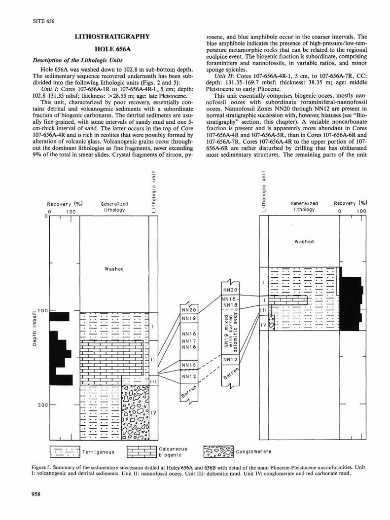
Description of the Lithologic Units Hole 656A was washed down to 102.8 m sub-bottom depth.
The sedimentary sequence recovered underneath has been subdivided into the following lithologic units (Figs. 2 and 5):
Unit I: Cores 107-656A-1R to 107-656A-4R-1, 5 cm; depth: 102.8-131.35 mbsf; thickness: > 28.55 m; age: late Pleistocene.
This unit, characterized by poor recovery, essentially contains detrital and volcanogenic sediments with a subordinate fraction of biogenic carbonates. The detrital sediments are usually fine-grained, with some intervals of sandy mud and one 5-cm-thick interval of sand. The latter occurs in the top of Core 107-656A-4R and is rich in zeolites that were possibly formed by alteration of volcanic glass. Volcanogenic grains occur throughout the dominant lithologies as fine fragments, never exceeding 9% of the total in smear slides. Crystal fragments of zircon, py
roxene, and blue amphibole occur in the coarser intervals. The blue amphibole indicates the presence of high-pressure/low-temperature metamorphic rocks that can be related to the regional eoalpine event. The biogenic fraction is subordinate, comprising foraminifers and nannofossils, in variable ratios, and minor sponge spicules.
Unit II: Cores 107-656A-4R-1, 5 cm, to 107-656A-7R, CC: depth: 131.35-169.7 mbsf; thickness: 38.35 m; age: middle Pleistocene to early Pliocene.
This unit essentially comprises biogenic oozes, mostly nannofossil oozes with subordinate foraminiferal-nannofossil oozes. Nannofossil Zones NN20 through NN12 are present in normal stratigraphic succession with, however, hiatuses (see "Biostratigraphy" section, this chapter). A variable noncarbonate fraction is present and is apparently more abundant in Cores 107-656A-4R and 107-656A-5R, than in Cores 107-656A-6R and 107-656A-7R. Cores 107-656A-4R to the upper portion of 107-656A-6R are rather disturbed by drilling that has obliterated most sedimentary structures. The remaining parts of the unit
Recovery (%) 0 100
Generalized l i thology
~ 1 00
2 0 0
Washed
Generalized l i thology
Recovery (%)
0 100
T e r r i g e n o u s ^ Calcareous b i ogen i c
Conglomerate
Figure 5. Summary of the sedimentary succession drilled at Holes 656A and 656B with detail of the main Pliocene-Pleistocene unconformities. Unit I: volcanogenic and detrital sediments. Unit II: nannofossil oozes. Unit III: dolomitic mud. Unit IV: conglomerate and red carbonate mud.
958

SITE 656
are moderately burrowed, but also contain intervals showing subparallel color lamination. The colors are dominantly grayish in Cores 107-656A-4R and 107-656A-5R, becoming more brown or comprising brown-gray alternations in Cores 107-656A-6R and 107-656A-7R.
Zeolite-bearing sandy mud layers occur as discrete intervals at 107-656A-5R-4, 130 cm, to 656A-5R-5, 30 cm, at 107-656A-6R-3, 110-130 cm, to 656A-6R-6, 35-50 cm, and in Core 656A-7R (trace in Section 656A-7R-5). Volcanic glass appears occasionally in minor amounts (0%-6°7o) among the dominant lithologies. Micrite is an important component from Core 107-656A-5R downward; Core 107-656A-5R also contains several indurated layers of nannofossil chalk as thick as 6 cm.
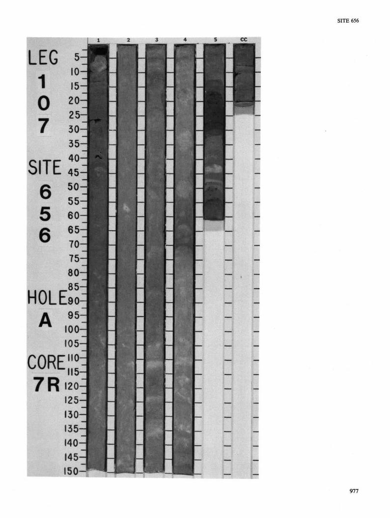
Important sedimentary features are observed in Interval 107-656A-6R-7, 13-20 cm, and in Interval 107-656A-7R-5, 17-32 cm. These intervals exhibit very sudden color and lithology changes at a millimeter scale, together with the occurrence of sharp contacts and thin (millimeter) indurated layers (Fig. 6). The interval at 107-656A-7R-5, 17-32 cm (Fig. 6) has been examined in more detail using smear slides. The different layers are indurated and comprise calcareous sand, nannofossil ooze, and silty claystone. Spots of iron oxide-hydroxide mineral were observed within this interval and several centimeters below it. Such intervals may correspond either to very condensed sequences or to surfaces of nondeposition.
One slump or debris-flow interval was observed in 107-656A-6R-5, 32-74 cm.
Unit III: Core 107-656A-8R; depth 169.7-179.1 mbsf; thickness 9.4 m; age: pre-Pliocene (Messinian?).
This unit contains gray and dark gray dolomitic muds that are mostly calcareous, sometimes with a significant sand fraction. Biogenic components are either absent, or extremely scarce, and are reworked. The sediments are structureless and very homogenous. The unit terminates in the core catcher with a quartz-feldspar sandstone exhibiting a micritic-dolomicritic matrix. The lower boundary of the unit is rather artificial, since the top of the underlying Unit IV is essentially the same color and is also barren. In interval 107-656A-8R-2, 111-112 cm, one red colored very thin interval exhibits characteristics of the underlying Unit IV. We prefer to distinguish Unit III for two reasons: (1) the marked homogenity of the sediments and (2) the striking resemblance (apart from the absence of gypsum) with sediments of upper Messinian age cored at other sites (e.g., 652, 653).
Unit IV: Cores 107-656A-9R to 107-656A-14R; depth 179.1-236.4 mbsf; thickness: 57.3 m; age: pre-Pliocene.
Unit IV is characterized by (1) the presence of pebbles and cobbles, and (2) the very bright and deep red to brown colors of the dolomitic matrix. This unit is again barren. Core 107-656A-9R recovered a matrix-supported conglomerate with clasts embedded in a claystone matrix. By contrast, Cores 107-656A-10R to 107-656A-14R recovered only rock pebbles without any fine detrital sediment. The absence of matrix is probably an artifact of drilling, similar to that recorded at the base of Site 654.
Sulfides and oxides are abundant both in the matrix and as clasts. The clasts range from coarse sands to gravels and cobbles as follows: greenish siltstone and fine-grained calcarenite; altered greenstone; red chert, white chert; silicified micritic limestone; limonitic clay; crystalline sulfide clusters and fragments (pyrite, chalcopyrite, galena?); amphibole-rich rocks (large fibrous crystals); mudstones; altered metagabbro (tremolite-rich) (Figs. 7 and 8); amphibolites (sometimes banded); metadolerite; metaquartzite.
The main characteristics of these rocks are: (1) the very severe alteration, with replacement of most ferromagnesian minerals (e.g., tremolite-actinolite-talc-pyrophyllite paragenesis), and (2) the wide variety of sedimentary, metamorphic, and igneous rocks occurring therein.
cm 10
20
30
40
50
^CiC. m
60
Figure 6. Close-up photograph of Core 107-656A-7R-5. The lower part of the photograph (below 35 cm) comprises variably colored interlay-ered nannofossil ooze; 17-35 cm is composed of reddish semi-indurated nannofossil ooze; 10-16 cm is nannofossil ooze. The major hiatus between nannofossils Zones NN15 and NN12 occurs at 16 cm. The curved lamination is drilling disturbance.
959

SITE 656
cm 25
30
35
40
45
cm 0
10
15
50
Figure 7. Close-up photograph of Core 107-656A-9R-7, showing the chaotic nature of the conglomerate making up Unit IV. The large white clast is made essentially by huge fibrous crystals of amphibole (actino-lite-tremolite group) deriving from alteration of a mafic rock.
W^W^&^-^'-^^m^-m^^rM^ Figure 8. Close-up photograph of Core 107-656A-9R, CC; same general lithology as Figure 7. The largest clast is altered metagabbro; small whitish clasts are white cherts.
Most of the clasts, for example the greenstones, metagabbros, metadolerites, cherts, and some of the limestones, are consistent with provenance from an ophiolitic nappe terrane in which associated sedimentary rocks have been largely metamorphosed. Other rocks are quartzitic and calcarenitic. These rocks sometimes include reworked crystals of blue amphibole, with anellid fragments and possible oogons of Characeae. Reworking of continental sedimentary rocks, as well as metamorphic basement, is thus indicated. Sulfides occur in both the matrix and in the clasts and are usually euhedral or concretionary. The observations suggest that the sulfides formed essentially in situ.
960

SITE 656
Hole 656B Description of Lithologic Units
Hole 656B was located 580 m east of Hole 656A and was washed down to 55.5 mbsf. The sedimentary sequence recovered was strongly disturbed by drilling and has been subdivided into four lithologic units (Fig. 5).
Unit I: Cores 107-656B-1R to 656B-3R (55.5-83.9 mbsf); thickness: >27.7 m; age: late Pleistocene.
This unit mainly contains detrital and volcanogenic sediments, with a significant fraction of biogenic carbonates, inter-layered with marly nannofossil oozes. As in Hole 656A, various heavy minerals occur: zircon, sphene, tourmaline, chlorite, and amphiboles, particularly blue amphiboles (glaucophane group). Pieces of red iron oxide-hydroxide material are frequent, especially at the top of Core 107-656B-3R (74.8 mbsf). Probable debris flows strongly disturbed by drilling occur at the top of Core 107-656B-1R (55.5 mbsf) and 656A-3R (74.8 mbsf).
Unit II: Core 107-656B-4R (83.9-93.3 mbsf); thickness: 9.4 m; age: reworked Pliocene slump within Pleistocene sediments.
Unit II is dominated by biogenic oozes, mostly nannofossil oozes and foraminiferal-nannofossil oozes of late Pliocene age (NN16 to NN18) (see "Biostratigraphy" section, this chapter). Some thin detrital intervals contain altered volcanic ash (anal-cime-rich sand) with pyroxenes. Colors are strongly variable, dominantly pink; variations are olive yellow, reddish yellow, or light reddish brown. Red iron oxide-hydroxide material occurs at the top of the core (83.9 mbsf) and in a very thin millimetric layer in Section 656B-4R-6 at 52 cm. In Section 656B-4R-6 beneath 45 cm and in Section 656B-4R-7 there are alternations of dark gray dolomitic nannofossil oozes and light gray foraminiferal-nannofossil oozes. The sediments composing this whole unit are late Pliocene in age. They occur within a Pleistocene sequence. Unit II is thus interpreted as a slump.
Unit III: Core 107-656B-5R to 107-656B-6R-2, 120 cm (93.3-105.6 mbsf); thickness: 12.3 m; age: Pleistocene to early Pliocene.
This unit mainly contains varicolored dolomitic muds, ranging in color from light yellow, olive gray, pinkish gray, weak red, red to reddish brown. At the top of Core 107-656B-5R there is a unit highly disturbed by drilling which yielded nannofloras of the NN19 zone of Pleistocene age (see "Biostratigraphy" section, this chapter). Indurated limonite-cemented sandstones are frequent beneath this interval. At 107-656B-5R-6, 104 cm, there is a minor occurrence (pebble?) of gypsiferous sand. The top of Core 107-656B-6R (Sections -1 and -2, 0-120 cm) shows minor intervals of gray or reddish brown nannofossil oozes, or of nannofossil-rich calcareous oozes that contain nannofloras of early Pliocene age (NN12, see "Biostratigraphy" section, this chapter).
Unit IV: From 107-656B-6R-2, 120 cm, to 107-656B-7R, CC (105.6-121.8 mbsf); thickness: 16.2 m; age: pre-Pliocene (Messinian or older).
The dominant sediment is a weak red carbonate mud containing scattered sand, gravel and pebble-sized clasts of iron oxide-hydroxides, sandstones, dolomites, marlstones, limestones, and gypsum-bearing sandstones.
Comparisons Between Holes 656A and 656B Although the general sequences are comparable in Holes
656A and 656B, we note several differences (Fig. 5):
1. The base of Unit I is located at 131 mbsf in Hole 656A but at only 83.9 mbsf at Hole 656B. Seismic reflection records, drilling characteristics, and comparison with Holes 650 and 651 suggest that the washed intervals contained sediments similar to those cored in Unit I. If correct, this Unit is approximately 47 m thinner updip in Hole 656B than downdip in Hole 656A.
2. The thickness of Unit II (biogenic oozes) decreases from 38.35 m in Hole 656A to 9.4 m in Hole 656B. In Hole 656A,
Unit II occurs in a normal stratigraphic sequence, although hiatuses and slumped intervals are present. In Hole 656B, Unit II comprises late Pliocene sediments that are completely reworked into Pleistocene sediments.
3. In Hole 656A, Unit III comprises barren dolomitic muds that underlie lower Pliocene nannofossil oozes (NN12). The situation in Hole 656B is more complicated. Comparable dolomitic muds occur beneath nannofossil oozes of NN19 age and above nannofossil oozes of NN12 age; also, the dolomitic mud contains some reworked gypsum inferred to be Messinian in age.
4. Emplacements of Units II and III of Hole 656B probably coincided in time to emplacement of the lower part of Unit II of Hole 656A, i.e., both were emplaced between nannofossil Zones NN12 and NN20. Unit III of Hole 656A has no apparent equivalent in time at Hole 656B, i.e., no subaqueous sediments below nannofosil Zone NN12.
5. Comparing the two holes, the middle and upper Pliocene sequences of nannofossil oozes of Hole 656A (Unit II; nannofossil Zones NN15-NN18) occupy the same stratigraphic positions as the barren dolomitic muds of reddish color that contain reworked gypsum in Hole 656B (part of Unit III); i.e., both fall immediately above apparently in-situ oozes of nannofossil Zone NN12. These observations are explicable if the dolomitic sediments in Hole 656B are interpreted as an allocthonous sequence reworked from beneath nannofossil Zone NN12.
6. Hole 656A exhibits two main hiatuses: between NN12 and NN15 in the lower Pliocene, and within NN19 in the lowermost Pleistocene. Hole 656B, instead, shows only one very large hiatus, extending from Zones NN12 to NN19.
7. Unit IV in Hole 656A is rich in large clasts composed mostly of altered igneous, metamorphic, and sedimentary rocks. Unit IV in Hole 656B is much richer in iron and in sandstone but contains fewer clasts. These clasts were exclusively derived from calcareous and terrigenous rocks.
BIOSTRATIGRAPHY
Summary A Quaternary sequence of 160 m thickness is present at Hole
656A of which 102.8 m was washed down. The series belongs almost entirely to the upper part of the Quaternary. The lower part is represented by only 2.40 m. In Hole 656B the incomplete Quaternary sequence, including slumped Pliocene sediments, has a thickness of about 100 m (Fig.9).
The Quaternary is underlain by a incomplete, very condensed Pliocene sequence in Cores 107-656A-7R and 107-656B-4R through -6R. The sediments are rich in well-preserved micro- and nannofossils.
In Hole 656A the Pliocene (NN12) is underlain by grey dolomitic mudstones (lithostratigraphic Unit III) barren of autochthonous fossils, containing common reworked nannoplankton from Cretaceous and Paleogene. These dolomitic mudstones probably belong to the Messinian. In Hole 656B, the Pliocene (NN12) is underlain by an iron-oxide-rich unit containing scattered pebbles (lithostratigraphic Unit IV).
Planktonic Foraminifers Quaternary: A sequence of about 160 m thickness of Qua
ternary has been drilled at Hole 656A. Core 107-656A-1R was empty but in 107-656A-1R, CC (112.2 mbsf) a sample shows a warm temperate assemblage of the Globorotalia truncatulinoides excelsa Zone. The index species occurs from the top to 150.5 mbsf (107-656A-5R, CC). Between this level and 160.1 mbsf (107-656A-6R, CC) Globigerina cariacoensis was recognized.
961

SITE 656
Hole 656A Hole 656B
100
200
Age
Pleistocene
Messinian?
Biost ra t igraphy
Nannofoss i l zones
NN20
NN19 !^, Pliocene NN1B-1$
N N 1 2 /
Planktonic f o ramin i fe rs
Globorotalia truncatulinoides excelsa
Globorotalia cariacoensis
MPI5 MPI2
Cor
e no
.
1
■f +
6 7
Rec
over
y
1
Biostratigraphy
Nannofossil zones
NN20
_NN16 : :18 NN19
N N 1 2 /
Planktonic foraminifers
Globorotalia truncatulinoides excelsa
_ MPI5
Figure 9. Summary of biostratigraphy determinations made at Site 656.
Only one specimen of Globigerinoides obliquus has been found in 107-656A-6R, CC (160.1 mbsf).
At Site 656B, the Quaternary is more than 83.9 m thick. The first 55.5 m of sediments was washed. The Globorotalia truncatulinoides excelsa Zone is present from 107-656B-1R, CC (65.1 mbsf) until 107-656B-3R, CC (83.9 mbsf). Therefore, the upper part of Pleistocene is recognized. Globigerinoides obliquus extremus is common in 107-656B-4R, CC (93.3 mbsf).
Pliocene: At Hole 656A, the interval between 107-656A-7R-1, 15-72 cm, and 107-656A-7R-5, 57-59 cm (176.3 mbsf) must be referred to MP15 biozone. That means that a large gap exists including MP15 (part), MP16, and the lower part of the Pleistocene. Then Section 107-656A-7R, CC (169.7 mbsf) shows an assemblage of the lower Pliocene Globorotalia margaritae Zone (MP12). Another long gap is present including MP12 (upper part), MP13, MP14, and probably the base of MP15. No foraminifers were recorded in Section 107-656A-8R, CC (179.1 mbsf)-Downward, a red soil appears in Section 107-656A-9R, CC (188.2 mbsf). Shore-based studies may clarify the position of the Miocene/Pliocene boundary.
At Hole 656B, Section 107-656A-4R, CC (93.3 mbsf) shows an assemblage of the Globigerinoides elongatus (MP15) zone. No foraminifers were recorded at the top of Section 107-656A-5R, CC. Section 107-656A-6R, CC is pure dolomite without fossils (Messinian?).
Benthic Foraminifers Benthic foraminifers in Site 656 occurred from 112 mbsf to
170 mbsf of Hole 656A, and from 65 to 93 mbsf of Hole 656B. In the middle Pleistocene (112-150 mbsf in Hole 656A, and 65-84 mbsf in Hole 656B), Articulina tubulosa and Parafissurina spp. are found as the autochthonous species. The upper part of this interval (112-131 mbsf in Hole 656A), which contains abundant volcanic materials, includes many displaced specimens. A similar assemblage can be found at 75 mbsf in Hole 656B.
At 160 mbsf of Hole 656A (Core 107-656A-6R, CC), Oridorsalis stellatus, Gyroidina altiformis, Cibicidoides kullenbergi,
and A. tubulosa are found together with some reworked specimens including C. italicus and Sigmoilopsis schlumbergeri. The faunal association of autochthonous species is similar to that of the corresponding part of the Pleistocene in the previous holes.
In the samples of Sections 656A-7R-1 to 656A-7R-4 in Hole 656A and Sections 656B-4R-2 to 656B-4R-7 in Hole 656B, O. stellatus, Karreriella bradyi, Gyroidina spp., and C. robertsonianus are present. They are also associated with some reworked specimens of C. italicus.
The samples at 167 and 170 mbsf in Hole 656A (Cores 107-656A-7R-5, 79-81 cm, and 656A-7R-5, CC) are characterized by occurrence of O. stellatus, C. italicus, and Siphonina reticulata. This fauna resembles those in and below the interval of maximum abundance of species diversity in the MP14 biozone of Pliocene sequences.
Nannoplankton At Hole 656A the upper 102.8 m of Pleistocene turbidites
was washed down. The Gephyrocapsa oceanica zone (NN20) was determined from Core 107-656A-1R to Sample 107-656A-6R-5, 30 cm (102.8-156.8 mbsf) underlain by a very condensed or incomplete sequence belonging to the Pseudoemiliania lacunosa zone (NN19) from Samples 107-656A-6R-5, 83 cm, to 107-656A-6R-7, 12 cm (157.0-160.0 mbsf). The sediments are generally rich in nannoplankton. However, they are diluted by detrital carbonate, volcanic ash, and reworked species within the turbiditic layers.
The small Gephyrocapsa zone was recognized at Hole 656A from Samples 107-656A-6R-6, 139 cm, to 107-656A-6R-7, 12 cm. It is supposed that the greatest part of the lower NN19 is not represented. The sample taken from a reddish-brown indurated layer (Sample 107-656A-6R-7, 14 cm) is poor in nannoplankton due to dissolution. This horizon is underlain by nan-noplankton-rich sediments of Zone NN19. The reddish-brown layer might indicate an interval of nondeposition.
The Pliocene/Pleistocene boundary at Hole 656A lies between Samples 107-656A-6R-7, 12 cm, and 107-656A-6R-7, 26
962

SITE 656
cm (at about 160.0 mbsf), recognized by the extinction of Cyclococcolithus macintyrei. At Hole 656B this boundary was determined between Cores 107-656B-3R and 107-656B-4R.
The sequence from Samples 107-656A-7R-1, 96 cm, to 107-656A-7R-4, 60 cm, belongs to the upper Pliocene (nannoplankton Zones NN18 to upper NN16). Discoasters are absent or are very rare. The lower part of Zone NN16 seems to be missing.
Nannoplankton are abundant and well preserved in Zone NN15 (Reticulofenestra pseudombilica zone) from Samples 107-656A-7R-4, 90 cm, to 107-656A-7R-5, 8 cm. Discoasters are common. This zone is again separated from the underlying lower Pliocene (Zone NN12) by a reddish-brown indurated layer (nondeposition) poor in nannoplankton due to dissolution.
Zone NN12 (Amaurolithus tricorniculatus zone) is present from Samples 107-656A-7R-5, 15 cm, to 107-656A-7R, CC.
In Hole 656B, Zone NN20 (Pleistocene) is present from Core 107-656B-1R to Core 107-656B-3R, CC (55.5-84.0 mbsf). It is underlain by slumped upper Pliocene sediments (NN16-NN18) in Core 107-656B-4R equivalent to lithostratigraphic Unit II. Sediments of Zone NN19 (lower Pleistocene) mixed with Pliocene and barren dolomitic mud were encountered in Core 107-656A-5R, underlain by lower Pliocene deposits of Zone NN12 in Core 107-656B-6R-1.
The lowest portion of both holes contains red to brown clay with pebbles and conglomerates of different lithologies. These deposits are inferred to represent the continental facies of the Messinian.
PHYSICAL PROPERTIES
Introduction Cores from both holes were used for shipboard analysis.
Physical properties measured at Site 656 include GRAPE density from full round core sections, vane shear strength, compressional-wave velocity, and index properties (porosity, bulk density, and grain density) from split sections. Due to drilling disturbances, shear strength measurements were done on only some cores of Holes 656A and 656B. Tables 2 through 7 list Site 656 physical-properties measurements.
The methods of analysis are described in the "Explanatory Notes" chapter, this volume.
Results
Index Properties and Compressional Velocity Porosity, bulk density, grain density, and compressional ve
locity from Holes 656A and 656B are listed in Tables 2 through 5 and are shown in Figures 10 and 11. Because the upper sec-
Table 2. Physical properties index, Hole 656A.
Core section
2R-3 2R-6 4R-1 4R-3 6R-5 6R-7 7R-4 7R-5 8R-1 8R-2 9R-3 9R-7
Interval or piece
no.
44-47 44-48 59-62 31-34 88-90 22-25
100-103 5-8
48-52 104-107
1-7 1-7
Depth sub-bottom
(m)
115.64 120.14 131.89 134.61 157.38 159.72 165.60 166.15 170.18 172.24 182.11 188.11
Bulk density (g/cm3)
1.70 1.71 1.80 1.79 1.83 1.97 1.85 1.84 2.26 2.36 2.12 2.35
Porosity (%) 63.4 58.8 57.8 60.7 60.9 63.1 54.3 56.2 33.9 29.9 56.7 45.8
Grain density (g/cm3)
2.76 2.68 2.72 2.77 3.05 2.78 2.72 2.77 2.77 2.91 3.40 3.21
Table 3. Physical properties index, Hole 656B.
Core section
1R-1 2R-1 2R-7 3R-6 4R-6 5R-6 6R-7 7R-6 7R-6
Interval or piece
no.
21-24 15-18 50-53
129-132 100-103
7-10 27-30 4-10
74-77
Depth sub-bottom
(m)
55.72 65.26 74.62 83.60 92.40
100.90 112.20 119.90 120.57
Bulk density (g/cm3)
1.50 1.67 1.76 1.81 2.15 1.70 2.14 2.00 2.04
Porosity (<%) 74.1 66.2 60.7 58.9 42.1 35.8 47.8 53.8 51.8
Grain density (g/cm3)
2.51 2.70 2.77 2.93 2.85 2.03 2.94 3.09 3.11
Table 4. Compressional velocity, Hole 656A.
Core section
2R-3 2R-6 4R-1 4R-3 5R-4 6R-5 6R-7 7R-4 7R-5 8R-1 8R-2
Interval (cm)
44-47 44-48 59-62 31-34 86-89 88-90 22-25
100-103 5-8
48-52 104-107
Depth sub-bottom
(m)
115.64 120.14 131.89 134.61 146.40 157.38 159.72 165.60 166.15 170.18 172.24
Compressional velocity (km/s)
1.525 1.627 1.493 1.564 1.610 1.564 1.637 1.665 1.632 1.927 1.815
Table 5. Compressional velocity, Hole 656B.
Core section
2R-1 2R-7 3R-6 4R-3 4R-6 5R-6 6R-7 7R-6
Interval (cm)
15-18 50-53
129-132 146-150 100-103
7-10 27-30 74-77
Depth sub-bottom
(m)
65.26 74.62 83.60 88.40 92.40
100.90 112.20 120.55
Compressional velocity (km/s)
1.602 1.655 1.573 1.621 1.720 1.656 1.655 1.691
tions of both holes were partially washed and because of severe drilling disturbances, few results are available.
Grain density is variable from 2.68 to 3.40 g/cm3 in Hole 656A and from 2.03 to 3.11 g/cm3 in Hole 656B. However, the red continental matrix of sedimentary Unit IV has significantly higher grain densities (2.9-3.4 g/cm3) than Units I, II, or III. This may be due to the presence of iron oxides or heavy minerals.
The bulk density values are in good agreement with the porosity values and reflect the same trend along the two holes, Hole 656A shows homogeneous bulk densities (1.8 g/cm3) and porosity (60%) down to 166 mbsf. The bulk density is then sensibly higher (average 2.27 g/cm3) in the two deepest lithostratigraphic units. Nevertheless, those two units can be distinguished with the porosity data: 29.9%-33.9% for Unit III, 51.8%-53.8% for Unit IV.
Hole 656B presents a regular decrease of porosity from 74% at 55.72 mbsf to 35% at 100.90 mbsf, corresponding to lithostratigraphic Units I, II, and III. As in Hole 656A, higher porosity values were noted in lithostratigraphic Unit IV (average 51.1%). The few bulk density data available seem to underline each of the sedimentary units: A regular increase (1.50-1.81 g/
963

SITE 656
1 i U
120
130
140
150
160
170
180
I
-
—
—
I
1 '
—
-
—
—
-
V / -
, \ -
i r
/
1 2 Bulk density
3 0 40 Porosity
(%)
80 1 .2
(g/cm3)
Figure 10. Bulk density, porosity, and velocity vs. depth at Hole 656A.
1 .6 Velocity (km/s)
2.0
cm3) was observed in lithostratigraphic Unit I, a high value (2.15 g/cm3) was noted in lithostratigraphic Unit II, a lower value (1.70 g/cm3) characterizes Unit III, and Unit IV presents sensibly higher data (average 2.06 g/cm3).
Compressional velocity data of Hole 656A show a slightly increasing trend down to 166 mbsf. In this interval, data range from 1.49 to 1.66 km/s. The two deepest samples gave higher velocities (1.93 and 1.85 km/s) and correspond to lithostratigraphic Unit III. Material of Unit IV was too soft to be measured.
Few data from Hole 656B are available. Nevertheless, two trends can be noted: from 65.26 to 88.40 mbsf (average 1.613 km/s) and from 92.4 mbsf to the bottom of the hole (average 1.681 km/s). Due to drilling disturbances the velocities of lithostratigraphic Units III and IV were probably underestimated.
Shear Strength Due to drilling disturbances, few measurements were done at
Site 656 (Fig. 12 and Tables 6 and 7). The results are very heterogeneous and remain difficult to interpret.
Conclusion Although few data are available for this site, some conclu
sions can be noted:
1. Lithostratigraphic Units I and II cannot be distinguished by their physical properties in either hole.
2. Lithostratographic Unit III was distinguished by its low porosity values in both holes.
3. In both holes lithostratigraphic Unit IV presents higher grain densities and higher porosities than lithostratigraphic Unit III. Those physical properties are probably related to the continental nature of this unit.
DISCUSSION AND CONCLUSION Site 656 was handicapped by time constraints and technical
problems. Nonetheless, the site succeeded in documenting the presumed Messinian facies, and thereby substantiated the hypothesis that the lower Sardinia margin was relatively high-standing during the Messinian.
Depositional Environment The Pliocene-Pleistocene sediments (Units I and II at both
Holes 656A and 656B) were deposited in a normal open marine environment. As in Sites 650 and 651, the upper Pleistocene sediments (Unit I at Holes 656A and 656B) record significant detrital and volcanogenic input, with corresponding high accumulation rates. During the early Pleistocene/Pliocene (Unit II at Holes A and B) the sedimentation was mostly biogenic and characterized by lower accumulation rates. The difference in
964

SITE 656
o u
60
70
80
90
100
no
120
i i n
'
— \
—
—
— /
—
—
1
1
—
—
—
\ —
—
\ —
( —
1 1 .2 1 .8
Bulk density (g/cm3)
2.4 20 40 60 Poros i ty
(%)
1 .8
Figure 11. Bulk density, porosity, and velocity vs. depth at Hole 656B.
Unit I and II thicknesses between the two holes results from onlapping deposition on a sloping surface.
Unit III at Site 656A is a barren dolomitic mud. A Messinian age is inferred from the position of this unit beneath a normal (although condensed) Pliocene biostratigraphic succession. A similar lithology is encountered at Hole 656B, interbedded as a probable slump between lower Pliocene (NN12) and lower Pleistocene (NN19) sediments. The difference in stratigraphy between Holes 656A and 656B, with hiatuses in 656A and redeposited units in 656B, may be attributed to local basement relief.
Unit IV, in both Holes 656A and 656B, represents essentially a continental deposit such as an alluvial fan. The rock fragments of Unit IV are probably derived from the continental basement of Monte de Marchi. The nature of the clasts of this unit confirms the suggestion of previous workers (Colantoni et al., 1981; Gennesseaux et al., 1986) that Monte de Marchi contains a fragment of a complex Tethyan ophiolite alpine-type nappe as well as metamorphic complexes. The base of Hole 65 6A Unit IV may represent a true basement since the recovery in the last four cores was exclusively fragments of homogeneous basement rocks (stongly altered metagabbro).
Tectonic Implications
In light of the results from Sites 652, 653, and 654, we had postulated that during the Messinian desiccation, the region that is now the lower Sardinian margin (Site 652) was higher standing than the region that is now the upper Sardinian margin (Sites 654 and 653). At Site 656, we recovered two distinct barren lithologies inferred to be Messinian: a dolomitic mud above a subaerial iron-rich coarse-clastic deposit. The presence of the subaerial deposit supports the hypothesis of a relief inversion between upper and lower margins since the Messinian. If the dolomitic mud is a marginal Messinian facies, its superposition above the subaerial elastics may be interpreted as a transgressive contact. Such a transgression could result from tectonic subsidence during the Messinian or from refilling of the Mediterranean at the end of the Messinian.
The presence of numerous hiatuses and confused stratigraphic successions attributed to slumps indicates significant sedimentary instability during the early Pliocene and early Pleistocene. Such mass movements indicate the existence of a relatively steep slope and/or tectonic activity during this time interval. This inference is compatible with drilling results at Site 652, where the
965

SITE 656
60
80
100
120
140
160
1
—
— ^ S
1
1 ' 1 ' ▲ Hole 656A • Hole 656B
I . I .
—
-
—
—
—
-
—
-
—
Table 6. Shear strength measurements, Hole 656A.
Core section
2R-3 2R-5 4R-1 4R-3 6R-5 6R-7
Table 7.
Interval (cm)
37 98 65 13 27 30
Depth sub-bottom
(m)
115.57 119.18 131.95 134.43 156.77 159.80
Shear strength
(kPa)
73.965 6.828
55.758 21.621 81.931
100.137
Shear strength measurements, Hole 656B.
Core section
1R-1 3R-6 4R-6
Interval (cm)
32 137 52
Depth sub-bottom
(m)
55.42 83.67 91.92
Shear strength
(kPa)
11.379 59.172 85.344
0 40 80 Shear strength (kPa)
Figure 12. Shear strength vs. depth in Holes 656A and 656B.
120
syn-rift sequence was Messinian to early Pliocene in age, and with the observation of active faulting on the lower Sardinian margin.
REFERENCES Colantoni, P., Fabbri, A., Gallignani, P., Sartori, R., and Rehault,
J.-P., 1981. Lithologic and stratigraphic map of the Italian Seas. Consiglio Naz. Ricerche, Publ. 4.
Gennesseaux, M., Rehault, J.-P., Thomas, B., Colantoni, P., Fabbri, A., Lepvrier, C , Mascle, G., Mauffret, A., Polino, R., Robin, C , and Vanney, J., 1986. Les blocs bascules de la mer Tyrrhenian centrale et le volcan sous-marin Vavilov: resultats des plongees en submersible Cyana. C. R. Acad. Sci. Ser. A, 12:705-792.
966

SITE 656
SITE 656 HOLE A CORE 1 R CORED INTERVAL 3 6 9 9 . 8 - 3 7 0 9 . 2 mbsl; 1 0 2 . 8 - 1 1 2 . 2 mbsf U
NIT
-R
OCI
u i
s
LU 2 UI O
.EIS
TO
CL
BIOSTRAT. ZONE/ FOSSIL CHARACTER
CO K
INIF
E
3 CK O Li-
tC CO
xcel
CD
CO CO
;o O
c ^ 3 to
rune
bo
rota
/ia
t
o e>
CO
FOSS
I
1 2
< Z.
C3 O
o CM
2 2
CO 2
-AR
IA
o Q
< !L
i O
Q
CO
o
MAG
N!
o w - 1
< CL
:RTI
ES
PRO
F
CO
>-X o_
STR
Y
5 UJ X
°
2
P LU CO
CO
UJ
(-UJ
s
GRAPHIC LITHOLOGY
!TU
RB
NG D
l
_ l
cc Q
UR
ES
L-
!TR
UC
Q
CO
CO
5^ 2
< *
LITHOLOGIC DESCRIPTION
SANDY SILTY MUD
Traces of sandy silty mud in CC, olive-gray (5Y 4/2).
SMEAR SLIDE SUMMARY (%):
CC, 0 D
TEXTURE:
Sand 25 Silt 30 Clay 45
COMPOSITION:
Quartz 3 Mica 2 Clay 45 Volcanic glass 8 Calcite/dolomite Tr Pyroxene Tr Zeolites Tr Gypsum 2 Foraminifers 20 Nannofossils 15 Diatoms Tr Sponge spicules Tr Intraclasts 5
967

SITE 656
SITE 656 HOLE A CORE 2 R CORED INTERVAL 3 7 0 9 . 2 - 3 7 1 8 . 7 mbsl; 1 1 2 . 2 - 1 2 1 . 7 mbsf BIOSTRAT. ZONE/ FOSSIL CHARACTER
GRAPHIC LITHOLOGY
LITHOLOGIC DESCRIPTION
^
mm.
MUD and SANDY SILT
Sections 1 through 4 and 5, 0-60 cm, contain homogeneous gray (5Y 6/1) mud. Section 5, 60-150 cm, and Section 6 contain gray (5Y 6/1) sandy silt making up a thick graded unit. The coarsest intervals contain trace amounts of blue amphibole (glaucophane-riebeckite group).
SMEAR SLIDE SUMMARY (%):
TEXTURE:
Sand Silt Clay
COMPOSITION:
Quartz Feldspar Mica Clay Volcanic glass Calcite/dolomite Accessory minerals Gypsum Pvroxene Glaucophane/riebeckite Foraminifers Nannofossils Diatoms Radiolarians Sponge spicules Flagellates Fish remains Pellets Bioclasts
1, 51 D
5 95
2 1 1
40 2
15 5 5
— — 1 38
— — 1
— — — —
2, 100 D
5 95
2 1 1
40 Tr 5 5 3
— — 1 39
— — 1 2
— — —
2, 138 M
8 15 77
4 1 2
57 Tr 3 3
— — — — 28
— — — — 1
1 1
4, 140 D
10 20 70
4 1 2
67 1
Tr 3
— — — Tr 29
— Tr
— — — — 3
5, 144 D
60 20 20
46 5 1
22 5 4 2
— — — 4 12 1
— 1
— 2 4
6, 1 D
75 1b 10
30
— 2D 10 8
— — — 2 Ir
13 b
— — 2
— 10
968

SITE 656
969

SITE 656
SITE
i -
3
O
a.
UJ z UJ o o
1ST
UJ _ l 0_
6 5 6 HOLE BIOSTRAT. ZONE/ FOSSIL
<o cc UJ
u.
MIN
I
< cc o u.
co
Cl
* l b
CO Qi O O
c
n
nca
o L.
Glo
bo
rota
lia
CO
CO O
FO,
z
< *> LL
o CM 2 2
CHARACTER
< dV~lC
Q
< cc
1
A
CO
I I I
%
OM
A
UJ
< CL
s cr
o
0-
Q.
>-
ISTF
UJ I O
CORE 3
ION
1 -
UJ CO
_ L
C O
cc
R CORED INTERVAL 3 7 1 8 . 7 - 3 7 2 8 . 3 mbs l ; 1 2 1 . 7 - 1 3 1 . 3 mbs f
GRAPHIC LITHOLOGY
i — . . . . _
CO cc
j2 a
z
cc a
« cc
o
ST
R
en
LE
S
CL
CO
*
LITHOLOGIC DESCRIPTION
MUD
Mud, gray (5Y 6/1), with a small amount of volcanic glass.
SMEAR SLIDE SUMMARY (%):
1,6 D
TEXTURE:
Sand 5 Silt 10 Clay 85
COMPOSITION:
Quartz Tr Mica 1 Clay 60 Volcanic glass 9 Calcite/dolomite Tr Accessory minerals 5 Gypsum 5 Zircon Tr Clinopyroxene Tr Foraminifers 3 Nannofossils 12 Clasts 5
SITE
H-2
!4 CJ
t r
UJ 2
UJ Z UJ
IST
OC
UJ _ i CL
6 5 6 HOLE BIOSTRAT. ZONE/ FOSSIL
CO CC
L L
2
2 < CC
LL
et) 05
"53 o Qi
des
^nca
tu
■J
"*-
Tota
l i a
cS
3 1 5 §
2
NN
20
C/G
CHARACTER
CO
< < Q
< CC
% o
Q
A
2 w
< s s _J
< CL
LU
CC
CL
£ CO
a
• o
■ *
— i co LO
u
o CD
ll
>
• CO i n
-I CD
cx>
£
—
£ CO
I LU I o
CORE 4
§ p UJ CO
1
2
3
CC
CO
LO
S
-_
0.5—
--1 .0—
----_ :
: z --
-■
R CORED INTERVAL 3 7 2 8 . 3 - 3 7 3 8 . 0 mbs l ; 1 3 1 . 3 - 1 4 1 . 0 mbs f
GRAPHIC LITHOLOGY
&j&£:an&ite,
~ - H -H - -+-
— 1 — —1— —1—
— —1— — —1— —h—
_ —| _ 1 i _
. ' —f_- j - f -- t ~ - H
_ — ) — _ — 1 —
_ _L
_ _L .
3Df
l^J. T
_ _L —1—
y^_ ; I?1
7 i s i 3 cc a
1 1 1 1 | • | !
CO UJ
" a UJ en
C O
UJ
a. 2
< CO
*
*
*
OG
LITHOLOGIC DESCRIPTION
MARLY NANNOFOSSIL OOZE, FORAMINIFER-NANNOFOSSIL OOZE, and ZEOLITE-RICH SAND
Strongly disturbed by drilling. Section 1, 5 -110 cm, is mainly gray (5Y 6/1), marly nannofossil ooze. Remaining core is light gray (5Y 7/1 -8/1) foraminifer-nannofossil ooze, including thin layers of foraminifer sand in Section 1,70 and 100 cm, Section 2, 30 cm, and Section 3, 40 cm.
One 5-cm-thick gray (5Y 5/1) layer made of zeolite-rich sand occurs in the topmost 5 cm of the core (Section 1 , 1 - 5 cm).
SMEAR SLIDE SUMMARY (%):
1,3 1 ,100 2 , 6 0 M M D
TEXTURE:
Sand 50 30 — Silt 40 15 5 Clay 10 55 95
COMPOSITION:
Quartz 15 1 1 Feldspar 2 — — Mica 8 — — Clay 10 20 37 Calcite/dolomite — 3 2 Accessory minerals — 3 5 Pyroxenes 8 Tr — Zircon Tr — — Zeolites 22 — — Foraminifers 15 30 1 Nannofossils 10 38 50 Sponge spicules — — 1 Clasts 10 — — Gypsum — 5 3
970

SITE 656
1 0 7
o 5 6 to-
971

SITE 656
SITE
t-
)CK
UN
a. UJ
s
ENE
o o \-00 — UJ _ l Q.
6 5 6 HOLE BIOSTRAT. ZONE/ FOSSIL CHARACTER
PER
S IIN
I
2 :
et o U.
CO -CO
"33 CO
00
CO 5J
linoi
s CO CO C; 21
^ of a
lia
tr
o • Q O
CJ
5SIL
S
° z z
< z
O CN 2 2
:IAN
S < 2 Q
< Cd
5 o
o
A
SNET
ICJ
I o UJ _ l
< CL
UJ
10PE
RTI
CL
CO
>-I CL
£ I UJ I o
CORE S
z
p o LU CO
1
2
3
4
5
£C
CO
UJ i -
s
0.5—
1 .0—
-
~-
-
-
R
—
—
—.
-
CORED INTERVAL 3 7 3 8 . 0 - 3 7 4 7 . 5 mbs l j 1 4 1 . 0 - 1 5 0 . 5 mbs f
GRAPHIC LITHOLOGY
J _ _ L 1
J _ _ L [_
J _ _L
J_ _L —1—
J _ _ i
J - - I 1
J _ _L
J _ _L 1
J _ - L 1
JL_ _L
J _ _1
J _ _ i 1
J_ _L 1
1
_JJ
_ L
_ L
1
— —L
1 1
©
i i
T-HLTl
L_ JL_ _ t
_L_ J _ _ L
_L
; i : i
<§.
CO
DIS
TUf
z _ J
CE Q
CO
UC
TUR
E
cr
co
CO UJ
a. S
< CO
*
*
* *
LITHOLOGIC DESCRIPTION
MARLY NANNOFOSSIL OOZE, NANNOFOSSIL CHALK, and ZEOLITE-RICH, NANNOFOSSIL-BEARING SANDY MUD
Very disturbed by drilling, and original color alternations are rarely preserved. Most of Sections 1 through 3 consists of complex admixtures of differently colored oozes: light gray (5Y 6/1,7/2), light olive-gray (5Y 6/2), and olive-gray (5Y 5/2). Sections 4 through CC contain more discrete ooze intervals, with colors ranging downward from grayish brown (2.5Y 5/2), to dark grayish brown (2.5Y 4/2), and light brownish gray (2.5Y 6/2). Chalks occur either as discrete layers of light olive-gray (5Y 6/2), as much as 6-7 cm thick or, more frequently, as chunks or biscuits produced by drilling. Notable occurrences are in Section 1, 16-21 cm; Section 2,10-15 cm; Section 3,76-80,120-124, and 142-150 cm; Section 4,14-19,41-48,93-101, and 125-130 cm; and Section 5,56-60 cm.
One thick layer of black (2.5Y N2), zeolite-rich, sandy mud spans Section 4, 130-150 cm, through Section 5,0-28 cm.Othersmall chunks and thin layers of similar mud are observed in Section 1,15-16 cm, and scattered in Sections 1 and 3.
SMEAR SLIDE SUMMARY (%):
1,16 4,145 4,148 5,67 5,94 M D D M D
TEXTURE:
Sand 5 25 35 3 4 Silt 5 20 20 2 4 Clay 90 55 45 95 92
COMPOSITION:
Quartz 3 5 6 2 2 Feldspar Tr 2 2 — — Rock fragments Tr — — — — Mica — — Tr Tr Tr Clay 4 37 21 3 16 Volcanic glass — 2 6 — — Dolomite 3 3 43 10 2 Accessory minerals 1 2 2 Tr Tr Micrite 15 6 10 15 5 Zeolites (needle form) — 5 6 — — Analeynic spherules — 4 15 — — Foraminifers 4 Tr Tr — 3 Nannofossils 70 30 25 70 70 Diatoms — — — — Tr Sponge spicules — — — — 2 Opaque spherules — 4 4 — —
972

SITE 656
HOL A
COR 5F
973

SITE 656
SITE 6 5 6 HOLE A CORE 6 R CORED INTERVAL 3 7 4 7 . 5 - 3 7 5 7 . 1 mbs l ; 1 5 0 . 5 - 1 6 0 . 1 mbs f BIOSTRAT. ZONE/ FOSSIL CHARACTER
GRAPHIC LITHOLOGY
LITHOLOGIC DESCRIPTION
..-©_--
:—a
>
o
C7
FORAMINIFER-NANNOFOSSIL OOZE and NANNOFOSSIL OOZE, with ZEOLITE-RICH SANDY MUD
Very disturbed in Sections 1 through 4 and made up of ooze ranging from light gray (5Y 7/1) to greenish gray (5GY 5/1). The ooze appears bioturbated, but regularly alternates in color either as discrete centimeter-thick intervals or as discrete millimeter-thick laminae. In the less disturbed portion of the core, Section 5 downward, colors range from gray tones in Section 5 to brown tones in Section 6 and CC, to alternating gray and brown in Section 7, with numerous tone variations. These sections are also rich in foraminifers, mostly scattered and sometimes filling lens-shaped burrows. The different colors and laminae may represent ooze with different foraminifer/nannofossil ratios and/or carbonate/detrital ratios.
Dark gray to black sandy mud, sometimes zeolite-rich, is found in Section 1 (1 mm thick), Section 3,90-130 cm (stretched by drilling disturbance and reported at 110-130 cm in the graphic lithology), Section 4, and Section 6 (10 cm thick). A synsedimentary slump interval occurs in Section 5, 31-74 cm, and there is one 2-mm-thick nannofossil chalk in Section 7.
SMEAR SLIDE SUMMARY (%)
TEXTURE:
Sand Silt Clay
COMPOSITION:
Quartz Feldspar Mica Clay Volcanic glass Calcite Dolomite Accessory minerals Oxides Micronodules Opaques Foraminifers Nannofossils Sponge spicules Micrite Zeolite
5, 81 M
12 10 78
3
— 2 4
— — 5 2 3
— — 15 60 — 6
—
5, 85 M
12 10 78
3 Tr 2 5 3
— 5 2 2 1
— 12 60 — 5
—
5, 94 M
25 20 55
5 4 2
— 5 2 8 2
— — 4
— 43 — 10 15
6, 92 M
5 25 70
10 4
— 26
— 15 5 1
— 2
— 2 20 Tr 15
—
6, 97 D
15 20 65
4
— Tr 13 5 5 5 2
— — 2 4
50 — 10
—
974

SITE 656
6 5 6
SCtLl- "■■"■'? ' . - . . ' - v : '
975

SITE 656
SITE 6 5 6 HOLE A CORE 7 R CORED INTERVAL 3 7 5 7 . 1 - 3 7 6 6 . 7 mbs l ; 1 6 0 . 1 - 1 6 9 . 7 mbs f BIOSTRAT. ZONE/ FOSSIL CHARACTER
GRAPHIC LITHOLOGY LITHOLOGIC DESCRIPTION
s
cc :_
?-
t
FORAMINIFER-NANNOFOSSIL OOZE, with CALCAREOUS SAND, SILTY CLAYSTONE, and trace IRON OXIDE MINERALS
Section 1, 0-100 cm, Is dominated by oozes in brownish colors, passing downward (Section 1, 100-150 cm and Sections 2 and 3) to grayish colors, often in thin millimeter-thick alternations. Section 4,0-150 cm, and Section 5, 0-17 cm, are alternating brownish and grayish colors, burrowed and with scattered foraminifers. Section 5, 17-60 cm, contains multicolored and multicompositional thin layers ranging from dark yellowish brown (10YR 4/4), reddish brown (2.5YR 5/4), olive-brown (2.5Y4/4), light yellowish brown (10YR 6/4), to gray (10YR 5/1).
Different layers alternate between nannofossil ooze, foraminifer-nannofossil ooze, calcareous sand, and calcareous silty claystone, sometimes indurated. This interval may represent a condensed sequence with strong diagenesis.
Immediately below in Section 5, 50-60 cm, there are some red particles with metallic lustre (5R 6/4) inside the brown oozes; they are a red, transparent, isotropic mineral (iron oxide), and they are irregular in shape and a few millimeters in diameter.
SMEAR SLIDE SUMMARY (%):
TEXTURE:
Sand Silt Clay
COMPOSITION:
Quartz Feldspar Mica Clay Volcanic glass Calcite Dolomite Accessory minerals Opaques Analcime Gypsum? Foraminifers Nannofossils Radiolarians Sponge spicules Silicoflagellates Micrite Iron oxide
5, 10 D
5 10 85
3
— — 10
5
— 3 2 2 3
— 5 60 Tr 1 1 5
5, 17 M
40 20 40
20 5 3
17
5 15 2 3
— — — — — 30
5, 20 M
25 25 50
15
— 31
— 8 2 4
— — 20
— — 20
5,27 M
SO 20 30
20 10
10
10 10 2
— — 1
7
— Tr
30
5, 32 M
20 10 70
2
— 5
— 2 1
— 1
18 66 Tr 1
6
5, 50 M
2 3
95
2
— 10
— — — 3
— — 25
— — — 60
5, ! M
35 1b 50
10
— —
b b
— b
— 10 3b
— — 10 20
976
SITE 656
' : < ; / ; ' : : ■/ ft
tjWi.r K u f r
977

SITE 656
SITE 656 HOLE A CORE 8 R CORED INTERVAL 3 7 6 6 . 7 - 3 7 7 6 . 1 mbsl; 1 6 9 . 7 - 1 7 9 . 1 mbsf
f -2 3 u o t r
UI s
2
< 2
CO CO UJ 2
SIOSTRAT. ZONE/ FOSSIL CHARACTER
<r
2
s < ce o u.
CD
i s § z
CO
_J
1 < 2 Q
< cc
1 o
Q
s
1 s _J
< °-
LLI
ce UJ 0. o 0-
m
>-I a.
• 0)
7 i
■ *
CO
■ © -
>
•
co j i > o CO a
-e-
CO o
>
r -CO
i UJ X o
2
h-O
W|
1
2
(ic
CO
5 t -U l
s
-0.5—
1 .0—
-
-
GRAPHIC LITHOLOGY
CD CD CD CD
en CD CD en
e n CD CD CD CD CD
CD CD CD CD
CD CD CD CD
en CD CD CD
CD CD
vo CD CD CD CD
CD CD CD CD
CD CD CD CD
CD CD CD CD
CD CD CD CD
CD CD an CD
- - — -— . —
. .. _ D
_ - — . . . --
. . . . ftVSW&jSKKJitV
CO
3
H
u Q
1
1 1
1
CO
t -
3
LU CO
s CL
s <
*
*
LITHOLOGIC DESCRIPTION
DOLOMITIC SANDY MUD, DOLOMITIC MUD, and SANDSTONE
Very homogeneous and structureless dolomitic sandy mud and dolomitic mud, generally gray (10YR 5/1) and dark grayish brown (2.5Y 4/2). Sediment in Section 2 ,111-112 cm, is dark red (1 OR 3/6) and dark yellowish brown (1OYR 4/6-4/4). CC is sandstone.
SMEAR SLIDE SUMMARY (%):
1, 58 2, 45 M D
TEXTURE:
Sand 45 40 Silt 20 20 Clay 35 40
COMPOSITION:
Quartz 15 10 Clay 13 18 Calcite — 15 Dolomite 12 25 Accessory minerals 2 2 Opaques 5 — Foraminifers — 5 Nannofossils 8 — Micrite 45 25
978

SITE 656
LE 1
i l
979

656
SITE 6 5 6 HOLE A CORE 9 R CORED INTERVAL 3 7 7 6 . 1 - 3 7 8 5 . 2 mbs l ; 1 7 9 . 1 - 1 8 8 . 2 m b s f BIOSTRAT. ZONE/ FOSSIL CHARACTER
GRAPHIC LITHOLOGY
y
-1
LITHOLOGIC DESCRIPTION
>
-\------}x :=:-:-fe
^L-_-_- d'
vc
------C3
:*t?
g a'3 *
d
^ :0.-X
n 2
cc ; 0 0
OG
PEBBLY CLAYSTONE and MUDSTONE
Mostly brick-red mudstone and claystone with scattered pebbles of the following lithologies: # 1 : greenish siltstone and fine-grained sandstone #2: reddish dolomitic marl #3: altered greenstone #4: red chert #5: silicified micritic limestone #6: limonitic clay #7: crystalline sulfur (pyrite, chalcopyrite, and galena) #8: amphibole-rich rock #9: mudstone
Section 1 is plastic, reddish claystone with numerous mud clasts and pebbles of sandstone and siltstone. Section 2 is same but weak red, and Section 3 is dark red, with rock fragments (sandstone) as large as 4 x 3 x 3 cm. Section 4 consists of a more silty, weak red matrix with pebbles of sandstone and chert. Section 5 is composed of dark gray (reduced) clasts of sandstone, chert, and metagabbro. Section 6 is a conglomerate of reddish gray dolomitic clay and
gray clay matrix with pebbles of sandstone, chert, dolomite, and greenstone. Section 7 is same as Section 6, but with a large pebble of tremolite-rich metagabbro. Sections 6 and 7 are highly disturbed by drilling. CC is same as Section 7.
SMEAR SLIDE SUMMARY (%):
TEXTURE:
Sand Silt Clay
COMPOSITION:
Quartz Feldspar Rock fragments Mica Clay Calcite Dolomite Accessory minerals Limonite(?) Opaques Micrite Gypsum Bauxiticmineralf?) Rutile Zeolites
2, 103 M
5 5 90
2
— — — 4 70 24
—
4, 88 M
35 25 40
25
5 20 25 20 2
3
—
5, 87 M
50 20 30
5 2
19 40 20
3 10
—
6,48 M
40 60
—
— — Tr 100
Tr
7,26 M
— ~ Tr
— — — 35 — 65
7,40 M
20 80
Tr
60 — 10 15 15
Tr
7, ' M
20 80
Tr Tr 60 — — 20 Tr
?0
980

SITE 656
HOLE
981

SITE 656
SITE 656 HOLE A CORE 10 R CORED INTERVAL 3 7 8 5 . 2 - 3 7 9 4 . 8 mbsl; 1 8 8 . 2 - 1 9 7 . 8 mbsf
1 -
§
9
E-R
( BIOSTRAT. ZONE/ FOSSIL CHARACTER
en FE
R A
MIN
u"
3SIL
NO
FO
2
< 2
IAN
IOLA
F Q
< cr TO
MS
Q
o
2
EOM
A
_i
< °-
UJ
RTI
O
PE
°" I
""
>-
MIS
TF
o
TIO
N
co
1 cc
CO
a.
s
GRAPHIC LITHOLOGY
-a.?3?:£i#
Q
3
DIS
-L
ING
Q
co UJ
UCT
. S
TR
CO
PLE
S
> CO
LITHOLOGIC DESCRIPTION
METAMORPHIC ROCK CLASTS
Section 1 contains clasts of the following lithologies: # 1 : coarsely crystalline amphibolite #2, #3, and #4: metagabbro
CC contains the following: #1 and #2: metagabbro #3: amphibolite #4, #5, and #6: metagabbro
SITE 656 HOLE A CORE 11 R CORED INTERVAL 3794 . 8 - 3 8 0 4 .5 mbsl; 1 9 7 . 8 - 2 0 7 . 5 mbsf
TIM
E-RO
CK
UNIT
BIOSTRAT. ZONE/ FOSSIL CHARACTER
FOR
AM
INIF
ER
S
NA
NN
OFO
SS
ILS
RA
DIO
LAR
IAN
S
DIA
TOM
S
PA
LEO
MA
GN
ETI
CS
PH
YS
. P
RO
PE
RTI
ES
CH
EMIS
TRY
SEC
TIO
N
CC
MET
ERS
GRAPHIC LITHOLOGY
DR
ILLI
NG
D
ISTU
RB
. 1
SED
. ST
RU
CTU
RES
SAM
PLES
LITHOLOGIC DESCRIPTION
METAMORPHIC ROCK CLASTS
Pebbles of metadolerite with disseminated pyrite embedded in a white drilling matrix rich in sulfide crystals (pyrite and chalcopyrite).
982

SITE 656
L EG m I0 15 20
SITE 111
A
i A A
983

SITE 656
SITE 656 HOLE A CORE 12 R CORED INTERVAL 3804.5-3814.2 mbsl; 207.5-217.2 mbsf TI
ME-R
OCK
UNIT
BIOSTRAT. ZONE/ FOSSIL CHARACTER
FORA
MINI
FERS
NA
NNOF
OSSI
LS
RADI
OLAR
IANS
DI
ATOM
S
PALE
OMAG
NETI
CS
PHYS
. PR
OPER
TIES
CH
EMIS
TRY
SECT
ION
CC
METERS
GRAPHIC LITHOLOGY
DRIL
LING D
ISTU
RB.
SED. S
TRUC
TURE
S SA
MPLE
S LITHOLOGIC DESCRIPTION
METAMORPHIC ROCK CLASTS
Four metamorphic rock clasts of the following lithologies: # 1 : metagabbro #2: banded amphibolite #3: metagabbro #4: sulfite-bearing metagabbro
SITE 656 HOLE A CORE 13 R CORED INTERVAL 3814.2-3823.8 mbsl; 217.2-226.8 mbsf
TIME
-ROC
K UN
IT BIOSTRAT. ZONE/
FOSSIL CHARACTER
FORA
MINI
FERS
NA
NNOF
OSSI
LS
RADI
OLAR
IANS
DI
ATOM
S
PALE
OMAG
NETI
CS
PHYS
. PR
OPER
TIES
CH
EMIS
TRY
SECT
ION
CC
METE
RS
GRAPHIC LITHOLOGY
DRIL
LING D
ISTU
RB.
SED. S
TRUC
TURE
S SA
MPLE
S LITHOLOGIC DESCRIPTION
METAMORPHIC ROCK CLASTS
Five metamorphic rock clasts of the following lithologies: # 1 , #3, and #5: sulfite-bearing metagabbro #2 and #4: layered metaquartzite with pyrite
SITE 656 HOLE A CORE 14 R CORED INTERVAL 3823.8-3833.4 mbsl; 226.8-236.4 mbsf
TIME
-ROC
K UN
IT BIOSTRAT. ZONE/
FOSSIL CHARACTER
FORA
MINI
FERS
NA
NNOF
OSSI
LS
RADI
OLAR
IANS
DI
ATOM
S
PALE
OMAG
NETI
CS
PHYS
. PR
OPER
TIES
CH
EMIS
TRY
SECT
ION
CC
METE
RS
GRAPHIC LITHOLOGY
. . o • _ • " " U .
DRIL
LING D
ISTU
RB.
SED. S
TRUC
TURE
S SA
MPLE
S LITHOLOGIC DESCRIPTION
METAMORPHIC ROCK CLASTS
Two metamophic rock clasts of the following lithologies: # 1 : calcareous amphibolite #2: chlorite-bearing metagabbro with minor sulfite
984

SITE 656
CC
1 0 7
5 6
CORE"0-
I 25 -R I30-I35-I40-I45-I50-
1
985

SITE 656
SITE
t -2
o et
s
UJ -z. LLI O o H CO UJ _ l CL
6 5 6 HOLE B I O S T R A T . Z O N E /
F O S S I L
CO et UJ u. 2
s < EC O " ■
to
•2 o Qi
CO CU
}a o c
tuli
CO
o c
rrt;
oboro
falia
Ca
™
1 S o 2 2
< 2
CJ3
O
o CM 2 2
CHARACTER
CO
1 <
_
CO
s
Q
B
o
UJ
s o LU _J <t Q-
LU
1 -
Q-O
£ CO
> X a
•
-e-o LO
?4
> CO
s UJ
°
CORE 1
2
I -O UJ CO
1
cc
CO t r UJ
LU
s
. 0.5—
R CORED INTERVAL 3 6 5 2 . 5 - 3 6 6 2 . 1 mbs l ; 5 5 . 5 - 6 5 .1 mbs f
GRAPHIC
L I T H O L O G Y
VOID | .s>/vjwf j y ; * P>
. . — . . _ • - —- - - -
&&£^<£
CD
h-
Q
§
Q
1
1
CO
cr 3 o 3
Q
CO
A LA
S _ j 0_ s <
• • •
LITHOLOGIC DESCRIPTION
FORAMINIFER-BEARING, MARLY NANNOFOSSIL OOZE and VOLCANICLASTIC SANDY SILT
Section 1 contains the following (from top to base): debris flow with mud pebbles of various colors; homogeneous, foraminifer-bearing, gray (5Y 6/1), marly nannofossil ooze; graded, olive-gray (5Y 4/2), sandy silty mudstone, rich in volcanic glass; and one pumice element at top of the sequence. In CC is a probable debris flow, highly disturbed by drilling.
SMEAR SLIDE SUMMARY (%):
1, 24 1, 30 1 , 50 D D D
TEXTURE:
Sand 15 — 10 Silt 30 35 35 Clay 55 65 55
COMPOSITION:
Quartz 1 — 2 Feldspar — — Tr Mica Tr — 1 Clay 51 50 42 Volcanic glass 3 Tr 15 Calcite/dolomite 2 — 5 Accessory minerals 1 — 1 Foraminifers 15 15 15 Nannofossils 20 35 — Diatoms 1 — 1 Silicoflagellates 1 — 1 Intraclasts 5 Tr 17
986
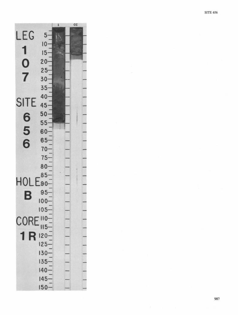
1 ££
SITE 656
1 \J
5 6
io%r
987

SITE 656
SITE
i -2
O
cc UJ
s
UJ 2 Ixl O O H CO
PLE
6 5 6 HOLE B10STRAT. ZONE/ FOSSIL CHARACTER
g u! 2
< O U-
CO
•2 5̂
CD
CO CD
T3
o C
"3 CO O
a tr
un
CO
o ^ o •Q O
CJ3
3 CO
o u_
2 2
< Z
o CM 2 2
O o
S < < 2 Q
< a
S o
Q
B
2
g s
UJ
< a-
s
ER
TI
o
a.
CO
I a
• O CO
i CD CD
■ e -
r-tq — ^
655
i <D
-e-CO >>
£ •
>-m i LU
O
CORE 2
1
UJ 0 )
1
2
_
3
4
5
6
7
cc
CO
£ 5
0.5—
1 .0—
_ :
_
_ ---
-
_ -— -
R CORED INTERVAL 3 6 6 2 . 1 - 3 6 7 1 . 8 mbs l ; 6 5 . 1 - 7 4 . 8 mbs f
GRAPHIC LITHOLOGY
.
tiii
j^p&fOU :v""tt'''"^r-"":
VOID
— - — ■ ' —
VOID
— — . _
1 7
CO
STU
F
Q
2
- J
or
0 ' o 0 0 0 0 0 0
0 0
I
•
I
m
TUR
E
zy cc
°! a
m
UJ
Q. 2
CO
*
*
*
*
LITHOLOGIC DESCRIPTION
SANDY SILT
Strongly disturbed by drilling. The sediment is soupy, olive-gray (5Y 4/2) sandy silt without any observable structure, and contains many different minerals (amphibole, pyroxene, and blue amphibole) and silt.
SMEAR SLIDE SUMMARY (%):
1,8 1,50 6,113 CC, 5 D D D M
TEXTURE:
Sand 20 10 40 60 Silt 25 40 30 30 Clay 55 50 30 10
COMPOSITION:
Quartz 15 10 30 15 Feldspar 3 Tr 4 — Mica 1 1 1 Tr Clay 50 22 31 10 Volcanic glass 1 15 25 15 Calcite/dolomite 2 5 3 Tr Accessory minerals 2 — 2 20 Gypsum — 1 — — Chlorite — Tr — — Pyroxene — Tr Tr Tr Foraminifers 5 5 Tr 10 Nannofossils 10 30 2 10 Diatoms 1 — 1 — Sponge spicules — 1 — — Intraclasts 10 10 5 15 Amphibole — Tr 1 5 Zircon — — Tr — Analcime — — Tr — Glaucophane — — — Tr
988


SITE 656
SITE
TIM
E-RO
CK U
NIT
PLE
ISTO
CE
NE
6 5 6 HOLE BIOSTRAT. ZONE/ FOSSIL CHARACTER
FOR
AM
INIF
ER
S G
lobo
rota
lia
tru
nca
tulin
oid
es
exce
lsa
NA
NN
OFO
SS
ILS
| C/G
N
N20
R
AD
IOLA
RIA
NS
DIA
TOM
S
B
PA
LEO
MA
GN
ETI
CS
PH
YS
. P
RO
PE
RTI
ES
CO r̂ lO
•
_
CH
EMIS
TRY
CORE 3
SE
CTI
ON
1
2
3
4
5
6
7
CC
MET
ERS
0 . 5 -
1 .0—
_
:
-
]
-_
-
_ --
~
-
-
:
-
'-_
R
GRAPHIC LITHOLOG
VOID
— - — - — -Z Z ^ I Z T
; - : - z = : ■'.'.■■
CORED INTERVAL 3 6 7 1 . 8 - 3 6 8 0 . 9 mbs l ; 7 4 . 8 - 8 3 . 9 m b s f
DR
ILLI
NG
DIS
TUR
B.
_--- -- -- -
-- --- " " -- -- " - -
: - -— - -— -- -- -- -_.
-- -- -
- -
--- .
- ■
- -- -— — • - r - r
•• • •
SE
D.
STR
UC
TUR
ES
A
I A
SA
MP
LES
*
*
*
*
LITHOLOGIC DESCRIPTION
CLAY, CLAY MUDSTONE, and SANDY SILT
Core is strongly affected by drilling disturbance. Dominant sediment is gray (5Y 6/1, 5/1) clay or clay mudstone. Minor lithology is graded sandy silt or silt of olive-gray (5Y 5/2) or light olive-gray (5Y 6/2) color. Sand is rich in calcareous lithoclasts and bioclasts and heavy minerals. At top of Section 1 is one pebble of red hematitic material, and small patches of the same appear elsewhere. Pteropod shells are frequent (Section 5, 77 cm, and Section 7, 30 cm). A possible debris flow exists in Section 1; if so, the red hematitic pebble could be from it.
SMEAR SLIDE SUMMARY (%):
1,1 3,34 3,135 5,77 6,43 M M M M D
TEXTURE:
Sand — 25 5 15 — Silt — 15 20 35 10 Clay — 60 75 50 90
COMPOSITION:
Quartz — 5 2 28 — Feldspar — 1 Tr 4 — Mica — 20 6 Tr — Clay — 42 51 46 75 Volcanic glass — 1 Tr Tr — Calcite/dolomite — 1 Tr 4 — Accessory minerals — 1 1 — 10 Amphibole — Tr Tr — — Basalt gypsum — — — Tr Tr Pteropods — — — Tr — Foraminifers — 5 3 3 Tr Nannofossils — 10 20 12 5 Sponge spicules — 1 Tr Tr — Hematite 100 — — — — Intraclasts — 2 2 — 10 Bioclasts — 10 15 3 — Pellets — 1 — — — Zircon — — — Tr — Chlorite sphene — — Tr Tr — Tourmaline — — — Tr —
990

SITE 656
LEG 1
7
C -• W
Ji mm mm
1 : rlla
*ill§
■...'::'\.'iV..-,,'-., ; t "M«P
S8&~" fit ^ u j ISli®8fl
991

SITE 656
SITE
TIM
E-RO
CK U
NIT
LATE
P
LIO
CE
NE
6 5 6 HOLE BIOSTRAT. ZONE/ FOSSIL CHARACTER
FOR
AM
INIF
ER
S M
PI
5 N
ANN
OFO
SSIL
S N
N16
-NN
18
RA
DIO
LAR
IAN
S
DIA
TOM
S
B
PALE
OM
AGN
ETIC
S
PH
YS
. P
RO
PE
RTI
ES
CM to
•
o CM
CM
II
■e-
•
CH
EMIS
TRY
CORE 4
SEC
TIO
N
1
2
3
4
5
6
7
CC
MET
ERS
0.5—
1 .0—
-_
-
I I
l l
1 l
I I
I l
I l
l l
-
1
-_
-
R CORED INTERVAL 3 6 8 0 . 9 - 3 6 9 0 . 3 mbsl; 8 3 . 9 - 9 3 . 3 mbsf
GRAPHIC LITHOLOGY
£ ~L~
:i;
:±i; Z :
— ~ i / ~j~ / 1 TT
~ H - "
"_+_"
/ /
- H - 1 " -
1 1
DR
ILLI
NG
DIS
TUR
B.
•
I
SED
. ST
RU
CTU
RES
tt
A
tt
tt tt
SA
MP
LES
* *
*
*
*
*
* *
LITHOLOGIC DESCRIPTION
MARLY NANNOFOSSIL OOZE and DOLOMITIC NANNOFOSSIL OOZE
Strongly disturbed by drilling, particularly Sections 1 through 5. In Sections 1 through 5 and Section 6,0-45 cm, sediment is mainly marly nannofossil ooze, limonitic, with carbonate debris. Color varies from pale olive (5Y 6/3) and light reddish brown (5YR 6/3) in Section 1 to pink (7.5YR 7/2) in Sections 2,3, and 4; Section 5 and Section 6, 0-45 cm, are dominantly olive-yellow (2.5YR 6/8) with some patches of reddish yellow (5YR 6/8). Section 1,96 cm, is analcimic ash.
Section 6, 45-75 cm, is dark gray (2.5Y 4/0) dolomitic mud and dolomitic nannofossil ooze at top and dark gray (2.5Y 3/0) silt at base, with a < 1 -mm-thick red bauxitic layer; 75-113 cm is dark gray dolomitic mud; and 113-150 cm to Section 7, 0-20 cm, is light yellowish brown foraminifer-bearing nannofossil ooze; some bauxitic red patches exist, particularly a big piece at the top of Section 7. Section 7, 20-75 cm, through CC, is a foraminifer-rich nannofossil ooze, light gray (2.5Y 7/2); a patch of hematitic material occurs also in this nannofossil ooze.
SMEAR SLIDE SUMMARY (%):
1,96 1,70 2,16 4,66 6,19 6,92 D D D D D D
TEXTURE:
Sand 40 — — — 5 — Silt 45 10 20 30 15 5 Clay 15 90 80 70 80 95
COMPOSITION:
Quartz 2 — 3 5 1 2 Feldspar — — — — — 1 Mica Tr — — — — — Clay 9 30 60 40 19 25 Volcanic glass 10 — 15 — — — Calcite/dolomite — Tr — — 30 67 Accessory minerals 3 — — — — 5 Anacime 40 — Tr — 2 — Gypsum — — Tr — — — Pyroxene Tr — Tr — — — Foraminifers 3 5 2 — 3 — Nannofossils 12 35 15 — 31 — Bioclasts 1 5 5 30 4 — Limonite — — — 25 — — Hematite — — — Tr — — Sphene — — — Tr — — Micrite — 25 — — 10 —
6, 137 7,220 D M
TEXTURE:
Sand 10 5 Silt 5 20 Clay 85 75
COMPOSITION:
Quartz — 5 Feldspar — Tr Rock fragments — Tr Clay 20 50 Calcite/dolomite — 1 Accessory minerals — 1 Foraminifers 8 5 Nannofossils 62 35 Bioclasts — 3 Limonite Tr — Hematite Tr — Micrite 10 —
992

tCilJ —

SITE 656
SITE 6 5 6 HOLE B CORE 5 R CORED INTERVAL 3 6 9 0 . 3 - 3 6 9 9 . 9 mbs l : 9 3 . 3 - 1 0 2 . 9 mbs f BIOSTRAT. ZONE/ FOSSIL CHARACTER
GRAPHIC LITHOLOGY
LITHOLOGIC DESCRIPTION
1 . 0 — ^ —
CC
DOLOMITIC MUD
Strongly disturbed by drilling. Sections 1,2, and 3 are drill breccia with numerous elements of various colors: pink (7.5YR 7/4), pinkish gray (7.5YR 6/2), light yellow (2.5Y 7/2), and grayish brown (2.5Y 5/2). Sections 4,5, and 6 are also strongly disturbed; the sediment is a plastic dolomitic mud; dominant colors are gray (5Y 6/1), weak red (1 OR 5/4), and red (1 OR 5/6). Mainly in Sections 4,5, and 6 are hard pieces of indurated sandstone, and in Section 6, 103 cm, a small pocket of gypsiferous sandstone is present.
SMEAR SLIDE SUMMARY (%):
TEXTURE:
Sand Silt Clay
COMPOSITION:
Quartz Feldspar Mica Clay Calcite/dolomite Accessory minerals Gypsum Amonite Nannofossils Carbonate detritus
2, 144 M
10 90
— — 25 3
— Tr 42 25
5
3,30 D
5 30 65
5 Tr
— 30 60 5
— — — —
4, 80 D
5 35 60
5 Tr
— — 50 45
— — — —
4, 93 D
2 90 8
1 1
— 6
— 2
— 90 — —
5, 103 D
40 30 30
5 2 5
— 83 — 5
— — —
994
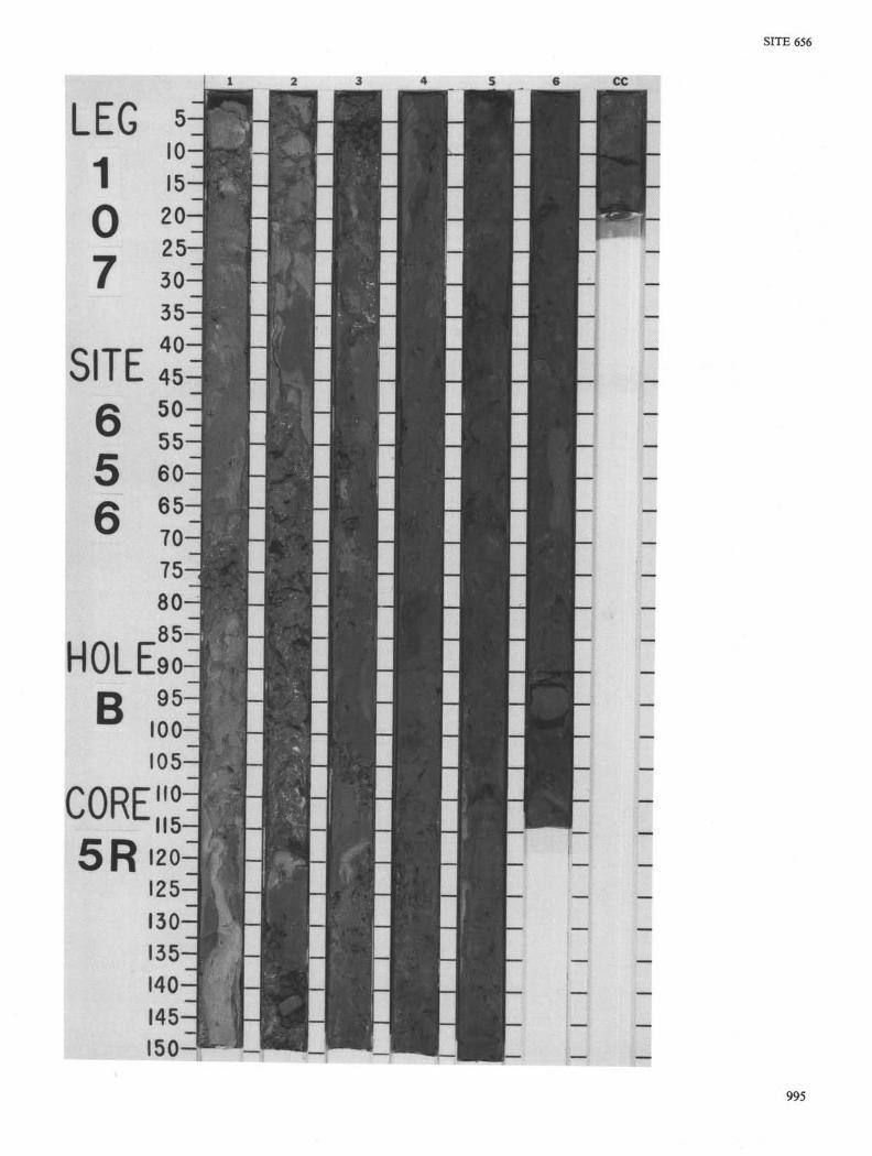
LEG C£
I0 15 20-25 30 35 40
50 55 60 65 70 75 80-85
HOLEso 95
100 05
1 0 7
SITE 6 5 6
r s i l 1 i 1
1 1
1 1 1 I 1 I i l l i l l I i i

SITE 656
SITE 6 5 6 HOLE B CORE 6 R CORED INTERVAL 3 6 9 9 . 9 - 3 7 0 9 . 3 mbs l ; 1 0 2 . 9 - 1 1 2 . 3 m b s f BIOSTRAT. ZONE/ FOSSIL CHARACTER
GRAPHIC LITHOLOGY
LITHOLOGIC DESCRIPTION
CD CD CD CD
CD a CD a _ CD en
CD CD CD CD
CD CD CD CD I . .
CD CD CD CD - CD CD CD
CD CD CD CD CD CD CD
iCD CD CD CD
iff ■ ■ V
:
II
m
-O-:
V O I D
- Fe -
GHHiSBH XF*
" - (Fe*
>
O
CALCAREOUS SANDY MUD, DOLOMITIC SANDSTONE, NANNOFOSSIL-RICH CALCAREOUS OOZE, NANNOFOSSIL OOZE, LIMONITIC MUD, and SANDSTONE
Core is extremely disturbed by drilling and has a soupy appearance. In Section 1 and Section 2, 0-120 cm, olive-gray (5Y 5/2) and reddish brown (5Y 4/3), carbonate sandy mud alternates with gray (5Y 5/1), quartz-rich dolomitic sandstone.
Minor intervals are reddish brown (5Y 4/3), nannofossil-rich calcareous ooze and gray (5Y 6/1) nannofossil ooze. While the sandstone is strongly cemented, the other intervening lithologies are soft or poorly indurated. From Section 2, 120 cm, to Section 6, 88 cm, the small amount of sediment in the liners was limonitic mud alternating with minor limonite-cemented sandstone (mostly as chunks), all showing bright colors such as strong brown (7.5YR 5/8) and brownish yellow (10YR 6/8).
From Section 6,88 cm, to the end of the core are alternations of gray (5Y 6/1), carbonate, sandy mud and of limonitic mud with limonite-cemented sandstone.
SMEAR SLIDE SUMMARY (%):
TEXTURE:
Sand Silt Clay
COMPOSITION:
Quartz Mica Clay Volcanic glass Calcite Dolomite Accessory minerals Opaques Limonite Foraminifers Nannofossils Radiolarians Micrite
TEXTURE:
Sand Silt Clay
COMPOSITION:
Quartz Clay Calcite Dolomite Limonite Bauxite Iron oxides
1, 36 D
25 30 45
12
50 33 1
CM
CM
--3, 64 D
12 18 70
3 2 S 5 30 40 15
1, 123 D
12 15 73
12 2
30 10 2 1
30
13
4, 145 M
15 15 70
2 — 3 2 78
15
1, 134 D
7 8 85
5 1 7
3 2 1
5 70
5
2, 45 M
20 20 60
12
30 8 3 5 5 Tr 20
27
2,82 M
50 40 10
20
18 60 2 —
= -
2, M
12 18 70
2
1
50 1 2
5
39
996

SITE 656
LEG <4 1 l0^ 1 15—1
35 J 1 40-1 1
GS^
m::
B ,£
t c. D —
;
997
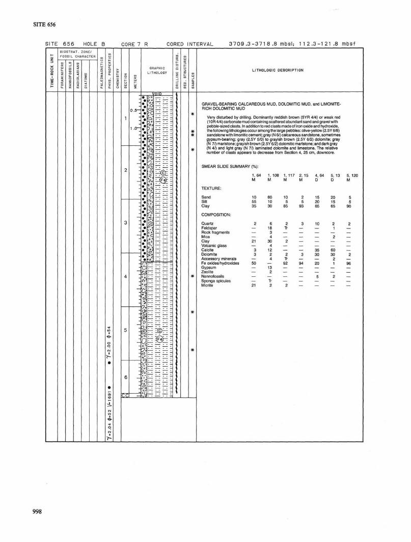
656
SITE 6 5 6 HOLE B CORE 7 R CORED INTERVAL 3 7 0 9 . 3 - 3 7 1 8 .8 mbs l ; 1 1 2 . 3 - 1 2 1 . 8 mbs f BIOSTRAT. ZONE/ FOSSIL CHARACTER
GRAPHIC LITHOLOGY
LITHOLOGIC DESCRIPTION
(*-
DU
Hu
%
v
^Of;
VOID
£ — r^©I
life
GRAVEL-BEARING CALCAREOUS MUD, DOLOMITIC MUD, and LIMONITE-RICH DOLOMITIC MUD
Very disturbed by drilling. Dominantly reddish brown (5YR 4/4) or weak red (1 OR 4/4) carbonate mud containing scattered abundant sand and gravel with pebble-sized clasts. In addition to red clasts made of iron oxide and hydroxide, the following lithologies occur among the large pebbles: olive-yellow (2.5Y 6/8) sandstone with limonitic cement; gray (N 6/) calcareous sandstone, sometimes gypsum-bearing; gray (2.5Y 5/0) to grayish brown (2.5Y 6/2) dolomite; gray (N 7/) marlstone; grayish brown (2.5Y 6/2) dolomitic marlstone; and dark gray (N 4/) and light gray (N 7/) laminated dolomite and limestone. The relative number of clasts appears to decrease from Section 4, 25 cm, downcore.
SMEAR SLIDE SUMMARY (%):
TEXTURE:
Sand Silt Clay
COMPOSITION:
Quartz Feldspar Rock fragments Mica Clay Volcanic glass Calcite Dolomite Accessory minerals Fe oxides/hydroxides Gypsum Zeolite Nannofossils Sponge spicules Micrite
1, 64 M
10 55 35
2
— — — 21
— 3 3
— 50
— — — — 21
1, 108 M
60 10 30
6 18 3 4
30 4
12 2 4
— 13 2
— Tr 2
1, 117 M
10 5
85
2 Tr
— 2
— 2 Tr 92
— — 2
2, 15 M
2 5
93
3 — — — — 3 — 94
— — —
4, 64 D
15 20 65
10 — — — 35 30 — 20
5 — —
5, 13 D
20 15 65
2 1
2 — 60 30
2 1
2 — —
5, 120 M
5 5
90
2 — — — — 2 — 96
— — —
>

SITE 656
CORE"° its 7R
999