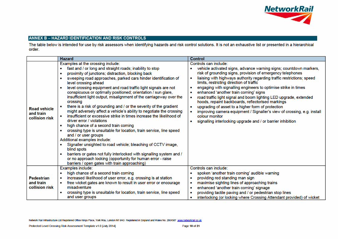
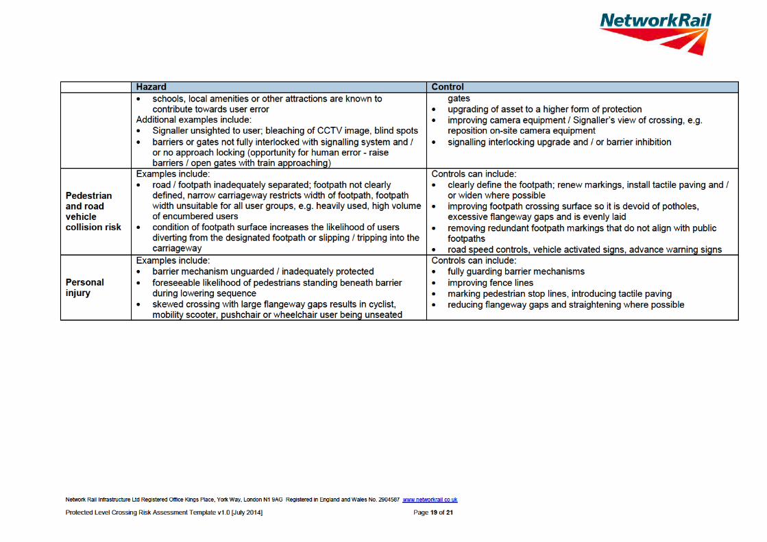
1.3 environment - network rail · as at time of this assessment there have been no further ......
TRANSCRIPT


1.3 ENVIRONMENT
Up side crossing approach
Down side crossing approach The level crossing is located on Kiln Lane which is unusually an occupation use AHB due to being the sole access to a Hydro International Facility. The road approach speed is estimated to be less than or equal to 30mph. There are no stations visible at the level crossing.
Network Rail Infrastructure Ltd Registered Office Kings Place, York Way, London N1 9AG Registered in England and Wales No. 2904587 www networkrail co uk Protected Level Crossing Risk Assessment Template v1.0 [July 2014] Page 2 of 21

At Kiln Lane AHB the orientation of the road/path from the north is 110°; the orientation of the railway from the north to the up line in the up direction is 240°. Low horizon can result in sun glare; sun glare is a known potential issue at this crossing. There are no planned or apparent developments near the crossing which may lead to a change or increase in use or risk. Site visit general observations: There are marked footways over the crossing but users tend to walk down the middle of the road as vehicle use is low and the speed vehicles will travel over the crossing is low. The vegetation on the Up and Down Approaches to the crossing requires constant monitoring by the LCM as if left to grow it impinges on the sighting of the crossing and all the signage. The LCM is in constant contact with the environment agency to ensure this is managed correctly. Following liaison with the Environment Agency, signage which had previously been obscured by vegetation on the up side is now in a much better condition. The vegetation has been cut back and the LCM constantly monitors this on the 7 weekly inspections. As at time of this Assessment there have been no further incidents with vegetation obscuring visibility of signs at this crossing. Keep Dogs On Leads Signs have been added to this crossing recently
2. LEVEL CROSSING USAGE 2.1 RAIL The train service over Kiln Lane AHB level crossing consists of passenger and freight trains. There are 258 trains per day. The highest permissible line speed of trains is 60mph. Trains are timetabled to run for 24 hours per day. Assessor’s train service notes: There is a high frequency of trains and a high frequency of pedestrian usage at this crossing, mixed in with a relatively low frequency of vehicular usage. The train service is expected to increase in the next year or two years and this will therefore increase the risks associated with the crossing assuming this service increase actually happens. 2.2 USER CENSUS DATA A 24 hour census was carried out on 12/06/2013 by Count On Us Survey – 2013. A further 9 day survey was undertaken by Sotera from 05.09.16 to 13.09.15. The data below is a combination of both census results. These two results apply to 100% of the year. The census taken on the day is as follows:
Cars 125 Vans / small lorries 42 Buses 1 HGVs 17 Pedal / motor cyclists 28 Pedestrians 300 Tractors / farm vehicles 1 Horses / riders 0 Animals on the hoof 0
Available information indicates that the crossing has a high proportion of vulnerable users.
Network Rail Infrastructure Ltd Registered Office Kings Place, York Way, London N1 9AG Registered in England and Wales No. 2904587 www networkrail co uk Protected Level Crossing Risk Assessment Template v1.0 [July 2014] Page 3 of 21
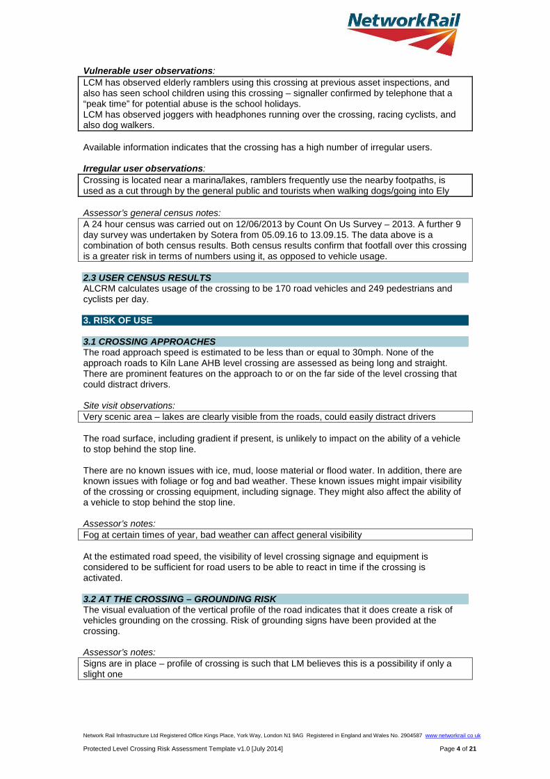
Vulnerable user observations: LCM has observed elderly ramblers using this crossing at previous asset inspections, and also has seen school children using this crossing – signaller confirmed by telephone that a “peak time” for potential abuse is the school holidays. LCM has observed joggers with headphones running over the crossing, racing cyclists, and also dog walkers. Available information indicates that the crossing has a high number of irregular users. Irregular user observations: Crossing is located near a marina/lakes, ramblers frequently use the nearby footpaths, is used as a cut through by the general public and tourists when walking dogs/going into Ely Assessor’s general census notes: A 24 hour census was carried out on 12/06/2013 by Count On Us Survey – 2013. A further 9 day survey was undertaken by Sotera from 05.09.16 to 13.09.15. The data above is a combination of both census results. Both census results confirm that footfall over this crossing is a greater risk in terms of numbers using it, as opposed to vehicle usage. 2.3 USER CENSUS RESULTS ALCRM calculates usage of the crossing to be 170 road vehicles and 249 pedestrians and cyclists per day. 3. RISK OF USE 3.1 CROSSING APPROACHES The road approach speed is estimated to be less than or equal to 30mph. None of the approach roads to Kiln Lane AHB level crossing are assessed as being long and straight. There are prominent features on the approach to or on the far side of the level crossing that could distract drivers. Site visit observations: Very scenic area – lakes are clearly visible from the roads, could easily distract drivers The road surface, including gradient if present, is unlikely to impact on the ability of a vehicle to stop behind the stop line. There are no known issues with ice, mud, loose material or flood water. In addition, there are known issues with foliage or fog and bad weather. These known issues might impair visibility of the crossing or crossing equipment, including signage. They might also affect the ability of a vehicle to stop behind the stop line. Assessor’s notes: Fog at certain times of year, bad weather can affect general visibility At the estimated road speed, the visibility of level crossing signage and equipment is considered to be sufficient for road users to be able to react in time if the crossing is activated. 3.2 AT THE CROSSING – GROUNDING RISK The visual evaluation of the vertical profile of the road indicates that it does create a risk of vehicles grounding on the crossing. Risk of grounding signs have been provided at the crossing. Assessor’s notes: Signs are in place – profile of crossing is such that LM believes this is a possibility if only a slight one
Network Rail Infrastructure Ltd Registered Office Kings Place, York Way, London N1 9AG Registered in England and Wales No. 2904587 www networkrail co uk Protected Level Crossing Risk Assessment Template v1.0 [July 2014] Page 4 of 21
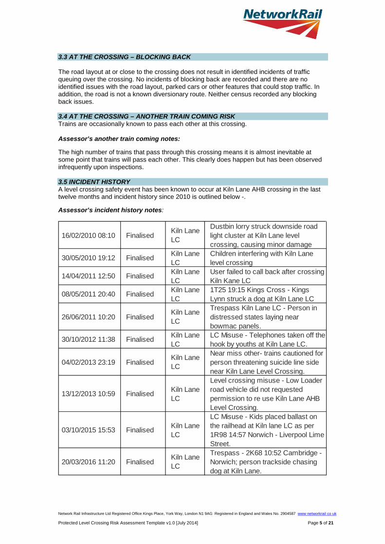
3.3 AT THE CROSSING – BLOCKING BACK The road layout at or close to the crossing does not result in identified incidents of traffic queuing over the crossing. No incidents of blocking back are recorded and there are no identified issues with the road layout, parked cars or other features that could stop traffic. In addition, the road is not a known diversionary route. Neither census recorded any blocking back issues. 3.4 AT THE CROSSING – ANOTHER TRAIN COMING RISK Trains are occasionally known to pass each other at this crossing. Assessor’s another train coming notes: The high number of trains that pass through this crossing means it is almost inevitable at some point that trains will pass each other. This clearly does happen but has been observed infrequently upon inspections. 3.5 INCIDENT HISTORY A level crossing safety event has been known to occur at Kiln Lane AHB crossing in the last twelve months and incident history since 2010 is outlined below -. Assessor’s incident history notes:
16/02/2010 08:10 FinalisedKiln Lane LC
Dustbin lorry struck downside road light cluster at Kiln Lane level crossing, causing minor damage
30/05/2010 19:12 Finalised Kiln Lane LC
Children interfering with Kiln Lane level crossing
14/04/2011 12:50 Finalised Kiln Lane LC
User failed to call back after crossing Kiln Kane LC
08/05/2011 20:40 Finalised Kiln Lane LC
1T25 19:15 Kings Cross - Kings Lynn struck a dog at Kiln Lane LC
26/06/2011 10:20 FinalisedKiln Lane LC
Trespass Kiln Lane LC - Person in distressed states laying near bowmac panels.
30/10/2012 11:38 Finalised Kiln Lane LC
LC Misuse - Telephones taken off the hook by youths at Kiln Lane LC.
04/02/2013 23:19 FinalisedKiln Lane LC
Near miss other- trains cautioned for person threatening suicide line side near Kiln Lane Level Crossing.
13/12/2013 10:59 Finalised Kiln Lane LC
Level crossing misuse - Low Loader road vehicle did not requested permission to re use Kiln Lane AHB Level Crossing.
03/10/2015 15:53 Finalised Kiln Lane LC
LC Misuse - Kids placed ballast on the railhead at Kiln lane LC as per 1R98 14:57 Norwich - Liverpool Lime Street.
20/03/2016 11:20 FinalisedKiln Lane LC
Trespass - 2K68 10:52 Cambridge - Norwich; person trackside chasing dog at Kiln Lane.
Network Rail Infrastructure Ltd Registered Office Kings Place, York Way, London N1 9AG Registered in England and Wales No. 2904587 www networkrail co uk Protected Level Crossing Risk Assessment Template v1.0 [July 2014] Page 5 of 21


vehicular access may make this an option which is best
considered as part of a package not a singular solution on its
own. Upgrade to MCB/OD
Long Term D4 0.00333768 0.044788912 £1,140,000 1.16 COMPLETE Only real logical upgrade –
downtime would be an issue
Flashing Pedestrian Signs
Short Term C2 0.043313933 0.004812659 £20,000 7.12 COMPLETE
Would be a possible upgrade and passes CBA. Would be a
recommended option here given type of pedestrian usage
Closure By Bridge or By Pass
Long Term M13 0.00
0.00 0.048126592 0.048126592
£3,000,000 £5,000,000
0.47 0.28 COMPLETE
Bridge - High level of pedestrian use Sole means of
vehicular access to Hydro International site. Feasible.
Area of natural beauty - would have to be in keeping with the
local area. Currently on a significant skew but it may be
possible to reduce this by remodelling the road. Not a Public Road so it would not
have to be highway standard bridge. By Pass - . Alternative access from Queen Adelaide and exiting bridge River Great
Ouse at the CEMEX Ely Asphalt and rail depot . Would need to
get permission to use bridge/access road at this
location and use the CEMEX depot as a through road. At present there is a pedestrian
bridge over the waterway between the CEMEX depot and
Network Rail Infrastructure Ltd Registered Office Kings Place, York Way, London N1 9AG Registered in England and Wales No. 2904587 www networkrail co uk Protected Level Crossing Risk Assessment Template v1.0 [July 2014] Page 9 of 21
the Hydro International site. Need to investigate whether
there is a legal right for CEMEX to offer a through road to Hydro International site. High level of uncertainty in the estimate but
substantial bridge required over waterway between CEMEX and
Hydro international. NOTES Network Rail always evaluates the need for short1 and long term risk control solutions. An example of level crossing risk management might be; a short term risk control of a temporary speed restriction with the long term solution being closure of the level crossing and its replacement with a bridge. 1 Includes interim CBA gives an indication of overall business benefit. It is used to support, not override, structured expert judgement when deciding which option(s) to progress. CBA might not be needed in all cases, e.g. standard maintenance tasks or low cost solutions (less than £5k). The following CBA criteria are used as a support to decision making:
a. benefit to cost ratio is ≥ 1: positive safety and business benefit established; b. benefit to cost ratio is between 0.99 and 0.5: reasonable safety and business benefit established where costs are not grossly disproportionate against the
safety benefit; and c. benefit to cost ratio is between 0.49 and 0.0: weak safety and business benefit established.
Network Rail Infrastructure Ltd Registered Office Kings Place, York Way, London N1 9AG Registered in England and Wales No. 2904587 www networkrail co uk Protected Level Crossing Risk Assessment Template v1.0 [July 2014] Page 10 of 21

5.2 CONCLUSIONS Assessor’s notes: Kiln Lane is an AHB crossing with two half width barriers and four Road Traffic Lights (Wig Wags). The crossing is monitored from Cambridge Signal Box. The crossing is located to the east of Ely on Kiln Lane and provides the sole means of vehicular access to a Hydro International facility. The road is understood not to be a public highway although there is a public footpath across the crossing.
The line speed over the line is 60 mph. Trains are very frequent with 258 trains per weekday including passenger and freight services. The crossing lies within the Ely Pits and Meadows SSSI as detailed below -.
Given that the key risk drivers for this crossing are frequency of trains, pedestrian and cycle usage (including vulnerable and irregular users), low vehicle usage – although a remote private road may facilitate misuse by risk takers, a small trespass and vandalism issue and visibility issues the following options should be considered –
Network Rail Infrastructure Ltd Registered Office Kings Place, York Way, London N1 9AG Registered in England and Wales No. 2904587 www networkrail co uk Protected Level Crossing Risk Assessment Template v1.0 [July 2014] Page 11 of 21

Recommendations from Sotera Risk Assessment dated 17th November 2015 CONCLUSIONS AND RECOMMENDATIONS
The following conclusions and recommendations are made from the analysis:
Closure
1. The crossing provides the sole means of vehicular access to a Hydro International facility. The road is understood not to be a public highway although there is a public footpath across the crossing. It is, therefore, not considered feasible to close without making alternative arrangements.
2. A road bridge at the site of the crossing was thought in 2013 to be feasible with some minor road remodelling in order to reduce the skew of the crossing. It is, however, now understood that it is much more difficult than previously though due to the height requirement.
3. An off-line road bridge close to the site of the crossing may be feasible with some minor road remodelling in order to reduce the skew of the crossing. The crossing is on a Site of Special Scientific Interest and the adjacent meadow is an important breeding area for lapwings and as such, an environmental assessment of such an option would need to be carried out.
4. A potential road scheme making use of alternative access from Queen Adelaide Way and existing bridge over the River Great Ouse at the CEMEX Ely Asphalt and rail depot may be feasible. There would still be the need to provide a bridge from the CEMEX site to the east side of the Hydro International site. At present there is a pedestrian bridge over the waterway. There would also be the need to get permission to use the bridge/access road at this location and use the CEMEX depot as a through road and indeed whether there is a legal right for CEMEX to offer a through road to Hydro International site. The cost of such a scheme is estimated to be in excess of £5m and is not considered to have any advantages over an in situ bridge or off-line bridge as it does not address the need to maintain pedestrian access across the railway at the Kiln Lane level crossing as it is on a public footpath; it may however cause less environmental concern. This is expected to require an additional pedestrian bridge at the site of the level crossing at a cost of £2m. The feasibility of such a scheme would have to be assessed.
Crossing options
5. Retaining the existing AHB type crossing is not feasible due to the high safety risk at the crossing. The 30 year safety cost accounting for current and future usage is estimated to be £3.1m; given the cost of upgrade to MCB-CCTV or MCB-OD would be about £1.5m it is concluded that retaining the current crossing would not reduce risk so far as is reasonably practicable and upgrade or closure is required.
6. With the assumed CP6 usage for 2025, MCB-OD or MCB-CCTV type crossings at Kiln Lane LC is infeasible as there are 15 hours during the day that the crossing would be closed for almost the entire hour.
Options to be taken forward
7. Closure is the preferred solution for this crossing as the MCB-CCTV or MCB-OD road closure time with the proposed increase to train frequency would not be viable. The final decision for option selection is dependent on the viability of closure schemes for this and the Queen Adelaide crossings. It is therefore recommended that a separate project be set up to consider the best option for the four crossings as a whole.
Network Rail Infrastructure Ltd Registered Office Kings Place, York Way, London N1 9AG Registered in England and Wales No. 2904587 www networkrail co uk Protected Level Crossing Risk Assessment Template v1.0 [July 2014] Page 12 of 21

Bridge options should be further considered in the next GRIP stage taking into account:
• There is a skew that might be alleviated by some road realignment;
• The current crossing is located on a Site of Special Scientific interest and the adjacent meadow is an important breeding area for lapwings and as such, the bridge would have to have minimal impact on the local environment;
• Construction costs can be higher in the area due to fenland and need to pile structures;
• The crossing is on a public footpath which would likely need to be retained, therefore any option involving a bridge to the east would likely also require a pedestrian footbridge at the site of the current crossing.
Local Hazards
8. Certain key local hazards associated with the crossing are highlighted below for consideration in relation to the crossing:
• High pedestrian and cyclist use;
• High and increasing rail use;
• Low sun on approach;
• The skew of the crossing, which increases the potential for cars to turn onto the railway, presents a hazard to cyclists and increases the crossing length;
• Remote private road may facilitate misuse by risk takers
9. Should the crossing be renewed as MCB-OD, Lower LIDAR is recommended at this crossing as the safety benefit to cost ratio is greater than one; there are also several hazards rated as Major. The following additional controls are also recommended from the Lower LIDAR assessment:
• Provide an infill cover for the manhole covers in the footways.
• Provide new level footway with no trip hazards.
• 1.5m footway widths to meet ORR RSPG
• Alleviate skew by swinging road to south.
• Low lux lighting or illuminated footway edges
• Increase volume of audible warning (subject to environmental impact).
Other Options to be considered as evaluated by LCM –
• Full spoken ATC Yodels – Could be a possible upgrade and passes CBA. Given footfall over the crossing it would be sensible to see if this is possible to implement at this crossing
• Red Light Safety Enforcement Cameras – Passes CBA and may be more useful if the crossing was upgraded to CCTV/MCB/OD given the anticipated greater barrier down time. Limited vehicular access may make this an option which is best considered as part of a package not a singular solution on its own.
• Flashing Pedestrian Signs – Would be a possible upgrade and passes CBA. Would be a recommended option here given type of pedestrian usage. Probably needs feasibility study as would be an upgrade to the current AHB layout.
Network Rail Infrastructure Ltd Registered Office Kings Place, York Way, London N1 9AG Registered in England and Wales No. 2904587 www networkrail co uk Protected Level Crossing Risk Assessment Template v1.0 [July 2014] Page 13 of 21
• Upgrade to MCB/CCTV – Passes CBA and is feasible except down time is likely to make road unusable. See other comments in CBA.
• Upgrade to MCB/OD - Passes CBA and is feasible except down time is likely to make road unusable. See other comments in CBA.
Crossing already has LED Lights, Full trespass guards and fenced off boundaries. However there are some minor signs of vandalism on the pedestals, REB and signage so a further option may be to increase the BTP presence at this crossing – more regular patrols etc. Level Crossing Manager will continue to keep in constant dialogue with the Environment Agency to ensure visibility of crossing signage is maintained and vegetation management is rigorous.
Network Rail Infrastructure Ltd Registered Office Kings Place, York Way, London N1 9AG Registered in England and Wales No. 2904587 www networkrail co uk Protected Level Crossing Risk Assessment Template v1.0 [July 2014] Page 14 of 21
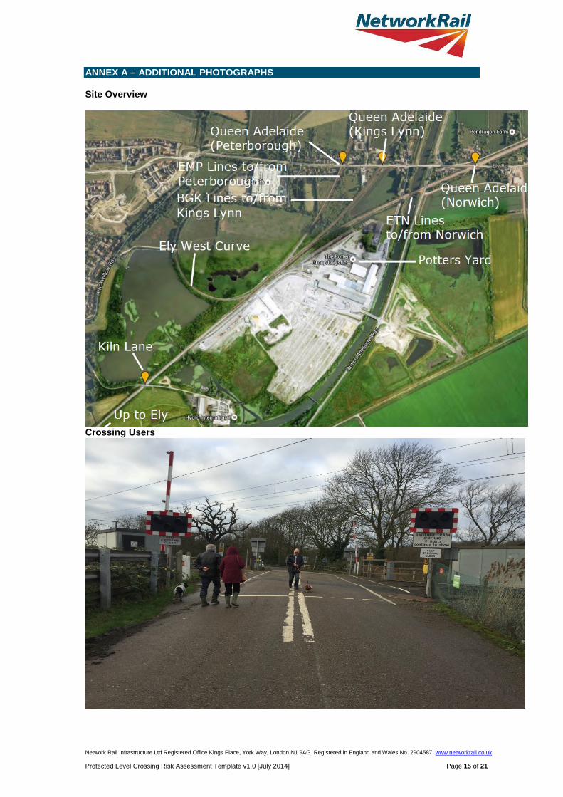
ANNEX A – ADDITIONAL PHOTOGRAPHS Site Overview
Crossing Users
Network Rail Infrastructure Ltd Registered Office Kings Place, York Way, London N1 9AG Registered in England and Wales No. 2904587 www networkrail co uk Protected Level Crossing Risk Assessment Template v1.0 [July 2014] Page 15 of 21

Network Rail Infrastructure Ltd Registered Office Kings Place, York Way, London N1 9AG Registered in England and Wales No. 2904587 www networkrail co uk Protected Level Crossing Risk Assessment Template v1.0 [July 2014] Page 16 of 21

Crossing Mitigations
Network Rail Infrastructure Ltd Registered Office Kings Place, York Way, London N1 9AG Registered in England and Wales No. 2904587 www networkrail co uk Protected Level Crossing Risk Assessment Template v1.0 [July 2014] Page 17 of 21