14 band e-amir mohibbi & cochard (1)
TRANSCRIPT
Contents lists available at ScienceDirect
Environmental Development
Environmental Development 11 (2014) 141–161
http://d2211-46
AbbreProtecte
n CorrE-m
journal homepage: www.elsevier.com/locate/envdev
Residents’ resource uses and nature conservationin Band-e-Amir National Park, Afghanistan
Abdul Aziz Mohibbi a, Roland Cochard b,n
a Faculty of Agriculture, Kabul University, Jamal Mina, Kabul, Afghanistanb Institute of Integrative Biology, Swiss Federal Institute of Technology, Universitätsstrasse 16,CH-8092 Zurich, Switzerland
a r t i c l e i n f o
Article history:Received 13 January 2014Received in revised form9 April 2014Accepted 24 April 2014
Keywords:Resource extractionLivestock grazingFuelwood harvestingVegetation degradationWildlife huntingProtected area management
x.doi.org/10.1016/j.envdev.2014.04.00345/& 2014 Elsevier B.V. All rights reserved
viations: Abi, irrigated crop land (mostly od Area Committee; lalmi, rain-fed crop lanesponding author.ail addresses: [email protected] (A.
a b s t r a c t
In 2009 the scenic Band-e-Amir Lakes and surrounding landscapes(2800–3800 m elevation) were declared Afghanistan's firstnational park (BANP) with the hope that the lakes will eventuallyattract tourists at levels as before the war period (1979–2001). Thearea is rich in plant species, and was formerly populated by ibexand urial. Today fauna is impoverished and vegetation (mostlymountain steppe) is degraded due to intensive livestock grazing,dryland agriculture, and shrub collection. BANP was created incollaboration with local residents (�800 families), and longer-term plans are to upgrade biological qualities of landscapes whilstimproving residents’ livelihoods. To provide baselines for adequatemanagement plans, a survey of 116 households was conducted in15 villages. Most families were subsistent agro-pastoralists.Population growth was �2.2% annually. Estimates of mostlyfree-ranging livestock populations were �19,900 sheep and goats,�2500 cattle, and �2100 donkeys and horses. Grazing impactswere evident, especially near villages. Families collected �3.1 t ofshrubs and �0.4 t of cattle dung annually as biofuel. Estimatesindicated that Z0.7% of BANP area was cleared of shrubs annually.Dryland agriculture covered �3.4% area. Other resource uses(collection of reed, medicinal plants, hunting, fishing) wereassessed. Further research is needed on spatial patterns of resourceexploitation and vegetation ecology. Promotion of alternativeenergy sources could alleviate pressures on shrub resources. Steeplands should be better protected (possibly fenced) from livestock
.
n alluvial plains); BANP, Band-e-Amir National Park; BAPAC, Band-e-Amird (in steppe areas); WCS, Wildlife Conservation Society
Aziz Mohibbi), [email protected] (R. Cochard).
A. Aziz Mohibbi, R. Cochard / Environmental Development 11 (2014) 141–161142
and human impacts. Environmental workshops with residents andintegration of locals in research projects could enhance manage-ment effectiveness and acceptance of park rules.
& 2014 Elsevier B.V. All rights reserved.
1. Introduction
The Band-e-Amir Lakes are situated at an elevation of �2900 m above sea level in the Hazarajat inCentral Afghanistan. Their crystal-blue waters embedded in a rugged rocky mountain landscapeprovide for stunning sights, instilling tranquility and mystery. The lakes have been a source of legendsand inspiration for local Hazara people (Bourrouilh-Le Jan et al., 2007). During the 1950s to 1970s,scores of travelers from around the world were attracted to this place (Omrani and Leeming, 2005).Today few international travelers venture there, but the destination is popular again among manyAfghans seeking respite from their daily work life.
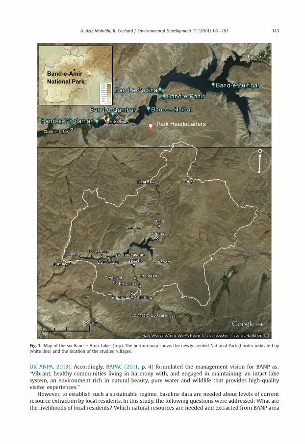
Since the 1960s, proposals for conservation of the area were made, but plans have remained onhold due to political events and the ensuing wars (1979–2001). Finally in 2009, the lakes andsurrounding high plateaus were declared as Afghanistan's first national park (BAPAC, 2011; Fig. 1).Originally, ‘national parks’ have been created to preserve wildlife and natural landscapes for posterityand as symbols of national pride and recreational enjoyment (Lockwood et al., 2006). In this spirit,Band-e-Amir National Park (BANP) may serve several functions, locally, regionally, and nationally.It may represent an icon of Afghanistan's natural landscapes which could attract domestic andinternational visitors again, thus contributing to national identification, peace and stability. In addition,revenues from visitors can be used for improved park management, conservation of representativefauna and flora, and – in a medium to longer term – the diversification and improvement of residents’livelihoods (Smallwood et al., 2011).
Already before the war, the vegetation around Band-e-Amir was degraded and the fauna wasimpoverished (Dieterle, 1973; Shank and Larsson, 1977). During the times of conflict, environmentaldegradation in many regions of Afghanistan was further aggravated through unchecked exploitationof natural resources, i.e. vegetation destruction through wood cutting, fires, and overgrazing, andexcessive hunting of wildlife (UNEP, 2003; Formoli, 1995; Saba, 2001; Shank, 2006; Kanderian et al.,2011). If the new park can be adequately managed in the future, the ecosystems may partly recoverand populations of large game could once again find suitable habitats and refuges in the area (BAPAC,2011; Bedunah et al., 2010; WCS, 2011). Optimally, scientific research, which started in the area beforethe war, will be continued and the park may acquire demonstration functions for nature conservationand best-practice sustainable resource management. However, currently the park's management is atits beginning and conservation plans are still preliminary and in need of better baseline data.
Within BANP, �800 families (�5000 people) live in 16 villages (MAIL, 2008; Fig. 1). The residentsare mostly subsistence agro-pastoralists. The limited fertile alluvial areas at the valley bottoms havebeen intensively cultivated for generations on a hitherto fairly sustainable level. In contrast, the higherplateaus, which were traditionally used as rangelands and as a source for wild products, have beenexposed to increasing pressures. Major impacts on the environment currently include (1) intensivelivestock grazing, (2) collection of plant resources (for fuelwood, animal feed, and medicines),(3) expansion of rain-fed field cultivations in drylands (called lalmi), and (4) wildlife hunting(Bedunah et al., 2010).
Band-e-Amir is a landscape which over thousands of years has been inhabited and influenced byhumans. The central objective of BANP is therefore not the setting-aside of a ‘pristine nature’, but theendowment of environmental stewardship, i.e. the establishment of a use regime which is sustainableand fulfils key requirements for nature conservation. Such regimes are practiced in many nationalparks in the United Kingdomwhich are in effect ‘protected landscapes’ (IUCN Protected area category V)that allow for controlled agricultural activities and limited development (Lockwood et al., 2006;
Band-e-Amir National Park
Park Headquarters
Fig. 1. Map of the six Band-e-Amir Lakes (top). The bottom map shows the newly created National Park (border indicated bywhite line) and the location of the studied villages.
A. Aziz Mohibbi, R. Cochard / Environmental Development 11 (2014) 141–161 143
UK ANPA, 2013). Accordingly, BAPAC (2011, p. 4) formulated the management vision for BANP as:“Vibrant, healthy communities living in harmony with, and engaged in maintaining, an intact lakesystem, an environment rich in natural beauty, pure water and wildlife that provides high-qualityvisitor experiences.”
However, to establish such a sustainable regime, baseline data are needed about levels of currentresource extraction by local residents. In this study, the following questions were addressed: What arethe livelihoods of local residents? Which natural resources are needed and extracted from BANP area
A. Aziz Mohibbi, R. Cochard / Environmental Development 11 (2014) 141–161144
to fulfill the residents’ livelihood needs? Which environmental impacts may arise from resource useregimes? In which ways could resource use regimes be improved to optimize benefits whilstpreserving the resource bases? The last question, in particular, may be subject to further research inthe future to which this current work may provide useful benchmarks.
2. The study site
The literature and data describing the area are still fragmentary, even though the area wascomparatively (i.e. within Afghanistan) well documented before 1979 (literature summarized inShank and Larsson, 1977; Dieterle, 1973). However, there are a few recent, very useful publications(e.g. Bedunah et al., 2010; Robinett et al., 2008; Shank, 2006) which are mainly based on consultanciesmandated by the Wildlife Conservation Society (WCS). These, and the summaries provided in theBand-e-Amir National Park Management Plan (BAPAC, 2011), provide the main sources of descriptiveinformation.
2.1. Geography, climate, vegetation and fauna
Band-e-Amir National Park (BANP) covers 613.3 km2 in the western Hindu Kush mountain range inthe Hazarajat (Yakawland District, Bamiyan Province), 250 km northwest of Kabul and 55 km west ofBamiyan town (Fig. 1). The six lakes (located in an east-west running valley at �2900 m a.s.l.) cover anarea of 600 ha and are contained by naturally formed travertine dams (called band in Dari; Fig. 2a).The surrounding mountains rise up to 3832 m at the highest point (BAPAC, 2011).
The climate is continental with low air humidity, high evaporation, and high temperaturedifferences. There are no long-term climatic records for BANP, but by comparison to data from nearbystations (Bamiyan, Panjaw, Lal) average temperatures at 2900 m a.s.l. may range from about �14 1C inJanuary to �20 1C in July/August (up to �40 1C in winter, and 30 1C in summer). Average monthlyprecipitation may be at the extent of 25–35 mmwith peaks in spring (March–May; up to �90 mm) andminima in late summer (July–September; o3 mm) (cf. Bedunah et al., 2010; Shank, 2006; Dieterle,1973). Winter snow and melt water is important for plant community formation and productivity,especially at higher elevations.
The region is part of the Irano-Turanian floral area, characterized by high altitude steppe plains anddeserts. Reaching westernmost limits, components of Central Asian mountain flora are also found atBANP (Shank and Larsson, 1977). The steppe vegetation is dominated by dwarf shrubs (mainlyArtemisia spp.), cushion shrubs (mainly Acantholimon and Astragalus spp.), and interspersed grasses(mostly perennials). Cushion shrubs tend to increase in dominance with higher elevation. Dieterle(1973), and other authors cited therein suggested that (on deeper soils) this is a secondary type ofvegetation which replaced original grass steppe under prolonged livestock grazing. Bedunah et al.(2010) questioned this, noting that vegetation was similar in function and productivity to NorthAmerican shrub-dominated dry grassland types. Interpretations may partly depend on the questionunder which grazing levels the vegetation initially evolved. In depressions and at canyon bottoms,other vegetation communities prevail. In basins with high evaporation, salt-tolerant species (e.g.Zygophyllum and Haloxylon spp.) predominate. Sedge communities (Carex and Eleocharis spp.) arefound in more permanently moist depressions and are replaced by dense communities of reed(Phragmites australis) and cattail (Typha beome) in marshes near the lakes. Riparian bush communities(Salix,Myricaria and Populus spp.) grow along river courses and at the travertine dams (Bedunah et al.,2010; Dieterle, 1973; Breckle, 2007). Soils formed in a semi-desert environment with cold winters andare derived from calcareous rocks (sierozems or aridisols; cf. Bedunah et al., 2010).
The fauna of BANP is impoverished due to habitat degradation and hunting (MAIL, 2008). Until the1970s, populations of Siberian ibex (Capra sibirica) and urial (Ovis orientalis) inhabited themountainous parts of BANP, but the species apparently have not been seen for several years (Shankand Larsson, 1977, C. Shank, personal communication). The Afghan pika (Ochotona rufescens), long-tailed marmot (Marmota caudata) and desert rodents (e.g. jerboas) are still abundant in BANP and aremajor prey of wolves (Canis lupus) and foxes (Vulpes vulpes). BANP is an Important Bird Area (IBA),
abandoned lalmi
new lalmi lalmi
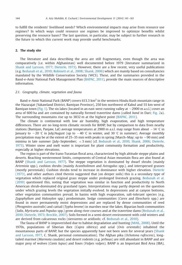
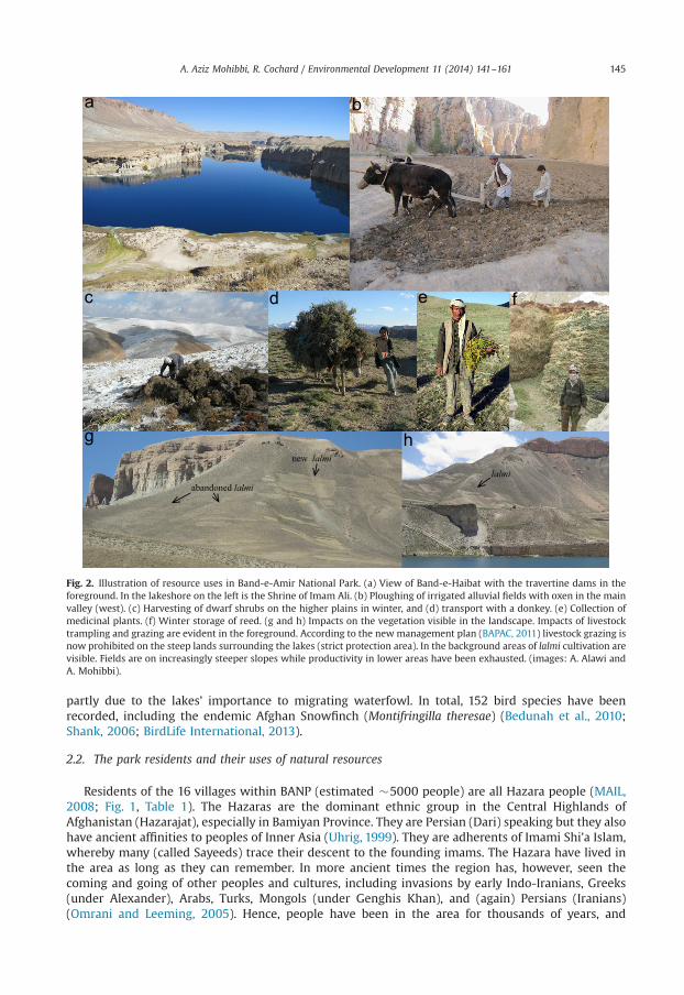
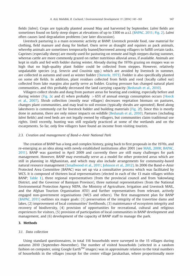
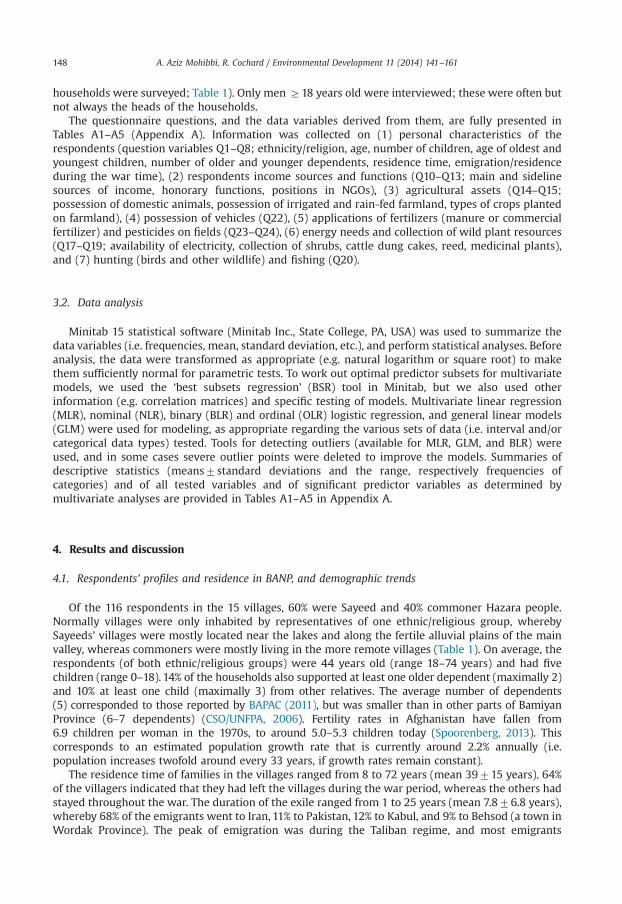
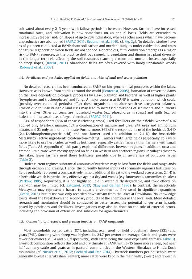
Fig. 2. Illustration of resource uses in Band-e-Amir National Park. (a) View of Band-e-Haibat with the travertine dams in theforeground. In the lakeshore on the left is the Shrine of Imam Ali. (b) Ploughing of irrigated alluvial fields with oxen in the mainvalley (west). (c) Harvesting of dwarf shrubs on the higher plains in winter, and (d) transport with a donkey. (e) Collection ofmedicinal plants. (f) Winter storage of reed. (g and h) Impacts on the vegetation visible in the landscape. Impacts of livestocktrampling and grazing are evident in the foreground. According to the newmanagement plan (BAPAC, 2011) livestock grazing isnow prohibited on the steep lands surrounding the lakes (strict protection area). In the background areas of lalmi cultivation arevisible. Fields are on increasingly steeper slopes while productivity in lower areas have been exhausted. (images: A. Alawi andA. Mohibbi).
A. Aziz Mohibbi, R. Cochard / Environmental Development 11 (2014) 141–161 145
partly due to the lakes’ importance to migrating waterfowl. In total, 152 bird species have beenrecorded, including the endemic Afghan Snowfinch (Montifringilla theresae) (Bedunah et al., 2010;Shank, 2006; BirdLife International, 2013).
2.2. The park residents and their uses of natural resources
Residents of the 16 villages within BANP (estimated �5000 people) are all Hazara people (MAIL,2008; Fig. 1, Table 1). The Hazaras are the dominant ethnic group in the Central Highlands ofAfghanistan (Hazarajat), especially in Bamiyan Province. They are Persian (Dari) speaking but they alsohave ancient affinities to peoples of Inner Asia (Uhrig, 1999). They are adherents of Imami Shi’a Islam,whereby many (called Sayeeds) trace their descent to the founding imams. The Hazara have lived inthe area as long as they can remember. In more ancient times the region has, however, seen thecoming and going of other peoples and cultures, including invasions by early Indo-Iranians, Greeks(under Alexander), Arabs, Turks, Mongols (under Genghis Khan), and (again) Persians (Iranians)(Omrani and Leeming, 2005). Hence, people have been in the area for thousands of years, and
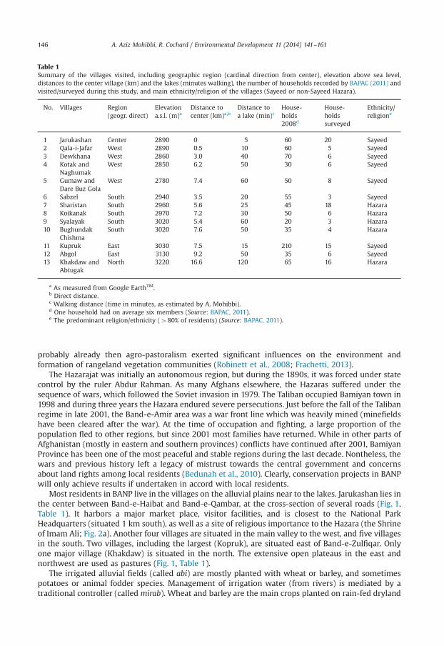
Table 1Summary of the villages visited, including geographic region (cardinal direction from center), elevation above sea level,distances to the center village (km) and the lakes (minutes walking), the number of households recorded by BAPAC (2011) andvisited/surveyed during this study, and main ethnicity/religion of the villages (Sayeed or non-Sayeed Hazara).
No. Villages Region(geogr. direct)
Elevationa.s.l. (m)a
Distance tocenter (km)a,b
Distance toa lake (min)c
House-holds2008d
House-holdssurveyed
Ethnicity/religione
1 Jarukashan Center 2890 0 5 60 20 Sayeed2 Qala-i-Jafar West 2890 0.5 10 60 5 Sayeed3 Dewkhana West 2860 3.0 40 70 6 Sayeed4 Kotak and
NaghumakWest 2850 6.2 50 30 6 Sayeed
5 Gumaw andDare Buz Gola
West 2780 7.4 60 50 8 Sayeed
6 Sabzel South 2940 3.5 20 55 3 Sayeed7 Sharistan South 2960 5.6 25 45 18 Hazara8 Koikanak South 2970 7.2 30 50 6 Hazara9 Syalayak South 3020 5.4 60 20 3 Hazara10 Bughundak
ChishmaSouth 3020 7.6 50 35 4 Hazara
11 Kupruk East 3030 7.5 15 210 15 Sayeed12 Abgol East 3130 9.2 50 35 6 Sayeed13 Khakdaw and
AbtugakNorth 3220 16.6 120 65 16 Hazara
a As measured from Google EarthTM.b Direct distance.c Walking distance (time in minutes, as estimated by A. Mohibbi).d One household had on average six members (Source: BAPAC, 2011).e The predominant religion/ethnicity (480% of residents) (Source: BAPAC, 2011).
A. Aziz Mohibbi, R. Cochard / Environmental Development 11 (2014) 141–161146
probably already then agro-pastoralism exerted significant influences on the environment andformation of rangeland vegetation communities (Robinett et al., 2008; Frachetti, 2013).
The Hazarajat was initially an autonomous region, but during the 1890s, it was forced under statecontrol by the ruler Abdur Rahman. As many Afghans elsewhere, the Hazaras suffered under thesequence of wars, which followed the Soviet invasion in 1979. The Taliban occupied Bamiyan town in1998 and during three years the Hazara endured severe persecutions. Just before the fall of the Talibanregime in late 2001, the Band-e-Amir area was a war front line which was heavily mined (minefieldshave been cleared after the war). At the time of occupation and fighting, a large proportion of thepopulation fled to other regions, but since 2001 most families have returned. While in other parts ofAfghanistan (mostly in eastern and southern provinces) conflicts have continued after 2001, BamiyanProvince has been one of the most peaceful and stable regions during the last decade. Nontheless, thewars and previous history left a legacy of mistrust towards the central government and concernsabout land rights among local residents (Bedunah et al., 2010). Clearly, conservation projects in BANPwill only achieve results if undertaken in accord with local residents.
Most residents in BANP live in the villages on the alluvial plains near to the lakes. Jarukashan lies inthe center between Band-e-Haibat and Band-e-Qambar, at the cross-section of several roads (Fig. 1,Table 1). It harbors a major market place, visitor facilities, and is closest to the National ParkHeadquarters (situated 1 km south), as well as a site of religious importance to the Hazara (the Shrineof Imam Ali; Fig. 2a). Another four villages are situated in the main valley to the west, and five villagesin the south. Two villages, including the largest (Kopruk), are situated east of Band-e-Zulfiqar. Onlyone major village (Khakdaw) is situated in the north. The extensive open plateaus in the east andnorthwest are used as pastures (Fig. 1, Table 1).
The irrigated alluvial fields (called abi) are mostly planted with wheat or barley, and sometimespotatoes or animal fodder species. Management of irrigation water (from rivers) is mediated by atraditional controller (called mirab). Wheat and barley are the main crops planted on rain-fed dryland
A. Aziz Mohibbi, R. Cochard / Environmental Development 11 (2014) 141–161 147
fields (lalmi). Crops are typically planted around May and harvested by September. Lalmi fields aresometimes found on fairly steep slopes at elevations of up to 3300 m a.s.l. (BAPAC, 2011; Fig. 2). Lalmioften causes land degradation problems (see later discussion).
Livestock pasturing is a main economic activity at BANP. Livestock provide food, raw material forclothing, field manure and dung for biofuel. Oxen serve as draught and equines as pack animals,whereby animals are sometimes temporarily loaned/borrowed among villagers to fulfill certain tasks.Caprines (especially sheep) are mostly used for pasturing on remote and high steppes during summer,whereas cattle are more commonly grazed on rather nutritious alluvial areas, if available. Animals arekept in stalls and fed with fodder during winter. Already during the 1970s grazing on steppes was sohigh that no high-quality plant fodder could be collected from steppes. However, relativelyunpalatable species (e.g. Senecio and Cousinia spp.) which are avoided by livestock in summer,are collected in autumn and used as winter fodder (Dieterle, 1973). Fodder is also specifically plantedon some abi fields. In addition, plant residues collected from fields and reed (locally called nai)collected from lake margins also partly serve as fodder. Grazing pressure has changed natural plantcommunities, and this probably decreased the land carrying capacity (Bedunah et al., 2010).
Villagers collect shrubs and dung from pasture areas for heating and cooking, especially before andduring winter (Fig. 2c and d) when probably 465% of annual energy consumption occurs (Hoecket al., 2007). Shrub collection (mostly near villages) decreases vegetation biomass on pastures,changes plant communities, and may lead to soil erosion (typically shrubs are uprooted). Reed alonglakeshores is commonly cut for livestock fodder and building materials (Fig. 2f). Since this is mostlydone in autumn, there are only minor impacts on wildlife (Bedunah et al., 2010). Pastures (includinglalmi fields) and reed beds are not legally owned by villagers, but communities claim traditional userights. Until recently, hunting was still regularly practiced at some of the wetlands and on theescarpments. So far, only few villagers have found an income from visiting tourists.
2.3. Creation and management of Band-e-Amir National Park
The creation of BANP has a long and complex history, going back to first proposals in the 1970s, andre-emerging as an idea along with newly established institutions after 2001 (see MAIL, 2008; BAPAC,2011). BANP was gazetted in April 2009 and currently there are still many challenges for parkmanagement. However, BANP may eventually serve as a model for other protected areas which arestill in planning in Afghanistan, and which may also include arrangements for community-basednatural resource management (Smallwood et al., 2011; Johnson et al., 2012). In 2006 the Band-e-AmirProtected Area Committee (BAPAC) was set up via a consultative process which was facilitated byWCS. It is composed of thirteen local representatives (elected in each of the 13 main villages withinBANP; Table 1), three regional representatives (from the provincial council and from YakowlangDistrict, and the Governor of Bamiyan Province), three national representatives (from the NationalEnvironmental Protection Agency NEPA, the Ministry of Agriculture, Irrigation and Livestock MAIL,and the Afghan Tourism Organisation ATO) and further representatives from relevant, activelyengaged non-government organisations (WCS and others). The first management plan for BANP(BAPAC, 2011) outlines six major goals: (1) preservation of the integrity of the travertine dams andlakes, (2) improvement of local communities’ livelihoods, (3) maintenance of ecosystem integrity andrecovery of biodiversity, (4) provision of opportunities for recreational, cultural and religiousexperiences for visitors, (5) provision of participation of local communities in BANP development andmanagement, and (6) development of the capacity of BANP staff to manage the park.
3. Methods
3.1. Data collection
Using standard questionnaires, in total 116 households were surveyed in the 15 villages duringautumn 2010 (September–November). The number of visited households (selected in a randomfashion on computer, using Google EarthTM images) was in approximate relation to the total numbersof households in the villages (except for the center village Jarukashan, where proportionally more
A. Aziz Mohibbi, R. Cochard / Environmental Development 11 (2014) 141–161148
households were surveyed; Table 1). Only men Z18 years old were interviewed; these were often butnot always the heads of the households.
The questionnaire questions, and the data variables derived from them, are fully presented inTables A1–A5 (Appendix A). Information was collected on (1) personal characteristics of therespondents (question variables Q1–Q8; ethnicity/religion, age, number of children, age of oldest andyoungest children, number of older and younger dependents, residence time, emigration/residenceduring the war time), (2) respondents income sources and functions (Q10–Q13; main and sidelinesources of income, honorary functions, positions in NGOs), (3) agricultural assets (Q14–Q15;possession of domestic animals, possession of irrigated and rain-fed farmland, types of crops plantedon farmland), (4) possession of vehicles (Q22), (5) applications of fertilizers (manure or commercialfertilizer) and pesticides on fields (Q23–Q24), (6) energy needs and collection of wild plant resources(Q17–Q19; availability of electricity, collection of shrubs, cattle dung cakes, reed, medicinal plants),and (7) hunting (birds and other wildlife) and fishing (Q20).
3.2. Data analysis
Minitab 15 statistical software (Minitab Inc., State College, PA, USA) was used to summarize thedata variables (i.e. frequencies, mean, standard deviation, etc.), and perform statistical analyses. Beforeanalysis, the data were transformed as appropriate (e.g. natural logarithm or square root) to makethem sufficiently normal for parametric tests. To work out optimal predictor subsets for multivariatemodels, we used the ‘best subsets regression’ (BSR) tool in Minitab, but we also used otherinformation (e.g. correlation matrices) and specific testing of models. Multivariate linear regression(MLR), nominal (NLR), binary (BLR) and ordinal (OLR) logistic regression, and general linear models(GLM) were used for modeling, as appropriate regarding the various sets of data (i.e. interval and/orcategorical data types) tested. Tools for detecting outliers (available for MLR, GLM, and BLR) wereused, and in some cases severe outlier points were deleted to improve the models. Summaries ofdescriptive statistics (means7standard deviations and the range, respectively frequencies ofcategories) and of all tested variables and of significant predictor variables as determined bymultivariate analyses are provided in Tables A1–A5 in Appendix A.
4. Results and discussion
4.1. Respondents’ profiles and residence in BANP, and demographic trends
Of the 116 respondents in the 15 villages, 60% were Sayeed and 40% commoner Hazara people.Normally villages were only inhabited by representatives of one ethnic/religious group, wherebySayeeds’ villages were mostly located near the lakes and along the fertile alluvial plains of the mainvalley, whereas commoners were mostly living in the more remote villages (Table 1). On average, therespondents (of both ethnic/religious groups) were 44 years old (range 18–74 years) and had fivechildren (range 0–18). 14% of the households also supported at least one older dependent (maximally 2)and 10% at least one child (maximally 3) from other relatives. The average number of dependents(5) corresponded to those reported by BAPAC (2011), but was smaller than in other parts of BamiyanProvince (6–7 dependents) (CSO/UNFPA, 2006). Fertility rates in Afghanistan have fallen from6.9 children per woman in the 1970s, to around 5.0–5.3 children today (Spoorenberg, 2013). Thiscorresponds to an estimated population growth rate that is currently around 2.2% annually (i.e.population increases twofold around every 33 years, if growth rates remain constant).
The residence time of families in the villages ranged from 8 to 72 years (mean 39715 years). 64%of the villagers indicated that they had left the villages during the war period, whereas the others hadstayed throughout the war. The duration of the exile ranged from 1 to 25 years (mean 7.876.8 years),whereby 68% of the emigrants went to Iran, 11% to Pakistan, 12% to Kabul, and 9% to Behsod (a town inWordak Province). The peak of emigration was during the Taliban regime, and most emigrants

A. Aziz Mohibbi, R. Cochard / Environmental Development 11 (2014) 141–161 149
returned after 2001. According to informal information (heads of shura, personal communication)only a few families were still returning in recent years.
4.2. Respondents’ income sources and honorary positions
91% of the respondents stated that their households’ main source of income was agriculture,whereby some were exclusively engaged in crop farming (11%) or in pastoralism (2%), but most (78%)followed both activities. The remaining households gained their incomes from services, such as fromvarious occasional labor (6%), house construction (1%), health services (1%), teaching (1%), and fromsupport of governmental and non-governmental agencies (3%). Most respondents with serviceoccupations lived at Jarukashan, whereas all respondents in the more remote villages in the north andsouth were agro-pastoralists (Table 2).
In Bamiyan Province average incomes per capita from agriculture may be less than 0.25 US$(52 Afs) and about 0.5 US$ for other occupations (ADB, 2009). For this and other reasons, manyrespondents were engaged in sideline occupations, earning extra income in part time teaching (20%),agriculture (3% in farming and 6% in livestock keeping), tourism (2% hotel or house renting, and1% boat renting), trading (7% shop keeping and bazaar), and other services (3% as park rangers, and2% working for NGO's and as drivers). Only one household (1%) in Jarukashan earned no income fromagriculture. In addition, some households possibly received remittances from relatives living in towns.However, such types of revenues were neither noted by respondents nor specifically appraised in thesurvey.
Some respondents (17%) occupied an honorary position in the village either as the head of thevillage council (1%), assistants of village councils (3%), or as representatives for several families (13%).9% of the villagers were involved in NGO work (four national and three international NGOs).
4.3. Land ownership and cultivation, and potential impacts on rangeland resources
Some respondents (9%) at lower-lying villages, with comparatively mild climates and goodirrigation, owned a home garden or orchard (average size of 0.370.2 ha; range 0.1–0.6 ha; excludingnon-owners). In contrast, 93% of respondents were cultivating irrigated abi fields (1.170.9 ha; range0.1–4 ha) and 91% rain-fed lalmi fields (2.871.7 ha; range 0.4–8 ha). Households in villages close tothe lakes (except Jarukashan), and especially in the main valley downstream (west) of the lakes,owned more abi lands than in other areas (Table 2). Households with much abi also tended to cultivatelarge areas of lalmi. In addition, older respondents, and those who had stayed through the war, tendedto cultivate larger areas of lalmi as compared to the younger, and those who had emigratedintermittently (Table A3, Appendix A).
Extrapolations from the data (on a baseline of 830 households in the park; census by MAIL, 2008,adjusted for population growth) indicate that �25 ha of land (0.04% of BANP area) were covered byhome gardens/orchards, �830 ha (1.4% of BANP area) were under irrigated cropping, and �2092 ha(3.4%) were under rain-fed cropping. Areas designated by BAPAC (2011) as ‘settlement zones’ cover1710 ha (2.8% of BANP area) and contain all abi and gardens/orchards.
At BANP agricultural yields are restricted due to difficult terrain, infertile soils, and harsh climaticconditions (including cold winters, spring flooding, summer droughts). Abi fields produce grain yieldsaround 10–30 times the sown grains, whereas lalmi fields produce about half that amount (BAPAC,2011). Lalmi agriculture is sensitive to rainfall variation, and during unusual years crops can failentirely. In contrast, irrigated fields are usually maintained through careful management of snow meltwater (Rathjens, 1975). No detailed data on crops was collected, but if all fields were planted withwheat a household's average grain harvest during one year may be �3.4 t (i.e. �680 kg per person).The highest yields (�5 t hh�1 y�1 wheat equivalent) are likely to be collected by households in thewestern villages downstream from the lakes (Table 2). Annual per capita wheat consumption inAfghanistan has been 4200 kg during recent years (Persaud, 2012).
Traditionally, lalmi agriculture operated on a rotational basis. According to Dieterle (1973) lalmifields were mostly situated on even or slightly sloping lands on the higher plains, and fields were
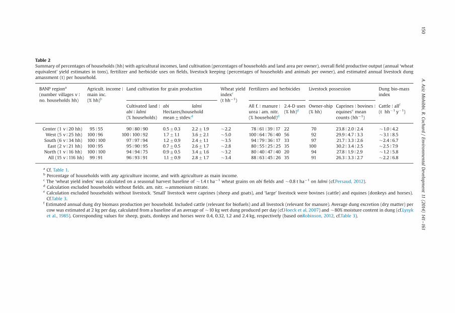
Table 2Summary of percentages of households (hh) with agricultural incomes, land cultivation (percentages of households and land area per owner), overall field productive output (annual ‘wheatequivalent’ yield estimates in tons), fertilizer and herbicide uses on fields, livestock keeping (percentages of households and animals per owner), and estimated annual livestock dungamassment (t) per household.
BANP regiona
(number villages v ¦no. households hh)
Agricult. income ¦main inc.(% hh)b
Land cultivation for grain production Wheat yieldindexc
(t hh�1)
Fertilizers and herbicides Livestock possession Dung bio-massindex
Cultivated land ¦ abi lalmi All f. ¦ manure ¦ 2.4-D uses Owner-ship Caprines ¦ bovines ¦ Cattle ¦ allf
abi ¦ lalmi(% households)
Hectares/householdmean7stdev.d
urea ¦ am. nitr.(% household)d
(% hh)d (% hh) equinese meancounts (hh�1)
(t hh�1 y�1)
Center (1 v ¦ 20 hh) 95 ¦ 55 90 ¦ 80 ¦ 90 0.570.3 2.271.9 �2.2 78 ¦ 61 ¦ 39 ¦ 17 22 70 23.8 ¦ 2.0 ¦ 2.4 �1.0 ¦ 4.2West (5 v ¦ 25 hh) 100 ¦ 96 100 ¦ 100 ¦ 92 1.771.1 3.672.1 �5.0 100 ¦ 64 ¦ 76 ¦ 40 56 92 29.9 ¦ 4.7 ¦ 3.3 �3.1 ¦ 8.5South (6 v ¦ 34 hh) 100 ¦ 100 97 ¦ 97 ¦ 94 1.270.9 2.471.1 �3.5 94 ¦ 79 ¦ 36 ¦ 17 33 97 21.7 ¦ 3.3 ¦ 2.6 �2.4 ¦ 6.7East (2 v ¦ 21 hh) 100 ¦ 95 95 ¦ 90 ¦ 95 0.770.5 2.671.7 �2.8 80 ¦ 55 ¦ 25 ¦ 25 35 100 30.2 ¦ 3.4 ¦ 2.5 �2.5 ¦ 7.9
North (1 v ¦ 16 hh) 100 ¦ 100 94 ¦ 94 ¦ 75 0.970.5 3.471.6 �3.2 80 ¦ 40 ¦ 47 ¦ 40 20 94 27.8 ¦ 1.9 ¦ 2.9 �1.2 ¦ 5.8All (15 v ¦ 116 hh) 99 ¦ 91 96 ¦ 93 ¦ 91 1.170.9 2.871.7 �3.4 88 ¦ 63 ¦ 45 ¦ 26 35 91 26.3 ¦ 3.3 ¦ 2.7 �2.2 ¦ 6.8
a Cf. Table 1.b Percentage of households with any agriculture income, and with agriculture as main income.c The ‘wheat yield index’ was calculated on a seasonal harvest baseline of �1.4 t ha�1 wheat grains on abi fields and �0.8 t ha�1 on lalmi (cf.Persaud, 2012).d Calculation excluded households without fields. am. nitr. ¼ammonium nitrate.e Calculation excluded households without livestock. ‘Small’ livestock were caprines (sheep and goats), and ‘large’ livestock were bovines (cattle) and equines (donkeys and horses).Cf.Table 3.
f Estimated annual dung dry biomass production per household. Included cattle (relevant for biofuels) and all livestock (relevant for manure). Average dung excretion (dry matter) percow was estimated at 2 kg per day, calculated from a baseline of an average of �10 kg wet dung produced per day (cf.Hoeck et al, 2007) and �80% moisture content in dung (cf.Lysyket al., 1985). Corresponding values for sheep, goats, donkeys and horses were 0.4, 0.32, 1.2 and 2.4 kg, respectively (based onRobinson, 2012, cf.Table 3).
A.A
zizMohibbi,R
.Cochard/Environm
entalDevelopm
ent11
(2014)141
–161150
A. Aziz Mohibbi, R. Cochard / Environmental Development 11 (2014) 141–161 151
cultivated about every 2–3 years with fallow periods in between. However, farmers have increasedrotational rates, and cultivation is now sometimes on an annual basis. Fields are extended toincreasingly steeper lands on slopes of up to 20% inclination, whereas other areas which have becomeunproductive are abandoned (BAPAC, 2011; Bedunah et al., 2010; cf. Fig. 2g). No detailed studies haveas of yet been conducted at BANP about soil carbon and nutrient budgets under cultivation, and ratesof natural regeneration when fields are abandoned. Nonetheless, lalmi cultivation emerges as a majorrisk to BANP resources, as the practice destroys rangeland vegetation and diminishes plant diversityin the longer term via affecting the soil resources (causing erosion and nutrient losses, especiallyon steep slopes) (BAPAC, 2011). Abandoned fields are often covered with hardy unpalatable weeds(Robinett et al., 2008).
4.4. Fertilizers and pesticides applied on fields, and risks of land and water pollution
No detailed research has been conducted at BANP on bio-geochemical processes within the lakes.However, as is known from studies around the world (Pentecost, 2005), formation of travertine damson the lakes depends on biological processes by algae, plankton and bacteria, as well as higher plants(bryophytes and tracheophytes) and fungi. A major concern at BANP is water pollution, which could(possibly over extended periods) affect these organisms and alter sensitive ecosystem balances.Erosion due to unsustainable land uses may lead to increased emissions of sediments and nutrientsinto the lakes. Other concerns are household wastes (e.g. phosphorus in soaps) and spills (e.g. oilleaks), and increased uses of agro-chemicals (BAPAC, 2011).
84% of respondents (88% of those cultivating crops) used fertilizers on their fields, whereof 40%applied only livestock manure, 18% a combination of manure and urea, 24% urea and ammoniumnitrate, and 2% only ammonium nitrate. Furthermore, 36% of the respondents used the herbicide 2,4-D(2,4-Dichlorophenoxyacetic acid) and one farmer used (in addition to 2,4-D) the insecticideMetasystox (active ingredient: oxydemeton-methyl). Farmers with large fields (especially abi) weremore likely to use herbicides, as well as fertilizers (especially cattle manure), than farmers with smallfields (Table A3, Appendix A); this partly explained differences between regions. In addition, urea andammonium nitrate were mostly applied on fields in western and northern regions. In villages closer tothe lakes, fewer farmers used these fertilizers, possibly due to an awareness of pollution issues(Table 2).
Under current regimes substantial amounts of nutrients may be lost from the fields and rangelandsthrough erosion and grazing. Hence, the currently limited inputs of (primarily organic) fertilizers onfields probably represent a comparatively minor, additional threat to the wetland ecosystems. 2,4-D isa herbicide which is particularly effective against dryland weeds (e.g. knotweeds, camomiles, thistles)(Perkow, 1985). Reportedly, it is not highly soluble in water, fairly degradable, and toxic effects onplankton may be limited (cf. Extoxnet, 2013; Okay and Gaines, 1996). In contrast, the insecticideMetasystox may represent a hazard to aquatic environments, if released in significant quantities(Gestis, 2013), but its use was only recorded downstream from the lakes at Dewkhana. No knowledgeexists about the breakdown and secondary products of the chemicals in the local soils. More detailedresearch and monitoring should be conducted to better assess the potential longer-term hazardsposed by pesticides and fertilizers. Investigations may also be done on the role of external actors,including the provision of extension and subsidies for agro-chemicals.
4.5. Ownership of livestock, and grazing impacts on BANP rangelands
Most households owned cattle (87%, including oxen used for field ploughing), sheep (82%) andgoats (74%). Stocking with sheep was highest, i.e. 24.7 per owner on average. Cattle and goats werefewer per owner (i.e. 3.4 and 5.1, respectively), with cattle being the most expensive animals (Table 3).Livestock composition reflects the cold and dry climate at BANP, with 5–15 times more sheep, but nearhalf as many cattle and goats as in pastoral communities in the Western Himalaya to Hindu Kushmountains (cf. Nüsser et al., 2012; Cochard and Dar, 2014). Livestock numbers per household weregenerally lowest at Jarukashan (center); more cattle were kept in the main valley (west) and fewest in
Table 3Frequencies (occurrence per household), numbers, densities, estimated plant consumption (annual feed on rangelands) andeconomic values of livestock and other domestic animals (dogs, poultry and ducks) at BANP.
Animaltype
House-holds(%)
Animal counts per household Est. totalcount inBANPa
Stockdensity(km�2)b
Annual feed(kg ha�1)c
Animalprice Afsd
Mean live-stockvalue Afs(hh�1)dMean7stdev max
All respondents ¦ owners
Sheep 82 20.2719.3 24.7718.5 120 �16,766 �27.3 �99.6 3499 70.680Goats 74 3.873.7 5.173.4 20 �3154 �5.1 �15.0 2242 6520Cattle 87 3.072.3 3.472.1 12 �2490 �4.1 �74.8 16,435 49,305Donkeys 91 2.271.3 2.471.1 7 �1826 �3.0 �32.8 3630 7623Horses 25 0.370.4 1 1 �249 �0.4 �8.8 14,736 4421Dogs 27 0.370.5 1.170.3 2 �249 (�0.4) – – –
Chicken 76 4.173.6 5.473.2 20 �3403 (�5.5) – 300 1230Ducks 1 0.1 6 6 �45 (�0.1) – 350 21
a Calculated based on an estimate (MAIL, 2008, adjusted for growth) of a total of 830 families living in BANP.b Calculated based on BANP area of 613.3 km2.c Based on data byRobinson (2012): average plant dry matter intake day�1: sheep (1 kg), goat (0.8 kg), cow (5 kg), donkey(3 kg), horse (6 kg).
d Information collected by A. Mohibbi. One Afs (Afghani) equaled 0.023 US$ (2010 exchange rate). hh¼household.
A. Aziz Mohibbi, R. Cochard / Environmental Development 11 (2014) 141–161152
remote Khakdaw (Table 2). Furthermore, Sayeeds owned on average 1.3 times more sheep and cattlethan commoner Hazara, and cattle numbers were also higher (�1.3) in households of respondentswith honorary positions. Large families which owned much abi land, and which had stayed for a longtime in the area, typically owned large herds of livestock (Table A2, Appendix A).
Donkeys were a common transport animal owned by most households (91%; 2.4 per owner),whereas only 25% owned a horse (Table 3). In relation to horses, the donkeys were more abundant(�12) in the outer villages as compared to the main valley (�7; west and center), but otherwiseno differences were noticeable among regions. Larger families generally owned more equines.In addition, horses were mainly kept by those who cultivated large fields of lalmi, possibly due tomore fodder resources available (wheat residues) (Table A2, Appendix A). Most households (76%) alsoowned chicken, and some (27%) at least one dog. Average cumulative value of animal possessions perhousehold was �139,800 Afs (�3200 US$). This is about twice the average livestock assets (�1650US$) of smallholder farmers in mountain areas of Azad Kashmir (Cochard and Dar, 2014).
Extrapolations from the data (on a baseline of 830 households) suggest that, averaged over the entireBANP area, livestock densities were �32.4 caprines km�2, �4.1 cattle km�2, and �3.4 equines km�2
(Table 3). These figures largely correspond with those by MAIL (2008), which implies �32.4 caprines,�6.5 cattle, and �3.9 equines km�2, respectively. Based on figures by Shank and Larsson (1977),livestock densities were �16.3 caprines and �2.9 cattle km�2 during the 1970s. The figures includeonly local livestock, but due to legacies of previous insecurity and conflict, nowadays few nomadicpastoralists pass through the area with their herds (MAIL, 2008; cf. Schütte, 2012).
Livestock may consume �230 kg dry plant matter ha�1 annually, averaged over entire BANP(Table 3). However, grazing pressures are considerably greater in some areas (close to settlements andmigration routes, near the lakes, and in comparatively nutritious pastures) and lesser in other moremarginal areas. On steep lands, impacts often lead to soil erosion (cf. Behnke et al., 2006; cf. Fig. 2h).No detailed surveys have been done on plant productivity in relation to grazing patterns at BANP. Dataderived from satellite (MODIS) images indicate an overall average annual net primary productivity(ANPP) of �2160 kg ha�1, with maximum green vegetation at the end of June (Bedunah et al., 2010).Artemisia-dominated steppes may reach 44500 kg ha�1 in standing above-ground biomass insome regions of Afghanistan, but are commonly o2000 kg ha�1 (Breckle, 1983). A large proportion(typically 80–94%) of plant biomass of dwarf shrub communities is, however, stored below-ground inroots. Typically o50% of above-ground plant matter is edible for livestock, and many plants areequipped with physical and chemical defenses (Walter and Box, 1983; Robinson, 2012). Artemisia spp.,for example, are not very palatable due to high levels of terpenes, and are often only browsed under
A. Aziz Mohibbi, R. Cochard / Environmental Development 11 (2014) 141–161 153
resource scarcity in late winter (Robinett et al., 2008). Livestock mainly forage for palatable herbs andgrasses (preferably perennials), and these could potentially be promoted through careful management(Breckle, 2007). Detailed field observations and grazing exclusion experiments could be of value toassess the impacts of grazing on vegetation productivity and species composition. For example, inKhirthar National Park (Pakistan) species richness of desert grasses and herbs was significantly higher(88 species on average) in grazing exclosures (fencing for 6 years) than in open research quadrats(50 species) (Enright and Miller, 2007). At Khirthar NP, the soil seed or bud bank of most speciespersisted under heavy grazing, but at BANP more complex species shifts may be observed. Authorities(Bedunah et al., 2010; Ostrowski et al., 2007; BAPAC, 2011) concurred in their (mainly qualitative)assessments that BANP rangelands are heavily grazed (evident from very low grass cover) and in manyplaces show signs of severe degradation (cf. Fig. 2h).
4.6. Possessions of vehicle assets
Material and personal transport was mostly done with equines, but 41% of respondents’ householdsowned at least one vehicle. Most vehicle owners owned one (34%) or two (3%) motorbikes (value perbike �30,000 Afs or �690 US$), whereof many (13%) also owned a bicycle (value �3000 Afs). A few(5%) owned a car (�500,000 Afs). Motorbikes and other vehicles were mostly owned by respondents inthe main valley, mostly by the younger, and the better-placed (those engaged in service occupations, orowners of cattle and irrigated fields, and those with an honorary position) (Table 4, Table A3, Appendix A).Ploughing of fields was mostly done with the use of oxen (Fig. 2b). One respondent (in Dewkhana),however, stated that he owned a tractor (�1000,000 Afs).
4.7. Energy needs, and collection of shrubs and dung for biofuel consumption
Households followed several strategies to cover their energy needs, depending on respectiveresource availabilities and specific tradeoffs in management (e.g. cattle dung used or not as manure).Electricity generated from micro-hydropower stations was mostly used for lighting and electronicappliances, and if sufficiently available sometimes for water heating and rarely for cooking. Mosthouseholds (91%) had access to electricity, but half the residents at Khakdaw and 9% in the southernregion were without electricity (Table 4). Nonetheless, all the households also collected shrubs (onaverage 63726 shrub bundles annually; range 20–250) to use as fuelwood for cooking and heating(especially in winter), and partly as fooder admixture for livestock. There were no significantdifferences between regions, but households with motorbikes and other vehicles tended to collectmore shrubs (72.6735.6 bundles) than those with no vehicles (58.4726.1) (Table A4, Appendix A).This possibly reflects two factors: more assets for which energy was needed (e.g. livestock), and bettermeans of transport to obtain shrubs. Notably, households with many cattle (42) used more shrubs(71727) than those with 0–2 cattle (54722). This is probably because more heating (and/or fodder)was necessary for keeping many cattle through winter in larger stalls. Particularly large amounts ofshrubs (68722) were collected by those who cultivated large fields of lalmi (42 ha) as compared tothose with no or small (o2 ha) fields (57728). Presumably new lalmi fields were cultivated in areaspreviously cleared of bushes, but the correlation may also reflect respondents’ general capacities andtendencies to exploit remaining available natural resources (i.e. utilization of shrub and land resourcesfor expanding cultivations).
Assessments indicated that a typical ‘bundle’ (�donkey load) contained �750 shrubs (mostlyArtemisia spp. and Acantholimon spp.) of �50 kg weight at harvest. For such harvest, a relativelyproductive shrubland area of up to �100 m2 was cleared (biomass largely included partly dug-outbelow-ground parts of plants; cf. Fig. 2c). Extrapolations from such figures thus indicate that onehousehold consumed �3.1 t of shrubs annually. This is less than half of household consumption ofteresken shrubs (Krascheninnikovia and Artemisia spp.; 47.2 t y�1) reported from villages at similaraltitudes in the Pamir mountains in Tajikistan (Hoeck et al., 2007). In the Pamir region, a fairly abrupt‘resource consumption switch’ to teresken biofuels occurred after the demise of the Soviet Union(Hoeck et al., 2007). At Band-e-Amir, harvesting of dwarf shrubs was already witnessed by Dieterle
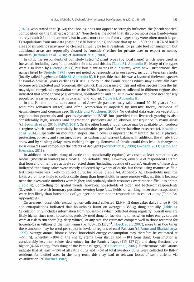
Table 4Summary of transport means, electricity access (frequencies of households hh with access to electricity), biofuel uses (shrub and dung collection), collection of other wild plant resources(reed and medicinal plants), and fish catch by residents in the different regions of BANP.
BANPregiona
Transport Electrichouseh.supply(% hh)
Shrub collection Dung collection Biofuel energyindexf
(GJ hh�1 y�1)
Reed collection Medicinal plants Fish
Bicycle ¦motorbike ¦car I (% hh)
Numberbundles(hh�1 y�1)b
Biomassindexc
(kg hh�1 y�1)
Collectdung(% hh)
No. dungcakesd
(hh�1 day�1)
Biomassindexe
(kg hh�1 y�1)
Collectreed(% hh)
Numberbundles(hh�1 y�1)d
Collectplants(% hh)
Approx.weight(kg y�1)d
Snagcatch(% hh)
Center 5 ¦ 20 ¦ 0 100 51720 �2527 25 1476 �175 �40.0 70 1579 60 3.571.9 40West 28 ¦ 64 ¦ 12 100 69728 �3450 48 1372 �342 �55.9 92 59741 24 3.371.9 40South 18 ¦ 35 ¦ 3 91 63726 �3154 76 1373 �531 �53.7 18 21710 26 3.371.5 0East 5 ¦ 38 ¦ 5 100 65724 �3238 67 1272 �443 �53.9 81 23713 14 4.771.5 5North 0 ¦ 19 ¦ 0 50 64728 �3203 12 1472 �92 �49.1 6 (10) 13 6.572.1 0All 13 ¦ 37 ¦ 4 91 63726 �3126 51 1373 �353 �51.1 53 34729 28 3.771.9 16
a Cf.Tables 1 and 2.b All households collected shrubs.c Based on assessments by A. Mohibbi a typical ‘bundle’ (�donkey load) contained �750 shrubs and weighted �50 kg at harvest (mostly dry biomass; literature figures are in the rangeof 30–70 kg;Hoeck et al., 2007, Bedunah et al., 2010).
d Calculations exclude non-collecting households.e The average weight of a cow dung cake was estimated at �0.15 kg, calculated based on the 2 kg d�1 baseline (cf.Table 2) and a defecation rate of �13 per day (cf.Smith and Frost,2000).
f Gigajoules calculated on the basis of 1 kg dry shrub biomass converting to �15 MJ fire energy and 1 kg dry dung �12 MJ (cf.Hoeck et al., 2007).
A.A
zizMohibbi,R
.Cochard/Environm
entalDevelopm
ent11
(2014)141
–161154
A. Aziz Mohibbi, R. Cochard / Environmental Development 11 (2014) 141–161 155
(1973), who stated that (p. 60) the “hoeing does not appear to strongly influence the [shrub species]composition on the high escarpments.” Nonetheless, he noted that shrub cushions near Band-e-Amir“rarely reach 0.5 m in diameter”, but in areas more remote from villages they were often much larger.Extrapolations from our data (baseline 830 households) indicate that up to �500 ha (�0.7% of BANParea) of shrublands may now be cleared annually by local residents for private fuel consumption, butadditional areas are reportedly cleared by ‘outsiders’ either for private uses or export to nearbymarkets (Bedunah et al., 2010; cf. Robinett et al., 2008).
In total, the respondents of our study listed 12 plant types (by local name) which were used asfuelwood, including dwarf and cushion shrubs, and thistles (Table B1, Appendix B). Many of the typeswere also listed by Dieterle (1973), but four plant names in our survey were new. Furthermore, fivenames listed by Dieterle (1973) were not noted by respondents in our survey, including teresken shrubs(locally called bujighana) (Table B1, Appendix B). It is possible that this was a favoured fuelwood speciesat Band-e-Amir 40 years earlier (as it still is today in the Pamir region) which may eventually havebecome overexploited and ‘economically’ extinct. Disappearance of this and other species from the listmay signal rangeland degradation since the 1970s. Patterns of species collected in different regions alsoindicated that some shrubs (e.g. Artemisia, Acantholimon and Cousinia) were more depleted near denselypopulated areas, especially at Jarukashan and Kopruk (Table B1, Appendix B).
In the Pamir mountains, restoration of Artemisia pastures may take around 20–30 years (if soilresources remained intact), and often restoration is impeded by invasive thorny cushions ofAcantholimon and Cousinia spp. (Breckle and Wucherer, 2006). No detailed data exist on vegetationregeneration potentials and species dynamics at BANP, but provided that livestock grazing is alsoconsiderably high, serious land degradation problems are an obvious consequence in many areas(cf. Bedunah et al., 2010; BAPAC, 2011). On the other hand, enough space may be available to introducea regime which could potentially be sustainable, provided further baseline research (cf. Kraudzunet al., 2014). Especially on mountain slopes, shrub cover is important to maintain the soils’ physicalprotection, porosity and structure, as well as carbon and nutrient balances. In addition, the shrubs trapsnow and by shading delay snow melting in spring. Removal of shrubs could thus lead to changes inlocal climates and compound the effects of droughts (Robinett et al., 2008; Cochard, 2013; Liston andHiemstra, 2011).
In addition to shrubs, dung of cattle (and occasionally equines) was used at least sometimes asbiofuel (mostly in winter) by almost all households (98%). However, only 51% of respondents statedthat household members actively collected dung (including outside of stables). Analyses of these dataindicated that dung cakes were mostly collected by owners of cattle, but those using manure as fieldfertilizers were less likely to collect dung for biofuel (Table A4, Appendix A). Households near thelakes were more likely to collect cattle dung than households in more remote villages; this is becausenear the lakes cattle numbers were higher, and probably shrub resources were more difficult to obtain(Table 4). Controlling for spatial trends, however, households of older and better-off respondents(Sayeeds, those with honorary positions, owning large lalmi fields, or working in service occupations)were less likely than households of younger and commoner respondents to collect dung (Table A4,Appendix A).
On average, households (excluding non-collectors) collected 12.974.2 dung cakes daily (range 9–40),and extrapolations indicated that households burnt on average �353 kg dung annually (Table 4).Calculation only includes information from households which collected dung regularly; overall uses arelikely higher since most households probably used dung for fuel during times when other energy sourceswere at risk to run short (e.g. deep winter). At any rate, the estimates compare well to those recorded forhouseholds in villages of the high Pamir (i.e. 400–535 kg y�1; Hoeck et al., 2007); more than two timesthese amounts may be used per capita in lowland regions of rural Pakistan (cf. Amur and Bhattacharya,1999). Average annual biomass-based household energy consumption may therefore be estimated at�51.1 GJ, whereby �90% of the energy stems from shrubs and �10% from dung. Consumption isconsiderably less than values determined for the Pamir villages (115–127 GJ), and dung fractions arehigher (4–6% energy from dung at the Pamir villages) (cf. Hoeck et al., 2007). Furthermore, calculationsindicate that at least �16% of all cattle dung and �5% of total livestock dung were collected by BANPresidents for biofuel uses. In the long term, this may lead to relevant losses of soil nutrients viavolatilization (cf. Boerner, 1982).
A. Aziz Mohibbi, R. Cochard / Environmental Development 11 (2014) 141–161156
4.8. Collection of other plant resources
Reed was collected for fodder and bedding of livestock during winter. It was also used for buildingmaterials and occasionally as fuel during shrub supply shortfalls in winter. Many households (70–92%)in villages in the main valley (especially close to the lakes), but also a few households (6–18%) fromthe outer villages, collected reed (Table 4, Fig. 2f). On average 34729 bundles of reed were collectedby households (excluding non-collectors), whereby particularly large amounts (maximally 150 bundles)were collected by owners of horses and motorbikes (Table A4, Appendix A). Communities haveestablished reed cutting rights and reed cutting was done since generations each year in autumn. Hence,the practice does not affect breeding of wetland birds, and it appears sustainable under the currentregime (cf. Dieterle, 1973; BAPAC, 2011).
At Jarukashan, plants of medicinal uses are sold or traded on the market, hence, many households (60%)were collecting medicinal plants (as stated around 3.571.9 bundles annually; excluding non-collectors).In contrast, much fewer households collected medicinal plants in the other villages (13–24%), wherebygenerally higher harvests (44 bundles) were stated by collectors in villages located at higher altitudes(Table 4, Table A4, Appendix A). In total, 12 different plants were noted down by various respondents(Table B2, Appendix B), but morewould probably be recorded following further investigations. In the PamirandWestern Himalayanmountains, 455 primarily wild plant species were identified by villagers (Kassamet al., 2010; Dar et al., 2012). The impact of herb collection on wild species populations at BANP is notknown, but probably it is and has been significant (cf. Kala, 2005).
4.9. Wildlife hunting and fishing
Mostly young respondents living close to the lakes (16% of all) were fishing on a regular basis, withan average stated catch of 2.871.0 fishes per day (excluding non-fishers; Table 4, Table A5, Appendix A).Levels of fishing were probably not affecting fish populations in significant ways (cf. Mail, 2008).
Three respondents (3%) stated that they were hunting birds, i.e. either waterfowl (2%; either 1 or4 birds per week), rock doves (1%; 6 per week), or smaller birds (1%; about 50 per week during birdmigration times). If such figures are representative, in total 430 waterfowl, 440 doves, and dozensof small birds may thus be hunted or caught per week (baseline 830 households). This is notinsubstantial, especially in the case of large waterfowl whose habitats and populations are limited(cf. Kanderian et al., 2011).
Questions about hunting of other animals were answered negatively by all respondents. Most largespecies of wildlife were probably eradicated during the war, and newly immigrating populations may nolonger be able to establish permanently due to high resource competition from livestock. Threats forwildlife may also come from livestock diseases, which thrive in certain areas (Bedunah et al., 2010;Ostrowski et al., 2007). Discussion with residents indicated that human-wildlife conflicts had increased,because in the absence of large wildlife, predators (mainly wolves) increasingly prey on livestock. Thismay partly explain why many of the relatively richer respondents (Sayeeds, owners of horses and largeirrigated fields) kept dogs to defend their livestock and other assets, and particularly in villages atrelatively higher elevations (Table A2, Appendix A). Attitudes towards wildlife and hunting may beambivalent, but wildlife conservation will likely gain if economic incentives and better insurancesagainst livestock losses (e.g. due to predators) can be established (cf. Huber, 2012).
5. Conclusions and recommendations
The socio-economic and environmental situation in newly created Band-e-Amir National Parkreflects conditions in other parts of Central Afghanistan. However, intentions are to transform BANPinto a model for responsible environmental stewardship in Afghanistan. First steps are to identify andbetter describe issues of resource uses and environmental impacts. This paper provides some baselineinformation and reference points for planning of projects which promote new approaches ofimproved resource management. It also provides some direction for further scientific investigations.
A. Aziz Mohibbi, R. Cochard / Environmental Development 11 (2014) 141–161 157
Conservation objectives in BANP will only have a prospect of success if undertaken with theconsent and close participation of local residents. It demands a considerate stepwise approach sinceenvironmental and socio-economic issues are inevitably intricate, and diverse interests exist amongcommunities. Land rights are not clearly regulated, especially in the case of lalmi agriculture andrangeland resources. Resident composition and demography is still in flux. Nonetheless, prospects forimprovements exist. BAPAC provides major representation for the main 13 villages of BANP, inaddition to delegates from state, provincial and district agencies and selected NGO's. If further supportand extension is provided (with an international spotlight set on the area), communities may gainconfidence in arrangements and processes, exercise their responsibilities, and follow rules andregulations. Although many residents are cautious to acknowledge environmental issues (probablydue to persistent mistrust towards outsiders), it is also increasingly obvious to them that resources arefurther declining if no actions are taken. Residents thus appear to be receptive for new livelihoodoptions and ideas for improving regimes of resource management, including to a certain extent,aspects of biodiversity conservation (cf. Adams et al., 2004).
Due to Afghanistan's security situation, the potentials for BANP to generate revenues and new jobsfrom international tourism will probably remain limited in the coming years. On the other hand, ifnational and international attention and support are maintained, BANP could serve as a ‘fieldlaboratory’ for scientists and practitioners to study and improve both—local people's livelihoods andthe natural quality and biotic diversity of the area. Within Afghanistan, BANP is one of the best-studied areas, even if much research has been conducted before 1979. In the current context, there is along list of new issues for which solutions need to be found, and for which in-depth research iscritical. Many research projects could be undertaken in partnership with local residents, wherebylocals benefit from additional incomes and from collaborative workshops. In such projects locals couldalso actively participate and contribute in developing feasible approaches to more sustainable landmanagement and nature conservation. As partly outlined elsewhere (BAPAC, 2011, Bedunah et al.,2010), further research should focus on following issues:
1)
Surveys and databases. Systematic vegetation surveys should be undertaken and compared to earliersurveys (e.g. Dieterle, 1973). A database of plant species should be established, and the relativeabundance and palatability of plant species for livestock should be determined via direct observationsduring different seasons. Information should be gathered on the ecology of the main plant species. Thequestion should be addressed whether some useful/palatable species could be promoted, e.g. viabreeding and seed dispersal. Animal species recorded for the area should be catalogued.2)
Vegetation patterns under intensive grazing and other impacts. Movements and patterns of grazingshould be observed in the field. Further vegetation patterns and impacts may be identified usingaerial/satellite images and geographical information systems (cf. Tobler et al., 2003). Ways toimprove rangeland use regimes should thus be studied.3)
Experiments of grazing exclusion. With the consent and collaboration of local residents small areas(replicated in different vegetation types) should be permanently and/or seasonally fenced to studyvegetation development in the absence of grazing pressure (cf. Bork et al., 1998). Relevant researchquestions are: To what degree do small protected areas increase overall plant diversity andproductivity? Do they contribute to increase productivity also in the surrounding grazedvegetation (e.g. via increasing propagule density and dispersion)? Can protection of areas duringcertain seasons (e.g. growth period until seed set) help to increase overall productivity withtangible benefits for livestock and/or wildlife?4)
Shrub cutting practices and impacts. These should be studied in field surveys and experiments(cf. Kraudzun et al., 2014). Relevant research questions are: Where and in which ways do locals and/oroutsiders preferably collect shrubs? What are the impacts on soils (erosion, nutrient losses) in variousterrain? Could alternative approaches of shrub extraction (e.g. selective as compared to completeclearing, protection of steep lands) mitigate against negative effects on vegetation and soils? What arethe regeneration rates in cleared areas in different terrain and various use regimes? How couldregeneration be aided by management measures (e.g. seeding of propagules, grazing exclusion, etc.)?5)
Practices of dryland farming (lalmi) and environmental impacts. In addition to similar researchquestions as above for shrub collection, traditional systems of land tenure should be investigated.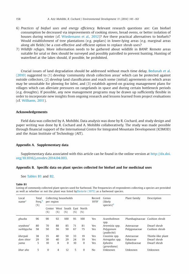
A. Aziz Mohibbi, R. Cochard / Environmental Development 11 (2014) 141–161158
6)
TabListas w
Lon
g
sesu
kdy
k
Practices of biofuel uses and energy efficiency. Relevant research questions are: Can biofuelconsumption be decreased via improvements of cooking stoves, bread ovens, or better isolation ofhouses during winter (cf. Wiedemann et al., 2012)? Are there practical alternatives to biofuels?Would establishment of tree plantations (e.g. poplars) in lower-lying areas (e.g. marginal areasalong abi fields) be a cost-effective and efficient option to replace shrub uses?
7)
Wildlife refuges. More information needs to be gathered about wildlife in BANP. Remote areassuitable for urial or ibex should be surveyed and possibly patrolled to prevent hunting. Hunting ofwaterfowl at the lakes should, if possible, be prohibited.Crucial issues of land degradation should be addressed without much time delay. Bedunah et al.(2010) suggested to (1) develop ‘community shrub collection areas’ which can be protected againstoutside collectors, (2) develop land classification and reach some (initial) agreements on which areasmay be unsuitable for plowing for lalmi, and (3) establish agreed-on grazing management plans forvillages which can alleviate pressures on rangelands in space and during certain bottleneck periods(e.g. droughts). If possible, any new management programs may be drawn up sufficiently flexible inorder to incorporate new insights from ongoing research and lessons learned from project evaluations(cf. Williams, 2011).
Acknowledgements
Field data was collected by A. Mohibbi. Data analysis was done by R. Cochard, and study design andpaper writing was done by R. Cochard and A. Mohibbi collaboratively. The study was made possiblethrough financial support of the International Centre for Integrated Mountain Development (ICIMOD)and the Asian Institute of Technology (AIT).
Appendix A. Supplementary data
Supplementary data associated with this article can be found in the online version at http://dx.doi.org/10.1016/j.envdev.2014.04.003.
Appendix B. Specific data on plant species collected for biofuel and for medicinal uses
See Tables B1 and B2.
le B1ing of commonly collected plant species used for fuelwood. The frequencies of respondents collecting a species are providedell as whether or not the plant was listed byDieterle (1973) as a fuelwood species.
calamea
TotalFreq.b
(%)
Collecting householdsper region
Record1970c
Genus(likelyspecies)d
Plant family Description
Center(%)
West(%)
South(%)
East(%)
North(%)
huzba 96 90 92 100 95 100 Yes Acantholimonspp.
Plumbaginaceae Cushion shrub
yabotae 80 70 88 85 71 81 Yes Artemisia spp. Asteraceae Dwarf shrubrkhpycha 58 50 56 50 67 75 Yes Polygonum
(podlechii)Polygonaceae Cushion shrub
herpak 38 35 40 50 33 19 Yes Cousinia spp. Asteraceae Thistle-like plantom shtor 29 30 40 29 24 19 Yes Astragalus spp. Fabaceae Dwarf shrubama 5 10 8 0 10 0 Yes Ephedra
(gerardiana)Ephedraceae Dwarf shrub
har aho 5 0 4 12 5 0 No Unknown Unknown Unknown
Table B1 (continued )
Localnamea
TotalFreq.b
(%)
Collecting householdsper region
Record1970c
Genus(likelyspecies)d
Plant family Description
Center(%)
West(%)
South(%)
East(%)
North(%)
ghawog bota 4 15 4 0 5 0 Yes Semenovia(lasiocarpa)
Apiaceae Cushion shrub
bar bota 4 5 8 0 5 6 No Unknown Unknown Unknownkhero 3 0 0 9 0 0 No Unknown Unknown Unknownarghushaf 2 0 8 0 0 0 Yes Senecio
(khorassanicus)Asteraceae Ragwort-like
plantkharsamboo 1 5 0 0 0 0 No Unknown Unknown Unknown
Further species which were listed byDieterle (1973) but were not recorded in this survey: bujighana (Krascheninnikoviapungens), jaka (Cerasus bifrons), attarghan (Ceragana aurantiaca), oilak (various bunch grass species), ?(Trigonella).
a Plant name listed by the respondents.b Frequency of respondents noting the plant in this survey.c Indicates whether or not the species was listed byDieterle (1973).d Often several species are referred to under a local plant name (species names in brackets are indicative but may not be
reliable).e The local name listed byDieterle (1973) was safed buta.f The local name listed byDieterle (1973) was gush-argali.
Table B2Listing of commonly collected plant species used for medicinal purposes.
Local namea Total Freq.b
(%)Collecting households per region Genus
(likely species)cPlant family Description
Center(%)
West(%)
South(%)
East(%)
North(%)
bosraq bota 22 45 24 18 14 13 Unknown Unknown Unknownmint 20 55 16 12 95 13 Mentha (longifolia) Lamiaceae Mint herbboe baran 20 5 0 9 0 0 Achillea (wilhelmsii) Asteraceae Yarrow herbkuza tani 18 55 12 15 10 0 Unknown Unknown Unknownsang ghazak 6 15 8 3 0 6 Acantholimon sp. Plumbaginaceae Cushion shrubyama 3 5 4 3 0 0 Ephedra (gerardiana) Ephedraceae Dwarf shrubdom gosala 3 0 0 9 0 0 Unknown Unknown Unknownkakoti 3 5 0 0 5 6 Ziziphora
clinopodioidesLamiaceae Mint herb
gol caw zaban 3 5 4 3 0 0 Borago officinalis Boraginaceae Boragebozbash 2 0 4 0 0 6 Rosa brunonii Rosaceae Shrubpiyaz kohi 1 0 0 3 0 0 Allium sp. Alliaceae Field garlicgul bota 1 5 0 0 0 0 Unknown Unknown Unknown
a Plant name listed by the respondents.b Frequency of respondents noting the plant in this survey.c Often several species are referred to under a local plant name, i.e. species in brackets may not be reliable.
A. Aziz Mohibbi, R. Cochard / Environmental Development 11 (2014) 141–161 159
References
Adams, W.M., Aveling, R., Brockington, D., Dickson, B., Elliott, J., Hutton, J., Roe, D., Vira, B., Wolmer, W., 2004. Biodiversityconservation and the eradication of poverty. Science 306, 1146–1149.
ADB, 2009. Environment Assessment Report. Initial Environment Project Examination. Asian Development Bank, Kabul.Amur, G.Q., Bhattacharya, S.C., 1999. A study of biomass as a source of energy in Pakistan. RERIC Int. Energy J 21 (1), 25–36.BAPAC, 2011. Band-e-Amir National Park Management Plan: 1390–1394. Band-e-Amir Protected Area Committee (BAPAC), Ministry
of Agriculture, Irrigation and Livestock (MAIL), National Environmental Protection Agency NEPA, Kabul, Afghanistan.
A. Aziz Mohibbi, R. Cochard / Environmental Development 11 (2014) 141–161160
Bedunah, D.J., Shank, C., Alavi, M.A., 2010. Rangelands of Band-e-Amir National Park and Ajar Provisional Wildlife Reserve,Afghanistan. Rangelands 32, 41–52.
Behnke, R., Davidson, G., Jabbar, A., Coughenour, M., 2006. Human and natural factors that influence livestock distributions andrangeland desertification in Turkmenistan. In: Behnke, R. (Ed.), The Socio-economic Causes and Consequences ofDesertification in Central Asia. Springer, The Netherlands, pp. 141–168.
BirdLife International, 2013. Important Bird Areas Factsheet: Bande Amir. BirdLife International. ⟨http://www.birdlife.org⟩(accessed 20 May 2013).
Boerner, R.E., 1982. Fire and nutrient cycling in temperate ecosystems. Bioscience 32 (3), 187–192.Bork, E.W., West, N.E., Walker, J.W., 1998. Cover components on long-term seasonal sheep grazing treatments in three-tip
sagebrush steppe. J. Range Manage. 51 (3), 293–300.Bourrouilh-Le Jan, F.G., Akram, B., Schvoerer, M., 2007. Band-e-Amir Lakes and Dragon Valley (Bamiyan): myths and seismicity
in Afghanistan. In: Piccard, L., Masse, W.B. (Eds.), Myth and Geology. Geological Society. Special Publication 273. CromwellPress, UK, pp. 121–132.
Breckle, S.W., 1983. Temperate deserts and semi-deserts of Afghanistan and Iran. In: West, N.E. (Ed.), Temperate Deserts andSemi-deserts. Ecosystems of the World, Volume 5. Elsevier, Amsterdam, The Netherlands, pp. 271–319.
Breckle, S.W., Wucherer, W., 2006. Vegetation of the Pamir (Tajikistan): land use and desertification problems. In: Spehn, E.M.,Liberman, M., Kor̈ner, C. (Eds.), Land use Change and Mountain Biodiversity. CRC Taylor & Francis, Boca Raton, FL, pp. 227–239.
Breckle, S.W., 2007. Flora and vegetation of Afghanistan. Basic Appl. Dryl. Res. 1 (2), 155–194.Cochard, R., 2013. Natural hazards mitigation services of carbon-rich ecosystems. In: Lal, R., Lorenz, K., Hüttl, R.F., Schneider, B.U.,
von Braun, J. (Eds.), Ecosystem Services and Carbon Sequestration in the Biosphere. Springer, Heidelberg, pp. 221–293.Cochard, R., Dar, M.E.U.I., 2014. Mountain farmers’ livelihoods and perceptions of forest resource degradation at Machiara
National Park, Pakistan-administered Kashmir. Environ Dev 10, 84–103.CSO/UNFPA, 2006. Bamyan Provincial Profile. Central Statistics Office and United Nations Population Fund, Kabul, Afghanistan.Dar, M.E.U.I., Cochard, R., Shreshta, R.P., Ahmad, S., 2012. Plant resource utilization by local inhabitants around Machiara
National Park, Azad Kashmir, Pakistan. J. Food Agric. Environ. 10 (3–4), 1139–1148.Dieterle, A., 1973. Vegetationskundliche Untersuchungen im Gebiet von Band-i-Amir (Zentralafghanistan). Dissertation.
University of Munich, Germany.Enright, N.J., Miller, B.P., 2007. Livestock grazing impacts on desert vegetation, Khirthar National Park, Pakistan. Rangeland Ecol.
Manage. 60, 680–684.Extoxnet, 2013. Pesticide Information Profile [Internet]. Ithaca (NY): Cornell University, Extension Toxicology Network; [cited
2013 Aug 10]. Available from: ⟨http://pmep.cce.cornell.edu/profiles/extoxnet/index.html⟩.Formoli, T.A., 1995. Impacts of the Afghan-Soviet war on Afghanistan's environment. Environ. Conserv. 22, 66–69.Frachetti, M., 2013. Bronze age pastoralism and differentiated landscapes along the Inner Asian Mountain Corridor. In:
Abraham, S.A., Gullapalli, P., Raczek, T.P., Rizvi, U.Z. (Eds.), Connections and Complexity: New Approaches to the Archaeologyof South Asia. Left Coast Press, Walnut Creek, CA, pp. 279–298.
Gestis, 2013. Gefahrstoffinformationssystem. Sankt Augustin, Germany: Institut für Arbeitsschutz der Deutschen GesetzlichenUnfallversicherung (IFA); [cited 2013 Aug 10]. Available from: ⟨http://gestis.itrust.de/nxt/gateway.dll/gestis_de/⟩.
Hoeck, T., Droux, R., Breu, T., Hurni, H., Maselli, D., 2007. Rural energy consumption and land degradation in a post-Sovietsetting—an example from the west Pamir mountains in Tajikistan. Energy Sustainable Dev. 11 (1), 48–57.
Huber, T., 2012. The changing role of hunting and wildlife in pastoral communities of Northern Tibet. In: Kreutzmann, H. (Ed.),Pastoral Practices in High Asia. Springer, Heidelberg, pp. 195–216.
Johnson, M.F., Kanderian, N., Shank, C.C., Rahmani, H., Lawson, D., Smallwood, P., 2012. Setting priorities for protected areaplanning in a conflict zone—Afghanistan's National Protected Area System Plan. Biol. Conserv. 148, 146–155.
Kala, C., 2005. Indigenous uses, population density, and conservation of threatened medicinal plants in protected areas of theIndian Himalayas. Conserv. Biol. 19 (2), 368–378.
Kanderian, N., Lawson, D., Zahler, P., 2011. Current status of wildlife and conservation in Afghanistan. Int. J. Environ. Stud. 68 (3),281–298.
Kassam, K.-A., Karamkhudoeva, M., Ruelle, M., Baumflek, M., 2010. Medicinal plant use and health sovereignty: findings fromthe Tajik and Afghan Pamirs. Hum. Ecol. 38 (6), 817–829.
Kraudzun, T., Vanselow, K.A., Samimi, C., 2014. Realities and myths of the Teresken syndrome—an evaluation of the exploitationof dwarf shrub resources in the Eastern Pamirs of Tajikistan. J. Environ. Manage. 132, 49–59.
Liston, G.E., Hiemstra, C.A., 2011. Representing grass- and shrub-snow-atmosphere interactions in climate system models.J. Climate 24, 2061–2079.
Lockwood, M., Worboys, G.L., Kathari, A., 2006. Managing Protected Areas: A Global Guide. Earthscan, London.Lysyk, T.J., Easton, E.R., Evenson, P.D., 1985. Seasonal changes in nitrogen and moisture content of cattle manure in cool-season
pastures. J. Range Manage. 38 (3), 251–254.MAIL, 2008. Band-i-Amir Provisional National Park: A Preliminary Management Plan. Government report. Ministry of
Agriculture, Irrigation and Livestock (MAIL), Kabul, Afghanistan.Nüsser, M., Holdschlag, A., Rahman, F., 2012. Herding on high grounds: diversity and typology of pastoral systems in the
Eastern Hindukush (Chitral, Northwest Pakistan). In: Kreutzmann, H. (Ed.), Pastoral Practices in High Asia. Springer, Heidelberg,pp. 31–52.
Okay, O.S., Gaines, A., 1996. Toxicity of 2,4-D acid to phytoplankton. Water Res. 30 (3), 688–696.Omrani, B., Leeming, M., 2005. Afghanistan. A Companion and Guide. Odyssey Books and Guides, New York, NY.Ostrowski, S., Rajabi, A.M., Noori, H., 2007. A Field Mission of the Ecosystem Health Component to Bande-Amir in May–June
2007. Unpublished Report. Wildlife Conservation Society, New York, NY, USA.Pentecost, A., 2005. Travertine. Springer, The Netherlands.Perkow, W., 1985. Wirksubstanzen der Pflanzenschutz- und Schädlingsbekämpfungsmittel. Paul Parey, Singhofen, Germany.Persaud, S., 2012. Long-term Growth Prospects for Wheat Production in Afghanistan. Report from the Economic Research
Service (WHS-11L-01). United States Department of Agriculture, Washington, DC.Rathjens, C., 1975. Witterungsbedingte Schwankungen der Ernährungsbasis in Afghanistan. Erdkunde 29 (3), 1982–1988.
A. Aziz Mohibbi, R. Cochard / Environmental Development 11 (2014) 141–161 161
Robinett, D., Miller, D., Bedunah, D., 2008. Central Afghanistan rangelands: a history of tribal rule, grazing, war, and rebuilding.Rangelands 30 (4), 2–12.
Robinson, S., 2012. Carrying Capacity of Pasture and Fodder Resources in the Tajik Pamirs. Food and Agriculture Organization ofthe United Nations (FAO), Rome.
Saba, D.S., 2001. Afghanistan: environmental degradation in a fragile ecological setting. Int. J. Sustainable Dev. World 8, 279–289.Schütte, S., 2012. Pastoralism, power and politics: access to pastures in Northern Afghanistan. In: Kreutzmann, H. (Ed.), Pastoral
Practices in High Asia. Springer, Heidelberg, pp. 195–216.Shank, C.C., Larsson, J.Y., 1977. National Parks and Utilization of Wildlife Resources in Afghanistan: A Strategy for the
Establishment and Development of Bande Amir National Park. United Nations Development Program (UNDP) and UnitedNations Food and Agriculture Organisation (FAO), Kabul, Afghanistan.
Shank, C.C., 2006. The Wildlife Conservation Society Afghanistan Biodiversity Conservation Project. Hazarajat Component—2006 Annual Report. Wildlife Conservation Society (WCS) Afghanistan Programme, Kabul, Afghanistan.
Smallwood, P., Shank, C., Dehgan, A., Zahler, P., 2011. Wildlife conservation… in Afghanistan? Bioscience 61 (7) 506–511.Smith, K.A., Frost, J.P., 2000. Nitrogen excretion by farm livestock with respect to land spreading requirements and controlling
nitrogen losses to ground and surface waters. Part 1: Cattle and sheep. Bioresour. Technol. 71 (2), 173–181.Spoorenberg, T., 2013. An evaluation of the recent fertility changes in Afghanistan: a parity-specific analysis. J. Popul. Res. 30 (2),
133–149.Tobler, M.W., Cochard, R., Edwards, P.J., 2003. The impact of cattle ranching on large-scale vegetation patterns in a coastal
savanna in Tanzania. J. Appl. Ecol. 40, 430–444.Uhrig, R., 1999. Die Ethnie der Hazara in Afghanistan. Int. Asienforum 30 (1–2), 27–46.UNEP, 2003 Afghanistan. Post-Conflict Environmental Assessment. United Nations Environment Programme (UNEP), Geneva,
Switzerland.UK ANPA, 2013. National Parks. Britain's Breathing Spaces. United Kingdom Association of National Park Authorities ⟨http://
www.nationalparks.gov.uk/⟩ (accessed 20 May 2013).Walter, H., Box, E.O., 1983. The Pamir—an ecologically well-studied high-mountain desert biome. In: West, N.E. (Ed.), Temperate
Deserts and Semi-deserts. Ecosystems of the World, Volume 5. Elsevier, Amsterdam, The Netherlands, pp. 239–269.WCS, 2011. Wildlife Conservation Society (2011, December 5): Return of the Persian leopard in Afghanistan's Central Highlands.
ScienceDaily. ⟨http://www.sciencedaily.com/releases/2011/12/111205140519.htm⟩ (accessed 21 May 2012).Wiedemann, C., Salzmann, S., Mirshakarov, I., Volkmer, H., 2012. Thermal insulation in high mountainous regions. Mt. Res. Dev.
32 (2), 294–303.Williams, B.K., 2011. Adaptive management of natural resources—framework and issues. J. Environ. Manage. 92, 1346–1353.