14.0 transportation - nb power · mactaquac project: final comparative environmental review (cer)...
TRANSCRIPT

MACTAQUAC PROJECT: FINAL COMPARATIVE ENVIRONMENTAL REVIEW (CER) REPORT
August 2016 14-1
14.0 TRANSPORTATION
14.1 SCOPE OF THE REVIEW
Transportation, as defined for this CER, refers to the quality of road transportation networks and
infrastructure and their capacity to provide safe and efficient service for movement of vehicles on
provincial highways. The scope of the review considers the arterial, collector and local highways, and
bridges and interchanges between Nackawic and Fredericton.
14.1.1 Why Transportation is a Valued Component
The Station provides an important transportation link between Route 102 (south of the Saint John River)
and Route 105 (north of the Saint John River). This link, known locally as Mactaquac Road, traverses the
river. It crosses over the earthen dam and diversion sluiceway before crossing
the left bank approach channel to the powerhouse via a bridge. This road is a
primary commuter route between communities surrounding the Station on either
side of the Saint John River.
Each of the Options will affect the transportation link between Routes 102 and
105, will result in changes to local traffic and circulation patterns near the
Station, and will result in increased traffic (passenger vehicles and heavy trucks)
on local roads as a result of the transport of workers, materials and equipment to
and from the area of the Station. If unmitigated, the removal of this
transportation link and the resulting changes to traffic patterns and increased
use would result in traffic disruptions during the Project. Traffic will need to use an
alternative river crossing.
14.1.2 Regulations and Policies Relevant to Transportation
The management of road transportation on provincial arterial and collector highways, including
transportation network infrastructure condition and traffic management, is the responsibility of the
New Brunswick Department of Transportation and Infrastructure (NBDTI) , under the authority of the
New Brunswick Highway Act. The New Brunswick Department of Public Safety administers the
New Brunswick Motor Vehicle Act by enforcing traffic rules (e.g., speed limits, seasonal weight
restrictions).
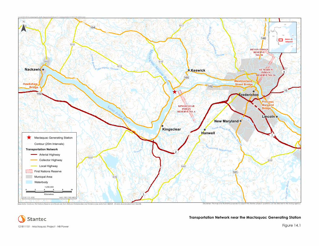
14.1.3 Area of Review
The area of review for transportation extends approximately 40 km upstream of the Station to the
Hawkshaw Bridge in Pokiok (near Nackawic), and approximately 22 km downstream of the Station to
the Princess Margaret Bridge in Fredericton. The area includes arterial, collector and local highways,
and associated interchanges and bridges that are directly connected to the transportation network at
Mactaquac (Figure 14.1). This includes Routes 2 and 3 south of the Station; Routes 101, 635, and 640
from the communities of Harvey, Hanwell and Fredericton; and Routes 104, 105, 610, 615, 616, and 620
from the communities of Upper Caverhill, Upper Keswick and Fredericton. The area of review is
consistent with the area considered in the Transportation Study of Mactaquac Project Options
(exp Services Inc. 2015).
^ !
!
!
!
!
!
!
180
220
160
200
140
80
100
40
160
140
4020
20
14010060
180
8060
200
180
160
80
60
140
80
200
100 4020
60
100
80
160
140120
80
2040
60
100
60
260240
120
120
100
220
160
180
160
100
140
120
120
80
80
60
160
180
160
200
160
120
200
160
120
40
120
140
120
280
160
80
180
160
120 140
120
140
60
220
160
120
200
180
100
100
140
120
80
120
140
120
140
180
220200
180
120
20
ST. MARY'SINDIAN
RESERVE NO. 24
KINGSCLEARINDIAN
RESERVE NO. 6
DEVON INDIANRESERVE
NO. 30
Hawkshaw Bridge
Westmorland Street Bridge
PrincessMargaretBridge
UV102
UV8
UV104
UV2
UV102
UV101
UV105
UV10
UV7
UV3
UV148
UV635
UV610
UV640UV655
UV595
UV616
UV620
UV605
UV636
UV617
UV628
UV615
Fredericton
KingsclearNew Maryland
Hanwell
Keswick
Lincoln
Nackawic
Je wettsCr
ee k
North BranchRusagonis Stream
Orom
octo R
iv er
WestBranch Nashwaaksis
S treamSouthBranc h Mactaquac Stream
Nas onworth Mill stream
Baker Brook
Saint John River
Macta quac Stream Basin
NBME
QC
NS
PE
Figure 14.1
Area of Interest
-
NAD 1983 CSRS NBDS
121811151 - Mactaquac Project - NB Power
0 2 4 6 8 10
Kilometres
DRAFT - For In
ternal Use Only
Transportation Network near the Mactaquac Generating Station
^ Mactaquac Generating StationContour (20m Intervals)
Transportation NetworkArterial HighwayCollector HighwayLocal Highway
First Nations ReserveMunicpal AreaWaterbody
U:\121811151\3_drawings\3_draft_figures\mxd\rpt\cer\11_transportation\121811151-0030.mxd
121811151-0030
Disclaimer: This map is for illustrative purposes to support this Stantec project; questions can be directed to the issuing agency.Base Data: Contours, First Nations Reserve and Roads are from SNB and Waterbodies and Watercourses data from NBDNR. All data downloaded from GeoNB.
1:250,000

MACTAQUAC PROJECT: FINAL COMPARATIVE ENVIRONMENTAL REVIEW (CER) REPORT
August 2016 14-3
14.1.4 Key Issue
The transportation of workers, materials, goods, services and equipment to the Project site will add to
traffic on the transportation network in the vicinity of the Station, and may affect the condition of this
infrastructure. This could affect traffic flow for the duration of construction. Additionally, all Options will
result in the removal of Mactaquac Road between Routes 102 and Route 105. This will change traffic
flow and patterns between Nackawic and Fredericton. Traffic changes outside this area as a result of
the Project are not likely to be distinguishable from current levels.
The key issue of concern for transportation is outlined in Table 14.1.
Table 14.1 Description of Key Issue for Transportation
Key Issue Description
Potential change in
transportation
Changes in network infrastructure (i.e., quality and condition of the existing
transportation network).
Changes in traffic volume, measured by annual average daily traffic (AADT), as a
result of:
the removal of Mactaquac Road during construction;
the transportation of workers, goods, materials, services and equipment to the
Project site; and
changes in traffic patterns (e.g., temporary intersections, bypasses and
alignments).
14.2 EXISTING CONDITIONS
14.2.1 Sources of Information
NB Power retained exp Services Inc. to prepare a transportation study (exp Services Inc. 2015) in support
of its decision-making regarding the Options. The City of Fredericton engineering and planning staff
were consulted as part of that study to determine where residential and commercial growth will occur
and to make traffic predictions. The transportation study provides the basis for defining existing
transportation conditions. It identifies the historical, current and predicted future traffic volumes on the
transportation network in the Mactaquac area, and alternative alignments for the transportation link
across the Saint John River at Mactaquac.
14.2.2 Description of Existing Conditions
14.2.2.1 Transportation Network
Roadways within the Mactaquac area are described below.
Route 2, an arterial highway, is a four-lane divided highway. It is part of the Trans-Canada Highway
system. It provides a main route through New Brunswick, and is the principal link between Fredericton,
Nackawic and Woodstock.
MACTAQUAC PROJECT: FINAL COMPARATIVE ENVIRONMENTAL REVIEW (CER) REPORT
August 2016 14-4
Route 3, an arterial highway, is a two-lane undivided highway. It begins at Route 2 south of Longs Creek
and extends south towards St. Stephen. It provides a link from the south of the province to Longs Creek,
where drivers can travel to Mactaquac via Route 102.
There are three collector highways in the Mactaquac area; they are all two-lane undivided highways.
Route 102 was part of the Trans-Canada Highway system and is locally referred to as the
“Old Trans-Canada Highway”, originating at Pokiok (near Nackawic) and terminating at Grand Bay-
Westfield, along the south side of the Saint John River. It provides access from the south side of the
Station, and is the primary route used by travellers between the south side of Fredericton and
Mactaquac.
Route 104 linking Hartland, Burtts Corner, and Keswick, and terminating at Route 105 at Mouth of
Keswick.
Route 105 linking Nackawic to Mactaquac and points downstream of Fredericton, beginning at
Grand Falls and terminating at Youngs Cove, along the north side of the Saint John River. It provides
access from the north side of the Station, and is the primary route used by travellers between the
north side of Fredericton and Mactaquac.
There are also six local highways in the general Mactaquac area:
Route 605;
Route 610;
Route 615;
Route 616;
Route 620; and
Route 635.
There are four river crossings within the area of review:
the Westmorland Street Bridge in Fredericton, which is the closest
crossing downstream of the Station;
the Princess Margaret Bridge in Fredericton;
the crossing at the Station, on Mactaquac Road; and
the Hawkshaw Bridge in Nackawic, which is the closest crossing
upstream of the Station.

MACTAQUAC PROJECT: FINAL COMPARATIVE ENVIRONMENTAL REVIEW (CER) REPORT
August 2016 14-5
14.2.2.2 Traffic Volumes
Annual average daily traffic (AADT) volumes for the roadways within the Mactaquac area are
presented in Table 14.2. They include the most recent AADT data collected by the NBDTI in 2013 and
extrapolated to 2014 volumes by exp Services Inc., and one-time traffic counts at the Route 102
and Mactaquac Road interchange carried out by exp Services Inc. in September 2014 (exp Services
Inc. 2015).
Table 14.2 Annual Average Daily Traffic, 2014
Location Annual Average Daily Traffic
(AADT, number of vehicles)
Local Highways
Route 2 at Mazerolle Settlement 8,440
Route 102 4 km east of Hawkshaw Bridge 620
Route 102 between Kellys Creek and Longs Creek 1,770
Route 102 at the exit to the Station 5,460a
Route 102 near Springhill Road 10,150
Route 105 south of Hawkshaw Bridge 2,320
Route 105 at Scotch Lake Road east of Nackawic 260
Route 105 at Mactaquac Marina Road 920
Route 105 at the Mactaquac Causeway 2,590
Route 105 near the Mouth of Keswick 4,570
Route 105 (Ring Road) in Douglas 9,030
Route 105 (Ring Road) Maple Street to Brookside Drive 21,110
Route 605 at Caverhill Siding Road 530
Route 610 south of Route 615 370
Route 615 at South Mactaquac River #1 Bridge 270
Route 616 north of Rocky Road 1,660
River Crossings on the Saint John River
Hawkshaw Bridge in Nackawic 3,150
Mactaquac Road at the Mactaquac Generating Station 4,410
Westmorland Street Bridge in Fredericton 51,970
Princess Margaret Bridge in Fredericton 21,520
Source: exp Services Inc. (2015) a One-time traffic count conducted by exp Services Inc. in September 2014
In 2014, the Mactaquac Road over the Station had the third highest AADT of the four river crossings
between Fredericton and Nackawic (4,410 vehicles) (Table 14.2). Westmorland Street Bridge had the
highest AADT (51,970), followed by the Princess Margaret Bridge (21,520). Hawkshaw Bridge in Nackawic
had the lowest AADT (3,150).
The primary arterial highway in the Mactaquac area is the Trans-Canada Highway, Route 2, which
bypasses the Station. In 2014, Route 2 had an AADT of 8,440 vehicles at Mazerolle Settlement,
approximately 7 km southwest of the Station (Table 14.2).
MACTAQUAC PROJECT: FINAL COMPARATIVE ENVIRONMENTAL REVIEW (CER) REPORT
August 2016 14-6
The highest AADT on Route 102 (10,150 vehicles) was recorded at
Springhill Road, approximately 9 km east of the Station
(Table 14.2). The AADT on this route declined sharply farther west
of the Fredericton city limits: Route 102 interchange with
Mactaquac Road (5,460 vehicles), Longs Creek (1,770) and 4 km
east of the Hawkshaw Bridge (620). The decline in traffic volumes
is a reflection of the number of commuters that travel this route
from Nackawic and Fredericton (exp Services Inc. 2015).
Traffic volumes on other routes west of the Fredericton city limits also showed a downward trend,
indicative of the commuter traffic travelling to Fredericton from the surrounding communities of Burtts
Corner (via Route 104), Keswick (via Routes 615 and 616) and the McLeod Hill area north of Fredericton
(via Route 620). On Route 105, the highest AADT (21,110 vehicles) was recorded at Ring Road in the
Fredericton city limits (exp Services Inc. 2015). The AADTs on Route 105 west of the Station ranged from
2,320 to 2,590 vehicles on the approach roads leading to the Hawkshaw Bridge and
Mactaquac Causeway, respectively (Table 14.2). However, the AADTs on Route 105 between the
approaches were substantially lower. They ranged from 260 vehicles east of Nackawic to 920 west of
the Mactaquac Provincial Park (exp Services Inc. 2015).
14.3 SUMMARY OF STANDARD MITIGATION FOR TRANSPORTATION
Standard mitigation and best management practices for transportation will be implemented during
construction and operation. They are based on normal operating procedures and regulatory
requirements, as outlined in Section 2.6. The primary measure to mitigate the disruption/loss of the
current river crossing at the dam will be planning and implementation of an alternative transportation
link across the Saint John River.
14.4 POTENTIAL INTERACTIONS BETWEEN TRANSPORTATION AND THE OPTIONS
Table 14.3 provides an overview of how the Options might interact with transportation.
Table 14.3 Potential Interactions between Transportation and the Options
Phases
Option 1 Option 2 Option 3
Potential Change in
Transportation
Potential Change in
Transportation
Potential Change in
Transportation
Construction (New facilities,
Option 1 or Option 2)
Demolition (Existing structures,
Option 1 or Option 2)
Operation (Option 1 or 2) NI NI
Decommissioning
(Option 3 only)
Notes:
= Potential interactions.NI = No interaction.Shaded cells are not applicable to the particular Option and phase.

MACTAQUAC PROJECT: FINAL COMPARATIVE ENVIRONMENTAL REVIEW (CER) REPORT
August 2016 14-7
The Project will result in a change in transportation network infrastructure at the Station and associated
changes in traffic volumes and traffic patterns within the local communities. These changes will occur
during construction and demolition under Options 1 or 2, or during decommissioning under Option 3.
Under Options 1 or 2, the change in traffic as a result of employees travelling to and from the site during
operation of each Option is expected to be minimal. Under Option 1, the peak labour force during
operation will number only 30 employees. Therefore, no changes in transportation are anticipated as a
result of operation, and the operation phase of each Option is therefore not discussed further in
this CER.
Potential interactions for Options 1, 2 and 3 during construction and demolition activities are discussed
below.
14.4.1 Potential Change in Transportation
The potential interactions of all the Options with transportation are discussed together because there is
little distinction between the nature and magnitude of those interactions. Construction of Options 1, 2 or
3 will result in a temporary or permanent disruption to traffic on Mactaquac Road as the existing
structures at the Station are demolished and either replaced or restored, will affect local traffic patterns
in the transportation network leading to and from the Station and
surrounding area, and will result in increased passenger vehicles and heavy
trucks transporting workers, materials and equipment to and from the site.
Therefore, the discussion below considers the potential changes to
transportation irrespective of which Option is ultimately selected.
Mactaquac Road provides an important transportation link between
Routes 102 and 105 over the Saint John River. Under Options 1 or 2, the
Mactaquac Road between Route 102 and the earthen dam would be
closed and this transportation link would be removed as the new right bank
approach and discharge channel is excavated and new components are
developed—a temporary road would be developed along the river bank
to the west of the approach and discharge channel, over the rock plug to
be maintained until the new facilities are ready for commissioning, to
facilitate Project-related traffic and some passenger traffic if an alternative
transportation link is not available at that time. Option 3 would cause the permanent closure and
abandonment of Mactaquac Road as it currently exists between Routes 102 and 105 as a result of the
removal of the structures associated with the existing Station. Therefore, regardless of the
Option selected, the existing transportation link between Routes 102 and 105 at the south end of
Mactaquac Road will be severed either temporarily (i.e., during construction) or permanently.
Maintaining a river crossing at Mactaquac regardless of Option selected (Section 2.6.3), including the
possible implementation of a new transportation link as described in Section 2.6.3 and development of
a temporary road along the shoreline during construction (for Option 1 or 2), would allow vehicle
movements to continue across the Saint John River at or near Mactaquac. Several routes and locations
for a new transportation link are being considered (Section 2.6.3). Consequently, with this mitigation, the
environmental interactions of the Options with transportation arising from the temporary or permanent
disruption to traffic on Mactaquac Road due to the removal of structures associated with the Station will
be minimal.

MACTAQUAC PROJECT: FINAL COMPARATIVE ENVIRONMENTAL REVIEW (CER) REPORT
August 2016 14-8
The construction of the Options is expected to generate different volumes of traffic in the area near the
Station because different numbers of workers will be required under each Option. Preliminary estimates
of the labour force requirements for each Option have been developed, and resulting vehicle
movements of workers travelling to and from the site on the transportation network have been
approximated (exp Services Inc. 2015). However, these estimates are preliminary and subject to change
as engineering design is conducted; the estimates herein are intended to be “order-of-magnitude”
estimates only, for preliminary planning and evaluation purposes.
Estimated passenger vehicle movements under each Option are provided in Table 14.4. It was assumed
that 50% of trips would originate from the south side of Fredericton, 30% from the north side of
Fredericton, and 20% from the Nackawic to Woodstock area.
Table 14.4 Passenger Vehicle Movements Generated by the Options
Option
Project-related vehicles added to the transportation network (AADT)
Passenger vehicles
Route 102 between
Fredericton and
Mactaquac
Route 105 between
Fredericton and
Mactaquac
Route 102 between
Mactaquac and
Communities to the West
Option 1: Construction, demolition
and operation 750–1,000 450–600 300–400
Option 2: Construction, demolition
and operation 375–625 225–375 150–250
Option 3: Decommissioning 50–75 30–45 20–30
Source: Adapted from exp Services Inc. (2015) based on revised labour estimates from engineering studies.
In addition to passenger vehicle movements, each Option would involve movements of trucks and
other construction vehicles and equipment. Estimated truck movements for carrying equipment,
materials and supplies to and from the site under each Option are provided in Table 14.5.
Table 14.5 Heavy Truck Movements Generated by the Options
Option
Approximate Total
Number of Truck Loads
for Duration of Option
Approximate Duration
of Option (Years)
Estimated Average
Daily Truck Traffic
(trucks/day)*
Option 1: Construction, demolition
and operation 37,500-77,500 11 22-47
Option 2: Construction, demolition
and operation 27,500-57,000 10 18-38
Option 3: Decommissioning not available 7 not available
Note:
* Assumes a simple linear interpolation of anticipated truck traffic over an approximate 150 day per year construction period.
Source: Sparkes, J., pers. comm., 2015.
Option 1 would generate the highest passenger traffic volumes; Option 3 would generate the lowest
(Tables 14.4 and 14.5). Estimated truck loads to and from the site are also highest for Option 1 or
decrease with Option 2. Estimates of truck loads are currently not available for Option 3, but are
expected to be a fraction of those estimated for either Option 1 or Option 2.

MACTAQUAC PROJECT: FINAL COMPARATIVE ENVIRONMENTAL REVIEW (CER) REPORT
August 2016 14-9
Both Route 102 and Route 105 are collector highways. Historically,
they have had large traffic volumes, particularly Route 102, which
formerly was part of the Trans-Canada Highway.
Changes in transportation patterns will depend on whether a new
cross-river transportation link is selected and the origin and
destination of the vehicles. When a Preferred Option is selected,
the means by which a transportation link will be maintained at
Mactaquac will be determined by NBDTI, and further studies and
modelling will be conducted to predict specifically how transportation will be affected by the Project.
However, regardless of the Option ultimately selected, with a cross-river transportation link between
Routes 102 and 105 being maintained or a new one being developed as mitigation for the
environmental interactions of the Options with transportation, no unacceptable interactions are
expected with respect to traffic flows or road infrastructure.
NB Power will develop a plan to manage transportation issues associated with
Project-related traffic. This plan will include measures to reduce adverse
interactions with the transportation network as a result of increased traffic
volumes associated with the Project; including but not necessarily limited to
consideration of:
encouraging workers to carpool;
providing shuttles from accommodation centres;
establishing park-and-ride lots; and
staggering the start and end of shifts to spread traffic over a longer period.
The transportation of personnel, equipment, materials and services to and from the Station during the
implementation of the Preferred Option (once selected) could also damage existing road infrastructure
as a result of increased traffic volume or transport of heavy, oversized loads. NB Power will seek all the
necessary permits for extremely heavy or oversized loads from the Province, transportation routes will be
planned, and the public will be notified (e.g., by NB Power and NBDTI websites, social media, local
newspapers and radio advertisements) about long delays or disruptions to the transportation network.
Alternative trucking routes, including a possible temporary haul route linking Route 2 to Mactaquac, will
be explored and implemented as feasible.
During the implementation of the Preferred Option (once selected), traffic
control personnel and/or equipment (e.g., lighted temporary signs, pylons or
temporary barriers) will be used, when necessary, to direct motorists within the
transportation network and maintain traffic flows and safety. Traffic control will
be implemented in accordance with NBDTI standards and policies.
Offsetting the peak hour of new traffic from typical morning and evening peak
hours would help reduce traffic issues.

MACTAQUAC PROJECT: FINAL COMPARATIVE ENVIRONMENTAL REVIEW (CER) REPORT
August 2016 14-10
As described above, the review has identified the potential requirement for additional mitigation
measures and requirements for further study, as highlighted in Table 14.6.
Table 14.6 Summary of Additional Potential Mitigation and Information Requirements
Option Additional Potential Mitigation Additional Information Requirements
Option 1: Construction, demolition
and operation
Communication of long traffic
delays or disruptions to the public
and stakeholders.
Development and
implementation of a
transportation plan to manage
traffic.
Selection of an alternative
transportation link.
Modelling to predict
transportation effects with the
alternative transportation link.
Option 2: Construction, demolition
and operation
Option 3: Decommissioning