16350 hwy 77, wadley, al 36276 - geological survey of … 16350 hwy 77, wadley, al 36276 zip l code...
TRANSCRIPT


,..-w..T;.:~'J-;"~.<,'''''';;
~NOTIFICATION OF INTENT TO DRILL A WATER WELL AND CERTIFICATION OF COMPLETION
Co., Inc. 571 16350 Hwy 77, Wadley, Al 36276 ZiP Code Date
L 3~CJ.? Zip Code
1... County Township Range Section 1/4 Section
Distance and direction from nearest town, community, road junction or other reference point
WELL TO BE USED FOR: IKl o o o Private Public Industrial Test supply supply supply well
o Other: _Irrigation
61 LOCATION OF WELL: Latitude
JI I,.SIp:3 Drilling Method: 0 Cable tool Estimated starting date
IOIal uepln
Interval
~-IO
ID -.3 5 3S-bS SS-~3 ,.. ~
t.. 3 -2.,., S
~t...5
VCRotary 0 Jetted 0 Bored o Other:
... -- ,G!w"
ClaY C Jav
Description of cuttings
JfII")lt!!.. d Sattel r:. "..../.. , r~ c:;:" J.. ,~+-(§('t/I" i+4f>S ....1- (?4~/'" ~
I J'
1,,~....,
............ 9 ........
""'- "/, ,,~
" " I~J~II 1"1'1 wt IJ Ie ~ ,
----.~-
Longitude Diameter of well
o Monitoring well
Estimated depth
_ 6h_ ~.:oa.Itu1 .. . :3Lumpleuun Udle ~--
Completion date: report depths below ground level
Q. Type: a Turb. rV(ubm. a Jet aCyl Other_ E ".. Intake depth 250 H.P. J Yield "3 gpm
Tested by: o pumping a air lift a bailer o none
Measured Static Water Level ft.
·f Measured pumping level ft. after ..Q.
V hrs. pumping gpm
Development time prior to testing hrs•
a Open hole a Screened a Slotted pipe a Gr..el pk.
Inen/al(s) screened: to ft;
to to ft.:i cu:
Packer(s) set at and It.
Screen: diam. ; Size openings
Interval Oiam. Interval''Type co·J;~gs(Inches)cased Foutedp.".
I.t,YI./ PVC"3 .., .iljc 'Couplings: Threaded & Coupled (T&C) Welded (W) V Threaded & coupled & welded (TC&W)
Other:
·Pipe: Black; PCV; Galv.; Other:
Water analysis
obtained! (check) .~ ;:;
"0 Analysis by:
Signed Certification:
a No o Bacteriological
o Chemical
a Ala Geol. Surv. a u.S. Geol. SUn/. a Ala Health Dept. a Private lab.
For deeper well please attach continuation sheet. Send WHITE copy to: Send YELLOW and PINK copies to: Retain GOLD copy for your Records
ALABAMA GEOLOGICAL SURVEY ADEM DRINKING WATER BRANCH P.O. BOX 869999 P.O. BOX 301463
ADEM FORM 60 5102 TUSCALOOSA, AL 35486 MONTGOMERY, AL 36130-1463

_c~T"i", 'v:;'~i '"':;,#"
NOTIFICATION OF INTENT TO DRILL A WATER WELL AND CERTIFICATION OF COMPLETION ~
Ballard Drilling Co., Inc. 571 16350 Rwy 77, Wadley, AL 36276 DRILLING CONTRACTOR \ License Number 't:l Address ate
"'~O'J MQ.$ Y\ ?~. QO~ ~a'1 t<~ \\~i~~~. ~\.. 350 a 1PROPERTY OWM:Rr:> \ Address (mailing) • I Zip Code
Co..", \To~ ,,,a.. Coa.5£\ :2.3", ~oE WELL LOCATION County Township Range Section 1/4 Section
Distance and direction from nearest town, community, road]unction or other reference point
WELL TO BE USED FOR: U o o o o Private Public Industrial Test Monitoring supply supply supply well well
o Other: _Irrigation 6t LOCATION OF WELL: Latitude Longitude Diameter of well Estimated depth
8j2b\ D~ Drilling Method: 0 Cable tool Estimated II Rotary starting o Jetted date o Bored
o Other: _
lotal Uepth ... - ..., • _... I Lompletlon uate n, uo...... .".. -~, -........
Interval Description of cuttings Completion date: report depths below ground level
D - Joe J 4 V Q. Type: 0 Turb. 0 Subm. 0 Jet 0 Cyl Other_
I D - 3 9 t!._J ell. \J ./11,.X ~ ~ <,n n J ~ Intake depth H.P. Yield 3.5 gpm
..3 9 - S'0 f..:..,.d 1'1 J h .!5:J. ; ~ + Tested by: 0 pumping 0 air lift 0 bailer 0 none 50- ~g C,ra",TG .,.,8 S..I- C Measured Stallc Water level ft. ~ e., Cl~;nd .~
_J) g_ 2.0 5 I [ Measured pumping level ft. after .. U hrs. pumping 8pm
'" ~ Development time prior to testing hrs.
~ '-.:> 1"_' , 0 Open hole 0 Screened 0 Slotted pipe 0 Gravel pk.
.............. '/}J J'.. ,e~ Inerval(s) screened: to it;
"""- ~ to ; to ft. c
f--------+--------------"'----"~--------------__1 i.i: Packerls) set at and ft.
Screen: diam. ; Size openings
I~~~al (I~~ah~~) ·;r~ 4;::;Cgs ~~e:t~
:2 0 ~ We.." t'! &1 mole f-p S8 to Y4 pvc., .., c
-iii 'Couplings: Threaded &Coupled (T&C) Welded (WI U Threaded &coupled &welded (TC&W)
Other:
*Pipe: Black; PCV; Calv.; Other:
Water analysis 0 No
~ obtainedl (check) 0 Bacteriological ~ 0 Chemical ::l c-
Analysis by: 0 Ala Geol. Surv. 0 U.S. Geol. Surv. o Ala Health Dept. 0 Private lab.
f--------+-------------------------------__1 Signed Certification:
"For deeper well please attach continuation sheet. Send WHITE copy to: Send YELLOW and PINK copies to: Retain GOLD copy for your Records
ALABAMA GEOLOGICAL SURVEY ADEM DRINKING WATER BRANCH P.O. BOX 869999 P.O. BOX 301463
ADEM FORM 60 5/02 TUSCALOOSA, AL 35486 MONTGOMERY, AL 36130-1463
I..
1

'Typ. 'Type
"I". couplinos
fiVe..",
r I{::,{:r-[) l REPORT OF DRILLED WELL ~\~f11\-.. "
~Mn_ w.dl g~.-g g/2~ 1b~~.M'/d~J~~4/:$6&;g
WELL WILL BE USED FOR: [EJ' Priut. .upply
Number Addren Zip Code Oete
~ ~-0- ItllJ2.. &,1: g~.M~&~~ VZJ/t!/ Addreu (m.iling) Ip ode
/T ~b Township R.n'lle ---or:
tf)~ reference point
CJ c=J CJ Public Industrial T.st supply .upply w,lI
~ Oth.r: _lrri,.tion
b~t'I g,tJ.tJ 'S'....16-~1 Drillin9 method: C.bl. tool E.tim.t.d Dldmeter of well Estim.t.d
Ich.ckl •t.rtinll d.t. Bor.d
'»00"
~ Z-k/(J~ ;o~. SIGNATURE~ontr.ctor
Tot. I O.pth Compl.tion D.te~ Lf5 I tJ-I-'-~
oth.r:
Yi.ld 91"" D nOn.
ft.
ft.•ft.r
lIpm
hrs.
pip. D Grev.1 pk.
ft:
to ft.
ft.
op.nlnlls
Interval orouttd
o U.S. 6.01. S.rv. o Prlv.t. I.b.
-- -- , --, "7_
Inter- Description of cutting: Int.r· Description of cuttings Compl.tlon d.t.: r.port d.pths b.low lIround lev.I Vol I v.1
n-H:. Jtlllull /i " (IJf/11A A. yp.: o Turb. ~bm. D J'~ Cyl:;E, (I ".... Int.k. d.pth H.P. z.. T....d by: lJAIlImpln, (J .ir 11ft o b.lI.r
~ "'eesur.d St.tlc W.t.r L.v.1 e u
"'eesurod pumpiall l.v.1 1C/5•A.• S hrs. pumpinll 5'""0
D.velopm.nt tim. prior to- testln ::J II ~nhol. D ~cr••n.d D Slott.d
Int.r..lIsl scr••ned: to ..c:..'c to ;a:
P.ck.r lsI set .t end
Scr••n: d/.",. ; Sir.
lat.rv.1 Ol.m. c.sed IInches)
IlJ-7.t>' 7,,11
IlII c:.;;• 'Coupllnlll: Thre.d.d I Coupl.d (TICI W.ld.d (WI0
Thr••ded I coupl.d I _Id.d ITCIWI
oth.r:
'PIpe: .'.ck; pVC; G.lv.; oth.r:
W.t.r .n.lysls obt.in.d? Ich.ck) ~t.riolollIC'1
o Ch.mlc.1
I•.. An.lysls by: o AI. G.ol. Surv.0
/ o AI. !4••lth D.pt.
Silln'd71i~/b-t pe p 1I••tlon sh••t.
ADEM Form 60 1/83

"~rw,, I wr IJ"I"~ .,., c....
7. Dot•• r
AI""'" l"'oilln9) Zip C.cI.
~~ a ao-J ::l ~ :>'""\. ~O-W-E-L-L-LO~C-A~T~IO~N~----lI~oUii1"y S;Jion II. Section To;,;;:tip Ronge - --0':
DiitonCl ond di.ection f.om nee,ut town. community, .oed junction o. other .efe.ence point
WELL WILL IE USED FOR: g c:=J~ IndUlt.ial c;;:J lupply lupply lupply wall
c=;:J' Other:Irri•• tlon
-JlJu- D.1I1in9 m.lhod: Cabla 1001 fLll ~/
Ith.ck) 1I01a,y V Ita.lIn9 d.plhJ.tt.d date lo,.d Oth.r: --,;,-
=:J:QM tt~ LUJ.~oJ--) ri'GNATO; of D.illing Cont.ecto.
Totol Depth C o• p ,"';"" Do"/21 I
7/z~ Inte. De.c.iption of cutting I 'nte. Delc.iption of cutting I If/} .• ;~...g.I.tion dat.: ••po.t d.pthl below 9.ound l.v.1
".1 vel , IJ-JIA /'/ ..... I~ ~ II ~ .. ~ A. "{P.:" o Tu.b. XSubm. 0 J.t 0 Cyl:: Oth•• :
E --/)/ • ,.;:z,f ,6 ;" _ J. / ....~ ... -.._.. J. " IlL. Intake d.pth ~' H.P. ~'7 Yi.ld 1/ 9pm
i 'f_~ "... ::- . '/ ' I ..~ ~ ... I -'f --J Telt.d by: 0 pumPin9"~ai, lift D bail., o non.
I ,. , /-1.'- VI' I, ~ ..... Iu••d Stotlt Wat•• L .1 ft. 'u• W•• lur.d pumpint level ft. aft.,A.•0 hrl. pumpin9 9pm
D.velopm.nt tim. prio, to t.,tin9 h...
~op.n hoi. D Str••n.d D Slott.d pip. o G.evel pk.
Int.rvalll) Icr••ned: to ft; -5'c: to ; to ft. LL
Pach.111 I.t at 4nd ft.
S~r••n: diam. : Size openin91
Int.rvel Diam. ·Typ. "Typ. Inte,vel c••ed linch.. , Dip. couplinGs orout.d
,-.-JJJ /A I'"'%'v/ ~ -
Dl
.~
•0 ·Couplin9" Thr..d.d I Coupl.d ITICI W.ld.d IWI Thr..d.d I coupl.d I w.ld.d ITCIW,
Oth.r: ,
·'ipe: Ilack; PVC; Galv.; Oth.r:
Wat.r analYlis o No Dbtain.d? (ch.ckl o lact.rioI09ita'
o Ch.mical
~ •" AnalYlil by: o Ala &.01. Surv. o U.S. &.01. Surv.0 o Ala H..lth D.pt. o Privat. lab.
Si9n.d: ~ "n/), I , ) . ndJh'hJ "Fo' deepe. w.II pl.... attach continuation lhe.t. C/'''"'' r:F' ~--
ADEM Form 60 1/83

i.~
-:S larry kJeIC,';!
~EPORT OF DRILLED WELL
238 Licen,. Number
:;t. J. Box 330 Addr.n
Tallassee, A$. Zip Cod.
12/87 D.t.
,{
PROPERTY OWNER Addr.n (m.i1ing' Zip Code
'.. 23 201< e 1 ] Yt Q Ii Coosa 21 WELL LOCATiON County Section 'I. Section Town,hip R.ng• ..: --or:
Di,t.nce .nd direction from neer.st town, community, ro.d junction or, other reference point
WELL WILL BE USED FOR: ~ Prlv.t. .upply
CJ 'ublic .upply
c:::J Industriat i
.uPply
c:::J Test well .,'
c::::J Irriejl"tion Other:, _
, ) I rj] E.timated .tartinll date
Drillinll method: Icheck)
C.ble tool Rot.ry X Jetted Bored Other: __=_
6 11
b,ameter of well 80 ft.
Estimated depth
""<'iP'~tr;~~l~?~~~~~;m'~'1i*·-..,..~.T'T""" Tot.1 D.pth 67 '" ~ , Compl.tion D.t.__....Ll.lo.2..L/..J.l'-o!7-'1"-~....(,j..7 ---' _
Intelr.••
I De,cription of cutting, I Int·1r.
va I De,cription of cutting, I I Completion date: report depth. below vround level
.,."". •.• ~~
Development time prior to- te.tinlJ ,hr•.
~ Open hole o Screaned o Slotted pipe o &rnel pk. ______ to _
Intarvella' Icr••ned: tt: .II: ______to _ .~ I to ; It ~ _______---"4nd _
'ackerfsl .et at It.
________ ; 51.. open'nv. _Screen: dla",. -
rf----+~---+---+-----+-------1
I I I I~ i-=:--::--~;__-:-:_:1.::___:_:__:::I=_:=:-:::_:_:_:_=---____t
OtIIer,' ;. ( ", -:;,., .::
.~~;. ,j'.~\;, .• ,f .·~·,",··~:,~}:~~t·"J.
1--_1 I 1"'-';o"pe: I'ack; PVC; &alv.; Oth.r: ,. .
,;~~~,j" 1" . '\ Wa,,;'j.~"''1tb', 0 No' ,,,,,:~..,"'I"" ~ ,. l;' obtal;,edt J~h.c~!: ',0 lact.rloIo91caj::,_, , . :"'",.• ,,,' ,-, ;':.
,.' , •• '0 Che",lcal .' :',.;;)!t.".",u>,. "
A
I
I
I
I
I
I
I
r!•:a
I () Analy." by: 0 Ala ~I. S"rv.
o Ala H.alth Dept. 0 0
U.S. &aol. Surv. Privet. lab.
"For d••p.r w.1I pi.... attach cont'nuatlon .h••t.
Sllln.d~ ('a H MM
lJ 11 ) . ~ II f\
,,{;P~""}'" " ADEM Form 60 1/83 .'~: :,:t j
Int.rv41 I O'a",. ....11 IInche"
Ii- "1'11 f.
-:-11- J lib L Ii
"-ype 'nternl°Typ. DI... .routedcouollne'
Dve: II TI_ .. ~
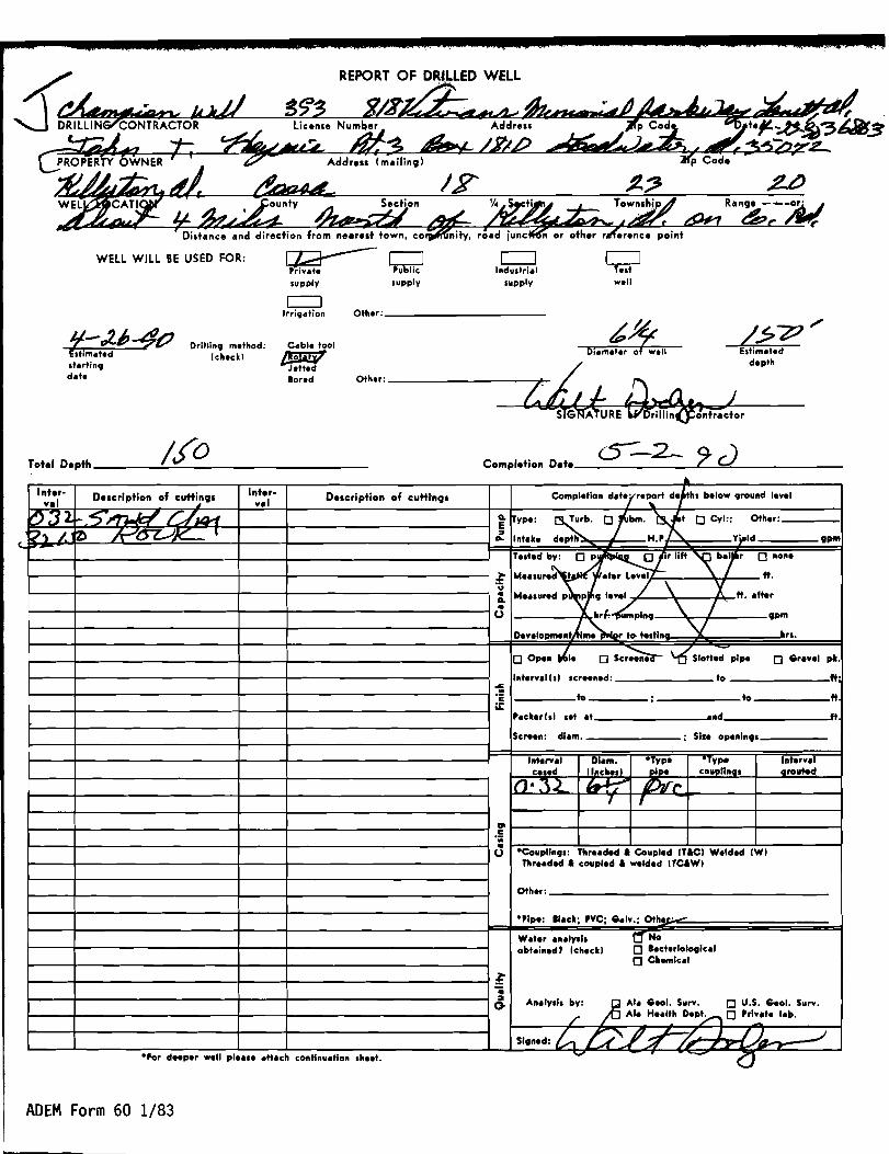
REPORT OF DRJ,LLED WELL
WEll Will BE USED FOR: [=:J CJ~ Q Iftdustri.1 T.st supplv supplv supplv well
c=J Other: _Irri,.tion
/??/ ;'~-:l"~ ~~_&L-K, __ __~_Il ~ . ": Drillin, method: P;t~I;;OI Estim.ted
(check' depthst.rtin, Jetted d.te Bored
Other: ~ ~ z:~L.- aA~,o=o~)--.......SIG A'\uREDrillin(fontr.ctor
Tot.1 Depth / J0 Completion O.te ~-2- 9' cJ . Description of cutt~nCJs
~;}2 -.5nwd rAUW i2) ~O JV' I ,
Interval
t:?" /.--
I
Inter- Description of c:utti-nCJs Completioft d.terre~rt d;rh. below ,rouftd level val
Q, ~vpe: Turb. Dfbm.•~ D eVI:: Other:
E '" Yi-'da- Intete depth H.P ."'" .l
Te.ted bv: 0 p~ 11ft ~ bir 0 ftofte
"N"~~."'''''' ..'u Me••ured p p, level / \ Y ft••fter..
Q,.. hr. umpln, \ / 9pm0
DeveIO"",eftb.(.m~r to- te"lft V hu.
D Opeft tf,.e o Scr~ '-6"slotted pipe o Sr....' pt.
Ifttervelhl Icr••ned: to ft:....'c to : to ft. a::
P.cterl.1 .et .t .ftd ft.
Screeft: dI.m. : Sile Opeft1ft9'
Ifttervel DI.m, °Tvpe °Tvpe Interv.1 used IInche.1 ..i_ couonna. arouted
If)' :"\2 ~ IDJr,., {
VI c ';;..
·Couplln,s: Thre.ded I Coupled (TICI Welded IWI0 Thre.ded I coupled I welded ITCIWI
other:
·Pipe: tI.d; PVC; S.lv.; Oth _•. -
W.ter .n.,v.l. t:f'No obt.ined' Ichec" D ••cterloIo9Ical
D Chemical
~.... An.lv.ls bv: ;f5 AI. Seol. Surv. D U.S. Seol. Surv.G /'
AI. He.lth Dep~ D Prlv,te I.b.
Sl9ned: ~ u'/~- ,L / )A .-/
ADEM Form 60 1/83

; g Z IS J-= ... 4 ;e .W' 4 lalii" "J ~
'I. Section Township Range - --or:
road junction or other reference point
WELL WILL BE USED FOR: ~ c=J CJ Private Industrial Tell supply supply well
c:::::J PubHc supply
~ Irri'dtion
Other: _
/I- :9-2? ES'limated Itartin9 date
Drillinq method:
(checkl ~Ol
~
Jetted Bored Other: ~ ~h;;
~~ #M.£~R~Drilling Contractor
b ''''' Diameter 01 weI!
~5~ Estimated
depth
Total Depth vyrH= Completion Date /1- J-~7 Inter· ve;
~O J.:r~ _"'" ~
1
Description of cuffin!Js
~ ./"Lc/~ PLJ7L /
Inter· vel Description of cuttings
: ::l...
Completion date: ~rt depths below 9round leyel ~ ,
~ype: o Turb. ~m. 0 J~ Cyl:: Other:
Intake depth H.P. Yield
Telted by: 0 pumpin9 .yr lift 0 bai7 0 none
9Pm
~ 'u•Go
0•
"'ealured Stati Water Ley
"'ea.ured pumpin leve'/
~ I. pu
,
\ /
~
ft.
ft. after
9pm
Deyelopment time prior to- tellln "" hrs.
~n hole o Screened o Slotted pipe o GreYel pk.
~..'c LL
Interullil scr••ned:
to
Packerl.1 let et
:
to
and
to
ft:
ft.
ft.
Screen: diem. ; SI.e openln91
InterYal caled
I", .'"L.')
Dlam. flnchell
fiJJ,..f I
·Type oloe
"/01/;V
ype coupHnen
InterYar orouted
'" c:.;;•0 ·Couplln9S: Threaded I Coupled ITICI Welded IWI
Threaded I coupled I welded ITCIWI
Other:
·Pipe: Ilack~c1aIY.; OthM:
Water analYll1 11 No obtained? (check I o lacteriol09ica'
o Chemical
~ ... ::l
0 AnalYll1 by: o Ala Geol. SurY. o U.S. Geol. Sury. frAla Health ~ o PrlYate 'abo
Sl9ned: 7-. ~,,1: ilA ·For deeper well please attach continuation Iheet. ~ "'"'" G
ADEM Form 60 1/83

.". '.
, ,
c•• ~."
"\' "
,.
>~J
',';,1, ,~_l;.
/~:"":,.,;'>.
w'/' .
.:' ,.
).~j.
c;
:!J-
n . . ,,/
../~.
/
..../ I
f'
oo
"-(
/-
,/
£ 1
<.) o.
----0
~/'#
6
'....
J-'
':' $
,,', ~
•
..... ••
l.o1'
/
/~
\.
\
)
'.--.
'iii'~"
';
'~':'.'
/t:';:',:.-
."".
! ,'.
f -l'

..~ \' Y' 1 '~j " U~ 5.q.EOLOGICAL SU~VEY •j", " ,,~.,',' '1c.~· ,; r ~f
'f! ' ' _ P. O. Box 2033 , ,.- !l ri ~>j ~ 1 • 1''If'; UDivenity, Alabama ~ 2. I
,~i; ~ ~ ,c:it,EllICAL ANALYSIS REPORT IDATEi--__
0wND HQ rjo- s~ ._CoUNTY: c.QQSB...__.L~ .. _ MlAii', eo T: Smith - te.Q.~J,I.t' :LocATION (Well-§mjq) Irc. I lytoa, Ill.. _
24 sf(AJ eon15DEPI'H FEm. ARTESIAN ( ) NON-ARTESIAN ( )
W. B. FOBMATlON_._.. CoLLECTED By.x...L3..-...DATE 1- ~f·~:L
USE &.&0Al awppll' ANALVZED BY. :r: IIY. G'''ria SAMPLING CoNDmONS--._. WAte.Y ~y~ie. ...... - 5m .. 1J 5P"'~"'j ~ m~. ftom----.....---_._-_.._---, CoMPLETE ( PARTIAL (v1' PRELIMINARY ( FJEW ( ) 54~OO / -rkr~'" hf$ 1N..7f.Y .fo'r dr:,~k;~ only
::~~,
S'o.l'\·lf~1;Of\- IVo pos~,.bJ ... poll",+,~n of •
;:;;~,i" 5'P""Y1j ~
Pro), Jtm1 - $pt'ln, t ()D -fQI1' f 1'4 lOY' , '"1.00I. Co"+....\AO""~ .p', IJ~J WI t ~ a. Ij ~c. . R.. i ~&
:1;,,.,..v..,),''1 spl".nJ' ~
,f'. B'. - - - • - - - - -_ 4·' eF.1emperat1lre' • - - - -
~a I
011' - - - c.ILAIC
.Appearauce , 1="--,,-._.!JlL D. 01.1 ...._-_. _ .._- -_.
Remark. fl.. ~ot Q. :2';. r'CooL 3'1. If
ppm Total Hardness (Soap)
CoNTENT
IlJ 'Ie (Total) D. :U., Cl 7.D CC?a 0
J , ,BCO. aro, NO. NO. 0.(;, )[11.
'I. (").:1 810. Color Wa" Bbsolved SeIitlB 0Ivc.
I ' '" :'J
I


.K
"
J ~ .. WID Ixp. (GW) ven Ro. .;?::/ , April 1966
WEll SCHEDULE U. S. DEPT. or THE INTERIOR GEOLOGICAL SURVEY WATER RESOURCES DIVISION
MASTER CARD
.£" Source Record by ~....~f data ~'~.r Date ~.;v:"'r*p ~ a.. 'II'
Jt'./..,~
State .#.#4,,, I ~; --: I(~~n~;;".,) 4?",a1JEJ~ ~: Ci1iJ .P [d 14: SO GJ~ Longitude: 14# I ':~ I ~; ~ 12-:~ I ~:~:~~ial r::1 ~ 7 m~nA1' sec ---;I,; 12 degrees IS min sec ~II
Lat-1iog accur ey: li..--~ I. Zt7 w, Sec J , N.... to, oa; to, h"..w to .....,_--::--:--::-__
wel~ber:!#Sig :-ti & ;!1?1 o!;: : !.o! ! : :!2 I ~::~r:';:~ Bfo M
woO> "'" lor,! ~i i ;"1 1 i i !..I : ; i : i.J~, ='l ::,-: Owner or name: I?d!~~ !Atd:~:Ei.4!.r1 I ! ! I~: LL--r ~~ "' JrL- 61 . 56 66
(C) (F) (M) (N) ~ (S) (W) r-::1 Ownership: County, Fed Gavlt, City, Corp or co,~e. State Agency, Water Diet 6~
(A) (8) (C) (D) (I) (F) AIIn (I) (M) (N) (P) (I.) Use of Air cond, Bottling, Comm, Dewater, Power, Flr~ Irr, Ned, Ind, P 5, Rec,
~ (S) (T) (U) (V) (W) (X) (Y) (-&) ..I.AI I Stock, Instit, Unused, Repressure, Recharge, Desal-P S, Deaal-other, Other ,
Uae of (A) (D) (G) (H) (,) (P) (I.) (T) (U) ~ (X) (e) ••r--l well: Anode, Drain, Seiamic, Heat aea, Cba, Oil-gaa, ReCharge, Teat, Unuaed, w~w, Waate, Deatroyed. ~
DATA AVAILABLE: Well datal.r-I Freq. WIL me".: /' r7I Field aquifer char. 7·0 70 ~ 7.D
Hyd. lab. data:
Qual. water data;!l::.I!!.: A~ Z ..leJ 7r?f
760Freq. sampling: ~,~/ ~ Pumpage inventory: ~ period:,- 7, e..:,:;t"
yea 770Aperture cards:
Log data: 1\ : I 7' 7'
WEll-DESCRIPTION CARD
ISAME AS ON MASTER CARD IDepth well: ....K ft ~. pp~.r"0 ,19 ~ accuracy
(~m~ ~:~~~5 ~_I'_' ft 1 2' i :Z; 6' I ~n ; Q!!!!. d' in I 29 Ii: I (C) (Fl (G) (H) (ill) (p) (S) (T) (W)~ (e) CKJ
Fl . h- porous grave w. gravel w. hortz. open perf., screen, ad. pt., shOre. -t' ----!!!.!.... concrete» (perf.). (screen) • gallery, end, e, other 31
Method (A) (8) (C) (D) (H) (J) ~ (I.) (T) (V) (Ii) (i!) r.:I ~d: air bored, cable, dug, hyd jetted, reverae trenching, driven, drive ~~J f ....--- rot, rot., p cue.ion, r.,tary, wash, oEher 32 .... Date
~ ~: 1"J':~7 I 9:.e- : z IPump ft I ! : Iintake setting:
, 3) » J' 3. :II
Driller: ~~M9en ~&".,,~ A4,t,""'4 n....,e (L) (M) addresa
Lift (A) (B) (C) (J) (N) (P) (I.) ~ (T) (i!) r:::I ~[£]fuE.!2.: air, bucket, cent, je·t, m(~;~~~)J m(~~~c~)· nooe, piaton, rot, ~I, turb, other ~ Shallow 00
Power nat LP r:::l Irans. or fuE.!2.: diesel, e, gaa, gaaoline, hand, IU, Wind; .!!.al. .,/.a L:!:J meter no. _
Descrip. MP ;6~ .... 4v"'~ ~.,- , f~:~D, Alt. MP Zt!r.r ~: #i, I5 :;Y; lrJ~: dlMdb ...L ..(ZJ//!.()~
.. 2 .5Water ,./.. above above I!! ~ 1 -- / / W
~ Level rl'~Y ft f2 MP; F~ LSD ;; r:" Accuracy: ~~ • ~ -'IP~1' Date •• " I I Method r7I
meaa: fI!~« 52; L : 55 ll.!.!!!.: SO 'gpn i ! :, 1$" determined l!.,.J Dravdown: ft .2 i ! IAccuracy: 0 '!::;r~~8 .0 hraL.U.aJ QUALITY OF .. r71 WATER DATA: Iron • &:JJ' I,uu.m, ~ Chloride /'- 0 ~Hard. // L.(•.Jppm Sf. Conduct 4 "'''p. - ~r oFl .. i"lid ~:d gr,(:~y ppn Iz!~ Ie" T.ate. color. etc.

Ven 110., _
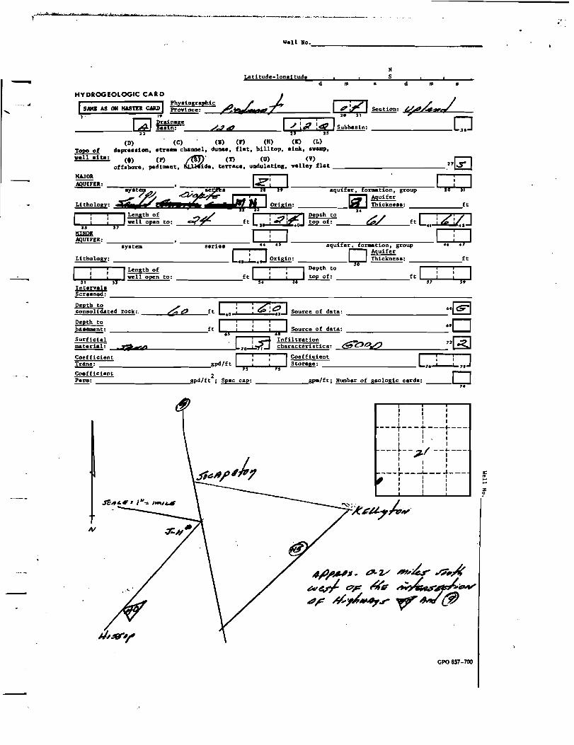
II -HYDROGEOLOGIC CAR D
Phyaiographic SAMIl AS OR MASTER CA&D~:I, J
~
C£] K~:i~ge -------- 22
'I i ILength of....,.rT,..'L...-I...r.'t"S... vell open to:
Intervale Screened:
Depth to conaoliCl4ted rock:, __-"':::..:=
Depth to basement:
~.s-
rL d m a
./l. /d~~ F;"i71~:
~ /4&1 I /L; :a ISubhaaln:
23 25
Latitude-longitude S
(D) (C) (I) (P) A/lP') (K) (L) clepre..i01l, atre_ channel, clunea, flat, ~, alnk, avallp,!2P!L2!
ven alte: (.) (P) An (T) (U) (V) offahore, pedi_nt, hh'(.ide, terraee, UDdulatina, valley flat _..:....
~~~Il: l.z; l-----=,.....,.....................,............-,~_=_--I : I---=ay"'a"'t""...=----•
earl.. Ii i. aquifer, formation, group 3& 51
Lithology:
I.a-r~~.;J., d! t I~: [(J ~~~:::..:_--;::::::::;;:=::;:::ft
Length of L ! :;1 Depth to [i i OJ ....,.:'r•.a.._....."'S"J'f- vell open to: /0 t!!P' ft --::: 0 iEtoJ top of: __-=3~7tC.. ft ,4'~.J
=EIl: ---==-:-::--_1 .. :.. I ---.,..~__-~---I I system series· • aquifer. formation, group 4' 47
L ' J D AquiferLithology: ...1-. ~: Thicknea..: _~;::=;::=:;::f::t
oS 61
K+i3 Infiltration characteristics:.a;,L
; ICoefficientI :gpd/ft Storage:73 ,.
'01 1Depth to
ft ,.......,...l_.............- top of:
-;::=:;:=::;:=:::;==;
_ ft Lo! :~ !.d Source of data:
ft i : ! ISource of data:
d m a
~//'" 0
r::1.27~
: I---T---+---+----: I l
I I I
---t-- 3 -'-t--: ' :---l----L.-- -1 _ I I I I I : I : I
.re"c.C' • I". I r/~...-..=---.c:..--------...,jL-L---l .IV
~:.
GPO 857-700
I ,ft L...,....,...L._...L..,...,_
--;:=:::;
..~
·,D '2~6'0C!V.2
L..L..L,.J
I I I , I I
l
.:........ z o

't ~t1t: *'M'i1 m!:,teie -...... ",'+:f
Ill]) Bxp. (GW) WoURo. ~ April 1966
WELL SCHEDULE U. S. DEPT. OP' THE INTERIOR GEOLOGICAL SURVEY WATER RESOURCES DIVISION-
MAST ER CA RD ---... Source Q /~
Record b.l of elata ~L. t;/I-/Wt.J" Date '-~1iL !!!E. ~ 004 ,Hrl"'l!,. ., County
;~ I I (or tlJlln=::)~:4=:::~=tiI~=i=:;:;i=:::;== L:JzJ
Sequential o:J~: it' I 0 ~ I c: /II : Lo:gitude: Id: ,: ~ I d ; i I ": 0 I .!!!!!!!!!!!.: 7 n A.f")9 sec ~ 12 degrees IS min .ec.1 I
Lat-long CJY G" accuracy: 6' s. R :#0" w. Sec 9 , ",~ \, <""€ t. #1"\ ----;:-...-u--
> B & K
vel~ber: (jf: hiAS.!~ :O! 2l : l 30! ! I : I~:::r: _.J=~-::.;'~Z _..I~ I..! ! !.0: : : ! !..! ; : ! ! IJ ~: «4-/h.. A I~...~
n L Owner 0'1' name: I~!. !-1-:. !-:.: iri e-!A INtC:.e.! I~: 4" ""~<' AJ.L.=,A15 u ., .6 ....,. ~ ~
(C) (F) (M) (N) ~ (S) (W) r:::1 OWnership: County, Fed Gov It, City.' Corp or Co, ~ State Agency, Wa~er Dist 6,L..e...J
(A) (B) (C) (D) (E) (F) I<i'i'>\ (1) (M) (N) (P) (R) Use of Air cond, Bottling, CoaIIII, Dewater, Power, Fire,\.eI lrr, !ted, lad, P S, Rec,
~ (S) (T) (U) (V) (W) (X) (Y) (-&) ..r7.'"1 Stock, Inatit, Unused, Repressure, Recharge, Desal-P 5, Desal-other, Other ~
Use of (A) (D) (G) (H) (f) (P) (R) (T) (U) ~ (X) (ll) veIl: Anode, Drain, Sei.mic. Heat Res, Obs. Oil-gas, Recharge, Test, Unused.~, Waste, Destroyed .,~
720DATA AVAILABLE: Well data@ Freg. W/L meas.: ......1 _ ~ Field aguifer char. 70
730Hyd. lab. data:
Qual. vater data;!n!!.: __.e.e:."AolI~&"'_'£~"u;ttu/=__ _ 7.[£] l.LJ Pumpage inventory: y~ period: 760.Freq. sampling: /?.t!.I9/I..UP/ - , 75 ~ ---------
yea nOAperture cards: .
Log data: I ! I 7. 79
WEL L-DESCRIPTION CARD
ISAME AS ON MASTER CARD! Depth veIl: -?p ft I : : '7 i~ I~ /2n.,..It..w=~4J 240 I i, 20 = 21 accuracy'1 I Depth cased, I ; : : I Cuing ~ / !"
(first perf.) J4 ft ; i ", i <::1 !n!!.:.' Tn .";!!!!!!. r, in i -- 2$ 21 - 2'
(C) (Fl (G) (H) (t) (P) (S) (T) (W) ~ (l!) lXJ Finish- paroue grave v. gravel v. horlz. open perf., screen, sd. pt •• shored p n ~-------0 concrete, (perf.), (screen) • gallery. end, , other :~
Method (A) (B) (C) (D) (H) (J) P (R) (T) (V) (W) (ll) r::-1 Dr1lied: air bored, cable, dug, hyd jetted, air reveree trenching, driven, drive ~J ...f--- rot, rot., ercua n, rotary. va.h, other 3 ...
~~::~led: .L-zL-..rz 19:.r! ZJ P=p intake setting: ft I ! ; I --- 33 35 ~ 36 ,.
!!!!.!!!!.: "K.J:tIl'iiPt~£UItI(i'OJ.. q ~C46'2'" -4414-, (L) (M) ·aCl3fe.. 0!:!.ll (A) (8) (C) (J)' mu Ie (N) (P) (R) (S) (T) (6) ~I@](ill)1lY2!l: air, bucket, cent· e (~~~~.). ~~~~C~)' noae, p~eton, rot, suhmerg, turb, other ~ Shall"" 40
P""er nat LP r=1 Irana. or (type): diesel~gae, gaeoline, hand, gae, viad; .!!.al.. J.. 4 tn :=_=te~r~n~o.:.. _
Descrip. HP ~ <?'Jr 4rlE'er#,y;;,...., ~~?7 - ,t f~:;D • Alt. HP 7..?/.11
~: 2U'bP I!: ?:..7 l/ I~: #7.#4#...:/JAtJUJf/lq{.< .7[2] ~~:~ 2JU' ::D I ; !z !? JAccuracy: ~ 520 Date .1 ,51 Method r;-l
J~" " ;;;&.: ""il?-~'" .~ I ~ gpm'6 de'W;;inad L/ .J ".J-s-
~: ft L. I ; D=~~s hr~LJ_L.J~-?-~-; QUALITY OF ~ u 65 r=1 WATER DATA: Iron ¢, &- Sulfate rI Chloride .:<_ 0 r:;;'lHard. .:ss: L1i':J
ppm • r-:-1 ppm ~I ID ppm ~ ppm I r6SE. Conduct
Taete. color. etc. ~
r" K" 10 1 J I T...,.. t'~ OF u i ,:, ;;;10/ 9-d-~r.l if: l i(

r~-,-,'to,'.· ,
Well Noo _
- N Latitude-longitude S
d m d m
HYDROGEOLOGIC CAR D ._.-...
I Physiographic A / (" I; 71 SAME AS ON MASTER CARD ~:~~ ..,,~ If': r ~:II I' -I...L=""":::<O=:L..~==:~~~~:.: 20 > 21o R~:t~~ge /.?4r 1/ iJ?:;Z I~:
-------- 22 _.LJB.-"""-_________.. .. ----0 ~ well aite:
MAJOR
AqUIFER: __==::-- _ ft
ft
__J',=..::'C'==---- f t L.. I ~ S~urce of data: ______..IDI Depth to ~: ft ~~~;----I.!--~!~r-lSource of data: _____6·0
- 65 68 Surficial / ~:~J Infiltration material: .JAi,~ C~=" 1.4«"'"~71' characteristics: 72~ Coefficient ICoefficient [ i i J Trana: gpd/ft 1 : ;: , Storage: 7,..L.-l.. 71
73 15 Coefficient Perm: "'gpd/ft2 ; ~: _________gpm/ft; Number of geologic carda: _0
79
~ I I I I : i
---f-- - ... ---~---I I I I
---t-- ? --t---i
___ ,...: :1-
i IIi: i : z
I I I I I
I
__ ..1.I _
I
i o
GPO 857-700
-

. ,~ '" ...' ... I " ---~'-~~--. ""t,
J_ W.ll No. ;r:...z ,~;~WaD I!xp. (GW) I
April 1966
---"
4!~~
-3:-,--1,-7
c --:/ /z c/r-
WELL SCHEDULE U. S. DEPT. 01' THE INTERIOR GEOLOGICAL SURVEY WATER RESOURCES DIVISION
MASTER CARD
Record ,¢.e. ts:"~"' ~ : p .....r; ~j State ~..,.. 1 2 .u.n,} ~~~ Lf~J --- , Ii' , i , n..1
I-V
Iii I iiiZ01 'Sequential ~ ~: ?:~ ~: L- ,,~ ~: ~ ,Lat-long _ accuracy: ~J T, z..:s '"S. R .2.6 w. Sec "y . ........., \. « \. .r::i,./ \ "'""',.-;;-__
we1i"~:;b" '1 I:J:±-?11a-b? l1'!.3 i : !.o! ; I 132 I~~~;r: .J= / () B& M .i i ; ~ i ( i ;;;;;;; i : i , , , , , I - 0"'£ L"'r;.r
Local use: .0J I .. ~
I
1. 51
Owner or name: I;¢A'! /:~: !£:~!".; 7j : ~: Ad/~A/..d,., .56 .1
(C) (F) (H) (N) AfT") (5) (W) _r=-1 Ownership: County, Fed Gavlt, City, Corp or Co, ~, State Agency, Water Dist 6~
(A) (B) (C) (D) (E) (F) ~ (1) (M) (N) (P) (R) Use of Air cond, Bottling, Comm, Dewater, Power, Flre~Irr, Hed, Ind, P S, Ree,
~ (5) (T) (U) (V) (W) (X) (Y) (~) ••r:rl Stock, Inatit, Unused, Repressure, Recharge, Desal-P S, Desal-other, Other ~
U.e of (A) (D) (G) (H) (41) (P) (R) (T) (U) ~ (X) (ll) .,gwell: Anode, Drain, Seismic, Heat Res, Oba, 011-gaa, Recharge, Teat, Unused~ Waate. Destroyecl.
72 0DATA AVAILABLE: Well datag Freq. WIL meas.: ~./"- _ ~ Field aquifer char. 70
730Hyd. lab. data: --;__--.- _
Qual. water data; ll1!!.: _--L.A::.....<~2!'!'ii'fi'=~.e./:....-----------------------------7·0 Q yes D. n
Freq. sampling: .5 Pump.ge lnventory: ~:
yes 77DAperture cards:
Log data: I : I 71 7f
Well-DESCRIPTION CARD
ISAME AS ON MASTER 9£ I :s:d;0?; 31~' I?&,L,~.". 26~CARol Depth well: ft I 19 20 ~3 CY acctr8Cf"~ Depth cased· ""~ Casing., /I:: ""': ,.1 I !, I
(first perf.) r; I ft i ;" i ll1!!.: «'''C? T7 , ; Diam. 4- in i 2.5 2 "7 ~ II: 5,
(C) (n (Cl (Hl (41) (P) (5) (T) (W)dm (~) IAl F" . h" poroua gravel w. gravel w. horlz. open perf., screen, sd. pt., shore, p 1t .....!!!.!.!-. concrete, (perf"), (screen) , gallery, end J e, other 3' Method (A) (B) ~ (D) (H) i (J) (P) (R) (T) (V) (W) (i!) r-:-1 ~d: air bored~, dug, hyd jetted, air" reverse trenching, driven, drive L.~J --- rot,' rot., percual10n, r"ltary, wash, otner~_r-_r-_
intake setting:~;~~led: /-~S-s'" I ?; ~ r IPump ./ z,? ft I ./! ~? I Driller: _'_'- '. ~,.e&4J""~~C~. ~A"'~ 41.,(Nf •• •• L' f@ame(L)(H) /'" ~ [£Ja~ ~....!...!. (A) (B) (J) multi le multiple (N) (P) (R) (5) (T) (i!) c:::. . ~: air, bucket, ce ,jet,' (ceni.)' (turb.)' none; pilton, rot, lubmera, turb , other 39 a1 ~o
Power nat LP Trans. or ~: diesel~ gas, gasoline, hand, gas, wind; .!!.al. ~ 7~ [£] meter no..' Descrip. MP ~d ac= ~""1~ c:?-a ~: 72;b j ={ :7 :zl ~: '7[2]
42 4j II-' ~:~:~ KO? I ; ; .1Lt...JLSD tr Date' ... Method ~ me.. : ?-6?-U ~ I ~d gpm.6 ~in.d L.'· ~: ft [.2 i ; IAccuracy: D ::r~~g hraL• ..LJ..J QUALITY OF ~.. ~ •• ~ I1J WATER DATA: Iron - O.,s- 0 Sulfate Chloride";:' , 0 Hard. .J1 I.
ppm. ppm 7 ppm ppm i r Sp. Conduct 32/ K x 10
6 0 Temp. ?? 'FI i,...!? I~led .?-~-~K ;! If : .' ~:2 7" • 7
Ta.te, color, etc. ~. ~/~
I .~.".......-.,741
f...... !l!: o
..
l

• •
vell "o.' _
'- "Latitude-lonsitude S d
HYDROGEOLOGIC CAR D ] Phydogr.phic / /I. SAKI AS 011 IWlTU CA&II~: &~,,~ I I.
W H~:t:,ge /.7 4? 1/ i.e i« -------- 22 is 2'
(D) (C)' (I) A'P)\~ (It) (L) dapre.. iotl•• treaa ch.DDel. du.... ~ hitr.op .inlt. - ......~
vell .ite: (t) (P) (S) (T) (V)offahore. pediillllnt. hill.ide. terr.ce. undnl.U.... v.lley fl.t
m d m
r;i2l~:~/ ~ ~
I~: -----------0 ~ .27L.t:..J
~~R: Iz l ---:;;;=;--'"'l!:==---::;::::::-_1'i'1•
• ..' "'-&K~emP.l~d;:.er~~ 2i.. .qUifr.::;,A:~~;:; group ~ Litbology : .' s1""St;r-_~-;,.cL iff ~! t 1.2!!I!!l: I.lIJ Thicknea.: _---;=:::;=:;~ft
ILength of L ! i Ai Depth to./ L? ~l"""'l2~''''''-''''''S"71'''' vell open to: 3a ft -3 i ~0.1 top of: -'Q=-..::.~"'_ ,ft -.. "~.J"31:
=ER: __---.,.____ __----:"=""':-:--__1•• :•• , -=-..,..,...,. ,...-.,........,..,....,- --=--- : I syatem series aquifer, formation, group •• 47
i AquiferJ D ft:L:i:th:O~l:o:g~y~:-=~_;:=::~;_---------L.J... .2!!I!!l: Thieme...:.0'I ILength of I IDepth to I
'""'1."1',.....- .....':'03- vell open to: ft ~."1'.....-....1"""t..z-ol top of: ,ft --:.7;-'-.....'""'1.'=.... Interv.b
Screened:
Depth to consolidated rock:
::::.~~: --;
~~:~~~~~ ~4-Coefficient Trans:
~~~ ~!!!!!!:
~-----_;:::::;::::;::::::;:::::;_--------------------__;:::::::; / L ! ! ~~4 r=1..lello£:..:l=.6: ft .0: : e:~J-l Source of data: ..L&:LJoL
ft Ii: ! ISource of dat.: ..0 .J 61
c h~ li'¥d ~~;~~~~:;~:~iC.: ,P~dR T2E)"7 I:: ICoefficient
gpd/ft 7:1. • 75 Storage:
2-"spd/ft ; Spec c.p: .oSpm1ft ; N\aDber 0 f
[ ' i J76~7'0
geo1ogi c c.rd.: --- 79
i I I 1 I ~ : i---T---+---+---, I I I I I
---L-- ; ~-L--i I I ,
: : I ---1""---1---...1_-I I
I ~
I: I : I
~
-_
if
GPO 851-700
-

so
••
Source of c1ete
name:
~ tr'. . .. .. I I , I AD' , I , ! 4' f , ,
, ii' iii iii i ,:r: :E:Af,F:1 j.(J l~iElRj
Record bY'/;Q. &CI2~"
/7/It.I?4-~ I ~; / I~:~n~~) , ii' , i , ...tot 2
Longitude:
j/. Sec /f __ i '
" " ,/. ~.. ,.,
h '"k" )·.. ;).···8.''1.... ....... '<"""-~--~, b,' "", ""' .....~u-~.. _A&.~ao--'"~_~~, .......,' I'd' 'k ""* ,.,. .~~---~
WID Esp. (GIl) wan Bo.J J-=* April 1966
WELL SCHEDULE U. S. DEPT. Olp THE INTERIOR GEOLOGICAL SURVEY WATER RESOURCES DIVISION- 4-Jf~ .
... A ~AL.1~1~
tfO 6:"~ r tl "," , ~
MASTER CARD Date ~~-';J"-t:§ MaP~"¥~ /~~,; ~ eOOS4., ~ifJ
~ :'IU:?1 sa9uentia10 ~: I I IJ 1_ !!:l.iZ...l !!!!!!!!!!:
'2 egrees I~ min lee II 1 Lat-l~ng accur cy: . Sw \. Ne \. .sli'
Local "ii' .Other velrn;;;;;ber: iiUiiibe"r' .
LDeal use: I , I 51.,.j ~ ..~:&~=~ , i ,
Owner or ~:·j(el/eyiPn . ~.-, ) (C) (F) 1M) (N) (S) (II) ~
Ownership: County, Fed Gavlt, ~ltYJ Corp or Co, State Agency, Water Dilt 6~
(A) (8) (C) (D) (E) (F)~) (I) (M) (N) (P) (R) Ule of Air cond, Bottling. COlD, Devater, Pover. Fire Dam, Irr, Mad, 1Dd, P S, Ree,
~ (S) (T) (11) (V) (W) (Y) (.) ..i":"'T1 Stock. Instlt. Unused. Repressure. Recharge. Desal-P S. Desal-other. Other ~
Use of (A) (D) (G) (8) (C!). (P) (R) (T) (U) (X) (Il) ••G2}well: Anode, Drain, Seismic, Heac Rea, Oba, Oil-ga., Recharge, Test, Un~sed , Waate, Deatroyed
720DATA AVAILABLE: well data@ Fuq. W/L meaS.: p 0<:'- fleld aqulfer char.7. ~ Hyd. lab. data: ---:=__-:-......_-:- _ "0Qual. _vater data;~: _....L~-"'=v::.....f'_.:.,..:<:L~·::...l!'_ 7·rn
i 760ruq. sampUng: _--'o"'-'-'1ecc:.-. _ ~ pumpage lnventory: Y::. period:
yes 770Aperture cards: -;:......;=:::; I ; I Log data:
71 7t
WEll-OESCR IP nON CARD
ISAME AS ON MASTER CARD IDepth vell: ~ 9 ft I i I 6 : 9} ~ 2·m accura-;y1 l' I I 20 2~~ I I
(~m~ ~::~~~ 55)?; ft j !~; 5 ~~I sfd.6ltr.stGe! ; Dlam.b ln if - 2S 5. - - !if ;B
(C) (n (G) (H) mP (P) (S) (T) (II) (X) (II) [i]Fi isha porous gravel v. gravel Va horiz. open perfa, screen, sda pt~, shored, QPen ~ _n__" concrete, (pe~' lacreen) , gallery, end hole.. otner ."li Method (A) (8) (C) (D) (H) (J) (R) (T) (V) (II) (iI) I'A1 ~d: air bored, able dug, hyd jetted, air reverse trenching, driven, drive ~ ~ ...--- rot, rot., percu.sion, rotary, waSh, ----,o"'t"'h"e"rr--_-_-_-,.-_-_r-"""'! ...
~~:~~led: 10 -1- jY 19!~ :51 PUIUP lntake setUns: ft I ! ; l ~3 3' 36 ~ •
~: . ~, . <Je.-~ ~ (L) (M) addr..sc=r ~ 0 D [TI.llll (A) (B) ltiple multl le (N) (P) (R) (S) (T) (II) eep ~ .llIP!l: dr. bucket. (centa)' (ture.)' none, piston, rot. aU~I, turb, other 39 ~ 4D
Paver nat - LP // Irans. orIC' I (type): dleSel.8 gas. galGUne. hand. gas, W1Dd; !6l.. /::)... -...J meter no. _
Descrlp. MP« 2 fR~:'~~D • Alt. MP Y~ ~: 2"'; I:: ~4'!~ I~:~«,#Jk,...,..l; '{:2]
42 45 -rA'l ~:~:~ ~ '!-.:J-o ft ::~: MP; Fe :~: LSD I l :~! iLl~: ski -I-a-ee 't.!LJ
~ •• fro • ~:~:: h':§~6f .~ ~ ; Ie l )fl" !!ill: 1 ! ! : :(4 I ~lne~:;Jgpm (
. ,6;fo ] ~: ft L. I : IAccuracy: 0 ::r~~& huL• .l..J..s
QUALI"I'Y OF Q" ~ os DWATER DATA: Iron Sulfate Chloride rlHard • n
ppm • ppm 7 D ppm6D L-n-' ppm I I
Sp. Conduct K " 10 Temp. - oFI i ! I~led ~ -~,,-S ~ ; , :::,~ 7. 7. 77 ~
Taste, color, etc. hwe. ,. ~<-

liell No., _
N Latitude-longitude S - d m d m
HYDROGEOLOGIC CAR D
I Physiographic SAME AS ON MASTER CARD ~: Pf,1J.,,,~ 1~i?1 ~:--~ I ,I ,. __~c::..UlOlll;le.tIllilml~~;::=:;:=:;:=:. 20 21 ~
ILl «~:t~~8e /.1~ ------- 22 _..L.=....,,=-- _ I/b? :1; I~: 023
Topo of well site:
MAJOR AQUIFER:
ILength of
....,,:":.r-'--....1"""Ilj"l'7. we11 open to:
twlQI!.AQUIFER: _~~:-- _
system
Lithology: ft
ILength of
1..-,'~I~--"-:5"'- well open to: _________ft 1""".,.••...l.__I....,.......J
Intervals
Source of data:
Source of data:
Depth to ~:
~:
~ L !consolidated rock: ...s::->L..~,, ft 60;
________ft I,. i ; i ,. I Surficial .~~ / L; J Infiltration ~: C 7 "",;1" .r:i-",L ~ characteristics:
Coefficient I ! ! ICoefficient!!.!!!!: gpd/ft 1:1: : 75 Storage:
------,.[QJ _____,·0
72 0L i i ]76J........l..7. Coefficient !!!!!!: gpd/tt
2 ; ~: ______________igpm/ft; Number of geologic cards: _0..
I I I I I : : I
---T---+---~---I I I I I I
I ,~f I---t-- /-r--t--I I I I 1A
1---- Ir II- __ ..J:~ _
I I : I I I I : I
GPO 857-700
f .... .... z o

------
:J 4:"
WID Bzp. (GIl) Vell Bo. .:7=-t April 1966
WELL SCHEDULE U. S. DEPT. OF THE INTERIOR GEOLOGICAL SURVEY WATER RESOURCES DIVISION
---_.......
iJ
'-10
~~.5£--~b 1--'0"
MASTER CARD
aecord by z;., ()'.1f",e;t!.':tu~~a E:(.{;,(W~)' . Dace· 7·:!..~',f 'MapC;t.tnly J.hf'~ /i/6'H':' llm Ul4t4cffldL 1:'; I I(:~n~~) C4c2~<L ,- Ul.iJ ~: 5'"1 u.~itUde: I J II j, I o! -,.,1 it! ij =~iel n
'7 n 'lee S
12 ;tIre.. 13 miD ••c II Y Lat-~~ng tf() ~ ~~~ . accu cr: .2 ~ S. a:2<J w. Sec I:T , .....~ k. At!,,:'~\. S£ \ __....".....,......",....-__
B (0 M
Ve1~ber: ~! 'dO !?Jl~ :,,! 71: :!:: t~::~r: .... _.;r:<--'-._-f~_'biit: ~, 10 5.--- u.cal use: It! i,1 ! ! 40: : ! : i.J !! l.J ,~:.:5#n1 lJ;~& Owner or name: l.s;.q !n;, i'p! Ii:.e:k:; ! .! .. ! Iid,;~~:~~~a~-,qI4Lw""A...
Ii 56, 6' ~:; (C) (F) (M) (N) (S) (\I.) ~
Ownership: County, Fed Gov' t, City, Corp or Co tate 'aency, Water Dist 6'1...::I::1
(A) (B) (C) (D) (E) F fCii>\(I) (M) (N) (P) (a) ~ Air cond, Bottling. eom., Dewater, Power, Fire~Irr, Mad. Ind, P S, Rec,
~ (S) (T) (D) (V) (W) (X) (Y) (-&) .sr"':"'71 Stock. Instit, Unused, Repressure, aecharge, Desal-P S. DesaI-other, Other L.l:Zl
Use of (A) (D) (G) (H) (,) (P) (R) (T) (U) (X) (.) well: Anode, Drain, Seismic, Heat Res, Obs, Oil-gas, Recharge, Test, Un~sed Waste, Destroyed ..~
DATA AVAILABLE: Well dataCiJ--Freg. WIL meas.: t2..t1.e.:. Field aguifer char. ..0 70 ~
720Hyd. lab. data: ---,,..,
Qual. vater data; llI!!: _.,:,..£~~~.::.:.._hL.:.~·=ed:.=.,-- . _ 74[E] yes
760Freg. sampling: DI/e ~ Pumpage Iinventory: no' period:
yea 7S 770Aperture cards:
u.g data: -I D..7S--------========-----
...f... ~
Taete, color. etc.

,.
lIell No, _
N Latitude-longitude S
d m d m- HYDROGEOLOGIC CAR D
I Physiographic A - / /.ISAME AS ON MASTER CARD~: nt......., ...:z:: I ~;71 I I. 20 21
[2]22 R~:t~~ge /~ dZ I ". itJ lea I~:-------- 23 15 (D) (C) (I) (F). ~ (It) (L)
Topo of depression. stream channel. dunes, flat~~sink. swamp,
well site: (t) (P) ,.m (T) (U) (V) ~ offshore, pediment, ~ide, terrace, undulating, valley flat 2'~
MAJOR AqUIFER: , . I.;:::; I__===--==~~r-:--lo
---:-,':'sy=s;:,te::m::---- _erie ,. 29 aquifer. formation, group ~ (/J) ,'._L . p/;". . I :.(". r.::;"'l Aquifer
I
Li tho logy: &.''''iPY~eJ.. ¢I :t;;~~O~r~i~g~i~n~:..::;_;;:::;;_:_-- ..,~ Thickness: _~;:::=::;:=;~ft; . ILength of [;.' i JDepth to . [ J""3~,~:·-....I"""3"l',- well open to: ?w2 ft 3'~~: t::t!1 ft .,: ~ tf?
=ER: _~=:---_I : I I ; I system series 44 45 aquifer. fannation, group 46 47
i AquiferJ D ~ '0
ft
IL~i~t~h~O~l~O:gy~:.:~~=::~~---------L••..l.... Q!!.&i!!: Thickness:
Length of I Depth to II...,sr'l,""'"-..........' ...3- well open to: ft ..,.3~.""'"-....L....,3i'll.- ~: ft ...-:,t"l,,.-I-_....L....,sr:.:Intervals ~:
~ consolidated rock: --"~;,tfZLd,,--__ [0 ! !?!~J Source of data: -----_••CQ]ft
~:::e~~: ,ft I ! : : I. Source of data: _____··0 '2~:~;;~~~~ ....~.~"'~,.1.". "'~'j~-=...s.:;::=:'OWOEJ«IEI~iL----·-3-~~+.iJ .!~;;~~~:~~:~ic s:_-'C' ..
Coefficient I : ~ ,Coefficient L i i J!!!!!.!: gpd/ f t 73. . 73 Storage: 76....1..-...l.. ,. Coefficient 0!!.!!!l: gpd/ft2 ; ~: gpm/ft; Number of geologic cards: _
70
I
I : I : I i
---T-- - ... ---~---I I I I I I , I I
---t-- /~-t---I ,
:-- r :I __ '0.J. _ I i
i I I
I I I Ii'
GPO 857-700
)

-
'J Well 80 LlfR.6,E: \)Je..u.. .. . ...?F"4,,'-"", VI]) Exp. (GW) April 1966
j
WELL SCHEDULE U. S. DEPT. or THE INTERIOR GEOLOGICAL SURVEY WATER RESOURCES DIVISION
MAST ER CAR D
Record by ~.~."·d..Jl..,;rr:.:"E:/.,b'v4 ve,s, ,Date1-~-&;~ MaP~t21'~~~'!t /:1"",,: ...,--~
!1!!!. _--;.a=~~~/.=~;::=;A,=;:=::;=:::;::::=;l0::,.....;.,2~/I(~~n~;;".,) e""tf4.:· ~_ Ulil ~: 9' ~ I ~ ~~ Longitude:I~!,14 I ~r42J2-1 =~ia1rJ1
A/l"'t' • C 12 deare.. Ii min .ec.1 L..W-J Lat-ling c..r ,-? accur cy: ;, T • ..2.:a s. Il U w, Sec .,IlL , #*'" \, JW \, KfJ \ __-:;'-:-~__
wel~~~~be. It; '1j~'!e!~: 1 ! : ! I ! I~~~~r: ..7= <p B & M 10 52 ~
Local use: I~ i1f1 ! i .Q: ! !! !J ; i ! ! :.J ~-: Le9r"l &Ce
Owner or name: I~: ~~! ~.~ !#a/ :~ i €i ! I :.! '! I Addre~: ""Kt:II~¥ T1 A/4..ha ,n a15 S6 •• •• r 7 .
(C) (F) (M) (N) ~ (S) (1) _r::1 Ownerehip: County, Fed Gov't, City, Corp or co,~e, State Agency, Water Dist 6~
(A) (I) (C) (D) (E) (F) ....,(!IJJ(I) (M) (N) (P) (Il) Use of Air cond, 10ttUll8, COIiID, Dewater, Power, FirelJ?sp,(Irr, Mad, Ind, P S, Ilec,
~ (S) (T) (U) (V) (W) (X) (Y) (it) 6.r:;'l Stock, Instit, Unused, Ilepressure, Ilecharge, Desal-P S, Desal-other, Other ~
Use of (A) (D) (G) (H) (,) (P) (Il) (T) (U) ~ (X) (a) well: Anode. Drain, Seismic, Heat Res, Ob., 011-8as, Recharge, Test, Un~.ed, W~, Waite, Destroyed ··11v I
720Well data~Fre9. WIL meas.: / ~ Field aguifer char.DATA AVAILABLE:
~ ~ nO "yd. lab. data:
Qual. water datai tvne:' ".'" 4 '£""!'.:. / a_ 7'r""7I"""""" --,',,". -;"'.. /- ~ / I ;ye8 0
Freg. sampling: <?2?)"-d?n4 Pumpage inventory: t5J period: 76
"0Aperture cards: yes
I ; ILog data: --;;;;;;;;;;;;;;;;;;;;;;;;;;;;;;;;;;;;;;;;;;;;;;;;;;;;;;;;;;;;;;;;;;;;;;;;;;;;;;;;;;;;;;;;;;;;;;;;;;;;;;;;;;;;;;;;;;;;;;;;;;;;;;;;;;;;;;;;;;;;- _ 7. ,. WEL L-DESCRIPTION CARD
ISAME AS MASTER CARD IDepth well: I~ ft I I ~ J:::' .&1Iz</k t?~·lZJON [,~/It 19 2: = 3~e..-;...' accuracy
(~m~ ~::~~5 Ji 2-- ft I :'" :; :~c r... ; l1.!.!!!. ~ in I i ~ I -- 25 ~ ~:. 2' m
(C) (F) (G) (H) (~) (P) (S) (T) (1) ~ (15) [:;:]F1 1 h- porou. gravel v. gravel w. horiz. open perf., .creen, ad. pt., .hored ~ ~. concrete, (p~r , (Iereen) , gallery, end. ., otner ~~,
Method (A) (B) C) (D) (H) (J) (P) (R) (T) (V) (1) (il) r-1 0:: ~d: air bored, abl dug, hyd jetted, air rever.e trenching, driven, drive l.~ ~ --- rot, rot.. pereua.ion, rotary, va.h, oEner :'J""2"".....
~;~~led: ;. - ~'f ... ,., I~ is-I ~ IPump intake setting: I ~ ? ft I" !Z- : z I ~ 33 35 / +- 36~'
~: L":i· 4"''''''''''4C4<i«N<i'"G?.. ~AI:;,¢II A46M4r 7 ~ess AdS.
~ ()Y!!. (A) (B) (C) L (M) (N) (p) (Il) (S) (T) (15) r=1 ~ r=-1
J!I2!l: air, bucket, cent j ,me~;~r~)' me~~~&~)' none, piston, rot, aubDIrl, turb, other ~ ShellOW~ Power Glnat' LP r-=l Irana. or (type): diesel, e gas, galGline, hand, gu, Wind; .!!.al.. <?-5' L£J _ter no. _
AI above
Descrip. HP zt.L Y ~~! "'- i ft bel_LSD, Alt. MP.:za.
~: ~y l=t2:$"12~:&£-u.l 44.* ,4 '7[Z] ~:~:~;f ft~above:. F~above :~SD I ; !v!s-I Accuracy: ~~J~ ~~.' Date A' ., 51 [ I Method ;;;U;: ;;-~I"-.rz y"j4( 55 ll!.!!!.: ~() gpm i : :.:f'1d' datera1nad ~.53
-- '6 60 J '. ~: ft [2! ! IAccuracy: 0 ::r~ii8 hraL• .LL. QUALITY OF r;A" 11 •• r-:L WATER DATA: Iron - tt~L..WJSulfete ~ Chloride ~ f ~ard. "~ ::-'12Sp. Conduct .FIJ,;' K ':106[3 Temp.P~.t" !4lL I~:d .?-Af-"I2I~ :, (tf
13 1. ~ ~ h f •• te,· color, etc. ~

I
IIell No. _
- N Latitude-longitude 5
d m d m
HYDROGEOLOGIC CAR D
I Physiographic"",,- ~ ~I 14; t'l ~: -~"'7""'c;,-,I""",,-,,,,;L-'i/ _. SAME AS ON MASTER CARD~: rL~ ~ 2:0 ; 2: I
~ R::t~~ge /&,d 1./ La' :g l~: -------- 22 -....:.-'--''''---------- 22 2S
I "
----0 (D) (C) (1),,(f1) ~ (It) (L)
Topo of depree.ion, .tream channel, dunes, ~t~p, sink, swamp, well site: (t) (P) (5) (T) (U) (V) r:::;'\
ofbhore, pediment, niUside, terrace, undulating, valley flat -,=:-::-_ 27~
system ~ • -.--.-~--_-=ss~e=?r='re=s::----bt; 2f' aquifer, formad~n, -~r~~;·~110~ ,::L:i~th~0~1~0~8~i~:.:·~M~:;:.~~1r~ l4ItJ .Q!!&!!!: ~ ~:~~~::.. : ft
r- ILength of L i i -J Depth to [i i i ~J~S""'"-....."""lI3'!17- well open to: 2 g: ft 3'~~O~: /~ Z-- ft !.J..:l..i.1r=J ~3~~ER: __----,-,=>""::-::-__ 1.. .. , ----:--;,.....,-::--.,..----.-,-_.,..."...--.__ i I
system series ~ aquifer, formation, group 46 47J 0 1
AquiferL I ftL:i~t:h~O:l:o:g:y~:.:::;~=:;:-::-_________ ••.1.-.. .Q!.!..8!.!!.: so Thic kneB s:~ : ILength of I Depth to I
L...,3"",..l.I--l....,s'"3...1 well open to: ft .....3.....l-_..l...,3"'g- toP of: ft --:s';'7....- .....--:3":•..1I Intervals ~:
______0·1.0 I ______0·0
72[E
Source of data:
1 I I I I I
i : I ---T-- - 4- ---+---
1 I I • , i I
I ' I---t-- I';--t---I i i I I I I
~--- r---I--- ..J. _ I I : i I I I : i
~ consolidated rock:
I1a ./. ~./ir ~aa/4 /;k/de,ft~. I?F ~ ~ ~
GPO 857-700

i
"0: «.
WKD Exp. (GIl) Well No.~TJ ..z:" ,April 1966
t
~
~
~
--, J
-~-~
=.J ~o# ,.,
~ -~t'~
-=3
WELL SCHEDULE U. S. DEPT. or THE INTERIOR GEOLOGICAL SURVEY WATER RESOURCES DIVISION
MASTER CARD
Record by~.a-...4, ~~ud~~a ~.... Date~'*~( Map <ft- a, " ..... ~'" ~ ..eM&.. c:?y I(:~n~;".) 4,,,,. C;d2J ~: ;i. ':Z- ~ Lo:gitude: 1'" Ir 14 16:l' IJII k I~~ial r:1
lJ::> 12 degra.. U min sec II L...f-lLat-ling accur ey: ~ Z!J 2,0, "'. Sec H . ~ \,,r;,, . \. ~ ~ __--;:-~:--_-
Local "ell number: e~~-~hd;tZ;4:<2:8: ; ! 'O! f I ! I~:~~r:..z=p B & M Lucal use: I;: Ci! ! i 40: : ! 1 ! •• 1 : ; I ; ; ,J ~niL: -7::1, #.,./~
53
Owner or name: IOf :.e: W!'d:~ !~I«!!"iAJ i l' i !-I~~: -d/ ..rJk- .IIL,.r $6 .1 6.
(C) (F) (M) (N) ~- (S) . (W) .r::;"1 Ownership: County, Fed Gavlt. City, Corp or.Co, ~eJ State Agency, ~ater Dist 6~
(A) (B) (C) (D) (E). (F) ~(I) (M) (N) (P) (R) Use of Air cond, 80ttl108. C~. Devater, Power, Flre~Irr. Hed. Ind. P S, Ree,
~ (S) (T) (U)' (V) (W) (X) (Y) (iI-) ••r:i1 Stock. Inatit, Unused, Repressure, Recharge. Desal-P S. DesaI-other. Other ~
(A) (D) (G) (H) (4)) (P) (R) (T) (U) ~ (X) (6)~ ,,[;]Anode, Drain, Seismic, Heat Rea, Cbs, Oil-ga., Recharge. Test t Un~sed. W aw. Waste, Destroyed.!!!!.l:..
DATA AVAILABLE: Well data~ Freq. WIL meas.: Field aquifer char. 7·0~
70 ~ Hyd. lab. data: "0
..[Z]QuaL water data; l.:l2!: _...A=~_:c;-·~h.L<~..,,"'/~---------------..,....----------------------------
~ yes Freq. sampling: ~"...-I"~A;f./ L.frJ Pumpage inventory: <9 period: "0
yes ,,0Aperture cards:
Log data: :::0 's " WEL L-DESCR I P liON CARD
ISAME AS ON MASTER CARD IDepth well: rr ft I ; 1 3";.5"'" 1~s. AiuJ4". ).... s 2·m'1' 20 21 ~ accuracy Depth cased, Ii: ": I Casing ----oJ ~ I:~ I
(first perf.j ! J ft i : k: I l.:l2!: ~ ; Diam. ~ in :62 2S 11 --.. 30
(C) (Fl (G) (H) (4)) (P) (S) (T) (W) ~ (i§) m Finish. porous gravel w. gravel w. horiz. open perf., screen, sd. pt., shored, Jl -------" concrete, (perf.), (screen) , gallery. end, e. other 31
Method (A) (ll) ~ ~D) (H) (J) (P) (R) (T) (V) (Ii) (i§) r=-1 ~d: air bored,~, ug, hyd jetted, air reverse trenching. driven, drive L.~J ----- rot, rot., percussion, r'1tary, wash, other ,if
~:~~led: /,~.. f, 12:6!.1 IPump intake setting: ft I ; ; I 4Ve~~~~ 0:;. 3. 21
~: ~~~~~, b¥MA"'.I.. ~ik;,M" . .. Lift (A) (B)' (C) nA(L) (M) (N) (R) (S) ad (~) 1..:7' I 8 r=-1(p) (i§) J!lE!l: air, bucket, cent,(lS;I, m(~;~i~)' m(~~~~~), noae, piston, rot, .ubmer~, t~rb, other 3. ShallOV~ ~ > nat LP J,. r::1 Trans. or ' J!lE!l: dieSel,e, gas, gasoline, hand, gas, wiud; !!.al. ~ ~ "m"'e"'t"'erO-.'n"'o"'·c _
Descrip. MP .7jD J' ~~~~~~~~~~~==i~~~=:_-----ft~:~D , Alt. MP 2f':!.. ~ Accuracy: . ~ / r=1
~: zp .i!2!!!£!l4fh;le:"II~V -'''Ala~.", •7 LZ.J Water above 42 above I I .-oJ _ J r:-1 Level ~.-" fte£MP; Ft~ LSD :; ~i1( ~:...llTiEL 1'1tp6 ''U!...J Date "'. $1 I j I Method r:rl meas:@---.If'..4-t'· 53 p" ! 55~: C gpm i ; : l~ ~inad L?t.J
~: ft [.! : IAccuracy: 0 '!:;r~~g .0 huL.U••J QUALITY OF Q" ., 0 WATER DATA: Iron SUlfate ll Chloride IlHard • 72
ppm • D ppm ~I D ppm L...,;-' ppm 1 r6
Sp. Conduct 10 ~S:·F : ~l.rl ;led4-Z~-4::! t?; <LeK x Temp. 13 7'" no- --= II- ",. ~
Taste, color, etc. ~$ ({d,J -'..t
...f... z °
,..~.:?,. 'Y£"'?'I:~j~;C:";:;'7 ~ "::I4"',i :~?ii~'''1~7 :P~~P9 -
1
·~---~-~---~---~.
Ven Ho., _
H Latitude-longitude S- d m d m a
HYDROGEOLOGIC CARD .)
I Phy.iogr.phic' ~I./'/I~IIHE AS OR MASTER CARD ~: __--;AG<.;btll&-".e.-ll2,tL_·-;:=::;::=:::;:=~~'~:IZjrr-~: .ju.~~l!!~V~.i!!!.-':2!!:il:loLL. _ , . ., ~ S- 20 I ..,
-------I4J _i~_:_t_~~ge ....4~~.~4~ 1~:..? :~ I~: ---------0 (D) (C) (I) (F) (R) (I:) (L)
depr...iOD. .tre_ channel. du.... , fl.t, hilltop••ink••vamp.~ ven aite: (t) (P) Am- (T) (U) (V) r=1
offshore, pediment, ~de, terr.ce. UDdul.ti.... ".ney fl.t .27L=:t.J
MAJOR ~ ~ AQUIFER: _--:=:=- ="""",..-__ .E' =.,..,.- ..,...-,==-- - ' .y.t~ '.a;, ~. I~ ...U1f~A:~~~:; group
~L:i:t:ho;I~0:g~y~:-=I?k~~~~~;&!I!Ii~I!#I!I,!!l;.;r;~UII~E~1I7..~~: ~ Thicknes.: _::=::;:=;;:::ft 1...;.1'I'......_..I.,SI"!,1""1 ~:~~t:P:~ to: c:y( ft L. !~ i2Q ~::t:f~o ---J~_~£.... ft L..LllZJ AQUIFER: :
.y.tem ----s-e-r-:"i-e-.--- .... ~j aquifer, formation, group •• 41 twIQI 1 I I : I
L ' J D Aquifer..:L~i~t~ho~l~o~g:y~:~:::;~=:;~-;-_________ ...l... ~: •• Thickness: _-;:::=::;:=:::;=f:.:t
r" i ILength of I IDepth to II""J~I...IIo-_~.'l"S~ veIl open to: ft _ ••,....l.........L...o.....-, top of: ft '--:....,..J..-..L...."'p_3
Interval. Screened: ;:=:;:=:;:=:;:=::;;- --;:=::;
~~~~~l~dated rock:. -e;;~p-..t2c:::...--ft L.. ! !Z1 '?J Source of data: ..1~I
~:::.~~: ft Ii! ! ISource of dat.: ·pD6) 61
Surfici.l L i ~ InfU tration r:::;"l ~: 4'rc 7 • ..l..'1?.J characteristics: G'£::)Oc:2 12L.5J
Coefficient I : : ICoefficient L i i ].I!!!!!.: gpd/ft : ; . Stor.ge: 1.~7'
73 75 Coefficient 0 Perm: ~gpd/ft2; Spec cap: ,gpm/ft; Humber of geologic c.rds: _
7t
I I I I I
l : I ---T---+---f----
I I I i I I I ' I---t--;I --j----i I I I I I I
~ .- 1-__ ..1 _
I~ I I : .. I I I
I : i z o
N
GPO 857-700

----
'j .~'
WI]) Exp. (Gil) V.11 No. .tz=::.J!t. April 1966
WELL SCHEDULE U. S. DEPT. OP' THE INTERIOR GEOLOGICAL SURVEY WATER RESOURCES DIVISION
- Source of data 4!!F." -~y~.c Date ~D-~~ MaR. ~~ ~.h.',{
~ r---T"":" ~ A£,bll!A I t:';Z I(~~n~~) a".rA
. I , I iii >I .IN' I:: I ! I : I Sequential C?J ~: /
g 7 min , sec ~ '2 degrees 15 mln eec, II I ~: ~-~- tV I - Ie , -'=IS LongitUde:. bIT i' ~ i f 0 :~
-GJ Lat-long _ t9 (';JIT accuracy: 1: T ~~ S. I. ~ y. Sec ,2 I . At'~ I,; • .s:;,.., 1,;. HI I,; __---,.....,......,. _ ~ wel~ber: i!t~,dd l'pf ~:4:9: I" l
, .! ! ; :
5a I~::~r: -c~vu H
Local use: I~ ill 1 i <.: : ! ; :..: ; ! ! : ;J ~e: /,LA A4./'4a~ name:Owner or I~ !~: :ifv:~Le1£,i/Z!~I~ ! ! I~: R4'a~ p,J,..
i2 '6 61 66 ~ ~ (C) (F) (M) (N) Ai'tl (S) (W) s--;:"I
Ownership: County, Fed Gav't, City. Corp or Co, ~e. State Agency, Water Diet 6~
(A) (B) (C) (D) (I) (F) /t'il) (I) (M) (N) (P) (I.) Use of Air cond, Bottling, COaD, Devacer, Pove:r, F1're~, ITT, Mad, Incl. P 8. llec,
~ (S) (T) (U). (V) (Y) (-&) .1r:if1(V) (X) Scock, Insc1c, Unused. llepressure, Recharge. Desal-P 8. Desai-ocher. Ocher ~
Use of (A) (D) (G) (H) (~) (P) (I.) (T) (U) @ (X) (6) well; Anode, Drain, Seismic. Heat Rea, Oba, 01l-ga•• Recharge, test, Unused, W thd v, Waste, Destroyed. ..~
----'----,
720DATA AVAILABLE: Well data~ FreQ. W/L meas.: / Field aquifer char.
Hyd. lab. data:
7. ~ ,,0
Qual. water data; ~: 4/dN& ..0 760Freq. sampling: o Pumpage inventory: ~ period:
7, e....::;t/
yes 770 Aperture cards:
I .,: I Log data: ----;;;;;;;;;;;;;;;:;;:;;:;;:;;;;;;:;;;;;;:;;:;;:;;:;;;;;;;;;;;;;;;;;;;;;;;;;==;;;;;;;;;;;--------- 71 79
WE L L-DESCR IP TlON CARD
ISAME AS ON MASTER CARol Depth well: e~ ft I : :9: Zd~·lJ&.J/q.cL4 2<0 ,I. 20 d rL, 21 ~ ~uracy T
(~~m ~:~1~1 ..E~ ft I I :of ;.r-I ~~g "Me J{fL '; Q!!!!!. It' in I !:£) -- 25 2' 2' ~
(C) (Fl (G) (H) (lP) (P) (S) (T) (W) ~ (a) W F' 'h" porou! grave w. gravel w. hortz. open perf •• sCJ:een. sd. pt., shored p .y ~. concrete, (perf.), (screen) , gallery, end, e, other -~,
Method (A) (B) (C) (D) (H) (J) AP)) (I.) (T) (V) (Ii) (~) r::-1 ~d: air bored, cable •.dug. hyd jetted, ~. reverse trenching. driven, drive l!:'.,J f...--- rot, rot.. percus810n. r"tary, wash. other 32 ...
if=~:~~led: ft.z- -£9 17;.;r:! ? IPump ft I ! : Iintake setting:=r- 33 35 • / 36 3S
~: .::-.c. W..w....,....~<2 .. ~~ 44U'-d Lit name (L) (M) > :t<fr..s. 0 __t (A) (B) (C) (J) multiple multi 1e (N) (P) (R) ~ (T) (ii) .r ~[Q]~: air. bucket, cent, jet, (cent.)' (turC.)' noge, pi.ton, rot, ~1"a, turb, other 39 shsdow <.
7 ~ nat LP r:::t Trans. or ~: dieselrS gas, gasoline, hand, ga8, Wind; .!!..al. .OS- L.=l..J meter no. _
// / c'"") Labove ., Descrip. MP ~~ zi:? 4'.-:'""-4r~ r.ro".,.... <IF 'U..... ft bel.,'0.SD. Alt. HP __"';...:~:::....II =_ ~: 7~o I;: 2: ~;.- l~: A~'iJ e"M,..,...b.,.. ..5]
"2 .. 3 -r::-1Water Level ;2 7 ftcraboveP; Ft ~a:o: LSD I : ! z.! 7 l~: ~ ''I£.J D - ... 51 Method....- m m:~:: t<-J -q ..~ ! 55 r!!!!!: /S-gpm. I I I / I ~in.d (,
~: ft C.: ! IAccuracy: 0 :~~r~~s hnL.LLJ
QUALITY OF D·· ~ ., 0 D· IlATER DATA; Iron Sulfate . Chloride Hard. 7'
ppm.. ppm 7 ppm ppm I r Sp. Conduct K x 10
6 0 Tem:z' .FI!! I;led : : 73 • 7 7" 76 77 "
Taste, color, etc.~; G~~., !
. -;:-::"?':. J., ~
.. •. ':i4#5.r'ij -:;: ~.

, ,
: : ' I----r----I--- ..1 , I i I
I :
,.
Ven 50., _
- N Latitude-loogitude S
d .m d .._ 111.
HYDROGEOLOGIC CAR D ;i- • •
I.SA-·AS - UAaTllll ~A.ftI Phyeiogrephic /' ~' / LA ..... .... .-.. ........ ,~: __4::..c.. ... ~ ~: VA:/;...,'*"-IIZs.rr.;~~=:::;=::::;:=~I'. 0 ,
r:i Hretnase /..2L I L::? :'2 I D--------~ ....!!..!!: - -- , 5T - '''''!!~: ----------- n
(D) (C) (I) (I') ~ (&) (L)
~ -amp.c1epreaaiOG. atre_ chaDDeI. dUDea •.n.t billto. aink. _11 aite: (t) (P) ·(S) (T) . (V) r:7'1
offsbore. peditDent. bill.ide. terr.ce. uodul.ti.... v.lley n.t .'7L!!.J
=~R: --""':'ay~a::'1t~_=---- ---""a::e::r'11":e:::a~--I1i: if l------=a-=qu:':'irf...e"'r""......f"'o'=rma=,-tiro--n-•......,g'=r-=o:':'up=--_I SO;. 51 I !L:i~th~O;I:O~8Y~:~~:(~O'~_~V~4~(~·~*~.:....:.l!!eiil'•.i;;~!;iii4E~=_~~: ------1iJ re~~=:: ..:_~=:::;=::;:::ft
ILengtb of -P"7 ( :;;:;:;;1 Depth to L !~r3' 37 veIl open to: ....: ft o3'..L:z:.l-troJ top of: __-'3.....::..•..:<z.. ft ~1;.3 :~
=EIl: _--,-__ _----::-:=__1.. .. 1__----.,.,......---.-----,..,-- 1 : I .yat.. serle. aquifer, formation. group .....,
.::L:i:t:b~O~IO~I:Y~:~:::;~=::~-;- LJ....J~: 0 ~~~=::...:_~;::::;::::;::;f:t~r i ILength of I IDepth to I ""'1.'1",...- ...';'....... well open to: ft 1.,...,....J1-....1...,3!!'g..l top of: ft --:'.~7...L.-..."l!.......J
Interv.b Screened: -;::::::;:::::;:::::::;::::;- --;::;;::;;
pepth to L : ' '-::::I r""jI;"'1conaolidated rock:. __ ....:...- ft •• ; :J :'=ji.J Source of dat.:--".$.='.s= ••~
~:::.~~: ft i ! ! I Source of data: "Da, Zi Surficial _/ _ / [i ] Infiltr.tion r:;"'l!!!:!!!!.!!!: ~:? ~ ~~ characteristic.: /"7ft/A' 72~ Coefficient I ! : ICoefficient [ ' i J Trana: gpd/ft : : Storage: ; :
7:1 . . 75 7.-----7'
Coefficient 2 0!!!!!: .J5Spd/ft ; Spec c.p: S\>IO/ft; Number of geologie card.: _
7'
,I : 1 I 1 Il I I
---T---+---f--- I , , I I I I I
---~-- 2/--"'-- I I'
_ I :
'
N
GPO 857-700
-
~ ...... z o

'~ .,... \Cot':! ..... .~ ~ __;~~ '_ ...... .•.••. ....~_~-t ;. <"*': .tEi:"~ii(j';~ f ., ~~, •.. e . we r ~ ~..' .. J VIll Exp. (GW) Wall No. ..;T: '/0
April 1966
WELL SCHEDULE U. S. DEPT. or THE INTERIOR GEOLOGICAL SURVEY WATER RESOURCES DIVISION-
MAS T ER CA RD
Record by d~' a/.J., ~~u~~a IF.'~. <:e.__r ~-Zf'7~V!!!E.Data, =-- ati ,.~,.-.£ State .##4A.d: I ~; <I(:~n~;;",.) Q,;?J;1t __~;.ZJ
, iii , i "N I::::::: I ! ::L I : I Sequential ~ Latitude: ~ ) - ! - II ! .. , a IS Longitude: C: ¥JG c'; T .z:d .!!!!!!!!!: I r/!
Qi!:Ji 7 ml.l~ sec (J!J 12 aegrees 15 min sec II 1 Lat-l~ng accur ey: 0'" " t'.L s. R?t7 w. Sec z./ . «~\. A(A:! \. Nw \ __---:,....,.....,..,... _
Local we ll'OWDber: li'+:~-~J: a k.i:/ :0 I I i)o: ! : : I~~~:r: ..;r:.s- B& M
Local uae: J1.i :~ ! .0: : : : :.J ; : i ! :J ~e: ~.£~; ~ft;,h7L Owner or name: 1?,,1? !~~!f1 !it~ 1/!c--:p l""!~!d"r~:~. ~WAte4TrJ .56 61 6' .....",
(C) (F) (H) (N) ~ (5) (II) r::1 Ownership: County, Fed Gov't, City) Corp or COJ~' State Agency, Water Dist 6~
(A) (B) (C) (D) (E) (F) ft)(I) (M) (N) (P) (I) Use of Air cond, Bottling, Camm J Dewater. Power. rlr~ lrr, Hed, lnd, P S, Rae,
water: (5) (T) (U) (V) (W) (X) (Y) (-&) ••r-::1 Stock, Inatit. Unuaed, lepreaaure, lecharse, Deeal-P S. Deaal-other. Other ~
Uae of (A) (D) (G) (H) (4)) (P) (I) (T) (U) (X) (.) rI well: Anode, Drain. Se18mdc, Heat Res, Obs, 011-g8a, Recharge, Test, Unused, ~, Waste, Destroyed, .,~
720DATA AVAILABLE: Well datal.;-I Freq. W/L meaa.: /' r::;r Field aquifer char.
70 I..tr=J 0 73
Hyd. lab. data:
Qual. water data; =, b:'/ "0 Freqe sampling: ~~;AA ~ Pumpage inventory: & period: 7·0
yea 0Aperture cards: 77
I ;' ILog data: 7. 7' WEL L-DESCR IP nON CARD
ISAME AS ON MASTER CARol Depth well: /~ ft I : ~j(:cr]~:' .o~/4r4,£ 2'[L] I 19 ~o ~t!9 accuracy Depth cased: / j: /; f : '" I Casing ./ I 1, I(firat perf.) /J ft.!i:2!.: oJ tif=:! J; Diem. C, in
) 2.S -- , 29
,(C) (Fl (G) (H) (ill) (P) (S) (T) (II~, (ll) r:r.J Finish" porous grave. v. gravel w. hariz. open perf •• screen, ad. pc. shor • p .Jr-------0 concrete, (perf.!. (screen) • gallery, end, e, other 3f. Method (A) '(B) (C) (D) (H) (J) ~ (R) (T) (V) on (ll) r=1 Drilled: air bored, cable, dug, hyd jetted, air reverse trenching, driven, drive ~J f...--- rot, rot., 8s10n, r')tary, wash, other 32 ...
~~;~~led: JI-$-' - ~t? I 9":?'! col Pump aettin~: ft I ! IIintake 33 3$ .--/ 36 31
Driller: _. ~-M-""'V".P~~_ ~41!A1' 1lik ,. Lift (~) (B) (C)~ mUl~~) Ie mUl~) Ie (N) (P) (R) > (S) a re(~) (a) r=1 B r:1 ~: 81r, bucket, cen~ (cen~.)J (turC.)' no~e. piston. rot, 8ubmerg, turb. other ~ Shal1OV~ ~ nat LP r=1 Irans. or ~: dieael,@, gaa, gaaoline, hand, S88, Wind; .!!.a!. d.. cr- L.£J meter no. -'-__--- ~.I
Alt.Descrip. MP /!?!~ d£ 1a~ /! 0 ft',;el"" LSD ,
, I ! : : I Accuracy: .,r:I;t-j': (I tJ Alt. LSD: A:?Z.tL : Z; d' j kr ~ LZ..J ~ .. 2 _r-:-t-~.~ 4"
~:~:~ atU r ft ~ MP; Ft ~ LSD I a.: ! zJ. II Accuracy: ''l!!..J
L...Z.",c. I i J ; J lid ~ined[] .. .0 [I , J'
_____h,re • ...L-.l•• ---I "uwu"" ,/..-V ~Hard. :Jv [:iJI... :,~; i3 ~:d izr:~;pm I ,,; :7i I
IAccuracy:
S'p. Conduct
~: ft
QUALITY OF WATER DATA: Iron ,,_ " _a:..
Date • /.A£/ r.;z; ~, ~--me88: ~;.,t:FL
Taite. color. etc.
~~f

Vell Roo _
N Latitude-longitude S
d m d m- • HYDROGEOLOGIC CARD ~
Phy.iographicISAM! AS OR KASTD. CAIlI)]~: A~a" ~~:~ I " . r-::;'l Krainage
,~ .aD: /.:2 <z I,i"'" :~ ISubba.in: -----------022 -
(D) (C) (I) I(Jb /fir) (1:) (L) depre••ion••tr'" chaDDeI. dU....."i'r."t~. sink••vBIIp.I22!W!!
_11 .ite: (t) (P) . (8) (T) (U) (V) r::::I offsbore. peditlent. billside. terrace. UDdulatiDll. valley flJlt .27~
~~~R: • 12 : l__---::':":':Tl.-=::--===-==--_1'i1~ . .;.e:. n group ~51 aquifer. formation.
ILithoI08Y:d.%4:~g J'iV.!!tll!.!!: ------~ ¢:~~=~:..: ft
Lengtb of .~/ L :L1 Depth to [' i J -;."1',.....- ....""5"'7.. well open to: __-=A;....,,~,e..'-- ftH i /j '7;J top of: /~/ ft tJ.!!..J1..
=ER: .y.tem ----.:-:e:-:r'"'i-:e-:.---1.. :.. 1------=a=qu:':'ii":f..e::r=-.......f'=o=rma=t:-iO:o::n=-.-::g'=r'=o::up::---1 •• : .. IJ rI AquiferL i
:L:i:th:O~I:o:s:y~:..:::;I~Le;:n:g:t:b~O:f--------- .....:..1· ~: I Depth to L....;o--J Thickne...: _~I;:::::;:::::;:::,ft:. 1""5~I..i""""""""J3'- well open to: ft ~5.:--J....-L..,5r•...I top of: ft 57 59 Intervale
Screened: ---------------;:=:;:::::;::::;::::;-----------------------r::;;:::; ~:~~~li~ted rock:. __ .......:::O::...__ft L.! 2 3!~J Source of data:......e;/..'-''S u[£] ~:::.~~: ft I ! ! ! ISource of data: "D63' . . 31 ------------
/Surficial 0 / [ i ::I Infiltration rI ~: ?!/A~.." .t::iwL ~-L4:J cbaracteriatic.: G"O!:111!? 72~ Coefficient I ! ! ICoefficient [ ' , J!!.!!!!.: gpd/ft I : Storage: 76~7'
73 75 Coefficient 0!!!!!: ..asPd/ft2; Spec cap: gpm/ft; Number of seologic card.: _
-: : Il : I
---T-- - .... ---+---, I I I I , I I I
---t-- t/ --r--i I I I I i I
---r----I---...l-- I I I I I :
i : ' L
'" .... " ....
GPO 857-700
-
79

'.."' , _.._-----_._------------_._--- '. ,' •. ;l
Wall No.J ;7=4 . i..;,"WID Exp. (GW) April 1966
-
£~~~
/~ ~..1.9'.J
WELL SCHEDULE U. S. DEPT. OP' THE INTERIOR GEOLOGICAL SURVEY WATER RESOURCES DIVISION
MASTER CARD . ~~ Source
Record by ~. "~~' of data ""...-~ .,. Date ~.~ .....~ ""-""7L~~rMal!..P ~C;~·~·!!o.QfQ:t.-~~:~:~E~;~;::i =J' ~ ~/6.M4 I ~1<I"Mnr,
-"""/ c::::; d.r~ . , , ~:::~~ia1 f"7l ii" ~
~: i ~ i.. :.,. :A: ~:: ~ j'"
i i
~8 7 min ,seF bLat-long accuracy: ~J T~.!I ~ R ;" ],I, Sec :ov" • 4£ \. UN \ • .4!4:..
.\ B & M
wel~ber: bf. ; . !J In ;~: I ! /: : I i ! : i I~::~r: ;E2'30 51
Local use: kff :<aH1 i 40: : : : : oJ ; ! ! ! !J ~e: IL. '.z,{A A4 G~~Z¥ Owner or name: I?~~:~ fdlc::L2d.4!r:....l ! 1 I~;~'~a..< ~L,kA
~ '6 61 66 -;r
(C) (F) (M) (N) ~ (S) (II) J15"1 Ownership: County, Fed Gav't, City, Corp or Co, ~e. State Agency, Water Dist 61L:..J
(A) (B) (C) (D) (E) (F) .AIfn (I) (M) (N) (P) (Il) ~ Air cond, Bottling, Comm, Dewater, Pover, Fire.~ Irr, Hed, Ind, P 5, Ree,
~ (S) (T) (U)' (V) (W) (X) (Y) (r,) ••r:7'l Stock, Instit, Unused, Repressure, Recharge, DesaI-P S. DesaI-other, Other t.=:.J
Use of (A) (D) (G) (8) (,) (P) (Il) (T) (U) ~ (X) (a) ••r-:-1 well: Anode, Drain, Seismic, Heat Res, Obs. 011-gsa, Recharge, Test, Unuaed, ~J Waate, Deatroyed, ~
Well dataS Freq. W/L meas.: /' r:;rf Field aquifer char. ,20DATA AVAILABLE: 70 ~ 0
73 Hyd. lab. data: "
Qual. water data;~: hd:.r2 ..Ie:] , Freq. sampling: ~fi/n,,/ ~ Pumpage inventory: & period: ,,0
yes 170Aper ture cards: -;:....~;;::~
I f:~ ILog data: 7. 7' WEL L-DESCRIPTiON CARD
ISAME AS ON MASTER CARD IDepth well: .,e2 ft I i ~~ '$1-; z I~· dg ,4.: 1.,< 2 4 [L]
I 19 20 • ..J,.3 ~ accuracy I Depth cased: I i [ : I Casing ..~ .., I! ~
(first perf.) t. ft; i /. ~:' Ii! t !IV...."; .E.i!!!!. k in i - 25 ~ 2'
(C) (Fl (G) (H) (~) (p) (S) (T) (II) ~ (l!) GJ Fi i h- porous gravel w. _gravel w. horlZ. open perf. J screen .. ad. pt .• shored p ~ ---!!.....!..... concrete, (perf , (screen) , gallery, end, 'other -3'
Method (A) (B) C) (D) (H) (J) (P) (R) (T) (V) (1;) (l!) r=-1 air bored cab J dug, hyd jetted, air reverse trenching, driven. drive L.~j fDrilll'd: ...rot, rot., percussion, r"tary, wash, oErier 32 ...
Date ~
~: ~/~U .I i.cii IPump intake setting: ft I ! : I , 7 33 ,1 3S / ~ 3...
Driller: ~4~'• ..4lt#-AeO d/~~. ( ~A , n(l!2 (L) aI"ess ~ Llft (A) (B) (C) (J) (M) (N) (p) (R) (S) (T) (lJ) ~ ~ r::-1 ~: air. bucket, cent , m'l~;~~~~J m(~~~&~). nOlile, pi.ton, rot, subaaerg, turb, other t::;,J ShallOV~ Power Itat LP r:::1 Trans. or (type): diesel,&. gas, ga.oline, hand, gas, Wind; ]!.l. • JJ L.£J meter no. ---------7'""---
Descrip. MP ~ <2IG' ~ J7. /<? f~:~D • Alt. MP ~.n'/ ~: cP;; IfiJi? !<fj~: ~N/ S~.,.,(~ ..0 :~:~ &: ?.r ~SD I ; ;2. rf?1~: de/~ ·0ft 02
Date •• " 'I I I Method r;;-, ine.. : 9c.a:/ii' /¥' gpm i ! i / ;y determined t:e,.J
7 D ~ping 00 L! : J ~: ft ....1000_'-::-:-' Accuracy: period hra • ..J...-.J.6I
qUALITY OF ~ 64 ~ 65 WATER DATA: Iron .. /J' Sulfate
I Chloride A' r-:;:;I Hard. ' ~ F'72...l
ppm • r-;'l ppm I ID ppm L...1? ppm I?- --Sp. Conduct :r7 K x lo6LLJ Temp.L.s- OF : ~:..s- .:'::led ?-Z.r-~J'" :
r I
~ 73 F )' ""J'" 76 - 7 ry. Taite. color. etc.
l

,-- ----_.--.-----~---,.--- .,
Vell 1100 _
- II Latitude-longitude S
d m d ml- • • HYDROGEOLOGIC CAR D
Phy.iographic A / r:::7l / /I,~R4B AS 01 KASTIIl~.J Province: Y'~'''_ ~~: ~~
------I4J K~:t~ge L.;!& .I eLi L,I~: D .. ~-
(D) (C) (I) (F) (It) (L)t12lIepre.el...... t:r... CMDDel. du...... nat:. i , elDlt, .vamp,I222..2!
_11 .ite: (.) (P) Aft (T) U) (V) r=iI off.hore. pedi..."t:. h~ide, terrace, uDdulaUng, .aUey nat: .•7~
~~R: • '--_-:r.::'S':=__ lz.. : .,1 -==:=-===--==:::=-_1 •• : ., I ~r $?Lt: Q ;3<;tee aqUifi:f1A::~;:; group
~L~i~t~ho;l~0~g~~~~-!~~6~-~.~~:;!:!~!ii;::::~=~~-~ .!!!!I!.!!: II:frJ Thickn... : _-;:=::;:=:;:;f~tlui h 1~:~~t~p:: to: -=...,L.::'-__"_ft L. 1 i?i5j ~:r~f~o .::~:::... ,ft c.,..LJ.~J
=ER: ----,=,..".."...__1•• : .0 ,--_-=,.....,..,=----""=,.".,..",..,..--:-=,...,,..-__ 1 I system seri.. aquifer. formation, group .....7
AquiferL ' J D ft~L:i:tho:::l:O:!5:y~:.:::;~==__=_;_--------- ...l-. .!!!!i!!!: 50 Thickne...:r i ILen!5th of I IDepth to I
"""'IIJ"I'l....._ vell open to: ft ..r-L...-.....,.!I:.- ,ft _ ...."'lJ!':......"'s3~ .,. top of: """'=5"l'7....
Interval. Scraened: Depth to --------------~L::::!;::::::;::::~::;;::j:::::;;---------------------rl~:::::~1 conaolidated rock: __ ...'- 60: ~.J Source of data: •• '-='-=..s- ft
~:::..:~: ft i : ! ISource of data: "0 .J ••
Surficial h / [ ./ i :J Infiltration r::"'1 !!!!!!!!!!: _.:C:"-':~9",~~_.:::n::.t~=:4(""''- -J ,.,.Z.J characteristic.: c;;'~.o 72~ Coefficient I l : ICoefficient [ i i ]Tran.: --'gpd!ft , 7J' ... Storage: "~7.
Coefficient 02Perm: .....gPd!ft ; Spec cap: ,gpm!ft; N\DDber of geologic card.: --- 7t
: :,: ~ : i---T---+---+---, i I I I I I I I
---t-- Z,/--j--- i I Iii I i--- r- 1-__ ..1 _
, ' I
I ' : i : i
GPO 8S7-7llO

lS:' , .•~itb ri( d ..Kif*' o:...t.iJ..... , ~ I4i:. ;""":l.d.+ qk" ....... , oM i '. n 11 ri/ ( of d'
_& ... 4
WaD Exp. (GW) Well Ro. ..:z=...~u .. April 1966
WELL SCHEDULE U. S. DEPT. OF THE INTERIOR GEOLOGICAL SURVEY WATER RESOURCES DIVISION -
.--~ Source J /'l ..', /'l "" a ... J J ~,/ • Record of data!i.c..~ra.ues Date ~f' Map U!t,u'hy ~!'1!f '"'~'''
~ 10 ! / I(~~n~~) ~a., "- ----lL:j.f]..,'fS ,c.
~: AI s" !A):a1tUde : I Jg: ~ Ib 1 i I¥ !() I =~ial n~~PI,,'l"V 7 n, JA.. 12 ~aree. Ii min aec.1 Y
Lat-l~ng ~ ~ &1,... accur cy: fo': :?3 s. II w, Sec 33 , N'if"~, NC" \. Ale'" \ __..............-__ vel~ber: Ii i; iOCidJ~! I) 21 : ! .J-l ! Local use: I"" :.1 i .0: : ! : !.J ; i I ! !.J CNner or nam:: Ir!H!o:..,!;,,!~1 ;J3iUIRI-rl dJ.! I
ii 56 66
(C) (F) (M) (N) (P) (S) (W) r:;:;:;'l CNnership: County, Fed Gov't, City, Corp or Co, Private State Agency, Water Dist .1L1::J
(A) (B) (C) (D) (E) (F) ~H) (I) (M) (N) (P) (ll) Use of Air cond, Bottling, ColD, Dewater, Paver, Fire Dam, Irr, Mad, Ind. P S, I.ec,
~ (S) (T) (U) (V) (W) X (Y) (-&) 'sr771 Stock, Instit, Unused, !lepressure, !lecharge, Desal-P S. DesaI-other, Other ~
---., Use of (A) (D) (G) (H) (4)) (P) (ll) (T) (U) ~:>.,(lI:) (a) well: Anode, Drain, Sei.~cJ Heat Re., Obs, 01l-gas, Recharge, Test, Un~8ed, Withdraw aste, Destroyed ..~
7~OField aquifer char.DATA AVAILABLE: Well data~ Freq. W/L me".: Me 70 ~
Hyd. lab. data: nO Qual. vater data; .ElP!.: ~..;..,~! ..[£]
r:::z-1 I yes 076Freq. sampling: _ ...o:..<.0<..<..e'- _ f!;i-J Pumpage inventory: no' period: _
yes 77~ Aperture cards: -------------------------------------r:....;,;..;L....J;::::;
I "! .. ILog data: 78
WEl L-DESCRIPTION CARD
/l
: IM__ B & M
,
25 -
(Fl (Gl (HI (P) (S) (T) (W) (X) (a) [l]grave v. sravel v. har~. perf., screen, ad. pt., shored, open
(perf.) (screen) gallery, hole, other 'J J
(C) (D) (H) (J) (R) (n (V) (W) (a) tto--J Date
!.!.!!!..!h: (B)red, cable, dug, hyd jetted, reverse trenching, driven, drive ~~, ...f
rot., percussion, rotary, vaah, -'oijitEln".~r=:::;;::::.;:~ ... g:
Dr1lled: 10- 2y-tt I9 !(; !b IP\DDP intake setting: ft I ! : I, 33 :u )6 2.
DrHler: £i. 9y~es 2)n;, 4 ,....:sy~ ~~ 4. dM,1
n~V(L) (M 7 ~ adare.. ~ 1!i! (A) (8) (C), ) (N) (P) (ll) (S) (T) (a) ~eep ~ f.u"-_\. ltiple, multiple, ~ ~. a1r, bucket, cent, jet, (cent .. ) (turb.) none, pilton, rot, 8ubaaerl, turb, other 2. 11 40
!.2!!.!. ~nst LP 1/ Is I Trans. or.ill:P!l: diesel~g... gasoline, hand. gas, vind; .!!..l.. /,;;2. mater no. _
~.' #'7 Descrip. MP ! 8 ft belovLSD, Alt. MP ~L
r;O ~: Z/Z ! : ZI Ii I~: "N&:1t~u'/L,~1C ..~ ~:~:~ 4" ~2.- ft ~SD I ; :4!g I Accuracy: .s-l~1 AeeftJ~o·.1t.'L s~,0 ~ or 4' -I- 'fi • ~:::: 7- 3/~3 ss ~: / spaI : ; : !II ~inad0~ .fr"/~:;1 ft L.! ! IAccuracy: 0 =m~~g '0 hrsL.l...J•• J4&7QUALITY OF so .sQ c::J 0 0 WATER DATA: Iron Sulfate Chloride Hard. n1 fJ .
ppa • ppm 1 D ppaQ I ppa I I6Sp. COJlduct K x 10 Temp. -OF : ! I';led 7-3-~! Z : , i £
7 74 76 ~ ~ f •• te , color, etc. IJMe)c~
20~
ft
accuracy I It in ; 62' 50
1SAME AS ON MASTEIl CAllD I Depth vell: Ie; 0 I .. Depth cased. (/ i' i i P) , r
(first perf. ~ ---...L2...

- N Latitude-longitude S a m d
HYDROGEOLOGIC CARD L ISAME AS ON MASTEIl CARD I Ph~110graPhi£A_ /
If? ZISection: ,,?,kL. .~:~.-, .. 20 I--------C#l i~:t~~ge_ ........_... ~"_.c;'4""L' J ,LD? -4'; I~: ······0;t-lO..• ... (C) (E) (1") (R) (I:)
stream channel, dunes, flat, hilltop, sink, (D) (L)
Topo of depression, svamp, well site: (t) (P) (~ 'lJ1alley flat
offshore, pediment, 21~
MAJOR ~ ~ AqUIFER: __=;;::;:;-:-___ Zo' I
, .Y;I'(;I. :'., .e~~ 2 -----""a"q"'u"l"f"'e:':r'",--.f'=o'::rma=-=tTi"'o"'n-,-g"'r"'o"'.u'"p:--- 30 ftLi tho lOlly:. It""'i2iL,,*,~~I~o~r~l;lI~ln~:..;:;-;;:;;;;;;-;:;-_~~~~~::.. :
Length of :.- - L- i i JDepth to ~ [ i i ;pj .....,:-=.~-....I..,S"7...1 I veIl open to: ~ ft n..i..f:L..-:t top 0.£: ~ it A'...L........l..~.J
=ER: _-----::-:::=__1"!.. 1------::-:':':71!":::::---7=.-=---==:-:=---1 ; Isystem .- series -. -..I aquifer, formation, group 46 47
I AquiferJ 0 [ ft.::L~l~t~h~O~l~O:II:Y~:.:::;~==:-:~ ----- ••.1.-. .!!E..!E.!.!!: .0 Thickne.. :'" ILength of I Depth to II-,J":,...._ .......,..!I',...I well open to: _--~--_-_ftL..,3~ ~: ft --:.;;,,....-.....~J!'l.:-•....l.--l-,3n.~
Intervals ~:
~ consolidated rock: __-..3l.:L..c..... ft L.o : ----_..~Source of data:
Source of data: _----6·0 12~
I I II'f"l I I ,
: : I ---T-- - .... --- .....--
I I I I I I
---L- 33--L-~
I
: ~
IL..__ I
i ..J. _
I I I I I : I : I
GPO 857-700
-

•
5 ,( ;;:.
1111) bp. (GIl) VellMo. ~ Ap:dl 1966•
WELL SCHEDULE
• U. S. DEPT. or THE INTERIOR GEOLOGICAL SURVEY WATER RESOURCES DIVISION
MASTER CARD-_ .. .A
32·0-0 J:l-~ ~UJ:' . ~ '" ~
llecord by.::T."O:7ii""f'K :~U~:a C:t..{;raves Dateh-:JI,..'8 Map t':u,,!y 4?itd-..., ,/%/,",;
~ _-.i.~~~~~:;:::;;::;::::;:;;:;:=;:::~I;'O~;"';'/21(:~n~;",,) ~ 0 S a.- lZ.lfI .-1II 2
~: J\/: Longitude: I !8 : 'I tJ !~ I~:~'I :::~~iall1 7 n~, I e 11 12 aear... '5 min ••c.1 Y
Lat-ling ~ ~. ,# accur cy: 20 T.:J. 3 s. II "0 .w. Sec IT" . He- \. NW\. .1411'\ __..."....,,....,.,.__
vel~berJ# L: fltt! !4?f~!3j : ! 20: !.; ! 52 I~::~r: ..7=/ B& M
Local ule: ~ l'l I 1J : ! i :) ; ; I ! !.J~: kP.III'f -&n Owner or name: 1«!c=!L:L. !'idTI.o!.vi i~!C W1c Ic=I !t;.1 ~: '>tWy"?f>,.;
(A) (8) (e) (D) (E) (F) (H) (1) (M) (N) (P) (ll)
.!!!!....2f Air cond, Bottlina, Cam., Devater, Power, Fire, Dam, Irr. MBd, lad, P S, Ree, ~ (S) (D) (V) (V) (X) (Y) (-&) i-::'I
Stock. ~.ed, .Repre88ure, Recharge, Delal-P S. De.al-other, Other 6'~
Use of (A) (D) (G) (H) (Cl) (P) (It) (r) (U) (X) (a)well: Anode, Drain, Seismic, Heat Rea, Oba, 011-gas, Recharge, Teat, Un~8ed ..!h3Valte, Deltroyed
DATA AVAILABLE: VeIl data~ Freq. W/L meal.: One. It'l Field aquifer char. 720
70
730Hyd •. lab. data:
Qual. vater data;!.U!: l1;,.t! ~I 7.[fJ r:::r1 j yea 76D .....Le ue....JFreq. lampling: -->O'? _ Pumpage inventory: no' period:
" "0Aperture carda: yeo
Log data: --;;;;;;;;;;;;;;;;;;;;;;;;;;;;;;;;;;;;;;;;;;;;;;;;;;;;;;;;;;;;;;;;;;;;;;;;;;;;;;;;;;;;;;;;;;;=;;;;;;;;;;;;;;;;;;;;;;;;;;;;;;;;;;;;;;;;;;;- _ I ; I 7. __"
WEL L-DESCRIPTION CARD
I SAME AS ON MASTER CARD I Depth veIl: /56 ft -I : I : ~ : ~ I ~". 2'~ . 1 i, 20 2.1 ~-~aa;cCcc"uiir:;;aLCcry---r==-;==;: Depth caled' I Caeing j' / I / / I! wi
(fLrot perf.~ lot> ft !.U!: S~.Jlt':§t<:c:L ; Di.... CO in i ~ -- 2'
(C) (Fl (G) (H) (p) (S) (T) (W) (X) (i!) rn Finish- porous gravel w. gravel v. hortz. open perf., screen, ad. pt., shored, OPin ___0 concrete, (perf.). (screen) • gallery, end ho e, other I
~ (A) (B) ~ (D) (H) (J) (P (ll) (T) (V) (W) (i!) r::;"1 Drilled: air bored, ~dug, hyd jetted, air reverie trenching, driven. drive l.~J ...f--- rot, rot., percussion, rotary, va.h, other :12 ...
~~:~~led: /0 19f1 19 ;5"! I IP=p intake letting: ft I ! ; I . ~ )) 35 / 36 31
Driller: :;!. <f}<LvtY" j);'ft' ~, ,.sy/fL~9 ev /J.I",., .i.; r ~adare..
.!:!!!. (A) (B) (C) (J) L) (M) (N) (P) (ll) (S) (T) (i!) 1.7 I~ 'lf1 ~: air, bucket, cent. et (~;~~~)' m(~~~g~)' none, piaton. rot. aU~~I; turbo othar 3' ShallOW~:&Dc Pover nat LP / Iran•• or 1ul!!l: dielel,~gaa, gaaoline, hand, gaa, vind; .!l.a!. _tar no. _
Deacrip. liP ..:.'"'£'- ;::=:;::=:;:=:::;:=:::;=::::;;-::::::==- . ~:~ I : : z.,-Li I~: '7CZJ Water .,.~D I ; ! / ,~Level i3?f" 11.~ 0 j
•• Method -:-1Date ~meu: 6 - zeS' -bK ·1 <U ,6 :K I" ll.!.!!!: ""r gpm ~inad L~,.J
u '
Dravdovn: ¥ ft L.,! ; IAccuracy: D ::r~~g hroL.J...J ••J QUALITY OF Q" ~ ., Q 0VATER DATA: Iron Sulfate Chloride Hard. 72
ppm •6 0 ppm D ppm ppm I r
""Se........;C;:;.:o"'n=:du::.;:c""t ....;K" 10 Temp, - orl ! ! 11::led b' ~5-(.8 6; ~ i! - 73".01 fA ~'f Tute, color, etc. at) ,,~ e./~
}
..
I

, ,
f,'Y .'(' lIell No, _
N
Latitude-longitude S d m d m- HYDROGEOLOGIC CAR D
Phya~ograph1c A ~ J:i---.. ISAKE AS ON MASTER CARD I 1~2'1 ~:~4/~: 'Ad... 20 21
I "r-:1 Kratnage _______ ~...!!..!!' __/Q2.a;I'-'42_~ _ I~: ----0 "
(D) (C) (E) ~ (II) (It) (L) depression. stream channel. dune., ~t, hilltop, sink, svamp.
well site: Tapa of
(.) (P) ~ (T) (U) (V) [";'loffahore, pediment,~errace.undulating, valley flat 27l!:!.J
MAJOR
AqUIFER:-' aystem • aefJl"s ~ aquifer, formation, group Q::J.< y .1 .0..·.,..e'::I:. ~ 1:;;1 Aquifer
~L~i~t~h~O~l~O:g~)~',~::!~Z:hL~iJ!tlr..;'~~t~O~r~i:g:1~n~:...:~;::_;:__;:-~Thickness: ft
_-=-:-'-_...a.....,..1 ~:~r~p~~ to: R ft L,. :?~J ~~f~/o /~d ft k"~J 35 3'
~3~:ER:_-....,. -==-_, ; I ~~~ I i I system series.... 45 aquifer, fonnation, group 46 4'
I ] , Aquifer0 Lithology: [ 4'~49 ~: 50 Thickness: ft
Depth toI IILength ofI1-I",:-.l.--l...."..,- well open to: ft L..,3"'•....L--J.-,...,... !2£...£!: ft ""..',.,7,....L-....J.....'~•....I 3
Intervals ~:
Source of data: ~ consolidated rock:
____________,gpm/ft; Number of geologic cards: _0 19
I I I I I : : I
---1-- - .. -- -f---, I I I I I
I IJ.-q-- I r --:--I I I I I---,..---1--- .!_-_ I I , I I : I : I o '"
GPO 8.57-700
1

I k ,
, JIV .... i~.'. .."
r'o' '
~- ~
UNITED STATES Jfro (4~'~ARTMENT OF'TH£ I~OR ( ,
"1'( •
~,,'~~;\1'~ GEOLOCioICAL SURVEY' ,; ",,', '_WATER RESOURCES BRANCH , " ,', "'I;·,SCHEDULE ,; " .
.~~~__.~A.l:ul t:~._. •• 19.&~. Field No••_..3.-__. ~b1....:..--.:...::::_...J"~ _ __ _ .._._.._..__ Office No••••__••••• _
i," > J _Source of data • .c..v..i:!is_.E.... .c..1U1JU.. ._. . .. . _
," J. ~iora: 8w.te --A1A~Il.--.-- Couni, .__.C.g.9_~A._._ .•__•....__ 'l, ' ...1." I . A 'LL 'w. -;; ", 'Map ~" M' J,J:J.~--DW.'1--L:lAp.--._-.--.----.-- ---..m..-.--.'.. ~j( , G'"J( leO• •-J.1* T -atJ.--}R----..aO --.--J'
:. 0-.: b,",.
III to n s.c. hool Addreu _..ki11~tA_"J.t-_M!L_..... ~enant .______ Addreu • • ._••__
J'4~iL Dd11er f. _L. .b-bU_~ ._. AddreIII _~ttuJ_WJA..tt:r.~.--~-La. ..-. :'~a:,'~TopogrollA" m~ld.r' "",ih;iJ }\i~..,.Wt.1h.-.tiA ..c. ,
.:~~~- • ~ .. above I!-I,'" ;-~
• " ,J 4.. ~ ft.. below---•••-.-----. --.--r-'-'- ·····r·-~&:Ja..,.".: DU&~,drfveD,bored,jettedA ... 19U, ! ! ' ~r~':' .~;~),o(l.lI;o.' DqlA: Rept. -l.~_.ft. Mess.•_•• ••_. ft. I Ij.,';,7 Cui . Dlam...J....~ in. to in T -....!.....- .._...L._._ ''''~-.,'~b~~ .. fI(/. .... t .----- .J ype ---- ~ i
.~, :,:' _---~l .L/)J,.. I I
, j' f,;,; ,Depth • ft., FinIah ---.-.op.j.h...----...-.. ' : ":";'s. CAW!AfltAf'" _._-h.... __ From •__••••_ft. to ._••__._.__• ft.
";~. ~ ---'-_.._._--_ _.._-_.._._._...._-_._.._---_...__.-..._.---... .•:>;',,,. ,.' ,'.' , , t~ rep • S' ,..bove ~ ,':~:1;lV" z..(,:-" "'>;2 - ft...... --.Au.,....-.---1~-~-. below -.---••-----.- , '~; y\~{",i"" ;, ,>' , above~~~:;" , ", --. • wblah lB -----. ft. below surface ,'~"\>'f ' , f .~'fi41 ,t · 1'"': .i,{!Oi,\~~;,~~, b." -J• Capaaity ----•.--- G. M. ---....• "¥t~, ': " ."..;;. ""';'" -J '.L..'" L"'-' 'i.',"~: ~i;r'" .&>""'IX..L~__· _ .. , Horsepower __••• _._. •••_
f,' ", ~'Pt' ~'''i ::i:';~t~1.!;A~~.;Fump 30, G. M.,Meu., ~.Eat.!.,:,_s:.J. ~:'!n-w~~lt.after __~_ hoUl'll pumping _••••__30 . G. M.
'12: UN:' Dom:,: ~k,J:i' BR., Ind., Irr., Obe. _._. .s~I1~L-- ....]--..----..-.. • Adequacy~ per!DaDeDoe __ aJ/;J. ~ ~Y.J.."i:..L';JA..-. .._.. ,,_., •• ' ~. ~••- ••-••-••-.-- Temp •._.__•• •__•OF.
: T~ odor~.~ ·wI- t) II ~ (. - wiud'::, Sample i:. ..:_....._ .:q,pl,'ror ,7' ;' ... , '_' ... ...._.._.._.__. _ .J~ ~.~ _) ~.,.p t;1...... 1_1QQ._~&r.W.lllU
I";: F "Ie_2 M ~4 c.'OI~ '''~:'/.30 v;)- 'ilS"O Tp ,0,,)
~~ ~'''-~~!-eMII! e-r4ft ~:"i.·~ ~'~ ~ :;.•.:.~;' .:ti;:i"t, vi:,: .... __..!...~_ ~...,
-~ ••{~J""_..;,'>fI".....
"'° 1_ ...
',- ~oo- 3 - .'
''v'
\ . ;.<:, !;;,.",- , 'ti
"\,!,,;'" ':: ;~: ,
\.
n \,\
\,0..... \
i It...lIxt.~
~ ~ ..h." I
6tJ
10
l)
~t
:'
x ~
"
~f' -t -+ '
'Q '
F-J
'\)
~ ........:
.....,co ' Cl "".1'
, ~
:'ir " 1·
! "
l.:~.~{,Jj \.
~
~

~ - .......,-.. - ~ _._-_.~ -. .,t ...-_~ c.,....
I ,.1'~ 'J
~, u. s. GEOLOGICAL SURVEY ~.~ I - ' P. O. BOK 2033:-;. ~; keLlyton 5,1,00 t r~.JF Univenity, .Alabama
CHEMICAL ANALYSIS REPORT DATE _
OWNEB....1rcJ..11-tQ.r:L.J:c~__COUNTY__:....cAO~4 .. 3CCA..tis E. CJ.,./d5-ptinc..p~1 LocATION ('!b11:-Spring)_..__._. kdLy¥-t..&..Qo,gn+.-IA~iA~'I------
'15 Sa h.A.cl e.nts DEPJ'B. 15' .__FEl:r. AlrrEsIAN ( ) NON-.ARTEsu.N ( )
W, B. FORMATION_.. CoLLECTED BY~ B· DAftl·3"-S~
USF-_. Sc.LoQI SUPPly ANA.LyzmB~ JiM!. &c.urj.... ~ SAMPLING CoNDITlONtl-S • --:-
i. 'Wo.te..". s 'loS ft.,." - D~;}/cJ wc.1I f't.A ;-hiS hH _....._----.__.--'---_.. -------- \. ",.1... {or dr;"k;~, ,c••n-t.;., I"n./'.""."" CoMPLETE ( PARTIAL (v1' PaELIMINARY ( FlEW ( )
ppmCONTENT I," io~J,.,t:JJ ...,. prit'lc...ip",1 ~ hou.~t.. Total Hardness (Soap) ':\""
Fe (Total)~, Iff CI ~,Of,
I
'. ICO. rr /';) HI ~+o"'Y" 01 d dlAj w~1J reo p {a. c.«C AlA." ,(4 t; I)
\1 HCO. U4t ~ I II SO.
~ '\II 10., ~rl"'e.J WC.f1Jwh~" -rai Jc.ts flAT i.,., .1" nNOI AIr. ~, r ~~ S."·d,,ii.tt -. 540ft'" frAl'\ t • ~;, rot" f .f~ f, IJ !AI t.l1 ltj'j".-:O, .......'
~&;tl9W\') ~tll .('I'e,.. INc-II '·'~··' >~,
:'f,
I P..ob/u'f\ - "PIA -r Oc.eu'/IH"ICllj bruks down.
~~ 1$)i
I:':; .X ' t 1'-:
' f~· t'~
NO. J.'t Mn. F• ".~SiOI
-,:,;: __T -" 4
Color • a9'~... '~:, I Total Dissolved Solids bQod, ., ... 0
t.~qpH
Temperature - .' -----ell'.
Oil
Appearance ,,,.,. pi+..te.- Jon; / ley , Con~. ,~~O
Remarks F'c.. $oL Q, oB"~!; &.' ppT...L.:/.:.,;;j'iL.-_
I.'~._- _I .. It