2010 estuary & salmon restoration program annual report · 2019-12-19 · by other communities...
TRANSCRIPT
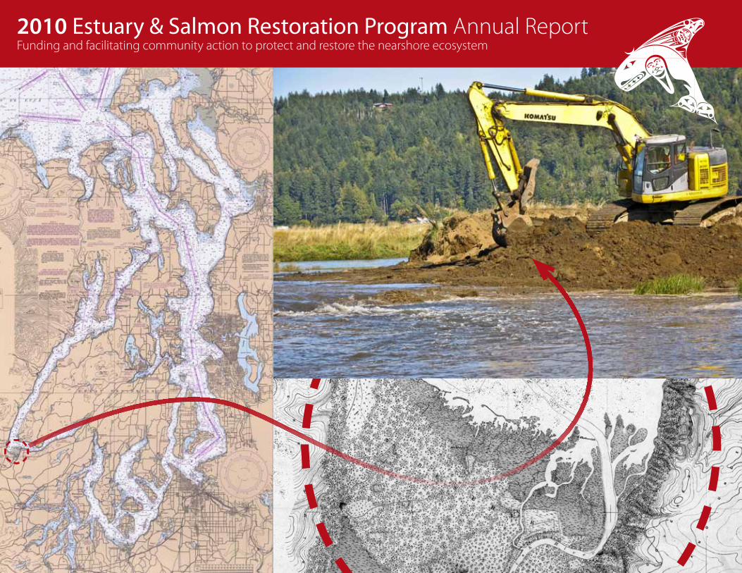
2010 Estuary & Salmon Restoration Program Annual ReportFunding and facilitating community action to protect and restore the nearshore ecosystem
1
2
3
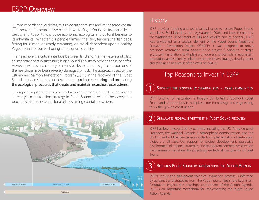
ESRP Overview
From its verdant river deltas, to its elegant shorelines and its sheltered coastal embayments, people have been drawn to Puget Sound for its unparalleled
beauty and its ability to provide economic, ecological and cultural benefits to its inhabitants. Whether it is people farming the land, tending shellfish beds, fishing for salmon, or simply recreating, we are all dependent upon a healthy Puget Sound for our well being and economic vitality.
The nearshore is a critical interface between land and marine waters and plays an important part in sustaining Puget Sound’s ability to provide these benefits. However, with over a century of intensive development, significant portions of the nearshore have been severely damaged or lost. The approach used by the Estuary and Salmon Restoration Program (ESRP) in the recovery of the Puget Sound nearshore focuses on the root of the problem: restoring and protecting the ecological processes that create and maintain nearshore ecosystems.
This report highlights the vision and accomplishments of ESRP in advancing an ecosystem restoration strategy in Puget Sound to restore the ecosystem processes that are essential for a self-sustaining coastal ecosystem.
History ESRP provides funding and technical assistance to restore Puget Sound shorelines. Established by the Legislature in 2006, and implemented by the Washington Department of Fish and Wildlife and its partners, ESRP was envisioned as a tactical element of the Puget Sound Nearshore Ecosystem Restoration Project (PSNERP). It was designed to move nearshore restoration from opportunistic project funding to strategic ecosystem restoration. ESRP plays a unique and critical role in ecosystem restoration, and is directly linked to science-driven strategy development and evaluation as a result of the work of PSNERP.
Top Reasons to Invest in ESRP
SuppOrtS the ecOnOmy by creating jObS in lOcal cOmmunitieS
ESRP funding for restoration is broadly distributed throughout Puget Sound and supports jobs in multiple sectors from design and engineering to on-the-ground construction.
StimulateS federal inveStment in puget SOund recOvery
ESRP has been recognized by partners, including the U.S. Army Corps of Engineers, the National Oceanic & Atmospheric Administration, and the U.S. Fish and Wildlife Service, as a model for implementation of restoration projects of all sizes. Our support for project development, aggressive development of regional strategies, and transparent competitive selection mechanisms is the catalyst for attracting new federal investments in Puget Sound.
reStOreS puget SOund by implementing the actiOn agenda
ESRP’s robust and transparent technical evaluation process is informed by guidance and strategies from the Puget Sound Nearshore Ecosystem Restoration Project, the nearshore component of the Action Agenda. ESRP is an important mechanism for implementing the Puget Sound Action Agenda.

ESRP’s emphasis on ecological nearshore processesNatural processes, such as tidal flow, the exchange of nutrients, and sediment delivery, have been significantly altered. These changes have affected important functions and services that the nearshore provides; things like: water filtration, essential resting places for young salmon, stop overs for migratory birds and waterfowl, and supplying sediment to maintain Puget Sound beaches.
Restoration of coastal processes is vital to ensure that both existing fish and wildlife habitats and the benefits of complementary restoration efforts, such as salmon recovery, are sustained over time in the face of increasing development pressures and a changing climate.
ContentsCreating Jobs in Local Communities . . . . . . . . . . . . . . . . . . . . . . . . . . . . . . . . . . . . . . . . . . 2
Investing Strategically in the Puget Sound Nearshore . . . . . . . . . . . . . . . . . . . . . . . . . 4
Program Accomplishments . . . . . . . . . . . . . . . . . . . . . . . . . . . . . . . . . . . . . . . . . . . . . . . . . . . 6
Delivering Benefits to the Communities in Puget Sound . . . . . . . . . . . . . . . . . . . . . . 8
Edited by Betsy Lyons and Jaïr Reitsma
Graphic Design: Jaïr Reitsma
Front cover photos: Left: 1994 chart of Puget Sound, courtesy of the NOAA Office of Coast Survey’s Historical Map and Chart Collection.
Top right: An excavator is removing a dike in the Skokomish River estuary, courtesy of Paul Cereghino, NOAA Restoration Center.
Bottom right: A topographic sheet from the U.S. Coast & Geodetic Survey of the Skokomish River estuary circa 1884, courtesy of the Puget Sound River History Project, University of Washington.
Back cover photo: The first tide is entering into the newly restored Skokomish River estuary, courtesy of Paul Cereghino, NOAA Restoration Center.
Photo by hugh ShiPman
Photo by melinda milner 1

creating jObS in lOcal cOmmunitieS
Restoration and protection of Puget Sound nearshore is an investment in our future and in the many local communities across the Sound. ESRP
funding for restoration is broadly distributed throughout Puget Sound and supports jobs in multiple sectors from technical and clerical support to environmental planning to design and engineering and on-the-ground construction. As a result of the Skokomish Estuary restoration project
25 people were employed. At Fisher Slough 20 new jobs were created and over 150 people employed at some point during construction. By supporting job creation and engaging local contractors and volunteers, providing opportunities for environmental education and public access, many restoration efforts play a significant role in building and strengthening local communities.
Once the largest contiguous saltmarsh complex in Hood Canal, the Skokomish Estuary, like many estuaries and river deltas in Puget Sound, was converted to farmland during early development. Dikes and levees were built to keep tidal waters out and ditches were built to drain wetlands. These actions disrupted ecological processes such as the flow of tidal water and sediment, blocked fish passage, and reduced a number of ecosystem services such as flood storage, natural water filtration and production of fish and wildlife.
Today this area is undergoing another significant transformation—restoration. The Skokomish Tribe and Mason Conservation District are leading efforts to remove dikes, fill in ditches and eliminate fish passage barriers. Tidal waters are once again flowing into their historic channels across the Skokomish Estuary. New channels are already being created, saltmarsh vegetation is re-establishing and fish and wildlife are returning.
Area Restored
Phase I (2007) - Skokomish West Bank: 108 acresPhase II (2010) - Nalley Island: 216 acresPhase III (2011) - Proposed Skokomish
West Bank expansion 525 acresTotal: 849 acresRestoration Actions: Dike removal, channel creation, and culvert removal.
Case Study 1:Skokomish Estuary
“This project had a significant labor component, which was important in helping Quigg Brothers to provide local jobs for its diverse and specialized workforce.”
John Quigg, Owner, Quigg Brothers Inc.2
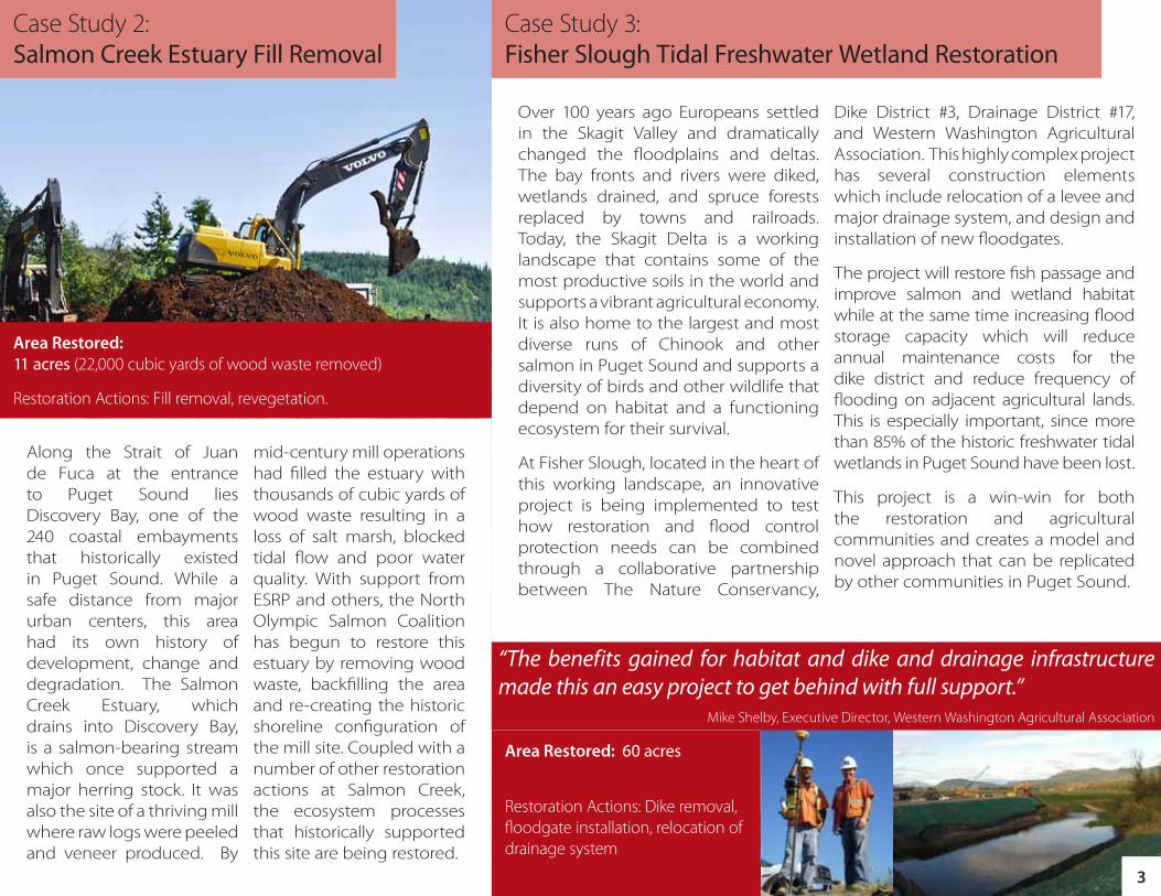
Over 100 years ago Europeans settled in the Skagit Valley and dramatically changed the floodplains and deltas. The bay fronts and rivers were diked, wetlands drained, and spruce forests replaced by towns and railroads. Today, the Skagit Delta is a working landscape that contains some of the most productive soils in the world and supports a vibrant agricultural economy. It is also home to the largest and most diverse runs of Chinook and other salmon in Puget Sound and supports a diversity of birds and other wildlife that depend on habitat and a functioning ecosystem for their survival.
At Fisher Slough, located in the heart of this working landscape, an innovative project is being implemented to test how restoration and flood control protection needs can be combined through a collaborative partnership between The Nature Conservancy,
Dike District #3, Drainage District #17, and Western Washington Agricultural Association. This highly complex project has several construction elements which include relocation of a levee and major drainage system, and design and installation of new floodgates.
The project will restore fish passage and improve salmon and wetland habitat while at the same time increasing flood storage capacity which will reduce annual maintenance costs for the dike district and reduce frequency of flooding on adjacent agricultural lands. This is especially important, since more than 85% of the historic freshwater tidal wetlands in Puget Sound have been lost.
This project is a win-win for both the restoration and agricultural communities and creates a model and novel approach that can be replicated by other communities in Puget Sound.
Along the Strait of Juan de Fuca at the entrance to Puget Sound lies Discovery Bay, one of the 240 coastal embayments that historically existed in Puget Sound. While a safe distance from major urban centers, this area had its own history of development, change and degradation. The Salmon Creek Estuary, which drains into Discovery Bay, is a salmon-bearing stream which once supported a major herring stock. It was also the site of a thriving mill where raw logs were peeled and veneer produced. By
mid-century mill operations had filled the estuary with thousands of cubic yards of wood waste resulting in a loss of salt marsh, blocked tidal flow and poor water quality. With support from ESRP and others, the North Olympic Salmon Coalition has begun to restore this estuary by removing wood waste, backfilling the area and re-creating the historic shoreline configuration of the mill site. Coupled with a number of other restoration actions at Salmon Creek, the ecosystem processes that historically supported this site are being restored.
Case Study 2:Salmon Creek Estuary Fill Removal
Case Study 3: Fisher Slough Tidal Freshwater Wetland Restoration
Area Restored: 60 acres
Restoration Actions: Dike removal, floodgate installation, relocation of drainage system
Area Restored: 11 acres (22,000 cubic yards of wood waste removed)
Restoration Actions: Fill removal, revegetation.
“The benefits gained for habitat and dike and drainage infrastructure made this an easy project to get behind with full support.”
Mike Shelby, Executive Director, Western Washington Agricultural Association
3
ww
ww
ww w
óóóóóóóóóóóóóóóóóóóó
óóóóóó
óóóóóóóóóóóóóóóó
óóóóóóóóóóóó
óóóó
óóóóóóóóóóóóóóóóóóóóóóóóóóóóóóóóóóóóóóóóóóóóóóóóóóóóóóóóóó
óóóóóóóóóóóóóóóóóóóó
óóóóóóóóóóóó
óóóóóó
kj
kjkj
kj
kjkj
kj
kjkj
G G'
F
F'
Puget Sound Nearshore Ecosystem Restoration Project (PSNERP) USACE Drawing FIle Number: D-1-1-64SOURCE: Washington Public Lands Database (2006); Washington Counties Parcels (2009); Action Area (PSNERP, 2010)
0 500
Feet
Lead Contractor: ESA Design Lead: ESA PWA with KPFFDate: 12/27/2010
Legend
Conceptual Design PlanSite Name: Discovery Bay
Action Name: Snow Creek and Salmon Creek Estuary RestorationPSNERP ID #:1230
Full Restoration
North
WDFW Contract # 100-000204 (CAPS No. 10-1461)
SnowSalmonFULLOrig
kj Large Wood Placement
Proposed Tide MHHW
Existing Tide MHHW
Channel Rehab/Creation
óóóóTrails
w Water
Other
Bridge
Buildings
Demolition/Removal - Bridge/Road
Dredging - Bucket - Land
Excavation - Lowland
Excavation - Upland
Hydroseeding
Previously Restored
Roadway
Sand/Gravel for Beach Nourishment
Required Project Lands
Remove Creosote Trestle and Rip Rap,and Install New Steel/Concrete Bridge (125 ft)
Remove Culvert, Widen Opening
Leave Embankment, Restore Beach andAdd Trail
Excavate CherryTree Pond
Remove Railroad Grade (510 ft)
Remove Imported Fill
Construct 8030 ft of Starter Tidal Channels
Acquire Lands, Demo/Remove, and Grade Down to MHHW
Demolish Sections of Highway 101 and SR 20
New Highway 101 Bridge withPedestrian Access/Trails (1175 ft)
New SR 20
DISCOVERYBAY
Reconnect Snow Creek to Salmon CreekSee Section F
SNO
W C
REEK
SALMON CREEK
Demolish and Remove Concrete Bridge (68 ft) andWood Bridge (104 ft) at Snow Creek
Place Large Wood
Acquire Lands, Demo Buildings
Remove Shore Armoring (1000 ft)and Restore Beach Profile (1000 ft)
MILL POND LAGOON
HIGHW
AY 1
01
SR 20
Remove Railroad Trestle (110 ft)
ww
w
ww
w w
óóóóóóóóóóóóóóóóóóóóóóóóóóóóóó
óóóó
óóóóóóóóóóóóóóóóóóóóóóóóóóóó
óóóóóóóóóóóóóóóóóó
óóóó
óóóóóó
kj
kjkj
kj
Construct ThirdOrder ChannelsSee Section B
Construct Third Order ChannelsSee Section B
Realign 1,310 ft of Snow CreekSee Section E
Remove Existing Railroad Bridge (40 ft)
ReconstructDistributary ChannelSee Section C
Expand Salmon Creekat Highway 101
C C'
B B'
D D'
E E'
Typical Cross SectionA A'
A A'
Construct Second Order ChannelsSee Section A
Remove Railroad Bridge (40 ft)
Figure 30-3
Date: 2/2011
fferson County
Ö
Ö
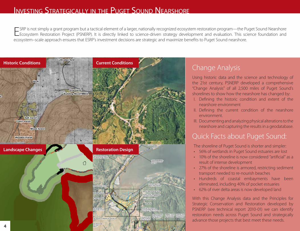
ESRP is not simply a grant program but a tactical element of a larger, nationally recognized ecosystem restoration program—the Puget Sound Nearshore Ecosystem Restoration Project (PSNERP). It is directly linked to science-driven strategy development and evaluation. This science foundation and
ecosystem–scale approach ensures that ESRP’s investment decisions are strategic and maximize benefits to Puget Sound nearshore.
inveSting Strategically in the puget SOund nearShOre
Change AnalysisUsing historic data and the science and technology of the 21st century, PSNERP developed a comprehensive “Change Analysis” of all 2,500 miles of Puget Sound’s shorelines to show how the nearshore has changed by:I. Defining the historic condition and extent of the
nearshore environmentII. Defining the current condition of the nearshore
environment.III. Documenting and analyzing physical alterations to the
nearshore and capturing the results in a geodatabase.
Quick Facts about Puget Sound:The shoreline of Puget Sound is shorter and simpler:• 56% of wetlands in Puget Sound estuaries are lost• 10% of the shoreline is now considered “artificial” as a
result of intense development• 27% of the shoreline is armored, restricting sediment
transport needed to re-nourish beaches• Hundreds of coastal embayments have been
eliminated, including 40% of pocket estuaries• 62% of river delta areas is now developed land
With this Change Analysis data and the Principles for Strategic Conservation and Restoration developed by PSNERP (see technical report 2010-01) we can identify restoration needs across Puget Sound and strategically advance those projects that best meet these needs.
Historic Conditions Current Conditions
Restoration DesignLandscape Changes
4

Applying StrategiesPuget Sound is a highly diverse landscape where the interplay of geology and natural processes has led to the development of a variety of shoreforms from large river deltas, to coastal inlets, lagoons and marshes, to mudflats and sandy beaches (see also the PSNERP technical report, 2008-01 A Geomorphic Classification of Puget Sound Nearshore Landforms). Each of these groups or shoreforms is similar in terms of the natural processes which create them and the types of human alterations that degrade them.
To address this natural variability, ESRP relies on strategies to provide a general sense of protection and restoration needs in these different systems:
1. River Deltas: Protect and restore freshwater input and tidal processes where major river floodplains meet marine waters.
2. Beaches: Protect and restore sediment input and transport processes which create and sustain beaches.
3. Barrier Embayments: Protect and restore tidal flow, as well as the sediment input and transport processes, which sustain the beach segments that enclose barrier embayments.
4. Coastal Inlets: Protect and restore tidal flow processes in coastal inlets, and protect and restore freshwater input.
These strategies can help us figure out where and how to strategically invest in habitat restoration or protection.
By effectively reducing or eliminating the underlying causes of degradation, we can move the nearshore environment towards a more natural, self-sustaining state.
Strategy 1:RIVER
DELTAS
Strategy 2:BEACHES
Strategy 3:BARRIER
EMBAYMENTS
Strategy 4:COASTAL
INLETS
Map of PSNERP strategic analysis of protection and restoration opportunities
5
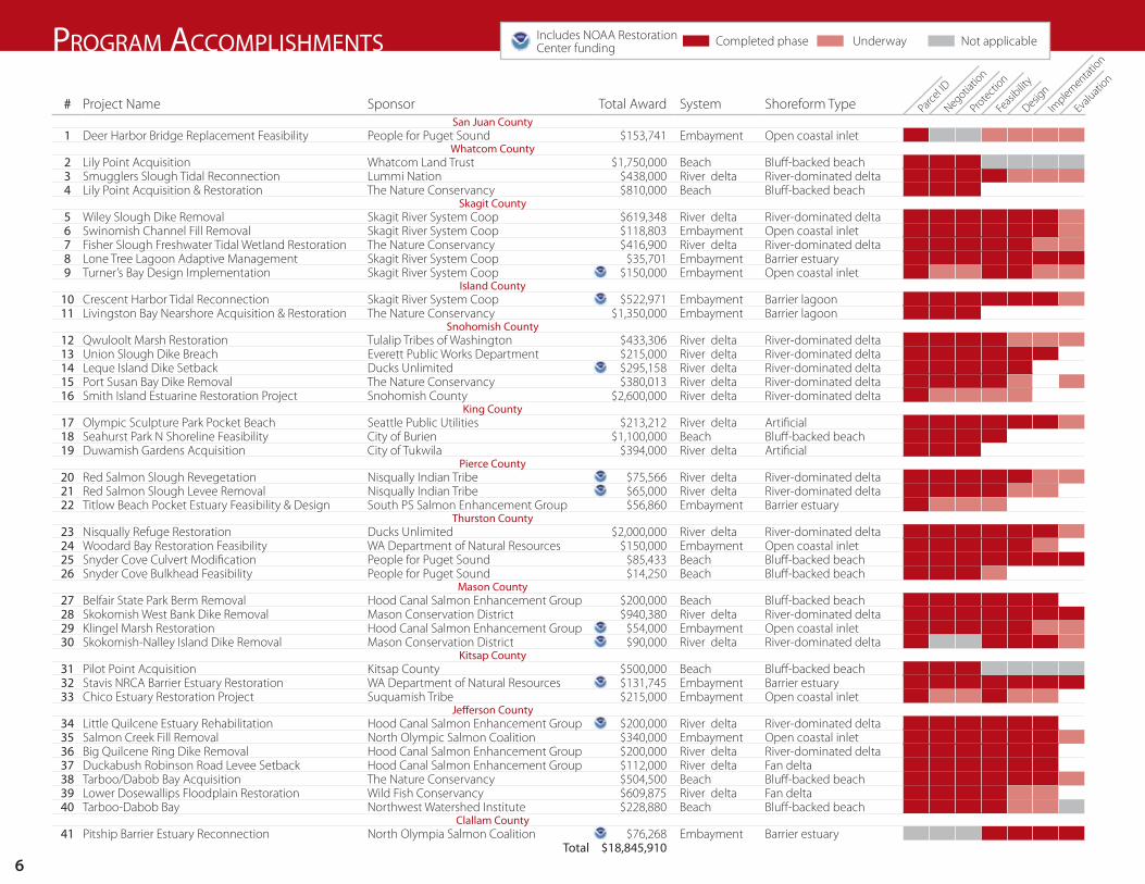
# Project Name Sponsor Total Award System Shoreform TypeSan Juan County
1 Deer Harbor Bridge Replacement Feasibility People for Puget Sound $153,741 Embayment Open coastal inletWhatcom County
2 Lily Point Acquisition Whatcom Land Trust $1,750,000 Beach Bluff-backed beach3 Smugglers Slough Tidal Reconnection Lummi Nation $438,000 River delta River-dominated delta4 Lily Point Acquisition & Restoration The Nature Conservancy $810,000 Beach Bluff-backed beach
Skagit County5 Wiley Slough Dike Removal Skagit River System Coop $619,348 River delta River-dominated delta6 Swinomish Channel Fill Removal Skagit River System Coop $118,803 Embayment Open coastal inlet7 Fisher Slough Freshwater Tidal Wetland Restoration The Nature Conservancy $416,900 River delta River-dominated delta8 Lone Tree Lagoon Adaptive Management Skagit River System Coop $35,701 Embayment Barrier estuary9 Turner’s Bay Design Implementation Skagit River System Coop $150,000 Embayment Open coastal inlet
Island County10 Crescent Harbor Tidal Reconnection Skagit River System Coop $522,971 Embayment Barrier lagoon11 Livingston Bay Nearshore Acquisition & Restoration The Nature Conservancy $1,350,000 Embayment Barrier lagoon
Snohomish County12 Qwuloolt Marsh Restoration Tulalip Tribes of Washington $433,306 River delta River-dominated delta13 Union Slough Dike Breach Everett Public Works Department $215,000 River delta River-dominated delta14 Leque Island Dike Setback Ducks Unlimited $295,158 River delta River-dominated delta15 Port Susan Bay Dike Removal The Nature Conservancy $380,013 River delta River-dominated delta16 Smith Island Estuarine Restoration Project Snohomish County $2,600,000 River delta River-dominated delta
King County17 Olympic Sculpture Park Pocket Beach Seattle Public Utilities $213,212 River delta Artificial18 Seahurst Park N Shoreline Feasibility City of Burien $1,100,000 Beach Bluff-backed beach19 Duwamish Gardens Acquisition City of Tukwila $394,000 River delta Artificial
Pierce County20 Red Salmon Slough Revegetation Nisqually Indian Tribe $75,566 River delta River-dominated delta21 Red Salmon Slough Levee Removal Nisqually Indian Tribe $65,000 River delta River-dominated delta22 Titlow Beach Pocket Estuary Feasibility & Design South PS Salmon Enhancement Group $56,860 Embayment Barrier estuary
Thurston County23 Nisqually Refuge Restoration Ducks Unlimited $2,000,000 River delta River-dominated delta24 Woodard Bay Restoration Feasibility WA Department of Natural Resources $150,000 Embayment Open coastal inlet25 Snyder Cove Culvert Modification People for Puget Sound $85,433 Beach Bluff-backed beach26 Snyder Cove Bulkhead Feasibility People for Puget Sound $14,250 Beach Bluff-backed beach
Mason County27 Belfair State Park Berm Removal Hood Canal Salmon Enhancement Group $200,000 Beach Bluff-backed beach28 Skokomish West Bank Dike Removal Mason Conservation District $940,380 River delta River-dominated delta29 Klingel Marsh Restoration Hood Canal Salmon Enhancement Group $54,000 Embayment Open coastal inlet30 Skokomish-Nalley Island Dike Removal Mason Conservation District $90,000 River delta River-dominated delta
Kitsap County31 Pilot Point Acquisition Kitsap County $500,000 Beach Bluff-backed beach32 Stavis NRCA Barrier Estuary Restoration WA Department of Natural Resources $131,745 Embayment Barrier estuary33 Chico Estuary Restoration Project Suquamish Tribe $215,000 Embayment Open coastal inlet
Jefferson County34 Little Quilcene Estuary Rehabilitation Hood Canal Salmon Enhancement Group $200,000 River delta River-dominated delta35 Salmon Creek Fill Removal North Olympic Salmon Coalition $340,000 Embayment Open coastal inlet36 Big Quilcene Ring Dike Removal Hood Canal Salmon Enhancement Group $200,000 River delta River-dominated delta37 Duckabush Robinson Road Levee Setback Hood Canal Salmon Enhancement Group $112,000 River delta Fan delta38 Tarboo/Dabob Bay Acquisition The Nature Conservancy $504,500 Beach Bluff-backed beach39 Lower Dosewallips Floodplain Restoration Wild Fish Conservancy $609,875 River delta Fan delta40 Tarboo-Dabob Bay Northwest Watershed Institute $228,880 Beach Bluff-backed beach
Clallam County41 Pitship Barrier Estuary Reconnection North Olympia Salmon Coalition $76,268 Embayment Barrier estuary
Total . $18,845,910
prOgram accOmpliShmentS
Parcel ID
Negotiatio
n
Protection
Design
Feasi
bility
Evalu
ation
Implementat
ion
Completed phaseIncludes NOAA Restoration Center funding Underway Not applicable
6

SKAGIT
WHATCOM
SNOHOMISH
KING
PIERCE
MASON
JEFFERSON
CLALLAM
ISLAND
THURSTON
KITSAP
SAN JUAN SKAGIT
WHATCOM
SNOHOMISH
KING
PIERCE
MASON
JEFFERSON
CLALLAM
ISLAND
THURSTON
KITSAP
SAN JUAN
LegendContract Status
Ongoing
Complete
Learning from Projects ESRP continually strives to improve program effectiveness and efficiency to ensure increasingly scarce public dollars deliver anticipated project benefits. Our Learning Strategy is designed to reduce the risk and uncertainty associated with restoration practices. By investing in project learning we can identify better projects and advance those that are most cost-effective and have the least risk of failure.
Through project learning, we also strive to identify the social barriers that can impede implementation and look for solutions that ensure funded projects move forward. For instance, through project monitoring, we can better understand how hydrologic modifications, such as self-regulating tidegates, affect the development and functioning of river channels and how fish accessibility and flooding on adjacent lands is altered. Or, we can study how saltmarsh vegetation develops in restored sites to better predict how a site may respond as sea-levels rise.
1.
2.
3.
4.
6.
7.
11.
10.
14.15.
16.12.
13.
17.
18. 19.
20.21.
22.
23.24.25.
26.
27.29.
30.
32.
31.
33.37.
34.
35.
36.
38.40.
41.
39.
28.
5.
9.8.
7

prOviding benefitS tO peOple, placeS and cOmmunitieS
Healthy, functioning ecosystems provide local communities with a range of valuable ecosystem goods such as abundant fish and shellfish, clean water, public access and swimming beaches, as well as ecosystem services such as flood and erosion control, water filtration, carbon sequestration and
nutrient exchange. As Puget Sound’s nearshore has been altered, its ability to provide the same level of ecosystem goods and services has decrease. However, by strategically focusing restoration actions on key ecosystem processes we can restore the nearshore to a more vibrant and resilient condition for all its inhabitants.
Restoration projects not only provide jobs but they also provide an opportunity to bring communities together to develop creative solutions to community problems. Through open dialogue and thoughtful planning many restoration projects can directly incorporate elements into the design that address both ecological and social needs such as flood storage, upgrades to failing infrastructure (roads, culverts, bridges or tidegates), improved access to the nearshore; recreational opportunities and resiliency to climate change.
Before & After | Improved public access and recreation
Before & After | Infrastructure Upgrades
Improved flood control
Resiliency to climate change8

Stimulating Federal InvestmentESRP has been recognized by federal partners including the U.S. Army Corps of Engineers, the National Oceanic and Atmospheric Administration (NOAA) and U.S. Fish and Wildlife Service as a model for implementing restoration projects of all sizes. ESRP builds on the nationally recognized Puget Sound Ecosystem Restoration Project, combining regional science-based strategy with transparent and competitive project selection to attract new federal investments in Puget Sound. ESRP’s strategic funding of engineering and design prepares projects for winning national competitions for federal construction resources.
“The Estuary and Salmon Restoration Program funds high quality habitat protection and restoration in Puget Sound that make it one of the most active and productive EPA partnerships with our Puget Sound National Estuary Program.”
Michael Rylko, Puget Sound National Estuary Program, Environmental Protection Agency
“The Estuary and Salmon Restoration Program delivers Puget Sound coastal projects that are ready to compete for NOAA funds and are aligned with program goals. ESRP is a vital pipeline for developing capital projects of national stature.”
Jennifer Steger, NW/AK Region Supervisor NOAA Restoration Center
“Our Puget Sound Coastal Program fully supports this program and looks forward to continued participation in ESRP planning and project implementation.”Tom McDowell, Manager, Division of Environmental Assessment and Restoration Washington Fish and Wildlife Office, U.S. Fish and Wildlife Service
A Partnership in Community Based RestorationThe NOAA Restoration Center works across the nation to inspire and sustain local efforts to advance coastal habitat restoration. Through its Community-based Restoration Program, the Restoration Center develops multi-year agreements with regional partners to advance projects that offer a broad range of ecological, socioeconomic, and stewardship benefits to coastal communities.
In 2007, stimulated by ESRP’s strategic approach, NOAA’s Restoration Center entered into a three year partnership with Washington Department of Fish and Wildlife that brought over $1.1 million dollars in federal funds to Puget Sound projects. This partnership increased collaboration between NOAA and state staff, and brought NOAA technical assistance to bear on Puget Sound restoration priorities. A second three-year agreement using ESRP’s competitive selection mechanism was signed with the Puget Sound Partnership in 2011.
StaviS Natural area: before reStoratioN
StaviS Natural area: a loSt embaymeNt, reStored by the departmeNt of Natural reSourceS
9
For more inFormation: betSy lyOnS • (360) 902-2572 • [email protected] • www.pugetSOundnearShOre.org
“The Leadership Council supports the ESRP process and project list. Projects like these get people working while helping achieve our shared goal of a healthy Puget Sound”
Martha Kongsgaard, Chair of the Leadership Council, Puget Sound Partnership