2010 reproposed draft methods - state.nj.us
TRANSCRIPT
Revised Draft 2010
Integrated Water Quality Monitoring and Assessment Methods
This document was prepared pursuant to Section 303(d) of the Federal Clean Water Act
State of New Jersey Department of Environmental Protection
Water Monitoring and Standards
Jon Corzine, Governor Mark N. Mauriello, Acting Commissioner
December 2009
Revised Draft for Reproposal

Revised Draft 2010 Methods Document
Table of Contents CHAPTER PAGE 1.0 Introduction 03
1.1 Background 03 1.2 Summary of Major Changes from the 2008 Methods Document 04
2.0 Overview of the Assessment Process 05
3.0 Use and Interpretation of Data 08
3.1 Data Quality 08 3.2 Criteria and Policies 09
4.0 Evaluation of Data at the Station Level 11
4.1 Physical and Chemical Data 11 4.2 Pathogenic Indicators 14 4.3 Biological Data 15 4.4 Assessment of Nutrient Impacts 18
5.0 Evaluating Data from Multiple Stations within an Assessment Unit 19
6.0 Designated Use Assessment Methods 23 6.1 Aquatic Life Use Assessment Method 24 6.2 Recreational Use Assessment Method 26
6.3 Fish Consumption Use Assessment Method 26 6.4 Shellfish Harvesting Use Assessment Method 27 6.5 Drinking Water Supply Use Assessment Method 28 6.6 Industrial Water Supply Use Assessment Method 29 6.7 Agricultural Water Supply Use Assessment Method 30
7.0 Integrated Listing Guidance 30
7.1 Integrated Listing Methodology 31 7.2 Identifying Causes and Sources of Non-attainment (303(d) List) 32 7.3 Delisting Assessment Unit/Pollutant Combinations 32
8.0 Method to Rank and Prioritize Assessment Units That Do Not Attain Designated Uses 33 9.0 Method for Developing the Monitoring and Assessment Plan 34 10.0 Public Participation 34
10.1 Request for Data 35 10.2 Public Notification 36
11.0 References 37 Appendix A: Parameters Used Assessment Process and Associated Designated Uses 41

Revised Draft 2010 Methods Document NJDEP December 2009
2
List of Tables Table Number PageTable 4.3 Descriptive and Regulatory Thresholds for Biological Metrics 16Table 4.4 Nutrient Impact Assessment Outcomes 19Table 6.0 Minimum Suite of Parameters for Needed to Assess Use Attainment 24Table 6.1 Aquatic Life Use Assessment Based Upon Individual and Integrated
Data Sets 25
Table 6.2 Recreation Use Assessment Results 26Table 6.3a Thresholds for fish tissue-based toxics 27Table 6.3b Fish Consumption Use Assessment Results: 27Table 6.4 Shellfish Harvest Use Assessment Results 28Table 6.5 Drinking Water Supply Use Assessment Results 29Table 7.1 Assessment Results and Integrated List Outcomes 31Table 8.0 Importance of Pollutants of Concern 33
List of Figures Figure Number PageFigure 2 Overview of Water Quality Assessment Process 7Figure 4.3 Spatial Extent of Application for Each of the Benthic
Macroinvertebrate 15
Figure 5a Offshore HUC Extensions 21Figure 5b Station Representation 21

Revised Draft 2010 Methods Document NJDEP December 2009
3
1.0 Introduction 1.1 Background Since 2001, the United States Environmental Protection Agency (USEPA) has recommended that states integrate their Water Quality Inventory Report (required under Section 305(b) of the federal Clean Water Act (Act)) with their List of Water Quality Limited Segments (required under Section 303(d) of the Act). New Jersey submitted its first Integrated Water Quality Monitoring and Assessment Report (Integrated Report) in 2002. The New Jersey Department of Environmental Protection's (Department) 2010 Integrated Report will continue to follow the integrated format to provide an effective tool for maintaining high quality waters where designated uses are attained, and improving the quality of waters that do not attain their designated uses. The Integrated Report includes an “Integrated List” that combines the reporting requirements of Sections 305(b) and 303(d) of the Act. The Integrated List is the only part of the Integrated Report that is subject to regulatory requirements, which include public participation and submission to USEPA for approval and adoption. The Integrated List identifies the status of all applicable designated uses for every assessment unit by labeling the results of each designated use assessment as one of the five sublists (see Section 7.1 for complete sublist descriptions). Sublists 1 through 5 satisfy the assessment and reporting requirements of Section 305(b), while Sublist 5 is also used to specifically satisfy Section 303(d). Section 303(d) requires states to produce a list of waters that are not meeting surface water quality standards (SWQS) despite the implementation of technology-based effluent limits and thus require the development of total maximum daily loads (TMDLs). This list is referred to as the “List of Water Quality Limited Segments” or the “303(d) List”. The Department will be submitting the 2010 Integrated List to USEPA Region 2 via its Assessment Database (ADB). However, since the public will be afforded the opportunity to review and comment on the Integrated List, the Department will also generate an Integrated List Table that organizes assessment results by assessment unit, designated use, and sublist. The Department will also generate a separate List of Water Quality Limited Segments (303(d) List) that includes all assessment units identified as Sublist 5 (i.e., not attaining one or more designated uses), the specific pollutants not meeting SWQS in each assessment unit, and the relative rank of the assessment unit/parameter combination for TMDL development. USEPA Guidance recommends placing the assessment results into one of five specific categories. The Department has chosen to use the term “sublist” rather than “category” when referring to the Integrated List, to avoid confusion between Category 1 of the Integrated List and Category One Waters designated under New Jersey’s SWQS at N.J.A.C. 7:9B. Prior to developing an Integrated List, states are required to publish, for USEPA and public review, the methods used to collect, analyze, and interpret data, and place assessment units on their respective sublists. This Methods Document serves that function by providing an objective and scientifically sound assessment methodology, including:

Revised Draft 2010 Methods Document
4
• A description of the data the Department will use to assess attainment of the designated uses; • The quality assurance aspects of the data; • A detailed description of the methods used to evaluate designated use attainment; • The rationale for the placement of assessment units on one of the five sublists. The Methods Document does not establish assessment methods for assessing raw data on the Delaware River mainstem, Estuary, and Bay, fish tissue data for fish consumption, or pathogen data for shellfish. The Methods Document does explain how the Department uses the data collected in support of fish consumption advisories as well as shellfish classifications to assess the fish consumption and shellfish harvest for consumption designated uses, respectively (see Sections 6.3 and 6.4). The water quality assessment for the Delaware River mainstem, Estuary, and Bay is conducted by the Delaware River Basin Commission (DRBC) and its assessment results are incorporated into New Jersey’s Integrated List. 1.2 Summary of Major Changes from the 2008 Methods Document Temperature The seasonal average temperature criteria have been replaced with acute and chronic criteria to better protect the State’s cold and warm water fisheries (see (41 N.J.R. 4735(a)). The Department will evaluate continuous monitoring data with recordings taken anywhere between once per hour to every 15 minutes for weeks at a time against these new shorter term criteria (see Section 4.1, Temperature under Continuous Monitoring). Fish Consumption Use Assessment and 303(d) Listing The Department has modified the fish consumption use assessment method to reflect the direct assessment of concentrations of bioaccumlating toxic parameters in fish tissue. For all bioaccumlating toxic parameters except mercury, the assessment threshold for use attainment is the concentration considered safe for unlimited fish consumption by infants, children, pregnant women, nursing mothers, and women of childbearing age (i.e., the “high risk” population). For mercury, the use attainment threshold is based upon the concentration established in the Department’s statewide mercury TMDL, which is designed to protect high risk populations but will still result in a consumption advisory of one meal a week. Details of the new fish consumption use assessment method for mercury and other toxics are provided in Section 6.3. Nutrients The Department will use a new assessment method to evaluate nutrient impairment of freshwaters based on response indicators using a “weight of evidence” approach that will determine whether phosphorus causes non-attainment of the aquatic life use. Where sufficient data is not available to apply the new method, the Department will assess nutrient impairment based on compliance with the existing numeric SWQS criteria for phosphorus. Freshwaters previously assessed as not attaining the aquatic life use based on exceedances of the numeric phosphorus criteria will be delisted only if it can be demonstrated that the narrative nutrient criteria has been met. Details of the new assessment methodology are found in Section 4.4. The Department will continue to refine and expand the nutrient impact assessment method to include other types of waterbodies and other response indicators, as explained in the New Jersey Nutrient

Revised Draft 2010 Methods Document
5
Criteria Enhancement Plan (NJDEP, 2009) available on the Department’s Web site at http://www.state.nj.us/dep/wms/bwqsa/Nutrient_Criteria_Enhancement_Plan.Final.pdf. Pathogens The Department has deleted secondary contact recreation from the designated uses of FW1, PL, FW2, SE1, and SC waters (see N.J.A.C. 7:9B-1.12(a), (b), (c), (d), and (g)). FW1, FW2, PL, SE1 and SC will be assessed for primary contact recreation. Secondary contact recreation will only be evaluated in SE2 and SE3 waters (see (41 N.J.R. 4735(a)). 2.0 Overview of the Assessment Process The Department is required to use all existing and readily available data to assess water quality for the Integrated List. With data originating from a host of different entities with different monitoring and analytical capabilities, the Department must ensure that the data used for assessment purposes is reliable and of good quality. The Department must also determine how to use the diverse types of data it generates and receives in a consistent manner to ensure an accurate evaluation of water quality on a station level, which will then be used to determine designated use attainment at the assessment unit level. The overall assessment process used by the Department, beginning with the collection of raw data, through the assessment of designated uses, to the development of the Integrated List, is comprised of five steps, each of which is explained in detail in Chapters 3 through 7. Below is a brief summary of each chapter/step in the assessment process. Chapter 3: Use and Interpretation of Data Chapter 3 outlines the requirements regarding quality assurance and quality control, monitoring design, age of data, accurate sampling location information, data documentation, and use of electronic data management that are taken into consideration when deciding if data are readily available and appropriate for use in generating the Integrated List. Chapter 3 also discusses the relevant policies established in the SWQS and how they relate to data interpretation.
Chapter 4: Evaluation of Data at the Station Level Chapter 4 explains the many issues affecting the interpretation of chemical, physical, pathogenic, and biological data that the Department must take into consideration, such as sample size, frequency, magnitude, duration, outliers, and censored data. Chapter 4 describes the procedures used to evaluate chemical parameters and determine if an individual parameter complies with the applicable SWQS (including policies and narrative criteria) at each station. This chapter also describes how the Department evaluates pathogenic and biological indicators to assess water quality impairment at a station level. Chapter 4 also includes a new method for assessing nutrient impacts on water quality. Chapter 5: Evaluating Data from Multiple Stations within an Assessment Unit Chapter 5 defines the scale (“assessment unit”) used by the Department to assess designated uses and explains the process used to identify all sampling stations associated with each assessment unit. Chapter 5 also explains the additional evaluations and policies that are applied when data for the same parameter is combined from different stations within an assessment unit, including

Revised Draft 2010 Methods Document
6
assessment units with more than one stream classification or waterbody type, relative weight of datum, de minimus data results, contradictory data sets, macroinvertebrate metrics, modeling results, and shellfish classification data. Chapter 6: Designated Use Assessment Methods Chapter 6 identifies the uses designated for each SWQS classification, the type of data necessary to assess each use, and the minimum suite of parameters needed to assess attainment of each use. Chapter 6 also discusses the process used to assess attainment based on data sampled from multiple locations and/or for multiple parameters, the parameters associated with each designated use (Appendix A), the type of data needed to assess each use (Table 6.0a), and the minimum suite of parameters needed to assess use attainment (Table 6.0b). Chapter 7: Integrated Listing Guidance Chapter 7 explains how assessment results for each assessment unit/designated use combination are depicted on the Integrated List and assigned to the appropriate sublist, taking into consideration the status of TMDLs. For each assessment unit/designated use identified as Sublist 5, the Department will identify the pollutant(s) causing the non-attainment of a designated use and place the assessment unit/pollutant combinations on the 303(d) List along with the assessment unit name and its priority ranking for TMDL development. Figure 2 on the following page illustrates the relationship between the different levels of data assessment explained in Chapters 4, 5, and 6 and used to generate the Integrated List. Chapters 8, 9, and 10: Prioritizing, Monitoring, and Public Participation. Chapter 8 describes the methods used to rank and prioritize waterbodies for TMDL development pursuant to the requirements of the federal Clean Water Act. Chapter 9 describes the State’s approach to obtaining additional data to assess compliance with SWQS in all assessment units, and to support TMDL development. Chapter 10 outlines the public participation requirements and process, both regulatory and non-regulatory, employed in the development and finalization of the Integrated List. Among other things, Chapter 10 describes the data solicitation and the public notification processes.

Revised Draft 2010 Methods Document
7
Figure 2: Overview of the Water Quality Assessment Process

Revised Draft 2010 Methods Document NJDEP December 2009
8
3.0 Use and Interpretation of Data The Department reviews all existing and readily available data. With data originating from many diverse entities, the Department must ensure that the data used for assessment purposes is reliable and of good quality. The Department must also determine how to use the diverse types of data in a consistent manner to ensure an accurate assessment of the water quality in each assessment unit. This process is outlined below. The Integrated Report will include a list all the sources of data received and identify which sources were used, as well as provide an explanation for any data not used, to develop the Integrated List. 3.1 Data Quality Data Age The Department will use the most recent five years of readily available data to characterize current conditions. Past assessments are considered valid until new data show that conditions have changed. Data received in response to the Department’s solicitation that are more than five years old may be used on a case-by-case basis if they enhance the Department’s ability to assess current conditions. Older data may also be used in conjunction with newer data to demonstrate water quality trends where appropriate analytical methods are used and results can easily be compared with more recent data. The Department may apply less weight to data less than five years old if newer data was collected or analyzed using scientific methods that are more precise. Electronic Data Management In general, only electronic data are considered “readily available” due to the significant effort needed to computerize and analyze data submitted in hard copy. The Department uses electronic data from the USEPA Storage and Retrieval (STORET) system, and the United States Geological Survey (USGS) National Water Information System (NWIS). The Department recognizes that USEPA is migrating from STORET to a new, more technologically advanced water quality data exchange system (WQX). The Department has developed a New Jersey-specific water quality data exchange system (WQDE) that is compatible with WQX. The Department has requested that monitoring organizations seeking to have their data used for the 2010 Integrated Report submit data via WQDE. The Department has also requested that all potential data submitters submit an on-line “Intent To Submit Data” registration form by May 17, 2009 and that all data be entered into WQDE by December 31, 2009. The Department is working with data submitters with this new data submittal process and held training for WQDE on November 12, 2009. Additional information about WQDE and instructions for data submittal are available on the Department’s Web site at www.nj.gov/dep/wms/wqde. Locational Data Accurate locational data are required to ensure comparison to appropriate SWQS, as well as confirming that sampling stations are located outside of regulatory mixing zones. Digital spatial data in the form of a Geographical Information System (GIS) shape file or Global Positioning System (GPS) coordinates, or latitude/longitude information, must be provided for all monitoring station locations, which must be accurate to within 200 feet. Only sampling stations that are spatially referenced will be used to develop the Integrated List.

Revised Draft 2010 Methods Document
9
Quality Assurance The Department maintains a strong commitment to the collection and use of high quality data to support environmental decisions and regulatory programs. All data and information used to develop the Integrated Report must comply with the Department’s Quality Assurance Guidelines, the Department’s field sampling procedures, and be analyzed by a certified laboratory. Department policy mandates that all environmental data collection activities performed (or for use) by the Department comply with and be accompanied by an approved Quality Assurance Project Plan (QAPP). QAPPs describe the procedures used to collect and analyze samples and review and verify the results to assure high quality data. QAPPs must be approved by the Department, USEPA or USGS. The QAPP must be approved prior to the start of any sampling. The USEPA’s QAPP guidance document is available at http://www.epa.gov/region02/qa/qa_documents/air_h20_qapp04.pdf. The Department also provides guidance for developing QAPPs for volunteer monitoring data which is available at: http://www.state.nj.us/dep/wms/bwqsa/vm/quality_assurance.html. Additional information about the Department’s QAPP process is available on the Department’s Web site at http://www.nj.gov/dep/oqa/. Entities responsible for generating the data are responsible for compiling the data, completing a detailed quality assurance review, and addressing questions regarding the data set. The sampling protocol for data used in the Integrated Report must also comply with the procedures in the Department’s Field Sampling Procedures Manual (NJDEP, 2005) or follow equivalent field procedures as determined by the Department’s Office of Quality Assurance. The Department’s Manual includes approved procedures for sample collection, field quality assurance, sample holding times, and other data considerations and is available for download from the Department’s Web site at http://www.state.nj.us/dep/srp/guidance/fspm/). Samples must be analyzed at a laboratory certified by the Department’s Office of Quality Assurance, or a federal laboratory (e.g., the USGS National Water Quality Laboratory in Denver) using analytical methods or their equivalents, as certified by the Department pursuant to N.J.A.C. 7:18, USEPA, or USGS. 3.2 Criteria and Policies Since water quality data are assessed for compliance with the Surface Water Quality Standards (SWQS), the SWQS provide the foundation for the Integrated List. The SWQS establish surface water classifications, the designated uses associated with the surface water classifications, and the criteria and policies established to protect, maintain, and restore the designated uses. Antidegradation Policy: The SWQS contain an antidegradation policy that applies to all surface waters of the State. Antidegradation is a requirement under the federal Clean Water Act designed to prevent or limit future degradation of the nation’s waters. Under this policy, existing uses shall be maintained and protected. Designated uses shall be maintained or, as soon as technically and economically feasible, be attained wherever these uses are not precluded by natural conditions. No irreversible changes may be made to existing water quality that would impair or preclude attainment of the designated use(s) of a waterway. No changes shall be allowed in waters that constitute an outstanding national or state resource or in waters that may affect these Outstanding National Resource Waters. The Department applies the antidegradation
Revised Draft 2010 Methods Document
10
policy in tandem with the classification of the receiving waterbody in making decisions about proposed new or expanded discharges to surface waters, including stormwater permits, as well as certain land use permits. Additional information about the SWQS antidegradation policy is available on the Department’s Web site at http://www.state.nj.us/dep/wms/bwqsa/swqs.htm. Assessment of Threatened Waters: Lists of Water Quality Limited Waters (303(d) Lists) are required to include all “threatened and impaired” waters. “Threatened waters” are waters that currently meet water quality standards, but are likely to exceed standards by the time the next 303(d) List is generated. Assessing threatened waters requires sufficient existing and readily available data and information on adverse declining trends to predict future water quality. This means a dataset must sufficiently robust to support the evaluation of short-and long-term statistical trends; generally, at least ten years of seasonally (four times per year) data. Currently the Department maintains a series of long-term monitoring locations, which support statistical trends assessments developed by the USGS. Assessments to determine if waters are threatened will be conducted by the Department wherever sufficient data and trends assessments are available to make such predictions. Narrative Water Quality Criteria: Narrative water quality criteria are non-numeric descriptions of the conditions necessary for a waterbody to attain its designated uses. To implement narrative data, which is qualitative in nature, the Department has identified assessment approaches, also known as “translators”, to quantitatively interpret narrative criteria. New Jersey’s SWQS contain narrative criteria for toxics, nutrients, and natural conditions.
Toxics: The SWQS contain two narrative criteria for toxic substances:
1. None, either alone or in combination with other substances, in such concentrations as to affect humans or be detrimental to the natural aquatic biota, produce undesirable aquatic life, or which would render the waters unsuitable for the desired use; and
2. Toxic substances shall not be present in concentrations that cause acute or chronic
toxicity to aquatic biota, or bioaccumulate within the organism to concentrations that exert a toxic effect on that organism or render it unfit for human consumption.
The Department uses several translators to assess compliance with the narrative toxic criteria. These translators include: fish tissue concentrations used for consumption advisories (see Section 6.3, Fish Consumption Use Assessment); shellfish closure data (see Section 6.4, Shellfish Use Designated Use Assessment); source water information (see Section 6.5, Drinking Water Supply Use Assessment) with regard to human health; and biological data (see Section 6.1, Aquatic Life Use Assessment) with regard to aquatic life.
Nutrients: The SWQS include narrative nutrient criteria that apply to all freshwaters of the State, in addition to the applicable numeric criteria for phosphorus. The narrative nutrient criteria prohibit nutrient concentrations that cause objectionable algal densities,

Revised Draft 2010 Methods Document
11
nuisance aquatic vegetation, or render waters unsuitable for designated uses. Section 4.4 details the interpretation of this narrative criterion. Natural Conditions: The SWQS at N.J.A.C 7:9B-1.5(c) state, “Natural water quality shall be used in place of the promulgated water quality criteria of N.J.A.C. 7:9B-1.14 for all water quality characteristics that do not meet the promulgated water quality criteria as a result of natural causes.” The concept of “natural causes” is applied when the Department can document that there are no anthropogenic sources or causes of a given characteristic or that the characteristic is clearly attributable to the natural conditions of the waterbody. Data that do not meet applicable SWQS criteria potentially due to natural conditions will be carefully evaluated.
Numeric Water Quality Criteria: The surface water quality criteria established for each of the different surface water classifications in the SWQS are numeric estimates of constituent concentrations, including toxic pollutants that are protective of the designated uses. Numeric surface water quality criteria have been established for conventional parameters (e.g., dissolved oxygen, pH, temperature), toxics (e.g., metals, organics, unionized ammonia), and sanitary quality (e.g., pathogens). Additional information about numeric water quality criteria is available on the Department’s Web site at http://www.state.nj.us/dep/wms/bwqsa/swqs.htm. 4.0 Evaluation of Data at the Station Level
4.1 Evaluation of Physical and Chemical Data The Department assesses physical and chemical data for which criteria have been established in the SWQS. Once the data is reviewed and deemed appropriate for use in generating the Integrated List (see Chapter 3), the data for each parameter sampled at a specific monitoring station are evaluated for compliance with the SWQS. Any samples that do not comply with the applicable numeric SWQS criteria are considered excursions and are reviewed to determine if the excursion is within the margin of error of the analytical method or can be attributed to natural conditions, transient events, or flow conditions that do not represent design flows. “Natural conditions” are water quality characteristics for which no anthropogenic sources or causes can be documented or that are clearly attributable to natural phenomena (see Section 3.2). “Transient events” are water quality conditions that occur at very low frequencies, over very brief timeframes, and as such neither impair the designated use of the waterbody nor, if captured by the data, represent overall water quality conditions. For regulatory purposes, water quality criteria apply only where stream flow is maintained at or above the “design flow” specified for the applicable numeric SWQS criteria, which is usually the MA7CD10 (see N.J.A.C. 7:9B-1.5(c)). Flow conditions are evaluated for all excursions to determine if the data were collected under appropriate flow conditions. Any data that are collected when stream flows are below design flows are not assessed. Excursions that can be attributed to any of these conditions are not assessed as exceedances of the SWQS criteria. Excursions that cannot be attributed to one of these factors are further evaluated at the assessment unit level to determine if they collectively constitute an exceedance of the SWQS criteria.

Revised Draft 2010 Methods Document
12
Analytical Precision and Accuracy: The Department will take into consideration the precision and accuracy of the analytical method used to measure the data when an ambient measurement is compared to a numeric SWQS criterion. Analytical precision and accuracy are determined by the methods used to sample, analyze, and report the data. The precision of the analytical method is determined by the margin of error expressed for the method used. The margin of error defines the range of values that are considered to represent valid results for a specific analytical method or instrument. For example, if the surface water quality criterion is 1.0 and the margin of error for the instrument is “(+) or (-) 0.2,” a reported value of 1.1 would not be considered an exceedance. Unlike precision, which is a function of the analytical method used, the accuracy of the data is determined by the number of decimal places used to express the surface water quality criterion. For example, when a parameter is measured in a concentration whose value is reported to three decimal places but the applicable criterion is represented by (i.e. accurate to) only two decimal places, the parameter concentration will be rounded to two decimal places to determine compliance with the criterion. Continuous Monitoring: More and more frequently, instruments such as Datasondes are being deployed to continuously monitor the water. The parameters most commonly measured in this fashion are water temperature, dissolved oxygen (DO), pH, salinity and conductivity. The protocol for comparing continuous monitoring data, collected over a minimum of three days, to the SWQS criteria is as follows:
Dissolved Oxygen: The SWQS criteria for DO are expressed as either a minimum, “not less than…at any time” concentration or as a 24-hour average concentration. An excursion occurs when the lowest concentration over a 24-hour period is below the DO criterion for at least one hour. Two such excursions at the same location during two or more 24-hour periods constitute an exceedance of the criterion. An excursion of the 24-hour average criterion occurs when the average concentration of all measurements recorded within a 24-hour period is below the criterion. Two such excursions occurring at the same location constitutes an exceedance of the criterion. When assessing diurnal DO flux, the Department will review the results from continuous monitoring performed during the growing season and calculate the difference between the highest and lowest measurements of DO concentration observed over a 24-hour period. If the difference between these two values (i.e., the “flux”), is 3 mg/l or greater in two or more 24-hour periods, the Department will conclude that the DO swing is excessive.
pH: When evaluating continuously recorded pH data, as with DO, an exceedance occurs when the pH criterion is not met for the equivalent of one hour or more during a 24-hour period.
Temperature: When evaluating continuous monitoring data for compliance with the new temperature criteria, the acute, one-hour maximum criterion will be compared to the maximum temperature recorded within a one-hour duration. Two exceedances of the acute criterion recorded on two separate days over the period of review (up to five years) are considered an exceedance of the temperature criterion.

Revised Draft 2010 Methods Document
13
Computations Using Censored Data: Censored data are reported values that are less than the minimum reporting level of an analytical procedure. These data are usually labeled with a “<” symbol followed by the reporting limit in the data report received from the laboratory. Non- parametric methods must be used to evaluate datasets containing censored values. When censored values represent less than 50 percent of the dataset, the Department will calculate a median value for the dataset and compare that median to the applicable criterion. When censored values exceed 50 percent of the data, the Department will consider the dataset insufficient to determine if the criterion has been exceeded. Duration (Exposure Periods): The SWQS includes criteria-specific exposure periods (durations) that range from one hour to 70 years. In assessing compliance with the SWQS, the Department takes into consideration the specific duration applicable to the criterion for the parameter being assessed. For example, chronic aquatic life criteria require a four-day exposure period; therefore, data collected under flow conditions that last less than four days (as is generally the case for high flow conditions) are not considered valid for assessment of chronic aquatic life criteria but such data may be used to assess acute aquatic life criteria, which do not have such duration constraints. For human health carcinogen criteria, which are based on a 70-year exposure rate, the Department calculates a long-term average of all data available for the most recent five-year period for comparison to the applicable criterion. Frequency of Exceedance: The Department has determined that a minimum of two exceedances of a numeric SWQS criterion are necessary to confirm noncompliance with the criterion. The Department has determined that a second exceedance is necessary to ensure that the first exceedance was not a transient condition. When the minimum exceedance is met but the dataset is very large (more than 30 data points), the Department will consider the relative frequency and magnitude of the exceedances within the dataset and use Best Professional Judgment to determine if they represent non-attainment of the designated use. The Department will provide an explanation of any assessment which concludes that the use is attained because of relatively low magnitude or frequency of exceedances in a very large dataset. Metals: SWQS criteria for metals include human health (HH), acute aquatic life (AQLa), and chronic aquatic life (AQLc). HH criteria are based on the total recoverable (TR) form of the metal to protect human health from all forms of the metals. To the extent available, total recoverable (TR) and dissolved fraction (DF) data will be compared to the TR and DF criterion, respectively. When only TR data are available, in addition to comparing the TR concentration to the TR criterion, the Department will also compare the TR concentrations to the DF criterion. If the TR concentrations are below the DF criterion, the Department assumes the DF criterion is also met. TR concentrations above the DF criterion will trigger additional sampling for DF. Minimum Number of Samples: Unless described differently for a particular parameter, the minimum data set consists of eight samples. The Department believes that two years of data collected quarterly are adequate and represents the minimum dataset necessary for an adequate assessment. These recommendations are intended to ensure that existing water quality conditions are accurately portrayed by the data and that the results do not reflect transitional conditions. The Department will consider a data set which does not meet this minimum requirement on a case-by-case basis to determine if the data adequately characterizes the water quality conditions.

Revised Draft 2010 Methods Document
14
Summer-only sampling for nutrients, pathogenic quality, and temperature may be acceptable since summer generally represents the critical condition for these parameters. If the Department determines that the data set adequately represents water quality conditions and there are at least two exceedances of the Surface Water Quality Standards, this limited data set will be used to determine that a use is not attained (see Chapter 6, Use Assessment Methods). Outliers: Any datum that is identified as an outlier in accordance with the corresponding Quality Assurance Project Plan (QAPP) is not considered a valid result and is not assessed. 4.2 Pathogenic Indicators Waters classified as PL, FW, SE1, and SC are assessed for primary contact (“in the water”) SE2 and SE3 waters are assessed for secondary recreation (“on the water”). This approach is consistent with amendments to the New Jersey Surface Water Quality Standards at N.J.A.C. 7:9B-1.12(a), (b), (c), (d), and (g)), adopted on November 16, 2009. These amendments deleted secondary contact recreation from the designated uses of FW1, PL, FW2, SE1, and SC waters (see (41 N.J.R. 4735(a)). Assessment for recreation compares the geometric mean (geomean) of the water quality data for pathogenic indicators to the appropriate SWQS criterion. At least five samples collected over a 30-day period are required to calculate the geomean; however, other sampling frequencies may be acceptable provided that the frequency supports the statistical method for calculating a seasonal geomean. In addition to assessing primary contact recreation in all PL, FW, SE1, and SC waters using geomean, a second assessment is conducted for “designated bathing beaches”. "Designated bathing beaches" include beaches that are heavily used for primary contact recreation such as swimming, bathing, and surfing during the recreational season pursuant to the New Jersey State Sanitary Code N.J.A.C. 8:26. Designated bathing beaches are assessed as attaining primary contact recreation if there are no beach closures lasting seven or more consecutive days in a given year, or the average number of beach closures is less than two per year over a five-year period. Beach closure procedures are established at N.J.A.C. 8:26-8.8, which is available on the U.S. Department of Health’s Web site at http://www.state.nj.us/health/eoh/phss/recbathing.pdf. Designated bathing beaches are sampled weekly. If the sample indicates an exceedance of the single sample maximum (SSM), the beach is resampled. If this follow-up sample also exceeds the SSM, the beach is closed. In assessing designated bathing beaches, the Department will review the beach closure data to confirm that the closures were due to water quality issues. Short term beach closures of less than a week generally signify occasional excursions of the pathogen criterion. If these short term closures occur chronically over several (five or more) years the beach is assessed as impaired. One beach closure lasting seven or more consecutive days in a given year, or an average of two or more beach closures (of any duration) per year over a five-year period, is also assessed as an impairment. Recreational use assessment methods are explained in detail in Section 6.2.

Revised Draft 2010 Methods Document
15
4.3 Biological Data The Department has developed biological indicators (benthic macroinvertebrates and fin fish) to evaluate aquatic life use attainment. Benthic Macroinvertebrate Data: New Jersey has been using biological metrics to evaluate biological conditions in freshwater streams since the early 1990s. Prior to the 2008 Integrated Report, macroinvertebrate data collected under New Jersey’s Rapid Bioassessment Protocol (RBP) were evaluated using the New Jersey Impairment Score (NJIS) system for all freshwater streams. Assessments were based upon family level taxonomy with three condition categories: not impaired, moderately impaired, and severely impaired. Starting with the 2008 Integrated Report, the Department will use three new biological indices based upon genus level taxonomy. The three indices were developed for different physiographic regions of the State: the High Gradient Macroinvertebrate Index (HGMI), which applies to the streams of northern ecoregions (Highlands, Ridge and Valley, and Piedmont); the Coastal Plain Macroinvertebrate Index (CPMI), which applies to the Coastal Plain (excluding waters considered Pinelands waters); and the Pinelands Macroinvertebrate Index (PMI), which applies to PL waters contained within the jurisdictional boundary of the Pinelands as well as FW2 waters within five kilometers of the Pinelands Area boundary (see Figure 4.3). For the new PMI, scores in the fair category are assessed as impaired if the waters are classified as PL but are assessed as not impaired if the waters are classified as FW2. This is because the PMI was developed specifically to reflect the unique conditions of nondegradation PL waters. The Department will continue to use biological assessment results based on the family level macroinvertebrate NJIS index in non-Pinelands waters, if they are submitted by other entities. However, where assessment results based upon the newly developed, genus level metrics (HGMI and CPMI) are available, these results will override those based upon family level metrics when assessing aquatic life use attainment for the entire assessment unit.
Figure 4.3: Spatial Extent of Application for Each of the Benthic
Macroinvertebrate Indices Applied in New Jersey
Region Assessed by High Gradient Macroinvertebrate Index (HGMI)
Region Assessed by Pinelands Macroinvertebrate Index (PMI)
Revised Draft 2010 Methods Document
16
Region Assessed by NJ Impairment Score (NJIS)*
Region Assessed by Coastal Plain Macroinvertebrate Index (CPMI)
* NJIS is no longer used by the Department but may be used by other entities Fin Fish Data - Fish Index of Biotic Integrity (FIBI): Fin fish population data are assessed using the Fish Index of Biotic Integrity (FIBI). A more detailed description of the FIBI program, including sampling procedures, is available on the Department’s Web site at http://www.state.nj.us/dep/wms/bfbm/fishibi.html. The current FIBI metric applies to high gradient streams above the fall line (Highlands, Ridge and Valley, and Piedmont physiographic provinces). This metric has four assessment result categories: excellent, good, fair, and poor. Scores in the “excellent”, “good”, and “fair” categories indicate that biology is not impaired while scores in the “poor” category indicates that the biology is impaired (see Table 4.3).
Table 4.3: Descriptive and Regulatory Thresholds for Biological Metrics*
Macroinvertebrate Index for High Gradient Streams (HGMI Metric) (Highlands, Ridge and Valley, Piedmont Physiographic Provinces)
Category Metric Score Assessment Excellent 63 - 100 Not Impaired
Good 42 - < 63 Not Impaired Fair 21 - < 42 Impaired Poor < 21 Impaired
Macroinvertebrate Index for Low Gradient (CPMI Metric) Coastal Plain (Non Pinelands) Streams
Category Metric Score Assessment Excellent 22 - 30 Not Impaired
Good 12 - 20 Not Impaired Fair 10 - 6 Impaired Poor < 6 Impaired

Revised Draft 2010 Methods Document
17
Macroinvertebrate Index for Pinelands Waters (PMI Metric)
Category Metric Score Assessment Result Excellent 63 - 100 Not Impaired
Good 56 - < 63 Not Impaired Fair 34 - < 56 PL waters: Impaired
FW2 Waters: Not Impaired Poor < 34 Impaired
New Jersey Macroinvertebrate Index (NJIS) Category Metric Score Assessment Result
Not Impaired 24 - 30 Not Impaired Moderately Impaired 9 - 21 Impaired
Severely Impaired 0 - 6 Impaired Fish Index of Biotic Integrity (FIBI)
(Highlands, Ridge and Valley, Piedmont Physiographic Provinces) Category Metric Score Assessment Result Excellent 45 - 50 Not Impaired
Good 37 - 44 Not Impaired Fair 29 - 36 Not Impaired Poor 10 - 28 Impaired
*Source: Standard Operating Procedures Ambient Biological Monitoring Using Benthic Macroinvertebrates Field, Lab, Assessment Methods (NJDEP, 2007), available on the Department’s Web site at http://www.state.nj.us/dep/wms/bfbm/download/ AMNET_SOP.pdf.
Regional Monitoring and Assessment Program (REMAP) Assessments: A Benthic Index of Biotic Integrity was developed for the New York/New Jersey Harbor based on USEPA Region 2’s REMAP protocol and data reflecting benthic invertebrate communities. The results are used to assess the waters of Raritan Bay, the Arthur Kill, and the Kill van Kull. This index was developed by scoring each of five metrics as 5, 3, or 1. Overall index scores less than 3 are considered biologically impaired while scores greater than 3 are considered not impaired. Additional information about this metric is available on the USEPA Web site at http://www.epa.gov/emap/remap/html/docs/nynjsedapp1.pdf. Additional Considerations When Evaluating Biological Data Disturbed or impaired biota can result from extended drought or other conditions that result in reduced base flow. If biological communities are impaired due to drought-induced, low flow conditions, the impairment will be attributed to natural conditions and the data will not be considered valid for assessment purposes (see “Natural Conditions” in Section 3.2). The Department has developed multiple biological indices based upon both fish and benthic macroinvertebrates that represent several tropic levels and each assessing significantly different

Revised Draft 2010 Methods Document
18
spatial and temporal scales. Where multiple indices are employed on a waterbody, if one indicates impairment, the aquatic life use will be listed as impaired.
4.4 Assessment of Nutrient Impacts The Surface Water Quality Standards include both narrative nutrient criteria and numeric phosphorus criteria for freshwater lakes and streams. The Department has selected appropriate response indicators to evaluate compliance with the narrative nutrient criteria in freshwater wadeable streams to determine if phosphorus should be identified as a cause of aquatic life use non-attainment (see Section 6.1, “Aquatic Life Designated use Assessment Method). The relationship has long been established between excess nutrients and the potential for depressed dissolved oxygen (DO) levels, broad swings in DO (resulting from high rates of daytime photosynthesis coupled with nighttime respiration), excess levels of algal growth (measured as chlorophyll a) and changes to the aquatic ecosystem. The Department believes that these cause/response relationships are better indicators of adverse nutrient impacts on the aquatic ecosystem than an assessment of the in-stream concentration of total phosphorus alone. Where benthic macroinvertebrate indices indicate impairment (see Section 4.3), the assessment unit will be assessed as not attaining the general aquatic life use. The purpose of the nutrient impact assessment is to determine whether phosphorus is a cause of non-attainment. Continuous DO monitoring data is required to evaluate whether the DO criteria is exceeded and to determine if excessive daytime photosynthesis is occurring at the site (see Section 4.1, “continuous monitoring … dissolved oxygen”). The Department has determined that diurnal fluctuations in DO concentration in excess of 3 mg/l are a strong indication excessive photosynthetic activity due to nutrient over-enrichment. Where benthic macroinvertebrate indices indicate impairment, and the DO criteria are exceeded, and the diurnal DO fluctuation is more than 3mg/l, the Department will conclude that phosphorus is a cause of non-attainment of the general aquatic life use and will list phosphorus and the assessment unit on the 2010 303(d) List of Water Quality Limited Waters. Conversely, where biology is not impaired, the DO criteria are not exceeded, and there is no significant DO fluctuation, the Department will determine that the narrative nutrient criteria have been met and will not place phosphorus on the 2010 303(d) List for that assessment unit even if the in-stream concentrations of total phosphorus exceed the numeric phosphorus criteria for FW streams. The Department recognizes that there may be situations where the nutrient impact assessment is inconclusive because of site-specific factors (see Table 4.4). For example, where biology is impaired and there is an excessive DO swing but the DO criteria are not exceeded, the Department will review periphyton chlorophyll a data to determine if phosphorus is a cause of the impairment. The chlorophyll a threshold of 150 g/sq. meter will be used to determine if the amount of periphyton present is sufficient to change the composition of the aquatic ecosystem. This periphyton chlorophyll a threshold is based upon a consensus in the scientific literature that at this level and above algal growth has reached nuisance levels. If the seasonal average chlorophyll a concentration from a minimum of three sampling events exceeds 150 mg/sq. meter, the Department will conclude that phosphorus is a cause of the aquatic life use non-attainment and will place phosphorus and that assessment unit on the 2010 303(d) List of Water Quality Limited Waters. These chlorophyll a measurements are required only when the nutrient
Revised Draft 2010 Methods Document
19
impact assessment is inconclusive regarding whether phosphorus is a cause of general aquatic life use non-attainment. Where sufficient data is not available to apply the nutrient impact assessment method, the cause assessment will be based on compliance with the applicable numeric SWQS criteria for phosphorus. Freshwaters previously assessed as not attaining the general aquatic life use based solely on exceedance of the numeric phosphorus criteria will be reassessed using the new nutrient impact assessment method and will be delisted for phosphorus if it can be demonstrated that the narrative nutrient criteria are met. This assessment method does not apply to other waterbody types. For lakes, the Department will continue to evaluate compliance with the numeric phosphorus criteria.
Table 4.4: Nutrient Impact Assessment Outcomes
Results of Biological
Assessment
Dissolved Oxygen
Results of Nutrient Impact Assessment
No exceedances of criteria; No excessive swing
Phosphorus not a cause; (Place “Cause Unknown” on 303(d) List)
No exceedances of criteria; Excessive swing present
Inconclusive regarding phosphorus; Evaluate chlorophyll a and reassess
Exceedances of criteria; No excessive swing
Phosphorus not a cause; (Place DO on 303(d) List)
Benthic Macroinvertebrate Indices indicate impairment; General aquatic life use is not attained
Exceedances of criteria; Excessive swing present
Phosphorus is confirmed as the cause (Place/retain phosphorus on 303(d) List)
5.0 Evaluating Data from Multiple Stations within an Assessment Unit While the initial data evaluation is conducted at the station level, use assessments are conducted for entire assessment units, each of which may contain data from multiple stations and multiple waterbody types. All data from one or more monitoring stations located within a given assessment unit are extrapolated to represent all waters within that assessment unit’s boundaries. Exceedances of applicable SWQS or biological indices identified at the parameter/station level are further evaluated collectively for each parameter sampled at all monitoring stations within the assessment unit. Where stations within an assessment unit yield different assessment results, the assessment decision is based on the worst case. Where there are numerous beach or shellfish harvest closures within an assessment unit, the spatial coverage of these impairments are evaluated in assessing attainment of the recreation and shellfish consumption uses for the respective assessment units. Assessment Units: New Jersey’s assessment units are delineated based on Hydrologic Unit Code (HUC) 14 subwatershed boundaries except for the Delaware River mainstem, Estuary, and Bay, where assessment units are delineated based on DRBC designated zones. HUCs are

Revised Draft 2010 Methods Document
20
geographic areas representing part or all of a surface drainage basin or distinct hydrologic feature as delineated by USGS in cooperation with the National Resources Conservation Service (NRCS). The HUC system starts with the largest possible drainage area and progressively smaller subdivisions of that drainage area are then delineated and numbered in a nested fashion. The Department has identified the river miles, lake and estuary acres and ocean square miles for each assessment unit. There are currently 950 HUC 14 subwatersheds in New Jersey. HUC 14 subwatersheds range in size from 0.1 to 42 square miles, with an average size of 8.5 square miles. The Department’s GIS database contains a coverage containing discrete polygons for each of New Jersey’s 950 HUC 14 subwatersheds. Since the Integrated Report also addresses the 20 Delaware River zones designated by DRBC, there are a total of 970 assessment units assessed in the Integrated Report. The identification number (ID) for each HUC 14 assessment unit was created by adding a two-digit ID number to the end of the 14-digit HUC code for that subwatershed. The boundaries of HUCs located along the shore were extended from three statute miles to three nautical miles, which represents the jurisdictional waters of the State of New Jersey. The Department decided to split some HUC 14 polygons into smaller, more homogeneous assessment units. The newly divided assessment units are now identified with “01” and “02” extensions. The new HUCs have the original assessment unit name but with one of the following terms added: “upstream” or “downstream” (for rivers), “inshore” or “offshore” (along the coast). The ocean HUCs are divided into a near shore assessment unit extending perpendicular to the shore 1500 feet out and an offshore area extending from 1500 feet to the three nautical mile boundary. The inshore assessment unit represents the outward extent of the designated bathing beaches along the Atlantic Coast (Fig. 5a). Station Representation: The Department will evaluate station locations on a case-by-case basis to determine if the data from these stations should be used in assessing the adjacent assessment unit (AU). For example, it is common for monitoring sites to be placed at the terminus of one assessment unit as it flows into an adjacent assessment unit. When a monitoring site falls within 200 feet of a given assessment unit boundary, the assessment based upon that site is applied to both the assessment unit containing the site and to the adjacent assessment unit (Fig 5b). This assignment is made provided that there are no significant tributaries, impoundments, or other hydrological alterations that could impact water quality between the monitoring site and the neighboring assessment unit. If there are no applicable monitoring stations for an assessment unit, the unit will be identified as not assessed (Sublist 3).

Revised Draft 2010 Methods Document
21
Figure 5a: Offshore HUC Extensions Figure 5b: Station Representation
Assessment Units With More Than One Stream Classification: Data will be compared to the SWQS for the stream classification where the station is located. Where data is available for both higher and lower classification streams, the Department will use the more stringent criteria to assess designated use attainment for the assessment unit. For example, if the assessment unit contains both FW2-TM (trout maintenance) and FW2-NT (non-trout) waters, and the DO criteria are met for the FW2-NT waters but not met for the FW2-TM waters, the results for the more stringent trout maintenance criteria will be applied and the entire assessment unit will be assessed as not attaining the aquatic life use. Where the assessment unit contains both higher and lower classification streams but there is no data for the higher classification stream segment, then data from a station located outside of the higher classification waters will be compared to the SWQS for that classification. If the lower classification waters meet the higher classification’s SWQS, the data will be used to assess both classifications. However, if the data collected at the station in a lower classification does not meet the higher classification’s SWQS, the assessment unit will be considered to have insufficient data with which to assess the higher classification and the assessment unit will be assessed as attaining only the general aquatic life use. Assessment Units with More than one Waterbody Type: Assessing Lake Data: Lakes are assessed based upon in-lake chemistry data collected just below the surface (generally at a one-meter depth if the lake is sufficiently deep). Lakes can have multiple in-lake sampling locations, depending on their size. Each sampling location within a lake is considered a “subsample”. Lake subsamples that do not comply with the applicable numeric SWQS criteria are considered excursions and are reviewed to determine if the excursion

Revised Draft 2010 Methods Document
22
is within the margin of error of the analytical method or can be attributed to natural conditions or transient events. Excursions occurring at multiple locations or subsamples within a lake on the same date are considered a “single excursion”. Two or more excursions occurring within a lake on separate dates constitute an exceedance. Continuous Monitoring and Grab Sampling: Grab samples collected quarterly may not capture the most critical time period; therefore, they may not reflect the worst case scenario for use attainment. Thus, the Department will give more weight to continuous monitoring data, provided that the continuous monitoring data is available for at least a single season. De minimus: When evaluation of data at a station level identifies portions of an assessment unit as impaired but, upon further evaluation, these stations represent minute portions of the total area of the assessment unit, the Department will regard the assessed area as de minimus rather than impaired. The concept of de minimus is applied to numerous situations when evaluating assessment units. Examples of situations where a de minimus determination would be applied are as follows:
Recreational use assessments: Where an assessment unit contains one or more impaired bathing beaches but the spatial extent of the impaired bathing beaches is a minute portion of the assessment unit, the impairment would be considered de minimus and would not be considered in assessing recreational use attainment for the entire assessment unit. When determining the spatial extent, a designated bathing beach represents the area within 1,500 feet from the shoreline in the saline coastal (SC) waters, and the area within 200 feet from the shoreline in saline estuarine (SE1) waters. In these instances, where the Department uses Best Professional Judgment and determines that the impairment is de minimus, the individual impaired bathing beaches will be identified in the Integrated Report for follow up sanitary surveys required by the DHSS.
Shellfish harvest use assessments: Assessment units overlie but do not follow shellfish classification boundaries. As a result, an assessment unit may include several different shellfish classifications. In most instances, the use assessment will be based on the most restrictive classification found within the assessment unit. In the few instances where only a very small portion of the acreage within the assessment unit is has some degree of restriction, the use assessment will be based on assessment of the larger area. Any de minimus areas that are restricted but are not subject to administrative closures (i.e., the restriction is due to poor water quality) will be identified in the Integrated Report.
Evaluating Contradictory Data Sets: Weighing data is necessary when evaluating numerous data sets that have different data collection and analysis methods, or have temporal or spatial sampling variability. These decisions will apply in the following situations: newer data will override older data; larger data collection sets might override or be combined with nominal data sets; and higher quality data will override data sets of lower quality based on sampling protocol, equipment, training and experience of samplers, quality control program, and lab and analytical procedures.
Revised Draft 2010 Methods Document
23
Assigning relative “weight” to data is necessary when evaluating numerous data sets that have different data collection and analysis methods, or temporal or spatial sampling variability. When data sets yield contradictory or ambiguous assessment results, a “weight of evidence” approach will be used to evaluate the different data sets in relation to one another. The Department will take into account the data sets’ age, robustness, and accuracy. In large data sets, the magnitude and frequency of the exceedances are evaluated. Other factors, such as changes in pollutant concentration over time and other water quality trends, may also influence the weight of a given data set. Modeling and Sampling Results: Water quality models are used to predict changes in water quality over time under different flow, weather, and temporal conditions. The Department may use the results obtained through a model to list or delist a waterbody, if the Department determines that the model adequately predicts water quality in the specific waterbody. 6.0 Designated Use Assessment Methods The SWQS identify specific designated uses for the waters of the State according to their waterbody classifications. Designated uses include:
• aquatic life (general and trout); • recreation (primary and secondary contact); • fish consumption; • shellfish harvest (for consumption); • drinking water supply; • industrial water supply; and • agricultural water supply.
The Department uses both numeric and narrative criteria to protect designated uses. Numeric criteria are estimates of constituent concentrations that are protective of the designated uses. Narrative criteria are non-numeric descriptions of conditions to be attained/maintained or avoided. To implement narrative data, which are qualitative in nature, the Department has identified assessment approaches, also known as “translators”, to quantitatively interpret narrative criteria. This section outlines the assessment methodologies for designated use attainment that include the utilization of both numeric and narrative criteria and involves the integration of data for multiple parameters at multiple stations for each assessment unit. Appendix A of the Methods Document identifies which parameters may be evaluated to assess each designated use. The Department has also established a minimum suite of parameters necessary to assess use attainment (see Table 6.0). The Department uses a conservative approach regarding use assessments that requires more extensive data for a finding that a use is attained than for a finding that a use is not attained. Specifically, an assessment unit will be assessed as attaining the designated use only if data for the minimum suite of parameters are available and the data indicate that there are no impairments or exceedances, in which case, the assessment unit will be assigned to Sublist 1 or 2. If data are available for only some of the minimum suite of parameters, the assessment unit will be identified as having insufficient information with

Revised Draft 2010 Methods Document
24
which to assess the designated use (Sublist 3), even if there are no exceedances or impairments within that data set. If data for any one parameter associated with a designated use (Appendix A parameters) indicate any impairment or exceedance, the assessment unit will be assessed as not attaining the designated use (Sublist 4 or 5), even data is not available for the entire the minimum suite of parameters.
Table 6.0: Minimum Suite of Parameters Needed to Assess Use Attainment
Designated Use Minimum Suite of Parameters
General Aquatic Life Macroinvertebrate Indices or fish IBI
If biological data is not available: pH, DO, temperature, and TP (in non-tidal waters); or DO (in tidal waters)
Aquatic Life - Trout Temperature and DO,
Recreation • Enterococcus (in SC and SE1 waters) ; • Fecal coliform (in SE2 and SE3 waters) ; • E. coli (in FW2 and PL waters)
Shellfish Harvesting Shellfish Classifications
Drinking Water Supply
Nitrate and TDS
Agricultural Water Supply
TDS
Industrial Water Supply
TSS and pH
Fish Consumption Fish tissue data
6.1 Aquatic Life Use Assessment Method The aquatic life use is assessed by directly evaluating biotic communities and assessing the health of the aquatic biota. This direct evaluation is performed using biological information that integrates a full suite of environmental conditions over many months (for macroinvertebrates) to many years (for fish-based indicators). When such data are available, the Department bases its aquatic life use assessments upon metrics developed to assess benthic macroinvertebrate data, in conjunction with fin fish IBI (Index of Biotic Integrity) data, and supplemented with a broad suite of biologically relevant physical/chemical data (e.g., dissolved oxygen, temperature, toxic pollutants). The minimum data sets for biologically relevant physical/chemical data will differ depending on stream classification. For instance, the minimum data set for assessing attainment with the aquatic life use-trout is more extensive than the minimum data set used to evaluate the general aquatic life use (see Table 6.1).
Revised Draft 2010 Methods Document
25
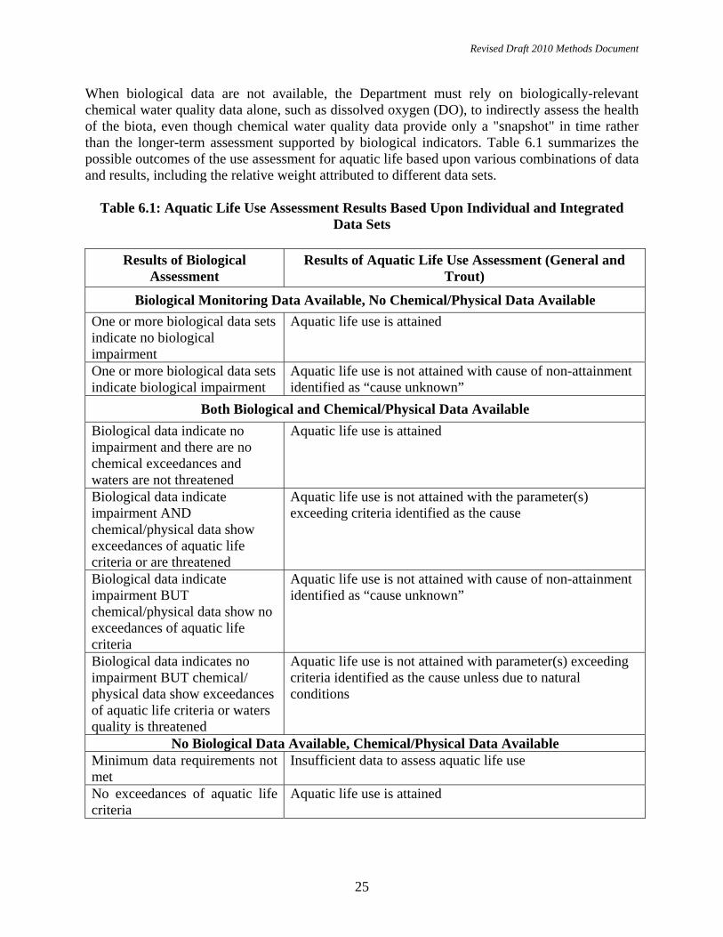
When biological data are not available, the Department must rely on biologically-relevant chemical water quality data alone, such as dissolved oxygen (DO), to indirectly assess the health of the biota, even though chemical water quality data provide only a "snapshot" in time rather than the longer-term assessment supported by biological indicators. Table 6.1 summarizes the possible outcomes of the use assessment for aquatic life based upon various combinations of data and results, including the relative weight attributed to different data sets.
Table 6.1: Aquatic Life Use Assessment Results Based Upon Individual and Integrated
Data Sets
Results of Biological Assessment
Results of Aquatic Life Use Assessment (General and Trout)
Biological Monitoring Data Available, No Chemical/Physical Data Available One or more biological data sets indicate no biological impairment
Aquatic life use is attained
One or more biological data sets indicate biological impairment
Aquatic life use is not attained with cause of non-attainment identified as “cause unknown”
Both Biological and Chemical/Physical Data Available Biological data indicate no impairment and there are no chemical exceedances and waters are not threatened
Aquatic life use is attained
Biological data indicate impairment AND chemical/physical data show exceedances of aquatic life criteria or are threatened
Aquatic life use is not attained with the parameter(s) exceeding criteria identified as the cause
Biological data indicate impairment BUT chemical/physical data show no exceedances of aquatic life criteria
Aquatic life use is not attained with cause of non-attainment identified as “cause unknown”
Biological data indicates no impairment BUT chemical/ physical data show exceedances of aquatic life criteria or waters quality is threatened
Aquatic life use is not attained with parameter(s) exceeding criteria identified as the cause unless due to natural conditions
No Biological Data Available, Chemical/Physical Data Available Minimum data requirements not met
Insufficient data to assess aquatic life use
No exceedances of aquatic life criteria
Aquatic life use is attained

Revised Draft 2010 Methods Document
26
6.2 Recreational Use Assessment Method The SWQS identify two levels of recreational use – primary contact and secondary contact. Primary contact recreation is defined as those water-related recreational activities that involve significant ingestion risks and includes, but is not limited to, wading, swimming, diving, surfing, and water skiing. Secondary contact recreation is defined as those water-related recreational activities where the probability of water ingestion is minimal and includes, but is not limited to, boating and fishing. SWQS criteria have been promulgated for primary contact recreation in SC, SE1, and FW2 waters. SWQS criteria have been promulgated for secondary contact recreation in SE2 and SE3 waters. Primary contact recreation in FW1 and PL waters is assessed using the SWQS criteria for FW2 waters because numeric criteria for recreational use have not been promulgated for FW1 or PL waters. Assessment units containing bathing beaches are assessed as not attaining the recreational use when beach closure data indicate impairment or when bacterial counts exceed the applicable SWQS criteria (expressed as a geometric mean).
Table 6.2: Recreational Use Assessment Results
Data Assessment Results Use Assessment Results (see note below)
a) Beach closure data does not identify impairment (Primary Contact), or:
b) Applicable SWQS criteria are met
Use Is Attained
a) Beach closure data identifies impairment* (Primary Contact), or: b) Applicable SWQS criteria are not met
Use Is Not Attained
*Note: When bathing beaches represent a minute portion of the total area of the assessment unit, the Department will regard the assessed area as de minimus rather than impaired (see Section 5.1). 6.3 Fish Consumption Use Assessment Method The Department may use fish tissue concentrations or water column concentrations for bioaccumulative toxic pollutants to assess the fish consumption use. The Department has established thresholds for specific bioaccumulative toxic pollutants used to develop fish consumption advisories. The Department follows USEPA’s “Guidance for Assessing Chemical Contaminant Data for Use in Fish Advisories – Volume 1, 2 and 3 (USEPA 2000b) for establishing fish tissue thresholds, which are listed in Table 6.3a. Thresholds for fish tissue-based toxics, except mercury, are intended to protect the high risk population, which includes infants, children, pregnant women, nursing mothers and women of childbearing age. Where fish tissue concentrations are below the thresholds listed in Table 6.3a below, fish consumption is unrestricted. For mercury, the Department has selected 0.18 ug/g, which reflects a 1 meal per week consumption restriction for high risk populations consistent with the Department’s Statewide Mercury TMDL established on September 10, 2009 (see the Department’s web site at: http://www.nj.gov/dep/watershedmgt/tmdl.htm). The mercury threshold is based on the expected mercury concentration in fish tissue due to natural sources that can not be addressed by the

Revised Draft 2010 Methods Document
27
TMDL. It is likely that once all anthropogenic sources of mercury are eliminated, fish consumption advisories will continue to be necessary to protect high risk populations. The Department will also evaluate compliance with human health criteria for toxic pollutants expected to bioaccumulate in fish tissue. The Department will utilize the human health criteria for SE/SC waters which are based on “fish consumption only” for all assessment units. The list of pollutants to be evaluated for fish consumption use are listed in Appendix A and are based upon USEPA’s “National Study of Chemical Residues in Lake Fish Tissue” (USEPA, 2009).
Table 6.3a: Thresholds for fish tissue-based toxics
Bioaccumulative Toxic Parameter
Tissue Concentration Threshold
Mercury 0.18 ppm (ug/g)
PCBs 8 ppb (ug/Kg)
Chlordane 11.0 ppb (ug/Kg)
Dioxin 0.19 pptr (ng/Kg)
DDT and Metabolites (DDX)
86.0 ppb (ug/Kg)
Table 6.3b: Fish Consumption Use Assessment Results:
Data Assessment Results Use Assessment Result
All fish tissue concentrations are below the threshold and no exceedances of the applicable SWQS SE/SC human health criteria for selected parameters
Use is Attained
One or more parameters exceed the threshold or the SWQS SE/SC human health criteria for selected parameters
Use is Not Attained
Water column data and fish tissue data not available Insufficient Data
6.4 Shellfish Harvest For Consumption Use Assessment Method The shellfish harvest use is designated in all waters classified as SC and SE1. The shellfish sampling and assessment program is overseen by the federal Food and Drug Administration (FDA) and administered through the National Shellfish Sanitation Program (NSSP) to ensure the safe harvest and sale of shellfish. The NSSP’s guidance, entitled National Shellfish Sanitation Program Guide for the Control of Molluscan Shellfish, is available on the FDA’s Web site at

Revised Draft 2010 Methods Document
28
http://www.fda.gov/Food/FoodSafety/Product-SpecificInformation/Seafood/FederalStatePrograms/ NationalShellfishSanitationProgram/ucm046353.htm. The Department’s Bureau of Marine Water Monitoring determines shellfish classifications based on sampling data and assessment procedures in the NSSP manual. Waters are classified as approved (“unrestricted”), special restricted, seasonal, or prohibited harvest. Prohibited, special restricted, and seasonal harvest areas are further separated into waters where shellfish harvest is prohibited due to poor water quality or administrative closures based on land use, resource availability, or sanitary surveys. The legal description of shellfish classification areas is updated annually at N.J.A.C. 7:12. The Department’s shellfish classification areas are included in the SWQS by reference at N.J.A.C. 7:9B-1.12. Administrative closures are established in areas around potential pollution sources, such as sewage outfalls and marinas, as a preventive measure to prevent the harvest of possibly contaminated shellfish. Administrative closures are located in areas immediately adjacent to the sewage treatment plant outfalls in the ocean. In marinas, prohibited areas are established to protect human health from contamination from boat wastes and runoff. Where shellfish harvest is prohibited due an administrative closure that is based on land use (e.g., marinas, treatment plant outfalls, etc.), such prohibited areas will not be included in the overall assessment. Only assessment units containing shellfish waters classified as unrestricted are assessed as attaining the shellfish harvest use. For assessment units that do not attain the shellfish harvest use, the pollutant causing the non-attainment will be identified as fecal or total coliform, as appropriate. Table 6.4 summarizes the possible outcomes of the use assessment for the shellfish harvest use.
Table 6.4: Shellfish Harvest Use Assessment Results
NSSP Classification Assessment Results*
Unrestricted Use Is Attained
Prohibited, Special Restricted, or Seasonal classifications based on water quality
Use Is Not Attained
*Note: Where assessment units contain more than one shellfish classification, the use assessment will be based on the most restrictive classification, except where only a de minimus portion is restricted, in which case the assessment will reflect the non-de minimus area (see Section 5.1, “De minimus”). This assessment method may exaggerate the extent of shellfish waters actually impaired; therefore, the official adopted Shellfish Classification maps should be referenced for the actual areas approved for shellfish harvest. 6.5 Drinking Water Supply Use Assessment Method The drinking water supply use is defined as waters that are potable after conventional filtration treatment and disinfection, without additional treatment to remove other chemicals. All waters classified as Freshwater (FW2) and Pinelands (PL) are designated as drinking water supply use. It is important to note that many waterbodies do not have drinking water intakes due to stream size and other considerations. Nitrate concentrations are the minimum data necessary to assess the drinking water use; however, other Appendix A parameters (i.e., arsenic, cadmium,

Revised Draft 2010 Methods Document
29
chromium, copper, cyanide, lead, mercury, thallium, zinc, nitrate, TDS, chloride, radioactivity, and volatile organic compounds) will also be used to assess the drinking water use when sufficient data for these parameters is available. In addition to ambient chemical water quality parameters, the Department uses monitoring data from treated or finished water supplies to determine compliance with the Safe Drinking Water Act’s National Primary Drinking Water Regulations (NPDWRs, or primary standards) and water supply use restrictions. Pollutants monitored for the protection of human health under the primary standards include volatile organic compounds, semi-volatile organic compounds, inorganic constituents, salinity, radioactive constituents, and disinfection by-products. Use restrictions include closures, contamination-based drinking water supply advisories, better than conventional treatment requirements, and increased monitoring requirements due to confirmed detection of one or more pollutants. The Department’s Bureau of Safe Drinking Water summarizes safe drinking water violations annually. The drinking water use assessment method uses the data provided in these reports. Only violations that can be attributed to surface water sources are considered. Violations for copper and lead, which could be attributed to the collection system, are not used in assessing source water unless the violations occur in ambient waters. Table 6.5 summarizes the possible outcomes of the use assessment for the drinking water use. Since human health concerns associated with bioaccumulative constituents are generally addressed through consumption advisories, the Department will review exceedances of human health criteria for such constituents to determine which use is not being attained: the drinking water use, the fish consumption use, or both.
Table 6.5: Drinking Water Supply Use Assessment Results
Safe Drinking Water Actions Assessment Results No closures, use restrictions, SWQS criteria are met and waters are not threatened*
Use is Attained
Closures are recorded or water quality standards are exceeded or threatened*
Use is Not Attained
Surface water quality is such that more than conventional treatment is required
Use is Not Attained
Contamination-based drinking water supply advisories are in effect Use is Not Attained Increased monitoring requirements are in effect due to confirmed detection of one or more pollutants
Use is Not Attained
*Note: Threatened is defined as chemical/physical data showing no exceedances of surface water quality criteria but degrading water quality trends indicate that criteria are likely to be exceeded within two years (see Section 3.2, “Assessing Threatened Waters”). 6.6 Industrial Water Supply Use Assessment Method Industrial water supply use assessment is conducted for waters used for industrial processing or cooling. The Department will use total suspended solids (TSS) and pH, a measure of acidity, as
Revised Draft 2010 Methods Document
30
indicators for assessing attainment of the industrial water supply use. A pH range of 5 to 9 will be used as a threshold for use attainment. 6.7 Agricultural Water Supply Use Assessment Method The agricultural water supply use includes water used for irrigation and livestock farming. Only waters classified as FW2 and PL are designated for this use. The Department will use total dissolved solids (TDS) as the indicator of agricultural use attainment because of its adverse and immediate detrimental effects on agricultural practices. Currently, the numeric TDS SWQS criterion of “no increase in background which would interfere with the designated or existing uses, or 500 mg/L, whichever is more stringent” was promulgated to protect the drinking water supply use and is not relevant to impacts related to agriculture. The Department used guidelines that had been established by the U.S. Department of Interior Natural Resources Conservation and other states (Follet and Soltanpour, 1999; Bauder, 1998) for evaluating whether water supplies can support common agricultural uses such as irrigation and raising livestock. These guidelines established acceptable levels for TDS in agricultural water supplies as at or below 2,000 mg/l (Follet and Soltanpour, 1999). This threshold will be used by the Department to assess attainment of the agricultural water supply use. Toxics are also a primary concern for agricultural water supply uses; however, the State’s criteria for toxics apply to human health and aquatic life protection, which are more stringent than the criteria needed for agricultural use. Several other states have established criteria for agricultural uses and further research will be done to evaluate the feasibility of applying their criteria to assess attainment of the agricultural water supply use in New Jersey. 7.0 Integrated Listing Guidance The 2006 Integrated Report Guidance (USEPA, 2005, supplemented by October 12, 2006 memo) recommends placing assessment results into one of five specific categories on the Integrated List. Based on this guidance and the Department’s listing methodology (explained in Section 1.1), the five sublists used to identify an assessment unit on the Department’s Integrated List are described below. Sublist 1: An assessment unit is attaining all applicable designated uses and no uses are
threatened. (The Department does not include the fish consumption use for this sublist.)
Sublist 2: The assessment unit is attaining the designated use but is not attaining
another/other applicable designated use(s). Sublist 3: Insufficient data and information are available to determine if the designated use
is attained. Sublist 4: One or more designated uses are not attained or are threatened but TMDL
development is not required because (three sub-categories):

Revised Draft 2010 Methods Document
31
A. A TMDL has been completed for the parameter causing the non- attainment. B. Other enforceable pollutant control measures are reasonably expected to result in the attainment of the designated use in the near future. C. Non-attainment of the designated use is caused by something other than a pollutant.
Sublist 5: One or more designated uses are not attained or are threatened by a pollutant(s), which requires development of a TMDL.
7.1 Integrated Listing Methodology As stated above, USEPA encourages states to use a five-category system for classifying the water quality status of each states’ waters based on attainment of designated uses. Table 7.1 displays how the results of the designated use assessment results will be displayed on New Jersey’s 2010 Integrated List of Waters (Integrated List).
Table 7.1: Assessment Results and Integrated List Outcomes
Assessment Results Integrated List
Full Attainment (all uses except fish consumption)
Sublist 1: All designated uses are assessed and attained, with the exception of fish consumption.
Designated Use Is Attained
Sublist 2: The designated use is attained but other designated uses within the assessment unit are either not assessed due to insufficient data or not attained.
Insufficient Data Sublist 3: Insufficient data is available to determine if the designated use is attained.
Designated Use Is Not Attained (TMDL Not Required)
Sublist 4A: The designated use is not attained or is threatened and development of a TMDL is not required because a TMDL for the parameter responsible has already been approved by USEPA.
Designated Use Is Not Attained (TMDL Not Required)
Sublist 4B: The designated use is not attained or is threatened and development of a TMDL is not required because other enforceable pollutant control measures are reasonably expected to result in the attainment of the designated use in the near future.

Revised Draft 2010 Methods Document
32
Assessment Results Integrated List
Designated Use Is Not Attained (TMDL Not Required)
Sublist 4C: The designated use is not attained or is threatened and development of a TMDL is not required because the cause was attributed solely to pollution, not pollutant(s).
Designated Use Is Not Attained (TMDL Required)
Sublist 5: The designated use is not attained or is threatened by a pollutant and development of a TMDL is required.
7.2 Identifying Causes and Sources of Non-attainment (303(d) List) The List of Water Quality Limited Segments (303(d) List) is comprised of assessment unit/pollutant combinations, of which the “pollutant” is the chemical parameter (i.e., “pollutant”) causing non-attainment of the applicable designated use. A pollutant is considered to be the cause of use non-attainment if it is associated with the designated use (see Appendix A) and it exceeds the applicable SWQS criterion. If chemical data are unavailable or show no exceedance of applicable criteria, the cause will be identified on the 303(d) List as “cause unknown”. A source assessment is conducted for each pollutant identified on the 303(d) List as causing non-attainment. “Suspected” sources of pollutants causing impairment are identified using the Department’s Geographic Information System (GIS). A more thorough investigative study will be conducted through the TMDL process to determine the specific sources, and relative contributions, of the pollutant(s) and nonpoint sources causing use non-attainment. 7.3 Delisting Assessment Unit/Pollutant Combinations There are specific scenarios under which USEPA will allow states to remove an assessment unit/pollutant combination from the List of Water Quality Limited Segments (303(d) List), a process commonly referred to as “delisting”. When an assessment unit is reassigned from Sublist 5 to Sublist 4 on the 2010 Integrated List because a TMDL was established or not required, the assessment unit/pollutant combination will be removed from the 2008 303(d) List because measures are being taken to restore water quality (“delisted but still impaired”). When an assessment unit is reassigned from Sublist 5 to Sublist 1 or 2 because SWQS criteria are being met, the pollutant will be removed from the 303(d) List (i.e., “restoration”). When an assessment unit is moved from Sublist 5 to Sublist 3 because there is insufficient information to assess compliance with the applicable SWQS criteria, the pollutant will be removed from the 2008 303(d) List (i.e., “delisting”). Appendix C of the 2010 Integrated Report will identify all assessment unit/pollutant combinations delisted from the 2008 303(d) List and the corresponding reason for each delisting action.

Revised Draft 2010 Methods Document
33
8.0 Method to Rank and Prioritize Assessment Units That Do Not Attain Designated Uses Section 303(d) of the federal Clean Water Act requires states to rank and prioritize assessment units that require development of TMDLs (i.e., Sublist 5). The goal of priority ranking is to focus available resources on developing TMDLs in the most effective and efficient manner, while taking into account environmental, social, and political factors. Assessment units ranked as high (H) priority for TMDL development, based on the factors outlined below, are those the Department expects to complete within the next two years. Assessment units ranked as medium (M) priority are those the Department expects to complete in the near future, but not within the next two years. Assessment units ranked as low (L) priority are those the Department does not expect to complete in the immediate or near future. The Department will prioritize assessment units identified on the 303(d) List and schedule them for TMDL development based on the following factors: • Importance of pollutants of concern (refer to Table 8.0); • TMDL complexity; • Status of parameter (actively produced or legacy pollutant); • Additional data and information collection needs; • Sources of pollutants; • Severity of the actual or threatened exceedance/impairment; • Spatial extent of the exceedance/impairment; • Nature of the designated uses not being attained (i.e., recreational, economic, cultural,
historic, and aesthetic importance); • Efficiencies of grouping TMDLs by drainage basin or parameter; • Efficiencies related to leveraging water quality studies triggered by NJPDES permit
renewals; • Status of TMDLs currently under development; • Timing of TMDLs for shared waters; • Status of watershed management activities (e.g., priority watershed selection or 319 grant
activities); • Status of other ongoing pollutant/pollution control actions that could result in water quality
restoration (e.g., site remediation activities); • Existence of endangered and sensitive aquatic species; • Recreational, economic, cultural, historic and aesthetic importance; and • Degree of public interest and support for addressing particular assessment units.
Table 8.0: Importance of Pollutants of Concern
Pollutant of Concern Importance Pathogen indicators, nitrate Direct human health issues Metals and Toxics • Direct human health issues
• Designated use impacts Other conventional pollutants such as phosphorous, pH, dissolved oxygen, temperature, total dissolved solids, total suspended solids, unionized ammonia
• Significant designated use implications
• Indirect human health issues
Revised Draft 2010 Methods Document
34
9.0 Method for Developing the Monitoring and Assessment Plan
The Integrated Report guidance (USEPA, 2005) recommends that states include descriptions and schedules of additional monitoring needed to: 1) assess all designated uses in all assessment units, and 2) support development of TMDLs for all assessment unit/pollutant combinations identified as not attaining designated uses. New Jersey’s 2010 Integrated Report will identify its future monitoring plans and needs in Appendix H: New Jersey’s Water Monitoring and Assessment Strategy, as well as in Chapter 9 Next Steps: Preparing for 2012 and Beyond. Chapter 9 of the 2010 Integrated Report summarizes the information gaps and steps the Department is taking to bridge data gaps and improve assessment methods. The Department’s goal for water monitoring and assessment is to ultimately have enough data to assess every designated use in every assessment unit and for assessment results to indicate that every assessment unit is in full attainment, i.e., attaining every applicable designated use (except fish consumption). It is important to recognize that monitoring and assessing each assessment unit will require significant effort and can only be accomplished over the long term. Several strategies will be key to accomplishing this goal including: • Exchanging and using data and assessments from other programs within the Department and
other entities (e.g., local government, volunteer monitoring groups); • Expanding ongoing and planned monitoring and assessment to address data limitations for
assessment units assigned to Sublist 3. 10.0 Public Participation The public is afforded the opportunity to participate in three key phases of development of the Integrated Report: 1) submission of data, 2) review of and comment on the proposed assessment methods; and 3) review of and comment on the proposed Integrated List and 303(d) List. Section 10.1 explains the Department’s process for soliciting data for use in the Integrated Report. The Department also strives to continuously interact with other data collecting organizations and facilitate the exchange of data and information. The New Jersey Water Monitoring Coordinating Council was established on October 24, 2003 and serves as a statewide body to promote and facilitate the coordination, collaboration, and communication of scientifically sound, ambient water quality and quantity information to support effective environmental management. The Council consists of representatives from various Divisions within the Department; USGS; USEPA Region 2; the Delaware River Basin, Pinelands, and Meadowlands Commissions; the Interstate Environmental Commission; county health departments, academia; and the volunteer monitoring community, and provides the opportunity to exchange information and data among its participants. The Department, through its Volunteer Monitoring Program, has been working to identify volunteer groups that collect data and are interested in submitting it for use in Integrated Reports. The Watershed Watch Network serves as an umbrella organization for all of New Jersey’s

Revised Draft 2010 Methods Document
35
volunteer monitoring programs. Volunteer monitoring program managers throughout the State make up the Watershed Watch Network Council. A four-tiered approach has been developed to allow volunteers to pick their level of involvement based on the purpose of their monitoring program, the intended data use, and the intended data users. The goal of this program is to provide acceptable protocols and QA/QC requirements for volunteers who choose to submit their data to the Department, assist volunteers in designing and building upon their existing programs, and assist data users in gathering sound data for their desired uses. Additional information on the four-tier volunteer monitoring approach is available on the Department’s Web site at http://www.state.nj.us/dep/wms/bwqsa/vm/ . Section 10.2 explains the Department’s process for announcing public availability of the draft Methods Document, draft Integrated List, and draft 303(d) List for review and comment prior to adoption of the final Methods Document and Lists. As explained in Chapter 1, the Integrated Report combines the reporting requirements of Sections 305(b) and 303(d) of the federal Clean Water Act. The Integrated List component of the Report, which categorizes the results of use assessments for all the State’s assessment units into sublists (Sublists 1 through 5), satisfies the reporting requirements of Section 305(b) formerly addressed by the Statewide Water Quality Inventory Report. The 303(d) List component of the Report, which satisfies the reporting requirements of Section 303(d), includes the assessment units identified as not attaining one or more designated uses (Sublist 5), the pollutants causing non-attainment of those assessment units, and their priority ranking for TMDL development. The public participation requirements of these two components are different. The 303(d) requirements are considered regulatory requirements because they trigger TMDL development. Therefore, the regulatory requirements identified in this section regarding public participation, USEPA approval, and adoption apply only to the 303(d) List component of the Integrated Report. The Department is required under 40 CFR 130.7(b)(6) to provide a description of the methodology used to develop the 303(d) List. This Methods Document lays out the framework for assessing data and categorizing assessment units into the five sublists of the Integrated List. The Department develops a draft Methods Document that is made available for public review and comment through public notification, as outlined below. After finalizing the Methods Document, the Department assesses the data in accordance with those methods and develops the Integrated Report, which includes the draft Integrated List, draft 303(d) List, and two-year TMDL Schedule. A public notice is published in the New Jersey Register and newspapers of general circulation announcing that the draft Integrated List and draft 303(d) List are available for public review and comment. The Integrated List and 303(d) List are revised, as appropriate, after full consideration of comments received. The public participation procedures related to proposal and adoption of the Integrated List and final 303(d) List are outlined in Section 10.2 below. 10.1 Request for Data The Department pursues several avenues for notifying the public of its intent to seek water quality-related data and information from external partners, including notices published in the New Jersey Register, public notices published in newspapers of general circulation, announcements published in Department-generated newsletters, and direct mailings to interested

Revised Draft 2010 Methods Document
36
individuals and organizations. The six-month time period for submitting data is specified in the public notice. A cut-off date for submission of data is established 15 months prior to the Department’s deadline for completing the Integrated Report (usually April 1st of even-numbered years). This is consistent with the neighboring States of Delaware and Pennsylvania, as well as the Delaware River Basin Commission. A cut-off date for data submission is necessary to allow the data to be received, analyzed, and assessed for timely completion of the Integrated Report. If data arrives past the cut-off date for the current report, it will be considered for the next report. In determining which data are appropriate and readily available for assessment purposes, the Department will consider quality assurance/quality control, monitoring design, age of data, accurate sampling location information, data documentation, and use of electronic data management (see Chapter 3). A data package submitted to the Department for use in the Integrated Report should include: • The approved quality assurance project plan (see Section 3.1 Data Quality) • Data provided in electronic format. The Department prefers that all data be entered into the
Department’s new web-based Water Quality Data Exchange System (WQDE). However, data can be submitted to USEPA’s STORET system or USEPA’s Water Quality Exchange (WQE) System. Volunteer organizations may submit data through the Department's new data management system for volunteer monitoring data (VM) at http://www.state.nj.us/dep/wms/bfbm/vm/database.html. For information regarding registering as a data submitter for either system, go to www.njdeponline.com.
• Station location data should be provided in a GIS shape file or compatible format when possible. Station locations identified by latitude and longitude must also be mapped on a USGS Quadrangle Sheet (or copy of a section of a sheet with the name of the sheet identified); and,
• A citable report summarizing the data that includes name, address, and telephone number of the entity that generated the data set.
10.2 Public Notification Public Notices: The Department will publish a notice announcing the availability of the draft Methods Document for public review and requesting comments. The Department may revise the Methods Document based on public comment. The Department will propose the 303(d) List of Water Quality Limited Segments as an amendment to the Statewide Water Quality Management Plan, provide an opportunity for public comment, and adopt the amendment in accordance with N.J.A.C. 7:15-6.4. A public notice announcing availability of the proposed 303(d) List for public review and comment shall be published in the New Jersey Register, on the Department’s Web site, and in newspapers of general circulation throughout the State. Adjacent state, federal, and interstate agencies shall also be notified, as necessary. The public notice shall include the following: • A description of the procedures for comment; and • The name, address, and Web site of the Department office or agent from which the proposed
document may be obtained and to which comments may be submitted.

Revised Draft 2010 Methods Document
37
The public notice for the draft 2010 303(d) List will also notify the public that the Department has finalized the 2010 Methods Document The final Methods Document, including agency responses to public comments, will be included as an Appendix to the 2010 Integrated Report. Comment Period: The comment period shall be a minimum of 30 days. Public Hearings: Within 30 days of publication of the public notice, interested persons may submit a written request to extend the comment period for an additional 30 days, or request a public hearing. If the Department determines that there are significant environmental issues or that there is a significant degree of public interest, the Department may hold a public hearing and/or extend the comment period. If granted, a notice announcing extension of the comment period and/or public hearing shall be published promptly on the Department’s Web site. Final Action: After the close of the public comment period for the Methods Document, the Department will address the comments and publish the final Methods Document on the Department’s Web site along with the Response to Comments. After the close of the public comment period for the List of Water Quality Limited Segments, the Department will address the public comments, make any necessary revisions, and prepare a final List of Water Quality Limited Segments. The Department will submit the final List of Water Quality Limited Segments to USEPA Region 2 in accordance with 40 CFR 130.7. Upon receipt of a response from USEPA Region 2, the Department may amend the final list based on their comments. The Department will adopt the List of Water Quality Limited Segments as an amendment to the Statewide Water Quality Management Plan by placing a notice in the New Jersey Register and on the Department’s Web site. However, the Department may repropose the List of Water Quality Limited Segments, if the Department determines that revisions made in response to USEPA Region 2 comments result in substantive changes that should be subject to public review and comment. Availability of Final Documents: The Integrated Report, which will include the Integrated List, monitoring needs and schedules, TMDL needs and schedules, and any other information usually included in the 305(b) Report, will be submitted to the USEPA Region 2 as required by Section 305(b) of the federal Clean Water Act. The Department will post the availability of the final Integrated Report and the 303(d) list on its Web site after receipt of approval from the USEPA. 11.0 References Bauder, J, 1998. When is Water Good Enough for Livestock. Montana State University. Online. Internet. July 9, 2000. Commission on Life Sciences, 2000. Toxicological Effects of Methylmercury. National Research Council. Copies available at http://books.nap.edu/openbook.php?record_id=9899&page=R1 .
Revised Draft 2010 Methods Document
38
CFR, 1985. Code of Federal Regulations. Water Quality Planning and Management Final Rule. 40 CFR, Parts 35 and 130. Washington, D.C. CFR, 1992. Code of Federal Regulations. Federal Register, Volume 57, No. 143 July 24, 1992.Pg 33047, Preamble to Section 130.7 TMDLs DRBC. 1996. Administrative Manual — Part III Water Quality Regulations. October, 23, 1996. West Trenton, New Jersey 08628. Follet, R.H. and Soltanpour, P. 1999. Irrigation Water Quality Criteria. Colorado State University Cooperative Extension. Online. Internet. July 9, 2000. Forman, Richard T.T. 1979, ed. New Jersey Pine Barrens: Ecosystem and Landscape. New York, NY. Academic Press Inc. Harshberger, John W., 1916, Vegetation of the New Jersey Pine Barrens; An Ecological Investigation. Philadelphia, PA. Christopher Sower Co., 329 pp. Long, E.R., MacDonald, D.D., Smith, S.L., and Calder, F.D. 1995. Incidence of adverse biological effects within ranges of chemical concentrations in marine and estuarine sediments. Environmental Management Vol. 19, No.1. pp. 81-97. McCormick, J. and Andresen, J.W. 1963, The Role of Pinus virginiana in the Vegetation of Southern New Jersey. New Jersey Nature News 18, 27-38. National Research Council. 2001. Assessing the TMDL Approach to Water Quality Management. National Academy Press. Washington, DC. NJDEP, 1994. Mercury Contamination New Jersey Freshwater Fish, Report of the Toxics in Biota Committee. July 1994. NJDEP. 1996. Regulations Governing the Certification of Laboratories and Environmental Measurements. (N.J.A.C. 7:18). July 1, 1996. NJDEP Office of Quality Assurance Trenton, NJ. NJDEP. 1996b. Ambient Biomonitoring Network Lower Delaware River Drainage Basin: 1995-96 Benthic Macroinvertebrate Data. Jul, 1996. Water Monitoring Management. Trenton, NJ. NJDEP. 2000. Work/ Quality Assurance Project Plan 303(d) Evaluation Monitoring. FY2001- Revised. Nov. 14. Water Monitoring Management. Trenton, NJ. NJDEP, 2001a. 2000 New Jersey Water Quality Inventory Report 305(b). Water Monitoring and Standards, Trenton, NJ. http://njedl.rutgers.edu/ftp/PDFs/2692.pdf NJDEP. 2001b. Bureau of Freshwater and Biological Monitoring, Rapid Bioassessment Protocol. Internet : http://www.state.nj.us/dep/watershedmgt/bfbm/rbpinfo.html NJDEP 2005. New Jersey Department of Environmental Protection Field Procedures Manual. August 2005. Available at: http://www.state.nj.us/dep/srp/guidance/fspm/cover.htm.
Revised Draft 2010 Methods Document
39
NJDEP. 2006. FY07 - FY10 Departmental Quality Management Plan. Department of Environmental Protection, Office of Quality Assurance. Trenton, New Jersey. Document Control Number OQA-QAD-001-07/06. NJDEP 2007. Standard Operating Procedures Ambient Biological Monitoring Using Benthic Macroinvertebrates Field, Lab, Assessment Methods. Available at: http://www.state.nj.us/dep/wms/bfbm/download/AMNET_SOP.pdf NJDEP. 2009. New Jersey Nutrient Criteria Enhancement Plan. Department of Environmental Protections, Bureau of Water Quality Standards and Assessment. April 2009. Trenton, NJ. NJDHSS. 2006. N.J. Sanitary Code Chapter IX Public Recreation Bathing. March 2006. Trenton, NJ. NJ Register. 2001. Solicitation Of Water Quality Related Data To Support The Development Of The 2002 Water Quality Limited Segments List Under Section 303(D) Of The Federal Clean Water Act And Subchapter 6 Of The New Jersey Watershed Management Planning Rules (N.J.A.C. 7:15-6).Department Of Environmental Protection. Division of Science, Research and Technology. Trenton, NJ. USEPA. 1978. Total maximum Daily Loads Under clean Water Act. Federal register, Vol. 43, No. 250. Thursday, December 28, 1978. Six pages. USEPA. 1984. Guidance for Preparation of Combined Work/Quality Assurance Project Plans for Environmental Monitoring. May. Office of Water Regulations and Standards, 553, Washington, DC 20460. USEPA. 1991. Guidance for Water Quality Based Decisions, The TMDL Process (April 1991). EPA National Policy. . EPA-440/4-91-001 7/91. Office of Water. Washington DC 20460. USEPA. 1993. Volunteer Estuary Monitoring: A Methods Manual. EPA 842-B-93-004. December. Office of Wetlands, Oceans, and Watersheds, 4503F, Washington, DC 20460. USEPA. 1996a. The Volunteer Monitor’s Guide to Quality Assurance Project Plans. EPA 841-B-96-003. September. Office of Wetlands, Oceans, and Watersheds, 4503F, Washington, DC 20460. USEPA. 1996b. The Metals Translator: Guidance for Calculating a Total Recoverable Permit Limit from a Dissolved Criterion (EPA 823-B-96-007) June, 1996. USEPA. 1997a. National Clarifying Guidance for 1998 State and Territory Clean Water Act Section 303(d) Listing Decisions. August 17, 1997. 11 pages. Office of Water. Washington, DC 20460. USEPA. 1997b. The Use of Existing and Readily Available Biological and Habitat for Listing Waters on the 1998 303(d) List. December, 1997. Assessment and Watershed Protection Division .Washington, D.C. USEPA. 1997c. Volunteer Stream Monitoring: A Methods Manual. EPA 841-B-97-003. November. Office of Wetlands, Oceans, and Watersheds, 4503F, Washington, DC 20460. USEPA. 1998. Guidance on Quality Assurance Project Plans (QA/O-5). February, 1998. Washington, DC. 20460. USEPA. 1999a. EPA Requirements for QA Project Plans (QA/R-5), Interim Final, November. Washington, DC. 20460.

Revised Draft 2010 Methods Document
40
USEPA. 1999b. Guidance for the Development of Quality Assurance Project Plans for Environmental Monitoring Programs. USEPA Region 2. May 1, 1999. New York, NY. USEPA. 1999c. Rapid Bioassessment Protocols for use in Wadeable Streams and Rivers-Periphyton, Benthic, Macroinvertebrates, and Fish.. EPA 841-B-99-002.July. Office of Water. Washington, DC. USEPA, 2000a. Nutrient Criteria. Technical Guidance Manual. Rivers and Stream. Office of Water. EPA-822-B-00-002. July 2000. USEPA. 2000b. Guidance: Use of Fish and Shellfish Advisories and Classification in 303(d) and 305(b) Listing Decisions. WQSP-00-03. October. Office of Water. Washington, DC. 20460. USEPA. 2001. Memorandum from Robert H. Wayland III to EPA Regional Water Management Directors, Science and Technology Directors and State, Territory and Authorized Tribe Water Quality Program Directors. Re: 2002 Integrated Water Quality Monitoring and Assessment Report Guidance. November 19, 2001 USEPA. 2002. Consolidated Assessment and Listing Methodology: Toward a Compendium of Best Practices. First Edition. July 2002. U.S. Environmental Protection Agency. Office of Wetlands, Oceans, and Watersheds (http://www.epa.gov/owow/monitoring/calm.html) USEPA 2005. Guidance for 2006 Assessment, Listing and Reporting Requirements Pursuant to Sections 303(d), 305(b) and 314 of the Clean Water Act. U.S. Environmental Protection Agency. Office of Wetlands, Oceans, and Watersheds. Assessment and Watershed Protection Division, Watershed Branch. USEPA 2009. The National Study of Chemical Residues in Lake Fish Tissue. September 2009. Available at http://www.epa.gov/waterscience/fish/study/data/finalreport.pdf. See also: NJDEP, Surface Water Quality Standards N.J.A.C. 7:9B, proposals and adoptions, at http://www.nj.gov/dep/wms/bwqsa/rule_archives.htm. New Jersey Nutrient Criteria Enhancement Plan, April 2009 at http://www.state.nj.us/dep/wms/bwqsa/Nutrient_Criteria_Enhancement_Plan.pdf

Revised Draft 2010 Methods Document NJDEP December 2009
41
Appendix A:
A listing of all the parameters the Department might use in the assessment process and the designated uses associated with each parameter.
Parameter Aquatic Life (general and
trout) Recreation
Drinking Water Supply
Agricultural Water Supply
Industrial Water Supply
Shellfish Harvest
Fish Consumption
Biological Community Data: X Shellfish Closures X Beach Closure Data X
Dissolved Oxygen X
Enterococci (saline) X
Fecal Coliform (saline) X* X
E. Coli (freshwater) X
Total Coliform X pH (Standard Units) X X X
Phosphorus, Total X Solids, Suspended (TSS) X X Salinity X * secondary only

Revised Draft 2010 Methods Document
42
Parameter Aquatic Life (general and
trout) Recreation
Drinking Water Supply
Agricultural Water Supply
Industrial Water Supply
Shellfish Harvest
Fish Consumption
Solids, Total Dissolved (TDS) X X X Sulfate X Temperature X Turbidity X Ammonia, un-ionized X Acenaphthene X Acrolein X Acrylonitrile X Aldrin X X Anthracene X Antimony X Arsenic X X Asbestos X Barium X Benz(a)anthracene X Benzene X Benzidine X 3,4-Benzofluoranthene (Benzo(b)fluoranthene) X Benzo(k)fluoranthene X

Revised Draft 2010 Methods Document
43
Parameter Aquatic Life (general and
trout) Recreation
Drinking Water Supply
Agricultural Water Supply
Industrial Water Supply
Shellfish Harvest
Fish Consumption
Benzo(a)pyrene (BaP) X Beryllium X alpha-BHC (alpha-HCH) X X beta-BHC (beta-HCH) X X gamma-BHC (gamma-HCH/Lindane) X X X Bis(2-chloroethyl) ether X Bis(2-chloroisopropyl) ether X Bis(2-ethylhexyl) phthalate X Bromodichloromethane (Dichlorobromomethane) X Bromoform X Butyl benzyl phthalate X Cadmium X X Carbon tetrachloride X Chlordane X X X Chloride X X Chlorine Produced Oxidants (CPO) X X Chlorobenzene X Chloroform X 2-Chloronaphthalene X 2-Chlorophenol X
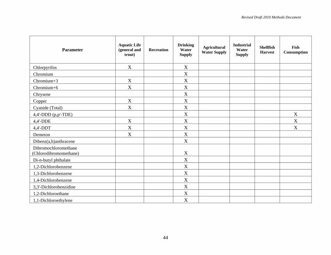
Revised Draft 2010 Methods Document
44
Parameter Aquatic Life (general and
trout) Recreation
Drinking Water Supply
Agricultural Water Supply
Industrial Water Supply
Shellfish Harvest
Fish Consumption
Chlorpyrifos X X Chromium X Chromium+3 X X Chromium+6 X X Chrysene X Copper X X Cyanide (Total) X X 4,4'-DDD (p,p'-TDE) X X 4,4'-DDE X X X 4,4'-DDT X X X Demeton X X Dibenz(a,h)anthracene X Dibromochloromethane (Chlorodibromomethane) X Di-n-butyl phthalate X 1,2-Dichlorobenzene X 1,3-Dichlorobenzene X 1,4-Dichlorobenzene X 3,3'-Dichlorobenzidine X 1,2-Dichloroethane X 1,1-Dichloroethylene X
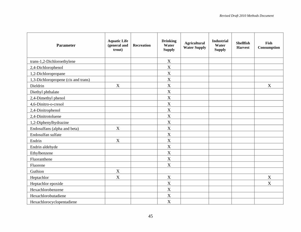
Revised Draft 2010 Methods Document
45
Parameter Aquatic Life (general and
trout) Recreation
Drinking Water Supply
Agricultural Water Supply
Industrial Water Supply
Shellfish Harvest
Fish Consumption
trans-1,2-Dichloroethylene X 2,4-Dichlorophenol X 1,2-Dichloropropane X 1,3-Dichloropropene (cis and trans) X Dieldrin X X X Diethyl phthalate X 2,4-Dimethyl phenol X 4,6-Dinitro-o-cresol X 2,4-Dinitrophenol X 2,4-Dinitrotoluene X 1,2-Diphenylhydrazine X Endosulfans (alpha and beta) X X Endosulfan sulfate X Endrin X X Endrin aldehyde X Ethylbenzene X Fluoranthene X Fluorene X Guthion X Heptachlor X X X Heptachlor epoxide X X Hexachlorobenzene X Hexachlorobutadiene X Hexachlorocyclopentadiene X

Revised Draft 2010 Methods Document
46
Parameter Aquatic Life (general and
trout) Recreation
Drinking Water Supply
Agricultural Water Supply
Industrial Water Supply
Shellfish Harvest
Fish Consumption
Hexachloroethane X Indeno(1,2,3-cd)pyrene X Isophorone X Lead X X Malathion X Manganese X Mercury X X X Methoxychlor X X Methyl bromide (bromomethane) X Methyl t-butyl ether (MTBE) X Methylene chloride X Mirex X X Nickel X X Nitrate (as N) X Nitrobenzene X N-Nitrosodi-n-butylamine X N-Nitrosodiethylamine X N-Nitrosodimethylamine X N-Nitrosodiphenylamine X N-Nitrosodi-n-propylamine (Di-n-propylnitrosamine) X N-Nitrosopyrrolidine X

Revised Draft 2010 Methods Document
47
Parameter Aquatic Life (general and
trout) Recreation
Drinking Water Supply
Agricultural Water Supply
Industrial Water Supply
Shellfish Harvest
Fish Consumption
Parathion X Pentachlorobenzene X Pentachlorophenol X X Phenol X Phosphorous X Polychlorinated biphenyls (PCBs) X X X Pyrene X Selenium X X Silver X X Sulfide-hydrogen sulfide (undissociated) X 1,2,4,5-Tetrachlorobenzene X 2,3,7,8-Tetrachlorodibenzo X -p-dioxin (TCDD) X X 1,1,2,2-Tetrachloroethane X Tetrachloroethylene X Thallium X Toluene X Toxaphene X X 1,2,4-Trichlorobenzene X 1,1,1-Trichloroethane X 1,1,2-Trichloroethane X

Revised Draft 2010 Methods Document
48
Parameter Aquatic Life (general and
trout) Recreation
Drinking Water Supply
Agricultural Water Supply
Industrial Water Supply
Shellfish Harvest
Fish Consumption
Trichloroethylene X 2,4,5-Trichlorophenol X 2,4,6-Trichlorophenol X Vinyl chloride X Zinc X
Radioactivity X