2011 aapl annual meeting · pdf file2011 aapl annual meeting sponsors platinum gold silver...
TRANSCRIPT

2011 AAPL ANNUAL MEETING SPONSORSPLATINUM
GOLD
SILVER
BOSTON SEMINAR
GOLFA wholly owned subsidiary of ExxonMobil

AAPL’s 57th Annual Meeting – June 8-11 in Boston, MA Copyright © 2011 by AAPL 2
GEOGRAPHIC
INFORMATION
SYSTEMS (GIS) FOR LAND
BOSTON 2011
JULIE PARKER
405-249-6910
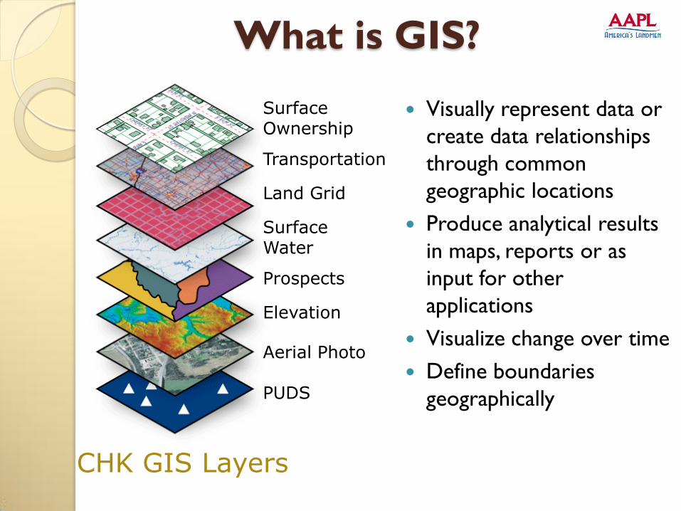
What is GIS?
Visually represent data or
create data relationships
through common
geographic locations
Produce analytical results
in maps, reports or as
input for other
applications
Visualize change over time
Define boundaries
geographically
CHK GIS Layers
SurfaceOwnership
Transportation
Land Grid
Surface Water
Prospects
Elevation
Aerial Photo
PUDS

Why use GIS?
GIS ties leasehold, wells, competitor and other information to a real world location.
Everything we do is tied to a location on the earth’s
surface. GIS allows us to link features on the
earth’s surface with information.
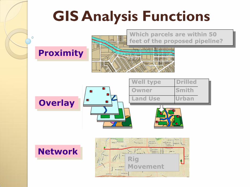
GIS Analysis FunctionsWhich parcels are within 50 feet of the proposed pipeline?
Well type Drilled
Owner Smith
Land Use Urban
Proximity
Overlay
NetworkRig Movement

GIS Query Functions
Identifying specific features
Identifying features based on conditions
Here we have identified
leases where the Lessee is
TS DUDLEY LAND CO INC.
CHK GIS Facts
• CHK GIS is a “business- facing” department supported by various
IT staff, some of whom have expertise in GIS data management and
application development.
• Our team consists primarily of embedded GIS Analysts and
Specialists who work closely with internal clients. OKC, Fort
Worth, Shreveport, Towanda and Harrisburg, PA. Nearly 80% of the
staff have degrees in Geography or related disciplines such as
Cartography.
• We have embedded staff in Land, Geology, Drilling, Reservoir
Engineering, Meteorology, and Regulatory. Land is by far our largest
internal customer.
CHK GIS Functions
• GIS is responsible for mapping Leasehold and Assets which
composes the Chesapeake “Game Board”.
• Responsible for development and training of corporate solutions
for non-GIS users.
• Provide spatial analysis of corporate data. (i.e. Expirations, Rigs,
Acreage Calculations, Unit Calculations, Site Selection,
Construction Support, Weather Mapping, Emergency Response)
• Create custom map products for use by all departments, including
some unlikely examples such as Accounting, Corporate
Development, and Human Resources.
9
GIS DATA AS A CORPORATE ASSET

GIS Layers are an Asset – value
comes from deploying them widely.
Internal & External uses
10
SurfaceOwnershipTransportation
Land Grid
Surface Water
Prospects
Elevation
Aerial Photo
PUDS
11
GIS BUSINESS CASES

Well Layer
City Layer
Wells within City Limit for
Accounting

Lease Tracking

Owner Relations Contacts

Rig Location – Site Selection

CHK acreage (yellow), our acquired acreage (bright green), wells and competitor units from LTDB in the area.
Strategy &Local Intelligence
17
IMPROVING EFFICIENCY WITH GIS

ELIMINATING/REDUCING REDUNDANT PROCESSES
Automated Leasehold mapping – Carteview,
tax parcels
Units
18

GETTING FROM THE LEASE TO THE MAP
GIS-assisted lease
mapping workflow
Lease Taken by broker on behalf of CHK or via acquisition
Lease information sent to CHKLease information uploaded to
Land records system
GIS runs report against Land records system to obtain
Information on new and/or unmapped leases
GIS System maps leasehold Containing parcel id’s or
Quartering info
Leases available in GIS Leasehold master layer for mapping and
analysis
GIS Technicians manually map remaining leases
20
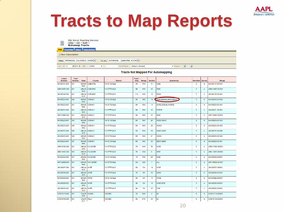
Tracts to Map Reports

USING GIS & SURFACE OWNERSHIP
Map the lease by using the tax parcel number.

OBTAINING PARCEL ID #S
The attributes of the selected parcel are
displayed in the GIS layer. In this case, we can
use the PARCEL_ID field to map the lease.

USING PARCELS
Entering Parcel ID on the CHK LPR or
in a spreadsheet for mapping.

24
Tracts to Map ReportsSpeed the process of manual mapping
by putting information at the fingertips of leasehold mappers

UNITS – DATA GENERATION
Create 10-acre blocks for federal unit mapping
25

PUBLISHING GIS DATA
Leveraging the value of GIS Data by
making it widely available
26
BOSTON 2011

So the leases are mapped, now what?
◦ Perform Analysis and Map Creation
Proposal Maps
Lease Maps
Expiration Maps
Drilling and Special Obligations Maps
Competitor Maps
Unit Maps
And many more…
GIS and Land

GIS and Land
• Proposal Map

GIS and Land
• Lease Map
GIS and Land
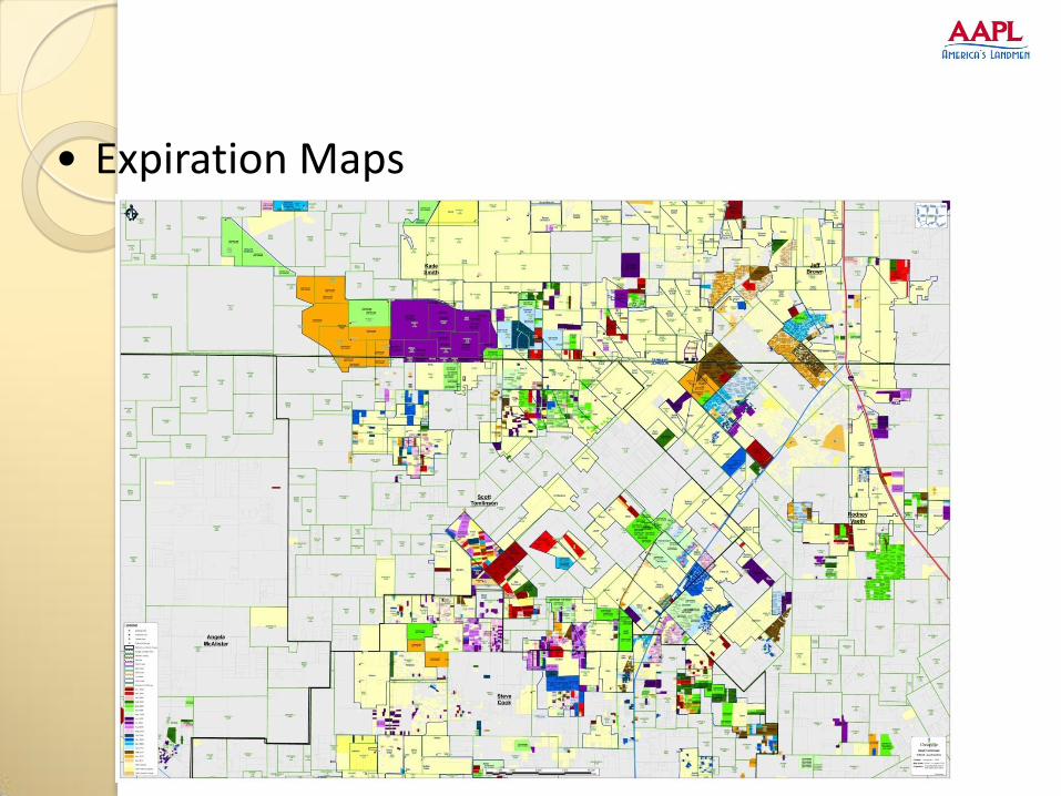
• Expiration Maps

• Drilling & Special Obligations Maps

How is GIS information made
available to decision-makers and
other CHK Staff?
Paper Maps
Web-based Maps
Desktop Maps
Coming soon…maps on your mobile devices
33
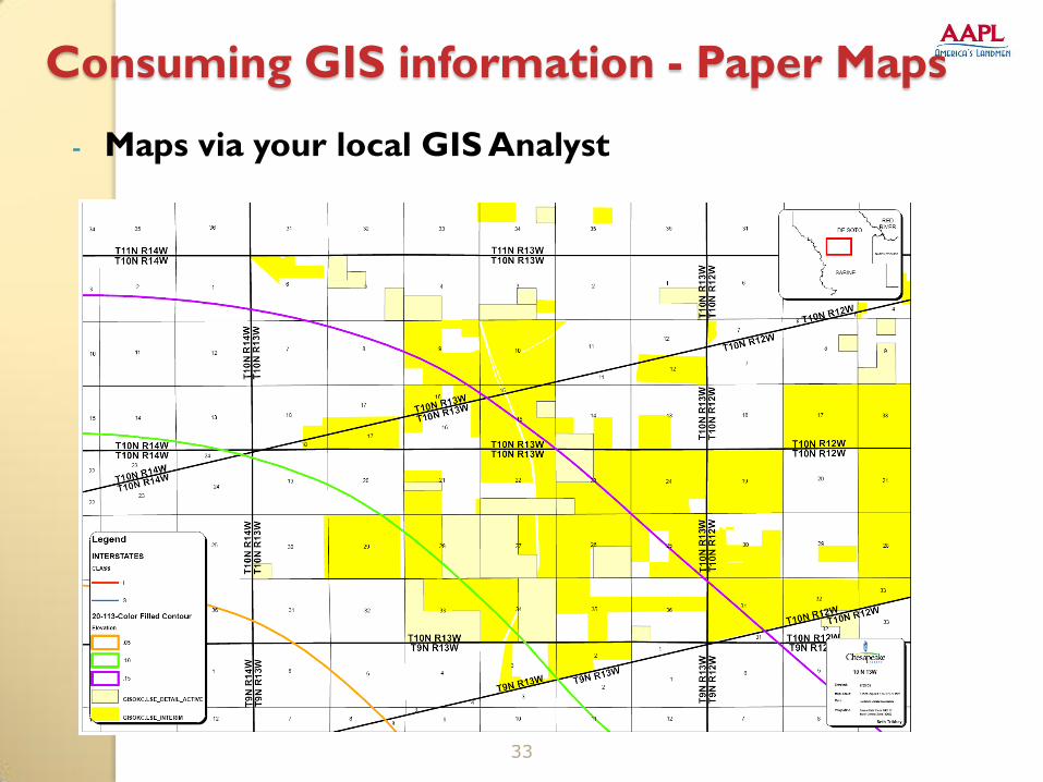
Consuming GIS information - Paper Maps
- Maps via your local GIS Analyst

VAL –Visual Asset Locator
35
A web-based mapping tool for finding and viewing land assets

Consuming
GIS
Information -
ArcReader
36
- Free map viewer – ArcReader- Digital maps for your desktop/laptop created by a GIS Analyst and customized for you.-Content is always updated because its linked to data sources.

37

MOBILE GIS - LEVERAGE YOUR INVESTMENT IN GIS DATA BY DEPLOYING IT OUTSIDETHE OFFICE
Mobile GIS is an emerging technology -View and
update maps on the go
38

MOBILE GIS
Using your smart phones for more than just
emails, texting, & calls.
39

MOBILE GIS
Applications for Land – Land research, Lease
tracking, Field data capture
40

IN SUMMARY
Chesapeake uses GIS in Land to…
Eliminate/reduce redundant processes such as
leasehold mapping
Share data and maps among Land teams via GIS
tools placed on desktop computers or made
available on the web.
Promote a consistent operational view between
CHK Land and brokers by sharing data and maps
via free map viewers such as ArcReader.
41

42
QUESTIONS?
FOR MORE INFORMATION CONTACT
JULIE PARKER
405-249-6910
Questions/Answers