2012 annual report ms4 permit version
DESCRIPTION
ÂTRANSCRIPT
1 | C A P I T O L R E G I O N W A T E R S H E D D I S T R I C T A N N U A L R E P O R T 2 0 1 2
Capitol Region Watershed District
2012A N N U A L R E P O R T

2 | C A P I T O L R E G I O N W A T E R S H E D D I S T R I C T A N N U A L R E P O R T 2 0 1 2
Letter to Stakeholders
Dear Stakeholders April 2013
The Board Managers and staff of Capitol Region Watershed District (CRWD) would like to share a review of 2012
accomplishments, the Capitol Region Watershed District Annual Report.
2012 was another excellent year for CRWD. Oversight, maintenance and improvement continued for the Trout
Brook Stormwater Interceptor, which was transferred to CRWD from Metropolitan Council in 2006. The CRWD
Permitting Program completed its sixth year. In 2012, 30 permit applications were received and processed. Of
the 331 acres covered in the applications, approximately 109 of those acres were impervious surfaces on which
stormwater runoff is treated to the 1” standard specified in the Watershed Rules.
CRWD’s Monitoring program included 17 stormwater monitoring sites in 2012. Ten of these sites were full moni-
toring stations that record flow and take water quality samples. Major subwatershed monitoring stations are
located near four outlets to the Mississippi River.
The construction of the Central Corridor Light Rail Transit (CCLRT) project has presented a unique opportunity
to improve stormwater quality in a major urban transportation corridor. With financial assistance from State of
Minnesota Clean Water Fund, project partners Metropolitan Council, the City of Saint Paul and Ramsey County
constructed green infrastructure practices to reduce stormwater pollution in the corridor.
In 2012, progress continued on the Trillium Site, which is being developed into a nature sanctuary on Saint Paul’s
East Side that will include special water quality features. CRWD also continued its involvement with City of Saint
Paul’s Neighborhood Stabilization Program in which grant funds are used to acquire and redevelop foreclosed
properties. The City of Saint Paul requested CRWD’s assistance creating stormwater BMP plans that minimize
runoff and while improving aesthetics. CRWD also supported the installation of 60 boulevard rain gardens in
the Hamline Midway neighborhood in partnership with City of Saint Paul Department of Public Works as they
carried out their annual Residential Street Vitality Program (RSVP) street reconstruction work.
Fellow Board Managers and staff also extended heartfelt thanks to Manager Bob Piram as he retired from the
CRWD Board in 2012. A few of Manager Piram’s accomplishments during his eventful tenure include leading
negotiations with Metropolitan Council for the transfer of ownership of the Trout Brook Storm Sewer, spear-
heading the Arlington Pascal Stormwater Improvement Project planning and overseeing development of
CRWD’s Watershed Rules that regulate treatment of stormwater on development sites. Manager Piram also
won a 2012 Sustainable Saint Paul Award. Board and staff recall with gratitude his 13 years of dedicated service.
More details of our accomplishments follow in this report. For this successful year, CRWD Board of Managers
would like to express appreciation to CRWD’s Citizen Advisory Committee, Saint Paul District Planning Councils,
the cities of Saint Paul, Falcon Heights, Maplewood, Roseville and Lauderdale, Ramsey County, Ramsey
Conservation District, District consultants and most importantly, the citizens of CRWD for their continued
support in helping improve our water quality.
Respectfully,
Joe Collins, President Mark Doneux, Administrator
2 0 1 2 C A P I T O L R E G I O N W A T E R S H E D D I S T R I C T A N N U A L R E P O R T | 3
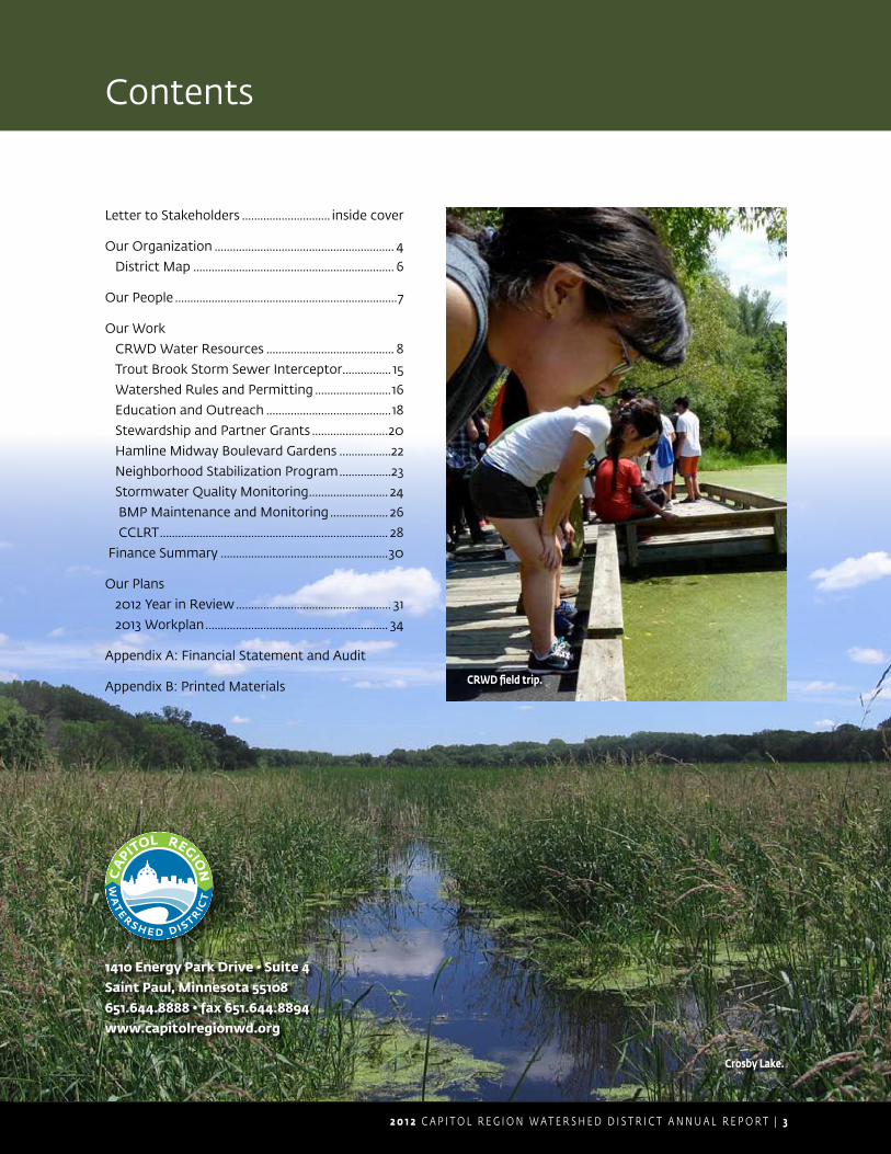
Contents
1410 Energy Park Drive • Suite 4Saint Paul, Minnesota 55108651.644.8888 • fax 651.644.8894www.capitolregionwd.org
CRWD field trip.
Letter to Stakeholders ............................. inside cover
Our Organization ........................................................... 4
District Map .................................................................. 6
Our People .........................................................................7
Our Work
CRWD Water Resources .......................................... 8
Trout Brook Storm Sewer Interceptor ................ 15
Watershed Rules and Permitting .........................16
Education and Outreach .........................................18
Stewardship and Partner Grants .........................20
Hamline Midway Boulevard Gardens .................22
Neighborhood Stabilization Program .................23
Stormwater Quality Monitoring .......................... 24
BMP Maintenance and Monitoring ................... 26
CCLRT ........................................................................... 28
Finance Summary .......................................................30
Our Plans
2012 Year in Review ................................................... 31
2013 Workplan ............................................................ 34
Appendix A: Financial Statement and Audit
Appendix B: Printed Materials
Crosby Lake.
4 | C A P I T O L R E G I O N W A T E R S H E D D I S T R I C T A N N U A L R E P O R T 2 0 1 2
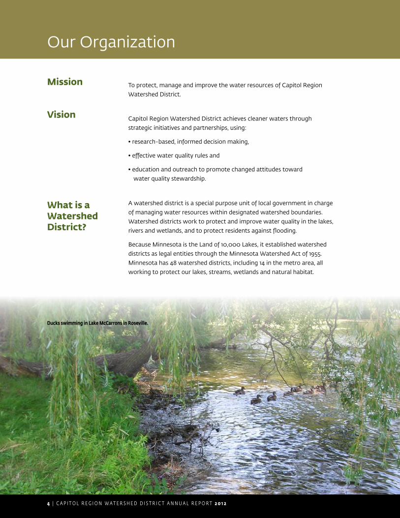
Our Organization
Mission To protect, manage and improve the water resources of Capitol Region
Watershed District.
Vision Capitol Region Watershed District achieves cleaner waters through
strategic initiatives and partnerships, using:
• research-based, informed decision making,
• effective water quality rules and
• education and outreach to promote changed attitudes toward
water quality stewardship.
What is a Watershed District?
A watershed district is a special purpose unit of local government in charge
of managing water resources within designated watershed boundaries.
Watershed districts work to protect and improve water quality in the lakes,
rivers and wetlands, and to protect residents against flooding.
Because Minnesota is the Land of 10,000 Lakes, it established watershed
districts as legal entities through the Minnesota Watershed Act of 1955.
Minnesota has 48 watershed districts, including 14 in the metro area, all
working to protect our lakes, streams, wetlands and natural habitat.
Ducks swimming in Lake McCarrons in Roseville.
2 0 1 2 C A P I T O L R E G I O N W A T E R S H E D D I S T R I C T A N N U A L R E P O R T | 5
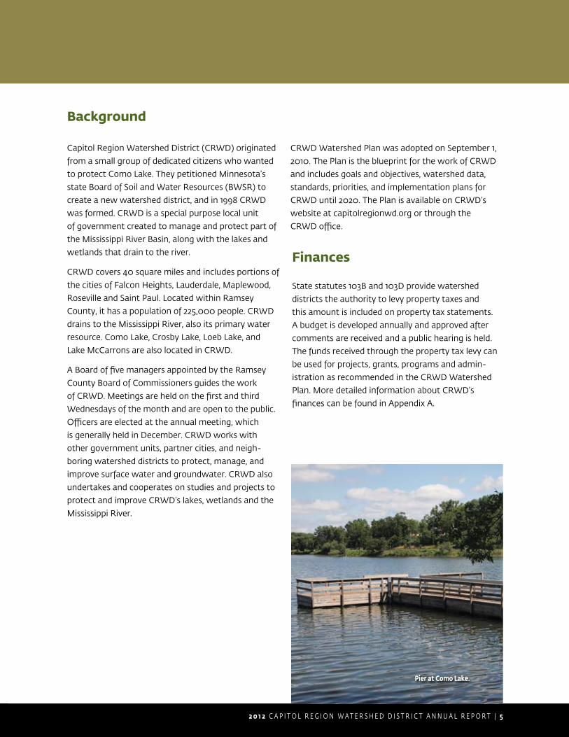
Background
Capitol Region Watershed District (CRWD) originated
from a small group of dedicated citizens who wanted
to protect Como Lake. They petitioned Minnesota’s
state Board of Soil and Water Resources (BWSR) to
create a new watershed district, and in 1998 CRWD
was formed. CRWD is a special purpose local unit
of government created to manage and protect part of
the Mississippi River Basin, along with the lakes and
wetlands that drain to the river.
CRWD covers 40 square miles and includes portions of
the cities of Falcon Heights, Lauderdale, Maplewood,
Roseville and Saint Paul. Located within Ramsey
County, it has a population of 225,000 people. CRWD
drains to the Mississippi River, also its primary water
resource. Como Lake, Crosby Lake, Loeb Lake, and
Lake McCarrons are also located in CRWD.
A Board of five managers appointed by the Ramsey
County Board of Commissioners guides the work
of CRWD. Meetings are held on the first and third
Wednesdays of the month and are open to the public.
Officers are elected at the annual meeting, which
is generally held in December. CRWD works with
other government units, partner cities, and neigh-
boring watershed districts to protect, manage, and
improve surface water and groundwater. CRWD also
undertakes and cooperates on studies and projects to
protect and improve CRWD’s lakes, wetlands and the
Mississippi River.
CRWD Watershed Plan was adopted on September 1,
2010. The Plan is the blueprint for the work of CRWD
and includes goals and objectives, watershed data,
standards, priorities, and implementation plans for
CRWD until 2020. The Plan is available on CRWD’s
website at capitolregionwd.org or through the
CRWD office.
Finances
State statutes 103B and 103D provide watershed
districts the authority to levy property taxes and
this amount is included on property tax statements.
A budget is developed annually and approved after
comments are received and a public hearing is held.
The funds received through the property tax levy can
be used for projects, grants, programs and admin-
istration as recommended in the CRWD Watershed
Plan. More detailed information about CRWD’s
finances can be found in Appendix A.
Pier at Como Lake.

6 | C A P I T O L R E G I O N W A T E R S H E D D I S T R I C T A N N U A L R E P O R T 2 0 1 2
§̈¦94
§̈¦35E
§̈¦35W
§̈¦EB I694
§̈¦TO 10TH
§̈¦35E
§̈¦35E
§̈¦35W
£¤52
£¤61
£¤52
£¤51
£¤36
£¤149
£¤5
£¤280
£¤156
£¤13
£¤5
£¤36
£¤149
")25
")23
")46
")48
")58
")37
")55
")53
")30
")88
")20
")36
")49
")34
")51
")75
")32
")78
")35
")50
")33
")40
")52
")139
")31
")38
")22
")24
")27
")64
")21
")56
")26
")19
")132
")35
")46
")30
")32
")23
")32
")31
")37
B2
GRAND AVE
EA
RL
ST
HA
MLI
NE
AV
E
SHEPARD RD
THOMAS AVE
LAFOND AVE
DAV
ER
N S
T
3RD ST
ARLINGTON AVE
SAINT CLAIR AVE
CR
ETI
N A
VE
ROBERT ST
FAIR
VIE
W A
VE
SUMMIT AVE
EDMUND AVE
B
FOR
ES
T S
T
COOK AVE
C2
SHERBURNE AVE
CASE AVE
PALACE AVE
CONCORDIA AVE
5TH ST6TH ST
PR
IOR
AV
E
PHALEN BLVD
DAYTON AVE
SAINT ANTHONY AVE
BU
RR
ST
ROSELAWN AVE
WATER ST
OH
IO S
T
SELBY AVE
STANFORD AVE
CLA
RE
NC
E S
T
AYD M
ILL RD
JEFFERSON AVE
SIMS AVE
SA
RAT
OG
A S
T
MARSHALL AVE
BEECH ST
SHORE DR
HIGHLAND PKWY
OTIS AVE
HA
LL A
VE
HEWITT AVE
JULIET AVE
LABORE RD
KELLOGG BLVD
AR
CA
DE
ST
JENKS AVE
MARGARET ST
GEORGE ST
CHILDS RD
BAY
ST
JES
SIE
ST
WE
STE
RN
AV
E
IVY AVE
RYAN AVE
PAS
CA
L S
T
BLAIR AVE
94
EUCLID ST
BUSH AVE
7TH ST
LAWSON AVE
GR
IGG
S S
T
ME
ND
OTA
ST
FULLER AVE
GR
OTT
O S
T
GARDEN AVE
FRONT AVE
PINEHURST AVE
BERKELEY AVE
DU
NLA
P S
T
BURNS AVE
LINCOLN AVE
ANNAPOLIS ST
36
EN
GLI
SH
ST
KING ST
WE
STM
INS
TER
ST
ALB
ER
T S
T
WA
LSH
ST
PACIFIC ST
REANEY AVE
WA
LNU
T S
T
HYACINTH AVE
ROBIE ST
WH
EE
LER
ST
ROME AVE
WELLESLEY AVE
MC
ME
NE
MY
ST
BAKER ST
STR
YK
ER
AV
E
SHRYER AVE
PRINCETON AVE
MCLEAN AVE
IOWA AVE
GOODRICH AVE
WIN
SLO
W A
VE
HAWTHORNE AVE
WHEELOCK PKWY
IDE
ST
HAGUE AVE
CA
RL
ST
STATE ST
VIKING DR
SY
ND
ICAT
E S
T
STEWART AVE
EVA ST
12TH ST
HEINEL D
R
ATWATER ST
TAYLOR AVE
HUDSON RD
BOHLAND AVE
GERANIUM AVE
PE
LHA
M B
LVD
MC
AFE
E S
T
IDAHO AVE
WABASHA ST
WYOMING ST
CALIFORNIA AVE
CARTER AVE
WA
RW
ICK
ST
HATCH AVE
DE
WE
Y S
T
EATON ST
PAGE ST
BR
IMH
ALL
ST
FAIRMOUNT AVE
OTTO AVE
RIPLEY AVE
VIE
W S
T
SAUNDERS AVE
ISABEL ST
TATU
M S
T
ELEANOR AVE
TOPPING ST
JUNO AVE
MO
OR
E S
T
VAN BUREN AVE
MAT
ILD
A S
T
GA
LTIE
R S
T
AR
ON
A S
T
EB I94
CH
ER
OK
EE
AV
E
MINNEHAHA AVE
UN
DE
RW
OO
D S
T
SIDNEY ST
4TH ST
AIR
PO
RT
RD
GRACE ST
PIGS
EYE LAKE R
D
CARROLL AVE
BELVIDERE ST
SEMINARY AVE
DEMONT AVE
COTTAGE AVE
MA
NO
MIN
AV
E
LAUREL AVE
BURGESS ST
WE
IDE
ST
LIN
CO
LN D
R
BATES AVE
HUBBARD AVE
TERRITORIAL RD
SMITH AV
E
INTERCAMPUS TRANSITW
BURKE AVE
BEVERLY RD
OTT
AWA
AVE
HOYT AVE
DOSWELL AVE
JAC
KS
ON
ST
MARIA AVE
AR
UN
DE
L S
T
HA
MP
DE
N A
VE
RO
SEGATE
EDGCUMBE RD
GO
RTN
ER
AV
E
LON
G L
AK
E R
D
MIDWAY PKWY
SKILLMAN AVE
CURTICE ST
MORTON ST
COMO AVE
ARMSTRONG AVE
ORCHARD AVE
ELDRIDGE AVE
SHERIDAN AVE
MA
CK
UB
IN S
T
HENDON AVE
FROST AVE
SYCAMORE ST
MA
LVE
RN
ST
CH
AR
LTO
N S
T
CONGRESS ST
KE
LLE
R P
KW
Y
HILLCREST AVE
2ND ST
OLD SHEPARD RD
10TH ST
CO
OP
ER
ST
STEVENS ST
WINONA ST
GERVAIS AVE
TUSCARORA AVE
DALE ST
ELI RD
JESSAMINE AVE
ROSS AVE
NO
EL
DR
WINIFRED ST
HU
RO
N S
T
HOLLY AVE
CAPP RD
NEBRASKA AVE
RIC
E S
T
COPE AVE
11TH ST
CEDAR ST
SHERWOOD AVE
OA
KD
ALE
AVE
SB
HW
Y280
LOR
IENT ST
AURORA AVE
RE
TUR
N C
T
BEECHWOOD AVE
MINNESOTA ST
MA
RIO
N S
T
HO
LTO
N S
T
OX
FOR
D S
T
BIR
MIN
GH
AM
ST
RAY
MO
ND
AV
E
ALB
EM
AR
LE S
T
PLE
AS
AN
T S
T
CROSBY FARM RD
SPRING ST
BREDA AVE
ENGLEWOOD AVE
OLI
VE
ST
CESAR CHAVEZ ST
ELMER ST
PARKWAY DR
LOVELL AVE
WILSON AVE
JUDSON AVE
AG
ATE
ST
VIC
TOR
IA S
T
FILLMORE AVE
SA
INT
ALB
AN
S S
T
COMMONWEALTH AVE
CO
UN
TRY
DR
SB I35E
CONWAY ST
MCCARRONS BLVD
SAINT PETER ST
WYNNE AVE
CO
MO
LAKE DR
PARKER AVE
CH
ATS
WO
RTH
ST
EM
ER
ALD
ST
TERRACE DR
DELOS ST
DA
LY S
T
CY
PR
ES
S S
T
WALL ST
BUFORD AVE
ALBANY AVE
FREMONT AVE
NB
HW
Y61
94 TO6TH ST
GOTZIAN ST
ALMOND AVE
VIR
GIN
IA A
VE
SAINT PAUL AVE
AS
BU
RY
ST
BENSON AVE
SN
ELL
ING
AV
E
BE
LLO
WS
ST
NB I35E
ETN
A S
T
HU
MB
OLD
T AV
E
ASHLAND AVE
AG
LEN
ST
CLIFF ST
CO
HA
NS
EY
ST
694
NB I35W
MAPLE ST
SB HWY61
SAVAGE LNS
UE
ST
SIM
PS
ON
ST
HILLSIDE AVE
NILES AVE
DE
SO
TO S
T
HARTFORD AVE
ALABAMA ST
FIE
LD A
VE
PH
ALE
N P
L
FOLWELL AVE
PORTLAND AVE
YORK AVE
LITTLE CANADA RD
OAKCREST AVE
MONTREAL AVE
EXETER PL
LEALAND RD
KOHLMAN AVE
NO
RTO
N S
TGATEWAY DR
ELF
ELT
ST
STINSON ST
AR
BO
R S
T
IONE ST
OWASSO BLV
D
FRA
NK
ST
DE
LAW
AR
E A
VE
WAKEFIELD AVE
ENERGY LN
KE
NW
OO
D D
R
CH
IPP
EW
A AV
E
ALTA VISTA DR
MO
NTC
ALM
PL
HANCOCK ST
FAR
RIN
GTO
N S
T
LAK
E S
T
WOODHILL DR
DODD RD
ARCH ST
CO
MO
PL
PAR
K S
T
BRAINERD AVE
SEXTANT AVE
EMPIRE DR
8TH ST
ALA
ME
DA
ST
RUGGLES ST
HARRISON AVE
TOR
ON
TO S
T
SCUD
DER
ST
DESNOYER AVEB
RO
AD
WAY
ST
DU
KE
ST
WO
OD
BR
IDG
E S
T
FER
RY
ST
COMO BLVD
YORKSHIRE AVE
TO AYD MILL RD
RU
TH S
T
HU
NTIN
G VA
LLEY
RD
BROOKS AVE
GROVE ST
CH
AM
BE
R S
T
FRANKSON AVE
LIN
DIG
ST
MONTANA AVE
EU
STI
S S
T
WB HWY36
HA
ND
AV
E
TO C
LEV
ELA
ND
AVE
UNIVERSITY AVE
WINTER ST
CAYUGA ST
CH
ESTER ST
CO
LETT
E P
L
KOHL
MAN
LN
DUDLEY AVE
MARYLAND AVE
KE
STO
N S
T
MOUNT AIRY ST
FISK ST
TO DALE ST
BEAM AVE
ROSE PL
MAY
WO
OD
ST
CO
ND
IT S
T
JOHN
IREL
AND
BLVD
ALAS
KA A
VE
LARK AVE
ADA
ST
LOMBARD AVE
DA
NFO
RTH
ST
HO
WE
LL S
T
LEE
ST
KASOTA AVE
RY
DE
ST
STA
RK
ST
SCHEFFER AVE
AD
ELE
ST
MILLWOOD AVE
GRANDVIEW AVE
HO
MER
ST
CLEVELAND AVE
AMH
ERS
T ST
WB I94
MUNSTER AVE
SLO
AN
ST
BR
AD
LEY
ST
LARCH ST
TO 1
0TH
ST
AIDA PL
GLUEK LN
DRAPER AVE
AR
KW
RIG
HT
ST
WO
OD
BU
RY
ST
CH
UR
CH
ILL
ST
RO
Y S
T
ATLA
NTI
C S
T
EAGLE PKW
Y
LAK
EV
IEW
AV
E
ROMA AVE
VIR
GIN
IA S
T
WAGNER ST
BENHILL RD
BR
OM
PTO
N S
T
RIDDER CIR
CU
RFE
W S
T
IONA LN
TEMPLE CT
BAYFIELD ST
THOMPSON ST
HA
GE
N D
R
AC
OR
N R
D
FULT
ON
ST
MCGOFFIN AVE
PAY
NE
AV
E
LAURIE RD
94 TO MARION ST
MAR
ION
RD
EB HWY36
CO
SG
RO
VE
ST
SH
ELD
ON
ST
LAN
E P
L
AMES AVE
CLEAR AVE
PIE
RC
E S
T
ED
WA
RD
ST
WHEATON AVE
FORD PKWY
WYCLIFF ST
94 TODALE ST
DU
LUTH
ST
KNAPP ST
36 SERVICE DR
CLI
FTO
N S
T
MO
UN
T R
IDG
E R
D
MO
RR
ISO
N A
VE
CU
MB
ER
LAN
D S
T
MID
LOTH
IAN
RD
JUDITH AVE
AUTUMN ST
GRANITE ST
CENTRAL AVE
LIV
ING
STO
N A
VE
PATT
ON
RD
NEVADA AVE
LILL
EHEI
PLZ
TRO
SETH
RD
COLVIN AVE
PARKVIEW AVE
ROSE AVE
LIN
DIG
AV
E
CHARLES AVE
LONG AVE
GILBERT AVE
RACE ST
SUMMER ST
ANIT
A ST
FRISBIE AVE
BIGLOW LN
TO R
AND
OLP
H A
VE
MILFORD ST
ELW
AY S
T
FIFI
ELD
ST
GU
RN
EY
ST
CLA
YLA
ND
ST
DIA
NN
A LN
COHANSEY BLVD
VANDALIA ST
STURGIS ST
TIMBERLAKE RD
ROBLYN AVE
MANVEL ST
COMMERCE ST
MONTREAL WAY
LOE
B S
T
BUFORD PL
SLO
AN
PL
EXCHANGE ST
FENTON AVE
GR
AN
THA
M S
T
FITCH AVE
NORPAC RD
BELMONT LN
ROSE LN
WATSON AVE
SHIELDS AVE
SU
MN
ER
ST
SHERREN ST
KE
NN
ETH
ST
VALE
NTO
LN
MARKET PL
SY
LVA
N S
T
PRESERVE CT
PH
ALE
N D
R
NIN
A S
T
SUMMER AVE
IRVINE AVE
UPPER SAINT DENNIS RD
FER
RIS
LN
NASON PL
MILD
RED
DR
GOODHUE ST
PINE ST
WA
LTE
R S
T
DOWNS AVE
MAPLE LN
MORGAN AVE
CARLING DR
OSCEOLA AVE
MIL
TON
ST
SARGENT AVE LINWOOD AVE
PLEASANT AVE
MILL S
T
BELLWOOD AVE
CO
STA
LN
ALD
INE
ST
TO NB RICE ST
MO
NTR
OSE PL
MYRTLE AVE
HE
RS
CH
EL
ST
CA
NTO
N S
T
EDGERTON ST
JUNCTION AVE
BUR
NQ
UIST ST
SHORT ST
CAPITOL VIEW ST
SP
RU
CE
ST
ACKER ST
COACH RD
WEWERS RD
DIONNE ST
CA
NA
BU
RY D
R
FER
NW
OO
D S
T
IRE
NE
ST
BOHLAND PL
GRAHAM AVE
CANFIELD AVE
AR
THU
R S
T
MA
CA
LES
TER
ST
IDA
AVE
ROSEWOOD LN
WABASH AVE
DE
LLW
OO
D S
T
FULH
AM
ST
ELLIS AVE
MIS
SIS
SIP
PI S
T
AVO
N S
T
WELLS ST
ER
IE S
T
WE
BS
TER
ST
LEE
CH
ST
LAFA
YETTE RD
BREWSTER ST
RANDOLPH AVE
RAVOUX ST
JAMES AVE
IGLEHART AVE
CONCORD ST
SE
AR
LE S
T
OR
ME C
T
PRICE AVE
GIBBS AVE
DA
N E
LME
R W
AY
KINGSTON AVE
LEXINGTON AVE
AB
EL
ST
BANFIL ST
NORFOLK AVE
SANDHURST DR
KAUFMAN DR
WO
OD
LAW
N A
VE
KE
NT
ST
WOOD ST
FERONIA AVE
FIN
N S
T
BR
OW
N A
VE
NORTH ST
MAGNOLIA AVE
AR
GY
LE S
T
ROCKWOOD AVE
LITCHFIELD ST
WHEELOCK AVE
WIL
DE
R S
T
MINNESOTA AVE
CUSHING CIR
PERIMETER RD
ROSEVILLE MALL DR
LIN
DY
AV
E
DE
LLW
OO
D A
VE
SA
INT
MA
RY
S S
T
HA
RVA
RD
ST
TO M
AR
YLA
ND
AV
E
BAR
CLA
Y S
T
WILLIUS ST
GRAND HILL
SA
INT C
RO
IX S
T
IDE
CT
AB
ELL
ST
WA
SH
ING
TON
ST
HU
RO
N A
VE
ME
RR
ILL
ST
SPENCER RD
SU
E P
L
JOH
N S
T
CAT
HLI
N S
T
PAR
TRID
GE
RD
RAMBLER RD
ITASCA AVE
LABORE AVE
TRANSIT AVE
PROSPECT BLVD
BAYARD AVE
CLA
RK
ST
DAY
RD
MA
PLE
WO
OD
DR
FIE
LD R
D
94 TOWALL ST
14TH ST
STO
NE
BR
IDG
E B
LVD
BE
RR
Y S
T
NA
NC
Y P
L
MC
AFE
E C
IR
COMMERCIAL ST
WIL
LIA
M S
T
WIL
KIN
ST
MO
UN
T C
UR
VE
BLV
D
MAY
RE
ST
9TH ST
STEL
LA S
T
CH
AR
LOTT
E S
T
CHILDS ROAD TO WARNER RD
WA
ND
A S
T
LEXINGTON PKWY
FAIRWAYS LN
LEE AVE
PEARL ST
HAMPSHIRE AVE
CENTENNIAL DR
BANC
ROFT
AVE
MOUNT VERNON AVE
PIERCE BUTLER AVE
BEAUMONT ST
RIDGEWOOD LN
SUNSET CT
OTI
S LN
NO
RBER
T LN
BO
SS
AR
D D
R
MA
PLE
CT
BAYLESS PL
SE
AL
ST
AR
ON
A AV
E
LYTON PL
KITTSON ST
CH
ELS
EA
ST
ALA
DD
IN S
T
SU
NR
ISE
DR
VAN SLYKE AVE
TO LA
RP
EN
TEU
R AV
E
NEVADA ST
SN
ELL
ING
CR
V
MID OAKS LN
MARSHALL PL
ATWATER CIR
BID
WE
LL S
T
WORCESTER AVE
GR
EE
NB
RIE
R S
T
ELK
ST
ORANGE AVE
MAYWOOD PL
NO
RFO
LK L
N
WIN
STO
N S
T
DRAPER DR
TALISMAN CRV
VAN
CE
ST
VILLARD AVE
TO R
OS
ELA
WN
AV
E
PAC
KA
RD
ST
ED
GE
MO
NT
ST
AD
OLP
HU
S S
T
HY
THE
ST
COLONIAL DRTO
LAFAYETTE RD
COPE CT
OC
EA
N S
T
KANSAS AVE
KEN
WO
OD
CT
FER
NW
OO
D A
VE
CIV
IC C
EN
TER
DR
BLUWOOD AVE
WAYZATA ST
CHELTON AVE
TO S
HE
PAR
D R
D
MAPLE HILLS DR
LOWER HIDDEN FALLS DR
KN
AP
P P
L
BE
AC
ON
ST
280
TELL
ST
SHARONDALE AVE
BEECHWOOD PL
ALL
EN
PL
TER
RA
CE
CT
GA
LTIER
CIR
HA
DD
ING
TON
RD
CLAY ST
LOREN RD
MAT
ILD
A C
IR
JOH
NS
ON
PK
WY
HILL S
T
NE
WC
OM
BE
ST
36 SERVICE RD
COLLEGE AVE
SIBLEY ST
CITY VIEW LN
EMMA ST
PENN
SYLVANIA AVE
EDGEHILL CT
YO
UN
G S
T
COLORADO ST
AN
DR
EW
ST
HAW
LEY
GR
IFFI
TH S
T
TERRACE HEIGHTS ST
ELEANOR AVE
NEBRASKA AVE
C2
CASE AVEAV
ON
ST
KE
NT
ST
HARTFORD AVE
HAWTHORNE AVE
DE
SO
TO S
T
SN
ELL
ING
AV
E
IVY AVE
GA
LTIE
R S
T
SHRYER AVE
ALB
EM
AR
LE S
T
CHARLES AVE
SY
LVA
N S
T
SN
ELL
ING
AV
E
FIN
N S
T
WH
EE
LER
ST
SEXTANT AVE
JULIET AVE
DU
NLA
P S
T
RYAN AVE
ALB
ER
T S
T
AR
CA
DE
ST
ROSE PL
SY
ND
ICAT
E S
T
OX
FOR
D S
T
HOYT AVE
BR
AD
LEY
ST
WO
OD
BR
IDG
E S
T
MAPLE LN
WELLS ST
MA
CK
UB
IN S
T
VIR
GIN
IA S
T
JUNO AVE
BAYARD AVE
PORTLAND AVE
PAGE ST
CURTICE ST
IGLEHART AVE
CARROLL AVE
YORK AVE
TERRACE DR
PACIFIC ST
DE
LLW
OO
D A
VE
ANNAPOLIS ST
HU
RO
N S
T
MINNEHAHA AVE
DAYTON AVE
HO
LTO
N S
T
MIS
SIS
SIP
PI S
T
HAMLINE AVE
AR
KW
RIG
HT
ST
OSCEOLA AVE
BATES AVE
SKILLMAN AVE
LARK AVE
GERANIUM AVE
GR
IGG
S S
T
JUNO AVE
GR
OTT
O S
T
ATLA
NTI
C S
T
JESSAMINE AVE
SIM
PS
ON
ST
HOYT AVE
REANEY AVE
ARLINGTON AVE
BURKE AVE
PR
IOR
AV
E
PLEASANT AVE
PR
IOR
AV
E
BU
RR
ST
6TH ST
PAY
NE
AV
E
SUMMER ST
OX
FOR
D S
T
HA
MLI
NE
AV
E
PR
IOR
AV
E
SELBY AVE
RYAN AVE
BELMONT LN
FRA
NK
ST
EN
GLI
SH
ST
CLA
RE
NC
E S
T
FER
NW
OO
D A
VE
FULLER AVE
DE
SO
TO S
T
JUDITH AVE
C2
NEVADA AVE
AR
ON
A ST
BELLWOOD AVE
SNELLING AVE
OX
FOR
D S
T
LAWSON AVE
10TH STIGLEHART AVE
BUSH AVE
FIELD AVE
AG
LEN
ST
CY
PR
ES
S S
T
AD
OLP
HU
S S
T
PAY
NE
AV
E
PAS
CA
L S
T
MIL
TON
ST
SARGENT AVE
HOYT AVE
PR
IOR
AV
E
OX
FOR
D S
T
VIC
TOR
IA S
T
MAPLE LN
KE
NT
ST
HE
RS
CH
EL
ST
MIL
TON
ST
GOODRICH AVE
ALB
ER
T S
T
DU
NLA
P S
T
DA
LE S
T
MONTANA AVE
FRONT AVE
AVO
N S
T
LAWSON AVE
BAYARD AVE
HO
WE
LL S
T
MIL
TON
ST
ANNAPOLIS ST
HOYT AVE
TERRACE DR
IRE
NE
ST
CU
MB
ER
LAN
D S
T
IONA LN
TATU
M S
T
WB HWY36 FE
RR
Y S
T
KNAPP ST
GR
OTT
O S
T
PR
IOR
AV
E
LINCOLN AVE
OSCEOLA AVE
CLA
RK
ST
TRANSIT AVE
CARROLL AVE
DAYTON AVE
JUDITH AVE
ETN
A S
T
FAR
RIN
GTO
N S
T
HO
WE
LL S
T
CAYUGA ST
PAS
CA
L S
T
GR
IGG
S S
T
AVO
N S
T
ALB
ER
T S
T
SA
INT
ALB
AN
S S
T
ELEANOR AVE
ASHLAND AVE
FRA
NK
ST
KA
NS
AS
AV
E
WYOMING ST
C2
MAT
ILD
A S
T
BAYARD AVE
RO
BE
RT
ST
IRE
NE
ST
B2
AG
LEN
ST
CH
ATS
WO
RTH
ST
TRANSIT AVE
FAIRMOUNT AVE
HOYT AVE
OX
FOR
D S
T
SIMS AVE
TO DALE ST
PAY
NE
AV
E
PORTLAND AVE
9TH ST
SUNR
ISE
DR
FRA
NK
ST
IDAHO AVE
BELMONT LN
7TH ST
CONWAY ST
FIS
K S
TMONTANA AVE
IVY AVE
RYAN AV
E
BE
AU
MO
NT
ST
B
FRA
NK
ST
WIL
DE
R S
T
FER
RY
ST
PR
IOR
AV
E
VIC
TOR
IA S
T
AR
UN
DE
L S
T
SHRYER AVE
SA
INT
ALB
AN
S S
T
WE
STE
RN
AV
E
ASHLAND AVE
MAT
ILD
A S
T
MA
RIO
N S
T
AURORA AVE
IDAHO AVE
WELLESLEY AVE
AR
ON
A S
T
HOYT AVE
COMO AVE
SEXTANT AVE
PAS
CA
L S
T
MILLWOOD AVE
IOWA AVE
BID
WE
LL S
T
FAR
RIN
GTO
N S
T
CO
HA
NS
EY
ST
BIR
MIN
GH
AM
ST
RYAN AVE
AVO
N S
T
ALAMED
A ST
B2
RIPLEY AVE
PARKW
AY D
R
NB I35W
WH
EE
LER
ST
AR
CA
DE
ST
KE
NT
ST
COMO AVE
JESSAMINE AVE
BROOKS AVE
PAS
CA
L S
T
STEVENS ST
SEXTANT AVE
MILLWOOD AVE
WATSON AVE
PAS
CA
L S
T
CLE
VE
LAN
D A
VE
LON
G L
AK
E R
D
SHRYER AVE
BUSH AVE
WATSON AVE
SELBY AVE
CLA
RE
NC
E S
T
LAUREL AVE
CO
NC
OR
D ST
C2
JENKS AVE
SCHEFFER AVE
IRE
NE
ST
CHARLES AVE
AR
ON
A S
T
OWASSO BLVD
COLORADO ST
ENGLEWOOD AVE
BAYARD AVE
PIE
RC
E S
T
VIR
GIN
IA S
T
ROSELAWN AVE
TAYLOR AVE
AVO
N S
T
VIKING DR
IDE
ST
AS
BU
RY
ST
ME
RR
ILL
ST
CARROLL AVE
ORANGE AVE
BELMONT LN
IOWA AVE
WE
IDE
ST
GR
IGG
S S
T
ROSE PL
SY
LVA
N S
T
FIS
K S
T
SB HWY280
ETN
A S
T
WE
STE
RN
AV
E
MAPLE LN
JUNO AVE
JAC
KS
ON
ST
WH
EE
LER
ST
FIELD AVE
LAKE ST
DU
NLA
P S
T
STAT
E ST
COOK AVE
IVY AVE
ELDRIDGE AVE
HOLLY AVE
HUBBARD AVE
C2
BURGESS ST
JEFFERSON AVE
ME
RR
ILL
ST
WAT
ER ST
ROSE AVE
EN
GLI
SH
ST
LIN
DY
AV
E
VAN BUREN AVE
CH
AM
BE
R S
T
DRAPER AVE
BELMONT LN
IDAHO AVE
LOR
IEN
T S
T
FAIR
VIE
W A
VE
BEAM AVE
AR
UN
DE
L S
T
DU
LUTH
ST
MIS
SISS
IPPI
ST
VIC
TOR
IA S
T
5TH ST
SARGENT AVE
BENSON AVE
COTTAGE AVE
GA
LTIE
R S
T
JAMES AVE
HOYT AVE
STINSON ST
JESSAMINE AVE
JAMES AVE
SY
LVA
N S
T
HAGUE AVEAYD MILL RD
HUBBARD AVE
SA
INT
ALB
AN
S S
T
ALB
EM
AR
LE S
T
CALIFORNIA AVE
CARROLL AVE
BLAIR AVE
SKILLMAN AVE
DE
SO
TO S
T
SHERREN ST
MORTON ST
KE
NT
ST
NILES AVE
AVO
N S
T
CLA
RE
NC
E S
TBEECH ST
ORANGE AVE
BERKELEY AVE
SCHEFFER AVE
ALD
INE
ST
ATLA
NTI
C S
TJUNO AVE
ALD
INE
ST
WINONA ST
ATLA
NTI
C S
T
MAPLEWOOD DR
HO
WE
LL S
T
EDMUND AVE
MC
ME
NE
MY
ST
TERRACE DR
TATU
M S
T
FIN
N S
T
ATLA
NTI
C S
T
YORK AVE
ENGLEWOOD AVE
DE
SO
TO S
T
IVY AVE
MAGNOLIA AVE
MINNESOTA AVE
TRANSIT AVE
ASHLAND AVE
HYACINTH AVE
DU
LUTH
ST
DU
NLA
P S
T
GA
LTIE
R S
T
BR
AD
LEY
ST
MA
CK
UB
IN S
T
SKILLMAN AVE
IGLEHART AVEBU
RR
ST
WINONA ST
LINWOOD AVE
HATCH AVE
JES
SIE
ST
VIR
GIN
IA S
T
RICE ST
36
CH
ATS
WO
RTH
ST
PAS
CA
L S
T
KING ST
NEBRASKA AVE
HU
RO
N ST
OS
CE
OLA
AV
E
DELOS ST
DRAPER AVE
SIM
PS
ON
ST
MA
RIO
N S
T
COOK AVE
RYAN AVE
BANFIL ST
DAYTON AVE
ROSE PL
WAT
ER S
T
FAIRMOUNT AVE
SKILLMAN AVE
SIM
PS
ON
ST
HO
WE
LL S
T
LAK
E S
T
RYAN AVE
MA
RIO
N S
T
SY
LVA
N S
T
LEXINGTON AVE
WO
OD
BR
IDG
E S
T
ELDRIDGE AVE
GOODRICH AVE
ME
RR
ILL
ST
NILES AVE
WATSON AVE
CH
UR
CH
ILL
ST
GRANDVIEW AVE
FULH
AM
ST
4TH ST
CLA
RK
ST
CH
ATS
WO
RTH
ST
SIDNEY ST
BAKER ST
NEVADA AVE
AS
BU
RY
ST
EU
STI
S S
T
GR
OTT
O S
T
GOODRICH AVE
AR
UN
DE
L S
T
ETN
A S
T
IGLEHART AVE
LINCOLN AVE
EU
STIS
ST
WILD
ER ST
ORANGE AVE
MO
UN
T C
UR
VE
BLV
D
AS
BU
RY
ST
COOK AVE
KE
NN
ETH
ST
SHRYER AVE
CO
HA
NS
EY
ST
36 SERVICE DR
FOR
ES
T S
T
94
PAR
K S
T
WILSON AVE
ISABEL ST
LAUREL AVE
MILL S
T
JENKS AVE
OX
FOR
D S
T
ROSE AVE
WATSON AVE
BIR
MIN
GH
AM
ST
MIL
L ST
COPE AVE
SHEPARD RD
HATCH AVE
WH
EE
LER
ST
OX
FOR
D S
T
GR
OTT
O S
T
LOVELL AVE
CENTENNIAL DR
FER
RY
ST
ELDRIDGE AVE
OAKCREST AVE
FAR
RIN
GTO
N S
T
MA
CA
LES
TER
ST
4TH ST
BU
RR
ST
PR
IOR
AV
E
35E
949494
94
LakeMcCarrons
CrosbyLake
ComoLake
LoebLake
LakeMcCarrons
Legend
Capitol Region Watershed District
Cities
Parks
Subwatershed Boundary
Watershed Organizations
Water
Wetlands
Trout Brook Storm Sewer
Roads
County Road
Interstate Highway
US Highway
US Highway
St. Anthony HillWest Kittsondale
St. Anthony Park
Mississippi River Blvd.
East Kittsondale
West Seventh
Goodrich-Western
Downtown
Urban
Phalen Creek
Trout Brook
Como
Lake McCarrons
CrosbyHidden Falls
Davern
Falcon Heights
Roseville
Little Canada
Maplewood
St. Paul
Lauderdale
Grass Lake
Rice Creek
CentralMississippi
River
Ramsey-Washington Metro
Capitol Region
Lower Mississippi River
Lower Minnesota River
0 10.5Miles I
District Map
Capitol Region Watershed District is home to more than 225,000 people and the land area contains 42% impervious surfaces.
Our Organization

2 0 1 2 C A P I T O L R E G I O N W A T E R S H E D D I S T R I C T A N N U A L R E P O R T | 7
Our People
Board of ManagersCRWD is led by a five-person Board of Managers that guides the implementation of goals and objectives
set forth in the CRWD Watershed Management Plan. Board Managers are appointed by the Ramsey County
Board of Commissioners and serve a three-year term.
Citizen Advisory Committee StaffMark Doneux, Administrator
Melissa Baker, Water Resource Technician
Elizabeth Beckman, Education Coordinator
Anna Eleria, Water Resource Project Manager
Bob Fossum, Water Resource Project Manager
Forrest Kelley, Permit Coordinator
Matt Loyas, Water Resource Technician
Dawn Nelson, Office Manager
Britta Suppes, Water Resource Technician
Lindsay VanPatten, Education Asst. & Receptionist
Staff can be contacted by email at
The Citizen Advisory Committee (CAC) assists CRWD Board of Managers with organizational development and strengthens connections between CRWD and its citizens. Meetings are held the second Wednesday of each month and are open to the public. 2012 members are:
David Arbeit; Bill Barton; Pat Byrne; Janna Caywood; Steven Duerre; Wade Johnson; Jerry Kafka; Michael MacDonald; Ted McCaslin; Shirley A. Reider*; Michael Trojan; Michelle Ulrich; Jerome Wagner; Gwen Willems
Shirley Reider1725 Fairview Ave N Falcon Heights, MN [email protected]
Joe Collins, President534 W Orange StSt. Paul, MN 55117651-488-5108joe.collins@ ci.stpaul.mn.us
Michael Thienes, Treasurer284 S McCarrons BlvdRoseville, MN 55113651-489-1998mthienes@ comcast.net
Seitu Jones, Secretary629 Kent StSt. Paul, MN 55103651-227-9328seitu.jones@ comcast.net
Mary Texer, Education/ Information113 Farrington StSt. Paul, MN [email protected]
Seasonal Water Resource Interns Joy Degl’innocenti; David Depaz; Morgan Greenfield;
Corey Poland; Joe Sellner
Gordon Parks High School Intern Michael Hiveley
* Appointed to Board of Managers 11/2012.
2012 Consultant EngineersBarr Engineering 4700 77th St | Minneapolis, MN 55435
Emmons & Olivier Resources, Inc. 651 Hale Ave N | Oakdale, MN 55128
HDR Engineering, Inc. 701 Xenia Ave S | Minneapolis, MN 55416
HR Green and Associates 2550 University Ave W, Ste 400N | St. Paul MN 55114
Houston Engineering, Inc. 6901 E Fish Lake Rd, Ste 140 | Maple Grove MN 55369
SRF Consulting Group, Inc. One Carlson Pkwy, Ste 150 | Minneapolis, MN 55447
Wenck Associates 1800 Pioneer Creek Center | Maple Plain, MN 55359

8 | C A P I T O L R E G I O N W A T E R S H E D D I S T R I C T A N N U A L R E P O R T 2 0 1 2
Our Work
CRWD Water Resources
The water resources located in CRWD all eventually
discharge to the Mississippi River. The four major lakes
in CRWD are Como Lake, Crosby Lake and Loeb Lake
in Saint Paul, and Lake McCarrons in Roseville. All four
lakes serve important recreational needs for CRWD
residents and visitors, including fishing, boating and
swimming. Water quality is monitored by Ramsey
County.
Groundwater underneath the land surface of the
District provides non-drinking water for businesses
and institutions in Ramsey County. Few natural
wetlands in the District remain because they were
removed or altered during urbanization and develop-
ment over the past century. Woodview Marsh located
off Larpenteur Avenue in Roseville, Willow Reserve
located off Maryland Avenue in Saint Paul, and Villa
Park wetland located northwest of Lake McCarrons
in Roseville are the largest tracts of wetlands in the
District.
Como Lake
Located in the City of Saint Paul, Como Lake is a rela-
tively shallow (approximately 16 feet deep), 72-acre
lake located in a highly urbanized watershed. Como
Lake and its associated parkland are a major regional
recreational amenity within the metro. The lake drains
1,680 acres of land in Saint Paul, Roseville and Falcon
Heights.
Nonpoint source or stormwater runoff is the most
serious threat to the water quality of Como Lake
because it carries excessive quantities of nutrients,
specifically phosphorus and sediment, to the lake.
Como Lake does not meet water quality standards for
nutrients and is therefore listed as an impaired water
body by the Minnesota Pollution Control Agency.
In 2002, CRWD developed a strategic management
plan that describes water-related issues facing the
lake and identifies the management strategies and
Arlington Pascal Stormwater Improvement Project
Algae overgrowth in Como Lake has caused problems
with water clarity and quality, and has periodically
created an unpleasant odor in the area around the
lake. Elsewhere in the Como Lake watershed,
excessive stormwater runoff causes intercommunity
flooding problems. CRWD, along with the cities of
Saint Paul, Falcon Heights and Roseville, and Ramsey
County, has worked cooperatively to evaluate, design,
construct and fund several stormwater facilities
to address these problems. The Arlington Pascal
Stormwater Improvement Project has resulted in a
number of important and effective efforts including
rain gardens, infiltration trenches, a large under-
ground infiltration/storage facility, a regional storm-
water pond and storm drain improvements. Como Lake algae blooms, August 2010.
2 0 1 2 C A P I T O L R E G I O N W A T E R S H E D D I S T R I C T A N N U A L R E P O R T | 9
implementation activities to address the priority
issues. This plan serves as a guide for CRWD, the City
of Saint Paul and others for Como Lake’s improve-
ment projects. The plan identified four priority areas of
concern: water quality, aesthetics, recreation/lake use
and natural resources. One of the key management
goals from the plan is to reduce by 60% phosphorus
loading of the lake.
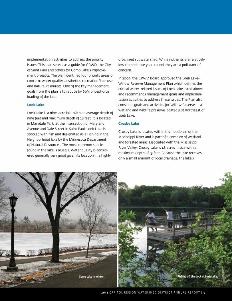
Loeb Lake
Loeb Lake is a nine-acre lake with an average depth of
nine feet and maximum depth of 28 feet. It is located
in Marydale Park, at the intersection of Maryland
Avenue and Dale Street in Saint Paul. Loeb Lake is
stocked with fish and designated as a Fishing in the
Neighborhood lake by the Minnesota Department
of Natural Resources. The most common species
found in the lake is bluegill. Water quality is consid-
ered generally very good given its location in a highly
urbanized subwatershed. While nutrients are relatively
low to moderate year-round, they are a pollutant of
concern.
In 2009, the CRWD Board approved the Loeb Lake-
Willow Reserve Management Plan which defines the
critical water-related issues of Loeb Lake listed above
and recommends management goals and implemen-
tation activities to address these issues. The Plan also
considers goals and activities for Willow Reserve — a
wetland and wildlife preserve located just northeast of
Loeb Lake.
Crosby Lake
Crosby Lake is located within the floodplain of the
Mississippi River and is part of a complex of wetland
and forested areas associated with the Mississippi
River Valley. Crosby Lake is 48 acres in size with a
maximum depth of 19 feet. Because the lake receives
only a small amount of local drainage, the lake’s
Como Lake in winter. Fishing off the dock at Loeb Lake.
1 0 | C A P I T O L R E G I O N W A T E R S H E D D I S T R I C T A N N U A L R E P O R T 2 0 1 2
Our Work
water quality has generally been good with very
good lake clarity, however, in recent years its water
quality has slightly declined. CRWD analyzes the lake
monitoring data collected by Ramsey County and
identifies concerns and trends in the lake’s health in
our annual Monitoring report. The land surrounding
Crosby Lake, collectively known as Crosby Farm
Regional Park, is managed by the City of Saint Paul
Parks and Recreation Department and is a part of the
National Park Service’s Mississippi National River and
Recreation Area.
In 2012, CRWD completed the development of a
management plan for Crosby Lake. The Plan includes
management goals and implementation projects
and activities to achieve those goals. Reviewed by
both technical and citizen advisory groups for the
plan, CRWD Board approved the plan in summer
2012. Partial funding for this project was provided by
Minnesota Clean Water Partnership Program.
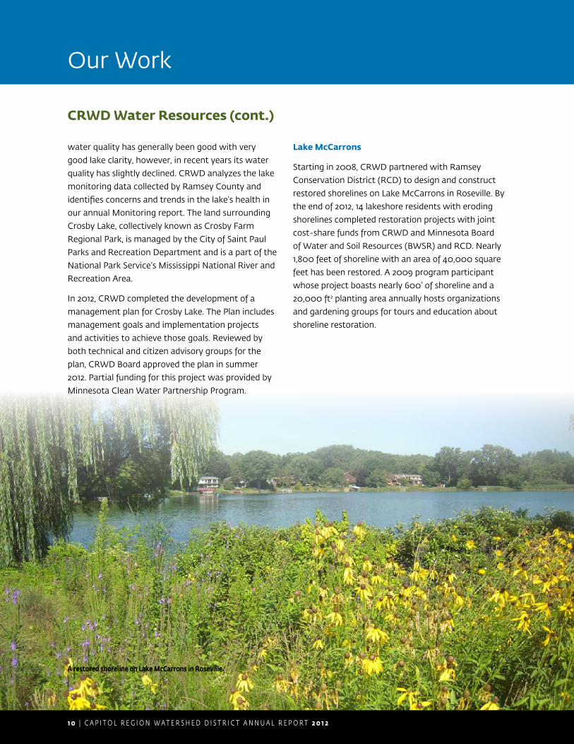
Lake McCarrons
Starting in 2008, CRWD partnered with Ramsey
Conservation District (RCD) to design and construct
restored shorelines on Lake McCarrons in Roseville. By
the end of 2012, 14 lakeshore residents with eroding
shorelines completed restoration projects with joint
cost-share funds from CRWD and Minnesota Board
of Water and Soil Resources (BWSR) and RCD. Nearly
1,800 feet of shoreline with an area of 40,000 square
feet has been restored. A 2009 program participant
whose project boasts nearly 600’ of shoreline and a
20,000 ft2 planting area annually hosts organizations
and gardening groups for tours and education about
shoreline restoration.
A restored shoreline on Lake McCarrons in Roseville.
CRWD Water Resources (cont.)
2 0 1 2 C A P I T O L R E G I O N W A T E R S H E D D I S T R I C T A N N U A L R E P O R T | 1 1
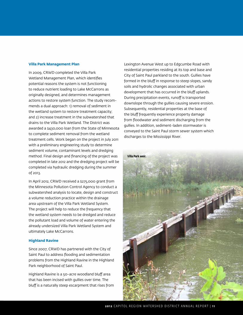
Villa Park Management Plan
In 2009, CRWD completed the Villa Park
Wetland Management Plan, which identifies
potential reasons the system is not functioning
to reduce nutrient loading to Lake McCarrons as
originally designed, and determines management
actions to restore system function. The study recom-
mends a dual approach: 1) removal of sediment in
the wetland system to restore treatment capacity;
and 2) increase treatment in the subwatershed that
drains to the Villa Park Wetland. The District was
awarded a $430,000 loan from the State of Minnesota
to complete sediment removal from the wetland
treatment cells. Work began on the project in July 2011
with a preliminary engineering study to determine
sediment volume, contaminant levels and dredging
method. Final design and financing of the project was
completed in late 2012 and the dredging project will be
completed via hydraulic dredging during the summer
of 2013.
In April 2012, CRWD received a $275,000 grant from
the Minnesota Pollution Control Agency to conduct a
subwatershed analysis to locate, design and construct
a volume reduction practice within the drainage
area upstream of the Villa Park Wetland System.
The project will help to reduce the frequency that
the wetland system needs to be dredged and reduce
the pollutant load and volume of water entering the
already undersized Villa Park Wetland System and
ultimately Lake McCarrons.
Highland Ravine
Since 2007, CRWD has partnered with the City of
Saint Paul to address flooding and sedimentation
problems from the Highland Ravine in the Highland
Park neighborhood of Saint Paul.
Highland Ravine is a 50-acre woodland bluff area
that has been incised with gullies over time. The
bluff is a naturally steep escarpment that rises from
Lexington Avenue West up to Edgcumbe Road with
residential properties residing at its top and base and
City of Saint Paul parkland to the south. Gullies have
formed in the bluff in response to steep slopes, sandy
soils and hydrolic changes associated with urban
development that has occurred in the bluff uplands.
During precipitation events, runoff is transported
downslope through the gullies causing severe erosion.
Subsequently, residential properties at the base of
the bluff frequently experience property damage
from floodwater and sediment discharging from the
gullies. In addition, sediment-laden stormwater is
conveyed to the Saint Paul storm sewer system which
discharges to the Mississippi River.
Villa Park weir.

1 2 | C A P I T O L R E G I O N W A T E R S H E D D I S T R I C T A N N U A L R E P O R T 2 0 1 2
Our Work
In response to concerns raised by citizens regarding
property damages from gully erosion, CRWD
completed the Highland Ravine Stabilization/
Restoration Feasibility Study in spring 2011. Based on
the results from this study, several strategies were
recommended to stabilize and restore the ravine area
to alleviate flooding, sedimentation and pollutant
loading.
In 2011, CRWD received a Minnesota Board of Water
and Soil Resources (BWSR) 2012 Clean Water Fund
– Clean Water Assistance Grant for $150,000 to
implement the recommendations detailed in the
feasibility study. In 2012, CRWD began work with an
engineering firm to develop preliminary designs for
gully stabilization and woodland restoration. Actual
construction of the stabilization practices as well as
the woodland restoration plan will occur during fall
2013. It is estimated that the implementation of this
project will reduce total sediment loads by 11.5 tons/
year and total phosphorus loads by 91 lbs/yr.
CRWD Water Resources (cont.)
Erosion damage on Highland Ravine.
Residential properties at the base of Highland Ravine often experience property damage from floodwater.
2 0 1 2 C A P I T O L R E G I O N W A T E R S H E D D I S T R I C T A N N U A L R E P O R T | 1 3
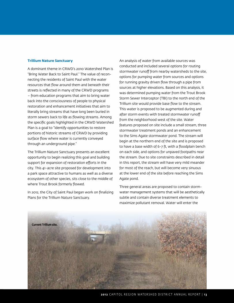
Trillium Nature Sanctuary
A dominant theme in CRWD’s 2010 Watershed Plan is
“Bring Water Back to Saint Paul.” The value of recon-
necting the residents of Saint Paul with the water
resources that flow around them and beneath their
streets is reflected in many of the CRWD programs
– from education programs that aim to bring water
back into the consciousness of people to physical
restoration and enhancement initiatives that aim to
literally bring streams that have long been buried in
storm sewers back to life as flowing streams. Among
the specific goals highlighted in the CRWD Watershed
Plan is a goal to “identify opportunities to restore
portions of historic streams of CRWD by providing
surface flow where water is currently conveyed
through an underground pipe.”
The Trillium Nature Sanctuary presents an excellent
opportunity to begin realizing this goal and building
support for expansion of restoration efforts in the
city. This 41-acre site proposed for development into
a park space attractive to humans as well as a diverse
ecosystem of other species, sits close to the middle of
where Trout Brook formerly flowed.
In 2012, the City of Saint Paul began work on finalizing
Plans for the Trillium Nature Sanctuary.
An analysis of water from available sources was
conducted and included several options for routing
stormwater runoff from nearby watersheds to the site,
options for pumping water from sources and options
for running gravity driven flow through a pipe from
sources at higher elevations. Based on this analysis, it
was determined pumping water from the Trout Brook
Storm Sewer Interceptor (TBI) to the north end of the
Trillium site would provide base flow to the stream.
This water is proposed to be augmented during and
after storm events with treated stormwater runoff
from the neighborhood west of the site. Water
features proposed on site include a small stream, three
stormwater treatment ponds and an enhancement
to the Sims Agate stormwater pond. The stream will
begin at the northern end of the site and is proposed
to have a base width of 6-7 ft, with a floodplain bench
on each side, and options for unpaved footpaths near
the stream. Due to site constraints described in detail
in this report, the stream will have very mild meander
for most of the reach, but will become very sinuous
at the lower end of the site before reaching the Sims
Agate pond.
Three general areas are proposed to contain storm-
water management systems that will be aesthetically
subtle and contain diverse treatment elements to
maximize pollutant removal. Water will enter the
Current Trillium site.
1 4 | C A P I T O L R E G I O N W A T E R S H E D D I S T R I C T A N N U A L R E P O R T 2 0 1 2
Signage Key
D
eyAENTRY SIGN A
INTERPRETIVE SIGN
DIRECTIONAL SIGN
STOP SIGN
KKIOSK
ENTRY SIGN B
DN
i
A
NN ii
B
NN
KK
DN
S
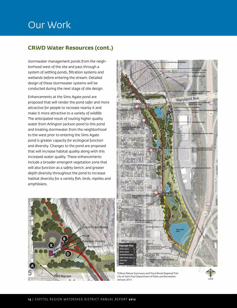
Trillium Nature Sanctuary and Trout Brook Regional TrailCity of Saint Paul Department of Parks and RecreationJanuary 2013 north
ART INSTALLATION
SIMS-AGATEPOND
ART RAILING ON BRIDGE
PRESERVE HIGH QUALITY TREES
ART INSTALLATION - MURAL(UNDER BRIDGE)
HISTORICAL OVERLOOK FROM NEIGHBORHOOD. PEDESTRIAN ACCESS
PEDESTRIAN CONNECTION TO NEIGHBORHOOD
CRUSHED LIMESTONE NATURE TRAIL (2/3 MILE)
HANDCART ART ON TRACKS
PULL-OFF WITH INTERPRETIVE SIGNAGE AND BENCH
NEIGHBORHOOD STORMWATERCOLLECTION POND
HEADWATER POND
PEDESTRIAN/MAINTENANCE ACCESS
COMBINED TROUT BROOK/GATEWAY TRAIL
TO BE COMPLETED BY MnDOT W35E/CAYUGA PROJECT
RAINGARDEN
FUTURE TRAIL EXPANSION
BUS DROP-OFF /PARKING (12-16 CARS)TRAILHEAD FACILITY
MnD
OT Property
City Property
OVERLOOK
Maryland Ave.
Jack
son
St.
Cayuga St.
BOARDWALK
CONNECTION TO TBITROUT BROOK STORM SEWER
i
i
i
i
MMMMn
Mtyyytyy
D
i
B
B
B
B
B
A
K
D
stormwater management ponds from the neigh-
borhood west of the site and pass through a
system of settling ponds, filtration systems and
wetlands before entering the stream. Detailed
design of these stormwater systems will be
conducted during the next stage of site design.
Enhancements at the Sims Agate pond are
proposed that will render the pond safer and more
attractive for people to recreate nearby it and
make it more attractive to a variety of wildlife.
The anticipated result of routing higher quality
water from Arlington Jackson pond to this pond
and treating stormwater from the neighborhood
to the west prior to entering the Sims Agate
pond is greater capacity for ecological function
and diversity. Changes to the pond are proposed
that will increase habitat quality along with this
increased water quality. These enhancements
include a broader emergent vegetation zone that
will also function as a safety bench, and greater
depth diversity throughout the pond to increase
habitat diversity for a variety fish, birds, reptiles and
amphibians.
Our Work
CRWD Water Resources (cont.)
2 0 1 2 C A P I T O L R E G I O N W A T E R S H E D D I S T R I C T A N N U A L R E P O R T | 1 5
Trout Brook Storm Sewer Interceptor
CRWD owns, operates and maintains the Trout Brook
Storm Sewer Interceptor (TBI), which consists of 6.5
miles of pipes that drain 5,054 acres from the cities of
Saint Paul, Roseville, Falcon Heights and Maplewood.
In 2012, the first phase of the TBI Realignment Project
near I-35E and Cayuga in Saint Paul was completed.
In 2011, during the preliminary design process of
Minnesota Department of Transportation’s (MnDOT)
reconstruction of Interstate I-35E, it was determined
that a portion of the existing TBI was in conflict with
the proposed I-35E bridge piers and needed to be
moved by the middle of 2013. The new Trout Brook
alignment involves abandoning 630 feet of existing TBI
pipe and replacing it with 830 feet of new 12’ x 9’ box
culvert and a new TBI railroad crossing.
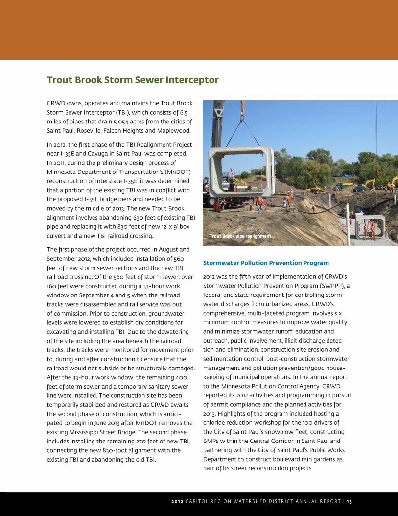
The first phase of the project occurred in August and
September 2012, which included installation of 560
feet of new storm sewer sections and the new TBI
railroad crossing. Of the 560 feet of storm sewer, over
160 feet were constructed during a 33-hour work
window on September 4 and 5 when the railroad
tracks were disassembled and rail service was out
of commission. Prior to construction, groundwater
levels were lowered to establish dry conditions for
excavating and installing TBI. Due to the dewatering
of the site including the area beneath the railroad
tracks, the tracks were monitored for movement prior
to, during and after construction to ensure that the
railroad would not subside or be structurally damaged.
After the 33-hour work window, the remaining 400
feet of storm sewer and a temporary sanitary sewer
line were installed. The construction site has been
temporarily stabilized and restored as CRWD awaits
the second phase of construction, which is antici-
pated to begin in June 2013 after MnDOT removes the
existing Mississippi Street Bridge. The second phase
includes installing the remaining 270 feet of new TBI,
connecting the new 830-foot alignment with the
existing TBI and abandoning the old TBI.
Stormwater Pollution Prevention Program
2012 was the fifth year of implementation of CRWD’s
Stormwater Pollution Prevention Program (SWPPP), a
federal and state requirement for controlling storm-
water discharges from urbanized areas. CRWD’s
comprehensive, multi-faceted program involves six
minimum control measures to improve water quality
and minimize stormwater runoff: education and
outreach, public involvement, illicit discharge detec-
tion and elimination, construction site erosion and
sedimentation control, post-construction stormwater
management and pollution prevention/good house-
keeping of municipal operations. In the annual report
to the Minnesota Pollution Control Agency, CRWD
reported its 2012 activities and programming in pursuit
of permit compliance and the planned activities for
2013. Highlights of the program included hosting a
chloride reduction workshop for the 100 drivers of
the City of Saint Paul’s snowplow fleet, constructing
BMPs within the Central Corridor in Saint Paul and
partnering with the City of Saint Paul’s Public Works
Department to construct boulevard rain gardens as
part of its street reconstruction projects.
Trout Brook pipe realignment.
1 6 | C A P I T O L R E G I O N W A T E R S H E D D I S T R I C T A N N U A L R E P O R T 2 0 1 2
Our Work
Watershed Rule Adoption
In 2002, CRWD adopted Development Review
Criteria addressing stormwater runoff control, flood
protection, wetland protection and erosion control.
During 2003-2005, CRWD assumed an advisory
role to District cities on development and redevel-
opment proposals. The advisory role consisted of
review and comment in reference to the District’s
Development Review Criteria. The District reviewed
71 developments and tracked implementation with all
of the criteria and found marginal compliance. After
completing a study to assess the impact of non-
compliance with the Development Review Criteria,
the District found that the water quality goals estab-
lished in the Watershed Management Plan were not
being met. CRWD then set a goal to develop and
adopt science-based watershed rules to improve
water quality. This process was initiated in 2005. In
January 2006, CRWD Board of Managers established
a joint Technical Advisory Committee (TAC) to make
recommendations on the standards in the draft
rules. After revision of the rules to reflect the recom-
mendations of the TAC, the rules were adopted in
September, effective October 1, 2006.
2012 Watershed Rules and Permitting
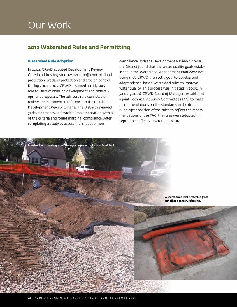
Construction of underground storage at a permitted site in Saint Paul.
A storm drain inlet protected from runoff at a construction site.
2 0 1 2 C A P I T O L R E G I O N W A T E R S H E D D I S T R I C T A N N U A L R E P O R T | 1 7
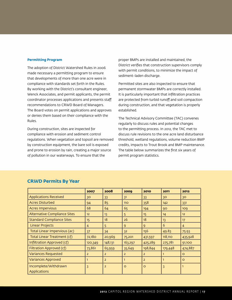
CRWD Permits By Year
2007 2008 2009 2010 2011 2012
Applications Received 30 33 31 33 30 30
Acres Disturbed 94 85 110 358 142 331
Acres Impervious 68 64 65 194 90 109
Alternative Compliance Sites 12 13 5 15 14 12
Standard Compliance Sites 15 18 26 18 13 17
Linear Projects 4 5 9 9 6 4
Total Linear Impervious (ac) 37 34 32 156 49.83 75.93
Total Linear Treatment (cf) 72,180 20,969 75,201 431,597 118,110 435,928
Infiltration Approved (cf) 120,349 148,131 163,297 425,289 275,781 91,100
Filtration Approved (cf) 73,861 65,959 35,649 198,844 179,448 474,887
Variances Requested 2 2 2 2 1 0
Variances Approved 1 2 1 2 1 0
Incomplete/Withdrawn
Applications
3 2 0 0 3 1
Permitting Program
The adoption of District Watershed Rules in 2006
made necessary a permitting program to ensure
that developments of more than one acre were in
compliance with standards set forth in the Rules.
By working with the District’s consultant engineer,
Wenck Associates, and permit applicants, the permit
coordinator processes applications and presents staff
recommendations to CRWD Board of Managers.
The Board votes on permit applications and approves
or denies them based on their compliance with the
Rules.
During construction, sites are inspected for
compliance with erosion and sediment control
regulations. When vegetation and topsoil are removed
by construction equipment, the bare soil is exposed
and prone to erosion by rain, creating a major source
of pollution in our waterways. To ensure that the
proper BMPs are installed and maintained, the
District verifies that construction supervisors comply
with permit conditions, to minimize the impact of
sediment-laden discharge.
Permitted sites are also inspected to ensure that
permanent stormwater BMPs are correctly installed.
It is particularly important that infiltration practices
are protected from turbid runoff and soil compaction
during construction, and that vegetation is properly
established.
The Technical Advisory Committee (TAC) convenes
regularly to discuss rules and potential changes
to the permitting process. In 2012, the TAC met to
discuss rule revisions to the one acre land disturbance
threshold, wetland regulations, volume reduction BMP
credits, impacts to Trout Brook and BMP maintenance.
The table below summarizes the first six years of
permit program statistics.

1 8 | C A P I T O L R E G I O N W A T E R S H E D D I S T R I C T A N N U A L R E P O R T 2 0 1 2
Our Work
Education and Outreach
TM
Outreach
CRWD also continued outreach to students and
adults in 2012 through direct work with organiza-
tions and community groups. CRWD staff and
volunteers contacted more than 1,100 watershed
residents through public events, trainings, presenta-
tions, resource assistance, school visits and field trips
within the District. This included a summer evening
lake study attended by 35 residents of all ages and
rain garden workshops and walking tours for more
than 120 residents. CRWD also sponsored transpor-
tation costs for eight water quality education field
trips attended by CRWD students, co-sponsored
with Friends of the Mississippi River storm drain
stenciling and trash cleanup in CRWD as part of the
Girl Scouts Centennial Day of Service on October 13,
2012, supported Children’s Water Fest with a financial
contribution, led a rain garden tour for Saint Paul
PROGRAM COST
• Design $188
• Printing $969
• Promotion (stamps) $51
• Web updates $300
• Education Assistant Intern staff time (157 hours August-October)
$2,045
Program cost subtotal $3,552
DOWNSPOUT REDIRECTION COST
• Homeowner reimbursement $300
• Contractor (labor and materials) $3,607
Downspout redirection cost subtotal $3,907
TOTAL ANNUAL COST $7,459
ANNUAL COST PER PROJECT $240
2012 SRD Total Annual Cost (31 projects)
A Stop the Rain Drain redirected downspout.
Parks and Recreation’s 50+ group, sponsored chloride
education workshops for 100 snowplow fleet drivers
from Saint Paul Public Works Street Maintenance
division and hosted 50 Saint Paul Parks staff for an
educational workshop about maintaining turf in a way
that causes minimal impact to water quality.
Stop the Rain Drain
CRWD carried out a third and
final year of the Stop the Rain
Drain gutter downspout redirec-
tion program. In 2012, 31 garages
were redirected totaling 10,000
ft2 of redirected runoff amounting
to approximately 4 million gallons
of reduction per year. CRWD staff revisited and left
doorhangers with suitable project sites identified in
2011. Twenty percent of those identified responded.
SRD 2012 contractor DTD Construction made the
adjustments to downspouts and also installed rain
barrels purchased by homeowners, who were then
allowed to request a $50 reimbursement from CRWD.
Homeowners who completed redirection work them-
selves were eligible for reimbursement at $4/linear foot
after submitting paperwork and receipts.
2 0 1 2 C A P I T O L R E G I O N W A T E R S H E D D I S T R I C T A N N U A L R E P O R T | 1 9
The Blue Thumb Partners are a group of
professionals from local governmental units
(watershed and conservation districts, cities,
counties), nonprofit and community organiza-
tions, and nursery and landscape professionals.
Blue Thumb partners advocate for clean
water through the use of native plant rain
gardens, native plant gardens and shoreline
restoration projects. Since 2007, CRWD has
participated as a Blue Thumb contributing
partner helping to maintain a website of
clean water gardening resources and print
and display materials for resident use. Blue
Thumb partners work to cultivate consistent
clean water planting messages for watershed
residents. Visit bluethumb.org.
P L A N T I N G F O R C L E A N W A T E R
Rain Barrel Construction Workshop Grants
With rain barrel construction workshop grants from
CRWD, four community organizations hosted more
than 180 participants at six events. Workshops were
held by Hamline Midway Coalition, Saint Anthony Park
Community Council, Union Park District Council and
Mississippi Market food cooperative.
Metro WaterShed Partners
CRWD has been a contributing member to WaterShed
Partners since 2005. WaterShed Partners (WSP) is a
coalition of more than 50 public, private and nonprofit
organizations in the metro area formed to educate
people about how their actions affect the watershed.
The Partners collaborate on outreach projects, share
resources and maintain the WaterShed exhibits, which
are portable, interactive, educational tools about
metropolitan watersheds and their connection to
human activities. A program of WSP, the Minnesota
Water — Let’s Keep It Clean! media campaign uses
media placements on radio and cable television and
public service announcements (PSAs) to educate
the public about preventing polluted runoff. In 2012,
the media campaign partnership financed 38 public
service announcement (PSA) placements during Saint
Paul Saints and Minnesota Twins baseball games,
400 PSA placements on Comcast cable channels
and streaming online gateway ads about sidewalk
salt reduction education on Minnesota Public Radio
(KNOW 91.1) during December 2012.
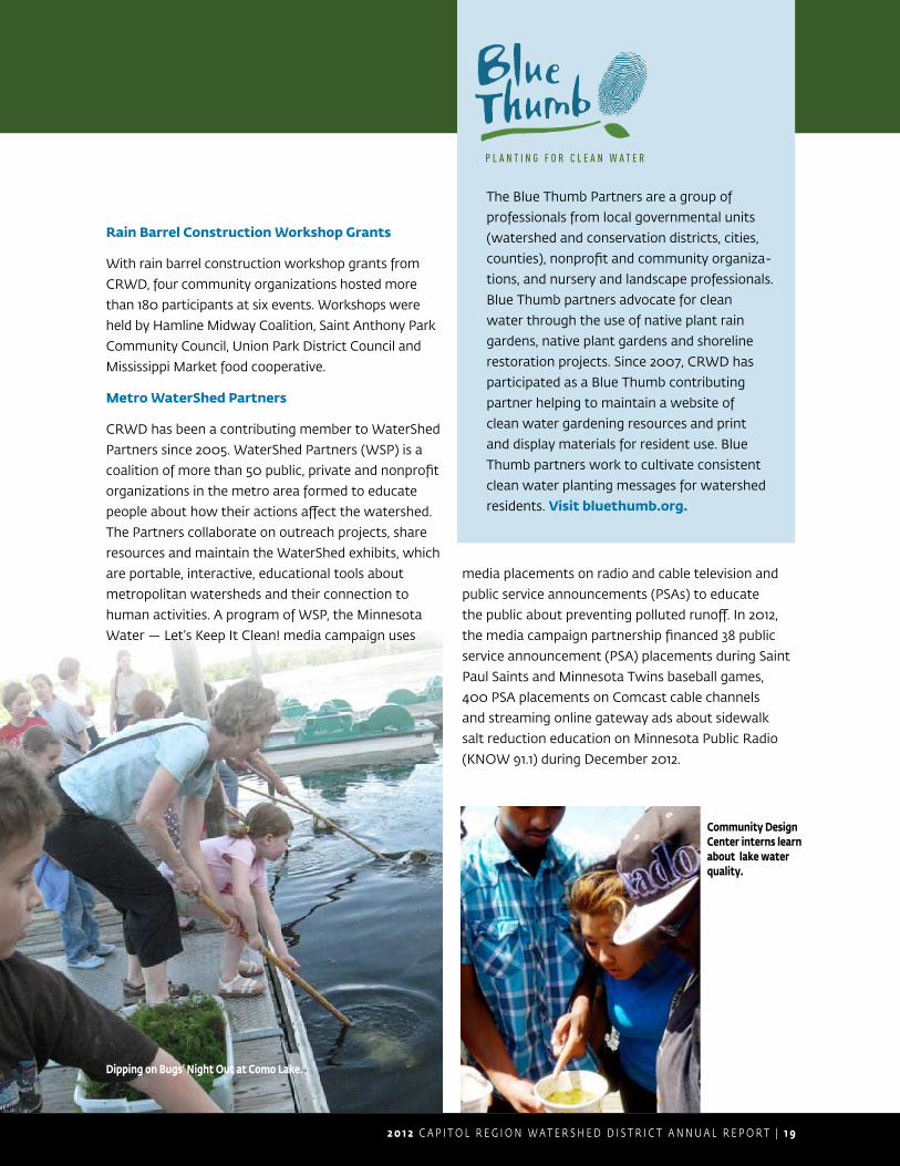
Dipping on Bugs’ Night Out at Como Lake.
Community Design Center interns learn about lake water quality.

2 0 | C A P I T O L R E G I O N W A T E R S H E D D I S T R I C T A N N U A L R E P O R T 2 0 1 2
Our Work
Stewardship and Partner Grants
Stewardship Grants
CRWD values collaboration with individuals and
organizations, and sees the involvement of all citizens
as important to improving the water resources in the
District. Through our grants we hope to encourage
a strong ethic of water resource stewardship among
citizens.
Goals of the Stewardship Grant program are to:
1. improve water quality,
2. increase groundwater recharge,
3. protect plant and wildlife communities and
4. raise stormwater pollution prevention awareness
among residents.
Grant requests are reviewed and approved by staff.
Grants include cost-share funding for residential water
quality improvement projects, as well as funding
for water quality education activities and events.
Grants are available to residents of the District as
well as government agencies, businesses, schools
and nonprofit organizations that are located and/
or conduct work in the District. CRWD offers free
technical assistance for rain garden and shoreline
restoration projects and reimburses project expenses
up to 50% of the approved project budget.
In 2012, 31 grants were awarded, totaling $34,400.
These grants helped make possible 42 rain gardens, a
green roof, nine residential rain barrels and three rain
barrel construction workshops. Grant funding also
provided support for CRWD to host two interns from
Gordon Parks High School, support of storm drain
stenciling for the Girl Scouts Centennial Day of Service,
a community clean up at Como Lake and a native
plant education expo and market.
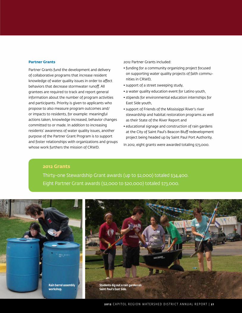
First Covenant Church volunteers plan a rain garden.
2 0 1 2 C A P I T O L R E G I O N W A T E R S H E D D I S T R I C T A N N U A L R E P O R T | 2 1
2012 Grants
Thirty-one Stewardship Grant awards (up to $2,000) totaled $34,400.
Eight Partner Grant awards ($2,000 to $20,000) totaled $73,000.
Partner Grants
Partner Grants fund the development and delivery
of collaborative programs that increase resident
knowledge of water quality issues in order to affect
behaviors that decrease stormwater runoff. All
grantees are required to track and report general
information about the number of program activities
and participants. Priority is given to applicants who
propose to also measure program outcomes and/
or impacts to residents, for example: meaningful
actions taken, knowledge increased, behavior changes
committed to or made. In addition to increasing
residents’ awareness of water quality issues, another
purpose of the Partner Grant Program is to support
and foster relationships with organizations and groups
whose work furthers the mission of CRWD.
2012 Partner Grants included:
• funding for a community organizing project focused
on supporting water quality projects of faith commu-
nities in CRWD,
• support of a street sweeping study,
• a water quality education event for Latino youth,
• stipends for environmental education internships for
East Side youth,
• support of Friends of the Mississippi River’s river
stewardship and habitat restoration programs as well
as their State of the River Report and
• educational signage and construction of rain gardens
at the City of Saint Paul’s Beacon Bluff redevelopment
project being headed up by Saint Paul Port Authority.
In 2012, eight grants were awarded totaling $73,000.
Rain barrel assembly workshop.
Students dig out a rain garden on Saint Paul’s East Side.

2 2 | C A P I T O L R E G I O N W A T E R S H E D D I S T R I C T A N N U A L R E P O R T 2 0 1 2
Our Work
Hamline Midway Boulevard Rain Gardens
On Saturday, June 9, Hamline Midway neighbors
came together to improve the quality of our lakes
and Mississippi River by planting 60 boulevard rain
gardens. When Saint Paul Public Works reconstructed
the streets in a section of the neighborhood, they
gave residents the option of having a rain garden
installed in the boulevard in front of their home. Curb
cuts were constructed to allow water to enter the
gardens, boulevard soil was replaced with a sandy rain
garden soil mix and mulch was laid. CRWD provided
plants and coordinated the neighborhood planting.
Staff from the organization Great River Greening
were on hand during planting day to provide planting
help, advice, tools and watering assistance. Minnesota
native plant species were used in the gardens and
include turtlehead, prairie dropseed, wild petunia,
junegrass and Jacob’s ladder.
After the rain gardens were planted, homeowners
assumed responsibility for maintaining the gardens,
which is critical during the first two growing seasons.
The frequency of maintenance decreases once
gardens become established, but until then these
basic tasks are important:
Water weekly with at least 1” of water if it has not •rained…more often in very hot weather.
Keep the garden weeded in order to prevent weeds •from shading the plants and to keep it looking well
maintained.
Maintain a 2 to 3” mulch cover to reduce the need •for watering and minimize weed growth.
Regularly clear the inlet of accumulated leaves, •sediment and trash.
Aside from regular maintenance, avoid walking in •the rain garden basin to prevent soil compaction.
Project engineer Barb Mundahl of Saint Paul Public
Works was instrumental in making this project a
reality. Special thanks also goes to Hamline Midway
homeowners who are caring for their new gardens.
These gardens play a role in preventing water
pollution in our lakes and the Mississippi River,
they provide food for wildlife and will be a beautiful
addition to the neighborhood.
Rain garden excavation.
Stewardship and Partner Grants (cont.)
Planting Day, June 9, 2012.
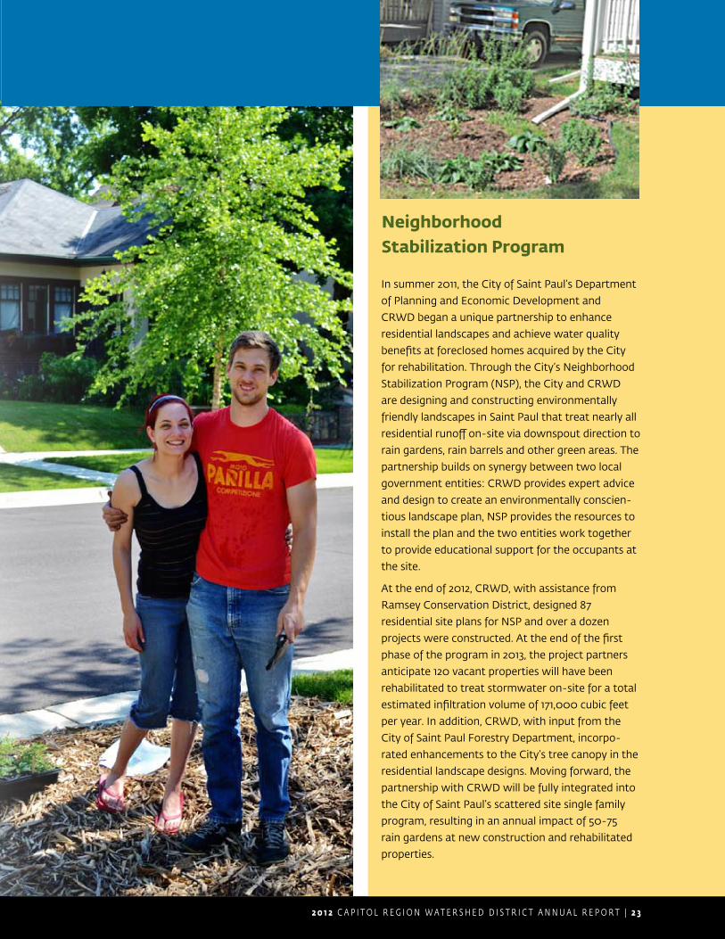
2 0 1 2 C A P I T O L R E G I O N W A T E R S H E D D I S T R I C T A N N U A L R E P O R T | 2 3
In summer 2011, the City of Saint Paul’s Department
of Planning and Economic Development and
CRWD began a unique partnership to enhance
residential landscapes and achieve water quality
benefits at foreclosed homes acquired by the City
for rehabilitation. Through the City’s Neighborhood
Stabilization Program (NSP), the City and CRWD
are designing and constructing environmentally
friendly landscapes in Saint Paul that treat nearly all
residential runoff on-site via downspout direction to
rain gardens, rain barrels and other green areas. The
partnership builds on synergy between two local
government entities: CRWD provides expert advice
and design to create an environmentally conscien-
tious landscape plan, NSP provides the resources to
install the plan and the two entities work together
to provide educational support for the occupants at
the site.
At the end of 2012, CRWD, with assistance from
Ramsey Conservation District, designed 87
residential site plans for NSP and over a dozen
projects were constructed. At the end of the first
phase of the program in 2013, the project partners
anticipate 120 vacant properties will have been
rehabilitated to treat stormwater on-site for a total
estimated infiltration volume of 171,000 cubic feet
per year. In addition, CRWD, with input from the
City of Saint Paul Forestry Department, incorpo-
rated enhancements to the City’s tree canopy in the
residential landscape designs. Moving forward, the
partnership with CRWD will be fully integrated into
the City of Saint Paul’s scattered site single family
program, resulting in an annual impact of 50-75
rain gardens at new construction and rehabilitated
properties.
Neighborhood Stabilization Program
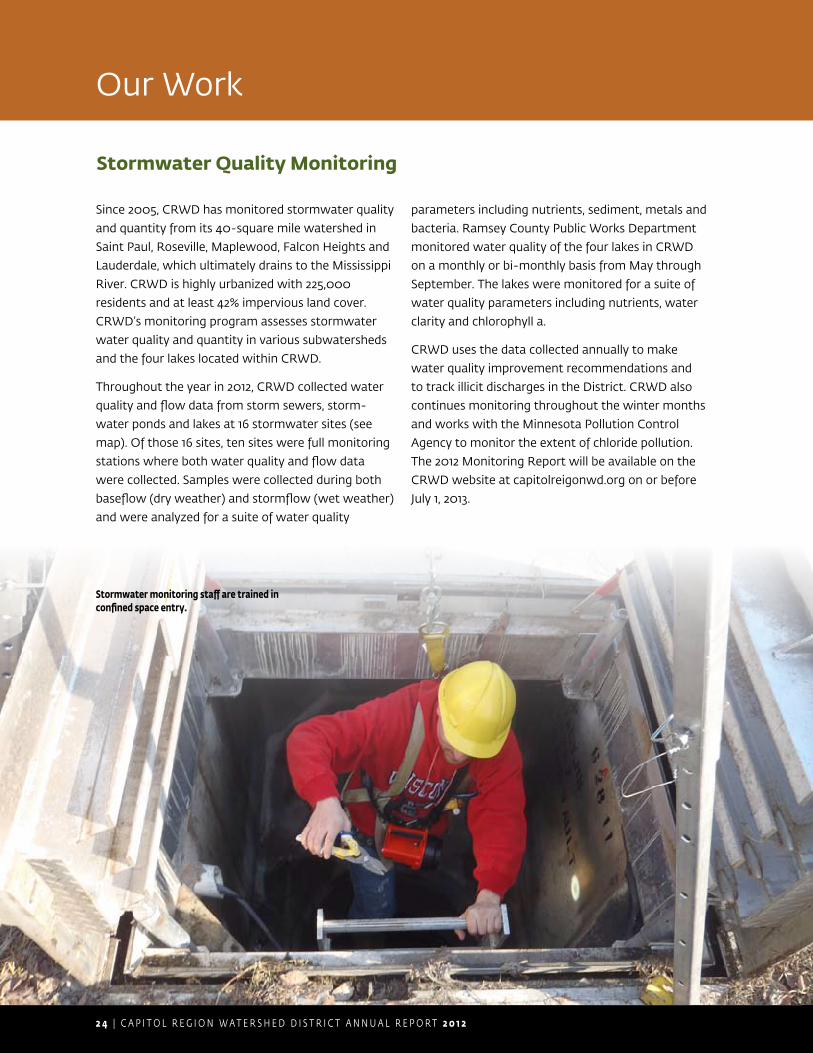
2 4 | C A P I T O L R E G I O N W A T E R S H E D D I S T R I C T A N N U A L R E P O R T 2 0 1 2
Stormwater Quality Monitoring
Since 2005, CRWD has monitored stormwater quality
and quantity from its 40-square mile watershed in
Saint Paul, Roseville, Maplewood, Falcon Heights and
Lauderdale, which ultimately drains to the Mississippi
River. CRWD is highly urbanized with 225,000
residents and at least 42% impervious land cover.
CRWD’s monitoring program assesses stormwater
water quality and quantity in various subwatersheds
and the four lakes located within CRWD.
Throughout the year in 2012, CRWD collected water
quality and flow data from storm sewers, storm-
water ponds and lakes at 16 stormwater sites (see
map). Of those 16 sites, ten sites were full monitoring
stations where both water quality and flow data
were collected. Samples were collected during both
baseflow (dry weather) and stormflow (wet weather)
and were analyzed for a suite of water quality
parameters including nutrients, sediment, metals and
bacteria. Ramsey County Public Works Department
monitored water quality of the four lakes in CRWD
on a monthly or bi-monthly basis from May through
September. The lakes were monitored for a suite of
water quality parameters including nutrients, water
clarity and chlorophyll a.
CRWD uses the data collected annually to make
water quality improvement recommendations and
to track illicit discharges in the District. CRWD also
continues monitoring throughout the winter months
and works with the Minnesota Pollution Control
Agency to monitor the extent of chloride pollution.
The 2012 Monitoring Report will be available on the
CRWD website at capitolreigonwd.org on or before
July 1, 2013.
Stormwater monitoring staff are trained in confined space entry.
Our Work

2 0 1 2 C A P I T O L R E G I O N W A T E R S H E D D I S T R I C T A N N U A L R E P O R T | 2 5
Stormwater monitoring continues in winter.
Downloading stormwater data.

2 6 | C A P I T O L R E G I O N W A T E R S H E D D I S T R I C T A N N U A L R E P O R T 2 0 1 2
BMP Maintenance and Monitoring
Stormwater Best Management Practices (BMPs) are
activities, practices and structures that reduce the
impacts of stormwater runoff. CRWD maintains/owns
several stormwater BMP structures throughout the
watershed: eighteen stormwater BMPs constructed in
the Como Lake Subwatershed in Saint Paul and twelve
BMPs constructed in the Central Corridor Light Rail
Transit (CCLRT) project area, also in Saint Paul.
The BMPs constructed in the Como Lake
Subwatershed were built as part of the Arlington
Pascal Stormwater Improvement Project; a multi-
jurisdictional project that aimed to reduce localized
flooding and improve the water quality of Como
Lake. BMPs constructed include an underground
stormwater storage and infiltration facility, a regional
stormwater pond, eight rain gardens and eight
underground infiltration trenches. The underground
stormwater facility and infiltration trenches have
pretreatment devices (a hydrodynamic separator
and sumped catch basins and manholes) incorpo-
rated into their design, in order to provide treatment
of stormwater runoff by capturing trash, debris, oils
and sediment before it flows into the BMP. These
pretreatment units help to maintain the performance
of those BMPs at removing pollutants and infiltrating
stormwater runoff.
The BMPs constructed in the CCLRT project area
include five stormwater planters and four rain
gardens. These green infrastructure practices are
highly visible along the corridor. They not only provide
treatment of stormwater runoff, reducing the amount
of pollutants flowing to the Mississippi River, but also
improve aesthetics, improve air quality and reduce the
urban heat island effect.
All of the BMPs and pretreatment units are regularly
inspected and maintained by CRWD to ensure they
are functioning properly. CRWD also receives assis-
tance with maintenance of some of the BMPs from
citizen volunteers and other government entities. In
2012, approximately 640 staff and volunteer hours
were spent inspecting and maintaining the BMPs.
Since 2007, CRWD has been collecting water quality
and quantity data on several BMPs constructed for
the Arlington Pascal Project. BMPs are monitored
to determine their overall effectiveness at reducing
stormwater runoff and pollutant loads. All of this
monitoring data was used to calibrate a water quality
model which simulated the amount of stormwater
runoff and pollutants flowing to and from all eighteen
of the Arlington Pascal Project BMPs. Modeling efforts
are necessary because Minnesota’s winter prohibits
monitoring data from being collected year round.
This data, in addition to actual construction, design,
Cleaning out street trenches with a vacuum truck.
Our Work
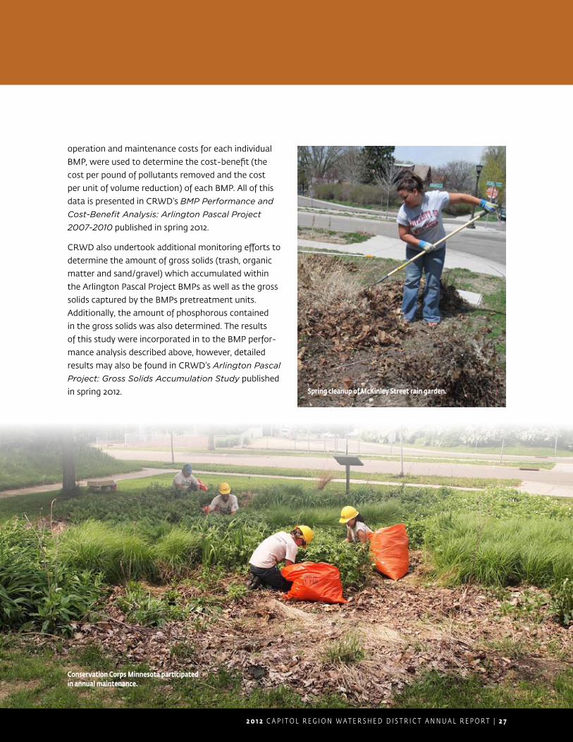
2 0 1 2 C A P I T O L R E G I O N W A T E R S H E D D I S T R I C T A N N U A L R E P O R T | 2 7
operation and maintenance costs for each individual
BMP, were used to determine the cost-benefit (the
cost per pound of pollutants removed and the cost
per unit of volume reduction) of each BMP. All of this
data is presented in CRWD’s BMP Performance and
Cost-Benefit Analysis: Arlington Pascal Project
2007-2010 published in spring 2012.
CRWD also undertook additional monitoring efforts to
determine the amount of gross solids (trash, organic
matter and sand/gravel) which accumulated within
the Arlington Pascal Project BMPs as well as the gross
solids captured by the BMPs pretreatment units.
Additionally, the amount of phosphorous contained
in the gross solids was also determined. The results
of this study were incorporated in to the BMP perfor-
mance analysis described above, however, detailed
results may also be found in CRWD’s Arlington Pascal
Project: Gross Solids Accumulation Study published
in spring 2012. Spring cleanup of McKinley Street rain garden.
Conservation Corps Minnesota participated in annual maintenance.
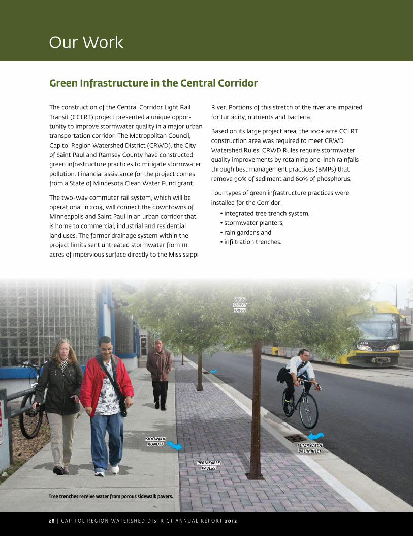
2 8 | C A P I T O L R E G I O N W A T E R S H E D D I S T R I C T A N N U A L R E P O R T 2 0 1 2
The construction of the Central Corridor Light Rail
Transit (CCLRT) project presented a unique oppor-
tunity to improve stormwater quality in a major urban
transportation corridor. The Metropolitan Council,
Capitol Region Watershed District (CRWD), the City
of Saint Paul and Ramsey County have constructed
green infrastructure practices to mitigate stormwater
pollution. Financial assistance for the project comes
from a State of Minnesota Clean Water Fund grant.
The two-way commuter rail system, which will be
operational in 2014, will connect the downtowns of
Minneapolis and Saint Paul in an urban corridor that
is home to commercial, industrial and residential
land uses. The former drainage system within the
project limits sent untreated stormwater from 111
acres of impervious surface directly to the Mississippi
River. Portions of this stretch of the river are impaired
for turbidity, nutrients and bacteria.
Based on its large project area, the 100+ acre CCLRT
construction area was required to meet CRWD
Watershed Rules. CRWD Rules require stormwater
quality improvements by retaining one-inch rainfalls
through best management practices (BMPs) that
remove 90% of sediment and 60% of phosphorus.
Four types of green infrastructure practices were
installed for the Corridor:
• integrated tree trench system,
• stormwater planters,
• rain gardens and
• infiltration trenches.
Green Infrastructure in the Central Corridor
Our Work
Tree trenches receive water from porous sidewalk pavers.

2 0 1 2 C A P I T O L R E G I O N W A T E R S H E D D I S T R I C T A N N U A L R E P O R T | 2 9
The integrated tree trench system was constructed on
both sidewalks along five miles of University Avenue
where soils were clean and well drained. The system
receives street runoff via catch basins that direct
runoff to infiltration trenches and from sidewalks via
pervious pavers that direct runoff to structured soils
that support the health of boulevard trees.
In total, eleven green infrastructure projects have
been constructed on streets connecting to University
Avenue. Stormwater planters are located in the boule-
vards of five streets including Aldine SE, Albert NW,
Albert NE, Griggs NW and Oxford SE. Rain gardens
have been constructed in the boulevards of Pillsbury
NW, Syndicate SW, Marion SW and Marion SE. Two
infiltration trenches are situated beneath the streets
of Saint Albans and Arundel.
It is anticipated that CCLRT green infrastructure
practices will remove 83 pounds of phosphorus and
two tons of sediment per year from stormwater
runoff which will improve water river quality.
Green Infrastructure: A stormwater management approach that
uses natural landscape features and hydro-
logic processes to treat stormwater by
infiltrating, evapotranspiring and/or reusing
runoff. Green infrastructure also achieves
other environmental goals such as carbon
sequestration, reductions in urban heat
island effect, improved air quality, improved
wildlife habitat and increased opportunities
for outdoor recreation.
Stormwater planter.
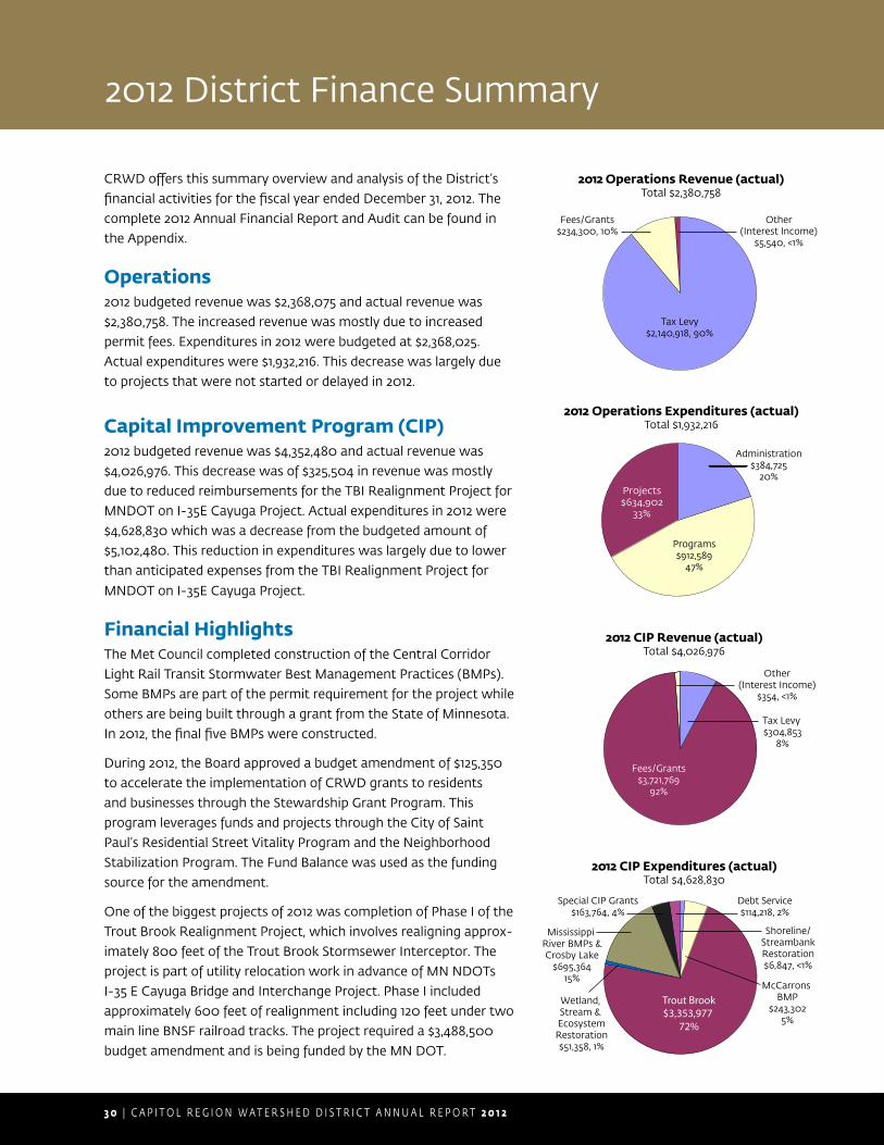
3 0 | C A P I T O L R E G I O N W A T E R S H E D D I S T R I C T A N N U A L R E P O R T 2 0 1 2
2012 District Finance Summary
CRWD offers this summary overview and analysis of the District’s financial activities for the fiscal year ended December 31, 2012. The complete 2012 Annual Financial Report and Audit can be found in the Appendix.
Operations2012 budgeted revenue was $2,368,075 and actual revenue was $2,380,758. The increased revenue was mostly due to increased permit fees. Expenditures in 2012 were budgeted at $2,368,025. Actual expenditures were $1,932,216. This decrease was largely due to projects that were not started or delayed in 2012.
Capital Improvement Program (CIP)2012 budgeted revenue was $4,352,480 and actual revenue was $4,026,976. This decrease was of $325,504 in revenue was mostly due to reduced reimbursements for the TBI Realignment Project for MNDOT on I-35E Cayuga Project. Actual expenditures in 2012 were $4,628,830 which was a decrease from the budgeted amount of $5,102,480. This reduction in expenditures was largely due to lower than anticipated expenses from the TBI Realignment Project for
MNDOT on I-35E Cayuga Project.
Financial HighlightsThe Met Council completed construction of the Central Corridor Light Rail Transit Stormwater Best Management Practices (BMPs). Some BMPs are part of the permit requirement for the project while others are being built through a grant from the State of Minnesota. In 2012, the final five BMPs were constructed.
During 2012, the Board approved a budget amendment of $125,350 to accelerate the implementation of CRWD grants to residents and businesses through the Stewardship Grant Program. This program leverages funds and projects through the City of Saint Paul’s Residential Street Vitality Program and the Neighborhood Stabilization Program. The Fund Balance was used as the funding source for the amendment.
One of the biggest projects of 2012 was completion of Phase I of the Trout Brook Realignment Project, which involves realigning approx-imately 800 feet of the Trout Brook Stormsewer Interceptor. The project is part of utility relocation work in advance of MN NDOTs I-35 E Cayuga Bridge and Interchange Project. Phase I included approximately 600 feet of realignment including 120 feet under two main line BNSF railroad tracks. The project required a $3,488,500 budget amendment and is being funded by the MN DOT.
Tax Levy$2,140,918, 90%
Fees/Grants$234,300, 10%
Other(Interest Income)
$5,540, <1%
2012 Operations Revenue (actual)Total $2,380,758
Programs$912,589
47%
Projects$634,902
33%
Administration$384,725
20%
2012 Operations Expenditures (actual)Total $1,932,216
2012 CIP Revenue (actual)Total $4,026,976
Other(Interest Income)
$354, <1%
Tax Levy $304,853
8%
Fees/Grants$3,721,769
92%
Debt Service$114,218, 2%
2012 CIP Expenditures (actual)Total $4,628,830
McCarrons BMP
$243,3025%
Special CIP Grants$163,764, 4%
Trout Brook$3,353,977
72%
Shoreline/StreambankRestoration$6,847, <1%
Wetland, Stream & EcosystemRestoration$51,358, 1%
Mississippi River BMPs &Crosby Lake
$695,36415%
2 0 1 2 C A P I T O L R E G I O N W A T E R S H E D D I S T R I C T A N N U A L R E P O R T | 3 1
Our Plans
2012 Year In Review
Below is a complete list of 2012 CRWD projects:
Fund Name Project Name
Administration General Administration
Performance Review & Assistance Program
Groundwater Protection Well Sealing
Groundwater Studies
Rulemaking Evaluate Rules and Conduct Annual TAC Mtg
Permitting Implement Effective, Efficient & Equitable Permit Program
Construction Inspection
Permit Closure and Post Construction Inspection and Maintenance
Stewardship Grants Grant Promotion and Outreach
Project Inspection
Project Design & Assistance
Stewardship and Partner Grants
Monitoring and Data Collection
Baseline Monitoring and Data Collection
Lake Monitoring and Data Collection
Villa Park Monitoring and Data Collection
Wetland Biological Monitoring
Willow Reserve/Loeb Lake Monitoring and Data Collection
Filtration BMP Monitoring
CCLRT Tree Trench Monitoring
Education and Outreach Outreach — Communication
Homeowner Outreach — Stop the Rain Drain
Homeowner Outreach — Community Clean-Up
Municipal Outreach
Website and Social Media
Landscape Contractor Outreach
Partnerships
Events/Outreach

3 2 | C A P I T O L R E G I O N W A T E R S H E D D I S T R I C T A N N U A L R E P O R T 2 0 1 2
Fund Name Project Name
Technical Resources and Information Sharing
Urban Stormwater BMP Specialist
Strategic Project Preparation
Future Trends: Research & Positioning
Innovative BMPs Research
National Speakers for Conferences
Geographic Information System GIS Program Development
Data Acquisition
Safety Program Safety Training
Safety Program Updates/Audits
CSE Equipment
Shoreline and Streambank Maintenance
Lake McCarrons Shoreline Restoration Project
Saint Paul Natural Resources Intern Program
Como Lake Project Planning, Maintenance, Inspection, Monitoring
Como BMP Maintenance and Inspection
Como 7 Subwatershed - Curtis Field
Settleable Solids Accumulation Sampling and Investigation
Como Park Regional Pond Bathymetric Survey
BMP Performance Improvements
Lake McCarrons Project Planning, Maintenance, Inspection, Monitoring
Lake McCarrons Subwatershed Study
Crosby Lake Subwatershed
Crosby Lake Management Plan
Highland Ravine Stabilization
2012 Year In Review (cont.)
Our Plans
2 0 1 2 C A P I T O L R E G I O N W A T E R S H E D D I S T R I C T A N N U A L R E P O R T | 3 3
Fund Name Project Name
Trout Brook Subwatershed
Operation, Maintenance and Management
Center Street/Rice Street Subwatershed Analysis
NPDES MS4 Stormwater Program
Illicit Discharge Detection and Elimination Program
Trout Brook Subwatershed Study
Wetland, Stream and Ecosystem Restoration — Planning
Wetland Reestablishment Feasibility Study — Victoria Park
Stream Corridor Restoration Feasibility Study — Trillium Site
Mississippi River Subwatershed Implement Green Infrastructure along the Central Corridor — Planning
Shoreline and Streambank Restoration
Shoreline and Streambank Restoration Projects
Como Lake BMPs Como Lake Subwatershed BMPs
Lake McCarrons BMPs Villa Park Wetland Restoration Project
Villa Park Subwatershed Plan and BMP Design
Crosby Lake BMPs Highland Ravine Stablization Project
Trout Brook BMPs TBI Repair Station 136+16 to 168+73
TBI Repair Station 185+82 to 186+94
TBI Repair West Tunnel Station 0+00 to 17+62
Wetland, Stream and Ecosystem Restoratiom — Implementation
Wetland Improvement
Wetland Reestablishment: Implementation
Trillium Site - Water Resource Feature Engineering
Mississippi River Subwatershed BMPs
CCLRT BMP Implementation
Special Projects and Grants Special Grants
3 4 | C A P I T O L R E G I O N W A T E R S H E D D I S T R I C T A N N U A L R E P O R T 2 0 1 2
Fund Name Project Name Priority Project Description
Adminstration General Administration
Critical Administration initiatives include ongoing activities that recur annually to satisfy Minnesota Rules for watershed districts and those that pertain to the organization, administration and coordination of programs, services and facilities provided by the District. Administration initiatives also include organization and coordination of the Citizen Advisory Committee and its activities.
Groundwater Groundwater Protection — Well Sealing
Beneficial Groundwater and well sealing initiatives that were begun prior to this Plan will continue. The well sealing cost share program will continue to be implemented in 2013.
Rulemaking/ Rule Revisions
Wetland Manage-ment & Regulation Plan
Critical The District regularly reviews its Rules with support from the Technical Advisory Committee (TAC) to satisfy both the spirit and letter of State statute 103D, described above.
Permitting Implement Permit Program
Critical Continue to implement an effective, efficient and equitable permitting program. Evaluate amounts approved for permit fees, surety, cap on cost, and Stormwater Impact Fund Contribution.
Permit Tracking Database and Infor-mation Management
Critical Continue the development of an electronic permit/fee tracking system which integrates database functions with GIS and web-based capabilities.
Construction Inspection
Critical Inspect active permitted construction sites for permit and erosion/sediment control compliance.
Stewardship Grants
Grant Program Administration
Important Administer, promote and conduct outreach on Stewardship and Partner Grant Programs.
Project Inspection Important Annual inspection of Stewardship Grant projects to ensure the proper function and intended benefit of each project.
Project Design & Assistance
Important Partner with Ramsey Conservation District to prepare project designs.
Application Processing & Grant Award
Important Conduct pre-application site visits of potential grant projects. Review and make recommendations on proposed projects and grant applications. Approve and make payments to applicants.
2013 Workplan
2012 Year In Review (cont.)Our Plans
2 0 1 2 C A P I T O L R E G I O N W A T E R S H E D D I S T R I C T A N N U A L R E P O R T | 3 5
Fund Name Project Name Priority Project Description
Monitoring & Data Collection
Baseline Monitoring & Data Collection
Critical Continue to collect baseline stormwater data and monitor improvements. Operate and maintain 18 full water quality monitoring stations, 7 lake/pond stations, 1 BMP level station and 5 precipitation stations. Continue to operate monitoring station for the Como 3 subwatershed feasibility study. Develop and implement a plan to address issues identified in the 2011 Monitoring Report. Complete 2012 Water Monitoring Report by May 2012. Assist the City of Saint Paul with their NPDES monitoring require-ments.
Lake Monitoring & Data Collection
Critical Continue lake level monitoring on Como, McCarron’s and Loeb Lakes and continue to support Ramsey County Public Works staff conducting the water quality monitoring on these lakes.
Villa Park Monitoring & Data Collection
Critical Continue to monitor the Villa Park wetland system.
Wetland Bio-monitoring
Important Complete macrophyte and invertebrate indices of biological integrity for 10 wetlands.
Long-term Monitoring Database Development
Critical Data Continue partnership with other metro agencies in the development of a database for long term storage of monitoring data, to facilitate further analysis of monitoring data.
Willow Reserve / Loeb Lake Monitoring & Data Collection
Important Monitor Loeb Lake and Willow Reserve as identified in the Loeb Lake/Willow Reserve Management Plan.
Non-CRWD BMP Inventory
Future Document non-CRWD BMps within the watershed.
10-Year Monitoring Plan
Beneficial Develop a long range plan for the District’s Monitoring program in conjunction with the City of Saint Paul’s NPDES permit monitoring requirements.
BMP Monitoring Important Monitor the effectiveness of BMPs, including Beacon Bluff, CCLRT, William Street Pond and filtration BMPs.
3 6 | C A P I T O L R E G I O N W A T E R S H E D D I S T R I C T A N N U A L R E P O R T 2 0 1 2
Fund Name Project Name Priority Project Description
Education & Outreach
Outreach/ Communication
Critical Provide staff, equipment and material support for general watershed outreach and education programing.
Homeowner Outreach - Stop the Rain Drain
Critical In partnership with CCM, conduct Stop the Rain Drain campaign in two phases, 1) District-wide, and 2) to a focused geographic area.
Homeowner Outreach - Community Cleanup
Critical In partnership with Freshwater Society promote to organizations in the District CRWD grants in combi-nation w/ Community Clean Ups for Water Quality leaf litter education toolkit.
Municipal Outreach Important Develop a municipal outreach effort to build potential for clean water partnership between the District and municipal staff and increase the use of education as a way of affecting decisions regarding land use planning.
Website & Social Media
Important Maintain and improve CRWD website for effective use as a tool for educating and informing the public.
Contractor Outreach Important Participate as a Blue Thumb partner to facilitate outreach of clean water planting techniques.
Partnerships Beneficial Sponsor rain garden or other water quality protection workshops for homeowners in partnership w/ RCD, District Planning Councils, and other organizations.
Events/Outreach Beneficial Provide water quality education field events for the general public, schools and student groups.
Homeowner Outreach - Watershed Heroes
Beneficial Develop a Watershed Heroes program to recognize citizens working for water quality protection in the community that can be used to make a statement about CRWD’s values
Technical Resources & Information Sharing
Local and Agency Plan Review & TechCommittee
Important Participate in the review and comment on local water plans, agency plans, relevant agency regulations as well as active involvement on technical committees.
Watershed Approach: MS4 & TMDL Compliance
Important Coordinate MS4 and TMDL compliance and reporting as well as BMP implementation.
Strategic Project Preparation
Important Take selected projects through design to a level where they are ready for bidding in advance of available funding.
2013 Workplan (cont.)
Our Plans
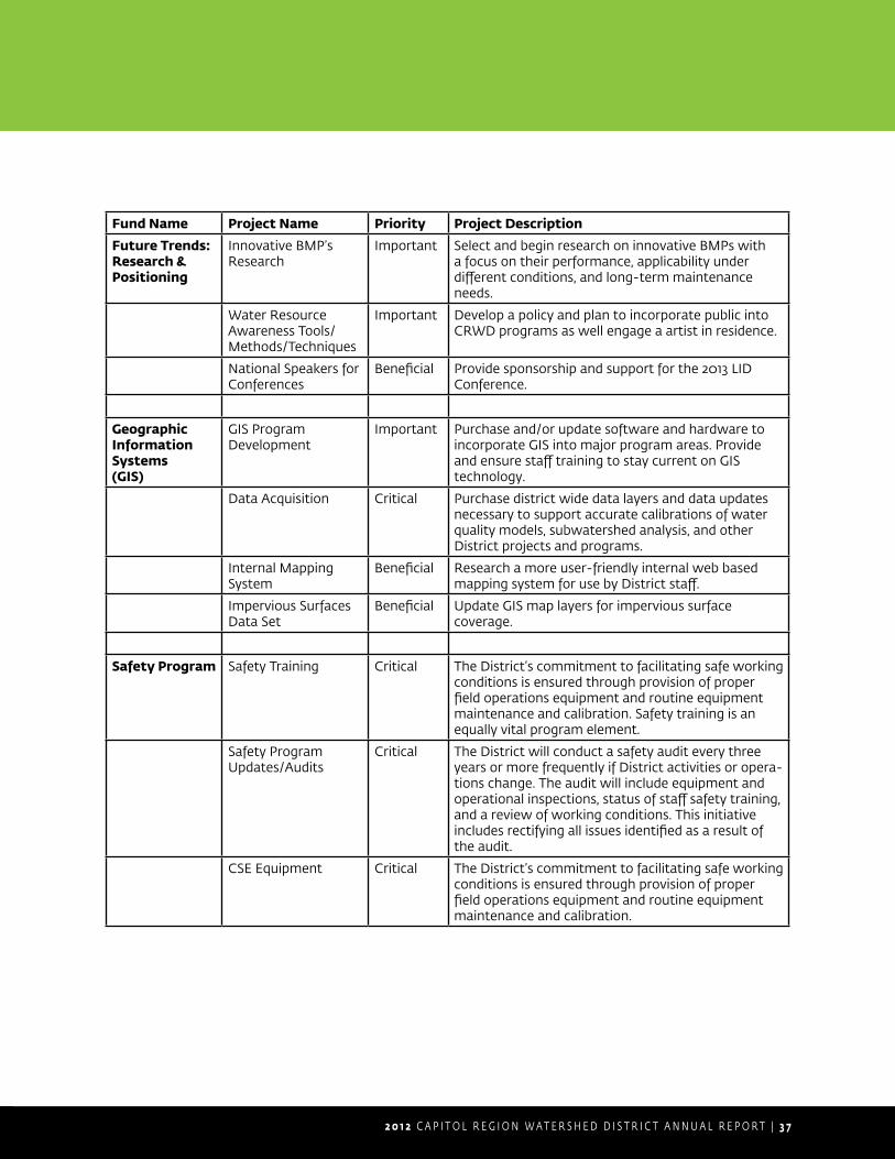
2 0 1 2 C A P I T O L R E G I O N W A T E R S H E D D I S T R I C T A N N U A L R E P O R T | 3 7
Fund Name Project Name Priority Project Description
Future Trends:Research &Positioning
Innovative BMP’s Research
Important Select and begin research on innovative BMPs with a focus on their performance, applicability under different conditions, and long-term maintenance needs.
Water Resource Awareness Tools/ Methods/Techniques
Important Develop a policy and plan to incorporate public into CRWD programs as well engage a artist in residence.
National Speakers for Conferences
Beneficial Provide sponsorship and support for the 2013 LID Conference.
GeographicInformation Systems(GIS)
GIS Program Development
Important Purchase and/or update software and hardware to incorporate GIS into major program areas. Provide and ensure staff training to stay current on GIS technology.
Data Acquisition Critical Purchase district wide data layers and data updates necessary to support accurate calibrations of water quality models, subwatershed analysis, and other District projects and programs.
Internal Mapping System
Beneficial Research a more user-friendly internal web based mapping system for use by District staff.
Impervious Surfaces Data Set
Beneficial Update GIS map layers for impervious surface coverage.
Safety Program Safety Training Critical The District’s commitment to facilitating safe working conditions is ensured through provision of proper field operations equipment and routine equipment maintenance and calibration. Safety training is an equally vital program element.
Safety Program Updates/Audits
Critical The District will conduct a safety audit every three years or more frequently if District activities or opera-tions change. The audit will include equipment andoperational inspections, status of staff safety training, and a review of working conditions. This initiative includes rectifying all issues identified as a result of the audit.
CSE Equipment Critical The District’s commitment to facilitating safe working conditions is ensured through provision of proper field operations equipment and routine equipment maintenance and calibration.
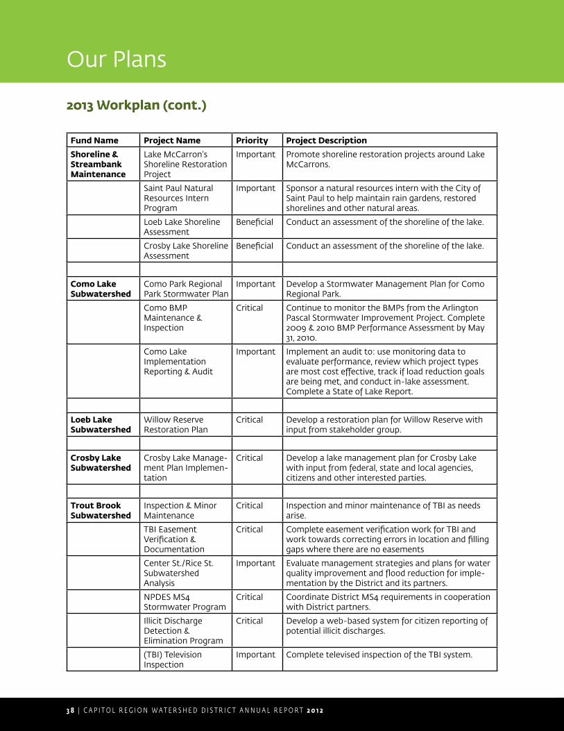
3 8 | C A P I T O L R E G I O N W A T E R S H E D D I S T R I C T A N N U A L R E P O R T 2 0 1 2
Fund Name Project Name Priority Project Description
Shoreline &StreambankMaintenance
Lake McCarron’s Shoreline Restoration Project
Important Promote shoreline restoration projects around Lake McCarrons.
Saint Paul Natural Resources Intern Program
Important Sponsor a natural resources intern with the City of Saint Paul to help maintain rain gardens, restored shorelines and other natural areas.
Loeb Lake Shoreline Assessment
Beneficial Conduct an assessment of the shoreline of the lake.
Crosby Lake Shoreline Assessment
Beneficial Conduct an assessment of the shoreline of the lake.
Como Lake Subwatershed
Como Park Regional Park Stormwater Plan
Important Develop a Stormwater Management Plan for Como Regional Park.
Como BMP Maintenance & Inspection
Critical Continue to monitor the BMPs from the Arlington Pascal Stormwater Improvement Project. Complete 2009 & 2010 BMP Performance Assessment by May 31, 2010.
Como Lake Implementation Reporting & Audit
Important Implement an audit to: use monitoring data to evaluate performance, review which project types are most cost effective, track if load reduction goals are being met, and conduct in-lake assessment. Complete a State of Lake Report.
Loeb Lake Subwatershed
Willow Reserve Restoration Plan
Critical Develop a restoration plan for Willow Reserve with input from stakeholder group.
Crosby Lake Subwatershed
Crosby Lake Manage-ment Plan Implemen-tation
Critical Develop a lake management plan for Crosby Lake with input from federal, state and local agencies, citizens and other interested parties.
Trout Brook Subwatershed
Inspection & Minor Maintenance
Critical Inspection and minor maintenance of TBI as needs arise.
TBI Easement Verification & Documentation
Critical Complete easement verification work for TBI and work towards correcting errors in location and filling gaps where there are no easements
Center St./Rice St. Subwatershed Analysis
Important Evaluate management strategies and plans for water quality improvement and flood reduction for imple-mentation by the District and its partners.
NPDES MS4 Stormwater Program
Critical Coordinate District MS4 requirements in cooperation with District partners.
Illicit Discharge Detection & Elimination Program
Critical Develop a web-based system for citizen reporting of potential illicit discharges.
(TBI) Television Inspection
Important Complete televised inspection of the TBI system.
2013 Workplan (cont.)
Our Plans
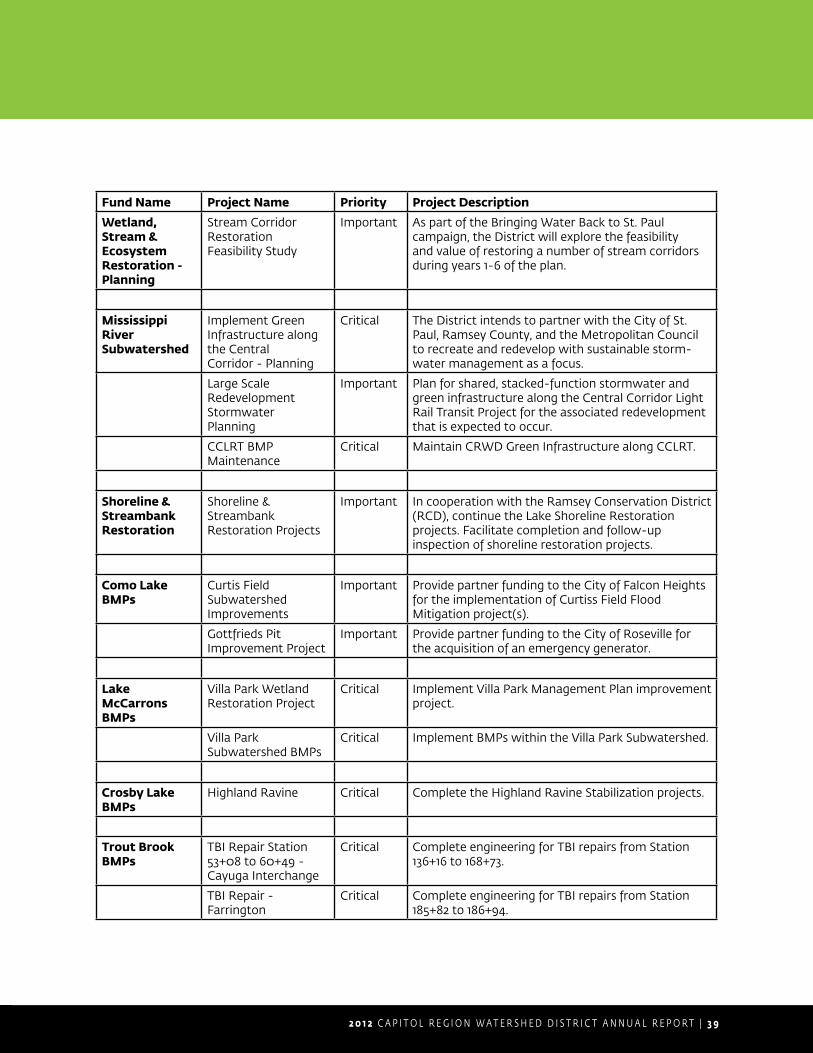
2 0 1 2 C A P I T O L R E G I O N W A T E R S H E D D I S T R I C T A N N U A L R E P O R T | 3 9
Fund Name Project Name Priority Project Description
Wetland, Stream &EcosystemRestoration -Planning
Stream Corridor Restoration Feasibility Study
Important As part of the Bringing Water Back to St. Paul campaign, the District will explore the feasibility and value of restoring a number of stream corridors during years 1-6 of the plan.
Mississippi RiverSubwatershed
Implement Green Infrastructure along the CentralCorridor - Planning
Critical The District intends to partner with the City of St. Paul, Ramsey County, and the Metropolitan Council to recreate and redevelop with sustainable storm-water management as a focus.
Large Scale Redevelopment StormwaterPlanning
Important Plan for shared, stacked-function stormwater and green infrastructure along the Central Corridor Light Rail Transit Project for the associated redevelopment that is expected to occur.
CCLRT BMP Maintenance
Critical Maintain CRWD Green Infrastructure along CCLRT.
Shoreline &StreambankRestoration
Shoreline & Streambank Restoration Projects
Important In cooperation with the Ramsey Conservation District (RCD), continue the Lake Shoreline Restoration projects. Facilitate completion and follow-upinspection of shoreline restoration projects.
Como Lake BMPs
Curtis Field Subwatershed Improvements
Important Provide partner funding to the City of Falcon Heights for the implementation of Curtiss Field Flood Mitigation project(s).
Gottfrieds Pit Improvement Project
Important Provide partner funding to the City of Roseville for the acquisition of an emergency generator.
Lake McCarrons BMPs
Villa Park Wetland Restoration Project
Critical Implement Villa Park Management Plan improvement project.
Villa Park Subwatershed BMPs
Critical Implement BMPs within the Villa Park Subwatershed.
Crosby Lake BMPs
Highland Ravine Critical Complete the Highland Ravine Stabilization projects.
Trout Brook BMPs
TBI Repair Station 53+08 to 60+49 - Cayuga Interchange
Critical Complete engineering for TBI repairs from Station 136+16 to 168+73.
TBI Repair - Farrington
Critical Complete engineering for TBI repairs from Station 185+82 to 186+94.
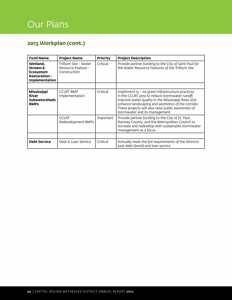
4 0 | C A P I T O L R E G I O N W A T E R S H E D D I S T R I C T A N N U A L R E P O R T 2 0 1 2
Fund Name Project Name Priority Project Description
Wetland, Stream &EcosystemRestoration -Implementation
Trillium Site - Water Resource Feature -Construction
Critical Provide partner funding to the City of Saint Paul for the Water Resource Features of the Trillium site.
Mississippi RiverSubwatershedsBMPs
CCLRT BMP Implementation
Critical Implement 15 - 20 green infrastructure practices in the CCLRT area to reduce stormwater runoff, improve water quality in the Mississippi River and enhance landscaping and aesthetics of the corridor. These projects will also raise public awareness of stormwater and its management.
CCLRT Redevelopment BMPs
Important Provide partner funding to the City of St. Paul, Ramsey County, and the Metropolitan Council to recreate and redevelop with sustainable stormwater management as a focus.
Debt Service Debt & Loan Service Critical Annually meet the full requirements of the Districts past debt (bond) and loan service.
2013 Workplan (cont.)
Our Plans

Financial Statements and Audit
Appendix A
DRAFT - 6-7-
13
ANNUAL FINANCIAL REPORT
Year Ended December 31, 2012
Capitol Region Watershed District
Ramsey County, Minnesota

DRAFT - 6-7-
13
- This page intentionally left blank -

DRAFT - 6-7-
13
CAPITOL REGION WATERSHED DISTRICTTABLE OF CONTENTS
Reference Page
Organization 3
Independent Auditor's Report 7
Management's Discussion and Analysis 9
Basic Financial Statements:
Government-Wide Financial Statements:Statement of Net Position Statement 1 16Statement of Activities Statement 2 17
Fund Financial Statements:Balance Sheet - Governmental Funds Statement 3 18Statement of Revenues, Expenditures, and Changes in Fund Balance -
Governmental Funds Statement 4 19Reconciliation of the Statement of Revenues, Expenditures, and Changes in
Fund Balances of Governmental Funds to the Statement of Activities Statement 5 20
Notes to Financial Statements 21
Required Supplementary Information:
Budgetary Comparison Schedule - Operations Fund Schedule 1 38
Budgetary Comparison Schedule - Capital Improvement Fund Schedule 2 39
Note to Required Supplementary Information 40
INTRODUCTORY SECTION
FINANCIAL SECTION
DRAFT - 6-7-
13
- This page intentionally left blank -

DRAFT - 6-7-
13INTRODUCTORY SECTION
1

DRAFT - 6-7-
13
- This page intentionally left blank -
2

DRAFT - 6-7-
13
CAPITOL REGION WATERSHED DISTRICTORGANIZATIONDecember 31, 2012
Board of ManagersJoseph Collins - President
Seitu Jones - SecretaryMary Texer - Vice-President
Michael R. Thienes - TreasurerShirley Reider
Watershed District StaffMark Doneux, Administrator
Melissa Baker, Water Resource TechnicianElizabeth Beckman, Education and Outreach Coordinator
Anna Eleria, Water Resource Project ManagerRobert Fossum, Water Resource Project Manager
Forrest Kelley, Regulatory and Conservation Program ManagerMatt Loyas, Water Resources Technician
Dawn Nelson, Office ManagerBritta Suppes, Water Resource TechnicianDavid Depaz, Water Resource TechnicianJoe Sellner, Water Resource Technician
Lindsay VanPattern, Education & Admin. Assistant
3

DRAFT - 6-7-
13
- This page intentionally left blank -
4
DRAFT - 6-7-
13 FINANCIAL SECTION
5

DRAFT - 6-7-
13
- This page intentionally left blank -
6
DRAFT - 6-7-
13INDEPENDENT AUDITORS REPORT
7

DRAFT - 6-7-
13
- This page intentionally left blank -
8

DRAFT - 6-7-
13
MANAGEMENT’S DISCUSSION AND ANALYSIS As management of the Capitol Region Watershed District (the District) we offer readers of the District’s financial statements this narrative overview and analysis of the financial activities of the District for the fiscal year ended December 31, 2012. Financial Highlights The assets of the District exceeded its liabilities at the close of the most recent fiscal year by $13,293,021 (Net position). Of this amount, $3,735,640 (unrestricted net position) may be used to meet the government’s ongoing obligations to citizens and creditors in accordance with the District's fund designations and fiscal policies. The District’s total net position increased by $3,292,336. As of the close of the current fiscal year, the District’s governmental funds reported combined ending fund balance was $3,402,332 compared to $4,255,685 the previous year. Overview of the Financial Statements This discussion and analysis is intended to serve as an introduction to the District’s basic financial statements. The District’s basic financial statements comprise three components: 1) government-wide financial statements, 2) fund financial statements, and 3) notes to the financial statements. This report also contains other supplementary information in addition to the basic financial statements themselves. Government-wide financial statements. The government-wide financial statements are designed to provide readers with a broad overview of the District’s finances, in a manner similar to a private-sector business. The statement of net position presents information on all of the District’s assets and liabilities, with the difference between the two reported as net position. Over time, increases or decreases in net position may serve as a useful indicator of whether the financial position of the District is improving or deteriorating. The statement of activities presents information showing how the District’s net position changed during the most recent fiscal year. All changes in net position are reported as soon as the underlying event giving rise to the change occurs, regardless of the timing of related cash flows. Thus, revenues and expenses are reported in this statement for some items that will only result in cash flows in future fiscal periods (e.g. uncollected taxes and earned but unused vacation leave).
9
DRAFT - 6-7-
13
Management’s Discussion and Analysis
Fund Financial statements. A fund is a grouping of related accounts that is used to maintain control over resources that have been segregated for specific activities or objectives. The District, like other state and local governments, uses fund accounting to ensure and demonstrate compliance with finance-related legal requirements. The funds of the District are governmental funds. Governmental funds. Governmental funds are used to account for essentially the same functions reported as governmental activities in the government-wide financial statements. However, unlike the government-wide financial statements, governmental fund financial statements focus on near-term inflows and outflows of spendable resources, as well as on balances of spendable resources available at the end of the fiscal year. Such information may be useful in evaluating a government’s near-term financial requirements. Because the focus of governmental funds is narrower than that of the government-wide financial statements, it is useful to compare the information presented for governmental funds with similar information presented for governmental activities in the government-wide financial statements. By doing so, readers may better understand the long-term impact of the District's near term financial decisions. Both the governmental fund balance sheet and governmental fund statement of revenues, expenditures and change in fund balance provide a reconciliation to facilitate this comparison between governmental funds and governmental activities. The District maintains two individual major governmental funds. Information is presented separately in the governmental fund balance sheet and in the governmental fund statement of revenues, expenditures, and changes in fund balances for the Operations Fund and the Capital Improvement Fund, which are considered to be major funds. The District adopts an annual appropriated budget for the Operations Fund and the Capital Improvement Fund. A budgetary comparison schedule has been provided for these funds to demonstrate compliance with this budget. Notes to the financial statements. The notes provide additional information that is essential to a full understanding of the data provided in the government–wide and fund financial statements.
10
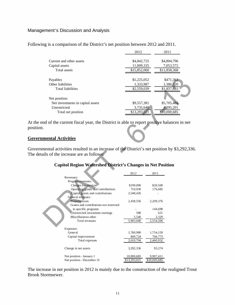
DRAFT - 6-7-
13
Management’s Discussion and Analysis
Following is a comparison of the District’s net position between 2012 and 2011.
2012 2011
Current and other assets $4,842,725 $4,804,796Capital assets 11,009,335 7,053,572 Total assets $15,852,060 $11,858,368
Payables $1,225,052 $471,363Other liabilities 1,333,987 1,386,320 Total liabilities $2,559,039 $1,857,683
Net position: Net investments in capital assets $9,557,381 $5,705,484 Unrestricted 3,735,640 4,295,201 Total net position $13,293,021 $10,000,685
At the end of the current fiscal year, the District is able to report positive balances in net position. Governmental Activities Governmental activities resulted in an increase of the District’s net position by $3,292,336. The details of the increase are as follows:
Capitol Region Watershed District’s Changes in Net Position
2012 2011Revenues:
Program revenues: Charges for services $199,000 $20,500 Operating grants and contributions 710,930 176,682 Capital grants and contributions 2,548,426 - General revenues:
Property taxes 2,438,556 2,209,376Grants and contributions not restricted to specific programs - 144,698Unrestricted investment earnings 588 621Miscellaneous other 5,540 2,329
Total revenues 5,903,040 2,554,206
Expenses:General 1,760,980 1,754,159Capital improvement 849,724 706,773
Total expenses 2,610,704 2,460,932
Change in net assets 3,292,336 93,274
Net position - January 1 10,000,685 9,907,411Net position - December 31 $13,293,021 $10,000,685
The increase in net position in 2012 is mainly due to the construction of the realigned Trout Brook Stormsewer.
11
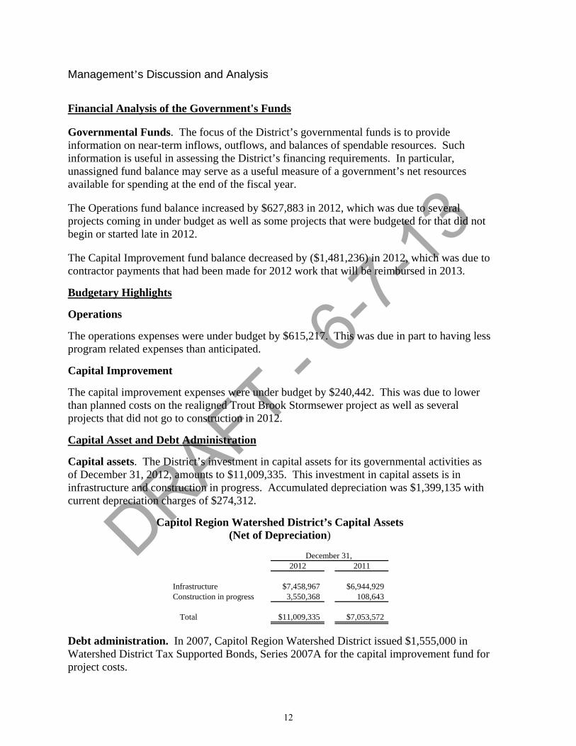
DRAFT - 6-7-
13
Management’s Discussion and Analysis
Financial Analysis of the Government's Funds Governmental Funds. The focus of the District’s governmental funds is to provide information on near-term inflows, outflows, and balances of spendable resources. Such information is useful in assessing the District’s financing requirements. In particular, unassigned fund balance may serve as a useful measure of a government’s net resources available for spending at the end of the fiscal year. The Operations fund balance increased by $627,883 in 2012, which was due to several projects coming in under budget as well as some projects that were budgeted for that did not begin or started late in 2012. The Capital Improvement fund balance decreased by ($1,481,236) in 2012, which was due to contractor payments that had been made for 2012 work that will be reimbursed in 2013.
Budgetary Highlights
Operations
The operations expenses were under budget by $615,217. This was due in part to having less program related expenses than anticipated.
Capital Improvement
The capital improvement expenses were under budget by $240,442. This was due to lower than planned costs on the realigned Trout Brook Stormsewer project as well as several projects that did not go to construction in 2012.
Capital Asset and Debt Administration
Capital assets. The District’s investment in capital assets for its governmental activities as of December 31, 2012, amounts to $11,009,335. This investment in capital assets is in infrastructure and construction in progress. Accumulated depreciation was $1,399,135 with current depreciation charges of $274,312.
Capitol Region Watershed District’s Capital Assets (Net of Depreciation)
2012 2011
Infrastructure $7,458,967 $6,944,929Construction in progress 3,550,368 108,643
Total $11,009,335 $7,053,572
December 31,
Debt administration. In 2007, Capitol Region Watershed District issued $1,555,000 in Watershed District Tax Supported Bonds, Series 2007A for the capital improvement fund for project costs.
12
DRAFT - 6-7-
13
Management’s Discussion and Analysis
2012 Financial Highlights The Met Council completed construction of the Central Corridor Light Rail Transit Stormwater Best Management Practices (BMPs). Some BMPs are part of the permit requirement for the project while others are being built through a grant from the State of Minnesota. In 2012, the final five BMPs were constructed. During 2012, the Board approved a budget amendment of $125,350 to accelerate the implementation of CRWD grants to residents and businesses through the Stewardship Grant Program. This program leverage funds and projects through the City of St. Paul are Residential Street Vitality Program and the Neighborhood Stabilization Program. The Fund Balance was used as the funding source for the amendment. One of the biggest highlights and projects of 2012 was completion of Phase I of the Trout Brook Realignment Project. This project involves realigning approximately 800 feet of the Trout Brook Stormsewer Interceptor. The project is part of the advance utility relocation work in advance of MN NDOTs I-35 E Cayuga Bridge and Interchange Project. Phase I included approximately 600 feet of realignment including 120 feet under two main line BNSF railroad tracks. The project required a $3,488,500 budget amendment and is being funded by the MN DOT. The District awarded $194,000 in special grants to our partners for capital projects in the District. The final design was completed for the Trillium Site Water Resource Features with its Partner, the City of St. Paul. The District also completed the Villa Park Wetland Restoration Final Engineering Plans and Specifications. Maintenance improvements were substantially completed on the Como Park Golf Course Pond. Requests for information. This financial report is designed to provide a general overview of Capitol Region Watershed District’s finances for all those with an interest in the government’s finances. Questions concerning any of the information provided in this report or requests for additional financial information should be addressed to Capitol Region Watershed District, 1410 Energy Park Drive, Suite 4, St. Paul, MN, 55108, 651-644-8888.
13

DRAFT - 6-7-
13
- This page intentionally left blank -
14

DRAFT - 6-7-
13BASIC FINANCIAL STATEMENTS
15

DRAFT - 6-7-
13
CAPITOL REGION WATERSHED DISTRICTSTATEMENT OF NET POSITION Statement 1December 31, 2012
Primary Government Governmental
ActivitiesAssets:
Cash and short term investments $1,927,371Property taxes receivable:
Due from county 40,446Delinquent 64,482
Due from other governments 2,644,676Accounts receivable - net 136,557Prepaid items 5,203Deferred charges 23,990Capital assets - net:
Depreciable 7,458,967Nondepreciable 3,550,368
Total assets 15,852,060
Liabilities:Accounts payable 712,278Contracts payable 183,166Deposits payable 307,715Accrued interest payable 21,893Bonds payable:
Due within one year 65,000Due in more than one year 1,222,583
Compensated absences payable:Due within one year 46,404
Total liabilities 2,559,039
Net position:Net investments in capital assets 9,557,381Unrestricted 3,735,640
Total net position $13,293,021
The accompanying notes are an integral part of these financial statements. 16
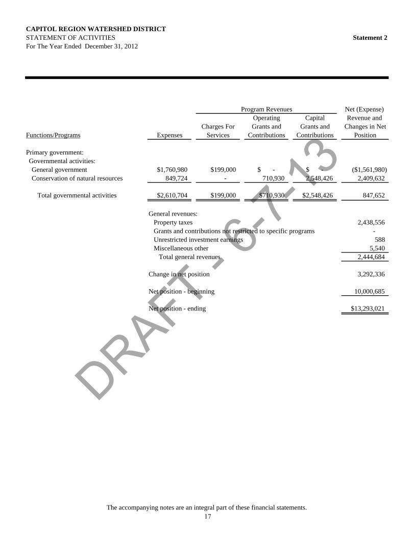
DRAFT - 6-7-
13
CAPITOL REGION WATERSHED DISTRICTSTATEMENT OF ACTIVITIES Statement 2For The Year Ended December 31, 2012
Net (Expense) Operating Capital Revenue and
Charges For Grants and Grants and Changes in NetFunctions/Programs Expenses Services Contributions Contributions Position
Primary government:Governmental activities:General government $1,760,980 $199,000 $ - $ - ($1,561,980)Conservation of natural resources 849,724 - 710,930 2,548,426 2,409,632
Total governmental activities $2,610,704 $199,000 $710,930 $2,548,426 847,652
General revenues:Property taxes 2,438,556Grants and contributions not restricted to specific programs - Unrestricted investment earnings 588Miscellaneous other 5,540
Total general revenues 2,444,684
Change in net position 3,292,336
Net position - beginning 10,000,685
Net position - ending $13,293,021
Program Revenues
The accompanying notes are an integral part of these financial statements. 17
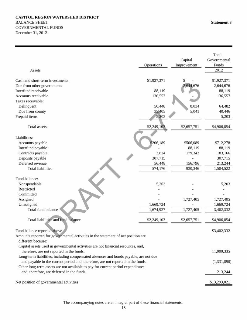
DRAFT - 6-7-
13
CAPITOL REGION WATERSHED DISTRICTBALANCE SHEET Statement 3GOVERNMENTAL FUNDSDecember 31, 2012
Total
OperationsCapital
ImprovementGovernmental
FundsAssets 2012
Cash and short-term investments $1,927,371 $ - $1,927,371Due from other governments - 2,644,676 2,644,676Interfund receivable 88,119 - 88,119Accounts receivable 136,557 - 136,557Taxes receivable: Delinquent 56,448 8,034 64,482 Due from county 35,405 5,041 40,446Prepaid items 5,203 - 5,203
Total assets $2,249,103 $2,657,751 $4,906,854
Liabilities:Accounts payable $206,189 $506,089 $712,278Interfund payable - 88,119 88,119Contracts payable 3,824 179,342 183,166Deposits payable 307,715 - 307,715Deferred revenue 56,448 156,796 213,244
Total liabilities 574,176 930,346 1,504,522
Fund balance:Nonspendable 5,203 - 5,203Restricted - - - Committed - - - Assigned - 1,727,405 1,727,405Unassigned 1,669,724 - 1,669,724
Total fund balance 1,674,927 1,727,405 3,402,332
Total liabilities and fund balance $2,249,103 $2,657,751 $4,906,854
Fund balance reported above $3,402,332Amounts reported for governmental activities in the statement of net position are
different because:Capital assets used in governmental activities are not financial resources, and,
therefore, are not reported in the funds. 11,009,335Long-term liabilities, including compensated absences and bonds payable, are not due
and payable in the current period and, therefore, are not reported in the funds. (1,331,890)Other long-term assets are not available to pay for current period expenditures
and, therefore, are deferred in the funds. 213,244
Net position of governmental activities $13,293,021
The accompanying notes are an integral part of these financial statements. 18
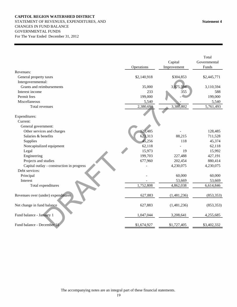
DRAFT - 6-7-
13
CAPITOL REGION WATERSHED DISTRICTSTATEMENT OF REVENUES, EXPENDITURES, AND Statement 4CHANGES IN FUND BALANCEGOVERNMENTAL FUNDSFor The Year Ended December 31, 2012
OperationsCapital
Improvement
Total Governmental
FundsRevenues:
General property taxes $2,140,918 $304,853 $2,445,771Intergovernmental:
Grants and reimbursements 35,000 3,075,594 3,110,594Interest income 233 355 588Permit fees 199,000 - 199,000Miscellaneous 5,540 - 5,540
Total revenues 2,380,691 3,380,802 5,761,493
Expenditures:Current:
General government:Other services and charges 128,485 - 128,485Salaries & benefits 623,313 88,215 711,528Supplies 45,256 118 45,374Noncapitalized equipment 62,118 - 62,118Legal 15,973 19 15,992Engineering 199,703 227,488 427,191Projects and studies 677,960 202,454 880,414Capital outlay - construction in progress - 4,230,075 4,230,075
Debt services:Principal - 60,000 60,000Interest - 53,669 53,669
Total expenditures 1,752,808 4,862,038 6,614,846
Revenues over (under) expenditures 627,883 (1,481,236) (853,353)
Net change in fund balance 627,883 (1,481,236) (853,353)
Fund balance - January 1 1,047,044 3,208,641 4,255,685
Fund balance - December 31 $1,674,927 $1,727,405 $3,402,332
The accompanying notes are an integral part of these financial statements. 19

DRAFT - 6-7-
13
CAPITOL REGION WATERSHED DISTRICTRECONCILIATION OF THE STATEMENT OF REVENUES, Statement 5EXPENDITURES, AND CHANGES IN FUND BALANCES OFGOVERNMENTAL FUNDS TO THE STATEMENT OF ACTIVITIESFor The Year Ended December 31, 2012
2012Amounts reported for governmental activities in the Statement of Activities (Statement 2)
are different because:
Net changes in fund balances - total governmental funds (Statement 4) ($853,353)
Governmental funds report capital outlays as expenditures. However, in theStatement of Activities the cost of these assets is allocated over the estimatedlives and reported as depreciation expense. This is the amount by which depreciationexceeded capital outlay in the current period:
Capital outlay 4,230,075Depreciation expense (274,312)
Accrued interest payable:At December 31, 2012 (21,893)At December 31, 2011 22,739
The issuance of long-term debt (e.g., bonds, leases) provides current financialresources to governmental funds, while the repayment of the principal oflong-term debt consumes the current financial resources of governmental funds. Neither transaction, however, has any effect on net position. This amount is thenet effect of these differences in the treatment of long-term debt and related items:
Principal payment 60,000Amortization of premium (4,295)
Revenues in the Statement of Activities that do not provide current financialresources are not reported as revenues in the funds:
Deferred revenue:A At December 31, 2012 213,244A At December 31, 2011 (71,697)
Some expenses reported in the statement of activities do not require the use of current financial resources and, therefore, are not reported as expenditures in governmental funds:
Compensated absences payable:A At December 31, 2012 (46,404)A At December 31, 2011 38,232
Change in net position of governmental activities (Statement 2) $3,292,336
The accompanying notes are an integral part of these financial statements. 20
DRAFT - 6-7-
13
CAPITOL REGION WATERSHED DISTRICT NOTES TO FINANCIAL STATEMENTS December 31, 2012
Note 1 SUMMARY OF SIGNIFICANT ACCOUNTING POLICIES The accounting policies of the Capitol Region Watershed District conform to generally accepted accounting principles (GAAP).
A. FINANCIAL REPORTING ENTITY
The Capitol Region Watershed District (the District) was organized in September 1998 under the provisions of Minnesota Statutes Chapter 103D. Additional powers and duties are contained in Minnesota Statutes Chapters 103B and 103E. A watershed district is a “special purpose” unit of local government, which has taxing authority and can promulgate and implement rules that have the effect and force of law. The purpose of the District is to provide for surface and groundwater management within the District’s geographic boundaries. The District is approximately 42 square miles in size and contains portions of the cities of Falcon Heights, St. Paul, Maplewood, Roseville, and Lauderdale. The University of Minnesota St. Paul Campus and Minnesota State Fair Grounds are also within this district. The District is governed by a board of managers that are appointed by the Ramsey County Board of Commissioners. Managers serve three-year terms.
B. GOVERNMENT-WIDE AND FUND FINANCIAL STATEMENTS The government-wide financial statements (i.e., the statement of net position and the statement of
activities) report information on all of the nonfiduciary activities of the primary government. For the most part, the effect of interfund activity has been removed from these statements. Governmental activities, which normally are supported by taxes and intergovernmental revenues, are reported. There are no business-type activities, which rely to a significant extent on fees and charges for support.
The statement of activities demonstrates the degree to which the direct expenses of a given function
are offset by program revenues. Direct expenses are those that are clearly identifiable with a specific function. Program revenues include 1) charges to customers or applicants who purchase, use, or directly benefit from goods, services, or privileges provided by a given function or business-type activity and 2) grants and contributions that are restricted to meeting the operational or capital requirements of a particular function or business type activity. Taxes and other items not included among program revenues are reported instead as general revenues.
Separate financial statements are provided for governmental funds. Major individual governmental funds are reported as separate columns in the fund financial statements.
21
DRAFT - 6-7-
13
CAPITOL REGION WATERSHED DISTRICT NOTES TO FINANCIAL STATEMENTS December 31, 2012
C. MEASUREMENT FOCUS, BASIS OF ACCOUNTING, AND FINANCIAL STATEMENT PRESENTATION
The government-wide financial statements are reported using the economic resources measurement
focus and the accrual basis of accounting. Revenues are recorded when earned and expenses are recorded when a liability is incurred, regardless of the timing of related cash flows. Property taxes are recognized as revenues in the year for which they are levied. Grants and similar items are recognized as revenue as soon as all eligibility requirements imposed by the provider have been met.
Governmental fund financial statements are reported using the current financial resources
measurement focus and the modified accrual basis of accounting. Revenues are recognized as soon as they are both measurable and available. Revenues are considered to be available when they are collectible within the current period or soon enough thereafter to pay liabilities of the current period. For this purpose, the government considers all revenues to be available if they are collected within 60 days of the end of the current fiscal period. Expenditures are recorded when the related fund liability is incurred, except for principal and interest on long-term debt, compensated absences, and claims and judgments, which are recognized as expenditures to the extent they have matured.
Property taxes, intergovernmental revenues, and interest associated with the current fiscal period are
all considered to be susceptible to accrual and so have been recognized as revenues of the current fiscal period. All other revenue items are considered to be measurable and available only when cash is received by the District.
The District reports the following major governmental funds:
Operations Fund is the general operating fund of the District. It is used to account for all financial resources except those required to be accounted for in the Capital Improvements Fund. Capital Improvements Fund is established to account for expenditures related to the preparation and implementation of the watershed management plan.
As a general rule the effect of interfund activity has been eliminated from the government-wide financial statements. Exceptions to this general rule are transactions that would be treated as revenues, expenditures or expenses if they involved external organizations, such as buying goods and services or payments in lieu of taxes, that are similarly treated when they involve other funds of the District. Elimination of these charges would distort the direct costs and program revenues reported for the various functions concerned. Amounts reported as program revenues include 1) charges to customers or applicants for goods, services, or privileges provided, 2) operating grants and contributions, and 3) capital grants and contributions. Internally dedicated resources are reported as general revenues rather than as program revenues. General revenues include all taxes. When both restricted and unrestricted resources are available for an allowable use, it is the District’s policy to use restricted resources first, then unrestricted resources as they are needed.
22
DRAFT - 6-7-
13
CAPITOL REGION WATERSHED DISTRICT NOTES TO FINANCIAL STATEMENTS December 31, 2012
D. BUDGETS
Budgets are legally adopted on a basis consistent with generally accepted accounting principles. Annual appropriated budgets are legally adopted for the Operations Fund and Capital Improvements. Budgeted expenditure appropriations lapse at year end.
Encumbrance accounting, under which purchase orders, contracts, and other commitments for the expenditure of monies are recorded in order to reserve that portion of the appropriation, is not employed by the District because it is at present not considered necessary to assure effective budgetary control or to facilitate effective cash management.
E. LEGAL COMPLIANCE – BUDGETS
The District prepares annual revenue and expenditure budgets for the District's Operations Fund. The District monitors budget performance on the fund basis. All amounts over budget have been approved by the Board through the budget extension process. The modified accrual basis of accounting is used by the District for budgeting data. All appropriations end with the fiscal year for which they were made.
F. CASH AND INVESTMENTS
Cash and investments are stated at fair value, based upon quoted market prices, and consist of amounts in demand deposit, savings, and a pooled investment fund organized under Minn. Stat. 471.59, the Joint Powers Act. Cash and investment balances from all funds are pooled and invested to the extent available in authorized investments. Investment income is allocated to individual funds on the basis of the fund's equity in the cash and investment pool.
G. PROPERTY TAX REVENUE RECOGNITION
The Board of Managers annually adopts a tax levy and certifies it to the County in October (levy/assessment date) of each year for collection in the following year. The County is responsible for billing and collecting all property taxes for itself, the City, the local School District and other taxing authorities. Such taxes become a lien on January 1 and are recorded as receivables by the District at that date. Real property taxes are payable (by property owners) on May 15 and October 15 of each calendar year. Delinquent collections for November and December are received the following January. The District has no ability to enforce payment of property taxes by property owners. The County possesses this authority.
GOVERNMENT-WIDE FINANCIAL STATEMENTS The District recognizes property tax revenue in the period for which the taxes were levied.
Uncollectible property taxes are not material and have not been reported.
23

DRAFT - 6-7-
13
CAPITOL REGION WATERSHED DISTRICT NOTES TO FINANCIAL STATEMENTS December 31, 2012
GOVERNMENTAL FUND FINANCIAL STATEMENTS The District recognizes property tax revenue when it becomes both measurable and available to
finance expenditures of the current period. In practice, current and delinquent taxes and State credits received by the District in July, December and January, are recognized as revenue for the current year. Taxes collected by the County by December 31 (remitted to the District the following January) and taxes and credits not received at the year end are classified as delinquent and due from County taxes receivable. The portion of delinquent taxes not collected by the District in January is fully offset by deferred revenue because it is not available to finance current expenditures.
H. INVENTORIES The original cost of materials and supplies has been recorded as expenditures at the time of purchase.
The District does not maintain material amounts of inventories. I. LONG-TERM OBLIGATIONS In the government-wide financial statements long-term debt is reported as a liability in the statement of
net position. Material bond premiums and discounts, as well as issuance costs, are amortized over the life of the bond.
In the fund financial statements, governmental fund types recognize bond premiums and discounts, as
well as bond issuance costs, during the current period. The face amount of debt issued is reported as other financing sources. Premiums received on debt issuances are reported as other financing sources while discounts on debt issuances are reported as other financing uses. Issuance costs, whether or not withheld from the actual debt proceeds received, are reported as debt service expenditures.
J. FUND BALANCE CLASSIFICATIONS
In the fund financial statements, governmental funds report fund balance in classifications that disclose constraints for which amounts in those funds can be spent. These classifications are as follows:
Nonspendable - consists of amounts that are not in spendable form, such as prepaid items. Restricted - consists of amounts related to externally imposed constraints established by creditors, grantors or contributors; or constraints imposed by state statutory provisions. Committed - consists of internally imposed constraints. These constraints are established by Resolution of the District. Assigned - consists of internally imposed constraints. These constraints reflect the specific purpose for which it is the District’s intended use. These constraints are established by the District Administrator.
24
DRAFT - 6-7-
13
CAPITOL REGION WATERSHED DISTRICT NOTES TO FINANCIAL STATEMENTS December 31, 2012
Unassigned - is the residual classification for the general fund and also reflects negative residual amounts in other funds.
When both restricted and unrestricted resources are available for use, it is the District’s policy to first use restricted resources, and then use unrestricted resources as they are needed. When committed, assigned or unassigned resources are available for use, it is the District’s policy to use resources in the following order; 1) committed 2) assigned and 3) unassigned.
K. CAPITAL ASSETS Capital assets, which include property, plant, equipment and infrastructure assets (e.g., storm sewer,
manholes, control structures, and similar items), are reported in the governmental activities column in the government-wide financial statements. Capital assets are defined by the government as assets with an initial, individual cost of more than $10,000 (amount not rounded) and an estimated useful life in excess of one year.
The costs of normal maintenance and repairs that do not add to the value of the asset or materially
extend assets’ lives are not capitalized. Property, plant and equipment of the District is depreciated using the straight-line method over the
following estimated useful lives:
Rain gardens 20 years Trenches 20 years Other Infrastructure 30 years
The District implemented GASB Statement No. 51, Accounting and Financial Reporting for Intangible Assets effective January 1, 2010. GASB Statement No. 51 required the District to capitalize and amortize intangible assets. Intangible assets include easements and computer software. For governmental entities with total annual revenues of less than $10 million for the fiscal year ended December 31, 1999, the retroactive reporting of intangible assets in not required under the provision of GASB Statement No. 51. The District has elected not to report intangible assets acquired in years prior to 2010. The District did not acquire any intangible assets for the year ending December 31, 2012.
L. COMPENSATED ABSENCES It is the District’s policy to permit employees to accumulate earned but unused vacation and sick pay
benefits. All vacation and sick pay benefits that are vested as severance pay are accrued when incurred in the government-wide financial statements. A liability for these amounts is reported in the governmental funds only if they have matured: for example, as a result of employee resignations and retirements. In accordance with the provisions of Statement of Government Accounting Standards No. 16, Accounting for Compensated Absences, no liability is recorded for nonvesting accumulating rights to receive sick pay benefits.
25
DRAFT - 6-7-
13
CAPITOL REGION WATERSHED DISTRICT NOTES TO FINANCIAL STATEMENTS December 31, 2012
M. PREPAID ITEMS Certain payments to vendors reflect costs applicable to future accounting periods and are recorded as prepaid items in both the government-wide and fund financial statements.
N. REVENUES AND EXPENDITURES
REVENUES In accordance with GASB Statement No. 33, Accounting and Financial Reporting for Nonexchange Transactions, revenues for nonexchange transfers are recognized based on the principal characteristics of the revenue. Exchange transactions are recognized as revenue when the exchange occurs. The modified accrual basis of accounting is used by the Operations and Capital Improvements Funds. Under this basis, revenue is not recognized in the financial statements unless it is available to finance current expenditures. IMPOSED NONEXCHANGE TRANSACTIONS Imposed nonexchange transactions result from assessments by governments on non-governmental entities and individuals. Property taxes are imposed nonexchange transactions. Revenues from property taxes are recognized in the fund financial statements in the period for which the taxes were levied, to the extent they are collected in the current period or soon enough thereafter to be used to pay liabilities of the current period. Property taxes receivable but not available are reported as deferred revenue and will be recognized as revenue in the fiscal year that they become available. INTERGOVERNMENTAL Government-mandated nonexchange transactions occur when a government at one level provides resources to a government at another level and requires that government to use them for specific purposes. The provider government establishes purpose restrictions and also may establish time requirements. Federal and state grants mandating the District perform particular programs are government-mandated nonexchange transactions. Revenues are recognized when eligibility and time requirements are met, usually when the corresponding expenditure is incurred. Voluntary nonexchange transactions result from legislative or contractual agreements, such as grants, entitlements, appropriations, and donations. The provider may establish purpose restrictions or eligibility requirements. Revenues are recognized in the year to which they apply according to the statute or contract. EXCHANGE TRANSACTIONS Investment income is recognized as revenue when earned. EXPENDITURES Expenditure recognition for the Operations and Capital Improvements Funds includes only amounts represented by current liabilities.
26
DRAFT - 6-7-
13
CAPITOL REGION WATERSHED DISTRICT NOTES TO FINANCIAL STATEMENTS December 31, 2012
O. DEFERRED REVENUE
The District reports deferred revenues in the governmental funds in the amount of $213,244 at December 31, 2012. Deferred revenues consist of delinquent taxes and other receivables that do not provide current financial resources.
P. USE OF ESTIMATES
The preparation of financial statements in accordance with GAAP requires management to make estimates that could affect amounts reported in the financial statements during the reporting period. Actual results could differ from such estimates.
Q. RECONCILIATION OF GOVERNMENT-WIDE AND FUND FINANCIAL STATEMENTS
1. EXPLANATION OF CERTAIN DIFFERENCES BETWEEN THE GOVERNMENTAL FUND BALANCE SHEET AND THE GOVERNMENT-WIDE STATEMENT OF NET POSITION
The governmental fund balance sheet includes a reconciliation between fund balance – total governmental funds and net position – governmental activities as reported in the government-wide statement of net position. One element of that reconciliation explains that “long-term liabilities, including compensated absences and bonds payable, are not due and payable in the current period and, therefore, are not reported in the funds”. The details of this ($1,331,890) difference are as follows:
Bonds payable ($1,287,583)Compensated absences (46,404)Accrued interest (21,893)Deferred charges 23,990
Net adjustment to reduce fund balance - totalgovernmental funds to arrive at net assets -governmental activities ($1,331,890)
27
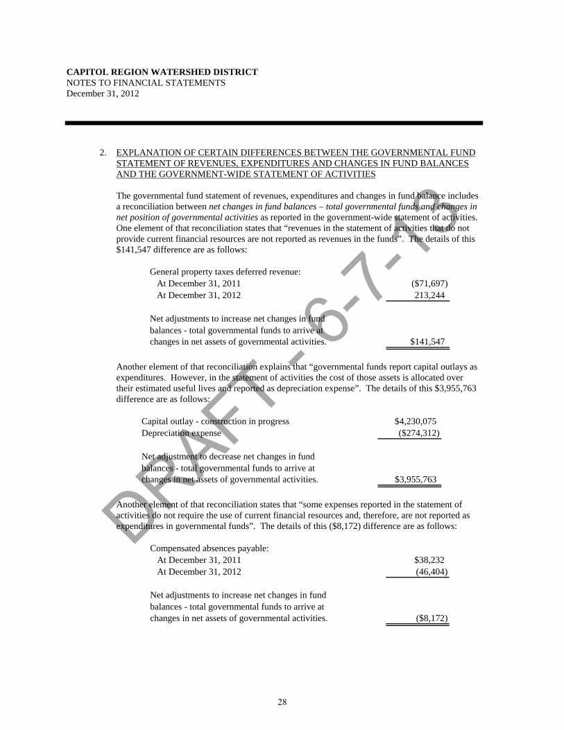
DRAFT - 6-7-
13
CAPITOL REGION WATERSHED DISTRICT NOTES TO FINANCIAL STATEMENTS December 31, 2012
2. EXPLANATION OF CERTAIN DIFFERENCES BETWEEN THE GOVERNMENTAL FUND STATEMENT OF REVENUES, EXPENDITURES AND CHANGES IN FUND BALANCES AND THE GOVERNMENT-WIDE STATEMENT OF ACTIVITIES
The governmental fund statement of revenues, expenditures and changes in fund balance includes a reconciliation between net changes in fund balances – total governmental funds and changes in net position of governmental activities as reported in the government-wide statement of activities. One element of that reconciliation states that “revenues in the statement of activities that do not provide current financial resources are not reported as revenues in the funds”. The details of this $141,547 difference are as follows:
General property taxes deferred revenue: At December 31, 2011 ($71,697) At December 31, 2012 213,244
Net adjustments to increase net changes in fundbalances - total governmental funds to arrive atchanges in net assets of governmental activities. $141,547
Another element of that reconciliation explains that “governmental funds report capital outlays as expenditures. However, in the statement of activities the cost of those assets is allocated over their estimated useful lives and reported as depreciation expense”. The details of this $3,955,763 difference are as follows:
Capital outlay - construction in progress $4,230,075Depreciation expense ($274,312)
Net adjustment to decrease net changes in fundbalances - total governmental funds to arrive atchanges in net assets of governmental activities. $3,955,763
Another element of that reconciliation states that “some expenses reported in the statement of activities do not require the use of current financial resources and, therefore, are not reported as expenditures in governmental funds”. The details of this ($8,172) difference are as follows:
Compensated absences payable: At December 31, 2011 $38,232 At December 31, 2012 (46,404)
Net adjustments to increase net changes in fundbalances - total governmental funds to arrive atchanges in net assets of governmental activities. ($8,172)
28
DRAFT - 6-7-
13
CAPITOL REGION WATERSHED DISTRICT NOTES TO FINANCIAL STATEMENTS December 31, 2012
Note 2 DEPOSITS AND INVESTMENTS
A. DEPOSITS
In accordance with Minnesota Statutes, the District maintains deposits at those depository banks authorized by the District, all of which are members of the Federal Reserve System.
Minnesota Statutes require that all District deposits be protected by insurance, surety bond, or
collateral. The market value of collateral pledged must equal 110% of the deposits not covered by insurance or bonds.
Minnesota Statutes require that securities pledged as collateral be held in safekeeping by the District or
in a financial institution other than that furnishing the collateral. Authorized collateral includes the following:
a) United States government treasury bills, treasury notes, treasury bonds;
b) Issues of United States government agencies and instrumentalities as quoted by a recognized
industry quotation service available to the government entity;
c) General obligation securities of any state or local government with taxing powers which is rated “A” or better by a national bond rating service, or revenue obligation securities of any state or local government with taxing powers which is rated “AA” or better by a national bond rating service;
d) Unrated general obligation securities of a local government with taxing powers may be pledged as collateral against funds deposited by that same local government entity:
e) Irrevocable standby letters of credit issued by Federal Home Loan Banks to a municipality accompanied by written evidence that the bank’s public debt is rated “AA” or better by Moody’s Investors Service, Inc. or Standard & Poor’s Corporation; and
f) Time deposits that are fully insured by any federal agency. The District has no deposits at December 31, 2012.
29
DRAFT - 6-7-
13
CAPITOL REGION WATERSHED DISTRICT NOTES TO FINANCIAL STATEMENTS December 31, 2012
B. INVESTMENTS Minnesota Statutes authorize the District to invest in the following:
a) Securities which are direct obligations or are guaranteed or insured issues of the United States, its agencies, its instrumentalities, or organizations created by an act of Congress, except mortgage-backed securities defined as “high risk” by Minn. Stat. § 118A.04, subd. 6;
b) Mutual funds through shares of registered investment companies provided the mutual fund
receives certain ratings depending on its investments;
c) General obligations of the State of Minnesota and its municipalities, and in certain state agency and local obligations of Minnesota and other states provided such obligations have certain specified bond ratings by a national bond rating service;
d) Bankers’ acceptances of United States banks; e) Commercial paper issued by United States corporations or their Canadian subsidiaries that is rated
in the highest quality category by two nationally recognized rating agencies and matures in 270 days or less; and
f) With certain restrictions, in repurchase agreements, securities lending agreements, joint powers
investment trusts, and guaranteed investment contracts.
The District’s external investment pool investment is with the 4M Fund. The fair value of the District’s position in the external investment pool is equal to the pool shares. The external investment pool is not registered with the Securities and Exchange Commission and regulatory oversight rests with the League of Minnesota Cities. The investments are managed in compliance with investment guidelines as outlined within the Minnesota Statutes. At December 31, 2012, the District held $1,927,371 in a pooled investment fund (4M Fund) organized under Minn. Stat. 471.59, the Joint Powers Act. Credit Risk. Credit risk is the risk that an issuer or other counterparty to an investment will be unable to fulfill its obligation to the holder of the investment. The District follows State Statutes in regards to credit risk of investments. The District does not have an investment policy which further limits its investment choices. Interest Rate Risk. Interest rate risk is the risk that changes in the interest rates of debt investments could adversely affect the fair value of an investment. The District does not have an investment policy which limits investment maturities as a means of managing its exposure to fair value losses arising from increasing interest rates. Concentration of Credit Risk. Concentration of credit risk is the risk of loss that may be attributed to the magnitude of the District’s investment in a single issuer. The District does not have an investment policy which addresses the concentration of credit risk.
30
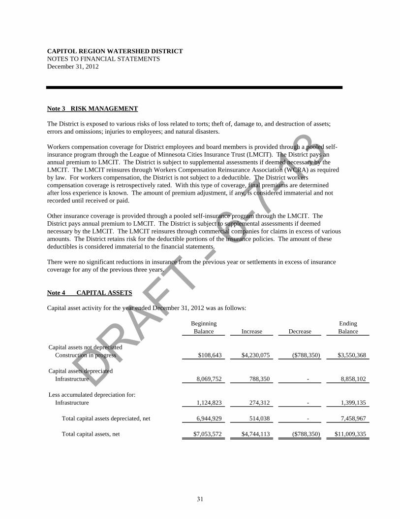
DRAFT - 6-7-
13
CAPITOL REGION WATERSHED DISTRICT NOTES TO FINANCIAL STATEMENTS December 31, 2012
Note 3 RISK MANAGEMENT
The District is exposed to various risks of loss related to torts; theft of, damage to, and destruction of assets; errors and omissions; injuries to employees; and natural disasters. Workers compensation coverage for District employees and board members is provided through a pooled self-insurance program through the League of Minnesota Cities Insurance Trust (LMCIT). The District pays an annual premium to LMCIT. The District is subject to supplemental assessments if deemed necessary by the LMCIT. The LMCIT reinsures through Workers Compensation Reinsurance Association (WCRA) as required by law. For workers compensation, the District is not subject to a deductible. The District workers compensation coverage is retrospectively rated. With this type of coverage, final premiums are determined after loss experience is known. The amount of premium adjustment, if any, is considered immaterial and not recorded until received or paid. Other insurance coverage is provided through a pooled self-insurance program through the LMCIT. The District pays annual premium to LMCIT. The District is subject to supplemental assessments if deemed necessary by the LMCIT. The LMCIT reinsures through commercial companies for claims in excess of various amounts. The District retains risk for the deductible portions of the insurance policies. The amount of these deductibles is considered immaterial to the financial statements. There were no significant reductions in insurance from the previous year or settlements in excess of insurance coverage for any of the previous three years.
Note 4 CAPITAL ASSETS Capital asset activity for the year ended December 31, 2012 was as follows:
Beginning EndingBalance Increase Decrease Balance
Capital assets not depreciatedConstruction in progress $108,643 $4,230,075 ($788,350) $3,550,368
Capital assets depreciatedInfrastructure 8,069,752 788,350 - 8,858,102
Less accumulated depreciation for:Infrastructure 1,124,823 274,312 - 1,399,135
Total capital assets depreciated, net 6,944,929 514,038 - 7,458,967
Total capital assets, net $7,053,572 $4,744,113 ($788,350) $11,009,335
31
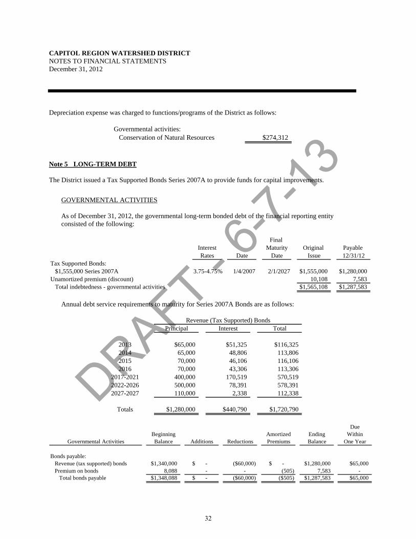
DRAFT - 6-7-
13
CAPITOL REGION WATERSHED DISTRICT NOTES TO FINANCIAL STATEMENTS December 31, 2012
Depreciation expense was charged to functions/programs of the District as follows:
Governmental activities:Conservation of Natural Resources $274,312
Note 5 LONG-TERM DEBT The District issued a Tax Supported Bonds Series 2007A to provide funds for capital improvements.
GOVERNMENTAL ACTIVITIES As of December 31, 2012, the governmental long-term bonded debt of the financial reporting entity consisted of the following:
Final Interest Maturity Original Payable Rates Date Date Issue 12/31/12
Tax Supported Bonds: $1,555,000 Series 2007A 3.75-4.75% 1/4/2007 2/1/2027 $1,555,000 $1,280,000
Unamortized premium (discount) 10,108 7,583Total indebtedness - governmental activities $1,565,108 $1,287,583
Annual debt service requirements to maturity for Series 2007A Bonds are as follows:
Principal Interest Total
2013 $65,000 $51,325 $116,3252014 65,000 48,806 113,8062015 70,000 46,106 116,1062016 70,000 43,306 113,306
2017-2021 400,000 170,519 570,5192022-2026 500,000 78,391 578,3912027-2027 110,000 2,338 112,338
Totals $1,280,000 $440,790 $1,720,790
Revenue (Tax Supported) Bonds
Due
Beginning Amortized Ending WithinGovernmental Activities Balance Additions Reductions Premiums Balance One Year
Bonds payable:Revenue (tax supported) bonds $1,340,000 $ - ($60,000) $ - $1,280,000 $65,000Premium on bonds 8,088 - - (505) 7,583 -
Total bonds payable $1,348,088 $ - ($60,000) ($505) $1,287,583 $65,000
32
DRAFT - 6-7-
13
CAPITOL REGION WATERSHED DISTRICT NOTES TO FINANCIAL STATEMENTS December 31, 2012
Note 6 OPERATING LEASE The District leases office space from an unrelated third party. The lease is classified as an operating lease. The term of the lease is November 1, 2006 through October 31, 2011. As of December 31, 2011, the lease is on a month to month basis. Lease expenditures for the year ended December 31, 2012 amounted to $64,225. The District also leases a copier from an unrelated third party. The lease is classified as an operating lease. The term of the lease is September 1, 2009 through August 31, 2014. Lease expenditures for the year ended December 31, 2012 amounted to $5,727. Total annual minimum future lease payments under the operating lease are as follows:
2013 $3,1962014 2,397
Total $5,593
Note 7 DEFINED BENEFIT PENSION PLANS - STATEWIDE
A. PLAN DESCRIPTION
All full-time and certain part-time employees of the Capitol Region Watershed District are covered by defined benefit plans administered by the Public Employees Retirement Association of Minnesota (PERA). PERA administers the General Employees Retirement Fund (GERF) which is a cost-sharing, multiple-employer retirement plan. This plan is established and administered in accordance with Minnesota Statute, Chapters 353 and 356.
GERF members belong to either the Coordinated Plan or the Basic Plan. Coordinated Plan members
are covered by Social Security and Basic Plan members are not. All new members must participate in the Coordinated Plan.
PERA provides retirement benefits as well as disability benefits to members, and benefits to survivors
upon death of eligible members. Benefits are established by State Statute, and vest after three years of credited service. The defined retirement benefits are based on a member’s highest average salary for any five successive years of allowable service, age, and years of credit at termination of service. The benefit provisions stated in the previous paragraphs of this section are current provisions and apply to active plan participants. Vested, terminated employees who are entitled to benefits but are not receiving them yet are bound by the provisions in effect at the time they last terminated their public service.
PERA issues a publicly available financial report that includes financial statements and required supplementary information for GERF. That report may be obtained on the internet at www.mnpera.org, by writing to PERA, 60 Empire Drive #200, St. Paul, Minnesota, 55103-2088, or by calling (651)296-7460 or 1-800-652-9026.
33
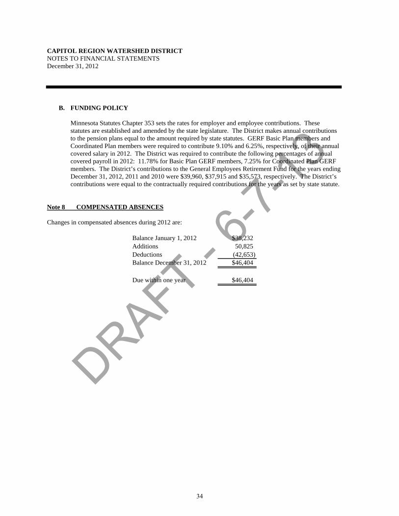
DRAFT - 6-7-
13
CAPITOL REGION WATERSHED DISTRICT NOTES TO FINANCIAL STATEMENTS December 31, 2012
B. FUNDING POLICY
Minnesota Statutes Chapter 353 sets the rates for employer and employee contributions. These statutes are established and amended by the state legislature. The District makes annual contributions to the pension plans equal to the amount required by state statutes. GERF Basic Plan members and Coordinated Plan members were required to contribute 9.10% and 6.25%, respectively, of their annual covered salary in 2012. The District was required to contribute the following percentages of annual covered payroll in 2012: 11.78% for Basic Plan GERF members, 7.25% for Coordinated Plan GERF members. The District’s contributions to the General Employees Retirement Fund for the years ending December 31, 2012, 2011 and 2010 were $39,960, $37,915 and $35,573, respectively. The District’s contributions were equal to the contractually required contributions for the years as set by state statute.
Note 8 COMPENSATED ABSENCES
Changes in compensated absences during 2012 are:
Balance January 1, 2012 $38,232Additions 50,825Deductions (42,653)Balance December 31, 2012 $46,404
Due within one year $46,404
34

DRAFT - 6-7-
13
CAPITOL REGION WATERSHED DISTRICT NOTES TO FINANCIAL STATEMENTS December 31, 2012
Note 9 FUND BALANCE
A. CLASSIFICATIONS
At December 31, 2012, a summary of the governmental fund balance classifications are as follows:
CapitalOperations Improvement Total
Nonspendable:Prepaid items $5,203 $ - $5,203
Total Nonspendable 5,203 - 5,203
Assigned to:Capital improvement - 1,727,405 1,727,405
Total assigned - 1,727,405 1,727,405
Unassigned 1,669,724 - 1,669,724
Total $1,674,927 $1,727,405 $3,402,332
Note 10 INTERFUND RECEIVABLE/PAYABLES
Fund Receivable PayableGovernmental Funds:
Major Funds:Operations $88,119 $ - Capital Improvement - 88,119
Total $88,119 $88,119
Interfund payables and receivable is representative of lending/borrowing arrangements to cover deficit cash balances at the end of the fiscal year. Note 11 SUBSEQUENT EVENTS The District sold $3,000,000 of General Obligation Bonds on April 17, 2013 to finance its Capital Improvement Program. The rates of the bonds per year range from 2.0% to 3.0% with a true interest cost of 2.28%. Principal payments are due annually each February beginning in 2014 through 2034.
35

DRAFT - 6-7-
13
- This page intentionally left blank -
36

DRAFT - 6-7-
13REQUIRED SUPPLEMENTARY INFORMATION
37

DRAFT - 6-7-
13
CAPITOL REGION WATERSHED DISTRICTREQUIRED SUPPLEMENTARY INFORMATION Schedule 1BUDGETARY COMPARISON SCHEDULE - OPERATIONSFor The Year Ended December 31, 2012
Budgeted Amounts2012 Actual
Amounts
Variance with Final Budget -
Positive (Negative)
Original FinalRevenues:
Tax levy $2,182,675 $2,182,675 $2,140,918 ($41,757)Intergovernmental:
Grants and reimbursements 25,000 25,000 35,000 10,000Fees 20,000 20,000 199,000 179,000Interest income 15,000 15,000 233 (14,767)Other - - 5,540 5,540
Total revenues 2,242,675 2,242,675 2,380,691 138,016
Expenditures:Administrative 355,550 355,550 384,587 (29,037)Programs 1,227,067 1,352,417 912,597 439,820Projects 660,058 660,058 455,624 204,434
Total expenditures 2,242,675 2,368,025 1,752,808 615,217
Revenues over expenditures $ - ($125,350) 627,883 $753,233
Fund balance - January 1 1,047,044
Fund balance - December 31 $1,674,927
The accompanying note to the required supplementary information is an integral part of this schedule.38
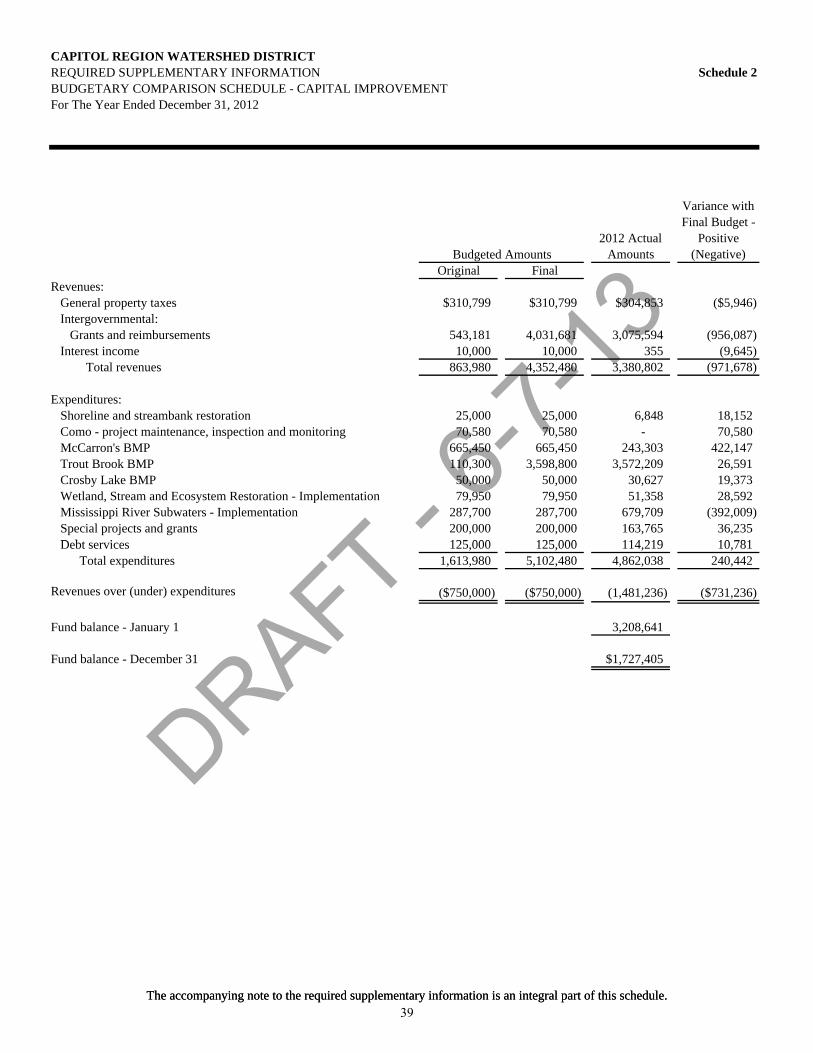
DRAFT - 6-7-
13
CAPITOL REGION WATERSHED DISTRICTREQUIRED SUPPLEMENTARY INFORMATION Schedule 2BUDGETARY COMPARISON SCHEDULE - CAPITAL IMPROVEMENTFor The Year Ended December 31, 2012
Budgeted Amounts2012 Actual
Amounts
Variance with Final Budget -
Positive (Negative)
Original FinalRevenues:
General property taxes $310,799 $310,799 $304,853 ($5,946)Intergovernmental:
Grants and reimbursements 543,181 4,031,681 3,075,594 (956,087)Interest income 10,000 10,000 355 (9,645)
Total revenues 863,980 4,352,480 3,380,802 (971,678)
Expenditures:Shoreline and streambank restoration 25,000 25,000 6,848 18,152Como - project maintenance, inspection and monitoring 70,580 70,580 - 70,580McCarron's BMP 665,450 665,450 243,303 422,147Trout Brook BMP 110,300 3,598,800 3,572,209 26,591Crosby Lake BMP 50,000 50,000 30,627 19,373Wetland, Stream and Ecosystem Restoration - Implementation 79,950 79,950 51,358 28,592Mississippi River Subwaters - Implementation 287,700 287,700 679,709 (392,009)Special projects and grants 200,000 200,000 163,765 36,235D b i 125 000 125 000 114 219 10 781
The accompanying note to the required supplementary information is an integral part of this schedule.
Debt services 125,000 125,000 114,219 10,781Total expenditures 1,613,980 5,102,480 4,862,038 240,442
Revenues over (under) expenditures ($750,000) ($750,000) (1,481,236) ($731,236)
Fund balance - January 1 3,208,641
Fund balance - December 31 $1,727,405
The accompanying note to the required supplementary information is an integral part of this schedule.39

DRAFT - 6-7-
13
CAPITOL REGION WATERSHED DISTRICT REQUIRED SUPPLEMENTARY INFORMATION NOTE TO REQUIRED SUPPLEMENTARY INFORMATION December 31, 2012
Note A BUDGETS The Operations and Capital Improvement Funds budgets are legally adopted on a basis consistent with accounting principles generally accepted in the United States of America. The legal level of budgetary control is at the fund level for both funds. Expenditures did not exceed appropriations in the Operations Fund or the Capital Improvement Fund. The Board of Managers adopts an annual budget for the Operations Fund and Capital Improvement Fund of the District. During the budget year, supplemental appropriations and deletions are or may be authorized by the Board. The modified accrual basis of accounting is used by the District for budgeting data. All appropriations end with the fiscal year for which they were made.
The District monitors budget performance on the fund basis. All amounts over budget have been approved by the Board through the disbursement approval process. Encumbrance accounting, under which purchase orders, contracts and commitments of monies are recorded in order to reserve that portion of the applicable appropriation, is not employed by the District.
40

Appendix B
Printed Materials
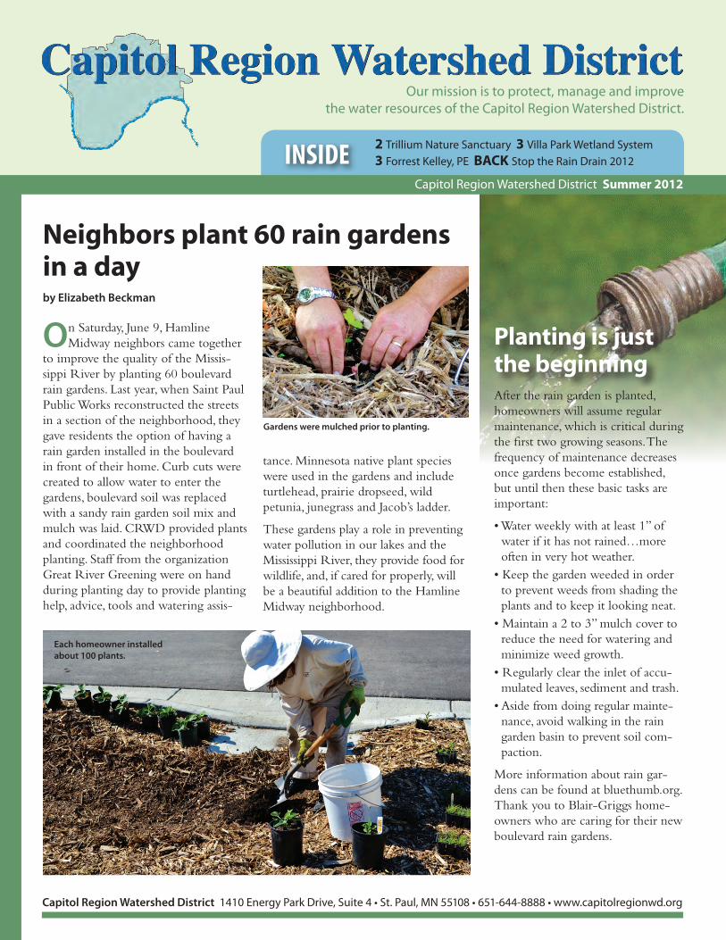
Our mission is to protect, manage and improvethe water resources of the Capitol Region Watershed District.
2 Trillium Nature Sanctuary 3 Villa Park Wetland System3 Forrest Kelley, PE BACK Stop the Rain Drain 2012INSIDE
Capitol Region Watershed District Summer 2012
Capitol Region Watershed District 1410 Energy Park Drive, Suite 4 • St. Paul, MN 55108 • 651-644-8888 • www.capitolregionwd.org
On Saturday, June 9, Hamline Midway neighbors came together
to improve the quality of the Missis-sippi River by planting 60 boulevard rain gardens. Last year, when Saint Paul Public Works reconstructed the streets in a section of the neighborhood, they gave residents the option of having a rain garden installed in the boulevard in front of their home. Curb cuts were created to allow water to enter the gardens, boulevard soil was replaced with a sandy rain garden soil mix and mulch was laid. CRWD provided plants and coordinated the neighborhood planting. Staff from the organization Great River Greening were on hand during planting day to provide planting help, advice, tools and watering assis-
tance. Minnesota native plant species were used in the gardens and include turtlehead, prairie dropseed, wild petunia, junegrass and Jacob’s ladder.
These gardens play a role in preventing water pollution in our lakes and the Mississippi River, they provide food for wildlife, and, if cared for properly, will be a beautiful addition to the Hamline Midway neighborhood.
Neighbors plant 60 rain gardens in a dayby Elizabeth Beckman
After the rain garden is planted, homeowners will assume regular maintenance, which is critical during the first two growing seasons. The frequency of maintenance decreases once gardens become established, but until then these basic tasks are important:
• Water weekly with at least 1” of water if it has not rained…more often in very hot weather.
• Keep the garden weeded in order to prevent weeds from shading the plants and to keep it looking neat.
• Maintain a 2 to 3” mulch cover to reduce the need for watering and minimize weed growth.
• Regularly clear the inlet of accu-mulated leaves, sediment and trash.
• Aside from doing regular mainte-nance, avoid walking in the rain garden basin to prevent soil com-paction.
More information about rain gar-dens can be found at bluethumb.org. Thank you to Blair-Griggs home-owners who are caring for their new boulevard rain gardens.
Planting is just the beginning
Each homeowner installed about 100 plants.
Gardens were mulched prior to planting.

2 Capitol Region Watershed District Summer 2012
Board of Managers: Joe Collins, President; Mike Thienes, Treasurer; Seitu Jones, Secretary ; Mary Texer, Vice Pres.
Staff: Mark Doneux, Administrator Melissa Baker, Water Resource Technician Elizabeth Beckman, Education & Outreach Coordinator David Depaz, Seasonal Water Resource TechnicianAnna Eleria, Water Resource Specialist Bob Fossum, Water Resource Project Manager Jennea Jerdee, ReceptionistForrest Kelley, Permit Coordinator Matt Loyas, Water Resource Technician Dawn Nelson, Office Manager Joe Sellner, Seasonal Water Resource TechnicianBritta Suppes, Water Resource TechnicianLindsay VanPatten, Education Assistant
Established in 1998, the Capitol Region Watershed District covers 40
square miles and includes portions of the cities of Falcon Heights,
Lauderdale, Maplewood, Roseville and St. Paul. Located within Ramsey
County, it has a population of 225,000 people. The district drains to The
Mississippi River, also its primary water resource. Como Lake, Crosby Lake,
Loeb Lake and Lake McCarrons are also located in the District.
Capitol Region Watershed District 1410 Energy Park Drive, Suite 4 St. Paul, MN 55108 • 651-644-8888 • www.capitolregionwd.org
Plans for a nature preserve in the heart of Saint Paul continue to move forward. The Trillium Nature Sanctuary, a 40-acre
site near I-35E and Cayuga Avenue, is part of a larger plan for the Trout Brook Regional Trail corridor. The new section of the trail will extend from Jackson Street and connect to the Gateway Trail at Cayuga Avenue.
The new Saint Paul park and nature sanctuary will include recreating a portion of Trout Brook, a stream that once flowed in the valley of the project area but was buried underground during the expansion of industry and railroad transportation in the area. Wetlands and ponds will also be created at this current brown-field site using a system that intercepts stormwater runoff from the neighborhood. City of Saint Paul Parks and Recreation staff are currently developing the final project plans. Construction is scheduled to begin in 2013 and be completed in late 2014. Since their current Watershed Plan prioritizes stream and wetland restoration, CRWD staff are working in partnership with the City of Saint Paul Parks and Recreation to design waterway restoration elements. Upon completion, the Trillium Nature Sanctuary will represent one of the largest stream, wetland and habitat restoration projects ever completed in the City of Saint Paul.
Trillium Nature Sanctuary moving toward realityby Elizabeth Beckman
Capitol Region Watershed Distr ict
Figure: Trillium Concept Plan
Located on a converted railbed, the Gateway State Trail features 18 miles of paved trail for hiking, biking and skating.
The trail begins in the city of St. Paul and ends at Pine Point Regional Park north of Stillwater. The Gateway Trail is generally level
and wheelchair accessible. More information at Minnesota DNR Trails: www.dnr.state.mn.us/state_trails/index.htm
Gateway State Trail
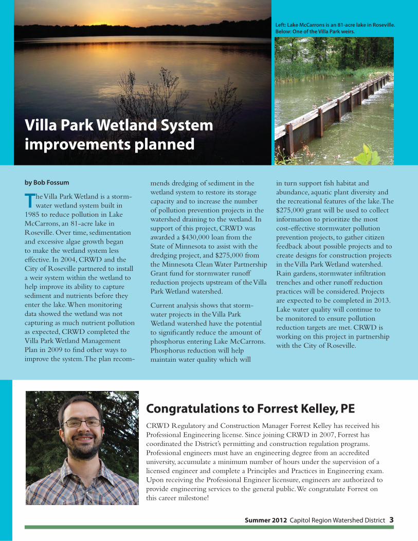
Summer 2012 Capitol Region Watershed District 3
by Bob Fossum
The Villa Park Wetland is a storm-water wetland system built in
1985 to reduce pollution in Lake McCarrons, an 81-acre lake in Roseville. Over time, sedimentation and excessive algae growth began to make the wetland system less effective. In 2004, CRWD and the City of Roseville partnered to install a weir system within the wetland to help improve its ability to capture sediment and nutrients before they enter the lake. When monitoring data showed the wetland was not capturing as much nutrient pollution as expected, CRWD completed the Villa Park Wetland Management Plan in 2009 to find other ways to improve the system. The plan recom-
mends dredging of sediment in the wetland system to restore its storage capacity and to increase the number of pollution prevention projects in the watershed draining to the wetland. In support of this project, CRWD was awarded a $430,000 loan from the State of Minnesota to assist with the dredging project, and $275,000 from the Minnesota Clean Water Partnership Grant fund for stormwater runoff reduction projects upstream of the Villa Park Wetland watershed.
Current analysis shows that storm-water projects in the Villa Park Wetland watershed have the potential to significantly reduce the amount of phosphorus entering Lake McCarrons. Phosphorus reduction will help maintain water quality which will
in turn support fish habitat and abundance, aquatic plant diversity and the recreational features of the lake. The $275,000 grant will be used to collect information to prioritize the most cost-effective stormwater pollution prevention projects, to gather citizen feedback about possible projects and to create designs for construction projects in the Villa Park Wetland watershed. Rain gardens, stormwater infiltration trenches and other runoff reduction practices will be considered. Projects are expected to be completed in 2013. Lake water quality will continue to be monitored to ensure pollution reduction targets are met. CRWD is working on this project in partnership with the City of Roseville.
Villa Park Wetland System improvements planned
Congratulations to Forrest Kelley, PECRWD Regulatory and Construction Manager Forrest Kelley has received his Professional Engineering license. Since joining CRWD in 2007, Forrest has coordinated the District’s permitting and construction regulation programs. Professional engineers must have an engineering degree from an accredited university, accumulate a minimum number of hours under the supervision of a licensed engineer and complete a Principles and Practices in Engineering exam. Upon receiving the Professional Engineer licensure, engineers are authorized to provide engineering services to the general public. We congratulate Forrest on this career milestone!
Left: Lake McCarrons is an 81-acre lake in Roseville.Below: One of the Villa Park weirs.

1410 Energy Park Drive, Suite 4
St. Paul, MN 55108
651-644-8888
651-644-8894 fax
www.capitolregionwd.org
This summer, CRWD has been looking for garages
and homes with gutter downspout extensions that
can be redirected onto lawn or garden areas nearby.
Keeping rainwater out of streets and alleys helps
prevent pollution in our lakes and the Mississippi
River. With the homeowner’s permission, CRWD
will make these improvements to your gutters
free of charge. Look for a Stop the Rain Drain
doorhanger at your house, or visit stopraindrain.org
for information about being reiumbursed to do the
work yourself.
Learn more at stopraindrain.org A newly redirected downspout.
Stop the Rain Drain 2012Stop the Rain Drain teaches residents about reducing runoff and helps them take action.
2 Trout Brook realignment
3 Biological monitoring
BACK Sant Peter Claver
project update
INSIDE
News from Capitol Region Watershed District Fall 2012
This week, Capitol Region Watershed
District (CRWD) presents its newly
designed logo. The new image is
intended to illustrate CRWD’s work
to protect the Mississippi River and its
service to watershed residents. “The
circular outline represents the natural
water cycle and the Capitol skyline
represents the built environment that
overlays the District,” said CRWD
Board Manager Seitu Jones. The blue
and green color scheme exemplifies
the aquatic and natural systems that
coexist in the urban landscape. CRWD’s
original logo was created in 2000 by
Irv Deneen, husband of veteran CRWD
Board Manager Marylyn Deneen. The
new logo was designed by Charles Ross
Group and was officially presented
to CRWD Board of Managers on
Wednesday, October 3.
CRWD unveils new logoby Elizabeth Beckman
Stream restoration Trillium Nature Sanctuary is a 40-acre site near I-35E and
Cayuga Avenue being developed by Saint Paul Parks and Recreation as part of the
larger Trout Brook Regional Trail. The new park will include a recreated portion
of Trout Brook, which once flowed in the valley of the project area, as well as
restored wetlands and ponds fed by stormwater runoff from the neighborhood.
Green infrastructure As part of the Central Corridor Light Rail Transit (CCLRT)
project, CRWD, Metropolitan Council and the City of Saint Paul are constructing
green infrastructure practices to reduce water pollution including stormwater
planters, rain gardens, infiltration trenches and an integrated tree trench
system. Assistance for this project comes from a Minnesota Clean Water
Fund grant.
Clean water partnerships CRWD is partnering with City of Saint
Paul Department of Public Works to plant boulevard rain gardens built
during the street construction portion of the city’s Residential Street
Vitality Program (RSVP). Additionally, CRWD is partnering with the City
of Saint Paul’s Department of Planning and Economic Development on
its Neighborhood Stabilization Program (NSP). The program purchases
and refurbishes foreclosed properties that may otherwise degrade the
community. CRWD’s role has been to prepare landscape plans that provide
water pollution reduction benefits and enhance property aesthetics.
With its new visual identity in place, CRWD looks forward to continued work with
its clean water partners! Visit the CRWD website at capitolregionwd.org.
Our mission is to protect, manage and improve the water resources of the Capitol Region Watershed District.
Capitol Region Watershed District 1410 Energy Park Drive, Suite 4 • St. Paul, MN 55108 • 651-644-8888 • www.capitolregionwd.org
The new design comes at a time when CRWD is involved in a variety
of exciting projects:

Capitol Region
Watershed District
1410 Energy Park Drive Ste 4
St. Paul, MN 55108
651-644-8888
capitolregionwd.org
Board of Managers: Joe Collins, President; Mike Thienes, Treasurer; Seitu Jones, Secretary; Mary Texer, Vice President
Staff: Mark Doneux, AdministratorMelissa Baker, Water Resource Technician Elizabeth Beckman, Education & Outreach
CoordinatorDavid Depaz, Seasonal Water Resource
TechnicianAnna Eleria, Water Resource SpecialistBob Fossum, Water Resource Project
ManagerForrest Kelley, Permit CoordinatorMatt Loyas, Water Resource TechnicianDawn Nelson, Office ManagerJoe Sellner, Seasonal Water Resource
TechnicianBritta Suppes, Water Resource TechnicianLindsay VanPatten, Education Assistant
and Receptionist
During the preliminary design of
I35-E from University Avenue to
Maryland Avenue, it was determined
that a portion of CRWD’s Trout Brook
Storm Sewer would have to be moved
to avoid conflicts with a new proposed
bridge. The new Trout Brook alignment
involves abandoning 630 feet of existing
TBI pipe and replacing it with 830
feet of new 12’ x 9’ pipe and a new TBI
railroad crossing.
The first phase of the project occurred
in August and September 2012, which
included installation of 560 feet of new
storm sewer sections and the new
TBI railroad crossing. Of the 560 feet
of storm sewer, over 160 feet were
constructed during a 33-hour work
window on September 4-5, when the
railroad tracks were disassembled and
rail service was out of commission.
Prior to installation of TBI, groundwater
levels had to be lowered by six to ten
feet so excavation and installation of
TBI could occur under dry conditions.
Since dewatering of the site included
the area beneath the railroad tracks, the
tracks were monitored for movement
prior to, during and after construction
to ensure that the railroad would not
subside or be structurally damaged as a
result of the project.
After the 33-hour work window, the
remaining 400 feet of storm sewer and
a temporary sanitary sewer line were
installed. The construction site has been
temporarily stabilized and restored
as CRWD awaits the second phase of
construction, which is expected to start
in June 2013 after MnDOT removes
the existing Mississippi Street Bridge.
The second phase includes installing
the remaining 270 feet of new TBI,
connecting the new 830-foot alignment
with the existing TBI, and abandoning
the old TBI. Follow the progress of this
project and others on our website,
capitolregionwd.org.
Trout Brook realignmentby Anna Eleria
Trout Brook construction, September 2012
Established in 1998, the
Capitol Region Watershed
District covers 40 square
miles and includes portions
of the cities of Falcon Heights,
Lauderdale, Maplewood,
Roseville and St. Paul.
Located within Ramsey
County, it has a population of
225,000 people. The district
drains to The Mississippi
River, also its primary water
resource. Como Lake, Crosby
Lake, Loeb Lake and Lake
McCarrons are also located in
the District.
2 Capitol Region Watershed District Fall 2012
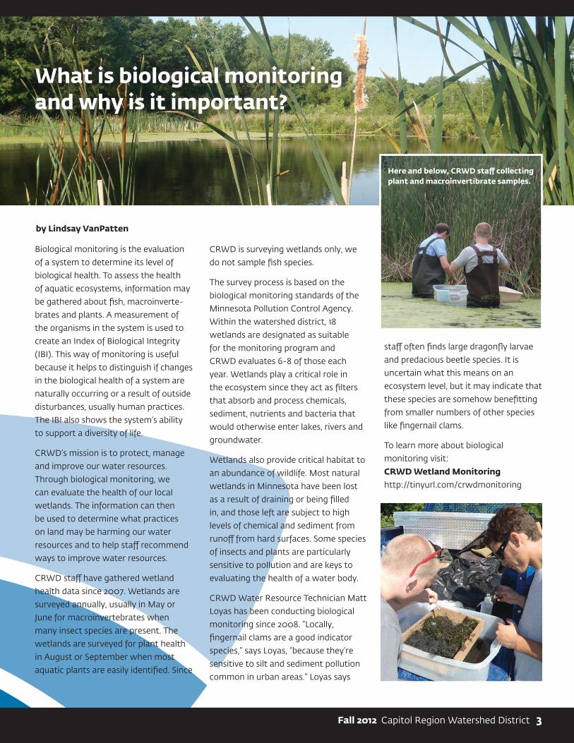
Biological monitoring is the evaluation
of a system to determine its level of
biological health. To assess the health
of aquatic ecosystems, information may
be gathered about fish, macroinverte-
brates and plants. A measurement of
the organisms in the system is used to
create an Index of Biological Integrity
(IBI). This way of monitoring is useful
because it helps to distinguish if changes
in the biological health of a system are
naturally occurring or a result of outside
disturbances, usually human practices.
The IBI also shows the system’s ability
to support a diversity of life.
CRWD’s mission is to protect, manage
and improve our water resources.
Through biological monitoring, we
can evaluate the health of our local
wetlands. The information can then
be used to determine what practices
on land may be harming our water
resources and to help staff recommend
ways to improve water resources.
CRWD staff have gathered wetland
health data since 2007. Wetlands are
surveyed annually, usually in May or
June for macroinvertebrates when
many insect species are present. The
wetlands are surveyed for plant health
in August or September when most
aquatic plants are easily identified. Since
CRWD is surveying wetlands only, we
do not sample fish species.
The survey process is based on the
biological monitoring standards of the
Minnesota Pollution Control Agency.
Within the watershed district, 18
wetlands are designated as suitable
for the monitoring program and
CRWD evaluates 6-8 of those each
year. Wetlands play a critical role in
the ecosystem since they act as filters
that absorb and process chemicals,
sediment, nutrients and bacteria that
would otherwise enter lakes, rivers and
groundwater.
Wetlands also provide critical habitat to
an abundance of wildlife. Most natural
wetlands in Minnesota have been lost
as a result of draining or being filled
in, and those left are subject to high
levels of chemical and sediment from
runoff from hard surfaces. Some species
of insects and plants are particularly
sensitive to pollution and are keys to
evaluating the health of a water body.
CRWD Water Resource Technician Matt
Loyas has been conducting biological
monitoring since 2008. “Locally,
fingernail clams are a good indicator
species,” says Loyas, “because they’re
sensitive to silt and sediment pollution
common in urban areas.” Loyas says
staff often finds large dragonfly larvae
and predacious beetle species. It is
uncertain what this means on an
ecosystem level, but it may indicate that
these species are somehow benefitting
from smaller numbers of other species
like fingernail clams.
To learn more about biological
monitoring visit:
CRWD Wetland Monitoring http://tinyurl.com/crwdmonitoring
What is biological monitoring and why is it important?
Fall 2012 Capitol Region Watershed District 3
by Lindsay VanPatten
Here and below, CRWD staff collecting plant and macroinvertibrate samples.

1410 Energy Park Drive, Suite 4
St. Paul, MN 55108
651-644-8888
651-644-8894 fax
www.capitolregionwd.org
In December of 2011, CRWD Board
approved a grant for the Saint Peter
Claver Church and School Stormwater
Improvement Project. Grant funds will
help with design and construction of
clean water practices that are part of
the project. Saint Peter Claver plays
an important role in the Twin Cities
Community. Located in the Summit-
University neighborhood, it is one of
the largest congregations in Saint Paul
and is the largest parochial school of its
kind in the city.
Project goals include playground and
parking lot improvements that also
reduce stormwater runoff pollution:
a rain garden that captures rainwater
from the school roof and parking lot, a
new plaza constructed with permeable
pavers, turf grass stabilized to allow
stormwater to soak in and a landscape
buffer around the property to prevent
erosion. The project will be completed
in Fall 2012. Please visit our website
for more information on this and other
projects, capitolregionwd.org.
Local Project Update: Saint Peter Claver Catholic School and Parish
Shown during construction (top) and after completion, this rain garden captures roof and parking lot runoff.
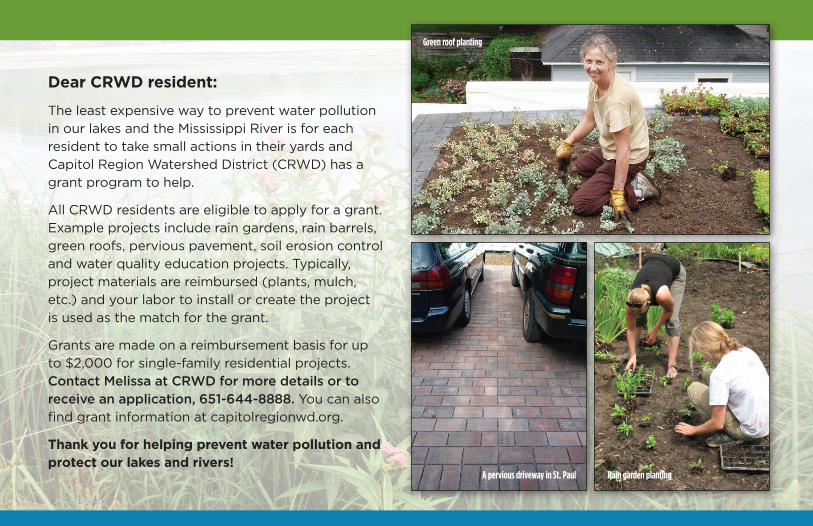
Dear CRWD resident:
The least expensive way to prevent water pollution
in our lakes and the Mississippi River is for each
resident to take small actions in their yards and
Capitol Region Watershed District (CRWD) has a
grant program to help.
All CRWD residents are eligible to apply for a grant.
Example projects include rain gardens, rain barrels,
green roofs, pervious pavement, soil erosion control
and water quality education projects. Typically,
project materials are reimbursed (plants, mulch,
etc.) and your labor to install or create the project
is used as the match for the grant.
Grants are made on a reimbursement basis for up
to $2,000 for single-family residential projects.
Contact Melissa at CRWD for more details or to receive an application, 651-644-8888. You can also
find grant information at capitolregionwd.org.
Thank you for helping prevent water pollution and protect our lakes and rivers!
Green roof planting
A pervious driveway in St. Paul Rain garden planting

1410 Energy Park Drive, Ste. 4St. Paul, MN 55108
A rain barrel construction workshop
Grants available to prevent water
pollution and protect
our lakes and rivers!
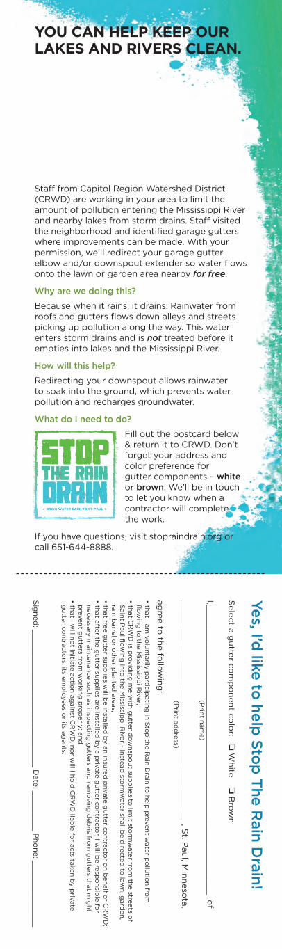
Staff from Capitol Region Watershed District (CRWD) are working in your area to limit the amount of pollution entering the Mississippi River and nearby lakes from storm drains. Staff visited the neighborhood and identified garage gutters where improvements can be made. With your permission, we’ll redirect your garage gutter elbow and/or downspout extender so water flows onto the lawn or garden area nearby for free.
Why are we doing this?
Because when it rains, it drains. Rainwater from roofs and gutters flows down alleys and streets picking up pollution along the way. This water enters storm drains and is not treated before it empties into lakes and the Mississippi River.
How will this help?
Redirecting your downspout allows rainwater to soak into the ground, which prevents water pollution and recharges groundwater.
What do I need to do?
Fill out the postcard below & return it to CRWD. Don’t forget your address and color preference for gutter components – white or brown. We’ll be in touch to let you know when a contractor will complete the work.
If you have questions, visit stopraindrain.org or call 651-644-8888.
YOU CAN HELP KEEP OUR LAKES AND RIVERS CLEAN.
Yes, I’d
like to
help
Sto
p T
he R
ain
Dra
in!
Sele
ct a
gu
tter c
om
po
nen
t co
lor: o
Wh
ite o
Bro
wn
I, ___
____
____
____
____
____
____
____
____
____
____
___
__
___
__
___
__
of
____
____
____
____
____
____
____
____
____
____
____
, St. P
au
l, Min
neso
ta,
ag
ree to
the fo
llow
ing
:
• that I a
m v
olu
nta
rily p
artic
ipatin
g in
Sto
p th
e R
ain
Dra
in to
help
pre
ven
t wate
r po
llutio
n fro
m
flo
win
g to
the M
ississipp
i Riv
er;
• that C
RW
D is p
rovid
ing
me w
ith g
utte
r do
wn
spo
ut su
pp
lies to
limit sto
rmw
ate
r from
the stre
ets o
f S
ain
t Pau
l flo
win
g in
to th
e M
ississipp
i Riv
er - in
stead
storm
wate
r shall b
e d
irecte
d to
law
n, g
ard
en
, ra
in b
arre
l or o
ther p
lan
ted
are
as;
• that fre
e g
utte
r sup
plie
s will b
e in
stalle
d b
y a
n in
sure
d p
rivate
gu
tter c
on
tracto
r on
beh
alf o
f CR
WD
;• th
at a
fter th
e g
utte
r sup
plie
s are
insta
lled
by a
priv
ate
gu
tter c
on
tracto
r, I will b
e re
spo
nsib
le fo
r n
ecessa
ry m
ain
ten
an
ce su
ch
as in
spectin
g g
utte
rs an
d re
mo
vin
g d
eb
ris from
gu
tters th
at m
igh
t p
reven
t gu
tters fro
m w
ork
ing
pro
perly
; an
d• th
at I w
ill no
t initia
te a
ctio
n a
gain
st CR
WD
, no
r will I h
old
CR
WD
liab
le fo
r acts ta
ken
by p
rivate
g
utte
r co
ntra
cto
rs, its em
plo
yees o
r its ag
en
ts.
Sig
ned
: _____________________
___
_____
__ D
ate
: ___
_____
_ P
ho
ne: _
___
____
______
_
(Prin
t nam
e)
(Prin
t ad
dre
ss)
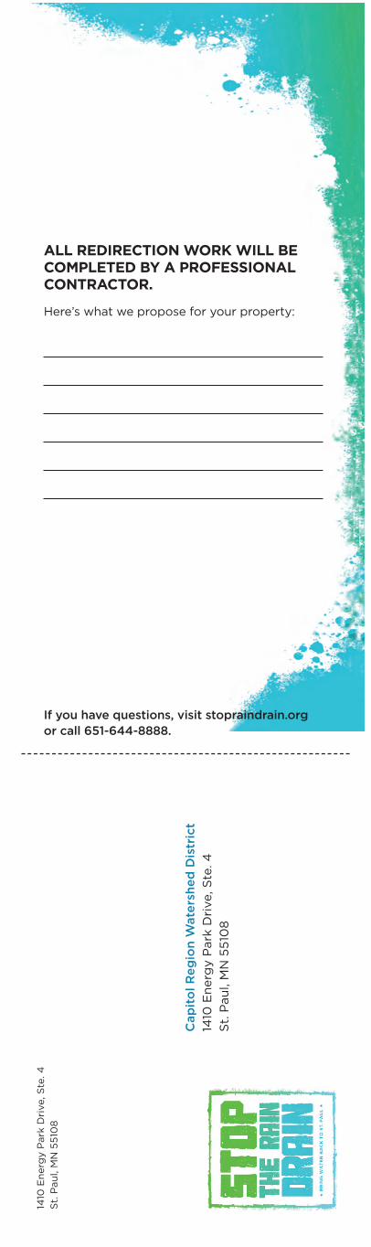
Here’s what we propose for your property:
If you have questions, visit stopraindrain.org or call 651-644-8888.
ALL REDIRECTION WORK WILL BE COMPLETED BY A PROFESSIONAL CONTRACTOR.
1410
En
erg
y P
ark
Dri
ve, S
te. 4
St.
Pau
l, M
N 5
510
8
Cap
ito
l R
eg
ion
Wate
rsh
ed
Dis
tric
t
1410
En
erg
y P
ark
Dri
ve, S
te. 4
St.
Pau
l, M
N 5
510
8
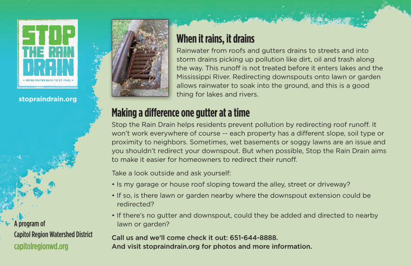
When it rains, it drainsRainwater from roofs and gutters drains to streets and into storm drains picking up pollution like dirt, oil and trash along the way. This runoff is not treated before it enters lakes and the Mississippi River. Redirecting downspouts onto lawn or garden allows rainwater to soak into the ground, and this is a good thing for lakes and rivers.
stopraindrain.org
A program of
Capitol Region Watershed District
capitolregionwd.org
Making a difference one gutter at a timeStop the Rain Drain helps residents prevent pollution by redirecting roof runoff. It won’t work everywhere of course -- each property has a different slope, soil type or proximity to neighbors. Sometimes, wet basements or soggy lawns are an issue and you shouldn’t redirect your downspout. But when possible, Stop the Rain Drain aims to make it easier for homeowners to redirect their runoff.
Take a look outside and ask yourself:
• Is my garage or house roof sloping toward the alley, street or driveway?
• If so, is there lawn or garden nearby where the downspout extension could be redirected?
• If there’s no gutter and downspout, could they be added and directed to nearby lawn or garden?
Call us and we’ll come check it out: 651-644-8888. And visit stopraindrain.org for photos and more information.

Stop the Rain Drain
is brought to you by
CRWD. Redirect your
garage gutter downspouts
this summer to improve
water quality in our lakes
and the Mississippi River!
Where rain drains matters.
1410 Energy Park Drive, Ste. 4
St. Paul, MN 55108
stopraindrain.org
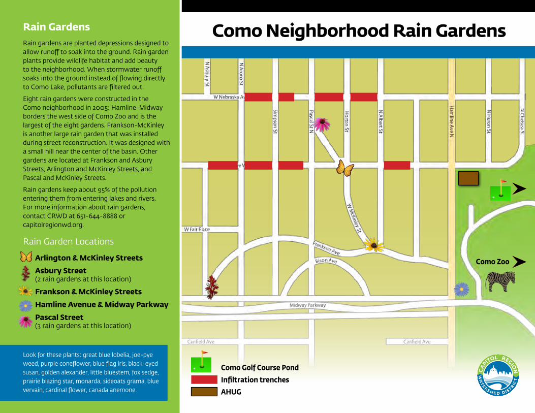
Como Golf Course Pond
Infiltration trenches
AHUG
Como Zoo
Rain Gardens Rain gardens are planted depressions designed to allow runoff to soak into the ground. Rain garden plants provide wildlife habitat and add beauty to the neighborhood. When stormwater runoff soaks into the ground instead of flowing directly to Como Lake, pollutants are filtered out.
Eight rain gardens were constructed in the Como neighborhood in 2005: Hamline-Midway borders the west side of Como Zoo and is the largest of the eight gardens. Frankson-McKinley is another large rain garden that was installed during street reconstruction. It was designed with a small hill near the center of the basin. Other gardens are located at Frankson and Asbury Streets, Arlington and McKinley Streets, and Pascal and McKinley Streets.
Rain gardens keep about 95% of the pollution entering them from entering lakes and rivers. For more information about rain gardens, contact CRWD at 651-644-8888 or capitolregionwd.org.
Rain Garden Locations
Arlington & McKinley Streets
Asbury Street(2 rain gardens at this location)
Frankson & McKinley Streets
Hamline Avenue & Midway Parkway
Pascal Street(3 rain gardens at this location)
Look for these plants: great blue lobelia, joe-pye weed, purple coneflower, blue flag iris, black-eyed susan, golden alexander, little bluestem, fox sedge, prairie blazing star, monarda, sideoats grama, blue vervain, cardinal flower, canada anemone.
Como Neighborhood Rain Gardens
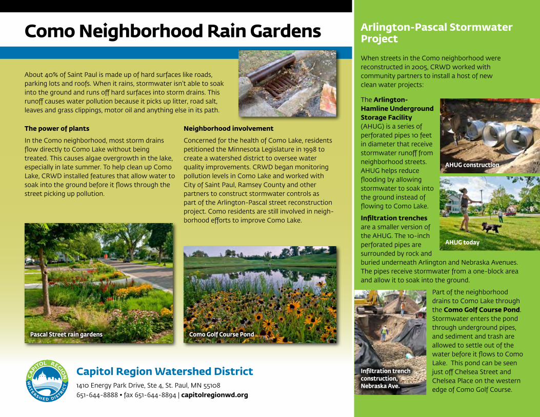
The power of plants
In the Como neighborhood, most storm drains flow directly to Como Lake without being treated. This causes algae overgrowth in the lake, especially in late summer. To help clean up Como Lake, CRWD installed features that allow water to soak into the ground before it flows through the street picking up pollution.
Neighborhood involvement
Concerned for the health of Como Lake, residents petitioned the Minnesota Legislature in 1998 to create a watershed district to oversee water quality improvements. CRWD began monitoring pollution levels in Como Lake and worked with City of Saint Paul, Ramsey County and other partners to construct stormwater controls as part of the Arlington-Pascal street reconstruction project. Como residents are still involved in neigh-borhood efforts to improve Como Lake.
Como Neighborhood Rain Gardens
About 40% of Saint Paul is made up of hard surfaces like roads, parking lots and roofs. When it rains, stormwater isn’t able to soak into the ground and runs off hard surfaces into storm drains. This runoff causes water pollution because it picks up litter, road salt, leaves and grass clippings, motor oil and anything else in its path.
Arlington-Pascal Stormwater Project
When streets in the Como neighborhood were reconstructed in 2005, CRWD worked with community partners to install a host of new clean water projects:
The Arlington-Hamline Underground Storage Facility (AHUG) is a series of perforated pipes 10 feet in diameter that receive stormwater runoff from neighborhood streets. AHUG helps reduce flooding by allowing stormwater to soak into the ground instead of flowing to Como Lake.
Infiltration trenches are a smaller version of the AHUG. The 10-inch perforated pipes are surrounded by rock and buried underneath Arlington and Nebraska Avenues. The pipes receive stormwater from a one-block area and allow it to soak into the ground.
Part of the neighborhood drains to Como Lake through the Como Golf Course Pond. Stormwater enters the pond through underground pipes, and sediment and trash are allowed to settle out of the water before it flows to Como Lake. This pond can be seen just off Chelsea Street and Chelsea Place on the western edge of Como Golf Course.
Pascal Street rain gardens Como Golf Course Pond
AHUG construction
AHUG today
Infiltration trench construction, Nebraska Ave.
Capitol Region Watershed District1410 Energy Park Drive, Ste 4, St. Paul, MN 55108651-644-8888 • fax 651-644-8894 | capitolregionwd.org
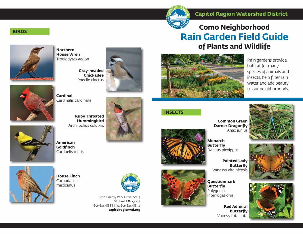
Capitol Region Watershed District
Como Neighborhood Rain Garden Field Guide
of Plants and Wildlife
Rain gardens provide habitat for many species of animals and insects, help filter rain water and add beauty to our neighborhoods.
American GoldfinchCarduelis tristis
Gray-headed Chickadee
Poecile cinctus
House FinchCarpodacus mexicanus
Northern House WrenTroglodytes aedon
Ruby Throated Hummingbird
Archilochus colubris
CardinalCardinalis cardinalis
BIRDS
Monarch ButterflyDanaus plexippus
Painted Lady Butterfly
Vanessa virginiensis
QuestionmarkButterflyPolygonia interrogationis
Red AdmiralButterfly
Vanessa atalanta
Common GreenDarner Dragonfly
Anax junius
1410 Energy Park Drive, Ste 4St. Paul, MN 55108
651-644-8888 | fax 651-644-8894capitolregionwd.org
INSECTS
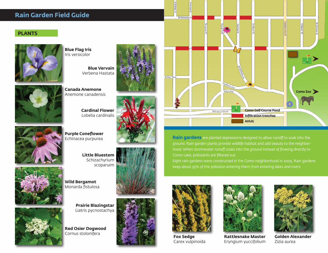
Como Golf Course Pond
Infiltration trenches
AHUG
Como Zoo
Rain Garden Field Guide
Blue Flag IrisIris versicolor
PLANTS
Golden AlexanderZizia aurea
Canada AnemoneAnemone canadensis
Fox SedgeCarex vulpinoida
Blue VervainVerbena Hastata
Cardinal FlowerLobelia cardinalis
Purple ConeflowerEchinacea purpurea
Red Osier DogwoodCornus stolonifera
Rattlesnake MasterEryngium yuccifolium
Prairie BlazingstarLiatris pycnostachya
Little BluestemSchizachyrium
scoparuim
Wild BergamotMonarda fistulosa
Rain gardens are planted depressions designed to allow runoff to soak into the
ground. Rain garden plants provide wildlife habitat and add beauty to the neighbor-
hood. When stormwater runoff soaks into the ground instead of flowing directly to
Como Lake, pollutants are filtered out.
Eight rain gardens were constructed in the Como neighborhood in 2005. Rain gardens
keep about 95% of the pollution entering them from entering lakes and rivers.