2013 comprehensive plan - fairfax planning district
TRANSCRIPT

FAIRFAX COUNTY COMPREHENSIVE PLAN, 2013 Edition AREA II Fairfax Planning District, Amended through 10-28-2014 Overview Page 1
FAIRFAX PLANNING DISTRICT OVERVIEW
The Fairfax Planning District is centrally located in Fairfax County and surrounds the City of Fairfax. The planning district is approximately 13,000 acres in size, which encompasses approximately five percent of the county. Many of the major roads in the county are tangent to or traverse the district, including Interstate 66 (I-66), Arlington Boulevard (Route 50), Chain Bridge Road/Ox Road (Route 123), Lee Highway (Route 29), Little River Turnpike (Route 236), Braddock Road, Hunter Mill Road and Gallows Road (see Figure 1). The Fairfax Planning District contains several mixed-use centers in part or whole. A portion of the Fairfax Center Area Suburban Center is located within the western section of the Fairfax Planning District; plan recommendations for the Fairfax Center Area Suburban Center are included in the Area III volume of the Comprehensive Plan, Fairfax Center Area. A portion of the Merrifield Suburban Center is located within the eastern section of the district; plan recommendations for the Merrifield Suburban Center are included in the Area I volume of the Comprehensive Plan, Merrifield Suburban Center. The Flint Hill Suburban Center is located entirely within the Fairfax Planning District, north of the intersection of Chain Bridge Road and I-66. The district also includes approximately 50 acres of land surrounded by the City of Fairfax (F6: County Government Center Community Planning Sector) on which the Fairfax County Courthouse and Public Safety Center are located.
The predominant character of the Fairfax Planning District is low density residential development. Most of the low density residential development was built in the 1950s through 1970s. The northwestern portion of the planning district, which lies in the Difficult Run Watershed, is developed with low density residential neighborhoods or is environmental conservation (open space) use. Townhouse and multifamily residential uses are located north and south of I-66 near the Flint Hill Suburban Center and northeast of the City of Fairfax. In the vicinity of Woodburn Road and Gallows Road there is a townhouse and multifamily development adjacent to the Merrifield Suburban Center. George Mason University is a major institutional use located in the southern portion of the planning district. The university complex includes the Patriot Center, which is a regional sports and entertainment facility. George Mason University owns a large vacant tract in this district, which is under state control for planning purposes.
There is a small area in the southwestern section of the planning district (F7 George Mason Community Planning Sector) that is in the Occoquan Watershed. The Comprehensive Plan for the area within the Fairfax Planning District located within the watershed of the Occoquan Reservoir provides for a rural character by maintaining a very low density development recommendation of .1-.2 dwelling units per acre or five- to ten-acre lots. This very low density pattern provides reasonable use of the property and serves as a land use Best Management Practice (BMP). When used in conjunction with stormwater management facilities (structural BMPs), the water that ultimately enters the Occoquan Reservoir is managed in a way that positively contributing to the quality of water in the reservoir. The reservoir is a major source of drinking water for the county and other jurisdictions, and the reservoir is an environmentally important feature and source of recreation for the public.
In addition to water quality benefits, very low density residential development within the
Occoquan Watershed preserves large lot development opportunities and assures compatibility

FAIRFAX COUNTY COMPREHENSIVE PLAN, 2013 Edition AREA II Fairfax Planning District, Amended through 10-28-2014 Overview Page 2
FAIRFAX PLANNING DISTRICT FIGURE 1

FAIRFAX COUNTY COMPREHENSIVE PLAN, 2013 Edition AREA II Fairfax Planning District, Amended through 10-28-2014 Overview Page 3 with the character of the existing residential development. More importantly, it allows the county to concentrate limited public resources for public facilities, transportation and public utilities in those areas of the county planned for higher intensity development. Public revenue may be more economically and efficiently used by targeting these resources to planned mixed-use centers that are expected to provide for economic development and affordable housing opportunities in accordance with the Policy Plan and Concept for Future Development.
The county has adopted a sewer service area map, which defines areas where public sewer is planned to be permitted. Land in the Fairfax Planning District in the Occoquan Watershed is not within the approved sewer service area nor are some portions of the Difficult Run Watershed that are planned for low density residential use. These areas are planned for and generally developed with uses which do not require public service and may be developed in residential densities or in nonresidential uses which do not require public sewer service. CONCEPT FOR FUTURE DEVELOPMENT
The planning guidance provided by the Concept for Future Development is one of the principal elements used in formulating Area Plan recommendations. The Concept and its associated land use guidance recommend the predominant use and character envisioned for land areas within each planning district although within the Planning District, there may be land areas planned for a distinctly different land use than that envisioned by the Concept.
In the context of the Policy Plan, the majority of the Fairfax Planning District has been
recommended as Suburban Neighborhoods. The Flint Hill Suburban Center (Sector F3) incorporates a relatively small area adjacent to the intersection of I-66 and Route 123 on the northern boundary of Fairfax City. A small portion of the Merrifield Suburban Center (Sector F2) is located near the intersection of Arlington Boulevard and Gallows Road in the eastern part of the District. A Large Institutional Land Area has been identified for George Mason University (Sector F7).
Suburban Centers are defined as mixed-use areas where employment use predominates.
Suburban Neighborhoods emphasize a residential character and suggest development guidelines that will help maintain this character and inhibit potentially incompatible land uses or intensities of use. Neighborhood stability is further promoted through sound planning principles addressing appropriate transitions between adjoining land uses, access control, environmental protection and other appropriate public facility and transportation guidelines. MAJOR OBJECTIVES
Planning objectives in the Fairfax Planning District are the following: • Preserve stable residential areas, including those older neighborhoods within this
Planning District through infill and new development of a compatible character, use and intensity;
• Limit commercial encroachment into established residential neighborhoods and by
defining a clear "edge" within transition areas between stable commercial and residential areas;

FAIRFAX COUNTY COMPREHENSIVE PLAN, 2013 Edition AREA II Fairfax Planning District, Amended through 10-28-2014 Overview Page 4
• Provide pedestrian access from residential and employment areas to retail areas; • Ensure compatibility between any future expansion of major institutional uses, such
as George Mason University and the Fairfax Hospital complex, and the interests of the surrounding community;
• Encourage residential and ancillary retail uses in the Flint Hill Suburban Center to
help create a mixture of uses where the predominant development is for employment use. Also, encourage added amenities, such as plazas, fountains, and outdoor sitting areas, within existing development;
• Protect environmental resources associated with all stream valleys; • Provide parks, open space and recreation facilities; and • Identify, preserve and promote awareness of heritage resources through research,
survey and community involvement.
DISTRICT-WIDE RECOMMENDATIONS Transportation
Travel within and through the Fairfax Planning District is affected by land uses and transportation facilities in adjacent districts, as well as throughout the Northern Virginia region. Therefore, the transportation network affecting the District is comprised of several elements, many of which relate to more extensive countywide facilities, services, and policies. The arterial and major collector roadways affecting the District are shown on Figure 2. Other countywide Transportation elements are also depicted.
Within the discussion for each sector of the planning district, a sector map depicting the Transportation Plan recommendations in that sector is provided. More detail is provided on these sector maps than on the planning district map. The additional detail may relate to more local transportation issues that are difficult to present at the planning district scale. In some cases, such as interchange areas, a portion of the sector map has been enlarged so that the transportation recommendations are clearly identified. These enlargements of the sectors may also include guidance regarding the provision of access to selected land areas.
Braddock Road from Guinea Road to Ox Road was widened to four lanes in 1991. There
are few, if any, opportunities to add highway capacity on this stretch of Braddock Road. A Corridor Study must be done before additional lanes can be considered. This study should explore not only alternate routes, but also additional transit services and carpooling incentives.
Community- and neighborhood-sized commuter parking facilities are needed along
Braddock Road. Park-and-ride lots could be built for commuters, or shared parking arrangements could be made with churches, parks, and other uses. Provisions need to be made for safe pedestrian access between bus stops, park-and-ride lots, and nearby developments.
Hunter Mill Road from Chain Bridge Road to Baron Cameron Avenue is a 7.2 mile roadway that is designated a Virginia Byway. To preserve the road’s scenic and historic
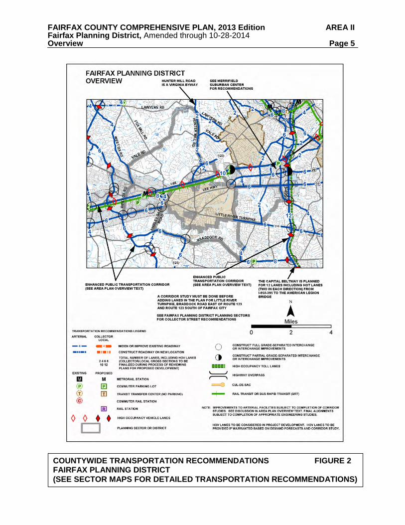
FAIRFAX COUNTY COMPREHENSIVE PLAN, 2013 Edition AREA II Fairfax Planning District, Amended through 10-28-2014 Overview Page 5
COUNTYWIDE TRANSPORTATION RECOMMENDATIONS FIGURE 2 FAIRFAX PLANNING DISTRICT (SEE SECTOR MAPS FOR DETAILED TRANSPORTATION RECOMMENDATIONS)

FAIRFAX COUNTY COMPREHENSIVE PLAN, 2013 Edition AREA II Fairfax Planning District, Amended through 10-28-2014 Overview Page 6 character, planning efforts should focus on innovative ways of dealing with traffic volumes. The Hunter Mill Road Traffic Calming Study, sponsored by the Northern Virginia Regional Commission (NVRC) and completed in 2006, provides both a traffic calming conceptual plan for Hunter Mill Road, as well as context sensitive roadway design techniques.
The I-66 travel corridor is an Enhanced Public Transportation Corridor, with a planned
Metrorail line. The provision of a rail station between the existing Vienna-Fairfax-GMU Metro station and the easternmost station in the Fairfax Center area may be necessary in order to ensure the viability of high quality Metrorail service in this corridor. To allow for preservation of land for a Metro station in this area, an enhanced corridor study should be undertaken that will consider the requirements of Metrorail service in the entire I-66 corridor, identify the need for stations west of Vienna, and locate potential sites for rail stations. Site recommendations should be consistent with the policy of preserving low density residential land use in the headwaters of the Difficult Run. Housing
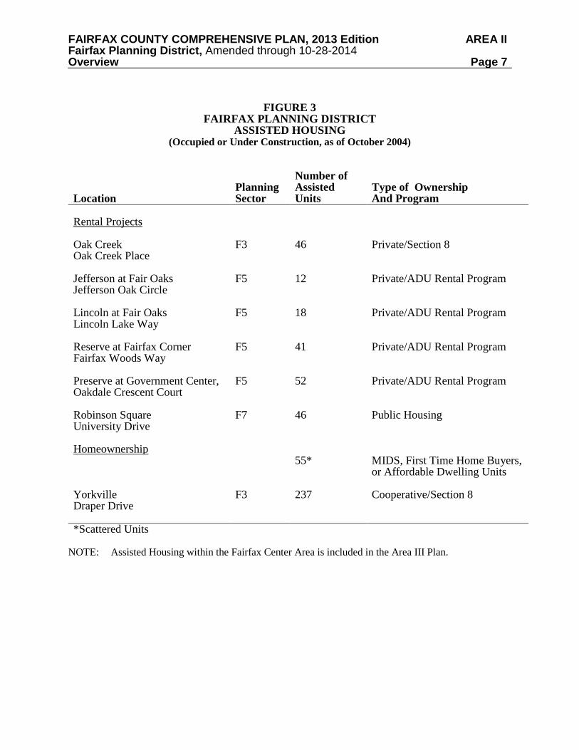
A list of existing, under construction, and proposed assisted housing for the Fairfax Planning District is shown in Figure 3. This list includes housing developments which, to the county's knowledge, have received some type of housing assistance as defined below, but it should not be considered all inclusive.
Assisted housing includes programs which limit the amount of rent and the eligibility of occupants based on income as a condition for the provision of financial assistance from federal, state, or local sources. Some programs have time limits, and those units would no longer be considered "assisted" after income eligibility and rent limitations have been removed. The programs listed below are included as "assisted housing.” Most programs provide assistance to privately owned housing developments. In some cases, multiple sources of financing may be used. The primary program and type of ownership is listed in the figure.
• Housing units owned or managed by the Fairfax County Redevelopment and Housing Authority (FCRHA) and operated by the Department of Housing and Community Development under the Federal Public Housing program or the local Fairfax County Rental Program;
• Housing units owned by the FCRHA and leased to the Fairfax-Falls Church
Community Services Board for use as group homes or to nonprofit groups for emergency housing;
• Federal Section 8 project based rent subsidy units, which are usually privately owned; • Units subsidized under federal mortgage subsidy programs including Section 202
(Elderly), Section 811 (Disabled) , Section 221(d)(3), Section 235 or Section 236. These units may be publicly owned but most are owned by private or nonprofit entities;
• Developments which were financed with FCRHA bonds where a portion of the units
must have reduced rents for tenants who meet income eligibility requirements;
FAIRFAX COUNTY COMPREHENSIVE PLAN, 2013 Edition AREA II Fairfax Planning District, Amended through 10-28-2014 Overview Page 7
FIGURE 3
FAIRFAX PLANNING DISTRICT ASSISTED HOUSING
(Occupied or Under Construction, as of October 2004)
Location
Planning Sector
Number of Assisted Units
Type of Ownership And Program
Rental Projects
Oak Creek Oak Creek Place
F3
46
Private/Section 8
Jefferson at Fair Oaks Jefferson Oak Circle
F5 12 Private/ADU Rental Program
Lincoln at Fair Oaks Lincoln Lake Way
F5 18 Private/ADU Rental Program
Reserve at Fairfax Corner Fairfax Woods Way
F5 41 Private/ADU Rental Program
Preserve at Government Center, Oakdale Crescent Court
F5 52 Private/ADU Rental Program
Robinson Square University Drive
F7
46
Public Housing
Homeownership 55*
MIDS, First Time Home Buyers, or Affordable Dwelling Units
Yorkville Draper Drive
F3
237 Cooperative/Section 8
*Scattered Units NOTE: Assisted Housing within the Fairfax Center Area is included in the Area III Plan.
FAIRFAX COUNTY COMPREHENSIVE PLAN, 2013 Edition AREA II Fairfax Planning District, Amended through 10-28-2014 Overview Page 8
• Tax Credit/VHDA financed projects with Low Income Housing Tax Credits and/or Virginia Housing Development Authority (VHDA) financing which establishes income eligibility requirements, many of which are privately owned;
• Nonprofit rental units and group homes serving nine or more individuals and owned
by private entities, which were assisted with loans or grants from the Community Development Block Grant (CDBG), Section 108 loans, Home Investment Partnerships Program (HOME), or Fairfax County Housing Trust Fund;
• Moderate Income Direct Sales (MIDS) program units which are for sale to
income-eligible, first time home buyers with financial assistance provided in return for control of the re-sale price of the home; and
• Affordable Dwelling Units (ADU) for sale or for rent to serve households with
incomes up to 70% of Metropolitan Statistical Area (MSA) median income and which are required to be included in certain housing developments of 50 or more units pursuant to Article 2, Part 8 of the Fairfax County Zoning Ordinance. In some instances, units created under the ADU Program may be owned by the FCRHA or a nonprofit organization; if so, they would be considered in one of the other categories above.
In many cases the assisted units represent only a portion of a larger development. Only the number of assisted units is included on the figure. Also, the housing listed as part of the Section 8 program is only that where the Section 8 rent subsidy is tied to specific housing units (project based). Housing where eligible tenants are receiving assistance through the Section 8 Housing Choice Voucher Rental program or where the subsidy transfers with the tenant is not listed since the units change continuously as tenants move. Countywide, at the end of 2002, over 3,200 families living in Fairfax County were assisted with tenant-based vouchers. Finally, for some proposed developments where a zoning proffer requires the provision of low and/or moderate income housing, but no specific program (such as MIDS) is identified in the proffer, the type of program is listed as Unknown.
Environment
The dominant environmental feature of the Fairfax Planning District is the Difficult Run
Environmental Quality Corridor. The two main branches of the Difficult Run meet in the far northern corner of Community Planning Sector F4, Fox Lake. Headwaters occur north and west of Jermantown Road and in the I-66 area. Building sites in the Difficult Run headwaters are severely constrained by environmental factors, including steep slopes, poor soils and wetlands. Like portions of the Pohick, Lower Potomac, Upper Potomac and Bull Run Planning Districts, this area is important for the preservation of wildlife habitat in Fairfax County.
Environmentally sensitive lands are also found in the southwestern portion of this district. This area comprises headwaters for Popes Head Creek watershed, which flows into the Occoquan Reservoir. Portions of this watershed have been developed for a long time. Stormwater management Best Management Practices (BMPs) are required for the lands within the Occoquan Reservoir water supply watershed. These are detailed in the Public Facilities Manual.
Older, developed portions of the county often have fair to poor surface run-off water
quality. This is due primarily to nonpoint source pollution in the form of stormwater runoff
FAIRFAX COUNTY COMPREHENSIVE PLAN, 2013 Edition AREA II Fairfax Planning District, Amended through 10-28-2014 Overview Page 9 which contains high levels of fertilizers, pesticides, sediment, and hydrocarbons. Portions of the Fairfax Planning District have benefited to a certain extent from state-of-the-art water quality control practices, BMPs, instituted under the Occoquan watershed protection initiatives. However, these controls apply only to a small portion of the Fairfax Planning District. The challenge is to implement controls in built up areas.
High water quality should continue to be promoted through land use and structural controls
in order to comply with the spirit of the Chesapeake Bay Preservation Act. The following guidelines are suggested to achieve this objective:
• Maintain very low density development in the portions of the District that are
environmentally constrained and drain into the Difficult Run and the Occoquan Reservoir;
• Create an extended EQC system to provide protection to areas that constitute the
Difficult Run and Popes Head Creek headwaters. The EQC system includes areas of significant habitat in addition to stream valley lands;
• Provide for the regional stormwater management ponds according to the Regional
Stormwater Management Plan. Discourage the use of on-site stormwater management techniques in lieu of a regional alternative. In headwaters areas with suitable soils, infiltration techniques may be appropriate; and
• Encourage cluster development at planned densities and low development densities in
the stream valley headwaters.
Extensive EQCs are found in this district in association with the Difficult Run and Popes Head Creek. The Difficult Run Stream Valley has been designated an area of critical environmental concern by the Commonwealth. The entire watershed has been identified as a significant environmental resource by the Board of Supervisors under the county's Adopt-A-Stream Program. Many initiatives are underway to reclaim and preserve this watershed. This district includes a large part of the Difficult Run wildlife habitat. Also, the southwestern portion of this district drains into the Occoquan Reservoir. Only a small portion of this area is subject to land use controls that maintain water quality. The undeveloped sections of Fairfax Planning District that are severely constrained by environmental factors, including steep slopes, poor soils, or significant areas of vegetation should be maintained as natural resource/wildlife areas.
The headwaters of several major watersheds, Accotink Creek, Pohick Creek, Difficult Run and Popes Head Creek, are environmentally sensitive areas located in the Fairfax Planning District. The floodplains and parks associated with these creeks and their tributaries form the basis for the environmental quality network in this Planning District. The protection of these stream valleys, wetlands and their associated wildlife habitat is essential.
Heritage Resources The Fairfax Planning District contains both known and potential heritage resources. A list of those heritage resources included in Fairfax County's Inventory of Historic Sites is shown on Figure 4, and a map of those resources is shown on Figure 5. The inventory is open-ended and

FAIRFAX COUNTY COMPREHENSIVE PLAN, 2013 Edition AREA II Fairfax Planning District, Amended through 10-28-2014 Overview Page 10
FIGURE 4 INVENTORY OF HISTORIC SITES FAIRFAX PLANNING DISTRICT
(Inventory as of 2013)
Name Location Planning Sector Parcel Number Date
Fairfax County Courthouse N,V
4000 Chain Bridge Road Fairfax
F6 57-4 ((1)) 14 1800
Fairfax County Jail N,V 4010 Chain Bridge Road Fairfax
F6 57-4 ((1)) 14 c. 1885
Fairfax Villa Community Park
East of Shirley Gate Road between Lee Highway and Braddock Road, Fairfax
F7 56-4 ((6)) A, 39, 40, 41, 42, 87A; 57-3 ((1)) 1, 2; 57-3 ((7)) A1
c. 5000 BC – Early 20th century
Flint Hill School 3012 Chain Bridge Road Fairfax
F4 47-2 ((1)) 36A 1930, moved here 1986
Gabrielson Gardens Park/Great Crest
2514 Leeds Road Oakton
F4 37-1 ((3)) 7 1950
Lawyers Road1 b/t Hunter Station and Hunter Mill Roads, Vienna
F4 27-3; 27-4 Pre 1800
Legato School 4100 Chain Bridge Road Fairfax
F6 57-4 ((1)) 14 c.1877
Oakton Trolley Station N, V
2923 Gray Street Oakton
F3 47-2 ((1)) 63C 1905
Oakton United Methodist Church
2951 Chain Bridge Road Oakton
F3 47-2 ((1)) 91 1898
Squirrel Hill 3416 Lyrac Street Oakton
F4 46-1 ((18)) B1 c. 1706
* indicates demolition: potential remains for archaeological site. N National Register of Historic Places V Virginia Landmarks Register H Historic Overlay District _________________________ 1Site is also located in Vienna and Upper Potomac Planning Districts

FAIRFAX COUNTY COMPREHENSIVE PLAN, 2013 Edition AREA II Fairfax Planning District, Amended through 10-28-2014 Overview Page 11
FIGURE 5

FAIRFAX COUNTY COMPREHENSIVE PLAN, 2013 Edition AREA II Fairfax Planning District, Amended through 10-28-2014 Overview Page 12 continues to grow. For information about these and other historic sites, consult the Fairfax County Department of Planning and Zoning. Identified heritage resources include:
• Fairfax County Courthouse and Jail – Built in 1799, this modified town hall type courthouse was the prototype for other Virginia courthouses. The folk Victorian jail was built c. 1885.
• Oakton Trolley Station – This building is the last remaining station on an electric trolley line from Washington D.C. to Fairfax Courthouse which ceased operations in 1936.
Large portions of the Fairfax Planning District have not been surveyed to determine the presence or absence of heritage resources. These areas should be examined before development is committed and appropriate action taken to record, preserve and/or recover significant heritage resources. There are known and potential heritage resources located along the 7.2-mile length of Hunter Mill Road, a portion of which lies within this Planning District. Such resources include sites or structures that are evidence of Native American occupation, pre-Revolutionary and Civil War activities, and the county’s agrarian past. Actions to document these heritage resources, and to protect and preserve those that are determined by the county to be of historic or archaeological significance are underway and should be encouraged. Hunter Mill Road has been determined to be eligible for listing in the Virginia Landmarks Register and the National Register of Historic Places. The determination of eligibility is the first step in the process for being listed on the Virginia Landmarks and/or the National Register of Historic Places. Hunter Mill Road has also been designated as a Virginia Byway. Other heritage resources including those protected by Historic Overlay Districts, or listed on the National Register of Historic Places or Virginia Landmarks Register, may be identified in the text and recommendations section. The Fairfax County Inventory of Historic Sites, the National Register of Historic Places and the Virginia Landmarks Register, and the county's Historic Overlay Districts promote the recognition of sites with historic, architectural and archaeological significance. Designation confers public recognition and can offer incentives for preservation to the property owner.
The county Inventory of Historic Sites includes properties which meet certain eligibility criteria and are officially designated by the county's History Commission. In addition to historic, architectural or archaeological significance, property that serves as a focus of community identity and pride may also be recognized. The benefits of designation include public recognition of the structure's significance and enhanced support for preservation. Owners of properties included in the Inventory may meet with the county's Architectural Review Board on a voluntary basis to review proposed changes to their properties. Project review and approval by the county's Architectural Review Board may be required in accordance with the guidance provided by the Policy Plan under Land Use Appendix 9 Residential Development Criteria 8 Heritage Resources.
The Virginia Landmarks Register and the National Register of Historic Places also officially recognize properties meeting specific criteria. Like the county Inventory, benefits of designation include public recognition and enhanced support for preservation. In addition, projects that are funded or sanctioned by federal government agencies may require review to
FAIRFAX COUNTY COMPREHENSIVE PLAN, 2013 Edition AREA II Fairfax Planning District, Amended through 10-28-2014 Overview Page 13 determine if they will have any effect on properties listed in or eligible for listing in the National Register for Historic Places. Alternatives must be explored to avoid or reduce harm to the historic properties. The county's Historic Overlay District is a zoning tool used to regulate proposed new construction and changes to existing structures in areas containing heritage resources to ensure compatibility with the resources. Site design, facades, demolition, and building materials must be reviewed and approved by the county's Architectural Review Board. In those areas where significant heritage resources have been recorded, an effort should be made to preserve them for the benefit of present and future generations. If preservation is not feasible then the threatened resources should be thoroughly recorded and, in the case of archaeological resources, the data recovered in accordance with countywide policies. Prior to any zoning action, heritage resource staff from the Department of Planning and Zoning should be consulted as to what architectural surveys are necessary to document any on-site cultural resources. Staff from the Cultural Resource Management and Protection Branch of the Park Authority should be consulted to develop a scope of work for any on-site archaeological surveys prior to any development or ground disturbing activity. Should architectural or archaeological resources be discovered that are potentially eligible for inclusion in the National Register, further survey and testing should occur to evaluate these resources as to their eligibility. If such resources are found to be eligible, mitigation measures should be developed that may include avoidance, documentation, data recovery excavation and interpretation. Public Facilities
Existing public facilities located within the Fairfax Planning District and those for which a future need has already been identified are included on Figure 6. Major expansions of existing facilities (with the exception of federal or state facilities) or uses of land that are distinctly different than the use of the public facility must be considered by the county Planning Commission through provisions outlined in Section 15.2-2232 of the Code of Virginia. For these existing facilities minor expansions, which are in keeping with the character of the facility, may be considered in conformance with the Plan.
A number of public facilities are identified as future needs in this Planning District. These
projects are included for informational purposes and in most cases will require a 2232 Review public hearing before the Planning Commission prior to being established. Those facilities for which a specific location for future construction has been identified are also listed in the sector recommendations and may be considered a feature of the Comprehensive Plan upon review by the Planning Director and concurrence by the Planning Commission. If such feature shown determination is made, these projects will not require a future 2232 Review public hearing. The following public facilities are identified as future needs in the Fairfax Planning District:
1. Expansion of Fairfax Hospital facilities as indicated for Land Unit M1 of the Merrifield Suburban Center in the Area I Plan. (Sector F2).
2. Renovation and expansion of the Woodburn Mental Health Center to provide for
additional individual clinical treatment space, group rooms, public areas, equipment and storage space, administrative office space and a parking structure. Specific recommendations are found in Land Unit M1 of the Merrifield Suburban Center in the Area I Plan (Sector F2).

FAIRFAX COUNTY COMPREHENSIVE PLAN, 2013 Edition AREA II Fairfax Planning District, Amended through 10-28-2014 Overview Page 14
FIGURE 6 FAIRFAX PLANNING DISTRICT EXISTING PUBLIC FACILITIES
Schools Libraries Public Safety Human Services Public Utilities Other Public
Facilities F1 Old Creek
Elem., Frost Middle, Woodson High, School Maint.
F2 Mantua Elementary
West Annandale Fire Station Co. 23
Woodburn Center for Community Mental Health, Fairfax House for Adolescents, Northern Virginia Mental Health Institute
FCWA Hospital Storage Tank, FCWA Fairfax Circle Pumping Station
Willow Oaks Corp. Center Detent. Pond, Fairfax Hospital
F3 Mosby Woods Elementary
Mental Retardation Case Management Community Program
Recycling Drop-off
F4 Oakton, Waples Mill Elementary
Oakton Community Library Site
Oakton Fire Station Co. 34
FCWA Penderwood Storage Site No. 1, Buckley Road Sewage Pumping Station, Oakton Road Sewage Pumping Station
F5 County Admin. - Government Center, Herrity Building Community Development Center, Fairfax Center Fire Station Site
Housing and Community Development Admin., Pennino Building Human Services Center, Mental Health Services-Admin., Mental Retardation Services-Admin., Adult Care Residence for Persons with Mental Illness
(2) Sewer Pumping Stations, FCWA Fair Oaks Pumping Station

FAIRFAX COUNTY COMPREHENSIVE PLAN, 2013 Edition AREA II Fairfax Planning District, Amended through 10-28-2014 Overview Page 15
FIGURE 6 FAIRFAX PLANNING DISTRICT EXISTING PUBLIC FACILITIES
(continued) Schools Libraries Public
Safety Human Services Public Utilities Other Public
Facilities F6 Burkholder
Admin. Juvenile Courts,
Juvenile Detention Center, Juvenile Court Center County Probation Center, Public Safety Admin. (Massey Building), Police Annex, County Courthouse, Adult Detention, Less Secure Shelter
Alcohol and Drug Services
F7 Fairfax Villa Elementary, Eleven Oaks Area V Admin.
Housing and Community Development Maintenance
City of Fairfax Water Storage, Sewage Pumping Station
George Mason University
* Federal and state facilities are not subject to the 2232 review process

FAIRFAX COUNTY COMPREHENSIVE PLAN, 2013 Edition AREA II Fairfax Planning District, Amended through 10-28-2014 Overview Page 16
3. A new fire and rescue facility in the Hunter Mill Road corridor north of Oakton. (Sector F4).
4. A new juvenile residential facility. 5. Unspecified expansion of existing Courts and juvenile detention centers. (Sector F6). 6. A future community library to be built consistent with Policy Plan standards for
community libraries on Hunter Mill Road in Oakton to help alleviate overcrowding in existing library facilities.
7. Provide additional finished water transmission facilities between Waples Mill Road
and Vale Road. The following Fairfax County facilities are located in Fairfax City:
- DVS Jermantown Maintenance Facility - Fairfax City Regional Library - Facilities Management Maintenance Compound - Joseph Willard Health Center - Alcohol and Drug Services Administration - Alcohol and Drug Services Assessment and Referral Center - Alcohol and Drug Services Adult Outpatient - Recovery Women's Center - Health Department Administration Office - Office for Children Training Center - Maintenance and Stormwater Management Administration and Maintenance Facility
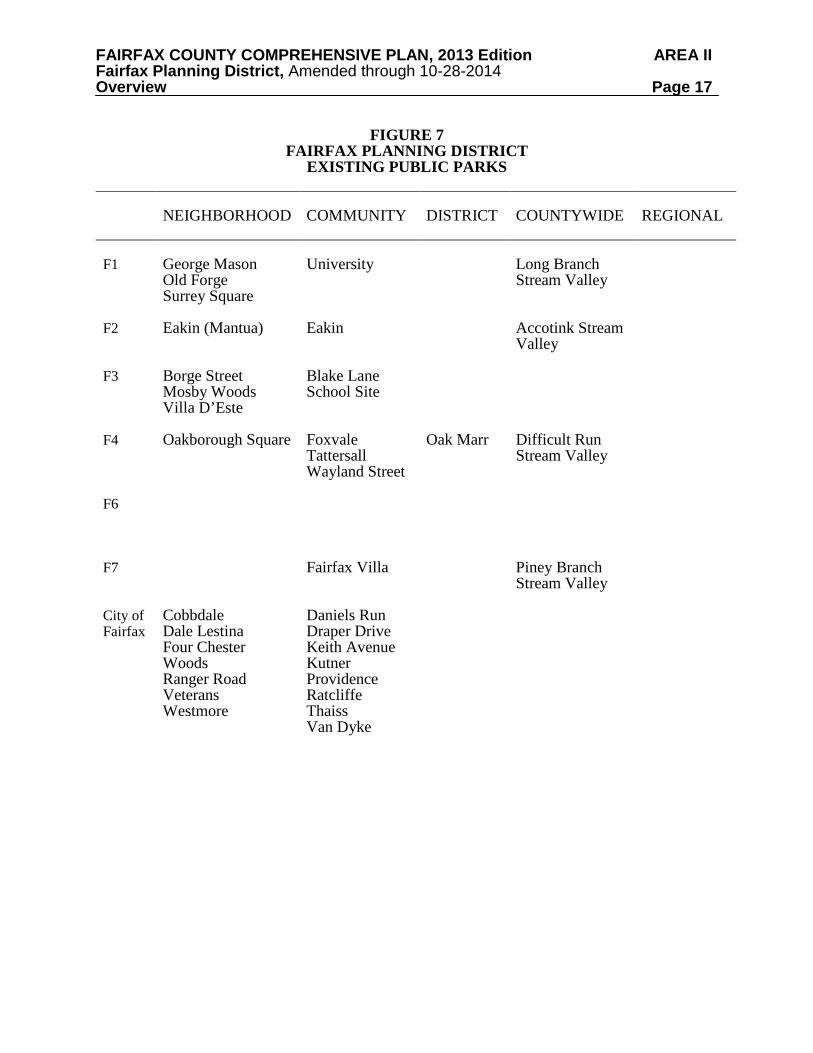
Parks and Recreation Existing public parks are identified in Figure 7. Additional active recreation facilities are provided at county public school sites. Consideration should also be given to co-locating other compatible public facilities where feasible. The Fairfax Planning District contains the headwaters of several major stream valleys including the Accotink, Difficult Run, and Long Branch systems. These stream valley parks offer the potential for development of a greenway system, extending from the geographic center of the county northward and southeast to the Potomac River shoreline, which eventually can provide hiking and biking access to a wide diversity of active and passive recreational facilities. The EQCs of the Accotink and Difficult Run Stream Valley systems contain environmentally sensitive areas, as well as natural, cultural and recreational resources. Intrusions of non-recreational development should therefore be restricted, or prohibited and adverse environmental and visual impacts should be mitigated.
The Oak Marr Recreation Center provides year-round recreational opportunities for area residents and employees in the Flint Hill Suburban Center. The planned expansion of Oak Marr District Park should address the deficiencies of active recreation facilities in the area. Development of additional facilities will meet or exceed all environmentally-related state and county requirements in order to minimize possible impacts on environmentally sensitive areas and to the water quality of Difficult Run.
FAIRFAX COUNTY COMPREHENSIVE PLAN, 2013 Edition AREA II Fairfax Planning District, Amended through 10-28-2014 Overview Page 17
FIGURE 7 FAIRFAX PLANNING DISTRICT
EXISTING PUBLIC PARKS
NEIGHBORHOOD
COMMUNITY
DISTRICT
COUNTYWIDE
REGIONAL
F1 F2 F3 F4 F6 F7 City of Fairfax
George Mason Old Forge Surrey Square Eakin (Mantua) Borge Street Mosby Woods Villa D’Este Oakborough Square Cobbdale Dale Lestina Four Chester Woods Ranger Road Veterans Westmore
University Eakin Blake Lane School Site Foxvale Tattersall Wayland Street Fairfax Villa Daniels Run Draper Drive Keith Avenue Kutner Providence Ratcliffe Thaiss Van Dyke
Oak Marr
Long Branch Stream Valley Accotink Stream Valley Difficult Run Stream Valley Piney Branch Stream Valley

FAIRFAX COUNTY COMPREHENSIVE PLAN, 2013 Edition AREA II Fairfax Planning District, Amended through 10-28-2014 Overview Page 18
In general there is a good distribution of Neighborhood and Community Parks in this Planning District, although a number of these parks are currently undeveloped. Acquisition and development of an additional Community Park to include active recreation facilities is recommended to serve the area east and southeast of Fairfax City.
FAIRFAX COUNTY COMPREHENSIVE PLAN, 2013 Edition AREA II Fairfax Planning District, Amended through 10-28-2014 Flint Hill Suburban Center Page 19
FLINT HILL SUBURBAN CENTER
CHARACTER
The Flint Hill Suburban Center is located on both sides of Chain Bridge Road (Route 123) north of its intersection with I-66 and near the northern boundary of the City of Fairfax (See Figure 8). It lies between Interstate 66 (I-66), the Dudley Heights single-family detached subdivision, Jermantown Road and the eastern boundary of the AT&T Corporate Center boundary extended south to I-66.
The Flint Hill Suburban Center is defined primarily by 110 contiguous acres of land
planned and developed for a mixture of office, retail and residential uses that straddle Chain Bridge Road on the north side of I-66. The majority of development, however, is office use. The area contains over 1,700,000 square feet of office space and has a typical FAR of about .40. The only vacant land is a five-acre tract at the intersection of White Granite Drive and Chain Bridge Road. The area contains the AT&T Corporate office site at Chain Bridge Road and Jermantown Road and the 35-acre Flint Hill Office Park between Jermantown Road and Chain Bridge Road. Other smaller tracts are fully developed with office use. Building heights do not exceed six stories in the Center area. The Oakton Gable apartments are adjacent to the Flint Hill Office Park and both were developed as part of the same planned unit development.
The Flint Hill Suburban Center is surrounded by a mixed development character (See
Sectors F3 and F4). The area adjacent to the Center northwest of Jermantown Road is a low density area with little residential development and extensive parkland. It is in the upper headwaters of the Difficult Run watershed where there is extensive low density residential use and significant environmental resources. To the north of the Center is Oakton with a mixture of detached, and attached single-family residential use, neighborhood-serving retail facilities and some institutional uses, including the Oakton Elementary School and the Flint Hill Preparatory School. To the east is a sizable area of townhouses and multifamily apartments that extends along the Blake Lane corridor and I-66 to Fairfax Circle. CONCEPT FOR FUTURE DEVELOPMENT
The Concept for Future Development recommends this area as a Suburban Center. The area includes a mixture of office and residential uses. Flint Hill is much smaller in size than the other designated Suburban Centers in the county. RECOMMENDATIONS Land Use
Extensive landscaping and integrated pedestrian systems should be provided throughout the Flint Hill Suburban Center to make the office and hotel uses more attractive and convenient to use. Plazas, urban parks, fountains and street furniture are examples of amenities that would enhance office use, even in existing development.
Recommendations for the Flint Hill Suburban Center are organized by land units. The
boundaries for these land units are shown on Figure 8.

FAIRFAX COUNTY COMPREHENSIVE PLAN, 2013 Edition AREA II Fairfax Planning District, Amended through 10-28-2014 Flint Hill Suburban Center Page 20
FLIN
T H
ILL
SUB
UR
BA
N C
ENTE
R
FIG
UR
E 8

FAIRFAX COUNTY COMPREHENSIVE PLAN, 2013 Edition AREA II Fairfax Planning District, Amended through 10-28-2014 Flint Hill Suburban Center Page 21 Land Unit A
Land Unit A, approximately 60 acres, is designated as the area west of Chain Bridge Road between Jermantown Road, Chain Bridge Road and the Dudley Heights subdivision. This land unit is planned and developed for low to medium intensity mixed-use including office use up to .40 FAR, residential use at a density of 16-20 dwelling units per acre and a fire station. Ancillary retail and institutional uses could be incorporated into existing structures to serve the work force in the Flint Hill Suburban Center. Land Unit B
Land Unit B, approximately 50 acres, is designated as the area located east of Chain Bridge
Road between Chain Bridge Road, Jermantown Road, Oakton Village, and part of the Arrowhead and Calibre subdivisions. This land unit is developed, for the most part, with office uses, generally at an intensity of .40. It is planned for low to medium intensity mixed-use development not to exceed .40 FAR.
The AT&T Corporate Office is the predominant use in this land unit and is almost completely developed. Further development on the AT&T site should be within the approved intensity and compatible with existing development on the site. Only existing access should be used and existing landscaping should be maintained and enhanced, where appropriate.
There is a vacant tract (Tax Map 47-4((1))16), about five acres, at the intersection of White
Granite Drive and Chain Bridge Road that is appropriate for hotel or office use at a maximum FAR of .40 to be compatible with existing development in the immediate vicinity. Ancillary retail use may be considered if it is incorporated into office or hotel structures. Residential use at 12-16 dwelling units per acre would also be appropriate on this site. Development on this site should meet the general objectives indicated above at the beginning of the land use recommendations section.
Within Land Unit B residential use should be mid-rise multifamily at a density of 12-16
dwelling units per acre. Building heights should not exceed six stories. Office parking areas should be well-buffered and screened from nearby residential areas.
While the primary uses set forth above are preferred, as an option, restaurant use with a maximum of 17,500 square feet could be considered, if all of the following conditions are met:
• No more than two separate structures containing one restaurant each are designed and developed as a single, coordinated project.
• If the optional restaurant use is developed no other uses, including the primary uses,
should be permitted. No additional restaurants will be permitted if this option is used. • The optional restaurant use may not include any fast food or drive-through service. • Sufficient mitigation measures should be provided to ensure that the level of service
of the intersection of Chain Bridge Road and White Granite Drive is not impaired compared to other development options.
• The restaurant use must provide sufficient landscaping, screening, and buffering
along Chain Bridge Road and White Granite Drive to preserve the existing parkway

FAIRFAX COUNTY COMPREHENSIVE PLAN, 2013 Edition AREA II Fairfax Planning District, Amended through 10-28-2014 Flint Hill Suburban Center Page 22
ambience on Chain Bridge Road in this vicinity. This landscaping, screening, and buffering must be sufficient to fulfill its intended purpose even after eventual widening of Chain Bridge Road.
• Peripheral and interior landscaping must be sufficient to establish a "campus" pattern of development compatible with the development of the adjacent AT&T corporate office site. The overall objective should be 40 percent open space, although a minor deviation from that objective may be allowed if all of the objectives of the conditions for the optional restaurant use relating to landscaping, screening and buffering are fully met.
• Street furniture and special paving treatments must be provided as part of the
landscaping plan to provide attractive visual and pedestrian-serving amenities. • Pedestrian access must be provided to adjacent parcels. • Signage, lighting, and building design and finish must be unobtrusive and of a high
quality comparable to that for existing development in the Suburban Center.
For any development on this tract, the following transportation conditions must also be met:
• Access to the site must be provided on the north side of the property via White Granite Drive with the entrance to the parcel to be located on the north side as far from the intersection with Chain Bridge Road as possible.
• No direct access may be provided from Chain Bridge Road. • Improvements should be made to the intersection of Chain Bridge Road and White
Granite Drive with the objective of improving service on White Granite Drive without significant deterioration in the service currently provided on Chain Bridge Road.
• Appropriate measures must be taken to minimize impacts (including cut-through
traffic) on the nearby residential communities and to promote pedestrian safety on White Granite Drive, Flag Pole Lane, Borge Street and the area surrounding the Borge Street playground.
The intermittent impairment of the functioning of White Granite Drive, Flagpole Lane and
Borge Street and problems of pedestrian safety on those streets and in the area surrounding the Borge Street playground, both due in part to cut-through traffic, require the attention of appropriate public authorities. Land Unit C
Land Unit C, approximately 20 acres, contains the Arrowhead townhouse subdivision. This land unit is planned and developed at a density of 8-12 dwelling units per acre.

FAIRFAX COUNTY COMPREHENSIVE PLAN, 2013 Edition AREA II Fairfax Planning District, Amended through 10-28-2014 Flint Hill Suburban Center Page 23 Transportation Transportation recommendations for the Flint Hill Suburban Center are shown on Figure 9. In some instances, site-specific transportation recommendations are included in the land use recommendations section. The figures show access orientation, circulation plans, interchange impact areas and generalized location of proposed transit facilities. The recommendations contained in the Area Plan text and maps, the Policy Plan and Transportation Plan map, policies and requirements in the Public Facilities Manual, the Zoning Ordinance, and other standards will be utilized in the evaluation of development proposals. Parks and Recreation
Park and recreation recommendations for this sector are shown on Figures 21 and 25 (Sectors F3 and F4). The column "Park Classification" includes existing park facilities. The "Recommendations" column includes entries for both existing and proposed facilities. Prior to developing parkland, the Fairfax County Park Authority initiates a master planning process to determine the appropriate facilities and design for that park. This process involves extensive citizen review and participation. If an existing park is listed but no recommendation appears on that line, it means the park has been developed in accordance with its master plan. Trails and Bicycle Facilities
Trails planned for this sector are described as a part of the recommendations for Sector F3 and Sector F4.

FAIRFAX COUNTY COMPREHENSIVE PLAN, 2013 Edition AREA II Fairfax Planning District, Amended through 10-28-2014 Flint Hill Suburban Center Page 24
TRANSPORTATION RECOMMENDATIONS FIGURE 9 FLINT HILL SUBURBAN CENTER F3, F4 COMMUNITY PLANNING SECTORS

FAIRFAX COUNTY COMPREHENSIVE PLAN, 2013 Edition AREA II Fairfax Planning District, Amended through 10-28-2014 Page 25
COMMUNITY PLANNING SECTORS FIGURE 10
FAIRFAX PLANNING DISTRICT

FAIRFAX COUNTY COMPREHENSIVE PLAN, 2013 Edition AREA II Fairfax Planning District, Amended through 10-28-2014 F1- Braddock Community Planning Sector Page 26
F1 BRADDOCK COMMUNITY PLANNING SECTOR
CHARACTER
The Braddock Community Planning Sector is located on the southeast boundary of the City of Fairfax, bounded generally by Main Street/ Little River Turnpike (Route 236), Olley Lane, Long Branch Stream Valley Park, Guinea Road, Braddock Road and Roberts Road.
A majority of the sector contains stable residential development at a density of
approximately 2-3 dwelling units per acre. Major subdivisions are Hickory Farms, George Mason Forest, Somerset, Starlit Ponds, Chestnut Hills, Old Creek Estates, Somerset South, Olde Forge and Surrey Square. Some small sections scattered throughout the sector have older subdivisions with lots up to five acres in size some of which are vacant, such as Holly Park and Little Run Estates.
No community-serving or neighborhood-serving retail or office facilities are located in this
planning sector, but such facilities are adequately provided in locations adjacent to the sector. The Fairfax Memorial Gardens and Calvary Memorial Gardens are large cemeteries located
in the vicinity of the northeast quadrant of the Burke Station Road and Braddock Road intersection. The Long Branch Stream Valley Park extends through much of this sector.
CONCEPT FOR FUTURE DEVELOPMENT
The Concept for Future Development recommends that the entire sector be identified as a Suburban Neighborhood. RECOMMENDATIONS Land Use
The Braddock sector is largely developed with stable residential neighborhoods. Infill development in these neighborhoods should be compatible with existing development in the vicinity in terms of use, type and intensity, in accordance with the guidance provided by the Policy Plan under Land Use Objectives 8 and 14.
Where substantial parcel consolidation is specified, it is intended that such consolidations
will provide for projects that function in a well-designed, efficient manner and provide for the development of unconsolidated parcels in conformance with the Area Plan.
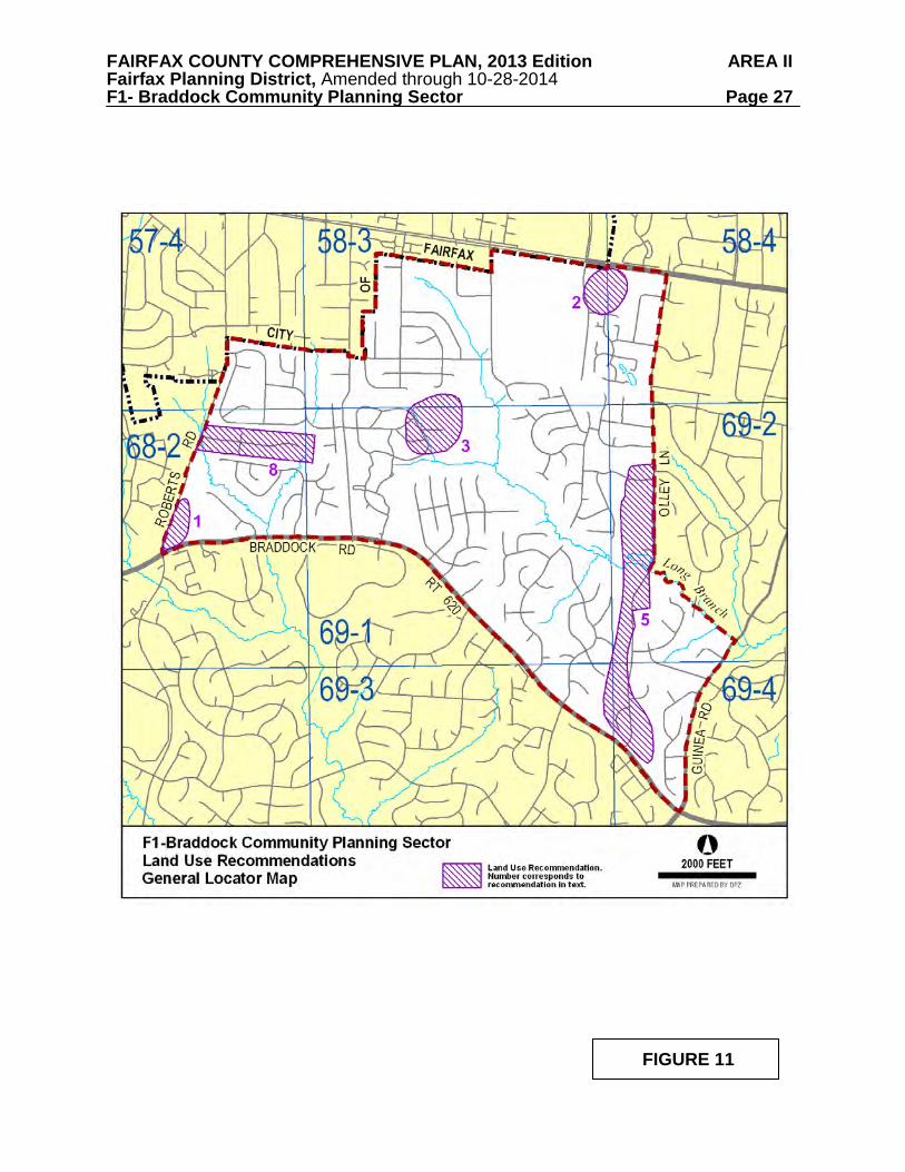
Figure 11 indicates the geographic locations of land use recommendations for this sector.
Where recommendations are not shown on the General Locator Map, it is so noted.
1. Land in the northeast quadrant of the intersection of Roberts Road and Braddock Road (Tax Map 68-2((1))14-17, 18A, 21A, 21-25) is planned for single-family detached residential use at 1-2 dwelling units per acre. Redevelopment at the higher end of this density range may be appropriate if the following conditions are met:
FAIRFAX COUNTY COMPREHENSIVE PLAN, 2013 Edition AREA II Fairfax Planning District, Amended through 10-28-2014 F1- Braddock Community Planning Sector Page 27
FIGURE 11
FAIRFAX COUNTY COMPREHENSIVE PLAN, 2013 Edition AREA II Fairfax Planning District, Amended through 10-28-2014 F1- Braddock Community Planning Sector Page 28
• Two or more parcels are consolidated; • Each group of consolidated parcels is limited to a single point of access to
Roberts Road as far north as possible; whenever feasible, this access should be provided in conjunction with abutting properties to minimize the number of future points of access to Roberts Road;
• Density proposed should not necessitate the widening of Roberts Road to a
four-lane facility or the provision of additional curb and gutter except as required for safety purposes. Improvements should include a sidewalk or pedestrian trail along the east side of Roberts Road unless such a public sidewalk/trail is provided along the west side of Roberts Road by George Mason University; and
• Redevelopment is sensitive to existing environmental features, particularly
major tree stands which should be preserved as much as possible.
Community-serving institutional uses or university-related uses may be appropriate on land south of the Catholic Campus Ministry [Tax Map 68-2((1))21A-25] given the proximity of this area to George Mason University. In general, such uses should be approved only if the following conditions, in addition to those listed above and in item 7 below, are met:
• Such use is nonresidential and of a size and scale that will not adversely affect
the residential character of the area nor generate peak hour traffic in excess of that which would be generated if the property is redeveloped for single-family detached residential use;
• A landscaped transitional screening strip not less than 35 feet in width is
provided between the institutional use and any adjoining residential properties. 2. The 15-acre parcel (Tax Map 58-3((1))2A) located between Route 236, Pickett Road,
Starlit Ponds subdivision, Haywood subdivision and Calvary Hill Baptist Church is planned for residential development at 4-5 dwelling units per acre. Currently it is developed with Barcroft Bible Church. This institutional use provides a transition between single-family detached development, and community-serving retail use. In any development proposal the following conditions should be met:
• A landscaped buffer of at least 25 feet should be provided along the perimeter
adjacent to existing single-family detached subdivisions; • Primary access should be via Pickett Road; • Environmental resources, particularly major tree stands, should be preserved;
and
• Substantial landscaped screening and buffering along Route 236 should be provided.

FAIRFAX COUNTY COMPREHENSIVE PLAN, 2013 Edition AREA II Fairfax Planning District, Amended through 10-28-2014 F1- Braddock Community Planning Sector Page 29
Institutional development should be designed to ensure compatibility with the residential communities to the south and east in terms of building height, scale and building components.
3. If the vacant portion of the Calvary Memorial Gardens cemetery, which includes about 40
acres west of the stream valley, becomes available for an alternative use, this land should be planned for parkland and incorporated into the Long Branch Stream Valley system.
4. Commercial and industrial uses are not appropriate in this sector because the sector is
adequately served by such facilities in Fairfax City and areas along the Route 29 corridor and at the intersection of Ox Road and Braddock Road. [Not shown]
5. Land in the Olley Lane corridor located between Braddock Road and the lots fronting on
Athens Road is planned for residential use at 1-2 dwelling units per acre. In view of the large lot, low density, single-family detached residential use that predominates in this corridor, new and infill development in the corridor, that includes Parcels 69-2 ((2))L, M, N1, P1, Q, R , S, 3, 3A, 5, 7, 7B, 8A, 8B1, 8B2, 9A, 9C, 9D, 10B, 11A, 11B1, 11B2, as well as parcels 69-2((1))5A, 5B, 5C, 6; parcel 69-2((13))44; Parcels 69-4((24))A, 1-21 and Parcel 69-4((1)) 6A, generally should not exceed one dwelling unit per acre, to retain the contour of land to preserve existing mature trees. Accordingly, land North and South of the Resource Protection Area should retain its current low density residential and rural character to be in consonance with the surrounding communities.
Parcels 69-4((24))A, 1-21 located at the southern portion of the corridor have been
redeveloped under a plan option requiring the consolidation of three parcels and limited overall density to 2.2 dwelling units per acre. This redevelopment (Olley Lane Subdivision) preserved five acres of environmentally sensitive land and limited access to Olley Lane to address safety and operational issues.
6. Land in the northwest quadrant of the intersection of Burke Station and Braddock Roads
(Tax Map 69-1((1))4-11) is planned for residential use at 1-2 dwelling units per acre as shown on the Plan map. As an option, residential use at 2-3 dwelling units per acre may be appropriate, if the following conditions are met:
• A minimum of seven acres of land is consolidated in a manner that provides the
opportunity for coordinated development with and interparcel access for the area that is not consolidated;
• Lot sizes and/or density are compatible with the adjacent George Mason Forest
subdivision; • No access is provided to Braddock Road; and • Access is provided to Manor Place or to Burke Station Road. If access is
provided to Burke Station Road, it should be at the northern point of Parcel 4.
7. The cumulative effect of institutional uses in this sector should be considered before additional institutional uses or expansion of existing uses are developed. Nonresidential uses requiring special exceptions or special permits should be rigorously reviewed and permitted only if the following conditions are met:

FAIRFAX COUNTY COMPREHENSIVE PLAN, 2013 Edition AREA II Fairfax Planning District, Amended through 10-28-2014 F1- Braddock Community Planning Sector Page 30
• Access is oriented only to arterial roads; • The size and scale of the use should be compatible with, that is, similar to, the
character of existing development in the immediate vicinity; and • Buffering and screening should be provided in excess of that required by the
Zoning Ordinance.
8. The Ridge Manor Subdivision, Tax Map 68-2((1))12, 12A and 68-2((2))1-29, is an established, stable and low density residential neighborhood with environmentally sensitive features that include stands of mature trees, flood plain and portions of two stream valleys. To retain this area’s existing low density residential character and preserve its environmental features, the neighborhood should remain planned as shown on the Comprehensive Land Use Plan map and should be protected from consolidation and higher density development. Moreover, public, institutional or university-related uses are inappropriate for this area.
Transportation
Transportation recommendations for this sector are shown on Figure 12. In some instances, site-specific transportation recommendations are included in the land use recommendations section. The figures show access orientation, circulation plans, interchange impact areas and generalized locations of proposed transit facilities. The recommendations contained in the Area Plan text and maps, the Policy Plan and Transportation Plan map, policies and requirements in the Public Facilities Manual, the Zoning Ordinance, and other standards will be utilized in the evaluation of development proposals. Heritage Resources Significant heritage resources may be located in open space, in low density residential areas and in mid 20th century neighborhoods and should be identified and preserved where possible. Because land in these areas may be relatively undisturbed, the resources that may exist could also be undisturbed and therefore more easily identified and preserved. Any development or ground disturbance in this sector, both on private and public land, should be preceded by heritage resource studies, and alternatives should be explored for the avoidance, preservation or recovery of significant heritage resources that are found. In those areas where significant heritage resources have been recorded, an effort should be made to preserve them. If preservation is not feasible, then, in accordance with countywide objectives and policies as cited in the Heritage Resources section of the Policy Plan, the threatened resource should be thoroughly recorded and in the case of archaeological resources, the artifacts recovered. Parks and Recreation
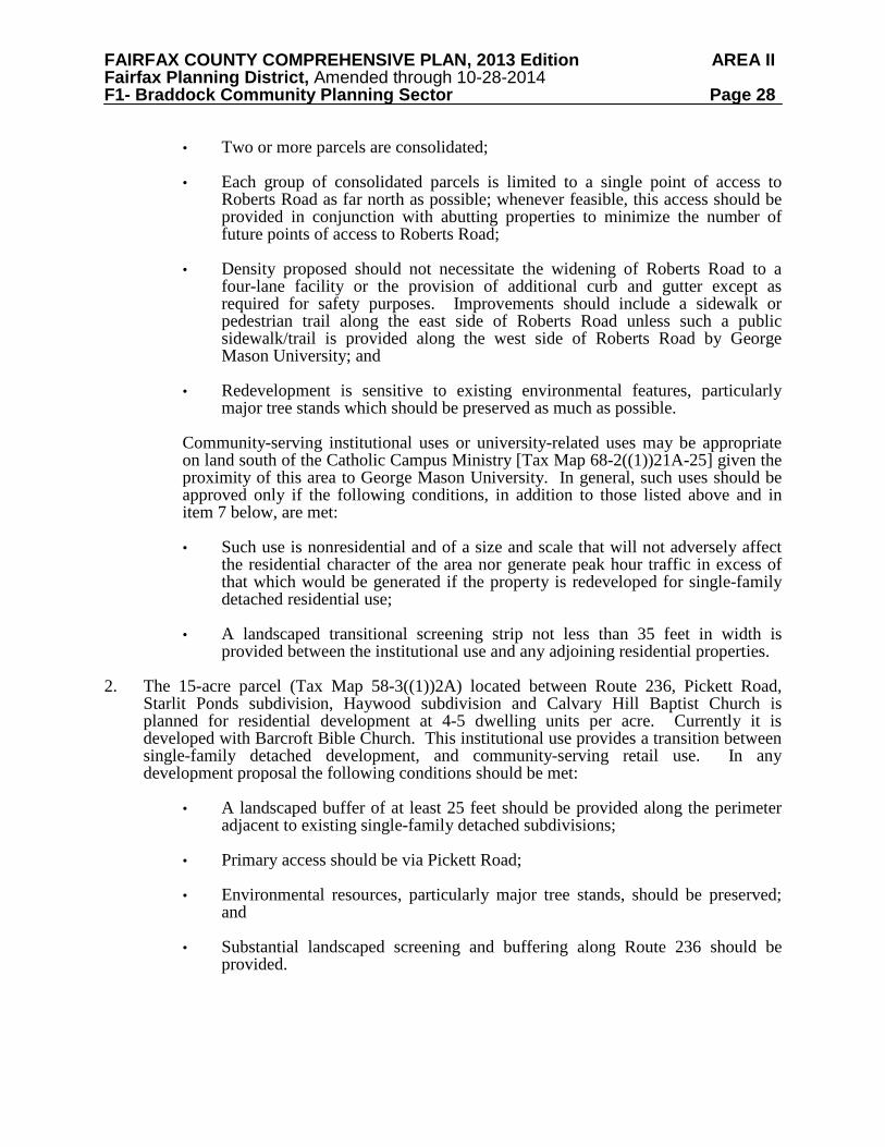
Park and recreation recommendations for this sector are shown on Figure 13. The column "Park Classification" includes existing park facilities. The "Recommendations" column includes entries for both existing and proposed facilities. Prior to developing parkland, the Fairfax County Park Authority initiates a master planning process to determine the appropriate facilities and design for that park. This process involves extensive citizen review and participation. If an

FAIRFAX COUNTY COMPREHENSIVE PLAN, 2013 Edition AREA II Fairfax Planning District, Amended through 10-28-2014 F1- Braddock Community Planning Sector Page 31
TRANSPORTATION RECOMMENDATIONS FIGURE 12
FAIRFAX COUNTY COMPREHENSIVE PLAN, 2013 Edition AREA II Fairfax Planning District, Amended through 10-28-2014 F1- Braddock Community Planning Sector Page 32
FIGURE 13 PARKS AND RECREATION RECOMMENDATIONS
SECTOR F1
PARK CLASSIFICATION
RECOMMENDATIONS
NEIGHBORHOOD PARKS: George Mason Olde Forge Surrey Square
Initiate a master planning process and develop in accordance with approved plan. Develop in accordance with approved master plan.
COMMUNITY PARKS: University
If consolidation of adjacent parcels is achieved, land should be dedicated to expand this park. Initiate a master planning process and develop accordingly. This site currently serves as a recreation planning laboratory under an agreement with the George Mason University Department of Leisure Services (also noted under land use recommendations). If vacant portion of Calvary Memorial Gardens cemetery becomes available, consider acquisition of land adjacent to Long Branch Stream Valley.
DISTRICT PARKS:
This sector is located between but outside the service areas of four District Parks. All are within a five mile radius.
COUNTYWIDE PARKS: Long Branch Stream Valley
Acquire privately-owned portions of the stream valley through dedication of land and/or donation of easements to provide continuity of public access. Complete development of countywide stream valley trail south to Accotink Creek.
FAIRFAX COUNTY COMPREHENSIVE PLAN, 2013 Edition AREA II Fairfax Planning District, Amended through 10-28-2014 F1- Braddock Community Planning Sector Page 33 existing park is listed but no recommendation appears on that line, it means the park has been developed in accordance with its master plan. Trails and Bicycle Facilities Trails planned for this sector are delineated on the 1”:4,000’ Countywide Trails Plan Map which is referenced as Figure 2 in the Transportation element of the Policy Plan and is available from the Department of Transportation. Trails in this sector are an integral part of the overall county system. While some of the segments have already been constructed, the Countywide Trails Plan Map portrays the ultimate system for the sector and the county at large. In addition, the map specifies a classification for each segment, which represents the desired ultimate function and surface type of the trail. Specific construction requirements are detailed in the Public Facilities Manual.
Bicycle Facilities for this sector are delineated on the 1”:4000’ Countywide Bicycle Network Map which is referenced as Figure 3 in the Transportation element of the Policy Plan and is available from the Department of Transportation.

FAIRFAX COUNTY COMPREHENSIVE PLAN, 2013 Edition AREA II Fairfax Planning District, Amended through 10-28-2014 F2-Mantua Community Planning Sector Page 34
F2 MANTUA COMMUNITY PLANNING SECTOR CHARACTER The Mantua Community Planning Sector is located east of the City of Fairfax, between Arlington Boulevard (Route 50) and Little River Turnpike (Route 236), extending to Woodburn Road. Portions of the Mantua Planning Sector are within the Merrifield Suburban Center. Plan guidance for this area is included in the Area I volume of the Comprehensive Plan, Merrifield Suburban Center. The planning sector is almost completely developed with single-family detached residential use. Most of this development was built between 1950 and 1970. Major single-family detached subdivisions include Mantua, Ridgelea, Pine Ridge, Sutton Place, Little River Pines and Prosperity Heights.
Two townhouse subdivisions are located in the sector: Strathmeade Square, which is developed at a density of 8-12 dwelling units per acre adjacent to the Inova Fairfax Hospital complex, and Chesterfield Mews, developed at a density of 3-4 dwelling units per acre, located on Arlington Boulevard opposite Nutley Street. Three multifamily housing developments are located along Little River Turnpike near Pickett Road and the City of Fairfax: Margate Manor, Pinewood Plaza and Fairfax Plaza. These are developed at a density of 16-20 dwelling units per acre, as are the Condominiums of Woodburn, which are adjacent to the Inova Fairfax Hospital complex along Gallows Road.
Towers Park, owned by the Fairfax County Park Authority, is located south of Arlington Boulevard along Accotink Creek adjacent to the City of Fairfax. The density attributable to this parcel was transferred to Circle Towers, located on the north side of Arlington Boulevard, at the time of its development. There are a number of institutional uses in the sector, including The Virginian, a Continuing Care Retirement Community (CCRC), the Kena Temple, the Elks Lodge, the Merritt Academy, the Sunrise Senior Assisted Living Community, the Fairfax Circle Baptist Church, and the Chabad Lubavich of Northern Virginia. There is a large concentration of special exception and special permit uses in this area, especially in the Arlington Boulevard and Little River Turnpike corridors. A small amount of neighborhood-serving retail development is located on Little River Turnpike between Pineland Street and Woodburn Road.
The Accotink Creek Stream Valley is a major land use feature that traverses the sector and includes parts of Long Branch, Bear Branch, Hunters Creek, Crooks Creek and various unnamed connecting creeks.
CONCEPT FOR FUTURE DEVELOPMENT
The Concept for Future Development recommends most of the sector be identified as a Suburban Neighborhood and a small portion is recommended as part of the Merrifield Suburban Center (see Merrifield Suburban Center for Recommendations).
FAIRFAX COUNTY COMPREHENSIVE PLAN, 2013 Edition AREA II Fairfax Planning District, Amended through 10-28-2014 F2-Mantua Community Planning Sector Page 35 RECOMMENDATIONS
Land Use
The Mantua sector is largely developed as stable residential neighborhoods. The
predominant planned density is 2 dwelling units per acre with other planned densities as shown on the Plan Map and/or as further described in the following land use recommendations. Infill development in these neighborhoods should be compatible with existing development in the vicinity in terms of use, type and intensity, in accordance with the guidance provided by the Policy Plan in Land Use Objectives 8 and 14.
Where substantial parcel consolidation is specified, it is intended that such consolidations will provide for projects that function in a well-designed, efficient manner and provide for the development of unconsolidated parcels in conformance with the Area Plan.
Figure 14 indicates the geographic locations of land use recommendations for this sector.
Where recommendations are not shown on the General Locator Map, it is so noted. 1. Tax map 58-2((1))14, formerly part of the Krasnow Estate, is located between the Mantua
neighborhood in the county and Pickett’s Reserve in the City of Fairfax consisting of approximately 15 acres is planned for public park use. This property is heavily wooded and efforts should be made to preserve mature trees where feasible.
2. The land fronting on Pickett Road between Mathy Drive and Route 236 is planned and developed for neighborhood-serving office and retail use and light industrial use. Due to the proximity of this land to Margate Manor apartments, any development or redevelopment on these parcels should not exceed an FAR of .25.
3. The majority of the area generally bounded by Accotink Creek, Bear Branch, Arlington
Boulevard, Pine Ridge, Tobin Road, Woodburn Road, Route 236, Briars of Westchester, Pinewood Plaza Apartments and the Fairfax City boundary is planned for residential use at a density of 1-2 dwelling units per acre as shown on the Plan map. Infill development in Pine Ridge, Tax Maps 59-1((1))25, 59-3((1))4 and 5, Forest Grove, Beaches Pine Ridge, Little River Pines, Mantua (Tax Map 58-2((4)); (Tax Map 48-4((5)) ) Oak Spring Village, Langhorne Acres, Westchester and Fairfax Forest shall be at no more than one dwelling unit per acre. [Not shown]
4. In the Sunny Hill subdivision infill development should be residential at a density of 1-2
dwelling units per acre. For consideration above the low end of the range, (a) sufficient consolidation must be achieved to allow for a well-designed and unified development plan and (b) sufficient improvements must be made to bring all affected roads up to state standards.
5. Commercial development in this sector should be limited to those areas designated for
commercial use on the Plan map. Existing commercial uses generally should not be intensified, except minimally for modernization or beautification. Additional landscaping
and buffering between commercial and residential uses and carefully designed pedestrian connections to adjacent residential areas are strongly encouraged, where appropriate. [Not shown]
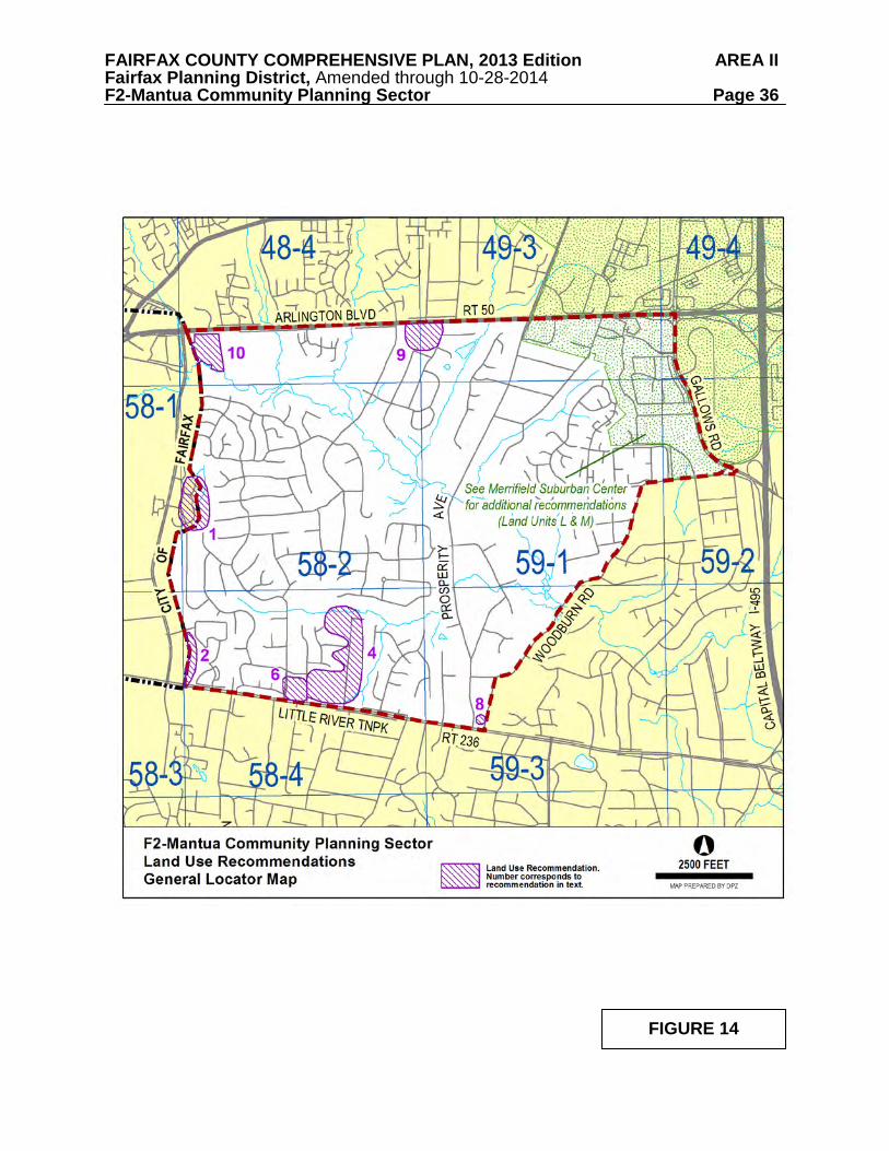
FAIRFAX COUNTY COMPREHENSIVE PLAN, 2013 Edition AREA II Fairfax Planning District, Amended through 10-28-2014 F2-Mantua Community Planning Sector Page 36
FIGURE 14

FAIRFAX COUNTY COMPREHENSIVE PLAN, 2013 Edition AREA II Fairfax Planning District, Amended through 10-28-2014 F2-Mantua Community Planning Sector Page 37 6. There are several special exception and special permit uses in this sector. When those uses
are terminated, the underlying parcels should return to residential use at the densities for which the surrounding parcels are planned. The former "YMCA facility" ((Tax Map 58-4((1))50) should not be expanded or intensified, since any expansion or intensification of this use would adversely effect the adjacent stable residential neighborhood. [Not shown]
7. Automobile-oriented uses of any type with direct access to Arlington Boulevard and Little
River Turnpike are inappropriate as they may exacerbate congestion and are liable to create nuisance activity in and near stable residential areas. [Not shown]
8. The existing small, commercial retail and office area between Pineland Street and
Woodburn Road primarily fronting on either Little River Turnpike (Route 236) or Prosperity Avenue, should not be expanded. Extensive buffering is required along the northern, eastern, and western boundaries of the tract to maintain the adjacent stable residential area.
9. Properties with direct access to Arlington Boulevard, between Chichester Lane and Barkley
Drive [Tax Map 48-4((1))40 and 41; 49-3((1))12 and 13] should be developed residentially at 1-2 dwelling units per acre. Alternatively, these properties may be developed residentially, as an extension of Oak Spring Village, with access to Barbara Lane or with access to Chichester Lane at no more than 1 dwelling unit per acre. To avoid through traffic on neighborhood streets in Mantua/Oak Spring Village, under no circumstances shall Arlington Boulevard be connected directly or indirectly to Barbara Lane.
10. Towers Park, owned by the Fairfax County Park Authority, is located south of Arlington
Boulevard along Accotink Creek adjacent to the City of Fairfax. The density attributable to this parcel was transferred to Circle Towers, located on the north side of Arlington Boulevard, at the time of its development. Accordingly, this publically-owned parcel should not be developed and should be used for public park purposes.
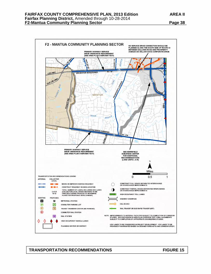
Transportation
Transportation recommendations for this sector are shown on Figure 15. In some instances, site-specific transportation recommendations are included in the land use recommendations section. The figures show access orientation, circulation plans, interchange impact areas and generalized locations of proposed transit facilities. The recommendations contained in the Area Plan text and maps, the Policy Plan and Transportation Plan map, policies and requirements in the Public Facilities Manual, the Zoning Ordinance, and other standards will be utilized in the evaluation of development proposals. Heritage Resources
Numerous prehistoric archaeological resources dating to the earliest known human inhabitants of Fairfax County (c. 9000 B.C.) and later have been identified in the Accotink watershed of this sector and adjacent uplands. Several of these resources have not been disturbed by modern development. Additionally, the archaeological remains of several historic mills have been located in the Accotink floodplain. These resources should be protected.
Any development or ground disturbance in this sector, both on private and public land, should be preceded by heritage resource studies, and alternatives should be explored for the avoidance, preservation or recovery of significant heritage resources that are found. In those
FAIRFAX COUNTY COMPREHENSIVE PLAN, 2013 Edition AREA II Fairfax Planning District, Amended through 10-28-2014 F2-Mantua Community Planning Sector Page 38
TRANSPORTATION RECOMMENDATIONS FIGURE 15

FAIRFAX COUNTY COMPREHENSIVE PLAN, 2013 Edition AREA II Fairfax Planning District, Amended through 10-28-2014 F2-Mantua Community Planning Sector Page 39 areas where significant heritage resources have been recorded, an effort should be made to preserve them. If preservation is not feasible, then, in accordance with countywide objectives and policies as cited in the Heritage Resources section of the Policy Plan, the threatened resource should be thoroughly recorded and in the case of archaeological resources, the artifacts recovered. Public Facilities The following facilities are identified as future needs: 1. Expansion of Fairfax Hospital facilities as indicated for Sub-Unit M1 of the Merrifield
Suburban Center in the Area I Plan. (Sector F2).
2. Improve and expand the Woodburn Mental Health Center to provide for additional individual clinical treatment space, group rooms, public areas, equipment and storage space, administrative office space and a parking structure. Specific recommendations are found in Sub-Unit M1 of the Merrifield Suburban Center in the Area I Plan (Sector F2).
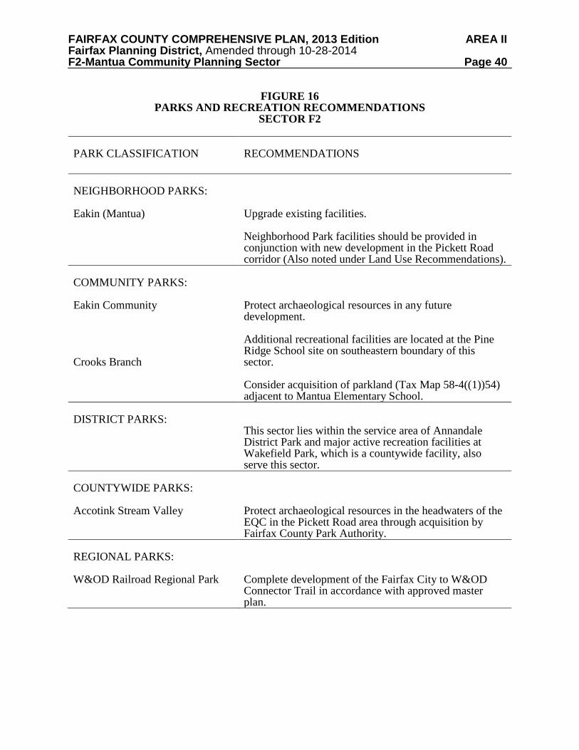
Parks and Recreation
Park and recreation recommendations for this sector are shown on Figure 16. The column "Park Classification" includes existing park facilities. The "Recommendations" column includes entries for both existing and proposed facilities. Prior to developing parkland, the Fairfax County Park Authority initiates a master planning process to determine the appropriate facilities and design for that park. This process involves extensive citizen review and participation. If an existing park is listed but no recommendation appears on that line, it means the park has been developed in accordance with its master plan. Trails and Bicycle Facilities Trails planned for this sector are delineated on the 1”:4,000’ Countywide Trails Plan Map which is referenced as Figure 2 in the Transportation element of the Policy Plan and is available from the Department of Transportation. Trails in this sector are an integral part of the overall county system. While some of the segments have already been constructed, the Countywide Trails Plan Map portrays the ultimate system for the sector and the county at large. In addition, the map specifies a classification for each segment, which represents the desired ultimate function and surface type of the trail. Specific construction requirements are detailed in the Public Facilities Manual.
Bicycle Facilities for this sector are delineated on the 1”:4000’ Countywide Bicycle Network Map which is referenced as Figure 3 in the Transportation element of the Policy Plan and is available from the Department of Transportation.
FAIRFAX COUNTY COMPREHENSIVE PLAN, 2013 Edition AREA II Fairfax Planning District, Amended through 10-28-2014 F2-Mantua Community Planning Sector Page 40
FIGURE 16 PARKS AND RECREATION RECOMMENDATIONS
SECTOR F2
PARK CLASSIFICATION
RECOMMENDATIONS
NEIGHBORHOOD PARKS: Eakin (Mantua)
Upgrade existing facilities. Neighborhood Park facilities should be provided in conjunction with new development in the Pickett Road corridor (Also noted under Land Use Recommendations).
COMMUNITY PARKS: Eakin Community Crooks Branch
Protect archaeological resources in any future development. Additional recreational facilities are located at the Pine Ridge School site on southeastern boundary of this sector. Consider acquisition of parkland (Tax Map 58-4((1))54) adjacent to Mantua Elementary School.
DISTRICT PARKS:
This sector lies within the service area of Annandale District Park and major active recreation facilities at Wakefield Park, which is a countywide facility, also serve this sector.
COUNTYWIDE PARKS: Accotink Stream Valley
Protect archaeological resources in the headwaters of the EQC in the Pickett Road area through acquisition by Fairfax County Park Authority.
REGIONAL PARKS: W&OD Railroad Regional Park
Complete development of the Fairfax City to W&OD Connector Trail in accordance with approved master plan.

FAIRFAX COUNTY COMPREHENSIVE PLAN, 2013 Edition AREA II Fairfax Planning District, Amended through 10-28-2014 F3-Mosby Woods Community Planning Sector Page 41
F3 MOSBY WOODS COMMUNITY PLANNING SECTOR CHARACTER
The Mosby Woods Community Planning Sector is bounded by the City of Fairfax on the
south, Jermantown Road and Chain Bridge Road (Route 123) on the west and north, and Edgelea Road and Blake Lane on the east.
This sector is predominantly developed with higher density residential use and medium
intensity office use, which has occurred primarily since 1980. These higher intensity uses are located near the intersection of Chain Bridge Road and Interstate 66 (I-66) and south of Blake Lane which extends from Chain Bridge Road to Lee Highway (Route 29) near Fairfax Circle.
Oakton Gable, Four Winds at Oakton, the Oakton, Trevor House, and the Vistas of Vienna
are apartment and condominium developments located north of I-66. The Oakton Park Apartments are located south of I-66 and east of Chain Bridge Road. Hawthorne Village and Fairfax Circle Villa are apartment complexes near Fairfax Circle. Densities are upwards of 20 dwelling units per acre.
There are numerous townhouse developments in the same two areas, including Villa D'Este
Village, Tudor Hall, Cedar Grove Park, Cyrandall Valley, Blake Lee, Oakton Village, Concord Village, Cherrywood Square, and Treebrook. These have densities in the range of 5-12 dwelling units per acre.
There are older single-family detached residential subdivisions in the remaining portions of
the sector, developed generally at a density of 1-3 dwelling units per acre. The major subdivisions of this type are Fairfax Acres, near I-66 and Spruce Street, east of Jermantown Road; and Grays/Grays Oakton and Old Courthouse Woods, located between Blake Lane and Chain Bridge Road. Five Oaks Estates and Villa D'Este are single-family detached subdivisions south of I-66 and Blake Lane near the City of Fairfax.
The Flint Hill Suburban Center is completely contained in this planning sector; plan
recommendations for the suburban center are found in a previous section of the Fairfax Planning District guidance, following the Overview section. Other nonresidential uses include a number of highway-oriented, neighborhood-serving retail uses located along Chain Bridge Road between Blake Lane and the Oakton Shopping Center at Hunter Mill Road. A number of light industrial uses are located on Draper Drive near Kingsbridge Drive.
Oakton Trolley Station and Oakton United Methodist Church are significant heritage
resources in this sector. The trolley station is listed in the Fairfax County Inventory of Historic Sites, Virginia Landmarks Register and the National Register of Historic Places. An open space/conservation easement has been placed on the trolley station property. A list and map of these heritage resources are included in the Fairfax Planning District Overview section, Figures 4 and 5.
FAIRFAX COUNTY COMPREHENSIVE PLAN, 2013 Edition AREA II Fairfax Planning District, Amended through 10-28-2014 F3-Mosby Woods Community Planning Sector Page 42 CONCEPT FOR FUTURE DEVELOPMENT
The Concept for Future Development recommends that most of this sector be identified as a Suburban Neighborhood. The Flint Hill Suburban Center is located in this sector (see the Flint Hill Suburban Center).
RECOMMENDATIONS Land Use
The Mosby Woods sector is largely developed as stable residential neighborhoods. Infill development in these neighborhoods should be compatible with existing development in the vicinity in terms of use, type and intensity, in accordance with the guidance provided by the Policy Plan under Land Use Objectives 8 and 14.
Where substantial parcel consolidation is specified, it is intended that such consolidations
will provide for projects that function in a well-designed, efficient manner and provide for the development of unconsolidated parcels in conformance with the Area Plan.
Figure 17 indicates the geographic locations of land use recommendations for this sector.
Where recommendations are not shown on the General Locator Map, it is so noted. 1. Neighborhoods containing older, more moderately priced housing should be maintained
and protected in order to provide affordable housing opportunities. Some of these areas include Fairfax Acres, Dudley Heights and Grays/Grays Oakton.
2. Bannockbairn Estates north of I-66, planned for residential use at 5-8 dwelling units per
acre, is an older single-family detached residential subdivision that was bisected by I-66. The portion north of I-66 [(Tax Map 48-3((18)) and ((31))] may be considered for redevelopment at 8-12 dwelling units per acre with substantial parcel consolidation. This density would be compatible with adjacent development, which is built at a density between 8 and 20 dwelling units per acre.
3. Commercial development in this sector should be limited to those areas designated for
commercial use on the Plan map. Existing commercial uses generally should not be intensified, except minimally for modernization or beautification. Additional landscaping and buffering between commercial and residential uses and carefully designed pedestrian connections to adjacent residential areas are strongly encouraged where appropriate. [Not shown]
4. There is a small industrial area on Draper Drive that is planned and developed in a manner
similar to adjacent land in Fairfax City. The intensity of development on this land should not exceed .50 FAR. Adjacent to this area is a vacant parcel that is owned by Virginia Power (Tax Map 48-3((1))25), which is programmed for a substation. The substation should be designed with a substantial buffer area (at a minimum - 50 feet) adjacent to residential neighborhoods to the north and east. The buffer area should include berms, barrier walls and landscaping designed to minimize the visual impact of the substation. Transmission lines should access the property from the industrial area to the south or west or be provided underground to minimize the visual impact on the adjoining residential area.

FAIRFAX COUNTY COMPREHENSIVE PLAN, 2013 Edition AREA II Fairfax Planning District, Amended through 10-28-2014 F3-Mosby Woods Community Planning Sector Page 43
FIGURE 17

FAIRFAX COUNTY COMPREHENSIVE PLAN, 2013 Edition AREA II Fairfax Planning District, Amended through 10-28-2014 F3-Mosby Woods Community Planning Sector Page 44
Any interim use of the property should provide substantial buffering and screening to residential areas.
As an option, should Virginia Power determine that this site is no longer viable for a
substation, the site may be considered for residential use at 16-20 dwelling units per acre. Adequate buffering and screening should be provided between any residential development and the adjacent industrial area. Transportation
Transportation recommendations for this sector are shown on Figures 18, 19 and 20. In some instances, site-specific transportation recommendations are included in the land use recommendations section. The figures show access orientation, circulation plans, interchange impact areas and generalized locations of proposed transit facilities. The recommendations contained in the Area Plan text and maps, the Policy Plan and Transportation Plan map, policies and requirements in the Public Facilities Manual, the Zoning Ordinance, and other standards will be utilized in the evaluation of development proposals. Heritage Resources
Reports of Civil War period camps suggest the potential for unrecorded heritage resources to exist in this sector. Efforts should be made to identify and preserve significant heritage resources in this sector. Any development or ground disturbance in this sector, both on private and public land, should be preceded by heritage resource studies, and alternatives should be explored for the avoidance, preservation or recovery of significant heritage resources that are found. In those areas where significant heritage resources have been recorded, an effort should be made to preserve them. If preservation is not feasible, then, in accordance with countywide objectives and policies as cited in the Heritage Resources section of the Policy Plan, the threatened resource should be thoroughly recorded and in the case of archaeological resources, the artifacts recovered.
Public Facilities 1. Expand by approximately 1,250 square feet the existing Oakton Fire Station. 2. Construct six additional classrooms to Mosby Elementary School. Parks and Recreation
Park and recreation recommendations for this sector are shown on Figure 21. The column "Park Classification" includes existing park facilities. The "Recommendations" column includes entries for both existing and proposed facilities. Prior to developing parkland, the Fairfax County Park Authority initiates a master planning process to determine the appropriate facilities and design for that park. This process involves extensive citizen review and participation. If an existing park is listed but no recommendation appears on that line, it means the park has been developed in accordance with its master plan.
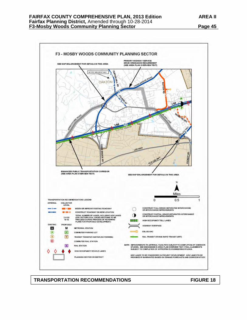
FAIRFAX COUNTY COMPREHENSIVE PLAN, 2013 Edition AREA II Fairfax Planning District, Amended through 10-28-2014 F3-Mosby Woods Community Planning Sector Page 45
TRANSPORTATION RECOMMENDATIONS FIGURE 18

FAIRFAX COUNTY COMPREHENSIVE PLAN, 2013 Edition AREA II Fairfax Planning District, Amended through 10-28-2014 F3-Mosby Woods Community Planning Sector Page 46
INTERCHANGE RECOMMENDATIONS FIGURE 19 F3, V1 COMMUNITY PLANNING SECTORS

FAIRFAX COUNTY COMPREHENSIVE PLAN, 2013 Edition AREA II Fairfax Planning District, Amended through 10-28-2014 F3-Mosby Woods Community Planning Sector Page 47
FIGURE 22 INTERCHANGE RECOMMENDATIONS FIGURE 20 F3, F4 COMMUNITY PLANNING SECTORS

FAIRFAX COUNTY COMPREHENSIVE PLAN, 2013 Edition AREA II Fairfax Planning District, Amended through 10-28-2014 F3-Mosby Woods Community Planning Sector Page 48
FIGURE 21 PARKS AND RECREATION RECOMMENDATIONS
SECTOR F3
PARK CLASSIFICATION
RECOMMENDATIONS
NEIGHBORHOOD PARKS: Borge Street Mosby Woods Villa D’Este
Complete development in accordance with master plan. Develop in accordance with master plan.
COMMUNITY PARKS: Blake Lane School Site
Initiate a re-master planning process, if necessary, and develop in accordance with adopted plan.
DISTRICT PARKS:
This sector lies within the service area of the Oak Marr District Park, which is proposed for expansion. Additional athletic fields are needed to alleviate the shortage of active recreation facilities in this general area. Contributions for development of active recreation facilities at Oak Marr Park should be provided by the private sector in conjunction with planned residential and commercial development.

FAIRFAX COUNTY COMPREHENSIVE PLAN, 2013 Edition AREA II Fairfax Planning District, Amended through 10-28-2014 F3-Mosby Woods Community Planning Sector Page 49 Trails and Bicycle Facilities Trails planned for this sector are delineated on the 1”:4,000’ Countywide Trails Plan Map which is referenced as Figure 2 in the Transportation element of the Policy Plan and is available from the Department of Transportation. Trails in this sector are an integral part of the overall county system. While some of the segments have already been constructed, the Countywide Trails Plan Map portrays the ultimate system for the sector and the county at large. In addition, the map specifies a classification for each segment, which represents the desired ultimate function and surface type of the trail. Specific construction requirements are detailed in the Public Facilities Manual. Bicycle Facilities for this sector are delineated on the 1”:4000’ Countywide Bicycle Network Map which is referenced as Figure 3 in the Transportation element of the Policy Plan and is available from the Department of Transportation.
FAIRFAX COUNTY COMPREHENSIVE PLAN, 2013 Edition AREA II Fairfax Planning District, Amended through 10-28-2014 F4-Fox Lake Community Planning Sector Page 50
F4 FOX LAKE COMMUNITY PLANNING SECTOR
CHARACTER
The Fox Lake Community Planning Sector is located north of the City of Fairfax and is bounded generally by West Ox Road, Vale Road, Hunter Mill Road and Chain Bridge Road (Route 123). The southwestern portion of the Fox Lake Community Planning Sector is included within the Fairfax Center Area Suburban Center. Plan recommendations for this area can be found in the Area III volume of the Comprehensive Plan, Fairfax Center Area.
This sector is almost entirely within the Difficult Run Watershed. Most of the sector is
developed as low density residential use at a typical density of less than one unit per acre. A sizable portion of this sector is open space along Difficult Run and scattered elsewhere throughout the area.
Two townhouse cluster subdivisions, Oak Marr Courts and Oakborough Square, have been
developed near the intersections of Jermantown Road, Miller Road and Chain Bridge Road at a density of 3-4 dwelling units per acre. The Penderbrook planned development is located in the western part of the sector, partly in the Fairfax Center Area. Penderbrook is developed at an overall density of about 7 dwelling units per acre, with both single-family detached and attached units. A golf course is incorporated into this development to serve the general area.
Hunter Mill Plaza and Oakton Shopping Center are neighborhood-serving shopping centers
located at the intersection of Hunter Mill Road, Miller Road and Chain Bridge Road. Due to the low density of residential and commercial development in this planning sector,
it is one of the areas of highest potential for surviving prehistoric and historic heritage resources. Although few heritage resource surveys have been conducted in this sector, those that have been done have produced evidence of important resources from both time periods. Of particular interest are Squirrel Hill, a clapboard house (c. 1706) near Wayland Street; the Waples and Fox Milling complex, which is an archaeological site at the intersection of Waples and Fox Mill Roads; and reported prehistoric resources dating to at least 7000 B.C. along the southern and eastern boundaries of the sector.
Squirrel Hill is listed in the Fairfax County Inventory of Historic Sites. A list and map of
heritage resources are included in the Fairfax Planning District Overview section, Figures 4 and 5. Additional historic sites in this sector are also included in the inventory. CONCEPT FOR FUTURE DEVELOPMENT
The Concept for Future Development recommends that almost the entire sector remain as a Low Density Residential Area. There is a narrow area along Miller Road and Chain Bridge Road that the Concept for Future Development recommends as part of a Suburban Neighborhood due to its higher residential densities.
FAIRFAX COUNTY COMPREHENSIVE PLAN, 2013 Edition AREA II Fairfax Planning District, Amended through 10-28-2014 F4-Fox Lake Community Planning Sector Page 51 RECOMMENDATIONS Land Use
The Fox Lake sector is largely developed with many stable residential neighborhoods. Infill development in these neighborhoods should be compatible with existing development in the vicinity in terms of use, type and intensity, in accordance with the guidance provided by the Policy Plan under Land Use Objectives 8 and 14.
Where substantial parcel consolidation is specified, it is intended that such consolidations
will provide for projects that function in a well-designed, efficient manner and provide for the development of unconsolidated parcels in conformance with the Area Plan.
Figure 22 indicates the geographic locations of land use recommendations for this sector.
Where recommendations are not shown on the General Locator Map, it is so noted. 1. It is appropriate that land in the Low Density Residential Area associated with the Difficult
Run watershed be developed with residential use at a density of .1-.2, .2-.5 and .5-1 dwelling unit per acre as shown on the Plan map, except for Valewood Manor, which is developed at a density of 1-2 dwelling units per acre. This will help maintain the large lot residential character of the area that has been established. These areas are largely outside the approved sewer service area and should remain so to maintain the area in its current condition.
The Guidelines for Cluster Development contained in the Policy Plan should be strictly adhered to in this area, especially the guideline that no cluster development should be considered when the primary purpose of the clustering is to maximize density on the site. Because of the configuration of several planned density ranges on the Plan map for this area, when a site has more than one planned density range assigned, the appropriate overall density and average lot size should be determined by placing strong emphasis on achieving compatibility with existing development in the vicinity. [Not shown]
2. The area east of Oakborough Square, north of Hunter Mill Plaza and west of Hunter Mill
Road (i.e., (Tax Map 47-2 ((1))19, 20, 21, 22, 24, 25 and pt. 27E) is planned for residential use at .5-1 dwelling units per acre. As an option, with full consolidation the entire area (Tax Map 47-2((1))19, 20, 21, 22, 24, 25 and pt. 27E) may develop with residential use at a density of 3-4 dwelling units per acre with development limited to a maximum of 58 units total, including any units provided for by the Affordable Dwelling Unit Program. Development can occur only if the area can be served by gravity-flow sewer without expansion of the sewer service area, and if the following conditions are met:
• Development should consist of single-family residential use which could include a
mixture of single-family detached and single-family attached, with single-family detached housing to be located adjacent to the existing low density residential area to the north.
• A minimum 25 foot landscaped buffer area should be provided n the northwest side
of the subject property between the new small lot single-family detached housing and

FAIRFAX COUNTY COMPREHENSIVE PLAN, 2013 Edition AREA II Fairfax Planning District, Amended through 10-28-2014 F4-Fox Lake Community Planning Sector Page 52
FIGURE 22
FAIRFAX COUNTY COMPREHENSIVE PLAN, 2013 Edition AREA II Fairfax Planning District, Amended through 10-28-2014 F4-Fox Lake Community Planning Sector Page 53
the adjacent existing low density residential area. Within this buffer area, maturetrees should be preserved and supplemental plantings provided in order to provide effective screening to the adjacent area.
• At a minimum, a 15 foot buffer area should be provided on the western side of the
subject property adjacent to the Oakborough Square Townhouses. In order to preserve mature trees, portions of the buffer area may need to be substantially wider.
• At a minimum, a 7 foot solid barrier wall should be provided along the southern edge
of the subject property adjacent to the existing office structure, with no residential structure closer than 25 feet to this property line. In addition, a 10 foot landscaped buffer area should be provided along the entire southern boundary of the subject property.
• Any adverse traffic impacts which are coincident with development of this property
should be mitigated through transportation improvements. Any improvements to Hunter Mill Road should be designed in a manner that preserves the 200-year old oak tree on the east side of Hunter Mill Road north of Route 124. Improvements should, at a minimum, included dedication of right-of-way for Hunter Mill Road, the provision of right and left turn lanes into the site, the provision of a southbound turn lane into the Oakton Shopping Center site, and provision of “right turn only” entrances on Hunter Mill Road except for the primary access.
• The primary access to Hunter Mill Road should be designed to align with the primary
access for the existing Oakton Shopping Center and if warranted, a contribution towards signalization and a crosswalk should be provided. Internal circulation should be designed in a manner which avoids potential cut-through traffic between Hunter Mill Road and Miller Road.
• Transitional screening should be provided between the future right-of-way for Hunter
Mill Road and the proposed development. This transitional screening should, at a minimum, include screening walls and shrubs, with shade trees (to include oak trees) along the sidewalk/trail.
• Pedestrian walkways (sidewalks and trails) connecting all portions of the
development to Hunter Mill Road, Miller Road and the Oakborough Square Park should be provided. In making the connection to Oakborough Square Park, the walkway(s) should be designed to remove only a minimum number of trees. In addition to the internal pedestrian system, trails should be provided along the Hunter Mill Road and Miller Road periphery of the property.
• Pedestrian access should be provided to existing commercial areas to the south and
east of the subject property. Land for library and/or park uses should be dedicated as part of this residential option.
3. The Flint Hill Preparatory School should maintain a character that is compatible with existing and planned development in the vicinity.
4. Commercial development in this sector should be limited to those areas designated for
commercial use on the Plan map. Existing commercial uses should not be intensified,
FAIRFAX COUNTY COMPREHENSIVE PLAN, 2013 Edition AREA II Fairfax Planning District, Amended through 10-28-2014 F4-Fox Lake Community Planning Sector Page 54
except minimally for modernization or beautification. Additional landscaping and buffering between commercial and adjacent residential land is strongly encouraged with carefully designed pedestrian connections created to adjacent residential areas where this is appropriate. [Not shown]
5. The Fairfax Farms subdivision should be retained as a low density residential area.
Residential development at a density of .1-.2, .5-1 and 1-2 dwelling units per acre is appropriate as outlined in the recommendations for Land Unit C within the Fairfax Center area text (see Area III Plan). Redevelopment to higher densities or intensities should not occur. Infill of vacant lots in the subdivision and in adjacent areas should be compatible with existing development in terms of use, intensity and dwelling unit type.
6. The Penderbrook Golf Course is an amenity incorporated into the Penderbrook subdivision
as an area-wide public amenity. The golf course should be preserved, either as an operating golf course or as passive green space in perpetuity should the privately-owned operations cease. The development policies that apply to this subdivision and golf course are contained in the Area III Plan, Land Unit B of the Fairfax Center area.
7. The area north of Jermantown Road between Oakton Elementary School on the east and
Oak Marr Park on the west is planned for residential development at 3-4 dwelling units per acre except for the northern portion of the tract with frontage along the south side of Miller Road which is planned for residential development at .5-1 dwelling unit per acre to be compatible with the existing large-lot, single-family houses along Miller Road. The area planned for residential development at .5-1 dwelling unit per acre should extend to a minimum depth of 300 feet south of Miller Road. Lots should, at a minimum, be one acre in size, with no provision for clustering in view of the existing pattern of residential development along Miller Road. In addition, these lots should not be served by public sewer. To achieve the upper end of the .5-1 dwelling unit per acre density range, maximum advantage should be taken of the existing vegetation and topography and the development should result in minimal disruption to environmental features. If the area should develop as a part of a planned unit development, the density restrictions for this northern part, as described above, should still be maintained.
Transportation
Transportation recommendations for this sector are shown on Figures 23 and 24. In some instances, site-specific transportation recommendations are included in the land use recommendations section. The figures show access orientation, circulation plans, interchange impact areas and generalized locations of proposed transit facilities. The recommendations contained in the Area Plan text and maps, the Policy Plan and Transportation Plan map, policies and requirements in the Public Facilities Manual, the Zoning Ordinance, and other standards will be utilized in the evaluation of development proposals. Development proposals should also be evaluated against the Hunter Mill Road Traffic Calming Study (Northern Virginia Regional Commission, 2006), which provides both a traffic calming conceptual plan for Hunter Mill Road, as well as context sensitive roadway design techniques.

FAIRFAX COUNTY COMPREHENSIVE PLAN, 2013 Edition AREA II Fairfax Planning District, Amended through 10-28-2014 F4-Fox Lake Community Planning Sector Page 55
TRANSPORTATION RECOMMENDATIONS FIGURE 23

FAIRFAX COUNTY COMPREHENSIVE PLAN, 2013 Edition AREA II Fairfax Planning District, Amended through 10-28-2014 F4-Fox Lake Community Planning Sector Page 56
INTERCHANGE RECOMMENDATIONS FIGURE 24 F3, F4 COMMUNITY PLANNING SECTORS

FAIRFAX COUNTY COMPREHENSIVE PLAN, 2013 Edition AREA II Fairfax Planning District, Amended through 10-28-2014 F4-Fox Lake Community Planning Sector Page 57 Heritage Resources
The Waples and Fox Milling complex dates to the 19th century and has extensive mill race systems in the adjacent floodplain. These resources and the prehistoric resources that probably exist in the Difficult Run Stream Valley are particularly vulnerable to public utility and recreational development which should not proceed without prior survey and appropriate measures to mitigate adverse impacts. Any development or ground disturbance in this sector, both on private and public land, should be preceded by heritage resource studies, and alternatives should be explored for the avoidance, preservation or recovery of significant heritage resources that are found. In those areas where significant heritage resources have been recorded, an effort should be made to preserve them. If preservation is not feasible, then, in accordance with countywide objectives and policies as cited in the Heritage Resources section of the Policy Plan, the threatened resource should be thoroughly recorded and in the case of archaeological resources, the artifacts recovered. Public Facilities 1. A new fire and rescue facility in the Hunter Mill Road corridor, north of Oakton, has been
identified as a future need. 2. In general, the area north of Jermantown Road, Oakton Road, and Waples Mill Road is not
planned or programmed for sewer construction. This area includes part of the headwaters of Difficult Run, and the current policy of the Board of Supervisors, reaffirmed in May 1989, is not to extend sewer service into this watershed. However, to remedy a public health hazard caused by a number of irreparably failed and imminently failing septic systems, the county’s Approved Sewer Service Area (ASSA) was expanded and implemented under the county’s Extension & Improvement Program to the area generally north of Interstate 66 (I-66), west of Jermantown Road, south of Tattersall and Oak Marr Parks, and east of an unnamed tributary of the Difficult Run Stream Valley. This limited expansion of the ASSA includes land that can be served by gravity flow sewer lines which are installed in accordance with sound engineering and financial principles and which connect to the facilities serving dwelling units with irreparably failed and imminently failing septic systems.
3. The Flint Hill private school is located at Oakton and Jermantown Roads. A limited
expansion of the Approved Sewer Service Area (ASSA) on a portion of the school site should be permitted to only support restroom facilities to serve the existing accessory athletic fields. This limited expansion of the ASSA should in no way be construed to support future expansion of the school buildings or other types of facilities. Any expansion of school buildings should be allowed only to the extent that the proposed expansion can be accommodated by the ASSA that was in place in 2004.
Parks and Recreation
Park and recreation recommendations for this sector are shown on Figure 25. The column "Park Classification" includes existing park facilities. The "Recommendations" column includes entries for both existing and proposed facilities. Prior to developing parkland, the Fairfax County Park Authority initiates a master planning process to determine the appropriate facilities and design for that park. This process involves extensive citizen review and participation. If an

FAIRFAX COUNTY COMPREHENSIVE PLAN, 2013 Edition AREA II Fairfax Planning District, Amended through 10-28-2014 F4-Fox Lake Community Planning Sector Page 58 existing park is listed but no recommendation appears on that line, it means the park has been developed in accordance with its master plan.
Trails and Bicycle Facilities Trails planned for this sector are delineated on the 1”:4,000’ Countywide Trails Plan Map which is referenced as Figure 2 in the Transportation element of the Policy Plan and is available from the Department of Transportation. Trails in this sector are an integral part of the overall county system. While some of the segments have already been constructed, the Countywide Trails Plan Map portrays the ultimate system for the sector and the county at large. In addition, the map specifies a classification for each segment, which represents the desired ultimate function and surface type of the trail. Specific construction requirements are detailed in the Public Facilities Manual. Bicycle Facilities for this sector are delineated on the 1”:4000’ Countywide Bicycle Network Map which is referenced as Figure 3 in the Transportation element of the Policy Plan and is available from the Department of Transportation.

FAIRFAX COUNTY COMPREHENSIVE PLAN, 2013 Edition AREA II Fairfax Planning District, Amended through 10-28-2014 F4-Fox Lake Community Planning Sector Page 59
FIGURE 25 PARKS AND RECREATION RECOMMENDATIONS
SECTOR F4
PARK CLASSIFICATION
RECOMMENDATIONS
NEIGHBORHOOD PARKS: Oakborough Square
Initiate a master planning process and develop in accordance with the approved plan. Additional Neighborhood Parks are not recommended in this predominantly Low Density Residential Area.
COMMUNITY PARKS: Foxvale Tattersall Wayland Street
Initiate a master planing process and develop these parks with a mix of passive and active recreation uses consistent with site constraints.
DISTRICT PARKS: Oak Marr
Consider acquisition of additional contiguous parcels on Oakton Road to improve park access. Proposed expansion and development of this park should address the need for active recreation to alleviate recreation deficiencies in the service area and to protect the sensitive parkland resources. Plan and develop a countywide trail connection between the Fairfax Center Area and Oak Marr District Park.
COUNTYWIDE PARKS: Difficult Run Stream Valley
Protect and preserve significant ecological resources in the Difficult Run headwaters through a combination of land dedication, donation of conservation easements to, and purchase by, the Fairfax County Park Authority. Ensure continuity of public access within Difficult Run EQC through donation and/or purchase of trail easements as necessary. Preserve and protect heritage resources in areas planned for public park use. Seek historic preservation easements on selected privately owned prehistoric sites and historic properties.

FAIRFAX COUNTY COMPREHENSIVE PLAN, 2013 Edition AREA II Fairfax Planning District, Amended through 10-28-2014 F5-Legato Community Planning Sector Page 60
F5 LEGATO COMMUNITY PLANNING SECTOR
The Legato Community Planning Sector is entirely within the Fairfax Center Area Suburban Center. Plan guidance for this area is in the Fairfax Center Area section of the Area III volume of the Comprehensive Plan.

FAIRFAX COUNTY COMPREHENSIVE PLAN, 2013 Edition AREA II Fairfax Planning District, Amended through 10-28-2014 F5-Legato Community Planning Sector Page 61
FIGURE 26

FAIRFAX COUNTY COMPREHENSIVE PLAN, 2013 Edition AREA II Fairfax Planning District, Amended through 10-28-2014 F6-County Government Center Community Planning Sector Page 62
F6 COUNTY GOVERNMENT CENTER COMMUNITY PLANNING SECTOR
CHARACTER The county Government Center Community Planning Sector comprises county land surrounded by the City of Fairfax, on which the Fairfax County Courthouse and Public Safety Center are located. The sector generally is bounded by Main Street (Route 236), Chain Bridge Road (Route 123), Judicial Drive, Page Avenue, and commercial properties and a cemetery along Main Street (see Figure 27). This planning sector contains heritage resources listed in the Fairfax County Inventory of Historic Sites, Virginia Landmarks Register and the National Register of Historic Places. A list and map of these heritage resources are included in the Fairfax Planning District Overview section, Figures 4 and 5. The Fairfax County Courthouse and Jail are among the significant heritage resources in this sector. Additional historic sites in this sector are also included in the inventory. CONCEPT FOR FUTURE DEVELOPMENT
This area is not covered by the Concept for Future Development because it is entirely within the City of Fairfax. RECOMMENDATIONS Land Use
The following is recommended for this area in the Policy Plan, as part of Public Facilities Objective 17:
• Establish the Massey Building/Judicial Center Complex as the county's Public Safety Center which will include the expanded Adult Detention Center, juvenile detention facilities, adult and juvenile courts systems, and police and fire and rescue main administrations.
• Design new space and expanded facilities at the Public Safety Center to be functional
and efficient with respect to county environmental guidelines, particularly storm drainage, and pedestrian and vehicle access and circulation. This center should be aesthetically pleasing, complement existing architecture, and provide for future expansions for a 20-year horizon.
Transportation
There are no transportation recommendations for this sector.

FAIRFAX COUNTY COMPREHENSIVE PLAN, 2013 Edition AREA II Fairfax Planning District, Amended through 10-28-2014 F6-County Government Center Community Planning Sector Page 63
EXISTING FACILITIES FIGURE 27

FAIRFAX COUNTY COMPREHENSIVE PLAN, 2013 Edition AREA II Fairfax Planning District, Amended through 10-28-2014 F6-County Government Center Community Planning Sector Page 64 Heritage Resources
The Fairfax County Courthouse and Jail are listed in the Virginia Landmarks Register and the National Register of Historic Places. All rehabilitation to these structures should be consistent with the Secretary of the Interior's Standards for Rehabilitation.
The Legato School building should continue to be protected and interpreted as a one-room
school. Because of the significance of Old Ox Road (Chain Bridge Road) in Fairfax and the
presence of the courthouse, significant and irreplaceable historic archaeological resources can be expected around the courthouse and in relatively undisturbed areas along Chain Bridge Road. Any subsurface disturbance, including those associated with road improvements, parking lots, and underground utilities, should be preceded by an archaeological survey in accordance with county policies.
Any development or ground disturbance in this sector, both on private and public land,
should be preceded by heritage resource studies, and alternatives should be explored for the avoidance, preservation or recovery of significant heritage resources that are found. In those areas where significant heritage resources have been recorded, an effort should be made to preserve them. If preservation is not feasible, then, in accordance with countywide objectives and policies as cited in the Heritage Resources section of the Policy Plan, the threatened resource should be thoroughly recorded and in the case of archaeological resources, the artifacts recovered.
Public Facilities 1. Expand the courts, and the adult and juvenile detention facilities. Parks and Recreation
Park and recreation recommendations for this sector are shown on Figure 28. The column "Park Classification" includes existing park facilities. The "Recommendations" column includes entries for both existing and proposed facilities. Prior to developing parkland, the Fairfax County Park Authority initiates a master planning process to determine the appropriate facilities and design for that park. This process involves extensive citizen review and participation. If an existing park is listed but no recommendation appears on that line, it means the park has been developed in accordance with its master plan.
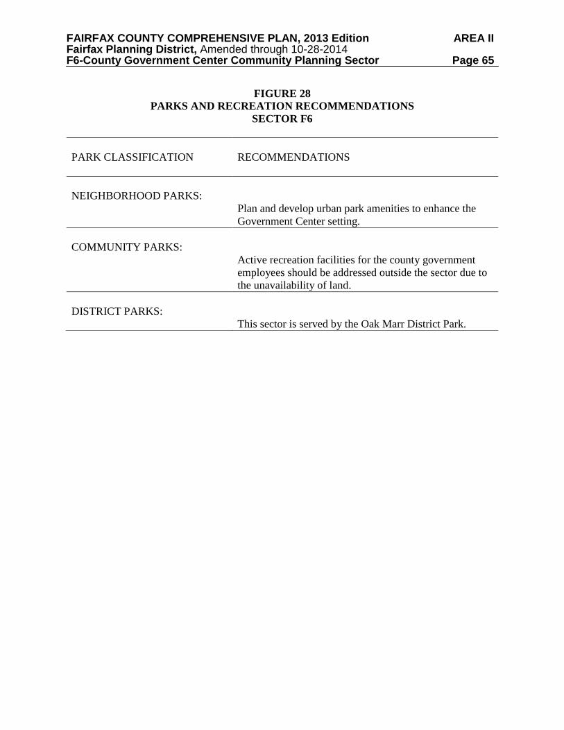
FAIRFAX COUNTY COMPREHENSIVE PLAN, 2013 Edition AREA II Fairfax Planning District, Amended through 10-28-2014 F6-County Government Center Community Planning Sector Page 65
FIGURE 28 PARKS AND RECREATION RECOMMENDATIONS
SECTOR F6
PARK CLASSIFICATION
RECOMMENDATIONS
NEIGHBORHOOD PARKS:
Plan and develop urban park amenities to enhance the Government Center setting.
COMMUNITY PARKS:
Active recreation facilities for the county government employees should be addressed outside the sector due to the unavailability of land.
DISTRICT PARKS:
This sector is served by the Oak Marr District Park.

FAIRFAX COUNTY COMPREHENSIVE PLAN, 2013 Edition AREA II Fairfax Planning District, Amended through 10-28-2014 F7-George Mason Community Planning Sector Page 66
F7 GEORGE MASON COMMUNITY PLANNING SECTOR CHARACTER
The George Mason Community Planning Sector is located between the southwestern boundary of the City of Fairfax, Roberts Road, Braddock Road and Shirley Gate Road. The northern portion of the sector where Lee Highway (Route 29) intersects with Shirley Gate Road is in the Fairfax Center Area Suburban Center. Plan recommendations for the Fairfax Center Area can be found in the Area III volume of the Comprehensive Plan.
A substantial portion of the land in this sector is owned by George Mason University
(GMU). A portion of the GMU land holdings located east of the Braddox subdivision near Ox Road (Route 123) is undeveloped. The western portion of this sector is in the low density portion of the Occoquan Watershed.
Shirley Gate Park, Lake Fairfax Estates and Cavalier Woods subdivisions are located near
Shirley Gate Road. Braddox and Braddock Forest are located near Ox Road. The average density of these subdivisions is about 1-2 dwelling units per acre. The Fairfax Gateway townhouse subdivision is located next to the City of Fairfax boundary of University Drive near Chain Bridge Road and George Mason University. Its density is about 4 dwelling units per acre. There are no community-serving or neighborhood-serving retail or office uses in this sector outside of those located in the Fairfax Center Area.
Fairfax Villa and University Square are single-family detached subdivisions located on the
southern boundary of the City of Fairfax and developed at a density of about 3-4 dwelling units per acre. Access for Fairfax Villa is via the City of Fairfax, exclusively. The Fairfax Villa Elementary School is located between these subdivisions.
Prehistoric and historic resources, including Civil War earthworks and camps, have been
located along Braddock Road and on George Mason University property. An undisturbed significant Native American quarry complex which is at least 3,000 years old is located in the western portion of the sector. This site is one of the few sites of its kind remaining in the Middle Atlantic region. Fairfax Villa Community Park is a significant heritage resource listed in the Fairfax County Inventory of Historic Sites. A list and map of heritage resources are included in the Fairfax Planning District Overview section, Figures 4 and 5. CONCEPT FOR FUTURE DEVELOPMENT
The Concept for Future Development recommends that a sizable portion of this sector be identified as a Large Institutional Land Area. The remaining portion of the sector is recommended as part of a Low Density Residential Area and as part of a Suburban Neighborhood.

FAIRFAX COUNTY COMPREHENSIVE PLAN, 2013 Edition AREA II Fairfax Planning District, Amended through 10-28-2014 F7-George Mason Community Planning Sector Page 67 RECOMMENDATIONS Land Use
The George Mason sector has a few stable residential neighborhoods. Infill development
in these neighborhoods should be compatible with existing development in the vicinity in terms of use, type and intensity, in accordance with the guidance provided by the Policy Plan in Land Use Objectives 8 and 14.
Where substantial parcel consolitation is specified, it is intended that such consolidations
will provide for projects that function in a well-designed, efficient manner and provide for the development of unconsolidated parcels in conformance with the Area Plan.
Figure 29 indicates the geographic locations of land use recommendations for this sector.
Where recommendations are not shown on the General Locator Map, it is so noted. 1. The Braddox subdivision (Tax Map 68-1((2))((3))((4)) ) is a stable residential community
that should remain planned at its existing density, which is 1-2 dwelling units per acre. 2. The area south of the School Street neighborhood in Fairfax City and west of Route 123
(Tax Map 57-4((1))2, 2A and 2B), about three acres in size, is appropriate for residential development at a density of 3-4 dwelling units per acre. For development at this density, access should not be via Route 123, and land, preferably to include the existing church, should be consolidated. An option for up to 6 dwelling units per acre could be considered with full consolidation of all parcels in the county along with additional land in Fairfax City and no access via Route 123. This optional density should be compatible with density planned for adjacent land in Fairfax City along School Street. Excellence of design and provision of amenities, such as screening along Route 123, would also be conditions for achieving development at this higher density.
3. The area in Fairfax County generally bordered by Route 123, University Drive, School
Street, and lies on both sides of George Mason Boulevard is planned for residential use at a density of 5-8 dwelling units per acre. It includes Fairfax Gateway, a townhouse community (Tax Map 57-4((18))A, 11-47) and the former Eleven Oaks School site (Tax Map 57-4((1))6). However, the former Eleven Oaks School site should generally not exceed 7 dwelling units per acre. As an infill parcel the Eleven Oaks site should provide for a transition between the lower density single-family detached housing types on the east and the townhouses along Route 123. In order to complement existing development small lot or “zero-lot-line” single-family detached and single-family attached may be appropriate. The development should incorporate adjacent parcels along School Street. A tree survey should be undertaken identifying and locating all trees 10 inches in diameter or greater. These trees should be analyzed for preservation and to the extent possible trees in good condition should be preserved and incorporated into the final design. A consistent streetscape treatment along George Mason Boulevard, to include street trees, landscaping, sidewalks, and various paving textures should be provided to the extent possible.

FAIRFAX COUNTY COMPREHENSIVE PLAN, 2013 Edition AREA II Fairfax Planning District, Amended through 10-28-2014 F7-George Mason Community Planning Sector Page 68
FIGURE 29

FAIRFAX COUNTY COMPREHENSIVE PLAN, 2013 Edition AREA II Fairfax Planning District, Amended through 10-28-2014 F7-George Mason Community Planning Sector Page 69
The access points to the development should be aligned with each other on opposite sides of George Mason Boulevard and the number of median breaks should be minimized. The proposed density and/or total number of dwelling units should be balanced against the needs for adequate open space to serve the recreational needs of residents and adequate visitor parking, as parking is not permitted along George Mason Boulevard.
4. Some land in the western portion of this sector is planned for residential use at .1-.2
dwelling unit per acre in accordance with the findings in the Occoquan Basin Study. The planning and zoning is commensurate with predominant densities and the well-established character of existing development in this sector and should be maintained. Nonresidential uses requiring special exception or special permit approval should be rigorously reviewed. In general, these uses, if permitted at all, should only be located at the boundary of Low Density Residential Areas and Suburban Neighborhoods. These uses should be granted only if the following conditions are met:
• Access for the use is oriented to an arterial:
• The use is of a size and scale that will not adversely impact the character of the area
in which it is located; and • The use is designed to mitigate impacts on the water quality of the Occoquan
Reservoir. [Not Shown]
5. The planning of undeveloped land and expansion of existing facilities on land in the ownership of George Mason University near Shirley Gate Road and Braddock Road should be coordinated with both Fairfax City and Fairfax County. Further development of the University has a potential for adverse impact on the surrounding area which should be identified and mitigated through a cooperative planning effort.
6. Commercial and industrial uses are not appropriate in this sector because the sector is
adequately served by such facilities in Fairfax City and areas along the Route 29 corridor and at the intersection of Ox Road and Braddock Road. [Not shown]
7. The cumulative effect of institutional uses in this sector should be considered before
additional institutional uses or expansion of existing uses are developed. Nonresidential uses requiring special exceptions or special permits should be rigorously reviewed and permitted only if the following conditions are met:
• Access is oriented only to arterial roads; • The size and scale of the use should be compatible with, that is, similar to, the
character of existing development in the immediate vicinity; • Buffering and screening should be provided in excess of that required by the Zoning
Ordinance; and • No access to George Mason University institutional uses will be permitted through
Alta Vista Drive. [Not shown]
FAIRFAX COUNTY COMPREHENSIVE PLAN, 2013 Edition AREA II Fairfax Planning District, Amended through 10-28-2014 F7-George Mason Community Planning Sector Page 70 8. Parcels 57-1((1))3-7 are primarily located in Sub-unit V2 of the Fairfax Center Area and
are planned for residential use up to 3 du/ac, with an option for residential use at 3-4 du/ac (See the Fairfax Center Area portion of the Area III Plan for guidance on these parcels).
Transportation
Transportation recommendations for this sector are shown on Figures 30 and 31. In some instances, site-specific transportation recommendations are included in the land use recommendations section. The figures show access orientation, circulation plans, interchange impact areas and generalized locations of proposed transit facilities. The recommendations contained in the Area Plan text and maps, the Policy Plan and Transportation Plan map, policies and requirements in the Public Facilities Manual, the Zoning Ordinance, and other standards will be utilized in the evaluation of development proposals. Heritage Resources
Any development or ground disturbance in this sector, both on private and public land,
should be preceded by heritage resource studies, and alternatives should be explored for the avoidance, preservation or recovery of significant heritage resources that are found. In those areas where significant heritage resources have been recorded, an effort should be made to preserve them. If preservation is not feasible, then, in accordance with countywide objectives and policies as cited in the Heritage Resources section of the Policy Plan, the threatened resource should be thoroughly recorded and in the case of archaeological resources, the artifacts recovered. Parks and Recreation
Park and recreation recommendations for this sector are shown on Figure 32. The column "Park Classification" includes existing park facilities. The "Recommendations" column includes entries for both existing and proposed facilities. Prior to developing parkland, the Fairfax County Park Authority initiates a master planning process to determine the appropriate facilities and design for that park. This process involves extensive citizen review and participation. If an existing park is listed but no recommendation appears on that line, it means the park has been developed in accordance with its master plan. Trails and Bicycle Facilities Trails planned for this sector are delineated on the 1”:4,000’ Countywide Trails Plan Map which is referenced as Figure 2 in the Transportation element of the Policy Plan and is available from the Department of Transportation. Trails in this sector are an integral part of the overall county system. While some of the segments have already been constructed, the Countywide Trails Plan Map portrays the ultimate system for the sector and the county at large. In addition, the map specifies a classification for each segment, which represents the desired ultimate function and surface type of the trail. Specific construction requirements are detailed in the Public Facilities Manual.
Bicycle Facilities for this sector are delineated on the 1”:4000’ Countywide Bicycle Network Map which is referenced as Figure 3 in the Transportation element of the Policy Plan and is available from the Department of Transportation.
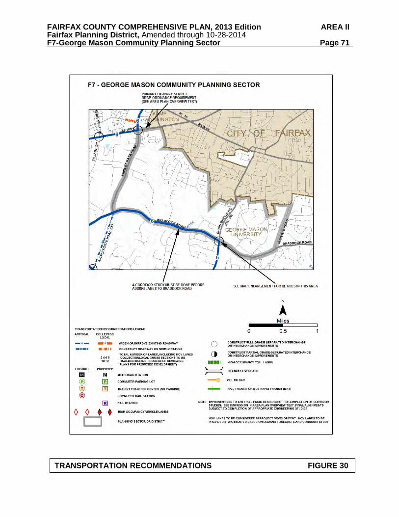
FAIRFAX COUNTY COMPREHENSIVE PLAN, 2013 Edition AREA II Fairfax Planning District, Amended through 10-28-2014 F7-George Mason Community Planning Sector Page 71
TRANSPORTATION RECOMMENDATIONS FIGURE 30
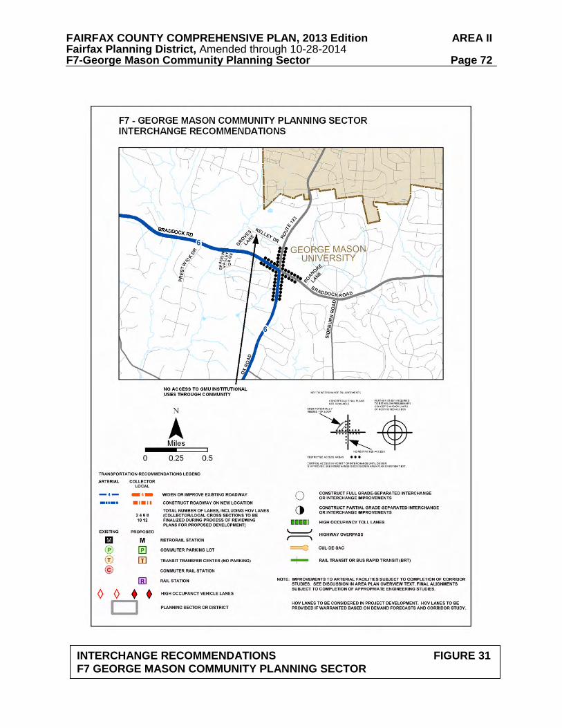
FAIRFAX COUNTY COMPREHENSIVE PLAN, 2013 Edition AREA II Fairfax Planning District, Amended through 10-28-2014 F7-George Mason Community Planning Sector Page 72
INTERCHANGE RECOMMENDATIONS FIGURE 31 F7 GEORGE MASON COMMUNITY PLANNING SECTOR

FAIRFAX COUNTY COMPREHENSIVE PLAN, 2013 Edition AREA II Fairfax Planning District, Amended through 10-28-2014 F7-George Mason Community Planning Sector Page 73
FIGURE 32 PARKS AND RECREATION RECOMMENDATIONS
SECTOR F7
PARK CLASSIFICATION
RECOMMENDATIONS
NEIGHBORHOOD PARKS:
Neighborhood Parks are not recommended in this sector in light of the large institutional uses.
COMMUNITY PARKS: Fairfax Villa
Re-master plan and develop this expanded park site for passive recreation and protection of significant prehistoric archaeological resources. Active recreation facilities to serve this sector may become available at the proposed Community Park in Fairfax Center.
DISTRICT PARKS:
This sector lies within the service area of Popes Head District Park.
COUNTYWIDE PARKS: Piney Branch Stream Valley
Ensure protection of EQC and public access to stream valley park through land acquisition, dedication or open space easements by the Fairfax County Park Authority.