2013 student technology fee (stf) proposal form · gain from the project, and how the acquisition...
TRANSCRIPT

1
2013 Student Technology Fee (STF) Proposal Form
Project Title: Acquisition of Small Unmanned Aircraft Systems (sUAS) to enhance and support teaching and research
Department/Organization: ESCI/BIOL/ENVS
Name(s) of Project Applicant(s)
Name David Wallin MS 9181 Email: [email protected] Phone x7526
Name Roger Anderson MS 9160 Email: [email protected] Phone x3992
Name Craig Moyer MS 9160 Email: [email protected] Phone x7935
Name Michael Medler MS 9085 Email: [email protected] Phone x3173
Principal Contact:
Name David Wallin Email: [email protected] Phone x7526
Amount Requested for Project
Proposed Budget:
1. Equipment total $ 82000
2. Plus site preparation (not STF funded) + $
3. Total Project Cost (spreadsheet total from part IV of this form, Total Project Budget) = $ 89134
4. Less organization’s contribution – $
5. Less site preparation – $
6. STF Grant Request = $ 89134
PREREQUISITES 1. Review the policies (two) and procedure (one) below for using lab fees to purchase equipment.
You may decide that this option is more effective for funding your proposal.
POL-U1400.03 Establishing and Changing Course and Lab Fees
POL-U1400.04 Administering and Spending Course and Lab Fees
PRO-U1400.03A Establishing a Course or Lab Fee, or Changing the Amount or Purpose of an Existing Course or Lab Fee, Fixed or Variable
2. Read the updated II. STF Proposal Form and Instructions on the Student Technology Fee
website. IMPORTANT NOTES 1. Disallowed Proposals:
a. Proposals for computer lab upgrades – Existing computer labs are upgraded on a rolling schedule, and the Student Technology Fee continues to fund these upgrades.
b. Combined proposals – The STF Committee accepts single, distinct proposals only.
2
c. Proposals for software related to maintenance and/or serial payments
2. THE STF Committee will only accept complete proposals by the announced deadline. Every
section (I–IX) and all items of this proposal format must be addressed.
I. Executive Summary (800 words max) Provide a summary of the project and the benefits to be derived. Explain what the students would gain from the project, and how the acquisition would meet the Student Technology Fee mission.
Unmanned aircraft systems (UAS) have evolved rapidly over the past decade, primarily due to military use, and these systems are now poised to dramatically expand into a wide range of civilian applications including scientific data collection. UAS are also referred to as Unmanned aerial Vehicles (UAV) or drones. Larger UAS can cover thousands of miles, stay in the air for days and cost millions of dollars. Small systems (sUAS) are generally less than 10 Kg (22 lbs), have a range of a few miles and are capable flying for 0.5-2 hours. These sUAS can be equipped with a wide variety of digital imaging systems (still images, video, thermal) that are ideally suited to address a wide range of science questions. These smaller systems are reasonably priced and will soon become standard tools for scientific research and to address applied science questions in the public and private sectors. These systems provide a much less expensive and safer option than a manned aircraft, provide imagery with a much higher spatial resolution than can be obtained with spaceborne sensors (e.g., Landsat) and make it practical to provide more frequent coverage of a study area. Through this proposal we seek funds to acquire several sUAS that can be used for undergraduate and graduate teaching and research in the Departments of Environmental Sciences, Environmental Studies and Biology. This equipment will provide students with hands-on experience using this cutting edge technology and provide the skills necessary to compete for 21st century environmental jobs in government agencies and the private sector. At this time, there are fewer than a dozen universities in the country that provide training in the use of sUAS. We plan to acquire two different sUAS. They are powered by rechargeable batteries, ruggedized, weather sealed and capable of flying in gusty winds up to about 30 mph. Imagery is streamed to the operator in real time. The first is a commercially available rotor-winged unit, the Aeryon Scout: (http://www.aeryon.com/applications/missions/379-ship-based-wildlife-observation.html). This is a small (<3 lb.) helicopter with a range of about two miles and flight duration of about 30 minutes. We also have the opportunity to acquire a second sUAS, the Aerovironment Raven (http://www.avinc.com/uas/small_uas/raven/). The Raven is a small (<5 lb.) hand-launched, fixed-wing aircraft with a range of about 6 miles and flight duration of 60-90 minutes. The Raven nicely complements the Scout in that higher flight speeds (~30 mph) and extended flight duration makes it suitable for coverage of larger study areas. In contrast, the Scout can hover over a fixed location to obtain more detailed imagery or to observe animal behavior. The Raven is currently being used with great success by scientists with USGS (http://rmgsc.cr.usgs.gov/UAS/) and the University of Alaska at Fairbanks (UAF; see attached letter from Greg Walker). Although a civilian version of the Raven is not available, The UAF group has obtained a large number of military-surplus Ravens and, under contract with the military, has developed an improved avionics package that is more user-friendly. They are primarily an engineering group and they are eager to develop partnerships with other universities who have applications for these units. The UAF group can provide us with two ground control units, four aircraft and sensors at no cost but we would need to pay for the materials and labor
3
involved in installing the new avionics package. Although the use of STF funds to obtain military surplus/prototype equipment may be unusual, this is an amazing opportunity to acquire a unique, cutting-edge, commercially unavailable system at about 1/10th the original cost. There are currently only a handful of non-military agencies in the country using the Raven for scientific research. Acquisition of these two systems will synergistically enhance the quality of technology application in a wide range of courses (about 1343 students & 4906 hours per year) that are currently offered at WWU. Geographical Information System (GIS) software and Global Positioning Systems (GPS) are now widely used across campus. Acquisition of both GIS and GPS hardware and software was funded by past STF proposals. The use of sUAS will marvelously complement the use of GIS and GPS in these courses. GIS mapping can be used to plan a data acquisition exercise that will be carried out using the sUAS. Although the sUAS can be controlled manually, both systems are equipped with GPS and they can be programed to follow a flightpath developed using GIS. Following completion of the survey, the sUAS can be programed to return to a fixed location. Coordinates for easily identifiable reference points within the study area can be acquired in the field using our GPS equipment. This information can be used to groundtruth and georectify the high resolution imagery acquired by the sUAS. Analysis of the imagery, and fusion with other data layers, can be conducted in the GIS.
II. Relationship to STF Objectives / Impact on Current Academic Programs The STF Committee will use as its primary assessment criteria the three objectives—access, quality, and integration—defined in the STF mission. Given this criteria, describe your proposed project in detail. 1. Tell us—focusing on what the students will gain from the project—how the project would provide
positive benefits to specific courses or instructional programs. Specifically:
a. How would this project provide additional student access to technological resources?
Fewer than a dozen universities in the country are using sUAS technology. Aerial mapping with geo-tagged photos at multiple scales, and at locales that students have also experienced on the ground will be a new invigorating perspective for students. Access to the bird's eye view will allow students to investigate ecological parameters more fully and open the door to a more quantitative, instrumentation-rich experience of the world around them. The technology also will provide visual access to sensitive sites (e.g. plant communities that might be damaged by ground-based sampling) and to sites that might be difficult to access, particularly for students with a disability. Using GPS-benchmarked video and photos and using geo-tagged photos permit students to have a real-time experience in spatial sampling and analysis. This group of components could be utilized by undergraduate student teams across a variety of courses and by individual undergraduate and graduate students in myriad field-based ecological studies, such as those requiring documentation of spatiotemporal distribution of 1) perennial plants in locales recovering from catastrophic fire or human modifications, 2) large predatory lizards on boulder-strewn slopes east of the Cascades, 3) seals and sea lions at haul-out sites in Puget Sound, 4) butterfly pollinated plants in high mountain meadows, 5) small mammals on rocky slopes in the Cascades. Moreover, the close view afforded by the

4
Aeryon system will allow analyses of annual plant distributions across relatively large spatial scales as well as enable students to uniquely document behavioral interactions of small animals in open, shrub-dominated habitats. Students will have the opportunity to use GIS to analyze imagery acquired using the sUAS. Thermal imaging of macrohabitats and microhabitats, for example, will be useful in studies of ground cover, vegetation, and thermal ranges of sun-shade gradient, large animal detection and in detailed spatiotemporal analyses of thermal hot springs such as exotic locales as Yellowstone National Park. Moreover, studying thermally compromised refugia will become relevant in the coming years due to global climate change. The basic and applied research applications that students have the opportunity to learn are myriad.
b. How would this project broaden or enhance the quality of the student’s academic experience through the proposed technology?
Technological tools for the photo and video analysis of ecologically relevant habitats and the organisms that reside in those habitats as well as environmental assessment have just become available due to the advancements in miniature aircraft (e.g., Ravens for more landscape & macrohabitat scale versus Aeryon helicopters for microhabitat scale and observing animal interactions). These aircraft are durable, safe and user-friendly. This close-range bird's eye view perspective has largely gone unused in ecological field studies due to logistical and resource constraints. Adding in the GPS and high-resolution photography to these aerial systems provides platforms that are spectacularly useful tools for both teaching and student research. We think student experiences with these systems would spark their imaginations and motivate them to engage in focused and meaningful learning. These new technologies would enable students to develop useful, technology-based research skills and abilities that could open post-grad & career opportunities. Having the right camera in the right place is key for all analyses as outlined above and central to the theme of this proposal. Each of the camera systems provides different information and is suited to different applications. In addition to more accurately documenting ecosystems and habitats, the patterns of individual and interacting animal movements requires a relatively unobstructed, broader view from above. The proposed software and hardware would document behavior and movement of these animals with a broad field of view, and then specifics of behaviors can be documented with digital zooming of the high resolution images that some of the cameras provide.
c. How would this project integrate technology into coursework?
There are many opportunities to integrate this technology into coursework. In this section, we highlight just a handful. Aerial mapping and environmental assessment will be integrated into courses such as Biol 326 (Ecology Lab), where documentation of sampling locations already plays a key role in many of the existing laboratory exercises. This is also the case for Biol 408 (Ecological Methods), where we focus on the shrub and arthropod relationships in disturbed and intact habitats, and in Biol 409 (Research in Reptile Ecology) where the context of many visual obstacles (boulders and shrubs) in some areas and the challenge of large open spaces in other areas are considered while focusing on the movements of lizards in relation to prey search, prey pursuit, and predator evasion. With this new technology, this could now be done with advanced video

5
and photography where these data could then be linked up with other ecological measurements and done so in a time-series format for interclass comparisons as part of the intended exercise. In ESCI 442 (Remote Sensing) we have had to rely on imagery acquired by spaceborne sensors or sensors carried in manned aircraft. This imagery is of lower resolution and we have had little or no control over the timing of image acquisition. With the Raven, we will be able to acquire much higher resolution imagery and the students will plan and carry out the image acquisition in a way that is optimized for particular applications. Direct control and involvement in the image acquisition process by the students will provide for a much richer experience. In the GIS courses (ENVS 320, 420,421, 422) students will also be able to acquire their own imagery rather than relying on old and possibly outdated information. In addition to mapping natural ecosystems, those interested in planning can use these sUAS to map suburban and urban setting for current landuse and infrastructure. Imagery can also be used to develop high resolution maps of surface topography and monitor changes in response to erosion, sediment deposition or development. For aquatic courses (including ESCI 410 and 411), thermal imaging can be used to locate cold groundwater discharge into streams. These locations can represent critical habitat for anadromous fish and the repeat coverage available with sUAS makes it possible to monitor seasonal variation is these features. The video cameras can be used to conduct surveys for large terrestrial mammals (e.g., elk; ESCI 408, Field Methods in Wildlife Ecology ) and marine mammals (Biol 464, Biology of Marine Mammals). In microbial courses such as Biol 405 and 436, these types of data can be used to show the boundaries of microbial communities across various geochemical gradients. Infrared video mapping could be used to quantify and correlate temperature characteristics to specific in situ microbial processes and physiologies. Behavioral and physiological studies are already an integral part of the classes listed below (III. Utilization). The proposed instrumentation will seamlessly integrate into the existing classes and open new avenues for student research. Independent projects in the labs are driven by student interest and creativity. Placing these new tools into the hands of eager and motivated students will open new avenues for students and faculty to explore experiential learning, and in the new high-tech world of eco-behavior-physiology.
2. Will other departments be involved with this project?
No Yes If yes, describe.
Departments of Environmental Sciences, Environmental Studies, Biology.
3. Has any part of this project previously been funded by the Student Technology Fee? No Yes If yes, describe.
6
4. Is the proposed project a pilot project? No Yes
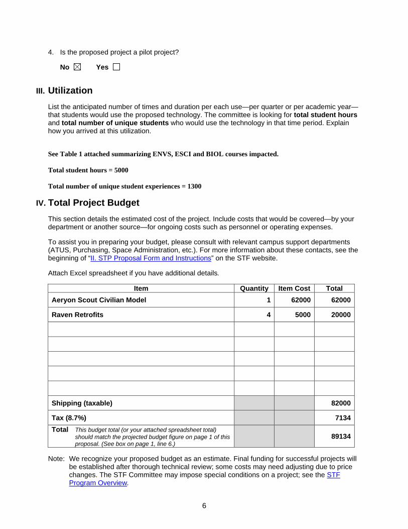
III. Utilization List the anticipated number of times and duration per each use—per quarter or per academic year—that students would use the proposed technology. The committee is looking for total student hours and total number of unique students who would use the technology in that time period. Explain how you arrived at this utilization. See Table 1 attached summarizing ENVS, ESCI and BIOL courses impacted. Total student hours = 5000 Total number of unique student experiences = 1300
IV. Total Project Budget This section details the estimated cost of the project. Include costs that would be covered—by your department or another source—for ongoing costs such as personnel or operating expenses. To assist you in preparing your budget, please consult with relevant campus support departments (ATUS, Purchasing, Space Administration, etc.). For more information about these contacts, see the beginning of “II. STP Proposal Form and Instructions” on the STF website. Attach Excel spreadsheet if you have additional details.
Item Quantity Item Cost Total
Aeryon Scout Civilian Model 1 62000 62000
Raven Retrofits 4 5000 20000
Shipping (taxable) 82000
Tax (8.7%) 7134
Total This budget total (or your attached spreadsheet total) should match the projected budget figure on page 1 of this proposal. (See box on page 1, line 6.)
89134
Note: We recognize your proposed budget as an estimate. Final funding for successful projects will
be established after thorough technical review; some costs may need adjusting due to price changes. The STF Committee may impose special conditions on a project; see the STF Program Overview.
7
1. What funding or contributions are available from your department or other sources?
Note: “Contribution“ is defined as a monetary contribution. A vendor discount, for example, is
not considered a contribution.
None
2. Could this project be divided into discrete elements that could be funded separately? Note: A “no” response to this question creates an “all or nothing” proposal. That is, if the STF
Committee decides against funding your entire proposal, it will not consider any elements for partial funding. If proposal elements could be funded separately, the applicant is responsible for prioritizing these elements before submitting the proposal.
No Yes If yes, summarize and prioritize project segments with cost estimate for
each segment.
3. Are lab fees charged for any of the courses that will use this equipment? No Yes If yes, please note: The total funding requested from the Student Technology Fee must reflect the amount collected from course fees for
equipment replacement and/or equipment acquisition. All proposals asking for course fees will be reviewed by the Academic Budget Office.
V. Impact on Existing Resources Your proposal must address the project’s potential impact on existing resources. Give special attention to the impact on data transmission networks (e.g., sources accessed, networking equipment, etc.), and personnel (e.g., staffing, administrative support, faculty support, etc.). Any proposal that includes replacement of computers should specifically address the feasibility and cost effectiveness of upgrading the computers rather than replacing them. 1. Describe how existing equipment is used. Contrast this to projected use if your project were
funded.
No comparable equipment is available on campus. In the GIS and Remote Sensing classes, imagery from airborne and spaceborne sensors is used but this imagery has a much lower spatial resolution.
2. Is similar equipment or technology available elsewhere on campus—such as the Student Technology Center, Classroom Services, Video Services, Western Libraries, a college lab? No Yes If yes, describe why the existing equipment does not meet the needs
outlined in this proposal.
3. If this project involves the replacement of equipment:
a. Describe the “before and after” configuration changes. (A spreadsheet reflecting these changes may be attached.) Or, write “N/A.”
N/A
8
b. Describe the costs and benefits of replacing vs. upgrading. Or, write “N/A.”
N/A
4. Will this equipment be available to students outside your department? No Yes If the proposed technology would be used by students outside of your
department, describe how they would gain access, how equipment availability would be publicized, the hours/week when equipment would be available, and any costs that would apply.
Student use for both teaching and research purposes will be coordinated among the faculty proponents.
5. Does this project involve the check-out of equipment to students? No Yes If yes, discuss whether or not the Student Technology Center could be
assigned this task.
6. Does the department have adequate operating funds to provide ongoing maintenance and support? No Yes If yes, describe.
With this type of equipment, minor damage is to be expected. Hard landings are inevitable and result in minor damage to the aircraft and the need for replacement parts. Rechargeble batteries will wear out and need to be replaced. The budget for this proposal includes a modest list of spare parts. As we gain experience with the equipment, we will develop a better feel for the rate at which these needs arise and we will impose course fees to cover these costs.
7. Does the department have adequate personnel funds to provide ongoing staff support for this project? No Yes If yes, describe.
See attached letter from Clint Burgess.
VI. Space and Site Information This section addresses any space alteration or site preparation necessary for the proposed project. Site alterations include painting, holes in walls, security systems, carpeting, construction, lighting changes, or conversion of a lab or office. Special If this project would require any site preparation, or if this project would use any space Note: not currently under your department’s control:
You must submit a draft proposal to Space Administration by November 28, 2012. Space Administration and Facilities Management will then conduct a site survey and
respond to you by December 12, 2012 about project feasibility, cost, and schedule. You must include the site survey response with your final proposal.
1. Location for installation of equipment or technology.
N/A

9
2. Would site modification be required?
No Yes If yes, describe the modifications (electrical, air, painting, lighting, security,
network access, etc.).
3. Would this project use space not currently assigned to your department or area? No Yes If yes, describe.
VII. Project Schedule Describe your overall implementation schedule. (Remember that project awards are announced during spring quarter, and that projects are to be substantially completed by the end of the calendar year.) If any site preparation is involved (see section VI above), align your project schedule with the schedule provided by Space Administration and Facilities Management.
Equipment acquisition and training will occur during the spring and summer of 2013. Equipment will be in place and available for use during the fall of 2013.
VIII. Constraints List or describe any external or internal factors/constraints that could affect your project schedule, project objectives, or the project budget (e.g., if external approval is required for curricular changes, or if funding must be received by a certain date).
In order to operate Small Unmanned Aerial Systems (sUAS) in the USA, you must acquire a Certificate of Authorization (COA) through the Federal Aviation Administration (FAA). Currently, these certificates are only granted to state and federal agencies (including universities and law enforcement). Commercial use of UAS is not currently permitted. While the requirements of each COA will differ between situations, typically they state the following: (1) Flight only below 400 ft. AGL (2) Daytime operation in Visual Flight Rules (VFR) (3) Range limited to Visual Line of Sight (VLOS) (4) Greater than 5 miles from an airport The FAA's primary concern is to limit the potential for conflict between UAS and manned aircraft. It is important to note that we do not consider this a major obstacle and that the FAA is currently undertaking an initiative to accelerate the approval process for public agencies. The development of regulations that would permit commercial use of UAS are under development but recent privacy concerns surrounding the use of UAS may slow this process somewhat. This will mean that our students will be poised to utilize this technology as the regulatory constraints are eased. Furthermore, part of our student training will involve compliance with FAA regulations and sensitivity to privacy issues.
IX. External Funding This section must be completed for any projects over $100,000. For project budgets of this scale, the applicant should investigate opportunities for obtaining external funding for all or part of the proposed project.

10
1. Describe the external organization(s) able to provide funding in support of this project.
2. Describe the funding cycle for these requests (submission dates, projected award dates).
3. Indicate the amount of external funding that would be requested.
4. In cases where joint funding is requested, what would happen if the Student Technology Fee award is made and the external grant is not awarded?
5. Has a grant proposal already been submitted for all or part of the proposed Student Technology Fee project?

Course
Title (# credits)
#
sections per year
#
stdt per year
taught
#
hrs per Stdt
#
stdt hours
per year
Use range: demo to multi-week projects using equipment for up to tens of hours. Note: * indicates same students, different instruments
ENVS 320 Intro to GIS (4) 5 150 3 450 1-hr demo, 2 hrs imagery use/stdt
ENVS 420 Intermediate GIS (4) 1 30 3 90 1-hr demo, 2 hrs imagery use/stdt
ENVS 421 GIS Databases (4) 1 30 3 90 3 hour analysis of imagery and fusion with other GIS layers
ENVS 422 Advanced GIS (5) 1 30 10 300 Group projects involving flight planning, image acquisition & anal.
ESCI 380 Energy & Environment (3) 1 30 2 60 2-hr demo & use, building heat loss
ESCI 408 Field Mthds: Wildlife Ecol (5) 1 15 4 60 4-hr team projects: wildlife surveys
ESCI 410 Forestry-Fish Interactions (3) 1 50 1 50 1-hr demo & use: stream temps
ESCI 411 Forest & Fish Assessment (2) 1 24 4 96 4-hr lake temp survey, flight plan-ning, data acquisition & analysis
ESCI 430 Limnology/ Limnology Lab (5) 1 35 4 140 4-hr stream temp survey, flight plan-ning, data acquisition & analysis
ESCI 442 Intro to Remote Sensing (5) 1 24 10 240 Team projects involving flight planning, image acquisition & anal.
ESCI 480 Appl. Energy Production (4) 1 11 1 11 2-hr demo & use: building heat loss
BIOL 197a Marine Habitats (4) 1 22 6 132 2-hr demo & 4 hour use per student
BIOL 204 Intro: Evol, Ecol, Biodiver. (5) 26 624 1 624 1-hr demo within a lab providing spatial analysis experience
BIOL 326 Ecology Lab (3) 3 48 8 384 4 lab teams, 4-student teams
BIOL 407 Marine Ecology (5) 1 16 10 160 2-hr demo & use for 16 students; two 4- student teams, 16 hrs each
BIOL 408 Ecological Methods (6) 1 14* 30 560 14 students, 23 field days, 10 lab days on campus
BIOL 409 Research in Reptile Ecology (6) 1 14* 30 560 14 students, 23 field days, 10 lab days on campus
BIOL 410 Animal Behavior (4) 1 30 1 30 1-hr demo to 30 students
BIOL 436 Molec Phylo & Microbial Div (5) 0.5 12 6 36 12 students, 2 labs, 3 hrs/lab
BIOL 437a Tropical Marine Org. Biol. (5) 1 18* 4 132 18 students, 4 hr demo, one 3 student team, 20 hours each
BIOL 437b Tropical Marine Ecology (5) 1 18* 4 132 18 students, 4 hr demo, one 3 student team, 20 hours each
BIOL 464 Biol. of Marine Mammals (4) 0.5 24 4 48 24 students, 4-hr demo
BIOL 465 Vertebrate Zoology (5) 0.5 30 3 45 1-hr demo to 30 students, plus > 3 labs/qtr, with 8 stdts/lab, 3 hrs/lab
BIOL 468 Comp Vert Physiology Lab (3) 0.5 12 10 60 2-hr demo, 12 students; one 4 student team, 20 hrs each
BIOL 494 Individual Student Research (~3) 3 18 20 360 6 students each > 20 hrs/qtr
56.5 1343 190 4906 TOTALS

Jobs & Grad School!Flying video camera!
Infra red camera!Rapid measurements at small spatial scale
Document and analyze rapidly
Rapid measurements at large spatial scale
ls
Undergrads in collaborative, publication quality ecological research with
High speed camera!
f Document and analyze rapidlyoccurring behavioral experiments
Advanced video analysis!
dvan
ced level
gfaculty & grad students.
Biology: 550majorsStudents in intensive, multi‐week team
research with STF instrumentation:
High impact:
data can
analyzed at increasingly
a
Environmental Studies 220 majors research with STF instrumentation:Biology Depth & Electives:
eg., Biol 403, 405, 407, 408, 409, 437, 468, 494
Environmental Science Electives: eg., ESCI 408, 422, 430, 440, 441, 442, 470
Environmental Science: 185majors
Biol 204,
The same
j
Biology Core Courses: Biol 322 & 326 students using STF equipment will engage in ecological research that is bothaccessible & advanced; data can be further analyzed
gEvolution, Ecology & Biodiversity:
624 Biol 204 students
Biology Core Courses: Biol 204 students (includes ENSC majors) are introduced to
accessible & advanced; data can be further analyzed in even more advanced, software‐intensive courses.
Biology Depth & Electives: Biol 410, 436, 464, 465 with similar use.
s ude s
Biology Core Courses: Biol 204 students (includes ENSC majors) are introduced to the exciting & meaningful ecological research thatcan be performed with STF instrumentation systems.

Scientific Technical Services
Environmental Studies 508 516 High Street
Bellingham, Washington 98225-9079 (360) 650-3511
www.wwu.edu/scitech
Active Minds Changing Lives
December 03, 2012 Dr. Craig Moyer Department of Biology Western Washington University Bellingham, WA 98225 Re: Technical Support for Equipment Dear Craig, I am writing to confirm our support of your grant application to Western's 2013 Student Technology Fee program and to confirm that Scientific Technical Services (STS) will provide assistance for the maintenance and repair of the proposed instrumentation. As you know, STS (http://www.wwu.edu/depts/scitech/) provides university‐wide support services for the teaching and research activities of Western’s faculty, staff, and students. SciTech has four full time employees that are responsible for the University Instrument Center, a multi‐user instrumentation facility, as well as full service science shops. SciTech has advanced capabilities that include electronics, machining and other manufacturing services for the design, construction, and repair of scientific instrumentation and equipment. These services are provided at no cost to the individual researchers with the understanding that the instrumentation is available for teaching and research activities to the general university community. If I can provide you with any additional information to support your application, please feel free to contactme. Good luck with your proposal. Sincerely, Clint Burgess Clint Burgess STS Supervisor

Geophysical Institute Phone: 907-474-7558 FAX: 907-474-7290 http://www.gi.alaska.edu
Poker Flat Research Range: 907-455-2110 FAX: 907-455-2120 http://www.pfrr.alaska.edu
November 28, 2012 Dr. Steven Hollenhorst Dean Huxley College of the Environment Western Washington University Bellingham, WA 98225-9181 Dear Dean Hollenhorst: Dr. David Wallin recently contact me regarding a proposal that he is developing to acquire small Unmanned Aerial Systems (sUAS) equipped with various instrument payloads. It is my understanding that he is applying for internal university funding to support the acquisition of technology that can be used to support teaching and research. I am the Director of the Unmanned Aircraft Applications Program in the Geophysical Institute at the University of Alaska, Fairbanks. As part of our work, we have an agreement with the United States Air Force to develop improved user interfaces, avionics, and new payloads for the Raven, a small, hand-launched sUAS that the military uses for reconnaissance. To support this task, the Air Force has provided us with a large number of surplus Ravens that we are retrofitting with improved open source avionics and a new ground station with an improved user interface. We are interested in distributing these units, to a limited number of universities that would like to further exploit or develop the technology. Our interest is in developing collaborative relationships with groups who can test these units while using them to address real-world science questions. Based on my correspondence and discussions with Dr. Wallin, it is clear that both of our universities could benefit from such a collaborative relationship. Dr. Wallin has described his plans to use these units in both undergraduate and graduate-level courses and various research projects. Dr. Wallin has plans to use these units for a variety of applications including wildlife surveys (both large terrestrial and marine mammals), land use or land cover mapping and monitoring stream temperature using thermal sensors. Each of these objectives are realistic, related to our ongoing Geophysical Institute research and will provide your students with hands-on experience using state of the art technology. With this experience, your students will be well-positioned to play leadership roles in the widespread application of this technology in the coming years. I can provide you with the following equipment:
� ��������� ������������������ ������������������� � ��!�������� ����������������������������������� �������������� �� �� �"��������������
� �� ���������� �� ��������������� ������������������������ �#���$������������������ ���"�
� �������������������������������� ����������� ������� ���������������"� Unlike the military variant of the Raven the modified Ravens that we are developing operate on FCC compliant commercial radio frequencies. We would request recovery of our time and associated new materials to build out the systems for Dr. Wallin but there would be no cost for the basic Raven
Geophysical Institute, University of Alaska Fairbanks Page: 2
systems or ongoing support. I can deliver this equipment to you during the Summer 2013 with June as a target date for our work to be completed at a total cost of $20,000 I would be happy to discuss this with you in greater detail at any time. I fully support Dr. Wallin’s effort to acquire this technology and I look forward to working with your institution in the coming years. I am hopeful that his proposal is funded. Sincerely,
Gregory Walker Director Unmanned Aircraft Program