2014-0305 pegasus drilling results -...
TRANSCRIPT
6 March 2014 The Manager ASX Limited Exchange Centre 20 Bridge Street SYDNEY NSW 2000 Pegasus Deposit Drilling Results Northern Star Resources Limited (ASX: NST), as Managers of the East Kundana Joint Venture, have today released the attached announcement in relation to the Pegasus Deposit. The Company’s interest in the East Kundana Joint Venture is 36.75% Yours faithfully Tribune Resources Ltd Anton Billis Director
Page 1 of 12
HIGH-GRADE RESULTS POINT
TO SIGNIFICANT RESOURCE
UPGRADE AT KUNDANA'S
RICH PEGASUS DEPOSIT
Plus maiden Pegasus reserve set for June Quarter KEY POINTS
Drilling has returned high-grade intersections up to 500m north of the current 355,000-ounce1* resource at Pegasus, a rich deposit awaiting development at the Kundana gold mine in WA
Deepest intersection to date of 3.2m at 49.9gpt has extended the high-grade zone at depth by 100m, to 550m below surface
The Pegasus deposit remains open at depth and along strike
Visible gold intersected in numerous holes
Significant intersections along strike and outside of the current Pegasus resource include:
3.2m @ 49.9gpt gold (true width 2.2m) 5,824mRL
9.0m @ 11.7gpt gold (true width 6.5m) 5,901mRL
1.9m @ 10.8gpt gold (true width 1.3m) 5,888mRL
8.7m @ 7.8gpt gold (true width 4.8m) 5,836mRL
6.0m @ 5.2gpt gold (true width 3.3m) 5,882mRL
7.1m @ 5.1gpt gold (true width 5.1m) 5,923mRL
Infill drilling of the current resource has returned encouraging results showing that a large portion is likely to convert to reserve. Maiden Pegasus reserve set for June Quarter
Significant infill intersections include:
4.0m @ 32.5gpt gold (true width 2.8m) 5,968mRL
5.7m @ 27.9gpt gold (true width 4.0m) 6,008mRL
2.2m @ 6.9gpt gold (true width 1.5m) 6,006mRL
Recent intersections also confirm the existence of a new mineralised structure at Pegasus named the Pode Vein. This mineralisation is outside of the main K2 vein that hosts the Pegasus Resource. Intersections at Pode to date include:
3.0m @ 26.7gpt gold (true width 2.9m) 6,243mRL
13.7m @ 16.4gpt gold (true width 13.3m) 6,215mRL
13.2m @ 11.0gpt gold (true width 12.8m) 6,226mRL
7.0m @ 8.6gpt gold (true width 6.8m) 6,211mRL
5.0m @ 8.5gpt gold (true width 4.9m) 6,239mRL
Drilling continues with further assays pending for Pegasus K2 and Pode veins
Northern Star Resources Limited (ASX: NST) is pleased to announce that some outstanding drilling results from its recently-acquired Kundana Gold Mine in WA point to a significant resource upgrade at the project’s rich Pegasus discovery.
*NST owns 51% of the East Kundana Joint Venture
ASX ANNOUNCEMENT
6 MARCH 2014
Australian Securities
Exchange Code: NST
Board of Directors
Mr Chris Rowe
Non-Executive Chairman
Mr Bill Beament
Managing Director
Mr Peter O’Connor
Non-Executive Director
Mr John Fitzgerald
Non-Executive Director
Ms Liza Carpene
Company Secretary
Issued Capital
Shares 526
Options 4.5M
Current Share Price $1.20
Market Capitalisation
$631.5 million
Cash/Bullion and Investments
31 Dec 13 - $54.3 million
Level 1, 1 Puccini Court
Stirling WA 6021
T +6 8 6188 2100
F +6 8 6188 2111
www.nsrltd.com
ABN: 43 092 832 892
Page 2 of 12
ASX ANNOUNCEMENT - 6 MARCH 2014
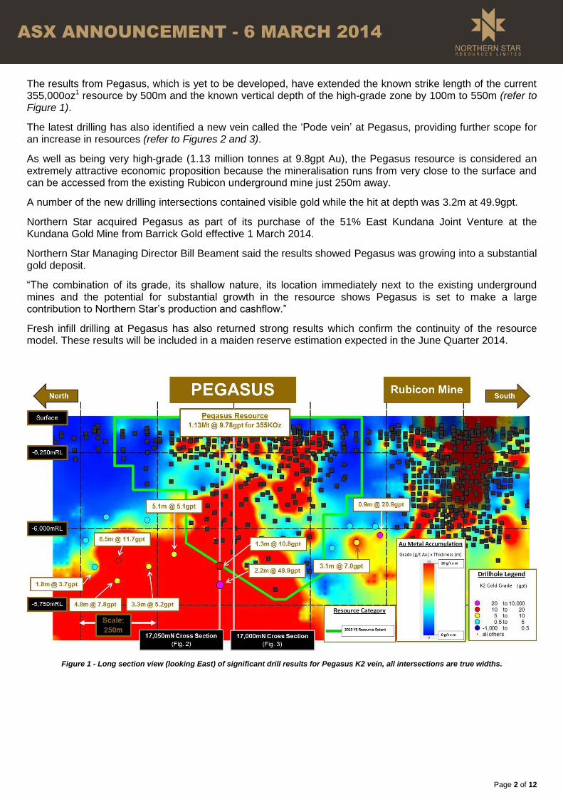
The results from Pegasus, which is yet to be developed, have extended the known strike length of the current 355,000oz1 resource by 500m and the known vertical depth of the high-grade zone by 100m to 550m (refer to Figure 1).
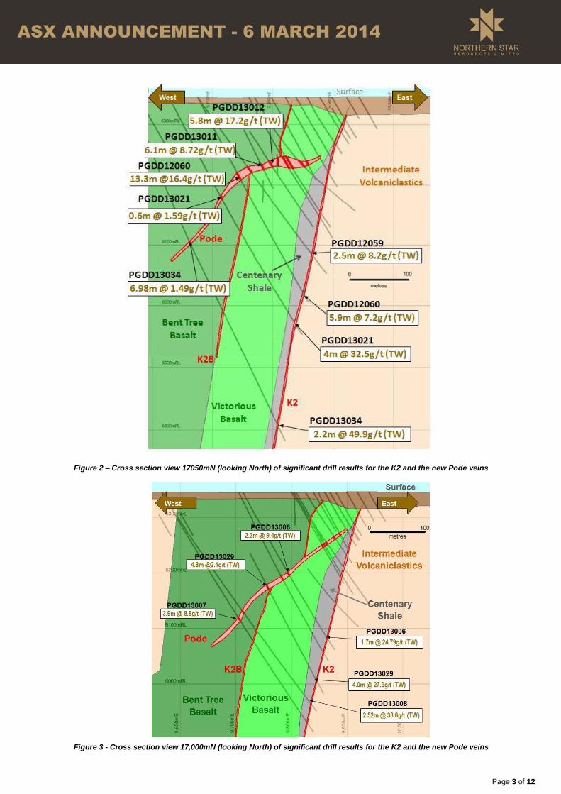
The latest drilling has also identified a new vein called the ‘Pode vein’ at Pegasus, providing further scope for an increase in resources (refer to Figures 2 and 3).
As well as being very high-grade (1.13 million tonnes at 9.8gpt Au), the Pegasus resource is considered an extremely attractive economic proposition because the mineralisation runs from very close to the surface and can be accessed from the existing Rubicon underground mine just 250m away.
A number of the new drilling intersections contained visible gold while the hit at depth was 3.2m at 49.9gpt.
Northern Star acquired Pegasus as part of its purchase of the 51% East Kundana Joint Venture at the Kundana Gold Mine from Barrick Gold effective 1 March 2014.
Northern Star Managing Director Bill Beament said the results showed Pegasus was growing into a substantial gold deposit.
“The combination of its grade, its shallow nature, its location immediately next to the existing underground mines and the potential for substantial growth in the resource shows Pegasus is set to make a large contribution to Northern Star’s production and cashflow.”
Fresh infill drilling at Pegasus has also returned strong results which confirm the continuity of the resource model. These results will be included in a maiden reserve estimation expected in the June Quarter 2014.
Figure 1 - Long section view (looking East) of significant drill results for Pegasus K2 vein, all intersections are true widths.
Page 3 of 12
ASX ANNOUNCEMENT - 6 MARCH 2014
Figure 2 – Cross section view 17050mN (looking North) of significant drill results for the K2 and the new Pode veins
Figure 3 - Cross section view 17,000mN (looking North) of significant drill results for the K2 and the new Pode veins
Page 4 of 12
ASX ANNOUNCEMENT - 6 MARCH 2014
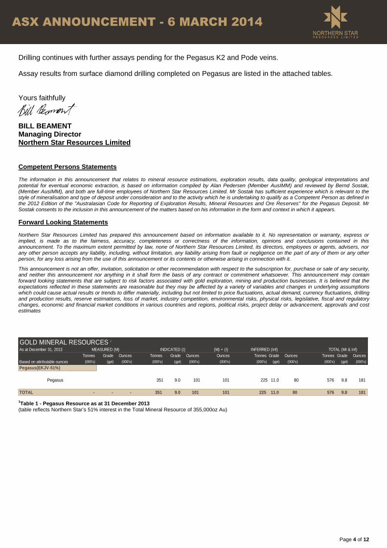
Drilling continues with further assays pending for the Pegasus K2 and Pode veins.
Assay results from surface diamond drilling completed on Pegasus are listed in the attached tables.
Yours faithfully
BILL BEAMENT Managing Director Northern Star Resources Limited Competent Persons Statements The information in this announcement that relates to mineral resource estimations, exploration results, data quality, geological interpretations and potential for eventual economic extraction, is based on information compiled by Alan Pedersen (Member AusIMM) and reviewed by Bernd Sostak, (Member AusIMM), and both are full-time employees of Northern Star Resources Limited. Mr Sostak has sufficient experience which is relevant to the style of mineralisation and type of deposit under consideration and to the activity which he is undertaking to qualify as a Competent Person as defined in the 2012 Edition of the "Australasian Code for Reporting of Exploration Results, Mineral Resources and Ore Reserves" for the Pegasus Deposit. Mr Sostak consents to the inclusion in this announcement of the matters based on his information in the form and context in which it appears.
Forward Looking Statements Northern Star Resources Limited has prepared this announcement based on information available to it. No representation or warranty, express or implied, is made as to the fairness, accuracy, completeness or correctness of the information, opinions and conclusions contained in this announcement. To the maximum extent permitted by law, none of Northern Star Resources Limited, its directors, employees or agents, advisers, nor any other person accepts any liability, including, without limitation, any liability arising from fault or negligence on the part of any of them or any other person, for any loss arising from the use of this announcement or its contents or otherwise arising in connection with it.
This announcement is not an offer, invitation, solicitation or other recommendation with respect to the subscription for, purchase or sale of any security, and neither this announcement nor anything in it shall form the basis of any contract or commitment whatsoever. This announcement may contain forward looking statements that are subject to risk factors associated with gold exploration, mining and production businesses. It is believed that the expectations reflected in these statements are reasonable but they may be affected by a variety of variables and changes in underlying assumptions which could cause actual results or trends to differ materially, including but not limited to price fluctuations, actual demand, currency fluctuations, drilling and production results, reserve estimations, loss of market, industry competition, environmental risks, physical risks, legislative, fiscal and regulatory changes, economic and financial market conditions in various countries and regions, political risks, project delay or advancement, approvals and cost estimates
1Table 1 - Pegasus Resource as at 31 December 2013
(table reflects Northern Star’s 51% interest in the Total Mineral Resource of 355,000oz Au)
GOLD MINERAL RESOURCES 1
As at December 31, 2013 (M) + (I) INFERRED (Inf)
Tonnes Grade Ounces Tonnes Grade Ounces Ounces Tonnes Grade Ounces Tonnes Grade Ounces
Based on attributable ounces (000's) (gpt) (000's) (000's) (gpt) (000's) (000's) (000's) (gpt) (000's) (000's) (gpt) (000's)
Pegasus 351 9.0 101 101 225 11.0 80 576 9.8 181
TOTAL - - - 351 9.0 101 101 225 11.0 80 576 9.8 181
Resources only
MEASURED (M) INDICATED (I) TOTAL (MI & Inf)
Pegasus(EKJV-51%)

Page 5 of 12
ASX ANNOUNCEMENT - 6 MARCH 2014
PEGASUS EXTENSION DRILLING (Outside of 31 December 2013 Resource)
Drill Hole #
Easting (Mine Grid)
Northing (Mine Grid)
Drill hole collar RL
(Mine Grid)
Dip (degrees)
Azimuth (degrees,
Mine Grid)
End of hole
depth (m)
Downhole From (m)
Downhole To (m)
Downhole Intersection
(m)
Au (gpt) uncut
Est True Thickness
(m)
EKD037B 9587 16725 6342 -64 63 505 463.75 465.16 1.41 3.1 1.0
PGDD12062 9569 17205 6344 -61 62 549 485.04 492.10 7.06 5.1 5.1
PGDD12063 9652 17298 6345 -60 62 411 358.00 360.00 2.00 4.1 1.5
PGDD12098 9652 17298 6344 -73 65 564 481.00 487.00 6.00 5.2 3.3
PGDD12119 9618 16619 6343 -62 62 492 436.16 440.65 4.49 7.0 3.1
PGDD12120 9621 16527 6343 -60 59 450 419.75 421.00 1.25 20.9 0.9
PGDD12125 9532 17422 6344 -61 62 567 511.00 520.00 9.00 11.7 6.5
PGDD12126 9718 17421 6346 -70 61 369 321.25 322.13 0.88 3.7 0.5
PGDD12127 9603 17486 6346 -70 88 573 543.40 552.10 8.70 7.8 4.8
PGDD12128 9635 17489 6345 -66 62 474 415.70 417.10 1.40 2.4 1.0
PGDD12129 9603 17488 6347 -70 65 552 499.00 502.00 3.00 3.7 1.8
PGDD13026 9560 17039 6345 62 -63 555 385.00 385.60 0.60 2.3 0.9
PGDD13027 9637 16647 6343 58 -60 480 386.68 387.10 0.42 3.4 0.3
PGDD13033 9643 16559 6344 58 -60 416 519.76 521.61 1.85 10.8 1.3
PGDD13034 9560 17040 6344 55 -66 609 544.55 547.70 3.15 49.9 2.2
Table 2 – Complete table of Pegasus drill results outside of the 31 December 2013 Resource estimation (released 23/1/2014)
PEGASUS RESOURCE DEFINITION (Inside 31 December 2013 Inferred Resource)
Drill Hole #
Easting (Mine Grid)
Northing (Mine Grid)
Drill hole collar RL
(Mine Grid)
Dip (degrees)
Azimuth (degrees,
Mine Grid)
End of hole
depth (m)
Downhole From (m)
Downhole To (m)
Downhole Intersection
(m)
Au (gpt) uncut
Est True Thickness
(m)
PGDD13021 9630 17049 6344 -61 59 450 427.00 431.00 4.00 32.5 2.8
PGDD13028 9646 17089 6344 -60 57 435 392.82 395.00 2.18 6.9 1.5
PGDD13029 9670 16968 6344 -62 46 408 376.00 381.74 5.74 27.9 4.0
PGDD13030 9646 16921 6344 -62 60 456 415.26 416.40 1.14 9.9 0.8
PGDD13031 9606 16892 6343 -57 68 489 432.35 433.60 1.25 3.3 0.9
PGDD13032 9636 16725 6343 -60 66 446 420.00 421.00 1.00 2.3 0.7
Table 3 – Complete table of Pegasus resource definition drill results completed inside the 31 December 2013 Resource estimation (released 23/1/2014)
PEGASUS DRILLING - PODE LODE DRILL RESULTS COMPLETED TO DATE
Drill Hole #
Easting (Mine Grid)
Northing (Mine Grid)
Drill hole collar RL
(Mine Grid)
Dip (degrees)
Azimuth (degrees,
Mine Grid)
End of hole
depth (m)
Downhole From (m)
Downhole To (m)
Downhole Intersection
(m)
Au (gpt) uncut
Est True Thickness
(m)
EKD034 9664 17124 6344 -60 84 402 191 192 1 5.97 0.97
EKD035 9600 16872 6343 -66 87 564 265 266 1 3.29 0.97
EKD038A 9559 16955 6344 -60 88 548.3 290 299.8 9.8 2.05 9.51
PGCD12047 9609 16893 6343 -63 88 521 256.45 257.3 0.85 1.2 0.82
PGCD12047 9609 16893 6343 -63 88 521 259 259.4 0.4 2 0.39
PGCD12048 9622 16965 6344 -66 99 528 255.74 256.45 0.71 2.09 0.69
PGDD12009 9618 16965 6343 -54 92 426 246.15 250 3.85 3.02 3.73
PGDD12059 9677 17053 6344 -54 91 360.2 137.7 150.93 13.23 11 12.83
PGDD12060 9677 17053 6344 -62 91 383.1 137.75 151.42 13.67 16.4 13.26
PGDD12061 9578 17064 6344 -60 88 543 228 234 6 1.94 5.82
PGDD12062 9569 17204 6344 -60 90 549 246.1 250 3.9 1.6 3.78

Page 6 of 12
ASX ANNOUNCEMENT - 6 MARCH 2014
PEGASUS DRILLING - PODE LODE DRILL RESULTS COMPLETED TO DATE
Drill Hole #
Easting (Mine Grid)
Northing (Mine Grid)
Drill hole collar RL
(Mine Grid)
Dip (degrees)
Azimuth (degrees,
Mine Grid)
End of hole
depth (m)
Downhole From (m)
Downhole To (m)
Downhole Intersection
(m)
Au (gpt) uncut
Est True Thickness
(m)
PGDD12063 9652 17298 6345 -60 92 411 186 187 1 1.573 0.97
PGDD12063 9652 17298 6345 -60 92 411 191 198 7 2.3 6.79
PGDD12097 9799 17030 6345 -55 91 216 118.7 119.26 0.56 21.17 0.54
PGDD12098 9652 17298 6344 -73 94 564 201 203 2 3.96 1.94
PGDD12112 9763 17077 6344 -60 90 243 107.73 109 1.27 12.3 1.23
PGDD12113 9728 17076 6344 -59 88 286.5 124.5 125.1 0.6 26.3 0.58
PGDD12115 9729 17036 6343 -59 91 286.8 136 140 4 2.01 3.88
PGDD12121 9805 16987 6344 -60 3 321 115 120 5 8.45 4.85
PGDD12121 9805 16987 6344 -60 3 321 121.5 126.5 5 2.2 4.85
PGDD12122 9783 17133 6344 -62 180 231 126.8 128.8 2 5.73 1.94
PGDD12125 9532 17422 6344 -59 100 567 277.8 283 5.2 19 5.04
PGDD12126 9718 17421 6346 -70 89 369 170.6 171.29 0.69 32 0.67
PGDD12127 9603 17486 6346 -69 120 573 232 235 3 2 2.91
PGDD12128 9635 17489 6345 -65 89 474 208 209 1 1.9 0.97
PGDD12129 9603 17488 6347 -68 98 551.5 220 221.8 1.8 1.33 1.75
PGDD12129 9603 17488 6347 -68 98 551.5 224.55 229.05 4.5 2.05 4.37
PGDD13006 9713 17001 6344 -59 94 327 172.63 175 2.37 9.4 2.30
PGDD13007 9568 17019 6344 -60 87 509.8 259 263 4 8.76 3.88
PGDD13011 9728 17035 6344 -64 78 168.02 126.22 128 1.78 8.72 6.10
PGDD13012 9727 17035 6344 -57 79 282 126 132 6 17.2 5.82
PGDD13013 9677 17053 6343 -60 74 366 159.4 161 1.6 14.4 1.55
PGDD13018 9694 17069 6343 -60 90 375 144 147 3 11.8 2.91
PGDD13019 9699 17090 6344 -60 90 368.8 162 162.8 0.8 2.66 0.56
PGDD13019 9699 17090 6344 -60 90 368.8 151 158 7 8.64 6.79
PGDD13020 9679 17090 6343 -60 90 189.1 167 170 3 4.94 2.91
PGDD13021 9630 17049 6344 -61 88 450 182.25 182.8 0.55 2.3 0.53
PGDD13021 9630 17049 6344 -61 88 450 183.4 184.05 0.65 1.59 0.63
PGDD13028 9646 17089 6344 -60 86 435 188.7 192 3.3 3 3.20
PGDD13029 9670 16968 6344 -62 75 408 190.89 195.8 4.91 2.1 4.76
PGDD13030 9646 16921 6344 -62 89 456 248.9 254.14 5.24 1.99 5.08
PGDD13030 9646 16921 6344 -62 89 456 259.65 262 2.35 2.68 2.28
PGDD13031 9606 16892 6343 -57 97 489 269.1 272 2.9 1.22 2.81
PGDD13031 9606 16892 6343 -57 97 489 275.7 277.25 1.55 1.3 1.50
PGDD13033 9560 17039 6345 -63 91 555 236.41 251.18 14.77 1.3 14.33
PGDD13034 9560 17040 6344 -66 84 609 245.2 252.4 7.2 1.49 6.98
PGRC12053 9771 17053 6344 -53 88 252 135 137 2 1.49 1.94
PGRC12054 9802 17125 6344 -58 88 204 96 101 5 1.36 4.85
PGRC12055 9764 17128 6344 -63 89 276 110 111 1 9.98 0.97
PGRC12064 9761 17052 6344 -60 85 270 106 109 3 26.7 2.91
PGRC12064 9761 17052 6344 -60 85 270 112 132 20 1.5 19.40
PGRC12099 9742 16969 6343 -54 83 300 146 147 1 4.31 0.97
PGRC12100 9737 16968 6343 -64 88 312 167 168 1 4.98 0.97
PGRCD039 9805 17013 6344 -59 90 210 106.3 107.3 1 1.56 0.97
PGRCD042 9816 17092 6345 -59 89 180 99.9 101.55 1.65 1.99 1.60
Table 4 – Complete drill results from the interpreted Pode Lode
Page 7 of 12
ASX ANNOUNCEMENT - 6 MARCH 2014
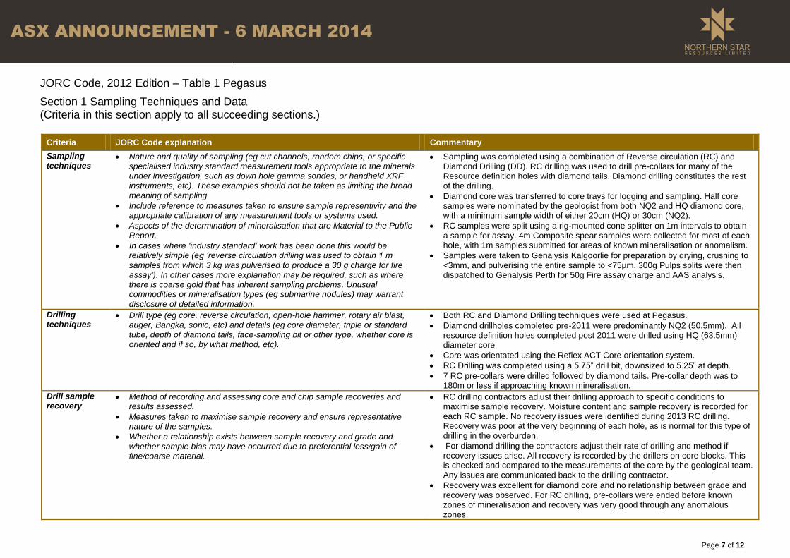
JORC Code, 2012 Edition – Table 1 Pegasus
Section 1 Sampling Techniques and Data (Criteria in this section apply to all succeeding sections.)
Criteria JORC Code explanation Commentary
Sampling techniques
Nature and quality of sampling (eg cut channels, random chips, or specific specialised industry standard measurement tools appropriate to the minerals under investigation, such as down hole gamma sondes, or handheld XRF instruments, etc). These examples should not be taken as limiting the broad meaning of sampling.
Include reference to measures taken to ensure sample representivity and the appropriate calibration of any measurement tools or systems used.
Aspects of the determination of mineralisation that are Material to the Public Report.
In cases where ‘industry standard’ work has been done this would be relatively simple (eg ‘reverse circulation drilling was used to obtain 1 m samples from which 3 kg was pulverised to produce a 30 g charge for fire assay’). In other cases more explanation may be required, such as where there is coarse gold that has inherent sampling problems. Unusual commodities or mineralisation types (eg submarine nodules) may warrant disclosure of detailed information.
Sampling was completed using a combination of Reverse circulation (RC) and Diamond Drilling (DD). RC drilling was used to drill pre-collars for many of the Resource definition holes with diamond tails. Diamond drilling constitutes the rest of the drilling.
Diamond core was transferred to core trays for logging and sampling. Half core samples were nominated by the geologist from both NQ2 and HQ diamond core, with a minimum sample width of either 20cm (HQ) or 30cm (NQ2).
RC samples were split using a rig-mounted cone splitter on 1m intervals to obtain a sample for assay. 4m Composite spear samples were collected for most of each hole, with 1m samples submitted for areas of known mineralisation or anomalism.
Samples were taken to Genalysis Kalgoorlie for preparation by drying, crushing to <3mm, and pulverising the entire sample to <75µm. 300g Pulps splits were then dispatched to Genalysis Perth for 50g Fire assay charge and AAS analysis.
Drilling techniques
Drill type (eg core, reverse circulation, open-hole hammer, rotary air blast, auger, Bangka, sonic, etc) and details (eg core diameter, triple or standard tube, depth of diamond tails, face-sampling bit or other type, whether core is oriented and if so, by what method, etc).
Both RC and Diamond Drilling techniques were used at Pegasus.
Diamond drillholes completed pre-2011 were predominantly NQ2 (50.5mm). All resource definition holes completed post 2011 were drilled using HQ (63.5mm) diameter core
Core was orientated using the Reflex ACT Core orientation system.
RC Drilling was completed using a 5.75” drill bit, downsized to 5.25” at depth.
7 RC pre-collars were drilled followed by diamond tails. Pre-collar depth was to 180m or less if approaching known mineralisation.
Drill sample recovery
Method of recording and assessing core and chip sample recoveries and results assessed.
Measures taken to maximise sample recovery and ensure representative nature of the samples.
Whether a relationship exists between sample recovery and grade and whether sample bias may have occurred due to preferential loss/gain of fine/coarse material.
RC drilling contractors adjust their drilling approach to specific conditions to maximise sample recovery. Moisture content and sample recovery is recorded for each RC sample. No recovery issues were identified during 2013 RC drilling. Recovery was poor at the very beginning of each hole, as is normal for this type of drilling in the overburden.
For diamond drilling the contractors adjust their rate of drilling and method if recovery issues arise. All recovery is recorded by the drillers on core blocks. This is checked and compared to the measurements of the core by the geological team. Any issues are communicated back to the drilling contractor.
Recovery was excellent for diamond core and no relationship between grade and recovery was observed. For RC drilling, pre-collars were ended before known zones of mineralisation and recovery was very good through any anomalous zones.
Page 8 of 12
ASX ANNOUNCEMENT - 6 MARCH 2014
Criteria JORC Code explanation Commentary
Logging Whether core and chip samples have been geologically and geotechnically logged to a level of detail to support appropriate Mineral Resource estimation, mining studies and metallurgical studies.
Whether logging is qualitative or quantitative in nature. Core (or costean, channel, etc) photography.
The total length and percentage of the relevant intersections logged.
All diamond core is logged for Regolith, Lithology, veining, alteration, mineralisation and structure. Structural measurements of specific features are also taken through oriented zones.
All logging is quantitative where possible and qualitative elsewhere. A photograph is taken of every core tray.
RC sample chips are logged in 1m intervals. For the entire length of each hole. Regolith, Lithology, alteration, veining and mineralisation are all recorded.
Sub-sampling techniques and sample preparation
If core, whether cut or sawn and whether quarter, half or all core taken.
If non-core, whether riffled, tube sampled, rotary split, etc and whether sampled wet or dry.
For all sample types, the nature, quality and appropriateness of the sample preparation technique.
Quality control procedures adopted for all sub-sampling stages to maximise representivity of samples.
Measures taken to ensure that the sampling is representative of the in situ material collected, including for instance results for field duplicate/second-half sampling.
Whether sample sizes are appropriate to the grain size of the material being sampled.
All Diamond core is cut and half the core is taken for sampling. The remaining half is stored for later use.
All RC samples are split using a rig-mounted cone splitter to collect a 1m sample 3-4kg in size. These samples were submitted to the lab from any zones approaching known mineralisation and from any areas identified as having anomalous gold. Outside of mineralised zones spear samples were taken over a 4m interval for composite sampling.
Field duplicates were taken for RC samples at a rate of 1 in 20
Sample preparation was conducted at Genalysis Kalgoorlie, commencing with sorting, checking and drying at less than 110°C to prevent sulphide breakdown. Samples are jaw crushed to a nominal -6mm particle size. If the sample is greater than 3kg a Boyd crusher with rotary splitter is used to reduce the sample size to less than 3kg (typically 1.5kg) at a nominal <3mm particle size. The entire crushed sample (if less than 3kg) or sub-sample is then pulverised to 90% passing 75µm, using a Labtechnics LM5 bowl pulveriser. 300g Pulp subsamples are then taken with an aluminium scoop and stored in labelled pulp packets.
Grind checks are performed at both the crushing stage(3mm) and pulverising stage (75µm), requiring 90% of material to pass through the relevant size.
Quality of assay data and laboratory tests
The nature, quality and appropriateness of the assaying and laboratory procedures used and whether the technique is considered partial or total.
For geophysical tools, spectrometers, handheld XRF instruments, etc, the parameters used in determining the analysis including instrument make and model, reading times, calibrations factors applied and their derivation, etc.
Nature of quality control procedures adopted (eg standards, blanks, duplicates, external laboratory checks) and whether acceptable levels of accuracy (ie lack of bias) and precision have been established.
A 50g Fire assay charge is used with a lead flux, dissolved in the furnace. The prill is totally digested by HCl and HNO3 acids before Atomic absorption spectroscopy (AAS) determination for gold analysis.
No geophysical tools were used to determine any element concentrations
Certified reference materials (CRMs) are inserted into the sample sequence randomly at a rate of 1 per 20 samples to ensure correct calibration. Any values outside of 3 standard deviations are re-assayed with a new CRM.
Blanks are inserted into the sample sequence at a rate of 1 per 20 samples, This is random, except where high grade mineralisation is expected. Here, a Blank is inserted after the high grade sample to test for contamination. Failures above 0.2gpt are followed up, and re-assayed. New pulps are prepared if failures remain.
Field Duplicates are taken for all RC samples (1 in 20 sample). No Field duplicates are submitted for diamond core.
Verification of sampling and assaying
The verification of significant intersections by either independent or alternative company personnel.
The use of twinned holes.
Documentation of primary data, data entry procedures, data verification, data storage (physical and electronic) protocols.
All significant intersections are verified by another geologist during the drill hole validation process, and later by a Competent person to be signed off
No Twinned holes were drilled for this data set
Geological logging was captured using excel templates. Both a hardcopy and electronic copy of these are stored, as well as being loaded in to the database

Page 9 of 12
ASX ANNOUNCEMENT - 6 MARCH 2014
Criteria JORC Code explanation Commentary
Discuss any adjustment to assay data. using automatic acquire loaders. Assay files are received in csv format and loaded directly into the database by the Database administrator (DBA). A geologist then checks that the results have inserted correctly. Hardcopy and electronic copies of these are also kept. No adjustments are made to this assay data.
Location of data points
Accuracy and quality of surveys used to locate drill holes (collar and down-hole surveys), trenches, mine workings and other locations used in Mineral Resource estimation.
Specification of the grid system used.
Quality and adequacy of topographic control.
A planned hole is pegged using a Differential GPS by the field assistants
During drilling single-shot surveys are every 30m to ensure the hole remains close to design. This is performed using the Reflex Ez-Trac system. Upon hole completion, a Gyroscopic survey is conducted by ABIMS, taking readings every 5m for improved accuracy. This is done in true north.
The final collar is picked up after hole completion by Differential GPS in the MGA 94_51 grid.
Good quality topographic control has been achieved through Lidar data and survey pickups of holes over the last 15 years.
Data spacing and distribution
Data spacing for reporting of Exploration Results.
Whether the data spacing and distribution is sufficient to establish the degree of geological and grade continuity appropriate for the Mineral Resource and Ore Reserve estimation procedure(s) and classifications applied.
Whether sample compositing has been applied.
Drillhole spacing across the area varies. For the Resource definition drilling, spacing was typically 40m x 40m, to allow the resource to be upgraded to indicated. For the Pode drilling spacing was approximately 20m x 20m. The HRPD drilling was much more wide spaced, as this is largely unclassified. Spacing is wider than 160m in some areas.
No compositing has been applied to these exploration results, although composite intersections are reported.
Orientation of data in relation to geological structure
Whether the orientation of sampling achieves unbiased sampling of possible structures and the extent to which this is known, considering the deposit type.
If the relationship between the drilling orientation and the orientation of key mineralised structures is considered to have introduced a sampling bias, this should be assessed and reported if material.
The majority of the structures in the Kundana camp dip steeply (80°) to WSW. The Pode structure has a much shallower dip in a similar direction, approximately 60° . To target these orientations the drillhole dips of 60-70° towards ~060° achieve high angle intersections on all structures.
No sampling bias is considered to have been introduced by the drilling orientation
Sample security
The measures taken to ensure sample security. Prior to laboratory submission samples are stored by Barrick Kanowna in a secure yard. Once submitted to the laboratories they are stored in a secure fenced compound, and tracked through their chain of custody via audit trails
Audits or reviews
The results of any audits or reviews of sampling techniques and data. No audits or reviews have recently been conducted on sampling techniques.
Page 10 of 12
ASX ANNOUNCEMENT - 6 MARCH 2014
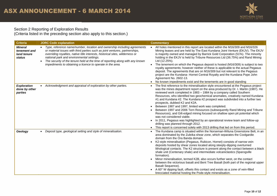
Section 2 Reporting of Exploration Results (Criteria listed in the preceding section also apply to this section.)
Criteria JORC Code explanation Commentary
Mineral tenement and land tenure status
Type, reference name/number, location and ownership including agreements or material issues with third parties such as joint ventures, partnerships, overriding royalties, native title interests, historical sites, wilderness or national park and environmental settings.
The security of the tenure held at the time of reporting along with any known impediments to obtaining a licence to operate in the area.
All holes mentioned in this report are located within the M16/309 and M16/326 Mining leases and are held by The East Kundana Joint Venture (EKJV). The EKJV is majority owned and managed by Barrick Gold Corporation (51%). The minority holding in the EKJV is held by Tribune Resources Ltd (36.75%) and Rand Mining Ltd (12.25%).
The tenement on which the Pegasus deposit is hosted (M16/309) is subject to two royalty agreements; however neither of these is applicable to the actual Pegasus deposit. The agreements that are on M16/309 but not relevant to the Pegasus project are the Kundana- Hornet Central Royalty and the Kundana Pope John Agreement No. 2602-13.
No known impediments exist and the tenements are in good standing
Exploration done by other parties
Acknowledgment and appraisal of exploration by other parties. The first reference to the mineralisation style encountered at the Pegasus project was the mines department report on the area produced by Dr. I. Martin (1987). He reviewed work completed in 1983 – 1984 by a company called Southern Resources, who identified two geochemical anomalies, creatively named Kundana #1 and Kundana #2. The Kundana #2 prospect was subdivided into a further two prospects, dubbed K2 and K2A.
Between 1987 and 1997, limited work was completed.
Between 1997 and 2006 Tern Resources (subsequently Rand Mining and Tribune Resources), and Gilt-edged mining focused on shallow open pit potential which was not considered viable.
In 2011, Pegasus was highlighted by an operational review team and follow-up drilling was planned through 2012.
This report is concerned solely with 2013 drilling that led on from this period.
Geology Deposit type, geological setting and style of mineralisation. The Kundana camp is situated within the Norseman-Wiluna Greenstone Belt, in an area dominated by the Zuleika shear zone, which separates the Coolgardie domain from the Ora Banda domain.
K2-style mineralisation (Pegasus, Rubicon, Hornet) consists of narrow vein deposits hosted by shear zones located along steeply-dipping overturned lithological contacts. The K2 structure is present along the contact between a black shale unit (Centenary shale) and intermediate volcaniclastics (Sparogville formation).
Minor mineralisation, termed K2B, also occurs further west, on the contact between the victorious basalt and Bent Tree Basalt (both part of the regional upper Basalt Sequence).
A 60° W dipping fault, offsets this contact and exists as a zone of vein-filled brecciated material hosting the Pode-style mineralisation.

Page 11 of 12
ASX ANNOUNCEMENT - 6 MARCH 2014
Criteria JORC Code explanation Commentary
Drill hole Information
A summary of all information material to the understanding of the exploration results including a tabulation of the following information for all Material drill holes: o easting and northing of the drill hole collar o elevation or RL (Reduced Level – elevation above sea level in metres) of
the drill hole collar o dip and azimuth of the hole o down hole length and interception depth o hole length.
If the exclusion of this information is justified on the basis that the information is not Material and this exclusion does not detract from the understanding of the report, the Competent Person should clearly explain why this is the case.
Too many holes to practically list and the long section and plan reflect the holes used for estimation attached below
Data aggregation methods
In reporting Exploration Results, weighting averaging techniques, maximum and/or minimum grade truncations (eg cutting of high grades) and cut-off grades are usually Material and should be stated.
Where aggregate intercepts incorporate short lengths of high grade results and longer lengths of low grade results, the procedure used for such aggregation should be stated and some typical examples of such aggregations should be shown in detail.
The assumptions used for any reporting of metal equivalent values should be clearly stated.
All reported assay results have been length weighted to provide an intersection width. A maximum of 2m of barren material between mineralised samples has been permitted in the calculation of these widths.
No assay results have been top-cut for the purpose of this report. A lower cut-off of 1gpt has been used to identify significant results, although lower results are included where a known ore zone has been intercepted, and the entire intercept is low grade.
No metal equivalent values have been used for the reporting of these exploration results
Relationship between mineralisation widths and intercept lengths
These relationships are particularly important in the reporting of Exploration Results.
If the geometry of the mineralisation with respect to the drill hole angle is known, its nature should be reported.
If it is not known and only the down hole lengths are reported, there should be a clear statement to this effect (eg ‘down hole length, true width not known’).
True widths have been calculated for intersections of the known ore zones, based on existing knowledge of the nature of these structures.
Both the downhole width and true width have been clearly specified when used.
Diagrams Appropriate maps and sections (with scales) and tabulations of intercepts should be included for any significant discovery being reported These should include, but not be limited to a plan view of drill hole collar locations and appropriate sectional views.
Appropriate plans and section have been included in the body of this report
Balanced reporting
Where comprehensive reporting of all Exploration Results is not practicable, representative reporting of both low and high grades and/or widths should be practiced to avoid misleading reporting of Exploration Results.
Both high and low grades have been reported accurately, clearly identified with the drillhole attributes and ‘From’ and ‘To’ depths.
Other substantive exploration data
Other exploration data, if meaningful and material, should be reported including (but not limited to): geological observations; geophysical survey results; geochemical survey results; bulk samples – size and method of treatment; metallurgical test results; bulk density, groundwater, geotechnical and rock characteristics; potential deleterious or contaminating substances.
Metallurgical testwork was conducted on 9 Pegasus samples. The results are summarised as follows:
- All Pegasus recoveries were above 91% for the leach tests - Gravity gold recovery estimated at 55% - Cyanide consumption 0.62 kgpt; Lime 2.29 kgpt - Oxygen Consumption 60 gpt per hour - Bond Ball mill work index average 18.1 kWh/t - Bond Abrasion Index average 0.1522

Page 12 of 12
ASX ANNOUNCEMENT - 6 MARCH 2014
Criteria JORC Code explanation Commentary
Further work The nature and scale of planned further work (eg tests for lateral extensions or depth extensions or large-scale step-out drilling).
Diagrams clearly highlighting the areas of possible extensions, including the main geological interpretations and future drilling areas, provided this information is not commercially sensitive.
Further work will commence in 2014 to extend the indicated resource deeper by infill drilling. Advanced exploration work will also attempt to upgrade an area at depth spanning 1km of strike to an inferred resource. The continuation of the ‘HRPD’ trend will continue to be drill tested at depth, with the intention of linking the known deposits of Hornet, Rubicon, Pegasus and Drake.
Plan View Pegasus Drilling Long Section Pegasus Drilling looking East