20170725 tx tig esa letter signed - fws.gov
TRANSCRIPT


Biological Evaluation Form Deepwater Horizon Oil Spill Restoration
U.S. Fish and Wildlife Service & National Marine Fisheries Service
This form will be filled out by the Implementing Trustee and used by the regulatory agencies. The form will provide information to initiate informal Section 7 consultations under the Endangered Species Act (ESA) and may be used to document a No Effect determination or to initiate pre-consultation technical assistance. It is recommended that this form also be completed to inform and evaluate additional needs for compliance with the following authorities: Migratory Bird Treaty Act (MBTA), Marine Mammal Protect Act (MMPA), Coastal Barrier Resources Act (CBRA), Bald and Golden Eagle Protection Act (BGEPA) and Section 106 of the National Historic Preservation Act (NHPA). Further information may be required beyond what is captured on this form. Note: if you need additional space for writing, please attach pages as needed.
A. Project Identification Federal Action Agency: U.S. Fish and Wildlife Service/National Marine Fisheries Service
Agency Contact(s) USFWS: Ashley Mills at 812-756-2712 and [email protected] NMFS: Christy Fellas at 727-551-5714 and [email protected]
I. Implementing Trustee Texas Commission on Environmental Quality (TCEQ) – for purposes of this BE form only
II. Applicant Contact Person Angela Schrift/Kathryn Burger
III. Phone 512-389-8755; 512-389-8153 Email: [email protected]; [email protected]
IV. Project Name and ID# (Official name of project and ID number assigned by action agency) Pierce Marsh Wetland Restoration
V. NMFS Office (Choose appropriate office based on project location) NMFS Southeast Regional Office

VI. FWS Office (Choose appropriate office based on project location) Texas Coastal Ecological Services Field Office, Houston, TX
VII. Restoration Type 1 Restore and Conserve Wetlands, Coastal, and Nearshore Habitat
VIII. Project Type 2, if helpful N/A
B. Project Location I. Project Location
Pierce Marsh lies adjacent to Highland Bayou on the north side of West Bay and the project site is only accessible via water/boat. The project is about 1.3 miles north of the Harborwalk Development, Hitchcock, TX or about 1 mile north of the diversionary canal.
II. State & County/Parish of Project Site Galveston County, Texas
III. Latitude & Longitude for Project Site (Decimal degrees and datum [e.g., 27.71622°N, 80.25174°W NAD83] [online conversion: https://www.fcc.gov/encyclopedia/degrees-minutes-seconds-tofrom-decimal-degrees]) Approximate 29.318175°, -94.965389°; WGS84
IV. Township, range and section of the project area Texas does not use the public land survey system.
C. Description of Action Area #1 Attach a separate map delineating where the action will occur. See attached figures.

Figure 1. Location of the action area.

Figure 2. Location of the potential restoration areas, bounded by existing levees. Beyond the existing levees, the nearshore areas may also be restored with beneficial use of dredged material. #2 Describe ALL areas that may be affected directly or indirectly by the action and not merely the immediate action area involved in the action, or just where species or critical habitat may be present. Provide a description of the existing environmental conditions and characteristics (e.g., topography, vegetation type, soil type, substrate type, water quality, water depth, tidal/riverine/estuarine, hydrology and drainage patterns, current flow and direction), and land uses (e.g., public, residential, commercial, industrial, agricultural). This project will restore marsh habitat in Pierce Marsh to historical conditions through the beneficial use of dredged material borrowed from maintenance dredging of the Gulf Intracoastal Waterway (GIWW). The majority of the action area is identified in Figure 2. Pierce Marsh is directly adjacent to the mainland, less than a half mile away from the shore. It is within 6 miles from Hitchcock city center, and 5 miles south of La Marque city center. The site is located adjacent to Highland Bayou, in upper West Bay, Galveston County, Texas. Specifically it is located near 29.318175°, -94.965389°; WGS84. The community of Bayou Vista is located within 1.2 miles of the site and contains homes, residential piers, and docks. This community may be impacted by noise, additional use of the boat docks, and additional personnel

passing through the area. Several industrial facilities, including the closed Solutia South 20 site, the GCWDA Campbell Bayou facility, and a closed Texas City landfill are located west of the project area. Protected marsh and wetlands owned by Scenic Galveston, Inc. border the southern portions of Pierce Marsh. See below for detailed descriptions of the action area. Existing Environmental Conditions and Characteristics Substrate type, Topography, and Soils Historically, Pierce Marsh was a salt marsh crisscrossed with channels on the north shore of West Galveston Bay. Currently, the project area is completely inundated primarily due to subsidence. Pierce Marsh would be restored over submerged sediments in subtidal unvegetated flats and estuarine emergent marsh habitat. Sediment cores have been collected in the project area as a part of ongoing restoration and monitoring projects and the substrate composition has been analyzed. The substrate varies throughout the restoration and borrow sites, but is predominantly comprised of fine silt overlying a lay of clay of varying depths (Howard 2008). Based on surveys of the submerged bay bottom performed in May 2013, there are no seagrasses or oyster reefs/shell pads at either the north or south site (HDR 2014). In addition, the TPWD seagrass viewer does not identify any seagrasses in the project area (http://tpwd.texas.gov/gis/seagrass/) and no seagrasses have been reported by resource agency biologists working in the area. This project would utilize source material from USACE dredged material placement areas that are associated with federally-maintained navigation channels. Fill material would be sourced from the GIWW. These placement areas are maintained and operated as part of the GIWW federal project. While the Pierce Marsh Wetland Restoration project is utilizing material sourced from a USACE maintenance dredging operation, the actual dredging of the GIWW is outside of the scope of this project and would occur regardless of whether or not this project was implemented. The dredging activities are not being funded through NRDA settlement money, and would occur regardless of whether the Pierce Marsh Wetland Restoration is implemented. Therefore the dredging activities and source area are not included in the compliance discussion below. The GIWW sediments would vary but would include silts and sands. Existing Vegetation Type No vegetation exists at the site. Water Quality, Water Depth, Tidal/Riverine/Estuarine, Hydrology and Drainage Patterns, Current Flow and Direction Pierce Marsh is a 2,346-acre area located on the north shore of Galveston Bay within the coastal plains ecoregion. The project area is bordered to the east by Galveston Bay and to the northeast by Swan Lake, a sub-bay of Lower Galveston Bay. Several industrial facilities, including the closed Solutia South 20 site, the GCWDA Campbell Bayou facility, and a closed Texas City landfill are located west of the project area. Protected marsh and wetlands owned by Scenic Galveston, Inc. border the southern portions of Pierce Marsh. Pierce Marsh was once part of Basford Lake, a salt marsh crisscrossed with channels and rich with fish and wildlife. Much of the area consists of marsh and slow-moving coastal bayous. Historically, the area maintained marsh elevations but due to the area’s growing industry, Pierce Marsh has subsided significantly. The area is currently mostly nearshore/open water habitat with some restored marsh units. The marsh complex varies in elevation. Areas of restored marsh are a maximum of +2.7 NAVD88. Unrestored areas vary greatly between

sites. Water depths vary within the restoration area between -0.7 to +0.7 feet NAVD88. Gradually, the marsh became inundated due to subsidence and much of that salt marsh habitat was lost. Since the late 1990s, several distinct marsh restoration activities, including marsh terracing and BUDM, improved over 400 acres at the site. There is additional capacity within dredged material containment levees constructed for a recently implemented beneficial use project. According to the EPA’s water quality index, Galveston Bay received a poor rating. Galveston Bay is rated fair for dissolved inorganic nitrogen concentrations and rated poor for dissolved inorganic phosphorus concentrations (EPA 2007a). Thirteen percent of the estuarine area was rated poor for dissolved inorganic nitrogen concentrations, and 68% of the estuarine area was rated poor for dissolved inorganic phosphorus concentrations. Expectations for water clarity are similar to those for normally turbid estuaries, with water clarity rated poor at a sampling site if light penetration at 1 meter was less than 10% of surface illumination. Dissolved oxygen conditions in Galveston Bay are rated as “good” (EPA 2007a). There are restricted consumption advisories in Galveston Bay for all species of catfish, spotted seatrout, and blue crab due to elevated levels of PCBs and dioxin (TDSHS 2013). Land Uses The project area is submerged bay bottom that is managed by the state of Texas. The project area is currently leased by Galveston Bay Foundation (GBF). There are pipelines nearby which will not be impacted. Vessels use the nearby GIWW. Commercial and recreational fishing, boating, and potentially wildlife viewing does occur in the open water areas. #3 If habitat for species is present in the action area, provide a general description of the current state of the habitat. The proposed project site is currently open water. Water dependent birds may use the open bay to forage and roost. These would include loons, bay ducks, gulls and terns, and pelicans. The habitat is also considered EFH, as it is important nursey habitat for a variety of fish and invertebrates. Dominant aquatic species that could be found in the project area include fish species (sand seatrout, spotted or speckled seatrout, red drum, tonguefish, flounders, Atlantic bumper, and porgys) and benthic organisms (bivalves, gastropods and other mollusks, amphipods, annelids, crabs, and brown and white shrimp). There are no seagrasses present according to the TPWD seagrass viewer (http://tpwd.texas.gov/gis/seagrass/). # 4 Identify any management or other activities already occurring in the area. Submerged bay bottom is managed by the state of Texas. There are nearby pipelines and an adjacent navigation channel. Fisherman and boaters may use the nearby areas for recreational or commercial purposes. The navigation channels, including the GIWW, may be used by vessels for transportation. #5 Provide or attach a detailed map of the area of potential effect for ground disturbing activities if the area is different from the action area. The potential area of impact from the construction activities is shown in Figures 1 and 2. Earthen fill material will be placed on submerged lands to raise elevations. Once the earthen fill has dewatered and sediments have settled, the marsh will be planted with Spartina grass. The final elevation of the marsh will be such that can sustain Spartina grass population (at a maximum height of +2.7 NAVD88). Underwater sediments may be trenched to allow for pipeline routing from the borrow site to the project area.

Material would be utilized from maintenance dredging of the GIWW. This dredging would occur despite this restoration project, and is outside of the scope of this project.
a. Waterbody (If applicable. Name the body of water, including wetlands (freshwater or estuarine), on which the project is located. If the location is in a river or estuary, please approximate the navigable distance from the project location to the marine environment.)
Pierce Marsh is located at the north end of West Bay. b. Existing Structures (If applicable. Describe the current and historical structures found in the action area
(e.g., buildings, parking lots, docks, seawalls, groins, jetties, marina.)). If known, please provide the years of construction.
There are existing levees which are part of the project area. There are petroleum pipelines within the vicinity of the project area. There are active oil and gas wells within one mile of Pierce Marsh. There are abandoned oil and gas wells within the area of the marsh. c. Seagrasses & Other Marine Vegetation (If applicable. Describe seagrasses found in action area. If a benthic
survey was done, provide the date it was completed and a copy of the report. Estimate the species area of coverage and density. Attach a separate map showing the location of the seagrasses in the action area.)
There are no known seagrasses in the project area. The TPWD seagrass viewer does not show any seagrasses in the project area (http://tpwd.texas.gov/gis/seagrass/).
d. Mangroves (If applicable. Describe the mangroves found in action area. Indicate the species found (red,
black, white), the species area of coverage in square footage and linear footage along project shoreline. Attach a separate map showing the location of the mangroves in the action area.)
There are no mangroves present in the proposed project site as it is open water.
e. Corals (If applicable. Describe the corals found in action area. If a benthic survey was done, provide the
date it was completed and a copy of the report. Estimate the species area of coverage and density. Attach a separate map showing the location of the corals in the action area.)
There are no corals in the project area. Appropriate habitat does not exist.
f. Uplands (If applicable. Describe the current terrestrial habitat in which the project is located (e.g. pasture,
forest, meadows, beach and dune habitats, etc.). The restoration is proposed to take place in an open water area.
No potential upland sites will be impacted by the proposed activities, with the exception of existing levees on the site. They are generally unvegetated and contain no nesting habitat. They may be utilized as resting habitat

for migratory birds. Any areas with critical habitat will be avoided and the activities associated with the use of an upland borrow site would not adversely affect listed species. To the maximum extent practicable, locations with habitats of at-risk species will also be avoided.
g. Marine Mammals (If applicable. Indicate and describe the species found in the action area. Use NMFS' Stock Assessment Reports (SARs) for more information, see http://www.nmfs.noaa.gov/pr/sars/region.htm)
The West Indian Manatee and bottlenose dolphin are the only two marine mammals that could potentially occur in Galveston Bay. Manatees are rarely found in Texas waters and are not expected to be in the project area.
D. Project Description I. Construction Schedule (What is the anticipated schedule for major phases of work? Include duration of in-water work.) Currently, this area of Pierce Marsh is open water; therefore, there is no nesting habitat present and construction could occur anytime during the year. Construction and dredged material placement must been done in coordination with the USACE maintenance dredging schedule for the GIWW. It is estimated that the next window of availability for this coordination may be 2018. The E&D for this project was funded in 2017 through the RESTORE Act and is estimated to take 6 months to complete once construction activities have begun. Project construction funding may span either one or two USACE maintenance dredging cycles to gather sufficient material for marsh restoration. Project construction is not expected to take longer than 6 months if only one dredge cycle is needed for sufficient material. The timing of contracting awards and weather conditions could impact the construction schedule. To prevent disturbance to nearby residential communities, construction activities that produce significant noise or require precision, such as dredging and placing material, would be limited to daylight hours.
To comply with the NMFS PDCs, a monitoring report will be submitted to NMFS including the following information:
Response and outcome of any spills that occur during construction per PDC 2.d As-built project completion drawings and photos Any interactions with protected species listed in PDC 4
II. Describe the Proposed Action: #1 What is the purpose and need of the proposed action?
The bay has been adversely affected by historical subsidence, which has led to the loss of much of the once-thriving marsh habitat in the system. This project would beneficially use dredged material to restore estuarine marsh complex (intertidal fringe marsh, salt flat marsh, sand flat and protected shallow water) within a 364-acre area in Pierce Marsh.

The primary objective of this project is to continue ongoing efforts to return current open-water habitat in Pierce Marsh to historical marsh elevations to support habitat restoration and revegetation with smooth cordgrass (Spartina alterniflora) and other native species. This project would route between 120,000 and 400,000 cubic yards of hydraulically dredged material excavated from USACE maintenance dredging at several stations along the GIWW to pre-existing sediment containment levees (cells) in Pierce Marsh. (Sediment containment levees were constructed as a part of a previous BUDM project in 2005.) This material would be used to raise the elevation of up to 47,050 linear feet of the existing levees to a height anticipated not to exceed +2.7 NAVD88. The selected elevation takes into consideration and allows for bulking (compaction of the dredged material as it dewaters) and sea-level rise. Containment levees may be intentionally breached or lowered as needed after dredged material dewatering in order to establish adequate tidal circulation to the restored marsh. Portions of the dredged material will be placed above intertidal elevation for restoration salt flat marsh/sand flat habitat in addition to intertidal Spartina marsh and will also allow for the migration of intertidal marsh to higher elevations in response to sea level rise. Project actions would restore up to 150 acres of marsh habitat.
#2 How do you plan to accomplish it? Describe in detail the construction equipment and methods** needed; permanent vs. temporary impacts; duration of temporary impacts; dust, erosion, and sedimentation controls; restoration areas; if the project is growth-inducing or facilitates growth; whether the project is part of a larger project or plan; and what permits will need to be obtained. To implement this project, the Texas TIG would partner with the USACE to use dredged material from the GIWW to increase elevations in leveed open water areas of Pierce Marsh and make them suitable for the establishment and long-term sustainability of a shallow intertidal wetland. It is anticipated that the next opportunity to partner with USACE to receive dredged material for restoration purposes would be between 2018 and 2020. Depending on availability of funding, this project may run more than one maintenance dredging cycle.
In general, construction would require the use of barges, small watercraft, large track hoe excavators, earth moving equipment, hydraulic dredges, and a dockside staging area. Equipment and materials for the construction activities would be transported via roads and marine waterways. Large equipment and materials moved by barges would use the established interconnected waterways. This may include the GIWW, the Houston Ship Channel and/or other navigation channels (NOAA navigational charts for Galveston/Houston: http://xpda.com/nauticalcharts/). The TGLO has identified places to access coastal waterways at http://www.glo.texas.gov/texas-beach-access/beach_bay.html. Information specific to Galveston County is located at http://www.glo.texas.gov/texas-beachaccess/pdf/beach-bay/Galveston.pdf.
Final E&D stages for this project have recently been funded but not implemented through the RESTORE Act Bucket 2 (GCERC 2015). This project would not be implemented until the final E&D funded under the RESTORE Act have been completed (estimated in mid-2018). Estimated material volume and restored acreage is currently based on existing preliminary designs. Final material volumes and acreage is dependent upon material available through adjacent USACE dredge projects and selected contractor capabilities.
This project will comply with NOAA’s PDCs. Specifically, there is no live bottom in marsh creation area, all

project related vessels will follow NMFS’s Vessel Strike Avoidance Measures and Reporting for Mariners, and all in-water work activities will be conducted during daylight hours.
Project Construction and Installation Construction may require mechanically excavated temporary trenches for pipeline access to the restoration and borrow sites. Location of the pipelines will be determined by the contractor. Typically, pipelines would be submerged in deeper waters (where dolphins are could occur) in order to avoid impacts with marine traffic. Floating pipelines may be used in shallow water areas where dolphins are not likely to be present. Measures will be taken to ensure that floating pipelines will not trap marine mammals. The number and length of temporary trenches would be determined during the E&D stage for the marsh. All temporary trenches would be backfilled upon completion of construction work. Partnering with the USACE, fill material would be sourced from beneficial use of USACE maintenance dredging of the GIWW. Levees are already in place at the site as a containment cell for dredged material. Mechanically excavated material may be used to raise the elevation of existing levees above the minimum marsh elevation to allow for settlement. A hydraulic dredge would likely be used to pump sediments from stations along the GIWW to restore the site to intertidal marsh elevations. All dredging activities would be contracted by the USACE as part of routine maintenance dredging of the GIWW. The dredged sediments would be pumped to an elevation that would allow for compaction and sea-level rise. The ultimate goal is to settle material to the elevation suitable to support emergent marsh vegetation. Portions of the dredged material may also be placed above intertidal elevation and be suitable for restoring salt flat marsh/mud flat habitat in addition to intertidal smooth cordgrass marsh and may also allow for the migration of intertidal marsh to higher elevations in response to sea level rise. This marsh restoration technique has been successfully used in previous restoration projects within the vicinity of the project area. Additional containment berms may be created, if needed, to contain any dredged material. Higher elevations of the marsh would be planted with native vegetation. Plants used would consist primarily of smooth cordgrass that is typical of this habitat type in this area and has been previously planted in similar projects throughout Pierce Marsh. Methods and tools would be approved by the PE and the project team that includes Texas TIG representatives prior to implementation. Environmental considerations, BMPs, and legal and permit requirements must be met regardless of methods and tools chosen. These would be outlined in the bid specification package developed by the PE and contracting officers. This specification package would ensure that the contractor is made aware of not only the engineering specifications but the additional obligations associated with federal and state laws governing the activities associated with the project. It would also provide the project-related approvals needed by the project manager and the PE to conduct the project. No hazardous waste would be created during construction. All hazardous substances (e.g. oils, hydraulic fluids, and fuels) handled during construction would be contained and appropriate barriers would be in place to ensure the protection of adjacent water resources from potential spills and leaks. In the event of a discharge of oil or release of hazardous substances, the release would be reported to the National Response Center (800-

424-8802) and Texas Emergency Oil Spill and Hazardous Substance Reporting line (800-832-8224) as required. BMPs in accordance with Occupational Safety and Health Administration and state and local requirements would be incorporated into construction activities on site to ensure the proper handling, storage, transport and disposal of all hazardous materials.
Beneficial Use of Dredged Material
This project would utilize source material from ongoing dredging operations and/or material harvested from existing placement areas that are associated with federally-maintained navigation channels. These placement areas are maintained and operated as part of the GIWW federal project. (While the Pierce Marsh Wetland Restoration project is utilizing material sourced from a USACE maintenance dredging operation, the actual dredging of the GIWW is outside of the scope of this project and would occur regardless of whether or not this project was implemented. This activity is not being funded through NRDA settlement money, and therefore is not included in the compliance discussion below.) Uncontaminated earthen fill material would be mined using hydraulic excavation techniques and used to restore Pierce Marsh to historical marsh elevations. Material would be transported to the placement area via a hydraulic dredge pipeline. Pipeline or hydraulic dredges would be used, because they are not known to take sea turtles (NOAA 2007). The Texas TIG would consider all current information to determine the appropriate level of contamination testing for sediments used in this project. For sediments from federally-maintained navigation channels or associated DMPAs, previously collected contaminant analysis and bio-assay data would be obtained from the USACE Galveston District-Operations Branch records. Based upon this information, the USACE and state and federal resource agency personnel would be consulted to determine the amount of sampling and the type of chemical analyses that may be needed. Measures to control turbidity caused by construction activities, decanting water, and sediment movement would be in place to ensure sensitive habitats are protected, water quality standards are met, and sensitive resources are not affected. These measures may include appropriate water control structures to decant water, as well as the installation of silt fences, hay bales, filter-fabric, and/or levees to control sediments and avoid negative impacts associated with the fill placement.
Levees Levees would be utilized in this project to contain earthen fill placement to support marsh elevation. They also may serve to protect the restored habitat from erosional forces. This project may utilize existing dredged material containment levees or may include construction of new ones. If necessary, new levees would be built within the project area. Final design will determine if and where these would be needed. The site is fairly homogeneous shallow bay bottom that formed from the contemporary (within last 50 years) marsh subsidence caused by the withdrawal of ground water. Currently existing dredged material containment levees constructed as a part of an earlier project have sufficient capacity to support an additional 150 acres of BUDM-constructed intertidal marsh. Existing levees may be surveyed to obtain an accurate cross-section so that proper engineering can be done to incorporate or work around these features. Existing levees may also be surveyed to verify holding capacity and appropriate depth. The structures may require additional height or support through

a construction method such as mechanical excavation. Mechanically excavated material may be used to raise the elevation of existing levees to a minimum height to get material to a depth that would settle to marsh elevation. Levees would be constructed/rehabilitated with in situ material. The amount, grading, and size of material that may be used as additional support would be dependent on several factors determined in the final design. These include wave and current energy expected, as well as intended use of the levees. Containment levees may be intentionally breached or lowered as needed after dredged material dewatering in order to establish adequate tidal circulation to the restored marsh.
Vegetation Planting Planting of native vegetation would occur in two stages. First, once the earthen fill has dewatered and sediments have settled substantially enough, the marsh would be seeded with smooth cordgrass in the spring season. This can help decrease the time it takes to dewater placement sediments through evapotranspiration. During the second stage, once the material has settled sufficiently to support vegetation, smooth cordgrass plants would be planted on elevated portions of marsh. This planting would likely be within 1 to 5 years after initial construction. Specific targeted number of acres for vegetative plantings for the marsh site would be developed concurrently with the E&D phase of this project. Vegetation success would be monitored as a part of the project’s MAM plan.
Operations and Maintenance The project area would be secured through a lease from the TGLO. Appropriate lease(s) or modifications to existing leases would be obtained prior to implementing the proposed restoration actions. Maintenance activities in Pierce Marsh would likely be managed by the GBF. A maintenance plan (e.g. which may include activities dealing with the dewatering of structures, lowering elevation of containment levees, the excavation of tidal channels, etc.) would be finalized concurrently with final design phases of this project, which are funded through the RESTORE Act. Maintenance activities may include management of water control structures to facilitate dewatering, monitoring of levee heights, and modifications to containment levees by breaching or lowering as needed after dredged material dewatering in order to establish adequate tidal circulation to the restored marsh. Is the project part of a larger project or plan?
Restoration of Pierce Marsh supports the needs or goals of several conservation plans. These plans include but are not limited to the following national, state, and regional planning documents:
The Galveston Bay Plan: The Comprehensive Conservation and Management Plan for the Galveston Bay Ecosystem (Galveston Bay Estuary Program (GBEP) 1994); Galveston Bay Habitat Conservation Blueprint: A Plan to Restore the Habitats and Heritage of Galveston Bay Habitat (GBF 1998); Waterbird Conservation for the Americas: The North American Waterbird Conservation Plan, Version 1 (Kushlan et. al. 2002); Southeast United States Regional Waterbird Conservation Plan (Hunter et al. 2006);

Gulf Coast Joint Venture (GCJV): Texas Mid-Coast Initiative. North American Water Fowl Management Plan (Wilson 2002); Gulf Coast Joint Venture (GCJV): Mottled Duck Conservation Plan. North American Water Fowl Management Plan (Wilson 2007); Waterfowl Strategic Plan (TPWD 2011); Texas Coastal Management Program: Section 309 Assessment and Strategies Report, 2016 – 2020 (TGLO 2015); North American Waterfowl Management Plan: People Conserving Waterfowl and Wetlands (USFWS 2012); US Shorebird Conservation Plan: Lower Mississippi/Western Gulf Coast Shorebird Planning Region (USSCP 2000); Strategic Plan: The Coastal Program Stewardship of Fish and Wildlife Through Voluntary Conservation Regional Step-Down Plan Region 2 (Texas) Part 2 of 3 FY 2006-2010 (USFWS 2006); Texas Conservation Action Plan 2012 – 2016: Gulf Coast Prairies and Marshes Handbook (TPWD 2012); and Texas Coastal and Estuarine Land Conservation Program Plan (NOAA 2010).
What permits will need to be obtained? USACE Section 10 and Section 404 (combined) permit will be obtained for this project. The lands are managed by the State of Texas and would be leased to Galveston Bay Foundation for management of the island. Any required leases or modifications will be acquired prior to construction. #3 Attach a separate map showing project footprint, avoidance areas, construction accesses, staging/laydown areas. **If construction involves overwater structures, pilings and sheetpiles, boat slips, boat ramps, shoreline armoring, dredging, blasting, or artificial reefs, list the method here, but complete the next section(s) in detail.
This project will restore marsh habitat in Pierce Marsh to historical conditions through the beneficial use of dredged material borrowed from maintenance dredging of the Gulf Intracoastal Waterway (GIWW). The majority of the action area is identified in Figure 2. Pierce Marsh is directly adjacent to the mainland, less than a half mile away from the shore.
In general, construction would require the use of barges, small watercraft, large track hoe excavators, earth moving equipment, hydraulic dredges, and a dockside staging area. Equipment and materials for the construction activities would be transported via roads and marine waterways. Large equipment and materials moved by barges would use the established interconnected waterways. This may include the GIWW, the Houston Ship Channel and/or other navigation channels (NOAA navigational charts for Galveston/Houston: http://xpda.com/nauticalcharts/). The TGLO has identified places to access coastal waterways at http://www.glo.texas.gov/texas-beach-access/beach_bay.html. Information specific to Galveston County is located at http://www.glo.texas.gov/texas-beachaccess/pdf/beach-bay/Galveston.pdf.
GIWW shipping operations occur within two miles of the project area. The project site is only accessible via boat/water, so there are no roads in the immediate vicinity of project activities and construction. Roads would not be used to transport materials to and from the site.

No public water supply intakes are located in the project area. There are petroleum pipelines within the vicinity of the project area. There are active oil and gas wells within one mile of Pierce Marsh. There are abandoned oil and gas wells within the area of the marsh.
Coordination under Section 106 NHPA has been initiated for all projects. There are no known historic sites or significant cultural, scientific, or historic resources in the area that would be affected by the proposed restoration actions. No cultural, scientific, or historic resources are known to be located in the vicinity of the project area. Prior to any work which could impact cultural resources a full and complete review under Section 106 of the NHPA will be completed.
II. Specific In-Water and/or Terrestrial Construction Methods (Provide a detailed account of construction methods. It is important to include step-by-step descriptions of how demolition or removal of structures is conducted and if any debris will be moved and how. Describe how construction will be implemented, what type and size of materials will be used and if machines will be used, manual labor, or both. Indicate if work will be done from upland, barge, or both.) See above.
a. Overwater Structures #1 Is the proposed use of this structure for a docking facility or an observation platform? No #2 If no, is this a fishing pier? Public or Private? How many people are expected to fish per day? How do you plan to address hook and line captures? This is not a fishing pier. #3 Use of “Dock Construction Guidelines”? http://sero.nmfs.noaa.gov/pr/endangered%20species/Section%207/DockGuidelines.pdf This is not applicable. No dock is being constructed. #4Type of decking: Grated – 43% open space; Wooden planks or composite planks – proposed spacing? This is not applicable. There is no decking #5 Height above Mean High Water (MHW) elevation? This project would route between 120,000 and 400,000 cubic yards of hydraulically dredged material excavated from USACE maintenance dredging at several stations along the GIWW to pre-existing sediment containment levees (cells) in Pierce Marsh. (Sediment containment levees were constructed as a part of a previous BUDM project in 2005.) This material would be used to raise the elevation of up to 47,050 linear feet of the existing levees to a height anticipated not to exceed +2.7 NAVD88. The selected elevation takes into consideration and allows for bulking (compaction of the dredged material as it dewaters) and sea-level rise. Portions of the dredged material will be placed above intertidal elevation for restoration salt flat marsh/sand flat habitat in addition to intertidal Spartina marsh and will also allow for the migration of intertidal marsh to higher elevations in response to sea level rise. Project actions would restore up to 150 acres of marsh habitat. #6 Directional orientation of main axis of dock? Not applicable.

#7 Overwater area (sq ft)? Not applicable. b.Pilings & Sheetpiles (What type of material is the piling or sheetpiles? What size and how many will be used? Method used to install: impact hammer, vibratory hammer, jetting, etc.?) Not applicable. c.Marinas and Boat Slips (Describe the number and size of slips and if the number of new slips changes from what is currently available at the project. Indicate how many are wet slips and how many are dry slips. Estimate the shadow effect of the boats - the area (sqft) beneath the boats that will be shaded.) Boat slips are not part of this project. d.Boat Ramp (Describe the number and size of boat ramps, the number of vessels that can be moored at the site (e.g., staging area) and if this is a public or private ramp. Indicate the boat trailer parking lot capacity, and if this number changes from what is currently available at the project.) Boat ramps are not part of this project. e.Shoreline Armoring (This includes all manner of shoreline armoring (e.g., riprap, seawalls, jetties, groins, breakwaters, etc.). Provide specific information on material and construction methodology used to install the shoreline armoring materials. Include linear footage and square footage. Attach a separate map showing the location of the shoreline armoring in the action area. Shoreline armoring is not part of this project. f. Dredging or digging (Provide details about dredge type (hopper, cutterhead, clamshell, etc.), maximum depth of dredging, area (ft2) to be dredged, volume of material (yd3) to be produced, grain size of material, sediment testing for contamination, spoil disposition plans, and hydrodynamic description(average current speed/direction)). If digging in the terrestrial environment, please describe fully with details about possible water jetting, vibration methods to install pilings for dune walk-over structure, or other methods. If using devices/methods/turtle relocation dredging to relocate sea turtles then describe the methods here. This project would utilize source material from ongoing dredging operations and/or material harvested from existing placement areas that are associated with federally-maintained navigation channels. These placement areas are maintained and operated as part of the GIWW federal project. While the Pierce Marsh Wetland Restoration project is utilizing material sourced from a USACE maintenance dredging operation, the actual dredging of the GIWW is outside of the scope of this project and would occur regardless of whether or not this project was implemented. This activity is not being funded through NRDA settlement money, and therefore is not included in the compliance discussion. Uncontaminated earthen fill material would be mined using hydraulic excavation techniques and used to restore Pierce Marsh to historical marsh elevations. Material would be transported to the placement area via a hydraulic dredge pipeline. Pipeline or hydraulic dredges would be used, because they are not known to take sea turtles (NOAA 2007). Levees, berms and access corridors would be mechanically excavated with a marine track hoe (with floating pontoons). Mechanical dredging would not utilize a clamshell dredge.

The Texas TIG would consider all current information to determine the appropriate level of contamination testing for sediments used in this project. For sediments from federally-maintained navigation channels or associated DMPAs, previously collected contaminant analysis and bio-assay data would be obtained from the USACE Galveston District-Operations Branch records. Based upon this information, the USACE and state and federal resource agency personnel would be consulted to determine the amount of sampling and the type of chemical analyses that may be needed.
Measures to control turbidity caused by construction activities, decanting water, and sediment movement would be in place to ensure sensitive habitats are protected, water quality standards are met, and sensitive resources are not affected. These measures may include appropriate water control structures to decant water, as well as the installation of silt fences, hay bales, filter-fabric, and/or levees to control sediments and avoid negative impacts associated with the fill placement.
g. Blasting (Projects that use blasting might not qualify as “minor projects,” and a Biological Assessment (BA) may need to be prepared for the project. Arrange a technical consultation meeting with NMFS Protected Resources Division to determine if a BA is necessary. Please include explosive weights and blasting plan.) This project does not involve blasting activities. h. Artificial Reefs (Provide a detailed account of the artificial reef site selection and reef establishment decisions (i.e., management and siting considerations, stakeholder considerations, environmental considerations), deployment schedule, materials used, deployment methods, as well as final depth profile and overhead clearance for vessel traffic. For additional information and detailed guidance on artificial reefs, please refer to the artificial reef program websites for the particular state the project will occur in. Artificial reef creation is not part of this project. i. Fishery Activities (Describe any use of gear that could entangle or capture protected species. This includes activities that may enhance fishing opportunities (e.g. fishing piers) or be fishery/gear research related (e.g. involve trawl gear, gillnets, hook and line gear, crab pots etc)). No fishery activities are part of this project.
E. NOAA Species & Critical Habitat and Effects Determination Requested
#1 List all species, critical habitat, proposed species and proposed critical habitat that may be found in the action area.
Species and/or Critical Habitat CH Unit (if applicable)
Location (sea turtles
only) Determination
Loggerhead Sea Turtle Marine May Affect, Not Likely to Adversely Affect
Green Sea Turtle Marine May Affect, Not Likely to Adversely Affect

Kemp’s Ridley Sea Turtle Marine May Affect, Not Likely to Adversely Affect
Leatherback Sea Turtle Marine May Affect, Not Likely to Adversely Affect
Hawksbill Sea Turtle Marine May Affect, Not Likely to Adversely Affect
Determination Definitions NE = no effect. This determination is appropriate when the proposed action will not directly, indirectly, or cumulatively impact, either positively or negatively, any listed, proposed, candidate species or designated/proposed critical habitat. NLAA = not likely to adversely affect. This determination is appropriate when the proposed action is not likely to adversely impact any listed, proposed, candidate species or designated/proposed critical habitat or there may be beneficial effects to these resources. Response requested is concurrence with the not likely to affect determination. This conclusion is appropriate when effects to the species or critical habitat will be wholly beneficial, discountable, or insignificant. Beneficial effects are contemporaneous positive effects without any adverse effects to the species or habitat. Insignificant effects relate to the size of the impact, while discountable effects are those that are extremely unlikely to occur. Based on best judgment, a person would not: (1) be able to meaningfully measure, detect, or evaluate insignificant effects; or (2) expect discountable effects to occur. If the Services concur in writing with the Action Agency’s determination of "is not likely to adversely affect" listed species or critical habitat, the section 7 consultation process is completed. LAA = likely to adversely affect. This determination is appropriate when the proposed action is likely to adversely impact any listed, proposed, candidate species or designated/proposed critical habitat. Response requested for listed species is formal consultation for action with a likely to adversely affect determination, with a biological opinion as the concluding document. Response requested for proposed and candidate species is “Conference.” This conclusion is reached if any adverse effect to listed species or critical habitat may occur as a direct or indirect result of the proposed action or its interrelated or interdependent actions, and the effect is not discountable or insignificant. In the event the overall effect of the proposed action is beneficial to the listed species or critical habitat, but may also cause some adverse effect on individuals of the listed species or segments of the critical habitat, then the determination is "likely to adversely affect." Any LAA determination requires formal section 7 consultation and will require additional information.
#2 Attach a separate map identifying species/critical habitat locations within the action area. Identify if Gulf sturgeon are in marine or in freshwater in your Species and/or Critical Habitat list to determine which federal agency will perform the analysis (e.g. Gulf sturgeon CH - marine). Identify if sea turtles are in water or on land in your Species and/or Critical Habitat list to determine which federal agency will perform the analysis (e.g. Loggerhead sea turtle CH - terrestrial).
There is no critical habitat in the action area.
F. USFWS Species & Critical Habitat and Effects Determination Requested #1 List all species, critical habitat, proposed species and proposed critical habitat that may be found in the action area.

Species and/or Critical Habitat
CH Unit (if applicable)
Location (sea turtles
only) Determination
Piping Plover May Affect, Not Likely to Adversely Affect
Red Knot May Affect, Not Likely to Adversely Affect
West Indian Manatee May Affect, Not Likely to Adversely Affect
#2 Attach a separate map identifying species/critical habitat locations within the action area. For information on species and critical habitat under USFWS jurisdiction, visit http://www.fws.gov/endangered/species/. Identify if Gulf sturgeon are in marine or in freshwater in your Species and/or Critical Habitat list to determine which federal agency will perform the analysis (e.g. Gulf sturgeon CH - marine). Identify if sea turtles are in water or on land in your Species and/or Critical Habitat list to determine which federal agency will perform the analysis (e.g. Loggerhead sea turtle CH - terrestrial).
There is no critical habitat in the action area.
Determination Definitions
NE = no effect. This determination is appropriate when the proposed action will not directly, indirectly, or cumulatively impact, either positively or negatively, any listed, proposed, candidate species or designated/proposed critical habitat. NLAA = not likely to adversely affect. This determination is appropriate when the proposed action is not likely to adversely impact any listed, proposed, candidate species or designated/proposed critical habitat or there may be beneficial effects to these resources. Response requested is concurrence with the not likely to affect determination. This conclusion is appropriate when effects to the species or critical habitat will be wholly beneficial, discountable, or insignificant. Beneficial effects are contemporaneous positive effects without any adverse effects to the species or habitat. Insignificant effects relate to the size of the impact, while discountable effects are those that are extremely unlikely to occur. Based on best judgment, a person would not: (1) be able to meaningfully measure, detect, or evaluate insignificant effects; or (2) expect discountable effects to occur. If the Services concur in writing with the Action Agency’s determination of "is not likely to adversely affect" listed species or critical habitat, the section 7 consultation process is completed. LAA = likely to adversely affect. This determination is appropriate when the proposed action is likely to adversely impact any listed, proposed, candidate species or designated/proposed critical habitat. Response requested for listed species is formal consultation for action with a likely to adversely affect determination, with a biological opinion as the concluding document. Response requested for proposed and candidate species is “Conference.” This conclusion is reached if any adverse effect to listed species or critical habitat may occur as a direct or indirect result of the proposed action or its interrelated or interdependent actions, and the effect is not discountable or insignificant. In the event the overall effect of the proposed

action is beneficial to the listed species or critical habitat, but may also cause some adverse effect on individuals of the listed species or segments of the critical habitat, then the determination is "likely to adversely affect." Any LAA determination requires formal section 7 consultation and will require additional information.
G. Effects of the Proposed Project
I. Explain the potential beneficial and adverse effects to each species listed above (Describe what, when, and how the species will be impacted and the likely response to the impact. Be sure to include direct, indirect, interdependent, interrelated, connected actions, and cumulative impacts. Where possible, quantify effects. If species are present (or potentially present) and will not be adversely affected describe your rationale. If species are unlikely to be present in the general area or action area, explain why. This justification provides documentation for your administrative record, avoids the need for additional correspondence regarding the species, and helps expedite review.)
Piping Plover:
The project may affect but is not likely to adversely affect this species. The piping plover is a winter resident on the Texas coast and occurs in Galveston County. However, there are no documented records of piping plovers in the project area. Piping plovers are not expected to occur in the construction area because typical habitats, beach and bayside tidal flat habitats, for the species do not exist. Construction activities will occur when the species is present along the Texas coastline. Individual piping plovers could rest on the existing levees. Piping plovers, if present and disturbed by the noise, have access to nearby habitat that is within their normal flying distances for daily foraging movement. Upland excavation activities will not occur in habitat used by this species.
Red Knot:
The project may affect but is not likely to adversely affect this species. The red knot is primarily migratory in Galveston County. Red knots are not expected to occur in the construction area because typical habitats, beach and bayside tidal flat habitats, for the species do not exist. Construction activities will occur when the species is present along the Texas coastline. Individual red knots could rest on the existing levees. Red knots, if present and disturbed by the noise, have access to nearby habitat that is within their normal flying distances for daily foraging movement.
West Indian Manatee:
The project is not likely to adversely affect this species. This species is uncommon in Texas waters and is not likely to occur in the action area (Fertl and others 2005). If present, the conservation measures described below will be followed.
Green Sea Turtle:

This project may affect but is not likely to adversely affect this species. No sea turtle nesting activities are expected to occur here since there is no beach habitat. Green Sea Turtles do occur in Galveston Bay and may be in the water during construction activities including the building of levees and potential construction of trenches. Impacts to bay bottom would have minimal impacts to foraging habitat for this species because this project will avoid and/or minimize impacts to seagrass beds and oyster reef habitats. Green sea turtles are specialist feeders that target sponges and seagrass or macroalgae. Substrate at the aquatic borrow areas largely consists of unvegetated sandy bottom.
Kemp’s Ridley Sea Turtle:
This project may affect but is not likely to adversely affect this species. No sea turtle nesting activities are expected to occur here since there is no beach habitat. Kemp’s Ridley sea turtles do occur in Galveston Bay and may be in the water during construction activities including the building of levees and potential construction of trenches.
The effects due to loss of foraging habitat on Kemp’s ridley sea turtles are insignificant. This species is a generalist carnivore, typically preying on benthic mollusks and crustaceans in the nearshore environment. Kemp’s ridley can be found foraging in shallow sandy habitat. However, any impacts to foraging habitat for Kemp’s ridleys will be temporary and would only affect a small area relative to the foraging habitat available in the nearshore marine environment off Texas.
Loggerhead Sea Turtle:
This project may affect but is not likely to adversely affect this species. No sea turtle nesting activities are expected to occur here since there is no beach habitat. This species is rarely seen in Galveston Bay. These sea turtles may be in the water during construction activities including the building of levees and potential construction of trenches.
The effects due to loss of foraging habitat on loggerhead sea turtles are insignificant. This species is a generalist carnivore, typically preying on benthic mollusks and crustaceans in the nearshore environment. Loggerheads can be found foraging in shallow sandy habitat. However, any impacts to foraging habitat for loggerheads will be temporary and would only affect a small area relative to the foraging habitat available in the nearshore marine environment off Texas.
Hawksbill Sea Turtle:
This project may affect but is not likely to adversely affect this species. No sea turtle nesting activities are expected to occur here since there is no beach habitat. This species is rarely seen in Galveston Bay. These sea turtles may be in the water during construction activities including the building of levees and potential construction of trenches.
Impacts to bay bottom would have minimal impacts to foraging habitat for this species because this project will avoid and/or minimize impacts to seagrass beds and oyster reef habitats. Hawksbill sea turtles are specialist feeders that target sponges and seagrass or macroalgae. Substrate at the dredging and disposal sites largely consists of unvegetated sandy bottom.

Leatherback Sea Turtle:
This project may affect but is not likely to adversely affect this species. No sea turtle nesting activities are expected to occur here since there is no beach habitat. This species is rarely seen in Galveston Bay. These sea turtles may be in the water during construction activities including the building of levees and potential construction of trenches. Impacts to bay bottom would have minimal impacts to foraging habitat for this species since it is a pelagic feeder.
II. Explain the potential beneficial and adverse effects to critical habitat listed above (Describe what, when, and how the critical habitat will be impacted and the likely response to the impact. Be sure to include direct, indirect, interdependent, interrelated, connected actions, and cumulative impacts. Where possible, quantify effects (e.g. acres of habitat, miles of habitat). Describe your rationale if designated or proposed critical habitats are present and will not be adversely affected.
There is no critical habitat in the action area.
H. Actions to Reduce Adverse Effects
Explain the actions to reduce adverse effects to each species listed above (For each species for which impacts were identified, describe any conservation measures (e.g. BMPs) that will be implemented to avoid or minimize the impacts. Conservation measures are designed to avoid or minimize effects to listed species and critical habitats or further the recovery of the species under review. Conservation measures are considered part of the proposed action and their implementation is required. Any changes to, modifications of, or failure to implement these conservation measures may result in a need to reinitiate this consultation.)
Piping Plover:
The project may affect but is not likely to adversely affect this species. The piping plover is a winter resident on the Texas coast and occurs in Galveston County. However, there are no documented records of piping plovers in the project area. Piping plovers are not expected to occur in the construction area because typical habitats, beach and bayside tidal flat habitats, for the species do not exist. Construction activities will occur when the species is present along the Texas coastline. Individual piping plovers could rest on the existing levees. Piping plovers, if present and disturbed by the noise, have access to nearby habitat that is within their normal flying distances for daily foraging movement. Upland excavation activities will not occur in habitat used by this species.
Red Knot:
The project may affect but is not likely to adversely affect this species. The red knot is primarily migratory in Galveston County. Red knots are not expected to occur in the construction area because typical habitats, beach and bayside tidal flat habitats, for the species do not exist. Construction activities will occur when the species is present along the Texas coastline. Individual red knots could rest on the existing levees. Red knots, if

present and disturbed by the noise, have access to nearby habitat that is within their normal flying distances for daily foraging movement.
West Indian Manatee: The project may affect but is not likely to adversely affect this species. All construction personnel will be notified of the potential presence of West Indian Manatee in the water and reminded of the criminal and civil penalties associated with harassing, injuring, or killing West Indian Manatees. All workers will be educated that there could be West Indian manatees in the water and will be advised to look for manatees and, if observed, wait until manatees leave the area to put the equipment in the water. Care will be taken when using equipment in the water to ensure that no harm is caused to any West Indian Manatee that may by nearby. Should a West Indian Manatee come within 50 foot of the project area during construction activities, work would immediately cease until the West Indian Manatee has moved away from the project area on its own. Construction noise will be kept to the minimum feasible.
Green Sea Turtle:
The project may affect but is unlikely to adversely affect this species. Sea turtle and smalltooth sawfish construction conditions and measures for reducing entrapment risk to protected species will be followed for all aspects of this project (http://sero.nmfs.noaa.gov/protected_resources/section_7/guidance_docs/documents/sea_turtle_and_smalltooth_sawfish_construction_conditions_3-23-06.pdf; http://sero.nmfs.noaa.gov/protected_resources/section_7/guidance_docs/documents/entrapment_bmps_final.pdf). Sea turtles may be affected by placement of fill material below mean high water. However, these effects are discountable because sea turtles are highly mobile and can avoid the area during sand placement activities and through the implementation of NMFS’ Sea Turtle and Smalltooth Sawfish Construction Conditions. Application of fill material is a slow process allowing time for sea turtles to leave the area.
Hawksbill Sea Turtle:
The project may affect but is unlikely to adversely affect this species. Sea turtle and smalltooth sawfish construction conditions and measures for reducing entrapment risk to protected species will be followed for all aspects of this project (http://sero.nmfs.noaa.gov/protected_resources/section_7/guidance_docs/documents/sea_turtle_and_smalltooth_sawfish_construction_conditions_3-23-06.pdf; http://sero.nmfs.noaa.gov/protected_resources/section_7/guidance_docs/documents/entrapment_bmps_final.pdf). Sea turtles may be affected by the placement of fill material below mean high water. However, these effects are discountable because sea turtles are highly mobile and can avoid the area during sand placement activities and through the implementation of NMFS’ Sea Turtle and Smalltooth Sawfish Construction Conditions. Application of fill material is a slow process allowing time for sea turtles to leave the area.
Leatherback Sea Turtle:

The project may affect but is unlikely to adversely affect this species. Sea turtle and smalltooth sawfish construction conditions and measures for reducing entrapment risk to protected species will be followed for all aspects of this project (http://sero.nmfs.noaa.gov/protected_resources/section_7/guidance_docs/documents/sea_turtle_and_smalltooth_sawfish_construction_conditions_3-23-06.pdf; http://sero.nmfs.noaa.gov/protected_resources/section_7/guidance_docs/documents/entrapment_bmps_final.pdf). Sea turtles may be affected the placement of fill material below mean high water. However, these effects are discountable because sea turtles are highly mobile and can avoid the area during sand placement activities and through the implementation of NMFS’ Sea Turtle and Smalltooth Sawfish Construction Conditions. Application of fill material is a slow process allowing time for sea turtles to leave the area.
Kemp’s Ridley Sea Turtle
The project may affect but is unlikely to adversely affect this species. Sea turtle and smalltooth sawfish construction conditions and measures for reducing entrapment risk to protected species will be followed for all aspects of this project (http://sero.nmfs.noaa.gov/protected_resources/section_7/guidance_docs/documents/sea_turtle_and_smalltooth_sawfish_construction_conditions_3-23-06.pdf; http://sero.nmfs.noaa.gov/protected_resources/section_7/guidance_docs/documents/entrapment_bmps_final.pdf). Sea turtles may be affected by the placement of fill material below mean high water. However, these effects are discountable because sea turtles are highly mobile and can avoid the area during sand placement activities and through the implementation of NMFS’ Sea Turtle and Smalltooth Sawfish Construction Conditions. Application of fill material is a slow process allowing time for sea turtles to leave the area.
Loggerhead Sea Turtle:
The project may affect but is unlikely to adversely affect this species. Sea turtle and smalltooth sawfish construction conditions and measures for reducing entrapment risk to protected species will be followed for all aspects of this project (http://sero.nmfs.noaa.gov/protected_resources/section_7/guidance_docs/documents/sea_turtle_and_smalltooth_sawfish_construction_conditions_3-23-06.pdf; http://sero.nmfs.noaa.gov/protected_resources/section_7/guidance_docs/documents/entrapment_bmps_final.pdf). Sea turtles may be affected by the placement of fill material below mean high water. However, these effects are discountable because sea turtles are highly mobile and can avoid the area during sand placement activities and through the implementation of NMFS’ Sea Turtle and Smalltooth Sawfish Construction Conditions. Application of fill material is a slow process allowing time for sea turtles to leave the area.
II. Explain the actions to reduce adverse effects to critical habitat listed above (For critical habitat for which impacts were identified, describe any conservation measures (e.g. BMPs) that will be implemented to
avoid or minimize the impacts. Conservation measures are designed to avoid or minimize effects to listed species and critical habitats or further the recovery of the species under review. Conservation measures are considered part of the proposed action and their implementation is required. Any changes to, modifications of, or failure to implement these conservation measures may result in a need to reinitiate this consultation.)
There is no critical habitat within the project area.
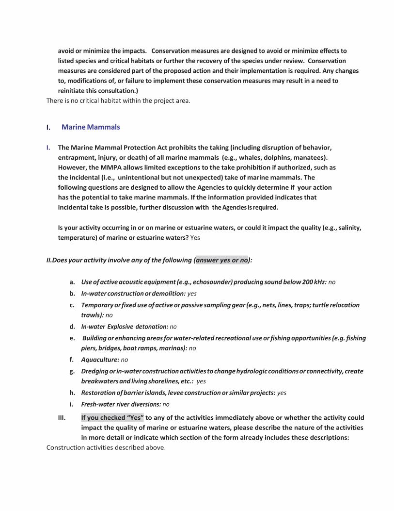
I. Marine Mammals
I. The Marine Mammal Protection Act prohibits the taking (including disruption of behavior, entrapment, injury, or death) of all marine mammals (e.g., whales, dolphins, manatees). However, the MMPA allows limited exceptions to the take prohibition if authorized, such as the incidental (i.e., unintentional but not unexpected) take of marine mammals. The following questions are designed to allow the Agencies to quickly determine if your action has the potential to take marine mammals. If the information provided indicates that incidental take is possible, further discussion with the Agencies is required.
Is your activity occurring in or on marine or estuarine waters, or could it impact the quality (e.g., salinity, temperature) of marine or estuarine waters? Yes
II.Does your activity involve any of the following (answer yes or no):
a. Use of active acoustic equipment (e.g., echosounder) producing sound below 200 kHz: no
b. In-water construction or demolition: yes
c. Temporary or fixed use of active or passive sampling gear (e.g., nets, lines, traps; turtle relocation trawls): no
d. In-water Explosive detonation: no
e. Building or enhancing areas for water-related recreational use or fishing opportunities (e.g. fishing piers, bridges, boat ramps, marinas): no
f. Aquaculture: no
g. Dredging or in-water construction activities to change hydrologic conditions or connectivity, create breakwaters and living shorelines, etc.: yes
h. Restoration of barrier islands, levee construction or similar projects: yes
i. Fresh-water river diversions: no
III. If you checked “Yes” to any of the activities immediately above or whether the activity could impact the quality of marine or estuarine waters, please describe the nature of the activities in more detail or indicate which section of the form already includes these descriptions:
Construction activities described above.

Sea turtles and marine mammals present in project areas where dredging or underwater use of equipment is occurring could be adversely affected by temporary increases in noise and turbidity, water quality changes, alteration or loss of habitats, entrapment, and potential interactions with dredging equipment. Potential minor adverse effects of this project could include disturbance to marine mammals, sea turtles, and birds in nearshore waters from increased vessel traffic. Additional minor long-term adverse impacts to species would stem from the conversion of existing subsided habitat to salt marsh, and the loss of habitat associated with that action. If disturbed mobile organisms including birds, sea turtles, and marine mammals would likely leave the area to avoid impacts from construction activities. BMPs including the Sea Turtle and Smalltooth Sawfish Construction Conditions (NMFS 2006) would be followed. If marine mammals are sighted within 50 feet of the construction area, work would stop until the animals move away from the area under their own volition. Therefore, no incidental take of marine mammals is anticipated. Bottlenose dolphins could be present, albeit not likely, in the action area. Impacts to wildlife would be avoided via management guidelines and techniques as appropriate. BMPs as described above for sea turtles and manatees will be implemented along with the NMFS 2008 vessel strike avoidance measures. Any potential minor, adverse effects to bottlenose dolphins in the project area are likely to be offset by implementing the BMPs discussed above, including having someone observe when marine mammals enter the project area. Therefore, no incidental take of dolphins is anticipated. However, the creation of additional highly-productive marsh habitat is anticipated to be largely ecologically beneficial. The creation of up to 150 acres of additional salt marsh habitat generates additional EFH habitat for many ecologically and economically important fish and invertebrate species, including but not limited to those listed above. This project would also generate additional bird habitat, which is crucial along the central flyway migration route, and benefit the wintering, nesting, and foraging species that regularly utilize the project area. IV. Are any measures planned to mitigate potential impacts to marine mammals? yes
If yes, provide text in below.
In addition to implementing measures described above for manatees and sea turtles (section H), the 2008 NMFS vessel strike avoidance measures will also be implemented. If marine mammals are sighted within 50 feet of the construction area and could be affected (e.g. work would not be stopped if a dolphin was sighted on the outside of a levee), work would stop until the animals move away from the area under their own volition. Any potential minor, adverse effects to marine mammals in the project area are likely to be offset by implementing the BMPs discussed above, including having someone observe when marine mammals enter the project area. Therefore, no incidental take of dolphins is anticipated. This project will follow the PDCs described in NMFS’s Framework Biological Opinion on Deepwater Horizon

Oil Spill Final Programmatic Damage Assessment and Restoration Plan and Final Programmatic Impact Statement (SER-2015-17459). NMFS’ PDCs consider where construction would occur, construction methodologies, BMPs that would be implemented, and reporting requirements (NOAA 2016).
J. Bald Eagles Are bald eagles present in the action area? Yes, bald and golden eagles potentially forage within the project component location. There are no nests in the project area. If YES, the following conservation measures should be implemented: 1.If bald eagle breeding or nesting behaviors are observed or a nest is discovered or known, all activities (e.g., walking, camping, clean-up, use of a UTV, ATV, or boat) should avoid the nest by a minimum of 660 feet. If the nest is protected by a vegetated buffer where there is no line of sight to the nest, then the minimum avoidance distance is 330 feet. This avoidance distance shall be maintained from the onset of breeding/courtship behaviors until any eggs have hatched and eaglets have fledged (approximately 6 months). 2.If a similar activity (e.g., driving on a roadway) is closer than 660 feet to a nest, then you may maintain a distance buffer as close to the nest as the existing tolerated activity. 3.If a vegetated buffer is present and there is no line of sight to the nest and a similar activity is closer than 330 feet to a nest, then you may maintain a distance buffer as close to the nest as the existing tolerated activity. 4.In some instances, activities conducted at a distance greater than 660 feet of a nest may result in disturbance. If an activity appears to cause initial disturbance, the activity shall stop and all individuals and equipment will be moved away until the eagles are no longer displaying disturbance behaviors.
Will you implement the above measures? No, since the project area is open water, they would not be nesting in the action area. Therefore the conservation measures would not be necessary. If these measures cannot be implemented, then you must contact the Service’s Migratory Bird Permit Office. Texas – (505) 248-7882 or by email: [email protected]
K. Migratory Birds Identify the species anticipated in the action area and behaviors (breeding, roosting, foraging) anticipated during project implementation. You may list similar species on a single line and categorize by type (e.g., Wading birds - great blue heron, snowy egret, reddish egret). If species or habitat impacts could occur, identify avoidance and minimization measures to prevent incidental take. Incidental take of Migratory Birds cannot be authorized. Use additional tables on the next page if needed.

Species/Species Group Behavior
Species/Habitat Impacts and Conservation Measures to Minimize Impacts
Waterfowl Roosting and Foraging
Open water associated with the project site is used by wintering waterfowl. Work associated with the project may disturb birds and cause them to move from areas of project activity to adjacent areas.
Loons and grebes Roosting and foraging
Open water associated with the project site is used by wintering and migrating loons and grebes. Work associated with the project may disturb birds and cause them to move from areas of project activity to adjacent areas. The site is used by anglers and visiting public and birds are habituated to some level of human activity.
Pelicans and allies Roosting and foraging
Open water and shoreline associated with the project site are used by pelicans and cormorants year-round. Work associated with the project may disturb birds and cause them to move from areas of project activity to adjacent areas.
Wading Birds Roosting and Foraging
Shorelines and wetlands associated with the project site are used by wading birds (herons, egrets, and ibis) year-round. Work associated with the project may disturb birds and cause them to move from areas of project activity to adjacent areas.
Rails and Coots Nesting, Roosting, and Foraging
Waters and wetlands associated with the project site are used by rails and coots. The Clapper Rail may nest during the breeding season. Work associated with the project may disturb roosting and foraging birds and cause them to move from areas of project activity to adjacent areas. Nesting habitat (heavily vegetated areas) for the Clapper Rail will be avoided.
Shorebirds Nesting, Roosting, and Foraging
Shorelines and tidal flats associated with the project site are used by shorebirds year-round. Species that may nest include the Willet, Killdeer, and Wilson's Plover. Work associated with the project may disturb roosting and foraging birds and cause them to move from areas of project activity to adjacent areas. To ensure no nesting birds are affected, surveys will be performed to guide project activity so that impacts to nesting species are avoided.
Gulls and Terns Roosting, and Foraging
Waters and shorelines associated with project site are used by Gulls and Terns year-round. Work associated with the project may disturb roosting and foraging birds and cause them to move from areas of project activity to adjacent areas. Project activities may attract birds to forage at or near project site activities.

NEPA Documents Is the NEPA analysis for this project complete or in progress (yes or no)? yes
Does this project fall under a programmatic NEPA document different from the PDARP/PEIS? (e.g. US Army Corps
of Engineers, BOEM or other agency) Answer yes or no. No
Fish and Wildlife Coordination Act (FWCA) consultation initiated or completed, if applicable? (answer yes or no) Not applicable
If yes to any question above, please provide details in the text box below (i.e. link to the document, or name of the document, year, lead federal agency, USFWS Field Office involved, etc.). If you do not have a link, attach documents to this BE form. Any documentation or information provided will be very helpful in moving your project forward. The NEPA for this project was included as part of the Texas Trustee Implementation Group (Texas TIG). 2017. Deepwater Horizon Oil Spill Natural Resource Damage Assessment, Texas Trustee Implementation Group, Draft 2017 Texas Restoration Plan/Environmental Assessment: Restoration of Wetlands, Coastal, and Nearshore Habitats; and Oysters. May 2017. The NEPA is also addressed as part of the Deepwater Horizon Final PDARP/PEIS. http://www.gulfspillrestoration.noaa.gov/restoration-planning/gulf-plan
NMFS ESA § 7 Consultation We request that all ESA §7 consultation requests/packages be submitted electronically to: [email protected] Questions about consultation status may be directed to the email address above or by phone: Christy Fellas: 727-551-5714
USFWS ESA § 7 Consultation We request that all consultation requests/packages to USFWS be submitted electronically to: [email protected]. You will be notified when we receive your Biological Evaluation. Upon receipt, we will conduct a preliminary review and provide any comments and feedback, including any requests for modifications or additional information. If modifications or additional information is necessary, we will work with you until the Biological Evaluation form is considered complete. Once complete, we will send your Biological Evaluation to the appropriate Field Office to conduct consultation. Questions about consultation status may be directed to the email address above or by phone: Ashley Mills: 812-756-2712

Name of Person Completing this Form: Kathryn Burger
Name of Project Lead:
Date Form Completed: 7/20/17
Date Form Updated:

Endangered Species Act Programmatic Biological Opinion
Deepwater Horizon Oil Spill Restoration National Marine Fisheries Service
Complete this section only if your project qualifies for streamlined ESA consultation under the ESA Framework Programmatic Biological Opinion completed by NMFS on February 10, 2016. To be eligible for streamlined ESA consultation with NMFS, you must implement all Project Design Criteria (PDCs) applicable to your project. By checking all boxes below that apply to this project you are confirming that PDCs are incorporated into the project design and construction. The entire Biological Evaluation Form must be completed and include any information necessary to verify that all applicable PDCs are incorporated into the project. If the project incorporates more than one type of restoration, check boxes in all appropriate categories.
You must receive NMFS approval before proceeding with your project. Note that this PDC checklist does not apply to ESA consultation with USFWS.
Full text of the PDCs can be reviewed at: http://sero.nmfs.noaa.gov/protected_resources/section_7/freq_biop/documents/DWH_bo/appendix_a.pdf Marsh Creation and Enhancement – Yes Yes - Project is designed to avoid techniques and locations listed in the marsh creation PDCs 1.a-1.f Yes - Follows NMFS’ Sea Turtle and Smalltooth Sawfish Conditions (PDC 2.a) Yes - Follows NMFS’ Vessel Strike Avoidance Measures and Reporting for Mariners (PDC 2.b) Yes - All in-water work activities will be conducted during daylight hours (PDC 2.c) Yes - Spill prevention and response plan has been developed (PDC 2.d) Yes - Fill material is not sourced using hopper dredge or from sea turtle, Gulf sturgeon or smalltooth sawfish critical habitat and in-water borrow sites do not impact turtle nesting beaches (PDC 2.e) Yes - Design and materials do not create entrapment or entanglement risks to ESA-listed species and do not block migration (PDC 2.f) Yes - In-water construction does not impede sea turtle access to or from nesting sites during nesting season (PDC 2.g) Yes - Methods are employed to avoid turbidity impacts to ESA-listed species (PDCs 2.h) Yes - Monitoring plan is included and final reports will be submitted to NMFS (PDC 3 and 4)
Check the box to confirm that all applicable requirements are met and a streamlined consultation with NMFS is requested: Name of person completing this form: Kathryn Burger/Angela Schrift Date form completed:7/20/17
*You must receive NMFS approval before proceeding with your project *

1 | P a g e
Biological Evaluation Form Deepwater Horizon Oil Spill Restoration
U.S. Fish and Wildlife Service & National Marine Fisheries Service
This form will be filled out by the Implementing Trustee and used by the regulatory agencies. The formwill provide information to initiate informal Section 7 consultations under the Endangered Species Act (ESA) and may be used to document aNoEffect determinationor to initiate pre-consultation technical assistance. It is recommended that this form also be completed to inform and evaluate additional needs for compliance with the following authorities: Migratory Bird Treaty Act (MBTA), Marine Mammal Protect Act (MMPA), Coastal Barrier Resources Act (CBRA), Bald and Golden Eagle Protection Act (BGEPA) and Section 106 of the National Historic Preservation Act (NHPA). Further information may be required beyond what is captured on this form. Note: if you need additionalspace for writing, please attach pages as needed.
A. Project Identification Federal Action Agency: U.S. Fish and Wildlife Service/National Marine Fisheries Service
Agency Contact(s) USFWS: Ashley Mills at 812-756-2712 and [email protected] NMFS: Christy Fellas at 727-551-5714 and [email protected]
I. Implementing Trustee Texas Parks and Wildlife Department (TPWD) – for purposes of this BE form only
II. Applicant Contact Person Angela Schrift/Kathryn Burger
III. Phone 512-389-8755; 512-389-8153 Email: [email protected]; [email protected]
IV. Project Name and ID# (Official name of project and ID number assigned by action agency) Follets Island Habitat Acquisition
V. NMFS Office (Choose appropriate office based on project location) NMFS Southeast Regional Office

VI. FWS Office (Choose appropriate office based on project location) Texas Coastal Ecological Services Field Office, Houston, TX
VII. Project Type 1 Restoration Type: Wetlands, Coastal, and Nearshore Habitats
VIII. Project Type 2, if helpful
B. Project Location I. Project Location
The project area is located on Follets Island and is bordered to the northwest by Drum Bay and Christmas Bay and to the southeast by the Gulf of Mexico (Figure 1). Follets Island is situated within the Gulf Prairies and Marshes ecological region and recognized by the USFWS as a nationally significant coastal barrier ecosystem. The entire northern shoreline of Christmas Bay is protected within the Brazoria NWR, and Christmas Bay is designated as a coastal preserve. This project would increase protection for the coastal ecosystem and it would complement the existing Follets Island Conservation Initiative (property owned and managed by TPWD), the Christmas Bay Coastal Preserve (jointly managed by TPWD and TGLO), and other adjacent coastal preservation activities.
II. State & County/Parish of Project Site Brazoria County, Texas
III. Latitude & Longitude for Project Site (Decimal degrees and datum [e.g., 27.71622°N, 80.25174°W NAD83] [online conversion: https://www.fcc.gov/encyclopedia/degrees-minutes-seconds-tofrom-decimal-degrees]) Approximate 29.037371N, 95.177958° W; WGS 84
IV. Township, range and section of the project area Texas does not use the public land survey system.
C. Description of Action Area #1 Attach a separate map delineating where the action will occur.

Figure 1. The general action area is located on Follets Island. The action area would only include
properties that were actually acquired through fee-simple acquisition. #2 Describe ALL areas that may be affected directly or indirectly by the action and not merely the immediate action area involved in the action, or just where species or critical habitat may be present. Provide a description of the existing environmental conditions and characteristics (e.g., topography, vegetation type, soil type, substrate type, water quality, water depth, tidal/riverine/estuarine, hydrology and drainage patterns, current flow and direction), and land uses (e.g., public, residential, commercial, industrial, agricultural). The action area is located on Follets Island and is bordered to the northwest by Drum Bay and Christmas Bay and to the southeast by the Gulf of Mexico (Figure 1). Follets Island is situated within the Gulf Prairies and Marshes ecological region and recognized by the USFWS as a nationally significant coastal barrier ecosystem. The entire northern shoreline of Christmas Bay is protected within the Brazoria NWR, and Christmas Bay is designated as a coastal preserve. This project would increase protection for the coastal ecosystem and it would complement the existing Follets Island Conservation Initiative (property owned and managed by TPWD), the Christmas Bay Coastal Preserve (jointly managed by TPWD and TGLO), and other adjacent coastal preservation activities. #3 If habitat for species is present in the action area, provide a general description of the current state of the habitat.

Recognized by the U.S. Fish and Wildlife Service as a nationally significant coastal barrier ecosystem, Follets Island is situated within the Gulf Prairies and Marshes ecological region and borders Drum and Christmas Bays. Ecological habitats in the project area include beaches, dunes, strand plains, coastal prairies, and wetlands. Seagrasses are located within waters adjacent to the project area but are not within the action area. Christmas Bay is a bay of uniquely high quality that is relatively unaltered by human activity, demonstrated by its designation as a Coastal Preserve. The land north of and adjacent to the Christmas Bay Coastal Preserve is the Brazoria National Wildlife Refuge, which further protects extensive coastal prairies and marshes and the water quality and wildlife habitat north of Christmas Bay. # 4 Identify any management or other activities already occurring in the area. The land is in private ownership. #5 Provide or attach a detailed map of the area of potential effect for ground disturbing activities if the area is different from the action area.
a. Waterbody (If applicable. Name the body of water, including wetlands (freshwater or estuarine), on which the project is located. If the location is in a river or estuary, please approximate the navigable distance from the project location to the marine environment.)
There are wetlands on Follets Island in the acquisition area. No open waters are in the area proposed for acquisition.
b. Existing Structures (If applicable. Describe the current and historical structures found in the action area (e.g., buildings, parking lots, docks, seawalls, groynes, jetties, marina.)). If known, please provide the years of construction.
There are no existing structures in the areas proposed for acquisition.
c. Seagrasses & Other Marine Vegetation (If applicable. Describe seagrasses found in action area. If a benthic survey was done, provide the date it was completed and a copy of the report. Estimate the species area of coverage and density. Attach a separate map showing the location of the seagrasses in the action area.)
There are no seagrasses located in the area being acquired. Seagrasses will not be adversely affected directly or indirectly by any actions taken as a result of this project.
d. Mangroves (If applicable. Describe the mangroves found in action area. Indicate the species found
(red, black, white), the species area of coverage in square footage and linear footage along project shoreline. Attach a separate map showing the location of the mangroves in the action area.)

There are no mangroves present in the proposed project site.
e. Corals (If applicable. Describe the corals found in action area. If a benthic survey was done, provide
the date it was completed and a copy of the report. Estimate the species area of coverage and density. Attach a separate map showing the location of the corals in the action area.)
There are no corals in the project area. Appropriate habitat does not exist.
f. Uplands (If applicable. Describe the current terrestrial habitat in which the project is located (e.g.
pasture, forest, meadows, beach and dune habitats, etc.). The project would conserve dune, coastal strand prairie, and marsh habitat in perpetuity through fee-simple acquisition. Once acquired, the land would be transferred to and managed by the Texas Parks and Wildlife Department for the purpose of habitat preservation. There will be no take of migratory birds.
g. Marine Mammals (If applicable. Indicate and describe the species found in the action area. Use NMFS' Stock Assessment Reports (SARs) for more information, see http://www.nmfs.noaa.gov/pr/sars/region.htm)
Not applicable.
D. Project Description I. Construction Schedule (What is the anticipated schedule for major phases of work? Include duration of in-water work.) No construction has been identified for implementation at this time. Once acquired, the land would be protected in perpetuity by a governmental agency. Initially the land would be transferred to TPWD and access to and through the property would be administered through current state regulations and laws. The land would be protected from development long-term by imposition of restrictions on development and subdivision of the property and by designation as a conserved area. TPWD would also work with the Texas TIG to develop an appropriate formal management plan for the tracts that would be protective of existing ecological services. TPWD anticipates leveraging existing agreements and relationships with private and public organizations in the area. For example, TPWD currently has an agreement with Brazoria County to provide trash haul-off on lands owned by TPWD that are part of the Follets Island Conservation Initiative. Passive recreation activities such as fishing from the shore and wildlife viewing would be allowed on the property. No new structures are proposed as part of this project. There would be clear signs to designate the appropriate use of vehicles and other activities on the land, restricting vehicles to

appropriate designated roads and access easements. Utilization of the area by the public is not anticipated to be heavy. Potential management activities such as the installation of bollards may occur to preserve habitat quality. The area would also be patrolled by law enforcement professionals to enforce regulations that prevent illegal vehicular activity, which damages ecological resources. No off-road access would be allowed except through current legal beach access easements. Under current Texas laws and regulations the “wet” beach is a public access area open to vehicular travel. Any changes to these laws and regulations are subject to the Texas Open Beaches Act, as administered by the TGLO.
II. Describe the Proposed Action: #1 What is the purpose and need of the proposed action?
The Texas TIG has undertaken this restoration planning effort to meet the purpose of restoring those natural resources and services injured as a result of the Deepwater Horizon Oil Spill. This project’s purpose is to begin to restore wetlands, coastal, and nearshore habitats injured as a result of the Spill.
#2 How do you plan to accomplish it? Describe in detail the construction equipment and methods** needed; permanent vs. temporary impacts; duration of temporary impacts; dust, erosion, and sedimentation controls; restoration areas; if the project is growth-inducing or facilitates growth; whether the project is part of a larger project or plan; and what permits will need to be obtained. The Follets Island Habitat Acquisition project would acquire and conserve approximately 300 acres of wetland and coastal habitats on Follets Island between San Luis Pass and Drum Bay in Brazoria County, Texas. The project would conserve dune, coastal strand prairie, and marsh habitat in perpetuity through fee-simple acquisition. Once acquired, the land would be transferred to and managed by the TPWD for the purpose of habitat preservation. See D. I. for additional information about potential management activities. When specific locations and management activities (e.g., installing signage and/or bollards) are identified, Implementing Trustees will determine if any protected species and/or designated critical habitat occur in those areas. If occurrence is known or likely, Implementing Trustees will identify potential impacts as well as measures to avoid or minimize impacts such that when implemented, impacts are insignificant or discountable. If a determination of "may affect, not likely to adversely affect" cannot be made, this consultation will be reinitiated. Re-initiation will also be required if the project description changes, or new information reveals that the effects of the proposed action may affect listed species in a manner or to an extent not considered, or a new species or critical habitat is designated that may be affected by the proposed action.

What permits will need to be obtained? No permits are needed for this project. #3 Attach a separate map showing project footprint, avoidance areas, construction accesses, stanging/laydown areas. **If construction involves overwater structures, pilings and sheetpiles, boat slips, boat ramps, shoreline armoring, dredging, blasting, or artificial reefs, list the method here, but complete the next section(s) in detail.
n/a
II. Specific In-Water and/or Terrestrial Construction Methods (Provide a detailed account of construction methods. It is important to include step-by-step descriptions of how demolition or removal of structures is conducted and if any debris will be moved and how. Describe how construction will be implemented, what type and size of materials will be used and if machines will be used, manual labor, or both. Indicate if work will be done from upland, barge, or both.) See above.
a. Overwater Structures #1 Is the proposed use of this structure for a docking facility or an observation platform? No #2 If no, is this a fishing pier? Public or Private? How many people are expected to fish per day? How do you plan to address hook and line captures? This is not a fishing pier. #3 Use of “Dock Construction Guidelines”? http://sero.nmfs.noaa.gov/pr/endangered%20species/Section%207/DockGuidelines.pdf This is not applicable. No dock is being constructed. #4Type of decking: Grated – 43% open space; Wooden planks or composite planks – proposed spacing? There is no decking #5Height above Mean High Water (MHW) elevation? n/a #6 Directional orientation of main axis of dock? Not applicable. #7 Overwater area (sqft)? Not applicable. b.Pilings & Sheetpiles (What type of material is the piling or sheetpiles? What size and how many will be used? Method used to install: impact hammer, vibratory hammer, jetting, etc.?) Not applicable.

c.Marinas and Boat Slips (Describe the number and size of slips and if the number of new slips changes from what is currently available at the project. Indicate how many are wet slips and how many are dry slips. Estimate the shadow effect of the boats - the area (sqft) beneath the boats that will be shaded.) Not applicable. d.Boat Ramp (Describe the number and size of boat ramps, the number of vessels that can be moored at the site (e.g., staging area) and if this is a public or private ramp. Indicate the boat trailer parking lot capacity, and if this number changes from what is currently available at the project.) Not applicable. e.Shoreline Armoring (This includes all manner of shoreline armoring (e.g., riprap, seawalls, jetties, groins, breakwaters, etc.). Provide specific information on material and construction methodology used to install the shoreline armoring materials. Include linear footage and square footage. Attach a separate map showing the location of the shoreline armoring in the action area. Not applicable. f.Dredging or digging (Provide details about dredge type (hopper, cutterhead, clamshell, etc.), maximum depth of dredging, area (ft2) to be dredged, volume of material (yd3) to be produced, grain size of material, sediment testing for contamination, spoil disposition plans, and hydrodynamic description(average current speed/direction)). If digging in the terrestrial environment, please describe fully with details about possible water jetting, vibration methods to install pilings for dune walk-over structure, or other methods. If using devices/methods/turtle relocation dredging to relocate sea turtles then describe the methods here. Not applicable. g.Blasting (Projects that use blasting might not qualify as “minor projects,” and a Biological Assessment (BA) may need to be prepared for the project. Arrange a technical consultation meeting with NMFS Protected Resources Division to determine if a BA is necessary. Please include explosive weights and blasting plan.) This project does not involve blasting activities. h.Artificial Reefs (Provide a detailed account of the artificial reef site selection and reef establishment decisions (i.e., management and siting considerations, stakeholder considerations, environmental considerations), deployment schedule, materials used, deployment methods, as well as final depth profile and overhead clearance for vessel traffic. For additional information and detailed guidance on artificial reefs, please refer to the artificial reef program websites for the particular state the project will occur in. Artificial reef creation is not part of this project.

i. Fishery Activities (Describe any use of gear that could entangle or capture protected species. This includes activities that may enhance fishing opportunities (e.g. fishing piers) or be fishery/gear research related (e.g. involve trawl gear, gillnets, hook and line gear, crab pots etc)). Gear that could entangle or capture protected species will not be used as part of this project.
E. NOAA Species & Critical Habitat and Effects Determination Requested
#1 List all species, critical habitat, proposed species and proposed critical habitat that may be found in the action area.
This project does not occur in open water. Species managed by NOAA are not located in the project area. There will be no effects to ESA-listed species under NMFS' jurisdiction.
Determination Definitions NE = no effect. This determination is appropriate when the proposed action will not directly, indirectly, or cumulatively impact, either positively or negatively, any listed, proposed, candidate species or designated/proposed critical habitat. NLAA = not likely to adversely affect. This determination is appropriate when the proposed action is not likely to adversely impact any listed, proposed, candidate species or designated/proposed critical habitat or there may be beneficial effects to these resources. Response requested is concurrence with the not likely to affect determination. This conclusion is appropriate when effects to the species or critical habitat will be wholly beneficial, discountable, or insignificant. Beneficial effects are contemporaneous positive effects without any adverse effects to the species or habitat. Insignificant effects relate to the size of the impact, while discountable effects are those that are extremely unlikely to occur. Based on best judgment, a person would not: (1) be able to meaningfully measure, detect, or evaluate insignificant effects; or (2) expect discountable effects to occur. If the Services concur in writing with the Action Agency’s determination of "is not likely to adversely affect" listed species or critical habitat, the section 7 consultation process is completed. LAA = likely to adversely affect. This determination is appropriate when the proposed action is likely to adversely impact any listed, proposed, candidate species or designated/proposed critical habitat. Response requested for listed species is formal consultation for action with a likely to adversely affect determination, with a biological opinion as the concluding document. Response requested for proposed and candidate species is “Conference.” This conclusion is reached if any adverse effect to listed species or critical habitat may occur as a direct or indirect result of the proposed action or its interrelated or interdependent actions, and the effect is not discountable or insignificant. In the event the overall effect of the proposed action is beneficial to the listed species or critical habitat, but may also cause some adverse effect on individuals of the listed species or segments of the critical habitat, then the determination is "likely to adversely affect." Any LAA determination requires formal section 7 consultation and will require additional information.
#2 Attach a separate map identifying species/critical habitat locations within the action area. Identify if Gulf sturgeon are in marine or in freshwater in your Species and/or Critical Habitat list to determine which federal agency will perform the analysis (e.g. Gulf sturgeon CH - marine). Identify if sea turtles are in water or on land in your Species and/or Critical Habitat list to determine which federal agency will perform the analysis (e.g. Loggerhead sea turtle CH - terrestrial).
There is no critical habitat within the project area.

F. USFWS Species & Critical Habitat and Effects Determination Requested #1 List all species, critical habitat, proposed species and proposed critical habitat that may be found in the action area.
Species and/or Critical Habitat
CH Unit (if applicable)
Location (sea turtles
only) Determination
Loggerhead Sea Turtle n/a Terrestrial No Effect Green Sea Turtle n/a Terrestrial No Effect Kemp’s Ridley Sea Turtle n/a Terrestrial
May Affect, Not Likely to Adversely Affect
Leatherback Sea Turtle n/a Terrestrial No Effect Hawksbill Sea Turtle n/a Terrestrial No Effect Whooping Crane n/a No Effect
Piping Plover n/a May Affect, Not Likely to Adversely Affect
Red Knot n/a May Affect, Not Likely to Adversely Affect
#2 Attach a separate map identifying species/critical habitat locations within the action area. For information on species and critical habitat under USFWS jurisdiction, visit http://www.fws.gov/endangered/species/. Identify if Gulf sturgeon are in marine or in freshwater in your Species and/or Critical Habitat list to determine which federal agency will perform the analysis (e.g. Gulf sturgeon CH - marine). Identify if sea turtles are in water or on land in your Species and/or Critical Habitat list to determine which federal agency will perform the analysis (e.g. Loggerhead sea turtle CH - terrestrial).
There is no critical habitat within the project area.
Determination Definitions
NE = no effect. This determination is appropriate when the proposed action will not directly, indirectly, or cumulatively impact, either positively or negatively, any listed, proposed, candidate species or designated/proposed critical habitat. NLAA = not likely to adversely affect. This determination is appropriate when the proposed action is not likely to adversely impact any listed, proposed, candidate species or designated/proposed critical habitat or there may be beneficial effects to these resources. Response requested is concurrence with the not likely to affect determination. This conclusion is appropriate when effects to the species or critical habitat will be wholly beneficial, discountable, or

insignificant. Beneficial effects are contemporaneous positive effects without any adverse effects to the species or habitat. Insignificant effects relate to the size of the impact, while discountable effects are those that are extremely unlikely to occur. Based on best judgment, a person would not: (1) be able to meaningfully measure, detect, or evaluate insignificant effects; or (2) expect discountable effects to occur. If the Services concur in writing with the Action Agency’s determination of "is not likely to adversely affect" listed species or critical habitat, the section 7 consultation process is completed. LAA = likely to adversely affect. This determination is appropriate when the proposed action is likely to adversely impact any listed, proposed, candidate species or designated/proposed critical habitat. Response requested for listed species is formal consultation for action with a likely to adversely affect determination, with a biological opinion as the concluding document. Response requested for proposed and candidate species is “Conference.” This conclusion is reached if any adverse effect to listed species or critical habitat may occur as a direct or indirect result of the proposed action or its interrelated or interdependent actions, and the effect is not discountable or insignificant. In the event the overall effect of the proposed action is beneficial to the listed species or critical habitat, but may also cause some adverse effect on individuals of the listed species or segments of the critical habitat, then the determination is "likely to adversely affect." Any LAA determination requires formal section 7 consultation and will require additional information.
G. Effects of the Proposed Project
I. Explain the potential beneficial and adverse effects to each species listed above (Describe what, when, and how the species will be impacted and the likely response to the impact. Be sure to include direct, indirect, interdependent, interrelated, connected actions, and cumulative impacts. Where possible, quantify effects. If species are present (or potentially present) and will not be adversely affected describe your rationale. If species are unlikely to be present in the general area or action area, explain why. This justification provides documentation for your administrative record, avoids the need for additional correspondence regarding the species, and helps expedite review.)
Piping Plover:
This project would benefit piping plovers. Much of the land is currently in private ownership and there is no oversight to how the land is managed. Transferring properties to public ownership will allow for management activities to occur that would remove human impacts.
Any adverse impacts associated with management activities to remove human impacts would be minimal and would ultimately benefit the species.
Red Knot:
This project would benefit red knots. Much of the land is currently in private ownership and there is no oversight to how the land is managed. Transferring properties to public ownership will allow for

management activities to occur that would remove human impacts. Any adverse impacts associated with management activities to remove human impacts would be minimal and would ultimately benefit the species.
Green Sea Turtle:
This project would benefit green sea turtles. Much of the land is currently in private ownership and there is no oversight to how the land is managed. Transferring properties to public ownership will allow for management activities to occur that would remove human impacts. Any adverse impacts associated with management activities to remove human impacts would be minimal and would ultimately benefit the species.
Although nesting habitat is present, this species is not known to nest in the project area. In coordination with the National Park Service’s Sea Turtle Recovery Project, nest detection patrols occur on the entire Texas Gulf of Mexico beachfront to some extent during the sea turtle nesting season. Any sea turtle nests located are excavated and the eggs are relocated to Padre Island National Seashore, on the southern Texas coast, for incubation. No impacts are anticipated.
Kemp’s Ridley Sea Turtle:
This project would benefit Kemp’s Ridley sea turtles. Much of the land is currently in private ownership and there is no oversight to how the land is managed. Transferring properties to public ownership will allow for management activities to occur that would remove human impacts. Any adverse impacts associated with management activities to remove human impacts would be minimal and would ultimately benefit the species.
Since Kemp’s Ridley sea turtle is a day-time nester and egg hatching also usually occurs during the day, lighting does not have much of an effect on biological processes for this species. In coordination with the National Park Service’s Sea Turtle Recovery Project, nest detection patrols occur on the entire Texas Gulf of Mexico beachfront to some extent during the sea turtle nesting season. Any sea turtle nests located are excavated and the eggs are relocated to Padre Island National Seashore, on the southern Texas coast, for incubation. No impacts are anticipated.
Loggerhead Sea Turtle:
This project would benefit loggerhead sea turtles. Much of the land is currently in private ownership and there is no oversight to how the land is managed. Transferring properties to public ownership will allow for management activities to occur that would remove human impacts. Any adverse impacts associated with management activities to remove human impacts would be minimal and would ultimately benefit the species.
Although nesting habitat is present, this species rarely nests on the upper Texas coast. In coordination with the National Park Service’s Sea Turtle Recovery Project, nest detection patrols occur on the entire Texas Gulf of Mexico beachfront to some extent during the sea turtle nesting season. Any sea turtle

nests located are excavated and the eggs are relocated to Padre Island National Seashore, on the southern Texas coast, for incubation. No impacts are anticipated.
Hawksbill Sea Turtle:
This project could benefit sea turtles. Much of the land is currently in private ownership and there is no oversight to how the land is managed. Transferring properties to public ownership will allow for management activities to occur that would remove human impacts. Any adverse impacts associated with management activities to remove human impacts would be minimal and would ultimately benefit the species.
Although nesting habitat is present, this species is not known to nest on the upper Texas coast. In coordination with the National Park Service’s Sea Turtle Recovery Project, nest detection patrols occur on the entire Texas Gulf of Mexico beachfront to some extent during the sea turtle nesting season. Any sea turtle nests located are excavated and the eggs are relocated to Padre Island National Seashore, on the southern Texas coast, for incubation. No impacts are anticipated.
Leatherback Sea Turtle:
This project could benefit sea turtles. Much of the land is currently in private ownership and there is no oversight to how the land is managed. Transferring properties to public ownership will allow for management activities to occur that would remove human impacts. Any adverse impacts associated with management activities to remove human impacts would be minimal and would ultimately benefit the species.
Although nesting habitat is present, this species is not known to nest on the upper Texas coast. The only recent recorded nesting was on Padre Island National Seashore. In coordination with the National Park Service’s Sea Turtle Recovery Project, nest detection patrols occur on the entire Texas Gulf of Mexico beachfront to some extent during the sea turtle nesting season. Any sea turtle nests located are excavated and the eggs are relocated to Padre Island National Seashore, on the southern Texas coast, for incubation. No impacts are anticipated.
Whooping Crane:
There will be no effect to this species since it is not within the project area.
II. Explain the potential beneficial and adverse effects to critical habitat listed above (Describe what, when, and how the critical habitat will be impacted and the likely response to the impact. Be sure to include direct, indirect, interdependent, interrelated, connected actions, and cumulative impacts. Where possible, quantify effects (e.g. acres of habitat, miles of habitat). Describe your rationale if designated or proposed critical habitats are present and will not be adversely affected.
There is no critical habitat in the action area.

H. Actions to Reduce Adverse Effects
Explain the actions to reduce adverse effects to each species listed above (For each species for which impacts were identified, describe any conservation measures (e.g. BMPs) that will be implemented to avoid or minimize the impacts. Conservation measures are designed to avoid or minimize effects to listed species and critical habitats or further the recovery of the species under review. Conservation measures are considered part of the proposed action and their implementation is required. Any changes to, modifications of, or failure to implement these conservation measures may result in a need to reinitiate this consultation.)
Piping Plover:
The project may affect, but is not likely to adversely affect this species. The piping plover is a winter resident on the Texas coast, arriving in late July or early August, and may remain for up to nine months. Management activities, although unknown at this time, may occur when piping plover are present along the Texas coastline. Piping plovers, if present and disturbed by management activities, are expected to move to nearby habitat that is within their normal flying distances for daily foraging movement.
Red Knot:
The project may affect, but is not likely to adversely affect this species. The red knot is primarily migratory in the project area, using beach and bayside tidal flats to forage and rest. Management activities, although unknown at this time, may occur when the species could be present along the Texas coastline. Individual red knots could rest and forage in the general area, along the shoreline and wetlands. Red knots, if present and disturbed by management activities, are expected to move to nearby habitat that is within their normal flying distances for daily foraging movement.
Green Sea Turtle:
The project would not affect this species. Although nesting habitat is present, this species is not known to nest in the project area. In coordination with the National Park Service’s Sea Turtle Recovery Project, nest detection patrols occur on the entire Texas Gulf of Mexico beachfront to some extent during the sea turtle nesting season. Any sea turtle nests located are excavated and the eggs are relocated to Padre Island National Seashore, on the southern Texas coast, for incubation.
Kemp’s Ridley Sea Turtle
The project may affect, but is not likely to adversely affect this species. If management activities, which are unknown at this time, could occur during sea turtle nesting season, Implementing Trustees will identify potential impacts as well as measures to avoid or minimize impacts such that when implemented, impacts are insignificant or discountable. If a determination of "may affect, not likely to adversely affect" cannot be made, this consultation will be reinitiated.

In coordination with the National Park Service’s Sea Turtle Recovery Project, nest detection patrols occur on the entire Texas Gulf of Mexico beachfront to some extent during the sea turtle nesting season. Any sea turtle nests located are excavated and the eggs are relocated to Padre Island National Seashore, on the southern Texas coast, for incubation.
Loggerhead Sea Turtle:
The project would not affect this species. Although nesting habitat is present, this species rarely nests on the upper Texas coast. In coordination with the National Park Service’s Sea Turtle Recovery Project, nest detection patrols occur on the entire Texas Gulf of Mexico beachfront to some extent during the sea turtle nesting season. Any sea turtle nests located are excavated and the eggs are relocated to Padre Island National Seashore, on the southern Texas coast, for incubation.
Hawksbill Sea Turtle:
The project would not affect this species. Although nesting habitat is present, this species is not known to nest on the upper Texas coast. In coordination with the National Park Service’s Sea Turtle Recovery Project, nest detection patrols occur on the entire Texas Gulf of Mexico beachfront to some extent during the sea turtle nesting season. Any sea turtle nests located are excavated and the eggs are relocated to Padre Island National Seashore, on the southern Texas coast, for incubation.
Leatherback Sea Turtle:
The project would not affect this species. Although nesting habitat is present, this species is not known to nest on the upper Texas coast. In coordination with the National Park Service’s Sea Turtle Recovery Project, nest detection patrols occur on the entire Texas Gulf of Mexico beachfront to some extent during the sea turtle nesting season. Any sea turtle nests located are excavated and the eggs are relocated to Padre Island National Seashore, on the southern Texas coast, for incubation.
Whooping Crane:
There will be no effect to this species since it is not within the project area.
II. Explain the actions to reduce adverse effects to critical habitat listed above (For critical habitat for which impacts were identified, describe any conservation measures (e.g. BMPs) that will be implemented to avoid or minimize the impacts. Conservation measures are designed to avoid or minimize effects to listed species and critical habitats or further the recovery of the species under review. Conservation measures are considered part of the proposed action and their implementation is required. Any changes to, modifications of, or failure to implement these conservation measures may result in a need to reinitiate this consultation.)
There is no critical habitat within the project area.

I. Marine Mammals
I. The Marine Mammal Protection Act prohibits the taking (including disruption of behavior, entrapment, injury, or death) of all marine mammals (e.g.,whales, dolphins, manatees). However, the MMPA allows limited exceptions to the take prohibition if authorized, such as the incidental (i.e., unintentional but not unexpected) take of marine mammals. The following questions are designed to allow the Agencies to quickly determine if your action has the potential to take marine mammals. If the information provided indicates that incidental take is possible, further discussion with the Agencies is required.
Is your activity occurring in or on marine or estuarine waters, or could it impact the quality (e.g., salinity, temperature) of marine or estuarine waters? Answer yes or no.
No.
II.Does your activity involve any of the following (answer yes or no): No.
a. Use of active acoustic equipment (e.g., echosounder) producing sound below 200 kHz
b. In-water construction or demolition
c. Temporary or fixed use of active or passive sampling gear (e.g., nets, lines, traps; turtle relocation trawls)
d. In-water Explosive detonation
e. Building or enhancing areas for water-related recreational use or fishing opportunities (e.g. fishing piers, bridges, boat ramps, marinas)
f. Aquaculture
g. Dredging or in-water construction activities to change hydrologic conditions or connectivity, create breakwaters and living shorelines, etc.
h. Restoration of barrier islands, levee construction or similar projects
i. Fresh-water river diversions
III. If you checked “Yes” to any of the activities immediately above or whether the activity could impact the quality of marine or estuarine waters, please describe the nature of the activities in more detail or indicate which section of the form already includes these descriptions:

IV. Are any measures planned to mitigate potential impacts to marine mammals? (answer yes or no)
If yes, provide text in below.
J. Bald Eagles Are bald eagles present in the action area? (answer yes or no) There are no bald or golden Eagle nests in the action area. Nesting habitat for these species is not present. One bald eagle was observed on Follets Island in 2014 (ebird.org) and there have been no observances of golden eagles on Follets Island. Bald and golden eagles could potentially forage within the project location. If YES, the following conservation measures should be implemented: 1.If bald eagle breeding or nesting behaviors are observed or a nest is discovered or known, all activities (e.g., walking, camping, clean-up, use of a UTV, ATV, or boat) should avoid the nest by a minimum of 660 feet. If the nest is protected by a vegetated buffer where there is no line ofsight to the nest, then the minimum avoidance distance is 330 feet. This avoidance distance shall be maintained from the onset of breeding/courtship behaviors until any eggs have hatched and eaglets have fledged (approximately 6 months). 2.If a similar activity (e.g., driving on a roadway) is closer than 660 feet to a nest, then you may maintain a distance buffer as close to the nest as the existing tolerated activity. 3.If a vegetated buffer is present and there is no line of sight to the nest and a similar activity is closer than 330 feet to a nest, then you may maintain a distance buffer as close to the nest as the existing tolerated activity. 4.In some instances, activities conducted at a distance greater than 660 feet of a nest may result in disturbance. If an activity appears to cause initial disturbance, the activity shall stop and all individuals and equipment will be moved away until the eagles are no longer displaying disturbance behaviors.
Will you implement the above measures? (answer yes or no) Yes, if applicable. If these measures cannot be implemented, then you must contact the Service’s Migratory Bird Permit Office. Texas – (505) 248-7882 or by email: [email protected]

K. Migratory Birds Identify the species anticipated in the action area and behaviors (breeding, roosting, foraging) anticipated during project implementation. You may list similar species on a single line and categorize by type (e.g., Wading birds - great blue heron, snowy egret, reddish egret). If species or habitat impacts could occur, identify avoidance and minimization measures to prevent incidental take. Incidental take of Migratory Birds cannot be authorized. Use additional tables on the next page if needed. There will be no take of migratory birds. If management activities, which are unknown at this time, occur during the nesting season and could potentially cause the harassment of nesting migratory birds, the action area will be surveyed for the presence of nesting birds by a qualified biologist. If nesting birds are present or indications of pre-nesting behavior are observed, appropriate BMPs will be employed to ensure that no incidental take of any individuals occurs. BMPs will be coordinated with USFWS prior to implementation of activities that could potentially cause harassment, per the Migratory Bird Treaty Act.
NEPA Documents Is the NEPA analysis for this project complete or in progress (yes or no)? yes
Does this project fall under a programmatic NEPA document different from the PDARP/PEIS? (e.g. US
Army Corps of Engineers, BOEM or other agency) Answer yes or no. No
Fish and Wildlife Coordination Act (FWCA) consultation initiated or completed, if applicable? (answer yes or no) Not applicable
If yes to any question above, please provide details in the text box below (i.e. link to the document, or name of the document, year, lead federal agency, USFWS Field Office involved, etc.). If you do not have a link, attach documents to this BE form. Any documentation or information provided will be very helpful in moving your project forward. The NEPA for this project was included as part of the Texas Trustee Implementation Group (Texas TIG). 2017. Deepwater Horizon Oil Spill Natural Resource Damage Assessment, Texas Trustee Implementation Group, Draft 2017 Texas Restoration Plan/Environmental Assessment: Restoration of Wetlands, Coastal, and Nearshore Habitats; and Oysters. May 2017. The NEPA is also addressed as part of the Deepwater Horizon Final PDARP/PEIS. http://www.gulfspillrestoration.noaa.gov/restoration-planning/gulf-plan
NMFS ESA § 7 Consultation We request that all ESA §7 consultation requests/packages be submitted electronically to: [email protected] Questions about consultation status may be directed to the email address above or by phone: Christy Fellas: 727-551-5714
USFWS ESA § 7 Consultation

We request that all consultation requests/packages to USFWS be submitted electronically to: [email protected]. You will be notified when we receive your Biological Evaluation. Upon receipt, we will conduct a preliminary review and provide any comments and feedback, including any requests for modifications or additional information. If modifications or additional information is necessary, we will work with you until the Biological Evaluation form is considered complete. Once complete, we will send your Biological Evaluation to the appropriate Field Office to conduct consultation. Questions about consultation status may be directed to the email address above or by phone: Ashley Mills: 812-756-2712 Name of Person Completing this Form: Angela Schrift
Name of Project Lead:
Date Form Completed: 7/20/2017
Date Form Updated:
Endangered Species Act Programmatic Biological Opinion
Deepwater Horizon Oil Spill Restoration National Marine Fisheries Service
Complete this section only if your project qualifies for streamlined ESA consultation under the ESA FrameworkProgrammatic Biological Opinion completed byNMFS on February 10, 2016. To be eligible for streamlined ESAconsultation with NMFS, youmust implement allProject Design Criteria (PDCs) applicable to your project. Bychecking all boxes below that apply to this project you are confirming thatPDCs are incorporated into the projectdesign and construction.The entire Biological Evaluation Form must be completed and include any information necessary to verify that all applicable PDCs are incorporated into the project. If theprojectincorporates more than one type of restoration, check boxes in all appropriate categories.
You must receive NMFS approval before proceeding with your project. Note that this PDC checklist does notapply to ESA consultation with USFWS.
Full text of the PDCs can be reviewed at:http://sero.nmfs.noaa.gov/protected_resources/section_7/freq_biop/documents/DWH_bo/appendix_a.pdf
PDCs are not applicable for this project.

1 | P a g e
Biological Evaluation Form Deepwater Horizon Oil Spill Restoration
U.S. Fish and Wildlife Service & National Marine Fisheries Service
This form will be filled out by the Implementing Trustee and used by the regulatory agencies. The form will provide information to initiate informal Section 7 consultations under the Endangered Species Act (ESA) and may be used to document a No Effect determination or to initiate pre-consultation technical assistance. It is recommended that this form also be completed to inform and evaluate additional needs for compliance with the following authorities: Migratory Bird Treaty Act (MBTA), Marine Mammal Protect Act (MMPA), Coastal Barrier Resources Act (CBRA), Bald and Golden Eagle Protection Act (BGEPA) and Section 106 of the National Historic Preservation Act (NHPA). Further information may be required beyond what is captured on this form. Note: if you need additional space for writing, please attach pages as needed.
A. Project Identification Federal Action Agency: U.S. Fish and Wildlife Service/National Marine Fisheries Service
Agency Contact(s) USFWS: Ashley Mills at 812-756-2712 and [email protected] NMFS: Christy Fellas at 727-551-5714 and [email protected]
I. Implementing Trustee Texas Commission on Environmental Quality (TCEQ) – for purposes of this BE form only
II. Applicant Contact Person Angela Schrift/Kathryn Burger
III. Phone 512-389-8755; 512-389-8153 Email: [email protected]; [email protected]
IV. Project Name and ID# (Official name of project and ID number assigned by action agency) Bessie Heights Wetland Restoration

V. NMFS Office (Choose appropriate office based on project location) NMFS Southeast Regional Office
VI. FWS Office (Choose appropriate office based on project location) Texas Coastal Ecological Services Field Office, Houston, TX
VII. Restoration Type 1 Restore and Conserve Wetlands, Coastal, and Nearshore Habitat
VIII. Project Type 2, if helpful N/A
B. Project Location I. Project Location
The Nelda Stark Unit of the Lower Neches Wildlife Management Area (WMA) in Orange County comprises approximately 3,375 acres located along the eastern bank of the Neches River approximately 5 miles north of the confluence of the Neches and Sabine Rivers at Sabine Lake. The area within and surrounding the Nelda Stark Unit is often referred to as the Bessie Heights Marsh and is also the site of the Port Neches oilfield. The project site is located about 3 miles northeast of Port Neches and about 2 miles northeast of the Neches River and only accessible via water/boat.
II. State & County/Parish of Project Site Orange County, Texas
III. Latitude & Longitude for Project Site (Decimal degrees and datum [e.g., 27.71622°N, 80.25174°W NAD83] [online conversion: https://www.fcc.gov/encyclopedia/degrees-minutes-seconds-tofrom-decimal-degrees]) Approximate 30.029121°, -93.935121°; WGS84
IV. Township, range and section of the project area Texas does not use the public land survey system.
C. Description of Action Area #1 Attach a separate map delineating where the action will occur.

3 | P a g e
Figure 1. Map showing the location of the Bessie Heights Wetland Restoration project in Orange County.
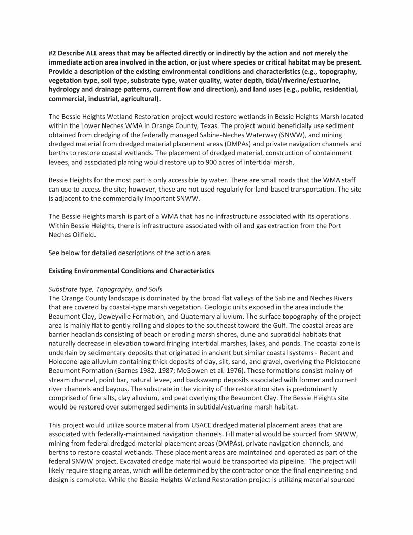
#2 Describe ALL areas that may be affected directly or indirectly by the action and not merely the immediate action area involved in the action, or just where species or critical habitat may be present. Provide a description of the existing environmental conditions and characteristics (e.g., topography, vegetation type, soil type, substrate type, water quality, water depth, tidal/riverine/estuarine, hydrology and drainage patterns, current flow and direction), and land uses (e.g., public, residential, commercial, industrial, agricultural). The Bessie Heights Wetland Restoration project would restore wetlands in Bessie Heights Marsh located within the Lower Neches WMA in Orange County, Texas. The project would beneficially use sediment obtained from dredging of the federally managed Sabine-Neches Waterway (SNWW), and mining dredged material from dredged material placement areas (DMPAs) and private navigation channels and berths to restore coastal wetlands. The placement of dredged material, construction of containment levees, and associated planting would restore up to 900 acres of intertidal marsh. Bessie Heights for the most part is only accessible by water. There are small roads that the WMA staff can use to access the site; however, these are not used regularly for land-based transportation. The site is adjacent to the commercially important SNWW. The Bessie Heights marsh is part of a WMA that has no infrastructure associated with its operations. Within Bessie Heights, there is infrastructure associated with oil and gas extraction from the Port Neches Oilfield. See below for detailed descriptions of the action area. Existing Environmental Conditions and Characteristics Substrate type, Topography, and Soils The Orange County landscape is dominated by the broad flat valleys of the Sabine and Neches Rivers that are covered by coastal-type marsh vegetation. Geologic units exposed in the area include the Beaumont Clay, Deweyville Formation, and Quaternary alluvium. The surface topography of the project area is mainly flat to gently rolling and slopes to the southeast toward the Gulf. The coastal areas are barrier headlands consisting of beach or eroding marsh shores, dune and supratidal habitats that naturally decrease in elevation toward fringing intertidal marshes, lakes, and ponds. The coastal zone is underlain by sedimentary deposits that originated in ancient but similar coastal systems - Recent and Holocene-age alluvium containing thick deposits of clay, silt, sand, and gravel, overlying the Pleistocene Beaumont Formation (Barnes 1982, 1987; McGowen et al. 1976). These formations consist mainly of stream channel, point bar, natural levee, and backswamp deposits associated with former and current river channels and bayous. The substrate in the vicinity of the restoration sites is predominantly comprised of fine silts, clay alluvium, and peat overlying the Beaumont Clay. The Bessie Heights site would be restored over submerged sediments in subtidal/estuarine marsh habitat. This project would utilize source material from USACE dredged material placement areas that are associated with federally-maintained navigation channels. Fill material would be sourced from SNWW, mining from federal dredged material placement areas (DMPAs), private navigation channels, and berths to restore coastal wetlands. These placement areas are maintained and operated as part of the federal SNWW project. Excavated dredge material would be transported via pipeline. The project will likely require staging areas, which will be determined by the contractor once the final engineering and design is complete. While the Bessie Heights Wetland Restoration project is utilizing material sourced

5 | P a g e
from a USACE maintenance dredging operation, the actual dredging of the SNWW is outside of the scope of this project and would occur regardless of whether or not this project was implemented. The dredging activities are not being funded through NRDA settlement money, and would occur regardless of whether the Bessie Heights Wetland Restoration is implemented. Therefore the dredging activities and source area are not included in the compliance discussion below. The SNWW sediments would vary but would include silts and sands. Existing Vegetation Type The predominant wetland habitats near the Lower Neches WMA are characterized as palustrine marsh and estuarine open water. However, no vegetation exists at the site. Water Quality, Water Depth, Tidal/Riverine/Estuarine, Hydrology and Drainage Patterns, Current Flow and Direction The site is adjacent to the commercially important SNWW. The Sabine region’s circulation and salinity patterns are complex. Fresh water enters the system through several tributaries, including the Sabine and Neches Rivers. The Sabine and Neches Rivers flow into Sabine Lake and into the Gulf of Mexico through Sabine Pass. The SNWW Navigation Channel system serves as a pathway for both freshwater from the inflowing rivers and the saltwater wedge coming up the deep draft channel through Sabine Pass. This combination results in highly stratified conditions in the navigation channel, bringing saltwater up the SNWW and into the northwest corner of Sabine Lake and the lower reaches of the Neches River. As a result, the observed salinity in Sabine Lake is highest at both the southern end, where the lake connects to Sabine Pass, and the northern end, where the lake connects to the SNWW. The lowest salinities are observed in the central and eastern portions of the lake, which are furthest from sources of salt water (USACE 2011). Natural forces, which shape the system, include dominant south to southeast winds, tropical weather systems, and a substantial rainfall of over 60 inches per year. Flooding and freshwater inflows are key systemic processes, which buffer salinity and provide nutrients and sediments to extensive estuaries in the Sabine region. The Sabine River has the largest water discharge at its mouth of any Texas river. The total basin drainage area is 9,756 square miles with 7,426 square miles within Texas borders (TCEQ n.d.). The tidal portion of the Sabine River, Texas river segment 0501, does not meet assigned water quality standards for bacteria and exceeds allowable concentrations of PCBs in fish tissue (TCEQ 2014). Sampling results of fish tissue in nearby Sabine Lake prompted the issuance of Texas Department of State Health Services Fish and Shellfish Consumption Advisory ADV-46 for Sabine Lake and all contiguous waters that recommended limited consumption of gafttopsail catfish (TDSHS 2011). The GIWW tidal portion, Neches-Trinity Coastal Basin segment 0702 adjacent to the J.D. Murphree WMA, was not found to be covered by any fish advisories and fully supported aquatic life, contact recreation, and general uses (TCEQ 2002). The Neches River has a 10,011 square mile drainage basin that intersects the Sabine River at the north end of Sabine Lake. Similar to the Sabine River tidal portion, the Neches River tidal portion, Texas River segment 0601 adjacent to Bessie Heights, does not meet water quality standards for bacteria and allowable concentrations of PCBs in fish tissue (TCEQ 2015b). This portion of the Neches River is also contiguous with Sabine Lake and subject to the ADV-16 fish consumption advisory for gafttopsail catfish. Land Uses The Bessie Heights marsh is part of a WMA that has no infrastructure associated with its operations.

Within Bessie Heights, there is infrastructure associated with oil and gas extraction from the Port Neches Oilfield. Lower Neches River WMA has 7,998 acres located near Bridge City in Orange County (TPWD 2017). The WMA is composed of three separate units. The Nelda Stark and Old River units are located adjacent to the lower Neches River. The Nelda Stark Unit is primarily shallow open water, which resulted from the degradation of a former marsh system by saltwater intrusion and subsidence. The Old River Unit, near the mouth of the Neches River, is a mixture of intermediate marsh and open water. The Bessie Heights marsh is managed by TPWD as a part of the Lower Neches WMA. The management includes the use the marsh for recreational fishing and waterfowl hunting. The project area is open water, however, hunting, fishing, hiking and wildlife viewing are regularly enjoyed by the public on the Lower Neches WMA. Bessie Heights for the most part is only accessible by water. There are small roads that the WMA staff can use to access the site; however, these are not used regularly for land-based transportation. The site is adjacent to the commercially important SNWW. Vessels use the nearby SNWW. Commercial and recreational fishing, boating, and potentially wildlife viewing does occur in the open water areas. #3 If habitat for species is present in the action area, provide a general description of the current state of the habitat. The proposed project site is currently open water. Water dependent birds use the open bay to forage and roost. These would include loons, bay ducks, gulls and terns, and pelicans. # 4 Identify any management or other activities already occurring in the area. Submerged bay bottom is managed by the state of Texas. The Bessie Heights marsh is part of a WMA that has no infrastructure associated with its operations. Within Bessie Heights, there is infrastructure associated with oil and gas extraction from the Port Neches Oilfield. Lower Neches River WMA has 7,998 acres located near Bridge City in Orange County (TPWD 2017). The WMA is composed of three separate units. The Nelda Stark and Old River units are located adjacent to the lower Neches River. The Nelda Stark Unit is primarily shallow open water, which resulted from the degradation of a former marsh system by saltwater intrusion and subsidence. The Old River Unit, near the mouth of the Neches River, is a mixture of intermediate marsh and open water. The recreational and industrial users of Bessie Heights are accustomed to navigating the marsh via the existing channels and avoiding shallow areas and areas that contain obstructions. The immediate vicinity of the project area was historically uplands habitat, but has since been inundated primarily due to subsidence from growing industry in the area. This has had adverse impacts on coastal resiliency and deleterious effects on the protectiveness of the area for storm surges. #5 Provide or attach a detailed map of the area of potential effect for ground disturbing activities if the area is different from the action area. The potential area of impact from the construction activities is shown in Figure 1. Dredged material will be placed on submerged lands to raise elevations. Underwater sediments may be trenched to allow for pipeline routing from the borrow site to the project area. Material would be utilized from maintenance dredging of the SNWW. This dredging would occur despite this restoration project, and is outside of the scope of this project.
a. Waterbody (If applicable. Name the body of water, including wetlands (freshwater or estuarine),

7 | P a g e
on which the project is located. If the location is in a river or estuary, please approximate the navigable distance from the project location to the marine environment.)
The site is adjacent to the Neches River. b. Existing Structures (If applicable. Describe the current and historical structures found in the action
area (e.g., buildings, parking lots, docks, seawalls, groynes, jetties, marina.)). If known, please provide the years of construction.
The Bessie Heights marsh is part of a WMA that has no infrastructure associated with its operations. Within Bessie Heights, there is pipeline infrastructure associated with oil and gas extraction from the Port Neches Oilfield. c. Seagrasses & Other Marine Vegetation (If applicable. Describe seagrasses found in action area. If a
benthic survey was done, provide the date it was completed and a copy of the report. Estimate the species area of coverage and density. Attach a separate map showing the location of the seagrasses in the action area.)
There are no known seagrasses in the project area. The TPWD seagrass viewer does not show any seagrasses in the project area (http://tpwd.texas.gov/gis/seagrass/).
d. Mangroves (If applicable. Describe the mangroves found in action area. Indicate the species found
(red, black, white), the species area of coverage in square footage and linear footage along project shoreline. Attach a separate map showing the location of the mangroves in the action area.)
There are no mangroves present in the proposed project site as it is open water.
e. Corals (If applicable. Describe the corals found in action area. If a benthic survey was done, provide
the date it was completed and a copy of the report. Estimate the species area of coverage and density. Attach a separate map showing the location of the corals in the action area.)
There are no corals in the project area. Appropriate habitat does not exist.
f. Uplands (If applicable. Describe the current terrestrial habitat in which the project is located (e.g.
pasture, forest, meadows, beach and dune habitats, etc.). The restoration is proposed to take place in an open water area.
No potential upland sites will be impacted by the proposed activities, with the exception of existing levees on the site. They are generally unvegetated and contain no nesting habitat. They may be utilized as resting habitat for migratory birds. Any areas with critical habitat will be avoided and the activities associated with the use of an upland borrow site would not adversely affect listed species. To the maximum extent practicable, locations with habitats of at-risk species will also be avoided.
g. Marine Mammals (If applicable. Indicate and describe the species found in the action area. Use NMFS' Stock Assessment Reports (SARs) for more information, see http://www.nmfs.noaa.gov/pr/sars/region.htm)
The bottlenose dolphin and the West Indian Manatee could potentially be in the project area. Manatees are rarely found in Texas waters, including Sabine Lake and are not expected to be found in the project area.
D. Project Description I. Construction Schedule (What is the anticipated schedule for major phases of work? Include duration of in-water work.) This project received funds for E&D in 2017 through the RESTORE Act. A USACE permit will be obtained with RESTORE funding. Other Federal compliance will be undertaken through the NRDA process. Construction and dredged material placement must been done in coordination with the USACE dredging schedule. It is estimated that the next window of availability for coordination with USACE may be 2018. Project construction may span either one or two USACE maintenance dredging cycles to gather sufficient material for marsh restoration. The schedule for the use of dredged material from private industry sources would depend on the timing of construction and maintenance of those facilities. Project construction is not expected to take longer than 6 months if only one dredge cycle is needed for sufficient material. The timing of contracting awards and weather conditions could impact the construction schedule. To prevent disturbance to nearby residential communities, construction activities that produce significant noise or require precision, such as dredging and placing material, would be limited to daylight hours. Additionally, all in water work activities will be conducted during daylight hours.
To comply with the NMFS PDCs, a monitoring report will be submitted to NMFS including the following information:
Response and outcome of any spills that occur during construction per PDC 2.d As-built project completion drawings and photos Any interactions with protected species listed in PDC 4
II. Describe the Proposed Action: #1 What is the purpose and need of the proposed action?
For the lower Neches River, from Beaumont to Sabine Lake, significant systematic change occurred between the 1950s and the 2000s as palustrine marsh was lost (reduced from 10,184 hectares (ha) to 4,279 ha) and converted to estuarine open water (increased from 694 ha to 5,080 ha). The largest

9 | P a g e
degree of loss of palustrine marsh was in the vicinity of the Lower Neches WMA where oil and gas production in the Port Neches Oil field caused subsidence via the activation of a pair of high-angle faults that promoted marsh flooding and conversion to open water (Tremblay and Calnan 2009). Previous restoration efforts in Bessie Heights have focused on restoring estuarine intertidal marsh by construction marsh terraces and through the BUDM. The proposed project would be a continuation of those efforts.
The Bessie Heights Wetland Restoration project would restore wetlands in Bessie Heights Marsh located within the Lower Neches WMA in Orange County, Texas. The project would beneficially use sediment obtained from dredging of the federally managed SNWW, and mining dredged material from DMPAs and private navigation channels and berths to restore coastal wetlands. The placement of dredged material, construction of containment levees, and associated planting would restore up to 900 acres of intertidal marsh.
#2 How do you plan to accomplish it? Describe in detail the construction equipment and methods** needed; permanent vs. temporary impacts; duration of temporary impacts; dust, erosion, and sedimentation controls; restoration areas; if the project is growth-inducing or facilitates growth; whether the project is part of a larger project or plan; and what permits will need to be obtained. To implement this project, the Texas TIG would partner with the USACE to use dredged material from the SNWW to increase elevations in areas of Bessie Heights and make them suitable for the establishment and long-term sustainability of a shallow intertidal wetland. The Texas TIG would coordinate with the USACE on this project to beneficially use dredged material from maintenance dredging of the SNWW and DMPAs. Dredged material may also be obtained from the dredging of private industrial docks, berths, and channels. The Texas TIG would coordinate with the appropriate parties for each sediment source to ensure the material is not contaminated and is appropriate for marsh restoration. The project would fund the construction of containment levees as needed to contain and dewater the dredged sediments. Sediment would be placed within these containment areas to build bottom elevations suitable for marsh growth as determined from adjacent natural wetlands. This would allow the marshes to return to sustainable and productive intertidal wetlands.
In general, construction would require the use of barges, small watercraft, large track hoe excavators, earth moving equipment, cutterhead-hydraulic or clamshell dredges, and a dockside staging area. The necessity for a staging area would be determined by the contractor during final engineering and design phases of this project. Equipment and materials for the construction activities would be transported via roads and marine waterways. Large equipment and materials moved by barges would use the established interconnected waterways. This may include the GIWW, SNWW, and/or other navigation channels. Based on existing preliminary designs, the project would place up to 4.8 million cubic yards of material to restore up to 900 acres of intertidal wetland complex. Final E&D stages for this project have recently been funded but not implemented through the RESTORE Act Bucket 2 (GCERC 2015). This project would not be implemented until the final E&D funded under the RESTORE Act have been completed. Final material volumes and acreage is dependent upon material available through adjacent dredge projects

and selected contractor capabilities. It is anticipated that the next opportunity to partner with USACE to receive dredged material for restoration purposes would be between 2018 and 2020. Depending on availability of funding, this project may run more than one USACE maintenance dredging cycle.
Estimated material volume and restored acreage is currently based on existing preliminary designs. Final material volumes and acreage is dependent upon material available through adjacent USACE dredge projects and selected contractor capabilities.
This project will comply with NOAA’s PDCs. Specifically, all project related vessels will follow NMFS’s Vessel Strike Avoidance Measures and Reporting for Mariners, and all in-water work activities will be conducted during daylight hours.
Project Construction and Installation Project proponents would engage the services of professional surveyors, coastal planners and coastal engineering firms to conduct site assessments and analyses, complete construction drawings, identify potential sources of dredged material, prepare lease and permit applications to the TGLO and USACE, and otherwise move the project to a shovel-ready state. Construction may require temporary trenches and channels to provide equipment access and routing of dredge pipelines to the restoration sites. The pipeline to transport dredge material would be temporary, and would not be buried. The pipeline will float or be sunk into the sediment depending on the safety needs or concerns of the contractor. The need for and location of temporary channels would be determined in the final E&D. All temporary channels would be backfilled upon completion of construction work. All sources of borrow material would be assessed for suitability from an engineering perspective and would be evaluated for environmental conditions to ensure sediments are uncontaminated and there are no significant impacts to cultural and sensitive resources. Hydraulic dredging utilizes in-situ water to mobilize the sediments through the pipeline. To achieve the target elevation for the restored wetlands, dredged material would be placed such that, after consolidation, elevations suitable to support intertidal marsh vegetation would be present. Mechanically excavated sediment from the existing substrates may be used to form containment levees to contain the dredged material, facilitate dewatering and protect the restoration sites from erosion until vegetation is established. After dewatering, the site would be planted with native species such as smooth cordgrass. The transplants would be propagated from upper Texas coast stocks. Specific methods and equipment used would be approved by a professional engineer (PE) and the project team that includes Texas TIG representatives and TPWD land managers prior to construction. Environmental considerations, BMPs, land use approvals, and permit requirements must be met regardless of methods and equipment chosen. These would be outlined in the bid specification package developed by the PE and contracting officers. This specification package would ensure that the contractor is made aware of the engineering specifications as well as any additional obligations they would incur associated with federal and state laws governing activities associated with the project. It would also provide the project related approvals needed by the project manager and the PE to conduct the project.
Beneficial Use of Dredged Material This project would utilize source material from ongoing dredging operations and/or material harvested

11 | P a g e
from existing placement areas that are associated with federally-maintained navigation channels. These placement areas are maintained and operated as part of the SNWW federal project. (While the Bessie Heights Wetland Restoration project is utilizing material sourced from a USACE maintenance dredging operation, the actual dredging of the SNWW is outside of the scope of this project and would occur regardless of whether or not this project was implemented. This activity is not being funded through NRDA settlement money, and therefore is not included in the compliance discussion below.) Dredged material would be used to construct containment levees as needed to contain and dewater dredged sediments. Sediment would be placed within these containment areas to build bottom elevations suitable for marsh growth as determined from adjacent natural wetlands. Containment levees may be intentionally breached or lowered as needed after dredged material dewatering in order to establish adequate tidal circulation to the restored marsh. Dredged material would be sourced from the SNWW or private navigation channels. Another method of BUDM is to mine existing USACE DMPAs that are associated with federally maintained navigation channels. Material would be mined using hydraulic excavation techniques. The Texas TIG would consider all current information to determine the appropriate level of contamination testing for sediments used in this project. For sediments from federally-maintained navigation channels or associated DMPAs, previously collected contaminant analysis and bio-assay data would be obtained from the USACE Galveston District - Operations Branch records. Based upon this information, the USACE and state and federal resource agency personnel would be consulted to determine the amount of sampling and the type of chemical analyses that may be needed. For private industry docks and channels, state and federal resource agency personnel would be consulted to determine the amount of sampling and the type of chemical analyses that may be needed. All environmental reviews required for the placement of the material obtained as part of a beneficial use disposal process would be coordinated with the project (e.g. a navigation maintenance project) supplying the dredged material. Measures to control turbidity caused by construction activities, decanting water, and sediment movement would be in place to ensure sensitive habitats are protected, water quality standards are met, and sensitive resources are not affected. These measures may include appropriate water control structures to decant water, as well as the installation of silt fences, hay bales, filter-fabric, and/or levees to control sediments and avoid negative impacts associated with the fill placement. No known oyster reefs, other hard structure reef resources, or seagrass beds are present within or adjacent to the restoration sites that would require the use of significant control measures during project implementation. Either a hydraulic cutter-head dredge or clamshell dredge would be used, as these do not pose a risk to pelagic aquatic organisms such as sea turtles. Material would be transported to the placement area via a hydraulic dredge pipeline. Location of the pipelines will be determined by the contractor. The dredge pipeline would be routed to avoid disturbance to sensitive resource areas such as oyster reefs and seagrass beds if identified along the pipeline route. Typically, pipelines would be submerged in deeper waters (where dolphins are could occur) in order to avoid impacts with marine traffic. Floating pipelines may be used in shallow water areas (approximately 3 feet or less) where dolphins are not likely to be present. Measures will be taken to ensure that floating pipelines will not trap marine mammals. Any areas containing such resources in the construction area and pipeline route would be protected using BMPs such as hay bales, silt fences or other appropriate methods.

Levees
Levees would be utilized in this project to contain dredged material and to facilitate dewatering of the dredged slurry. They also may serve to protect the restored habitat from erosion. In addition to construction of new levees, existing levees may be rehabilitated and utilized in this effort. The amount, grading, and size of material (such as rock) that may be used to stabilize the levees would be dependent on several factors determined in the final design. These include wave and current energy expected, as well as intended use of the levees. Containment levees may be intentionally breached or lowered as needed after dredged material dewatering in order to establish adequate tidal circulation to the restored marsh.
Vegetation Planting Planting of native vegetation would occur in two stages. First, once the earthen fill has dewatered and sediments have settled substantially enough, the marsh would be seeded and/or sprigged with native vegetation such as smooth cordgrass. This can help decrease the time it takes to dewater the sediments through evapotranspiration. During the second stage, once the material has settled to marsh elevations, unvegetated areas of the marsh would be planted with sprigs. Settlement could take between 1 to 5 years after initial construction. Specific targeted number of acres for vegetative plantings for the marsh site would be developed concurrently with the E&D phase of this project. Vegetation success would be monitored as a part of the project’s MAM plan. Colonization by invasive species is not likely, however there is potential for short- term growth of salt cedar. If encountered this plant and other invasive species would be removed by hand. In the long-term, these species would not survive inundation once the sediments compress to marsh elevation.
Operations and Maintenance Maintenance activities on the restored marsh sites would be managed by TPWD. Appropriate lease(s) or modifications to existing leases would be obtained prior to implementing the proposed restoration actions. TPWD has managed several similar projects to restore wetlands and marsh in the same area. As a member of the project team and the Texas TIG, TPWD would participate in final design development and be cognizant of obligations related to long-term management. A maintenance plan would be finalized concurrently with the final E&D phase of this project, which is funded through the RESTORE Act. Maintenance activities may include management of water control structures to facilitate dewatering, monitoring of levee height, and modifications to containment levees by breaching or lowering as needed after dredged material dewatering in order to establish adequate tidal circulation to the restored marsh. Is the project part of a larger project or plan?
Restoration of Texas coastal wetlands through beneficially using dredged material supports the needs or goals of several conservation plans. These plans include but are not limited to the following national, state, and regional planning documents:

13 | P a g e
Texas Coastal Management Program Final Environmental Impact Statement (NOAA and State of Texas 1996); and Gulf of Mexico Regional Sediment Management Master Plan (Gulf of Mexico Alliance 2009).
What permits will need to be obtained? A USACE permit will be needed for this project. Maintenance activities on the restored marsh sites would be managed by TPWD. Appropriate lease(s) or modifications to existing leases would be obtained prior to implementing the proposed restoration actions. #3 Attach a separate map showing project footprint, avoidance areas, construction accesses, stanging/laydown areas. **If construction involves overwater structures, pilings and sheetpiles, boat slips, boat ramps, shoreline armoring, dredging, blasting, or artificial reefs, list the method here, but complete the next section(s) in detail.
In general, construction would require the use of barges, small watercraft, large track hoe excavators, earth moving equipment, cutterhead-hydraulic or clamshell dredges, and a dockside staging area. Equipment and materials for the construction activities would be transported via roads and marine waterways. Large equipment and materials moved by barges would use the established interconnected waterways. This may include the GIWW, SNWW, and/or other navigation channels. Underwater sediments may be trenched to allow for pipeline routing from the borrow site to the project area. Material would be utilized from maintenance dredging of the SNWW. This dredging would occur despite this restoration project, and is outside of the scope of this project. Bessie Heights for the most part is only accessible by water. There are small roads that the WMA staff can use to access the site; however, these are not used regularly for land-based transportation. The site is adjacent to the commercially important SNWW. The Bessie Heights marsh is part of a WMA that has no infrastructure associated with its operations. Within Bessie Heights, there is infrastructure associated with oil and gas extraction from the Port Neches Oilfield. Coordination under Section 106 NHPA has been initiated for this project. There are no known historic sites or significant cultural, scientific, or historic resources in the area that would be affected by the proposed restoration actions. No cultural, scientific, or historic resources are known to be located in the vicinity of the project. Prior to any work which could impact cultural resources a full and complete review under Section 106 of the NHPA will be completed.
II. Specific In-Water and/or Terrestrial Construction Methods (Provide a detailed account of construction methods. It is important to include step-by-step descriptions of how demolition or removal of structures is conducted and if any debris will be moved and how. Describe how construction will be implemented, what type and size of materials will be used and if machines will be used, manual labor, or both. Indicate if work will be done from upland, barge, or both.) See above.

a. Overwater Structures #1 Is the proposed use of this structure for a docking facility or an observation platform? No #2 If no, is this a fishing pier? Public or Private? How many people are expected to fish per day? How do you plan to address hook and line captures? This is not a fishing pier. #3 Use of “Dock Construction Guidelines”? http://sero.nmfs.noaa.gov/pr/endangered%20species/Section%207/DockGuidelines.pdf This is not applicable. No dock is being constructed. #4Type of decking: Grated – 43% open space; Wooden planks or composite planks – proposed spacing? This is not applicable. There is no decking #5Height above Mean High Water (MHW) elevation? Height will be sufficient to support marsh vegetation. #6 Directional orientation of main axis of dock? Not applicable. #7 Overwater area (sqft)? Not applicable. b.Pilings & Sheetpiles (What type of material is the piling or sheetpiles? What size and how many will be used? Method used to install: impact hammer, vibratory hammer, jetting, etc.?) Not applicable. c.Marinas and Boat Slips (Describe the number and size of slips and if the number of new slips changes from what is currently available at the project. Indicate how many are wet slips and how many are dry slips. Estimate the shadow effect of the boats - the area (sqft) beneath the boats that will be shaded.) Boat slips are not part of this project. d.Boat Ramp (Describe the number and size of boat ramps, the number of vessels that can be moored at the site (e.g., staging area) and if this is a public or private ramp. Indicate the boat trailer parking lot capacity, and if this number changes from what is currently available at the project.) Boat ramps are not part of this project. e.Shoreline Armoring (This includes all manner of shoreline armoring (e.g., riprap, seawalls, jetties, groins, breakwaters, etc.). Provide specific information on material and construction methodology used to install the shoreline armoring materials. Include linear footage and square footage. Attach a separate map showing the location of the shoreline armoring in the action area.

15 | P a g e
Shoreline armoring is not part of this project. f.Dredging or digging (Provide details about dredge type (hopper, cutterhead, clamshell, etc.), maximum depth of dredging, area (ft2) to be dredged, volume of material (yd3) to be produced, grain size of material, sediment testing for contamination, spoil disposition plans, and hydrodynamic description(average current speed/direction)). If digging in the terrestrial environment, please describe fully with details about possible water jetting, vibration methods to install pilings for dune walk-over structure, or other methods. If using devices/methods/turtle relocation dredging to relocate sea turtles then describe the methods here. This project would utilize source material from ongoing dredging operations and/or material harvested from existing placement areas that are associated with federally-maintained navigation channels. These placement areas are maintained and operated as part of the SNWW federal project. While the Bessie Heights Wetland Restoration project is utilizing material sourced from a USACE maintenance dredging operation, the actual dredging of the SNWW is outside of the scope of this project and would occur regardless of whether or not this project was implemented. This activity is not being funded through NRDA settlement money, and therefore is not included in the compliance discussion below. Dredged material would be used to construct containment levees as needed to contain and dewater dredged sediments. Sediment would be placed within these containment areas to build bottom elevations suitable for marsh growth as determined from adjacent natural wetlands. Dredged material would be sourced from the SNWW or private navigation channels. Another method of BUDM is to mine existing USACE DMPAs that are associated with federally maintained navigation channels. Material would be mined using hydraulic excavation techniques. The Texas TIG would consider all current information to determine the appropriate level of contamination testing for sediments used in this project. For sediments from federally-maintained navigation channels or associated DMPAs, previously collected contaminant analysis and bio-assay data would be obtained from the USACE Galveston District - Operations Branch records. Based upon this information, the USACE and state and federal resource agency personnel would be consulted to determine the amount of sampling and the type of chemical analyses that may be needed. For private industry docks and channels, state and federal resource agency personnel would be consulted to determine the amount of sampling and the type of chemical analyses that may be needed. All environmental reviews required for the placement of the material obtained as part of a beneficial use disposal process would be coordinated with the project (e.g. a navigation maintenance project) supplying the dredged material. Measures to control turbidity caused by construction activities, decanting water, and sediment movement would be in place to ensure sensitive habitats are protected, water quality standards are met, and sensitive resources are not affected. These measures may include appropriate water control structures to decant water, as well as the installation of silt fences, hay bales, filter-fabric, and/or levees to control sediments and avoid negative impacts associated with the fill placement. No known oyster reefs, other hard structure reef resources, or seagrass beds are present within or adjacent to the restoration sites that would require the use of significant control measures during project implementation. Either a hydraulic cutter-head dredge or clamshell dredge would be used, as these do not pose a risk to pelagic aquatic organisms such as sea turtles. Material would be transported to the placement area via a

hydraulic dredge pipeline. The dredge pipeline would be routed to avoid disturbance to sensitive resource areas such as oyster reefs and seagrass beds if identified along the pipeline route. Any areas containing such resources in the construction area and pipeline route would be protected using BMPs such as hay bales, silt fences or other appropriate methods.
g. Blasting (Projects that use blasting might not qualify as “minor projects,” and a Biological Assessment (BA) may need to be prepared for the project. Arrange a technical consultation meeting with NMFS Protected Resources Division to determine if a BA is necessary. Please include explosive weights and blasting plan.) This project does not involve blasting activities. h. Artificial Reefs (Provide a detailed account of the artificial reef site selection and reef establishment decisions (i.e., management and siting considerations, stakeholder considerations, environmental considerations), deployment schedule, materials used, deployment methods, as well as final depth profile and overhead clearance for vessel traffic. For additional information and detailed guidance on artificial reefs, please refer to the artificial reef program websites for the particular state the project will occur in. Artificial reef creation is not part of this project. i. Fishery Activities (Describe any use of gear that could entangle or capture protected species. This includes activities that may enhance fishing opportunities (e.g. fishing piers) or be fishery/gear research related (e.g. involve trawl gear, gillnets, hook and line gear, crab pots etc)). No fishery activities are part of this project.
E. NOAA Species & Critical Habitat and Effects Determination Requested
#1 List all species, critical habitat, proposed species and proposed critical habitat that may be found in the action area.
Species and/or Critical Habitat
CH Unit (if applicable)
Location (sea
turtles only)
Determination
Loggerhead Sea Turtle Marine May Affect, Not Likely to Adversely Affect
Green Sea Turtle Marine May Affect, Not Likely to Adversely Affect
Kemp’s Ridley Sea Turtle Marine
May Affect, Not Likely to Adversely Affect
Hawksbill Sea Turtle Marine May Affect, Not Likely to Adversely Affect
Leatherback Sea Turtle Marine
May Affect, Not Likely to Adversely Affect

17 | P a g e
Determination Definitions NE = no effect. This determination is appropriate when the proposed action will not directly, indirectly, or cumulatively impact, either positively or negatively, any listed, proposed, candidate species or designated/proposed critical habitat. NLAA = not likely to adversely affect. This determination is appropriate when the proposed action is not likely to adversely impact any listed, proposed, candidate species or designated/proposed critical habitat or there may be beneficial effects to these resources. Response requested is concurrence with the not likely to affect determination. This conclusion is appropriate when effects to the species or critical habitat will be wholly beneficial, discountable, or insignificant. Beneficial effects are contemporaneous positive effects without any adverse effects to the species or habitat. Insignificant effects relate to the size of the impact, while discountable effects are those that are extremely unlikely to occur. Based on best judgment, a person would not: (1) be able to meaningfully measure, detect, or evaluate insignificant effects; or (2) expect discountable effects to occur. If the Services concur in writing with the Action Agency’s determination of "is not likely to adversely affect" listed species or critical habitat, the section 7 consultation process is completed. LAA = likely to adversely affect. This determination is appropriate when the proposed action is likely to adversely impact any listed, proposed, candidate species or designated/proposed critical habitat. Response requested for listed species is formal consultation for action with a likely to adversely affect determination, with a biological opinion as the concluding document. Response requested for proposed and candidate species is “Conference.” This conclusion is reached if any adverse effect to listed species or critical habitat may occur as a direct or indirect result of the proposed action or its interrelated or interdependent actions, and the effect is not discountable or insignificant. In the event the overall effect of the proposed action is beneficial to the listed species or critical habitat, but may also cause some adverse effect on individuals of the listed species or segments of the critical habitat, then the determination is "likely to adversely affect." Any LAA determination requires formal section 7 consultation and will require additional information.
#2 Attach a separate map identifying species/critical habitat locations within the action area. Identify if Gulf sturgeon are in marine or in freshwater in your Species and/or Critical Habitat list to determine which federal agency will perform the analysis (e.g. Gulf sturgeon CH - marine). Identify if sea turtles are in water or on land in your Species and/or Critical Habitat list to determine which federal agency will perform the analysis (e.g. Loggerhead sea turtle CH - terrestrial).
There is no critical habitat in the project area. F. USFWS Species & Critical Habitat and Effects Determination Requested #1 List all species, critical habitat, proposed species and proposed critical habitat that may be found in the action area.
Species and/or Critical Habitat
CH Unit (if applicable)
Location (sea turtles
only) Determination
Piping Plover May Affect, Not Likely to Adversely Affect
Red Knot May Affect, Not Likely to Adversely Affect
West Indian Manatee
May Affect, Not Likely to Adversely Affect

#2 Attach a separate map identifying species/critical habitat locations within the action area. For information on species and critical habitat under USFWS jurisdiction, visit http://www.fws.gov/endangered/species/. Identify if Gulf sturgeon are in marine or in freshwater in your Species and/or Critical Habitat list to determine which federal agency will perform the analysis (e.g. Gulf sturgeon CH - marine). Identify if sea turtles are in water or on land in your Species and/or Critical Habitat list to determine which federal agency will perform the analysis (e.g. Loggerhead sea turtle CH - terrestrial).
There is no critical habitat within the project area.
Determination Definitions
NE = no effect. This determination is appropriate when the proposed action will not directly, indirectly, or cumulatively impact, either positively or negatively, any listed, proposed, candidate species or designated/proposed critical habitat. NLAA = not likely to adversely affect. This determination is appropriate when the proposed action is not likely to adversely impact any listed, proposed, candidate species or designated/proposed critical habitat or there may be beneficial effects to these resources. Response requested is concurrence with the not likely to affect determination. This conclusion is appropriate when effects to the species or critical habitat will be wholly beneficial, discountable, or insignificant. Beneficial effects are contemporaneous positive effects without any adverse effects to the species or habitat. Insignificant effects relate to the size of the impact, while discountable effects are those that are extremely unlikely to occur. Based on best judgment, a person would not: (1) be able to meaningfully measure, detect, or evaluate insignificant effects; or (2) expect discountable effects to occur. If the Services concur in writing with the Action Agency’s determination of "is not likely to adversely affect" listed species or critical habitat, the section 7 consultation process is completed. LAA = likely to adversely affect. This determination is appropriate when the proposed action is likely to adversely impact any listed, proposed, candidate species or designated/proposed critical habitat. Response requested for listed species is formal consultation for action with a likely to adversely affect determination, with a biological opinion as the concluding document. Response requested for proposed and candidate species is “Conference.” This conclusion is reached if any adverse effect to listed species or critical habitat may occur as a direct or indirect result of the proposed action or its interrelated or interdependent actions, and the effect is not discountable or insignificant. In the event the overall effect of the proposed action is beneficial to the listed species or critical habitat, but may also cause some adverse effect on individuals of the listed species or segments of the critical habitat, then the determination is "likely to adversely affect." Any LAA determination requires formal section 7 consultation and will require additional information.

19 | P a g e
G. Effects of the Proposed Project
I. Explain the potential beneficial and adverse effects to each species listed above (Describe what, when, and how the species will be impacted and the likely response to the impact. Be sure to include direct, indirect, interdependent, interrelated, connected actions, and cumulative impacts. Where possible, quantify effects. If species are present (or potentially present) and will not be adversely affected describe your rationale. If species are unlikely to be present in the general area or action area, explain why. This justification provides documentation for your administrative record, avoids the need for additional correspondence regarding the species, and helps expedite review.)
Piping Plover:
The project may affect but is not likely to adversely affect this species. The piping plover is a seasonal resident on the Texas coast and occurs in south of the project area in Jefferson County. However, piping plover tend to use beach and bay shorelines and there are no documented records of piping plovers in the project area. Piping plovers are not expected to occur in the construction area because typical habitats, beach and bayside tidal flat habitats, for the species do not exist. Construction activities will occur when the species is present along the Texas coastline. Individual piping plovers could rest on the existing levees. Piping plovers, if present and disturbed by the noise, have access to nearby habitat that is within their normal flying distances for daily foraging movement. Upland excavation activities will not occur in habitat used by this species.
Red Knot:
The project may affect but is not likely to adversely affect this species. The red knot is primarily migratory along the northern Texas coast. Red knots are not expected to occur in the construction area because typical habitats, beach and bayside tidal flat habitats, for the species do not exist. Construction activities will occur when the species is present along the Texas coastline. Individual red knots could rest on the existing levees. Red knots, if present and disturbed by the noise, have access to nearby habitat that is within their normal flying distances for daily foraging movement.
West Indian Manatee:
The project is not likely to adversely affect this species. This species is uncommon in Texas waters and is not likely to occur in the action area (Fertl and others 2005). If present, the conservation measures described below will be followed.
Green Sea Turtle:
This project may affect but is not likely to adversely affect this species. No sea turtle nesting activities are expected to occur here since there is no beach habitat. Green Sea Turtles could occur in the project area and may be in the water during construction activities including the building of levees and potential construction of trenches. However, due to the low salinities in the project area the likelihood of a sea turtles being in the area is low. Impacts to bay bottom would have minimal impacts to foraging habitat

for this species because this project will avoid and/or minimize impacts to seagrass beds and oyster reef habitats. Green sea turtles are specialist feeders that target sponges and seagrass or macroalgae. Substrate at the aquatic borrow areas largely consists of unvegetated sandy bottom.
Kemp’s Ridley Sea Turtle:
This project may affect but is not likely to adversely affect this species. No sea turtle nesting activities are expected to occur here since there is no beach habitat. Kemp’s Ridley sea turtles could occur in the project area and may be in the water during construction activities including the building of levees and potential construction of trenches.
The effects due to loss of foraging habitat on Kemp’s ridley sea turtles are insignificant. This species is a generalist carnivore, typically preying on benthic mollusks and crustaceans in the nearshore environment. Kemp’s ridley can be found foraging in shallow sandy habitat. However, any impacts to foraging habitat for Kemp’s ridleys will be temporary and would only affect a small area relative to the foraging habitat available in the nearshore marine environment off Texas.
Loggerhead Sea Turtle:
This project may affect but is not likely to adversely affect this species. No sea turtle nesting activities are expected to occur here since there is no beach habitat. This species is rarely seen in inland waters along the northern Texas coast and is unlikely to be in the project area due to low salinities. These sea turtles may be in the water during construction activities including the building of levees and potential construction of trenches.
The effects due to loss of foraging habitat on loggerhead sea turtles are insignificant. This species is a generalist carnivore, typically preying on benthic mollusks and crustaceans in the nearshore environment. Loggerheads can be found foraging in shallow sandy habitat. However, any impacts to foraging habitat for loggerheads will be temporary and would only affect a small area relative to the foraging habitat available in the nearshore marine environment off Texas.
Hawksbill Sea Turtle:
This project may affect but is not likely to adversely affect this species. No sea turtle nesting activities are expected to occur here since there is no beach habitat. This species is rarely seen in inland waters along the northern Texas coast and is unlikely to be in the project area due to low salinities These sea turtles may be in the water during construction activities including the building of levees and potential construction of trenches.
Impacts to bay bottom would have minimal impacts to foraging habitat for this species because this project will avoid and/or minimize impacts to seagrass beds and oyster reef habitats. Hawksbill sea turtles are specialist feeders that target sponges and seagrass or macroalgae. Substrate at the dredging and disposal sites largely consists of unvegetated sandy bottom.
Leatherback Sea Turtle:

21 | P a g e
This project may affect but is not likely to adversely affect this species. No sea turtle nesting activities are expected to occur here since there is no beach habitat. This species is rarely seen in inland waters along the northern Texas coast and is unlikely to be in the project area due to low salinities. These sea turtles may be in the water during construction activities including the building of levees and potential construction of trenches. Impacts to bay bottom would have minimal impacts to foraging habitat for this species since it is a pelagic feeder.
II. Explain the potential beneficial and adverse effects to critical habitat listed above (Describe what, when, and how the critical habitat will be impacted and the likely response to the impact. Be sure to include direct, indirect, interdependent, interrelated, connected actions, and cumulative impacts. Where possible, quantify effects (e.g. acres of habitat, miles of habitat). Describe your rationale if designated or proposed critical habitats are present and will not be adversely affected.
There is no critical habitat in the action area.
H. Actions to Reduce Adverse Effects
Explain the actions to reduce adverse effects to each species listed above (For each species for which impacts were identified, describe any conservation measures (e.g. BMPs) that will be implemented to avoid or minimize the impacts. Conservation measures are designed to avoid or minimize effects to listed species and critical habitats or further the recovery of the species under review. Conservation measures are considered part of the proposed action and their implementation is required. Any changes to, modifications of, or failure to implement these conservation measures may result in a need to reinitiate this consultation.)
Piping Plover:
The project may affect but is not likely to adversely affect this species. The piping plover is a winter resident on the Texas coast and occurs in Galveston County. However, there are no documented records of piping plovers in the project area. Piping plovers are not expected to occur in the construction area because typical habitats, beach and bayside tidal flat habitats, for the species do not exist. Construction activities will occur when the species is present along the Texas coastline. Individual piping plovers could rest on the existing levees. Piping plovers, if present and disturbed by the noise, have access to nearby habitat that is within their normal flying distances for daily foraging movement. Upland excavation activities will not occur in habitat used by this species.
Red Knot:
The project may affect but is not likely to adversely affect this species. The red knot is primarily migratory in Galveston County. Red knots are not expected to occur in the construction area because typical habitats, beach and bayside tidal flat habitats, for the species do not exist. Construction activities will occur when the species is present along the Texas coastline. Individual red knots could rest on the

existing levees. Red knots, if present and disturbed by the noise, have access to nearby habitat that is within their normal flying distances for daily foraging movement.
West Indian Manatee: The project may affect but is not likely to adversely affect this species. All construction personnel will be notified of the potential presence of West Indian Manatee in the water and reminded of the criminal and civil penalties associated with harassing, injuring, or killing West Indian Manatees. All workers will be educated that there could be West Indian manatees in the water and will be advised to look for manatees and, if observed, wait until manatees leave the area to put the equipment in the water. Care will be taken when using equipment in the water to ensure that no harm is caused to any West Indian Manatee that may by nearby. Should a West Indian Manatee come within 50 foot of the project area during construction activities, work would immediately cease until the West Indian Manatee has moved away from the project area on its own. Construction noise will be kept to the minimum feasible.
Green Sea Turtle:
The project may affect but is unlikely to adversely affect this species. Sea turtle and smalltooth sawfish construction conditions and measures for reducing entrapment risk to protected species will be followed for all aspects of this project (http://sero.nmfs.noaa.gov/protected_resources/section_7/guidance_docs/documents/sea_turtle_and_smalltooth_sawfish_construction_conditions_3-23-06.pdf; http://sero.nmfs.noaa.gov/protected_resources/section_7/guidance_docs/documents/entrapment_bmps_final.pdf). Sea turtles may be affected by placement of fill material below mean high water. However, these effects are discountable because sea turtles are highly mobile and can avoid the area during sand placement activities and through the implementation of NMFS’ Sea Turtle and Smalltooth Sawfish Construction Conditions. Application of fill material is a slow process allowing time for sea turtles to leave the area.
Hawksbill Sea Turtle:
The project may affect but is unlikely to adversely affect this species. Sea turtle and smalltooth sawfish construction conditions and measures for reducing entrapment risk to protected species will be followed for all aspects of this project (http://sero.nmfs.noaa.gov/protected_resources/section_7/guidance_docs/documents/sea_turtle_and_smalltooth_sawfish_construction_conditions_3-23-06.pdf; http://sero.nmfs.noaa.gov/protected_resources/section_7/guidance_docs/documents/entrapment_bmps_final.pdf). Sea turtles may be affected by the placement of fill material below mean high water. However, these effects are discountable because sea turtles are highly mobile and can avoid the area during sand placement activities and through the implementation of NMFS’ Sea Turtle and Smalltooth Sawfish

23 | P a g e
Construction Conditions. Application of fill material is a slow process allowing time for sea turtles to leave the area.
Leatherback Sea Turtle:
The project may affect but is unlikely to adversely affect this species. Sea turtle and smalltooth sawfish construction conditions and measures for reducing entrapment risk to protected species will be followed for all aspects of this project (http://sero.nmfs.noaa.gov/protected_resources/section_7/guidance_docs/documents/sea_turtle_and_smalltooth_sawfish_construction_conditions_3-23-06.pdf; http://sero.nmfs.noaa.gov/protected_resources/section_7/guidance_docs/documents/entrapment_bmps_final.pdf). Sea turtles may be affected the placement of fill material below mean high water. However, these effects are discountable because sea turtles are highly mobile and can avoid the area during sand placement activities and through the implementation of NMFS’ Sea Turtle and Smalltooth Sawfish Construction Conditions. Application of fill material is a slow process allowing time for sea turtles to leave the area.
Kemp’s Ridley Sea Turtle
The project may affect but is unlikely to adversely affect this species. Sea turtle and smalltooth sawfish construction conditions and measures for reducing entrapment risk to protected species will be followed for all aspects of this project (http://sero.nmfs.noaa.gov/protected_resources/section_7/guidance_docs/documents/sea_turtle_and_smalltooth_sawfish_construction_conditions_3-23-06.pdf; http://sero.nmfs.noaa.gov/protected_resources/section_7/guidance_docs/documents/entrapment_bmps_final.pdf). Sea turtles may be affected by the placement of fill material below mean high water. However, these effects are discountable because sea turtles are highly mobile and can avoid the area during sand placement activities and through the implementation of NMFS’ Sea Turtle and Smalltooth Sawfish Construction Conditions. Application of fill material is a slow process allowing time for sea turtles to leave the area.
Loggerhead Sea Turtle:
The project may affect but is unlikely to adversely affect this species. Sea turtle and smalltooth sawfish construction conditions and measures for reducing entrapment risk to protected species will be followed for all aspects of this project (http://sero.nmfs.noaa.gov/protected_resources/section_7/guidance_docs/documents/sea_turtle_and_smalltooth_sawfish_construction_conditions_3-23-06.pdf; http://sero.nmfs.noaa.gov/protected_resources/section_7/guidance_docs/documents/entrapment_bmps_final.pdf).

Sea turtles may be affected by the placement of fill material below mean high water. However, these effects are discountable because sea turtles are highly mobile and can avoid the area during sand placement activities and through the implementation of NMFS’ Sea Turtle and Smalltooth Sawfish Construction Conditions. Application of fill material is a slow process allowing time for sea turtles to leave the area.
II. Explain the actions to reduce adverse effects to critical habitat listed above (For critical habitat for which impacts were identified, describe any conservation measures (e.g. BMPs) that will be implemented to avoid or minimize the impacts. Conservation measures are designed to avoid or minimize effects to listed species and critical habitats or further the recovery of the species under review. Conservation measures are considered part of the proposed action and their implementation is required. Any changes to, modifications of, or failure to implement these conservation measures may result in a need to reinitiate this consultation.)
There is no critical habitat within the project area.
I. Marine Mammals
I. The Marine Mammal Protection Act prohibits the taking (including disruption of behavior, entrapment, injury, or death) of all marine mammals (e.g.,whales, dolphins, manatees). However, the MMPA allows limited exceptions to the take prohibition if authorized, such as the incidental (i.e., unintentional but not unexpected) take of marine mammals. The following questions are designed to allow the Agencies to quickly determine if your action has the potential to take marine mammals. If the information provided indicates that incidental take is possible, further discussion with the Agencies is required.
Is your activity occurring in or on marine or estuarine waters, or could it impact the quality (e.g., salinity, temperature) of marine or estuarine waters? Yes
II.Does your activity involve any of the following (answer yes or no):
a. Use of active acoustic equipment (e.g., echosounder) producing sound below 200 kHz: no
b. In-water construction or demolition: yes
c. Temporary or fixed use of active or passive sampling gear (e.g., nets, lines, traps; turtle relocation trawls): no
d. In-water Explosive detonation: no
e. Building or enhancing areas for water-related recreational use or fishing opportunities (e.g. fishing piers, bridges, boat ramps, marinas): no

25 | P a g e
f. Aquaculture: no
g. Dredging or in-water construction activities to change hydrologic conditions or connectivity, create breakwaters and living shorelines, etc.: yes
h. Restoration of barrier islands, levee construction or similar projects: yes, levee construction is part of this project
i. Fresh-water river diversions: no
III. If you checked “Yes” to any of the activities immediately above or whether the activity could impact the quality of marine or estuarine waters, please describe the nature of the activities in more detail or indicate which section of the form already includes these descriptions:
Construction activities described above. Bottlenose dolphins could be present, albeit not likely, in the action area. Impacts to wildlife would be avoided via management guidelines and techniques as appropriate. BMPs as described above for sea turtles and manatees will be implemented along with the NMFS 2008 vessel strike avoidance measures. If marine mammals are sighted within 50 feet of the construction area and could be affected (e.g. work would not be stopped if a dolphin was sighted on the outside of a levee), work would stop until the animals move away from the area under their own volition. Therefore, no incidental take of marine mammals is anticipated. During construction, there would be short-term minor impacts to EFH through dredged material deposition and increased turbidity. The conversion of shallow open water to intertidal marsh would result in long-term minor adverse impacts to this habitat and species that utilize the habitat, including bald or golden eagles. However, this impact would be offset by the long-term major beneficial impact from restoring intertidal marsh. Potential minor adverse effects of this project could include disturbance to marine mammals, sea turtles, and birds in nearshore waters from increased vessel traffic. Additional minor long-term adverse impacts to species would stem from the conversion of existing subsided habitat to salt marsh, and the loss of habitat associated with that action. Any potential minor, adverse effects to bottlenose dolphins in the project area are likely to be offset by implementing the BMPs discussed above, including having someone observe when marine mammals enter the project area. Therefore, no incidental take of dolphins is anticipated. IV. Are any measures planned to mitigate potential impacts to marine mammals? yes
If yes, provide text in below.
BMPs including the Sea Turtle and Smalltooth Sawfish Construction Conditions (NMFS 2006) would be followed. If marine mammals are sighted within 50 feet of the construction area, work would

stop until the animals move away from the area under their own volition. Therefore, no incidental take of marine mammals is anticipated. This project will follow the PDCs described in NMFS’s Framework Biological Opinion on Deepwater Horizon Oil Spill Final Programmatic Damage Assessment and Restoration Plan and Final Programmatic Impact Statement (SER-2015-17459). NMFS’ PDCs consider where construction would occur, construction methodologies, BMPs that would be implemented, and reporting requirements (NOAA 2016).
J. Bald Eagles Are bald eagles present in the action area? Yes, bald eagles potentially forage within the project location. If YES, the following conservation measures should be implemented: 1.If bald eagle breeding or nesting behaviors are observed or a nest is discovered or known, all activities (e.g., walking, camping, clean-up, use of a UTV, ATV, or boat) should avoid the nest by a minimum of 660 feet. If the nest is protected by a vegetated buffer where there is no line of sight to the nest, then the minimum avoidance distance is 330 feet. This avoidance distance shall be maintained from the onset of breeding/courtship behaviors until any eggs have hatched and eaglets have fledged (approximately 6 months). 2.If a similar activity (e.g., driving on a roadway) is closer than 660 feet to a nest, then you may maintain a distance buffer as close to the nest as the existing tolerated activity. 3.If a vegetated buffer is present and there is no line of sight to the nest and a similar activity is closer than 330 feet to a nest, then you may maintain a distance buffer as close to the nest as the existing tolerated activity. 4.In some instances, activities conducted at a distance greater than 660 feet of a nest may result in disturbance. If an activity appears to cause initial disturbance, the activity shall stop and all individuals and equipment will be moved away until the eagles are no longer displaying disturbance behaviors.
Will you implement the above measures? No, since the project area is open water, they would not be nesting in the action area. Therefore the conservation measures would not be necessary. If these measures cannot be implemented, then you must contact the Service’s Migratory Bird Permit Office. Texas – (505) 248-7882 or by email: [email protected]
K. Migratory Birds

27 | P a g e
Identify the species anticipated in the action area and behaviors (breeding, roosting, foraging) anticipated during project implementation. You may list similar species on a single line and categorize by type (e.g., Wading birds - great blue heron, snowy egret, reddish egret). If species or habitat impacts could occur, identify avoidance and minimization measures to prevent incidental take. Incidental take of Migratory Birds cannot be authorized. Use additional tables on the next page if needed.
Species/Species Group Behavior
Species/Habitat Impacts and Conservation Measures to Minimize Impacts
Waterfowl Roosting and Foraging
Open water associated with the project site is used by wintering waterfowl. Work associated with the project may disturb birds and cause them to move from areas of project activity to adjacent areas.
Loons and grebes Roosting and foraging
Open water associated with the project site is used by wintering and migrating loons and grebes. Work associated with the project may disturb birds and cause them to move from areas of project activity to adjacent areas. The site is used by anglers and visiting public and birds are habituated to some level of human activity.
Pelicans and allies Roosting and foraging
Open water and shoreline associated with the project site are used by pelicans and cormorants year-round. Work associated with the project may disturb birds and cause them to move from areas of project activity to adjacent areas.
Wading Birds Roosting and Foraging
Shorelines and wetlands associated with the project site are used by wading birds (herons, egrets, and ibis) year-round. Work associated with the project may disturb birds and cause them to move from areas of project activity to adjacent areas.
Rails and Coots Nesting, Roosting, and Foraging
Waters and wetlands associated with the project site are used by rails and coots. The Clapper Rail may nest during the breeding season. Work associated with the project may disturb roosting and foraging birds and cause them to move from areas of project activity to adjacent areas. Nesting habitat (heavily vegetated areas) for the Clapper Rail will be avoided.
Shorebirds Nesting, Roosting, and Foraging
Shorelines and tidal flats associated with the project site are used by shorebirds year-round. Species that may nest include the Willet, Killdeer, and Wilson's Plover. Work associated with the project may disturb roosting and foraging birds and cause them to move from areas of project activity to adjacent areas. To ensure no nesting birds are affected, surveys will be performed to guide project activity so that impacts to nesting species are avoided.

Species/Species Group Behavior
Species/Habitat Impacts and Conservation Measures to Minimize Impacts
Gulls and Terns Roosting, and Foraging
Waters and shorelines associated with project site are used by Gulls and Terns year-round. Work associated with the project may disturb roosting and foraging birds and cause them to move from areas of project activity to adjacent areas. Project activities may attract birds to forage at or near project site activities.
Songbirds and Land Birds
Nesting, Roosting, and Foraging
Some landbirds may use vegetation associated with the site. However, the level of disturbance is so low as to not affect nesting songbirds.
NEPA Documents Is the NEPA analysis for this project complete or in progress (yes or no)?
Yes, draft EA has been reviewed by the public.
Does this project fall under a programmatic NEPA document different from the PDARP/PEIS? (e.g. US
Army Corps of Engineers, BOEM or other agency) Answer yes or no.
No.
Fish and Wildlife Coordination Act (FWCA) consultation initiated or completed, if applicable? (answer yes or no) No.
If yes to any question above, please provide details in the text box below (i.e. link to the document, or name of the document, year, lead federal agency, USFWS Field Office involved, etc.). If you do not have a link, attach documents to this BE form. Any documentation or information provided will be very helpful in moving your project forward. The NEPA for this project was included as part of the Texas Trustee Implementation Group (Texas TIG). 2017. Deepwater Horizon Oil Spill Natural Resource Damage Assessment, Texas Trustee Implementation Group, Draft 2017 Texas Restoration Plan/Environmental Assessment: Restoration of Wetlands, Coastal, and Nearshore Habitats; and Oysters. May 2017. The NEPA is also addressed as part of the Deepwater Horizon Final PDARP/PEIS. http://www.gulfspillrestoration.noaa.gov/restoration-planning/gulf-plan
NMFS ESA § 7 Consultation We request that all ESA §7 consultation requests/packages be submitted electronically to: [email protected] Questions about consultation status may be directed to the email address above or by phone: Christy Fellas: 727-551-5714

29 | P a g e
USFWS ESA § 7 Consultation We request that all consultation requests/packages to USFWS be submitted electronically to: [email protected]. You will be notified when we receive your Biological Evaluation. Upon receipt, we will conduct a preliminary review and provide any comments and feedback, including any requests for modifications or additional information. If modifications or additional information is necessary, we will work with you until the Biological Evaluation form is considered complete. Once complete, we will send your Biological Evaluation to the appropriate Field Office to conduct consultation. Questions about consultation status may be directed to the email address above or by phone: Ashley Mills: 812-756-2712 Name of Person Completing this Form: Kathryn Burger/Angela Schrift
Name of Project Lead:
Date Form Completed: 7/20/2017
Date Form Updated:
Endangered Species Act Programmatic Biological Opinion
Deepwater Horizon Oil Spill Restoration National Marine Fisheries Service
Complete this section only if your project qualifies for streamlined ESA consultation under the ESA FrameworkProgrammatic Biological Opinion completed byNMFS on February 10, 2016. To be eligible for streamlined ESAconsultation with NMFS, youmust implement allProject Design Criteria (PDCs) applicable to your project. Bychecking all boxes below that apply to this project you are confirming thatPDCs are incorporated into the projectdesign and construction.The entire Biological Evaluation Form must be completed and include any information necessary to verify that all applicable PDCs are incorporated into the project. If theprojectincorporates more than one type of restoration, check boxes in all appropriate categories.
You must receive NMFS approval before proceeding with your project. Note that this PDC checklist does notapply to ESA consultation with USFWS.
Full text of the PDCs can be reviewed at:http://sero.nmfs.noaa.gov/protected_resources/section_7/freq_biop/documents/DWH_bo/appendix_a.pdf
PDC for Marsh Creation and Enhancement – Yes

Yes - Project is designed to avoid techniques and locations listed in the marsh creation PDCs 1.a-1.f Yes - Follows NMFS’ Sea Turtle and Smalltooth Sawfish Conditions (PDC 2.a) Yes - Follows NMFS’ Vessel Strike Avoidance Measures and Reporting for Mariners (PDC 2.b) Yes - All in-water work activities will be conducted during daylight hours (PDC 2.c) Yes - Spill prevention and response plan has been developed (PDC 2.d) Yes - Fill material is not sourced using hopper dredge or from sea turtle, Gulf sturgeon or smalltooth sawfish critical habitat and in-water borrow sites do not impact turtle nesting beaches (PDC 2.e) Yes - Design and materials do not create entrapment or entanglement risks to ESA-listed species and do not block migration (PDC 2.f) Yes - In-water construction does not impede sea turtle access to or from nesting sites during nesting season (PDC 2.g) Yes - Methods are employed to avoid turbidity impacts to ESA-listed species (PDCs 2.h) Yes - Monitoring plan is included and final reports will be submitted to NMFS (PDC 3 and 4)
Check the box to confirm that all applicable requirements are met and a streamlined consultation with NMFS is requested: X Name of person completing this form: Angela Schrift/Kathryn Burger Date form completed:7/20/17
*You must receive NMFS approval before proceeding with your project *

U.S. Fish and Wildlife Service
United State Fish and Wildlife Service - for purposes of this BE form only
Chip Wood (361) 994-9005 [email protected]
Bahia Grande Hydrologic Restoration Project
NMFS Southeast Regional Office Texas Ecological Services Field Office (Houston, TX)
Create, Restore, and Enhance Coastal Wetlands
Select Most Appropriate
The project area is located in Cameron County west of Port Isabel, Texas.
Cameron County, Texas
Approximate 26.014847° N, 97.276267 °W NAD83
Texas does not use the public land survey system.

Part of the Tamaulipan Biotic Province, the Bahia Grande Unit is close to the Gulf of Mexico and consists of wind tidal flatsand high ground that includes brush-covered clay dunes (lomas) that attain heights of up to 30 feet. This matrix of stabilizedclay dunes is interspersed with grass and brush-covered uplands, saline flats, marshes, and shallow bays. Historically, theBahia Grande area was rich in biological resources and contained important waterfowl habitat, especially for winteringwaterfowl. Bahia Grande was also an important estuarine nursery area, contributing to a productive sport and commercialfishery. A small island within the bay provided nesting habitat for more than 10,000 terns, gulls and black skimmers.
The Gulf Coast Plain is geologically of recent origin. The area is typified by sediments deposited during Pleistoceneinterglacial periods. Most of the sediments were derived from deltaic or fluvial deposits of the ancestral Nueces and RioGrande Rivers. Large portions were subsequently covered by wind-deposited silts and sands. These sediments continue toundergo wind transport and form extensive dune fields on the barrier islands and clay lomas (brushy dunes) in the Rio Grandedelta. Wetland soils in the area are scattered and highly variable, usually with little peat and high sand content.
Several types of wetland habitat are found in the Bahia Grande area including natural inland ponds, small constructedimpoundments (for livestock watering), resacas (old oxbow river channels), estuaries and tidal flats. San Martín Lake containspermanent water even in drought years. Other surface waters are seasonal in nature. The Bahia Grande, once a tidal bay,was disconnected from the Gulf of Mexico by the construction of the Brownsville Ship Channel in the mid-1930s.
With the construction of the Brownsville Ship Channel, and the placement of dredge spoil on the north side of the channel, theshallow bay and wind tidal flats were isolated from the Laguna Madre. Open exchange of water was effectively blocked. Anadditional blockage was caused by the construction of SH48 in the early 1950s, when this roadway paralleled the ship channelon its northern side. These barriers to the natural hydrological connection between Bahia Grande and the Lower LagunaMadre caused a decline in biological productivity on the tidal flats and a loss of wildlife that was dependent on this productivity,including a decline in waterfowl numbers.
In its historical condition prior to the 1930's, Bahia Grande reportedly supported wintering flocks of redhead ducks (15,000were reported in one survey) and other ducks, much as the adjacent Lower Laguna Madre does today. Once converted from adry basin to one inundated by tidal variations, it is probable that flocks of redheads and other waterfowl would once again usethe area on a regular basis in the winter months. In addition, floral assemblages, both upland and wetland, were altered. Atpresent, Bahia Grande is barren and dry most of the year with only portions having ephemeral, moist sediment or standingwater conditions. Primary inflows are limited to water captured during precipitation events and occasional storm surges andother high tidal conditions.

Several types of waterbodies are found in the Bahia Grande area including natural inland ponds, small constructedimpoundments (for livestock watering), resacas (old oxbow river channels), estuaries and tidal flats. San Martín Lake containspermanent water even in drought years. Other surface waters are seasonal in nature. The Bahia Grande, once a tidal bay,was disconnected from the Gulf of Mexico by the construction of the Brownsville Ship Channel in the mid-1930s.
There are no existing structures within the action area.
The project area includes 2.31 acres of vegetated shallows (submerged aquatic vegetation).
Black mangroves are present within the project area. An estimated 0.14 acres of mangrove marsh will be impacted by theproposed project.
There are no corals in the project area. Appropriate habitat does not exist.
The project area is mostly open water or wetland vegetation, with scattered estuarine scrub shrub uplands occurring intopographically high areas.
The common bottlenose dolphin and the West Indian Manatee are the only marine mammals known to occur in the LowerLaguna Madre. However, presence of the West Indian Manatee is extremely rare in the Laguna Madre. See the publicationby Fertl and others, 2005 (http://aquila.usm.edu/cgi/viewcontent.cgi?article=1386&context=gcr)

The Bahia Grande Hydrologic Restoration project would restore and conserve the Bahia Grande wetland complex in theLaguna Atascosa National Wildlife Refuge (LANWR) near Brownsville, Texas. The project actions are covered under USACEPermit SWG-2003-01954 January 2016 (expires December 2021). The USFWS Texas Coastal Ecological Services FieldOffice responded March 30, 2015 to a Public Notice for the USACE permit application by letter saying they believe compliancewith section 7(a)(2) of the ESA has been achieved and no further action is required by the USFWS office unless project planschange or additional information on the distribution of listed or proposed species becomes available.There is no existing NMFS ESA consultation.
This project would enlarge and stabilize a pilot channel that would increase tidal flow into Bahia Grande, restoring thesystem’s tidal exchange and reducing salinities thereby creating habitat for a variety of fish, shellfish, and migratory waterfowl.The project area is currently hypersaline and the project will help reduce salinities and will improve habitat for estuarinespecies. The project area covers approximately 47 acres and includes 13.24 acres of existing open water. The land area canbe characterized as coastal marshland and tidal flats with some low hills (lomas) and dredge spoil mounds. Elevations in theproject area range from sea level to approximately 19 feet above mean sea level.
The project proposes to widen and deepen the existing pilot channel between Bahia Grande and the Brownsville ShipChannel (BSC), deposit dredged material into an existing placement area (DMPAs) in the vicinity of the proposed channelwidening project, and install rip rap scour protection along portions of the main channel and the Bahia Grande shoreline. Bothmechanical and hydraulic dredging methods would be used. The channel would be 2,200 feet long and increase from 34 feetwide to a 250 feet wide at the top, 15 feet to 150 feet wide at the bottom, -3.25 feet mean sea level (MSL) to -9 feet MSL.
A temporary access route area would be utilized during construction and would require temporary dredging and/or fill ofapproximately 1 acre within Bahia Grande. Upon construction completion, the access route would be returned topre-construction contours. The rip rap scour protection would be permanently installed along approximately 400 feet in bothdirections from the SH 48 bridge, covering approximately 4.3 acres. Dredging will temporarily impact 13.24 acres within theexisting pilot channel, portions of the Brownsville Ship Channel, the Bahia Grande (includes 10.48 acres of unvegetated openwater, 2.31 acres of seagrasses and 0.45 acre of oysters), and permanently impact 8.06 acres of special\ aquatic sites(including 7.46 acres of unvegetated tidal mud flats, 0.46 acre of emergent wetlands, and 0.14 acre of mangrove marsh).
Approximately 220,000 cubic yards of fill would be dredged from the existing pilot channel, adjacent land, the Brownsville ShipChannel, and Bahia Grande. The dredged material would be transported via pipeline, barge, or other method across theBrownsville Ship Channel or by land to one of the USACE’s existing DMPAs in the vicinity of the project site where thematerial would be de-watered and placed using appropriate BMPs. If a pipeline is used to cross the Brownsville Ship Channelwould be submerged to avoid impeding vessel traffic and impacts to marine mammals. Measures will be taken to ensure thatpipelines will not trap marine mammals. Approximately 25,000 feet of pipeline may be used to transport the dredged materialto the DMPAs.The project is located in the Bahia Grande and Brownsville Ship Channel, approximately 6.7 miles southwest ofPort Isabel, Cameron County, Texas.
Restoring tidal hydrological patterns in these waters would greatly increase wildlife and fishery resources, and may provideadditional recreational opportunities. The exchange of salt water would contribute to improving water circulation and reducingsalinities in the Bahia Grande. A total of about 6,500 acres would be flooded in Bahia Grande, 4,000 permanently, and 2,500tidally. In addition, about 1,700 acres in Laguna Larga would be flooded, either by freshwater from the NRCS diversions underSH100, or by saltwater from Bahia Grande. Another 1,400 acres would be inundated in Little Laguna Madre. Therefore a totalof approximately 9,600 acres would be flooded, either permanently (6,800-plus acres) or periodically by lunar and wind tidaleffects (2,800-plus acres).
The estimated period of construction is 12 months or less.

i. No.ii. This is not a fishing pier.iii. No dock is being constructed.iv. There is no decking.v. Not applicable.vi. Not applicable.vii. Not applicable.
Not applicable.
Not applicable.
Not applicable.

Following construction completion, rip rap scour protection would be permanently installed along the access route(Approximately 400 feet in both directions from the SH 48 bridge, covering approximately 4.3 acres).
Both mechanical and hydraulic dredging methods would be used to widen and deepen an existing pilot channel. The channelwould be 2,200 feet long and increase from 34 feet wide to a 250 feet wide at the surface level, 15 feet to 150 feet wide at thechannel bottom, -3.25 feet mean sea level (MSL) to -9 feet MSL. A temporary access route area would be utilized duringconstruction and would require temporary dredging and/or fill of approximately 1 acre within Bahia Grande. Dredging willtemporarily impact 13.24 acres within the existing pilot channel, portions of the Brownsville Ship Channel, the Bahia Grande(includes 10.48 acres of unvegetated open water, 2.31 acres of seagrasses and 0.45 acre of oysters), and permanentlyimpact 8.06 acres of special\ aquatic sites. Approximately 220,000 cubic yards of material would be excavated from theexisting pilot channel and adjacent land and may be transported via pipeline across the BSC into existing leveed DredgedMaterial Placement Area (DMPA) 5A.
This project does not include blasting.
Not applicable.
Gear that could entangle or capture protected species will not be used as part of this project.

Green Sea Turtle (T) Marine
Hawksbill Sea Turtle (E)
Loggerhead Sea Turtle (T)
Kemp's Ridley Sea Turtle (E)
Hawksbill Sea Turtle (E)
Select One
Select One
Select One
Select One
Select One
Select One
Select One
Select One
Select One
Select One
Select One
Select One
Marine
Marine
Marine
Select One
Select One
Select One
Select One
Select One
Select One
Select One
Select One
Select One
Select One
Select One
Select One
Select One
May Affect, Not Likely to Adversely Affect
May Affect, Not Likely to Adversely Affect
May Affect, Not Likely to Adversely Affect
May Affect, Not Likely to Adversely Affect
No Effect
Select Most Appropriate
Select Most Appropriate
Select Most Appropriate
Select Most Appropriate
Select Most Appropriate
Select Most Appropriate
Select Most Appropriate
Select Most Appropriate
Select Most Appropriate
Select Most Appropriate
Select Most Appropriate
Select Most Appropriate

Piping plover Select One No Effect
Kemp's Ridley sea turtle
Ocelot
Select One
Terrestrial
Terrestrial
Terrestrial
Select One
Select One
Select One
Terrestrial
Select One
Select One
Select One
Select One
Select One
Select One
Terrestrial
Select One
No Effect
No Effect
No Effect
No Effect
No Effect
No Effect
No Effect
No Effect
Select Most Appropriate
Select Most Appropriate
Select Most Appropriate
Select Most Appropriate
Select Most Appropriate
Select Most Appropriate
No Effect
No Effect
Northern aplomado falcon
Loggerhead sea turtle
Green sea turtle
Hawksbill sea turtle
West Indian manatee
Red knot
Gulf Coast jaguarundi
Leatherback sea turtle
Select One
Select One
Select One
Select One
Select One
Select One

The long term wetland-enhancement benefits of this project outweigh temporary impacts. The disruptions caused by constructionactivities would be temporary and once completed the hydrologic restoration would re-establish natural habitats in the Bahia Grande.
This project will benefit threatened and endangered species through habitat improvements. By restoring historic tidal inflows to thearea, species such as the Northern Aplomado Falcon may be encouraged to return to the area. Piping plovers will likely benefit froman enhanced wintering loafing/foraging habitat by the proposed flooding of Bahia Grande and the ancillary wetlands.
Dolphins present in project areas where dredging or underwater use of equipment is occurring could be adversely affected bytemporary increases in noise and turbidity, water quality changes, alteration or loss of habitats, entrapment, and potential interactionswith dredging equipment. Potential minor adverse effects of this approach could include disturbance to dolphins and sea turtles innearshore waters from increased vessel traffic.
Hawksbills are present but rare off the TX coast and not expected inside the ship channel/lagoons, therefore we expect no effect onhawksbill sea turtles in the water. The other four species of sea turtle under NMFS' jurisdiction may be affected but are not likely to beadversely affected by the following activities: strikes from work vessels, dredge or rip-rap, the short term effects of noise and turbidityduring construction and minimal effects on foraging from sea grass disturbance. The benefit of additional functional habitat isbeneficial to sea turtles using the action area. The proposed project will not affect sea turtle nests or nesting beaches because noneare present in the action area.
There is no critical habitat in the action area.

Some short-term adverse impacts could occur from dredging which would result in suspended sediments and increased near-siteturbidity. The use of BMPs during the proposed project would minimize temporary impacts associated with construction-related erosionand sediment loading that could increase turbidity. Sea turtles and dolphins present in project areas where dredging orunderwater use of equipment is occurring could be adversely affected by temporary increases in noise and turbidity, water qualitychanges, alteration or loss of habitats, entrapment, and potential interactions with dredging equipment. These activities couldtemporarily displace individuals or prey during construction and could result in short-term, minor impacts.
Potential minor adverse effects of this approach could include disturbance to dolphins and sea turtles in nearshore waters fromincreased vessel traffic. Short-term minor impacts may occur if species using the project area are temporarily disturbed and must moveto another area. Adverse impacts to wildlife would be avoided via management guidelines and techniques as appropriate; therefore,restoration activities are not likely to adversely affect federally-listed sea turtles or dolphins. The Sea Turtle and Smalltooth SawfishConstruction Conditions would be followed (NMFS 2006). Long-term impacts would be beneficial with the re-establishment of naturalhabitats that would support a more diverse community of benthic organisms and fish.
The marine mammals that may use Lower Laguna Madre are expected to leave the area to avoid the construction activities and/orgenerally avoid the area because optimal habitat does not exist. Manatees are extremely rare in Texas waters with sightings less thanone per year on average across the entire Texas coast. If marine mammals are sighted within 50 feet of the construction area, workwould stop until the animals move away from the area under their own volition. Therefore, marine mammals would not be impactedduring construction activities and no incidental take of marine mammals is anticipated. Moreover, there are additional long term benefitsto marine mammals due to expected increase in forage areas and food sources that would arise from restoring hydrology to the area.
There is no critical habitat within the project area.

✔
✔
✔
✔
✔
✔
✔
✔
✔
✔
See Section G above.
✔
See Section H above.
Sea Turtle and Small-tooth Sawfish Construction Conditions (NOAA 2006)Guidelines to Avoid Entrapment (NMFS 2006, 2008)If marine mammals are sighted within 50 feet of the construction area, work would stop until the animals move away from the areaunder their own volition. Therefore, marine mammals would not be impacted during construction activities and no incidental take ofmarine mammals is anticipated.

✔
✔
Waterfowl
Shorebirds
Pelagic seabirds
Raptors
Colonial waterbirds,
Marsh birds
Passerines
Loafing, feeding,migratory stopover
Loafing, feeding,migratory stopover
Loafing, feeding,migratory stopover
Loafing, feeding,migratory stopover
Loafing, feeding,migratory stopover
Loafing, feeding,migratory stopover
Loafing, feeding,migratory stopover
Project activities may disturb birds, but readily available foraging and restinghabitat is nearby for birds to access. We expect that if any birds are disturbed theywill move to nearby areas to continue foraging or resting.
Construction contracts would include instructions to avoid impacts to migratorybirds and their nests from construction-related activities.


✔✔
The NEPA for this project was included as part of the Texas Trustee Implementation Group (Texas TIG). 2017. Deepwater Horizon Oil SpillNatural Resource Damage Assessment, Texas Trustee Implementation Group, Draft 2017 Texas Restoration Plan/EnvironmentalAssessment: Restoration of Wetlands, Coastal, and Nearshore Habitats; and Oysters. May 2017.
The NEPA is also addressed as part of the Deepwater Horizon Final PDARP/PEIS.http://www.gulfspillrestoration.noaa.gov/restoration-planning/gulf-plan
07/24/2017

Project is designed to avoid techniques and locations listed in the oyster reef creation and enhancement PDCs 1.a-1.e.
Follows NMFS’ Sea Turtle and Smalltooth Sawfish Construction Conditions (PDC 2.a)
Follows NMFS’ Vessel Strike Avoidance Measures and Reporting for Mariners (PDC 2.b)
In-water construction does not impede sea turtle access to or from nesting sites during nesting season (PDC 2.c)
In Gulf sturgeon critical habitat, oyster reef creation and enhancement occurs only on existing shell substrata or relic reef locations (PDC 2.d)
Cultch material is free of debris and contaminants (PDC 2.e)
Fresh shell has been properly aged or quarantined before being deployed (PDC 2.f)
Cultch material is placed in a manner to minimize disturbance of sediment (PDC 2.g)
Methods are employed to avoid turbidity impacts to ESA-listed species (PDC 2.h)
Plan/drawings for intermittent breaks between oyster reef segment has been provided (2.i)
Spill prevention and response plan has been developed (2.j)
Design and materials used avoid entanglement and entrapment risks for ESA-listed species (2.k)
Monitoring plan is included and final reports will be submitted to NMFS (PDC 3 and 4)
This project is designed to avoid techniques and locations listed in the marine debris removal PDCs 1.a-1.c
All on-water operations shall take place during daylight hours (PDC 2.a)
Follows NMFS’ Sea Turtle and Smalltooth Sawfish Conditions (PDC 2.b)
Follows NMFS’ Vessel Strike Avoidance Measures and Reporting for Mariners (PDC 2.c)
Project personnel have been notified of procedures if approached by a marine mammal or sea turtle (PDC 2.d)
Trash and debris will be disposed of at an upland location (PDCs 2.e)
Monitoring plan is included and final reports will be submitted to NMFS (PDC 3 and 4)

This project is designed to avoid techniques and locations listed in the living shoreline PDCs 1.a-1.h
Follows NMFS’ Sea Turtle and Smalltooth Sawfish Conditions (PDC 2.a)
All in-water work activities will conducted during daylight hours (PDC 2.b)
Piles for navigation of public safety purposes are less than 24" diameter and non-metal if impact hammer used (PDC 2.c)
Spill prevention and response plan has been developed (2.d)
Fill material is not sourced using hopper dredge or from sea turtle, Gulf sturgeon or smalltooth sawfish critical habitat and in-water borrow sites do not impact turtle nesting beaches (PDC 2.e)
Design and materials do not create entrapment or entanglement risks to ESA-listed species and do not block migration (PDC 2.f)
In-water construction does not impede sea turtle access to or from nesting sites during nesting season (PDC 2.g)
Methods are employed to avoid turbidity impacts to ESA-listed species (PDC 2.h)
Follows NMFS’ Vessel Strike Avoidance Measures and Reporting for Mariners (PDC 2.i)
Project is designed to avoid techniques and locations listed in the marsh creation PDCs 1.a-1.f
Follows NMFS’ Sea Turtle and Smalltooth Sawfish Conditions (PDC 2.a)
Monitoring plan is included and final reports will be submitted to NMFS (PDC 3 and 4)
Follows NMFS’ Vessel Strike Avoidance Measures and Reporting for Mariners (PDC 2.b)
All in-water work activities will be conducted during daylight hours (PDC 2.c)
Spill prevention and response plan has been developed (PDC 2.d)
Fill material is not sourced using hopper dredge or from sea turtle, Gulf sturgeon or smalltooth sawfish critical habitat and in-water borrow sites do not impact turtle nesting beaches (PDC 2.e)
Design and materials do not create entrapment or entanglement risks to ESA-listed species and do not block migration (PDC 2.f)
In-water construction does not impede sea turtle access to or from nesting sites during nesting season (PDC 2.g)
Methods are employed to avoid turbidity impacts to ESA-listed species (PDCs 2.h)
Monitoring plan is included and final reports will be submitted to NMFS (PDC 3 and 4)

This project is designed to avoid locations listed in the non-fishing piers PDCs 1.a
Spill prevention and response plan has been developed (PDC 2.a)
Design and materials do not create entrapment or entanglement risks to ESA-listed species and do not block migration (PDC 2.b)
Follows NMFS’ Sea Turtle and Smalltooth Sawfish Construction Conditions (PDC 2.c)
Follows NMFS’ Vessel Strike Avoidance Measures and Reporting for Mariners (PDC 2.d)
Follow Construction Guidelines in Florida for Minor Piling-Supported Structures Constructed in or over Submerged Aquatic Vegetation (SAV), Marsh or Mangrove Habitat (PDC 2.e)
In-water construction does not impede sea turtle access to or from nesting sites during nesting season (PDC 2.f)
Follows methods and timing for pile driving (2.g)
Follows construction sequencing and avoids propwashing (PDC 2.h)
Water depth will not be altered (PDC 2.i)
Lighting specifications are incorporated for piers on or adjacent to sea turtle nesting beaches (PDC 2.j)
Follows educational and fishing signage requirements (PDC 2.k)
Methods are employed to avoid turbidity impacts to ESA-listed species (PDC 2.l)
Monitoring plan is included and final reports will be submitted to NMFS (PDC 3 and 4)
7/24/2017


1 | P a g e
Biological Evaluation Form Deepwater Horizon Oil Spill Restoration
U.S. Fish and Wildlife Service & National Marine Fisheries Service
This form will be filled out by the Implementing Trustee and used by the regulatory agencies. The formwill provide information to initiate informal Section 7 consultations under the Endangered Species Act (ESA) and may be used to document a No Effect determination or to initiate pre-consultation technical assistance. It is recommended that this form also be completed to inform and evaluate additional needs for compliance with the following authorities: Migratory Bird Treaty Act (MBTA), Marine Mammal Protect Act (MMPA), Coastal Barrier Resources Act (CBRA), Bald and Golden Eagle Protection Act (BGEPA) and Section 106 of the National Historic Preservation Act (NHPA). Further information may be required beyond what is captured on this form. Note: if you need additionalspace for writing, please attach pages as needed.
A. Project Identification Federal Action Agency: U.S. Fish and Wildlife Service/National Marine Fisheries Service
Agency Contact(s) USFWS: Ashley Mills at 812-756-2712 and [email protected] NMFS: Christy Fellas at 727-551-5714 and [email protected]
I. Implementing Trustee U.S. Fish and Wildlife Service – for purposes of this BE form only
II. Applicant Contact Person Angela Schrift/Kathryn Burger
III. Phone 512-389-8755; 512-389-8153 Email: [email protected]; [email protected]
IV. Project Name and ID# (Official name of project and ID number assigned by action agency) Bahia Grande Coastal Corridor Habitat Acquisition
V. NMFS Office (Choose appropriate office based on project location) NMFS Southeast Regional Office

VI. FWS Office (Choose appropriate office based on project location) Texas Coastal Ecological Services Field Office, Houston, TX
VII. Project Type 1 Restoration Type: Wetlands, Coastal, and Nearshore Habitats
VIII. Project Type 2, if helpful
B. Project Location I. Project Location
This project would acquire a parcel of land that would be conveyed to the USFWS as a part of the LANWR. This tract is part of the larger Bahia Grande Coastal Corridor, which consists of 105,000 acres that link the globally significant Laguna Madre (one of seven hypersaline lagoons in the world) region of South Texas and the northern coast of the Gulf of Mexico. The USFWS and its partners have identified 7,000 acres within the Corridor that it has prioritized for acquisition to reduce development risk to the habitat. The corridor itself includes the Laguna Atascosa National Wildlife Refuge (LANWR), Boca Chica State Park, and the Lower Rio Grande Valley NWR. The proposed tract is located north of Bahia Grande and west of the Lower Laguna Madre.
II. State & County/Parish of Project Site Cameron County, Texas
III. Latitude & Longitude for Project Site (Decimal degrees and datum [e.g., 27.71622°N, 80.25174°W NAD83] [online conversion: https://www.fcc.gov/encyclopedia/degrees-minutes-seconds-tofrom-decimal-degrees]) Approximate 26.131674° N, 97.309899°W; WGS 84
IV. Township, range and section of the project area Texas does not use the public land survey system.
C. Description of Action Area #1 Attach a separate map delineating where the action will occur.

3 | P a g e
Figure 1. Map showing the general location of the proposed Bahia Grande Coastal Corridor Habitat
Acquisition project area in Cameron County, Texas.

#2 Describe ALL areas that may be affected directly or indirectly by the action and not merely the immediate action area involved in the action, or just where species or critical habitat may be present. Provide a description of the existing environmental conditions and characteristics (e.g., topography, vegetation type, soil type, substrate type, water quality, water depth, tidal/riverine/estuarine, hydrology and drainage patterns, current flow and direction), and land uses (e.g., public, residential, commercial, industrial, agricultural). The action area includes a parcel of land that would be conveyed to the USFWS as a part of the LANWR. This tract is part of the larger Bahia Grande Coastal Corridor, which consists of 105,000 acres that link the globally significant Laguna Madre (one of seven hypersaline lagoons in the world) region of South Texas and the northern coast of the Gulf of Mexico. The USFWS and its partners have identified 7,000 acres within the Corridor that it has prioritized for acquisition to reduce development risk to the habitat. The corridor itself includes the LANWR, Boca Chica State Park, and the Lower Rio Grande Valley NWR. The proposed tract is located north of Bahia Grande and west of the Lower Laguna Madre. The action area is within Cameron County, Texas (Figure 1). #3 If habitat for species is present in the action area, provide a general description of the current state of the habitat. This tract includes 1,322 acres of tidal wetlands, thorn scrub, and coastal prairie with more than a mile of frontage on the Lower Laguna Madre and almost 2 miles frontage on a tidal inlet called Laguna Vista Cove. This tract is part of the larger Bahia Grande Coastal Corridor, which consists of 105,000 acres that link the globally significant Laguna Madre (one of seven hypersaline lagoons in the world) region of South Texas and the northern coast of the Gulf of Mexico. The USFWS and its partners have identified 7,000 acres within the Corridor that it has prioritized for acquisition to reduce development risk to the habitat. The corridor itself includes the LANWR, Boca Chica State Park, and the Lower Rio Grande Valley NWR. The proposed tract is located north of Bahia Grande and west of the Lower Laguna Madre (Figure 1). This tract would add considerable water frontage, emergent and submergent wetlands, and transitional habitats to the habitat complex along with another tract recently acquired through funds from the Migratory Bird Conservation Act and NFWF GEBF awards. # 4 Identify any management or other activities already occurring in the area. The land is in private ownership. #5 Provide or attach a detailed map of the area of potential effect for ground disturbing activities if the area is different from the action area.
a. Waterbody (If applicable. Name the body of water, including wetlands (freshwater or estuarine), on which the project is located. If the location is in a river or estuary, please approximate the navigable distance from the project location to the marine environment.)
There are wetlands in the areas proposed for acquisition.
Existing Structures (If applicable. Describe the current and historical structures found in the action area (e.g., buildings, parking lots, docks, seawalls, groynes, jetties, marina.)). If known, please provide the years of construction.

5 | P a g e
n/a
b. Seagrasses & Other Marine Vegetation (If applicable. Describe seagrasses found in action area. If a benthic survey was done, provide the date it was completed and a copy of the report. Estimate the species area of coverage and density. Attach a separate map showing the location of the seagrasses in the action area.)
There are no seagrasses located in the area being acquired. Seagrasses will not be adversely affected directly or indirectly by any actions taken as a result of this project.
c. Mangroves (If applicable. Describe the mangroves found in action area. Indicate the species found (red, black, white), the species area of coverage in square footage and linear footage along project shoreline. Attach a separate map showing the location of the mangroves in the action area.)
There are black mangroves present in the proposed project site. Mangroves will be protected by this project (land preservation).
d. Corals (If applicable. Describe the corals found in action area. If a benthic survey was done, provide the date it was completed and a copy of the report. Estimate the species area of coverage and density. Attach a separate map showing the location of the corals in the action area.)
There are no corals in the project area. Appropriate habitat does not exist.
e. Uplands (If applicable. Describe the current terrestrial habitat in which the project is located (e.g. pasture, forest, meadows, beach and dune habitats, etc.).
The tract includes tidal wetlands, thorn scrub, and coastal prairie with more than a mile of frontage on the Lower Laguna Madre and almost 2 miles frontage on a tidal inlet called Laguna Vista Cove. The tract protects extensive tidal flats, mud flats, emergent tidal marshes and seagrass beds. This tract is also part of the Laguna Madre/Bahia Grande wetlands system, which hosts 85 percent of the world population of redhead ducks, one-third of the Great Plains population of endangered piping plover for nine months of the year, and hundreds of threatened peregrine falcons during migration. There will be no take of migratory birds.
f. Marine Mammals (If applicable. Indicate and describe the species found in the action area. Use NMFS' Stock Assessment Reports (SARs) for more information, see http://www.nmfs.noaa.gov/pr/sars/region.htm)
Not applicable.
D. Project Description

I. Construction Schedule (What is the anticipated schedule for major phases of work? Include duration of in-water work.) Construction is not part of this project. Once the tract is in USFWS ownership, the agency would monitor wildlife populations as well as habitat conditions at the site. Their goal is to create stable to increasing populations of coastal grassland birds and protect estuarine and fresh marsh environments. These marshes provide nursery habitat for commercially and recreationally important fisheries species, as well as improved habitat for shorebirds, wading birds and waterfowl. These conditions would help meet habitat and/or population objectives of species recovery plans, Gulf Coast Joint Venture plans, Rio Grande Joint Venture plans, the Texas State Wildlife Action Plan, and LANWR Comprehensive Conservation Plan (CCP). The USFWS’ project objectives, consistent with the approved practices in the 2010 CCP (USFWS 2010), for the larger Bahia Grande project that would be met by this acquisition include:
Protect and restore 7000 acres of important coastal habitats adjacent to the Laguna Madre, Leverage and increase diversity of habitats by connecting the main unit of LANWR with the Bahia Grande Unit, and Create a functioning coastal corridor linking millions of acres of significant habitat in South Texas and Mexico.
The USFWS completed a Management Plan with the establishment of the NWR. The purposes of the NWR as defined in the Management Plan are to: (1) Protect, restore, enhance, and maintain the ecological integrity and diversity of native habitats with an emphasis on wetlands, brushlands, coastal prairies, and barrier island habitats, and (2) Protect, conserve, and manage for native wildlife such as endangered species, other federal trust species, and priority species with an emphasis on Refuge focal species (USFWS 2010). Any changes to the purposes of the NWR would be subject to public and congressional review. Management of the proposed project must be consistent with the Management Plan and goals defined in the Land Protection Plan and Conceptual Management Plan all of which must be consistent with refuge purpose and requirements of the Migratory Bird Conservation Act, Emergency Wetlands Resources Act of 1986 and the Fish and Wildlife Act of 1956. Longer term management and planning are addressed in the development of a CCP for the NWR. The USFWS must develop a CCP within 10 years of the establishment of the NWR and then review the CCP every 10-15 years after initial completion (16 U.S.C. §668dd(e)). The USFWS is required to ensure an opportunity for active public involvement in the preparation and revision of the CCP, including notice and an opportunity for public comment on the draft proposed plan, publication of comments, including the state’s; summarization of all comments received, and disposition of concerns raised in comments (16 U.S.C. §668dd(e)). The USFWS would coordinate and provide opportunity for the Texas TIG to provide input into management changes that may affect the conservation values of the proposed project. Prior to conveyance of the property, the Texas TIG would enter into agreement with USFWS that includes the expectations of the Texas TIG for management of the property.
II. Describe the Proposed Action:

7 | P a g e
#1 What is the purpose and need of the proposed action?
The Texas TIG has undertaken this restoration planning effort to meet the purpose of restoring those natural resources and services injured as a result of the Deepwater Horizon Oil Spill. This project’s purpose is to begin to restore wetlands, coastal, and nearshore habitats injured as a result of the Spill.
#2 How do you plan to accomplish it? Describe in detail the construction equipment and methods** needed; permanent vs. temporary impacts; duration of temporary impacts; dust, erosion, and sedimentation controls; restoration areas; if the project is growth-inducing or facilitates growth; whether the project is part of a larger project or plan; and what permits will need to be obtained. The Bahia Grande Coastal Corridor Habitat Acquisition project would include acquisition of important coastal habitat that would be conveyed to the USFWS to be managed as part of the LANWR (LANWR). This tract includes 1,322 acres of tidal wetlands, thorn scrub, and coastal prairie with more than a mile of frontage on the Lower Laguna Madre and almost 2 miles frontage on a tidal inlet called Laguna Vista Cove. Steps to acquiring the property include: 1) complete due diligence including appraisal, environmental assessment, survey and title search to ensure that the Texas TIG is not paying above market value, that the property is not contaminated, that property boundaries are certain and clear, and that the tract’s title is free and clear of objectionable encumbrances, 2) secure the property with a purchase contract, and 3) convey the tract to USFWS for the LANWR. Due diligence for the tract is already underway and a purchase option on the property has been secured. What permits will need to be obtained? No permits are needed for this project. #3 Attach a separate map showing project footprint, avoidance areas, construction accesses, stanging/laydown areas. **If construction involves overwater structures, pilings and sheetpiles, boat slips, boat ramps, shoreline armoring, dredging, blasting, or artificial reefs, list the method here, but complete the next section(s) in detail.
n/a
II. Specific In-Water and/or Terrestrial Construction Methods (Provide a detailed account of construction methods. It is important to include step-by-step descriptions of how demolition or removal of structures is conducted and if any debris will be moved and how. Describe how construction will be implemented, what type and size of materials will be used and if machines will be used, manual labor, or both. Indicate if work will be done from upland, barge, or both.) See above.

a. Overwater Structures #1 Is the proposed use of this structure for a docking facility or an observation platform? No #2 If no, is this a fishing pier? Public or Private? How many people are expected to fish per day? How do you plan to address hook and line captures? This is not a fishing pier. #3 Use of “Dock Construction Guidelines”? http://sero.nmfs.noaa.gov/pr/endangered%20species/Section%207/DockGuidelines.pdf This is not applicable. No dock is being constructed. #4Type of decking: Grated – 43% open space; Wooden planks or composite planks – proposed spacing? There is no decking #5Height above Mean High Water (MHW) elevation? n/a #6 Directional orientation of main axis of dock? Not applicable. #7 Overwater area (sqft)? Not applicable. b.Pilings & Sheetpiles (What type of material is the piling or sheetpiles? What size and how many will be used? Method used to install: impact hammer, vibratory hammer, jetting, etc.?) Not applicable. c.Marinas and Boat Slips (Describe the number and size of slips and if the number of new slips changes from what is currently available at the project. Indicate how many are wet slips and how many are dry slips. Estimate the shadow effect of the boats - the area (sqft) beneath the boats that will be shaded.) Not applicable. d.Boat Ramp (Describe the number and size of boat ramps, the number of vessels that can be moored at the site (e.g., staging area) and if this is a public or private ramp. Indicate the boat trailer parking lot capacity, and if this number changes from what is currently available at the project.) Not applicable. e.Shoreline Armoring (This includes all manner of shoreline armoring (e.g., riprap, seawalls, jetties, groins, breakwaters, etc.). Provide specific information on material and construction methodology used to install the shoreline armoring materials. Include linear footage and square footage. Attach a separate map showing the location of the shoreline armoring in the action area.

9 | P a g e
Not applicable. f.Dredging or digging (Provide details about dredge type (hopper, cutterhead, clamshell, etc.), maximum depth of dredging, area (ft2) to be dredged, volume of material (yd3) to be produced, grain size of material, sediment testing for contamination, spoil disposition plans, and hydrodynamic description(average current speed/direction)). If digging in the terrestrial environment, please describe fully with details about possible water jetting, vibration methods to install pilings for dune walk-over structure, or other methods. If using devices/methods/turtle relocation dredging to relocate sea turtles then describe the methods here.
Not applicable.
g.Blasting (Projects that use blasting might not qualify as “minor projects,” and a Biological Assessment (BA) may need to be prepared for the project. Arrange a technical consultation meeting with NMFS Protected Resources Division to determine if a BA is necessary. Please include explosive weights and blasting plan.)
This project does not involve blasting activities. h.Artificial Reefs (Provide a detailed account of the artificial reef site selection and reef establishment decisions (i.e., management and siting considerations, stakeholder considerations, environmental considerations), deployment schedule, materials used, deployment methods, as well as final depth profile and overhead clearance for vessel traffic. For additional information and detailed guidance on artificial reefs, please refer to the artificial reef program websites for the particular state the project will occur in. Artificial reef creation is not part of this project. i. Fishery Activities (Describe any use of gear that could entangle or capture protected species. This includes activities that may enhance fishing opportunities (e.g. fishing piers) or be fishery/gear research related (e.g. involve trawl gear, gillnets, hook and line gear, crab pots etc)). Gear that could entangle or capture protected species will not be used as part of this project.
E. NOAA Species & Critical Habitat and Effects Determination Requested
#1 List all species, critical habitat, proposed species and proposed critical habitat that may be found in the action area.
Species and/or Critical Habitat
CH Unit (if applicable)
Location (sea
turtles only)
Determination
Loggerhead Sea Turtle Marine No Effect Green Sea Turtle Marine No Effect Kemp’s Ridley Sea Turtle Marine No Effect Leatherback Sea Turtle Marine No Effect

Species and/or Critical Habitat
CH Unit (if applicable)
Location (sea
turtles only)
Determination
Hawksbill Sea Turtle Marine No Effect Determination Definitions NE = no effect. This determination is appropriate when the proposed action will not directly, indirectly, or cumulatively impact, either positively or negatively, any listed, proposed, candidate species or designated/proposed critical habitat. NLAA = not likely to adversely affect. This determination is appropriate when the proposed action is not likely to adversely impact any listed, proposed, candidate species or designated/proposed critical habitat or there may be beneficial effects to these resources. Response requested is concurrence with the not likely to affect determination. This conclusion is appropriate when effects to the species or critical habitat will be wholly beneficial, discountable, or insignificant. Beneficial effects are contemporaneous positive effects without any adverse effects to the species or habitat. Insignificant effects relate to the size of the impact, while discountable effects are those that are extremely unlikely to occur. Based on best judgment, a person would not: (1) be able to meaningfully measure, detect, or evaluate insignificant effects; or (2) expect discountable effects to occur. If the Services concur in writing with the Action Agency’s determination of "is not likely to adversely affect" listed species or critical habitat, the section 7 consultation process is completed. LAA = likely to adversely affect. This determination is appropriate when the proposed action is likely to adversely impact any listed, proposed, candidate species or designated/proposed critical habitat. Response requested for listed species is formal consultation for action with a likely to adversely affect determination, with a biological opinion as the concluding document. Response requested for proposed and candidate species is “Conference.” This conclusion is reached if any adverse effect to listed species or critical habitat may occur as a direct or indirect result of the proposed action or its interrelated or interdependent actions, and the effect is not discountable or insignificant. In the event the overall effect of the proposed action is beneficial to the listed species or critical habitat, but may also cause some adverse effect on individuals of the listed species or segments of the critical habitat, then the determination is "likely to adversely affect." Any LAA determination requires formal section 7 consultation and will require additional information. #2 Attach a separate map identifying species/critical habitat locations within the action area. Identify if Gulf sturgeon are in marine or in freshwater in your Species and/or Critical Habitat list to determine which federal agency will perform the analysis (e.g. Gulf sturgeon CH - marine). Identify if sea turtles are in water or on land in your Species and/or Critical Habitat list to determine which federal agency will perform the analysis (e.g. Loggerhead sea turtle CH - terrestrial).
There is no critical habitat within the project area.
F. USFWS Species & Critical Habitat and Effects Determination Requested #1 List all species, critical habitat, proposed species and proposed critical habitat that may be found in the action area.
Species and/or Critical Habitat
CH Unit (if applicable)
Location (sea turtles
only) Determination
Piping Plover No Effect Red Knot No Effect

11 | P a g e
Northern Aplomado Falcon No Effect Ocelot No Effect Gulf Coast Jaguarundi No Effect
#2 Attach a separate map identifying species/critical habitat locations within the action area. For information on species and critical habitat under USFWS jurisdiction, visit http://www.fws.gov/endangered/species/. Identify if Gulf sturgeon are in marine or in freshwater in your Species and/or Critical Habitat list to determine which federal agency will perform the analysis (e.g. Gulf sturgeon CH - marine). Identify if sea turtles are in water or on land in your Species and/or Critical Habitat list to determine which federal agency will perform the analysis (e.g. Loggerhead sea turtle CH - terrestrial).
There is no critical habitat within the project area.
Determination Definitions
NE = no effect. This determination is appropriate when the proposed action will not directly, indirectly, or cumulatively impact, either positively or negatively, any listed, proposed, candidate species or designated/proposed critical habitat. NLAA = not likely to adversely affect. This determination is appropriate when the proposed action is not likely to adversely impact any listed, proposed, candidate species or designated/proposed critical habitat or there may be beneficial effects to these resources. Response requested is concurrence with the not likely to affect determination. This conclusion is appropriate when effects to the species or critical habitat will be wholly beneficial, discountable, or insignificant. Beneficial effects are contemporaneous positive effects without any adverse effects to the species or habitat. Insignificant effects relate to the size of the impact, while discountable effects are those that are extremely unlikely to occur. Based on best judgment, a person would not: (1) be able to meaningfully measure, detect, or evaluate insignificant effects; or (2) expect discountable effects to occur. If the Services concur in writing with the Action Agency’s determination of "is not likely to adversely affect" listed species or critical habitat, the section 7 consultation process is completed. LAA = likely to adversely affect. This determination is appropriate when the proposed action is likely to adversely impact any listed, proposed, candidate species or designated/proposed critical habitat. Response requested for listed species is formal consultation for action with a likely to adversely affect determination, with a biological opinion as the concluding document. Response requested for proposed and candidate species is “Conference.” This conclusion is reached if any adverse effect to listed species or critical habitat may occur as a direct or indirect result of the proposed action or its interrelated or interdependent actions, and the effect is not discountable or insignificant. In the event the overall effect of the proposed action is beneficial to the listed species or critical habitat, but may also cause some adverse effect on individuals of the listed species or segments of the critical habitat,

then the determination is "likely to adversely affect." Any LAA determination requires formal section 7 consultation and will require additional information.
G. Effects of the Proposed Project
I. Explain the potential beneficial and adverse effects to each species listed above (Describe what, when, and how the species will be impacted and the likely response to the impact. Be sure to include direct, indirect, interdependent, interrelated, connected actions, and cumulative impacts. Where possible, quantify effects. If species are present (or potentially present) and will not be adversely affected describe your rationale. If species are unlikely to be present in the general area or action area, explain why. This justification provides documentation for your administrative record, avoids the need for additional correspondence regarding the species, and helps expedite review.)
We anticipate this land acquisition will not affect any listed species.
II. Explain the potential beneficial and adverse effects to critical habitat listed above (Describe what, when, and how the critical habitat will be impacted and the likely response to the impact. Be sure to include direct, indirect, interdependent, interrelated, connected actions, and cumulative impacts. Where possible, quantify effects (e.g. acres of habitat, miles of habitat). Describe your rationale if designated or proposed critical habitats are present and will not be adversely affected.
There is no critical habitat in the action area.
H. Actions to Reduce Adverse Effects
Explain the actions to reduce adverse effects to each species listed above (For each species for which impacts were identified, describe any conservation measures (e.g. BMPs) that will be implemented to avoid or minimize the impacts. Conservation measures are designed to avoid or minimize effects to listed species and critical habitats or further the recovery of the species under review. Conservation measures are considered part of the proposed action and their implementation is required. Any changes to, modifications of, or failure to implement these conservation measures may result in a need to reinitiate this consultation.)
No actions are necessary. The scope of this project is limited to habitat acquisition and preservation. See Section C for a description of the project.
II. Explain the actions to reduce adverse effects to critical habitat listed above (For critical habitat for which impacts were identified, describe any conservation measures (e.g. BMPs) that will be implemented to avoid or minimize the impacts. Conservation measures are designed to avoid or minimize effects to listed species and critical habitats or further the recovery of the species under

13 | P a g e
review. Conservation measures are considered part of the proposed action and their implementation is required. Any changes to, modifications of, or failure to implement these conservation measures may result in a need to reinitiate this consultation.)
There is no critical habitat within the project area.
I. Marine Mammals
I. The Marine Mammal Protection Act prohibits the taking (including disruption of behavior, entrapment, injury, or death) of all marine mammals (e.g.,whales, dolphins, manatees). However, the MMPA allows limited exceptions to the take prohibition if authorized, such as the incidental (i.e., unintentional but not unexpected) take of marine mammals. The following questions are designed to allow the Agencies to quickly determine if your action has the potential to take marine mammals. If the information provided indicates that incidental take is possible, further discussion with the Agencies is required.
Is your activity occurring in or on marine or estuarine waters, or could it impact the quality (e.g., salinity, temperature) of marine or estuarine waters? Answer yes or no.
No.
II.Does your activity involve any of the following (answer yes or no): No.
a. Use of active acoustic equipment (e.g., echosounder) producing sound below 200 kHz
b. In-water construction or demolition
c. Temporary or fixed use of active or passive sampling gear (e.g., nets, lines, traps; turtle relocation trawls)
d. In-water Explosive detonation
e. Building or enhancing areas for water-related recreational use or fishing opportunities (e.g. fishing piers, bridges, boat ramps, marinas)
f. Aquaculture
g. Dredging or in-water construction activities to change hydrologic conditions or connectivity, create breakwaters and living shorelines, etc.
h. Restoration of barrier islands, levee construction or similar projects
i. Fresh-water river diversions
III. If you checked “Yes” to any of the activities immediately above or whether the activity could impact the quality of marine or estuarine waters, please describe the nature of the activities in more detail or indicate which section of the form already includes these descriptions:

IV. Are any measures planned to mitigate potential impacts to marine mammals? (answer yes
or no)
If yes, provide text in below.
J. Bald Eagles Are bald eagles present in the action area? (answer yes or no) Bald and/or golden eagles may be present in the action area. However, there are no active nests in the action area. If YES, the following conservation measures should be implemented: 1.If bald eagle breeding or nesting behaviors are observed or a nest is discovered or known, all activities (e.g., walking, camping, clean-up, use of a UTV, ATV, or boat) should avoid the nest by a minimum of 660 feet. If the nest is protected by a vegetated buffer where there is no line ofsight to the nest, then the minimum avoidance distance is 330 feet. This avoidance distance shall be maintained from the onset of breeding/courtship behaviors until any eggs have hatched and eaglets have fledged (approximately 6 months). 2.If a similar activity (e.g., driving on a roadway) is closer than 660 feet to a nest, then you may maintain a distance buffer as close to the nest as the existing tolerated activity. 3.If a vegetated buffer is present and there is no line of sight to the nest and a similar activity is closer than 330 feet to a nest, then you may maintain a distance buffer as close to the nest as the existing tolerated activity. 4.In some instances, activities conducted at a distance greater than 660 feet of a nest may result in disturbance. If an activity appears to cause initial disturbance, the activity shall stop and all individuals and equipment will be moved away until the eagles are no longer displaying disturbance behaviors.
Will you implement the above measures? (answer yes or no) N/A. The project is land acquisition. . If these measures cannot be implemented, then you must contact the Service’s Migratory Bird Permit Office. Texas – (505) 248-7882 or by email: [email protected]
K. Migratory Birds Identify the species anticipated in the action area and behaviors (breeding, roosting, foraging)

15 | P a g e
anticipated during project implementation. You may list similar species on a single line and categorize by type (e.g., Wading birds - great blue heron, snowy egret, reddish egret). If species or habitat impacts could occur, identify avoidance and minimization measures to prevent incidental take. Incidental take of Migratory Birds cannot be authorized. Use additional tables on the next page if needed.
n/a NEPA Documents Is the NEPA analysis for this project complete or in progress (yes or no)? yes
Does this project fall under a programmatic NEPA document different from the PDARP/PEIS? (e.g. US
Army Corps of Engineers, BOEM or other agency) Answer yes or no. No
Fish and Wildlife Coordination Act (FWCA) consultation initiated or completed, if applicable? (answer yes or no) unknown
If yes to any question above, please provide details in the text box below (i.e. link to the document, or name of the document, year, lead federal agency, USFWS Field Office involved, etc.). If you do not have a link, attach documents to this BE form. Any documentation or information provided will be very helpful in moving your project forward. The NEPA for this project was included as part of the Texas Trustee Implementation Group (Texas TIG). 2017. Deepwater Horizon Oil Spill Natural Resource Damage Assessment, Texas Trustee Implementation Group, Draft 2017 Texas Restoration Plan/Environmental Assessment: Restoration of Wetlands, Coastal, and Nearshore Habitats; and Oysters. May 2017. NEPA has also been addressed as part of the LANWR Comprehensive Conservation Plan (https://www.fws.gov/doiddata/dwh-ar-documents/1266/DWH-ARZ000415.pdf). The NEPA is also addressed as part of the Deepwater Horizon Final PDARP/PEIS. http://www.gulfspillrestoration.noaa.gov/restoration-planning/gulf-plan
NMFS ESA § 7 Consultation We request that all ESA §7 consultation requests/packages be submitted electronically to: [email protected] Questions about consultation status may be directed to the email address above or by phone: Christy Fellas: 727-551-5714
USFWS ESA § 7 Consultation We request that all consultation requests/packages to USFWS be submitted electronically to: [email protected]. You will be notified when we receive your Biological Evaluation. Upon receipt, we will conduct a

preliminary review and provide any comments and feedback, including any requests for modifications or additional information. If modifications or additional information is necessary, we will work with you until the Biological Evaluation form is considered complete. Once complete, we will send your Biological Evaluation to the appropriate Field Office to conduct consultation. Questions about consultation status may be directed to the email address above or by phone: Ashley Mills: 812-756-2712 Name of Person Completing this Form: Angela Schrift
Name of Project Lead:
Date Form Completed: 7/20/17
Date Form Updated:
Endangered Species Act Programmatic Biological Opinion
Deepwater Horizon Oil Spill Restoration National Marine Fisheries Service
Complete this section only if your project qualifies for streamlined ESA consultation under the ESA FrameworkProgrammatic Biological Opinion completed by NMFS on February 10, 2016. To be eligible for streamlined ESAconsultation with NMFS, you must implement all Project Design Criteria (PDCs) applicable to your project. Bychecking all boxes below that apply to this project you are confirming that PDCs are incorporated into the projectdesign and construction. The entire Biological Evaluation Form must be completed and include any information necessary to verify that all applicable PDCs are incorporated into the project. If theprojectincorporates more than one type of restoration, check boxes in all appropriate categories.
You must receive NMFS approval before proceeding with your project. Note that this PDC checklist does notapply to ESA consultation with USFWS.
Full text of the PDCs can be reviewed at:http://sero.nmfs.noaa.gov/protected_resources/section_7/freq_biop/documents/DWH_bo/appendix_a.pdf
PDCs do not apply to this project.

National Marine Fisheries Service
Texas Parks and Wildlife Department - for purposes of this BE form only
Angela Schrift (512) 389-8755 [email protected]
Bird Island Cove Habitat Restoration
NMFS Southeast Regional Office Texas Ecological Services Field Office (Houston, TX)
Create, Restore, and Enhance Coastal Wetlands
Select Most Appropriate
Bird Island Cove is part of an estuarine marsh complex within Galveston County, Texas. It is located on the bay side ofGalveston Island within West Bay in the Galveston Bay System.
Galveston County, Texas
Approximate 29.180077° N, -95.009925° W; WGS 84
Texas does not use the public land survey system.

The scope of the project is engineering and design. This proposed project would evaluate the existing site conditions anddetermine appropriate corrective measures. Engineering tasks that may involve work outside could include data collectionactivities such as bathymetric/topographical survey, magnetometer survey, or soil borings in borrow area.
A previous habitat restoration project (completed in 2015; not funded by the Trustees) was implemented in the proposedproject area to enhance and restore estuarine marsh complex. This project involved the construction of a breakwater andestablishment of elevations necessary to restore the estuarine marsh complex. A hydraulic dredge was used to pumpsediments from a nearby designated borrow area to restore intertidal marsh elevations and to construct the geo-textile tubebreakwater. The restored elevations were then planted with smooth cordgrass. Post-construction site visits revealed that theproject was not progressing as expected compared to other restoration projects that have used the same restorationtechniques. Typical reasons for a project’s slow progress, lack of progress, or even failure can often be attributed todeficiencies in the project engineering and design (e.g. not adequately protected with breakwaters), construction (e.g. not builtto engineered specifications), or planting (e.g. low planting densities or low survival ) or a combination of these deficiencies.One reason for the project’s lack of progress may be the unexpected shifting of hydraulically dredged sediments in responseto environmental conditions affecting the plants’ ability to take hold and thrive.
This proposed project (Phase I) would evaluate the existing site conditions and determine appropriate corrective measures.The development of engineering plans would ensure the habitats are protected and though a later phase of restoration (PhaseII; not funded here) would potentially restore and protect additional estuarine wetland habitat through additional restoration.Engineering tasks could include data collection (such as bathymetric/topographical survey, magnetometer survey, or soilborings in borrow area); performance evaluation of the previous restoration project (completed in 2015); obtaining documentsneeded to receive a USACE permit(s) for later construction; development of E&D plans; and determining estimatedconstruction costs. Sea-level rise and other predicted changes in environmental conditions would be considered during thedevelopment of the E&D plans. Following completion of Phase I (E&D), Phase II of this project, which would implement thedesign developed in Phase I, would be evaluated at a later time.
The activities proposed will have no significant impact on habitats present in the study area. There is no critical habitat withinthe study area and there are no known cultural resources. Activities associated with gathering information in the field will beextremely short-term in nature and will not affect fish and wildlife resources present.
There is no critical habitat within the study area and there are no known cultural resources. Activities associated with gatheringinformation in the field will be extremely short-term in nature and will not affect fish and wildlife resources present.


See Section C.


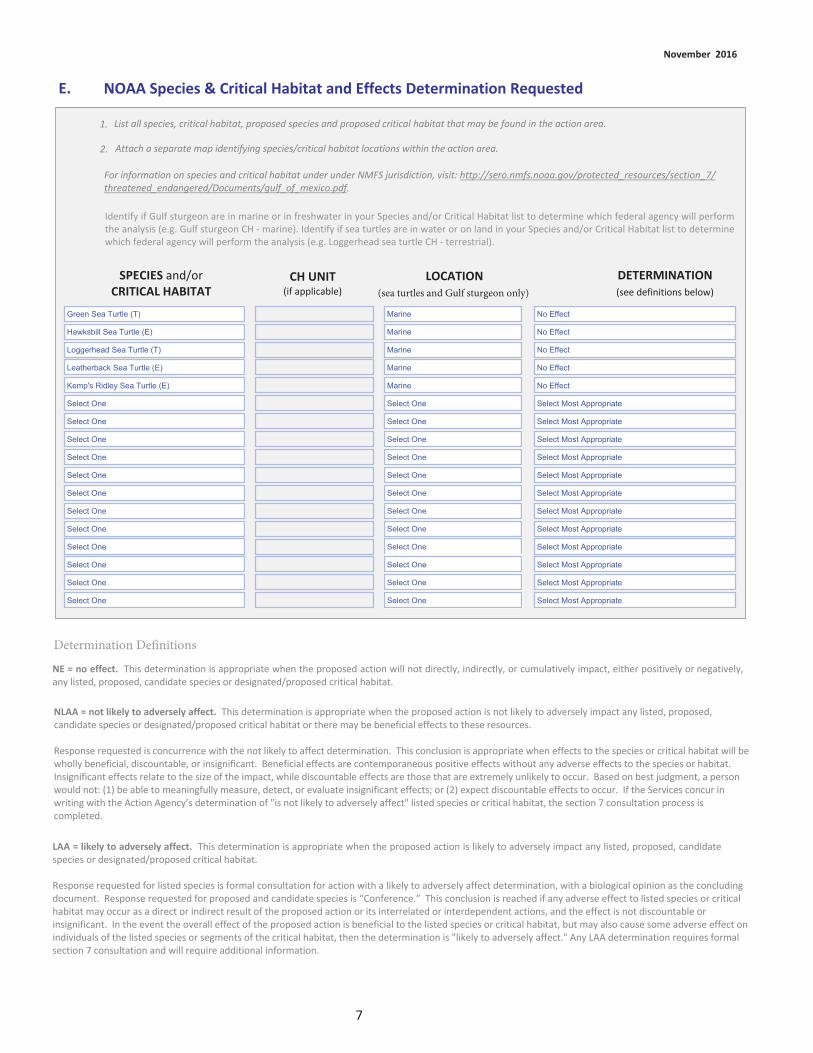
Green Sea Turtle (T) Marine
Hawksbill Sea Turtle (E)
Loggerhead Sea Turtle (T)
Leatherback Sea Turtle (E)
Kemp's Ridley Sea Turtle (E)
Select One
Select One
Select One
Select One
Select One
Select One
Select One
Select One
Select One
Select One
Select One
Select One
Marine
Marine
Marine
Marine
Select One
Select One
Select One
Select One
Select One
Select One
Select One
Select One
Select One
Select One
Select One
Select One
No Effect
No Effect
No Effect
No Effect
No Effect
Select Most Appropriate
Select Most Appropriate
Select Most Appropriate
Select Most Appropriate
Select Most Appropriate
Select Most Appropriate
Select Most Appropriate
Select Most Appropriate
Select Most Appropriate
Select Most Appropriate
Select Most Appropriate
Select Most Appropriate

Piping plover Select One No Effect
Select One
Select One
Select One
Select One
Select One
Select One
Select One
Select One
Select One
Select One
Select One
Select One
Select One
Select One
Select One
Select One
No Effect
Select Most Appropriate
Select Most Appropriate
Select Most Appropriate
Select Most Appropriate
Select Most Appropriate
Select Most Appropriate
Select Most Appropriate
Select Most Appropriate
Select Most Appropriate
Select Most Appropriate
Select Most Appropriate
Select Most Appropriate
Select Most Appropriate
Select Most Appropriate
Select Most Appropriate
Red knot
Select One
Select One
Select One
Select One
Select One
Select One
Select One
Select One
Select One
Select One
Select One
Select One
Select One

These E&D evaluations would be conducted through site visits and in an office setting. We anticipate this E&D work will not effect anyprotected species.
There is no critical habitat in the action area.

There will be no effect to listed species.

✔
✔
✔
✔
✔
✔
✔
✔
✔
✔
See Section C.
✔
No impacts to marine mammals are anticipated.

✔
Waterfowl
Loons and grebes
Pelicans and allies
Wading Birds
Rails and Coots
Shorebirds
Gulls and Terns
Songbirds and LandBirds
Roosting and Foraging
Roosting and foraging
Roosting and foraging
Roosting and Foraging
Nesting, Roosting, andForaging
Nesting, Roosting, andForaging
Roosting, andForaging, and Nesting
Nesting, Roosting, andForaging
Open water and wetlands associated with the project site is used by winteringwaterfowl. Work associated with the project may disturb birds and cause them tomove from areas of project activity to adjacent areas temporarily.Open water associated with the project site is used by wintering and migratingloons and grebes. Work associated with the project may disturb birds and causethem to move from areas of project activity to adjacent areas temporarily.Open water and shoreline associated with the project site are used by pelicans andcormorants year-round. Work associated with the project may disturb birds andcause them to move from areas of project activity to adjacent areas temporarily.Shorelines and wetlands associated with the project site are used by wading birds(herons, egrets, and ibis) year-round. Work associated with the project maydisturb birds and cause them to move from areas of project activity to adjacentareas temporarily.Waters and wetlands associated with the project site are used by rails and coots.The Clapper Rail may nest during the breeding season. Work associated with theproject may disturb roosting and foraging birds and cause them to move fromareas of project activity to adjacent areas temporarily. Nesting habitat (heavilyvegetated areas) for the Clapper Rail will be avoided.Shorelines and tidal flats associated with the project site are used by shorebirdsyear-round. Species that may nest include the Willet, Killdeer, and Wilson's Plover.Work associated with the project may disturb roosting and foraging birds andcause them to move from areas of project activity to adjacent areas temporarily.To ensure no nesting birds are affected, surveys will be perfomed to guide projectactivity so that impacts to nesting species are avoided.Waters and shorelines associated with project site are used by Gulls and Ternsyear-round. Work associated with the project may disturb roosting and foragingbirds and cause them to move from areas of project activity to adjacent areastemporarily.Some landbirds may use vegetation associated with the site. However, the level ofdisturbance is so low as to not affect nesting songbirds.


✔✔
The NEPA for this project was included as part of the Texas Trustee Implementation Group (Texas TIG). 2017. Deepwater Horizon Oil SpillNatural Resource Damage Assessment, Texas Trustee Implementation Group, Draft 2017 Texas Restoration Plan/EnvironmentalAssessment: Restoration of Wetlands, Coastal, and Nearshore Habitats; and Oysters. May 2017.
The NEPA is also addressed as part of the Deepwater Horizon Final PDARP/PEIS.http://www.gulfspillrestoration.noaa.gov/restoration-planning/gulf-plan
Angela Schrift
07/20/2017
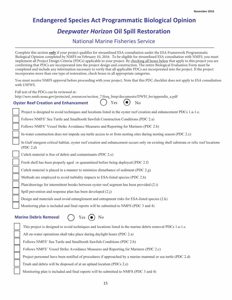
Project is designed to avoid techniques and locations listed in the oyster reef creation and enhancement PDCs 1.a-1.e.
Follows NMFS’ Sea Turtle and Smalltooth Sawfish Construction Conditions (PDC 2.a)
Follows NMFS’ Vessel Strike Avoidance Measures and Reporting for Mariners (PDC 2.b)
In-water construction does not impede sea turtle access to or from nesting sites during nesting season (PDC 2.c)
In Gulf sturgeon critical habitat, oyster reef creation and enhancement occurs only on existing shell substrata or relic reef locations (PDC 2.d)
Cultch material is free of debris and contaminants (PDC 2.e)
Fresh shell has been properly aged or quarantined before being deployed (PDC 2.f)
Cultch material is placed in a manner to minimize disturbance of sediment (PDC 2.g)
Methods are employed to avoid turbidity impacts to ESA-listed species (PDC 2.h)
Plan/drawings for intermittent breaks between oyster reef segment has been provided (2.i)
Spill prevention and response plan has been developed (2.j)
Design and materials used avoid entanglement and entrapment risks for ESA-listed species (2.k)
Monitoring plan is included and final reports will be submitted to NMFS (PDC 3 and 4)
This project is designed to avoid techniques and locations listed in the marine debris removal PDCs 1.a-1.c
All on-water operations shall take place during daylight hours (PDC 2.a)
Follows NMFS’ Sea Turtle and Smalltooth Sawfish Conditions (PDC 2.b)
Follows NMFS’ Vessel Strike Avoidance Measures and Reporting for Mariners (PDC 2.c)
Project personnel have been notified of procedures if approached by a marine mammal or sea turtle (PDC 2.d)
Trash and debris will be disposed of at an upland location (PDCs 2.e)
Monitoring plan is included and final reports will be submitted to NMFS (PDC 3 and 4)

This project is designed to avoid techniques and locations listed in the living shoreline PDCs 1.a-1.h
Follows NMFS’ Sea Turtle and Smalltooth Sawfish Conditions (PDC 2.a)
All in-water work activities will conducted during daylight hours (PDC 2.b)
Piles for navigation of public safety purposes are less than 24" diameter and non-metal if impact hammer used (PDC 2.c)
Spill prevention and response plan has been developed (2.d)
Fill material is not sourced using hopper dredge or from sea turtle, Gulf sturgeon or smalltooth sawfish critical habitat and in-water borrow sites do not impact turtle nesting beaches (PDC 2.e)
Design and materials do not create entrapment or entanglement risks to ESA-listed species and do not block migration (PDC 2.f)
In-water construction does not impede sea turtle access to or from nesting sites during nesting season (PDC 2.g)
Methods are employed to avoid turbidity impacts to ESA-listed species (PDC 2.h)
Follows NMFS’ Vessel Strike Avoidance Measures and Reporting for Mariners (PDC 2.i)
Project is designed to avoid techniques and locations listed in the marsh creation PDCs 1.a-1.f
Follows NMFS’ Sea Turtle and Smalltooth Sawfish Conditions (PDC 2.a)
Monitoring plan is included and final reports will be submitted to NMFS (PDC 3 and 4)
Follows NMFS’ Vessel Strike Avoidance Measures and Reporting for Mariners (PDC 2.b)
All in-water work activities will be conducted during daylight hours (PDC 2.c)
Spill prevention and response plan has been developed (PDC 2.d)
Fill material is not sourced using hopper dredge or from sea turtle, Gulf sturgeon or smalltooth sawfish critical habitat and in-water borrow sites do not impact turtle nesting beaches (PDC 2.e)
Design and materials do not create entrapment or entanglement risks to ESA-listed species and do not block migration (PDC 2.f)
In-water construction does not impede sea turtle access to or from nesting sites during nesting season (PDC 2.g)
Methods are employed to avoid turbidity impacts to ESA-listed species (PDCs 2.h)
Monitoring plan is included and final reports will be submitted to NMFS (PDC 3 and 4)

This project is designed to avoid locations listed in the non-fishing piers PDCs 1.a
Spill prevention and response plan has been developed (PDC 2.a)
Design and materials do not create entrapment or entanglement risks to ESA-listed species and do not block migration (PDC 2.b)
Follows NMFS’ Sea Turtle and Smalltooth Sawfish Construction Conditions (PDC 2.c)
Follows NMFS’ Vessel Strike Avoidance Measures and Reporting for Mariners (PDC 2.d)
Follow Construction Guidelines in Florida for Minor Piling-Supported Structures Constructed in or over Submerged Aquatic Vegetation (SAV), Marsh or Mangrove Habitat (PDC 2.e)
In-water construction does not impede sea turtle access to or from nesting sites during nesting season (PDC 2.f)
Follows methods and timing for pile driving (2.g)
Follows construction sequencing and avoids propwashing (PDC 2.h)
Water depth will not be altered (PDC 2.i)
Lighting specifications are incorporated for piers on or adjacent to sea turtle nesting beaches (PDC 2.j)
Follows educational and fishing signage requirements (PDC 2.k)
Methods are employed to avoid turbidity impacts to ESA-listed species (PDC 2.l)
Monitoring plan is included and final reports will be submitted to NMFS (PDC 3 and 4)
Angela Schrift
7/20/17


Bird
Isla
nd C
ove
Spec
ies/
Spec
ies G
roup
Beha
vior
Spec
ies/
Habi
tat I
mpa
cts a
nd C
onse
rvat
ion
Mea
sure
s to
Min
imiz
e Im
pact
sW
ater
fow
lRo
ostin
g an
d Fo
ragi
ngO
pen
wat
er a
ssoc
iate
d w
ith th
e pr
ojec
t site
is u
sed
by w
inte
ring
wat
erfo
wl.
Wor
k as
soci
ated
with
the
proj
ect m
ay d
istur
b bi
rds a
nd c
ause
them
to m
ove
from
are
as
of p
roje
ct a
ctiv
ity to
adj
acen
t are
as te
mpo
raily
.
Loon
s and
gre
bes
Roos
ting
and
fora
ging
Ope
n w
ater
ass
ocia
ted
with
the
proj
ect s
ite is
use
d by
win
terin
g an
d m
igra
ting
loon
s and
gre
bes.
W
ork
asso
ciat
ed w
ith th
e pr
ojec
t may
dist
urb
bird
s and
cau
se
them
to m
ove
from
are
as o
f pro
ject
act
ivity
to a
djac
ent a
reas
tem
pora
rily.
Pelic
ans a
nd a
llies
Roos
ting
and
fora
ging
Ope
n w
ater
and
shor
elin
e as
soci
ated
with
the
proj
ect s
ite a
re u
sed
by p
elic
ans a
nd
corm
oran
ts y
ear-
roun
d.
Wor
k as
soci
ated
with
the
proj
ect m
ay d
istur
b bi
rds a
nd
caus
e th
em to
mov
e fr
om a
reas
of p
roje
ct a
ctiv
ity to
adj
acen
t are
as te
mpo
raril
y.
Wad
ing
Bird
sRo
ostin
g an
d Fo
ragi
ngSh
orel
ines
and
wet
land
s ass
ocia
ted
with
the
proj
ect s
ite a
re u
sed
by w
adin
g bi
rds
(her
ons,
egr
ets,
and
ibis)
yea
r-ro
und.
W
ork
asso
ciat
ed w
ith th
e pr
ojec
t may
di
stur
b bi
rds a
nd c
ause
them
to m
ove
from
are
as o
f pro
ject
act
ivity
to a
djac
ent
area
s tem
pora
rily.
Ra
ils a
nd C
oots
Nes
ting,
Roo
stin
g, a
nd
Fora
ging
Wat
ers a
nd w
etla
nds a
ssoc
iate
d w
ith th
e pr
ojec
t site
are
use
d by
rails
and
coo
ts.
The
Clap
per R
ail m
ay n
est d
urin
g th
e br
eedi
ng se
ason
. Wor
k as
soci
ated
with
the
proj
ect m
ay d
istur
b ro
ostin
g an
d fo
ragi
ng b
irds a
nd c
ause
them
to m
ove
from
ar
eas o
f pro
ject
act
ivity
to a
djac
ent a
reas
tem
pora
rily.
Nes
ting
habi
tat (
heav
ily
vege
tate
d ar
eas)
for t
he C
lapp
er R
ail w
ill b
e av
oide
d.
Shor
ebird
sN
estin
g, R
oost
ing,
and
Fo
ragi
ngSh
orel
ines
and
tida
l fla
ts a
ssoc
iate
d w
ith th
e pr
ojec
t site
are
use
d by
shor
ebird
s ye
ar-r
ound
. Sp
ecie
s tha
t may
nes
t inc
lude
the
Will
et, K
illde
er, a
nd W
ilson
's Pl
over
. W
ork
asso
ciat
ed w
ith th
e pr
ojec
t may
dist
urb
roos
ting
and
fora
ging
bird
s and
ca
use
them
to m
ove
from
are
as o
f pro
ject
act
ivity
to a
djac
ent a
reas
tem
pora
rily.
To
ens
ure
no n
estin
g bi
rds a
re a
ffect
ed, s
urve
ys w
ill b
e pe
rfom
ed to
gui
de p
roje
ct
activ
ity so
that
impa
cts t
o ne
stin
g sp
ecie
s are
avo
ided
.

Gulls
and
Ter
nsRo
ostin
g, a
nd F
orag
ing
Wat
ers a
nd sh
orel
ines
ass
ocia
ted
with
pro
ject
site
are
use
d by
Gul
ls an
d Te
rns y
ear-
roun
d. W
ork
asso
ciat
ed w
ith th
e pr
ojec
t may
dist
urb
roos
ting
and
fora
ging
bird
s an
d ca
use
them
to m
ove
from
are
as o
f pro
ject
act
ivity
to a
djac
ent a
reas
te
mpo
raril
y.
Song
bird
s and
Lan
d Bi
rds
Nes
ting,
Roo
stin
g, a
nd
Fora
ging
Som
e la
ndbi
rds m
ay u
se v
eget
atio
n as
soci
ated
with
the
site.
How
ever
, the
leve
l of
dist
urba
nce
is so
low
as t
o no
t affe
ct n
estin
g so
ngbi
rds.

National Marine Fisheries Service
Texas General Land Office - for purposes of this BE form only
Angela Schrift (512) 389-8755 [email protected]
Dredged Material Planning for Wetland Restoration
NMFS Southeast Regional Office Texas Ecological Services Field Office (Houston, TX)
Create, Restore, and Enhance Coastal Wetlands
Select Most Appropriate
The geographic scope of this project includes the entire Texas coast and would consider sediments from the GIWW andassociated federal ship channels, private ship channels and berths, as well as and the mining of DMPAs currently used by theUSACE and the Texas Department of Transportation (TxDOT).
All Texas coastal counties: Orange, Jefferson, Chambers, Harris, Galveston, Brazoria, Matagorda, Jackson, Victoria, Calhoun,Refugio, San Patricio, Nueces, Kleberg, Kenedy, Willacy, Cameron
Not applicable: The geographic scope of this project includes the entire Texas coast and would consider sediments from theGIWW and associated federal ship channels, private ship channels and berths, as well as and the mining of DMPAs currently
Texas does not use the public land survey system.

The scope of the project is engineering and design.
This proposed project would help redirect the placement of this material so it may be used beneficially to construct andenhance valuable habitats. Implementation of the project has the potential to restore degraded wetlands, reduce erosion,improve water quality, create habitat, and provide beach nourishment and land reclamation, and increase coastal resiliency inan effective and efficient manner.
The proposed project is limited to planning and E&D, and would not include construction. The Dredged Material Planning forWetland Restoration project would develop a Master Plan, which would include draft designs, cost estimates, and permitapplication packages for eight coastal habitat restoration sites that would beneficially use dredged material. The project scopewould also include an environmental analysis of the construction effort that could potentially be incorporated into future DWHrestoration plans. Project partners could include private contractors, NGOs, and the Implementing Trustee. Project partnerswould be responsible for coordinating with the TGLO and USACE, along with other local, state, and federal agencies, ports,NGOs, industry, and technical advisors. Alternative sites may be chosen, if possible, or necessary. Selection of sites would bebased on overall beneficial use suitability, and support from project partners. Beneficial use suitability would be determinedbased on environmental, logistical, and economic variables which would be defined and quantified during the projectimplementation stage. For these sites, the project team would develop up to 60% design and cost estimates (draft designs),and would prepare permit application packages.
The development of draft designs would include:• A geotechnical analysis,• Bathymetric survey, and• Ecological/Environmental Analysis.
Following this field work, the project team’s design staff would prepare the Master Plan, including:• Sediment sources and dredging schedules,• Options for containment and decanting of excess water,• Shoreline stabilization, and• Development of draft designs.
For these eight sites, the project team would arrange and participate in pre-application meetings with permitting authorities,and would prepare permit application packages. Permit applications would be submitted when funding is identified forrestoration activities. Following completion of the Master Plan, subsequent phases would implement the actions described atthe sites identified in the Master Plan. Any subsequent phases proposed for implementation with DWH NRDA funds would beevaluated for consideration in a future restoration plan.
The activities proposed will have no significant impact on habitats present in the study area. Although there is critical habitatfor whooping crane and piping plover in the estuarine waters of Texas, there will be no impact to these species. Activitiesassociated with gathering information in the field will be extremely short-term in nature and will not affect fish and wildliferesources present.


See Section C.


Hawksbill Sea Turtle (E) Marine
Kemp's Ridley Sea Turtle (E)
Loggerhead Sea Turtle CH
Green Sea Turtle (T)
Leatherback Sea Turtle (E)
Select One
Select One
Select One
Select One
Select One
Select One
Select One
Select One
Select One
Select One
Select One
Select One
Marine
Marine
Marine
Marine
Select One
Select One
Select One
Select One
Select One
Select One
Select One
Select One
Select One
Select One
Select One
Select One
No Effect
No Effect
No Effect
No Effect
No Effect
Select Most Appropriate
Select Most Appropriate
Select Most Appropriate
Select Most Appropriate
Select Most Appropriate
Select Most Appropriate
Select Most Appropriate
Select Most Appropriate
Select Most Appropriate
Select Most Appropriate
Select Most Appropriate
Select Most Appropriate

West Indian manatee Select One No Effect
TX-37,26,21,5,69
Select One
Select One
Select One
Select One
Select One
Select One
Select One
Select One
Select One
Select One
Select One
Select One
Select One
Select One
Select One
Select One
No Effect
No Effect
No Effect
No Effect
No Effect
Select Most Appropriate
Select Most Appropriate
Select Most Appropriate
Select Most Appropriate
Select Most Appropriate
Select Most Appropriate
Select Most Appropriate
Select Most Appropriate
Select Most Appropriate
Select Most Appropriate
Select Most Appropriate
Piping plover CH
Whooping crane CH
Piping plover
Whooping crane
Red knot
Select One
Select One
Select One
Select One
Select One
Select One
Select One
Select One
Select One

These E&D evaluations would be conducted through site visits and in an office setting. We anticipate this E&D work will not effect anyprotected species.
Although whooping crane and piping plover critical habitat is present within the potential project area (exact study sites have not yetbeen determined), there will be no impacts to the critical habitat.


✔
✔
✔
✔
✔
✔
✔
✔
✔
✔
See Section C. Activities will occur in estuarine waters. However, there will be no impact to marine mammals. Activities arelimited to data collection and do not include any construction activities. Acoustic equipment may be used to conduct bathymetricsurveys in the project area.

✔
✔
Waterfowl
Loons and grebes
Pelicans and allies
Wading Birds
Rails and Coots
Shorebirds
Gulls and Terns
Songbirds and LandBirds
Roosting and Foraging
Roosting and foraging
Roosting and foraging
Roosting and Foraging
Nesting, Roosting, andForaging
Nesting, Roosting, andForaging
Roosting, and Foraging
Nesting, Roosting, andForaging
Open water associated with the project site is used by wintering waterfowl. Workassociated with the project may disturb birds and cause them to move from areasof project activity to adjacent areas temporarily.Open water associated with the project site is used by wintering and migratingloons and grebes. Work associated with the project may disturb birds and causethem to move from areas of project activity to adjacent areas temporarily.Open water and shoreline associated with the project site are used by pelicans andcormorants year-round. Work associated with the project may disturb birds andcause them to move from areas of project activity to adjacent areas temporarily.Shorelines and wetlands associated with the project site are used by wading birds(herons, egrets, and ibis) year-round. Work associated with the project maydisturb birds and cause them to move from areas of project activity to adjacentareas temporarily.Waters and wetlands associated with the project site are used by rails and coots.The Clapper Rail may nest during the breeding season. Work associated with theproject may disturb roosting and foraging birds and cause them to move fromareas of project activity to adjacent areas temporarily. Nesting habitat (heavilyvegetated areas) for the Clapper Rail will be avoided.Shorelines and tidal flats associated with the project site are used by shorebirdsyear-round. Species that may nest include the Willet, Killdeer, and Wilson's Plover.Work associated with the project may disturb roosting and foraging birds andcause them to move from areas of project activity to adjacent areas temporarily.To ensure no nesting birds are affected, a biologist will inspect each site andensure impacts to nesting species are avoided.Waters and shorelines associated with project site are used by Gulls and Ternsyear-round. Work associated with the project may disturb roosting and foragingbirds and cause them to move from areas of project activity to adjacent areastemporarily.Some landbirds may use vegetation near the site. However, the level ofdisturbance is so low as to not affect nesting songbirds.


✔✔
The NEPA for this project was included as part of the Texas Trustee Implementation Group (Texas TIG). 2017. Deepwater Horizon Oil SpillNatural Resource Damage Assessment, Texas Trustee Implementation Group, Draft 2017 Texas Restoration Plan/EnvironmentalAssessment: Restoration of Wetlands, Coastal, and Nearshore Habitats; and Oysters. May 2017.
The NEPA is also addressed as part of the Deepwater Horizon Final PDARP/PEIS.http://www.gulfspillrestoration.noaa.gov/restoration-planning/gulf-plan
Angela Schrift
07/20/2017

Project is designed to avoid techniques and locations listed in the oyster reef creation and enhancement PDCs 1.a-1.e.
Follows NMFS’ Sea Turtle and Smalltooth Sawfish Construction Conditions (PDC 2.a)
Follows NMFS’ Vessel Strike Avoidance Measures and Reporting for Mariners (PDC 2.b)
In-water construction does not impede sea turtle access to or from nesting sites during nesting season (PDC 2.c)
In Gulf sturgeon critical habitat, oyster reef creation and enhancement occurs only on existing shell substrata or relic reef locations (PDC 2.d)
Cultch material is free of debris and contaminants (PDC 2.e)
Fresh shell has been properly aged or quarantined before being deployed (PDC 2.f)
Cultch material is placed in a manner to minimize disturbance of sediment (PDC 2.g)
Methods are employed to avoid turbidity impacts to ESA-listed species (PDC 2.h)
Plan/drawings for intermittent breaks between oyster reef segment has been provided (2.i)
Spill prevention and response plan has been developed (2.j)
Design and materials used avoid entanglement and entrapment risks for ESA-listed species (2.k)
Monitoring plan is included and final reports will be submitted to NMFS (PDC 3 and 4)
This project is designed to avoid techniques and locations listed in the marine debris removal PDCs 1.a-1.c
All on-water operations shall take place during daylight hours (PDC 2.a)
Follows NMFS’ Sea Turtle and Smalltooth Sawfish Conditions (PDC 2.b)
Follows NMFS’ Vessel Strike Avoidance Measures and Reporting for Mariners (PDC 2.c)
Project personnel have been notified of procedures if approached by a marine mammal or sea turtle (PDC 2.d)
Trash and debris will be disposed of at an upland location (PDCs 2.e)
Monitoring plan is included and final reports will be submitted to NMFS (PDC 3 and 4)

This project is designed to avoid techniques and locations listed in the living shoreline PDCs 1.a-1.h
Follows NMFS’ Sea Turtle and Smalltooth Sawfish Conditions (PDC 2.a)
All in-water work activities will conducted during daylight hours (PDC 2.b)
Piles for navigation of public safety purposes are less than 24" diameter and non-metal if impact hammer used (PDC 2.c)
Spill prevention and response plan has been developed (2.d)
Fill material is not sourced using hopper dredge or from sea turtle, Gulf sturgeon or smalltooth sawfish critical habitat and in-water borrow sites do not impact turtle nesting beaches (PDC 2.e)
Design and materials do not create entrapment or entanglement risks to ESA-listed species and do not block migration (PDC 2.f)
In-water construction does not impede sea turtle access to or from nesting sites during nesting season (PDC 2.g)
Methods are employed to avoid turbidity impacts to ESA-listed species (PDC 2.h)
Follows NMFS’ Vessel Strike Avoidance Measures and Reporting for Mariners (PDC 2.i)
Project is designed to avoid techniques and locations listed in the marsh creation PDCs 1.a-1.f
Follows NMFS’ Sea Turtle and Smalltooth Sawfish Conditions (PDC 2.a)
Monitoring plan is included and final reports will be submitted to NMFS (PDC 3 and 4)
Follows NMFS’ Vessel Strike Avoidance Measures and Reporting for Mariners (PDC 2.b)
All in-water work activities will be conducted during daylight hours (PDC 2.c)
Spill prevention and response plan has been developed (PDC 2.d)
Fill material is not sourced using hopper dredge or from sea turtle, Gulf sturgeon or smalltooth sawfish critical habitat and in-water borrow sites do not impact turtle nesting beaches (PDC 2.e)
Design and materials do not create entrapment or entanglement risks to ESA-listed species and do not block migration (PDC 2.f)
In-water construction does not impede sea turtle access to or from nesting sites during nesting season (PDC 2.g)
Methods are employed to avoid turbidity impacts to ESA-listed species (PDCs 2.h)
Monitoring plan is included and final reports will be submitted to NMFS (PDC 3 and 4)

This project is designed to avoid locations listed in the non-fishing piers PDCs 1.a
Spill prevention and response plan has been developed (PDC 2.a)
Design and materials do not create entrapment or entanglement risks to ESA-listed species and do not block migration (PDC 2.b)
Follows NMFS’ Sea Turtle and Smalltooth Sawfish Construction Conditions (PDC 2.c)
Follows NMFS’ Vessel Strike Avoidance Measures and Reporting for Mariners (PDC 2.d)
Follow Construction Guidelines in Florida for Minor Piling-Supported Structures Constructed in or over Submerged Aquatic Vegetation (SAV), Marsh or Mangrove Habitat (PDC 2.e)
In-water construction does not impede sea turtle access to or from nesting sites during nesting season (PDC 2.f)
Follows methods and timing for pile driving (2.g)
Follows construction sequencing and avoids propwashing (PDC 2.h)
Water depth will not be altered (PDC 2.i)
Lighting specifications are incorporated for piers on or adjacent to sea turtle nesting beaches (PDC 2.j)
Follows educational and fishing signage requirements (PDC 2.k)
Methods are employed to avoid turbidity impacts to ESA-listed species (PDC 2.l)
Monitoring plan is included and final reports will be submitted to NMFS (PDC 3 and 4)
Angela Schrift
7/20/17


Bene
ficia
l Use
Pro
ject
Spec
ies/
Spec
ies G
roup
Beha
vior
Spec
ies/
Habi
tat I
mpa
cts a
nd C
onse
rvat
ion
Mea
sure
s to
Min
imiz
e Im
pact
sW
ater
fow
lFo
ragi
ng, R
oost
ing
and
Stag
ing
Ope
n w
ater
ass
ocia
ted
with
the
proj
ect s
ite is
use
d by
win
terin
g an
d m
igra
ting
wat
erfo
wl.
Wor
k as
soci
ated
with
the
proj
ect m
ay d
istur
b bi
rds a
nd c
ause
them
to
mov
e fr
om a
reas
of p
roje
ct a
ctiv
ity to
adj
acen
t are
as te
mpo
raril
y.
Loon
s and
gre
bes
Roos
ting
and
fora
ging
Ope
n w
ater
ass
ocia
ted
with
the
proj
ect s
ite is
use
d by
win
terin
g an
d m
igra
ting
loon
s and
gre
bes.
W
ork
asso
ciat
ed w
ith th
e pr
ojec
t may
dist
urb
bird
s and
cau
se
them
to m
ove
from
are
as o
f pro
ject
act
ivity
to a
djac
ent a
reas
tem
pora
rily.
Pelic
ans a
nd a
llies
Roos
ting
and
fora
ging
Ope
n w
ater
and
shor
elin
e as
soci
ated
with
the
proj
ect s
ite a
re u
sed
by p
elic
ans a
nd
corm
oran
ts y
ear-
roun
d.
Wor
k as
soci
ated
with
the
proj
ect m
ay d
istur
b bi
rds a
nd
caus
e th
em to
mov
e fr
om a
reas
of p
roje
ct a
ctiv
ity to
adj
acen
t are
as te
mpo
raril
y.
Wad
ing
Bird
sFo
ragi
ng, R
oost
ing
and
Stag
ing
Shor
elin
es a
nd w
etla
nds a
ssoc
iate
d w
ith th
e pr
ojec
t site
are
use
d by
wad
ing
bird
s (h
eron
s, e
gret
s, a
nd ib
is) y
ear-
roun
d.
Wor
k as
soci
ated
with
the
proj
ect m
ay
dist
urb
bird
s and
cau
se th
em to
mov
e fr
om a
reas
of p
roje
ct a
ctiv
ity to
adj
acen
t ar
eas t
empo
raril
y.
Rails
and
Coo
tsN
estin
g, R
oost
ing,
and
Fo
ragi
ngW
ater
s and
wet
land
s ass
ocia
ted
with
the
proj
ect s
ite a
re u
sed
by ra
ils a
nd c
oots
. Th
e Cl
appe
r Rai
l may
nes
t dur
ing
the
bree
ding
seas
on. W
ork
asso
ciat
ed w
ith th
e pr
ojec
t may
dist
urb
roos
ting
and
fora
ging
bird
s and
cau
se th
em to
mov
e fr
om
area
s of p
roje
ct a
ctiv
ity to
adj
acen
t are
as te
mpo
raril
y. N
estin
g ha
bita
t (he
avily
ve
geta
ted
area
s) fo
r the
Cla
pper
Rai
l will
be
avoi
ded.
Shor
ebird
sFo
ragi
ng, N
estin
g,
Roos
ting
and
Stag
ing
Shor
elin
es a
nd ti
dal f
lats
ass
ocia
ted
with
the
proj
ect s
ite a
re u
sed
by sh
oreb
irds
year
-rou
nd.
Spec
ies t
hat m
ay n
est i
nclu
de th
e W
illet
, Kill
deer
, and
Wils
on's
Plov
er.
Wor
k as
soci
ated
with
the
proj
ect m
ay d
istur
b ro
ostin
g an
d fo
ragi
ng b
irds a
nd
caus
e th
em to
mov
e fr
om a
reas
of p
roje
ct a
ctiv
ity to
adj
acen
t are
as te
mpo
raril
y.
To e
nsur
e no
nes
ting
bird
s are
affe
cted
, a b
iolo
gist
will
insp
ect e
ach
site
and
ensu
re
impa
cts t
o ne
stin
g sp
ecie
s are
avo
ided
.

Gulls
and
Ter
nsFo
ragi
ng, R
oost
ing
and
Stag
ing
Wat
ers a
nd sh
orel
ines
ass
ocia
ted
with
pro
ject
site
are
use
d by
Gul
ls an
d Te
rns y
ear-
roun
d. W
ork
asso
ciat
ed w
ith th
e pr
ojec
t may
dist
urb
roos
ting
and
fora
ging
bird
s an
d ca
use
them
to m
ove
from
are
as o
f pro
ject
act
ivity
to a
djac
ent a
reas
te
mpo
raril
y.
Song
bird
s and
Lan
d Bi
rds
Fora
ging
, Nes
ting,
Ro
ostin
g an
d St
agin
gSo
me
land
bird
s may
use
veg
etat
ion
asso
ciat
ed w
ith th
e sit
e. H
owev
er, t
he le
vel o
f di
stur
banc
e is
so lo
w a
s to
not a
ffect
nes
ting
song
bird
s.

National Marine Fisheries Service
NOAA - for purposes of this BE form only
Angela Schrift (512) 389-8755 [email protected]
Essex Bayou Habitat Restoration Engineering
NMFS Southeast Regional Office Texas Ecological Services Field Office (Houston, TX)
Create, Restore, and Enhance Coastal Wetlands
Select Most Appropriate
Essex Bayou and the Slop Bowl Marsh are part of the Brazoria NWR in Brazoria County, Texas. The project site is located inthe southwestern portion of the refuge near the Gulf of Mexico and the community of Surfside, Texas.
Brazoria County, Texas
Approximate 29.001639° N, -95.280523° W; WGS 84
Texas does not use the public land survey system.

The scope of the project is engineering and design. This project would further evaluate the conditions responsible for andpropose solutions to ameliorate extreme salinity conditions. A suite of potential corrective actions would be evaluated forfeasibility, cost, and effectiveness. The most effective and appropriate corrective measures would then be selected for 30%E&D development. Scientific and engineering tasks could include data collection (such as bathymetric/topographical survey,growth fault analyses, hydrologic and tidal flow evaluations, magnetometer survey, or soil borings); performance evaluation ofthe previous efforts noted above; gathering necessary materials for submission of required permit(s) at a later date;development of E&D plans; and estimating construction costs associated with different management actions.
Essex Bayou and the Slop Bowl Marsh are part of the Brazoria NWR in Brazoria County, Texas. The project site is located inthe southwestern portion of the refuge near the Gulf of Mexico and the community of Surfside (Figure 3-4). The tidal marshsystems associated within this region have historically high rates of relative sea level rise (sea level rise plus subsidence). Theproject site exhibits several geological growth faults that are likely associated with nearby salt domes but also activities relatedto oil and gas development. Additional hydrologic modifications associated with the marsh complex include man-madechannels such as the Intracoastal Waterway and access channels which have modified hydrology and geomorphic processes.
Essex Bayou and the Slop Bowl Marsh experience wide swings in salinity and tidal reach. Initial assessments suggest thatmodifications to the watershed, flow restrictions in Essex Bayou, and diversions of tidal flow are responsible for the extremesalinity conditions. Periods within these wide swings of salinity can produce high biological diversity and productivity, howeverswings into each extreme salinity condition causes changes to the existing vegetation that biologically and structurallydestabilize the system. High salinities cause considerable vegetation damage and allow for only a few species of estuarineorganisms to survive. These high salinity levels cause high mortality of wetland plants, invertebrates, and fish species. Theseconditions result in very poor foraging habitat for birds, fish, and other vertebrate species. In the drier summer months,salinities of 150 parts per thousand, almost five times that for full strength sea water, have been documented.
The activities proposed will have no significant impact on habitats present in the study area. There is no critical habitat withinthe study area and there are no known cultural resources. Activities associated with gathering information in the field will beextremely short-term in nature and will not affect fish and wildlife resources present.


See Section C.


Hawksbill Sea Turtle (E) Marine
Kemp's Ridley Sea Turtle (E)
Loggerhead Sea Turtle (T)
Leatherback Sea Turtle (E)
Green Sea Turtle (T)
Select One
Select One
Select One
Select One
Select One
Select One
Select One
Select One
Select One
Select One
Select One
Select One
Marine
Marine
Marine
Select One
Select One
Select One
Select One
Select One
Select One
Select One
Select One
Select One
Select One
Select One
Select One
Select One
No Effect
No Effect
No Effect
No Effect
No Effect
Select Most Appropriate
Select Most Appropriate
Select Most Appropriate
Select Most Appropriate
Select Most Appropriate
Select Most Appropriate
Select Most Appropriate
Select Most Appropriate
Select Most Appropriate
Select Most Appropriate
Select Most Appropriate
Select Most Appropriate

West Indian manatee Select One No Effect
Select One
Select One
Select One
Select One
Select One
Select One
Select One
Select One
Select One
Select One
Select One
Select One
Select One
Select One
Select One
Select One
No Effect
No Effect
No Effect
Select Most Appropriate
Select Most Appropriate
Select Most Appropriate
Select Most Appropriate
Select Most Appropriate
Select Most Appropriate
Select Most Appropriate
Select Most Appropriate
Select Most Appropriate
Select Most Appropriate
Select Most Appropriate
Select Most Appropriate
Select Most Appropriate
Piping plover
Red knot
Northern aplomado falcon
Select One
Select One
Select One
Select One
Select One
Select One
Select One
Select One
Select One
Select One
Select One

These E&D evaluations would be conducted through site visits and in an office setting. We anticipate this E&D work will not effect anyprotected species.


✔
✔
✔
✔
✔
✔
✔
✔
✔
✔
See Section C. Although some minor work activities related to the engineering and design may occur in estuarine waters, therewill be no effect to marine mammals.

✔
See attachment.


✔✔
The NEPA for this project was included as part of the Texas Trustee Implementation Group (Texas TIG). 2017. Deepwater Horizon Oil SpillNatural Resource Damage Assessment, Texas Trustee Implementation Group, Draft 2017 Texas Restoration Plan/EnvironmentalAssessment: Restoration of Wetlands, Coastal, and Nearshore Habitats; and Oysters. May 2017.
The NEPA is also addressed as part of the Deepwater Horizon Final PDARP/PEIS.http://www.gulfspillrestoration.noaa.gov/restoration-planning/gulf-plan
Angela Schrift
07/20/2017

Project is designed to avoid techniques and locations listed in the oyster reef creation and enhancement PDCs 1.a-1.e.
Follows NMFS’ Sea Turtle and Smalltooth Sawfish Construction Conditions (PDC 2.a)
Follows NMFS’ Vessel Strike Avoidance Measures and Reporting for Mariners (PDC 2.b)
In-water construction does not impede sea turtle access to or from nesting sites during nesting season (PDC 2.c)
In Gulf sturgeon critical habitat, oyster reef creation and enhancement occurs only on existing shell substrata or relic reef locations (PDC 2.d)
Cultch material is free of debris and contaminants (PDC 2.e)
Fresh shell has been properly aged or quarantined before being deployed (PDC 2.f)
Cultch material is placed in a manner to minimize disturbance of sediment (PDC 2.g)
Methods are employed to avoid turbidity impacts to ESA-listed species (PDC 2.h)
Plan/drawings for intermittent breaks between oyster reef segment has been provided (2.i)
Spill prevention and response plan has been developed (2.j)
Design and materials used avoid entanglement and entrapment risks for ESA-listed species (2.k)
Monitoring plan is included and final reports will be submitted to NMFS (PDC 3 and 4)
This project is designed to avoid techniques and locations listed in the marine debris removal PDCs 1.a-1.c
All on-water operations shall take place during daylight hours (PDC 2.a)
Follows NMFS’ Sea Turtle and Smalltooth Sawfish Conditions (PDC 2.b)
Follows NMFS’ Vessel Strike Avoidance Measures and Reporting for Mariners (PDC 2.c)
Project personnel have been notified of procedures if approached by a marine mammal or sea turtle (PDC 2.d)
Trash and debris will be disposed of at an upland location (PDCs 2.e)
Monitoring plan is included and final reports will be submitted to NMFS (PDC 3 and 4)

This project is designed to avoid techniques and locations listed in the living shoreline PDCs 1.a-1.h
Follows NMFS’ Sea Turtle and Smalltooth Sawfish Conditions (PDC 2.a)
All in-water work activities will conducted during daylight hours (PDC 2.b)
Piles for navigation of public safety purposes are less than 24" diameter and non-metal if impact hammer used (PDC 2.c)
Spill prevention and response plan has been developed (2.d)
Fill material is not sourced using hopper dredge or from sea turtle, Gulf sturgeon or smalltooth sawfish critical habitat and in-water borrow sites do not impact turtle nesting beaches (PDC 2.e)
Design and materials do not create entrapment or entanglement risks to ESA-listed species and do not block migration (PDC 2.f)
In-water construction does not impede sea turtle access to or from nesting sites during nesting season (PDC 2.g)
Methods are employed to avoid turbidity impacts to ESA-listed species (PDC 2.h)
Follows NMFS’ Vessel Strike Avoidance Measures and Reporting for Mariners (PDC 2.i)
Project is designed to avoid techniques and locations listed in the marsh creation PDCs 1.a-1.f
Follows NMFS’ Sea Turtle and Smalltooth Sawfish Conditions (PDC 2.a)
Monitoring plan is included and final reports will be submitted to NMFS (PDC 3 and 4)
Follows NMFS’ Vessel Strike Avoidance Measures and Reporting for Mariners (PDC 2.b)
All in-water work activities will be conducted during daylight hours (PDC 2.c)
Spill prevention and response plan has been developed (PDC 2.d)
Fill material is not sourced using hopper dredge or from sea turtle, Gulf sturgeon or smalltooth sawfish critical habitat and in-water borrow sites do not impact turtle nesting beaches (PDC 2.e)
Design and materials do not create entrapment or entanglement risks to ESA-listed species and do not block migration (PDC 2.f)
In-water construction does not impede sea turtle access to or from nesting sites during nesting season (PDC 2.g)
Methods are employed to avoid turbidity impacts to ESA-listed species (PDCs 2.h)
Monitoring plan is included and final reports will be submitted to NMFS (PDC 3 and 4)

This project is designed to avoid locations listed in the non-fishing piers PDCs 1.a
Spill prevention and response plan has been developed (PDC 2.a)
Design and materials do not create entrapment or entanglement risks to ESA-listed species and do not block migration (PDC 2.b)
Follows NMFS’ Sea Turtle and Smalltooth Sawfish Construction Conditions (PDC 2.c)
Follows NMFS’ Vessel Strike Avoidance Measures and Reporting for Mariners (PDC 2.d)
Follow Construction Guidelines in Florida for Minor Piling-Supported Structures Constructed in or over Submerged Aquatic Vegetation (SAV), Marsh or Mangrove Habitat (PDC 2.e)
In-water construction does not impede sea turtle access to or from nesting sites during nesting season (PDC 2.f)
Follows methods and timing for pile driving (2.g)
Follows construction sequencing and avoids propwashing (PDC 2.h)
Water depth will not be altered (PDC 2.i)
Lighting specifications are incorporated for piers on or adjacent to sea turtle nesting beaches (PDC 2.j)
Follows educational and fishing signage requirements (PDC 2.k)
Methods are employed to avoid turbidity impacts to ESA-listed species (PDC 2.l)
Monitoring plan is included and final reports will be submitted to NMFS (PDC 3 and 4)
Angela Schrift
7/20/17
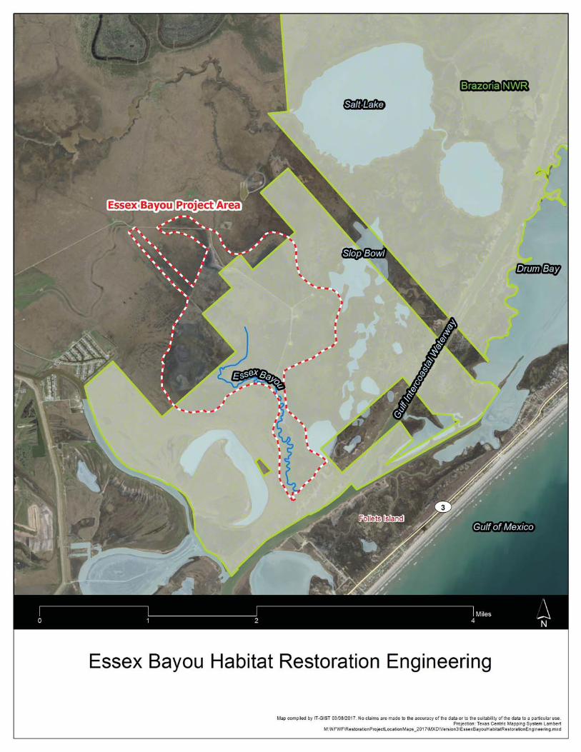

Esse
x Ba
you
Spec
ies/
Spec
ies G
roup
Beha
vior
Spec
ies/
Habi
tat I
mpa
cts a
nd C
onse
rvat
ion
Mea
sure
s to
Min
imiz
e Im
pact
sW
ater
fow
lRo
ostin
g an
d Fo
ragi
ngO
pen
wat
er a
ssoc
iate
d w
ith th
e pr
ojec
t site
is u
sed
by m
igra
ting
wat
erfo
wl.
Wor
k as
soci
ated
with
the
proj
ect m
ay d
istur
b bi
rds a
nd c
ause
them
to m
ove
from
are
as
of p
roje
ct a
ctiv
ity to
adj
acen
t are
as te
mpo
raily
.
Loon
s and
gre
bes
Roos
ting
and
Fora
ging
Ope
n w
ater
ass
ocia
ted
with
the
proj
ect s
ite is
use
d by
win
terin
g an
d m
igra
ting
loon
s and
gre
bes.
W
ork
asso
ciat
ed w
ith th
e pr
ojec
t may
dist
urb
bird
s and
cau
se
them
to m
ove
from
are
as o
f pro
ject
act
ivity
to a
djac
ent a
reas
tem
pora
rily.
Pelic
ans a
nd a
llies
Roos
ting
and
Fora
ging
Ope
n w
ater
and
shor
elin
e as
soci
ated
with
the
proj
ect s
ite a
re u
sed
by p
elic
ans a
nd
corm
oran
ts y
ear-
roun
d.
Wor
k as
soci
ated
with
the
proj
ect m
ay d
istur
b bi
rds a
nd
caus
e th
em to
mov
e fr
om a
reas
of p
roje
ct a
ctiv
ity to
adj
acen
t are
as te
mpo
raril
y.
Wat
erfo
wl
Roos
ting
and
Fora
ging
Ope
n an
d sh
allo
w w
ater
are
as m
ay b
e us
ed b
y no
n-br
eedi
ng w
ater
fow
l spe
cies
. W
ork
asso
ciat
ed w
ith th
e pr
ojec
t may
dist
urb
bird
s and
cau
se th
em to
mov
e fr
om
area
s of p
roje
ct a
ctiv
ity to
adj
acen
t are
as te
mpo
raril
y.
Wad
ing
Bird
sRo
ostin
g an
d Fo
ragi
ngSh
orel
ines
and
wet
land
s ass
ocia
ted
with
the
proj
ect s
ite a
re u
sed
by w
adin
g bi
rds
(her
ons,
egr
ets,
and
ibis)
yea
r-ro
und.
W
ork
asso
ciat
ed w
ith th
e pr
ojec
t may
di
stur
b bi
rds a
nd c
ause
them
to m
ove
from
are
as o
f pro
ject
act
ivity
to a
djac
ent
area
s tem
pora
rily.
Ra
ils a
nd C
oots
Nes
ting,
Roo
stin
g, a
nd
Fora
ging
Wat
ers a
nd w
etla
nds a
ssoc
iate
d w
ith th
e pr
ojec
t site
are
use
d by
rails
and
coo
ts.
The
Clap
per R
ail m
ay n
est d
urin
g th
e br
eedi
ng se
ason
. Wor
k as
soci
ated
with
the
proj
ect m
ay d
istur
b ro
ostin
g an
d fo
ragi
ng b
irds a
nd c
ause
them
to m
ove
from
ar
eas o
f pro
ject
act
ivity
to a
djac
ent a
reas
tem
pora
rily.
Nes
ting
habi
tat (
heav
ily
vege
tate
d ar
eas)
for t
he C
lapp
er R
ail w
ill b
e av
oide
d.

Shor
ebird
sN
estin
g, R
oost
ing,
and
Fo
ragi
ngSh
orel
ines
and
tida
l fla
ts a
ssoc
iate
d w
ith th
e pr
ojec
t site
are
use
d by
shor
ebird
s ye
ar-r
ound
. Sp
ecie
s tha
t may
nes
t inc
lude
the
Will
et, K
illde
er, a
nd W
ilson
's Pl
over
. W
ork
asso
ciat
ed w
ith th
e pr
ojec
t may
dist
urb
roos
ting
and
fora
ging
bird
s and
ca
use
them
to m
ove
from
are
as o
f pro
ject
act
ivity
to a
djac
ent a
reas
tem
pora
rily.
To
ens
ure
no n
estin
g bi
rds a
re a
ffect
ed, s
urve
ys w
ill b
e pe
rfom
ed to
gui
de p
roje
ct
activ
ity so
that
impa
cts t
o ne
stin
g sp
ecie
s are
avo
ided
.
Gulls
and
Ter
nsN
estin
g, R
oost
ing,
and
Fo
ragi
ngW
ater
s and
shor
elin
es a
ssoc
iate
d w
ith p
roje
ct si
te a
re u
sed
by G
ulls
and
Tern
s yea
r -ro
und.
Wor
k as
soci
ated
with
the
proj
ect m
ay d
istur
b ro
ostin
g an
d fo
ragi
ng b
irds
and
caus
e th
em to
mov
e fr
om a
reas
of p
roje
ct a
ctiv
ity to
adj
acen
t are
as
tem
pora
rily.
So
ngbi
rds a
nd L
and
Bird
sN
estin
g, R
oost
ing,
and
Fo
ragi
ngSo
me
land
bird
s may
use
veg
etat
ion
asso
ciat
ed w
ith th
e sit
e. H
owev
er, t
he le
vel o
f di
stur
banc
e is
so lo
w a
s to
not t
o ca
use
hara
ssm
ent o
f nes
ting
song
bird
s.

Biological Evaluation Form Deepwater Horizon Oil Spill Restoration
U.S. Fish and Wildlife Service & National Marine Fisheries Service
This form will be filled out by the Implementing Trustee and used by the regulatory agencies. The formwill provide information to initiate informal Section 7 consultations under the Endangered Species Act (ESA) and may be used to document aNoEffect determinationor to initiate pre-consultation technical assistance. It is recommended that this form also be completed to inform and evaluate additional needs for compliance with the following authorities: Migratory Bird Treaty Act (MBTA), Marine Mammal Protect Act (MMPA), Coastal Barrier Resources Act (CBRA), Bald and Golden Eagle Protection Act (BGEPA) and Section 106 of the National Historic Preservation Act (NHPA). Further information may be required beyond what is captured on this form. Note: if you need additionalspace for writing, please attach pages as needed.
A. Project Identification Federal Action Agency: U.S. Fish and Wildlife Service/National Marine Fisheries Service
Agency Contact(s) USFWS: Ashley Mills at 812-756-2712 and [email protected] NMFS: Christy Fellas at 727-551-5714 and [email protected]
I. Implementing Trustee U.S. Department of Agriculture – for purposes of this BE form only
II. Applicant Contact Person Angela Schrift/Kathryn Burger
III. Phone 512-389-8755; 512-389-8153 Email: [email protected]; [email protected]
IV. Project Name and ID# (Official name of project and ID number assigned by action agency) Indian Point Shoreline Erosion Protection
V. NMFS Office (Choose appropriate office based on project location) NMFS Southeast Regional Office
VI. FWS Office (Choose appropriate office based on project location) Texas Coastal Ecological Services Field Office, Corpus Christi, TX
VII. Project Type 1 Protect and Conserve Marine, Coastal, Estuarine, and Riparian Habitats;

VIII. Project Type 2, if helpful Create, Restore, and Enhance Wetlands
B. Project Location I. Project Location
Indian Point Shoreline Erosion Protection site is located approximately 2 miles southwest of the city of Portland, Texas. Indian point is a peninsula in north western Corpus Christi Bay on the eastern shore of the mouth of Nueces Bay as it connects with Corpus Christi Bay.
II. State & County/Parish of Project Site Nueces County, Texas
III. Latitude & Longitude for Project Site (Decimal degrees and datum [e.g., 27.71622°N, 80.25174°W NAD83] [online conversion: https://www.fcc.gov/encyclopedia/degrees-minutes-seconds-tofrom-decimal-degrees]) Approximate 27.852496° N, 97.351597° W; NAD83
IV. Township, range and section of the project area Texas does not use the public land survey system.
C. Description of Action Area #1 Attach a separate map delineating where the action will occur.
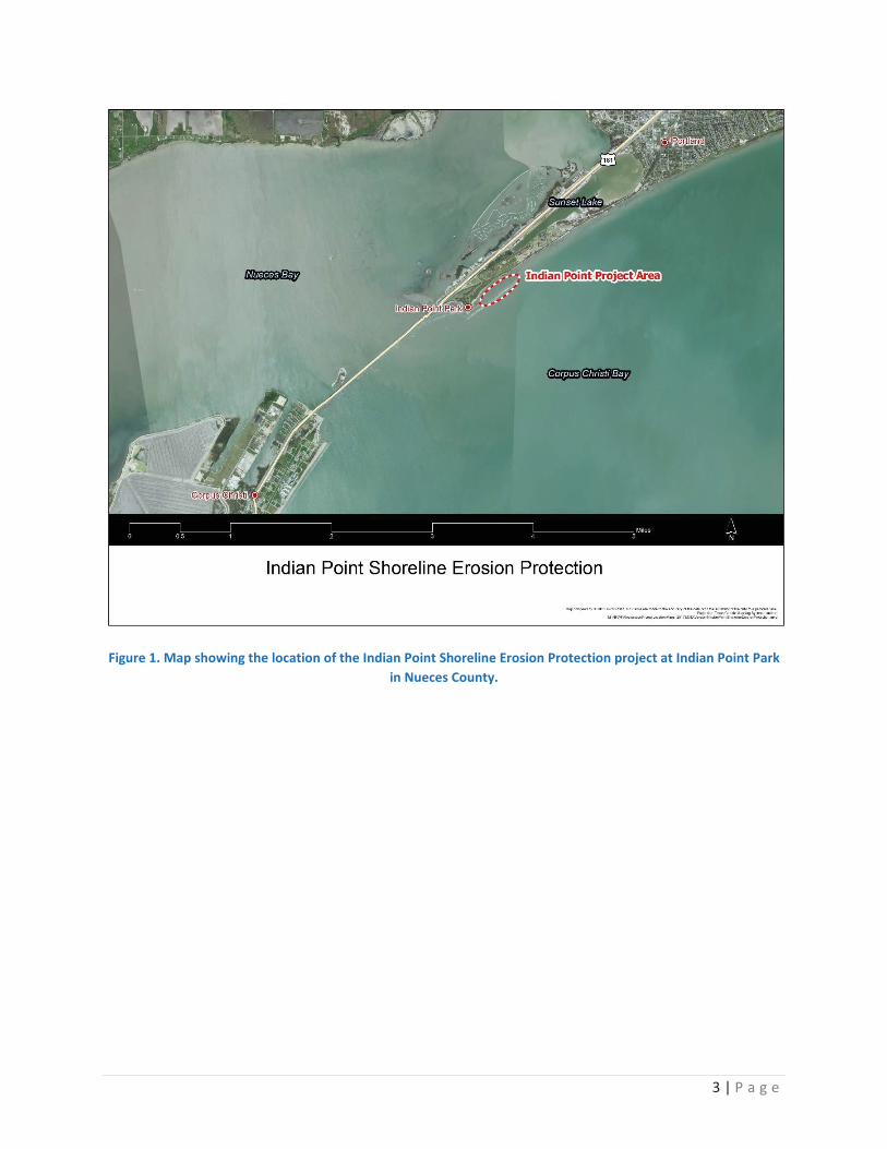
3 | P a g e
Figure 1. Map showing the location of the Indian Point Shoreline Erosion Protection project at Indian Point Park
in Nueces County.

Figure 2. Breakwater structure proposed for protection of the Indian Point shoreline.
#2 Describe ALL areas that may be affected directly or indirectly by the action and not merely the immediate action area involved in the action, or just where species or critical habitat may be present.

5 | P a g e
Provide a description of the existing environmental conditions and characteristics (e.g., topography, vegetation type, soil type, substrate type, water quality, water depth, tidal/riverine/estuarine, hydrology and drainage patterns, current flow and direction), and land uses (e.g., public, residential, commercial, industrial, agricultural). The majority of the Action Area is identified in Figures 1 thru 2. The Indian Point Shoreline Erosion Protection Project is located immediately adjacent to the northwestern shoreline of Corpus Christi Bay. The project site is approximately 2 miles southeast of the city of Portland and approximately 4.5 miles northeast of the city of Corpus Christi. The Indian Point fishing pier and elevated nature trail boardwalk are popular attractions located immediately adjacent to the project site. There may be some short term disruptions of the utilization of these amenities as well as impacts from equipment noise associated with the transport and placement of rock used to construct the breakwaters. See below for detailed descriptions of the action area. Existing Environmental Conditions and Characteristics Substrate type, Topography, and Soils Indian Point Shoreline Erosion protection project when built, will impact submerged sediments in subtidal habitat. Sediment cores were taken and the substrate was analyzed. The substrate was defined primarily as poorly graded sand. Detailed substrate profiles are in Appendix A of the Indian Point Shoreline Protection Project Manual (HDR 2014). The project site is located in subtidal habitat with an average water depth of approximately 4 feet. Existing Vegetation Type No vegetation exists within the project footprint (i.e. construction area). Sea grass beds as well as narrow emergent fringe marsh can be found shoreward of the construction area. Water Quality, Water Depth, Tidal/Riverine/Estuarine, Hydrology and Drainage Patterns, Current Flow and Direction The depths surrounding the project site are relatively shallow and average a depth of approximately 4 feet. Conditions at the site are influenced predominately by the adjacent larger Corpus Christi Bay system and to a lesser extent by Nueces Bay. The hydrology of the area is affected primarily by tidal actions. However, flows at the project site may become significant due to upstream Nueces River flooding events and thus lower the salinity at Indian Point. Wind speed and direction within the Corpus Christi Bay System plays an important role in affecting tide elevation. It can dampen or enhance the height of waves as well as their potential energy. The current breakwater design and orientation will account for hydrological pressures in the area. The recent construction of the shoreline revetment and first two of the planned eight breakwaters for the project area located immediately to the west of the project are being used as a pilot for this project (Figure 2). Current conditions of these structures will be taken into consideration as plans for the construction of the remaining six breakwaters are finalized. The frequency of dissolved oxygen level in Corpus Christi Bay occasionally drops below the TCEQ Standard of 5 ppm almost always in the summer or early fall and hypoxic condition (DO<2) are rare

(Ward & Armstrong, 1998). Corpus Christi Bay, like most Texas Bay systems, is turbid with long-term total suspended solids (TSS) averaging between 20-100 ppm (Ward & Armstrong, 1998). Though no testing has been performed, no advisories or bans for consumption of fish are in place for Corpus Christi Bay. Fish from the adjacent Nueces Bay have been tested for metals, pesticides, PCD’s volatile and semi-volatile organic compounds and been found safe for consumption (http://www.dshs.texas.gov/seafood/no-advisories.aspxs). Land Uses The project area is submerged bay bottom that is managed by the state of Texas. The appropriate lease will be obtained prior to construction. There are pipelines nearby which will not be impacted. Vessels use the nearby Nueces Bay Channel and the Corpus Christi Ship Channel. Commercial and recreational fishing, boating, and wildlife viewing does occur in the open water areas. Nearby rookery islands in Nueces Bay are managed for colonial waterbirds by the Coastal Bend Bays and Estuaries Program. Management includes monitoring, predator control, and educational signage to reduce disturbance. #3 If habitat for species is present in the action area, provide a general description of the current state of the habitat. The proposed project site is located within near shore shallow waters. Water dependent birds use the open bay to forage and roost. These would include loons, bay ducks, gulls and terns, and pelicans. Dominant aquatic species that could be found in the project area include fish species (sand seatrout, spotted seatrout, red drum, tonguefish, flounders, Atlantic bumper, and porgys) and benthic organisms (bivalves, gastropods and other mollusks, amphipods, annelids, crabs, and brown and white shrimp). Seagrass beds are present adjacent to the project site according to the TPWD seagrass viewer (http://tpwd.texas.gov/gis/seagrass/) and preconstruction surveys (HDR 2013 Sea Grass Survey). However, existing seagrass beds have been delineated and will be avoided during the construction process. Water calming benefits associated with the proposed breakwaters will enhance the area for further sea grass colonization. # 4 Identify any management or other activities already occurring in the area. Submerged bay bottom in the project area is owned by the Port of Corpus Christi. Pipelines are over a half mile away from the project area. There is a navigation channel adjacent to the project area. Fisherman and boaters may use the nearby areas for recreational or commercial purposes. The navigation channels, including the Corpus Christi Ship Channel, may be used by vessels for transportation. #5 Provide or attach a detailed map of the area of potential effect for ground disturbing activities if the area is different from the action area. The potential area of impact from the construction activities is shown in Figures 1 and 2. Rock rip-rap will be placed on submerged lands to ultimately construct a segmented breakwater structure. A continuous ribbon of breakwater will be constructed as rock is placed via dump trucks that back down the crown of the breakwater structure. Rock material will be placed in the proper position utilizing long armed front end loaders. Gaps, approximately 30 feet in width from crest to crest in the breakwater structure (approximately 200-300 feet in length) will be made once all the rock has been placed as the front end loaders complete the final grooming of the breakwater slope and crown as they walk down the structure towards the shoreline connection. As stated in the approved USACE permit, gap distances

7 | P a g e
and breakwater segment lengths are approximate may vary to improve design function. USACE permitted design plans are shown below.

a. Waterbody (If applicable. Name the body of water, including wetlands (freshwater or estuarine), on which the project is located. If the location is in a river or estuary, please approximate the

9 | P a g e
navigable distance from the project location to the marine environment.) The Indian Point Erosion Prevention Project is located in Corpus Christi Bay at the entrance of Nueces Bay as it joins with Corpus Christi Bay, Nueces County, Texas.
b. Existing Structures (If applicable. Describe the current and historical structures found in the action area (e.g., buildings, parking lots, docks, seawalls, groynes, jetties, marina.)). If known, please provide the years of construction.
See description above and Figure 2.
c. Seagrasses & Other Marine Vegetation (If applicable. Describe seagrasses found in action area. If a benthic survey was done, provide the date it was completed and a copy of the report. Estimate the species area of coverage and density. Attach a separate map showing the location of the seagrasses in the action area.)
Seagrass beds are present adjacent to the project site according to the TPWD seagrass viewer (http://tpwd.texas.gov/gis/seagrass/) and preconstruction surveys (HDR 2013 Sea Grass Survey) conducted December 5, 2013. Seagrass beds existing at that time were delineated and will be reconfirmed prior to construction and avoided during the construction process. The breakwaters would be placed at a minimum of 20 feet away from the nearest seagrasses. Water calming benefits associated with the proposed breakwaters will enhance the area for further sea grass colonization.

Figure 3. Results of the 2013 seagrass survey, existing, and proposed structures. Existing structures consist of the
revetment and the 2 westward most breakwaters depicted in the figure. d. Mangroves (If applicable. Describe the mangroves found in action area. Indicate the species found
(red, black, white), the species area of coverage in square footage and linear footage along project shoreline. Attach a separate map showing the location of the mangroves in the action area.)
There are no mangroves present in the proposed project site as it is open water. Wetlands adjacent to
the project area do contain mangroves.
e. Corals (If applicable. Describe the corals found in action area. If a benthic survey was done, provide the date it was completed and a copy of the report. Estimate the species area of coverage and density. Attach a separate map showing the location of the corals in the action area.)
There are no corals in the project area. Appropriate habitat does not exist.
f. Uplands (If applicable. Describe the current terrestrial habitat in which the project is located (e.g.
pasture, forest, meadows, beach and dune habitats, etc.).

11 | P a g e
There are no uplands in the project area. The breakwater structures are proposed to be constructed in a near shore shallow bay area. The project will utilize existing roads for project access.
g. Marine Mammals (If applicable. Indicate and describe the species found in the action area. Use
NMFS' Stock Assessment Reports (SARs) for more information, see http://www.nmfs.noaa.gov/pr/sars/region.htm)
The bottlenose dolphin and the West Indian Manatee could potentially be located within the project area. Manatees are rare in Texas and are unlikely to be within the project area.
D. Project Description I. Construction Schedule (What is the anticipated schedule for major phases of work? Include duration of in-water work.) Activities associated with engineering, contracting, and construction of the project are anticipated to require approximately three (3) years to complete. Final (100%) engineering and design for the project has been completed. However, a performance evaluation of the first portion of the project, which has already been completed, needs to be completed to ensure that the project design is working as intended. The evaluation process as well as incorporation of any design revisions needed and development of a Construction Proposal Package, solicitation of proposals and contracting are anticipated to require approximately 2 years. Project construction of the project is anticipated to be completed in less than a year, with actual “in water work” limited to a maximum of 8 months.
The timing of contracting awards and weather conditions could impact the construction schedule. Any such activities potentially affecting ESA species or migratory birds would be coordinated with the appropriate state and federal agency biologists and with non-governmental organization (NGO) partners prior to initiation of the field work.
Project activities will be conducted only during daylight hours.
II. Describe the Proposed Action: #1 What is the purpose and need of the proposed action?
This project’s purpose is to restore and protect habitats injured as a result of the Deepwater Horizon Oil Spill. The proposed breakwaters would protect the adjacent seagrass beds and stabilize the shoreline which would lead to a reduction in the loss of valuable wetland habitats. The project would significantly reduce wind driven wave action from Corpus Christi Bay by breaking and dissipating the energy. The construction of 2,800 linear feet of segmented rock breakwater would also create hard substrate habitat that would be similar to oyster reef habitat.

The proposed action is covered under the U.S. Army Corps of Engineers (USACE) permit SWG-2012-00591 (2013; expires December 2018) and permit amendment (2014). The USFWS Texas Coastal Ecological Services Field Office in Corpus Christi, Texas responded on November 20, 2012 to a Public Notice for the USACE permit application by letter saying they believe compliance with section 7(a)(2) of the ESA has been achieved and no further action is required by the USFWS office unless project plans change or additional information on the distribution of listed or proposed species becomes available. The USFWS Field Office also responded to the Interagency Coordination Notice for Permit Amendment by email indicating no objection to the amendment as proposed. No further action is requested of the USFWS Field Office.
There is no existing NMFS ESA consultation.
#2 How do you plan to accomplish it? Describe in detail the construction equipment and methods** needed; permanent vs. temporary impacts; duration of temporary impacts; dust, erosion, and sedimentation controls; restoration areas; if the project is growth-inducing or facilitates growth; whether the project is part of a larger project or plan; and what permits will need to be obtained. Construction would include the placement of 2,800 linear feet of graded riprap segmented breakwaters in shallow water to protect existing seagrass and coastal wetlands (Figures 1 and 2). The work includes mobilization/demobilization, surface preparation, placement of geotextile fabric, multiple hydrographic and topographic surveys for measurement and acceptances of placement, aerial photography, and other subsidiary work needed to facilitate the placement of the breakwaters. The project site has direct access through an improved road. Similar to past projects, it is anticipated that the contractor would use the parking lot adjacent to the pier as a staging area. The contractor would access the breakwater construction corridor from the shore by utilizing the existing breakwaters, placing the geotextile fabric, and then placing the rock along the corridor until reaching the full extent of the project area. The contractor would then back out of the project area and remove sections of the riprap to create the gaps between the segmented breakwaters. This approach would limit the impacts to surrounding sensitive seagrass beds and fringe marsh. The final elevation for the breakwaters would have a still water elevation of 1 to 2 feet above the water line.
Methods and tools would be approved by the project engineer (PE) and the project team that includes Texas TIG representatives prior to implementation. Environmental considerations, BMPs, and legal and permit requirements must be met regardless of methods and tools chosen. These would be outlined in the bid specification package developed by the PE and contracting officers. This specification package would ensure that the contractor is made aware of not only the engineering specifications but the additional obligations they would incur associated with federal and state laws governing the activities associated with the project. The specification package would also provide the project-related approvals needed by the project manager and the PE to conduct the project.
In general, construction would require the use of small watercraft, large track hoe excavators, earth moving equipment, and a project site staging area within the existing parking lot of the park. Equipment and materials for the construction activities would be transported via existing roads.

13 | P a g e
Breakwaters or armored levees would be installed to protect the sand beach, sea grass beds and wetlands from erosional forces. Graded stone, typically limestone, would be used to construct the breakwaters or armoring. The amount, grading, and size of rock used would be reviewed by the contracted engineer to ensure that the materials meet the specifications outlined in the engineer’s project manual developed for the breakwaters that were constructed in 2015. The project manual and engineering documents include the proposed six breakwaters that were not constructed during the previous phase of the project. These considerations, along with physical data collected since the construction of the previous revetment and two breakwaters, would be evaluated by a qualified coastal PE and the project team prior to placement of the additional stone materials. The project team would include individuals from TPWD, USFWS, and participating partners. The source of the material is expected to be from known and existing limestone quarries used for coastal construction projects across the western Gulf of Mexico meeting standards specified for the project.
The City of Portland, Texas currently has an easement to construct the breakwaters in the project area from the Port of Corpus Christi Authority. The existing easement includes the additional six breakwaters. Maintenance activities of the breakwaters would likely be managed by the City of Portland who owns and maintains the park and adjacent wetlands.
Equipment and materials for the construction activities may be transported via roads and marine waterways to the existing breakwater. The Texas General Land Office has identified places to access coastal waterways at http://www.glo.texas.gov/texas-beach-access/beach_bay.html.
The locations for staging sites will be placed to avoid sensitive resource areas such as oyster reefs, active bird nesting sites, and seagrass beds. Equipment may be staged for a period of time up to several weeks and or months. Describe permanent and temporary impacts, duration of temporary impacts, dust, erosion, and sedimentation controls
Permanent impacts result from an alteration in habitat type which will benefit the adjacent seagrasses and wetlands on Indian Point.
Construction activities for this project may cause temporary impacts to aquatic fauna that use the area. Critical habitat will not be impacted. The presence of vessels, equipment and people in the area may disturb animals using the water’s surface (birds) and aquatic organisms below the water surface. These impacts would last for the duration of construction.
Some temporary turbidity would take place but be minimized through the use of silt curtains and other water quality BMPs.
No hazardous waste would be created during construction. All hazardous substances (e.g. oils, hydraulic fluids, and fuels) handled during construction would be contained and appropriate barriers would be in place to ensure the protection of adjacent water resources from potential spills and leaks. In the event of a discharge of oil or release of hazardous substances, the release would be reported to the National Response Center (800-424-8802) and Texas Emergency Oil Spill and Hazardous Substance Reporting line

(800-832-8224) as required. BMPs in accordance with Occupational Safety and Health Administration and state and local requirements would be incorporated into construction activities on site to ensure the proper handling, storage, transport and disposal of all hazardous materials. The construction contractor will develop a site-specific storm water pollution prevention plan (SWPPP) that covers the staging/laydown and construction areas. The SWPPP will be implemented prior to commencing construction activities. Is the project part of a larger project or plan? This project supports goals of the following coastal ecosystem and watershed management plans:
Coastal Management Program, Texas Coastal Resiliency Master Plan, Nueces Estuary Ecosystem Initiative, Texas Wetlands Conservation Plan, Texas State-Owned Coastal Wetlands Conservation Plan, Coastal Bend Bays Plan / Comprehensive Conservation and Management Plan, Texas Comprehensive Wildlife Conservation Strategy 2005-2010, and U.S. Shorebird Conservation Plan Lower Mississippi/Western Gulf Coast Shorebird Planning Region.
What permits will need to be obtained? USACE Section 10 and Section 404 (combined) permit # SWG-2012-00581 for the project is currently held by the Coastal Bend Bays and Estuaries Program and is valid through December 31, 2018. The City of Portland, Texas currently has an easement to construct the breakwaters in the project area from the Port of Corpus Christi Authority. #3 Attach a separate map showing project footprint, avoidance areas, construction accesses, stanging/laydown areas. **If construction involves overwater structures, pilings and sheetpiles, boat slips, boat ramps, shoreline armoring, dredging, blasting, or artificial reefs, list the method here, but complete the next section(s) in detail.
See Figure 2. Construction methods are described above.
II. Specific In-Water and/or Terrestrial Construction Methods (Provide a detailed account of construction methods. It is important to include step-by-step descriptions of how demolition or removal of structures is conducted and if any debris will be moved and how. Describe how construction will be implemented, what type and size of materials will be used and if machines will be used, manual labor, or both. Indicate if work will be done from upland, barge, or both.) See above.
a. Overwater Structures #1 Is the proposed use of this structure for a docking facility or an observation platform? No

15 | P a g e
#2 If no, is this a fishing pier? Public or Private? How many people are expected to fish per day? How do you plan to address hook and line captures? This is not a fishing pier. #3 Use of “Dock Construction Guidelines”? http://sero.nmfs.noaa.gov/pr/endangered%20species/Section%207/DockGuidelines.pdf This is not applicable. No dock is being constructed. #4Type of decking: Grated – 43% open space; Wooden planks or composite planks – proposed spacing? There is no decking #5Height above Mean High Water (MHW) elevation? The target elevation for the breakwaters would be 2.5 foot MHW. #6 Directional orientation of main axis of dock? Not applicable. #7 Overwater area (sqft)? b.Pilings & Sheetpiles (What type of material is the piling or sheetpiles? What size and how many will be used? Method used to install: impact hammer, vibratory hammer, jetting, etc.?) Not applicable. c.Marinas and Boat Slips (Describe the number and size of slips and if the number of new slips changes from what is currently available at the project. Indicate how many are wet slips and how many are dry slips. Estimate the shadow effect of the boats - the area (sqft) beneath the boats that will be shaded.) Boat slips are not part of this project. d.Boat Ramp (Describe the number and size of boat ramps, the number of vessels that can be moored at the site (e.g., staging area) and if this is a public or private ramp. Indicate the boat trailer parking lot capacity, and if this number changes from what is currently available at the project.) Boat ramps are not part of this project. e.Shoreline Armoring (This includes all manner of shoreline armoring (e.g., riprap, seawalls, jetties, groins, breakwaters, etc.). Provide specific information on material and construction methodology used to install the shoreline armoring materials. Include linear footage and square footage. Attach a separate map showing the location of the shoreline armoring in the action area. Figure 2 shows details of the project design. Figure 1 shows project location. Construction methodology is described above. f.Dredging or digging (Provide details about dredge type (hopper, cutterhead, clamshell, etc.), maximum depth of dredging, area (ft2) to be dredged, volume of material (yd3) to be produced, grain

size of material, sediment testing for contamination, spoil disposition plans, and hydrodynamic description(average current speed/direction)). If digging in the terrestrial environment, please describe fully with details about possible water jetting, vibration methods to install pilings for dune walk-over structure, or other methods. If using devices/methods/turtle relocation dredging to relocate sea turtles then describe the methods here. This Project does not include dredging or digging. g.Blasting (Projects that use blasting might not qualify as “minor projects,” and a Biological Assessment (BA) may need to be prepared for the project.Arrange a technical consultation meeting with NMFS Protected Resources Division to determine if a BA is necessary. Please include explosive weights and blasting plan.) This project does not involve blasting activities. h.Artificial Reefs (Provide a detailed account of the artificial reef site selection and reef establishment decisions (i.e., management and sitingconsiderations, stakeholder considerations, environmental considerations), deployment schedule, materials used, deployment methods, as well asfinal depth profile and overhead clearance for vessel traffic. For additional information and detailed guidance on artificial reefs, please refer to theartificial reef program websites for the particular state the project will occur in. Artificial reef creation is not part of this project. i. Fishery Activities (Describe any use of gear that could entangle or capture protected species. This includes activities that may enhance fishing opportunities (e.g. fishing piers) or be fishery/gear research related (e.g. involve trawl gear, gillnets, hook and line gear, crab pots etc)). Fishing gear is not part of this project.
E. NOAA Species & Critical Habitat and Effects Determination Requested
#1 List all species, critical habitat, proposed species and proposed critical habitat that may be found in the action area.
Species and/or Critical Habitat CH Unit (if applicable)
Location (sea
turtles only)
Determination
Loggerhead Sea Turtle Marine May Affect, Not Likely to Adversely Affect
Green Sea Turtle Marine May Affect, Not Likely to Adversely Affect
Kemp’s Ridley Sea Turtle Marine May Affect, Not Likely to Adversely Affect
Leatherback Sea Turtle Marine May Affect, Not Likely to Adversely Affect
Hawksbill Sea Turtle Marine May Affect, Not Likely to Adversely Affect

17 | P a g e
Determination Definitions NE = no effect. This determination is appropriate when the proposed action will not directly, indirectly, or cumulatively impact, either positively or negatively, any listed, proposed, candidate species or designated/proposed critical habitat. NLAA = not likely to adversely affect. This determination is appropriate when the proposed action is not likely to adversely impact any listed, proposed, candidate species or designated/proposed critical habitat or there may be beneficial effects to these resources. Response requested is concurrence with the not likely to affect determination. This conclusion is appropriate when effects to the species or critical habitat will be wholly beneficial, discountable, or insignificant. Beneficial effects are contemporaneous positive effects without any adverse effects to the species or habitat. Insignificant effects relate to the size of the impact, while discountable effects are those that are extremely unlikely to occur. Based on best judgment, a person would not: (1) be able to meaningfully measure, detect, or evaluate insignificant effects; or (2) expect discountable effects to occur. If the Services concur in writing with the Action Agency’s determination of "is not likely to adversely affect" listed species or critical habitat, the section 7 consultation process is completed. LAA = likely to adversely affect. This determination is appropriate when the proposed action is likely to adversely impact any listed, proposed, candidate species or designated/proposed critical habitat. Response requested for listed species is formal consultation for action with a likely to adversely affect determination, with a biological opinion as the concluding document. Response requested for proposed and candidate species is “Conference.” This conclusion is reached if any adverse effect to listed species or critical habitat may occur as a direct or indirect result of the proposed action or its interrelated or interdependent actions, and the effect is not discountable or insignificant. In the event the overall effect of the proposed action is beneficial to the listed species or critical habitat, but may also cause some adverse effect on individuals of the listed species or segments of the critical habitat, then the determination is "likely to adversely affect." Any LAA determination requires formal section 7 consultation and will require additional information.
#2 Attach a separate map identifying species/critical habitat locations within the action area. Identify if Gulf sturgeon are in marine or in freshwater in your Species and/or Critical Habitat list to determine which federal agency will perform the analysis (e.g. Gulf sturgeon CH - marine). Identify if sea turtles are in water or on land in your Species and/or Critical Habitat list to determine which federal agency will perform the analysis (e.g. Loggerhead sea turtle CH - terrestrial).
There is no critical habitat within the action area.
F. USFWS Species & Critical Habitat and Effects Determination Requested #1 List all species, critical habitat, proposed species and proposed critical habitat that may be found in the action area.
Species and/or Critical Habitat
CH Unit (if applicable)
Location (sea turtles
only) Determination
Piping Plover No Effect Piping Plover Critical Habitat TX-13 No Effect Red Knot No Effect

#2 Attach a separate map identifying species/critical habitat locations within the action area. For information on species and critical habitat under USFWS jurisdiction, visit http://www.fws.gov/endangered/species/. Identify if Gulf sturgeon are in marine or in freshwater in your Species and/or Critical Habitat list to determine which federal agency will perform the analysis (e.g. Gulf sturgeon CH - marine). Identify if sea turtles are in water or on land in your Species and/or Critical Habitat list to determine which federal agency will perform the analysis (e.g. Loggerhead sea turtle CH - terrestrial).
There is no critical habitat within the action area. Piping plover critical habitat unit TX-13 is adjacent to the action area. We do not anticipate any effects to this critical habitat.
Determination Definitions
NE = no effect. This determination is appropriate when the proposed action will not directly, indirectly, or cumulatively impact, either positively or negatively, any listed, proposed, candidate species or designated/proposed critical habitat. NLAA = not likely to adversely affect. This determination is appropriate when the proposed action is not likely to adversely impact any listed, proposed, candidate species or designated/proposed critical habitat or there may be beneficial effects to these resources. Response requested is concurrence with the not likely to affect determination. This conclusion is appropriate when effects to the species or critical habitat will be wholly beneficial, discountable, or insignificant. Beneficial effects are contemporaneous positive effects without any adverse effects to the species or habitat. Insignificant effects relate to the size of the impact, while discountable effects are those that are extremely unlikely to occur. Based on best judgment, a person would not: (1) be able to meaningfully measure, detect, or evaluate insignificant effects; or (2) expect discountable effects to occur. If the Services concur in writing with the Action Agency’s determination of "is not likely to adversely affect" listed species or critical habitat, the section 7 consultation process is completed. LAA = likely to adversely affect. This determination is appropriate when the proposed action is likely to adversely impact any listed, proposed, candidate species or designated/proposed critical habitat. Response requested for listed species is formal consultation for action with a likely to adversely affect determination, with a biological opinion as the concluding document. Response requested for proposed and candidate species is “Conference.” This conclusion is reached if any adverse effect to listed species or critical habitat may occur as a direct or indirect result of the proposed action or its interrelated or interdependent actions, and the effect is not discountable or insignificant. In the event the overall effect of the proposed action is beneficial to the listed species or critical habitat, but may also cause some adverse effect on individuals of the listed species or segments of the critical habitat, then the determination is "likely to adversely affect." Any LAA determination requires formal section 7 consultation and will require additional information.

19 | P a g e
G. Effects of the Proposed Project
I. Explain the potential beneficial and adverse effects to each species listed above (Describe what, when, and how the species will be impacted and the likely response to the impact. Be sure to include direct, indirect, interdependent, interrelated, connected actions, and cumulative impacts. Where possible, quantify effects. If species are present (or potentially present) and will not be adversely affected describe your rationale. If species are unlikely to be present in the general area or action area, explain why. This justification provides documentation for your administrative record, avoids the need for additional correspondence regarding the species, and helps expedite review.)
Piping plover: No effects to piping plover are anticipated. Piping plover is a winter resident on the Texas coast and known to forage and rest along existing shorelines near the project area. However, piping plovers are not expected to occur in the construction areas which are located in open water, asphalt parking lot, and armored shoreline of the park. If present and disturbed by noise, piping plovers have access to nearby habitat this is within their normal flying distances for daily foraging movement.
Red Knot:
No effects to red knot are anticipated. . The red knot is primarily migratory in the project area. Red knots are known to forage and rest along existing shorelines near the project site, but are not expected to occur in the construction areas which are located in open water, asphalt parking lot, and armored shoreline of the park. Red knots, if present and disturbed by the noise, have access to nearby habitat that is within their normal flying distances for daily foraging movement.
Green Sea Turtle:
This project may affect but is not likely to adversely affect this species. No sea turtle nesting activities are expected to occur here since there is no beach habitat. Green Sea Turtles may be in the water during construction activities including the building of levees. Impacts to bay bottom would have minimal impacts to foraging habitat for this species because this project will avoid and/or minimize impacts to seagrass beds and oyster reef habitats. Green sea turtles are specialist feeders that target sponges and seagrass or macroalgae. Substrate at the aquatic borrow areas largely consists of unvegetated sandy bottom.
Kemp’s Ridley Sea Turtle:
This project may affect but is not likely to adversely affect this species. No sea turtle nesting activities are expected to occur here since there is no beach habitat. Kemp’s Ridley sea turtles do occur in Galveston Bay and may be in the water during construction activities.
The effects due to loss of foraging habitat on Kemp’s ridley sea turtles are insignificant. This species is a generalist carnivore, typically preying on benthic mollusks and crustaceans in the nearshore

environment. Kemp’s ridley can be found foraging in shallow sandy habitat. However, any impacts to foraging habitat for Kemp’s ridleys will be temporary and would only affect a small area relative to the foraging habitat available in the nearshore marine environment off Texas.
Loggerhead Sea Turtle:
This project may affect but is not likely to adversely affect this species. No sea turtle nesting activities are expected to occur here since there is no beach habitat. This species is rarely seen in the bay. These sea turtles may be in the water during construction activities.
The effects due to loss of foraging habitat on loggerhead sea turtles are insignificant. This species is a generalist carnivore, typically preying on benthic mollusks and crustaceans in the nearshore environment. Loggerheads can be found foraging in shallow sandy habitat. However, any impacts to foraging habitat for loggerheads will be temporary and would only affect a small area relative to the foraging habitat available in the nearshore marine environment off Texas.
Hawksbill Sea Turtle:
This project may affect but is not likely to adversely affect this species. No sea turtle nesting activities are expected to occur here since there is no beach habitat. This species is rarely seen in the bay. These sea turtles may be in the water during construction activities.
Impacts to bay bottom would have minimal impacts to foraging habitat for this species because this project will avoid and/or minimize impacts to seagrass beds and oyster reef habitats. Hawksbill sea turtles are specialist feeders that target sponges and seagrass or macroalgae. Substrate at the dredging and disposal sites largely consists of unvegetated sandy bottom.
Leatherback Sea Turtle:
This project may affect but is not likely to adversely affect this species. No sea turtle nesting activities are expected to occur here since there is no beach habitat. This species is rarely seen in the bay. These sea turtles may be in the water during construction activities. Impacts to bay bottom would have minimal impacts to foraging habitat for this species since it is a pelagic feeder.
II. Explain the potential beneficial and adverse effects to critical habitat listed above (Describe what, when, and how the critical habitat will be impacted and the likely response to the impact. Be sure to include direct, indirect, interdependent, interrelated, connected actions, and cumulative impacts. Where possible, quantify effects (e.g. acres of habitat, miles of habitat). Describe your rationale if designated or proposed critical habitats are present and will not be adversely affected.
There is no critical habitat in the action area. Piping plover critical habitat unit TX-13 is adjacent to the action area. We anticipate there will be no effects to the critical habitat from this project.

21 | P a g e
H. Actions to Reduce Adverse Effects
Explain the actions to reduce adverse effects to each species listed above (For each species for which impacts were identified, describe any conservation measures (e.g. BMPs) that will be implemented to avoid or minimize the impacts. Conservation measures are designed to avoid or minimize effects to listed species and critical habitats or further the recovery of the species under review. Conservation measures are considered part of the proposed action and their implementation is required. Any changes to, modifications of, or failure to implement these conservation measures may result in a need to reinitiate this consultation.)
Green Sea Turtle:
The project may affect but is unlikely to adversely affect this species. Sea turtle and smalltooth sawfish construction conditions and measures for reducing entrapment risk to protected species will be followed for all aspects of this project (http://sero.nmfs.noaa.gov/protected_resources/section_7/guidance_docs/documents/sea_turtle_and_smalltooth_sawfish_construction_conditions_3-23-06.pdf; http://sero.nmfs.noaa.gov/protected_resources/section_7/guidance_docs/documents/entrapment_bmps_final.pdf). Sea turtles may be affected by construction of the breakwaters. However, these effects are discountable because sea turtles are highly mobile and can avoid the area during construction activities and through the implementation of NMFS’ Sea Turtle and Smalltooth Sawfish Construction Conditions.
Hawksbill Sea Turtle:
The project may affect but is unlikely to adversely affect this species. Sea turtle and smalltooth sawfish construction conditions and measures for reducing entrapment risk to protected species will be followed for all aspects of this project (http://sero.nmfs.noaa.gov/protected_resources/section_7/guidance_docs/documents/sea_turtle_and_smalltooth_sawfish_construction_conditions_3-23-06.pdf; http://sero.nmfs.noaa.gov/protected_resources/section_7/guidance_docs/documents/entrapment_bmps_final.pdf). Sea turtles may be affected by construction of the breakwaters. However, these effects are discountable because sea turtles are highly mobile and can avoid the area during construction activities and through the implementation of NMFS’ Sea Turtle and Smalltooth Sawfish Construction Conditions.
Leatherback Sea Turtle:
The project may affect but is unlikely to adversely affect this species. Sea turtle and smalltooth sawfish construction conditions and measures for reducing entrapment risk to protected species will be followed for all aspects of this project (http://sero.nmfs.noaa.gov/protected_resources/section_7/guidance_docs/documents/sea_turtle_and

_smalltooth_sawfish_construction_conditions_3-23-06.pdf; http://sero.nmfs.noaa.gov/protected_resources/section_7/guidance_docs/documents/entrapment_bmps_final.pdf). Sea turtles may be affected by construction of the breakwaters. However, these effects are discountable because sea turtles are highly mobile and can avoid the area during construction activities and through the implementation of NMFS’ Sea Turtle and Smalltooth Sawfish Construction Conditions.
Kemp’s Ridley Sea Turtle
The project may affect but is unlikely to adversely affect this species. Sea turtle and smalltooth sawfish construction conditions and measures for reducing entrapment risk to protected species will be followed for all aspects of this project (http://sero.nmfs.noaa.gov/protected_resources/section_7/guidance_docs/documents/sea_turtle_and_smalltooth_sawfish_construction_conditions_3-23-06.pdf; http://sero.nmfs.noaa.gov/protected_resources/section_7/guidance_docs/documents/entrapment_bmps_final.pdf). Sea turtles may be affected by construction of the breakwaters. However, these effects are discountable because sea turtles are highly mobile and can avoid the area during construction activities and through the implementation of NMFS’ Sea Turtle and Smalltooth Sawfish Construction Conditions.
Loggerhead Sea Turtle:
The project may affect but is unlikely to adversely affect this species. Sea turtle and smalltooth sawfish construction conditions and measures for reducing entrapment risk to protected species will be followed for all aspects of this project (http://sero.nmfs.noaa.gov/protected_resources/section_7/guidance_docs/documents/sea_turtle_and_smalltooth_sawfish_construction_conditions_3-23-06.pdf; http://sero.nmfs.noaa.gov/protected_resources/section_7/guidance_docs/documents/entrapment_bmps_final.pdf). Sea turtles may be affected by construction of the breakwaters. However, these effects are discountable because sea turtles are highly mobile and can avoid the area during construction activities and through the implementation of NMFS’ Sea Turtle and Smalltooth Sawfish Construction Conditions.
II. Explain the actions to reduce adverse effects to critical habitat listed above (For critical habitat for which impacts were identified, describe any conservation measures (e.g. BMPs) that will be implemented to avoid or minimize the impacts. Conservation measures are designed to avoid or minimize effects to listed species and critical habitats or further the recovery of the species under review. Conservation measures are considered part of the proposed action and their implementation is required. Any changes to, modifications of, or failure to implement these conservation measures may result in a need to reinitiate this consultation.)

23 | P a g e
There is no critical habitat within the project area. Piping plover critical habitat unit TX-13 is adjacent to
the action area. We anticipate there will be no effects to the critical habitat from this project.
I. Marine Mammals
I. The Marine Mammal Protection Act prohibits the taking (including disruption of behavior, entrapment, injury, or death) of all marine mammals (e.g.,whales, dolphins, manatees). However, the MMPA allows limited exceptions to the take prohibition if authorized, such as the incidental (i.e., unintentional but not unexpected) take of marine mammals. The following questions are designed to allow the Agencies to quickly determine if your action has the potential to take marine mammals. If the information provided indicates that incidental take is possible, further discussion with the Agencies is required.
Is your activity occurring in or on marine or estuarine waters, or could it impact the quality (e.g., salinity, temperature) of marine or estuarine waters? Answer yes or no. Yes.
II.Does your activity involve any of the following (answer yes or no):
a. Use of active acoustic equipment (e.g., echosounder) producing sound below 200 kHz No
b. In-water construction or demolition Yes
c. Temporary or fixed use of active or passive sampling gear (e.g., nets, lines, traps; turtle relocation trawls) No
d. In-water Explosive detonation No
e. Building or enhancing areas for water-related recreational use or fishing opportunities (e.g. fishing piers, bridges, boat ramps, marinas) No
f. Aquaculture No
g. Dredging or in-water construction activities to change hydrologic conditions or connectivity, create breakwaters and living shorelines, etc. Yes
h. Restoration of barrier islands, levee construction or similar projects Yes
i. Fresh-water river diversions No
III. If you checked “Yes” to any of the activities immediately above or whether the activity could impact the quality of marine or estuarine waters, please describe the nature of the activities in more detail or indicate which section of the form already includes these descriptions:

The proposed activities could improve water quality by decreasing erosion on Indian Point. The result of this project would help maintain the adjacent marsh habitats and seagrasses which help maintain/improve water quality. The project description and construction activities are described above.

IV. Are any measures planned to mitigate potential impacts to marine mammals? (answer yes
or no)
If yes, provide text in below.
In addition to NMFS 2012 entrapment and 2006 construction and other BMPs described above for sea turtles and manatees, the NMFS 2008 vessel strike avoidance measures will be implemented. If marine mammals are sighted within 50 feet of the construction area, work would stop until the animals move away from the area under their own volition. Therefore, no incidental take of marine mammals is anticipated.
J. Bald Eagles Are bald eagles present in the action area? (answer yes or no) Yes, bald and golden eagles could potentially forage within the project location. If YES, the following conservation measures should be implemented: 1.If bald eagle breeding or nesting behaviors are observed or a nest is discovered or known, all activities (e.g., walking, camping, clean-up, use of a UTV, ATV, or boat) should avoid the nest by a minimum of 660 feet. If the nest is protected by a vegetated buffer where there is no line ofsight to the nest, then the minimum avoidance distance is 330 feet. This avoidance distance shall be maintained from the onset of breeding/courtship behaviors until any eggs have hatched and eaglets have fledged (approximately 6 months). 2.If a similar activity (e.g., driving on a roadway) is closer than 660 feet to a nest, then you may maintain a distance buffer as close to the nest as the existing tolerated activity. 3.If a vegetated buffer is present and there is no line of sight to the nest and a similar activity is closer than 330 feet to a nest, then you may maintain a distance buffer as close to the nest as the existing tolerated activity. 4.In some instances, activities conducted at a distance greater than 660 feet of a nest may result in disturbance. If an activity appears to cause initial disturbance, the activity shall stop and all individuals and equipment will be moved away until the eagles are no longer displaying disturbance behaviors.
Will you implement the above measures? (answer yes or no) YES Nesting is not expected in or near the project area. If nesting occurs, the measures above will be implemented. If these measures cannot be implemented, then you must contact the Service’s Migratory Bird Permit Office.

Texas – (505) 248-7882 or by email: [email protected]
K. Migratory Birds Identify the species anticipated in the action area and behaviors (breeding, roosting, foraging) anticipated during project implementation. You may list similar species on a single line and categorize by type (e.g., Wading birds - great blue heron, snowy egret, reddish egret). If species or habitat impacts could occur, identify avoidance and minimization measures to prevent incidental take. Incidental take of Migratory Birds cannot be authorized. Use additional tables on the next page if needed.
Species/Species Group Behavior
Species/Habitat Impacts and Conservation Measures to Minimize Impacts
Waterfowl Roosting and Foraging
Open water associated with Indian Point is used by wintering waterfowl. Work associated with the project may disturb birds and cause them to move from areas of project activity to adjacent areas. The site is used by anglers and visiting public and birds are habituated to some level of human activity.
Loons and grebes Roosting and foraging
Open water associated with Indian Point is used by wintering and migrating loons and grebes. Work associated with the project may disturb birds and cause them to move from areas of project activity to adjacent areas. The site is used by anglers and visiting public and birds are habituated to some level of human activity.
Pelicans and allies Roosting and foraging
Open water and shoreline associated with Indian Point are used by pelicans and cormorants year-round. Work associated with the project may disturb birds and cause them to move from areas of project activity to adjacent areas. The site is used by anglers and visiting public and birds are habituated to some level of human activity.
Wading Birds Roosting and Foraging
Shorelines and wetlands associated with Indian Point are used by wading birds (herons, egrets, and ibis) year-round. Work associated with the project may disturb birds and cause them to move from areas of project activity to adjacent areas. The site is used by anglers and visiting public and birds are habituated to some level of human activity.
Rails and Coots Nesting, Roosting, and Foraging
Waters and wetlands associated with Indian Point are used by rails and coots. The Clapper Rail may nest during the breeding season. Work associated with the project may disturb roosting and foraging birds and cause them to move from areas of project activity to adjacent areas. Nesting habitat (heavily vegetated areas) for the Clapper Rail will be avoided. The site is used by anglers and visiting public and birds are habituated to some level of human activity.

Species/Species Group Behavior
Species/Habitat Impacts and Conservation Measures to Minimize Impacts
Shorebirds Nesting, Roosting, and Foraging
Shorelines and tidal flats associated with Indian Point are used by shorebirds year-round. Species that may nest include the Willet, Killdeer, and Wilson's Plover. Work associated with the project may disturb roosting and foraging birds and cause them to move from areas of project activity to adjacent areas. To ensure no nesting birds are affected, surveys will be performed to guide project activity so that impacts to nesting species are avoided. The site is used by anglers and visiting public and non-nesting birds are habituated to some level of human activity.
Gulls and Terns Nesting, Roosting, and Foraging
Waters and shorelines associated with Indian Point are used by Gulls and Terns year-round. Work associated with the project may disturb roosting and foraging birds and cause them to move from areas of project activity to adjacent areas. To ensure no nesting birds are affected, surveys will be performed to guide project activity so that impacts to nesting species are avoided. The site is used by anglers and visiting public and non-nesting birds are habituated to some level of human activity.
Songbirds and Land Birds
Nesting, Roosting, and Foraging
Some landbirds may use vegetation associated with the site such as black mangrove stands. These areas will be avoided by project activities. There will be no take of migratory birds. If construction activities occur during the nesting season, the portion of action area consisting of nesting habitat will be surveyed for the presence of nesting birds by a qualified biologist. If nesting birds are present or indications of pre-nesting behavior are observed, appropriate BMPs will be employed to ensure that no incidental take of any individuals occurs. BMPs will be coordinated with USFWS prior to implementation.

NEPA Documents Is the NEPA analysis for this project complete or in progress (yes or no)?
yes
Does this project fall under a programmatic NEPA document different from the PDARP/PEIS? (e.g. US
Army Corps of Engineers, BOEM or other agency) Answer yes or no.
No
Fish and Wildlife Coordination Act (FWCA) consultation initiated or completed, if applicable? (answer yes or no) No
If yes to any question above, please provide details in the text box below (i.e. link to the document, or name of the document, year, lead federal agency, USFWS Field Office involved, etc.). If you do not have a link, attach documents to this BE form. Any documentation or information provided will be very helpful in moving your project forward. The NEPA for this project was included as part of the Texas Trustee Implementation Group (Texas TIG). 2017. Deepwater Horizon Oil Spill Natural Resource Damage Assessment, Texas Trustee Implementation Group, Draft 2017 Texas Restoration Plan/Environmental Assessment: Restoration of Wetlands, Coastal, and Nearshore Habitats; and Oysters. May 2017. The NEPA is also addressed as part of the Deepwater Horizon Final PDARP/PEIS.
NMFS ESA § 7 Consultation We request that all ESA §7 consultation requests/packages be submitted electronically to: [email protected] Questions about consultation status may be directed to the email address above or by phone: Christy Fellas: 727-551-5714
USFWS ESA § 7 Consultation We request that all consultation requests/packages to USFWS be submitted electronically to: [email protected]. You will be notified when we receive your Biological Evaluation. Upon receipt, we will conduct a preliminary review and provide any comments and feedback, including any requests for modifications or additional information. If modifications or additional information is necessary, we will work with you until the Biological Evaluation form is considered complete. Once complete, we will send your Biological Evaluation to the appropriate Field Office to conduct consultation. Questions about consultation status may be directed to the email address above or by phone: Ashley Mills: 812-756-2712 Name of Person Completing this Form: Angela Schrift/Don Pitts
Name of Project Lead:
Date Form Completed: 7/20/2017
Date Form Updated:

Endangered Species Act Programmatic Biological Opinion
Deepwater Horizon Oil Spill Restoration National Marine Fisheries Service
Complete this section only if your project qualifies for streamlined ESA consultation under the ESA FrameworkProgrammatic Biological Opinion completed byNMFS on February 10, 2016. To be eligible for streamlined ESAconsultation with NMFS, youmust implement allProject Design Criteria (PDCs) applicable to your project. Bychecking all boxes below that apply to this project you are confirming thatPDCs are incorporated into the projectdesign and construction.The entire Biological Evaluation Form must be completed and include any information necessary to verify that all applicable PDCs are incorporated into the project. If theprojectincorporates more than one type of restoration, check boxes in all appropriate categories.
You must receive NMFS approval before proceeding with your project. Note that this PDC checklist does notapply to ESA consultation with USFWS.
Full text of the PDCs can be reviewed at:http://sero.nmfs.noaa.gov/protected_resources/section_7/freq_biop/documents/DWH_bo/appendix_a.pdf PDCs do not apply to this project.

Biological Evaluation Form Deepwater Horizon Oil Spill Restoration
U.S. Fish and Wildlife Service & National Marine Fisheries Service
This form will be filled out by the Implementing Trustee and used by the regulatory agencies. The formwill provide information to initiate informal Section 7 consultations under the Endangered Species Act (ESA) and may be used to document aNoEffect determinationor to initiate pre-consultation technical assistance. It is recommended that this form also be completed to inform and evaluate additional needs for compliance with the following authorities: Migratory Bird Treaty Act (MBTA), Marine Mammal Protect Act (MMPA), Coastal Barrier Resources Act (CBRA), Bald and Golden Eagle Protection Act (BGEPA) and Section 106 of the National Historic Preservation Act (NHPA). Further information may be required beyond what is captured on this form. Note: if you need additionalspace for writing, please attach pages as needed.
A. Project Identification Federal Action Agency: U.S. Fish and Wildlife Service/National Marine Fisheries Service
Agency Contact(s) USFWS: Ashley Mills at 812-756-2712 and [email protected] NMFS: Christy Fellas at 727-551-5714 and [email protected]
I. Implementing Trustee U.S. Fish and Wildlife Service – for purposes of this BE form only
II. Applicant Contact Person Angela Schrift/Kathryn Burger
III. Phone 512-389-8755; 512-389-8153 Email: [email protected]; [email protected]
IV. Project Name and ID# (Official name of project and ID number assigned by action agency) Laguna Atascosa Habitat Acquisition
V. NMFS Office (Choose appropriate office based on project location) NMFS Southeast Regional Office
VI. FWS Office (Choose appropriate office based on project location)

Texas Coastal Ecological Services Field Office, Houston, TX
VII. Project Type 1 Restoration Type: Wetlands, Coastal, and Nearshore Habitats
VIII. Project Type 2, if helpful
B. Project Location I. Project Location
This project would acquire a parcel of coastal property on South Padre Island that would be conveyed to the USFWS to be held as a part of the LANWR. The 1,682-acre tract is located on South Padre Island, Texas and is located within the approved expansion boundary of the Laguna Atascosa National Wildlife Refuge (LANWR). The tract straddles the island and includes healthy, intact examples of all the island's habitats, including Gulf beach, dunes, vegetated and unvegetated flats, and bayside marshes on the Laguna Madre that protect significant shallow water habitats including seagrass beds. The tract includes three-quarters of a mile of Gulf beach in an area known to be used for nesting by threatened and endangered sea turtles, including the Kemps Ridley sea turtle, and is critical habitat for the endangered Piping Plover. Northern Aplomado Falcon, Red Knot, and Snowy and Wilsons Plovers also occur here. This tract is adjacent to and has roughly a mile and a half of boundary in common with the LANWR.
II. State & County/Parish of Project Site Cameron and Willacy County, Texas
III. Latitude & Longitude for Project Site (Decimal degrees and datum [e.g., 27.71622°N, 80.25174°W NAD83] [online conversion: https://www.fcc.gov/encyclopedia/degrees-minutes-seconds-tofrom-decimal-degrees]) Approximate 26.337525°N, 97.213735°W; WGS 84
IV. Township, range and section of the project area Texas does not use the public land survey system.
C. Description of Action Area #1 Attach a separate map delineating where the action will occur.

Figure 1. Map showing the general location of the proposed Laguna Atascosa Habitat Acquisition
project area in Willacy and Cameron Counties. #2 Describe ALL areas that may be affected directly or indirectly by the action and not merely the immediate action area involved in the action, or just where species or critical habitat may be present. Provide a description of the existing environmental conditions and characteristics (e.g., topography, vegetation type, soil type, substrate type, water quality, water depth, tidal/riverine/estuarine, hydrology and drainage patterns, current flow and direction), and land uses (e.g., public, residential, commercial, industrial, agricultural). The action area includes a 1,682-acre tract on South Padre Island, Texas. It is located within the

approved expansion boundary of the LANWR. The tract straddles the island and includes healthy, intact examples of all the island's habitats, including Gulf beach, dunes, vegetated and unvegetated flats, and bayside marshes on the Laguna Madre that protect significant shallow water habitats including seagrass beds. The tract includes three-quarters of a mile of Gulf beach in an area known to be used for nesting by threatened and endangered sea turtles, including the Kemps Ridley sea turtle, and is critical habitat for the endangered Piping Plover. Northern Aplomado Falcon, Red Knot, and Snowy and Wilsons Plovers also occur here. This tract is adjacent to and has roughly a mile and a half of boundary in common with the LANWR (Figure 1). Under this project, the land would be conveyed to LANWR for management and protection for habitat and wildlife conservation in perpetuity. The proposed acquisition lies within the area outlined in the LANWR Expansion and Conceptual Management Plan (referenced in the LANWR Comprehensive Conservation Plan (CCP) which limits expansion of the Refuge to areas in eastern Cameron County (around the Laguna Atascosa Unit and on South Padre Island north of Park Road 100) and Willacy County (South Padre Island). In addition, this parcel and adjacent parcels fall within a landscape boundary that has been identified as a priority area for acquisition by the LANWR (USFWS 1999 and USFWS 2010). #3 If habitat for species is present in the action area, provide a general description of the current state of the habitat. The tract includes sandy beaches, dune habitats, broad mud flats, and wind tidal flats. The tract protects extensive tidal flats, mud flats, emergent tidal marshes and seagrass beds. This tract is also part of the Laguna Madre/Bahia Grande wetlands system, which hosts 85 percent of the world population of redhead ducks, one-third of the Great Plains population of endangered piping plover for nine months of the year, and hundreds of threatened peregrine falcons during migration. # 4 Identify any management or other activities already occurring in the area. The land is in private ownership. #5 Provide or attach a detailed map of the area of potential effect for ground disturbing activities if the area is different from the action area.
a. Waterbody (If applicable. Name the body of water, including wetlands (freshwater or estuarine), on which the project is located. If the location is in a river or estuary, please approximate the navigable distance from the project location to the marine environment.)
There are wetlands in the action area.
b. Existing Structures (If applicable. Describe the current and historical structures found in the action area (e.g., buildings, parking lots, docks, seawalls, groynes, jetties, marina.)). If known, please provide the years of construction.
n/a
c. Seagrasses & Other Marine Vegetation (If applicable. Describe seagrasses found in action area. If a benthic survey was done, provide the date it was completed and a copy of the report. Estimate the

species area of coverage and density. Attach a separate map showing the location of the seagrasses in the action area.)
There are no seagrasses located in the area being acquired. Seagrass is adjacent to the land to be acquired. Seagrasses will not be adversely affected.
d. Mangroves (If applicable. Describe the mangroves found in action area. Indicate the species found
(red, black, white), the species area of coverage in square footage and linear footage along project shoreline. Attach a separate map showing the location of the mangroves in the action area.)
Mangroves are not present in the parcel proposed for acquisition. However, black mangroves are present on the barrier island. This land acquisition will not adversely affect mangroves.
e. Corals (If applicable. Describe the corals found in action area. If a benthic survey was done, provide
the date it was completed and a copy of the report. Estimate the species area of coverage and density. Attach a separate map showing the location of the corals in the action area.)
There are no corals in the project area. Appropriate habitat does not exist.
f. Uplands (If applicable. Describe the current terrestrial habitat in which the project is located (e.g.
pasture, forest, meadows, beach and dune habitats, etc.). The tract includes sandy beaches, dune habitats, broad mud flats, and wind tidal flats. The tract protects extensive tidal flats, mud flats, emergent tidal marshes and seagrass beds. There will be no take of migratory birds.
g. Marine Mammals (If applicable. Indicate and describe the species found in the action area. Use NMFS' Stock Assessment Reports (SARs) for more information, see http://www.nmfs.noaa.gov/pr/sars/region.htm)
Not applicable.
D. Project Description I. Construction Schedule (What is the anticipated schedule for major phases of work? Include duration of in-water work.) Construction is not part of this project.

Once the tract is under USFWS ownership, specifically the LANWR, the agency would monitor wildlife populations and habitats, as well as attempt to reduce unauthorized access through increased law enforcement capabilities. Parcels acquired or managed by the LANWR are operated and maintained in accordance with the LANWR CCP and the LANWR Expansion and Conceptual Management Plan. One of the specific reasons for the Refuge Expansion and Conceptual Management Plan is to protect habitats on South Padre Island for species such as endangered sea turtles, peregrine falcons, piping plovers, other shorebirds, wading birds, waterfowl, and Neotropical migrants (LANWR CCP 2010). The USFWS completed a Management Plan with the establishment of the NWR. The purposes of the NWR as defined in the Management Plan are to: (1) Protect, restore, enhance, and maintain the ecological integrity and diversity of native habitats with an emphasis on wetlands, brushlands, coastal prairies, and barrier island habitats, and (2) Protect, conserve, and manage for native wildlife such as endangered species, other federal trust species, and priority species with an emphasis on Refuge focal species (USFWS 2010). Any changes to the purposes of the NWR would be subject to public and congressional review. Management of the proposed project must be consistent with the Management Plan and goals defined in the Land Protection Plan and Conceptual Management Plan, all of which must be consistent with refuge purpose and requirements of the Migratory Bird Conservation Act, Emergency Wetlands Resources Act of 1986 and the Fish and Wildlife Act of 1956. Longer term management and planning are addressed in the development of a CCP for the NWR. The USFWS must develop a CCP within 10 years of the establishment of the NWR and then review the CCP every 10-15 years after initial completion (16 U.S.C. §668dd(e)). The USFWS is required to ensure an opportunity for active public involvement in the preparation and revision of the CCP, including notice and an opportunity for public comment on the draft proposed plan, publication of comments, including the state’s; summarization of all comments received, and disposition of concerns raised in comments (16 U.S.C. §668dd(e)). The USFWS would coordinate and provide opportunity for the Texas TIG to provide input into management changes that may affect the conservation values of the proposed project. Prior to conveyance of the property, the Texas TIG would enter into agreement with USFWS that includes the expectations of the Texas TIG for management of the property. II. Describe the Proposed Action: #1 What is the purpose and need of the proposed action?
The Texas TIG has undertaken this restoration planning effort to meet the purpose of restoring those natural resources and services injured as a result of the Deepwater Horizon Oil Spill. This project’s purpose is to begin to restore wetlands, coastal, and nearshore habitats injured as a result of the Spill.
#2 How do you plan to accomplish it? Describe in detail the construction equipment and methods** needed; permanent vs. temporary impacts; duration of temporary impacts; dust, erosion, and sedimentation controls; restoration areas; if the project is growth-inducing or facilitates growth; whether the project is part of a larger project or plan; and what permits will need to be obtained. The Laguna Atascosa Habitat Acquisition project would include acquisition of important coastal habitat that would be conveyed to the USFWS to be managed as part of the LANWR. This tract includes 1,682 acres of beach, dune, and tidal habitats on South Padre Island, Texas.

Steps to acquiring the property include: 1) complete due diligence, including appraisal, environmental assessment, survey, and title search to ensure that the Texas TIG is not paying above market value, that the property is not contaminated, that property boundaries are certain and clear, and that the tract’s title is free and clear of encumbrances, 2) secure the property with a purchase contract, and 3) convey the tract to USFWS for the LANWR. What permits will need to be obtained? No permits are needed for this project. #3 Attach a separate map showing project footprint, avoidance areas, construction accesses, stanging/laydown areas. **If construction involves overwater structures, pilings and sheetpiles, boat slips, boat ramps, shoreline armoring, dredging, blasting, or artificial reefs, list the method here, but complete the next section(s) in detail.
n/a
II. Specific In-Water and/or Terrestrial Construction Methods (Provide a detailed account of construction methods. It is important to include step-by-step descriptions of how demolition or removal of structures is conducted and if any debris will be moved and how. Describe how construction will be implemented, what type and size of materials will be used and if machines will be used, manual labor, or both. Indicate if work will be done from upland, barge, or both.) See above.
a. Overwater Structures #1 Is the proposed use of this structure for a docking facility or an observation platform? No #2 If no, is this a fishing pier? Public or Private? How many people are expected to fish per day? How do you plan to address hook and line captures? This is not a fishing pier. #3 Use of “Dock Construction Guidelines”? http://sero.nmfs.noaa.gov/pr/endangered%20species/Section%207/DockGuidelines.pdf This is not applicable. No dock is being constructed. #4Type of decking: Grated – 43% open space; Wooden planks or composite planks – proposed spacing? There is no decking #5Height above Mean High Water (MHW) elevation? n/a #6 Directional orientation of main axis of dock? Not applicable.

#7 Overwater area (sqft)? Not applicable. b.Pilings & Sheetpiles (What type of material is the piling or sheetpiles? What size and how many will be used? Method used to install: impact hammer, vibratory hammer, jetting, etc.?) Not applicable. c.Marinas and Boat Slips (Describe the number and size of slips and if the number of new slips changes from what is currently available at the project. Indicate how many are wet slips and how many are dry slips. Estimate the shadow effect of the boats - the area (sqft) beneath the boats that will be shaded.) Not applicable. d.Boat Ramp (Describe the number and size of boat ramps, the number of vessels that can be moored at the site (e.g., staging area) and if this is a public or private ramp. Indicate the boat trailer parking lot capacity, and if this number changes from what is currently available at the project.) Not applicable. e.Shoreline Armoring (This includes all manner of shoreline armoring (e.g., riprap, seawalls, jetties, groins, breakwaters, etc.). Provide specific information on material and construction methodology used to install the shoreline armoring materials. Include linear footage and square footage. Attach a separate map showing the location of the shoreline armoring in the action area. Not applicable. f.Dredging or digging (Provide details about dredge type (hopper, cutterhead, clamshell, etc.), maximum depth of dredging, area (ft2) to be dredged, volume of material (yd3) to be produced, grain size of material, sediment testing for contamination, spoil disposition plans, and hydrodynamic description(average current speed/direction)). If digging in the terrestrial environment, please describe fully with details about possible water jetting, vibration methods to install pilings for dune walk-over structure, or other methods. If using devices/methods/turtle relocation dredging to relocate sea turtles then describe the methods here. Not applicable. g.Blasting (Projects that use blasting might not qualify as “minor projects,” and a Biological Assessment (BA) may need to be prepared for the project. Arrange a technical consultation meeting with NMFS Protected Resources Division to determine if a BA is necessary. Please include explosive weights and blasting plan.) This project does not involve blasting activities.
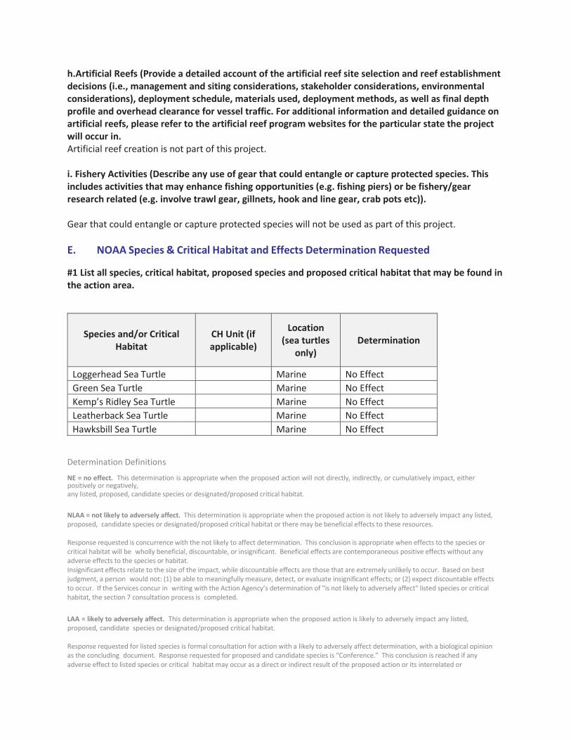
h.Artificial Reefs (Provide a detailed account of the artificial reef site selection and reef establishment decisions (i.e., management and siting considerations, stakeholder considerations, environmental considerations), deployment schedule, materials used, deployment methods, as well as final depth profile and overhead clearance for vessel traffic. For additional information and detailed guidance on artificial reefs, please refer to the artificial reef program websites for the particular state the project will occur in. Artificial reef creation is not part of this project. i. Fishery Activities (Describe any use of gear that could entangle or capture protected species. This includes activities that may enhance fishing opportunities (e.g. fishing piers) or be fishery/gear research related (e.g. involve trawl gear, gillnets, hook and line gear, crab pots etc)). Gear that could entangle or capture protected species will not be used as part of this project.
E. NOAA Species & Critical Habitat and Effects Determination Requested
#1 List all species, critical habitat, proposed species and proposed critical habitat that may be found in the action area.
Species and/or Critical Habitat
CH Unit (if applicable)
Location (sea turtles
only) Determination
Loggerhead Sea Turtle Marine No Effect Green Sea Turtle Marine No Effect Kemp’s Ridley Sea Turtle Marine No Effect Leatherback Sea Turtle Marine No Effect Hawksbill Sea Turtle Marine No Effect
Determination Definitions NE = no effect. This determination is appropriate when the proposed action will not directly, indirectly, or cumulatively impact, either positively or negatively, any listed, proposed, candidate species or designated/proposed critical habitat. NLAA = not likely to adversely affect. This determination is appropriate when the proposed action is not likely to adversely impact any listed, proposed, candidate species or designated/proposed critical habitat or there may be beneficial effects to these resources. Response requested is concurrence with the not likely to affect determination. This conclusion is appropriate when effects to the species or critical habitat will be wholly beneficial, discountable, or insignificant. Beneficial effects are contemporaneous positive effects without any adverse effects to the species or habitat. Insignificant effects relate to the size of the impact, while discountable effects are those that are extremely unlikely to occur. Based on best judgment, a person would not: (1) be able to meaningfully measure, detect, or evaluate insignificant effects; or (2) expect discountable effects to occur. If the Services concur in writing with the Action Agency’s determination of "is not likely to adversely affect" listed species or critical habitat, the section 7 consultation process is completed. LAA = likely to adversely affect. This determination is appropriate when the proposed action is likely to adversely impact any listed, proposed, candidate species or designated/proposed critical habitat. Response requested for listed species is formal consultation for action with a likely to adversely affect determination, with a biological opinion as the concluding document. Response requested for proposed and candidate species is “Conference.” This conclusion is reached if any adverse effect to listed species or critical habitat may occur as a direct or indirect result of the proposed action or its interrelated or

interdependent actions, and the effect is not discountable or insignificant. In the event the overall effect of the proposed action is beneficial to the listed species or critical habitat, but may also cause some adverse effect on individuals of the listed species or segments of the critical habitat, then the determination is "likely to adversely affect." Any LAA determination requires formal section 7 consultation and will require additional information. #2 Attach a separate map identifying species/critical habitat locations within the action area. Identify if Gulf sturgeon are in marine or in freshwater in your Species and/or Critical Habitat list to determine which federal agency will perform the analysis (e.g. Gulf sturgeon CH - marine). Identify if sea turtles are in water or on land in your Species and/or Critical Habitat list to determine which federal agency will perform the analysis (e.g. Loggerhead sea turtle CH - terrestrial).
There is no critical habitat within the project area.
F. USFWS Species & Critical Habitat and Effects Determination Requested #1 List all species, critical habitat, proposed species and proposed critical habitat that may be found in the action area.
Species and/or Critical Habitat
CH Unit (if applicable)
Location (sea turtles
only) Determination
Piping Plover CH TX-3A, TX-
3B No Effect Piping Plover No Effect Red Knot No Effect Northern Aplomado Falcon No Effect Ocelot No Effect Gulf Coast Jaguarundi No Effect Loggerhead Sea Turtle Terrestrial No Effect Green Sea Turtle Terrestrial No Effect Kemp’s Ridley Sea Turtle Terrestrial No Effect Leatherback Sea Turtle Terrestrial No Effect Hawksbill Sea Turtle Terrestrial No Effect
#2 Attach a separate map identifying species/critical habitat locations within the action area. For information on species and critical habitat under USFWS jurisdiction, visit http://www.fws.gov/endangered/species/. Identify if Gulf sturgeon are in marine or in freshwater in your Species and/or Critical Habitat list to determine which federal agency will perform the analysis (e.g. Gulf sturgeon CH - marine). Identify if sea turtles are in water or on land in your Species and/or Critical Habitat list to determine which federal agency will perform the analysis (e.g. Loggerhead sea turtle CH - terrestrial).

There is piping plover critical habitat within the project area. The project will preserve habitat and prevent development, which could harm the critical habitat. The scope of this project is limited to habitat acquisition and preservation. See Section C for a description of the project.
Determination Definitions
NE = no effect. This determination is appropriate when the proposed action will not directly, indirectly, or cumulatively impact, either positively or negatively, any listed, proposed, candidate species or designated/proposed critical habitat. NLAA = not likely to adversely affect. This determination is appropriate when the proposed action is not likely to adversely impact any listed, proposed, candidate species or designated/proposed critical habitat or there may be beneficial effects to these resources. Response requested is concurrence with the not likely to affect determination. This conclusion is appropriate when effects to the species or critical habitat will be wholly beneficial, discountable, or insignificant. Beneficial effects are contemporaneous positive effects without any adverse effects to the species or habitat. Insignificant effects relate to the size of the impact, while discountable effects are those that are extremely unlikely to occur. Based on best judgment, a person would not: (1) be able to meaningfully measure, detect, or evaluate insignificant effects; or (2) expect discountable effects to occur. If the Services concur in writing with the Action Agency’s determination of "is not likely to adversely affect" listed species or critical habitat, the section 7 consultation process is completed. LAA = likely to adversely affect. This determination is appropriate when the proposed action is likely to adversely impact any listed, proposed, candidate species or designated/proposed critical habitat. Response requested for listed species is formal consultation for action with a likely to adversely affect determination, with a biological opinion as the concluding document. Response requested for proposed and candidate species is “Conference.” This conclusion is reached if any adverse effect to listed species or critical habitat may occur as a direct or indirect result of the proposed action or its interrelated or interdependent actions, and the effect is not discountable or insignificant. In the event the overall effect of the proposed action is beneficial to the listed species or critical habitat, but may also cause some adverse effect on individuals of the listed species or segments of the critical habitat, then the determination is "likely to adversely affect." Any LAA determination requires formal section 7 consultation and will require additional information.
G. Effects of the Proposed Project
I. Explain the potential beneficial and adverse effects to each species listed above (Describe what, when, and how the species will be impacted and the likely response to the impact. Be sure to include direct, indirect, interdependent, interrelated, connected actions, and cumulative impacts.

Where possible, quantify effects. If species are present (or potentially present) and will not be adversely affected describe your rationale. If species are unlikely to be present in the general area or action area, explain why. This justification provides documentation for your administrative record, avoids the need for additional correspondence regarding the species, and helps expedite review.)
We anticipate this land acquisition will not affect any listed species or critical habitat.
II. Explain the potential beneficial and adverse effects to critical habitat listed above (Describe what, when, and how the critical habitat will be impacted and the likely response to the impact. Be sure to include direct, indirect, interdependent, interrelated, connected actions, and cumulative impacts. Where possible, quantify effects (e.g. acres of habitat, miles of habitat). Describe your rationale if designated or proposed critical habitats are present and will not be adversely affected.
There is piping plover critical habitat within the project area. The project will preserve habitat and prevent development, which could harm the critical habitat. The scope of this project is limited to habitat acquisition and preservation. See Section C for a description of the project.
H. Actions to Reduce Adverse Effects
Explain the actions to reduce adverse effects to each species listed above (For each species for which impacts were identified, describe any conservation measures (e.g. BMPs) that will be implemented to avoid or minimize the impacts. Conservation measures are designed to avoid or minimize effects to listed species and critical habitats or further the recovery of the species under review. Conservation measures are considered part of the proposed action and their implementation is required. Any changes to, modifications of, or failure to implement these conservation measures may result in a need to reinitiate this consultation.)
No actions are necessary. The scope of this project is limited to habitat acquisition and preservation. See Section C for a description of the project.
II. Explain the actions to reduce adverse effects to critical habitat listed above (For critical habitat for which impacts were identified, describe any conservation measures (e.g. BMPs) that will be implemented to avoid or minimize the impacts. Conservation measures are designed to avoid or minimize effects to listed species and critical habitats or further the recovery of the species under review. Conservation measures are considered part of the proposed action and their implementation is required. Any changes to, modifications of, or failure to implement these conservation measures may result in a need to reinitiate this consultation.)
No actions are necessary. The scope of this project is limited to habitat acquisition and preservation. See Section C for a description of the project. There will be no adverse impacts to critical habitat.

I. Marine Mammals
I. The Marine Mammal Protection Act prohibits the taking (including disruption of behavior, entrapment, injury, or death) of all marine mammals (e.g.,whales, dolphins, manatees). However, the MMPA allows limited exceptions to the take prohibition if authorized, such as the incidental (i.e., unintentional but not unexpected) take of marine mammals. The following questions are designed to allow the Agencies to quickly determine if your action has the potential to take marine mammals. If the information provided indicates that incidental take is possible, further discussion with the Agencies is required.
Is your activity occurring in or on marine or estuarine waters, or could it impact the quality (e.g., salinity, temperature) of marine or estuarine waters? Answer yes or no.
No.
II.Does your activity involve any of the following (answer yes or no): No.
a. Use of active acoustic equipment (e.g., echosounder) producing sound below 200 kHz
b. In-water construction or demolition
c. Temporary or fixed use of active or passive sampling gear (e.g., nets, lines, traps; turtle relocation trawls)
d. In-water Explosive detonation
e. Building or enhancing areas for water-related recreational use or fishing opportunities (e.g. fishing piers, bridges, boat ramps, marinas)
f. Aquaculture
g. Dredging or in-water construction activities to change hydrologic conditions or connectivity, create breakwaters and living shorelines, etc.
h. Restoration of barrier islands, levee construction or similar projects
i. Fresh-water river diversions
III. If you checked “Yes” to any of the activities immediately above or whether the activity could impact the quality of marine or estuarine waters, please describe the nature of the activities in more detail or indicate which section of the form already includes these descriptions:
IV. Are any measures planned to mitigate potential impacts to marine mammals? (answer yes
or no)

If yes, provide text in below.
J. Bald Eagles Are bald eagles present in the action area? (answer yes or no) Bald and/or golden eagles may be present in the action area. However, there are no known nesting sites near the project. If YES, the following conservation measures should be implemented: 1.If bald eagle breeding or nesting behaviors are observed or a nest is discovered or known, all activities (e.g., walking, camping, clean-up, use of a UTV, ATV, or boat) should avoid the nest by a minimum of 660 feet. If the nest is protected by a vegetated buffer where there is no line ofsight to the nest, then the minimum avoidance distance is 330 feet. This avoidance distance shall be maintained from the onset of breeding/courtship behaviors until any eggs have hatched and eaglets have fledged (approximately 6 months). 2.If a similar activity (e.g., driving on a roadway) is closer than 660 feet to a nest, then you may maintain a distance buffer as close to the nest as the existing tolerated activity. 3.If a vegetated buffer is present and there is no line of sight to the nest and a similar activity is closer than 330 feet to a nest, then you may maintain a distance buffer as close to the nest as the existing tolerated activity. 4.In some instances, activities conducted at a distance greater than 660 feet of a nest may result in disturbance. If an activity appears to cause initial disturbance, the activity shall stop and all individuals and equipment will be moved away until the eagles are no longer displaying disturbance behaviors.
Will you implement the above measures? (answer yes or no) N/A. The project is land acquisition. If these measures cannot be implemented, then you must contact the Service’s Migratory Bird Permit Office. Texas – (505) 248-7882 or by email: [email protected]
K. Migratory Birds Identify the species anticipated in the action area and behaviors (breeding, roosting, foraging) anticipated during project implementation. You may list similar species on a single line and categorize by type (e.g., Wading birds - great blue heron, snowy egret, reddish egret). If species or habitat impacts could occur, identify avoidance and minimization measures to prevent incidental take. Incidental take of Migratory Birds cannot be authorized. Use additional tables on the next

page if needed.
N/A NEPA Documents Is the NEPA analysis for this project complete or in progress (yes or no)? Yes
Does this project fall under a programmatic NEPA document different from the PDARP/PEIS? (e.g. US
Army Corps of Engineers, BOEM or other agency) Answer yes or no. Yes
Fish and Wildlife Coordination Act (FWCA) consultation initiated or completed, if applicable? (answer yes or no) Not applicable
If yes to any question above, please provide details in the text box below (i.e. link to the document, or name of the document, year, lead federal agency, USFWS Field Office involved, etc.). If you do not have a link, attach documents to this BE form. Any documentation or information provided will be very helpful in moving your project forward. The NEPA for this project was included as part of the Texas Trustee Implementation Group (Texas TIG). 2017. Deepwater Horizon Oil Spill Natural Resource Damage Assessment, Texas Trustee Implementation Group, Draft 2017 Texas Restoration Plan/Environmental Assessment: Restoration of Wetlands, Coastal, and Nearshore Habitats; and Oysters. May 2017. The NEPA is also addressed as part of the Deepwater Horizon Final PDARP/PEIS. http://www.gulfspillrestoration.noaa.gov/restoration-planning/gulf-plan The NEPA is also addressed as part of the LANWR Comprehensive Conservation Plan (https://www.fws.gov/doiddata/dwh-ar-documents/1266/DWH-ARZ000415.pdf).
NMFS ESA § 7 Consultation We request that all ESA §7 consultation requests/packages be submitted electronically to: [email protected] Questions about consultation status may be directed to the email address above or by phone: Christy Fellas: 727-551-5714
USFWS ESA § 7 Consultation We request that all consultation requests/packages to USFWS be submitted electronically to: [email protected]. You will be notified when we receive your Biological Evaluation. Upon receipt, we will conduct a preliminary review and provide any comments and feedback, including any requests for modifications or additional information. If modifications or additional information is necessary, we will work with you until the Biological Evaluation form is considered complete. Once complete, we will send your Biological Evaluation to the appropriate Field Office to conduct consultation.

Questions about consultation status may be directed to the email address above or by phone: Ashley Mills: 812-756-2712 Name of Person Completing this Form: Angela Schrift
Name of Project Lead:
Date Form Completed: 7/20/17
Date Form Updated:
Endangered Species Act Programmatic Biological Opinion
Deepwater Horizon Oil Spill Restoration National Marine Fisheries Service
Complete this section only if your project qualifies for streamlined ESA consultation under the ESA FrameworkProgrammatic Biological Opinion completed byNMFS on February 10, 2016. To be eligible for streamlined ESAconsultation with NMFS, youmust implement allProject Design Criteria (PDCs) applicable to your project. Bychecking all boxes below that apply to this project you are confirming thatPDCs are incorporated into the projectdesign and construction.The entire Biological Evaluation Form must be completed and include any information necessary to verify that all applicable PDCs are incorporated into the project. If theprojectincorporates more than one type of restoration, check boxes in all appropriate categories.
You must receive NMFS approval before proceeding with your project. Note that this PDC checklist does notapply to ESA consultation with USFWS.
Full text of the PDCs can be reviewed at:http://sero.nmfs.noaa.gov/protected_resources/section_7/freq_biop/documents/DWH_bo/appendix_a.pdf
PDCs do not apply to this project.

U.S. Fish and Wildlife Service
Texas General Land Office, U.S. Fish and Wildlife Service - for purposes of this BE form only
Ray Newby (TX GLO) (512) 475-3624 [email protected]
McFaddin Beach and Dune Restoration
NMFS Southeast Regional Office Texas Ecological Services Field Office (Houston, TX)
Restore and Enhance Dunes and Beaches
Select Most Appropriate
Along former SH87, McFaddin National Wildlife Refuge (NWR) is bounded on the south by Gulf of Mexico, on the east byTexas Parks and Wildlife Department (TPWD) property and private land, on the west by private land on High Island, and boththe Intracoastal Waterway and private property to the north. Nourishment site located within the Chenier Plain of SE Texas.
Jefferson and Chambers counties, TX
29.648077, -94.138454 NAD83
Texas does not use the public land survey system.

The McFaddin Beach and Dune Restoration project would include placement of sand along an 18-mile section of shoreline innortheastern Texas. The Texas TIG would partner with other funding sources to complete construction implementation,monitoring, and/or planning activities. This project would provide important ecological benefits by restoring lost beach anddune habitat and by helping to slow or stop marsh and land loss in McFaddin National Wildlife Refuge (NWR) interiormarshes.
The project site includes approximately 20 miles of beach along the McFaddin National Wildlife Refuge (MNWR), a 1,021-acrestrip of marsh located seaward of an existing berm, and an approximately 241-acre borrow site located approximately 1.5miles offshore from the MNWR, in Chambers and Jefferson Counties, Texas.
The dredging and borrow area are in a water depths of 18-27 feet in the GOM. The project area does not contain seagrassbeds or hard substrates that would support corals or hard structure habitats. In general, the vast majority of bottom substrateavailable to benthic communities in the project area consists of soft, muddy bottoms; the benthos here is dominated bypolychaetes. Many fish species including sharks, snapper, grouper, and mackerel can also be found in the project area. Thedredging pattern and depth of cut at the borrow site will be determined by the selected contractor based on geotechnical data,required sand quality at the nourishment site, and equipment to be used. Overburden material will be side-cast and aroundfour million cubic yards of sand material may be available for beach and dune nourishment. Dredged slopes of the borrowarea will not exceed (i.e. be steeper than) 5H:1V along the dredged boundaries to ensure integrity of the surrounding seabed,as suggested by Nairn and others (2005) (from BOEM 2012). As the borrow site is located considerably outside the depthlimits of significant motion of bottom sediments, the time rate for the removed area to fill is expected to be slow and consist offairly fine sediments. Deepened areas such as this are typically characterized by low turbulence areas and thus allowfor the settling of fine suspended sediments (Dean 2002 ). Side slopes of the pit are flattened due to gravitational effects; and,in areas where sediment is stirred by wave or current action, the effect of gravity always contributes to down-slope motion intothe pit.
McFaddin NWR is part of the Salt Bayou ecosystem, the largest contiguous estuarine marsh complex in Texas. Thisecosystem is approximately 139,000 acres in size within a Chenier Plain landscape that includes freshwater to estuarinemarsh, coastal prairie grasslands, tidal flats, creeks and basins and associated aquatic vegetation. This diversity ofcommunities creates a very productive complex for an array of fish and wildlife resources. In May 2013, the Salt BayouWorking Group, comprised of Federal, State, County level government representatives, and wetland conservationNon-Government Organizations (NGOs) completed the Salt Bayou Watershed Restoration Plan. This plan reflected thetechnical stakeholder group's understanding and knowledge of this ecosystem, as well as consensus on a strategy tocollectively improve conditions in the Salt Bayou system. Through scrutiny of the entire watershed, the workgroup studiedexisting and emerging alterations to the watershed that have the ability to drastically change the hydro logic and biologicalcharacteristics of the marshes. These alterations, human-induced and natural changes to hydrology, have altered the historichydrologic pattern either by reducing the amount of freshwater entering the system or by increasing the amount of saltwaterentering the system. These changes to the hydrologic pattern not only create widespread and continuous impacts, but are amajor driver of land loss and loss of elevation within the emergent marsh. Saltwater now enters from at least two majorlocations within the watershed where historically it had not. Without adequately addressing all of the actual and potentialalterations to the hydrologic flows into the watershed, we expect marsh loss will continue at an accelerating rate.
The proposed action will conserve one of the largest freshwater marshes on the Texas Coast, along with thousands of acresof intermediate to brackish marsh. McFaddin NWR supplies important feeding and resting habitat for migrating and winteringpopulations of waterfowl. Meeting the habitat needs of McFaddin NWR's diversity of wetland dependent resident and migratorybirds requires maintaining a range of coastal marsh habitat types and sequential stages of the plant community within thesemarsh types. Providing freshwater inflows and restricting saltwater intrusion are critical to maintaining the Chenier Plain'shistoric continuum of fresh, intermediate, and brackish saline marshes through existing system of impoundments. Habitatvalues for waterfowl, shorebirds and many wading bird species are greatly enhanced in intermediate marshes with earlysuccessional plant communities containing several perennial and annual plant species (primarily grasses and sedges) whichprovide important food resources, and where disturbance reduces the height and/or density of vegetation.
The project site includes both McFaddin NWR lands and adjacent state-owned public beach south of the refuge. Duringconstruction periods, the active construction zone will be off limits to the public. To ensure public safety, these closures willtemporarily prevent through traffic on the beach from either the east or west Refuge entrance. Off-road access into thesensitive wetland areas of McFaddin NWR for the purpose of avoiding temporary construction closures is not permitted.

McFaddin NWR is part of the Salt Bayou ecosystem, the largest contiguous estuarine marsh complex in Texas. Thisecosystem is approximately 139,000 acres in size within a Chenier Plain landscape that includes freshwater to estuarinemarsh, coastal prairie grasslands, tidal flats, creeks and basins and associated aquatic vegetation.
Oil and gas facilities are present.
Not applicable, not present in action area.
Not applicable, not present in action area.
Not applicable, not present in action area.
Beach habitat, which is primarily composed of clay overlain by a thin sand veneer.
West Indian manatee and bottlenose dolphins are the only marine mammals that could be present in the project area.Manatees are rarely found in Texas waters and are not expected to be in the project area.
Other marine mammals require, or prefer, deeper water depths for regular activities, and are unlikely to be present.

This project re-builds the dune line and beach face with material similar to its native sand from a source outside the Refuge.This results in a re-creation of historic dune heights and beach widths necessary for reducing shoreline retreat and protectingsensitive inland marshes. ESA section 7 consultation was completed with USFWS in August 2016 for these actions. Theactions are covered under USACE Permit SWG-2015-00444 November 2016 (expires December 2021). No additionalconsultation with USFWS is necessary at this time.
The proposed action involves dredging sand sediments from an offshore borrow area by using a cutter-head dredge andtransferring it to the shore via a submerged pipeline. This is done by lowering a rotating cutter-head, attached to a suctionpipe, to the seafloor. Material entering the pipe passes through the dredge pump(s) and is transported via pipeline to theshoreline. To remove material, the dredge (and rigid suction pipe) will swing side to side by applying tension on mooring wiresaffixed to anchors. As material is depleted, the dredge will progress forward potentially using a combination of spuds, mooringwires, and tender tugs. Depending upon the distance to the temporary construction area(s), booster pumps may be required.Once onshore, the material would be pumped along the shoreline to the local construction areas and graded to the requiredconstruction template with heavy equipment. Based on conversations with State and Federal archaeologists and biologists,impacts to cultural and biological resources can be mitigated by establishing designated pipeline corridors betweendredge/pipeline connections offshore and the coastline. This method also reduces the need for extra booster pumps bylimiting the along-shore pipeline reach on either side of shoreline connection points.
A recent pilot project which completed at least a 2-mile stretch of beach in front of McFaddin NWR used a 30-inch diameterpipeline. For this project it is anticipated that a pipeline of a similar size will be used. Also, similar to the pilot project, thepipeline from the offshore dredge site will be submerged and laid along the ocean floor until it meets a pipeline that will runparallel to shore. The location of the pipeline will not be a significant impediment to marine mammals.
Heavy equipment operators will create temporary earthen containment dikes, which will channelize the flow exiting the dredgepipe. As this flow runs along the beach, sediment will settle out within the project template and effluent will return to the ocean.As sediment builds up in front of the pipe, heavy equipment will grade the sediment to meet the project template. This may bedone using grade markers which are set by survey personnel for guidance. This is a continuous process interrupted only bythe need to shut down due to dredge maintenance, repositioning, fueling, adding/removing shoreline pipe, or an emergency.
Constant communication is required between shore-crew, dredge crew, and potential booster pump operators.This alternative was selected based on low to medium impacts of all criteria evaluated. The method is the only one that doesnot require construction of temporary roads which could permanently impact habitats within the Refuge. Construction,engineering representatives, and refuge management staff will meet periodically to discuss work completed, work to becompleted, issues identified, clarifications/directions, etc.
Designated environmental monitors will survey the immediate project area, a 100-ft buffer zone, and access routes daily asdeemed necessary by the presence of and/or likely presence of threatened and endangered species. Environmental monitorswill be in contact with refuge staff to determine this likelihood based on past surveys and current habitat availability.Environmental monitors will be responsible for communication and reporting of endangered species issues duringconstruction.
Adverse effects to the local environment would be localized and temporary. Adverse effects to any threatened andendangered species would be minimized based on the conservation measures employed.
Construction activities are planned to occur year-round due to the high cost of equipment mobilization associated with thisproject. The beach ridge would be restored in 2-mile sections, each taking around one month to complete.

No existing in-water or overwater structures are within the project area.
Not applicable.
Not applicable.
Not applicable.

Not applicable.
The proposed action involves dredging sand sediments from an offshore borrow area by using a cutter-head dredge andtransferring it to the shore via a submerged pipeline. Up to approximately 4.1 million cubic yards of sand will be hydraulicallydredged from a 241-acre borrow site located approximately 1.5 miles offshore of the project area. The material will be placedtransported to shore using a submerged dredge pipe, and placed on the shoreline via a dredge pipe. and used to constructdunes to an elevation of +8-foot North American Vertical Datum of 1988 (NAVD88). The final fill volume will averageapproximately 30-40 cubic yards per running foot of shoreline. Heavy equipment and machinery will be used onshore tomanage the dredge pipeline, contour dredge material, and to create containment dikes to ensure sediment settles out withinthe project area. Final designs are not yet complete, so there may be modifications to the design described above may occur.
Not applicable.
Not applicable.
Not applicable.

Loggerhead Sea Turtle (T) Marine
Green Sea Turtle (T)
Leatherback Sea Turtle (E)
Kemp's Ridley Sea Turtle (E)
Hawksbill Sea Turtle (E)
Smalltooth Sawfish (E)
Select One
Select One
Select One
Select One
Select One
Select One
Select One
Select One
Select One
Select One
Select One
Marine
Marine
Marine
Marine
Marine
Select One
Select One
Select One
Select One
Select One
Select One
Select One
Select One
Select One
Select One
Select One
May Affect, Not Likely to Adversely Affect
May Affect, Not Likely to Adversely Affect
May Affect, Not Likely to Adversely Affect
May Affect, Not Likely to Adversely Affect
May Affect, Not Likely to Adversely Affect
No Effect
Select Most Appropriate
Select Most Appropriate
Select Most Appropriate
Select Most Appropriate
Select Most Appropriate
Select Most Appropriate
Select Most Appropriate
Select Most Appropriate
Select Most Appropriate
Select Most Appropriate
Select Most Appropriate

Green sea turtle Terrestrial May Affect, Not Likely to Adversely Affect
Kemp's Ridley sea turtle
Terrestrial
Terrestrial
Terrestrial
Terrestrial
Terrestrial
Marine
Select One
Select One
Select One
Select One
Select One
Select One
Select One
Select One
Terrestrial
Select One
May Affect, Not Likely to Adversely Affect
May Affect, Not Likely to Adversely Affect
May Affect, Not Likely to Adversely Affect
May Affect, Not Likely to Adversely Affect
May Affect, Not Likely to Adversely Affect
May Affect, Not Likely to Adversely Affect
Select Most Appropriate
Select Most Appropriate
Select Most Appropriate
Select Most Appropriate
Select Most Appropriate
Select Most Appropriate
Select Most Appropriate
Select Most Appropriate
May Affect, Not Likely to Adversely Affect
Select Most Appropriate
Hawksbill sea turtle
Leatherback sea turtle
Loggerhead sea turtle
Piping plover
Red knot
West Indian manatee
Select One
Select One
Select One
Select One
Select One
Select One
Select One
Select One

ESA section 7 consultation with USFWS was completed as part of the USACE permitting project. That consultation document isattached to this BE Form and should be referenced for a complete summary of the proposed projects beneficial and adverse effects.
Summary of Project Impacts: Dredge placement will begin in the center of the project area, and then work to either side. A slurrymixture of sand and water will be placed in the designated project area to nourish the beach, and will de-water over time. Equipmentwill be used to shape the dunes and beach, but will only be in the immediate construction area while the slurry material is beingpumped. Once grading is complete, earth-moving equipment will be moved to the next section. Completed nourished portions willhave no additional passage of construction equipment.
Sea turtle Species-Current beach conditions are not suitable for sea turtle nesting clue to the lack of sand. Given that equipment willonly be in the immediate area for a short time and the actual slurry material does not provide suitable nesting habitat, interactionbetween construction equipment and nesting sea turtles is not expected.
Piping Plover and Red Knot-A limited number of piping plovers and red knots have been observed on McFaddin Beach. Short termadverse impacts (disturbance) may result from beach nourishment activities associated with this project. Similar habitat is abundant inthe area and no loss of species diversity or abundance is expected to result from this project.
West Indian Manatee-This species is unlikely to be found in the project area, but are vulnerable to vessel strikes. This project uses a hydraulic cutter-headdredge. Speed limits of marine vessels will be operated at "no wake/idle" speeds while in water where the draft of the vessel providesless than a four -foot clearance. All vessels will follow deep water routes whenever possible.
No critical habitat is located within the project area.

ESA section 7 consultation was completed with USFWS (August 2016) as part of the USACE permitting for this project (November2016).
A copy of the consultation document is attached to this BE Form and provides a complete summary of the conservation measures to beimplemented as part of this proposed project. The likelihood of impacts to all species listed will be minimized by implementing theconservation measures described in the attached consultation document.
No critical habitat is located within the project area.

✔
✔
✔
✔
✔
✔
✔
✔
✔
✔
The proposed action involves dredging sand sediments from an offshore borrow area by using a cutter-head dredge andtransferring it to the shore via a submerged pipeline. The borrow site is a 241 acre area located 1.5 miles from shore. A side-castarea is adjacent to the borrow site. The dredging of sediment will likely cause a short-term increase in turbidity in the watercolumn.
Marine mammals present in the area could be exposed to short-term disturbance from construction noise and turbidity, as well asan increased risk of vessel strike related to the use of a dredge in nearshore waters.
✔
Protections described in the existing USFWS consultation and USACE permit will be followed.
In addition to NMFS 2012 entrapment and 2006 construction and other BMPs described above for sea turtles and manatees, theNMFS 2008 vessel strike avoidance measures will be implemented to protect bottlenose dolphins. If marine mammals are sightedwithin 50 feet of the construction area, work would stop until the animals move away from the area under their own volition.Therefore, no incidental take of marine mammals is anticipated .

✔
✔
Wading birds
Shorebirds
Migratory waterfowl
Migratory songbirds
Waterfowl
Raptors
Terns and Gulls
foraging, loafing
foraging, loafing,nesting, breeding
loafing
foraging, loafing
loafing
foraging, loafing
foraging, roosting,nesting
No take under MBTA is expected as a result of this project
Work activities may occur year-round.
If construction activities occur during the nesting season, the area affected byproject activities would be surveyed for the presence of nesting birds by a qualifiedbiologist.
If nesting birds are present or indications of pre-nesting behavior are observed,appropriate BMPs would be employed to ensure that no incidental take of anyindividuals occurs.
Example BMPs may include virtual fencing, signage, exclusion zones for workersand equipment, hazing, and deterrents. BMP activities would be coordinated withUSFWS prior to implementation.


✔✔
✔
The Texas Trustee Implementation Group, Draft 2017 Texas Restoration Plan/Environmental Assessment: Restoration of Wetlands, Coastal,and Nearshore Habitats; and Oysters. May 2017 incorporates by reference two other previously-conducted NEPA analyses and conclusions:(1) The Environmental Assessment and Statement of Findings with USACE Permit SWG-2015-00444; and (2) NEPA analysis conducted bythe USFWS in its September 2016 Environmental Assessment: Beach Ridge Restoration on McFaddin NWR.The findings of the USFWS NEPA analysis are summarized in USFWS’s Environmental Action Statement.
Ashley Mills
07/20/2017

Project is designed to avoid techniques and locations listed in the oyster reef creation and enhancement PDCs 1.a-1.e.
Follows NMFS’ Sea Turtle and Smalltooth Sawfish Construction Conditions (PDC 2.a)
Follows NMFS’ Vessel Strike Avoidance Measures and Reporting for Mariners (PDC 2.b)
In-water construction does not impede sea turtle access to or from nesting sites during nesting season (PDC 2.c)
In Gulf sturgeon critical habitat, oyster reef creation and enhancement occurs only on existing shell substrata or relic reef locations (PDC 2.d)
Cultch material is free of debris and contaminants (PDC 2.e)
Fresh shell has been properly aged or quarantined before being deployed (PDC 2.f)
Cultch material is placed in a manner to minimize disturbance of sediment (PDC 2.g)
Methods are employed to avoid turbidity impacts to ESA-listed species (PDC 2.h)
Plan/drawings for intermittent breaks between oyster reef segment has been provided (2.i)
Spill prevention and response plan has been developed (2.j)
Design and materials used avoid entanglement and entrapment risks for ESA-listed species (2.k)
Monitoring plan is included and final reports will be submitted to NMFS (PDC 3 and 4)
This project is designed to avoid techniques and locations listed in the marine debris removal PDCs 1.a-1.c
All on-water operations shall take place during daylight hours (PDC 2.a)
Follows NMFS’ Sea Turtle and Smalltooth Sawfish Conditions (PDC 2.b)
Follows NMFS’ Vessel Strike Avoidance Measures and Reporting for Mariners (PDC 2.c)
Project personnel have been notified of procedures if approached by a marine mammal or sea turtle (PDC 2.d)
Trash and debris will be disposed of at an upland location (PDCs 2.e)
Monitoring plan is included and final reports will be submitted to NMFS (PDC 3 and 4)

This project is designed to avoid techniques and locations listed in the living shoreline PDCs 1.a-1.h
Follows NMFS’ Sea Turtle and Smalltooth Sawfish Conditions (PDC 2.a)
All in-water work activities will conducted during daylight hours (PDC 2.b)
Piles for navigation of public safety purposes are less than 24" diameter and non-metal if impact hammer used (PDC 2.c)
Spill prevention and response plan has been developed (2.d)
Fill material is not sourced using hopper dredge or from sea turtle, Gulf sturgeon or smalltooth sawfish critical habitat and in-water borrow sites do not impact turtle nesting beaches (PDC 2.e)
Design and materials do not create entrapment or entanglement risks to ESA-listed species and do not block migration (PDC 2.f)
In-water construction does not impede sea turtle access to or from nesting sites during nesting season (PDC 2.g)
Methods are employed to avoid turbidity impacts to ESA-listed species (PDC 2.h)
Follows NMFS’ Vessel Strike Avoidance Measures and Reporting for Mariners (PDC 2.i)
Project is designed to avoid techniques and locations listed in the marsh creation PDCs 1.a-1.f
Follows NMFS’ Sea Turtle and Smalltooth Sawfish Conditions (PDC 2.a)
Monitoring plan is included and final reports will be submitted to NMFS (PDC 3 and 4)
Follows NMFS’ Vessel Strike Avoidance Measures and Reporting for Mariners (PDC 2.b)
All in-water work activities will be conducted during daylight hours (PDC 2.c)
Spill prevention and response plan has been developed (PDC 2.d)
Fill material is not sourced using hopper dredge or from sea turtle, Gulf sturgeon or smalltooth sawfish critical habitat and in-water borrow sites do not impact turtle nesting beaches (PDC 2.e)
Design and materials do not create entrapment or entanglement risks to ESA-listed species and do not block migration (PDC 2.f)
In-water construction does not impede sea turtle access to or from nesting sites during nesting season (PDC 2.g)
Methods are employed to avoid turbidity impacts to ESA-listed species (PDCs 2.h)
Monitoring plan is included and final reports will be submitted to NMFS (PDC 3 and 4)

This project is designed to avoid locations listed in the non-fishing piers PDCs 1.a
Spill prevention and response plan has been developed (PDC 2.a)
Design and materials do not create entrapment or entanglement risks to ESA-listed species and do not block migration (PDC 2.b)
Follows NMFS’ Sea Turtle and Smalltooth Sawfish Construction Conditions (PDC 2.c)
Follows NMFS’ Vessel Strike Avoidance Measures and Reporting for Mariners (PDC 2.d)
Follow Construction Guidelines in Florida for Minor Piling-Supported Structures Constructed in or over Submerged Aquatic Vegetation (SAV), Marsh or Mangrove Habitat (PDC 2.e)
In-water construction does not impede sea turtle access to or from nesting sites during nesting season (PDC 2.f)
Follows methods and timing for pile driving (2.g)
Follows construction sequencing and avoids propwashing (PDC 2.h)
Water depth will not be altered (PDC 2.i)
Lighting specifications are incorporated for piers on or adjacent to sea turtle nesting beaches (PDC 2.j)
Follows educational and fishing signage requirements (PDC 2.k)
Methods are employed to avoid turbidity impacts to ESA-listed species (PDC 2.l)
Monitoring plan is included and final reports will be submitted to NMFS (PDC 3 and 4)
Ashley Mills
7/20/17


Biological Evaluation Form Deepwater Horizon Oil Spill Restoration
U.S. Fish and Wildlife Service & National Marine Fisheries Service
This form will be filled out by the Implementing Trustee and used by the regulatory agencies. The formwill provide information to initiate informal Section 7 consultations under the Endangered Species Act (ESA) and may be used to document aNoEffect determinationor to initiate pre-consultation technical assistance. It is recommended that this form also be completed to inform and evaluate additional needs for compliance with the following authorities: Migratory Bird Treaty Act (MBTA), Marine Mammal Protect Act (MMPA), Coastal Barrier Resources Act (CBRA), Bald and Golden Eagle Protection Act (BGEPA) and Section 106 of the National Historic Preservation Act (NHPA). Further information may be required beyond what is captured on this form. Note: if you need additionalspace for writing, please attach pages as needed.
A. Project Identification Federal Action Agency: U.S. Fish and Wildlife Service/National Marine Fisheries Service
Agency Contact(s) USFWS: Ashley Mills at 812-756-2712 and [email protected] NMFS: Christy Fellas at 727-551-5714 and [email protected]
I. Implementing Trustee U.S. Fish and Wildlife Service – for purposes of this BE form only
II. Applicant Contact Person Angela Schrift/Kathryn Burger
III. Phone 512-389-8755; 512-389-8153 Email: [email protected]; [email protected]
IV. Project Name and ID# (Official name of project and ID number assigned by action agency) Mid-Coast Habitat Acquisition
V. NMFS Office (Choose appropriate office based on project location) NMFS Southeast Regional Office
VI. FWS Office (Choose appropriate office based on project location)

Texas Coastal Ecological Services Field Office, Houston, TX
VII. Project Type 1 Restoration Type: Wetlands, Coastal, and Nearshore Habitats
VIII. Project Type 2, if helpful
B. Project Location I. Project Location
This project would acquire a parcel of land that would be conveyed to the USFWS as a part of the Mid Coast NWR Complex. The proposed land tract is located in Matagorda County near East Matagorda Bay. The tract is adjacent to estuarine waters, a county road, and nearby electrical service and has the potential for subdivision for recreational home site development. The tract is within the San Bernard NWR acquisition boundary. Big Boggy, San Bernard, and Brazoria NWRs are all managed by the USFWS under the Texas Mid-Coast NWR.
II. State & County/Parish of Project Site Matagorda County, Texas
III. Latitude & Longitude for Project Site (Decimal degrees and datum [e.g., 27.71622°N, 80.25174°W NAD83] [online conversion: https://www.fcc.gov/encyclopedia/degrees-minutes-seconds-tofrom-decimal-degrees]) Approximate 28.766935° N, 95.772912°W; WGS 84
IV. Township, range and section of the project area Texas does not use the public land survey system.
C. Description of Action Area #1 Attach a separate map delineating where the action will occur.

Figure 1. The action area is the Mid-Coast Acquisition area. The action area would only include property
that was acquired through fee-simple acquisition. #2 Describe ALL areas that may be affected directly or indirectly by the action and not merely the immediate action area involved in the action, or just where species or critical habitat may be present. Provide a description of the existing environmental conditions and characteristics (e.g., topography, vegetation type, soil type, substrate type, water quality, water depth, tidal/riverine/estuarine, hydrology and drainage patterns, current flow and direction), and land uses (e.g., public, residential, commercial, industrial, agricultural). The action area is located in Matagorda County near East Matagorda Bay. The tract is adjacent to estuarine waters, a county road, and nearby electrical service and has the potential for subdivision for recreational home site development. The tract is within the San Bernard NWR acquisition boundary. Big Boggy, San Bernard, and Brazoria NWRs are all managed by the USFWS under the Texas Mid-Coast NWR. #3 If habitat for species is present in the action area, provide a general description of the current state of the habitat. The project area is composed of several coastal habitat types that include 245 acres of saline coastal prairie dominated by gulf cordgrass, 525 acres of estuarine intertidal emergent wetlands dominated by marshhay cordgrass and smooth cordgrass, and 30 acres of palustrine emergent wetlands dominated by spike rush and rushes. The area is able to support a diverse and abundant estuarine assemblage of

plants and animals including secretive marsh birds, wading birds, invertebrates such as shrimp and crabs, as well as juvenile and adult estuarine fish. The tract is adjacent to estuarine waters, a county road, and nearby electrical service and has the potential for subdivision for recreational home site development. # 4 Identify any management or other activities already occurring in the area. The land is in private ownership. #5 Provide or attach a detailed map of the area of potential effect for ground disturbing activities if the area is different from the action area.
a. Waterbody (If applicable. Name the body of water, including wetlands (freshwater or estuarine), on which the project is located. If the location is in a river or estuary, please approximate the navigable distance from the project location to the marine environment.)
There are wetlands in the action area. Marshes near the project area are typically dominated by smooth cordgrass (Spartina alterniflora). Higher portions contain bushy seaside tansy (Borrichia frutescens) and turtleweed (Batis maritima). They are subject to intermittent inundation due to tidal action and high levels of freshwater inflow. Fluctuations in temperature, salinity, water depth, and sediment composition can have a limiting effect on the number of plant species found. There are no areas of open water proposed for acquisition. Lake Austin and East Matagorda Bay are near the project area.
b. Existing Structures (If applicable. Describe the current and historical structures found in the action area (e.g., buildings, parking lots, docks, seawalls, groynes, jetties, marina.)). If known, please provide the years of construction.
There are no known existing structures at the site proposed for acquisition
Seagrasses & Other Marine Vegetation (If applicable. Describe seagrasses found in action area. If a benthic survey was done, provide the date it was completed and a copy of the report. Estimate the species area of coverage and density. Attach a separate map showing the location of the seagrasses in the action area.)
There are no seagrasses located in the area being acquired. Seagrasses will not be adversely affected directly or indirectly by any actions taken as a result of this project.
c. Mangroves (If applicable. Describe the mangroves found in action area. Indicate the species found
(red, black, white), the species area of coverage in square footage and linear footage along project shoreline. Attach a separate map showing the location of the mangroves in the action area.)

There are no known mangroves present in the proposed project site.
d. Corals (If applicable. Describe the corals found in action area. If a benthic survey was done, provide
the date it was completed and a copy of the report. Estimate the species area of coverage and density. Attach a separate map showing the location of the corals in the action area.)
There are no corals in the project area. Appropriate habitat does not exist.
e. Uplands (If applicable. Describe the current terrestrial habitat in which the project is located (e.g.
pasture, forest, meadows, beach and dune habitats, etc.). Habitats associated with the subject tract include salty prairie. There will be no take of migratory birds.
f. Marine Mammals (If applicable. Indicate and describe the species found in the action area. Use NMFS' Stock Assessment Reports (SARs) for more information, see http://www.nmfs.noaa.gov/pr/sars/region.htm)
Not applicable.
D. Project Description I. Construction Schedule (What is the anticipated schedule for major phases of work? Include duration of in-water work.) Construction is not part of this project. Once the tract is in USFWS ownership, the agency would manage the tract and monitor wildlife populations as well as habitat conditions at the site. The goal is to create stable to increasing populations of coastal grassland and wetland dependent birds as well as protect estuarine and fresh marsh habitats that provide nursery habitat for commercially and recreationally important fisheries species, as well as improved habitat for shorebirds, wading birds and waterfowl. These conditions would help meet habitat and/or population objectives of conservation plans listed above and the Texas Mid-Coast NWR Comprehensive Conservation Plan (CCP) (USFWS 2013). Through the development of goals, objectives, and strategies, this CCP describes how the Complex contributes to the overall mission of the Refuge System, fulfills the purposes designated for the refuges, and uses the best available science for adaptive management. The USFWS refuge objectives, consistent with the approved practices in the 2013 CCP, that would be

met by this acquisition include:
To contribute to conservation efforts and to foster the ecological integrity of the Gulf Coast Prairies and Marshes Ecoregion through proven and innovative management practices across the Complex. To conserve, restore, enhance, and protect Complex habitats by implementing appropriate management programs to benefit native flora and fauna, including threatened and endangered species and other species of concern. To protect, maintain, and enhance populations of migratory birds and resident fish and wildlife, including federal and state threatened and endangered species.
The USFWS completed a Management Plan with the establishment of the NWR. The purposes of the NWR as defined in the Management Plan are to: (1) protect nesting, wintering and migratory habitat for migratory birds of the Central Flyway; (2) protect the bottomland hardwood forests for their diverse biological values and wetland functions of water quality improvement and flood control assistance; and (3) provide for compatible wildlife-dependent recreation opportunities in accordance with the National Wildlife Refuge System Improvement Act of 1997. Any changes to the purposes of the NWR would be subject to public and congressional review. Management of the proposed project must be consistent with the Management Plan and goals defined in the Land Protection Plan and Conceptual Management Plan, all of which must be consistent with refuge purpose and requirements of the Migratory Bird Conservation Act, Emergency Wetlands Resources Act of 1986 and the Fish and Wildlife Act of 1956. Longer term management and planning are addressed in the development of a CCP for the NWR. The USFWS must develop a CCP within 10 years of the establishment of the NWR and then review the CCP every 10-15 years after initial completion (16 U.S.C. §668dd(e)). The USFWS is required to ensure an opportunity for active public involvement in the preparation and revision of the CCP, including notice and an opportunity for public comment on the draft proposed plan, publication of comments, including the state’s; summarization of all comments received, and disposition of concerns raised in comments (16 U.S.C. §668dd(e)). The USFWS would coordinate and provide opportunity for the Texas TIG to provide input into management changes that may affect the conservation values of the proposed project. Prior to conveyance of the property, the Texas TIG would enter into agreement with USFWS that includes the expectations of the Texas TIG for management of the property.
II. Describe the Proposed Action: #1 What is the purpose and need of the proposed action?
The Texas TIG has undertaken this restoration planning effort to meet the purpose of restoring those natural resources and services injured as a result of the Deepwater Horizon Oil Spill. This project’s purpose is to begin to restore wetlands, coastal, and nearshore habitats injured as a result of the Spill.
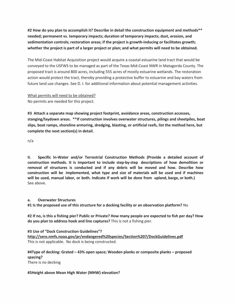
#2 How do you plan to accomplish it? Describe in detail the construction equipment and methods** needed; permanent vs. temporary impacts; duration of temporary impacts; dust, erosion, and sedimentation controls; restoration areas; if the project is growth-inducing or facilitates growth; whether the project is part of a larger project or plan; and what permits will need to be obtained. The Mid-Coast Habitat Acquisition project would acquire a coastal estuarine land tract that would be conveyed to the USFWS to be managed as part of the Texas Mid-Coast NWR in Matagorda County. The proposed tract is around 800 acres, including 555 acres of mostly estuarine wetlands. The restoration action would protect the tract, thereby providing a protective buffer to estuarine and bay waters from future land use changes. See D. I. for additional information about potential management activities. What permits will need to be obtained? No permits are needed for this project. #3 Attach a separate map showing project footprint, avoidance areas, construction accesses, stanging/laydown areas. **If construction involves overwater structures, pilings and sheetpiles, boat slips, boat ramps, shoreline armoring, dredging, blasting, or artificial reefs, list the method here, but complete the next section(s) in detail.
n/a
II. Specific In-Water and/or Terrestrial Construction Methods (Provide a detailed account of construction methods. It is important to include step-by-step descriptions of how demolition or removal of structures is conducted and if any debris will be moved and how. Describe how construction will be implemented, what type and size of materials will be used and if machines will be used, manual labor, or both. Indicate if work will be done from upland, barge, or both.) See above.
a. Overwater Structures #1 Is the proposed use of this structure for a docking facility or an observation platform? No #2 If no, is this a fishing pier? Public or Private? How many people are expected to fish per day? How do you plan to address hook and line captures? This is not a fishing pier. #3 Use of “Dock Construction Guidelines”? http://sero.nmfs.noaa.gov/pr/endangered%20species/Section%207/DockGuidelines.pdf This is not applicable. No dock is being constructed. #4Type of decking: Grated – 43% open space; Wooden planks or composite planks – proposed spacing? There is no decking #5Height above Mean High Water (MHW) elevation?

n/a #6 Directional orientation of main axis of dock? Not applicable. #7 Overwater area (sqft)? Not applicable. b.Pilings & Sheetpiles (What type of material is the piling or sheetpiles? What size and how many will be used? Method used to install: impact hammer, vibratory hammer, jetting, etc.?) Not applicable. c.Marinas and Boat Slips (Describe the number and size of slips and if the number of new slips changes from what is currently available at the project. Indicate how many are wet slips and how many are dry slips. Estimate the shadow effect of the boats - the area (sqft) beneath the boats that will be shaded.) Not applicable. d.Boat Ramp (Describe the number and size of boat ramps, the number of vessels that can be moored at the site (e.g., staging area) and if this is a public or private ramp. Indicate the boat trailer parking lot capacity, and if this number changes from what is currently available at the project.) Not applicable. e.Shoreline Armoring (This includes all manner of shoreline armoring (e.g., riprap, seawalls, jetties, groins, breakwaters, etc.). Provide specific information on material and construction methodology used to install the shoreline armoring materials. Include linear footage and square footage. Attach a separate map showing the location of the shoreline armoring in the action area. Not applicable. f.Dredging or digging (Provide details about dredge type (hopper, cutterhead, clamshell, etc.), maximum depth of dredging, area (ft2) to be dredged, volume of material (yd3) to be produced, grain size of material, sediment testing for contamination, spoil disposition plans, and hydrodynamic description(average current speed/direction)). If digging in the terrestrial environment, please describe fully with details about possible water jetting, vibration methods to install pilings for dune walk-over structure, or other methods. If using devices/methods/turtle relocation dredging to relocate sea turtles then describe the methods here. Not applicable. g.Blasting (Projects that use blasting might not qualify as “minor projects,” and a Biological Assessment (BA) may need to be prepared for the project. Arrange a technical consultation meeting

with NMFS Protected Resources Division to determine if a BA is necessary. Please include explosive weights and blasting plan.) This project does not involve blasting activities. h.Artificial Reefs (Provide a detailed account of the artificial reef site selection and reef establishment decisions (i.e., management and siting considerations, stakeholder considerations, environmental considerations), deployment schedule, materials used, deployment methods, as well as final depth profile and overhead clearance for vessel traffic. For additional information and detailed guidance on artificial reefs, please refer to the artificial reef program websites for the particular state the project will occur in. Artificial reef creation is not part of this project. i. Fishery Activities (Describe any use of gear that could entangle or capture protected species. This includes activities that may enhance fishing opportunities (e.g. fishing piers) or be fishery/gear research related (e.g. involve trawl gear, gillnets, hook and line gear, crab pots etc)). Gear that could entangle or capture protected species will not be used as part of this project.
E. NOAA Species & Critical Habitat and Effects Determination Requested
#1 List all species, critical habitat, proposed species and proposed critical habitat that may be found in the action area.
Species and/or Critical Habitat
CH Unit (if applicable)
Location (sea
turtles only)
Determination
Loggerhead Sea Turtle Marine No Effect Green Sea Turtle Marine No Effect Kemp’s Ridley Sea Turtle Marine No Effect Leatherback Sea Turtle Marine No Effect Hawksbill Sea Turtle Marine No Effect
Determination Definitions NE = no effect. This determination is appropriate when the proposed action will not directly, indirectly, or cumulatively impact, either positively or negatively, any listed, proposed, candidate species or designated/proposed critical habitat. NLAA = not likely to adversely affect. This determination is appropriate when the proposed action is not likely to adversely impact any listed, proposed, candidate species or designated/proposed critical habitat or there may be beneficial effects to these resources. Response requested is concurrence with the not likely to affect determination. This conclusion is appropriate when effects to the species or critical habitat will be wholly beneficial, discountable, or insignificant. Beneficial effects are contemporaneous positive effects without any adverse effects to the species or habitat. Insignificant effects relate to the size of the impact, while discountable effects are those that are extremely unlikely to occur. Based on best judgment, a person would not: (1) be able to meaningfully measure, detect, or evaluate insignificant effects; or (2) expect discountable effects

to occur. If the Services concur in writing with the Action Agency’s determination of "is not likely to adversely affect" listed species or critical habitat, the section 7 consultation process is completed. LAA = likely to adversely affect. This determination is appropriate when the proposed action is likely to adversely impact any listed, proposed, candidate species or designated/proposed critical habitat. Response requested for listed species is formal consultation for action with a likely to adversely affect determination, with a biological opinion as the concluding document. Response requested for proposed and candidate species is “Conference.” This conclusion is reached if any adverse effect to listed species or critical habitat may occur as a direct or indirect result of the proposed action or its interrelated or interdependent actions, and the effect is not discountable or insignificant. In the event the overall effect of the proposed action is beneficial to the listed species or critical habitat, but may also cause some adverse effect on individuals of the listed species or segments of the critical habitat, then the determination is "likely to adversely affect." Any LAA determination requires formal section 7 consultation and will require additional information.
#2 Attach a separate map identifying species/critical habitat locations within the action area. Identify if Gulf sturgeon are in marine or in freshwater in your Species and/or Critical Habitat list to determine which federal agency will perform the analysis (e.g. Gulf sturgeon CH - marine). Identify if sea turtles are in water or on land in your Species and/or Critical Habitat list to determine which federal agency will perform the analysis (e.g. Loggerhead sea turtle CH - terrestrial).
There is no critical habitat within the project area.
F. USFWS Species & Critical Habitat and Effects Determination Requested #1 List all species, critical habitat, proposed species and proposed critical habitat that may be found in the action area.
Species and/or Critical Habitat
CH Unit (if applicable)
Location (sea turtles
only) Determination
Piping Plover No Effect Red Knot No Effect Northern Aplomado Falcon No Effect West Indian Manatee No Effect Whooping Crane No Effect
#2 Attach a separate map identifying species/critical habitat locations within the action area. For information on species and critical habitat under USFWS jurisdiction, visit http://www.fws.gov/endangered/species/. Identify if Gulf sturgeon are in marine or in freshwater in your Species and/or Critical Habitat list to determine which federal agency will perform the analysis (e.g. Gulf sturgeon CH - marine). Identify if sea turtles are in water or on land in your Species and/or Critical Habitat list to determine which federal agency will perform the analysis (e.g. Loggerhead sea turtle CH - terrestrial).

There is no critical habitat within the project area.
Determination Definitions
NE = no effect. This determination is appropriate when the proposed action will not directly, indirectly, or cumulatively impact, either positively or negatively, any listed, proposed, candidate species or designated/proposed critical habitat. NLAA = not likely to adversely affect. This determination is appropriate when the proposed action is not likely to adversely impact any listed, proposed, candidate species or designated/proposed critical habitat or there may be beneficial effects to these resources. Response requested is concurrence with the not likely to affect determination. This conclusion is appropriate when effects to the species or critical habitat will be wholly beneficial, discountable, or insignificant. Beneficial effects are contemporaneous positive effects without any adverse effects to the species or habitat. Insignificant effects relate to the size of the impact, while discountable effects are those that are extremely unlikely to occur. Based on best judgment, a person would not: (1) be able to meaningfully measure, detect, or evaluate insignificant effects; or (2) expect discountable effects to occur. If the Services concur in writing with the Action Agency’s determination of "is not likely to adversely affect" listed species or critical habitat, the section 7 consultation process is completed. LAA = likely to adversely affect. This determination is appropriate when the proposed action is likely to adversely impact any listed, proposed, candidate species or designated/proposed critical habitat. Response requested for listed species is formal consultation for action with a likely to adversely affect determination, with a biological opinion as the concluding document. Response requested for proposed and candidate species is “Conference.” This conclusion is reached if any adverse effect to listed species or critical habitat may occur as a direct or indirect result of the proposed action or its interrelated or interdependent actions, and the effect is not discountable or insignificant. In the event the overall effect of the proposed action is beneficial to the listed species or critical habitat, but may also cause some adverse effect on individuals of the listed species or segments of the critical habitat, then the determination is "likely to adversely affect." Any LAA determination requires formal section 7 consultation and will require additional information.
G. Effects of the Proposed Project
I. Explain the potential beneficial and adverse effects to each species listed above (Describe what, when, and how the species will be impacted and the likely response to the impact. Be sure to include direct, indirect, interdependent, interrelated, connected actions, and cumulative impacts. Where possible, quantify effects. If species are present (or potentially present) and will not be adversely affected describe your rationale. If species are unlikely to be present in the general area or

action area, explain why. This justification provides documentation for your administrative record, avoids the need for additional correspondence regarding the species, and helps expedite review.)
We anticipate this land acquisition will not affect any listed species.
II. Explain the potential beneficial and adverse effects to critical habitat listed above (Describe what, when, and how the critical habitat will be impacted and the likely response to the impact. Be sure to include direct, indirect, interdependent, interrelated, connected actions, and cumulative impacts. Where possible, quantify effects (e.g. acres of habitat, miles of habitat). Describe your rationale if designated or proposed critical habitats are present and will not be adversely affected.
There is no critical habitat in the action area.
H. Actions to Reduce Adverse Effects
Explain the actions to reduce adverse effects to each species listed above (For each species for which impacts were identified, describe any conservation measures (e.g. BMPs) that will be implemented to avoid or minimize the impacts. Conservation measures are designed to avoid or minimize effects to listed species and critical habitats or further the recovery of the species under review. Conservation measures are considered part of the proposed action and their implementation is required. Any changes to, modifications of, or failure to implement these conservation measures may result in a need to reinitiate this consultation.)
No actions are necessary.
II. Explain the actions to reduce adverse effects to critical habitat listed above (For critical habitat for which impacts were identified, describe any conservation measures (e.g. BMPs) that will be implemented to avoid or minimize the impacts. Conservation measures are designed to avoid or minimize effects to listed species and critical habitats or further the recovery of the species under review. Conservation measures are considered part of the proposed action and their implementation is required. Any changes to, modifications of, or failure to implement these conservation measures may result in a need to reinitiate this consultation.)
There is no critical habitat within the project area.

I. Marine Mammals
I. The Marine Mammal Protection Act prohibits the taking (including disruption of behavior, entrapment, injury, or death) of all marine mammals (e.g.,whales, dolphins, manatees). However, the MMPA allows limited exceptions to the take prohibition if authorized, such as the incidental (i.e., unintentional but not unexpected) take of marine mammals. The following questions are designed to allow the Agencies to quickly determine if your action has the potential to take marine mammals. If the information provided indicates that incidental take is possible, further discussion with the Agencies is required.
Is your activity occurring in or on marine or estuarine waters, or could it impact the quality (e.g., salinity, temperature) of marine or estuarine waters? Answer yes or no.
No.
II.Does your activity involve any of the following (answer yes or no): No.
a. Use of active acoustic equipment (e.g., echosounder) producing sound below 200 kHz
b. In-water construction or demolition
c. Temporary or fixed use of active or passive sampling gear (e.g., nets, lines, traps; turtle relocation trawls)
d. In-water Explosive detonation
e. Building or enhancing areas for water-related recreational use or fishing opportunities (e.g. fishing piers, bridges, boat ramps, marinas)
f. Aquaculture
g. Dredging or in-water construction activities to change hydrologic conditions or connectivity, create breakwaters and living shorelines, etc.
h. Restoration of barrier islands, levee construction or similar projects
i. Fresh-water river diversions
III. If you checked “Yes” to any of the activities immediately above or whether the activity could impact the quality of marine or estuarine waters, please describe the nature of the activities in more detail or indicate which section of the form already includes these descriptions:

IV. Are any measures planned to mitigate potential impacts to marine mammals? (answer yes
or no)
If yes, provide text in below.
J. Bald Eagles Are bald eagles present in the action area? (answer yes or no) Bald and/or golden eagles may be present in the action area. However, there are no active nests of Bald Eagle near the subject tract. Golden Eagles may be present infrequently during winter months or during migration. If YES, the following conservation measures should be implemented: 1.If bald eagle breeding or nesting behaviors are observed or a nest is discovered or known, all activities (e.g., walking, camping, clean-up, use of a UTV, ATV, or boat) should avoid the nest by a minimum of 660 feet. If the nest is protected by a vegetated buffer where there is no line ofsight to the nest, then the minimum avoidance distance is 330 feet. This avoidance distance shall be maintained from the onset of breeding/courtship behaviors until any eggs have hatched and eaglets have fledged (approximately 6 months). 2.If a similar activity (e.g., driving on a roadway) is closer than 660 feet to a nest, then you may maintain a distance buffer as close to the nest as the existing tolerated activity. 3.If a vegetated buffer is present and there is no line of sight to the nest and a similar activity is closer than 330 feet to a nest, then you may maintain a distance buffer as close to the nest as the existing tolerated activity. 4.In some instances, activities conducted at a distance greater than 660 feet of a nest may result in disturbance. If an activity appears to cause initial disturbance, the activity shall stop and all individuals and equipment will be moved away until the eagles are no longer displaying disturbance behaviors.
Will you implement the above measures? (answer yes or no) N/A. The project is land acquisition. . If these measures cannot be implemented, then you must contact the Service’s Migratory Bird Permit Office. Texas – (505) 248-7882 or by email: [email protected]

K. Migratory Birds Identify the species anticipated in the action area and behaviors (breeding, roosting, foraging) anticipated during project implementation. You may list similar species on a single line and categorize by type (e.g., Wading birds - great blue heron, snowy egret, reddish egret). If species or habitat impacts could occur, identify avoidance and minimization measures to prevent incidental take. Incidental take of Migratory Birds cannot be authorized. Use additional tables on the next page if needed.
n/a NEPA Documents Is the NEPA analysis for this project complete or in progress (yes or no)? Yes
Does this project fall under a programmatic NEPA document different from the PDARP/PEIS? (e.g. US
Army Corps of Engineers, BOEM or other agency) Answer yes or no. Yes.
Fish and Wildlife Coordination Act (FWCA) consultation initiated or completed, if applicable? (answer yes or no) Not applicable.
If yes to any question above, please provide details in the text box below (i.e. link to the document, or name of the document, year, lead federal agency, USFWS Field Office involved, etc.). If you do not have a link, attach documents to this BE form. Any documentation or information provided will be very helpful in moving your project forward. The NEPA for this project was included as part of the Texas Trustee Implementation Group (Texas TIG). 2017. Deepwater Horizon Oil Spill Natural Resource Damage Assessment, Texas Trustee Implementation Group, Draft 2017 Texas Restoration Plan/Environmental Assessment: Restoration of Wetlands, Coastal, and Nearshore Habitats; and Oysters. May 2017. The NEPA is also addressed as part of the Deepwater Horizon Final PDARP/PEIS. http://www.gulfspillrestoration.noaa.gov/restoration-planning/gulf-plan The Texas Mid-coast National Wildlife Refuge Complex – Comprehensive Conservation Plan and Environmental Assessment (2013) contains NEPA analyses and information related to management actions of the refuge, acquisition of property for San Bernard, Big Boggy, and Brazoria national Wildlife Refuges(https://www.fws.gov/doiddata/dwh-ar-documents/1266/DWH-ARZ000378.pdf).
NMFS ESA § 7 Consultation We request that all ESA §7 consultation requests/packages be submitted electronically to: [email protected] Questions about consultation status may be directed to the email address above or by phone: Christy Fellas: 727-551-5714 USFWS ESA § 7 Consultation We request that all consultation requests/packages to USFWS be submitted electronically to: [email protected].

You will be notified when we receive your Biological Evaluation. Upon receipt, we will conduct a preliminary review and provide any comments and feedback, including any requests for modifications or additional information. If modifications or additional information is necessary, we will work with you until the Biological Evaluation form is considered complete. Once complete, we will send your Biological Evaluation to the appropriate Field Office to conduct consultation. Questions about consultation status may be directed to the email address above or by phone: Ashley Mills: 812-756-2712 Name of Person Completing this Form: Angela Schrift
Name of Project Lead:
Date Form Completed: 7/20/2017
Date Form Updated:
Endangered Species Act Programmatic Biological Opinion
Deepwater Horizon Oil Spill Restoration National Marine Fisheries Service
Complete this section only if your project qualifies for streamlined ESA consultation under the ESA FrameworkProgrammatic Biological Opinion completed byNMFS on February 10, 2016. To be eligible for streamlined ESAconsultation with NMFS, youmust implement allProject Design Criteria (PDCs) applicable to your project. Bychecking all boxes below that apply to this project you are confirming thatPDCs are incorporated into the projectdesign and construction.The entire Biological Evaluation Form must be completed and include any information necessary to verify that all applicable PDCs are incorporated into the project. If theprojectincorporates more than one type of restoration, check boxes in all appropriate categories.
You must receive NMFS approval before proceeding with your project. Note that this PDC checklist does notapply to ESA consultation with USFWS.
Full text of the PDCs can be reviewed at:http://sero.nmfs.noaa.gov/protected_resources/section_7/freq_biop/documents/DWH_bo/appendix_a.pdf
PDCs do not apply to this project.

National Marine Fisheries Service
TCEQ - this is for purposes of this BE form only
Angela Schrift (512) 389-8755 [email protected]
Oyster Restoration Engineering
NMFS Southeast Regional Office Texas Ecological Services Field Office (Houston, TX)
Create, Restore, and Enhance Coastal Wetlands
Select Most Appropriate
The Oyster Restoration Engineering project would occur in the Galveston Bay system, primarily in East Bay, Trinity Bay andUpper Galveston Bay.
Chambers, Harrris, and Galveston Counties
Approximate 29.568410° N, -94.848170° W; WGS 84
Texas does not use the public land survey system.

The scope of the project is engineering and design.
The Oyster Restoration Engineering project would provide for the planning, engineering, design, and permitting forrehabilitating and restoring oyster reef habitats in the Galveston Bay system, primarily in East Bay, Trinity Bay and UpperGalveston Bay (Figure 3-1). Hurricane Ike, which struck the Galveston Bay area in September 2008, buried approximately8,000 acres of oyster reef under sediment deposits up to 1.5 meters thick (Freese and Nichols 2015). Reef areas that werecovered with a relatively shallow layer of sediment were re-exposed through an effort of dragging bagless oyster dredges.However, oyster reef habitat in Galveston Bay has not recovered since Hurricane Ike to levels desired by resource managersto sustain a robust commercial oyster fishery and provide the full range of ecosystem service benefits. The Texas TIGrecognized the need to evaluate buried reefs in the Galveston Bay system as well as identify those areas within the GalvestonBay system that are currently in the greatest need of restoration. These areas include East Bay, Trinity Bay, and UpperGalveston Bay, generally east of the Houston Ship Channel.
The Oyster Restoration Engineering project would include an initial alternatives analysis designed to evaluate multiple oysterrestoration techniques and explore novel approaches to identify the most cost-effective landscape-level application of oysterrestoration within the target areas of Galveston Bay. The analysis would evaluate the most effective means of rehabilitatingburied oyster reefs and constructing sustainable intertidal reefs that would provide ecosystem benefits and ongoing sources oflarval material for surrounding reefs. The Texas TIG would procure the assistance of a qualified professional services provider(PSP) with expertise in the ecological and engineering aspects of oyster restoration and provide oversight of the alternativesanalysis.
The Oyster Restoration Engineering project would also identify potential project sites within the targeted areas of theGalveston Bay System. The PSP would utilize existing literature and monitoring data from previously constructed oysterrestoration projects and consult with the Texas TIG, TPWD resource managers, and oyster restoration experts to developrestoration site selection parameters. These parameters would then be used to identify the most appropriate restoration sitesto rehabilitate buried reefs and restore intertidal oyster reefs using the restoration techniques identified in the alternativesanalysis.
This project would further evaluate the conditions responsible for and propose solutions to ameliorate extreme salinityconditions. A suite of potential corrective actions would be evaluated for feasibility, cost, and effectiveness. The most effectiveand appropriate corrective measures would then be selected for 30% E&D development. Scientific and engineering taskscould include data collection (such as bathymetric/topographical survey, growth fault analyses, hydrologic and tidal flowevaluations, magnetometer survey, or soil borings); performance evaluation of the previous efforts noted above; gatheringnecessary materials for submission of required permit(s) at a later date; development of E&D plans; and estimatingconstruction costs associated with different management actions. Activities associated with data collection task could occur inthe field or office or both.
The activities proposed will have no significant impact on habitats present in the study area. There is no critical habitat withinthe study area and there are no known cultural resources. Activities associated with gathering information in the field will beextremely short-term in nature and will not affect fish and wildlife resources present.


See Section C.


Green Sea Turtle (T) Marine
Hawksbill Sea Turtle (E)
Loggerhead Sea Turtle CH
Leatherback Sea Turtle (E)
Kemp's Ridley Sea Turtle (E)
Select One
Select One
Select One
Select One
Select One
Select One
Select One
Select One
Select One
Select One
Select One
Select One
Marine
Marine
Marine
Marine
Select One
Select One
Select One
Select One
Select One
Select One
Select One
Select One
Select One
Select One
Select One
Select One
No Effect
No Effect
No Effect
No Effect
No Effect
Select Most Appropriate
Select Most Appropriate
Select Most Appropriate
Select Most Appropriate
Select Most Appropriate
Select Most Appropriate
Select Most Appropriate
Select Most Appropriate
Select Most Appropriate
Select Most Appropriate
Select Most Appropriate
Select Most Appropriate

West Indian manatee Select One No Effect
Select One
Select One
Select One
Select One
Select One
Select One
Select One
Select One
Select One
Select One
Select One
Select One
Select One
Select One
Select One
Select One
Select Most Appropriate
Select Most Appropriate
Select Most Appropriate
Select Most Appropriate
Select Most Appropriate
Select Most Appropriate
Select Most Appropriate
Select Most Appropriate
Select Most Appropriate
Select Most Appropriate
Select Most Appropriate
Select Most Appropriate
Select Most Appropriate
Select Most Appropriate
Select Most Appropriate
Select Most Appropriate
Select One
Select One
Select One
Select One
Select One
Select One
Select One
Select One
Select One
Select One
Select One
Select One
Select One
Select One

These E&D evaluations would be conducted through site visits and in an office setting. We anticipate this E&D work will not effect anyprotected species.
There is no critical habitat in the action area.


✔
✔
✔
✔
✔
✔
✔
✔
✔
✔
See Section C. There may be some data collection that does occur in estuarine waters. However, data collection tasks that occurin the field would have no affect on marine mammals. Acoustic equipment may be used to conduct bathymetric surveys within theproject area.
✔
There will be no adverse effects to marine mammals.

✔
✔
See attachment.


✔✔
The NEPA for this project was completed as part of the Texas Trustee Implementation Group (Texas TIG). 2017. Deepwater Horizon Oil SpillNatural Resource Damage Assessment, Texas Trustee Implementation Group, Draft 2017 Texas Restoration Plan/EnvironmentalAssessment: Restoration of Wetlands, Coastal, and Nearshore Habitats; and Oysters. May 2017.
The NEPA is also addressed as part of the Deepwater Horizon Final PDARP/PEIS.http://www.gulfspillrestoration.noaa.gov/restoration-planning/gulf-plan
Angela Schrift
07/20/2017

Project is designed to avoid techniques and locations listed in the oyster reef creation and enhancement PDCs 1.a-1.e.
Follows NMFS’ Sea Turtle and Smalltooth Sawfish Construction Conditions (PDC 2.a)
Follows NMFS’ Vessel Strike Avoidance Measures and Reporting for Mariners (PDC 2.b)
In-water construction does not impede sea turtle access to or from nesting sites during nesting season (PDC 2.c)
In Gulf sturgeon critical habitat, oyster reef creation and enhancement occurs only on existing shell substrata or relic reef locations (PDC 2.d)
Cultch material is free of debris and contaminants (PDC 2.e)
Fresh shell has been properly aged or quarantined before being deployed (PDC 2.f)
Cultch material is placed in a manner to minimize disturbance of sediment (PDC 2.g)
Methods are employed to avoid turbidity impacts to ESA-listed species (PDC 2.h)
Plan/drawings for intermittent breaks between oyster reef segment has been provided (2.i)
Spill prevention and response plan has been developed (2.j)
Design and materials used avoid entanglement and entrapment risks for ESA-listed species (2.k)
Monitoring plan is included and final reports will be submitted to NMFS (PDC 3 and 4)
This project is designed to avoid techniques and locations listed in the marine debris removal PDCs 1.a-1.c
All on-water operations shall take place during daylight hours (PDC 2.a)
Follows NMFS’ Sea Turtle and Smalltooth Sawfish Conditions (PDC 2.b)
Follows NMFS’ Vessel Strike Avoidance Measures and Reporting for Mariners (PDC 2.c)
Project personnel have been notified of procedures if approached by a marine mammal or sea turtle (PDC 2.d)
Trash and debris will be disposed of at an upland location (PDCs 2.e)
Monitoring plan is included and final reports will be submitted to NMFS (PDC 3 and 4)

This project is designed to avoid techniques and locations listed in the living shoreline PDCs 1.a-1.h
Follows NMFS’ Sea Turtle and Smalltooth Sawfish Conditions (PDC 2.a)
All in-water work activities will conducted during daylight hours (PDC 2.b)
Piles for navigation of public safety purposes are less than 24" diameter and non-metal if impact hammer used (PDC 2.c)
Spill prevention and response plan has been developed (2.d)
Fill material is not sourced using hopper dredge or from sea turtle, Gulf sturgeon or smalltooth sawfish critical habitat and in-water borrow sites do not impact turtle nesting beaches (PDC 2.e)
Design and materials do not create entrapment or entanglement risks to ESA-listed species and do not block migration (PDC 2.f)
In-water construction does not impede sea turtle access to or from nesting sites during nesting season (PDC 2.g)
Methods are employed to avoid turbidity impacts to ESA-listed species (PDC 2.h)
Follows NMFS’ Vessel Strike Avoidance Measures and Reporting for Mariners (PDC 2.i)
Project is designed to avoid techniques and locations listed in the marsh creation PDCs 1.a-1.f
Follows NMFS’ Sea Turtle and Smalltooth Sawfish Conditions (PDC 2.a)
Monitoring plan is included and final reports will be submitted to NMFS (PDC 3 and 4)
Follows NMFS’ Vessel Strike Avoidance Measures and Reporting for Mariners (PDC 2.b)
All in-water work activities will be conducted during daylight hours (PDC 2.c)
Spill prevention and response plan has been developed (PDC 2.d)
Fill material is not sourced using hopper dredge or from sea turtle, Gulf sturgeon or smalltooth sawfish critical habitat and in-water borrow sites do not impact turtle nesting beaches (PDC 2.e)
Design and materials do not create entrapment or entanglement risks to ESA-listed species and do not block migration (PDC 2.f)
In-water construction does not impede sea turtle access to or from nesting sites during nesting season (PDC 2.g)
Methods are employed to avoid turbidity impacts to ESA-listed species (PDCs 2.h)
Monitoring plan is included and final reports will be submitted to NMFS (PDC 3 and 4)

This project is designed to avoid locations listed in the non-fishing piers PDCs 1.a
Spill prevention and response plan has been developed (PDC 2.a)
Design and materials do not create entrapment or entanglement risks to ESA-listed species and do not block migration (PDC 2.b)
Follows NMFS’ Sea Turtle and Smalltooth Sawfish Construction Conditions (PDC 2.c)
Follows NMFS’ Vessel Strike Avoidance Measures and Reporting for Mariners (PDC 2.d)
Follow Construction Guidelines in Florida for Minor Piling-Supported Structures Constructed in or over Submerged Aquatic Vegetation (SAV), Marsh or Mangrove Habitat (PDC 2.e)
In-water construction does not impede sea turtle access to or from nesting sites during nesting season (PDC 2.f)
Follows methods and timing for pile driving (2.g)
Follows construction sequencing and avoids propwashing (PDC 2.h)
Water depth will not be altered (PDC 2.i)
Lighting specifications are incorporated for piers on or adjacent to sea turtle nesting beaches (PDC 2.j)
Follows educational and fishing signage requirements (PDC 2.k)
Methods are employed to avoid turbidity impacts to ESA-listed species (PDC 2.l)
Monitoring plan is included and final reports will be submitted to NMFS (PDC 3 and 4)
Angela Schrift
07/20/2017


Bene
ficia
l Use
Pro
ject
Spec
ies/
Spec
ies G
roup
Beha
vior
Spec
ies/
Habi
tat I
mpa
cts a
nd C
onse
rvat
ion
Mea
sure
s to
Min
imiz
e Im
pact
sW
ater
fow
lRo
ostin
g an
d Fo
ragi
ngO
pen
wat
er a
ssoc
iate
d w
ith th
e pr
ojec
t site
is u
sed
by w
inte
ring
wat
erfo
wl.
Wor
k as
soci
ated
with
the
proj
ect m
ay d
istur
b bi
rds a
nd c
ause
them
to m
ove
from
are
as
of p
roje
ct a
ctiv
ity to
adj
acen
t are
as te
mpo
raily
.
Loon
s and
gre
bes
Roos
ting
and
fora
ging
Ope
n w
ater
ass
ocia
ted
with
the
proj
ect s
ite is
use
d by
win
terin
g an
d m
igra
ting
loon
s and
gre
bes.
W
ork
asso
ciat
ed w
ith th
e pr
ojec
t may
dist
urb
bird
s and
cau
se
them
to m
ove
from
are
as o
f pro
ject
act
ivity
to a
djac
ent a
reas
tem
pora
rily.
Pelic
ans a
nd a
llies
Roos
ting
and
fora
ging
Ope
n w
ater
and
shor
elin
e as
soci
ated
with
the
proj
ect s
ite a
re u
sed
by p
elic
ans a
nd
corm
oran
ts y
ear-
roun
d.
Wor
k as
soci
ated
with
the
proj
ect m
ay d
istur
b bi
rds a
nd
caus
e th
em to
mov
e fr
om a
reas
of p
roje
ct a
ctiv
ity to
adj
acen
t are
as te
mpo
raril
y.
Wad
ing
Bird
sRo
ostin
g an
d Fo
ragi
ngSh
orel
ines
and
wet
land
s ass
ocia
ted
with
the
proj
ect s
ite a
re u
sed
by w
adin
g bi
rds
(her
ons,
egr
ets,
and
ibis)
yea
r-ro
und.
W
ork
asso
ciat
ed w
ith th
e pr
ojec
t may
di
stur
b bi
rds a
nd c
ause
them
to m
ove
from
are
as o
f pro
ject
act
ivity
to a
djac
ent
area
s tem
pora
rily.
Sh
oreb
irds
Nes
ting,
Roo
stin
g, a
nd
Fora
ging
Shor
elin
es a
nd ti
dal f
lats
ass
ocia
ted
with
the
proj
ect s
ite a
re u
sed
by sh
oreb
irds
year
-rou
nd.
Spec
ies t
hat m
ay n
est i
nclu
de th
e W
illet
, Am
eric
an O
yste
rcat
cher
, and
W
ilson
's Pl
over
. W
ork
asso
ciat
ed w
ith th
e pr
ojec
t may
dist
urb
roos
ting
and
fora
ging
bird
s and
cau
se th
em to
mov
e fr
om a
reas
of p
roje
ct a
ctiv
ity to
adj
acen
t ar
eas t
empo
raril
y. T
o en
sure
no
nest
ing
bird
s are
affe
cted
, a b
iolo
gist
will
insp
ect
each
site
and
ens
ure
impa
cts t
o ne
stin
g sp
ecie
s are
avo
ided
.
Gulls
and
Ter
nsN
estin
g, R
oost
ing,
and
Fo
ragi
ngW
ater
s and
shor
elin
es a
ssoc
iate
d w
ith p
roje
ct si
te a
re u
sed
by G
ulls
and
Tern
s yea
r -ro
und.
Wor
k as
soci
ated
with
the
proj
ect m
ay d
istur
b ro
ostin
g an
d fo
ragi
ng b
irds
and
caus
e th
em to
mov
e fr
om a
reas
of p
roje
ct a
ctiv
ity to
adj
acen
t are
as
tem
pora
rily.
Spe
cies
that
may
nes
t inc
lude
the
Gull-
bille
d Te
rn, B
lack
Ski
mm
er,
and
Leas
t Ter
n. T
o en
sure
no
nest
ing
bird
s are
affe
cted
, a b
iolo
gist
will
insp
ect e
ach
site
and
ensu
re im
pact
s to
nest
ing
spec
ies a
re a
void
ed.

List of References
List of references, existing ESA consultations, USACE permits and supporting documentation for thirteen projects included in the Texas Trustee Implementation Group Restoration Plan/Environmental Assessment (TX TIG RP/EA): Restoration of Wetlands, Coastal and Nearshore Habitats; and Oysters
Indian Point Shoreline Erosion Protection ● HDR Engineering, Inc (HDR). 2014. Project Manual for Indian Point Shoreline Protection, Portland, TX.
Appendix A. Subsurface Exploration and Geotechnical Report. 28pp. ● HDR. 2013. Memorandum: Sea Grass Survey for Indian Point Shoreline Protection. 1 pg. ● Quenzer et al. 1998. Total loads and water quality in the Corpus Christi Bay System: Corpus Christi Bay
National Estuary Program, CCBNEP–27, 133 p.
Existing permits and consultations: USFWS response to public notice 2012 USACE permit 2013 USACE interagency coordination notice for amendment 2014 USFWS response to amendment notice 2014 USACE permit 2014
McFaddin Beach and Dune Restoration ● Bureau of Ocean Energy Management (BOEM). 2012. Environmental Assessment for the Issuance of a Non-
Competitive Negotiated Agreement for the use of Outer Continental Shelf Sands for the Cameron Parish Shoreline Restoration Project (CS-33).
● Dean, R. G. 2002. Beach Nourishment: Theory and Practice. World Scientific Publishing Co. Pte. Ltd. Singapore.
● Nairn et al. 2005. A Study to Address the Issue of Seafloor Stability and the Impact on Oil and Gas infrastructure in the Gulf of Mexico. OCS Study MMS 2005-043. USDOI, MMS, Gulf of Mexico OCS Region. Existing permits and consultations: USACE permit application 2015 USFWS consultation 2016 USACE permit 2016
Bahia Grande Hydrologic Main Channel ● Fertl et al. 2005. Manatee occurrence in the northern Gulf of Mexico, west of Florida. Gulf and Caribbean
Research 17: 69-94.
Existing permits and consultations: USACE permit application 2015 USFWS response to public notice 2015 USACE permit 2016
Pierce Marsh Wetland Restoration through Beneficial Use of Dredged Material ● EPA. 2007a. The Role of the Federal Standard in the Beneficial Use of Dredged Material from U.S. Army
Corps of Engineers New and Maintenance Navigation Projects, EPA842-B-07-002. EPA Oceans and Coastal Protection Division Office of Wetlands, Oceans, and Watersheds Office of Water. Washington, DC. 12 pp.
● Fertl et al. 2005. Manatee occurrence in the northern Gulf of Mexico, west of Florida. Gulf and Caribbean Research 17: 69-94.
● Gulf Coast Ecosystem Restoration Council (GCERC). 2015. Resources and Ecosystems Sustainability, Tourist Opportunities, and Revived Economies of the Gulf Coast States Act (RESTORE Act) Initial Funded Priorities List.
● NMFS. 2016. Framework Biological Opinion on Deepwater Horizon Oil Spill Final Programmatic Damage Assessment and Restoration Plan and Final Programmatic Environmental Impact Statement (SER-2015- 17459). 416 pp.
● NMFS. 2006. Sea Turtle and Smalltooth Sawfish Construction Conditions. ● NOAA and USACE. 2007. Revision 2 to the National Marine Fisheries Service (NMFS) November 19, 2003,
Gulf of Mexico Regional Biological Opinion (GRBO) to the U.S. Army Corps of Engineers (COE) on Hopper Dredging of Navigation Channels and Borrow Areas in the U.S. Gulf of Mexico.

● Texas Department of State Health Services (TDSHS). 2013. Fish and Shellfish Consumption Advisory: Brazoria, Chambers, Galveston, and Harris Counties. ADV-50. Issued: June 26, 2013.
Bessie Heights Wetland Restoration ● Barnes, V.E. 1987. Geologic Atlas of Texas, Beeville-Bay City Sheet. The University of Texas at Austin,
Bureau of Economic Geology. Originally published: 1975, revised 1987. ● Barnes, V.E. 1982. Geologic Atlas of Texas, Houston Sheet. The University of Texas at Austin, Bureau of
Economic Geology, Austin. Originally published: 1968, revised 1982. ● Gulf Coast Ecosystem Restoration Council (GCERC). 2015. Resources and Ecosystems Sustainability, Tourist
Opportunities, and Revived Economies of the Gulf Coast States Act (RESTORE Act) Initial Funded Priorities List.
● McGowen et al. 1976. Environmental Geologic Atlas of the Texas Coastal Zone–Bay City-Freeport Area. Bureau of Economic Geology, The University of Texas at Austin.
● NMFS. 2016. Framework Biological Opinion on Deepwater Horizon Oil Spill Final Programmatic Damage Assessment and Restoration Plan and Final Programmatic Environmental Impact Statement (SER-2015- 17459). 416 pp.
● NMFS. 2008. Vessel Strike Avoidance Measures and Reporting for Mariners. ● NMFS. 2006. Sea Turtle and Smalltooth Sawfish Construction Conditions. ● TCEQ. No date. Sabine River Basin Narrative Summary. ● TCEQ. 2014. 2014 Texas Integrated Report for Clean Water Act Sections 305(b) and 303(d): 2014 Index of
Water Quality Impairments. ● TCEQ. 2002. Texas Water Quality Inventory, Intracoastal Waterway Tidal Segment 0702, Neches-Trinity
Coastal Basin. ● TDSHS. 2011. Fish and Shellfish Consumption Advisory: Sabine Lake (ADV-46).Issued: December 29, 2011. ● TPWD. 2017. Lower Neches WMA.
(http://tpwd.texas.gov/huntwild/hunt/wma/find_a_wma/list/?id=58)accessed May 8, 2017. ● Tremblay and Calnan. 2009. Status and Trends of Inland Wetland and Aquatic Habitats, Beaumont-Port Arthur
Area. Bureau of Economic Geology-University of Texas at Austin. Austin, Texas: Coastal Coordination Council. 70 pp.
● USACE. 2011. Final Feasibility Report for Sabine-Neches Waterway Channel Improvement Project Southeast Texas and Southwest Louisiana. Prepared by USACE Galveston District, Southwestern Division. March 2011.
Essex Bayou Habitat Restoration Engineering (E&D) - No references cited in BE form. Bird Island Cove Habitat Restoration engineering (E&D) -No references cited in BE form. Dredge Material Planning for wetland restoration (E&D) – No references cited in BE form.
Oyster Restoration Engineering (E&D) ● Freese and Nichols. 2015. Oyster Reef Restoration Decision Tool. Prepared for: Texas Parks and Wildlife
Department.
Follets Island Conservation Initiative - No references cited in BE form.
Laguna Atascosa Habitat Acquisition ● USFWS. 1999. Laguna Atascosa National Wildlife Refuge Expansion and Conceptual Management Plan. ● USFWS. 2010. Laguna Atascosa National Wildlife Refuge Comprehensive Conservation Plan. 274 pp. Midcoast Habitat Acquisition ● USFWS. 2013. Texas Mid-Coast National Wildlife Refuge Complex Comprehensive Conservation Plan (CCP)
and Environmental Assessment (EA).
Bahia Habitat Coastal Corridor Acquisition ● Fertl et al. 2005. Manatee occurrence in the northern Gulf of Mexico, west of Florida. Gulf and Caribbean
Research 17: 69-94 ● USFWS. 2010. Laguna Atascosa National Wildlife Refuge Comprehensive Conservation Plan. 274 pp.

Page 1 of 1
In Reply Refer To:
Date
Memorandum
To: Deputy Deepwater Horizon Department of the Interior Natural Resource Damage Assessment and Restoration (NRDAR) Case Manager
From: Field Supervisor, [Field Office Name] Subject: Informal Consultation and Conference for the Proposed [project name], [project location]
This memorandum acknowledges our receipt of your memorandum on [month day year]. This response is in accordance with Section 7 of the Endangered Species Act of 1973, as amended (16 U.S.C. 1531 et seq.) (ESA). We have reviewed your proposed project and concur with your [month day year] determinations for endangered and threatened species, their critical habitat, and at-risk species (should they become listed). We based our concurrence on the justification below. Where more than one justification was applicable, multiple boxes are checked and additional comments are added.
Species-specific surveys were conducted and there are no endangered, threatened, or at-risk species or designated critical habitat on site. Comments: ________________________________ ______________________________________________________________________________
Endangered, threatened, and at-risk species are not known from and are not expected to occur within the vicinity of the proposed project. Comments: __________________________________ ______________________________________________________________________________ Appropriate avoidance and minimization measures have been included within the project description to ensure that any effects to listed species (or at-risk species should they become listed) are insignificant or discountable. Comments: ____________________________________ ______________________________________________________________________________ Critical habitat is not present on site and does not occur within the vicinity of the proposed project. Comments: ______________________________________________________________ ______________________________________________________________________________ Appropriate avoidance and minimization measures have been included within the project description to ensure PCEs and/or critical habitat will not be adversely modified or destroyed. Comments: ____________________________________________________________________ ______________________________________________________________________________
Page 2 of 2
The proposed project is completely beneficial to the listed or at-risk species and/or critical habitat considered. Comments: ___________________________________________________________ ______________________________________________________________________________
Unless the project description changes, or new information reveals that the effects of the proposed action may affect listed species in a manner or to an extent not considered, or a new species or critical habitat is designated that may be affected by the proposed action, no further action pursuant to the ESA is necessary.
If you have questions, please contact [Field Office lead] at [###-###-####] or email [[email protected]].