3.13 transportation, traffic, circulation, … transportation , traffic, circulation, and parking...
TRANSCRIPT

3.13 Transportation, Traffic, Circulation, and Parking San Francisco VA Medical Center
3.13 TRANSPORTATION, TRAFFIC, CIRCULATION, AND PARKING
This section summarizes the traffic, transportation, circulation, and parking impacts, including transit, pedestrian, bicycle, and loading impacts, that are projected to result from implementation of the EIS Alternatives. A detailed transportation impact analysis was prepared and is included in Appendix E.
3.13.1 Affected Environment
Regional and Local Access
Existing Fort Miley Campus
The existing SFVAMC Fort Miley Campus is a 29-acre site located in northwestern San Francisco. The site is positioned along the north side of Clement Street, with access points at 42nd Avenue and 43rd Avenue (Figure 3.13-1). Regional and local access points to and from the existing Campus are summarized below.
Regional Access
State Route (SR) 1, U.S. Highway 101 (U.S. 101), Interstate 80 (I-80), and Interstate 280 (I-280) provide regional access to and from the existing SFVAMC Fort Miley Campus.
East Bay
Regional vehicular access to and from the East Bay is provided primarily by I-80 and the Bay Bridge, with on- and off-ramps at First Street/Fremont Street/Essex Street/Bryant Street in Rincon Hill, Fourth Street/Fifth Street in the central South of Market Area, and Seventh Street/Eighth Street in the western South of Market Area. Alternative access to I-80 is provided via U.S. 101 and the U.S. 101/I-80 interchange, which can be accessed via the Central Freeway ramps at Mission Street/South Van Ness Avenue or the U.S. 101 terminus at Market Street/Octavia Boulevard. Vehicles would be expected to use major local arterials such as Geary Boulevard/O’Farrell Street, Turk Boulevard/Golden Gate Avenue, or Fell Street/Oak Street to travel between the SFVAMC Fort Miley Campus and these ramps.
South Bay
Regional vehicular access to and from the South Bay is provided primarily by SR 1—operating through most of the San Francisco city limits as a surface arterial (19th Avenue/Park Presidio Boulevard)—and I-280. Access to SR 1 is provided primarily via the Park Presidio Boulevard/Geary Boulevard intersection, and vehicles would be expected to use Geary Boulevard to travel between the Campus and SR 1. Access to I-280 is provided via its interchange with SR 1 (Junipero Serra Boulevard) near John Daly Boulevard in Daly City, or via SR 35 (Skyline Boulevard/Sloat Boulevard). If using SR 35, access to the Campus is provided via the Great Highway and Point Lobos Avenue, or alternatively via Sunset Boulevard, Chain of Lakes Drive, and 43rd Avenue.
Long Range Development Plan 3.13-1 Supplemental Draft EIS

San Francisco VA Medical Center 3.13 Transportation, Traffic, Circulation, and Parking
Source: VA, 2014c
Figure 3.13-1: Location of Proposed Action
3.13-2 Long Range Development Plan Supplemental Draft EIS

3.13 Transportation, Traffic, Circulation, and Parking San Francisco VA Medical Center
North Bay
Regional vehicular access to and from the North Bay is provided by SR 1 (Park Presidio Boulevard in the vicinity of the Campus), 25th Avenue/Lincoln Boulevard, and the Golden Gate Bridge. Access to SR 1 or 25th Avenue/Lincoln Boulevard is provided via the Park Presidio Boulevard/Geary Boulevard and 25th Avenue/Geary Boulevard intersections, and vehicles would be expected to use Geary Boulevard to travel between the Campus and SR 1 or 25th Avenue.
Local Access
As part of the San Francisco General Plan, the City and County of San Francisco identifies several types of roadway networks: the Congestion Management Program network, the Metropolitan Transportation System network, Transit Preferential Streets, and the Citywide Pedestrian Network. Local roadways serving the existing SFVAMC Fort Miley Campus and their functional designations in the San Francisco General Plan are described in more detail below.
Clement Street
Clement Street is an east-west collector road running from 45th Avenue in the west (where it continues as Seal Rock Drive to El Camino del Mar and Lands End) to Arguello Boulevard in the east. In the vicinity of the Campus, Clement Street is two-way with one travel lane in each direction. On-street parking is provided on both sides of the street, with restrictions during street cleaning periods.
Geary Boulevard
Geary Boulevard is a major east-west roadway that runs from 48th Avenue and Sutro Heights Park in the west (with a branch connecting to Point Lobos Avenue at 39th Avenue/40th Avenue) to Gough Street in the east, where it continues as the one-way couplet of O’Farrell Street (eastbound) and Geary Street (westbound) to Market Street in downtown San Francisco. In the vicinity of the Campus, Geary Boulevard is two-way with two to three travel lanes in each direction. On-street parking is provided on both sides of the street, with restrictions during street cleaning periods. The San Francisco General Plan identifies Geary Boulevard as a Major Arterial in the Congestion Management Program network through the study area. Geary Boulevard is also classified as a Metropolitan Transportation System roadway, a Neighborhood Commercial Street, and a Transit Preferential (Transit-Important) Street.
Point Lobos Avenue
Point Lobos Avenue is a major east-west roadway running from the Cliff House and Ocean Beach in the west (where it continues as the Great Highway south to Daly City) to 39th Avenue and 40th Avenue, where Point Lobos Avenue merges with Geary Boulevard. On-street parking is provided on both sides of the street. The San Francisco General Plan identifies Point Lobos Avenue as a Transit Conflict Street in the Congestion Management Program network through the study area. Point Lobos Avenue is also classified as a Metropolitan Transportation System recreational street.
Long Range Development Plan 3.13-3 Supplemental Draft EIS

San Francisco VA Medical Center 3.13 Transportation, Traffic, Circulation, and Parking
34th Avenue
34th Avenue is a north-south collector road running from El Camino del Mar (near Lincoln Park and the Legion of Honor) to Fulton Street and Golden Gate Park. A separate section of 34th Avenue, functioning primarily as a local road, runs from Lincoln Way on the south side of Golden Gate Park to Sloat Boulevard. In the vicinity of the Campus, 34th Avenue is two-way with one travel lane in each direction. On-street parking is provided on both sides of the street, with restrictions during street cleaning periods.
42nd Avenue and 43rd Avenue
42nd Avenue and 43rd Avenue are north-south collector roads running from Clement Street in the north to Fulton Street and Golden Gate Park in the south. 42nd Avenue continues through Golden Gate Park as Chain of Lakes Drive, connecting with 41st Avenue at Lincoln Way and continuing south to Sloat Boulevard. A separate section of 41st Avenue also runs south of Golden Gate Park, but there is no direct connection through the park. In the immediate vicinity of the SFVAMC Fort Miley Campus, 42nd Avenue and 43rd Avenue are both two-way streets, with one travel lane in each direction, and serve as the two main access points to the Campus. On-street parking is provided on both sides of 42nd Avenue and 43rd Avenue, with restrictions during street cleaning periods.
Fort Miley Circle and Veterans Drive
Fort Miley Circle and Veterans Drive are the two primary roadways within the SFVAMC Fort Miley Campus, providing access to buildings and other facilities on the Campus. Both are generally two-way roadways with one travel lane in each direction, except for the section of Fort Miley Circle from Building 203 in the east to Veterans Drive in the west, which is one-way westbound. Veterans Drive connects into the Campus’s two main access points at the 43rd Avenue/Clement Street and 42nd Avenue/Clement Street intersections.
Potential New Mission Bay Campus
With regard to Alternative 3, the “Mission Bay” area is assumed to comprise the geographical extent shown in Figure 2-5.
Regional Access
U.S. 101, I-80, and I-280 provide regional access to and from the Mission Bay area.
Local Access
Major east-west arterials providing local access to and from the Mission Bay area are Market, Mission, Howard/Folsom, Harrison/Bryant, King, 16th, and Cesar Chavez Streets. Major north-south arterials providing local access to and from the Mission Bay area are The Embarcadero; Third, Fourth, Sixth, Seventh, Eighth, Ninth, and 10th Streets; and Van Ness Avenue.
3.13-4 Long Range Development Plan Supplemental Draft EIS

3.13 Transportation, Traffic, Circulation, and Parking San Francisco VA Medical Center
Traffic
Existing SFVAMC Fort Miley Campus
Five study intersections were selected for analysis, representing locations that are the most relevant for capturing traffic flow effects related to operation of the existing SFVAMC Fort Miley Campus:
1. 34th Avenue/Clement Street
2. 42nd Avenue/Clement Street 3. 43rd Avenue/Clement Street
4. 42nd Avenue/Point Lobos Avenue 5. 43rd Avenue/Point Lobos Avenue
The locations of these study intersections in relation to the SFVAMC Fort Miley Campus are illustrated in Figure 3.13-2.
Traffic counts for each study intersection were collected during the weekday p.m. peak period (4:00 p.m. to 6:00 p.m.) on a nonholiday, fair-weather weekday while school was in session (Tuesday, February 15, 2011) (Appendix E). The intersection analysis focuses on conditions during the weekday p.m. peak hour—defined as the peak 1 hour (four consecutive 15-minute intervals) of the weekday p.m. peak period—and uses the 2000 Highway Capacity Manual (HCM) methodology, which is based on level of service (LOS).1 The LOS methodology is a qualitative description of the performance of an intersection based on average delay per vehicle.
For signalized intersections, the HCM methodology determines the capacity of each lane group approaching the intersection. (Note that the only signalized intersections near the existing SFVAMC Fort Miley Campus are on Geary Boulevard.) The LOS is then based on average delay (in seconds per vehicle) for the various movements within the intersection. A combined weighted-average delay and LOS are then presented for the intersection. For unsignalized intersections, the LOS is based on the average delay (in seconds per vehicle) for all approaches for an all-way stop, or the worst approach for a one- or two-way stop controlled intersection.
Intersection LOS ranges from LOS A, which indicates free flow or excellent conditions with short delays, to LOS F, which indicates congested or overloaded conditions with extremely long delays. LOS A through D are considered excellent to satisfactory levels of service, and LOS E and LOS F represent unacceptable levels of service.
Lane geometries for each intersection are presented in Figure 3.13-3, and the existing-conditions traffic volumes are presented in Figure 3.13-4. The existing-conditions intersection LOS is summarized in Table 3.13-1. Detailed LOS calculations are provided in Appendix E.
1 As part of the HCM methodology, adjustments are typically made to the capacity of each intersection to account for various factors that reduce the ability of the streets to accommodate vehicles. These factors include the downtown nature of the area, number of pedestrians, vehicle types, lane widths, grades, on-street parking, and queues. These adjustments are performed to ensure that the LOS analysis results reflect the operating conditions that are observed in the field.
Long Range Development Plan 3.13-5 Supplemental Draft EIS

San Francisco VA Medical Center 3.13 Transportation, Traffic, Circulation, and Parking
Source: VA, 2014c
Figure 3.13-2: Traffic Analysis Locations near the SFVMC Fort Miley Campus
3.13-6 Long Range Development Plan Supplemental Draft EIS

3.13 Transportation, Traffic, Circulation, and Parking San Francisco VA Medical Center
Source: VA, 2014c
Figure 3.13-3: Intersection Lane Geometry near the SFVAMC Fort Miley Campus (Existing Conditions)
Long Range Development Plan 3.13-7 Supplemental Draft EIS

San Francisco VA Medical Center 3.13 Transportation, Traffic, Circulation, and Parking
Source: VA, 2014c
Figure 3.13-4: Intersection Traffic Volumes near the SFVAMC Fort Miley Campus (Existing Conditions)
3.13-8 Long Range Development Plan Supplemental Draft EIS

3.13 Transportation, Traffic, Circulation, and Parking San Francisco VA Medical Center
Table 3.13-1: Intersection Levels of Service—Existing Conditions, Weekday P.M. Peak Hour
Intersection Control Type Existing Conditions near the
SFVAMC Fort Miley Campus
LOS Delay1
1 34th Avenue/Clement Street All-way Stop B 11.8
2 42nd Avenue/Clement Street All-way Stop B 11.0
3 43rd Avenue/Clement Street All-way Stop B 11.7
4 42nd Avenue/Point Lobos Avenue All-way Stop B 12.4
5 43rd Avenue/Point Lobos Avenue All-way Stop B 14.2
Notes: LOS = level of service; SFVAMC = San Francisco Veterans Affairs Medical Center 1 Delay presented in seconds per vehicle. Source: VA, 2014c
As shown in Table 3.13-1, under existing conditions, all five study intersections were found to operate at acceptable conditions (LOS D or better) during the weekday p.m. peak hour (defined as the peak 1 hour [four consecutive 15-minute intervals] of the weekday p.m. peak period [4:00 p.m. to 6:00 p.m.]).
In addition to the intersection analysis, LOS was also analyzed for two midblock roadway segments, selected because of their proximity to the existing SFVAMC Fort Miley Campus and their function as the primary vehicular access routes to and from the Campus:
1. 42nd Avenue between Clement Street and Point Lobos Avenue 2. 42nd Avenue between Clement Street and Point Lobos Avenue
See Figure 3.13-2 for the locations of these study roadway segments. The roadway-segment analysis is based on the calculation of a volume-to-capacity ratio for each study roadway segment, assuming a conservative capacity of 450 vehicles per hour per lane.2 Similar to LOS for intersections, roadway LOS ranges from LOS A to LOS F, with LOS A through D considered excellent to satisfactory and LOS E and LOS F representing unacceptable conditions.
The existing-conditions LOS for roadway segments is summarized in Table 3.13-2. Detailed LOS calculations are provided in Appendix E. As shown in Table 3.13-2, under existing conditions, both study roadway segments were found to operate at acceptable conditions (LOS D or better) during the weekday p.m. peak hour, when traffic congestion is typically highest.
2 The capacity of roadway facilities can fall within a wide range of values, depending on the nature of access control and free-flow travel speeds. Facilities with high access control. such as expressways. can accommodate up to 1,900 vehicles per hour per lane (vphpl); roadways with limited access control generally operate with much lower capacity, as explained below. In most urban contexts, for example, intersection density and the presence of traffic control devices such as traffic signals or stop signs are the primary constraints on roadway capacity. Urban arterials with signal control are typically assumed to accommodate up to 900 vphpl, dropping to 600 vphpl for minor collector roads. Given the local context of the selected study roadway segments as neighborhood streets, a conservative capacity of 450 vphpl was assumed for this analysis.
Long Range Development Plan 3.13-9 Supplemental Draft EIS

San Francisco VA Medical Center 3.13 Transportation, Traffic, Circulation, and Parking
Table 3.13-2: Roadway Segment Levels of Service—Existing Conditions, Weekday P.M. Peak Hour
Roadway Segment Direction Existing Conditions near the
SFVAMC Fort Miley Campus
LOS v/c Ratio
1 42nd Avenue/Clement Street Between Clement Street and Point Lobos Avenue
Northbound A 0.16
Southbound A 0.24
2 43rd Avenue/Clement Street Between Clement Street and Point Lobos Avenue
Northbound A 0.16
Southbound C 0.64
Notes: LOS = level of service; SFVAMC = San Francisco Veterans Affairs Medical Center; v/c = volume-to-capacity Source: VA, 2014c
Mission Bay Area
Study intersections were not identified for the Mission Bay area because of the uncertainty about where SFVAMC facilities might be located in this approximately 2.5-square-mile area. Therefore, traffic counts and LOS information are not provided. When specific site locations are identified for SFVAMC facilities in the Mission Bay area, study intersections will be identified and a project-level transportation analysis will be completed.
Transit
Existing Fort Miley Campus
Public Transit
Local Transit
Transit Lines
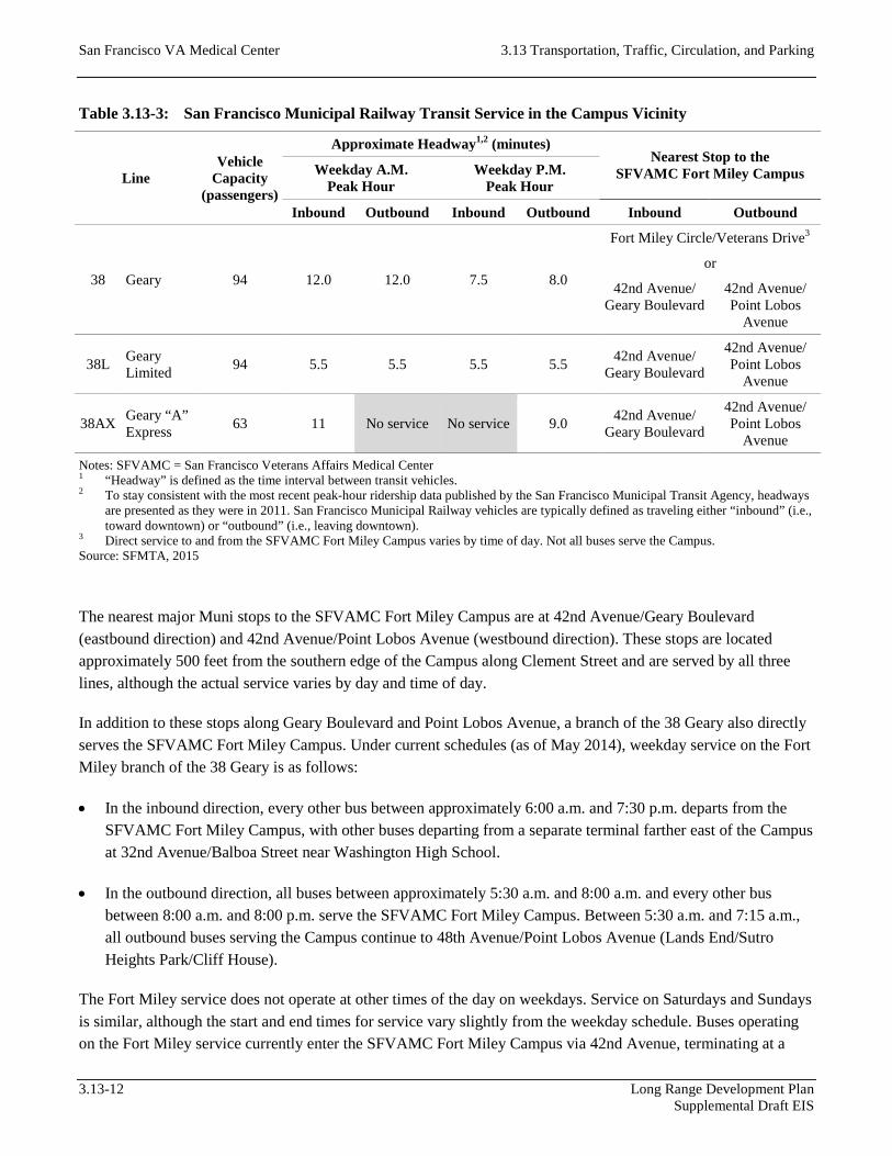
The San Francisco Municipal Railway (Muni) provides local transit service within San Francisco, including bus (diesel and electric trolley), light rail (Metro), streetcar, and cable car lines. Local transit service to the SFVAMC Fort Miley Campus is provided primarily by Muni bus services in the Geary Boulevard corridor. One of Muni’s busiest corridors, the Geary Boulevard corridor connects the Inner and Outer Richmond District neighborhoods, Laurel Heights, and Fillmore/Japantown/Western Addition with downtown San Francisco. The 38 Geary and 38L Geary Limited are the closest major routes serving the Campus, providing frequent service with articulated coaches each capable of carrying 94 passengers. The 38 Geary provides local service in the corridor and operates 24 hours a day, 7 days a week, and the 38L Geary Limited provides faster, limited-stop service during daytime hours (morning to early evening) on weekdays and Saturdays. Supplementary weekday peak-period service in the vicinity of the SFVAMC Fort Miley Campus is provided by the 38AX Geary “A” Express, but only in the general commute direction (inbound from the Outer Richmond to downtown in the mornings and outbound from downtown to the Outer Richmond in the evenings).
The key characteristics of each line are summarized in Table 3.13-3. Figure 3.13-5 illustrates the transit service in the vicinity of the existing Campus.
3.13-10 Long Range Development Plan Supplemental Draft EIS

3.13 Transportation, Traffic, Circulation, and Parking San Francisco VA Medical Center
Source: VA, 2014c
Figure 3.13-5: Transit Network—Existing Conditions
Long Range Development Plan 3.13-11 Supplemental Draft EIS
San Francisco VA Medical Center 3.13 Transportation, Traffic, Circulation, and Parking
Table 3.13-3: San Francisco Municipal Railway Transit Service in the Campus Vicinity
Line Vehicle
Capacity (passengers)
Approximate Headway1,2 (minutes) Nearest Stop to the
SFVAMC Fort Miley Campus Weekday A.M. Peak Hour
Weekday P.M. Peak Hour
Inbound Outbound Inbound Outbound Inbound Outbound
38 Geary 94 12.0 12.0 7.5 8.0
Fort Miley Circle/Veterans Drive3
or
42nd Avenue/Geary Boulevard
42nd Avenue/Point Lobos
Avenue
38L Geary Limited 94 5.5 5.5 5.5 5.5 42nd Avenue/
Geary Boulevard
42nd Avenue/Point Lobos
Avenue
38AX Geary “A” Express 63 11 No service No service 9.0 42nd Avenue/
Geary Boulevard
42nd Avenue/Point Lobos
Avenue
Notes: SFVAMC = San Francisco Veterans Affairs Medical Center 1 “Headway” is defined as the time interval between transit vehicles. 2 To stay consistent with the most recent peak-hour ridership data published by the San Francisco Municipal Transit Agency, headways
are presented as they were in 2011. San Francisco Municipal Railway vehicles are typically defined as traveling either “inbound” (i.e., toward downtown) or “outbound” (i.e., leaving downtown).
3 Direct service to and from the SFVAMC Fort Miley Campus varies by time of day. Not all buses serve the Campus. Source: SFMTA, 2015
The nearest major Muni stops to the SFVAMC Fort Miley Campus are at 42nd Avenue/Geary Boulevard (eastbound direction) and 42nd Avenue/Point Lobos Avenue (westbound direction). These stops are located approximately 500 feet from the southern edge of the Campus along Clement Street and are served by all three lines, although the actual service varies by day and time of day.
In addition to these stops along Geary Boulevard and Point Lobos Avenue, a branch of the 38 Geary also directly serves the SFVAMC Fort Miley Campus. Under current schedules (as of May 2014), weekday service on the Fort Miley branch of the 38 Geary is as follows:
• In the inbound direction, every other bus between approximately 6:00 a.m. and 7:30 p.m. departs from the SFVAMC Fort Miley Campus, with other buses departing from a separate terminal farther east of the Campus at 32nd Avenue/Balboa Street near Washington High School.
• In the outbound direction, all buses between approximately 5:30 a.m. and 8:00 a.m. and every other bus between 8:00 a.m. and 8:00 p.m. serve the SFVAMC Fort Miley Campus. Between 5:30 a.m. and 7:15 a.m., all outbound buses serving the Campus continue to 48th Avenue/Point Lobos Avenue (Lands End/Sutro Heights Park/Cliff House).
The Fort Miley service does not operate at other times of the day on weekdays. Service on Saturdays and Sundays is similar, although the start and end times for service vary slightly from the weekday schedule. Buses operating on the Fort Miley service currently enter the SFVAMC Fort Miley Campus via 42nd Avenue, terminating at a
3.13-12 Long Range Development Plan Supplemental Draft EIS

3.13 Transportation, Traffic, Circulation, and Parking San Francisco VA Medical Center
stop to the south of Building 1 (Opioid Replacement Clinic) before looping through the site via Fort Miley Circle to 43rd Avenue and continuing back inbound to downtown San Francisco.
It should also be noted that the 38AX is a peak-period, commute-direction service. During the weekday p.m. peak period, service is provided only in the westbound direction (toward Lands End and 48th Avenue/Point Lobos Avenue).
Ridership and Capacity
The availability of transit is based on the capacity utilization of each line, which relates the number of passengers per transit vehicle to the design capacity of the vehicle. The capacity per vehicle includes both seated and standing capacity, where standing capacity is between 30 and 80 percent of the seated capacity, depending on the configuration of the vehicle. Ridership values are obtained at the maximum load point, which is the stop along the line where average passenger loads reach their peak.
In accordance with Proposition E, the San Francisco Municipal Transportation Agency (SFMTA) Board of Directors has adopted an “85 percent” standard for transit vehicle loads—i.e., all transit vehicles should operate at or below 85 percent capacity utilization. The SFMTA Board has determined that this threshold most accurately reflects actual operations and the likelihood of “pass-ups” (i.e., vehicles not stopping to pick up more passengers).
Table 3.13-4 presents the weekday p.m. peak-hour capacity utilization for each Muni bus route that directly serves the existing SFVAMC Fort Miley Campus. The ridership data represent the most recent automatic passenger count data published by SFMTA. The capacity data presented reflect the schedule at the time the ridership data were collected in fall 2011 (as summarized in Table 3.13-3), and do not consider changes to Muni service since that time. For reference, the data for the 38BX Geary “B” Express are also included to present a more complete picture of conditions within the Geary Corridor, although this particular route does not directly serve the Campus (the outer terminus is at Geary Boulevard/25th Avenue, east of the Campus).
It should be noted that Muni defines trips with respect to downtown San Francisco. Thus, inbound (eastbound) trips are considered to be traveling toward downtown, and outbound (westbound) trips are considered to be traveling away from downtown. As shown in Table 3.13-4, all three lines operate below capacity during the weekday p.m. peak hour, with the majority of ridership traveling outbound from downtown San Francisco. The highest capacity utilization during the weekday p.m. peak hour is on outbound 38L Geary Limited buses, approaching the 85 percent policy standard when leaving the stop at Geary Boulevard/Van Ness Avenue.
Regional Transit
There is no regional public transit service in the immediate vicinity of the SFVAMC Fort Miley Campus. Transit passengers with origins or destinations outside of San Francisco typically need to transfer to or from Muni to complete their transit trips, or take advantage of the regional/commuter shuttles provided by SFVAMC. Regional public transit services in San Francisco are described in more detail below.
Long Range Development Plan 3.13-13 Supplemental Draft EIS

San Francisco VA Medical Center 3.13 Transportation, Traffic, Circulation, and Parking
Table 3.13-4: San Francisco Municipal Railway Transit Ridership and Capacity in the Vicinity of the Existing SFVAMC Fort Miley Campus, Weekday P.M. Peak Hour
Line Direction1 Existing Conditions, Weekday P.M. Peak Hour
Ridership Capacity Utilization Maximum Load Point
38 Geary Inbound 352 752 47% Geary Boulevard/Laguna Street
Outbound 450 705 64% Geary Boulevard/Franklin Street
38L Geary Limited
Inbound 556 1,025 54% Geary Boulevard/Divisadero Street
Outbound 862 1,025 84% Geary Boulevard/Van Ness Avenue
38AX Geary “A” Express
Inbound No service in inbound direction during weekday p.m. peak period
Outbound 280 420 67% Pine Street/Montgomery Street
38BX Geary “B” Express2
Inbound No service in inbound direction during weekday p.m. peak period
Outbound 222 378 59% Pine Street/Montgomery Street
Total Inbound 908 1,777 51%
Outbound 1,814 2,528 72%
Notes: SFVAMC = San Francisco Veterans Affairs Medical Center 1 San Francisco Municipal Railway vehicles are typically defined as either traveling “inbound” (i.e., toward downtown) or “outbound”
(i.e., leaving downtown). 2 This line does not directly serve the SFVAMC Fort Miley Campus, but is included here for consistency and to present a more
complete picture of transit conditions in the Geary Corridor. Source: SFMTA, 2015
• East Bay Regional public transit service connecting the East Bay (Alameda and Contra Costa Counties) with San Francisco is provided primarily by the San Francisco Bay Area Rapid Transit District (BART) and the Alameda–Contra Costa Transit District (AC Transit). BART provides regional rail service between San Francisco and the East Bay, with outer terminals at Pittsburg/Bay Point, Richmond, (East) Dublin/Pleasanton, and Fremont. Passengers traveling via BART would be able to transfer to Muni’s 38 Geary and 38L Geary Limited at the Montgomery Station or to SFVAMC’s commuter shuttles at the Embarcadero Station (Ferry Building).
AC Transit, the primary bus operator for Alameda and Contra Costa Counties, operates an extensive network of commuter routes. Some routes also operate all day and on weekends, although most operate only on weekdays during the commute period and in the general commute direction. Almost all of AC Transit’s commuter routes terminate at the (Temporary) Transbay Terminal, where passengers can connect with Muni’s 38 Geary and 38L Geary Limited or with SFVAMC’s commuter shuttles.
Supplementary transit service to and from the East Bay is provided by ferry (terminals in Vallejo, at Oakland’s Jack London Square, and in Alameda at Main Street and in Harbor Bay), and by commuter bus service operated by Solano County Transit (service to and from Vallejo via Route 200) and the Western Contra Costa Transit Authority (service to and from Hercules via the Lynx Commuter Express).
3.13-14 Long Range Development Plan Supplemental Draft EIS

3.13 Transportation, Traffic, Circulation, and Parking San Francisco VA Medical Center
• South Bay/Peninsula Regional public transit service connecting the South Bay and Peninsula (San Mateo and Santa Clara Counties) with San Francisco is provided primarily by BART, Caltrain, and San Mateo County Transit (SamTrans). BART provides service in northern San Mateo County, with outer terminals at San Francisco International Airport and Millbrae; passengers traveling on BART can transfer to Muni’s 38 Geary and 38L Geary Limited at the Montgomery Station or to SFVAMC’s commuter shuttles at the Civic Center Station.
Caltrain provides commuter rail service along the full length of the Peninsula to San Jose, with some services extending farther south to Gilroy. Passengers traveling on Caltrain can transfer to SFVAMC’s commuter shuttles at Caltrain’s San Francisco terminal at Fourth Street/King Street; or they can transfer to BART at the Millbrae Station, transferring to the commuter shuttle at the Civic Center Station.
SamTrans, the primary bus operator in San Mateo County, operates regular service to and from San Francisco on Routes KX and 292. Passengers on these services can transfer to Muni’s 38 Geary and 38L Geary Limited or SFVAMC’s commuter shuttles at the Civic Center Station or the (Temporary) Transbay Terminal.
• North Bay Regional public transit service connecting the North Bay (Marin and Sonoma Counties) with San Francisco is provided primarily by the Golden Gate Bridge, Highway & Transportation District. This transit provider operates an extensive network of bus service to San Francisco through Golden Gate Transit, as well as ferry services departing from Larkspur and Sausalito. Passengers traveling on Golden Gate Transit can transfer to SFVAMC’s commuter shuttles at the Golden Gate Bridge Toll Plaza, and passengers traveling via ferry can transfer at the Ferry Building. Supplementary transit service to and from the North Bay is provided by the Blue & Gold Fleet, which operates ferry services from Tiburon and Sausalito (terminating at Pier 41 in San Francisco’s Fisherman’s Wharf area).
SFVAMC Shuttle Services
SFVAMC provides a variety of local, regional, and intercity shuttle services through several different operating schemes:
• Services operated directly by SFVAMC staff members
• Services operated jointly with the University of California, San Francisco (UCSF)
• Services contracted out to third-party for-profit companies (currently Bauer’s Transportation)
• Services provided by the Disabled American Veterans Volunteer Transportation Network
These services operate weekdays only (Mondays through Fridays) but serve a wide variety of Campus users—patients, employees/staff members, and visitors as well as affiliated faculty, students, and guests of UCSF. Table 3.13-5 summarizes shuttle services provided at the SFVAMC Fort Miley Campus.
Long Range Development Plan 3.13-15 Supplemental Draft EIS

San Francisco VA Medical Center 3.13 Transportation, Traffic, Circulation, and Parking
Table 3.13-5: SFVAMC Shuttle Services
Route Operator Daily Round Trips (Weekday) Ridership Served
Intercity
Mendocino/Humboldt Counties: Santa Rosa (VA Outpatient Clinic), Ukiah (VA Outpatient Clinic), Willits, Laytonville, Garberville, Rio Dell/Scotia, Fortuna, Eureka (VA Outpatient Clinic)
SFVAMC 1‒21 Patients
Sonoma/Mendocino Counties: Santa Rosa (VA Outpatient Clinic), Cloverdale, Hopland, Ukiah (VA Clinic) SFVAMC 3.52 Patients
Mendocino County (Inland): Cloverdale, Hopland, Ukiah DAV VTN 1 Patients
Mendocino County (Coast): Boonville, Fort Bragg DAV VTN 1 Patients
Napa/Lake Counties: Napa, Middletown, Lower Lake, Clearlake DAV VTN 1 Patients
Regional/Commuter
South Bay/East Bay Commuter: Ferry Building, Transbay Terminal, Caltrain (Fourth & King), Civic Center Bauer’s 10.53 Patients, employees,
volunteers
North Bay Commuter: Golden Gate Bridge Toll Plaza Bauer’s 64 Patients, employees, volunteers
Marin/Sonoma Counties: Novato, Petaluma, Cotati, Santa Rosa DAV VTN 1 Patients
San Bruno VA Outpatient Clinic SFVAMC 4 Patients, employees, visitors
Local
Downtown San Francisco VA Outpatient Clinic: Third Street/Harrison Street SFVAMC 3 Patients, employees,
visitors
UCSF Parnassus Campus: 401 Parnassus Avenue
SFVAMC/UCSF 175
Patients, faculty, employees, students,
visitors
Notes: DAV VTN = Disabled American Veterans Volunteer Transportation Network; SFVAMC = San Francisco Veterans Affairs Medical Center; UCSF = University of California, San Francisco; VA = U.S. Department of Veterans Affairs
1 One round trip daily Mondays and Fridays, two round trips daily Tuesdays, Wednesdays, and Thursdays. 2 Three southbound trips and four northbound trips daily. 3 Commute period, commute direction only (inbound to SFVAMC in the mornings and outbound from SFVAMC in the afternoons/
evenings). Operates on variable headways (10‒30 minutes), with 11 inbound trips and 10 outbound trips. 4 Commute period, commute direction only (inbound to SFVAMC in the mornings and outbound from SFVAMC in the afternoons/
evenings). Operates on fixed headways (30 minutes), with six inbound trips and six outbound trips. 5 Operates on variable headways (approximately 30 minutes peak, 60 minutes off-peak). Source: VA, 2014c
Specifically, SFVAMC currently contracts with Bauer’s Transportation to provide free bus and shuttle service to SFVAMC staff members and patients daily. The service operates between the SFVAMC Fort Miley Campus and major transportation hubs in San Francisco (the Ferry Building/Embarcadero Station, the Transbay Terminal, Caltrain’s Fourth & King Station, and the Civic Center Station) from 5:00 a.m. to 9:00 a.m. and again from 2:30 p.m. to 6:30 p.m. More than 1,285 staff members and patients utilize this commuter service provided by VA every day.
3.13-16 Long Range Development Plan Supplemental Draft EIS
3.13 Transportation, Traffic, Circulation, and Parking San Francisco VA Medical Center
Taxis
In addition to public transit and the shuttle services provided by SFVAMC, the SFVAMC Fort Miley Campus is served by taxis. Designated taxi stops are provided in two different locations on the Campus, between Building 200 and Building 203 and between Building 208 and Building 209. Taxis are permitted to enter and exit the Campus through either 42nd Avenue or 43rd Avenue. A taxi call station is located at Building 200 near the entrance.
Mission Bay Area
Local service in the Mission Bay area is provided by Muni bus and light rail lines, while regional transit service is provided by Caltrain, BART, Golden Gate Transit, and AC Transit.
The Mission Bay area is near several key transit facilities: the Transbay Terminal, the Embarcadero BART/Muni Metro Station, the Montgomery BART/Muni Metro Station, the Ferry Building, and Caltrain’s San Francisco terminal (Fourth & King Station). Transit service to and from the East Bay is provided by BART and AC Transit. Transit service to and from the South Bay is provided by BART (via connection to Caltrain in Millbrae), SamTrans, and Caltrain. Transit service to and from the North Bay is provided by Golden Gate Transit buses and ferries. UCSF and other shuttles provide services to and from these hubs and Mission Bay neighborhood. Other UCSF shuttles run between Mission Bay and UCSF campuses.
Local transit service operated by Muni is available along major east-west roadways such as Market Street, Mission Street, Howard Street, Folsom Street, Harrison Street, and Bryant Street. North-south transit service is provided along Third Street, where light rail service will be extended more directly into downtown San Francisco and north into Chinatown as part of the Central Subway project (currently under construction).
Pedestrian
Existing SFVAMC Fort Miley Campus
Generally, a low level of pedestrian activity was observed throughout the day in the vicinity of the existing SFVAMC Fort Miley Campus. Activity at 42nd Avenue/Clement Street and 43rd Avenue/Clement Street is slightly higher than at other minor intersections farther away as a result of foot traffic heading to and from the Campus, particularly during the weekday a.m. and p.m. peak periods. During the weekday p.m. peak period, sidewalks and crosswalks were observed to be operating at free-flow conditions, with pedestrians moving at normal speeds and with freedom to bypass other pedestrians. Most Campus-related pedestrian traffic in the surrounding neighborhoods consists of staff members and patients heading to and from transit stops or parked vehicles.
On-Campus Conditions for Pedestrians
Sidewalks and walkways are provided on the existing SFVAMC Fort Miley Campus and connect to sidewalks along Clement Street. Sidewalks are provided around Fort Miley Circle and Veterans Drive and between buildings within the Campus. However, some segments of Veterans Drive, such as segments adjacent to Lot G and Lot J, currently lack sidewalks or designated pedestrian space on one or both sides. Pedestrians in these locations were observed to walk along the roadway edges, although these areas do not generally see high levels of pedestrian activity compared to other parts of the Campus.
Long Range Development Plan 3.13-17 Supplemental Draft EIS

San Francisco VA Medical Center 3.13 Transportation, Traffic, Circulation, and Parking
Off-Campus Conditions for Pedestrians
Sidewalks
Most major streets in the vicinity of the existing SFVAMC Fort Miley Campus have sidewalks on both sides of the street, although Clement Street abutting the Campus (between 43rd Avenue and 45th Avenue) and Lincoln Park (east of 42nd Avenue) lack sidewalks along the north side. Sidewalks are 4 feet wide or greater, although obstructions such as utility poles, fire hydrants, and shrubbery may narrow the effective width, such as along the south side of Clement Street at the southeast corner of 42nd Avenue/Clement Street or the north side of Clement Street at the northwest corner of 43rd Avenue/Clement Street. Sidewalk pavement conditions are generally good, although there is a high frequency of curb cuts because of the residential nature of the neighborhood and the need to secure access to ground-level garages for homes.
Crosswalks
The provision of marked crosswalks at intersections varies by location and direction. In the immediate vicinity of the SFVAMC Fort Miley Campus, marked crosswalks are only provided across two legs at 42nd Avenue/Clement Street (west and south legs) and 43rd Avenue/Clement Street (east and south legs), although stop bars are provided on the pavement. Farther from the Campus, minor intersections along Clement Street west and east of the Campus generally lack marked crosswalks completely. Major intersections south of the Campus at 42nd Avenue/Point Lobos Avenue, 42nd Avenue/Geary Boulevard, 43rd Avenue/Point Lobos Avenue, and 43rd Avenue/Geary Boulevard feature marked crosswalks on all legs. Crosswalk markings are low-visibility designs (parallel lines) lacking special treatments (e.g., ladder, continental, or diagonal striping; high-visibility signage; flashing devices) and are generally in poor condition, with substantial fading or cracking.
Curb Ramps
As with sidewalks, the provision of curb ramps varies by location and street corner. In the immediate vicinity of the SFVAMC Fort Miley Campus, curb ramps are missing at some street corners at 42nd Avenue/Clement Street (northeast corner) and 43rd Avenue/Clement Street (northwest corner), or may be provided in only one orientation (e.g., southwest corners at both intersections). Most existing curb ramps at these intersections and in the surrounding area are not compliant with the Americans with Disabilities Act (ADA), lacking tactile warning devices such as truncated dome tiles.
Speed Bumps
There are three speed bumps along Clement Street between 36th and 40th Avenues to slow vehicular traffic and enhance pedestrian and bicycle safety.
Mission Bay Area
All major streets in the Mission Bay area have sidewalks and all major intersections have marked crosswalks. Intersection corners also have curb ramps, although some are not ADA compliant and lack tactile warning systems such as truncated domes. In the Mission Bay area, there is generally a moderate level of pedestrian activity throughout the day. Peaks occur in the morning, at midday, and in the evening as employees head to office buildings, go to and from lunch, and head home.
3.13-18 Long Range Development Plan Supplemental Draft EIS

3.13 Transportation, Traffic, Circulation, and Parking San Francisco VA Medical Center
Bicycle
Existing Fort Miley Campus
During field observations, bicyclists were observed riding along the established bicycle routes near the existing SFVAMC Fort Miley Campus. Bicycle activity is generally low because of the hilly terrain and steep grades and the Campus’s location well outside of downtown San Francisco and major regional transportation hubs. However, SFMTA provides bicycle racks on the front of all Muni buses, and major regional public transit services such as BART and ferries allow passengers to bring bicycles on board. Some of the shuttle services bringing patients, staff members, and visitors to and from the Fort Miley Campus also feature bicycle racks and bicycle lockers. Overall, bicycle conditions were observed to be acceptable, with only minor conflicts observed between right-turning vehicles and bicyclists.
On-Campus Conditions for Bicycles
There are no designated bike lanes on the SFVAMC Fort Miley Campus and bicyclists must share Campus roads with other users. However, the restricted speed limit (10 miles per hour) on the Campus helps to provide a safe riding environment for bicyclists. SFVAMC currently provides bicycle racks and bicycle lockers for use by staff members commuting to and from the Campus by bike.
Off-Campus Conditions for Bicycles
Four major citywide bicycle routes consisting of Class 1 and Class 3 bikeways are situated in the vicinity of the existing SFVAMC Fort Miley Campus, and are supplemented by Class 1 trails through Lands End and Lincoln Park. Class 1 bicycle facilities are paved off-street paths; Class 2 bicycle facilities are striped separated bicycle lanes adjacent to the curb lane; and Class 3 bicycle facilities are signed routes only, where bicyclists share travel lanes with vehicles. The major bicycle routes in the immediate vicinity of the existing SFVAMC Fort Miley Campus are illustrated in Figure 3.13-6 and described below.
Route 10
Route 10 is a major east-west bikeway stretching from Lands End in the west to The Embarcadero in the east via Clement Street, Lake Street, Clay Street, and Pacific Street. In the immediate vicinity of the SFVAMC Fort Miley Campus along Clement Street, Route 10 comprises Class 3 facilities with painted sharrows and signage, but Class 2 facilities are provided farther east along Lake Street between 28th Avenue and Arguello Boulevard. At its western end, Route 10 connects to the Lands End trail network and Route 95. Because of the relatively flat terrain, low traffic volumes, and the presence of Class 2 facilities along Lake Street, Route 10 is one of the preferred east-west routes for reaching the SFVAMC Fort Miley Campus.
Route 85
Route 85 is a major north-south bikeway stretching from Lincoln Park and the Legion of Honor in the north to Lake Merced and the border with Daly City in the south, via 34th Avenue and Lake Merced Boulevard. In the immediate vicinity of the SFVAMC Fort Miley Campus, Route 85 runs along Legion of Honor Drive and 34th Avenue and comprises Class 3 facilities with painted sharrows and signage, connecting with east-west facilities such as Route 10 and Route 395.
Long Range Development Plan 3.13-19 Supplemental Draft EIS

San Francisco VA Medical Center 3.13 Transportation, Traffic, Circulation, and Parking
Source: VA, 2014c
Figure 3.13-6: Bicycle Network—Existing Conditions
3.13-20 Long Range Development Plan Supplemental Draft EIS

3.13 Transportation, Traffic, Circulation, and Parking San Francisco VA Medical Center
Route 95
Route 95 is a major north-south bikeway stretching from the Golden Gate Bridge in the north to Fort Funston and the border with Daly City in the south, via Lincoln Boulevard, El Camino del Mar, Clement Street, Point Lobos Avenue/Great Highway, and Skyline Boulevard. In the immediate vicinity of the SFVAMC Fort Miley Campus, Route 95 is a Class 3 facility along Clement Street with painted sharrows and signage, overlapping with Route 10. Farther away, Route 95 includes sections of Class 1 and Class 2 facilities, such as through the Presidio and along the Great Highway.
Route 395
Route 395 is a minor east-west bikeway that serves as a branch of Route 95, connecting Route 85 and the shared-use trails in Lands End/Lincoln Park with Route 95 at 30th Avenue/El Camino del Mar. Route 395 is a Class 3 bikeway with painted sharrows and signage.
Lands End Trail Network
A network of recreational trails serves the Lands End/Lincoln Park area of the Golden Gate National Recreation Area (GGNRA), to the immediate north of the SFVAMC Fort Miley Campus. The unpaved trails are used primarily for hiking, walking, and running because of steep grades and frequent elevation changes, dense vegetation, narrow width, and high levels of foot traffic. However, some segments are open to recreational (mountain) bicyclists as unpaved Class 1 facilities.
Speed Bumps
As discussed previously, there are three speed bumps along Clement Street between 36th and 40th Avenues to slow vehicular traffic and enhance pedestrian and bicycle safety.
Mission Bay Area
In the Mission Bay area, bicycle lanes are provided along Terry A. Francois Boulevard, 16th Street, Howard Street, Folsom Street, The Embarcadero, Seventh Street, Eighth Street, and 11th Street. Bicycle routes are provided along Second, Fifth, and Townsend Streets. Howard Street operates as a one-way couplet with Folsom Street. There is generally a low to moderate level of bicycle activity in the area.
Loading
Existing Fort Miley Campus
Medical, building, office, and food supplies are delivered to the existing SFVAMC Fort Miley Campus on a daily basis. Delivery vehicles have the option of using either of the two main access points at 42nd Avenue/Clement Street and 43rd Avenue/Clement Street. Typically, however, they access the site via the 42nd Avenue/Clement Street intersection, where they use Fort Miley Circle and Veterans Drive to directly access individual building delivery bays.
Long Range Development Plan 3.13-21 Supplemental Draft EIS

San Francisco VA Medical Center 3.13 Transportation, Traffic, Circulation, and Parking
There are currently 11 loading bays on campus, distributed as follows among on-site structures:
• Building 7—one bay
• Building 203—four bays
• Building 6—one bay
• Building 12—three bays
• Building 208—two bays
Mission Bay Area
Loading facilities were not identified for the Mission Bay area because a specific site for SFVAMC facilities has not been identified.3
Site Access and Circulation
Existing Fort Miley Campus
Access to the existing SFVAMC Fort Miley Campus is provided from 42nd Avenue and 43rd Avenue onto Veterans Drive, which provides access to all Campus buildings and all parking facilities. The two internal roadways—Fort Miley Circle and Veterans Drive—provide access throughout the Campus. Existing traffic patterns indicate that a majority of vehicles enter from 42nd Avenue/Clement Street and exit from 43rd Avenue/Clement Street.
Fire response service on the Campus is provided by the San Francisco Fire Department. Fire engines and trucks can currently enter and exit the Campus via either of the two main access points at 42nd Avenue/Clement Street and 43rd Avenue/Clement Street. SFVAMC currently provides only limited emergency medical services. Ambulances and other emergency medical vehicles arriving at the Campus are destined for Building 200 (Ambulatory Care Center), and typically enter the Campus via the 42nd Avenue access. Overall, the Campus currently provides adequate emergency medical access.
Mission Bay Area
Specific access and circulation points were not identified for the Mission Bay area because a specific site for SFVAMC facilities has not been identified.4
3 Loading facilities were not identified in the Mission Bay area because of the uncertainty about the location to which SFVAMC facilities might relocate in this approximately 2.5-square-mile area.
4 Specific access and circulation points were not identified in the Mission Bay area because of the uncertainty about the location to which SFVAMC facilities might relocate in this approximately 2.5-square-mile area.
3.13-22 Long Range Development Plan Supplemental Draft EIS

3.13 Transportation, Traffic, Circulation, and Parking San Francisco VA Medical Center
Parking
Existing Fort Miley Campus
Parking supply and occupancy for on- and off-street public parking facilities in the study area were obtained via field observations. Parking occupancy surveys were conducted during the weekday morning (9:00 a.m. to 11:00 a.m.), midday (1:00 p.m. to 3:00 p.m.), and evening (7:00 p.m. to 9:00 p.m.) peak periods to obtain sufficient data to characterize parking demand over the course of the day.
On-Campus Parking
Parking Supply
Two parking structures (Building 209 and Building 212) and 10 surface parking lots (Lot B through Lot L) are located on the existing SFVAMC Fort Miley Campus, providing a total of 1,253 parking spaces. These facilities are summarized in Table 3.13-6 and illustrated in Figure 3.13-7.
Table 3.13-6: Existing Off-Street Parking Supply at the SFVAMC Fort Miley Campus Facility Configuration Function/User Capacity (spaces)
Building 209 Structure Employee/Visitor 422 Building 212 Structure Patient 160 Lot B Surface lot Patient/Visitor 102 Lot C Surface lot Employee 13 Lot D Surface lot GSA/Employee 142 Lot E Surface lot Patient 23 Lot F Surface lot Employee 2 Lot G Surface lot Employee 87 Lot H Surface lot Patient/Visitor 17 Lot J Surface lot Employee 270 Lot K Surface lot Employee 7 Lot L Surface lot Employee 8 Total 1,253 Notes: GSA = General Services Administration; SFVAMC = San Francisco Veterans Affairs Medical Center Reflects status as of 2012, as reported in the SFVAMC Long Range Development Plan. Some facilities listed have since been
permanently or temporarily closed or restriped/reconfigured as a result of construction activities, Americans with Disabilities Act compliance, or other factors.
Sources: VA, 2014a and 2014c
Long Range Development Plan 3.13-23 Supplemental Draft EIS

San Francisco VA Medical Center 3.13 Transportation, Traffic, Circulation, and Parking
Source: VA, 2014.
Figure 3.13-7: Parking Facilities—Existing Conditions
3.13-24 Long Range Development Plan Supplemental Draft EIS

3.13 Transportation, Traffic, Circulation, and Parking San Francisco VA Medical Center
Patients and visitors may currently park in Lots B, E, and H, and at Buildings 209 and 212.5 The remaining facilities are designated for SFVAMC employees, except that some spaces in Lot D are reserved for use by the General Services Administration. Not included in the summary of parking supply in Table 3.13-6 are four additional spaces provided near Building 32 (Childcare Center) for pick-up/drop-off activities, as well as curb space along Fort Miley Circle adjacent to Buildings 208, 209, 200, and 203 designated for various uses such as police parking and shuttle parking.
Parking Demand
Field observations indicated very high utilization of off-street parking facilities on the Campus on weekdays. Occupancy levels remained at or near capacity through the morning and midday periods, but decreased considerably by the evening period. The results of the field observations were corroborated against older data regarding on-site parking occupancy levels, obtained from a transportation study prepared for a proposed new Campus building for the Northern California Institute for Research and Education (VA, 2003).
Off-Campus Parking
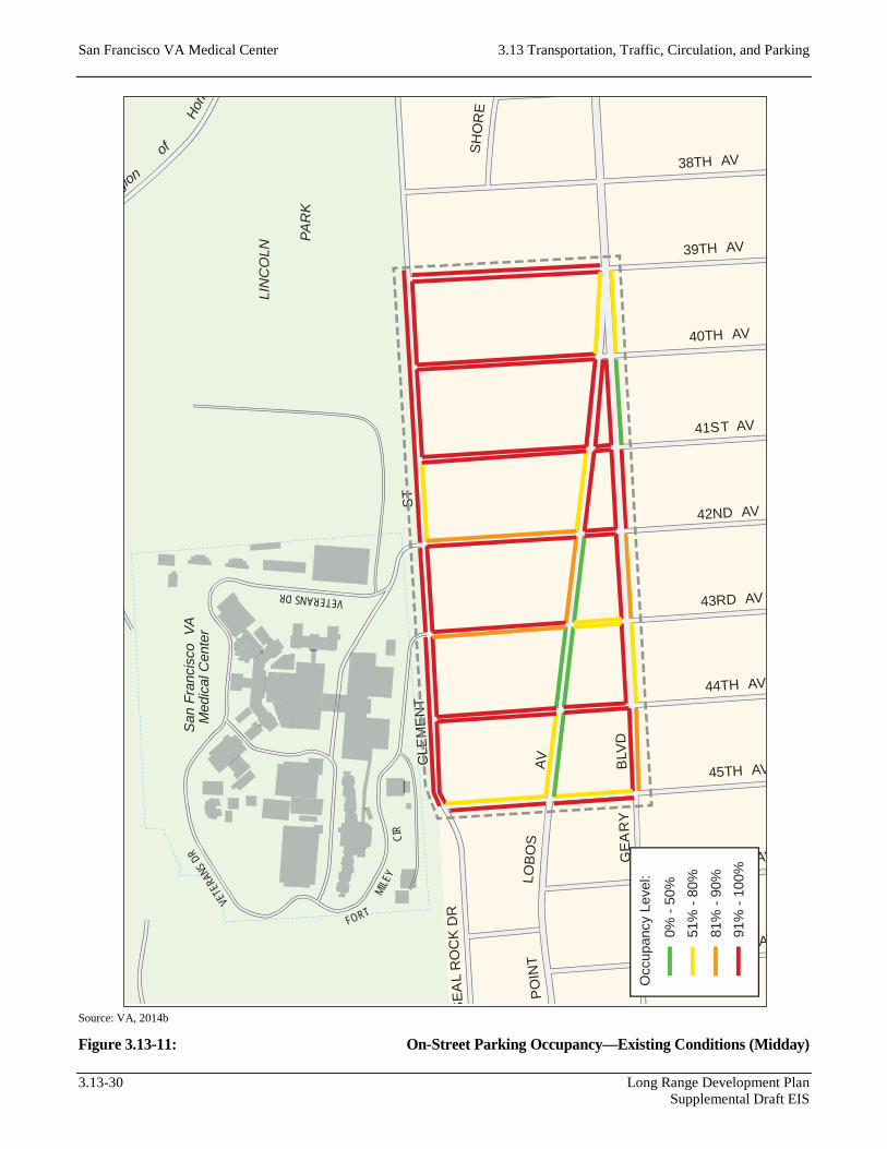
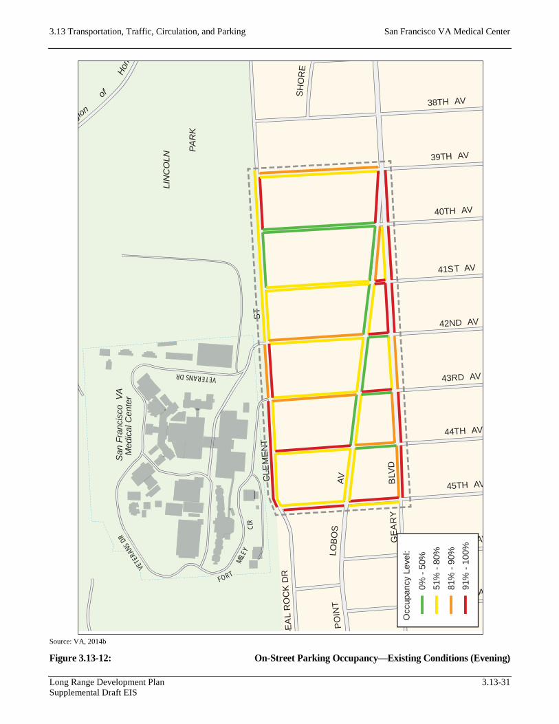
Off-campus (i.e., on-street) parking conditions were evaluated for a six-block area bounded by Clement Street to the north, Geary Boulevard to the south, 39th Avenue to the east, and 45th Avenue to the west (Figure 3.13-8).
Parking Supply
On-street parking in the vicinity of the existing SFVAMC Fort Miley Campus generally consists of unmetered parallel parking. Angled parking is provided along the north side of Geary Boulevard between 43rd Avenue and 42nd Avenue and between 41st Avenue and 40th Avenue, and along the south side of Point Lobos Avenue between 43rd Avenue and 42nd Avenue. It should be noted that the angled parking provided on the north side of Geary Boulevard and the south side of Point Lobos Avenue between 43rd Avenue and 42nd Avenue is located adjacent to a Walgreens store, the only major commercial land use in the immediate vicinity of the Campus. These spaces are designated as 1-hour parking spaces between 8:00 a.m. and 6:00 p.m. and can be used by all motorists (i.e., these spaces are not designated for customer use only). All other on-street parking in the study area is adjacent to residential land uses, with the exception of parking along the north side of Clement Street abutting the south edge of the Campus.
Because on-street parking in the study area is unmarked, the supply of on-street spaces has been estimated assuming 25 feet of curb space per vehicle. Based on this assumption, approximately 600 on-street parking spaces are currently provided in the parking study area. Figure 3.13-9 summarizes on-street parking capacity by block face.
5 Building 209 provides valet parking in addition to standard striped parking stalls.
Long Range Development Plan 3.13-25 Supplemental Draft EIS

San Francisco VA Medical Center 3.13 Transportation, Traffic, Circulation, and Parking
Source: VA, 2014b
Figure 3.13-8: On-Street Parking Study Area
3.13-26 Long Range Development Plan Supplemental Draft EIS

3.13 Transportation, Traffic, Circulation, and Parking San Francisco VA Medical Center
Source: VA, 2014b
Figure 3.13-9: On-Street Parking Supply—Existing Conditions
Long Range Development Plan 3.13-27 Supplemental Draft EIS

San Francisco VA Medical Center 3.13 Transportation, Traffic, Circulation, and Parking
Parking Demand
The parking study area, like most of the Richmond District, tends to have high on-street parking utilization, in part because the area has minimal parking restrictions (except during street cleaning) and no residential parking permits are required. In addition, many of the residential units have multiple tenants who do not have access to garage parking and therefore park on the street.
Parking occupancy surveys were conducted during the weekday morning (9:00 a.m. to 11:00 a.m.), midday (1:00 p.m. to 3:00 p.m.), and evening (7:00 p.m. to 9:00 p.m.) peak periods to obtain sufficient data to characterize parking demand over the course of the day. Based on the field observations, it was determined that on-street parking is well utilized throughout the day, although particular occupancy percentages can vary depending on location and peak period.
During the weekday morning peak period, on-street parking occupancy ranges between 80 percent and 100 percent along most block faces, with an average overall occupancy of 87 percent. During the weekday midday peak period, on-street parking occupancy continued to range between 80 percent and 100 percent along most block faces, with an average overall occupancy of 90 percent. Specifically, on-street parking spaces along the north side of Clement Street were found to be 100 percent occupied between 45th Avenue and 43rd Avenue, 92 percent occupied between 43rd Avenue and 42nd Avenue, and 93 percent occupied between 42nd Avenue and 39th Avenue during the weekday midday peak period.
During the weekday evening peak period, on-street parking occupancy levels are lower than during the weekday morning and midday peak periods. Many block faces experience occupancy levels below 80 percent. Average overall occupancy during the evening peak period was found to be 73 percent. On-street parking along Clement Street adjacent to the Campus remained relatively high, and lower occupancy levels were observed along Point Lobos Avenue and along roadways west of the Campus. Specifically, on-street parking spaces along the north side of Clement Street were found to be 100 percent occupied between 45th Avenue and 43rd Avenue, 85 percent occupied between 43rd Avenue and 42nd Avenue, and 53 percent occupied between 42nd Avenue and 39th Avenue during the weekday evening peak period.
On-street parking occupancy during the weekday morning, midday, and evening peak periods is illustrated in Figure 3.13-10, Figure 3.13-11, and Figure 3.13-12, respectively.
Mission Bay Area
On-street parking, parking lots, and parking structures exist throughout the Mission Bay area.6
6 Specific parking amenities were not identified in the Mission Bay area because of the uncertainty about the location to which SFVAMC facilities might relocate in this approximately 3-square-mile area.
3.13-28 Long Range Development Plan Supplemental Draft EIS

3.13 Transportation, Traffic, Circulation, and Parking San Francisco VA Medical Center
Source: VA, 2014b
Figure 3.13-10: On-Street Parking Occupancy—Existing Conditions (Morning)
LIN
CO
LN
PAR
K
SE
AL
RO
CK
DR
CLE
ME
NT
gion
of
Hono
ST
GE
AR
Y
38TH AV
39TH AV
40TH AV
44TH AV
45TH AV
46TH AV
47TH A
41ST AV
42ND AV
43RD AV
BLV
D
SH
OR
E
PO
INT
LOB
OS
AV
San
Fra
ncis
coVA
Med
ical
Cen
ter
VETERANS DR
VETE
RANS
DR
FORT
MILE
YCI
R
0% -
50%
51%
- 80
%
81%
- 90
%91
% -
100%
Occ
upan
cy L
evel
:
Long Range Development Plan 3.13-29 Supplemental Draft EIS
San Francisco VA Medical Center 3.13 Transportation, Traffic, Circulation, and Parking
Source: VA, 2014b
Figure 3.13-11: On-Street Parking Occupancy—Existing Conditions (Midday)
LIN
CO
LN
PAR
K
SE
AL
RO
CK
DR
CLE
ME
NT
gion
of
Hono
ST
GE
AR
Y
38TH AV
39TH AV
40TH AV
44TH AV
45TH AV
46TH AV
47TH A
41ST AV
42ND AV
43RD AV
BLV
D
SH
OR
E
PO
INT
LOB
OS
AV
San
Fra
ncis
coV A
Med
ical
Cen
ter
VETERANS DR
VETE
RANS
DR
FORT
MILE
YCI
R
0% -
50%
51%
- 80
%
81%
- 90
%91
% -
100%
Occ
upan
cy L
evel
:
3.13-30 Long Range Development Plan Supplemental Draft EIS
3.13 Transportation, Traffic, Circulation, and Parking San Francisco VA Medical Center
Source: VA, 2014b
Figure 3.13-12: On-Street Parking Occupancy—Existing Conditions (Evening)
LIN
CO
LN
PAR
K
SE
AL
RO
CK
DR
CLE
ME
NT
gion
of
Hono
ST
GE
AR
Y
38TH AV
39TH AV
40TH AV
44TH AV
45TH AV
46TH AV
47TH A
41ST AV
42ND AV
43RD AV
BLV
D
SH
OR
E
PO
INT
LOB
OS
AV
San
Fra
ncis
coVA
Med
ical
Cen
ter
VETERANS DR
VETE
RANS
DR
FORT
MILE
YCI
R
0% -
50%
51%
- 80
%
81%
- 90
%91
% -
100%
Occ
upan
cy L
evel
:
Long Range Development Plan 3.13-31 Supplemental Draft EIS

San Francisco VA Medical Center 3.13 Transportation, Traffic, Circulation, and Parking
3.13.2 Regulatory Framework
There are no applicable federal standards related to transportation and parking.
3.13.3 Environmental Consequences
Significance Criteria
A NEPA evaluation must consider the context and intensity of the environmental effects that would be caused by, or result from, the EIS Alternatives. There are no standard federal policies for assessment of project-level transportation, transit, pedestrian, bicycle, loading, and parking impacts. Therefore, after a review of guidance from other federal transportation agencies such as the Federal Highway Administration and the Federal Transit
Administration, the thresholds used by the jurisdiction closest to the SFVAMC Fort Miley Campus, the City and County of San Francisco, were used for this analysis.
An Alternative analyzed in this EIS is considered to result in an adverse operational impact related to transportation and parking if any of the following conditions related to signalized or unsignalized intersections would occur:
• Signalized intersections—Traffic related to the EIS Alternative would cause the intersection LOS to deteriorate from LOS D or better to LOS E or LOS F, or from LOS E to LOS F. An Alternative may result in adverse impacts at intersections that operate at LOS E or LOS F under existing conditions, depending on the magnitude of the contribution made by the Alternative to the worsening of the average delay per vehicle. In addition, an EIS Alternative would have an adverse impact if it would cause major traffic hazards or contribute considerably to cumulative traffic increases that would cause deterioration in LOS to unacceptable levels.
• Unsignalized intersections—Traffic related to the EIS Alternative would cause the intersection LOS to deteriorate from LOS D or better to LOS E or LOS F, or from LOS E to LOS F, and the conditions of the Manual on Uniform Traffic Control Devices peak-hour signal warrant would be met. In addition, an EIS Alternative would have an adverse impact if it would cause major traffic hazards or contribute considerably to cumulative traffic increases that would cause deterioration in LOS to unacceptable levels.
The City and County of San Francisco does not have significance criteria related to roadway segments. To preserve consistency with the intersection analysis, the LOS-based criteria identified above for the study intersections were also applied to the study roadway segments.
In addition, an Alternative analyzed in this EIS would have an adverse effect on the environment if any of the following additional conditions would occur:
• The EIS Alternative would cause a substantial increase in transit demand that could not be accommodated by adjacent transit capacity, resulting in unacceptable levels of transit service; or would cause a substantial increase in delays or operating costs such that adverse impacts in transit service levels could result. The Alternative would have an adverse effect on the transit provider if transit trips related to implementation of the Alternative would cause the capacity utilization standard to be exceeded during the peak hour.
3.13-32 Long Range Development Plan Supplemental Draft EIS

3.13 Transportation, Traffic, Circulation, and Parking San Francisco VA Medical Center
• The EIS Alternative would result in substantial overcrowding on public sidewalks, create potentially hazardous conditions for pedestrians, or otherwise interfere with pedestrian accessibility to the site and adjoining areas.
• The EIS Alternative would create potentially hazardous conditions for bicyclists or otherwise substantially interfere with bicycle accessibility to the site and adjoining areas.
• The EIS Alternative would result in a loading demand during the peak hour of loading activities that could not be accommodated within proposed on-site loading facilities or within convenient on-street loading zones, and would create potentially hazardous conditions or substantial delays affecting traffic, transit, bicycles, or pedestrians.
• The EIS Alternative would result in inadequate emergency access.
Assessment Methods
The following scenarios were evaluated to identify the potential transportation impacts of the proposed LRDP at the SFVAMC Fort Miley Campus:
• 2020 Short-Term Conditions:
− No Action (Alternative 4)
− Alternative 1 Short-Term Projects Conditions
− Alternative 3 Short-Term Projects Conditions
• 2027 Long-Term Conditions:
− No Action (Alternative 4)
− Alternative 1 Short-Term and Long-Term Projects Conditions
− Alternative 3 Short-Term and Long-Term Projects Conditions
• 2040 Cumulative Conditions:
− No Action (Alternative 4)
− Alternative 1 Short-Term and Long-Term Projects Conditions
− Alternative 3 Short-Term and Long-Term Projects Conditions
The 2040 Cumulative Conditions are discussed in Section 4.3.13 in Chapter 4.0, “Cumulative Impacts.”
It should be noted that Alternative 2 is identical to Alternative 1 in terms of the total amount and type of operational space proposed, but would involve different phasing and implementation schedules for some projects, resulting in a different, longer construction schedule. Therefore, the evaluation of the transportation impacts of the EIS Alternatives distinguishes between Alternatives 1 and 2 only when discussing construction-related impacts.
Long Range Development Plan 3.13-33 Supplemental Draft EIS

San Francisco VA Medical Center 3.13 Transportation, Traffic, Circulation, and Parking
Traffic
The potential for impacts of the Alternatives on intersection and roadway segment operations was assessed quantitatively based on the expected change in LOS and associated metrics (delay or volume-to-capacity ratio). Impacts on passenger vehicle access (and related activities, such as passenger loading) and vehicle access for GGNRA traffic at East Fort Miley were assessed qualitatively.
Transit
The potential for impacts of the Alternatives on transit access, operations, and facilities was generally assessed qualitatively. Transit services evaluated included those provided at the SFVAMC Fort Miley Campus, including local and regional public transit, various shuttle services provided by SFVAMC, and taxis, together with their access in and out of the Campus. However, transit ridership and capacity for the weekday p.m. peak hour was assessed quantitatively for Muni services in the Geary Boulevard corridor (38 Geary, 38L Geary Limited, and 38AX Geary “A” Express), using ridership and capacity data published by SFMTA.
Pedestrians
The potential for impacts of the Alternatives on pedestrian conditions throughout the study area was generally assessed qualitatively. The assessment included an estimate of the number of new pedestrian trips that would be added to the existing pedestrian network. Potential pedestrian safety issues were identified, including potential conflicts between vehicular traffic and pedestrian circulation. Impacts on pedestrian conditions from activities resulting from implementation of the Alternatives, including generation of vehicular traffic, also were assessed qualitatively.
Bicycles
The potential for impacts of the Alternatives on bicycle conditions throughout the study area was generally assessed qualitatively. The assessment included an analysis of safety and right-of-way issues and estimated the number of new trips that would be added to the existing bikeway and roadway network. Impacts on bicycle conditions from activities resulting from implementation of the Alternatives, including generation of vehicular traffic, also were assessed qualitatively.
Loading
The potential for impacts of the Alternatives on delivery loading access caused by changes in the circulation system at the SFVAMC Fort Miley Campus was assessed qualitatively.
Site Access and Circulation
The potential for impacts on general site access and circulation from changes in the circulation system at the SFVAMC Fort Miley Campus was assessed qualitatively. The assessment focused on fire access and emergency medical (ambulance) access.
3.13-34 Long Range Development Plan Supplemental Draft EIS

3.13 Transportation, Traffic, Circulation, and Parking San Francisco VA Medical Center
Parking
Absent NEPA requirements for parking supply, the proposed supply of parking was evaluated against guidance from the San Francisco Planning Code (Planning Code) regarding off-street parking requirements and the estimated peak parking demand generated by each Alternative. The peak parking demands were calculated using demand rates published by the Institute of Transportation Engineers (ITE) in Parking Generation (4th ed., 2010).
Travel Demand Methodology
Details of the methodology used for travel demand (trip generation, mode split, average vehicle occupancy, and trip distribution), parking demand, and delivery vehicle loading demand are provided below. Travel demand estimates for the EIS Alternatives were developed based on data from the following sources:
• Transportation Impact Analysis Guidelines for Environmental Review (SF Guidelines) Published by the San Francisco Planning Department in October 2002, the SF Guidelines prescribes standard methodologies for analyzing transportation impacts of development projects in the City and County of San Francisco. The SF Guidelines also contain empirical data on travel behavior characteristics—namely, trip distribution, mode split, and average vehicle occupancy—localized into four distinct quadrants (superdistricts) of the city. The SFVAMC Fort Miley Campus is located in Superdistrict 2, representing northwestern San Francisco and including the Inner Richmond, Outer Richmond/Seacliff, the Presidio, the Marina, Cow Hollow/Pacific Heights, Laurel Heights, the Fillmore/Western Addition, the Haight, and Hayes Valley/North of Panhandle. The proposed new SFVAMC Mission Bay Campus would be located in Superdistrict 3, representing most of central, eastern, and southeastern San Francisco and encompassing the Mission District, Castro/Noe Valley, Dogpatch/Potrero Hill, Mission Bay, Central Waterfront, Bayview/Hunters Point, Visitacion Valley, Outer Mission/Ingleside, Excelsior/Crocker Amazon, Diamond Heights/Glen Park, Portola/Silver Terrace, and Bernal Heights.
• U.S. Census The U.S. Census regularly collects and forecasts a variety of demographic data across the United States, including data on commute travel behavior, frequently referred to as “Journey to Work” data. Specifically, the U.S. Census provides data on residents’ commute mode share (“means of transportation to work”) and average vehicle occupancy, which can be obtained down to the census tract level.
• Trip Generation Published by ITE, Trip Generation (8th ed., 2008; 9th ed., 2012) are the most commonly used sources of land use–based trip generation rates, derived from empirical data collected through trip surveys at locations across the United States.
Trip Generation
The person-trip generation for each EIS Alternative includes trips made by patients, visitors, and employees of the proposed hospital, office, and research uses. For the purposes of this analysis, trip generation rates are based on information contained in ITE’s Trip Generation, because the SF Guidelines (SF Planning 2002) do not contain rates for uses comparable to those of the EIS Alternatives.
Long Range Development Plan 3.13-35 Supplemental Draft EIS
San Francisco VA Medical Center 3.13 Transportation, Traffic, Circulation, and Parking
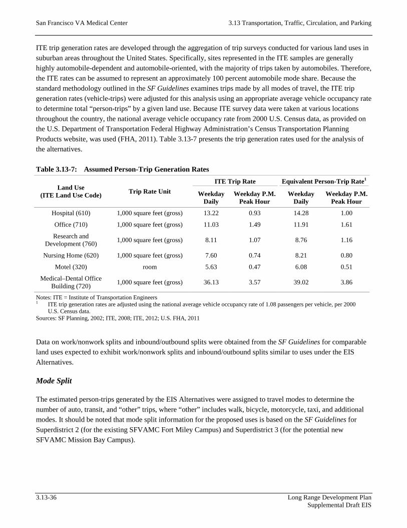
ITE trip generation rates are developed through the aggregation of trip surveys conducted for various land uses in suburban areas throughout the United States. Specifically, sites represented in the ITE samples are generally highly automobile-dependent and automobile-oriented, with the majority of trips taken by automobiles. Therefore, the ITE rates can be assumed to represent an approximately 100 percent automobile mode share. Because the standard methodology outlined in the SF Guidelines examines trips made by all modes of travel, the ITE trip generation rates (vehicle-trips) were adjusted for this analysis using an appropriate average vehicle occupancy rate to determine total “person-trips” by a given land use. Because ITE survey data were taken at various locations throughout the country, the national average vehicle occupancy rate from 2000 U.S. Census data, as provided on the U.S. Department of Transportation Federal Highway Administration’s Census Transportation Planning Products website, was used (FHA, 2011). Table 3.13-7 presents the trip generation rates used for the analysis of the alternatives.
Table 3.13-7: Assumed Person-Trip Generation Rates
Land Use (ITE Land Use Code) Trip Rate Unit
ITE Trip Rate Equivalent Person-Trip Rate1
Weekday Daily
Weekday P.M. Peak Hour
Weekday Daily
Weekday P.M. Peak Hour
Hospital (610) 1,000 square feet (gross) 13.22 0.93 14.28 1.00
Office (710) 1,000 square feet (gross) 11.03 1.49 11.91 1.61
Research and Development (760) 1,000 square feet (gross) 8.11 1.07 8.76 1.16
Nursing Home (620) 1,000 square feet (gross) 7.60 0.74 8.21 0.80
Motel (320) room 5.63 0.47 6.08 0.51
Medical–Dental Office Building (720) 1,000 square feet (gross) 36.13 3.57 39.02 3.86
Notes: ITE = Institute of Transportation Engineers 1 ITE trip generation rates are adjusted using the national average vehicle occupancy rate of 1.08 passengers per vehicle, per 2000
U.S. Census data. Sources: SF Planning, 2002; ITE, 2008; ITE, 2012; U.S. FHA, 2011
Data on work/nonwork splits and inbound/outbound splits were obtained from the SF Guidelines for comparable land uses expected to exhibit work/nonwork splits and inbound/outbound splits similar to uses under the EIS Alternatives.
Mode Split
The estimated person-trips generated by the EIS Alternatives were assigned to travel modes to determine the number of auto, transit, and “other” trips, where “other” includes walk, bicycle, motorcycle, taxi, and additional modes. It should be noted that mode split information for the proposed uses is based on the SF Guidelines for Superdistrict 2 (for the existing SFVAMC Fort Miley Campus) and Superdistrict 3 (for the potential new SFVAMC Mission Bay Campus).
3.13-36 Long Range Development Plan Supplemental Draft EIS

3.13 Transportation, Traffic, Circulation, and Parking San Francisco VA Medical Center
Trip Distribution/Assignment
The trips generated by the EIS Alternatives would be distributed to the four quadrants of San Francisco (Superdistricts 1, 2, 3, and 4), the East Bay, the North Bay, the South Bay/Peninsula, and outside the region, based on the origin/destination of each trip and land use–based trip distribution data contained in the SF Guidelines. For this analysis, it has been assumed that the trip distribution for the hospital and research uses proposed by the EIS Alternatives would be similar to the trip distribution for office uses. Table 3.13-8 presents the trip distribution percentages used for the analysis of each of the alternatives.
Table 3.13-8: Trip Distribution Patterns
Off-Site Trip End
Trip Distribution
Superdistrict 2 (Existing SFVAMC Fort Miley Campus)
Superdistrict 3 (Potential New SFVAMC
Mission Bay Campus)
Work Trips Nonwork Trips Work Trips Nonwork Trips
Superdistrict 1 8.4% 13.0% 8.3% 13%
Superdistrict 2 35.2% 27.0% 10.6% 14%
Superdistrict 3 15.8% 14.0% 23.9% 44%
Superdistrict 4 15.1% 9.0% 7.9% 7%
East Bay 7.1% 11.0% 14.3% 9%
North Bay 7.0% 4.0% 5.6% 1%
South Bay 10.6% 8.0% 26.9% 9%
Out of Region 0.8% 14.0% 2.5% 3%
Total 100.0% 100.0% 100.0% 100.0%
Parking Demand
Similar to the trip generation calculations, the proposed LRDP’s parking demand was calculated using rates provided from ITE’s Parking Generation, 4th Edition, the industry-accepted source for land use–based parking demand rates. The rates provided in Parking Generation are derived from empirical data collected through parking surveys at locations across the United States. Like the ITE trip generation rates, the ITE parking-demand rates represent data samples in automobile-dependent and automobile-oriented suburban areas with negligible transit, biking, and walking mode shares. To correct the ITE parking demand rates, mode splits from the SF Guidelines were applied to the rates, reflecting the multimodal nature of travel in San Francisco and producing a more accurate estimate of the actual increase in parking demand expected with the EIS Alternatives.
Table 3.13-9 presents the trip generation rates used in the analysis of the EIS Alternatives, together with the peak parking demand period(s) as identified in Parking Generation. As shown in Table 3.13-9, the equivalent parking rates are approximately half of the rates published by ITE in Parking Generation, reflecting the presence of attractive, viable alternative modes of travel in San Francisco. Most of the selected land use categories exhibit peaking characteristics similar to existing facilities on the SFVAMC Fort Miley Campus and reasonably approximate the weekday midday (1:00 p.m. to 3:00 p.m.) peak period selected for the parking occupancy surveys.
Long Range Development Plan 3.13-37 Supplemental Draft EIS

San Francisco VA Medical Center 3.13 Transportation, Traffic, Circulation, and Parking
Table 3.13-9: Assumed Vehicle Parking Demand Rates
Land Use (ITE Land Use
Code)
Parking Rate Unit
ITE Parking
Rate (spaces per
unit)
Equivalent Parking Rate (spaces per unit)
ITE Peak Parking Demand Periods
(Weekdays) Superdistrict 2
(Existing SFVAMC Fort Miley Campus)
Superdistrict 3 (Potential New
SFVAMC Mission Bay Campus)
Hospital (610)
1,000 square feet (gross) 3.70 2.16
9:00 a.m.–10:00 a.m. 12:00 p.m.–1:00 p.m. 3:00 p.m.–4:00 p.m.
Office (701)
1,000 square feet (gross) 2.47 1.20 9:00 a.m.–5:00 p.m.
University/College (550)
1,000 square feet (gross) 1.20 0.69 0.89 No data provided
Nursing Home (620)
1,000 square feet (gross) 0.98 0.57 9:00 a.m.–10:00 a.m.
11:00 a.m.–4:00 p.m.
Motel (320)
1,000 square feet (gross) 0.71 0.41 No data provided
Medical–Dental Office Building
(720)
1,000 square feet (gross) 3.20 1.87 2.09 10:00 a.m.–12:00 p.m.
2:00 p.m.–3:00 p.m.
Notes: ITE = Institute of Transportation Engineers; SFVAMC = San Francisco Veterans Affairs Medical Center Sources: SF Planning, 2002; ITE, 2010; VA, 2014c
Loading Demand
The SF Guidelines provide truck trip generation rates for common land uses such as residential, retail, light industry, and office, but they do not provide specific rates for medical or medical-related uses. In particular, medical and medical-related uses may have specific loading needs (e.g., medical equipment and supplies, biohazard waste disposal). These specific loading needs may not be adequately reflected when attempting to approximate these land uses with more common uses for which the SF Guidelines specifically provides truck trip generation rates.
In addition, most large campus environments such as the SFVAMC Fort Miley Campus typically provide delivery loading spaces within each campus building or facility. Vehicle parking for large campuses is typically shared among various campus facilities and provided in facilities designed specifically for vehicle storage; but the nature of delivery loading activities requires loading spaces to be typically provided in each building as needed, in the form of a loading dock or dedicated curb space. Thus, delivery loading impacts are typically analyzed for each specific building, at a time when the design of such buildings has been determined to a sufficient level of detail to identify the location of proposed loading facilities, the proposed supply of loading spaces, and the access routes for service and delivery vehicles. In particular, larger trucks may require specific accommodations with regard to building features (e.g., loading dock dimensions) or roadway design (e.g., curb radii) that typically require detailed turning template analyses to determine the accessibility and usability of proposed delivery loading facilities.
3.13-38 Long Range Development Plan Supplemental Draft EIS

3.13 Transportation, Traffic, Circulation, and Parking San Francisco VA Medical Center
The EIS Alternatives, however, represent a master plan for the SFVAMC Fort Miley Campus involving multiple buildings and uses and, as such, are analyzed here as part of a program-level environmental review. Specific details such as building features and roadway design will be determined only as each project for the selected Alternative begins to move into the design and implementation phase. Therefore, this EIS does not fully assess delivery loading impacts with regard to the demand and supply of loading spaces or the accessibility and usability of delivery loading facilities (and any associated off-Campus effects). These impacts may require further evaluation later as each project for the selected EIS Alternative is designed in more detail.
Travel Demand
Trip Generation
Table 3.13-10 and Table 3.13-11 summarize the person-trip generation for the uses proposed by Alternative 1 and Alternative 3, respectively.7 The trips in Table 3.13-10 and Table 3.13-11 represent net-new person-trips, accounting for reductions in travel demand as a result of the demolition or replacement of existing Campus facilities. Trips were not estimated for some uses, such as those involving nonhabitable uses, because they would not be expected to generate or attract trips on their own, and were therefore excluded from the calculations.
Because Alternative 1 and Alternative 3 propose the same short-term actions, these two Alternatives would generate the same number of person-trips in the short-term time frame. Specifically, short-term actions would generate approximately 159 net-new person-trips during the weekday p.m. peak hour under both Alternatives. Long-term actions would generate approximately 655 net-new person-trips and 809 net-new person-trips under Alternative 1 and Alternative 3, respectively, during the weekday p.m. peak hour. Alternative 3 would generate substantially more net-new person-trips in the long-term time frame, but the majority of these trips would be concentrated at the potential new Mission Bay Campus.
Mode Split
Table 3.13-12 presents the net-new trip generation by mode for Alternative 1. As shown, Alternative 1 is expected to generate 57 net-new vehicle-trips at the existing SFVAMC Fort Miley Campus under 2020 Alternative 1 Short-Term Projects Conditions and 259 net-new vehicle-trips under 2027 Alternative 1 Long-Term Project Conditions during the weekday p.m. peak hour.
Table 3.13-13 presents the net-new trip generation by mode under Alternative 3. As shown, Alternative 3 is expected to generate 57 net-new vehicle-trips at the existing SFVAMC Fort Miley Campus under 2020 Alternative 3 Short-Term Projects Conditions during the weekday p.m. peak hour. Under 2027 Alternative 3 Long-Term Projects Conditions, Alternative 3 would generate 57 net-new vehicle-trips at the existing SFVAMC Fort Miley Campus and 184 vehicle-trips at the potential new SFVAMC Mission Bay Campus during the weekday p.m. peak hour.
7 The person-trip generation for the proposed uses under Alternative 1 and Alternative 3 short-term projects (2020) is a conservative estimate, because it does not take into account the existing space deficiency at the SFVAMC Fort Miley Campus.
Long Range Development Plan 3.13-39 Supplemental Draft EIS
San Francisco VA Medical Center 3.13 Transportation, Traffic, Circulation, and Parking
Table 3.13-10: Net-New Person-Trip Generation—Alternative 1
Phase Action ITE Land Use [Code]
Net-New Gross Area
in square feet
Net-New Person-Trips Weekday
Daily Weekday P.M.
Peak Hour Short-Term Projects
1.1 Building 211: Emergency Operations Center/Parking Garage
Construction EOC to be operated by existing staff (no new parking demand) Parking garage not a habitable space
1.2
Trailer 17 Removal R&D Center [760] (1,700) (15) (2) Building 41: Research Construction R&D Center [760] 14,200 124 16 1.3 Buildings 5 and 7 Seismic Retrofit Renovation of existing building/space
1.4 Buildings 9 and 10 Seismic Retrofit Renovation of existing building/space
Building 22: Hoptel1 Construction Motel [320] 8,700 49 4
1.5 Buildings 209 and 211: Parking Garage Extensions Construction Not a habitable space
1.6
Building 203: C-Wing Extension (Ground-Floor Patient Welcome Center)/Drop-Off Area with Canopy Structure
Construction Hospital [610] 7,100 101 7
1.7 Building 200: Expansion (Operating Room D-Wing) Construction Hospital [610] 5,300 76 5
1.8
Building 20 Demolition Currently used as storage
Building 24: Mental Health Clinical Expansion Construction Hospital [610] 15,600 223 16
1.9
Building 18 Demolition R&D Center [760] (9,700) (85) (11) Building 14 Demolition R&D Center [760] (6,400) (56) (7) Building 21 Demolition R&D Center [760] (1,700) (15) (2) Trailer 23 Removal R&D Center [760] (900) (8) (1) Structure 206: Water Tower Installation Not a habitable space Structure 206: Water Tower Removal Not a habitable space Building 40: Research Construction R&D Center [760] 110,000 963 127
1.10 Building 207: Expansion (IT Support Space) Construction Office Building [710] 7,000 83 11
1.11
Trailer 31 Removal Hospital [610] (1,500) (21) (2) Building 43: Research and Admin. Construction R&D Center [760] 15,000 131 17 1.12 Trailer 36: New Modular Installation R&D Center [760] 2,200 19 3
1.13 Building 23: Mental Health Research Expansion
Construction R&D Center [760] 15,000 131 17
1.14 Building 203: Extension (Psychiatric Intensive Care Unit C-Wing)
Construction Hospital [610] 1,200 17 1
1.15
Trailer 24 Removal Medical–Dental Office Building [720] (1,000) (39) (4)
Building 208: Extension (Community Living Center/National Cardiac Device Surveillance Center)
Construction Nursing Home [620] 10,000 82 8
1.16
Building 8 Seismic Retrofit Renovation of existing building/space Building 1 Seismic Retrofit Renovation of existing building/space Building 6 Seismic Retrofit Renovation of existing building/space 1.17 Building 12 Demolition R&D Center [760] (38,900) (341) (45) Subtotal 1,421 159
3.13-40 Long Range Development Plan Supplemental Draft EIS

3.13 Transportation, Traffic, Circulation, and Parking San Francisco VA Medical Center
Table 3.13-10: Net-New Person-Trip Generation—Alternative 1
Phase Action ITE Land Use [Code]
Net-New Gross Area
in square feet
Net-New Person-Trips Weekday
Daily Weekday P.M.
Peak Hour Long-Term Project
2.1 Building 213: Clinical Addition Building Construction 170,000 6,633 655
Subtotal 6,633 655
Total 8,055 815 Notes: EOC = Emergency Operations Center; ITE = Institute of Transportation Engineers; R&D = Research and Development Numerical values enclosed in parentheses indicate negative values (demolition of building/structure or reduction in trips). 1 A guest room density of approximately 1 room per 1,000 gross square feet was assumed for the hoptel. Source: VA, 2014c
Table 3.13-11: Net-New Person-Trip Generation—Alternative 3
Phase Action ITE Land Use [Code]
Net-New Gross Area
in square feet
Net-New Person-Trips
Weekday Daily
Weekday P.M. Peak
Hour Short-Term Projects Same as for Alternative 1
Subtotal 1,421 159
Long-Term Projects1 2.1 Ambulatory Care Center Construction Medical–Dental Office Building [720] 140,000 5,463 540 2.2 Clinical Parking Garage (100 spaces) Construction Not a habitable space
Subtotal 5,463 540
Total 6,884 699 Notes: ITE = Institute of Transportation Engineers; R&D = Research and Development 1 Under Alternative 3, the long-term land use projects would take place at the new Mission Bay Campus. Source: VA, 2014c
Table 3.13-12: Net-New Trip Generation by Mode (Weekday P.M. Peak Hour)—Alternative 1
Direction Net-New Person-Trips Net-New
Vehicle-Trips Auto Transit Walk Other1 Total 2020 Short-Term Projects Inbound 13 6 4 1 25 7 Outbound 67 39 17 4 127 49 Total 81 45 20 6 152 57
2027 Long-Term Projects Inbound 177 85 47 18 327 101 Outbound 177 85 47 18 327 101 Total 354 170 94 36 654 202
Long Range Development Plan 3.13-41 Supplemental Draft EIS

San Francisco VA Medical Center 3.13 Transportation, Traffic, Circulation, and Parking
Table 3.13-12: Net-New Trip Generation by Mode (Weekday P.M. Peak Hour)—Alternative 1
Direction Net-New Person-Trips Net-New
Vehicle-Trips Auto Transit Walk Other1 Total Total (Short-Term and Long-Term Projects) Inbound 190 91 51 19 352 108 Outbound 244 124 64 22 454 150 Total 435 215 114 42 806 259 Notes: 1 “Other” mode includes bicycles, motorcycles, and taxis. Source: VA, 2014c
Table 3.13-13: Net-New Trip Generation by Mode (Weekday P.M. Peak Hour)—Alternative 3
Direction Net-New Person-Trips Net-New
Vehicle-Trips Auto Transit Walk Other1 Total 2020 Short-Term Projects (Existing SFVAMC Fort Miley Campus) Inbound 13 6 4 1 25 7 Outbound 67 39 17 4 127 49 Total 81 45 20 6 152 57 2027 Long-Term Projects (Potential New SFVAMC Mission Bay Campus) Inbound 164 52 36 18 270 92 Outbound 164 52 36 18 270 92 Total 327 104 72 37 540 184 Total (Short-Term and Long-Term Projects) Inbound 177 58 40 20 294 99 Outbound 231 91 53 23 397 141 Total 408 149 92 43 691 240 Notes: SFVAMC = San Francisco Veterans Affairs Medical Center 1 “Other” mode includes bicycles, motorcycles, and taxis. Source: VA, 2014c
Parking Demand
Table 3.13-14 presents the weekday parking demand for Alternative 1. Overall, Alternative 1 would result in a net increase in peak-period parking demand at the existing SFVAMC Fort Miley Campus of an estimated 132 spaces under 2020 Short-Term Projects Conditions and an additional 295 spaces under 2027 Long-Term Projects Conditions.
Table 3.13-15 presents the weekday parking demand for Alternative 3. Overall, Alternative 3 is anticipated to result in a net increase in peak-period parking demand of an estimated 132 spaces under 2020 Short-Term Projects Conditions at the existing SFVAMC Fort Miley Campus. Under 2027 Long-Term Projects Conditions,
3.13-42 Long Range Development Plan Supplemental Draft EIS

3.13 Transportation, Traffic, Circulation, and Parking San Francisco VA Medical Center
Table 3.13-14: Net-New Parking Demand—Alternative 1
Subphase Action ITE Land Use [Code]
Net-New Gross Area
in square feet
Net-New Weekday
Peak-Hour Parking Demand in Spaces
Short-Term Projects
1.1 Building 211: Emergency Operations Center/Parking Garage Construction EOC to be operated by existing staff (no new parking demand)
Parking garage not a habitable space
1.2 Trailer 17 Removal University/College [550] (1,700) (1)
Building 41: Research Construction University/College [550] 14,200 9 1.3 Buildings 5 and 7 Seismic Retrofit Renovation of existing building/space
1.4 Buildings 9 and 10 Seismic Retrofit Renovation of existing building/space
Building 22: Hoptel1 Construction Motel [320] 8,700 3
1.5 Buildings 209 and 211: Parking Garage Extensions Construction Not a habitable space
1.6 Building 203: C-Wing Extension (Ground-Floor Patient Welcome Center)/Drop-Off Area with Canopy Structure
Construction Hospital [610] 7,100 14
1.7 Building 200: Expansion (Operating Room D-Wing) Construction Hospital [610] 5,300 11
1.8
Building 20 Demolition Currently used as storage (no parking demand assumed)
Building 24: Mental Health Clinical Expansion Construction Hospital [610] 15,600 31
1.9
Building 18 Demolition University/College [550] (9,700) (6) Building 14 Demolition University/College [550] (6,400) (4) Building 21 Demolition University/College [550] (1,700) (1) Trailer 23 Removal University/College [550] (900) (1) Structure 206: Water Tower Installation Not a habitable space Structure 206: Water Tower Removal Not a habitable space Building 40: Research Construction University/College [550] 110,000 70 1.10 Building 207: Expansion (IT Support Space) Construction Office Building [701] 7,000 8
1.11 Trailer 31 Removal Hospital [610] (1,500) (3)
Building 43: Research and Admin. Construction University/College [550] 15,000 10 1.12 Trailer 36: New Modular Installation University/College [550] 2,200 1 1.13 Building 23: Mental Health Research Expansion Construction University/College [550] 15,000 10
1.14 Building 203: Extension (Psychiatric Intensive Care Unit C-Wing) Construction Hospital [610] 1,200 2
1.15
Trailer 24 Removal Medical–Dental Office Building [720] (1,000) (2)
Building 208: Extension (Community Living Center/National Cardiac Device Surveillance Center)
Construction Nursing Home [620] 10,000 5
1.16
Building 8 Seismic Retrofit Renovation of existing building/space Building 1 Seismic Retrofit Renovation of existing building/space Building 6 Seismic Retrofit Renovation of existing building/space 1.17 Building 12 Demolition University/College [550] (38,900) (25)
Subtotal 132 Long-Term Projects 2.1 Building 213: Clinical Addition Building Construction Medical–Dental Office Bldg. [720] 170,000 295
Subtotal 295
Total 426 Notes: EOC = Emergency Operations Center; ITE = Institute of Transportation Engineers Numerical values enclosed in parentheses indicate negative values (demolition of building/structure or reduction in trips). 1 A guest room density of approximately 1 room per 1,000 gross square feet was assumed for the hoptel. Source: VA, 2014c
Long Range Development Plan 3.13-43 Supplemental Draft EIS

San Francisco VA Medical Center 3.13 Transportation, Traffic, Circulation, and Parking
Table 3.13-15: Net-New Parking Demand—Alternative 3
Subphase Action ITE Land Use [Code]
Net-New Gross Area
in square feet
Net-New Weekday Peak-Hour Parking
Demand in Spaces
Short-Term Projects (Existing SFVAMC Fort Miley Campus) Same as for Alternative 1 Subtotal 132 Long-Term Projects (Potential New SFVAMC Mission Bay Campus) 2.1 Ambulatory Care Center Construction Medical–Dental Office Building [720] 140,000 271 2.2 Clinical Parking Garage (100 spaces) Construction Not a habitable space Subtotal 271 Total 403 Notes: ITE = Institute of Transportation Engineers; SFVAMC = San Francisco Veterans Affairs Medical Center 1 A guest room density of approximately 1 room per 1,000 gross square feet was assumed for the hoptel. Source: VA, 2014c
Alternative 3 is anticipated to result in a peak-period parking demand of an additional 271 spaces at the potential new SFVAMC Mission Bay Campus.
2020 Short-Term Effects—Methods and Assumptions
Background Growth
Background growth in travel demand consists of both general growth in the city and region, and growth from specific foreseeable developments. Information about background growth is generally obtained by consulting travel demand forecasting models in an attempt to project traffic volumes for a given forecast year. Travel demand forecasting models incorporate a variety of factors related to the transportation network and trip-making behavior; land use, population, and socioeconomic characteristics; and other data.
For this study, the San Francisco Chained Activity Modeling Process (SF-CHAMP) model maintained by the San Francisco County Transportation Authority (SFCTA) was consulted in the development of background growth projections. SF-CHAMP is the standard travel demand model used to develop future-year travel forecasts for the analysis of development projects in San Francisco. SF-CHAMP is a state-of-the-art tool that models the city’s transportation network (roadway and bikeway infrastructure, transit infrastructure and services, and the pedestrian environment) at a fine grain, while also comprehensively incorporating observations of city residents’ travel patterns and other factors that may affect trip-making behavior, such as vehicle ownership rates. SF-CHAMP was developed with a highly sensitive tour-based forecasting methodology that allows for trip chaining (or “trip linking”), which better replicates actual travel behavior and is more comprehensive than a traditional four-step model based on trip generation, mode split, trip distribution, and route assignment. To develop background growth projections, the SF-CHAMP model was used for both the baseline model year (2012) and forecast model year (2040).
Before background growth was estimated, the land use and socioeconomic inputs for the Traffic Analysis Zone (TAZ) containing the Campus were checked to determine whether the EIS Alternatives were already assumed in the future-year model. The SFVAMC Fort Miley Campus is located within TAZ 738, which is bounded by Clement Street/Seal Rock Drive at its southern end. TAZ 738 encompasses all of the Campus and portions of the surrounding GGNRA land, but does not include any of the surrounding residential neighborhoods. Investigation
3.13-44 Long Range Development Plan Supplemental Draft EIS

3.13 Transportation, Traffic, Circulation, and Parking San Francisco VA Medical Center
of the changes in assumed employment levels for TAZ 738 between the baseline-year and forecast-year models confirmed that the EIS Alternatives were not explicitly included as part of the forecast-year model.
Traffic Forecasts
To estimate future-year traffic volumes for this study, a noncompounded annual growth rate was derived by consulting the baseline-year and forecast-year SF-CHAMP models and extracting the projected volume on the roadway links feeding into each study intersection. Some degree of variability was observed in the calculated growth rates. Many locations showed a negative growth rate, corresponding to a decrease in traffic between the baseline-year and future-year models. The locations with the highest calculated growth rates still showed only modest growth of about 0.25 percent per year.
As a result, a general growth rate equivalent to approximately 0.5 percent per year was assumed for all the study intersections. Applying this level of growth is consistent with previous studies conducted in the vicinity of the existing SFVAMC Fort Miley Campus, including the Presidio Trust Management Master Plan Environmental Impact Statement. The 0.5 percent growth rate assumed is considered conservative because development in the vicinity of the Campus is near buildout conditions. This methodology was used in both short-term and long-term assumptions.
Transit Forecasts
Ridership projections for Muni lines serving the SFVAMC Fort Miley Campus were derived by examining ridership assignment outputs from SF-CHAMP for the baseline-year and forecast-year models. SF-CHAMP provides dedicated line-by-line boardings and alightings for each Muni line, known as “quickboards.” Similar to the development of traffic forecasts, transit ridership forecasts can be developed by calculating annual growth rates from the baseline-year model ridership to the forecast-year model ridership based on the quickboard outputs. These growth rates can then be applied to empirical ridership data, adjusting for the desired horizon year, to derive future-year ridership projections.
Given the nature of travel forecasting, however, the quickboards can produce counterintuitive results—such as unexpected decreases in ridership—when attempting to analyze ridership assignments at a microscopic (i.e., line-by-line) level. As a result, a direct application of line-based growth factors calculated from SF-CHAMP is typically considered impractical. Instead, future-year ridership is typically examined at the corridor level. The growth rates are calculated by aggregating the quickboard data for each line in the corridor, smoothing out any potential inconsistencies in the quickboard assignments. In particular, transit service along Geary Boulevard can be considered to comprise a total of four lines: one local line (38 Geary), one limited line (38L Geary Limited), and two express lines (38AX Geary “A” Express and 38BX Geary “B” Express). A noncompounded annual growth rate for transit ridership in the Geary Corridor was thus calculated by aggregating the quickboard assignments for these four lines.
The resulting ridership forecasts for the Geary Corridor were checked against the estimated ridership in 2035 for the Geary Corridor as calculated in the Transit Effectiveness Project Draft Environmental Impact Report (July 10, 2013) (TEP DEIR) (Planning Department Case No. 2011.0558E; State Clearinghouse No. 2011112030). Minor adjustments were made as necessary to ensure consistency with the TEP DEIR.
Long Range Development Plan 3.13-45 Supplemental Draft EIS

San Francisco VA Medical Center 3.13 Transportation, Traffic, Circulation, and Parking
Transportation Network Modifications
Also included in the analyses for 2020 Short-Term Projects Conditions are changes to the transportation network proposed by SFMTA, including those associated with the Geary Corridor Bus Rapid Transit (BRT) Project, the Transit Effectiveness Project (TEP), and the 2009 San Francisco Bicycle Plan (Bike Plan).
Geary Corridor Bus Rapid Transit
This project would involve major upgrades to transit service in the Geary Corridor designed to decrease travel times on transit, improve transit reliability, and improve pedestrian safety and access to transit. The project encompasses the stretch of Geary Street/O’Farrell Street and Geary Boulevard from Market Street west to 34th Avenue and proposes the following improvements:
• Improvements to transit infrastructure and service, including exclusive, high-visibility bus-only lanes for most of the route within the project extents, mostly in a side-running alignment but with a center-running alignment from Palm Avenue west to 26th Avenue. Transit signal priority and new low-floor buses would also be introduced, and bus stops would be relocated, replaced, or upgraded as needed. All-new, high-amenity platform stations would be constructed in the center-running segment and bus bulbs would be constructed in side-running segments.
• Improvements to pedestrian safety, including high-visibility treatments for crosswalks, improved signage, construction of corner bulb-outs at intersections, and measures to reduce conflict between pedestrians and left-turning vehicles.
Within the project extents, BRT stops would generally follow the existing stopping pattern for 38L services, with stops located at Kearny Street (outbound only), Stockton Street, Powell Street, Leavenworth Street, Van Ness Avenue, Fillmore Street, Divisadero Street, Masonic Avenue/Presidio Avenue, Spruce Street, Arguello Boulevard, 6th Avenue, Park Presidio Boulevard, 17th Avenue, 21st Avenue, 25th Avenue, 30th Avenue, and 33rd Avenue.
The project is expected to result in a 25 percent reduction in travel time and a 20 percent improvement in transit reliability, resulting in a 10 to 20 percent increase in ridership on the improved sections of the corridor. Construction could begin in 2017, with revenue service beginning as early as 2019, becoming Muni’s second BRT project after the Van Ness Avenue BRT.
Existing transit service in the Geary Corridor is structured around four distinct services or routes—one local service, one limited service, and two peak-period (commute) express services. Based on discussions with SFMTA staff members, service in the Geary Corridor would be restructured with the commencement of BRT service into three lines operating four distinct services—one local, two limited, and one peak-period (commute) express. Each of the four services would operate with articulated buses (94 passengers per bus) at 6-minute headways during the peak hours, providing a combined total of 40 services per hour in the Geary Corridor. These services are described below.
• 38 Geary: Local service between downtown and Fort Miley.
• 38 Geary Limited: Two limited services, one operating between downtown and Geary Boulevard/25th Avenue and the other continuing west of 25th Avenue to Point Lobos Avenue/48th Avenue.
• 38X Geary Express: Express service between downtown and Point Lobos Avenue/48th Avenue.
3.13-46 Long Range Development Plan Supplemental Draft EIS

3.13 Transportation, Traffic, Circulation, and Parking San Francisco VA Medical Center
Transit Effectiveness Project
The TEP would institute a series of sweeping, systemwide changes to Muni service to streamline operations, adapt to changes in travel patterns, and improve reliability and passenger experience. As described in the TEP DEIR, the proposed changes include the following projects:
• Service Improvements These projects include the following elements:
− the creation of new routes,
− changes to the alignment of existing routes (including elimination of underutilized routes or segments),
− changes to frequency and service hours,
− changes to transit vehicle type on specific routes,
− changes to corridor service plans (e.g., adjustments to the scheduled mix of local, limited, and express services), and
− other minor changes (e.g., new stops on express services, expansion of limited service on weekends, or providing an additional day of service on weekends).
• Service-Related Capital Improvements These projects represent service improvements that require investment in construction infrastructure, and include the following elements:
− “Terminal and Transfer Point Improvements” (e.g., installation of new switches, installation of bus bulbs, expansion of bus layover facilities),
− “Overhead Wire Expansion” (e.g., installation of new overhead wires and associated infrastructure to expand electric trolley coach service to new streets or allow electric trolley coaches to pass each other), and
− “Systemwide Capital Infrastructure” (e.g., installation of new accessible platforms on the surface light rail network).
• Travel Time Reduction Proposals These projects include implementation of elements from SFMTA’s Transit Preferential Streets Toolkit—transit stop changes, lane geometry modifications, parking/turn restrictions, traffic signal and stop sign changes, and pedestrian improvements—to 17 of the 23 corridors identified as part of Muni’s “Rapid Network.”
Specifically, the TEP proposes the following changes to routes in the Geary Corridor, where the weekday a.m. peak period is defined as 7:00 a.m. to 9:00 a.m., the weekday midday period as 9:00 a.m. to 2:00 p.m., and the weekday p.m. peak period as 4:00 p.m. to 6:00 p.m.:
• 38 Geary Service west of 33rd Avenue (i.e., Fort Miley and 48th Avenue/Point Lobos Avenue branches) would see minor changes to headways, as follows:
Long Range Development Plan 3.13-47 Supplemental Draft EIS

San Francisco VA Medical Center 3.13 Transportation, Traffic, Circulation, and Parking
− Weekday a.m. peak period: 12 minutes → 15 minutes − Weekday midday period: 16 minutes → 15 minutes − Weekday p.m. peak period: 16 minutes → 12 minutes
Service east of 33rd Avenue would see minor changes to headways, as follows:
− Weekday a.m. peak period: 12 minutes → 7.5 minutes
− Weekday p.m. peak period: 8 minutes → 6 minutes
• 38L Geary Limited Service would be expanded to operate on Sundays. Minor changes to headways would be implemented, as follows:
− Weekday a.m. peak period: 5.5 minutes → 5 minutes
− Weekday midday: 5.5 minutes → 5 minutes
− Weekday p.m. peak period: 5.5 minutes → 5 minutes
• 38AX Geary “A” Express New stops would be added at Bush Street/Van Ness Avenue (inbound) and Pine Street/Van Ness Avenue (outbound).
• 38BX Geary “B” Express New stops would be added at Bush Street/Van Ness Avenue (inbound) and Pine Street/Van Ness Avenue (outbound).
San Francisco Bicycle Plan
The Bike Plan (June 26, 2009) outlines a series of improvements to San Francisco’s bicycle route network, as well as supporting policies related to bicycle use (e.g., bicycle parking, traffic enforcement and safety) designed to promote and increase safe bicycle use in the city. The Bike Plan proposes changes to existing bicycle routes in the city’s network (e.g., relocation or realignment of routes), as well as expansions of the bicycle route network to new streets. In particular, the Bike Plan categorizes improvements to the bicycle route network into one of three categories:
• Short-Term Bicycle Improvement Projects These are a series of 60 projects intended to be implemented in the short-term time frame. Detailed design has already been conducted for these projects.
• Long-Term Bicycle Improvement Projects These projects are intended to be implemented in the long-term time frame. No schedule or detailed design has been developed for these projects.
3.13-48 Long Range Development Plan Supplemental Draft EIS

3.13 Transportation, Traffic, Circulation, and Parking San Francisco VA Medical Center
• Minor Improvements to Bicycle Route Network These projects are minor treatments to improve conditions for bicycle use, including projects to address gaps or deficiencies in the bicycle route network. Typical improvements include pavement treatments and signage, traffic signal adjustments, and changes to on-street parking.
In terms of improvement to the bicycle route network in the vicinity of the SFVAMC Fort Miley Campus, the Bike Plan proposes the following projects:8
• Short-Term Bicycle Improvement Projects
− Route 95: Great Highway and Point Lobos Avenue Bicycle Lanes, El Camino del Mar to Cabrillo Street (Project 7-3)
• Long-Term Bicycle Improvement Projects
− Geary Boulevard between 25th Avenue and Divisadero Street
• Minor Improvements to Bicycle Route Network
− Route 10: Lake Street between 28th Avenue and 30th Avenue
− Route 10/95: Clement Street/Seal Rock Drive between 30th and 34th Avenue and between 43rd Avenue and El Camino del Mar, and El Camino del Mar between Seal Rock Drive and Point Lobos Avenue
− Route 85: Legion of Honor Drive/34th Avenue between Lincoln Highway/El Camino del Mar and Cabrillo Street
− Route 95: El Camino del Mar between 28th Avenue and El Camino del Mar (Sea Cliff Avenue) and between McLaren Avenue and 30th Avenue, and 30th Avenue between El Camino del Mar and Lake Street
− Route 395: El Camino del Mar/Lincoln Highway between Legion of Honor Drive/34th Avenue and 30th Avenue
2027 Long-Term Effects—Methods and Assumptions
Background Growth
Like the analysis for 2020 Short-Term Projects Conditions, the analysis for 2027 Long-Term Projects Conditions assumes a 0.5 percent per year growth rate for background traffic for all study intersections. Muni ridership growth was calculated using the same methodology discussed above for the 2020 Short-Term analysis.
Transportation Network Modifications
The same changes to the transportation network assumed under the 2020 Short-Term Projects Conditions are assumed under the analyses of 2027 Long-Term Projects Conditions.
8 Since the lifting of an injunction that prevented implementation of the Bike Plan (subsequent to the data collection efforts conducted used to develop existing conditions for this EIS section), many of the improvement projects have already been completed. In particular, a modified version of Project 7-3 was approved as an addendum to the San Francisco Bicycle Plan Final Environmental Impact Report (August 2009) (Planning Department Case No. 2007.0347E; State Clearinghouse No. 2008032052) on May 15, 2013, and has already been constructed.
Long Range Development Plan 3.13-49 Supplemental Draft EIS

San Francisco VA Medical Center 3.13 Transportation, Traffic, Circulation, and Parking
Alternative 1: SFVAMC Fort Miley Campus Buildout Alternative
Short-Term Projects
Construction
This section evaluates the potential construction impacts of the Alternative 1 short-term projects and includes the following components:
• Identification of haul truck routes to be used during construction
• Estimate of temporary traffic and parking demand, including haul truck and construction worker traffic, that would be generated during construction
• Identification of mitigation measures, such as overflow parking and other management strategies, to accommodate the temporary traffic and parking demand generated by construction activities and any associated loss of parking supply on the SFVAMC Fort Miley Campus
Because Alternative 2 would have slightly different construction phasing than Alternative 1, this section also evaluates potential construction impacts of the Alternative 2 short-term projects.
Construction-Related Haul Activity
Haul trucks traveling to and from the SFVAMC Fort Miley Campus during construction would be expected to use truck traffic routes established by SFMTA. In particular, SFMTA has developed the San Francisco Truck Traffic Routes map (2010), a conceptual route map of truck traffic routes in San Francisco, for inclusion by the City and County of San Francisco in its next update to the San Francisco General Plan. Specifically, the map identifies potential routes for trucks traveling through the City, focusing on regional freeways/highways and surface arterials. Based on this map, large trucks would be expected to use the following routes:
• From points north of the Campus: U.S. 101 → SR 1 (Veterans Boulevard/Park Presidio Boulevard) → Geary Boulevard → Point Lobos Avenue → 42nd Avenue or 43rd Avenue
• From points south of the Campus: I-280 → SR 1 (Junipero Serra Boulevard/19th Avenue/Crossover Drive/Park Presidio Boulevard) → Geary Boulevard → Point Lobos Avenue → 42nd Avenue or 43rd Avenue; or, alternatively, U.S. 101 (Bayshore Freeway/Central Freeway) → Mission Street → U.S. 101 (Van Ness Avenue) → Geary Boulevard → Point Lobos Avenue → 42nd Avenue or 43rd Avenue
• From points east of the Campus: I-80 → U.S. 101 (Central Freeway) → Mission Street → U.S. 101 (Van Ness Avenue) → Geary Boulevard → Point Lobos Avenue → 42nd Avenue or 43rd Avenue
These routes would minimize the impacts of haul truck activity farther from the Campus. However, under the Alternative 1 short-term projects, haul truck activity may still result in temporary but adverse impacts on traffic and transportation and vehicle parking, either at the Campus itself or in the immediate vicinity (VA, 2014d).
3.13-50 Long Range Development Plan Supplemental Draft EIS

3.13 Transportation, Traffic, Circulation, and Parking San Francisco VA Medical Center
Mitigation Measure TRANS-1: Use Identified Truck Haul Routes and Implement Queue Abatement Program
SFVAMC will use only a combination of the three haul truck routes identified below for LRDP construction-related activities.
• From points north of the Campus: U.S. 101 → SR 1 (Veterans Boulevard/Park Presidio Boulevard) → Geary Boulevard → Point Lobos Avenue → 42nd Avenue or 43rd Avenue
• From points south of the Campus: I-280 → SR 1 (Junipero Serra Boulevard/19th Avenue/Crossover Drive/Park Presidio Boulevard) → Geary Boulevard → Point Lobos Avenue → 42nd Avenue or 43rd Avenue; or, alternatively, U.S. 101 (Bayshore Freeway/Central Freeway) → Mission Street → U.S. 101 (Van Ness Avenue) → Geary Boulevard → Point Lobos Avenue → 42nd Avenue or 43rd Avenue
• From points east of the Campus: I-80 → U.S. 101 (Central Freeway) → Mission Street → U.S. 101 (Van Ness Avenue) → Geary Boulevard → Point Lobos Avenue → 42nd Avenue or 43rd Avenue
Use of alternative routes, particularly through the surrounding neighborhoods, is actively discouraged. SFVAMC and its construction contractors will monitor truck arrivals and, if necessary, implement a queue abatement program to ensure that haul trucks do not queue up and idle on the Campus or on adjacent or nearby streets.
Implementation of Mitigation Measure TRANS-1 would reduce traffic-, transportation-, and parking–related impacts of construction haul truck activity to a minor level.
Construction-Related Traffic
Construction-Traffic Estimation Methodology
Detailed construction plans have not yet been developed for most of the projects identified as being part of the EIS Alternatives. As a result, estimates of traffic during construction of various projects are currently unavailable. To assess the potential impacts of construction-related traffic, both vendor/haul truck trips and construction worker trips were estimated based on the California Emissions Estimator Model (CalEEMod) Version 2013.2.2. CalEEMod, published and maintained by the California Air Pollution Control Officers Association, is the accepted model for modeling construction-related air quality and greenhouse gas emissions in California, (CAPCOA, 2013).
Vendor/haul truck traffic was estimated for four different construction actions: demolition, seismic retrofitting, construction, and removal/installation. Construction worker trips were estimated for each of six different construction phases: demolition, site preparation, grading, building construction, architectural coating, and asphalt paving. General assumptions were made regarding building envelope (volume), haul truck capacity, and construction duration, and were combined with CalEEMod-recommended standards for equipment needs and construction worker vehicle-trip factors. Additional adjustments to the construction traffic estimates were made to account for major earthwork/grading (cut-and-fill) activities associated with some projects for the EIS Alternatives (VA, 2014d). More detail on the traffic estimation methodology is provided in the Construction Traffic and Parking Management Plan.
Long Range Development Plan 3.13-51 Supplemental Draft EIS

San Francisco VA Medical Center 3.13 Transportation, Traffic, Circulation, and Parking
Construction Traffic Estimates
Under the Alternative 1 short-term projects, vendor and haul truck traffic would peak at 36 vehicles (72 trips) per day and construction worker trips would peak at 72 vehicles (144 trips) per day in December 2015. As a result, construction activities under the Alternative 1 short-term projects would generate their maximum traffic volumes in December 2015, with as many as 108 vehicles (216 trips) in a day. Construction traffic in other months would generally be much lower than during the peak month; in most months, the maximum traffic volume generated would not exceed 50 vehicles (100 trips) in a single day (VA, 2014d). Construction-related traffic impacts would be a minor.
Construction-Related Effects on Traffic, Transit, and Pedestrian Circulation
It is anticipated that construction activities for Alternative 1 short-term projects would take place primarily Monday through Friday between 7:30 a.m. and 6:00 p.m. Any Saturday work is assumed to occur between 8:00 a.m. and 4:00 p.m. on an as-needed basis, in compliance with the San Francisco Noise Control Ordinance (Article 29 of the City and County of San Francisco Police Code) and the conditions of the San Francisco Department of Building Inspection permit. It is anticipated that no regular travel lanes or Muni bus stops would need to be closed or relocated during the construction period.
Because detailed construction plans for each short-term project under Alternative 1 have yet to be developed, however, some potential still exists for construction-related activities to result in temporary disruptions to traffic, transit, and pedestrian circulation on or in the vicinity of the SFVAMC Fort Miley Campus. In particular, the placement of temporary swing space in Lot B under Alternative 1 may cause some disruption to circulation on the east side of the Campus, the primary access for Veterans and visitors. In addition, construction-related activities taking place simultaneously and/or close to each other could amplify the effects of these activities on Campus circulation (VA, 2014d). Although these effects generally would not be substantial enough to constitute an adverse impact, the following management measure is recommended to alleviate these effects.
Management Measure TRANS-1: Implement Protective Measures for Traffic, Transit, and Pedestrians if Pedestrian Facilities or Travel Lanes Require Closure during Construction
Should construction activities require the closure of sidewalks or other pedestrian facilities within or outside of the Campus, SFVAMC will implement protective measures and erect equipment to ensure pedestrian safety. In high-conflict areas (either vehicle/pedestrian or vehicle/vehicle) such as access gates into construction sites, flag workers will be deployed to minimize traffic and pedestrian disruption and ensure the safety of Campus users.
Should it be determined that any travel lanes would require closure during construction, SFVAMC will coordinate the lane closures with the City to minimize impacts on local traffic. In general, temporary traffic and transportation changes must be coordinated through SFMTA’s Interdepartmental Staff Committee on Traffic and Transportation and require a public meeting. As part of this process, the construction management plan may be reviewed by SFMTA’s Transportation Advisory Committee to resolve internal differences between different transportation modes. SFVAMC will follow the Regulations for Working in San Francisco Streets (“The Blue Book”)9 (SFMTA, 2012) and will reimburse SFMTA for the costs of installation and removal of temporary striping and signage changes required during construction.
9 The SFMTA Blue Book is available online through SFMTA (www.sfmta.com).
3.13-52 Long Range Development Plan Supplemental Draft EIS

3.13 Transportation, Traffic, Circulation, and Parking San Francisco VA Medical Center
SFVAMC and its construction contractors will meet with SFMTA, the San Francisco Fire Department, the San Francisco Planning Department, and other City agencies to determine feasible measures to reduce any construction-related effects, including any potential transit disruption and pedestrian circulation impacts that would occur off-site during LRDP construction. To this effect, SFVAMC and its construction contractor(s) will implement the following measures:
• Schedule most construction-related travel (i.e., deliveries, hauling, and worker trips) to occur during off-peak hours.
• Develop on-site detour routes to facilitate traffic movement through construction zones.
• Where feasible, temporarily restripe roadways—such as turn lanes, through lanes, and parking lanes—at affected locations to minimize driver confusion and optimize traffic flow.
• Where feasible, temporarily remove on-street parking to secure adequate traffic flow at those locations affected by construction closures.
• Post signage to encourage drivers to proceed at slower, safer travel speeds through construction zones.
• Develop and implement an outreach program to inform the general public about the construction process and planned roadway closures.
If VA proceeds with Alternative 1, SFVAMC would provide temporary modular swing space within Lot B. Lot B and the adjacent section of Veterans Drive are currently designed with a one-way circulation pattern (northbound traffic along the east edge of the lot, southbound traffic along the west side of the lot). However, the presence of modular structures at this location, existing curbside parking activities, and the loss of parking capacity in Lot B could temporarily disrupt circulation through this part of the Campus (VA, 2014d). Although these effects would generally not be substantial enough to constitute an adverse impact, the following management measure is recommended to alleviate these effects.
Management Measure TRANS-2: Implement Protective Measures for Traffic, Transit, and Pedestrians during the Presence of Temporary Modular Structures on Campus
During the presence of temporary modular structures on the SFVAMC Fort Miley Campus as construction proceeds, SFVAMC will implement protective measures to ensure pedestrian safety and minimize impacts on local traffic. Potential measures could include the following:
• Enhance signage and striping to reinforce the current one-way circulation pattern around Lot B.
• Discourage illegal parking, whether curbside along the east side of Veterans Drive adjacent to Building 8 (Mental Health) and Building 9 (Hoptel) or elsewhere in and around Lot B.
• Temporarily relocate curbside parking along the east side of Veterans Drive to other parts of the Campus.
• Temporarily convert any remaining parking spaces in Lot B from perpendicular parking to parallel parking.
Long Range Development Plan 3.13-53 Supplemental Draft EIS

San Francisco VA Medical Center 3.13 Transportation, Traffic, Circulation, and Parking
Pedestrian crossings at blind spots or locations with limited visibility for drivers (such as between modular structures) will also be discouraged, or will be properly designed with high-visibility markings and signage that force drivers to slow or stop. Adequate access for ambulances transporting patients to the SFVAMC Fort Miley Campus and emergency vehicles responding to Campus emergencies will be preserved at all times. Specific details of temporary measures to address any potential effects on Campus circulation will be discussed between SFVAMC and the general contractors during the construction planning process, at which time the magnitude of such effects can be more readily ascertained.
Construction-related activities occurring simultaneously and/or close to each other on the SFVAMC Fort Miley Campus could amplify the effects of these activities on overall Campus circulation. For example, the construction of the Building 209 and Building 211 extensions (March 2015 to March 2016) would partially overlap with the construction of Building 40 (December 2015 through December 2018). The close proximity of these two sites may affect constructability or on-Campus haul truck routes (VA, 2014d). Although these effects would generally not be substantial enough to constitute an adverse impact, the following management measure is recommended to alleviate these effects.
Management Measure TRANS-3: Implement Protective Measures for Traffic, Transit, and Pedestrians during Overlapping Construction Projects Located Close to Each Other on Campus
SFVAMC will serve as a liaison between the various general contractors for each construction project for coordination of construction-related activities to minimize potential secondary effects on SFVAMC Fort Miley Campus circulation. SFVAMC will collaborate with contractors to secure adequate haul truck access and minimize disruption of Campus user access, considering a variety of potential solutions such as limiting haul truck access to specific Campus access points or Campus roadways. In the case of Building 40 and the Building 209 and Building 211 extensions, for example, haul trucks could be restricted to the Campus’s 43rd Avenue entrance, minimizing impacts on circulation in the patient/visitor zone of the Campus.
Implementing Management Measures TRANS-1 through TRANS-3 would ensure that construction-related effects on traffic, transit, and pedestrian circulation would be minor.
Construction-Related Effects on Parking
To implement some of the subphases identified in the LRDP, portions of the on-Campus parking areas may require temporary conversion for various construction-related activities such as excavation, staging of equipment and materials, and installation of temporary modular structures for a limited time period. These activities would result in a temporary loss of on-site parking capacity during some short-term projects under Alternative 1. When combined with increased parking demand on the site from construction workers, vendors, and other construction-related traffic, this temporary loss in on-site parking capacity would generally intensify the parking situation at the SFVAMC Fort Miley Campus.
To alleviate some of the loss in parking capacity during on-Campus construction activities, SFVAMC would implement valet parking at its two primary on-site parking structures, Building 209 and Building 212, which it has done successfully in the past. Under the LRDP, SFVAMC proposes to provide valet parking until the end of construction of Subphase 1.9 (i.e., through December 2018 under Alternative 1). This measure would partially offset the temporary loss in parking capacity and reduce spillover effects into the surrounding neighborhood.
3.13-54 Long Range Development Plan Supplemental Draft EIS

3.13 Transportation, Traffic, Circulation, and Parking San Francisco VA Medical Center
The pending completion of Building 211 (Emergency Operations Center/Parking Garage) would increase parking capacity on the SFVAMC Fort Miley Campus by 200 spaces. This increased parking capacity is intended primarily to accommodate future growth on the Campus and existing spillover demand in the surrounding residential neighborhoods, but it also would likely be able to accommodate most of the temporary parking demand generated by construction-related activities. The Campus’s valet program could also be expanded to include Building 211, increasing the total effective capacity of on-Campus parking facilities.
In addition, it is anticipated that actual maximum parking demand generated by construction-related activities on any single day during the peak month of construction traffic (December 2015) would be substantially less than 100 vehicles. In particular, although most construction workers would require parking spaces for the entire day, vendor trucks may require parking spaces for only short periods of time to deliver materials or equipment or perform contracted tasks. This may allow for some potential to share parking spaces during the day as turnover occurs. Haul trucks importing or exporting soil or debris would remain at the Campus only temporarily, for short periods of time, and therefore would not be expected to require dedicated parking spaces.
As mentioned above, SFVAMC would provide valet parking until the end of Subphase 1.9, providing an additional 180 spaces of parking capacity even after Building 211 has been completed but before all projects have been implemented. Therefore, there would likely be sufficient on-site parking capacity to accommodate the estimated temporary increase in parking demand that would result from construction-related activities for Alternative 1 short-term projects. The subsequent (March 2016) completion of the Building 209 and Building 211 extensions would further increase on-site parking capacity by 250 spaces, which would likely be sufficient to accommodate the parking demand generated by construction of subsequent projects. However, because of limitations in the methodology for estimating construction traffic, unforeseen circumstances such as delays or other necessary changes to the construction schedule, or other factors, some potential still exists for the temporary increase in parking demand generated by construction-related activities to exceed the available on-site parking supply. Such a situation could potentially result in temporary but adverse impacts on traffic and transportation and vehicle parking at the Campus itself or in the immediate vicinity (VA, 2014d).
Mitigation Measure TRANS-2: Conduct Supplemental Surveys of Parking Occupancy and Implement Programs to Prevent Parking Spillover
SFVAMC will conduct supplemental surveys of parking occupancy several weeks after completion of Building 211 to determine the utilization of the new parking structure and overall occupancy of on-site facilities throughout the day. The survey will also consider on-street parking in the surrounding area to estimate how much spillover demand has been “recaptured” on the site as a result of the increased parking supply. As construction plans for specific LRDP projects are developed, construction contractors will work with SFVAMC to compare their own estimates of construction-related traffic and parking demand to the estimated parking capacity and surveyed occupancy levels, to determine whether additional temporary measures are required to mitigate expected parking constraints.
Should these coordination efforts indicate that construction activities could result in a major parking deficit on the SFVAMC Fort Miley Campus, SFVAMC will implement measures to ensure that construction-related parking demand, as well as any associated parking loss in on-site parking capacity required to accommodate construction-related activities, does not result in additional spillover into the surrounding neighborhood beyond current conditions.
Long Range Development Plan 3.13-55 Supplemental Draft EIS

San Francisco VA Medical Center 3.13 Transportation, Traffic, Circulation, and Parking
Potential programs (or other measures deemed necessary and adequate to ensure that spillover parking demand into the surrounding neighborhood does not increase beyond current conditions) could include the following:
• Expand the Campus’s valet parking program. Upon completion of Building 211, the valet parking program could be made permanent and expanded to include the new parking structure. Based on the estimates provided in the LRDP, Building 211 would provide a total of 461 marked spaces, but a valet parking program for this structure could provide approximately 140 additional spaces, based on the 30 percent increase in parking efficiency documented in field surveys of parking occupancy in Building 209.
• Require general contractors to establish carpool/vanpool programs and encourage transit use. Because some construction workers reside outside of San Francisco, a vanpool service could be tailored to meet worker needs by operating as a “commuter shuttle” to major transit facilities, such as the BART station at Civic Center or 16th Street/Mission. To encourage transit use among construction workers, the contractor could provide free or discounted transit passes. A vanpool service could also be implemented in conjunction with a remote (i.e., off-site) “park-and-ride” facility, affording construction workers some of the convenience of a private vehicle and reducing some of the construction-related traffic effects in the immediate vicinity of the Campus. SFVAMC could work with its contractor to negotiate with the relevant property owners and parking operators in the area to lease spaces in an off-site surface lot or parking structure for a fixed period of time. The vanpool service could be contracted out to a third-party service provider.
• Require general contractors to optimize staging-area needs and coordinate vendor arrival schedules. In the development of construction plans, contractors should be required to optimize site utilization and schedule arrivals to minimize the associated traffic and vehicle parking impacts on the Campus community and surrounding neighborhoods.
If VA were to proceed with Alternative 1, temporary modular swing space would be provided in four separate locations on the SFVAMC Fort Miley Campus, including Lot B. Lot B currently provides patient and visitor parking, including most of the Campus’s ADA-compliant spaces for patients and visitors. Use of this parking facility to accommodate temporary modular structures during Campus construction would require SFVAMC to temporarily provide replacement ADA spaces elsewhere on the Campus or implement other measures to ensure ADA compliance. Specifically, the use of Lot B to accommodate temporary modular structures during construction at the SFVAMC Fort Miley Campus would substantially reduce the Campus’s existing supply of ADA spaces for patients and visitors, which could result in an adverse impact on vehicle parking at the site for these Campus users (VA, 2014d).
Mitigation Measure TRANS-3: Implement Temporary ADA Parking Strategies during Presence of Temporary Modular Structures on Campus
SFVAMC will implement temporary strategies to ensure ADA compliance while Lot B is in use for modular swing space. Potential strategies could include temporarily striping ADA spaces in other parking facilities on the Campus, such as Building 212, or implementing valet parking at the traffic circle outside the Patient Welcome Center for patients and visitors requiring ADA accommodations.
3.13-56 Long Range Development Plan Supplemental Draft EIS

3.13 Transportation, Traffic, Circulation, and Parking San Francisco VA Medical Center
Implementing Mitigation Measures TRANS-2 and TRANS-3 would reduce construction-related parking impacts to a minor level.
Operation
Traffic
Implementing Alternative 1 short-term projects would result in an increase in vehicle trips to and from the existing SFVAMC Fort Miley Campus. Traffic growth resulting from planned development both within and outside of the study area was used to develop traffic volumes for 2020 Short-Term Conditions and was then compared against traffic conditions with the addition of traffic volumes from Alternative 1 short-term projects.
Intersections
The resulting traffic volumes for 2020 Alternative 1 Short-Term Projects Conditions at the study intersections are illustrated in Figure 3.13-13. The LOS results for the study intersections are summarized in Table 3.13-16.
Table 3.13-16: Intersection Levels of Service—2020 Alternative 1 Short-Term Projects Conditions, Weekday P.M. Peak Hour
Intersection Control Type 2020 Short-Term
Conditions 2020 Alternative 1 Short-Term
Projects Conditions
LOS Delay1 LOS Delay1
1 34th Avenue/Clement Street All-way Stop B 12.4 B 12.8
2 42nd Avenue/Clement Street All-way Stop B 11.4 B 11.8
3 43rd Avenue/Clement Street All-way Stop B 12.3 B 13.6
4 42nd Avenue/Point Lobos Avenue All-way Stop B 13.1 B 13.3
5 43rd Avenue/Point Lobos Avenue All-way Stop C 15.1 C 15.9
Notes: LOS = level of service 1 Delay presented in seconds per vehicle. Source: VA, 2014c
As shown in Table 3.13-16, Alternative 1 short-term projects would result in only a marginal increase in delays compared to the “no action” scenario without Alternative 1 (2020 Short-Term Conditions), with no material change in the LOS. In particular, all five study intersections are projected to operate at acceptable conditions (LOS D or better) during the weekday p.m. peak hour under 2020 Alternative 1 Short-Term Projects Conditions. Therefore, the Alternative 1 short-term projects would result in minor operational impacts at the study intersections.
Roadway Segments
LOS results for the study roadway segments are summarized in Table 3.13-17. As shown, Alternative 1 would result in only a marginal increase in the volume-to-capacity ratio compared to the “no action” scenario without Alternative 1 (2020 Short-Term Conditions). In particular, all study roadway segments are projected to operate at acceptable conditions (LOS D or better) during the weekday p.m. peak hour under 2020 Alternative 1 Short-Term
Long Range Development Plan 3.13-57 Supplemental Draft EIS

San Francisco VA Medical Center 3.13 Transportation, Traffic, Circulation, and Parking
Source: VA, 2014c
Figure 3.13-13: Intersection Traffic Volumes—2020 Alternative 1 Short-Term Projects Conditions
3.13-58 Long Range Development Plan Supplemental Draft EIS

3.13 Transportation, Traffic, Circulation, and Parking San Francisco VA Medical Center
Table 3.13-17: Roadway Segment Levels of Service—2020 Alternative 1 Short-Term Projects Conditions, Weekday P.M. Peak Hour
Intersection Direction 2020 Short-Term Conditions 2020 Alternative 1 Short-Term
Projects Conditions
LOS v/c Ratio LOS v/c Ratio
1 42nd Avenue/Clement Street between Clement Street and
Point Lobos Avenue
Northbound A 0.17 A 0.18
Southbound A 0.25 A 0.26
2 43rd Avenue/Clement Street between Clement Street and
Point Lobos Avenue
Northbound A 0.17 A 0.17
Southbound C 0.66 C 0.72
Notes: LOS = level of service; v/c = volume-to-capacity Source: VA, 2014c
Projects Conditions. Therefore, the Alternative 1 short-term projects would result in minor operational impacts along the study roadway segments.
Passenger Vehicle Access
Alternative 1 short-term projects would institute several changes to circulation on the SFVAMC Fort Miley Campus. Specifically, construction of the Patient Welcome Center would require SFVAMC to close Fort Miley Circle to through traffic and construct a new traffic circle, providing curb space for passenger pick-up and drop-off activities. Access between the east and west sides of the Campus would be retained via Veterans Drive, although security gates would be installed on some segments surrounding proposed Building 40, effectively creating separate “employee” and “Veteran/visitor” zones on the Campus. The roadway between Building 200 and the future Building 213 would be narrowed as part of a traffic calming measure, and Fort Miley Circle west of Building 203 would be converted from one-way westbound traffic to two-way traffic.
These changes would generally improve passenger vehicle access by simplifying circulation through the Campus and segregating employee and Veteran/visitor vehicular traffic. Although a specific design for the proposed security gates near Building 40 has yet to be determined, a typical gate-processing time of 5 seconds would accommodate up to 720 vehicle movements per hour at each gate. The gates would likely be placed sufficiently within the confines of the Campus that any temporary vehicle queues that may develop would not extend outside of the Campus or cause major disruption to Campus circulation. Overall, the changes to passenger vehicle access under Alternative 1 short-term projects would result in, at most, only minor changes to travel times (either increase or decrease) and access routes, and would not constitute an adverse operational impact on passenger vehicle access at the Campus. This impact would be minor.
East Fort Miley Access
Alternative 1 short-term projects would not involve implementing specific changes to GGNRA access to and from East Fort Miley, and the existing access road at the southwest corner of Building 212 would continue to serve traffic generated at this facility. SFVAMC would implement some minor changes to the internal roadway network to better segregate employee and Veteran/visitor traffic across the Campus’s two main access points on 42nd
Long Range Development Plan 3.13-59 Supplemental Draft EIS

San Francisco VA Medical Center 3.13 Transportation, Traffic, Circulation, and Parking
Avenue and 43rd Avenue. However, these changes would result in, at most, only minor changes in the total traffic volumes passing through the Veterans Drive/Fort Miley Circle intersection (either increase or decrease) and would not preclude GGNRA access into and out of East Fort Miley. Overall, implementing Alternative 1 short-term projects is not anticipated to result in adverse operational impacts on GGNRA access into and out of East Fort Miley. This impact would be minor.
Transit
Ridership and Capacity Effects
Alternative 1 would generate approximately 45 net-new transit trips (of which six would be inbound to the existing SFVAMC Fort Miley Campus and 39 would be outbound from the Campus) during the weekday p.m. peak hour (Table 3.13-12). Anticipated Muni ridership under 2020 Alternative 1 Short-Term Conditions is provided in Table 3.13-18. Existing ridership and future ridership (under 2020 Alternative 4 Short-Term Conditions) are also presented in Table 3.13-18 for reference, but the determination of impacts is based on the contribution, or share, of ridership generated by Alternative 1 relative to the total future ridership (2020 Alternative 1 Short-Term Conditions), in accordance with standard practice for evaluating transit ridership impacts in San Francisco.
Table 3.13-18: San Francisco Municipal Railway Transit Ridership and Capacity—2020 Alternative 1 Short-Term Projects Conditions, Weekday P.M. Peak Hour
Direction Existing Conditions 2020 Alternative 4
Short-Term Conditions 2020 Alternative 1
Short-Term Projects Conditions Ridership Capacity Utilization Ridership Capacity Utilization Ridership Capacity Utilization
Inbound 908 1,777 51% 1,142 2,820 41% 1,181 2,820 42%
Outbound 1,814 2,528 72% 2,359 3,826 62% 2,365 3,826 62% Notes: Ridership data based on conditions at the maximum load point for each line. Sources: SFMTA, 2015; VA, 2014c
As a result of the SFVAMC Fort Miley Campus’s location at the outer end of the Geary Corridor, well outside of downtown San Francisco, the commute direction for the Campus constitutes the “reverse commute” direction (i.e., traveling opposite the general commute direction). In particular, passenger loads are substantially heavier on outbound buses in the Geary Corridor than on inbound buses in the Geary Corridor during the weekday p.m. peak hour as passengers return home from downtown San Francisco. This trend is reflected in the expected ridership and capacity utilization for 2020 Alternative 1 Short-Term Projects Conditions.
Because of the Campus’s location, however, Alternative 1 short-term projects would add only a maximum of six passengers to the Geary Corridor in the outbound direction during the weekday p.m. peak hour. These additional passengers could be accommodated easily without exceeding the 85 percent capacity utilization threshold established by the SFMTA Board. In particular, outbound transit service in the Geary Corridor is expected to operate at only 62 percent capacity utilization under 2020 Alternative 4 Short-Term Conditions (Table 3.13-18). Adding up to six passengers as a result of implementation of Alternative 1 short-term projects would represent an increase in capacity utilization of only 0.2 percent. This would not constitute a material change in the capacity
3.13-60 Long Range Development Plan Supplemental Draft EIS

3.13 Transportation, Traffic, Circulation, and Parking San Francisco VA Medical Center
utilization, which would remain below the 85 percent threshold at 62 percent under 2020 Alternative 1 Short-Term Projects Conditions.
Most of the transit ridership generated by the Alternative 1 short-term projects during the weekday p.m. peak hour would be leaving the SFVAMC Fort Miley Campus. Although Alternative 1 short-term projects would generate approximately 39 new transit riders in this direction, inbound transit services in the Geary Corridor operate at only 41 percent capacity utilization during the weekday p.m. peak hour. The addition of up to 39 new riders generated by Alternative 1 short-term projects would only increase the capacity utilization to a maximum of 42 percent, well below the 85 percent threshold.
In addition, it is likely that only some of these 39 new transit riders would choose to take Muni buses in the Geary Corridor. In particular, SFVAMC currently provides two commuter shuttle routes, one serving transit hubs in downtown San Francisco and the other serving the Golden Gate Bridge Toll Plaza. Although service on these routes is generally less frequent than Muni service in the Geary Corridor, the benefits of a free transit service offering faster (and less variable) travel times, higher-amenity vehicles, and a seat for the entire journey would likely attract many of these new riders. As a result, the actual increase in capacity utilization on inbound buses in the Geary Corridor is expected to be less than described above.
Given these considerations, implementing Alternative 1 short-term projects is not anticipated to result in an adverse operational impact on Muni capacity in either direction in the Geary Corridor. This impact would be minor.
Other Effects
By implementing Alternative 1 short-term projects, SFVAMC would institute several changes to circulation on the SFVAMC Fort Miley Campus. In particular, construction of the Patient Welcome Center would close Fort Miley Circle to through traffic. Muni buses directly serving the Campus on the 38 Geary’s Fort Miley service would no longer loop via Fort Miley Circle to 43rd Avenue when continuing back inbound to downtown San Francisco, instead using the new traffic circle to return via 42nd Avenue. A designated stop for Muni vehicles would be provided at the traffic circle. Overall, these changes would not constitute an adverse operational impact on Muni service, and instead would represent benefits to Muni service, including a minor savings in travel time and fuel (and, by consequence, operating costs).
The circulation changes under Alternative 1 short-term projects would also better segregate traffic using the Campus’s two main access points. Veterans and visitors would be encouraged to use the 42nd Avenue access and employees would be encouraged to use the 43rd Avenue access. This change would not constitute an adverse operational impact on Muni service, because the potential for increased conflict between buses and other vehicles would be minimal, with some potential benefits generated by the segregation of employee traffic and buses during the peak hours. In particular, the expected net increase of 57 vehicle-trips under Alternative 1 short-term projects (as shown in Table 3.13-12) would likely not substantially affect Muni operations, and the expected increase in average delays at 42nd Avenue/Clement Street would be negligible (as shown in Table 3.13-16). This impact would be minor.
Long Range Development Plan 3.13-61 Supplemental Draft EIS

San Francisco VA Medical Center 3.13 Transportation, Traffic, Circulation, and Parking
SFVAMC Shuttle Services
By implementing Alternative 1 short-term projects, SFVAMC would institute several changes to shuttle access and circulation at the SFVAMC Fort Miley Campus. In particular, stops would be relocated into two new locations—one at the new Patient Welcome Center traffic circle, with dedicated stops and curbside space, and another between Building 208 and Building 209. Shuttles would be provided with the additional option of entering and exiting the Campus via 43rd Avenue. Overall, these changes would result in, at most, only minor changes to travel times (either increase or decrease), and would not constitute an adverse operational impact on shuttle services at the SFVAMC Fort Miley Campus. This impact would be minor.
Taxi Services
By implementing Alternative 1 short-term projects, SFVAMC would institute minor changes to the internal roadway network that would affect taxi circulation on the SFVAMC Fort Miley Campus. As for shuttle services, taxi services would be provided with dedicated stops at the new Patient Welcome Center traffic circle and a separate location between Building 208 and Building 209. Overall, these changes would result in, at most, only minor changes to travel times (either increase or decrease), and would not constitute an adverse operational impact on taxi services at the Campus. This impact would be minor.
Pedestrian
Alternative 1 short-term projects would include improvements to sidewalks and walkways for pedestrians to enhance connectivity and walkability. Pedestrian trips generated by Alternative 1 short-term projects would include walk-only trips (i.e., trips completed exclusively on foot) to and from the existing SFVAMC Fort Miley Campus, as well as some portion of transit trips (those trips not involving transit services that physically enter and exit the Campus). Overall, the net increase in pedestrian traffic under Alternative 1 short-term projects during the weekday p.m. peak hour on the streets surrounding the Campus under Alternative 1 would comprise 20 walk trips and some portion of the 45 transit trips and 81 auto trips (for transit passengers or motorists who access transit stops or parked vehicles at off-site locations).
Pedestrian connections are provided into Lands End and the surrounding National Park Service lands. However, most of this traffic is expected to enter and exit the Campus via the main access points at 42nd Avenue/Clement Street and 43rd Avenue/Clement Street. With the current volumes of pedestrian traffic on the surrounding street network, the new pedestrian trips generated by Alternative 1 short-term projects could be accommodated without any impacts on pedestrian safety or operations. The expected net increase of 57 vehicle-trips under Alternative 1 short-term projects (as shown in Table 3.13-12) would also likely not substantially increase the potential for conflicts between pedestrians and vehicles, especially when the traffic is distributed across two Campus access points at 42nd Avenue/Clement Street and 43rd Avenue/Clement Street. Both of these intersections feature all-way stop control, forcing motorists to come to a complete stop and visually check for the presence of pedestrians before proceeding through.
In addition, Alternative 1 short-term projects would not conflict with existing pedestrian facilities or propose design features hazardous to pedestrians. External access to and from the SFVAMC Fort Miley Campus for pedestrians would remain unchanged, and primary access would continue to be provided via 42nd Avenue and 43rd Avenue. By implementing Alternative 1 short-term projects, SFVAMC would make some general changes to enhance pedestrian
3.13-62 Long Range Development Plan Supplemental Draft EIS

3.13 Transportation, Traffic, Circulation, and Parking San Francisco VA Medical Center
connectivity and the pedestrian realm within the Campus. These general changes are expected to improve overall pedestrian conditions on the Campus by creating new pedestrian routes, eliminating conflict points with motorized traffic, and implementing traffic calming measures to reduce vehicle speed. Overall, Alternative 1 short-term projects are anticipated to result in minor operational impacts on pedestrian conditions.
Bicycle
A portion of the six “other” trips for Alternative 1 short-term projects presented in Table 3.13-12 would be bicycle trips. With the current bicycle and traffic volumes on the adjacent streets, bicycle travel generally occurs without major impedances or safety problems. The expected increase in bicycle trips in the study area that would occur with implementation of Alternative 1 short-term projects would not be substantial enough to affect overall bicycle circulation in the area or the operations of adjacent bicycle facilities. Thus, minor bicycle impacts are as anticipated to result from Alternative 1 short-term projects. Some portion of the expected net increase of 57 vehicle-trips for Alternative 1 short-term projects (as shown in Table 3.13-12) would travel on or cross roadways with designated bikeways, but this increase would likely not substantially increase the potential for conflicts between bicyclists and motorists.
SFVAMC does not propose specific changes with regard to bicycle access on the SFVAMC Fort Miley Campus as part of Alternative 1 short-term projects. Bicyclists would continue to be able to access the Campus as they currently do, via the main access points at 42nd Avenue/Clement Street and 43rd Avenue/Clement Street. Although Alternative 1 short-term projects would involve implementing some minor changes to the internal roadway network, these changes would result in, at most, only minor changes to travel times (either increase or decrease), and would not conflict with existing or planned bicycle facilities outside of the Campus or constitute a hazard to bicycle users. Overall, Alternative 1 short-term projects are anticipated to result in minor operational impacts on bicycle conditions.
Loading
SFVAMC does not propose specific changes to access to the SFVAMC Fort Miley Campus for service/delivery vehicles as part of Alternative 1 short-term projects. These vehicles would continue to be able to enter and exit the Campus via the existing access points at 42nd Avenue/Clement Street and 43rd Avenue/Clement Street. Although Alternative 1 short-term projects would involve implementing some minor changes to the internal roadway network, these changes would result in, at most, only minor changes to travel times (either increase or decrease) and access routes for trucks serving the Campus. For many buildings on Campus, access would remain unchanged, and service and delivery vehicles—such as delivery trucks serving the Canteen in Building 7—would continue to be able to access the Campus as they currently do. Overall, Alternative 1 short-term projects are anticipated to result in minor operational impacts on delivery loading conditions.
Specific details regarding the future provision of loading spaces will be determined as each specific project enters the design and implementation phase. As mentioned previously, some of the proposed facilities may require specific loading needs or design features that cannot be fully evaluated until a more detailed design is available. These impacts related to the demand for and supply of loading spaces for deliveries or the accessibility and usability of loading facilities (and any associated off-Campus effects) may require evaluation at a later time to address any project-level detailed design. However, this impact is anticipated to be minor.
Long Range Development Plan 3.13-63 Supplemental Draft EIS

San Francisco VA Medical Center 3.13 Transportation, Traffic, Circulation, and Parking
Site Access and Circulation
Patients and visitors are expected to enter the existing SFVAMC Fort Miley Campus via 42nd Avenue and park at facilities on the east side of the Campus, which include Building 212 and Lot B. Employees are expected to enter the Campus via 43rd Avenue and park at facilities on the west side of the Campus, which include Building 209 and Building 211. As proposed under Alternative 1 long-term projects, the 43rd Avenue entrance would be designated for staff members and service/delivery vehicles. Employees would enter the SFVAMC Fort Miley Campus via 43rd Avenue and be directed to parking facilities on the west side of the Campus. Buses, taxis, and private vehicles would utilize the Patient Welcome Center drop-off circle to transport passengers to/from the Campus.
Fire department access on the SFVAMC Fort Miley Campus would remain unchanged under Alternative 1 short-term projects. For emergency medical access, ambulances would be rerouted to enter the Campus via the 43rd Avenue entrance (instead of via the 42nd Avenue entrance as they currently do), but they would still have access to the Emergency Department located in the “D” Wing of Building 200. Alternative 1 short-term projects would also involve implementing minor changes to circulation within the Campus, which would affect how fire engines and trucks choose to access specific buildings or facilities on Campus when responding to emergencies. For example, the closure of through access along Fort Miley Drive and the creation of the new Patient Welcome Center may require the removal of bollards (or other movable obstructions or features) during emergency situations to facilitate direct fire response access to portions of Building 200 or Building 203. Overall, these changes would result in, at most, only minor changes to travel times (either increase or decrease) and access routes; they would not eliminate emergency vehicle access to Campus facilities. As a result, these changes would constitute a minor operational impact on emergency vehicle access.
Parking
Parking conditions are not static; parking supply and demand varies from day to day, from day to night, from month to month, etc. Hence, the availability of parking spaces (or lack thereof) is not a permanent physical condition, but changes over time as people change their modes and patterns of travel. Although parking conditions change over time, a substantial deficit in parking caused by a project that creates hazardous conditions or substantial delays to traffic, transit, bicycles, or pedestrians could adversely affect the physical environment. Whether a deficit in parking creates such conditions depends on the magnitude of the shortfall and the ability of drivers to change travel patterns or switch to other travel modes. If a substantial deficit in parking caused by a project creates hazardous conditions or substantial delays in travel, such a condition could also result in secondary physical environmental impacts (e.g., air quality or noise impacts caused by congestion), depending on the project and its setting.
The absence of a ready supply of parking spaces, combined with available alternatives to auto travel (e.g., transit service, taxis, bicycles, or travel by foot) and a relatively dense pattern of urban development, induces many drivers to seek and find alternative parking facilities, shift to other modes of travel, or change their overall travel habits. Any such resulting shifts to transit service or other modes (walking and biking) would be in keeping with the City’s “Transit First” policy and numerous San Francisco General Plan policies, including those enumerated in the Transportation Element. The City’s Transit First Policy, established in Article 8A, Section 8A.115 of the City’s Charter, provides that “parking policies for areas well served by public transit shall be designed to encourage travel by public transportation and alternative transportation.”
3.13-64 Long Range Development Plan Supplemental Draft EIS

3.13 Transportation, Traffic, Circulation, and Parking San Francisco VA Medical Center
This transportation analysis accounts for potential secondary effects, such as cars circling and looking for a parking space in areas of limited parking supply, by assuming that all drivers would attempt to find parking at or near the SFVAMC Fort Miley Campus and then seek parking farther away if convenient parking is unavailable. The secondary effects of drivers searching for parking are typically offset by a reduction in vehicle-trips by others who are aware of constrained parking conditions in a given area, and thus choose to reach their destination by other modes (walking, biking, transit, or taxi). Should this occur, any secondary environmental impacts that may result from a shortfall in parking in the vicinity of the Campus would be minor. Traffic assignments used in the transportation analysis, as well as in the associated air quality and noise analyses, would reasonably address potential secondary effects.
Parking Demand and Supply
Based on the results presented in Table 3.13-14, the new uses under Alternative 1 short-term projects would generate a demand for 132 parking spaces under 2020 Alternative 1 Short-Term Projects Conditions. Implementing Alternative 1 would provide 306 net additional spaces at the SFVAMC Fort Miley Campus in the short-term time frame, exceeding the estimated new demand under 2020 Alternative 1 Short-Term Projects Conditions by 174 spaces.
Some of these spaces would effectively “recapture” spillover demand generated by existing uses at the Campus that currently use on-street parking in the surrounding neighborhood. It should be noted, however, that the proposed supply of new spaces would exceed the parking provision ratio for the Campus under Existing Conditions. In particular, as published in the LRDP, the site currently houses 987,500 square feet in existing habitable building inventory (as of June 7, 2012) and provides 1,253 parking spaces (as of 2012), resulting in a ratio of approximately 1.27 spaces per 1,000 square feet. Alternative 1 short-term and long-term projects, however, would result in a net increase of approximately 152,500 square feet in habitable building inventory and 306 parking spaces, equivalent to approximately 2.00 spaces per 1,000 square feet.
The total capacity of visitor and patient parking on the SFVAMC Fort Miley Campus would be reduced slightly. However, the magnitude of this reduction would be relatively small and would be offset by improved pick-up and drop-off access provided by the proposed new traffic circle adjacent to the proposed Patient Welcome Center. Overall parking capacity on the Campus would still increase. SFVAMC would be able to repurpose additional employee-use Campus parking for patient and visitor use, either temporarily or permanently, should the parking demand for Campus patients and visitors exceed the supply of designated spaces.
Planning Code Guidance
Although this step is not explicitly required because the proposed EIS Alternatives are federal actions, the Planning Code was also consulted regarding requirements for providing off-street (i.e., on-Campus) parking. The following three land use categories from the Planning Code, listed with their associated requirement for off-street parking supply, were determined to be the most comparable proxies for the uses under Alternative 1 short-term projects:
• Offices or studios of architects, engineers, interior designers, and other design professionals and studios of graphic artists: One space for each 1,000 square feet of occupied floor area, where the occupied floor area exceeds 5,000 square feet
Long Range Development Plan 3.13-65 Supplemental Draft EIS

San Francisco VA Medical Center 3.13 Transportation, Traffic, Circulation, and Parking
• Medical or dental office or outpatient clinic: One space for each 300 square feet of occupied floor area, where the occupied floor area exceeds 5,000 square feet
• Residential care facility: In RH-1 and RH-2 districts, one space for each 10 residents, where the number of residents exceeds nine10
Each short-term project for Alternative 1 was cross-referenced to one of the three uses above to determine the associated requirements for off-street parking supply according to the Planning Code. The results are summarized in Table 3.13-19.
As shown in Table 3.13-19, with implementation of Alternative 1 short-term projects, SFVAMC would be required to provide 206 new parking spaces: 102 spaces for uses classified as “office,” 94 spaces for uses classified as “medical office/clinic,” and 10 spaces for uses classified as “residential care facility.” As noted, the 306 net new parking spaces would be provided under 2020 Alternative 1 Short-Term Projects Conditions. Therefore, the parking supply under Alternative 1 short-term projects would exceed Planning Code requirements.
In summary, Alternative 1 short-term projects (as part of 2020 Alternative 1 Short-Term Projects Conditions) would not result in a substantial parking deficit with the amount of on-Campus parking currently proposed. Rather, parking would be provided at higher provision ratios than currently supplied for existing on-site uses at the SFVAMC Fort Miley Campus.
In addition, the proposed on-Campus parking supply would create improved conditions for traffic, transit, bicycles, or pedestrians, because it would not cause delays or affect transit or other alternative modes of transportation. Specifically, the proposed parking would be provided in Building 209 and Building 211, located in the western half of the Campus. The existing access points to the Campus at 42nd Avenue/Clement Street and 43rd Avenue/Clement Street would remain unchanged; under Alternative 1 short-term projects, no new access points would be constructed to serve these new parking facilities.
The circulation changes under Alternative 1 short-term projects and the segregation of the Campus into separate zones for employees and Veterans/visitors, each with its own dedicated access point (43rd Avenue for employees and 42nd Avenue for Veterans/visitors), would minimize the effects on transit vehicles and other Campus users of traffic heading to and from these parking facilities.
Given these considerations, Alternative 1 short-term projects are anticipated to result in minor operational impacts related to parking.
Long-Term Projects
Construction
Under the Alternative 1 long-term project, vendor and haul truck traffic would peak at 36 vehicles (72 trips) additional per day in April 2024, and construction worker trips would peak at 44 vehicles (88 trips) total per day
10 Although the Fort Miley Campus is officially located within a “P” (Public) zoning district, blocks in the surrounding neighborhood are located within RH-1 and RH-2 zoning districts. Because any demand not met on the site will spill over into the surrounding neighborhood, the requirements for RH-1 and RH-2 districts have been applied for these uses. Resident/patient capacity of these facilities was calculated based on 1,000 square feet per resident/patient.
3.13-66 Long Range Development Plan Supplemental Draft EIS
3.13 Transportation, Traffic, Circulation, and Parking San Francisco VA Medical Center
Table 3.13-19: Planning Code Requirements for Off-Street Parking Supply—Alternative 1 Short-Term Projects
Subphase Action Planning Code Land Use1,2
Net-New Gross Area in square feet
Required Supply in Spaces
1.1 Building 211: Emergency Operations Center/Parking Garage Construction EOC to be operated by existing staff (no new parking demand)
Parking garage not a habitable space
1.2 Trailer 17 Removal
Office 12,500 13 Building 41: Research Construction 1.3 Buildings 5 and 7 Seismic Retrofit Renovation of existing building/space
1.4 Buildings 9 and 10 Seismic Retrofit Renovation of existing building/space
Building 22: Hoptel Construction Residential care facility 8,700 0
1.5 Buildings 209 and 211: Parking Garage Extensions Construction Not a habitable space
1.6 Building 203: C-Wing Extension (Ground-Floor Patient Welcome Center)/Drop-Off Area with Canopy Structure
Construction Medical office/clinic 7,100 24
1.7 Building 200: Expansion (Operating Room D-Wing) Construction Medical office/clinic 5,300 18
1.8
Building 20 Demolition Currently used as storage (no parking assumed)
Building 24: Mental Health Clinical Expansion Construction Medical office/clinic 15,600 52
1.9
Building 18 Demolition Grouped under
Building 40
(9,700) Grouped under
Building 40 Building 14 Demolition (6,400) Building 21 Demolition (1,700) Trailer 23 Removal (900) Structure 206: Water Tower Installation Not a habitable space Structure 206: Water Tower Removal Not a habitable space Building 40: Research Construction Office 110,000 91
1.10 Building 207: Expansion (IT Support Space) Construction Office 7,000 7
1.11
Trailer 31 Removal Medical office/clinic (1,500) (0) Building 43: Research and Admin. Construction Office 15,000 15 1.12 Trailer 36: New Modular Installation Office 2,200 0
1.13 Building 23: Mental Health Research Expansion Construction Office 15,000 15
1.14 Building 203: Extension (Psychiatric Intensive Care Unit C-Wing) Construction Medical office/clinic 1,200 0
1.15
Trailer 24 Removal Medical office/clinic (1,000) (0)
Building 208: Extension (Community Living Center/National Cardiac Device Surveillance Center)
Construction Residential care facility 10,000 10
1.16
Building 8 Seismic Retrofit Renovation of existing building/space Building 1 Seismic Retrofit Renovation of existing building/space Building 6 Seismic Retrofit Renovation of existing building/space 1.17 Building 12 Demolition Office (38,900) (39) Total 206 Notes: EOC = Emergency Operations Center Numerical values enclosed in parentheses indicate negative values (demolition of building/structure or reduction in spaces). 1 “Office” = Offices or studios of architects, engineers, interior designers and other design professionals, and studios of graphic artists “Medical office/clinic” = Medical or dental office or outpatient clinic 2 Where projects within the same subphase have been classified as the same land use according to the Planning Code, the calculation
of the required parking supply is calculated based on the total (net) square footage of the projects. Where projects within the same subphase have been classified as different land uses according to the Planning Code, the required parking supply is calculated separately for the projects.
Source: VA, 2014c
Long Range Development Plan 3.13-67 Supplemental Draft EIS

San Francisco VA Medical Center 3.13 Transportation, Traffic, Circulation, and Parking
in January 2026. Construction activities under the Alternative 1 long-term project would generate their maximum traffic volumes in April 2024, with as many as 77 vehicles (154 trips) in one day. Construction traffic would generally be much lower in other months than in the peak month, with most months generating a maximum traffic volume that would not exceed 50 vehicles (100 trips) in one day (VA, 2014d).
Overall, construction of the Alternative 1 long-term project would generate a lower peak-month traffic volume than construction of short-term projects under this alternative. As a result, construction-related impacts under the Alternative 1 long-term project are anticipated to be similar to or slightly less severe than construction-related impacts under short-term projects. Mitigation measures for any potentially adverse impacts of the Alternative 1 long-term project would be the same as described in the previous section for Alternative 1 short-term projects.
Operation
Traffic
Implementing the Alternative 1 long-term project would result in an increase in vehicle trips to and from the existing SFVAMC Fort Miley Campus. Growth in traffic as a result of planned development both within and outside of the study area was used to develop traffic volumes for 2027 Alternative 1 Long-Term Project Conditions. Please note that Alternative 1 Long-Term Project Conditions at the existing SFVAMC Fort Miley Campus account for the ongoing operation of the short-term projects under Alternative 1, plus planned development in the vicinity of the study area.
Intersections
The resulting traffic volumes under 2027 Alternative 1 Long-Term Project Conditions at the study intersections are illustrated in Figure 3.13-14. The LOS results for the study intersections are summarized in Table 3.13-20.
Table 3.13-20: Intersection Levels of Service—2027 Alternative 1 Long-Term Project Conditions, Weekday P.M. Peak Hour
Intersection Control Type 2027 Long-Term
Conditions 2027 Alternative 1 Long-Term Project Conditions
LOS Delay1 LOS Delay1
1 34th Avenue/Clement Street All-way Stop B 12.9 C 15.0 2 42nd Avenue/Clement Street All-way Stop B 11.8 C 15.1 3 43rd Avenue/Clement Street All-way Stop B 12.8 C 17.3 4 42nd Avenue/Point Lobos Avenue All-way Stop B 13.7 C 16.0 5 43rd Avenue/Point Lobos Avenue All-way Stop C 16.2 C 19.0
Notes: LOS = level of service 1 Delay presented in seconds per vehicle. Source: VA, 2014c
As shown in Table 3.13-20, under 2027 Alternative 1 Long-Term Project Conditions, all five study intersections are projected to operate at acceptable conditions (LOS D or better) during the weekday p.m. peak hour. Therefore, the Alternative 1 long-term project would result in minor operational impacts at the study intersections.
3.13-68 Long Range Development Plan Supplemental Draft EIS

3.13 Transportation, Traffic, Circulation, and Parking San Francisco VA Medical Center
Source: VA, 2014c
Figure 3.13-14: Intersection Traffic Volumes—2027 Alternative 1 Long-Term Project Conditions
Long Range Development Plan 3.13-69 Supplemental Draft EIS

San Francisco VA Medical Center 3.13 Transportation, Traffic, Circulation, and Parking
Roadway Segments
LOS results for the study roadway segments are summarized in Table 3.13-21. Although southbound 43rd Avenue between Clement Street and Point Lobos Avenue would degrade to LOS D, both roadway segments would operate at acceptable conditions (LOS D or better) during the weekday p.m. peak hour under 2027 Alternative 1 Long-Term Project Conditions (Table 3.13-21). Therefore, the Alternative 1 long-term project would result in minor operational impacts along the study roadway segments.
Table 3.13-21: Roadway Segment Levels of Service—2027 Alternative 1 Long-Term Project Conditions, Weekday P.M. Peak Hour
Intersection Direction 2027 Long-Term
Conditions 2027 Alternative 1 Long-Term
Project Conditions
LOS v/c Ratio LOS v/c Ratio
1 42nd Avenue/Clement Street Between Clement Street and Point Lobos Avenue
Northbound A 0.18 A 0.26
Southbound A 0.26 B 0.34
2 43rd Avenue/Clement Street Between Clement Street and Point Lobos Avenue
Northbound A 0.18 A 0.23
Southbound C 0.69 D 0.80
Notes: LOS = level of service; volume-to-capacity Source: VA, 2014c
Passenger Vehicle Access
As discussed for the Alternative 1 short-term projects, the changes to passenger vehicle access would simplify circulation through the SFVAMC Fort Miley Campus and help to segregate employee and Veteran/visitor vehicular traffic. These changes would result in, at most, only minor changes to travel times (either increase or decrease) and access routes, and would not constitute an adverse operational impact on passenger vehicle access at the Campus. This impact would be minor.
East Fort Miley Access
As discussed for the Alternative 1 short-term projects, the Alternative 1 long-term project would not involve implementing specific changes to GGNRA access to and from East Fort Miley. The existing access road at the southwest corner of Building 212 would continue to serve traffic generated at this facility. The changes to the internal roadway network proposed by the Alternative 1 long-term project would result in, at most, only minor changes in the total traffic volumes passing through the Veterans Drive/Fort Miley Circle intersection (either increase or decrease) and would not preclude GGNRA access into and out of East Fort Miley. Overall, the Alternative 1 long-term project is not anticipated to result in adverse operational impacts on GGNRA access into and out of East Fort Miley. This impact would be minor.
3.13-70 Long Range Development Plan Supplemental Draft EIS

3.13 Transportation, Traffic, Circulation, and Parking San Francisco VA Medical Center
Transit
Ridership and Capacity Effects
The Alternative 1 long-term project would generate approximately 215 net-new transit trips (91 inbound to the existing SFVAMC Fort Miley Campus and 124 outbound from the Campus) during the weekday p.m. peak hour (Table 3.13-12). Please note that Alternative 1 Long-Term Project Conditions at the Campus account for the ongoing operation of the short-term projects, plus planned development in the vicinity of the study area. Anticipated Muni ridership under 2027 Alternative 1 Long-Term Project Conditions is provided in Table 3.13-22. Existing ridership and future ridership (under 2027 Alternative 4 Long-Term Conditions) are also presented in Table 3.13-22 for reference, but the determination of impacts is based on the contribution, or share, of ridership generated by Alternative 1 relative to the total future ridership (2027 Alternative 1 Long-Term Project Conditions), in accordance with standard practice for evaluating transit ridership impacts in San Francisco.
Table 3.13-22: Muni Ridership and Capacity—2027 Alternative 1 Long-Term Project Conditions, Weekday P.M. Peak Hour
Direction Existing Conditions 2027 Alternative 4 Long-Term
Conditions 2027 Alternative 1 Long-Term
Project Conditions
Ridership Capacity Utilization Ridership Capacity Utilization Ridership Capacity Utilization
Inbound 908 1,777 51% 1,324 2,820 47% 1,448 2,820 51%
Outbound 1,814 2,528 72% 2,783 3,826 73% 2,874 3,826 75%
Notes: Ridership data based on conditions at the maximum load point for each line. Sources: SFMTA, 2015; VA, 2014c
As discussed for the Alternative 1 short-term projects, the location of the SFVAMC Fort Miley Campus at the outer end of the Geary Corridor means that the commute direction for the Campus constitutes the “reverse commute” direction. Trips heading inbound to the Campus would take outbound transit services in the Geary Corridor, and trips heading outbound from the Campus would take inbound transit services in the Geary Corridor.
In particular, outbound transit service in the Geary Corridor is expected to operate at 73 percent capacity utilization under 2027 Alternative 4 Long-Term Conditions (Table 3.13-22). Adding of up to 91 passengers as a result of implementation of the Alternative 1 long-term project would increase capacity utilization to 75 percent, which would still remain below the 85 percent threshold. In the opposite direction, inbound transit service in the Geary Corridor is expected to operate at only 47 percent capacity utilization during the weekday p.m. peak hour. Even with the addition of up to 124 new transit riders generated by implementation of the Alternative 1 long-term project, capacity utilization would still increase to only 51 percent, well below the 85 percent threshold.
Similar to 2020 Alternative 1 Short-Term Projects Conditions, it is likely that only some of these 124 new transit riders leaving the Campus would choose to take Muni buses in the Geary Corridor. Many of these riders would be expected to use the commuter shuttle services provided by SFVAMC. Thus, the actual increase in capacity utilization on inbound buses in the Geary Corridor is expected to be less than as described above.
Long Range Development Plan 3.13-71 Supplemental Draft EIS

San Francisco VA Medical Center 3.13 Transportation, Traffic, Circulation, and Parking
Overall, implementing the Alternative 1 long-term project is anticipated to result in a minor operational impact on Muni capacity in either direction within the Geary Corridor.
Other Effects
As discussed for the Alternative 1 short-term projects, the changes to circulation on the Campus for Muni buses with implementation of the Alternative 1 long-term project would represent only minor changes and would not constitute an adverse operational impact on Muni service. Although the short-term and long-term projects of Alternative 1 would generate a combined net increase of 259 vehicle-trips (as shown in Table 3.13-12), only some of these vehicles would interact with Muni buses. Many would actually be employee vehicles using the employee access at 42nd Avenue/Clement Street and would likely not interact with Muni buses at all. Overall, the expected increase in average delays at 42nd Avenue/Clement Street would be minimal, and this impact would be minor (as shown in Table 3.13-20).
SFVAMC Shuttle Services
As discussed for the Alternative 1 short-term projects, the changes to shuttle access and circulation at the SFVAMC Fort Miley Campus with implementation of the Alternative 1 long-term project would result in, at most, only minor changes to travel times (either increase or decrease), and would not constitute an adverse operational impact on shuttle services at the Campus. This impact would be minor.
Taxi Services
As discussed for the Alternative 1 short-term projects, the changes to taxi access and circulation at the SFVAMC Fort Miley Campus with implementation of the Alternative 1 long-term project would result in, at most, only minor changes to travel times (either increase or decrease), and would not constitute an adverse operational impact on shuttle services at the Campus. This impact would be minor.
Pedestrian
The net increase in pedestrian traffic during the weekday p.m. peak hour on the streets surrounding the SFVAMC Fort Miley Campus with implementation of the Alternative 1 long-term project would comprise 114 walk trips and some portion of the 215 transit trips and 435 auto trips (for transit passengers or motorists accessing transit stops or parked vehicles at off-site locations). Please note that Alternative 1 Long-Term Project Conditions at the SFVAMC Fort Miley Campus account for the ongoing operation of the short-term projects, plus planned development in the vicinity of the study area.
Similar to 2020 Alternative Short-Term Alternative 1 Conditions, the new pedestrian trips generated by the Alternative 1 long-term project could be accommodated without any impacts on pedestrian safety or operations. The expected net increase of 259 vehicle-trips from the Alternative 1 short-term and long-term projects (as shown in Table 3.13-12) would also likely not substantially increase the potential for conflicts between pedestrians and vehicles, especially when the traffic is distributed across two access points on the Campus (42nd Avenue/Clement Street and 43rd Avenue/Clement Street), both of which feature all-way stop control.
3.13-72 Long Range Development Plan Supplemental Draft EIS

3.13 Transportation, Traffic, Circulation, and Parking San Francisco VA Medical Center
As discussed for the Alternative 1 short-term projects, the Alternative 1 long-term project would not conflict with existing pedestrian facilities or propose design features hazardous to pedestrians. External access to and from the Campus for pedestrians would remain unchanged, but proposed changes within the Campus would generally improve pedestrian conditions. Overall, the Alternative 1 long-term project is anticipated to result in minor operational impacts on pedestrian conditions.
Bicycle
A portion of the 42 net-new “other” trips for Alternative 1 short-term and long-term projects presented in Table 3.13-12 would be bicycle trips. Please note that Alternative 1 Long-Term Project Conditions at the SFVAMC Fort Miley Campus account for the ongoing operation of the short-term projects, plus planned development in the vicinity of the study area. With the current bicycle and traffic volumes on the adjacent streets, bicycle travel generally occurs without major impedances or safety problems. Furthermore, the anticipated increase in bicycle trips in the study area under Alternative 1 would not be substantial enough to affect overall bicycle circulation in the area or the operations of adjacent bicycle facilities. Thus, minor impacts are anticipated as a result of Alternative 1 long-term projects. Some portion of the expected net increase of 259 vehicle-trips from the Alternative 1 short-term and long-term projects (as shown in Table 3.13-12) would travel on or cross roadways with designated bikeways. However, this would likely not substantially increase the potential for conflicts between bicyclists and motorists, especially when the traffic is distributed across two access points on the Campus (42nd Avenue/Clement Street and 43rd Avenue/Clement Street) and across two different directions (entering and exiting the Campus).
As discussed for the Alternative 1 short-term projects, the Alternative 1 long-term project does not propose specific changes with regard to bicycle access on the Campus. Bicyclists would continue to be able to access the Campus as they currently do, via 42nd Avenue and 43rd Avenue. The changes to the internal roadway network proposed by the Alternative 1 long-term project would result in, at most, only minor changes to travel times (either increase or decrease), and would not conflict with existing or planned bicycle facilities outside of the Campus or constitute a hazard to bicycle users. Overall, the Alternative 1 long-term project is anticipated to result in minor operational impacts on bicycle conditions.
Loading
As discussed for the Alternative 1 short-term projects, SFVAMC does not propose specific changes to Campus access for service/delivery vehicles as part of the Alternative 1 long-term project, and the existing access via 42nd Avenue and 43rd Avenue would remain unchanged. The changes to the internal roadway network would result in, at most, only minor changes to travel times (either increase or decrease) and access routes for trucks serving the Campus, and would constitute a minor operational impact on delivery loading conditions.
Similarly, specific details regarding the future provision of delivery loading spaces will only be determined as each specific project enters the design and implementation phase. As mentioned previously, some of the proposed facilities may require specific loading needs or design features that cannot be fully evaluated until a more detailed design is available. Impacts related to the demand and supply of loading spaces or the accessibility and usability of delivery loading facilities (and any associated off-Campus effects) may require evaluation later as specific details are designed for Alternative 1 projects. However, this impact is anticipated to be minor.
Long Range Development Plan 3.13-73 Supplemental Draft EIS

San Francisco VA Medical Center 3.13 Transportation, Traffic, Circulation, and Parking
Site Access and Circulation
No major changes would be made to access points or the internal roadway network beyond those already discussed for Alternative 1 short-term projects. Therefore, site access and circulation under the Alternative 1 long-term project would be similar to those described above for the short-term time frame under this alternative. As discussed for the Alternative 1 short-term projects, fire department access on the SFVAMC Fort Miley Campus would remain unchanged under the Alternative 1 long-term project, but emergency medical access would be rerouted via the 43rd Avenue entrance. These changes, together with changes to the internal roadway network, would result in, at most, only minor changes to travel times (either increase or decrease) and access routes for emergency vehicles, and would constitute a minor operational impact on emergency vehicle access.
Parking
As discussed for the Alternative 1 short-term projects, parking conditions are not static; parking supply and demand varies from day to day, from day to night, from month to month, etc. Hence, the availability of parking spaces (or lack thereof) is not a permanent physical condition, but changes over time as people change their modes and patterns of travel. Although parking conditions change over time, a substantial deficit in parking caused by a project that creates hazardous conditions or substantial delays to traffic, transit, bicycles, or pedestrians could adversely affect the physical environment. Whether a deficit in parking creates such conditions depends on the magnitude of the shortfall and the ability of drivers to change travel patterns or switch to other travel modes. If a substantial deficit in parking caused by a project creates hazardous conditions or substantial delays in travel, such a condition could also result in secondary physical environmental impacts (e.g., air quality or noise impacts caused by congestion), depending on the project and its setting.
The absence of a ready supply of parking spaces, combined with available alternatives to auto travel (e.g., transit service, taxis, bicycles, or travel by foot) and a relatively dense pattern of urban development, induces many drivers to seek and find alternative parking facilities, shift to other modes of travel, or change their overall travel habits. Any such resulting shifts to transit service or other modes (walking and biking) would be in keeping with the City’s “Transit First” policy and numerous San Francisco General Plan policies, including those enumerated in the Transportation Element. The City’s Transit First Policy, established in Article 8A, Section 8A.115 of the City’s Charter, provides that “parking policies for areas well served by public transit shall be designed to encourage travel by public transportation and alternative transportation.”
This transportation analysis accounts for potential secondary effects, such as cars circling and looking for a parking space in areas of limited parking supply, by assuming that all drivers would attempt to find parking at or near the SFVAMC Fort Miley Campus and then seek parking farther away if convenient parking is unavailable. The secondary effects of drivers searching for parking are typically offset by a reduction in vehicle-trips attributable to others who are aware of constrained parking conditions in a given area, and thus choose to reach their destination by other modes (walking, biking, transit, or taxi). Should this occur, any secondary environmental impacts that may result from a shortfall in parking in the vicinity of the Campus would be minor. Traffic assignments used in the transportation analysis, as well as in the associated air quality and noise analyses, would reasonably address potential secondary effects.
3.13-74 Long Range Development Plan Supplemental Draft EIS

3.13 Transportation, Traffic, Circulation, and Parking San Francisco VA Medical Center
Parking Demand and Supply
As shown in Table 3.13-14, Alternative 1 short-term and long-term projects would generate a demand for 426 new parking spaces under 2027 Alternative 1 Long-Term Project Conditions, based on ITE parking demand rates. Overall, Alternative 1 would provide 306 net new off-street spaces at the Campus, which would result in an unmet parking demand of 120 spaces.
The estimated demand would exceed the supply under the Alternative 1 long-term project. However, it should be noted that the SFVAMC Fort Miley Campus is located in an urban environment where alternative modes attract a reasonably substantial share of the total travel demand. As described above, the presence of viable alternative modes of travel such as transit, biking, and walking would likely induce some Campus users to shift to other modes of travel, in keeping with San Francisco’s “Transit First” policy.
The total capacity of visitor and patient parking on the SFVAMC Fort Miley Campus would be reduced slightly. However, the overall magnitude of this reduction would be relatively small and would be offset by improved pick-up and drop-off access provided by the proposed new traffic circle adjacent to the proposed Patient Welcome Center. Overall parking capacity on the Campus would still increase. SFVAMC would have the ability to repurpose additional employee-use Campus parking for patient and visitor use, either temporarily or permanently, should the parking demand for Campus patients and visitors exceed the supply of designated spaces.
Planning Code Guidance
Although this step is not explicitly required because the proposed EIS Alternatives are federal actions, the Planning Code was also consulted regarding requirements for the provision of off-street (i.e., on-Campus) parking was also consulted. The required supply of off-street parking under the Alternative 1 long-term project according to the San Francisco Planning Code was calculated using the methodology described under 2020 Short-Term Alternative 1 Conditions. The results are summarized in Table 3.13-23.
Table 3.13-23: Planning Code Requirements for Off-Street Parking Supply—Alternative 1 Short-Term and Long-Term Projects
Subphase Action Planning Code Land Use1
Net-New Gross Area in square feet
Required Supply
in spaces Short-Term Projects See Table 3.13-19 for detailed calculations of required parking supply for short-term projects Subtotal 206 Long-Term Project
2.1 Building 213: Clinical Addition Building Construction Medical
office/clinic 170,000 567
Subtotal 567 Total 773 Notes: 1 “Medical office/clinic” = Medical or dental office or outpatient clinic Source: VA, 2014c
Long Range Development Plan 3.13-75 Supplemental Draft EIS

San Francisco VA Medical Center 3.13 Transportation, Traffic, Circulation, and Parking
As shown in Table 3.13-23, with implementation of Alternative 1 short-term and long-term projects, SFVAMC would be required to provide 773 new parking spaces (206 spaces in the short-term time frame and 567 spaces in the long-term time frame). Because 306 net new spaces would be provided on the Campus, the parking supply under Alternative 1 short-term and long-term projects would not meet Planning Code requirements.
As discussed previously, however, a deficit in the parking supply under Alternative 1 relative to the estimated demand and/or Planning Code requirements, in and of itself, would not constitute an adverse impact related to vehicle parking conditions. On-site parking would be provided at higher provision ratios than currently provided for existing uses at the SFVAMC Fort Miley Campus. The Campus is well-served by transit and other viable alternative modes of travel, including a variety of shuttle services for patients, visitors, and SFVAMC staff and employees.
In addition, the proposed supply of parking would not create hazardous conditions or substantial delays affecting traffic, transit, bicycles, or pedestrians, nor would it render use of transit or other alternative modes infeasible.
Given these considerations, Alternative 1 long-term projects are anticipated to result in minor operational impacts related to parking. Should the secondary effects of the parking deficit cause concern, the existing valet parking program would be expanded to include the additional parking structures proposed to be constructed under Alternative 1 and could provide as much as 150 additional spaces.
Alternative 2: SFVAMC Fort Miley Campus Buildout Alternative
Short-Term Projects
Alternative 2 short-term projects at the existing SFVAMC Fort Miley Campus would be the same as short-term projects for Alternative 1, with one exception. Specifically, retrofitting of the existing Buildings 1, 6, and 8 would not occur as part of Alternative 2 short-term projects (Table 2-3 and Figure 2-3), but would instead be accomplished in the long term. Alternative 2 short-term projects include construction of a net total of 485,445 gross square feet (gsf), which is 115,547 gsf less than for short-term projects under Alternative 1. Therefore, impacts of Alternative 2 short-term projects would be similar to or less than those of Alternative 1 short-term projects, and the same mitigation measures would apply. Traffic, transportation, circulation, and parking impacts would range from minor to minor with mitigation.
Construction
Construction-Related Haul Truck Routes
Haul trucks operating during construction activities for Alternative 2 short-term projects would be expected to use the same routes to and from the existing SFVAMC Fort Miley Campus as haul trucks operating during Alternative 1 short-term projects. These routes would minimize the impacts of haul track activity farther away from the Campus. Still, haul truck activity could result in temporary but adverse impacts, either at the Campus itself or in the immediate vicinity, on traffic and transportation and vehicle parking. Such impacts would be minor with mitigation (Mitigation Measure TRANS-1).
3.13-76 Long Range Development Plan Supplemental Draft EIS

3.13 Transportation, Traffic, Circulation, and Parking San Francisco VA Medical Center
Construction Traffic Estimates
Under the Alternative 2 short-term projects, vendor and haul truck traffic would peak at 36 vehicles (72 trips) per day and construction worker trips would peak at 64 vehicles (128 trips) per day in January 2016. As a result, construction activities under Alternative 2 short-term projects would generate their maximum traffic volumes in January 2016, with as many as 100 vehicles (200 trips) in one day. As under Alternative 2 short-term projects, construction traffic would generally be much lower in other months than in the peak month, with most months generating a maximum traffic volume that would not exceed 50 vehicles (100 trips) in one day (VA, 2014d).
Construction-Related Effects on Traffic, Transit, and Pedestrian Circulation
Like construction activities for the Alternative 1 short-term projects, construction-related activities for Alternative 2 short-term projects may result in temporary impacts on circulation within or in the vicinity of the SFVAMC Fort Miley Campus for traffic, transit, and pedestrians. Although these effects would generally not be substantial enough to constitute an adverse impact, Management Measures TRANS-1, TRANS-2, and TRANS-3 are recommended to alleviate these effects. This impact would be minor.
In particular, although temporary modular swing space would be provided at a single location under Alternative 2 (at the site of the current Building 12 and future Building 213), similar measures to those cited for Alternative 1 under Management Measure TRANS-2 should be implemented as needed to minimize the effects of construction-related activities on traffic, transit, bicycle, pedestrian, and emergency vehicle circulation. Measures should be taken to ensure adequate safety and access for pedestrians crossing between Building 12 and surrounding facilities such as Building 200, Building 203, and Building 208. Double parking or other parking behavior that disrupts traffic circulation should be discouraged and enforced. Existing perpendicular parking may need to be converted to parallel parking or temporarily closed to minimize effects on Campus.
Construction-Related Effects on Parking
Construction-period parking capacity under Alternative 2 short-term projects would be similar to that under Alternative 1 short-term projects. There would be some minor differences in the construction schedules for the short-term projects for Alternative 1 and Alternative 2; however, the temporary loss and gain and the permanent net gain in on-Campus parking capacity would be identical for each subphase.
As under Alternative 1 short-term projects, the pending completion of Building 2011 and the continuation of valet parking through until the end of Subphase 1.9 under Alternative 2 short-term projects would likely be sufficient to accommodate the parking demand generated by construction of subsequent projects. However, because of limitations in the methodology for estimating construction traffic, unforeseen circumstances such as delays or other necessary changes to the construction schedule, or other factors, some potential still exists for the temporary increase in parking demand generated by construction-related activities to exceed the available on-site parking supply. Such impacts, however, would be minor with mitigation (Mitigation Measures TRANS-2 and TRANS-3).
Operation
The seismic retrofitting of Buildings 1, 6, and 8 would not affect the significance of operational impacts under the Alternative 2 short-term projects relative to those under the Alternative 1 short-term projects, as the retrofit would
Long Range Development Plan 3.13-77 Supplemental Draft EIS

San Francisco VA Medical Center 3.13 Transportation, Traffic, Circulation, and Parking
not increase the overall intensity of functions within these buildings. In particular, the expected travel demand and changes to the Campus circulation system under the Alternative 2 short-term projects would be similar to those under the Alternative 1 short-term projects. Therefore, traffic, transportation, circulation, and parking operational impacts would be minor.
Overall, construction of long-term projects would generate a lower peak-month traffic volume than construction of short-term projects. As a result, construction-related impacts under long-term projects are anticipated to be similar to or slightly less severe than those under short-term projects. Mitigation measures for any potentially adverse impacts under long-term projects would be as described in the previous section for short-term projects.
Long-Term Projects
Alternative 2 long-term projects at the existing SFVAMC Fort Miley Campus would be the same as the Alternative 1 long-term project, with one exception. Specifically, three additional existing buildings—Buildings 1, 6, and 8—would be retrofitted as part of Alternative 2 long-term projects (Table 2-4 and Figure 2-4). Alternative 2 long-term projects include construction of a total of 285,487 gsf, which is 115,487 gsf more than under the Alternative 1 long-term project, because Alternative 2 includes construction of Building 213 along with the seismic retrofit of Buildings 1, 6, and 8. Therefore, construction impacts of Alternative 2 long-term projects would be similar to, although slightly greater than, those of the Alternative 1 long-term project. Mitigation measures for any potentially adverse impacts under Alternative 2 long-term projects would be the same as described for the Alternative 1 long-term project. Traffic, transportation, circulation, and parking impacts would be minor or minor with mitigation.
Construction
Under the Alternative 2 long-term projects, vendor and haul truck traffic would peak at 36 vehicles (72 trips) per day and construction worker trips would peak at 45 vehicles (90 trips) per day in May 2024. As a result, construction activities under the Alternative 2 long-term projects would generate their maximum traffic volumes in May 2024, with as many as 81 vehicles (162 trips) in one day. As with the Alternative 2 short-term projects, construction traffic would generally be much lower in other months than during the peak month, with most months generating a maximum traffic volume that would not exceed 50 vehicles (100 trips) in one day (VA, 2014d). Construction impacts would be minor with mitigation (Mitigation Measures TRANS-1, TRANS-2, and TRANS-3) or minor with Management Measures TRANS-1, TRANS-2, and TRANS-3 further alleviating minor impacts.
Operation
The seismic retrofit of Buildings 1, 6, and 8 would not affect the significance of operational impacts under the Alternative 2 long-term projects relative to those under the Alternative 1 long-term project because the retrofit would not increase the overall intensity of functions within these buildings. In particular, the expected travel demand and changes to the Campus circulation system under the Alternative 2 long-term projects would be similar to those under the Alternative 1 long-term project. Therefore, traffic, transportation, circulation, and parking operational impacts would be minor.
3.13-78 Long Range Development Plan Supplemental Draft EIS

3.13 Transportation, Traffic, Circulation, and Parking San Francisco VA Medical Center
Alternative 3: SFVAMC Campus Plus Mission Bay Campus Alternative
Short-Term Projects
Alternative 3 short-term projects (during both construction and operation) would be the same as the short-term projects of Alternative 1 (Tables 2-1 and Figure 2-1). Therefore, the impacts of Alternative 3 short-term projects for construction, traffic, transit, pedestrian, bicycle, parking, loading, and site access and circulation would be the same as the impacts of Alternative 1 short-term projects.
Long-Term Projects
Alternative 3 long-term projects (during both construction and operation) at the existing SFVAMC Fort Miley Campus would be the same as the Alternative 1 long-term project, except that the ambulatory care center would be located at the potential new SFVAMC Mission Bay Campus under Alternative 3 (Tables 2-2 and 2-5 and Figure 2-5). Therefore, the impacts of Alternative 3 long-term projects at the existing Campus would be the same as or less than the impacts of the Alternative 1 long-term project.
As discussed in Chapter 2.0, buildout of the existing SFVAMC Fort Miley Campus is expected to be completed by 2026, while buildout of the potential new SFVAMC Mission Bay Campus is expected to be completed by 2027. Because a specific location for the potential new Campus has yet to be determined, a detailed quantitative analysis of transportation impacts on the Mission Bay area has not been conducted. Therefore, further analysis to quantify transportation impacts at the potential new Campus would be required in the future, once a specific location in the Mission Bay area has been identified.
Construction
SFVAMC does not propose any major construction-related activities at the SFVAMC Fort Miley Campus under the Alternative 3 long-term projects. Thus, there would be no additional construction impacts beyond those identified for 2020 Alternative 3 Short-Term Projects Conditions.
An analysis assessing construction impacts at the potential new Mission Bay Campus would be required as part of a subsequent environmental review, once a specific location and detailed facilities plan for the potential new Campus have been determined. In particular, a construction plan specific to the site location would need to be developed once the location is defined. Such a plan would be developed to ensure that any impacts of construction activities under Alternative 3 long-term projects on the surrounding area would be temporary. In general, temporary traffic and transportation changes must be coordinated through SFMTA’s Interdepartmental Staff Committee on Traffic and Transportation and require a public meeting. As part of this process, the construction management plan may be reviewed by SFMTA’s Transportation Advisory Committee to resolve internal differences between different transportation modes. Through assumed compliance with measures identified in a future site-specific transportation impact study for the potential new Mission Bay Campus, impacts related to construction traffic are anticipated to be minor.
Long Range Development Plan 3.13-79 Supplemental Draft EIS

San Francisco VA Medical Center 3.13 Transportation, Traffic, Circulation, and Parking
Operation
Traffic
Growth in traffic as a result of planned development both within and outside of the study area, as well as traffic growth attributable to Alternative 3 long-term projects, was used to develop traffic volumes for 2027 Alternative 3 Long-Term Project Conditions.
Intersections
The resulting traffic volumes for 2027 Alternative 3 Long-Term Projects Conditions at the study intersections are illustrated in Figure 3.13-15. The LOS results for the study intersections are summarized in Table 3.13-24.
Table 3.13-24: Intersection Levels of Service—2027 Alternative 3 Long-Term Projects Conditions, Weekday P.M. Peak Hour
Intersection Control Type 2027 Long-Term
Conditions 2027 Alternative 3 Long-Term Projects Conditions
LOS Delay1 LOS Delay1
1 34th Avenue/Clement Street All-way Stop B 12.9 B 13.3
2 42nd Avenue/Clement Street All-way Stop B 11.8 B 12.2
3 43rd Avenue/Clement Street All-way Stop B 12.8 B 14.3
4 42nd Avenue/Point Lobos Avenue All-way Stop B 13.7 B 14.0
5 43rd Avenue/Point Lobos Avenue All-way Stop C 16.2 C 17.1
Notes: LOS = level of service 1 Delay presented in seconds per vehicle. Source: VA, 2014c
As shown in Table 3.13-24, under 2027 Alternative 3 Long-Term Projects Conditions (encompassing both short-term and long-term projects), all five study intersections are projected to operate at acceptable conditions (LOS D or better) during the weekday p.m. peak hour. Therefore, the Alternative 3 long-term projects would result in minor operational impacts at any study intersections.
Roadway Segments
LOS results for the study roadway segments are summarized in Table 3.13-25. Although southbound 43rd Avenue between Clement Street and Point Lobos Avenue would degrade to LOS D, both roadway segments would operate at acceptable conditions (LOS D or better) during the weekday p.m. peak hour under 2027 Alternative 3 Long-Term Project Conditions (as shown in Table 3.13-25). Therefore, the Alternative 3 long-term projects would result in minor operational impacts along any study roadway segments.
3.13-80 Long Range Development Plan Supplemental Draft EIS

3.13 Transportation, Traffic, Circulation, and Parking San Francisco VA Medical Center
Source: VA, 2014c
Figure 3.13-15: Intersection Traffic Volumes—2027 Alternative 3 Long-Term Projects Conditions
Long Range Development Plan 3.13-81 Supplemental Draft EIS

San Francisco VA Medical Center 3.13 Transportation, Traffic, Circulation, and Parking
Table 3.13-25: Roadway Segment Levels of Service—2027 Alternative 3 Long-Term Projects Conditions, Weekday P.M. Peak Hour
Intersection Direction 2027 Long-Term
Conditions
2027 Alternative 3 Long-Term
Projects Conditions
LOS v/c Ratio LOS v/c Ratio
1 42nd Avenue/Clement Street Between Clement Street and Point Lobos Avenue
Northbound A 0.18 A 0.18
Southbound A 0.26 A 0.27
2 43rd Avenue/Clement Street Between Clement Street and Point Lobos Avenue
Northbound A 0.18 A 0.18
Southbound C 0.69 D 0.74
Notes: LOS = level of service; v/c = volume-to-capacity Source: VA, 2014c
Passenger Vehicle Access
As discussed for the Alternative 1 short-term projects, the changes to passenger vehicle access would simplify circulation through the SFVAMC Fort Miley Campus and help to segregate employee and Veteran/visitor vehicular traffic. These changes would result in, at most, only minor changes to travel times (either increase or decrease) and access routes, and would not constitute an adverse operational impact on passenger vehicle access at the Campus. This impact would be minor.
East Fort Miley Access
As discussed for the Alternative 1 short-term projects, Alternative 3 long-term projects would not involve implementing specific changes to GGNRA access to and from East Fort Miley, and the existing access road at the southwest corner of Building 212 would continue to serve traffic generated at this facility. The changes to the internal roadway network proposed by Alternative 3 long-term projects would result in, at most, only minor changes in the total traffic volumes passing through the Veterans Drive/Fort Miley Circle intersection (either increase or decrease) and would not preclude GGNRA access into and out of East Fort Miley. Overall, the Alternative 3 long-term projects are not anticipated to result in adverse operational impacts on GGNRA access into and out of East Fort Miley. This impact would be minor.
Potential New Mission Bay Campus
The location of the 140,000-square-foot ambulatory care center would be an undetermined site in the Mission Bay area of San Francisco. Alternative 3 would generate an estimated 184 vehicle-trips during the weekday p.m. peak hour at the potential new SFVAMC Mission Bay Campus (Table 3.13-11): 92 vehicle-trips inbound to the site and 92 vehicle-trips outbound from the site. Because a specific location and detailed facilities plan for the potential new Mission Bay Campus have not yet been determined, further analysis to assess traffic impacts at the potential new Campus would be required as part of a subsequent environmental review, once these details have been determined.
3.13-82 Long Range Development Plan Supplemental Draft EIS

3.13 Transportation, Traffic, Circulation, and Parking San Francisco VA Medical Center
Transit
Ridership and Capacity Effects
Alternative 3 long-term projects would generate an estimated 45 net-new transit trips at the existing SFVAMC Fort Miley Campus (six inbound to the Campus and 39 outbound from the Campus) during the weekday p.m. peak hour (Table 3.13-13). Please note that Alternative 3 Long-Term Projects Conditions at the SFVAMC Fort Miley Campus account for the ongoing operation of the short-term projects, plus planned development in the vicinity of the study area. For reference, anticipated Muni ridership under 2027 Alternative 4 Long-Term Projects Conditions is provided in Table 3.13-22.
As discussed for the Alternative 1 short-term projects, the location of the SFVAMC Fort Miley Campus at the outer end of the Geary Corridor means that the commute direction for the Campus constitutes the “reverse commute” direction. Trips heading inbound to the Campus would take outbound transit services in the Geary Corridor, and trips heading outbound from the Campus would take inbound transit services in the Geary Corridor.
In particular, outbound transit service in the Geary Corridor is expected to operate at only 73 percent capacity utilization under 2027 Alternative 4 Long-Term Conditions, as shown in Table 3.13-22. Adding up to six passengers as a result of Alternative 3 would represent an increase of only 0.2 percent in capacity utilization. This would not constitute a material change in the capacity utilization, which would continue to remain below the 85 percent threshold at 73 percent under 2027 Alternative 3 Long-Term Projects Conditions. In the opposite direction, inbound transit service in the Geary Corridor is expected to operate at only 47 percent capacity utilization during the weekday p.m. peak hour. Even with the addition of up to 39 new transit riders generated by Alternative 3 long-term projects, capacity utilization would still only increase to 48 percent, well below the 85 percent threshold.
Overall, Alternative 3 long-term projects are anticipated to result in a minor operational impact on Muni capacity in either direction in the Geary Corridor.
Other Effects
As discussed for the Alternative 1 short-term projects, the changes to circulation on the Campus for Muni buses under Alternative 3 long-term projects would represent only minor changes and would not constitute an adverse operational impact on Muni service. In particular, the expected net increase of 57 vehicle-trips from Alternative 3 as shown in Table 3.13-13 would likely not substantially affect Muni operations, and the expected increase in average delays at 42nd Avenue/Clement Street would be negligible, as shown in Table 3.13-24. This impact would be minor.
SFVAMC Shuttle Services
As discussed for the Alternative 1 short-term projects, the changes to shuttle access and circulation at the SFVAMC Fort Miley Campus under Alternative 3 long-term projects would result in, at most, only minor changes to travel times (either increase or decrease), and would constitute a minor operational impact on shuttle services at the Campus.
Long Range Development Plan 3.13-83 Supplemental Draft EIS

San Francisco VA Medical Center 3.13 Transportation, Traffic, Circulation, and Parking
Taxi Services
As discussed for the Alternative 1 short-term projects, the changes to taxi access and circulation at the SFVAMC Fort Miley Campus under Alternative 3 long-term projects would result in, at most, only minor changes to travel times (either increase or decrease), and would constitute a minor operational impact on shuttle services at the Campus.
Potential New Mission Bay Campus
The potential new SFVAMC Mission Bay Campus would generate an estimated 104 transit trips during the weekday p.m. peak hour (52 trips inbound to the potential new Campus and 52 trips outbound from the potential new Campus). Because a specific location and detailed facilities plan for the potential new Mission Bay Campus have not yet been determined, further analysis to assess transit impacts at the Mission Bay Campus would be required as part of a subsequent environmental review, once these details have been determined.
Pedestrian
The net increase in pedestrian traffic during the weekday p.m. peak hour on the streets surrounding the existing SFVAMC Fort Miley Campus with implementation of Alternative 3 long-term projects would comprise 20 walk trips and some portion of the 45 transit trips and 81 auto trips (for transit passengers or motorists accessing transit stops or parked vehicles at off-site locations) shown in Table 3.13-13.
Similar to the 2020 Alternative 1 Short-Term Projects Conditions, the new pedestrian trips generated by Alternative 3 long-term projects could be accommodated without any impacts on pedestrian safety or operations. Some portion of the expected net increase of 57 vehicle-trips from Alternative 3 as shown in Table 3.13-13 would travel on or cross roadways with designated bikeways, but would likely not substantially increase the potential for conflicts between bicyclists and motorists.
As discussed for the Alternative 1 short-term projects, Alternative 3 long-term projects would not conflict with existing pedestrian facilities or propose design features hazardous to pedestrians. External access to and from the existing Campus for pedestrians would remain unchanged, but proposed changes within the Campus would generally improve pedestrian conditions. Overall, implementing Alternative 3 long-term projects is anticipated to result in minor operational impacts on pedestrian conditions.
Mission Bay Campus
Pedestrian trips generated at the potential new Mission Bay Campus during the weekday p.m. peak hour would include approximately 72 walk trips, plus some portion of the 104 transit trips and 509 auto trips shown in Table 3.13-13, depending on the proposed shuttle services and on-site parking supply provided at the potential new Campus. Because a specific location and detailed facilities plan for the potential new Mission Bay Campus have not yet been determined, further analysis to assess pedestrian impacts at the potential new Campus would be required as part of a subsequent environmental review, once these details have been determined.
3.13-84 Long Range Development Plan Supplemental Draft EIS

3.13 Transportation, Traffic, Circulation, and Parking San Francisco VA Medical Center
Bicycle
A portion of the six net-new “other” trips presented in Table 3.13-13 would be bicycle trips at the existing SFVAMC Fort Miley Campus. Please note that Alternative 3 Long-Term Projects Conditions at the existing SFVAMC Fort Miley Campus account for the ongoing operation of the short-term projects, plus planned development in the vicinity of the study area. With the current bicycle and traffic volumes on the adjacent streets, bicycle travel generally occurs without major impedances or safety problems. The expected increase in bicycle trips in the area as a result of Alternative 3 would not be substantial enough to affect overall bicycle circulation in the area or the operations of adjacent bicycle facilities. Thus, minor impacts to bicycle conditions are anticipated as a result of Alternative 3 long-term projects at the existing Campus.
Some portion of the expected net increase of 57 vehicle-trips from Alternative 3 as shown in Table 3.13-13 would travel on or cross roadways with designated bikeways. However, this would likely not substantially increase the potential for conflicts between bicyclists and motorists, especially when the traffic is distributed across two access points on the SFVAMC Fort Miley Campus (42nd Avenue/Clement Street and 43rd Avenue/Clement Street) and across two different directions (entering and exiting the Campus).
As discussed for the Alternative 1 short-term projects, Alternative 3 long-term projects do not propose specific changes with regard to bicycle access on the SFVAMC Fort Miley Campus. Bicyclists would continue to be able to access the Campus as they currently do, via 42nd Avenue and 43rd Avenue. The changes to the internal roadway network proposed by Alternative 3 long-term projects would result in, at most, only minor changes to travel times (either increase or decrease), and would not conflict with existing or planned bicycle facilities outside of the Campus or constitute a hazard to bicycle users. Overall, implementing Alternative 3 long-term projects is anticipated to result in minor operational impacts on bicycle conditions.
Mission Bay Campus
A portion of the 37 trips during the weekday p.m. peak hour shown as “other” in Table 3.13-13 for Alternative 3 long-term projects, would be completed by bicycle. Because a specific location and detailed facilities plan for the potential new Mission Bay Campus have not yet been determined, further analysis to assess bicycle impacts at the Mission Bay Campus would be required as part of a subsequent environmental review, once these details have been determined.
Loading
As discussed for the Alternative 1 short-term projects, SFVAMC does not propose specific changes to SFVAMC Fort Miley Campus access for service/delivery vehicles with implementation of Alternative 3 long-term projects, and the existing access via 42nd Avenue and 43rd Avenue would remain unchanged. The changes to the internal roadway network would result in, at most, only minor changes to travel times (either increase or decrease) and access routes for trucks serving the Campus, and would constitute a minor operational impact on delivery loading conditions.
Similarly, specific details regarding the future provision of delivery loading spaces will be determined as each specific LRDP project enters the design and implementation phase. As mentioned previously, some of the proposed facilities may require specific loading needs or design features that cannot be fully evaluated until a
Long Range Development Plan 3.13-85 Supplemental Draft EIS
San Francisco VA Medical Center 3.13 Transportation, Traffic, Circulation, and Parking
more detailed design is available. Impacts related to the demand for and supply of loading spaces or the accessibility and usability of delivery loading facilities (and any associated off-Campus effects) would require additional evaluation later as specific projects are designed in more detail. However, this impact is anticipated to be minor.
Mission Bay Campus
Because a specific location and detailed facilities plan for the potential new Mission Bay Campus have not yet been determined, an analysis assessing delivery loading impacts at the Mission Bay Campus would be required as part of a subsequent environmental review, once these details have been determined.
Site Access and Circulation
No major changes would be made to access points or the internal roadway network beyond those already discussed for Alternative 1 short-term projects. As discussed for the Alternative 1 short-term projects, fire department access on the SFVAMC Fort Miley Campus would remain unchanged under Alternative 3 long-term projects, but emergency medical access would be rerouted via the 43rd Avenue entrance. These changes, together with changes to the internal roadway network, would result in, at most, only minor changes to travel times (either increase or decrease) and access routes for emergency vehicles, and would constitute a minor operational impact on emergency vehicle access.
Mission Bay Campus
Because a specific location and detailed facilities plan for the potential new Mission Bay Campus have not yet been determined, an analysis assessing site access and circulation impacts at the Mission Bay Campus would be required as part of a subsequent environmental review, once these details have been determined.
Parking
As discussed for the Alternative 1 short-term projects, parking conditions are not static; parking supply and demand varies from day to day, from day to night, from month to month, etc. Hence, the availability of parking spaces (or lack thereof) is not a permanent physical condition, but changes over time as people change their modes and patterns of travel. Although parking conditions change over time, a substantial deficit in parking caused by a project that creates hazardous conditions or substantial delays to traffic, transit, bicycles, or pedestrians could adversely affect the physical environment. Whether a deficit in parking creates such conditions depends on the magnitude of the shortfall and the ability of drivers to change travel patterns or switch to other travel modes. If a substantial deficit in parking caused by a project creates hazardous conditions or substantial delays in travel, such a condition could also result in secondary physical environmental impacts (e.g., air quality or noise impacts caused by congestion), depending on the project and its setting.
The absence of a ready supply of parking spaces, combined with available alternatives to auto travel (e.g., transit service, taxis, bicycles, or travel by foot) and a relatively dense pattern of urban development, induces many drivers to seek and find alternative parking facilities, shift to other modes of travel, or change their overall travel habits. Any such resulting shifts to transit service or other modes (walking and biking) would be in keeping with the City’s “Transit First” policy and numerous San Francisco General Plan policies, including those enumerated
3.13-86 Long Range Development Plan Supplemental Draft EIS

3.13 Transportation, Traffic, Circulation, and Parking San Francisco VA Medical Center
in the Transportation Element. The City’s Transit First Policy, established in Article 8A, Section 8A.115 of the City’s Charter, provides that “parking policies for areas well served by public transit shall be designed to encourage travel by public transportation and alternative transportation.” This transportation analysis accounts for potential secondary effects, such as cars circling and looking for a parking space in areas of limited parking supply, by assuming that all drivers would attempt to find parking at or near the Campus and then seek parking farther away if convenient parking is unavailable. The secondary effects of drivers searching for parking are typically offset by a reduction in vehicle-trips attributable to others who are aware of constrained parking conditions in a given area, and thus choose to reach their destination by other modes (walking, biking, transit, or taxi). If this occurs, any secondary environmental impacts that may result from a shortfall in parking in the vicinity of the Campus would be minor. The traffic assignments used in the transportation analysis, as well as in the associated air quality and noise analyses, would reasonably address potential secondary effects.
Parking Demand and Supply
As indicated in Table 3.13-15, the new uses under Alternative 3 long-term projects would generate a demand for 132 parking spaces at the existing SFVAMC Fort Miley Campus, similar to 2020 Alternative 1 Short-Term Projects Conditions. Alternative 3 would provide 306 net additional spaces at the Campus, exceeding the estimated new demand by 174 spaces.
Although some of these spaces would “recapture” unmet demand on the Campus that currently spills into the surrounding neighborhood, the proposed supply of 306 spaces would exceed the parking provision ratio for the Campus under Existing Conditions.
Given these considerations, Alternative 3 long-term projects are anticipated to result in minor operational impacts related to parking.
Mission Bay Campus
As indicated in Table 3.13-15, the new uses under Alternative 3 long-term projects would generate a demand for 271 parking spaces at the potential new Mission Bay Campus. Because a specific location and detailed facilities plan for the potential new Mission Bay Campus have not yet been determined, further analysis to assess vehicle parking impacts at the Mission Bay Campus would be required as part of a subsequent environmental review, once these details have been determined.
Alternative 4: No Action Alternative
Alternative 4 represents the “No Action” Alternative, facilitating a comparison with the EIS action Alternatives (Alternatives 1, 2, and 3) to help determine impacts. For this reason, this section focuses on topics for which potential impacts of the EIS action Alternatives are determined through quantitative analysis—namely, intersection and roadway segment operations for traffic conditions and Muni ridership and capacity for transit conditions. Topics for impacts evaluated qualitatively—such as bicycle, pedestrian, vehicle parking, delivery loading, and emergency vehicle access conditions—are not discussed in this section.
Long Range Development Plan 3.13-87 Supplemental Draft EIS

San Francisco VA Medical Center 3.13 Transportation, Traffic, Circulation, and Parking
Short-Term Projects
Construction
Under Alternative 4, there would be no construction or retrofitting of existing buildings. Thus, no construction-related transportation, traffic, parking, transit, or pedestrian circulation impacts would occur.
Operation
Traffic
Alternative 4 would involve the continued operation of facilities at the existing SFVAMC Fort Miley Campus. No additional vehicle trips would be generated by the Campus as a result of Alternative 4. Ambient growth in traffic volumes as a result of planned development both within and outside of the study area was used to develop traffic volumes for 2020 Alternative 4 Short-Term Conditions.
Intersections
The resulting traffic volumes for 2020 Alternative 4 Short-Term Conditions at the study intersections are illustrated in Figure 3.13-16. The LOS results for the study intersections are summarized in Table 3.13-26.
As shown in Table 3.13-26, under 2020 Alternative 4 Short-Term Conditions, all five study intersections are projected to operate at acceptable conditions (LOS D or better) during the weekday p.m. peak hour. Because no additional vehicle trips would be generated at the Campus, Alternative 4 would result in minor operational impacts at the study intersections.
Roadway Segments
LOS results for the study roadway segments are summarized in Table 3.13-27. As shown, all study roadway segments are projected to operate at acceptable conditions (LOS D or better) during the weekday p.m. peak hour under 2020 Alternative 4 Short-Term Conditions. Because no additional vehicle trips would be generated at the Campus, Alternative 4 would result in minor operational impacts along the study roadway segments.
Transit
Table 3.13-28 summarizes ridership, capacity, and capacity utilization of transit services in the Geary Corridor under 2020 Alternative 4 Short-Term Conditions. As shown in Table 3.13-28, ridership would increase from Existing Conditions, but overall capacity improvements in the corridor as a result of BRT and the TEP would help to reduce overall capacity utilization. Because no additional transit trips would be generated, Alternative 4 would not result in operational impacts on Muni ridership and capacity.
3.13-88 Long Range Development Plan Supplemental Draft EIS

3.13 Transportation, Traffic, Circulation, and Parking San Francisco VA Medical Center
Source: VA, 2014c
Figure 3.13-16: Intersection Traffic Volumes—2020 Alternative 4 Short-Term Conditions
Long Range Development Plan 3.13-89 Supplemental Draft EIS

San Francisco VA Medical Center 3.13 Transportation, Traffic, Circulation, and Parking
Table 3.13-26: Intersection Levels of Service—2020 Alternative 4 Short-Term Conditions, Weekday P.M. Peak Hour
Intersection Existing
Conditions 2020 Short-Term
Alternative 4 Conditions
LOS Delay1 LOS Delay1
1 34th Avenue/Clement Street B 11.8 B 12.4
2 42nd Avenue/Clement Street B 11.0 B 11.4
3 43rd Avenue/Clement Street B 11.7 B 12.3
4 42nd Avenue/Point Lobos Avenue B 12.4 B 13.1
5 43rd Avenue/Point Lobos Avenue B 14.2 C 15.1
Notes: LOS = level of service 1 Delay presented in seconds per vehicle. Source: VA, 2014c
Table 3.13-27: Roadway Segment Levels of Service—2020 Alternative 4 Short-Term Conditions, Weekday P.M. Peak Hour
Intersection Direction Existing
Conditions 2020 Alternative 4
Short-Term Conditions
LOS v/c Ratio LOS v/c Ratio
1 42nd Avenue/Clement Street Between Clement Street and Point Lobos Avenue
Northbound A 0.16 A 0.17
Southbound A 0.24 A 0.25
2 43rd Avenue/Clement Street Between Clement Street and Point Lobos Avenue
Northbound A 0.16 A 0.17
Southbound C 0.64 C 0.66
Notes: LOS = level of service; v/c = volume-to-capacity Source: VA, 2014c
Pedestrian
Under Alternative 4 Short-Term Conditions, there would be no net change in land use at the existing SFVAMC Fort Miley Campus. Although existing facilities may be renovated or seismically retrofitted, there would be no net increase in travel demand at the Campus. As a result, no impacts on pedestrian safety or operations are anticipated.
Table 3.13-28: San Francisco Municipal Railway Transit Ridership and Capacity—2020 Short-Term Alternative 4 Conditions, Weekday P.M. Peak Hour
Direction Existing Conditions 2020 Alternative 4 Short-Term Conditions
Ridership Capacity Utilization Ridership Capacity Utilization
Inbound 908 1,777 51% 1,142 2,820 41%
Outbound 1,814 2,528 72% 2,359 3,826 62%
Notes: Ridership data based on conditions at the maximum load point for each line. Sources: SFMTA, 2015; VA, 2014c
3.13-90 Long Range Development Plan Supplemental Draft EIS

3.13 Transportation, Traffic, Circulation, and Parking San Francisco VA Medical Center
Bicycle
Under Alternative 4 Short-Term Conditions, there would be no net change in land use at the existing SFVAMC Fort Miley Campus. Although existing facilities may be renovated or seismically retrofitted, there would be no net increase in travel demand at the Campus. As a result, no impacts on bicycle conditions are anticipated.
Loading
Under Alternative 4 Short-Term Conditions, there would be no net change in land use at the existing SFVAMC Fort Miley Campus. Although existing facilities may be renovated or seismically retrofitted, no impacts related to the demand for and supply of loading spaces or the accessibility and usability of delivery loading facilities would be anticipated.
Site Access and Circulation
Under Alternative 4 Short-Term Conditions, there would be no net change in land use at the existing SFVAMC Fort Miley Campus. Although existing facilities may be renovated or seismically retrofitted, there would be no expected changes to travel times and access routes for emergency vehicles. Overall, there would be no operational impact on emergency vehicle access under Alternative 4.
Parking
Under Alternative 4 Short-Term Conditions, there would be no net change in land use at the existing SFVAMC Fort Miley Campus. Although existing facilities may be renovated or seismically retrofitted, there would be no net increase in parking demand at the Campus. As a result, no impact on parking is anticipated.
Long-Term Projects
Construction
No construction or retrofitting of existing buildings would occur at the existing SFVAMC Fort Miley Campus or in the Mission Bay area under 2027 Alternative 4 Long-Term Conditions. Thus, no construction-related transportation, traffic, or parking impacts would occur.
Operation
Traffic
As discussed previously under the evaluation of Alternative 4 in the short-term time frame, the continued operation of existing facilities at the SFVAMC Fort Miley Campus would not generate additional vehicle trips to or from the Campus as part of Alternative 4. Ambient growth in traffic as a result of planned development both within and outside of the study area was used to develop traffic volumes for 2027 Alternative 4 Long-Term Conditions.
Long Range Development Plan 3.13-91 Supplemental Draft EIS
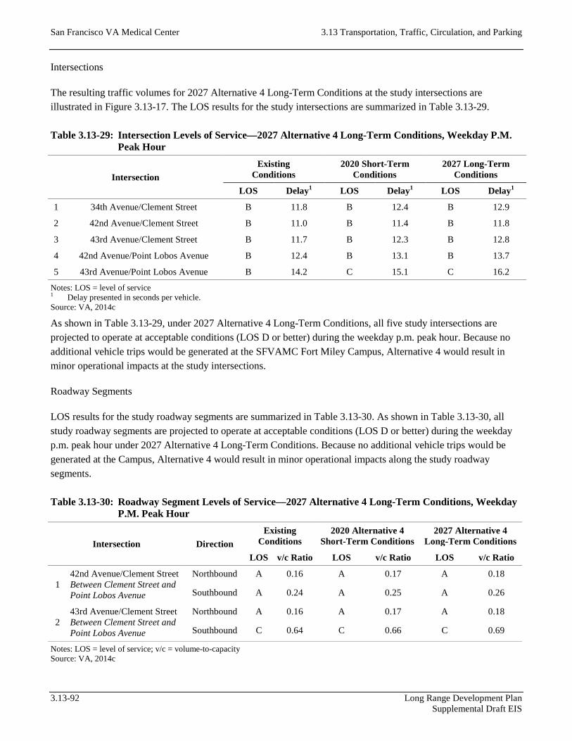
San Francisco VA Medical Center 3.13 Transportation, Traffic, Circulation, and Parking
Intersections
The resulting traffic volumes for 2027 Alternative 4 Long-Term Conditions at the study intersections are illustrated in Figure 3.13-17. The LOS results for the study intersections are summarized in Table 3.13-29.
Table 3.13-29: Intersection Levels of Service—2027 Alternative 4 Long-Term Conditions, Weekday P.M. Peak Hour
Intersection Existing
Conditions 2020 Short-Term
Conditions 2027 Long-Term
Conditions
LOS Delay1 LOS Delay1 LOS Delay1
1 34th Avenue/Clement Street B 11.8 B 12.4 B 12.9
2 42nd Avenue/Clement Street B 11.0 B 11.4 B 11.8
3 43rd Avenue/Clement Street B 11.7 B 12.3 B 12.8
4 42nd Avenue/Point Lobos Avenue B 12.4 B 13.1 B 13.7
5 43rd Avenue/Point Lobos Avenue B 14.2 C 15.1 C 16.2
Notes: LOS = level of service 1 Delay presented in seconds per vehicle. Source: VA, 2014c
As shown in Table 3.13-29, under 2027 Alternative 4 Long-Term Conditions, all five study intersections are projected to operate at acceptable conditions (LOS D or better) during the weekday p.m. peak hour. Because no additional vehicle trips would be generated at the SFVAMC Fort Miley Campus, Alternative 4 would result in minor operational impacts at the study intersections.
Roadway Segments
LOS results for the study roadway segments are summarized in Table 3.13-30. As shown in Table 3.13-30, all study roadway segments are projected to operate at acceptable conditions (LOS D or better) during the weekday p.m. peak hour under 2027 Alternative 4 Long-Term Conditions. Because no additional vehicle trips would be generated at the Campus, Alternative 4 would result in minor operational impacts along the study roadway segments.
Table 3.13-30: Roadway Segment Levels of Service—2027 Alternative 4 Long-Term Conditions, Weekday P.M. Peak Hour
Intersection Direction Existing
Conditions 2020 Alternative 4
Short-Term Conditions 2027 Alternative 4
Long-Term Conditions
LOS v/c Ratio LOS v/c Ratio LOS v/c Ratio
1 42nd Avenue/Clement Street Between Clement Street and Point Lobos Avenue
Northbound A 0.16 A 0.17 A 0.18
Southbound A 0.24 A 0.25 A 0.26
2 43rd Avenue/Clement Street Between Clement Street and Point Lobos Avenue
Northbound A 0.16 A 0.17 A 0.18
Southbound C 0.64 C 0.66 C 0.69
Notes: LOS = level of service; v/c = volume-to-capacity Source: VA, 2014c
3.13-92 Long Range Development Plan Supplemental Draft EIS

3.13 Transportation, Traffic, Circulation, and Parking San Francisco VA Medical Center
Source: VA, 2014c
Figure 3.13-17: Intersection Traffic Volumes—2027 Alternative 4 Long-Term Conditions
Long Range Development Plan 3.13-93 Supplemental Draft EIS

San Francisco VA Medical Center 3.13 Transportation, Traffic, Circulation, and Parking
Transit
Table 3.13-31 summarizes ridership, capacity, and capacity utilization of transit services in the Geary Corridor under 2027 Long-Term Alternative 4 Conditions. As shown in Table 3.13-31, ridership would increase from Existing Conditions, but overall capacity improvements in the corridor as a result of BRT and the TEP would help to reduce overall capacity utilization. Because no additional transit trips would be generated, Alternative 4 would not result in operational impacts on Muni ridership and capacity.
Table 3.13-31: San Francisco Municipal Railway Transit Ridership and Capacity—2027 Alternative 4 Long-Term Conditions, Weekday P.M. Peak Hour
Direction Existing
Conditions 2020 Alternative 4
Short-Term Conditions 2027 Alternative 4
Long-Term Conditions
Ridership Capacity Utilization Ridership Capacity Utilization Ridership Capacity Utilization
Inbound 908 1,777 51% 1,142 2,820 41% 1,324 2,820 47%
Outbound 1,814 2,528 72% 2,359 3,826 62% 2,783 3,826 73%
Notes: Ridership data based on conditions at the maximum load point for each line. Source: SFMTA, 2015; VA, 2014c
Pedestrian
Under Alternative 4 Long-Term Conditions, there would be no net change in land use at the existing SFVAMC Fort Miley Campus. Although existing facilities may be renovated or seismically retrofitted, there would be no net increase in travel demand at the Campus. As a result, no impacts on pedestrian safety or operations are anticipated.
Bicycle
Under Alternative 4 Long-Term Conditions, there would be no net change in land use at the existing SFVAMC Fort Miley Campus. Although existing facilities may be renovated or seismically retrofitted, there would be no net increase in travel demand at the Campus. As a result, no impacts on bicycle conditions are anticipated.
Loading
Under Alternative 4 Long-Term Conditions, there would be no net change in land use at the existing SFVAMC Fort Miley Campus. Although existing facilities may be renovated or seismically retrofitted, no impacts related to the demand for and supply of loading spaces or the accessibility and usability of delivery loading facilities would be anticipated.
Site Access and Circulation
Under Alternative 4 Long-Term Conditions, there would be no net change in land use at the existing SFVAMC Fort Miley Campus. Although existing facilities may be renovated or seismically retrofitted, there would be no
3.13-94 Long Range Development Plan Supplemental Draft EIS
3.13 Transportation, Traffic, Circulation, and Parking San Francisco VA Medical Center
expected changes to travel times and access routes for emergency vehicles. Overall, there would be no operational impact on emergency vehicle access under Alternative 4.
Parking
Under Alternative 4 Long-Term Conditions, there would be no net change in land use at the existing SFVAMC Fort Miley Campus. Although existing facilities may be renovated or seismically retrofitted, there would be no net increase in parking demand at the Campus. As a result, no impact on parking is anticipated.
3.13.4 References
California Air Pollution Control Officers Association (CAPCOA). 2013 (October 2). CA Emissions Estimator Model (CalEEMod) Version 2013.2.2. ENVIRON International Corporation & California Air Districts.
Institute of Transportation Engineers (ITE). 2008. Trip Generation, 8th Edition. Washington, DC.
———. 2010. Parking Generation, 4th Edition. Washington, DC.
———. 2012. Trip Generation, 9th Edition. Washington, DC.
Presidio Trust. 2002 (May). Final Environmental Impact Statement: Presidio Trust Management Plan—Land Use Policies for Area B of the Presidio of San Francisco. San Francisco, CA.
Rufus Graphics. 2014. San Francisco Bike Map & Walking Guide. San Francisco, CA.
San Francisco County Transportation Authority (SFCTA). 2012. SF-CHAMP. San Francisco, CA.
San Francisco Municipal Transportation Agency (SFMTA). 2009 (June 26). San Francisco Bicycle Plan. San Francisco, CA.
———. 2010 (January 29). San Francisco Truck Traffic Routes. San Francisco, CA.
———. 2012 (January). Regulations for Working in San Francisco Streets, 8th Edition. San Francisco, CA.
———. 2015. SFMTA Routes and Stops. San Francisco, CA. Available: <http://www.sfmta.com/getting-around/transit/routes-stops>. Accessed January 8, 2015.
San Francisco Planning Department (SF Planning). 2002 (October). Transportation Impact Analysis Guidelines for Environmental Review. San Francisco, CA.
———. 2009 (August). San Francisco Bicycle Plan Final Environmental Impact Report (Planning Department Case No. 2007.0347E; State Clearinghouse No. 2008032052). San Francisco, CA.
———. 2010. San Francisco General Plan: Transportation Element. Amendments by Board of Supervisors Ordinance 101193 adopted on December 7, 2010. San Francisco, CA.
———. 2013 (July 10). Transit Effectiveness Project Draft Environmental Impact Report (Planning Department Case No. 2011.0558E; State Clearinghouse No. 2011112030). San Francisco, CA.
Long Range Development Plan 3.13-95 Supplemental Draft EIS

San Francisco VA Medical Center 3.13 Transportation, Traffic, Circulation, and Parking
Transportation Research Board (TRB). 2000. Highway Capacity Manual. Washington, DC.
U.S. Department of Transportation, Federal Highway Administration (FHA). 2011 (April 28). Census Transportation Planning Products, Executive Summary. Available: <http://www.fhwa.dot.gov/planning/census_issues/ctpp/data_products/journey_to_work/executive.cfm>. Accessed January 8, 2015.
U.S. Department of Veterans Affairs (VA). 2003 (February 10). VA Medical Center NCIRE Building Transportation Study—Draft. San Francisco, CA. Prepared by CHS Consulting Group.
———. 2014a. San Francisco VA Medical Center: Transportation. Available: <http://www.sanfrancisco.va.gov/patients/transportation.asp>. Accessed on January 8, 2015.
———. 2014b. San Francisco VA Medical Center Long Range Development Plan Parking Study. San Francisco, CA. Prepared by AECOM.
———. 2014c. San Francisco VA Medical Center Long Range Development Plan Supplemental Draft EIS Transportation Impact Study. San Francisco, CA. Prepared by AECOM.
———. 2014d. San Francisco Veterans Affairs Medical Center (Fort Miley Campus) Long Range Development Plan—Construction Traffic and Parking Management Plan. San Francisco, CA. Prepared by AECOM.
———. 2014. San Francisco Veterans Affairs Medical Center Fort Miley Campus Long Range Development Plan. San Francisco, CA.
3.13-96 Long Range Development Plan Supplemental Draft EIS