3.2.3.3 threatened, endangered, candidate, and proposed
TRANSCRIPT

Chapter 3. Affected Environment and Environmental Consequences Wildlife
Nez Perce-Clearwater National Forests 3.2.3.3 - 1 DEIS for the Revised Forest Plan
3.2.3.3 Threatened, Endangered, Candidate, and Proposed Wildlife Species
The following analysis addresses the effects to federally listed threatened, endangered, proposed, and candidate species and their habitat from the suite of plan components and range of alternatives considered in the draft Revised Forest Plan.
This analysis will evaluate how the suite of plan components and alternatives provide for ecosystem integrity as it relates to federally listed wildlife and how the plan components and alternatives contribute to the recovery of federally listed threatened and endangered species and conserve proposed and candidate species.
Data was obtained from the most recent list of threatened, endangered, and candidate species from the U.S Fish and Wildlife Service (U.S. Fish and Wildlife Service IPAC database, accessed 10/30/2019). Information to develop plan components and complete the analysis were derived from various sources, including recovery plans, petitions for listing, twelve-month findings, and other documents produced by the U.S. Fish and Wildlife Service. Plan components for lynx are identical to those in the Northern Rocky Mountains Lynx Direction (U.S. Department of Agriculture, 2007b, 2007c).
The draft Revised Forest Plan establishes direction for various wildlife habitats in relation to structure, function, composition, and connectivity. The Plan also includes direction for the protection, enhancement, and restoration of threatened and endangered species and their habitats. The forest plan revision interdisciplinary team worked closely to integrate plan direction during the development of the plan components, especially wildlife, vegetation, fire, and access/recreation.
Providing for ecological integrity is an outcome of the draft Revised Forest Plan. It starts with a comparison of the current abundance and condition of various habitats with ecological reference conditions (historic range of variability) based on knowledge of the past and an understanding of ecological processes, such as fire, flooding, insects, and disease. This coarse filter approach delivers ecological conditions that provide for the diversity and abundance of wildlife. The coarse filter approach is reflected in the Forestlands’ desired conditions in the draft Revised Forest Plan. The coarse filter approach forms the foundation of the analysis for each species.
The companion approach to ecosystem diversity (coarse filter) is the “fine filter” approach in which conservation strategies are used for individual species or groups of species to contribute to species diversity. The fine filter approach narrows the focus to those species that require ecological conditions that may not be provided through coarse filter plan components. This fine filter approach is reflected in the species-specific plan components for wildlife found. Each species’ assessment in this report evaluates the effects of the coarse filter, fine filter, and other components.
The best available scientific information about federally listed threatened, endangered, proposed, and candidate species was reviewed to understand how the required ecological conditions and ecological integrity contribute to the recovery or conservation of these species. In doing so, key ecosystem characteristics required by each species and key threats and stressors were identified and evaluated to determine whether they were in effect on the Nez Perce-Clearwater under the 1987 Plans and, if so, to what extent.

Chapter 3. Affected Environment and Environmental Consequences Wildlife
Nez Perce-Clearwater National Forests 3.2.3.3 - 2 DEIS for the Revised Forest Plan
Generally, plan components were first developed to offer coarse filter ecosystem characteristics to deliver ecological conditions that would provide for ecological integrity and contribute to the recovery of threatened or endangered species and conserve candidate species. When ecological conditions were insufficient to contribute to the recovery of federally listed threatened or endangered species or conserve candidate species, species-specific plan components were developed where appropriate. The species-specific plan components included desired conditions, goals, objectives, suitability, management areas, standards, and guidelines.
A spatial and temporal analysis provided the basis for conclusions about the effects of plan direction and plan components on threatened, endangered, proposed, and candidate species. In general, the analysis area for environmental consequences for these species includes the National Forest System lands within the Nez Perce-Clearwater. Areas selected for analysis of cumulative effects were large enough to include the consequences of activities on all lands but not large enough to obscure effects. The cumulative effects for each species are identified in their respective sections.
The anticipated life of the forest plan is about 15 years. However, because management actions have the potential to affect wildlife species and their habitats for many decades, the temporal analysis for modeled vegetation change and the cumulative effects discusses changes that may occur over the next 50 years as conditions change and vegetation moves from one successional stage to another.
A thorough review of scientific information was completed and the best available scientific information was used to inform the planning process and develop plan components. Key information on the population, life history, and status of threatened, endangered, proposed, and candidate animal species on the Nez Perce-Clearwater was obtained from a variety of sources. Part 219.3 of the 2012 Planning Rule requires the responsible official to use the best available science to determine what is most accurate, reliable, and relevant. For the best available scientific information, the Nez Perce-Clearwater used available peer-reviewed articles and data in which reliable statistical or other scientific methods were used to establish the accuracy or uncertainty of any findings (Forest Service Handbook 1909.12 Zero Code 07.12). For best relevance, the Nez Perce-Clearwater used studies conducted in proximity to the plan area in north central Idaho, eastern Washington, eastern Oregon, western Montana, or western North America in habitat conditions similar to those that occur in the plan area. If these were not available, articles were selected that considered ecological processes or conditions relevant to the analysis area. The Nez Perce-Clearwater attempted to avoid professional opinion or publications that have not been peer-reviewed when peer-reviewed information was available. However, in accordance 2012 Planning Rule directives on sources of scientific information, scientific information that may be considered the best available scientific information may include expert opinions, panel consensuses, inventories, or observational data prepared and managed by the Forest Service, other federal agencies, universities, national research networks, other reputable scientific organizations, and data from public and governmental participation. In some cases, there is opposing, incomplete, or unavailable scientific information about a species or its habitat. This was also considered, in accordance with requirements of the National Environmental Policy Act. Data and information gaps exist but the breadth and depth of the available scientific information is sufficient to determine the key stressors and plan components to address those key stressors.
Chapter 3. Affected Environment and Environmental Consequences Wildlife
Nez Perce-Clearwater National Forests 3.2.3.3 - 3 DEIS for the Revised Forest Plan
Affected Environment Existing Condition The Nez Perce-Clearwater queried the U.S. Fish and Wildlife Service’s Information, Planning, and Consultation (IPAC) database for a list of federally listed species on June 4, 2019. Because of the size of the spatial data used in the request, queries were requested separately for the Nez Perce and Clearwater National Forest but the species lists for the two forests were the same.
Table 1. List of wildlife species identified as federally listed by the U.S. Fish and Wildlife Service.
Species Name ESA Status Canada Lynx (Lynx canadensis) threatened Wolverine (Gulo gulo) proposed threatened
Bull trout, whitebark pine, Spalding's catchfly, and water howellia were also identified as occurring within the plan area but are addressed in other sections. The grizzly bear was not included on the list of species that are known to occur on the Nez Perce-Clearwater. However, the plan area contains portions of the Bitterroot Recovery Zone and the grizzly bear has been a subject of interest from the public in comments and will be addressed below.
Past resource use and the exclusion of fire for almost 100 years has caused changes in some wildlife habitats. These changes have benefited some species and been detrimental to others. As documented in the forest plan revision analysis, defining and measuring the status of ecosystems now and comparing them to desired future conditions is the foundation for sustainability of ecosystems on the Nez Perce-Clearwater. The vegetation features assessed as “key indicators” for wildlife considered include changes in forest composition, structure, and pattern. These features are very much related to the quality and quantity of wildlife habitats.
The allocation of lands on the Nez Perce-Clearwater has been divided in the past by congressional designations, such as designated wild and scenic rivers, designated wilderness, and Idaho Roadless Rule areas. Thus, the bulk of the land area consists of these designated areas. While many people are interested in what happens in the managed front, about two-thirds of the Nez Perce-Clearwater is influenced by these designations. It made sense during the development of the plan to identify these different areas as management areas. The distribution of the various management areas has greater influence on the overall impact of the management of the Nez Perce-Clearwater on wildlife. See draft Revised Forest Plan for the management area descriptions.
Lynx On March 24, 2000, the U.S. Fish and Wildlife Service published the final rule listing the contiguous United States distinct population segment of Canada lynx (Lynx canadensis) as a threatened species (65 FR 16052). In its analysis of threats to the species, the U.S. Fish and Wildlife Service concluded that the single factor threatening the distinct population segment was the inadequacy of existing regulatory mechanisms, specifically the lack of guidance for conservation of lynx in National Forest land and resource management plans and Bureau of Land Management land use plans. The U.S. Fish and Wildlife Service prepared a recovery outline for the Canada lynx (U.S. Department of Interior, 2005). A recovery outline is intended to provide interim guidance for consultation and recovery efforts until a formal recovery plan has been approved. No recovery plan has yet been developed for the lynx. The recovery outline did not establish recovery goals but did identify a preliminary set of objectives and potential recovery actions for each area. Under the recovery outline, lynx habitat was stratified into core, secondary, and peripheral areas based on lynx occupancy, reproduction, and use, as documented by
Chapter 3. Affected Environment and Environmental Consequences Wildlife
Nez Perce-Clearwater National Forests 3.2.3.3 - 4 DEIS for the Revised Forest Plan
historical and current records. The U.S. Fish and Wildlife identified core areas where there was strong evidence of long-term persistence of lynx populations, including both historical records of lynx occurrence over time and recent evidence of presence and reproduction within the past 20 years. Both the Nez Perce and Clearwater National Forests are secondary areas for Canada lynx, as identified by the U.S. Fish and Wildlife Service (U.S. Department of Interior, 2005).
The Northern Rockies Lynx Management Direction (NRLMD) amended 18 forest plans for the National Forests in Idaho, Montana, Utah, and Wyoming, including the Nez Perce-Clearwater (U.S. Department of Agriculture, 2007a). The amendment adopted forest plan components applicable to vegetation management, livestock grazing, human uses, and linkage areas in order to conserve and promote the recovery of the lynx by reducing or eliminating adverse effects from land management activities on National Forest System lands while preserving the overall multiple-use direction in existing plans. In March of 2007, the U.S. Fish and Wildlife Service issued a biological opinion on the effects of the Northern Rocky Mountains Lynx Amendment on the distinct population segment of Canada lynx in the contiguous United States. In its 2007 biological opinion, the U.S. Fish and Wildlife Service concluded that the level of adverse effects to lynx that may result from implementation of the Northern Rockies Lynx Management Direction are not reasonably expected to either directly or indirectly appreciably reduce the likelihood of survival and recovery of the lynx distinct population segment in the wild by reducing the reproduction, numbers, or distribution of lynx (U.S. Department of Interior, 2007). The Clearwater National Forest was considered occupied while the Nez Perce National Forest was considered unoccupied. Both Forests are considered secondary habitat for Canada lynx. The effects were considered differently between the Forests – the effects on the Clearwater National Forest were evaluated for resident lynx while the effects on the Nez Perce National Forest were considered for transient lynx.
Methodology and Analysis Process Canada lynx use of habitat within their home range is dependent upon vegetation condition. Lynx analysis units are landscape units that approximate the size of a female lynx annual home range and encompass all seasonal habitats. These may also contain areas of non-lynx habitat, such as open meadows, especially in mountainous regions (Interagency Lynx Biology Team, 2013). The existing vegetation condition of Canada lynx habitat is estimated for each lynx analysis unit on the Nez Perce-Clearwater based upon past vegetation treatments and historic fire occurrence data.
For the forest plan, habitats across the Nez Perce-Clearwater have been grouped into broad potential vegetation types. These are groupings based upon habitat types. Potential vegetation types serve as a basis for describing certain ecological conditions across the Nez Perce-Clearwater and are useful in understanding the various ecosystems and their potential productivity, natural biodiversity, and the kinds of processes that sustain these conditions. Potential vegetation types are based upon vegetation potential, whereas dominance types describe existing vegetation.
In 2014, as part of the forest plan revision process, the mapped lynx habitat was revised to develop consistent mapping criteria across both the Nez Perce and Clearwater National Forests and to include the best available scientific information concerning lynx population dynamics, distribution, habitat use, competitor interactions, prey species, and human interactions that has become available since 2007. This mapping was also completed in coordination with the U.S. Fish and Wildlife Service and was based upon broad potential vegetation types. This process resulted in the mapping of 78 lynx analysis units across the Nez Perce-Clearwater (Error! Reference source not found. and Error! Reference source not found.). Lynx analysis units will be used to display the amount, relative quality, and distribution of lynx habitat across the Nez Perce-Clearwater. See the 2014 Nez Perce-Clearwater Forest Plan Assessment (U.S. Department of Agriculture, 2014) for more details on this and other aspects of the methodology and analysis process.

Chapter 3. Affected Environment and Environmental Consequences Wildlife
Nez Perce-Clearwater National Forests 3.2.3.3 - 5 DEIS for the Revised Forest Plan
After this mapping effort, the Nez Perce-Clearwater experienced large wildfires between 2015 and 2018. The amount of habitat currently unsuitable for lynx required updating to have an accurate accounting of effects and modeling with PRISM and SIMPPLLE. Therefore in 2018, the Nez Perce-Clearwater updated the habitat spatial data to update the amount of habitat currently unsuitable (Lutes, 2019). The update consisted of using the FACTS database to update areas currently unsuitable due harvest activities, and updating the amount of habitat that changed from unsuitable to suitable as a result of forest aging, and used burn severity data from sources, such as Rapid Assessment of Vegetative Condition after Wildfire (RAVG), Burned Acres Reflectance Classification (BARC), or Monitoring Trends in Burn Severity (MTBS), to identify areas of potential lynx habitat which burned at moderate to severe levels. Areas which burned at moderate to severe levels were considered currently unsuitable for lynx. For more detailed information about the lynx habitat mapping process see the Nez Perce-Clearwater National Forests Forest Plan Assessment (U.S. Department of Agriculture, 2014) and USDA 2019 Lynx Habitat Mapping Update 2018 Process Steps (Lutes, 2019).
PRISM modeling was used to estimate forest growth, trends, and yield. PRISM results were then run through SIMPPLLE to project out 50 years on how the Nez Perce-Clearwater will interact with wildfire, insects and disease, and vegetation management under the alternatives. The SIMPPLLE model is a spatially explicit model that uses logic pathways to predict how forests respond over time to succession, wildfires, and insect and disease risks based on cover types, size classes, crown closure, aspect, and slope (Chew, Moeller, & Stalling, 2012). This model was used for assessments of the natural range of variation and the potential future consequences of alternatives.
Information Sources and Incomplete or Unavailable Information A synthesis of information on lynx biology and ecology that is relevant to lynx at the national scale can be found in Ecology and Conservation of Lynx in the United States (Ruggiero, 1999) and in the Canada Lynx Conservation Assessment and Strategy (Interagency Lynx Biology Team, 2013). The final rule listing lynx (65 FR 16052) and the notice of remanded determination (68 FR 40076) evaluated population status and threats for the contiguous United States distinct population segment. The recovery outline (U.S. Department of Interior, 2005) provided preliminary recovery objectives and actions based on an understanding of current and historical lynx occurrence and lynx population dynamics in the contiguous United States.
At the forest scale, some information used to assess lynx habitat is incomplete or unavailable. At any given point in time in a forest stand’s development, it may provide habitat in a suitable condition or it may provide lynx habitat in a temporarily unsuitable condition, depending upon the existing vegetation condition. Vegetation condition is dependent upon time due to disturbances, such as fire and timber harvest, and the rate of forest succession. Satellite imagery and forest databases can be used to accurately classify recently harvested and burned areas, which helps to identify areas that provide lynx habitat in an unsuitable condition on a temporary basis. However, satellite imagery is poor at detecting the dense horizontal cover that provides snowshoe hare habitat in a multistory forest structure, which is an important feature of lynx foraging habitat, and downed woody material for denning habitat. Therefore, no forestwide estimates were made for these components of lynx habitat. During site-specific planning, habitat types used for the modeling and mapping of lynx habitat are verified and refined and lynx habitat is further characterized to estimate the amount and distribution of foraging and denning habitat components.

Chapter 3. Affected Environment and Environmental Consequences Wildlife
Nez Perce-Clearwater National Forests 3.2.3.3 - 6 DEIS for the Revised Forest Plan
In February 2009, the U.S. Fish and Wildlife Service designated revised critical habitat in Montana, Wyoming, Idaho, Washington, and other states (U.S. Department of Interior, 2009). Critical habitat was not designated on the Nez Perce or Clearwater National Forests (U.S. Department of Interior, 2009). On September 26, 2013, the U.S. Fish and Wildlife Service published a proposed rule for revised critical habitat in the Federal Register (50 CFR Part 17 – Canada Lynx). No critical habitat was proposed for the Nez Perce-Clearwater in the proposed rule.
Analysis Area and Temporal Scale of Analysis The period considered for the analysis of indirect effects of the alternatives is the anticipated life of the forest plan, which is about 15 years. However, because lynx habitat is dynamic, the anticipated vegetation and changing climate conditions were evaluated over longer time periods. The SIMPPLLE model was used to estimate the natural range of variation as it would have influenced forest ecosystems on the Nez Perce-Clearwater going back about 1,000 years (See Appendix B). Effects of the alternatives on lynx habitat were modeled over the next 50 years by the Ecosystem Research Group in 2019. The Ecosystem Research Group modeled several scenarios for comparison purposes, including a warmer, drier climate over the next five decades and acres burned due to anticipated climate changes, as well as fire suppression into the future. Lynx habitat on the Nez Perce-Clearwater is subdivided into lynx analysis units for the analysis of effects on Canada lynx. Lynx habitat within the U.S. Fish and Wildlife Service Northern Rockies Geographic Area has been divided into lynx analysis units to facilitate analysis, management, and monitoring. A detailed description of how lynx habitat and lynx analysis units were mapped can be found in the 2014 Assessment (U.S. Department of Agriculture, 2014) and a summary of those efforts are presented below. The area used for the analysis of indirect effects on Canada lynx is the Nez Perce-Clearwater’s modeled lynx habitat (U.S. Department of Agriculture, 2014). Habitat mapping criteria were developed to represent important life history characteristics, including foraging and denning. Lynx analysis unit delineations and habitat mapping actions directed by the Canada Lynx Conservation Assessment and Strategy (Ruediger et al., 2000) were completed for both the Nez Perce and Clearwater National Forests. Mapping of primary habitat was based on forest types necessary to support lynx survival and reproduction specific to each geographic area (Interagency Lynx Biology Team, 2013; Ruediger et al., 2000). The Nez Perce National Forest initially mapped lynx habitat between 2000 and 2002 and then revised the mapped habitat in 2004. The Clearwater National Forest revised its mapped lynx habitat in 2007. This mapping was completed in coordination with the U.S. Fish and Wildlife Service. The area of lynx habitat modeled and mapped by the Nez Perce-Clearwater in 2014 was 1,457,768 acres. Between 2014 and 2016, several wildfires burned within the Nez Perce-Clearwater. Lynx habitat is unsuitable for lynx until trees grow tall enough to protrude through winter snow, which takes between 20 to 30 years on the Nez Perce-Clearwater, depending upon site conditions. These fires changed conditions within lynx habitat in the plan area. In order to account for these changes, lynx habitat modeled in the 2014 Assessment was updated (Lutes, 2019). Lutes (2019) used burn severity data and FACTS activities data and time since disturbance to update the estimated number of acres that are currently unsuitable within each lynx analysis unit. Table 2 shows the amount of lynx habitat acres and acres of currently unsuitable habitat within each lynx analysis unit based on this update. The size of the lynx analysis unit reflects female home range size in the geographic unit. A sufficient amount of habitat must be present within the lynx analysis unit to support a female lynx. For example, in the western United States, it appears that at least 10 square miles of primary vegetation must be present. The arrangement of habitat within the lynx analysis unit should take into consideration the daily movement distances of resident females. Since the lynx analysis unit represents a hypothetical female home range and is the basis for analysis, it can be larger and contain more lynx habitat than an actual home range.
Chapter 3. Affected Environment and Environmental Consequences Wildlife
Nez Perce-Clearwater National Forests 3.2.3.3 - 7 DEIS for the Revised Forest Plan
Lynx analysis units on the Nez Perce-Clearwater are in accordance with guidance provided in the Canada Lynx Conservation Assessment and Strategy (Interagency Lynx Biology Team, 2013) and the Northern Rockies Lynx Management Direction. There are 79 lynx analysis units that are wholly or partially within the Nez Perce-Clearwater. These lynx analysis units encompass a total of about 2,505,072 million acres on the Nez Perce-Clearwater. Changes to lynx analysis units may only be made if site-specific habitat information demonstrates it is needed and after review by the Forest Service Northern Region Regional Office. As there is no critical habitat for lynx in the plan area, there are no effects to critical lynx habitat.
The Northern Rockies Geographic Area encompasses 18 National Forests and an estimated 18.5 million acres of lynx habitat in Montana, Idaho, Wyoming, and Utah. The Northern Rockies Geographic Area provides context for the analysis of cumulative effects. Adjoining areas in Canada were also considered with respect to connectivity. See Appendix A for a map of the lynx habitat and linkages.
Forest and Lynx Ecology Across their range, lynx typically occur in boreal and subalpine coniferous forests dominated by subalpine fir and spruce in landscapes with gentle topography (John R. Squires et al., 2013). On the Nez Perce-Clearwater, the cool, moist and cold potential vegetation types are capable of growing subalpine fir, Engelmann spruce, and lodgepole pine but the dominance type and structural stage can change over time due to factors such as fire, insects and disease, vegetation management, and forest succession (U. S. Department of Agriculture, 2014a). Engelmann spruce and subalpine fir tree species may also be found in other forest dominance types because they are very shade tolerant and commonly occur in mid- and understory tree canopy layers with western larch, lodgepole pine, and/or Douglas fir in the overstory. Lodgepole pine has been found to be an important component of mixed conifer stands in lynx habitat (J. D. Holbrook, Squires, Olson, Lawrence, & Savage, 2017). Lodgepole pine is a fire adapted species that can dominate after wildfire fires. It can also be a component in mixed conifer stands. Lynx modeling incorporated these broad potential vegetation types within the cold and cool, moist broad potential vegetation types as modeled lynx habitat.
During the winter and early spring, availability of den sites is important to lynx. Boutros et al (2007) and Moen et al (2008) found that coarse downed woody material provides kittens with protection from extreme temperatures, precipitation, and predators (Interagency Lynx Biology Team, 2013). Lynx dens are typically found in multistory stands of spruce-fir forests with dense horizontal cover and abundant coarse downed woody material. Squires et al found that 80 percent of dens were in mature forest stands and 13 percent in mid-seral regenerating stands (John R. Squires, Decesare, Kolbe, & Ruggiero, 2008). Young stands that were either naturally sparse or mechanically thinned were seldom used for denning. Denning habitat is generally abundant across the coniferous forest landscape of north central Idaho and is not likely to be limiting for lynx (John R. Squires et al., 2008; John R. Squires, Decesare, Kolbe, & Ruggiero, 2010; J. R. Squires, Ruggiero, Kolbe, & DeCesare, 2006).
In Montana, Squires et al (2010) reported that horizontal cover was denser at lynx kill sites than along travel paths. They further reported that lynx kill sites were associated with a higher proportion of spruce-fir overstory than lodgepole pine overstory and that neither snow depth nor snow penetrability influenced lynx kill sites. In Ruggiero (1999), Hodges reported that snowshoe hare abundance is also positively associated with dense horizontal cover. In western Montana, Griffin and Mills (2007) found the highest snowshoe hare densities in regenerating conifer stands that had a high density of saplings, defined as more than 2,267 stems per acre, in mature multistory conifer stands that had abundant saplings. Hare abundance was negatively affected in stands treated with traditional pre-commercial thinning prescriptions that reduced stem densities to about 263 to 526 stems per acre (Griffin & Mills, 2007).

Chapter 3. Affected Environment and Environmental Consequences Wildlife
Nez Perce-Clearwater National Forests 3.2.3.3 - 8 DEIS for the Revised Forest Plan
Squires et al (2010) compared lynx resource selection in summer versus winter, including lynx success in capturing snowshoe hares, their primary prey. During winter, lynx foraged primarily in mid- to high-elevation forests at 4,134 to 7,726 feet composed of mature, large-diameter trees with a diameter at breast height greater than 11 inches. In a comparison of use versus availability within a lynx home range, Squires et al (2010) found that lynx selected forests with relatively denser horizontal cover, more abundant hares, and deeper snow. They preferred forests that had a multistory structure with dense horizontal cover provided by the young trees in the understory and conifer boughs touching the snow surface, which could support snowshoe hare populations at varying snow depths throughout the winter. Engelmann spruce and subalpine fir were the dominant tree species in forests used by lynx but these forests contained a mix of other conifer species, including lodgepole pine, western larch, and Douglas fir. Squires et al (2010)stated that the primary limiting factor for Canada lynx in northwest Montana appears to be suitable winter foraging habitat.
During the summer months, lynx in Montana broaden their preferred habitat use to include more of the early-successional forest stand initiation structural stage with dense horizontal cover provided by abundant shrubs, spruce and fir saplings, and small-diameter trees (John R. Squires et al., 2010). These conditions can occur in forests burned by wildfire, regenerated by insects or disease, or regenerated by timber harvest. Squires et al (2010) found that lynx used slightly higher elevations during the summer but, as in winter, were located below the alpine zone and above the low-elevation dry forests dominated by ponderosa pine. The low-elevation ponderosa pine forests were not modeled as potential lynx habitat on the Nez Perce-Clearwater.
Young regenerating stands of 20 to 40 years old can support high densities of snowshoe hares before growing into a structure that no longer provides the needed dense horizontal cover. A regular influx of this “early stand initiation stage” of forest succession created by processes such as fire or vegetation management can help to enhance snowshoe hare production. Cheng et al (2015) studied snowshoe hare densities in areas of Glacier National Park that were burned by wildfire in 1988 and 1994. Hare pellet densities in lodgepole pine stands were 10 times higher 17 years post-fire at the time of their study than in the 11-year post-fire forests or other mature forests. Their “best” model for habitat predicted that the mean pellet density for 17-year-old lodgepole forests equates to hare densities nearly 3 times the threshold believed necessary to support lynx populations. Among the continuous habitat parameters measured in the Cheng et al (2015) study, only understory cover at a height of 0 to 20 inches above the ground surface and percent canopy cover were identified as predictors of hare density. Mean pellet density increased slowly with understory cover up to 80 percent, above which pellet densities declined (Cheng et al., 2015). Mean pellet densities increased from 10 percent canopy closure to 70 percent canopy closure when other variables were held at typical values. Cheng et al (2015) stated that snowshoe hares’ association with regenerating lodgepole pine forests is transient because these forests will eventually grow tall enough and dense enough to no longer provide the habitat conditions selected by snowshoe hares.
At the landscape scale, a mosaic of forest structure, from young regenerating to mature multistory stands, is recommended to provide for the habitat needs of lynx (Interagency Lynx Biology Team, 2013). Kosterman et al (2018) collected field data on denning and offspring survival in northwest Montana from 1998 to 2012, studying the relationship between female lynx reproductive success and habitat composition and arrangement at the scale of a lynx home range on the Kootenai and Lolo National Forests. Kosterman et al (2018) found that abundant and connected mature forests and intermediate amounts of small-diameter regenerating forests defined whether the female produced kittens or not. Small-diameter regenerating forests were described as “smaller sized” trees with an approximate diameter at breast height of 3.93 to 5.9 inches, intermediate canopy cover, and high horizontal cover.

Chapter 3. Affected Environment and Environmental Consequences Wildlife
Nez Perce-Clearwater National Forests 3.2.3.3 - 9 DEIS for the Revised Forest Plan
Reproductive success was highest for females with small-diameter regenerating forests between 12 to 20 percent and higher connectivity of mature forest. Reproductive success remained high when forests had small-diameter sized trees up to 20 percent and then declined slightly beyond 20 percent. Kosterman et al (2018) suggested that in addition to the connectivity of mature forest, the amount of small-diameter regenerating forests aids the reproductive success of female lynx.
The range of Canada lynx extends from Alaska across much of Canada, except for the coastal forests, with southern extensions into parts of the western United States, the Great Lakes region, and the northeast. Lynx distribution is closely tied to the distribution of snowshoe hares and boreal forests (McKelvey, Aubry, & K., 1999). The Nez Perce-Clearwater is in the U.S. Fish and Wildlife Service’s Northern Rocky Mountain Region of the contiguous distinct population segment of Canada lynx.
Snowshoe hares are the primary winter prey of lynx (John R. Squires & Ruggiero, 2007), as they are throughout the range of lynx (Ruggiero, 1999). Lynx are highly specialized predators of snowshoe hares with unique adaptations that include a lightweight body frame and large paws that enable them to travel on top of deep snow. In their study of lynx winter diets in northwest Montana, Squires et al (2013) described 86 lynx kills that included 7 prey species. Snowshoe hares contributed about 96 percent of prey biomass, whereas red squirrels, the second most common prey, provided only about 2 percent of prey biomass (J. R. Squires et al., 2006).
Lynx do not occur everywhere within the range of snowshoe hares in the contiguous United States, as discussed in both Bittner and Rongstad (1982) and McCord and Cardoza (1982). This may be due to inadequate abundance, density, the spatial distribution of hares in some places, the absence of snow conditions that would allow lynx to express a competitive advantage over other hare predators, or a combination of these factors (U.S. Department of Interior, 2014d). In the southern part of its range, the low densities of lynx populations are likely a result of naturally patchy habitat and lower densities of their snowshoe hare prey (Adams, 1959; Griffin & Mills, 2004; Koehler, Hornocker, & Hash, 1979; Mills et al., 2005).
The most commonly reported causes of Canada lynx mortality are (1) starvation, especially of kittens and (2) human-caused mortality, including trapping and shooting (Interagency Lynx Biology Team, 2013). Predation of lynx by mountain lion, coyote, wolverine, gray wolf, fisher, and other lynx has been confirmed (Interagency Lynx Biology Team, 2013). Squires and Laurion (2000) reported that two out of six mortalities of radio-collared lynx in Montana were due to mountain lion predation.
About 0.23 percent, or about 3352.8 acres, of lynx habitat in lynx analysis units was treated by regeneration harvest on National Forest System lands of the Nez Perce-Clearwater since 2000 (FACTS data, accessed August 2019). Holbrook et al (2018) evaluated lynx resource use of silviculture treatments over a temporal gradient of 1 to 67 years after treatment. They found that, while lynx used treatments, lynx use was low until approximately 10 years of age for all forest treatment types, including thinning, selection cuts, and regeneration cuts. Furthermore, cumulative use in both winter and summer by lynx reached 50 percent at approximately 20 years after a thinning treatment. While it took about 20 years for lynx to begin using regeneration and selection cuts (Joseph D. Holbrook et al., 2018), it took approximately 34 to 40 years after a selection or regeneration cut for cumulative lynx use to reach 50 percent. Lynx use of regeneration cuts in the winter was best explained by time since treatment. In summer, the composition and abundance of forest structural stages surrounding a particular treatment also influenced lynx use that treatment(Joseph D. Holbrook et al., 2018). Lynx appeared to use regeneration and selection cuts similarly over time, suggesting that the difference in vegetation impact between these treatment methods makes little difference relative to potential impacts to lynx.

Chapter 3. Affected Environment and Environmental Consequences Wildlife
Nez Perce-Clearwater National Forests 3.2.3.3 - 10 DEIS for the Revised Forest Plan
Holbrook et al (2017) found that snowshoe hares were associated with horizontal cover and that hare use increased with increasing amounts of horizontal cover. Horizontal cover increased with the abundance of subalpine fir and Engelmann spruce forests. Holbrook et al also demonstrated a relationship between abundance of lodgepole pine and snowshoe hare abundance in addition to horizontal cover. Snow depth was an important covariate to predict snowshoe hare occupancy, and snow depth is predicted to decrease under future climates. Their data indicated that dense horizontal cover within multistoried forests with a substantial component of medium-sized trees of 5 to 10 inches produced the highest use by snowshoe hares (J. D. Holbrook et al., 2017). Results from their data support conclusions similar to previous studies in that disturbing multistoried forests with high stem densities, particularly in the understory, by cutting or burning would likely have a negative effect on snowshoe hares in the short-term but may benefit them in the future (J. D. Holbrook et al., 2017).
Under some conditions, motorized over-snow vehicle use may have detrimental effects on lynx. In the past, some researchers have speculated that compacted trails could indirectly affect Canada lynx by serving as travel routes that might enable competing predators, such as coyotes, to access snowshoe hare prey in lynx habitat (Murray & Boutin, 1991; Murray, Boutin, & O'Donoghue, 1994) (Ruggiero, 1999). However, in its remanded determination (68 FR 40076), the U.S. Fish and Wildlife Service (2003) found no evidence of competition between lynx and other predators, such as coyotes, or no evidence that it exerts a population-level impact on lynx if competition exists. Therefore, the U.S. Fish and Wildlife Service did not consider compacted trails to be a threat to lynx. Additionally, Kolbe et al (2007) completed a study of the effect of snowmobile trails on coyote movements in lynx habitat in northwest Montana. They reported that coyotes in their study area were primarily scavengers in winter since snowshoe hare kills composed only three percent of coyote feed sites. Furthermore, coyotes did not forage closer to compacted snowmobile trails than random expectation and the overall influence of snowmobile trails on coyote movements and foraging success appeared to be minimal (Kolbe et al., 2007). However, because snow compaction results varied across the 18 National Forests encompassed by the Northern Rockies Lynx Management Direction, guideline HU G11 specified that designated over-the-snow routes or designated play areas should not be expanded outside baseline areas of consistent snow compaction unless designation serves to consolidate use and improve lynx habitat. Squires et al (2010) reported on the effects of snowmobiling on Canada lynx in their Seeley Lake, Montana, study area. They were unable to quantify the number of snowmobiles using National Forest System roads in lynx home ranges, but one primary groomed trail was used by approximately 130 snowmobiles per day. They reported that they found no evidence that lynx selected areas away from National Forest System roads or groomed snowmobile trails during winter.
Effects of winter recreation on lynx was studied in Colorado. Olson et al (Olson, Squires, Roberts, Ivan, & Hebblewhite, 2018) tracked 18 lynx and concurrently tracked snowmobilers and back country skiers. They found that lynx decreased their movement rate in areas with high-intensity back-country skiing and snowmobiling and adjusted their temporal patterns so that they were more active at night in areas with high-intensity recreation but did not find consistent evidence of spatial avoidance of recreation. Lynx exhibited some avoidance of areas with motorized recreation but selected areas in close proximity to non-motorized recreation trails. Lynx did avoid high intensity use ski resorts, especially when use was intense. Olson et al (2018) concluded that lynx did not exhibit strong negative responses to dispersed recreation but instead altered their behavior and temporal patterns in a nuanced response to recreation, perhaps to decrease direct interactions with recreationists. Based on observed avoidance of developed recreation, Olson et al (2018) concluded that there may be a threshold of human disturbance above which lynx cannot coexist with winter recreation.

Chapter 3. Affected Environment and Environmental Consequences Wildlife
Nez Perce-Clearwater National Forests 3.2.3.3 - 11 DEIS for the Revised Forest Plan
Affected environment—Canada lynx habitat The lynx recovery outline (U.S. Department of Interior, 2005) stratified lynx habitat into three categories: core, secondary, and peripheral. Core areas are places where long-term persistence of lynx and recent evidence of reproduction have been documented and where the quality and quantity of habitat provides for both lynx and snowshoe hare. The lynx recovery outline emphasized focusing conservation efforts on core areas to ensure the continued persistence of lynx in the contiguous United States. Six core areas were identified in the recovery outline while other areas were identified as secondary habitats for lynx. The Nez Perce-Clearwater is located entirely within secondary areas. Specimen records of lynx in Idaho during the early 1900s are relatively common (McKelvey, Aubry, et al., 1999). McKelvey et al (1999) reported 22 museum specimens of lynx from 1874 to 1917, all of which were collected north of the Snake River plain in Idaho. Thirteen other verified records prior to 1960 were also from the north central and northern regions of the state (McKelvey, Aubry, et al., 1999). There are 35 verified records from 1960 to 1991 with most coinciding with lynx irruptions in the 1970s. Idaho Department of Fish and Game personnel surveyed 20 routes that had adequate snow conditions from 2004 to 2006 and detected no lynx (Interagency Lynx Biology Team, 2013). In 2010 to 2013, the Idaho Department of Fish and Game conducted forest carnivore surveys in the Selkirk, Purcell, and West Cabinet Mountains, finding one male lynx in the Selkirks in 2010 and one male lynx in the Idaho Purcell Mountains in 2011. In 2012, a lynx was found on the Salmon-Challis National Forest and in northern Idaho in 2013. In February of 2014, a lynx was captured and collared in the West Cabinet Mountains. Lucid et al (2016) surveyed for multiple species between 2010 and 2014 in a multi-basin initiative in the Panhandle region of Idaho. During these surveys, Lucid et al (2016) detected 2 male and 3 female Canada lynxes within the Purcell, Cabinet, and Selkirk Mountains. Lynx were not detected in the Coeur d'Alene or Saint Joe National Forests (Lucid, 2016). Using protocol developed by Squires et al (John R. Squires, McKelvey, & Ruggiero, 2004; J. R. Squires, Olson, Turner, DeCesare, & Kolbe, 2012), snow track surveys in 2007 (Ulizio, Squires, & Claar, 2007) and again in 2013 (Stone et al, 2013) on the Nez Perce National Forest did not detect lynx. In 2013, the experienced lynx tracking crew covered all routes twice, which strengthens the detection probability that if present, or conversely, can suggest absence with 95 percent certainty (J. R. Squires et al., 2012). Much of the surveyed area appears to be suitable habitat that supports snowshoe hares and the lack of detections suggests that lynx are rare or infrequent to the Nez Perce National Forest. Following the protocol established by McKelvey et al (1999), hair snare surveys (5 transects) during the summer and fall of 2008 on the Nez Perce National Forest also did not detect lynx (Bonn, 2008). Lynx are wide-ranging animals. Given the lynx-specific survey work conducted on the Nez Perce National Forest and extensive surveys for other species using hair snares, snow track surveys, and camera stations conducted on the Clearwater National Forest, such as the U.S. Fish and Wildlife Service grizzly bear survey in 2008–2009, U.S. Forest Service fisher survey in 2002–2014, and the Idaho Fish and Game yearly aerial surveys for many species, the presence of a population would be detected given the vast network of roads and trails. Historical sightings that have been confirmed may be the result of transient lynx moving through the Nez Perce-Clearwater but the infrequency of such reports suggests that lynx are incidental to the area (Ulizio et al., 2007). In the Northern Rockies Lynx Management Direction, the Nez Perce National Forest was considered to be unoccupied while the Clearwater National Forest was considered to be occupied based on the best scientific information available at the time of the Northern Rockies Lynx Management Direction Forest Plan Amendment. However, due to inconsistencies on the status of lynx presence or occupancy on the Nez Perce National Forest, the U.S. Fish and Wildlife Service sent a letter addressed to Forest Supervisor Rick Brazell on December 10, 2012, stating that “there is consensus that transient lynx may be present on the Nez Perce National Forest, at least occasionally” (U.S. Fish and Wildlife Service, 2012).

Chapter 3. Affected Environment and Environmental Consequences Wildlife
Nez Perce-Clearwater National Forests 3.2.3.3 - 12 DEIS for the Revised Forest Plan
The U.S. Fish and Wildlife Service referenced two pieces of information to come to this conclusion:
1. Ulizio et al (2007) noted “historical sightings that may have been confirmed may be the result of transient lynx moving through the forest, but the infrequency of such reports suggests lynx are incidental to the area.”
2. McKelvey et al (1999) reported numerous verified historical records from Idaho County.
The letter also stated that the issue of lynx occupancy on the NPNF [Nez Perce National Forest] is a separate but related matter that is not the focus of this letter, and did not change the NPNF status as ‘unoccupied’ (U.S. Fish and Wildlife Service, 2012). Therefore, under the Northern Rockies Lynx Management Direction, the Nez Perce National Forest is considered unoccupied and the Clearwater National Forest is considered occupied. The U.S. Fish and Wildlife Service has determined that lynx “may be present” on both Forests, and both Forests are considered to be secondary areas. While lynx have occasionally been sighted on the Forests, currently, little evidence exists of a resident lynx population or reproduction on the Nez Perce-Clearwater due to the infrequent nature of lynx observations. The 2005 Canada Lynx Recovery Area map identified the Nez Perce-Clearwater as a “secondary” Canada lynx area (U.S. Department of Interior, 2005). The U.S. Fish and Wildlife Service’s 2014 reexamination of critical habitat for lynx concluded that the lands in the Nez Perce and Clearwater National Forests “were likely not occupied by lynx at the time of listing and are not currently occupied by lynx populations” (79 FR 54818 2014).
Compared to cores areas, secondary areas are defined as having fewer and more sporadic records of lynx occurrence and the quality and quantity of habitat to support populations of snowshoe hares and lynx is questionable (U.S. Department of Interior, 2005). The snow in lynx habitats on the Nez Perce-Clearwater may be subjected to more freezing and thawing than in the northern portion of lynx range. Crusting or compaction of snow may reduce the competitive advantage that lynx have in soft snow with their long legs and low-foot loadings (Ruggiero, 1999). At lower snow depths an increase in competition for prey occurs and there is an increase in potential predation on lynx.
In the southern part of the range of Canada lynx, which includes parts of Idaho, lynx population density and productivity are lower than in the northern part of its range; harvest may be an additive source of mortality, and lynx may be highly vulnerable to overexploitation (Koehler, 1990). State wildlife management agencies regulate the trapping of furbearers. Trapping and snaring of lynx is currently prohibited across the contiguous United States. Incidental trapping or snaring of lynx is possible in areas where regulated trapping for other species, such as wolverine, coyote, fox, fisher, marten, bobcat, and wolf, overlaps with lynx habitats (John R. Squires & Laurion, 1999). A trapped lynx can be released but there is potential for accidental injury or mortality (Kolbe, Squires, & Parker, 2003). The magnitude of illegal shooting of lynx is unknown. Incidents have been reported throughout the range of the species. Devineau et al (2010) reported a substantial number of shootings of lynx during the first 10 years after their reintroduction into Colorado with 14 known shootings and 5 probable shootings out of 102 known mortalities. Aubry et al (1999) hypothesized that human-caused mortality, such as illegal or incidental harvest, could significantly reduce lynx population numbers in southern regions. The state wildlife agencies have taken actions to reduce incidental or illegal trapping and shooting. State wildlife agencies work to reduce lynx mortality by disseminating information to the public and providing hunters with guides to the identifying characteristics of lynx.

Chapter 3. Affected Environment and Environmental Consequences Wildlife
Nez Perce-Clearwater National Forests 3.2.3.3 - 13 DEIS for the Revised Forest Plan
An important consideration for the long-term persistence of lynx in the northern Rockies is maintaining connectivity with lynx populations in Canada (Interagency Lynx Biology Team, 2013). Squires et al (2013) combined resource selection, step selection, and least-cost path models predict movement corridors for lynx in the northern Rockies. The models identified a few corridors that extend south from the international border with Canada but those fall outside of the plan area. Lynx are managed provincially in Canada with each province responsible for its own management program, harvest (trapping) policies, and conservation strategies. Lynx are considered secure in all provinces except New Brunswick and Nova Scotia (Bell et al., 2016).
Lynx Habitat Distribution and Management Area Direction Modeled lynx habitat occurs on an estimated 1,457,768 acres of Nez Perce-Clearwater lands. Within the Nez Perce-Clearwater, approximately 40 percent of modeled lynx habitat falls within designated wilderness, 43 percent falls within Idaho Roadless Rule areas, and about 17 percent falls within the areas managed for multiple uses. Under the alternatives, the amount of designated wilderness and Idaho Roadless Rule areas will not change. Nor will the Idaho Roadless Rule themes and associated direction change. The Idaho Roadless Rule includes several themes which varies the management activities allowed and the purpose for which those activities may be conducted. See the ‘Designated Areas’ section for a description of the Idaho Roadless Rule themes and associated direction. All recommended wilderness areas under the alternatives fall within Idaho Roadless Rule areas. After the alternatives are selected, the Nez Perce-Clearwater will make a recommendation to the Chief of the Forest Service recommending a change in Roadless Rule theme to the Wildland Recreation theme for any areas identified as recommended wilderness, if needed. The Idaho Roadless Rule theme of Wildland Recreation is the most restrictive Roadless Rule theme. As Roadless Rule area direction already restricts many activities in all themes, a change to recommended wilderness would result in only slightly more restrictive management and slightly more protections for lynx.
Management Area 2 would be composed of Idaho Roadless Rule areas, recommended wilderness, suitable wild and scenic rivers, and proposed research natural areas. Management Area 3 is general forest managed for multiple uses.
Table 2. Amount and percentage of lynx habitat in different management areas under No Action Alternative. Management Areas Acres of Lynx Habitat Percent of Lynx Habitat Designated Wilderness 615,893 40% Idaho Roadless Rule Area 607,309 43% General Forest 234,567 17% Grand Total 1,457,768 -
The acres of lynx habitat and percent of lynx habitat within different management direction are shown in Table 2. Designated wilderness, Idaho Roadless Rule areas, and recommended wilderness are managed more restrictively than general forest. Prohibited, restricted, or reduced activities in designated wilderness include timber production, timber harvest, road building, developments, roads, motorized recreation or access, and other anthropogenic activities. Similarly, Idaho Roadless Rule areas restrict roads and vegetation management is much more restrictive. Thus, about 83 percent of lynx habitat is protected from many human-caused threats. Limited access lowers the influence of factors like incidental trapping. The distribution of lynx habitat within the different land allocation areas sets the scope of impacts. That leaves only about 17 percent acres of lynx habitat subject to general forest management, which emphasizes multiple uses. Examples of activities allowed in general forest include timber production, fuels treatments, wildlife habitat management, range improvements, motorized recreation, special uses, and developed campgrounds.

Chapter 3. Affected Environment and Environmental Consequences Wildlife
Nez Perce-Clearwater National Forests 3.2.3.3 - 14 DEIS for the Revised Forest Plan
Dynamics of Habitat for Snowshoe Hare and Lynx on the Nez Perce-Clearwater Historically, fire, insects, and disease have been the primary processes that have affected forest vegetation in lynx habitat, reverting the vegetation to an early stage of succession or creating openings within the forest canopy. Immediately after a disturbance, forest areas are not yet able to support snowshoe hares and lynx because of the lack of live trees and shrubs so these areas are in a temporarily unsuitable condition. The Northern Rockies Lynx Management Direction (U.S. Department of Agriculture, 2007b, 2007c) defines lynx habitat in an unsuitable condition as being in the stand initiation structural stage where trees have not grown tall enough to protrude above the snow in winter, which the typical average time on the Nez Perce-Clearwater is estimated to be less than approximately 25 years. As a result, trees in this structural stage are too short or too open to provide dense seedling-sapling forage for snowshoe hares during winter but the trees will become taller and denser as the forests go through vegetative succession.
As vegetation regrows after a disturbance, the burned or harvested areas first develop into summer hare habitat. Then, after between 20 to 30 years trees and some shrubs will have grown tall enough to have branches at the snow surface and be dense enough to provide winter food and cover for hares, depending upon site condition. During the next couple of decades, this stage of forest succession will likely continue to provide winter snowshoe hare habitat but this depends upon the species composition and density of regenerating trees. As trees continue to grow, forests may move into the “stem exclusion” structural stage where food for hares is lacking. In this stage, tree branches grow out of reach of the hares, tree crowns close, and understory trees and shrubs decline due to too much shade. The denser the regenerating forest stand, the faster trees, such as lodgepole pine, lose their lower live branches and grow out of reach of hares.
Subalpine fir is the indicated climax species across most of the Nez Perce-Clearwater cold and cool, moist potential vegetation types. So, given enough time, these shade-tolerant species will eventually dominate. However, both subalpine fir and Engelmann spruce are intolerant of drought and fire due to their shallow roots, thin bark, and tree crowns that extend to the ground, making them susceptible to being killed by even low-severity fires. Though they may regenerate into the opening created by a fire, they have comparably slow growth rates and are soon overtopped by other early-successional species, such as lodgepole pine or western larch. However, their shade tolerance allows them to persist indefinitely and, eventually, they will dominate the site over many decades to centuries unless there is a fire event or other stand-replacing disturbance that re-initiates succession with early-successional species.
On the Nez Perce-Clearwater, the prevalence of subalpine fir and spruce-dominated forests is closely tied to the frequency of fire. More frequent fires will reduce the presence and dominance of these species and long fire-free intervals and/or the lack of a seed source of other species will favor their dominance. Forests dominated by subalpine fir and Engelmann spruce tend to support higher-severity fires due to the lower fire frequency, higher tree densities, multiple canopy layers, and greater litter depths and fuel loads typical in these stands. These stand-replacing fires make lynx habitat temporarily unsuitable. The multistory forest conditions that typically develop in subalpine fir and Engelmann spruce-dominated forests are also highly susceptible to damage from western spruce budworm. In contrast to stand-replacing wildfires, beetles may only kill some of the overstory trees, allowing the understory to respond.

Chapter 3. Affected Environment and Environmental Consequences Wildlife
Nez Perce-Clearwater National Forests 3.2.3.3 - 15 DEIS for the Revised Forest Plan
Past Disturbances and Natural Range of Variation The U.S. Forest Service’s SIMPPLLE model (SIMulating Patterns and Processes at Landscape scaLEs) was used to model the natural range of variation for lynx habitat. The Ecosystem Research Group provided the Nez Perce-Clearwater with an assessment of SIMPPLLE model outputs (See Appendix B).
Preliminary modeling results suggest the acreage of lynx habitat in a temporarily unsuitable condition across the Nez Perce-Clearwater fluctuated a great deal from decade to decade. Preliminary modeling results of the natural range of variability for lynx habitat suggests that lynx habitat is currently near the high end of its natural range of variation. It is out of balance with dominance types and size classes and has shifted from what they were prior to European settlement. For example, modeling results suggest that subalpine fir and Engelmann spruce dominate a slightly higher proportion of the modeled lynx habitat today than it did pre-settlement. Similarly, modeling results suggest that slightly less of the forest in lynx habitat is in a younger size class than it was before widespread fire suppression. There are currently more stands of the 5 to 14.9-inch size class than historically. Likewise, there are less stands within the 0 to 4.9-inch, 15 to 19.9-inch, and 20 plus inch size classes than there were under natural disturbance.
Fires are a natural driver of forests in the Nez Perce-Clearwater. The Nez Perce-Clearwater has experienced many large fires since record keeping began. The majority of the currently unsuitable habitat within the plan area is the result of wildfire with very few acres created by vegetation management. This is because most of the lynx habitat falls within designated wilderness and Idaho Roadless Rule areas.
The Assessment (U. S. Department of Agriculture, 2014a) provides the number and acres of currently unsuitable habitat by lynx analysis unit ; the amount of lynx habitat within Idaho Roadless Rule areas, designated wilderness areas, and general management areas; and the lynx habitat subject to timber management, including the amount of lynx habitat by timber suitability.
The SIMPPLLE model was also used to estimate the maximum and minimum amounts of the stand initiation structural stage, which may have provided hare habitat, which would have occurred historically due to naturally occurring fires. Modeling indicates that the stand initiation phase and stand initiation-hare habitat are well below historic levels. This is because the stand initiation phase occurs for a relatively short period of time following major disturbances, such as stand-replacing fire; it typically begins once small trees and shrubs have regenerated but may only last another decade or two until the stand moves into stem exclusion condition, depending upon factors such as elevation and stem density.
Similar to the effects of wildfire, regeneration harvest units do not develop into stand initiation snowshoe hare habitat until 20 years post-harvest on average. The stand initiation structural stage has also been created in lynx habitat by vegetation management activities, including timber harvest.
Existing Vegetation Conditions To provide context, existing vegetation conditions are discussed here relative to the Northern Rockies Lynx Management Direction vegetation standards. Within the lynx analysis units on the Nez Perce-Clearwater, an estimated 1,457,479 acres provide potential lynx habitat where Northern Rockies Lynx Management Direction management direction applies. The remainder of Nez Perce-Clearwater lands occur at low elevations lacking deep, fluffy snow or are inclusions that are not capable of producing boreal forest habitat, such as dry forest types and non-forested lands. See Appendix A for a map of the distribution of lynx habitat within the three management areas.

Chapter 3. Affected Environment and Environmental Consequences Wildlife
Nez Perce-Clearwater National Forests 3.2.3.3 - 16 DEIS for the Revised Forest Plan
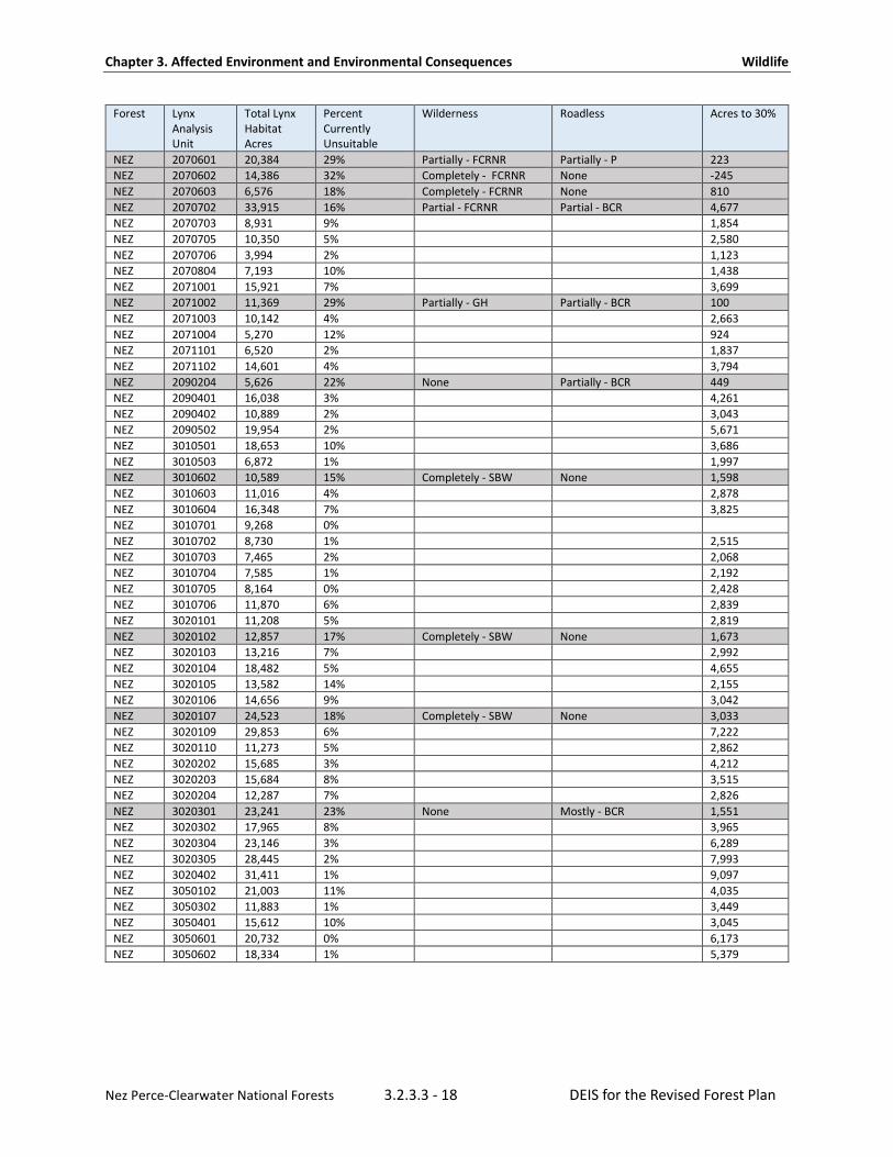
Under the Northern Rockies Lynx Management Direction Standard VEG S1, if more than 30 percent of the lynx habitat in a lynx analysis unit is currently in a stand initiation structural stage that does not yet provide winter snowshoe hare habitat, no additional habitat may be regenerated by vegetation management projects unless a broad scale assessment has been completed that substantiates different historic levels of stand initiation structural stages.
As of 2019, only 1 out of 106 lynx analysis units on the Nez Perce-Clearwater were modeled as having more than 30 percent of lynx habitat being in an early stand initiation condition as a result of stand-replacing wildfires and vegetation management (see Table 3 below). These areas are estimated to be in early stand initiation which does not yet provide winter snowshoe hare habitat. The only lynx analysis unit with more than 30 percent identified as currently unsuitable occurs entirely within designated wilderness. Only 9 lynx analysis units are over 20 percent in early stand initiation and all of them are located in-part or wholly within designated wilderness. Of these nine, all the early stand initiation is the result of wildfire.
Overall, wildfire has clearly been the driver in creating substantial acreages on the Nez Perce-Clearwater in a condition where they do not yet provide winter snowshoe hare and lynx habitat. The total amount of habitat in an unsuitable condition forestwide is about 110,431 acres, or about 7.5 percent of all the lynx habitat in the plan area. None of the lynx analysis units are estimated to exceed VEG S1 due to regeneration harvest on National Forest System lands. The percentage of lynx habitat affected by regeneration harvest has generally been minor in comparison to wildfire.
Under the Northern Rockies Lynx Management Direction Standard VEG S2, no more than 15 percent of lynx habitat on National Forest System lands can be regenerated by timber management projects within a lynx analysis unit in a 10-year period unless it meets criteria applicable to the wildland urban interface. Since 2000, only 0.23 percent of all lynx habitat in the plan area has been treated by timber activities (FACTS database, accessed August 2019).
Table 3 displays the condition of lynx analysis units based on the forestwide lynx model. All of the lynx analysis units over 15 percent fall entirely or partially within either designated wilderness or Idaho Roadless Rule areas where timber management is not allowed or is restricted. Thus, none of lynx analysis units over 15 percent were the result of timber management. Since the forest plan was amended to include the Northern Rockies Lynx Management Direction in 2007, none of the lynx analysis units have had more than 15 percent of lynx habitat acres regenerated by timber management projects in the last decade. At a forestwide scale, the numbers presented above suggest a lack of sufficient disturbance in lynx habitat for lynx kitten production in the future because a stand must go through early stand initiation before it can become small-diameter forest as described in Kosterman (2018).
Table 3 also shows the amount of lynx habitat within each lynx analysis unit, the size of each lynx analysis unit, and the amount of habitat estimated as currently unsuitable (CUS) on the Nez Perce-Clearwater. In addition, the table shows whether the lynx analysis unit is in designated wilderness or Idaho Roadless Rule areas.

Chapter 3. Affected Environment and Environmental Consequences Wildlife
Nez Perce-Clearwater National Forests 3.2.3.3 - 17 DEIS for the Revised Forest Plan
Table 3. Summary of 2018 Lynx Analysis Units Forest Lynx
Analysis Unit
Total Lynx Habitat Acres
Percent Currently Unsuitable
Wilderness Roadless Acres to 30%
CLW 1 0 0% CLW 2 0 0% CLW 3 5 0% CLW 4 11,953 0% CLW 5 20,943 0% CLW 6 24,495 0% CLW 7 19,004 2% CLW 8 2,713 0% CLW 9 5 0% CLW 10 0 0% CLW 11 0 0% CLW 12 1 0% CLW 13 10,140 5% CLW 14 11,541 0% CLW 15 14,845 0% CLW 16 9,598 0% CLW 17 12,771 4% 3,380 CLW 18 16,838 4% 3,573 CLW 19 6,320 0% CLW 20 12,500 0% CLW 21 6,369 0% CLW 22 16,015 0% CLW 23 18,423 3% 3,573 CLW 24 20,061 0% CLW 25 15,278 7% 3,573 CLW 26 25,645 6% 6,241 CLW 27 20,975 10% 4,144 CLW 28 25,904 3% 3,573 CLW 29 19,244 12% 3,368 CLW 30 12,012 2% 3,573 CLW 31 13,857 2% 3,573 CLW 32 11,314 0% CLW 33 10,075 0% CLW 34 7,373 0% CLW 35 14,076 14% 2,253 CLW 36 17,257 0% CLW 37 13,418 1% 3,573 CLW 38 20,677 9% 4,324 CLW 39 3,793 15% None Completely - P, SAHTS 586 CLW 40 13,840 2% 3,573 CLW 41 16,794 1% 3,573 CLW 42 13,409 0% CLW 43 19,015 1% 3,573 CLW 44 16,450 7% 3,838 CLW 45 16,823 25% Mostly - SBW Partially - BCR 848 CLW 46 14,381 14% 2,311 CLW 47 11,555 6% 2,768 CLW 48 25,038 10% - 5,068 CLW 49 19,264 13% 3,338 CLW 50 22,774 24% Partially - SBW Partially - WLR, P 1,468 CLW 51 20,013 7% 4,598 CLW 52 17,599 23% Partially - SBW Partially - BCR, WLR 1,194 CLW 53 16,401 21% Completely - SBW None 1,518 CLW 54 19,003 18% Completely - SBW None 2,213 NEZ 2070502 4,419 24% Completely - FCRNR None 253
Chapter 3. Affected Environment and Environmental Consequences Wildlife
Nez Perce-Clearwater National Forests 3.2.3.3 - 18 DEIS for the Revised Forest Plan
Forest Lynx Analysis Unit
Total Lynx Habitat Acres
Percent Currently Unsuitable
Wilderness Roadless Acres to 30%
NEZ 2070601 20,384 29% Partially - FCRNR Partially - P 223 NEZ 2070602 14,386 32% Completely - FCRNR None -245 NEZ 2070603 6,576 18% Completely - FCRNR None 810 NEZ 2070702 33,915 16% Partial - FCRNR Partial - BCR 4,677 NEZ 2070703 8,931 9% 1,854 NEZ 2070705 10,350 5% 2,580 NEZ 2070706 3,994 2% 1,123 NEZ 2070804 7,193 10% 1,438 NEZ 2071001 15,921 7% 3,699 NEZ 2071002 11,369 29% Partially - GH Partially - BCR 100 NEZ 2071003 10,142 4% 2,663 NEZ 2071004 5,270 12% 924 NEZ 2071101 6,520 2% 1,837 NEZ 2071102 14,601 4% 3,794 NEZ 2090204 5,626 22% None Partially - BCR 449 NEZ 2090401 16,038 3% 4,261 NEZ 2090402 10,889 2% 3,043 NEZ 2090502 19,954 2% 5,671 NEZ 3010501 18,653 10% 3,686 NEZ 3010503 6,872 1% 1,997 NEZ 3010602 10,589 15% Completely - SBW None 1,598 NEZ 3010603 11,016 4% 2,878 NEZ 3010604 16,348 7% 3,825 NEZ 3010701 9,268 0% NEZ 3010702 8,730 1% 2,515 NEZ 3010703 7,465 2% 2,068 NEZ 3010704 7,585 1% 2,192 NEZ 3010705 8,164 0% 2,428 NEZ 3010706 11,870 6% 2,839 NEZ 3020101 11,208 5% 2,819 NEZ 3020102 12,857 17% Completely - SBW None 1,673 NEZ 3020103 13,216 7% 2,992 NEZ 3020104 18,482 5% 4,655 NEZ 3020105 13,582 14% 2,155 NEZ 3020106 14,656 9% 3,042 NEZ 3020107 24,523 18% Completely - SBW None 3,033 NEZ 3020109 29,853 6% 7,222 NEZ 3020110 11,273 5% 2,862 NEZ 3020202 15,685 3% 4,212 NEZ 3020203 15,684 8% 3,515 NEZ 3020204 12,287 7% 2,826 NEZ 3020301 23,241 23% None Mostly - BCR 1,551 NEZ 3020302 17,965 8% 3,965 NEZ 3020304 23,146 3% 6,289 NEZ 3020305 28,445 2% 7,993 NEZ 3020402 31,411 1% 9,097 NEZ 3050102 21,003 11% 4,035 NEZ 3050302 11,883 1% 3,449 NEZ 3050401 15,612 10% 3,045 NEZ 3050601 20,732 0% 6,173 NEZ 3050602 18,334 1% 5,379

Chapter 3. Affected Environment and Environmental Consequences Wildlife
Nez Perce-Clearwater National Forests 3.2.3.3 - 19 DEIS for the Revised Forest Plan
It is assumed that forests burned by stand-replacing wildfire from 1993 to 2018 are not yet winter snowshoe hare habitat. Acres burned by wildfire are estimates for comparison with Standard VEG S1. These percentages are estimates based upon forest-scale data and need to be verified at the project level.
Acres are based on the Forest Service Activity Tracking System (FACTS) database, which does not include decisions not yet implemented. This percentage is shown for comparison to Standard VEG S2, which requires 15 percent or less in a 10-year period unless exempted for fuels reduction projects in the wildland urban interface.
Shaded lynx analysis units are estimated to have more than 30 percent of lynx habitat that is not yet winter snowshoe hare habitat due to stand-replacing wildfire. Estimates need to be verified at the project level.
In its biological opinion on the Northern Rockies Lynx Management Direction (U.S. Department of Interior, 2007), the U.S. Fish and Wildlife Service concluded that there was potential for incidental take to occur in lynx habitat, mostly due to the exemptions and exceptions to the vegetation standards which could diminish the value of lynx habitat and impair feeding and reproduction by adult female lynx and survival of kittens. Because of the difficulty of determining the incidental take of lynx, the U.S. Fish and Wildlife Service used the total estimated acreage of the exemptions and exceptions as a surrogate measure.
As defined under the Endangered Species Act, take means "to harass, harm, pursue, hunt, shoot, wound, kill, trap, capture, or collect, or to attempt to engage in any such conduct." Incidental take is an unintentional but not unexpected taking. Take and incidental take are common terms used when discussing federally listed species.
The amount of incidental take was anticipated to be represented by fuels treatments on up to six percent, or 729,000 acres, of lynx habitat across the entire northern Rockies analysis area over ten years and by precommercial thinning for other resource benefits on up to 64,320 acres, less than 0.5 percent, of snowshoe hare habitat (lynx foraging habitat) over a ten-year period. The U.S. Fish and Wildlife Service provided reasonable and prudent measures and terms and conditions in order to minimize incidental take. Standards VEG S1, VEG S2, VEG S5, and VEG S6 include an exemption for fuels treatments to protect communities at risk in lynx habitat within the wildland urban interface. Such fuels treatments may not occur on more than six percent of lynx habitat on each National Forest considered “occupied,” as defined in the Northern Rockies Lynx Management Direction, which limits fuels treatments to about 44,607 acres on the Clearwater National Forest (U.S. Department of Interior, 2007). Since 2007, the Nez Perce-Clearwater has used none of the exempted acres allowed under that take statement. Instead, all fire and fuels projects have abided the Northern Rockies Lynx Management Direction standards and guidelines and consulted on individual projects. The incidental take statement was amended by the U.S. Fish and Wildlife Service to extend exempted acres for an additional five years in the Forest Service’s Northern Region (U.S. Department of Interior, 2012).
Annual monitoring and reporting is a requirement of the Northern Rockies Lynx Management Direction biological opinion (U.S. Department of Interior, 2007) in order to ensure that the level of incidental take is not exceeded. None of the lynx analysis units exceeded the VEG S2 standard of 15 percent in the last ten years because the Nez Perce-Clearwater did not use the exemptions.
Standard VEG S5 also contains six listed exceptions that allow for precommercial thinning in lynx habitat to meet other specific resource objectives. VEG S6 contains several listed exceptions for vegetation management projects that reduce snowshoe hare habitat in multistory mature or late-successional forests. The estimated acres that would possibly be treated through precommercial thinning exceptions
Chapter 3. Affected Environment and Environmental Consequences Wildlife
Nez Perce-Clearwater National Forests 3.2.3.3 - 20 DEIS for the Revised Forest Plan
are shown in Appendix K of the Final Environmental Impact Statement for the Northern Rockies Lynx Management Direction. For the Clearwater National Forest, the estimated number of acres to be thinned under the exceptions to the vegetation standards was 5,510 acres over a 10-year period in the Clearwater National Forest and 12,370 acres in the Nez Perce National Forest, totaling approximately 0.4 percent of the lynx habitat on the Nez Perce-Clearwater. Combined these total 17,880 acres. The acres actually treated by thinning in lynx habitat on the Nez Perce-Clearwater from 2007 to 2019 was 17,257 acres, which is about 1.1 percent of the lynx habitat in the Nez Perce-Clearwater. According to the updated lynx habitat model, only 1380 acres of these treatments were considered as causing unsuitable lynx habitat (FACTS database, accessed August 2019). The allowable level of incidental take has not been exceeded for the northern Rockies analysis area (Conway & Hanvey, 2017) nor for the Nez Perce-Clearwater.
Winter Recreation In 2017, the Clearwater National Forest issued the decision for its motorized winter recreation plan, as part of the Clearwater Travel Plan (USDA, 2017). The decision clarified where, when, and under what conditions motorized over-snow vehicles are allowable on the Clearwater National Forest. The decision abided by Northern Rockies Lynx Management Direction guideline HU G11:
Designated over-the-snow routes or designated play areas should not expand outside baseline areas of consistent snow compaction1, unless designation serves to consolidate use and improve lynx habitat. This may be calculated on a lynx analysis unit basis, or on a combination of immediately adjacent lynx analysis units.
Thus, the motorized winter use on the Clearwater National Forest is consistent with the Northern Rockies Lynx Management Direction guidelines. At the time, there were 115 miles of groomed over-snow vehicle baseline routes in lynx habitat within the Clearwater side of the Forest and no additional groomed routes were proposed in lynx habitat. The Nez Perce National Forest has not yet undergone travel planning for motorize winter recreation. Currently, all areas that are not designated wilderness are open to motorized oversnow travel.
The 2012 Planning Rule requires plans to develop components for multiple uses for sustainable recreation, including recreation settings, opportunities, and access. The forest plan revision will set the winter recreation opportunity spectrum for the both the Nez Perce and Clearwater National Forests. The winter recreation opportunity spectrum was developed following guidance from the Final Directives for the 2012 Planning Rule (FSH 1902.12_20, section 23.23a). While the recreation opportunity spectrum will not make decisions about specific travel routes, the recreation opportunity spectrum will provide the framework under which recreational opportunities, such as winter motorized recreation activities, could be allowed during future travel or recreation planning. The recreation opportunity spectrum categorizes recreational settings into six distinct classes. Each setting provides the opportunities to engage in activities, such as motorized, non-motorized, developed, or dispersed, on land, water, and in the air. The winter recreation opportunity spectrum settings establish where activities, such as over the snow motor vehicle use and motorized recreation, are allowed, including urban, rural, roaded natural, and semi-primitive motorized. Under the 1987 Plans, the winter recreation opportunity spectrum allows winter motorized travel in all settings except wilderness and recommended wilderness. Motorized summer recreation is generally not allowed in the primitive and semi-primitive non-motorized settings.

Chapter 3. Affected Environment and Environmental Consequences Wildlife
Nez Perce-Clearwater National Forests 3.2.3.3 - 21 DEIS for the Revised Forest Plan
Table 4. Acres of lynx habitat and percent of total lynx habit by winter recreation opportunity spectrum setting in the No Action Alternative
Winter ROS Setting No Action Alternative Percent Lynx habitat
Primitive 581,905 40%
Roaded Natural 28,892 2%
SPM 736,803 51%
SPNM 110,168 8%
Table 5. Amount of lynx habitat within motorized and non-motorized winter recreation opportunity spectrum settings.
Winter ROS Setting Current Condition
Non-motorized 48%
Motorized 52%
Habitat Connectivity The Northern Rockies Lynx Management Direction identified lynx linkage areas, which are intended to maintain connectivity and allow for the movement of lynx between blocks of habitat that are otherwise separated by intervening non-habitat areas, such as basins, valleys, and agricultural lands or places where habitat naturally narrows due to topographic features. The Northern Rockies Lynx Management Direction contains plan components requiring conservation measures in lynx linkage areas, including objectives, standards, and guidelines. These linkage areas were initially identified on the basis of expert opinion and were coarsely mapped at a broad scale. Linkage areas on the Nez Perce-Clearwater are shown in Appendix A. The group anticipated that linkage areas would be further refined as more information became available. Subsequently, Squires et al (John R. Squires et al., 2013) used telemetry data for 64 lynx monitored from 1998 to 2007 to create a broad-scale resource selection model that predicted probable lynx habitat and “putative movement corridors” across the species’ distribution in the northern Rocky Mountains. This analysis included quantification of the relative likelihood of lynx crossing major highways – one of the major hypothesized anthropogenic threats to lynx connectivity. The areas where Squires et al (2013) mapped lynx connectivity did not include the Nez Perce-Clearwater. Most of the lynx sightings on the Nez Perce-Clearwater appear to be observations of transient individuals, suggesting that lynx move through the plan area.
Squires et al (2013) stated, “given that increased traffic and urbanization are projected for the northern Rockies, mitigation such as land purchases and conservation easements may be necessary to preserve connectivity among lynx populations.” Private land development, especially along highway corridors in mountain valleys, may also fragment habitat and impede the movement of lynx. The Nez Perce-Clearwater does not have jurisdiction over state or federal highways or lands under other ownerships, such as private, state, and tribal. The Forest Service can support habitat connectivity through its management of National Forest System lands by encouraging or acquiring conservation easements along highways or cooperating in identifying appropriate locations for installation of highway crossing structures. Activities on other ownerships are discussed in the analysis of cumulative effects.

Chapter 3. Affected Environment and Environmental Consequences Wildlife
Nez Perce-Clearwater National Forests 3.2.3.3 - 22 DEIS for the Revised Forest Plan
Key indicators for analysis Resource elements discussed in the analysis are based upon anthropogenic influences identified in the 2013 Lynx Conservation Assessment and Strategy, which relates to risk factors and habitat effectiveness. The analysis determines effects from the alternatives based on how plan components change the scope, severity, or both for these threats as described above.
Table 6. Key indicators for assessing effects to Canada lynx
Resource element Indicator
Amount and proportion of lynx habitat within different management areas by alternative
The amount of lynx habitat by alternative that falls within Management Area 1, Management Area 2, and Management Area 3, by alternative. Management areas set broad direction for large portions of the Nez Perce-Clearwater and largely control potential effects.
Vegetation management Terrestrial ecosystems and Canada lynx habitat diversity. Amount of lynx habitat suitable for timber production. Changes in vegetation conditions modeled in SIMPPLLE.
Fire management The amount of lynx habitat through time susceptible to uncharacteristic wildfire under future climates. Changes in vegetation conditions modeled in SIMPPLLE.
Habitat fragmentation Anticipated changes to Canada lynx habitat connectivity linkage areas.
Recreation Suitability for motorized over-snow vehicle use and Canada lynx habitat from winter recreation opportunity spectrum.
Minerals Distribution or suitability of minerals operations in Canada lynx habitat
Forest/backcountry roads Forest/backcountry roads and indirect effects of motorized access on the risk of trapping and shooting
Livestock grazing Livestock grazing and vegetation change in Canada lynx habitat
Driver/Stressor Anticipated changes in climate and effects on Canada lynx habitat
Consequences Common to All Alternatives All of the alternatives would retain the management direction in the Northern Rockies Lynx Management Direction for the conservation of lynx. The effects of the Northern Rockies Lynx Management Direction (Appendix 8 of the draft Revised Forest Plan) are discussed as consequences common to all alternatives. Plan components in the draft Revised Forest Plan are common to all alternatives, except for those related to nonconforming uses allowed in recommended wilderness, those for retention of snags during vegetation management, and objectives for the achievement of the rate of attainment of desired vegetation conditions.
Environmental Consequences—Canada Lynx The Lynx Conservation Assessment and Strategy (Interagency Lynx Biology Team, 2013) identified anthropogenic influences that may affect lynx and lynx habitat, sorted into either the “upper tier” or the “lower tier.” The upper tier includes the anthropogenic influences that are of greatest concern to the conservation of the lynx: vegetation management, wildland fire management, fragmentation of habitat, and climate change. The lower tier of anthropogenic influences includes recreation (primarily snowmobiling), minerals and energy management, forest/backcountry roads and trails, grazing by domestic livestock, and mortality due to incidental trapping or illegal shooting. It is thought that the lower tier activities could affect individual lynx but are not likely to have a substantial effect on lynx populations; these are of less concern for conservation of the species.

Chapter 3. Affected Environment and Environmental Consequences Wildlife
Nez Perce-Clearwater National Forests 3.2.3.3 - 23 DEIS for the Revised Forest Plan
Key Stressors Key stressors are discussed in the “Affected Environment” section and are summarized below.
Vegetation and Timber management Vegetation management activities, such as timber harvest, planting, and thinning, can affect lynx habitat conditions, such as forest composition, structure, dominance type, size class, and distribution. Specifically, timber management can affect the amount and distribution of dense horizontal cover providing snowshoe hare habitat, the amount and availability of large downed wood providing denning habitat, and the development of multistory hare habitat used by lynx for winter foraging (Interagency Lynx Biology Team, 2013). The allocation of management areas can affect where timber management occurs. Only about 17 percent of the lynx habitat on the Nez Perce-Clearwater is outside of Idaho Roadless Rule areas and wilderness areas, meaning only about 17 percent is in a management area that allows timber production.
While timber harvest is allowed in Idaho Roadless Rule areas, timber production is not. Roadless Rule areas are considered suitable for timber harvest for specific purposes. Timber harvest is only allowed in some Idaho Roadless Rule themes regulated by the Idaho Roadless Rule. The most permissive theme is the backcountry restoration theme. Timber harvest can be conducted in the backcountry restoration theme but it is only allowed in specific situations and for specific purposes as described below:
• Timber cutting, sale, or removal is prohibited in Idaho Roadless Rule backcountry restoration except: - To reduce hazardous fuels conditions outside a community protection zone if the project generally
retains large trees as appropriate for the forest type and consistent with land management plan. - To reduce hazardous fuel conditions outside a community protection zone where there is a
significant risk that a wildland disturbance event could adversely affect an at-risk community or municipal water supply.
- In a portion of a backcountry/roadless area that has been substantially altered by construction of a forest road and timber cutting, prior to October 16, 2008.
- To improve threatened, endangered, proposed, or sensitive species habitat. - To maintain or restore the characteristics of ecosystem composition, structure, or processes. - To reduce the risk of uncharacteristic wildland fire effects to an at-risk community or municipal
water supply. - For personal or administrative use or where incidental to the implementation of an activity not
prohibited. - Where cutting, sale, or removal is incidental to the implementation of a management activity not
otherwise prohibited by this subpart. These actions must be approved by the Regional Forester and:
Maintain or improve one or more of the roadless characteristics.
Maximize the retention of large trees as appropriate for the forest type to the extent these trees promote fire-resilient stands.
Are consistent with land management plan components.
Wildland recreation is the most restrictive and timber harvest is allowed only as follows:
Timber cutting, sale, or removal is prohibited except for personal or administrative use or where incidental to the implementation of an activity not prohibited.
Chapter 3. Affected Environment and Environmental Consequences Wildlife
Nez Perce-Clearwater National Forests 3.2.3.3 - 24 DEIS for the Revised Forest Plan
The final environmental impact statement for the Idaho Roadless Rule projected that 0.01 percent of the lands managed under Idaho Roadless Rule would be affected by timber removal and/or road construction in the first 15 years. For the nearly 1,500,000 acres of roadless areas on the Nez Perce-Clearwater, this would total 1500 acres over the 15-year period, or approximately 100 acres per year (U. S. Department of Agriculture, 2008). In the ten-year period from October 2008 to September 2018, approximately 1800 acres have been affected through community protection zone fuels reduction, constructed fuel breaks during wildfires, and removal of post-fire roadside hazard trees. This estimate of 1800 acres in the first 10 years is greater than the Idaho Roadless Rule projection. However, several extreme fire seasons have occurred during that time period and much of the tree removal has been tied to fire and post-fire hazard activities. If there is conflicting direction, the Idaho Roadless Rule will take precedent, as per the Idaho Roadless Rule.
Other Idaho Roadless Rule area themes fall between the backcountry restoration and wildland recreation themes for timber harvest in terms of what is allowed and why it is allowed. The amount of lynx habitat is shown in Table 7 below. Idaho Roadless Rule areas prevent the development of new roads, which makes much of the timber inaccessible or largely economically infeasible. Thus, vast areas of the Nez Perce-Clearwater have significant mechanisms to prevent impacts to lynx habitat from timber management. Neither timber harvest nor timber production are allowed in wilderness areas. Approximately 43 percent of lynx habitat is protected from timber management in these areas. Timber production is not allowed in about 56 percent of lynx habitats and timber harvest is restricted, reduced, or limited in about 30 percent. And, only 13 percent would be suitable for timber production.
Table 7. Acres of lynx habitat in each roadless rule theme and percent of lynx habitat forestwide that falls into each theme.
Idaho Roadless Rule Area Theme Acres of Lynx Habitat in Each Roadless Rule Theme
Percent of Lynx Habitat*
Backcountry Restoration 327452 22.46%
Forest Plan Special Area 2680 0.18%
Primitive 154873 10.62%
Special Area of Historic or Tribal Significance 20506 1.41%
Wildland Recreation 119642 8.21%
Total 42.88%
* Lynx habitat in each theme divided by total amount of lynx habitat in the plan area
The decision in the plan will identify areas suitable for timber production. Not all of the 17 percent of lynx habitat in Management Area 3 is suitable for timber production because areas, such as riparian zones or steep slopes, are not suitable. An estimated total of about 13 percent of all lynx habitat is suitable for timber production while other areas are not suitable or unsuitable. See Timber section for more details about timber suitability. Table 8 shows the amount of lynx habitat on the Nez Perce-Clearwater proposed in the different timber suitability categories.

Chapter 3. Affected Environment and Environmental Consequences Wildlife
Nez Perce-Clearwater National Forests 3.2.3.3 - 25 DEIS for the Revised Forest Plan
Table 8. Amount and percent of lynx habitat by timber suitability category.
Suitability Category Approximate Acres of Lynx Habitat Approximate Percent of Lynx Habitat
Suitable for production 195,264 13%
Suitable for harvest but not production
443,184 30%
Not suitable 819,031 56%
Currently, plan direction under the Northern Rockies Lynx Management Direction governs many vegetation and timber management activities forestwide. Standards and guidelines in the Northern Rockies Lynx Management Direction provide protection or reduce the impact to lynx from timber management. Direction from the Northern Rockies Lynx Management Direction vegetation standards currently limit the scope of timber management to no more than 15 percent of lynx habitat within a lynx analysis unit and no more than 30 percent total of a lynx analysis unit may be in an unsuitable condition. Thus, the scope of this threat in the plan area is constrained by 1) wilderness and roadless direction and 2) the Northern Rockies Lynx Management Direction. Combined, using the nature serve method, the scope of timber management is probably slight (less than 10 percent of lynx habitat) and at most is restricted (between 11-30 percent).
Holbrook (2017) showed that female lynx exhibited decreasing use of stand initiation structures by up to a maximum availability of 25 percent. Stand initiation structures, as defined in this paper, include very young stands, generally five years old and younger, with very few trees and open canopies resulting from recent disturbances, such as timber harvest and/or severe fire. The Northern Rockies Lynx Management Direction Standard VEG S1 limits disturbances from timber harvest or fire that result in the stand initiation (SI) structural stage not yet providing snowshoe hare habitat during winter to no more than 30 percent of mapped lynx habitat within a lynx analysis unit. However, stand initiation structures, as defined in this paper, and the stand initiation structural stage defined in the Northern Rockies Lynx Management Direction are not the same; stands in the stand initiation structural stage as defined in the Northern Rockies Lynx Management Direction, and that apply to Standard VEG S1, approach 20 to 25 plus years of age before moving to young regenerating stands that provide snowshoe hare habitat during winter. Thus, the stand initiation structure class defined in this paper is but a subset of the stand initiation structural conditions used in Northern Rockies Lynx Management Direction Standard VEG S1 to establish the 30 percent stand initiation condition threshold.
The terms Kosterman et al (2018) used to describe habitat use by lynx are very similar to those used in Holbrook et al (2017). However, forest structural classes described in those two papers and the classes described in Kosterman (2018) are not the same as those structural classes used to define and develop objectives, standards, and guidelines in the Northern Rockies Lynx Amendment. The forest structural classes described include sparse, stand initiation, advanced regeneration, and mature. Forest structural classes used in the Northern Rockies Lynx Management Direction are based on structural stages defined by Oliver and Larson (1996) and do not “crosswalk” well with the structural classes used in this study or those in the Kosterman thesis (2014) or Kosterman et al (2018). Staff in the Forest Service Region 1 Regional Office are working with research scientists at the Rocky Mountain Research Station to better interpret structure classes used in these studies and how they compare with those used in the Northern Rockies Lynx Management Direction.

Chapter 3. Affected Environment and Environmental Consequences Wildlife
Nez Perce-Clearwater National Forests 3.2.3.3 - 26 DEIS for the Revised Forest Plan
Of the five structure classes used to define habitat conditions in Kosterman et al (2018), the open, sparse and small-diameter regeneration forest classes are most likely to meet the unsuitable habitat conditions that define the 30 percent threshold in Standard VEG S1. Mean values within female lynx core use areas determined by Kosterman et al (2018) for the open, sparse and small-diameter classes where 4 percent, 10 percent, and 13 percent, respectively, and collectively would equal approximately 27 percent. Per structural class definitions in Table 1 of Kosterman et al (2018), the open and sparse structural classes lack horizontal cover and do not provide habitat for snowshoe hare; thus, both classes meet the unsuitable definition described in Standard VEG S1. However, it is unclear if the same is true for the small-diameter class defined by Kosterman et al (2018); this class provides dense horizontal cover for snowshoe hares but it is not known if this class includes young trees tall and dense enough to provide habitat during winter. In addition, structural habitat conditions described in Kosterman et al (2018) occurred within known female lynx core use areas; such conditions may not be the same within the larger home range or lynx analysis units used in the Northern Rockies Lynx Management Direction to approximate home ranges. Thus, because of the habitat differences and uncertainties described, it is unclear how, or if, the conclusions in Kosterman et al (2018) stating the probability of producing a litter was highest for females that had core-use areas with approximately 12 to 20 percent of small-diameter regenerating forest relates to the 30 percent stand initiation structural stage threshold described in the Northern Rockies Lynx Management Direction Standard VEG S1. As stated previously, staff in the Forest Service Region 1 Regional Office are working closely with research scientists at the Rocky Mountain Research Station to better interpret, understand, and crosswalk structural conditions described in research papers with those used to define management direction provided in the Northern Rockies Lynx Management Direction.
Timber management within lynx habitat has been avoided since the Canada lynx was listed. A query of the Forest Service’s Activities database (accessed August 2019) show that, since 2000, only 3295 acres of total lynx habitat have been impacted by timber harvest, which is less than one percent of the lynx habitat in the plan area.
The impacts of timber management on lynx habitat depends upon the type of treatments conducted, the time frames considered, and the forest type it is conducted in. Holbrook et al (2017) studied lynx use of timber management. They found that lynx used timber treatments but took longer to achieve 50 percent use of regeneration and selection cuts between 34 to 40 years than thinning in about 20 years. Thus, full use of timber treatments by lynx can take as long as 40 years and varies by treatment type. These results show that, when timber management happens, it can result in loss of habitat in the short-term depending on treatment. Within the scope, the severity of this threat when it happens, given a 15-year timeframe assumption for assessment, is classed as a serious threat within its scope using the nature serve method of assessing threats. The combined scope and severity assessment of threat impacts using the Nature Serve Methodology for identifying the magnitude of threats is estimated to be a medium threat with a scope of restricted and severity of serious when it happens.
Although standards and guidelines carried forward from the 2007 Northern Rockies Lynx Management Direction provide direction for many aspects of land management, the action alternatives have additional plan components that integrate Canada lynx habitat with desired conditions for vegetation that are tied to potential vegetation types within the context of the natural range of variation. The following paragraph discusses the effects of these plan components on Canada lynx.
Chapter 3. Affected Environment and Environmental Consequences Wildlife
Nez Perce-Clearwater National Forests 3.2.3.3 - 27 DEIS for the Revised Forest Plan
Desired conditions in all the alternatives are aligned with conservation measures for vegetation management in core habitat listed in the 2013 Lynx Conservation and Assessment Strategy (Interagency Lynx Biology Team, 2013). Desired conditions for vegetation pattern are tied to fit the natural range of variability within potential vegetation types. The majority of modeled Canada lynx habitat is in the cool, moist and cold groups, which correspond to boreal forest habitat types capable of growing spruce fir and lodgepole pine types.
A desired condition is a description of specific social, economic, and/or ecological characteristics of the plan area, or a portion of the plan area, toward which management of the land and resources should be directed. Desired conditions are not commitments or final decisions approving projects and activities. The desired condition for some resources may currently exist but for other resources they may only be achievable over a long time period. Forestwide desired condition FW-DC-TE-06 promotes providing the structure and pattern of forest vegetation across the landscape to contribute to structure and connectivity by potential vegetation type. Implementation of desired conditions should direct management actions in a way that would promote proper structure and distribution to promote connectivity for lynx habitats.
Desired conditions in FW-DC-FOR-09 and similar desired conditions found in the management area direction for cold and cool, moist potential vegetation type groups discuss the distribution of dominance types in the cool, moist broad potential vegetation types. This desired condition should, over time, change dominance types from Engelmann spruce and subalpine fir into lodgepole, larch, and white pine dominance types over the long-term. All of the cool, moist and cold potential vegetation types are considered lynx habitat and a habitat is still lynx habitat even if the dominance type changes. Based upon preliminary results from SIMPPLLE modeling, the plan components and alternatives would change about plus or minus two percent of the spruce-fir habitats into other types. A small percent change is expected in these types. While the dominance type may change, Engelmann spruce and subalpine fir will still be components of these stands and will move through succession through time to provide for lynx and snowshoe hares.
The Region 1 Existing Vegetation Classification System (Barber, Bush, & Berglund, 2011) explains how dominance types are classified. According to that document, dominance is the extent to which a given species has an influence in a setting or map feature because of its size, abundance, or coverage. In Region 1, canopy cover, basal area, or trees per acre are used to determine dominance. A dominance type is determined by the species with the greatest abundance of canopy cover, basal area, or trees per acre within a setting or map feature. The species that determine the dominance type are always of the same lifeform. Therefore, it is first necessary to identify the dominant lifeform and tree lifeform subclass before determining dominance type. Dominance, in this context, is determined by 60 percent plurality. Plurality refers to the plant species that has the most canopy cover, basal area, or trees per acre in a setting. Tree dominance group 6040 is based on two thresholds of tree abundance: 60 percent and 40 percent. If the single most abundant tree species comprises at least 60 percent of the total abundance of the classification attribute, the class assigned is the species code. While a species may dominate 60 percent of the stand, an additional 40 percent of the stand would contain other species. Thus, even though dominance type may change, species like Engelmann spruce and subalpine fir will still be components of stands in cool moist and cold potential vegetation types and should provide the horizontal cover needed for snowshoe hares.
In designated wilderness, the desired conditions would be achieved through natural processes which would be in about 43 percent of lynx habitat. Similarly, in Idaho Roadless Rule areas, the desired condition would be largely achieved through a combination of managed wildfire and prescribed fire. Planting in these areas would be minimal. Most likely, fire would reset succession and may shift

Chapter 3. Affected Environment and Environmental Consequences Wildlife
Nez Perce-Clearwater National Forests 3.2.3.3 - 28 DEIS for the Revised Forest Plan
dominance types. For example, dominance may shift from spruce-fir to lodgepole as a result from burning a spruce-fir stand that has a lodgepole pine components. Through time, spruce and fir would proceed through succession back into a spruce-fir dominated stand. Species without a seed bank, such as western larch, western white pine, and white bark pine, would have to be replanted to change the dominance type. Desired conditions for dominance type may be challenging in Idaho Roadless Rule and wilderness areas because of the restrictions on timber management and planting.
The rate at which this restoration occurs varies within the alternatives. Alternative W seeks to achieve desired conditions in 30 years, Alternative X at 20 years, Alternative Y at 50 years, and Alternative Z at 100 years. The No Action Alternative would continue at the same pace of the forest over the past three years. At this rate, it is similar to Alternative Z in its timeframe to achieve desired conditions. PRISM modeling was used to estimate the acres of treatment required by alternative to achieve these desired conditions. See the Forestlands section for additional details. In roadless and wilderness areas, which combined make up more than 80 percent of the lynx habitat in the plan area, fire is the primary disturbance projected to be needed to meet vegetation desired conditions for dominance types. Long-term management towards these desired conditions may decrease dominance types preferred by lynx in multistoried spruce fir dominated forests but would be within the natural range of variability.
The Northern Rockies Lynx Management Direction standards and guidelines would be followed in conducting these treatments. Thus, only 30 percent of a lynx analysis unit could be unsuitable and only 15 percent could be in an unsuitable condition within a 10-year period for lynx. These constraints were programed into PRISM for all alternatives; thus, amounts of treatments under all alternatives meet the Northern Rockies Lynx Management Direction guidelines. The Northern Rockies Lynx Management Direction does not have any constraints on changing dominance types within lynx habitat.
Desired conditions FW-DC-FOR-10 and MA1 and MA2-DC-FOR-04 address within-stand conditions in the cool, moist broad potential vegetation type and contain specific language to promote spruce and fir dominated stands to achieve a multistoried condition, which was written specifically to address lynx habitat needs. These desired conditions would allow maintenance of multistoried stand conditions within spruce and fir dominated stands in the cool, moist group.
Preliminary modeling for most of the action alternatives project forest conditions in the future and will trend slightly towards less dominance of spruce-fir forests with a slight increase in both the 0 to 4.9-inch and greater than 15-inch size classes over the next 50 years. Kosterman (2018) found that the number of small diameter trees, defined as 3.93 to 5.9-inch diameter at breast height, at the landscape scale influence whether lynx produce kittens and the probability a female having kittens increased until there was about 20 percent of the landscape in this size class. The forest plan size class breaks do not match up with those in Kosterman (2018) but size classes from 0 to 4.9-inch would contain trees that size. Most of this change is projected to occur following fires and prescribed fires, as well as through forest succession because of the distribution among land designation types, such as Idaho Roadless Rule and designated wilderness. The shift in dominance types would most likely slightly trend from spruce-fir dominated stands towards an increase in lodgepole pine, whitebark pine, and some larch. However, Engelmann spruce and subalpine fir will remain as a component of these stands and still contribute to lynx and hare habitat. All of these changes are trending towards or within the natural range of variability for lynx habitat. These changes occur under all action alternatives but at different rates. These conclusions are based upon preliminary modeling results from SIMPPLLE and the model is currently being refined.

Chapter 3. Affected Environment and Environmental Consequences Wildlife
Nez Perce-Clearwater National Forests 3.2.3.3 - 29 DEIS for the Revised Forest Plan
Consequences of Other Vegetation Management Treatments The U.S. Fish and Wildlife Service’s biological opinion on the Northern Rockies Lynx Management Direction (U.S. Department of Interior, 2007) stated that limited exceptions to vegetation standards VEG S5 and VEG S6 could occur for other resource benefits, such as to restore western white pine and whitebark pine, which is a candidate species for listing under the Endangered Species Act. Under all of the alternatives, the estimated acres that could have vegetation management treatments under the numbered exceptions to standards VEG S5 and VEG S6 was estimated to be 1930 acres for white pine under Appendix K of the Northern Rockies Lynx Management Direction. It was estimated to be 1650 acres for restoration of western larch on the Clearwater National Forest and 120 acres on the Nez Perce National Forest.
Plan components in the Northern Rockies Lynx Management Direction provide for the conservation of Canada lynx and their habitat. They are aligned with the conservation measures for vegetation management in core habitat listed in the 2013 Lynx Conservation and Assessment Strategy (Interagency Lynx Biology Team, 2013) at the forestwide scale, considering exceptions allowed by the incidental take statement.
In summary, Standard VEG S1 limits regeneration by vegetation management projects if more than 30 percent of the lynx habitat in a lynx analysis unit is currently in a stand initiation structural stage that does not yet provide winter snowshoe hare habitat with certain exceptions or exemptions allowed under the incidental take statement. Only 1 out of 106 lynx analysis units on the Nez Perce-Clearwater were modeled as having more than 30 percent of lynx habitat being in an early stand initiation condition as a result of stand-replacing wildfires. VEG S1 limits adverse effects to lynx because regeneration by vegetation management projects cannot occur until vegetation regrows into snowshoe hare habitat. As a result of recent large wildfires, an additional 9 lynx analysis units are over 20 percent in early stand initiation and all of them are located in-part or wholly within designated wilderness or roadless areas.
Standard VEG S2 limits regeneration by vegetation management projects to no more than 15 percent of lynx habitat on National Forest System lands within a lynx analysis unit in a 10-year period with certain exceptions or exemptions allowed under the incidental take statement. By limiting the rate of regeneration harvest in each lynx analysis unit, these standards would contribute to a mosaic of habitat over time, which would benefit lynx by supporting the distribution of prey resources within a lynx analysis unit and across the landscape. Projections for acres harvested by PRISM modeling took into account the limits imposed by VEG S1 and S2 of a maximum of 30 percent unsuitable in a lynx analysis unit and no more than 15 percent unsuitable in a 10-year period. These were imposed upon the amount of vegetation management and prescribed burning within analysis units by incorporating those as constraints in the model. The number of acres treated in the PRISM outputs projected under each alternative include those constraints and abide by VEG S1 and VEG S2. Therefore, each alternative provides ecological conditions for lynx through time. While PRISM can project growth, forestry outputs and general trends in vegetation do not project these spatially nor take into account the stochastic nature of fires given the assumptions in the model and plan objectives. SIMPPLLE modeling projects these spatially and simulates fires stochastically through multiple runs. Potential multi-storied lynx habitat is abundant, although projected to decline. Modeled multi-storied hare habitat declines slightly in all alternatives by time step 5 with minimal differences between alternatives. Alternatives W and Y show the highest reductions in multi-storied habitats by time step 5 but the differences between alternatives are not significant. The lack of differences between alternatives suggests that the decline is inevitable and unavoidable due to increasing wildfires. The level of habitat at decade 5 is still relatively abundant compared to the natural range of variation, suggesting that the availability of multi-storied habitat is not a limiting factor to lynx recovery on the Nez Perce-Clearwater.

Chapter 3. Affected Environment and Environmental Consequences Wildlife
Nez Perce-Clearwater National Forests 3.2.3.3 - 30 DEIS for the Revised Forest Plan
Standard VEG S5 limits precommercial thinning projects during the stand initiation structural stage until the stand no longer provides winter snowshoe hare habitat with certain exceptions or exemptions allowed under the incidental take statement. The intent is to maintain the habitat conditions that are expected to produce high densities of snowshoe hares, which would benefit lynx by supporting high-quality habitat. There are six exceptions to Standard VEG S5 that could be used to meet other resource objectives. The exceptions to VEG S5 for precommercial thinning are anticipated to result in the short-term loss of lynx foraging habitat in some treated stands, which could have an adverse effect on lynx survival and reproduction by reducing prey resources but this effect is limited in intensity and extent. Precommercial thinning at administrative sites and for research or genetic tests would generally have little or no adverse effect on lynx because few acres are involved and the acres impacted are widely distributed. Thinning to enhance whitebark pine and aspen would benefit other wildlife species and would occur on a limited number of acres of lynx habitat, resulting in a minor adverse effect on lynx. Daylight thinning would be allowed around individual western white pine in a manner that retains most winter snowshoe hare habitat. Daylight thinning might reduce lynx habitat quality in the short-term but might allow the development of multiple dense canopy layers in the long-term. Standard VEG S6 limits vegetation management projects that would reduce winter snowshoe hare habitat in multistory mature or late-successional forests with certain exceptions or exemptions allowed by the standard. Timber harvest would be allowed in areas that have the potential to improve winter snowshoe hare habitat that presently have poorly developed understories and do not provide winter snowshoe hare habitat, benefiting lynx by developing forests with a dense understory to support their snowshoe hare prey. The effects of the numbered exceptions to VEG S6 would create short-term loss of hare habitat quality or quantity but these are anticipated to be minor because they are limited in intensity and extent. Implementation of Standard VEG S6 would benefit lynx by retaining and developing important winter habitat over much of the Nez Perce-Clearwater.
As stated in the forest plan Appendix 8, VEG O1, VEG O2, and VEG O4 encourage management of vegetation to mimic or approximate natural succession and disturbance processes while maintaining lynx habitat components. Guideline VEG G1 encourages the development of projects that are designed to recruit a high density of conifers, hardwoods, and shrubs where such habitat is scarce or not available. Guideline VEG G5 is to provide habitat for alternative prey species, particularly red squirrel, in each lynx analysis unit. Guideline VEG G10 states that all the vegetation standards should be considered when designing fuel treatment projects within the wildland urban interface to promote lynx conservation and that this consideration should be explained in the project NEPA documentation. Guideline VEG G11 describes how denning habitat should be retained and distributed in each lynx analysis unit. These guidelines benefit lynx by encouraging practices that create or maintain lynx habitat components and would continue to be considered as site-specific projects are developed under all the alternatives. Plan components provide for a mosaic of habitat conditions over time that support dense horizontal cover and high densities of snowshoe hare with winter snowshoe hare habitat provided by the stand initiation stage and by mature multistory conifer vegetation in support of lynx conservation. Analysis of Forest Inventory and Analysis data on snags and large downed woody material for the Nez Perce-Clearwater forest plan shows that the availability of snags and large downed woody material was similar in wilderness and non-wilderness (Bollenbacher, Bush, & Lundberg, 2009).

Chapter 3. Affected Environment and Environmental Consequences Wildlife
Nez Perce-Clearwater National Forests 3.2.3.3 - 31 DEIS for the Revised Forest Plan
Guideline VEG G11 of the Northern Rockies Lynx Management Direction requires considerations for denning habitats when working in lynx habitat. Plan guidelines require minimum snag densities under all alternatives but differ at the scale they apply and the size of snags required to be retained. Alternatives W, X, and Y would require snags be retained from 15 inches with some proportion of those snags being greater than 20-inch diameter at breast height and larger. Alternative Z requires retention of snags 10-inch at diameter at breast and larger with some proportion of those snags required to be 15-inch and larger and some 20-inch and larger. Under Alternative Z, the number of snags would be from between 600 to 700 snags per 100 acres 10-inch and larger depending upon potential vegetation type.
The numbers for snags in the guideline are based upon the average number of snags reported by broad potential vegetation type in northern Idaho as stated in Bollenbacher et al (2009). For north Idaho forests, this represents between 600 to 700 snags per 100 acres of 10-inch diameter at breast and larger in the subalpine habitat type group, as in Alternative Z, versus between 0 to 400 snags per 100 acres 15-inch and larger, as under Alternatives W, X, and Y. Under all alternatives, these are required to be retained at the project area scale. These plan components would ensure that snags retained would be sufficient to ensure that denning habitat would be available after vegetation projects in areas of lynx habitat where these activities occur. Snag guidelines under all alternatives would provide potential denning habitat.
This effect to lynx would only happen in about 17 percent of the lynx habitat within Management Area 3. While plan components for snags in Management Area 2 do not vary by alternative, emphasis for vegetation management in Management Area 2 stresses restoration of forest structure, composition, function, and connectivity and snags would probably be retained during restoration treatments but not required. Furthermore, treatments in Management Area 2 are expected to be conducted through prescribed and wildfire use to restore habitats, which will naturally leave more snags.
Summary of Modeled Alternative Consequences In the Canada Lynx Conservation and Assessment Strategy (Interagency Lynx Biology Team, 2013), no conservation measures are identified for climate change due to the limited ability of federal land management agencies to alter the current trajectory. The conservation measures for vegetation include the following:
Conduct a landscape evaluation to identify needs or opportunities for adaptation to climate change. Consider potential changes in forest vegetation that could occur as a result of climate change (e.g., Gärtner et al 2008). Identify reference conditions relative to the landscape’s ecological setting and the range of future climate scenarios. For example, the historical range of variability could be derived from landscape reconstructions (e.g., Hessburg et al 1999, Blackwell et al 2003, Gray and Daniels 2006). (p. 91).
Plan alternatives were analyzed using a landscape evaluation that considered reference conditions relative to the landscape’s ecological settings and the range of future climate scenarios, considering the interaction of vegetation management, wildland fire, and possible effects on fragmentation of habitat.
The Ecosystem Research Group modeled the effects of the alternatives. The natural range of variation was modeled going back about 1,000 years and the effects of the alternatives were projected for the next 50 years, including anticipated changes in climate and the fire suppression logic of the model. Effects of vegetation management associated with each management area, combined with modeling of natural processes such as wildfires, insects and disease, and forest succession, were modeled in 2019. The Ecosystem Research Group modeled the effects of several future scenarios for comparison purposes, including a warmer and drier climate over the next five decades that would result in more acres burned due to expected climate change and continuing the current level of fire suppression into the future.

Chapter 3. Affected Environment and Environmental Consequences Wildlife
Nez Perce-Clearwater National Forests 3.2.3.3 - 32 DEIS for the Revised Forest Plan
Effects were modeled using SIMPPLLE and PRISM models. The SIMPPLLE and PRISM models provide a probabilistic assessment of the subset of federal actions that provide a programmatic framework for vegetation management activities across the Nez Perce-Clearwater over a 50-year future time period. However, since the exact location, extent, and timing of future fires, timber harvest, thinning, and planting are unknown, future site-specific actions would be subject to the requirements of Section 7 of the Endangered Species Act at a future time.
Ecosystem Research Group’s modeling used the GIS layer of modeled and mapped lynx habitat for the Nez Perce-Clearwater. Two analyses for lynx were done to assess their habitat requirements: (1) a stand initiation habitat analysis and (2) a potential multistoried habitat analysis. Stand initiation hare habitat was modeled as any cover types within the footprint of lynx habitat updated in 2018. Stand initiation hare habitat was modeled as the 0 to 5-inch size class as seedling and sapling with a canopy cover class of 40 to 100 percent and 20 or more years since the previous stand-replacing disturbance, such as high-severity fire or regeneration harvest. Modeled multistoried habitat is limited to cover types that contain subalpine fir or Engelmann spruce, which may be mixed with other species, within subalpine fir-spruce habitat groups. Multistoried lynx habitat is provided by forests with a high proportion of trees in the diameter classes of 7 to 11 inches and 11 plus inches (John R. Squires et al., 2010; J. R. Squires et al., 2006) and a dense understory providing snowshoe hare habitat. Although snowshoe hares require a dense understory, the SIMPPLLE model is dependent on Region 1 VMap classes and did not allow the incorporation of understory density. Updating of lynx habitat was conducted according to the Lynx Conservation Assessment and Strategy (2013) and is described in Lutes (2019).
The most important lynx habitats include Engelmann spruce, subalpine fir, spruce-fir, and lodgepole pine. Modeling results estimating the natural range of variability for lynx habitats suggests that they are departed from their natural range of variability. The departure is represented by an increase in Engelmann spruce and subalpine fir with a concurrent decrease in lodgepole pine and white bark pine. In other words, spruce-fir stands dominate more than they did under natural fire regimes while lodgepole and whitebark pine dominate less than they did in the past. Modeling results from PRISM suggest that, under all alternatives, the departure from the natural range of variability declines but the rate of that decline varies by alternative. That is because the alternatives vary the rate at which restoration of the natural range of variability is achieved, primarily by varying objectives for restoration. Objectives that restore or treat lynx habitat are mostly those that treat the cold and cool, moist potential vegetation types.
Given these objectives and various assumptions and constraints in the models, the modeling results suggest that, in all alternatives, subalpine fir, Engelmann spruce, and spruce-fir dominance types decline but the rate of that decline is faster in some alternatives than others. As these types decline, lodgepole pine and white bark pine dominance increases. In both Alternative W and Y, Engelmann spruce and subalpine fir dominance types decline faster than the other alternatives while lodgepole pine and white bark pine increases the fastest. In Alternative W and Y, restoration back to the natural range of variation is achieved roughly at decade 5. In Alternatives Z and the No Action Alternative, spruce-fir dominance types remain more constant and decline only slightly. Restoration back to the natural range of variation in these types take up to and beyond 70 years.
The amount of harvest or fire required to achieve these results fluctuates between about 20,000 acres to a high of about 40,000 acres per decade time step, depending upon the timestep. This amount of treatment per decade was constrained by the PRISM model and is consistent with VEG S1 and S2 of the Northern Rockies Lynx Management Direction. Treatments projected to achieve this include both vegetation management and fire.
Chapter 3. Affected Environment and Environmental Consequences Wildlife
Nez Perce-Clearwater National Forests 3.2.3.3 - 33 DEIS for the Revised Forest Plan
Through time, under all alternatives, the proportion of large diameter size class would progress to the very large class while other size classes would remain relatively similar in abundance through time. The heterogeneity in size classes within a stand would increase because desired conditions will direct management to retain live trees within stands, which will grow into the very large size classes. Thus, even regenerating stands will still contain large and very large trees.
Under the 2012 planning rule, the assumption for wildlife is that species are well adapted to the dynamic nature of their forested habitats and may even require forests to function within the natural range of variation in order to persist and obtain optimal population performance. For most species, these assumptions are not explored rigorously in the scientific literature. Lynx habitat use has not been studied in relation to how forests function within their natural range of variation so effects to lynx from direction to restore the natural range of variation is not completely understood. However, a few clues from the published lynx and snowshoe hare literature can help make inferences about the effects.
Holbrook (2017) suggested that lynx used what they termed advanced regeneration increasingly as it increased on the landscape. Advanced regeneration generally holds the most snowshoe hares while lynx hunt more efficiently in mature forest. In this study, Canada lynx demonstrated use of mixed conifer forests and a mosaic of structural stages with canopies composed of spruce-fir and lodgepole. These findings underscore the importance of both of these types of stand conditions. Holbrook defined advanced regeneration as follows:
Early–mid-seral stands of age ~25–40 yr with a mixed species composition, but spruce-fir tends to occur the most frequently (Appendix S1). Advanced regeneration exhibited a median basal area-weighted dbh of 8 inches or 20 cm (IQR = 5–10 inches or 14–27 cm); however, of the 51 plots examined 70% of them were classified at size classes between 5 and 15 inches (12.7–38 cm). Advanced regeneration exhibited median canopy cover of 45% (IQR = 30–70%), median tree height of 51 ft or 16 m (IQR = 34–64 ft or 10–20 m), and median basal area of 89 ft2/acre or 20 m2/ha (IQR = 39–124 ft2/acre or 9–28 m2/ha). Tree density for trees larger than 5 inches (12.7 cm) was 167 trees/acre or 416 trees/ha (IQR = 72–289 trees/acre or 178–714 trees/ha). Tree density for trees <5 inches (12.7 cm) was 900 trees/acre or 2223 trees/ha (IQR = 150–2549 trees/acre or 370–6298 trees/ha).
Holbrook defined mature forest as:
Mid-seral stands of age ≥40 yr arranged in a multi-storied structure with a mixed species composition, but spruce-fir tends to occur twice as much as any other species (Appendix S1). Mature exhibited a median basal area-weighted dbh of 10 inches or 25 cm (IQR = 7–14 inches or 18–35 cm). However, of the 194 plots examined 45% were classified at size classes between 5 and 10 inches (12.7–25.4 cm), 25% at size classes between 10 and 15 inches (25.4–38 cm), and 21% of them were classified at size classes between 15 and 25 inches (38–64 cm). Mature exhibited median canopy cover of 56% (IQR = 40–70%), median tree height of 65 ft or 20 m (IQR = 53–88 ft or 16–27 m), and median basal area of 140 ft2/acre or 32 m2/ha (IQR = 91–209 ft2/acre or 21–48 m2/ha). Tree density for trees larger than 5 inches (12.7 cm) was 217 trees/acre or 535 trees/ha (IQR = 144–331 trees/acre or 357–818 trees/ha). Tree density for trees <5 inches (12.7 cm) was 1500 trees/acre or 3705 trees/ha (IQR = 300–4200 trees/acre or 741–10,374 trees/ha).
Kosterman et al (2018) showed abundant mature forest and its connectivity contributed to lynx reproduction. They also showed that the amount of small-diameter regenerating forest conditions improves lynx reproduction until it reaches about 20 percent at a landscape scale and declines slightly after that amount (Megan K. Kosterman et al., 2018). Thus, both mature connected forests and intermediate amounts of small-diameter regenerating forests are likely important for lynx.

Chapter 3. Affected Environment and Environmental Consequences Wildlife
Nez Perce-Clearwater National Forests 3.2.3.3 - 34 DEIS for the Revised Forest Plan
Kosterman et al (2018) defined mature forest conditions as:
A multistoried or uneven-aged stand with a median DBH of 26 cm (10 inches). This DBH is reflective of the multistoried nature of the structure class, but despite this DBH, there was a comparatively high proportion (i.e., 22%) of large trees (≥38 cm in DBH or 15 inches). Common attributes in this class were substantial understory (e.g., seedlings and saplings) and horizontal cover, continuous canopy, and no evidence of recent disturbance.
Kosterman et al (2018) defined small-diameter regenerating forest as:
Regenerating forests generally due to forest management with smaller sized (~10–15 cm DBH or 4-6 inches) trees, intermediate canopy cover, and high horizontal cover.
In another publication, Holbrook et al (2017) studied multi-scale relationships of forest metrics and snowshoe hare use. They found that snowshoe hares require horizontal cover and that horizontal cover was associated with medium sized trees of 5 to 9 inches. While they found that spruce and fir forests produced high horizontal cover used by hares, they found a positive relationship with the amount of canopy cover of lodgepole pine within mixed conifer settings, both at the landscape scale and the plot scale. Work by Ellsworth et al (2013) suggested that lodgepole pine was more nutritious to snowshoe hares than other conifer species.
Berg et al (2012) found the lowest densities of snowshoe hares in young lodgepole low density and late seral stands of mixed whitebark spruce-fir and the highest densities of snowshoe hares were found in young lodgepole high density and late seral multi-storied stands of mixed spruce-fir, mixed aspen spruce-fir, and mixed lodgepole spruce-fir.
Together, these studies suggest that landscapes with a variety of size classes, structural stages, and proportions of forest structures can affect lynx selection and reproduction and snowshoe hare abundance. Management proposed a landscape scale under the forest plan would create conditions similar to those described above in some stands that would contribute to lynx selection and snowshoe hare abundance (Berg et al., 2012; Joseph D. Holbrook et al., 2017; J. D. Holbrook et al., 2017; Megan K. Kosterman et al., 2018).
Under all alternatives, dominance would shift from more spruce-fir to more lodgepole. Lodgepole pine can contribute positively to snowshoe hares as a component of a mixed conifer stand and a 30 to 70-year-old stand of lodgepole. While treatments could make some stands unsuitable for lynx short-term, those stands would grow into conditions preferred by lynx through time. As time went on, a greater proportion of the lynx habitat would be in a size class, such as advanced regeneration, and regenerating forest, both of which promotes lynx use or reproduction. As long as these treatments follow plan guidance within the Northern Rockies Lynx Management Direction they should promote lynx recovery.
To estimate the current condition, available data sets are not able to estimate horizontal cover associated with snowshoe hare and lynx habitat but overall density can be estimated based upon Forest Inventory and Analysis field measurements of canopy cover. A large portion of the Nez Perce-Clearwater – about 65 percent of the area in the cool, moist potential vegetation type – is currently in a moderate- to high-density class. Over the first three decades, modeling estimates that this proportion remains steady but then declines while the proportion of low-density forest increases. In the model, lower forest densities are largely driven by natural disturbances, such as fire, insects, and disease, which convert large areas to early-successional forest in the latter modeled decades with temporarily less canopy cover. The increasing proportion of forest with low canopy cover may temporarily reduce the quality and connectivity of lynx habitat; however, this would improve over time with development of vegetation in the understory and mid-story. According to the modeling of the natural range of variation, fire cycles

Chapter 3. Affected Environment and Environmental Consequences Wildlife
Nez Perce-Clearwater National Forests 3.2.3.3 - 35 DEIS for the Revised Forest Plan
affecting the amount of multistoried and stand initiation habitat have occurred in the past and are likely to occur in the future in the mid- to high-elevation subalpine fir and spruce forests of the Nez Perce-Clearwater. This is a natural fluctuation over time associated with the characteristic fire regimes and disturbance processes.
The Ecosystem Research Group modeled a multistory forest that provides snowshoe hare and lynx habitat over the next five decades. Since the model is not able to discern whether a dense understory is present or not, this should be interpreted as areas with a potential to provide winter snowshoe hare and lynx habitat. The model depicted a trend in forest stands that are most likely to have a multistoried structure, high canopy closure, and presence of subalpine fir and spruce. For potential multistory habitat, the range between maximum and minimum natural range of variation is very large at almost 650,000 acres. Since the model reduces harvest based upon lynx Standard VEG S6 and applies fire suppression logic as well as forest succession for all alternatives, levels of modeled multistoried lynx habitat slightly exceed the maximum range of natural range of variation for the first two decades. By the third decade, modeled levels of fire and/or insects and disease increase, consistent with projected changes in climate. If insects and disease kill scattered patches of trees in the overstory of multistoried forests, that could increase the density of the understory, creating multistoried stands after a lag time of a few decades, provided the loss of canopy cover is not too great. In contrast, stand-replacing wildfires would create more stand initiation habitat after a lag time of a few decades. Over the next five decades, the acres of modeled stand initiation habitat fluctuate up and down decade by decade.
Despite plan components to maintain or increase multistoried hare and lynx habitat, modeled declines below current levels are projected to occur by the end of five decades due to natural disturbances, which were modeled as increasing with a warmer, drier summer climate. Modeling of vegetation management that would occur under the preferred alternative, in combination with natural processes, shows that potential multistory hare and lynx habitat is expected to stay within the natural range of variation.
The modeling results discussed above are believed to be a worst-case scenario with respect to changing climate, stand-replacing wildfire, and insects and disease. The Nez Perce-Clearwater made updates to the SIMPPLLE model based upon input from scientists that the model may have projected too much effect from spruce bark beetle and Douglas-fir beetle infestation. This resulted in differences in future projected conditions for some of the vegetation conditions. The magnitude of decline in multistoried habitat by the fourth and fifth decades would likely be less because the extent of tree mortality from Douglas-fir beetles and spruce bark beetles would decrease across about 150,000 acres per decade, on average.
In the updated modeling, the Nez Perce-Clearwater also tested the effects of an earlier increase in stand-replacing wildfire. This resulted in stand-replacing wildfire occurring on about 80,000 more acres. This would initially create more temporarily unsuitable habitat for Canada lynx for about the first two decades, followed by an increase in stand initiation hare habitat for subsequent decades.
Under all the alternatives, there would be no change to the plan components for lynx. The effects to lynx that were described in the Northern Rockies Lynx Management Direction 2007 Final Environmental Impact Statement (Volumes 1 and 2), biological assessment, biological opinion, and record of decision are incorporated by reference. Continued implementation of the forest plan is anticipated to maintain or improve lynx habitat in the long-term, although some short-term adverse effects may occur, primarily due to the reduction of snowshoe hare habitat allowed under the exemptions to the vegetation standards. As a whole, the forest plan direction will promote conservation of the lynx population.

Chapter 3. Affected Environment and Environmental Consequences Wildlife
Nez Perce-Clearwater National Forests 3.2.3.3 - 36 DEIS for the Revised Forest Plan
Threat: Wildfire, Fire Suppression, Fire Management, and Fuels Stand-replacing wildfires are the most common type within lynx habitat on the Nez Perce-Clearwater. They remove understory vegetation and tree canopy cover in the short-term but can promote development of dense horizontal cover and recruitment of downed wood in the longer term. During the early post-fire period, a large stand-replacing fire may negatively affect the ability of a lynx to secure food resources within its home range. Lynx are known to use unburned patches in large, newly burned fire areas. Fuels projects aim to reduce hazardous fuels through vegetation management depending on the treatments. These changes can affect lynx habitat by reducing downed wood, simplifying forest structure, decreasing horizontal cover, removing understory vegetation, and reducing overstory and understory. These effects can vary depending upon the treatments used. The fuels treatments are usually localized around communities and infrastructure and evaluated on a site-specific basis but can be widespread in some cases. The Incidental Take Statement for the Northern Rockies Lynx Management Direction recognized impacts from fuels treatments and granted limited exceptions from forest plan standards for these activities within the Wildfire Community Protection Zones, which were discussed as the wildland urban interface in the Northern Rockies Lynx Management Direction and Incidental Take Statement. The Clearwater National Forest was identified as occupied and consulted with the U.S. Fish and Wildlife Service on the amount of lynx habitat exempted from the Northern Rockies Lynx Management Direction standards for fuels treatments. The amount of lynx habitat anticipated to be exempt from forest plan standards within the Northern Rockies Lynx Management Direction is about 44,607 acres on the Clearwater National Forest. The Nez Perce National Forest was considered unoccupied and was not required to consult on acres exempted from standards in the Northern Rockies Lynx Management Direction for fuels treatments. This analysis assumes that the Northern Rockies Lynx Management Direction will be implemented on the Nez Perce National Forest and will consult with the U.S. Fish and Wildlife Service on fuels exemptions for that Forest for fuels treatments within Community Protection Zones. Past fire regimes are described in the Assessment (U. S. Department of Agriculture, 2014a, 2014b), the Forestlands section, and Fire Management section. Fire regime differs by broad potential vegetation type, which for lynx is the cool, moist and cold potential vegetation types. Fire regimes in these potential vegetation types are characterized by many frequent small fires and periodic large stand replacing fires. Within stand replacing fires, burn severity can vary because of temperature, humidity, time of day or night, and wind, leaving the habitat within a burned landscape variable. The majority of fire starts result in small acreages burned, adding heterogeneity to size classes, patch size, and forest structure. The assumption is that most wildlife species are adapted to take advantage of the characteristics of this fire adapted ecosystem through time. Lynx use wide landscapes and some evidence suggests they reproduce better in those that have some mix of early seral and mature multistory (Megan K. Kosterman et al., 2018). Fire suppression over long periods of time can affect forest composition, dominance types, size class distribution, forest density, forest structure in single multi-story versus single story, habitat heterogeneity in distribution and size of habitat patches, and change in fire return intervals. Over shorter timeframes, fire suppression increases the amount of older age classes, decreases younger age classes, favors shade tolerant tree species over shade intolerant species, increases patch size resulting in less heterogeneity, increases forest density, and increases woody debris. Over longer time frames, fuel conditions build up and increase the chance of stand replacing wildfires and cause wildfire to burn uncharacteristically large and hot. Recovery from uncharacteristic fires take longer and may not provide lynx habitat because of their size. The effects of changes in lynx habitat as a result of fire suppression is not well studied but some effects could be inferred from what is known about lynx and their prey.

Chapter 3. Affected Environment and Environmental Consequences Wildlife
Nez Perce-Clearwater National Forests 3.2.3.3 - 37 DEIS for the Revised Forest Plan
Charactering the impact of fire suppression as a threat to lynx is complex. Before European settlement, Native Americans were allowing wildfire to burn the landscape and managing the forest by active ignition in some cases, possibly since the Pleistocene. Shortly after European settlement, fires were suppressed across the Nez Perce-Clearwater, resulting in stand conditions today.
More recently, much of the plan area has been designated as wilderness where wildfires have been allowed to burn. These areas are moving towards their natural range of variability through time. Yet, effects from suppression prior to wilderness designation still have some residual effects where some areas continue to be departed.
Given that about 43 percent of lynx habitat is in wilderness, which is trending towards its historic range of variability, and assuming that the rest of the lynx habitat on the Nez Perce-Clearwater has been under suppression for more than 100 years, the scope of effects of fire suppression is estimated to be somewhere between 30 to 70 percent. Using the Nature Serve method for threats, this puts the estimated scope in the large category using the Nature Serves rule-based methodology for determining threat magnitude.
Severity of impacts from fire suppression is difficult to assess using Nature Serve Methodology. Fire suppression probably enhanced lynx habitat over the intermediate term because Engelmann spruce and subalpine fir dominance types are estimated to have increased (U. S. Department of Agriculture, 2014a). Similarly, fire suppression has probably increased the amount of multi-storied mature forests, which are known to be selected by lynx.
Long-term, fire suppression leaves many multi-storied stands susceptible to uncharacteristic wildfire. Fires have increasingly burned larger, longer, and hotter than they have both historically and prehistorically across the western United States (Dennison, Brewer, Arnold, & Moritz, 2014). Large wildfires burning uncharacteristically hot have the potential long-term to reduce much of the multi-storied forest stands to a stage that is unsuitable for lynx use. For more information about fire within the Nez Perce-Clearwater see the Fire Management section.
Evidence from the Nez Perce-Clearwater suggests that the most significant factor changing lynx habitat into a currently unsuitable condition over the last decade or longer has been wildfire. This is evident when considering that the predominant cause of lynx analysis unit’s trending towards more than 30 percent in an unsuitable condition was caused by wildfire. Table 9 shows the total amount of habitat that falls within a fire perimeter that has burned since about 2000 when the Canada lynx was listed. Not all of the habitat within these perimeters have burned nor have they burned at high severity.
This analysis uses Burned Area Reflectance Classification (BARC) data to evaluate how fires have burned in lynx habitat. BARC data uses a satellite-derived data layer of post-fire vegetation condition. The BARC has four classes: high, moderate, low, and unburned. Burn severity data is only recorded on fires larger than 1000 acres and has only been available since about 2000. Table 10 shows the burn severity of all fires in the plan area that had burn severity data collected and shows the acres and percent of burn severity by broad potential vegetation type. Thus, not all burned acres should be considered unsuitable for lynx, only those that burned at high or moderate burn severity. An estimated 28.97 and 26.03 percent of acres of lynx habitat in the cold and cool, moist potential vegetation type groups burned at high severity within these burn perimeters. So, while 28 percent of lynx habitat fell within a fire polygon, only about 27.2 percent burned at high severity. High severity burns include acres of cool, moist potential vegetation type plus acres of cold potential vegetation type combined divided by total acres of these potential vegetation types burned. Fires have been the largest agent of disturbance in lynx habitat in the plan area.
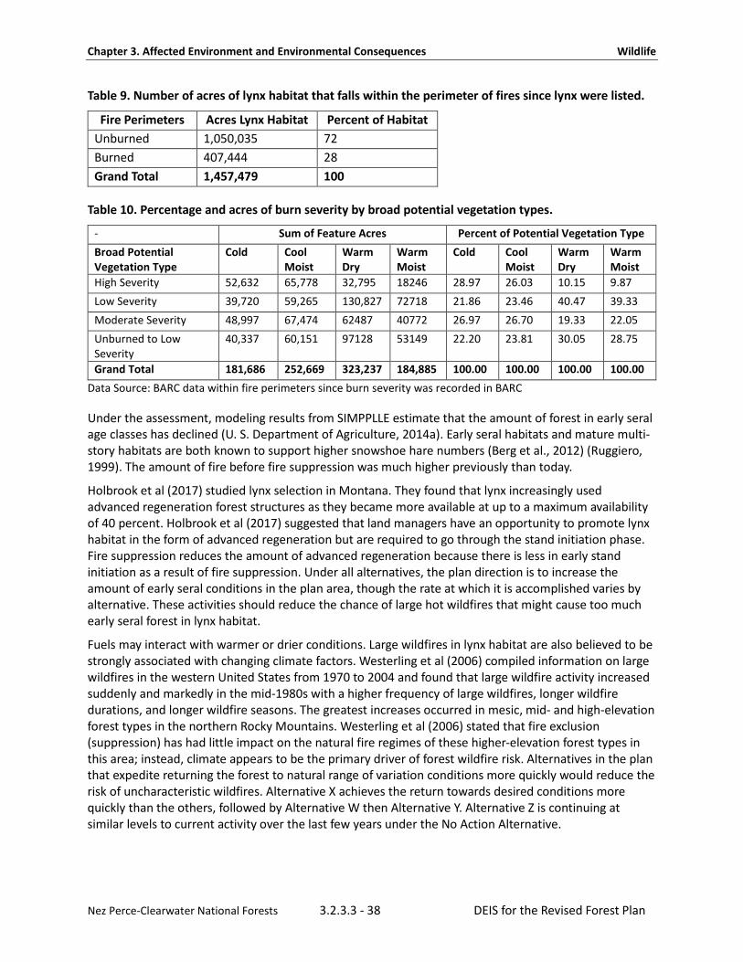
Chapter 3. Affected Environment and Environmental Consequences Wildlife
Nez Perce-Clearwater National Forests 3.2.3.3 - 38 DEIS for the Revised Forest Plan
Table 9. Number of acres of lynx habitat that falls within the perimeter of fires since lynx were listed.
Fire Perimeters Acres Lynx Habitat Percent of Habitat Unburned 1,050,035 72 Burned 407,444 28 Grand Total 1,457,479 100
Table 10. Percentage and acres of burn severity by broad potential vegetation types.
- Sum of Feature Acres Percent of Potential Vegetation Type Broad Potential Vegetation Type
Cold Cool Moist
Warm Dry
Warm Moist
Cold Cool Moist
Warm Dry
Warm Moist
High Severity 52,632 65,778 32,795 18246 28.97 26.03 10.15 9.87 Low Severity 39,720 59,265 130,827 72718 21.86 23.46 40.47 39.33 Moderate Severity 48,997 67,474 62487 40772 26.97 26.70 19.33 22.05 Unburned to Low Severity
40,337 60,151 97128 53149 22.20 23.81 30.05 28.75
Grand Total 181,686 252,669 323,237 184,885 100.00 100.00 100.00 100.00 Data Source: BARC data within fire perimeters since burn severity was recorded in BARC
Under the assessment, modeling results from SIMPPLLE estimate that the amount of forest in early seral age classes has declined (U. S. Department of Agriculture, 2014a). Early seral habitats and mature multi-story habitats are both known to support higher snowshoe hare numbers (Berg et al., 2012) (Ruggiero, 1999). The amount of fire before fire suppression was much higher previously than today.
Holbrook et al (2017) studied lynx selection in Montana. They found that lynx increasingly used advanced regeneration forest structures as they became more available at up to a maximum availability of 40 percent. Holbrook et al (2017) suggested that land managers have an opportunity to promote lynx habitat in the form of advanced regeneration but are required to go through the stand initiation phase. Fire suppression reduces the amount of advanced regeneration because there is less in early stand initiation as a result of fire suppression. Under all alternatives, the plan direction is to increase the amount of early seral conditions in the plan area, though the rate at which it is accomplished varies by alternative. These activities should reduce the chance of large hot wildfires that might cause too much early seral forest in lynx habitat.
Fuels may interact with warmer or drier conditions. Large wildfires in lynx habitat are also believed to be strongly associated with changing climate factors. Westerling et al (2006) compiled information on large wildfires in the western United States from 1970 to 2004 and found that large wildfire activity increased suddenly and markedly in the mid-1980s with a higher frequency of large wildfires, longer wildfire durations, and longer wildfire seasons. The greatest increases occurred in mesic, mid- and high-elevation forest types in the northern Rocky Mountains. Westerling et al (2006) stated that fire exclusion (suppression) has had little impact on the natural fire regimes of these higher-elevation forest types in this area; instead, climate appears to be the primary driver of forest wildfire risk. Alternatives in the plan that expedite returning the forest to natural range of variation conditions more quickly would reduce the risk of uncharacteristic wildfires. Alternative X achieves the return towards desired conditions more quickly than the others, followed by Alternative W then Alternative Y. Alternative Z is continuing at similar levels to current activity over the last few years under the No Action Alternative.

Chapter 3. Affected Environment and Environmental Consequences Wildlife
Nez Perce-Clearwater National Forests 3.2.3.3 - 39 DEIS for the Revised Forest Plan
On all lands, large wildfires in lynx habitat are believed to be strongly associated with changing climate factors. Wildland fires are likely to be actively suppressed to prevent loss of infrastructure and investments on all lands. Wildfires are likely to play a natural role in cumulative effects.
Fuels Reduction Treatments in the Wildland Urban Interface As stated in the Northern Rockies Lynx Management Direction (U.S. Department of Agriculture, 2007b, 2007c) and associated Incidental Take Statement (U.S. Department of Interior, 2012), the wildland urban interface is defined by the Healthy Forests Restoration Act. The U.S. Fish and Wildlife Service’s biological opinion on the Northern Rockies Lynx Management Direction (U.S. Department of Interior, 2007) stated that fuels treatment projects in the wildland urban interface would be exempted from compliance with VEG S1, VEG S2, VEG S5, and VEG S6 under certain conditions designed to protect communities at risk in recognition of the escalating monetary and societal costs associated with fires in the wildland urban interface. For Northern Rockies Lynx Management Direction analysis purposes, the wildland urban interface was modeled in 2007 as a 1-mile buffer surrounding communities with more than 28 people per square mile. Over the entire northern Rocky Mountains’ geographic area analyzed by the U.S. Fish and Wildlife Service, about six percent of lynx habitat was found to be within one-mile of communities. The 2007 Incidental Take Statement, updated in 2017, constrains wildland urban interface exemption treatments to no more than six percent cumulatively of lynx habitat on an individual National Forest. All action alternatives would carry forward the 6 percent exemption for vegetation treatments within the wildland urban interface, which is 44,607 acres for the Clearwater National Forest, for the life of the forest plan. The Nez Perce National Forest was not required to consult on acres of fuels treatment exempt from the vegetation standards found in the Northern Rockies Lynx Management Direction because it was found unoccupied by lynx.
Fuels treatments in the wildland urban interface are anticipated to have adverse effects on lynx and their snowshoe hare prey because the intent would be to maintain lower tree density in these areas, resulting in less area of dense horizontal cover. Reductions in snowshoe hare habitat due to fuels treatments and precommercial thinning could lead to lowered reproduction and survival of lynx. However, adverse effects are limited in their extent and distribution. In its previous biological opinion on the Northern Rockies Lynx Management Direction (U.S. Department of Interior, 2007), the U.S. Fish and Wildlife Service assumed that fuel treatments within the wildland urban interface would not be excessively concentrated in adjacent lynx analysis units because fuel treatment projects may not result in more than three adjacent lynx analysis units exceeding Standard VEG S1. Except to create defensible space, the exceptions may not be used in lynx analysis units that have more than 30 percent in stand initiation structural stage that does not yet provide winter snowshoe hare habitat. These limitations would continue to limit the concentration of impacts to Canada lynx in the future.
The wildland urban interface on the Nez Perce-Clearwater is defined by community protection plans. The Nez Perce-Clearwater has only used very few acres of the exceptions for fuels treatments. The total amount of fuels treatments occurring in lynx habitat amounts to 17,257 acres, which is about 1.18 percent of the lynx habitat in the plan area. Most of these treatments followed guidance in the Northern Rockies Lynx Management Direction and did not use the exceptions for fuels treatments.
Wildland Fire Management As stated in the Northern Rockies Lynx Management Direction, VEG O3 encourages fire use activities that restore ecological processes and maintain or improve lynx habitat. Under guideline VEG G4, prescribed fire activities should not create permanent travel routes that facilitate snow compaction and permanent firebreaks should not be constructed on ridges or saddles. As displayed in the “Affected Environment” section, fire has historically played a substantial role in creating forested landscape patterns on the Nez Perce-Clearwater and fire continues to do so. The Nez Perce-Clearwater has experienced several large

Chapter 3. Affected Environment and Environmental Consequences Wildlife
Nez Perce-Clearwater National Forests 3.2.3.3 - 40 DEIS for the Revised Forest Plan
stand-replacing wildfires since 2000. In the next 15to 25 years, a substantial portion of burned forest is expected to develop sufficient height and density to provide dense horizontal cover of branches at the snow surface to provide snowshoe hare habitat under all alternatives. The plan promotes greater use of wildfire within Management Areas 1 and 2 while wildland fire will continue to be suppressed in Management Area 3 lands. See Section 2.1.6 of the draft revised forest plan for fire management plan components. Natural ecosystem processes, such as wildland fire, would contribute to denning habitat for Canada lynx, as would forestwide plan components for old growth, snags, and downed wood. Fragmentation of Habitat Human-caused alterations of natural landscape patterns can reduce the total area of habitat, increase the isolation of habitat patches, and affect movement between those patches of habitat (Interagency Lynx Biology Team, 2013). Habitat fragmentation may be permanent, such as when converting forest habitat for residential developments or agricultural use, or temporary, such as when creating a forest opening through timber harvest until trees and shrubs regrow. Fragmentation of lynx habitat in the plan area due to anthropogenic developments is very low because the Nez Perce-Clearwater is a large contiguous block of area with much of it managed as wilderness or Idaho Roadless rule areas. The scope of permanent fragmentation is small and the severity is slight. Temporary fragmentation occurs because of departure of historic patterns of vegetation pattern. The amount of departure at a landscape scale is large, but the effect of this departure on fragmentation is probably slight. This could change if fires continue to burn hotter and larger than they did historically.
Changing Climate The Lynx Conservation Assessment and Strategy did not provide management recommendations specific to changing climate, although it did identify several information needs. Possible effects on lynx as a result of future changes in climate have been hypothesized as:
1. Potential upward shifts in elevation or latitudinal distribution of lynx and their prey. 2. Changes in the periodicity of when snowshoe hares change color or loss of snowshoe hare cycles
in the north. 3. Reductions in the amount of lynx habitat and associated lynx population size due to changes in
precipitation, particularly snow suitability and persistence, and changes in the frequency and pattern of disturbance events, such as fire and insect outbreaks.
4. Changes in the demography of lynx, such as survival and reproduction rates. 5. Changes in predator-prey relationships.
There is a high level of uncertainty about some of these hypothesized effects. These effects are not expected to be realized fully within the next 15 years. At most, within the 15-year timeframe of the plan, the severity would probably fall between slight with affects between 0 to 10 percent and moderate with affects between 11 to 30 percent for this threat under the Nature Serve methodology for evaluating threats. Climate change is pervasive in extent in the plan area and may interact with wildfire and wildfire suppression to shift the distribution and amount of lynx habitat over time. Climate change is influencing 100 percent of all lynx habitat in the plan area; thus, the scope is pervasive. Using the moderate severity category estimates, the overall impact from climate change is estimated to be a medium threat by multiplying the pervasive scope times moderate severity. Over longer timeframes, the effects could be much more severe.

Chapter 3. Affected Environment and Environmental Consequences Wildlife
Nez Perce-Clearwater National Forests 3.2.3.3 - 41 DEIS for the Revised Forest Plan
Winter and Summer Recreation Some kinds of recreational activities cause loss of habitat, behavioral responses to human disturbance, or snow compaction. Permanent habitat loss can occur within ski resorts from the clearing of trees for permanent infrastructure. Changes in winter habitat can result from vegetation removal and grooming of ski runs. The plan area does not contain ski resorts. Studies in Colorado of lynx and winter recreators showed that lynx do not avoid winter recreation until it gets more intensive (Olson et al., 2018) and suggests lynx are tolerant of human activities. A variety of behavioral responses may be expected from individual lynx and in different contexts (Interagency Lynx Biology Team, 2013). Recreation can occur across all of the lynx habitat but accessibility limits both the distribution and intensity of recreation and may vary seasonally. Mechanized recreation is disallowed in designated wilderness so recreation must be accessed on foot or horseback. This leaves the scope of this threat overall as large but the severity slight for an overall threat impact of low using the Nature Serve methodology for assessing threats. The alternatives vary in the amount of habitat that is open to motorized recreation. Alternative W has the least amount of lynx habitat in a motorized recreation opportunity spectrum setting at 30 percent. All other alternatives have between 50 to 59 percent open within motorized settings. These amounts are driven primarily by the allocation of recommended wilderness.
Under the No Action Alternative, about 47 percent of the lynx habitat on the Nez Perce-Clearwater is closed to over-snow motorized vehicle use, leaving 53 percent open to winter motorize recreation. Primitive and semi primitive non-motorized are the two categories of the recreation opportunity spectrum that do not allow motorized over-snow travel. Other recreation opportunity spectrum settings are open to motorized over-snow travel. The amount of winter recreation opportunity spectrum settings changes under the alternatives because the alternatives change the amount of recommended wilderness and suitability. The alternatives also vary by the amount of non-conforming uses that are allowed in the recommended wilderness areas. The semi-primitive motorized and non-motorized settings change the most by alternative. Alternative W allows the least over-snow motorized use and Alternatives X and Z have the highest percent of lynx habitat in a motorized setting.
Table 11. Acres of winter recreation opportunity spectrum setting under 1987 Plans for Nez Perce-Clearwater Winter Recreation Opportunity Setting
No Action Alternative
Alternative W Alternative X Alternative Y Alternative Z
Acres Percent Acres Percent Acres Percent Acres Percent Acres Percent
Primitive 581,905 40 581,905 40 581,905 40 581,905 40 581,905 40
Roaded Natural
28,892 2 28,892 2 28,892 2 28,892 2 28,892 2
Semi Primitive Motorized
736,803 51 409,532 28 835,280 57 699,043 48 835,280 57
Semi Primitive Non-Motorized
110,168 8 437,439 30 11,691 1 147,928 10 11,691 1

Chapter 3. Affected Environment and Environmental Consequences Wildlife
Nez Perce-Clearwater National Forests 3.2.3.3 - 42 DEIS for the Revised Forest Plan
Table 12. Acres of lynx habitat within each recreation opportunity spectrum settings for winter and summer recreation.
Summer Recreation Opportunity Spectrum Lynx Habitat
No Action Alternative
Alternative W Alternative X Alternative Y Alternative Z
Primitive 603,547 597,361 597,361 603,547 603,547
Rural 533 533 533 533 533
Roaded Natural 210,473 182,981 210,473 194,495 189,357
Semi-Primitive Motorized 211,934 247,500 427,696 214,004 192,648
Semi-Primitive Non-motorized 431,282 429,394 221,706 445,189 471,683
Table 13. Total amount of lynx habitat in motorized or non-motorized winter recreation opportunity spectrum.
- No Action Alternative
Alternative W Alternative X Alternative Y Alternative Z
Total percent of lynx habitat in non-motorized winter setting (Semi-primitive non-motorize and primitive)
47% 70% 41% 50% 41%
Total percent of lynx habit in winter motorized setting (roaded natural and semi primitive motorized)
53% 30% 59% 50% 59%
As discussed previously, Kolbe et al (2007) found that compacted trails from over-snow motorized vehicles in their study area in western Montana did not promote a competitive interaction between coyotes and lynx.
Although the Nez Perce-Clearwater is closed to lynx trapping, a potential indirect effect of motorized over-snow vehicle use is that it could facilitate access to lynx habitat and increase the vulnerability of lynx to incidental or accidental trapping or illegal shooting. Motorized over-snow vehicles provide access for trapping of other furbearers, which has the potential to increase the risk of incidental trapping of lynx; however, actual occurrences of incidental trapping of a lynx in Idaho is a rare event and usually results in live release. Wilderness areas on the Nez Perce-Clearwater are closed to motorized use and almost 40 percent of the lynx habitat is within wilderness and is largely inaccessible during trapping seasons. Shifting areas suitable for motorized over-snow vehicle use within the Nez Perce-Clearwater would slightly increase the risk of accidental or incidental trapping in some alternatives.
In our plan area, snowmobiling recreation is not intense in most areas because the forested vegetation inhibits this activity in many locations. Thus, over-snow travel is often limited to designated routes and known areas of use.
Chapter 3. Affected Environment and Environmental Consequences Wildlife
Nez Perce-Clearwater National Forests 3.2.3.3 - 43 DEIS for the Revised Forest Plan
To quantify where over-snow motorized uses occur, a combination of known use areas, as identified by user groups, and known groomed routes were used, combined with modeling of landscape factors that promote snowmobile use similar to methods published in Olson et al (2018). Olson et al (2018) used snowmobile use data collected from GPS data from winter recreation users. Those criteria were applied to the landscape to model the probability of snowmobile use base on topography, vegetation, climate, and access to predict where snowmobiling has a higher probability of occurrence. Many areas that do have a high probability of use correspond well to where recreation is known to occur. The primary exception is in areas where groomed trails have been established and use is primarily on those routes based upon modeling results.
The Forest Plan does not make site-specific determinations on snowmobile route grooming or snowmobile recreation areas. Rather, it controls the settings under which those activities may be conducted after a site-specific analysis. Alternatives X and Z would increase the amount of area suitable for over-snow travel by about six percent over the No Action Alternative. Alternative W decreases the percentage of area by 23 percent. Additional snow compaction would occur on some but not all of this acreage because there are portions where tree cover is too dense for snowmobiles to navigate.
Guideline HU G11 of the Northern Rockies Lynx Management Direction states that designated motorized over-snow vehicle routes or designated play areas should not expand outside baseline areas of consistent snow compaction unless designation serves to consolidate use and improve lynx habitat within a lynx analysis unit or a combination of immediately adjacent lynx analysis units. Based on scientific findings on snow compaction, competing predators, and risk of accidental trapping mortality relevant to the Northern Rockies, there would be minimal risk to lynx.
Increased competition from other predators due to snow compaction is a minor concern. As discussed previously, Kolbe et al (2007) found that compacted trails from motorized over-snow vehicles in their study area of western Montana had only minimal impacts on coyote movements and foraging success and that snowshoe hares were an insignificant portion of the winter diet of coyotes, indicating that snow compaction did not promote a competitive interaction between coyotes and lynx. In summary, the level and distribution of winter recreation is not likely to negatively impact the overall lynx population, although there is some risk of injury or mortality to individual lynx.
In vicinities that are already heavily used by motorized over-snow vehicles, there is a potential for the additional suitable areas to result in an increase in the area of consistent snow compaction, as defined by the Northern Rockies Lynx Management Direction. The effects of this increase on Canada lynx are anticipated to be minor based upon scientific findings (Kolbe et al., 2007; John R. Squires et al., 2010; John R. Squires et al., 2013). In addition, not all of the acreage in the added suitable areas would be expected to have an increase in the area of consistent snow compaction because terrain and vegetation influence where motorized over-snow vehicles can physically go. Vegetation conditions are dynamic over time and change in response to disturbance and succession. Wildfire may initially open up dense forests for motorized over-snow vehicle use but areas previously open to motorized over-snow vehicle use become unavailable because the machines cannot physically maneuver between or over the trees as high densities of dead trees fall or as succession occurs.

Chapter 3. Affected Environment and Environmental Consequences Wildlife
Nez Perce-Clearwater National Forests 3.2.3.3 - 44 DEIS for the Revised Forest Plan
Winter Recreation—Developed Ski Areas Downhill ski resorts typically are located at high elevations in areas with coniferous forests and deep snow, which coincides with lynx habitat. There are no ski resorts on Nez Perce-Clearwater lands and none are proposed. As stated in the Northern Rockies Lynx Management Direction, HU O1 discourages the expansion of snow-compacting activities in lynx habitat; HU O2 says to manage recreational activities to maintain lynx habitat and connectivity; HU O3 encourages concentrating activities in existing developed areas; and HU O4 says to provide for lynx habitat needs and connectivity when developing or expanding existing developed recreation sites or ski areas. No standards were adopted because recreational activities were not considered to be a threat to the population of lynx. Two guidelines in the Northern Rockies Lynx Management Direction address ski area development or expansion: HU G1 says that provisions should be made for inter-trail islands that maintain winter snowshoe hare habitat, and HU G2 encourages providing foraging habitat, consistent with the ski area’s operational needs. Guideline HU G3 says that recreation development and operations should be planned to provide for lynx movement and to maintain the effectiveness of lynx habitat.
Mining and Energy Development The Nez Perce-Clearwater has a long history of mineral exploration and development activity. Most of the mining has been oriented around rivers or in hard rock but few of them are open pit mines. Most mine activities on the Clearwater National Forest have been outside of lynx habitat. Mines on the Nez Perce National Forest do extend up into lynx habitat around Elk City and southward along Crooked River. They likely have little effect on lynx habitat and would not affect a transient lynx.
No oil and gas sites have been developed and no foreseeable oil and gas exploration is expected. The geology under the Nez Perce-Clearwater has low potential for oil and gas production. As stated in Forest Plan Appendix 8, HU O5 says to manage human activities, including minerals and oil and gas exploration and development, to reduce impacts to lynx and lynx habitat. Guideline HU G4 encourages remote monitoring of mineral and energy development sites and facilities to reduce snow compaction. Guideline HU G5 addresses development of a reclamation plan to restore lynx habitat when mineral and energy development sites and facilities are closed. HU G12 limits winter access for non-recreation special uses and mineral and energy exploration and development to designated routes or designated over-the-snow routes. The application of these measures is expected to minimize adverse effects on lynx.
Many acres of National Forest System lands on the Nez Perce-Clearwater are withdrawn from mineral entry. Designated wilderness, Idaho Roadless Rule areas, wild and scenic rivers, and research natural areas have withdrawn or restricted mineral exploration.
Withdrawal of large areas of the Nez Perce-Clearwater from mineral development reduces the risk of Canada lynx habitat loss, disturbance, displacement, and mortality. All withdrawals are subject to valid existing rights. The Forest Service does not have the discretion to deny the right to exercise an outstanding mineral right. However, the developer does not have unrestricted rights because the developer’s rights are limited to using only as much of the surface as is reasonably necessary to explore, develop, and transport materials. The developer must provide an operating plan to the Nez Perce-Clearwater. The Nez Perce-Clearwater has some ability to manage surface resources. Forest Service Manual 2832 provides direction for administration of an outstanding mineral rights.
National Forest System and Backcountry Roads On the Nez Perce-Clearwater, the majority of roads occur within the lands managed as general management in Management Area 3 and outside of lynx habitat, as most of the lynx habitat is within Idaho Roadless Rule areas and wilderness where new road construction is prohibited. About 17 percent of lynx habitat occurs within Management Area 3 so most of the effects of back country roads is limited to this area, though some existing roads do separate or are cherry stemmed into Management Areas 1

Chapter 3. Affected Environment and Environmental Consequences Wildlife
Nez Perce-Clearwater National Forests 3.2.3.3 - 45 DEIS for the Revised Forest Plan
and 2. Within Roadless Rule areas, roads travel between roadless areas but are already established. The Forest Plan will not make any specific decisions on roads but establishes the setting governing future proposed roads.
As stated in forest plan Appendix 8, four forest plan guidelines concern National Forest System roads:
HU G6 says to use methods that avoid or reduce effects on lynx when upgrading unpaved roads to Maintenance Levels 4 or 5.
HU G7 discourages building new permanent roads on ridgetops, saddles, or forested stringers or in areas identified as important for lynx habitat connectivity.
HU G8 says that brushcutting along low-speed, low-traffic-volume roads should be done to the minimum level necessary to provide for public safety.
HU G9 says that public motorized use should be restricted on new roads built for projects.
These plan components would continue to limit the potential local impacts of roads on lynx and lynx habitat.
Road construction results in a small reduction of lynx habitat by removing forest cover. On the other hand, if a road is closed, regrowth of dense vegetation may provide good snowshoe hare habitat, and lynx may use the roadbed for travel and foraging (Koehler & Brittell, 1990). Extensive backtracking studies in Montana found that lynx did not avoid gravel forest roads (John R. Squires et al., 2010). Trails are typically narrow routes with a native surface; there is no information to suggest that trails have negative impacts on lynx (Interagency Lynx Biology Team, 2013). Road densities within lynx habitat on the Nez Perce-Clearwater are low because most lynx habitat occurs within roadless and wilderness. Thus, the overall impact is low because of its small scope in lynx habitat and low severity in effects.
Livestock Grazing Little livestock grazing occurs on the Nez Perce-Clearwater. As stated in Forest Plan Appendix 8, four guidelines concern livestock grazing in lynx habitat. Objective GRAZ O1 is to manage livestock grazing to be compatible with improving or maintaining lynx habitat. Guideline GRAZ G1 says to manage livestock grazing in fire- and harvest-created openings so that regeneration of shrubs and trees is not prevented. Under GRAZ G2, livestock grazing in aspen stands should be managed to contribute to the long-term health and sustainability of aspen. Under GRAZ G3, livestock grazing in riparian areas and willow should be managed to contribute to maintaining or achieving a preponderance of mid- or late-seral stages. Under GRAZ G4, livestock grazing in shrub-steppe habitats that are in the elevation ranges of forested lynx habitat in lynx analysis units should be managed to contribute to maintaining or achieving a preponderance of mid- or late-seral stages. With these components in place, the effects of livestock grazing on lynx and lynx habitat were judged to be minimal across the analysis area in the northern Rockies. Livestock allotments are the same under all alternatives. Three allotments are vacant and not currently grazed. Table 14 shows the amount of lynx habitat affected by grazing by allotment. Very little livestock grazing occurs in lynx habitat on the Nez Perce-Clearwater. There would continue to be little or no effects to lynx attributable to livestock grazing. The Allison-Berg Allotment would be unsuitable for sheep grazing in the plan for the conservation of bighorn sheep.
About eight percent of the total lynx habitat overlaps with active livestock allotments. The overall impact from this threat is assessed as low with a small scope and slight severity. Effects to lynx habitat would be negligible in the plan area.

Chapter 3. Affected Environment and Environmental Consequences Wildlife
Nez Perce-Clearwater National Forests 3.2.3.3 - 46 DEIS for the Revised Forest Plan
Table 14. The amount of lynx habitat by allotment.
Allotment Name Active or Vacant?
Acres of Lynx Habitat within Allotment
Allison-Berg Vacant 6,307 Butte Gospel Active 22,310 Fiddle Creek Active 1,243 Florence Vacant 27,682 Hanover Mountain Active 6,386 Hungry Ridge Active 5,067 Mallard Creek Vacant 33,002 Peter Ready Active 13,251 White Bird Creek Active 3,250 Grand Total - 118,497
No existing research indicates that grazing or browsing by domestic livestock on federal lands would reduce the snowshoe hare prey base or have a substantial effect on lynx (Interagency Lynx Biology Team, 2013). However, it is possible that livestock browsing or grazing could reduce the forage and dense horizontal cover needed by snowshoe hares in some environments. Only about eight percent of the lynx habitat in the plan area overlaps with grazing allotments. Not all areas of allotments are grazed and most multistory forest is not grazed because it does not produce enough forage for livestock. Appendix A shows the overlap of lynx habitat and allotment boundaries. This threat is slight at less than 10 percent. The severity is slight and it is not expected to reduce the extent of lynx habitat or reduce lynx populations more than 10 percent.
Mortality Due to Highways and High-Speed Forest Roads Mortalities of lynx due to vehicle collisions have been documented in Colorado (reintroduced animals on paved highways), in Minnesota (on paved highways), in Maine (on high-speed gravel roads), and in Montana (on highways). Collisions are unlikely to occur on National Forest System roads, which are traveled at slower speeds and have lighter traffic volumes than highways. Comparatively, few paved roadways traverse through the Nez Perce-Clearwater. The longest paved roadways include U.S. Highway 12 along the Lochsa River, the Salmon River Road, portions of the Selway River Road, and Highway 14 along the Southfork Clearwater River. Other paved roadways include Highway 8 and Highway 3 through limited portions of the Palouse district and a few other portions of paved roads that end shortly after entering National Forest System lands. Highway 12 and Highway 14 allow traffic speeds between 45 to 50 miles per hour so it may be possible on rare occasions for a lynx to be struck by a moving vehicle on these roads. However, these roads have comparatively low traffic volumes and most of these road miles do not travel through lynx habitat because of their lower elevation. There are no major roadways that travel north to south in the plan area. Few if any lynx are known to have been killed on the paved roads in the plan area. The overall impact from these roads are low because roads on the Nez Perce-Clearwater only travel through a limited portion of the plan area (small scope) and the severity is slight (not expected to impact more than 10 percent of the lynx population) because most paved roads do not travel through lynx habitat and few lynx are expected to be struck on these roads. Perhaps the most significant impact is to lynx habitat connectivity. These roads currently represent only very minor impacts to connectivity.
Chapter 3. Affected Environment and Environmental Consequences Wildlife
Nez Perce-Clearwater National Forests 3.2.3.3 - 47 DEIS for the Revised Forest Plan
Mortality Due to Incidental Trapping or Illegal Shooting of Canada Lynx The Forest Service usually does not regulate trapping activities on National Forest lands and defers to the state on regulations regarding hunting, fishing, and trapping activities by the public. Trapping, snaring, and shooting of lynx is currently prohibited in the contiguous United States. In Idaho, there is no open season for trapping lynx and it has been prohibited since 1996, though the Center for Biological Diversity versus Otter (No. 1: 14-CV-258-BLW) case expressed concerns about incidental trapping of lynx when targeting other fur bearers. If a trapper traps a “non-target” animal such as a lynx, it must be “released immediately” if alive and taken “into possession” if dead (Title 36 Fish and Game, Chapter 11 Protection of Animals and Birds). Idaho has not adopted any laws that limit the types of traps that may be used in lynx habitat. However, incidents of inadvertent trapping of lynx in Idaho has been low. As an example, between January 2012 and February 2014, there were four reported incidental trappings of lynx in Idaho. The Center for Biological Diversity versus Otter (No. 1: 14-CV-258-BLW) case reviewed data stating three of these lynx were released alive while only one was mistaken for another species and killed by a hunter rather than the trap itself. None of the four incidents where lynx were incidentally trapped occurred in the Clearwater Region. Similarly, in Montana, a total of three lynx were captured during the eight license years between 2008 to 2015 and all were released uninjured; overall, lynx “take” during 2000 to 2007 averaged 1.6 per year (Montana Fish Wildlife and Parks, 2016). Most trapping of other furbearer species occurs in winter.
The distribution of legal trapping is influence by the distribution of roads. Save for a few areas, the distribution of roads influences winter travel because forested vegetation makes over-snow travel difficult. About 43 percent of lynx habitat is recommended wilderness, which makes accessibility to trappers more difficult. Wilderness prohibits mechanized travel, including over-snow vehicles. Similarly, Idaho Roadless Rule areas also make accessibility more challenging to trappers because of a lack of roads. So, while the scope of trapping is technically available in all lynx habitats, in reality, because of accessibility, the scope is probably largely limited to less than an estimated 50 percent of lynx habitat leaving the scope using the Nature Serve Methodology. Because lynx trappings are exceedingly rare in Idaho, let alone in the plan area, and lynx mortalities from trapping are also uncommon when lynx are trapped, the severity, or the extent to which lynx populations would be reduced, is estimated as slight. The overall magnitude of this threat is low with a large scope and slight severity. Regulation of trapping is under the authority of the State of Idaho, and the Forest Service only regulates this activity under specific circumstances. The alternatives vary in the amount of recommended wilderness and in whether over-snow travel would be suitable in recommended wilderness. The amount of recommended wilderness and whether over-snow travel is suitable could affect incidental trapping and access during winter. See the discussion below on recommended wilderness.
Consequences from Changes in Management Area Direction Consequences of plan components, other forest wide plan components, and management area direction are the same for all action alternatives, save for variations on snag retention, rate of attainment of desired vegetation conditions, the amount of over-snow motorized travel, differences in the types of non-conforming uses allowed within recommended wilderness areas, summer motorized recreation opportunity spectrum settings, restocking rates, live trees retained per acre, amount of timber production, and whether communication sites are allowed on Pilot Knob. The primary difference in alternatives from a management area perspective is in the mix of recommended wilderness and the amount of lands identified as suitable wild and scenic rivers. These alternatives can be selected individually and can make unique combinations of alternatives when selected. Thus, for each alternative and for each variation in plan component, the effects are analyzed separately because any piece of the alternatives that varies could be selected to make a unique combination.

Chapter 3. Affected Environment and Environmental Consequences Wildlife
Nez Perce-Clearwater National Forests 3.2.3.3 - 48 DEIS for the Revised Forest Plan
Management area allocations provide the on-the-ground framework that guides which allowable uses may occur in a particular area of the Nez Perce-Clearwater. This section characterizes the management areas in Canada lynx habitat and discusses the effects of the resulting management direction on the species.
Under the alternatives, the amount of designated wilderness and Idaho Roadless Rule areas will not change. The Idaho Roadless Rule themes could change if selected as recommended wilderness; otherwise, Roadless Rule themes do not vary by alternative. The Idaho Roadless Rule includes several themes which vary the management activities allowed and the purpose for which those activities may be conducted. All areas under consideration for recommended wilderness under the alternatives fall within Idaho Roadless Rule areas. After the alternatives are selected, and if needed, the Nez Perce-Clearwater will make a recommendation to the Chief of the Forest Service recommending a change in Roadless Rule theme to the wildland recreation theme for any areas identified as recommended wilderness. An Idaho Roadless Rule area theme of wildland recreation is the most restrictive Roadless Rule theme. As Roadless Rule area direction already restricts many activities in all themes, a change to recommended wilderness would result in only slightly more restrictive management and slightly more protections for lynx.
Recommended Wilderness and Nonconforming Uses These plan components and alternatives for the amount of recommended wilderness can be selected individually and can make unique combinations of the amount of recommended wilderness and plan components. Thus, for each alternative and for each variation in plan component, the effects are analyzed separately.
The amount of recommended wilderness varies by alternative. Recommended wilderness under Alternative W contains the most lynx habitat with up to 29 percent of all lynx habitat in the plan area while recommended wilderness under Alternative Z contains no lynx habitat. Table 15 shows the amount of lynx habitat that falls within each alternative. The No Action Alternative currently has nine percent of the total lynx habitat within recommended wilderness. Alternative X would not recommend any wilderness, including areas currently recommended.
Alternatives in recommended wilderness could influence lynx habitat connectivity. Several recommended wilderness areas are identified as linkage areas for lynx (U.S. Department of Agriculture, 2007b, 2007c). In particular, the Hoodoo area, East Meadow Creek, and Sneakfoot areas are identified as linkage areas for lynx. Changes to the Hoodoo recommended wilderness areas in Alternative Y would reduce the amount of linkage area compared to the No Action Alternative. This change would allow snowmobile use in these areas even when this activity is restricted as a non-conforming use. The effects to transient lynx from intensive over-snow travel is unclear. The types of nonconforming uses allowed in recommended wilderness varies by alternative.
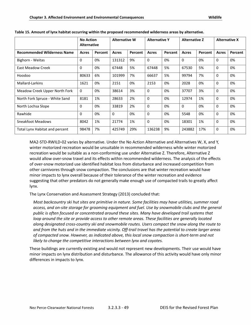
Chapter 3. Affected Environment and Environmental Consequences Wildlife
Nez Perce-Clearwater National Forests 3.2.3.3 - 49 DEIS for the Revised Forest Plan
Table 15. Amount of lynx habitat occurring within the proposed recommended wilderness areas by alternative.
No Action Alternative
Alternative W Alternative Y Alternative Z Alternative X
Recommended Wilderness Name Acres Percent Acres Percent Acres Percent Acres Percent Acres Percent
Bighorn - Weitas 0 0% 131312 9% 0 0% 0 0% 0 0%
East Meadow Creek 0 0% 67448 5% 67448 5% 67530 5% 0 0%
Hoodoo 80633 6% 101999 7% 66637 5% 99794 7% 0 0%
Mallard-Larkins 1621 0% 2151 0% 2153 0% 2028 0% 0 0%
Meadow Creek Upper North Fork 0 0% 38614 3% 0 0% 37707 3% 0 0%
North Fork Spruce - White Sand 8181 1% 28633 2% 0 0% 12974 1% 0 0%
North Lochsa Slope 0 0% 33819 2% 0 0% 0 0% 0 0%
Rawhide 0 0% 0 0% 0 0% 5548 0% 0 0%
Sneakfoot Meadows 8042 1% 21774 1% 0 0% 18301 1% 0 0%
Total Lynx Habitat and percent 98478 7% 425749 29% 136238 9% 243882 17% 0 0%
MA2-STD-RWILD-02 varies by alternative. Under the No Action Alternative and Alternatives W, X, and Y, winter motorized recreation would be unsuitable in recommended wilderness while winter motorized recreation would be suitable as a non-conforming use under Alternative Z. Therefore, Alternative Z would allow over-snow travel and its effects within recommended wilderness. The analysis of the effects of over-snow motorized use identified habitat loss from disturbance and increased competition from other carnivores through snow compaction. The conclusions are that winter recreation would have minor impacts to lynx overall because of their tolerance of the winter recreation and evidence suggesting that other predators do not generally make enough use of compacted trails to greatly affect lynx.
The Lynx Conservation and Assessment Strategy (2013) concluded that:
Most backcountry ski hut sites are primitive in nature. Some facilities may have utilities, summer road access, and on-site storage for grooming equipment and fuel. Use by snowmobile clubs and the general public is often focused or concentrated around these sites. Many have developed trail systems that loop around the site or provide access to other remote areas. These facilities are generally located along designated cross-country ski and snowmobile routes. Users compact the snow along the route to and from the huts and in the immediate vicinity. Off-trail travel has the potential to create larger areas of compacted snow. However, as indicated above, this local snow compaction is short-term and not likely to change the competitive interactions between lynx and coyotes.
These buildings are currently existing and would not represent new developments. Their use would have minor impacts on lynx distribution and disturbance. The allowance of this activity would have only minor differences in impacts to lynx.
Chapter 3. Affected Environment and Environmental Consequences Wildlife
Nez Perce-Clearwater National Forests 3.2.3.3 - 50 DEIS for the Revised Forest Plan
Designated and Eligible Wild and Scenic Rivers (Management Area 1) The amount of suitable wild and scenic rivers varies by alternative. Under the alternatives, most of the wild and scenic rivers either fall outside of lynx habitat because they are lower in elevation or they fall within Idaho Roadless Rule areas, recommended wilderness, or designated wilderness. The Nez Perce-Clearwater has four designated rivers – the Selway, the Lochsa, the Middle Fork Clearwater, and the Salmon River. During forest plan revision, rivers eligible for wild and scenic designation were identified base upon their outstandingly remarkable values. Wild and scenic river segments are classified as wild, scenic, or recreational segments. Timber harvest is not allowable in river segments classified as wild. River segments classified as scenic or recreational are not suitable for timber production but timber harvest may be allowed to meet desired social, economic, or ecological conditions. Wild and scenic river direction for designated rivers is managed as Management Area 1 while those found suitable are managed under Management Area 2 direction. Management direction for both designated and suitable wild and scenic rivers helps to maintain wide forested corridors along major waterways that may facilitate lynx movement through the landscape, providing connectivity. The majority of rivers being considered suitable as wild and scenic rivers under the alternatives and which also occur within lynx habitat are located within Idaho Roadless Rule areas or designated wilderness areas. Thus, most of them have substantial restrictions already. Suitable wild and scenic river direction would apply to these areas in addition to guidance for Idaho Roadless Rule areas and designated wilderness area direction. Lynx are not river dependent so they were not considered a criterion for determining wild and scenic river eligibility. One of the few rivers not within wilderness or roadless areas but within lynx habitat considered under the alternatives is Crooked Fork Creek. It flows through the checker board area of the forest and that area is identified as a linkage area. If this river were identified as suitable, it would enhance connectivity for lynx through this area, at least on National Forest System lands.
National Historic Landmark Most of the Lolo Trail National Historic Landmark lies within lynx habitat. This management area is to be managed consistent with the guidance for with which it was designated. This management area is not suitable for timber production, nor is it suitable for commercial use of non-timber forest products. Vegetation management may be allowed to maintain desired ecological conditions and values. Effects to lynx are largely beneficial.
Research Natural Areas Less than one percent of potential lynx habitat is located within research natural areas under all the alternatives. Research natural areas are generally natural appearing, and human influence on their ecological processes is limited and is guided by the Rocky Mountain Research Station. This management area is not suitable for timber production. Vegetation management may be allowed for study and research purposes or to protect the values for which the research natural area was designated, if needed. Although very limited in their number and size, research natural areas help provide a continuum of security habitat and connectivity for lynx.
Approximately 17 percent of lynx habitat is located within Management Area 3. The amount of area in Management Area 3 varies by alternative. These alternatives are mostly driven by rivers found suitable for wild and scenic river designation under the alternatives. Otherwise, Management Area 3 does not vary by alternative. Management Area 3 is anticipated to have the highest intensity of timber harvest because it is suitable for timber production. Thirteen percent of the lynx habitat forestwide is suitable for timber production while four percent of the lynx habitat forestwide falls within Management Area 3 but is not suitable. Management Area 3 is managed for multiple uses. Road building, recreational development, and both winter and summer motorized travel are generally allowed. The primary disturbance to vegetation is through timber management and fuels reductions. Fires have been
Chapter 3. Affected Environment and Environmental Consequences Wildlife
Nez Perce-Clearwater National Forests 3.2.3.3 - 51 DEIS for the Revised Forest Plan
suppressed to protect the timber resource and this would continue in this management area under the revised plan. In this management area, active management activities, including prescribed fire, timber harvest, fuels reduction, precommercial thinning, commercial thinning, and planting, are most likely to continue to create a mosaic of forest conditions. Much of Management Area 3 is in the wildland urban interface where fuels management is anticipated to be higher. Management Area 3 is where exemptions to the vegetation standards for lynx are most likely to result in short-term adverse effects but long-term benefits to hare habitat by creating a mosaic of successional stages. Recreation is managed to provide a variety of settings, most of which emphasize developed and motorized settings. However, plan components in the Northern Rockies Lynx Management Direction would reduce the effects of these activities in Management Area 3.
Fragmentation of Habitat Many actions that fragment habitat, such as highway expansions and residential developments, are not under the authority of the Forest Service. However, forest plan components under all alternatives are beneficial to Canada lynx by maintaining or improving habitat connectivity on National Forest System lands and would help to reduce or minimize adverse effects. Standard ALL S1 specifies that new or expanded permanent developments and vegetation management projects must maintain habitat connectivity in a lynx analysis unit and/or linkage area. In linkage areas, potential highway crossings will be identified (LINK S1) and Forest Service lands should be retained in public ownership (LINK G1). Guideline ALL G1 says that methods that avoid or reduce effects on lynx should be used when constructing or reconstructing highways or highways across federal land. Guideline HU G6 says that methods to avoid or reduce the effects on lynx in lynx habitat should be used when upgrading unpaved roads to Maintenance Levels 4 or 5 if the result would be increased traffic speeds and volumes or a foreseeable contribution to increases in human activity or development in lynx habitat. Guideline HU G7 states that new permanent roads should not be built on ridgetops or saddles or in areas identified as important for lynx habitat connectivity. New permanent roads and trails should be situated away from forested stringers. LINK O1 encourages working with landowners to pursue conservation easements, habitat conservation plans, land exchanges, or other solutions in mixed ownership areas to reduce the potential of adverse impacts on lynx and lynx habitat. These plan components help to reduce fragmentation of lynx habitat and provide for habitat connectivity. Most lynx linkage areas are composed of at least some designated wilderness or Idaho Roadless Rule areas and these contribute to connectivity for lynx. The primary exception is one linkage area around Lolo Pass that travels through checkerboard ownership. Forest lands within this checkerboard area are composed of lands managed for multiple uses. Forest lands to the northwest of the checkerboard areas are currently recommended wilderness. Designated wilderness, recommended wilderness, and Idaho Roadless Rules areas prevent or inhibit most of the threats that disrupt connectivity for lynx.
Alternatives W, Y and Z identify the East Meadow Creek area as recommended wilderness. Were this area to become recommended wilderness, it would slightly increase protections for lynx connectivity over its current status under the Idaho Roadless Rule wildland recreation theme, as recommended wilderness is slightly more restrictive than wildland recreation direction. The East Meadow Creek area would connect the Frank-Church Wilderness with the Selway-Bitterroot designated wilderness areas which would slightly benefit lynx connectivity.
Chapter 3. Affected Environment and Environmental Consequences Wildlife
Nez Perce-Clearwater National Forests 3.2.3.3 - 52 DEIS for the Revised Forest Plan
The amount of recommended wilderness varies by alternative and may affect linkage areas for lynx. Lynx linkage areas would be enhanced by all alternatives except Alternative X. Alternative Y would reduce protections slightly by shrinking some existing recommended wilderness areas. However, the change would be minor, and perhaps even negligible, because these lands would continue to be Idaho Roadless Rule areas, which have substantial protections from anthropogenic influences that could affect connectivity.
Plan components vary by alternative in what is allowed in recommended wilderness areas. Alternative Z allows over-snow travel. While allowed, over the snow travel is constrained by the Northern Rockies Lynx Management Direction guidelines to disallow new snow compaction areas from baseline amounts. These variations would have limited effects on lynx connectivity because they would not prohibit or disrupt traveling lynx.
In addition to plan components that are common to all alternatives, additional plan components address habitat connectivity and travel corridors. Forestwide plan components for riparian management zones and wildlife support connectivity of lynx habitat by providing for cover conditions that support lynx travel and access to foraging habitats and also provide for distribution of cover across the Nez Perce-Clearwater. Plan components that would apply to summer corridors identified by Squires et al (2013) would also facilitate long-distance movements and potential range shifts.
Guideline FW-GDL-WL-01 states that corridors of mature and mid seral forest with canopy closure greater than 40 percent should be retained and should connect to patches of mature forest in adjacent watershed basins. Considerations for location and width should include topography, elevation, and configuration of riparian areas. These should be retained at the HUC10 scale. This guideline is intended to benefit multiple wildlife species and would benefit lynx.
FW-DC-WL-03 would guide management towards a pattern that would facilitate connectivity for wildlife, such as lynx, and replicate the natural range of variability. It states the arrangement of vegetation patches range widely in size, shape, and structure to provide connectivity for wildlife. Patches are juxtaposed across the landscape forming a landscape pattern consistent with natural range of variation. These patterns vary by habitat type group, slope, aspect, and topographic position. Species are able to move freely across and between habitats, allowing for dispersal, migration genetic interaction, and species recruitment.
Connectivity of mature forest, percent composition of young regenerating forest, low perimeter-area ratio of young regenerating forest patches, and adjacency of mature to young regenerating forest types are important for lynx reproduction and survival at the scale of a lynx home range (Megan Katherine Kosterman, 2014). The perimeter-area ration of young regenerating forest patches is anticipated to be highly variable across the Nez Perce-Clearwater, depending upon whether patches are created by wildfire or by vegetation management activities, such as timber harvest. Plan components for old growth and riparian management zones, integrated with plan components for vegetation management, help to provide for adjacent mature and regenerating forests at the scale of a lynx home range; lynx are likely to travel through such habitat while accessing patches of boreal forest within their home range.
While many actions that fragment habitat, such as highway expansions and residential developments, are not under the authority of the Forest Service, these features are limited in the plan area and no new developments are anticipated within the life of the plan. Plan components in the forest plan are beneficial in maintaining or improving habitat connectivity on National Forest System lands and would help to reduce or minimize adverse effects. Management direction allows for activities to occur to meet social, economic, and multiple-use objectives of the Nez Perce-Clearwater while promoting the recovery of the Canada lynx population.

Chapter 3. Affected Environment and Environmental Consequences Wildlife
Nez Perce-Clearwater National Forests 3.2.3.3 - 53 DEIS for the Revised Forest Plan
Future Changes in Climate The preliminary Northern Region Adaptation Partnership risk assessment for the Canada lynx (McKelvey & Buotte, 2018) states that lynx have little or no adaptive capacity to live in areas lacking snow and limited ability to shift their diet away from snowshoe hares. There is a potential that climate change will reduce the extent of deep snow habitats preferred by lynx. McKelvey et al (2018) estimated that contiguous areas of spring snow cover would become smaller and more isolated throughout the Columbia River Basin with greatest losses at the southern periphery but possible increases in snow at higher elevations in the lynx core, including the Nez Perce-Clearwater. Regardless of snow depth, the timing of snowmelt has been occurring about two weeks earlier in recent decades. Mills and Johnson (Mills & Johnson, 2013) used an ensemble of locally downscaled climate projections and forecasted that the annual average duration of snowpack will decrease by 29 to 35 days by midcentury. Unless snowshoe hares show enough plasticity to adapt to earlier snowmelt, the reduced snow duration will increase the number of days that white hares will be mismatched on a snowless background. This lack of camouflage coloration may make lynx more successful in detecting their primary prey but in the long-term it may also reduce snowshoe hare numbers, especially at relatively lower elevations where snow reductions in the northern Rockies are anticipated to be greatest. McKelvey and Buotte (2018) estimate that the likelihood of future climate change effects is high, with a moderate magnitude of effects by 2030 and a high magnitude of effects by 2050.
Large wildfires in lynx habitat are also believed to be strongly associated with changing climate factors. Westerling et al (Westerling et al., 2006) compiled information on large wildfires in the western United States from 1970 to 2004 and found that large wildfire activity increased suddenly and markedly in the mid-1980s, with higher frequency of large wildfire, longer wildfire durations, and longer wildfire seasons. The greatest increases occurred in mesic, mid- and high-elevation forest types in the northern Rocky Mountains. Westerling et al stated that fire exclusion (suppression) has had little impact on the natural fire regimes of these higher-elevation forest types in this area; instead, climate appears to be the primary driver of forest wildfire risk.
As discussed above, stand-replacing wildfires on the Nez Perce-Clearwater have been the dominant force for creating early stand initiation habitat since lynx were listed. Increases in wildfire may initially create more habitat that is temporarily unsuitable for snowshoe hares and lynx foraging but may greatly increase suitable habitat within a few decades (Vanbianchi, Murphy, & Hodges, 2017). Plan components for fire would allow the Nez Perce-Clearwater to adapt its future management to changing conditions.
Vegetation Management In the past, timber harvest removed all size classes of trees, snags, and downed logs in mixed-species forests containing spruce and subalpine fir, resulting in loss of multistory stands as well as fragmentation of cover.
National Forests in the cumulative effects’ analysis area manage lynx habitat to provide boreal forest landscapes supporting a mosaic of differing successional forest stages and containing the presence of snowshoe hares and their preferred habitat conditions. These Forests follow management direction in the Northern Rockies Lynx Management Direction. During the last decade, timber harvest practices have been more favorable for lynx as a result of forest plan amendments, with fewer acres impacted by temporary loss of multistory stands that provide snowshoe hare and lynx habitat. In fact, less than one percent of the lynx habitat has been manipulated by timber management in the plan area.

Chapter 3. Affected Environment and Environmental Consequences Wildlife
Nez Perce-Clearwater National Forests 3.2.3.3 - 54 DEIS for the Revised Forest Plan
In response to increases in stand-replacing wildfires, fuels reduction programs have increased in recent decades and are expected to continue on managed portions of Forest Service, state, tribal, and private lands within the boundaries of the Nez Perce-Clearwater geographic areas, particularly in the wildland urban interface. Only about 1.18 percent of the lynx habitat in the plan area has been treated with fuels treatments since lynx were listed.
On National Forests in the cumulative effects’ analysis area, the wildland urban interface has vegetation treatments using the exceptions and/or exemptions to the Northern Rockies Lynx Management Direction vegetation standards, which may adversely affect stand initiation or multi-story hare and lynx habitat. On the Clearwater National Forest, the maximum acres of lynx habitat that could be affected by the wildland urban interface exemption is 55,800 acres. Exceptions for precommercial thinning projects for resource benefits are limited to 1930 acres. Combined, the exemptions and exceptions could affect about 3.9 percent of the lynx habitat on the Nez Perce-Clearwater. However, the Nez Perce National Forest did not consult on incidental take because they were considered unoccupied. Thus, the Nez Perce National Forest was not issued exemptions or exceptions for these activities. To date, the level of effects to lynx is substantially lower than that anticipated in the record of decision for the Northern Rockies Lynx Management Direction because the actual amount of treatments on the Clearwater National Forest total only about 15,399 acres under the wildland urban interface exemption (Hanvey, 2017).
The Idaho Department of Lands manages thousands of acres of forested habitats to the west of the Nez Perce-Clearwater, most of which is not lynx habitat because it is too low in elevation. The Idaho Department of Lands does not generally adjust their management for lynx. The Idaho Department of Lands manages their lands for sustainable timber production and in accordance with state law.
Most private lands within the Nez Perce-Clearwater’s geographic area boundaries are at elevations too low to be lynx habitat, but lynx do travel through some of these areas. Large portions of forested lands in Idaho, west and north of the plan area, are managed by Potlatch Deltic Corporation for timber production. Their management may affect lynx habitat and could be characterized as prioritizing timber production. Similar to Idaho Department of Lands, most of the forested areas they manage are too low in elevation to be lynx habitat. Their primary management efforts are to maximize profits from private forestry.
A much smaller amount of the Nez Perce-Clearwater is managed by individuals who own forested lands. These habitats are also lower in elevation and mostly are not lynx habitat. Some of these landowners are clearing vegetation to reduce the risk of wildfire, which may reduce the potential for lynx foraging, although whether lynx would forage in close proximity to human dwellings and dogs is unknown. Fuels treatments in lower montane forests that burned naturally with mixed severity may help to prevent uncharacteristically severe fires from occurring or spreading to lynx habitat at higher elevations.
Fragmentation of Habitat Due to Loss of Cover Although lynx are known to cross openings, Squires et al (2013) found that lynx generally use habitat within about 300 feet of cover. Because cover is altered by wildfire, insects, disease, and actions on other land ownerships, it is difficult to predict when or where these effects to cover would occur.
Fragmentation of Habitat Due to Highways Various studies have documented lynx crossings of highways. Highways pose a risk of direct mortality to lynx. Two-lane or four-lane highways with high traffic volumes or impediments, such as fences on both sides of a highway, may impede lynx movement. According to Alexander et al (Interagency Lynx Biology Team, 2013), traffic volumes between 3,000 and 5,000 vehicles per day may be the threshold above which successful crossings by carnivores are impeded. None of the roads in the plan area have this much traffic. U.S. Highway 12 west of the Nez Perce-Clearwater is a two-lane highway and has much higher
Chapter 3. Affected Environment and Environmental Consequences Wildlife
Nez Perce-Clearwater National Forests 3.2.3.3 - 55 DEIS for the Revised Forest Plan
traffic volumes than those on the Nez Perce-Clearwater and may impede lynx crossings between Kooskia and Lewiston. There are no four-lane highways in the cumulative effects’ analysis area and few roads have enough traffic to affect lynx travel. It is not anticipated that traffic volumes are expected to increase dramatically within the life of the plan.
Connectivity to Canada Connectivity to source populations of lynx in Canada is considered critical to the persistence of populations in most parts of the range in the United States (John R. Squires et al., 2013) (68 FR 40076). While connectivity from Canada has not been evaluated for lynx, other studies have evaluated connectivity hypothetically for 105 species using resistance kernel modeling (Cushman, Landguth, & Flather, 2012). Cushman et al (2012) showed that the Nez Perce-Clearwater is well connected to Canada. While connectivity was high, they found species associated with high elevations and species associated with lower elevations were predicted to have limited extent of connected habitat. Species associated with high elevations were predicted to have the vast majority of their connected habitat protected by federal Forest Service and National Park Service lands. Connectivity from the Nez Perce-Clearwater to Canada is relatively well connected with cover conditions that facilitate lynx travel.
Recreational Activities Scientific evidence to date indicates that most recreational activities pose a low risk of having negative effects on lynx (Interagency Lynx Biology Team, 2013). Within the cumulative effects’ analysis area outside the Nez Perce-Clearwater, there are two ski areas on private lands near the forest. These ski resorts are Snow Haven, south of Grangeville, Idaho, and Bald Mountain, northwest of Orofino, Idaho. Both are small ski areas with very little development at the base. These ski areas are not within lynx habitat so any effects to lynx are minor. There is one ski area on the Kootenai National Forest called Turner Mountain. This is a very small ski area with only one lift and very little development at the base. The ski area affects about 263 acres of lynx habitat, with 164 acres of cleared ski runs and 98 acres of gladed skiing, so any effects to lynx are minor. Additionally, there are approximately five miles of groomed cross-country ski trails in lynx habitat within lynx analysis units and another five miles that are designated for cross-country ski use on the Kootenai National Forest.
Cumulative Effects on Canada Lynx As described previously, the Lynx Conservation Assessment and Strategy (Interagency Lynx Biology Team, 2013) identified four anthropogenic influences as being of greatest concern to the conservation of the lynx: climate change, vegetation management, wildland fire management, and fragmentation of habitat. The lower tier of anthropogenic influences includes recreation, minerals and energy management, forest/backcountry roads and trails, grazing by domestic livestock, and mortality due to incidental trapping or illegal shooting. Although these lower-tier activities could affect individual lynx, they are not expected to have a substantial effect on the overall lynx population and are unlikely to cause cumulative adverse effects. Therefore, they are not discussed in detail. The analysis of cumulative effects considers the previous analysis and decision under the Northern Rockies Lynx Management Direction final environmental impact statement (U.S. Department of Agriculture, 2007b, 2007c).
The cumulative effects analysis area is predominantly National Forest System lands, state managed lands, tribal lands, and private lands. The cumulative effects area for lynx is managed through implementation of a consistent set of forest plan objectives, standards, and guidelines (U.S. Department of Agriculture, 2007b, 2007c). Habitat management on these units, in concert with the Nez Perce-Clearwater, promotes the conservation of lynx.

Chapter 3. Affected Environment and Environmental Consequences Wildlife
Nez Perce-Clearwater National Forests 3.2.3.3 - 56 DEIS for the Revised Forest Plan
Mortality Due to Incidental Trapping or Illegal Shooting of Canada Lynx Trapping and snaring of lynx is currently prohibited across the contiguous United States. Incidental trapping or snaring of lynx is possible in areas where regulated trapping for other species overlaps with lynx habitat (John R. Squires & Laurion, 1999). State wildlife management agencies regulate the trapping of furbearers. On all lands, areas open to motorized over-snow vehicle use occur in lynx habitat, and these areas may have increased risk of incidental trapping of lynx because trapping seasons for other species occur in the winter. However, many areas of lynx habitat have limited accessibility for off-route motorized over-snow vehicle use due to high tree densities and rugged topography. On the Kootenai National Forest, there are approximately 120 miles of groomed motorized over-snow vehicle routes and approximately another 46 miles of designated motorized over-snow vehicle routes in lynx habitat within lynx analysis units. One lynx was reported trapped on the Kootenai National Forest in December 2012 and was released unharmed. Incidental trapping of lynx is a rare event in Idaho and lynx have usually been released alive when it occurs.
Minerals and Energy Exploration and Development On the Kootenai National Forest, no leasable minerals (e.g., oil, gas, coal, geothermal resources, etc.) are being produced. All leases are currently suspended in accordance with the 1985 court decision of Conner v. Burford (848 F. 2d 1441 (9th Cir. 1988)). The Troy copper and silver mine was in operation for over 20 years on the Kootenai National Forest and affects approximately 50 acres on National Forest System lands and an additional 400 acres of private lands. There are no plans of operation or notices of intent to explore or operate any commercial mines in lynx habitat on the Lolo National Forest. The Cotter Basin Mine on the Helena National Forest produced copper and silver in the past. In its biological opinion on the Northern Rockies Lynx Management Direction, the U.S. Fish and Wildlife Service (U.S. Department of Interior, 2007) concluded that the application of the amendment guidelines would result in no or only minor adverse effects to lynx due to minerals and energy development. No adverse cumulative effects are anticipated.
Forest Roads Much of the lynx habitat on the Kootenai, Lolo, and Helena-Lewis and Clark National Forests overlaps with grizzly bear habitat, where road construction and motorized use is constrained. Additionally, the objectives and guidelines related to lynx in the amended forest plans reduce or minimize any potential adverse effects (U.S. Department of Interior, 2007), and no adverse cumulative effects are anticipated.
Livestock Grazing The effects of livestock grazing were anticipated to be minimal under the Northern Rockies Lynx Management Direction (U.S. Department of Interior, 2007) and there is no new information to suggest that this has changed. No adverse cumulative effects are anticipated.

Chapter 3. Affected Environment and Environmental Consequences Wildlife
Nez Perce-Clearwater National Forests 3.2.3.3 - 57 DEIS for the Revised Forest Plan
Wolverine When the Nez Perce-Clearwater’s Assessment was published (U.S. Department of Agriculture, 2014), the U.S. Fish and Wildlife Service had recently published a proposed rule to list the North American wolverine as a threatened distinct population segment in the contiguous United States (U.S. Department of Interior, 2013c). However, on August 13, 2014, the U.S. Fish and Wildlife Service withdrew its previous proposal. On April 14, 2016, the U.S. District Court for the District of Montana Missoula Division remanded the matter to the U.S. Fish and Wildlife Service for further consideration consistent with order CV 14-246-M-DLC (consolidated with case nos.14-247-M-DLC and 14-250-M-DLC) (U.S. Department of Interior, 2014b). The wolverine is now listed as a proposed threatened or endangered species for the Nez Perce-Clearwater, pending a status review by the U.S. Fish and Wildlife Service. The U.S. Fish and Wildlife Service is currently preparing a new species status review to inform its listing determination for the North American wolverine. The species status assessment will incorporate additional information about the species from new studies, as well as new climate modeling results.
The Nez Perce-Clearwater completed a thorough review of scientific information to inform the planning process, develop plan components, and assess consequences of alternatives but some information is incomplete or unavailable. The U.S. Fish and Wildlife Service’s wolverine status review is not yet available. Recent studies include evaluation of the effects of winter recreation on wolverines and preliminary results of multi-state efforts to survey for wolverines with camera traps. Data and information gaps exist, but the breadth and depth of the available scientific information are sufficient to assess potential effects of alternatives.
Wolverines live at low densities and occupy remote areas with persistent snowpack, which they use for denning. Their global distribution is circumpolar, as they occupy the boreal regions on several continents. They rely on small mammals and ungulates as food sources, both scavenging and hunting their prey. Winter food resources influence habitat selection (John Krebs, Lofroth, & Parfitt, 2007) and survival (J. Krebs et al., 2004).
Analysis of the effects of the alternatives on wolverines and their habitat is based upon wolverine habitat models that are designed and updated by researchers. Current wolverine models include persistent spring snow as a factor in modeling habitat suitability, but different models assess and use this factor in different ways. The U.S. Fish and Wildlife Service initially modeled wolverine habitat across the United States in 2013 (U.S. Department of Interior, 2013c), incorporating the work of two groups of scientists(J. P. Copeland et al., 2010; R. Inman et al., 2011). Since that time, Inman (2011) produced a more refined model that delineated areas of the western United States predicted to be maternal wolverine habitat suitable for use by reproductive females, primary wolverine habitat suitable for survival and use by resident adults, female dispersal habitat suitable for relatively brief female dispersal movements, and male dispersal habitat suitable for relatively brief male dispersal movements. This model is based on a resource selection function developed with wolverine telemetry locations from 2001 to 2010 in the Greater Yellowstone Ecosystem of Montana, Idaho, and Wyoming (R. M. Inman et al., 2012). The model by Copeland et al (2010) used satellite data to classify areas of persistent spring snow based upon coarse-scale satellite data collected over a seven-year time period from 2000 to 2006, in which snow cover varied from year to year. This model displayed the number of years out of seven that a GIS pixel was classified as snow. Copeland et al (2010) studied all known wolverine dens in Norway and Sweden, finding that areas with persistent spring snow at least five years out of seven were preferred.

Chapter 3. Affected Environment and Environmental Consequences Wildlife
Nez Perce-Clearwater National Forests 3.2.3.3 - 58 DEIS for the Revised Forest Plan
Wolverine habitat models may be refined in the future as more scientific information becomes available. As Magoun et al (2017) pointed out, “to manage wolverines and their habitat and incorporate persistent spring snow in models of future wolverine habitat, we must understand the relationship of wolverines to snow and measure persistent spring snow at an appropriate resolution and scale that is biologically meaningful for the species.” As summarized by Magoun et al (2017), the spatial and temporal coarseness of the model and analysis by Copeland et al (J. P. Copeland et al., 2010) introduced uncertainty regarding the obligatory nature of the relationship between persistent spring snow through May 15 and wolverine habitat. Magoun et al (2017) stated the “use of snow-covered den sites may not be obligatory through 15 May, or may not be obligatory at the scale in Copeland et al (2010); nevertheless, wolverines may continue to use snow-covered sites as long as they are available.” Magoun et al (2017) discuss that scattered patches of snow that are not detectable by remote sensing techniques at the den-site scale may persist long enough in spring to provide cover for wolverines, even when considering future climates. These authors encouraged more research on the relationship of wolverines to smaller patches of spring snow at the den-site scale to determine if snow is necessary for successful reproduction; if it must be present for the entire denning season; if other structures, such as boulders or down trees, afford protection for wolverine kits near the end of the denning season; if wolverine distribution is tied to factors that have not yet been measured and defined; or if other possible uses of snow are an important component of wolverine habitat.
Snow in wolverine habitat may be affected by changes in climate. For this draft environmental impact statement, the Nez Perce-Clearwater used a compilation of climate change effects published for the Northern Region Adaptation Partnership (Halofsky et al., 2018a, 2018b) that summarizes climate change projections by subregions. Downscaled climate models were used to predict the effects of a changing climate. Future climate uncertainty and anticipated variability is associated with scale. Potential effects of future changes in snow cover and persistence are uncertain or variable due to geographic location, atmospheric circulation patterns, such as the Pacific Decadal Oscillation, and elevation. A study by Webb et al (Webb et al., 2016) found that wolverines in the boreal forest region of northern Alberta were not as closely associated with persistent spring snow as wolverines in the Rocky Mountains and suggested that these two very different habitats should be separated for analysis purposes and for the study of climate change effects.
Methodology and Analysis Process The Nez Perce-Clearwater considered the peer-reviewed models of Copeland et al (2010), as well as Inman et al (IDFG, 2014; 2012), and a composite union of these two models for analysis of alternatives. The composite model from Inman et al (2012) and Copeland et al (2010) was used to assess effects to wolverine habitat. The model by Copeland et al (2010) was used to assess effects to maternal and natal denning habitat, including areas providing persistent spring snow at least five years out of seven on average, referred to as “maternal denning habitat,” throughout the analysis. Maternal denning habitat is a smaller area within primary wolverine habitat, which in turn is within the dispersal habitat modeled by Inman et al (2012). The Idaho Fish and Game adopted a composite union of these two habitat models for their Conservation of Wolverines in Idaho 2014–2019 management plan. This composite model concurs with 87 percent of Idaho Fish and Game’s current dataset of verified wolverine records for Idaho (IDFG, 2014), which is why it was selected for this analysis.

Chapter 3. Affected Environment and Environmental Consequences Wildlife
Nez Perce-Clearwater National Forests 3.2.3.3 - 59 DEIS for the Revised Forest Plan
Spatial and Temporal Analysis The analysis area for indirect effects of the forest plan is the areas of modeled habitat encompassed by the geographic areas of the Nez Perce-Clearwater. Because wolverines are wide-ranging, the analysis of cumulative effects is discussed in the context of the northern Rocky Mountains area.
Affected Environment Population, Life History, and Distribution Wolverines are year-round residents across Alaska and Canada. The southern portion of the species’ range extends into high-elevation alpine portions of Washington, Idaho, Montana, Wyoming, California, and Colorado. Wolverines occur at low densities, range widely, inhabit remote and rugged landscapes away from human populations, and are difficult to detect so conducting research on wolverines is challenging (Idaho Department of Fish and Game, 2014). Wolverine populations in Idaho were heavily trapped in the early 1900s and were near extinction. Wolverine population growth and expansion has been documented in the North Cascades and northern Rocky Mountains (U.S. Department of Interior, 2014a). In Idaho, wolverines have been reported in 34 of 44 counties (77%) and presently occur in most, if not all, historically occupied habitat in Idaho (Idaho Department of Fish and Game, 2014).
The Western Association of Fish and Wildlife Agencies is currently conducting a multi-state occupancy study to address conservation of the wolverine, including restoring, connecting, and monitoring wolverine populations and their habitat in the U.S. Rocky Mountains and Cascade Mountains. Across all four western states participating in the study, wolverines were detected at 59 of 183 state run camera stations (32%) and an additional 34 stations run by federal and non-governmental organization partners using the states’ protocol. In Idaho, wolverines were detected with photographs at 22 of the 60 state-run cameras and 1 of 7 volunteer-run cameras. Three detections of the same individual male were noticed in the Selway Bitterroot Wilderness in the plan area and one detection of a different male was detected on the Lolo National Forest near the Nez Perce-Clearwater boundary. This study ran from December 2016 through March 31, 2017.
A few other studies have been conducted on the Nez Perce-Clearwater that indicate wolverine use. In January through March 2018, a multi-species meso-carnivore survey was conducted throughout the Nez Perce-Clearwater, excluding wilderness and roadless areas. During this survey time, one wolverine was detected at 1 out of 4 camera stations located in modeled wolverine habitat near Lolo Pass. Two other samples of wolverine DNA were collected in 2015 from hair snare samples near the Adam Ranger Station. These samples were not high enough quality to determine sex or individual identities.
The Idaho Species Diversity Database records (accessed January 2019) observations of wolverines and other wildlife in Idaho. In that database, a total of 66 observations of wolverines have been documented throughout the plan area from 1962 to 2015. From 1962 to 2015, observation frequency was relatively steady with an average of 1.2 observations per year with 0 to 11 observations recorded annually. Observations were the result of both incidental observations and targeted surveys and were composed of visual observations, tracks identified as wolverine, individuals in hand, and photographs.
According to the U.S. Fish and Wildlife Service (U.S. Department of Interior, 2014a), “within the area known to currently have wolverine populations, relatively few wolverines can coexist due to their naturally low population densities, even if all areas were occupied at or near carrying capacity. Given the natural limitations on wolverine population density, it is likely that historic wolverine population numbers were also low.”

Chapter 3. Affected Environment and Environmental Consequences Wildlife
Nez Perce-Clearwater National Forests 3.2.3.3 - 60 DEIS for the Revised Forest Plan
Wolverine populations fluctuate in response to prey availability, juvenile dispersal, and mortality of adult females. The U.S. Fish and Wildlife Service stated that the northern Rocky Mountains portion of the North American wolverine distinct population segment is thought to be the largest subpopulation and the most genetically resilient of the current subpopulations within the United States (U.S. Department of Interior, 2014a). Inman et al (2013) estimated the current population, as well as the population capacity for regions of the western United States. The Nez Perce-Clearwater is in the Salmon-Selway region. They estimated that the current population in the Salmon-Selway region is near its capacity and estimated to about 101 individuals out of a capacity of about 105. However, no recent research that would estimate population levels has been conducted for wolverine on the Nez Perce-Clearwater.
The Idaho Fish and Game established wolverine priority conservation areas as a framework for managing wolverines in the State of Idaho. The areas across the state with wolverine habitat were categorized as Tier I, Tier II, or Tier III as a means to prioritize conservation work for wolverines. Nearly all the lands of the Nez Perce-Clearwater were identified as either Tier II or Tier III.
Wolverines are constantly on the move and are known to make long-distance movements that are not impeded by topography or deep snow (Jeffrey P. Copeland & Yates, 2006; John R. Squires, Copeland, Ulizio, Schwartz, & Ruggiero, 2007). Copeland and Yates estimated that adult female wolverines have home ranges averaging 55 square miles. Adult males ranged over an even larger area, with home ranges that averaged 193 square miles (Jeffrey P. Copeland & Yates, 2006). Home range boundaries are dynamic, as are population demographics.
Habitat For wolverine habitat across the western United States, Inman et al (2013) reported that, in general, wolverines are distributed in areas of higher elevation where there is steeper terrain, more snow, fewer roads, and less human activity and in areas closer to high-elevation talus, tree cover, and snow cover persisting to April 1. Year-round habitat includes rocky alpine habitats, glacial cirque basins, and avalanche chutes that provide food sources, such as marmots, voles, and carrion (Jeffrey P. Copeland et al., 2007; Hornocker & Hash, 1981; Robert M. Inman et al., 2007; Magoun & Copeland, 1998). Wolverines appear to rely on the cold and snow to cache carrion (Robert M. Inman, Magoun, Persson, & Mattisson, 2012). Wolverines also travel through the area where snow persists, and they minimize travel through low-elevation habitat (McKelvey et al., 2011). Persistent spring snow cover is also correlated with gene flow because this is where the wolverine’s within-home-range movements and dispersal occur year-round (M. K. Schwartz et al., 2009). The area modeled by Inman et al (2013) as providing primary habitat encompasses much of the higher elevation areas of the Nez Perce-Clearwater; whereas, the area modeled as providing for maternal habitat is much more limited and restricted to only the highest elevations along the Idaho-Montana border, the Gospel-Hump Wilderness, and the Selway-Bitterroot Wilderness.
Magoun and Copeland (Magoun & Copeland, 1998) described two types of reproductive dens: natal dens where young are born and maternal dens where the mother may move the kits if conditions are no longer suitable at the natal den. Sites used for maternal dens are often close to the natal den and have a similar structure. Prior to the Glacier National Park study, not much was known about the den sites of reproductive female wolverines in Montana because den sites are often in remote terrain that is very difficult to study. During the first three years of the study, data was collected for 19 wolverines and information about reproductive dens was obtained for two adult females that raised four offspring (kits). Copeland et al (2010) found that dens were excavated in the snow and were on upper slopes in sparse timber beneath downed woody debris or rocks. Dens are typically used through late April or early May. Females used two to three different dens prior to the weaning of kits at six to seven months of age. Kits gather at rendezvous sites that are primarily in boulder, talus, and cliff areas (J. P. Copeland et al., 2010).
Chapter 3. Affected Environment and Environmental Consequences Wildlife
Nez Perce-Clearwater National Forests 3.2.3.3 - 61 DEIS for the Revised Forest Plan
Survival of young was low, even in the National Park setting where trapping is not allowed and motorized disturbance does not occur in winter or spring. Wolverine den sites may not occur in the same exact spot year after year and specific maternal and/or natal den sites on the Nez Perce-Clearwater are unknown.
Primary wolverine habitat is also characterized by low levels of human development (Jeffrey P. Copeland, 1996; Hornocker & Hash, 1981; John Krebs et al., 2007). This negative association with frequent human presence is sometimes interpreted as active avoidance of human disturbance but it may reflect the wolverine’s preference for cold, snowy, and high-elevation habitat that humans do not often develop. The U.S. Fish and Wildlife Service assessed the effects of a variety of human activities that can affect wolverines and their use of habitat.
The U.S. Fish and Wildlife Service (2013b) stated:
Few effects to wolverines from land management actions such as grazing, timber harvest, and prescribed fire have been documented. Wolverines in British Columbia used recently logged areas in the summer and moose winter ranges for foraging (John Krebs et al., 2007). Males did not appear to be influenced strongly by the presence of roadless areas (John Krebs et al., 2007). In Idaho, wolverines used recently burned areas despite the loss of canopy cover (Jeffrey P. Copeland, 1996)...
Intensive management activities such as timber harvest and prescribed fire do occur in wolverine habitat; however, for the most part, wolverine habitat tends to be located at high elevations and in rugged topography that is unsuitable for intensive timber management...Wolverines are not thought to be dependent on specific vegetation or habitat features that might be manipulated by land management activities, nor is there evidence to suggest that land management activities are a threat to the conservation of the species.
The U.S. Fish and Wildlife Service (2013b) also stated that it is unlikely that wolverines avoid the type of low-use forest roads that generally are found in wolverine habitat. Based on the best available science, the U.S. Fish and Wildlife Service concluded that wolverines do not avoid human development of the types that occur within suitable wolverine habitat and that there is no evidence that wolverine dispersal is affected by infrastructure development.
Krebs et al (2007) modeled male versus female wolverine habitat selection in British Columbia, hypothesizing that food, predation risk, and human disturbance affected habitat selection. Krebs et al (2007) based their model on 39 adult wolverines, 23 females and 16 males, that were located a total of 2,125 times within two study areas. These authors modeled selection in two time periods: winter and non-winter. The winter season was defined as the period when there was persistent snow cover at the treeline. Human use variables incorporated into the models included those associated with winter recreation activity, roads, and timber harvesting. Winter recreation data included estimates of snowmobile primary use sites, locations of runs for two helicopter skiing companies in the Columbia Mountains study area, and backcountry ski use centered on the Trans-Canada Highway corridor within and adjacent to Mount Revelstoke and Glacier National Park. These authors stated that extensive timber harvesting had occurred within a large portion of the study area. Krebs et al (2007) concluded that male wolverines were most closely associated with food availability in both summer and winter. Moose winter ranges, valley bottom forests, and avalanche terrain were positively associated with winter male wolverine use.

Chapter 3. Affected Environment and Environmental Consequences Wildlife
Nez Perce-Clearwater National Forests 3.2.3.3 - 62 DEIS for the Revised Forest Plan
Krebs et al (2007) stated:
Habitat associations of females were more complex; combinations of variables supporting food, predation risk, or human disturbance hypotheses were included in most supported models from both summer and winter in both study areas. Females were associated with alpine and avalanche environments where hoary marmot and Columbia ground squirrel prey are found in summer. Roaded and recently logged areas were negatively associated with female wolverines in summer. In the Columbia Mountains, where winter recreation was widespread, females were negatively associated with helicopter and backcountry skiing. Moose winter ranges within rugged landscapes were positively associated with females during winter. Our analysis suggests wolverines were negatively responding to human disturbance within occupied habitat. The population consequences of these functional habitat relationships will require additional focused research. Our spatially explicit models can be used to support conservation planning for resource extraction and tourism industries operating in landscapes occupied by wolverines.
Recreational Use in Wolverine Habitat The threshold for the amount of human activity that can occur before it affects male and female wolverine habitat selection is unknown. Some scientists have expressed concern about the effects of human activities on female wolverines with young kits during the mid-February to mid-May time period because food resources are scarce for foraging females. As the kits mature, the mother will leave them for longer periods of time to find food but they cannot travel with their mother until the kits are at least 10 weeks old. If a female wants to move kits to a new location, or to another den, she must carry them in her mouth. If the female needs to move the kits very far, the probability of kits dying increases. Reproductive females and kits are at risk of predation (Magoun & Copeland, 1998) and females are most vulnerable to energetic pressures due to the high cost of lactation during this period (John Krebs et al., 2007). The predominant activity in some portions of wolverine habitat during this time period is backcountry recreation.
Winter backcountry recreation opportunities in the northern Rocky Mountains include snowshoeing, snowboarding, skiing, snowcat- or trackster-assisted skiing and snowboarding, snow bikes, and snowmobiling. Studies of winter recreation have produced mixed conclusions. Wolverines have been documented to persist and reproduce in habitats with high levels of human use and disturbance, including developed alpine ski areas and areas with motorized snowmobile use (K. Heinemeyer, 2012; K. Heinemeyer & Squires, 2013). Heinemeyer and Squires (2014) stated “wolverines appear to tolerate winter recreation in their home ranges, including denning females. Based on our preliminary findings, potential wolverine habitats that have even high levels of winter recreation may support resident wolverines despite the potential human disturbance.” This suggests that wolverines can survive and reproduce in areas that experience human use and disturbance; however, there is uncertainty with respect to the amount, type, and timing of human recreational use and its effects on female wolverines. Heinemeyer et al (2017) studied effects of winter recreation on wolverines in the Greater Yellowstone Area. They found that wolverines responded to backcountry winter use in different ways but, given the extent of overlap between winter recreation and wolverine distribution, suggested that wolverines tolerate winter recreation to some degree. In this study, wolverines reacted negatively to higher levels of recreation use in winter, with stronger responses to dispersed use than to use on designated routes, indicating that wolverines may have a higher tolerance for more predictable patterns of winter recreation use. Wolverines reacted to both motorized and nonmotorized winter recreation. However, since motorized equipment allows humans to travel further and faster than nonmotorized means of transport, motorized winter recreation could affect larger proportions of wolverine habitat.

Chapter 3. Affected Environment and Environmental Consequences Wildlife
Nez Perce-Clearwater National Forests 3.2.3.3 - 63 DEIS for the Revised Forest Plan
The Nez Perce-Clearwater has approximately 1.3 to 1.8 million acres of modeled wolverine habitat, depending upon which model is used (U.S. Department of Interior, 2014b). The majority of the modeled habitat occurs in designated wilderness areas or in Idaho Roadless Rule areas. On the Nez Perce-Clearwater, about 727,320 acres of modeled wolverine habitat is in designated wilderness where motorized uses, including snowmobiling, helicopter-assisted skiing or snowboarding, and trackster-assisted skiing or snowboarding, are not allowed. Nonmotorized uses, such as backcountry skiing, are not restricted but it is also difficult to access for nonmotorized winter recreation because much of the wilderness area on the Nez Perce-Clearwater is large and remote. Wilderness areas provide habitat where the risk of human disturbance to wolverines is very low during the time period when females have dependent young. In addition, about 776,922 acres of modeled wolverine habitat is in Idaho Roadless Rule areas where road building is not allowed and timber harvest is restricted. An additional 163,295 acres of modeled wolverine habitat occurs within recommended wilderness under the No Action Alternative. Winter motorized recreation is generally allowed in Idaho Roadless Rule areas but not in recommended wilderness or designated wilderness.
Actual use of this area by winter recreation or winter motorized use is less than where it is allowed because of vegetation characteristics, slope, terrain, and access from passable roads in the winter. Actual winter use was estimated by a combination of information provided by winter motorized user groups, the distribution of groomed routes, and geospatial modeling that estimated the probability of winter recreation use based upon the preferences of winter recreators studied in Colorado (Olson et al., 2017). The winter recreation models were validated with information provided by user groups, knowledge of recreation managers on the forest, and the distribution of groomed routes. These models suggest a much smaller footprint of winter recreation than that currently allowed in areas open to motorized winter recreation. These models were developed for snowmobiles and backcountry skiing but do not predict winter motorized use on machines like snow bikes.
In areas open to motorized over-snow vehicle use, the amount of use has likely increased over the last few decades due to technical advances in motorized over-snow vehicles and human population growth. Backcountry skiing has also increased in popularity.
Connectivity and Wolverine Habitat Cegelski et al (2006) found wolverines in Idaho to have the lowest genetic diversity levels among eight populations evaluated across the Rocky Mountains and high levels of genetic structure. They concluded, despite some evidence of immigration of wolverines from Canada to the United States, Idaho populations were genetically isolated, even from populations in Montana. Overall, wolverines in the northern Rockies exist as small and semi-isolated subpopulations within a larger metapopulation that requires regular dispersal of individuals between habitat patches for maintenance (Aubry, McKelvey, & Copeland, 2007; Robert M. Inman et al., 2013). Inman et al (2013) reported that the United States’ northern Rockies include most of the major core areas, the majority of the current population, and connections to larger populations in Canada. They identified six regions that can likely function as major population cores where primary habitats exist as large blocks of relatively contiguous, publicly-owned lands that include significant portions of designated wilderness or National Parks and are capable of supporting 50 or more wolverines. These are the Northern Cascade, Northern Continental Divide, Salmon-Selway, Greater Yellowstone, southern Rockies, and Sierra-Nevada regions. Maps in Inman et al (2013) suggest the plan area retains high levels of connectivity both within the plan area and to other wolverine regions.

Chapter 3. Affected Environment and Environmental Consequences Wildlife
Nez Perce-Clearwater National Forests 3.2.3.3 - 64 DEIS for the Revised Forest Plan
Inman et al (2013) stated “the greatest potential for wolverine dispersal was concentrated in western Montana and along Montana’s borders with Idaho and Wyoming proximate to this area.” This modeling suggests the Nez Perce-Clearwater provides, and will continue to provide, for connectivity because it is a large contiguous block of publicly owned land that contains high amounts of wilderness and roadless areas. Schwartz et al (2009) mapped wolverine connectivity with least cost path methods. Predicted connectivity was highest in the plan area along the Idaho-Montana border. Schwartz et al (2009) identified the Bitterroot Mountains between Montana and Idaho as a critical artery of gene flow. This area genetically links wolverines of central Idaho to those in the Bob Marshall Wilderness and Glacier National Park in Montana and through them on to Canada. Key Stressors Land Management Few land management activities are thought to affect wolverines. Those thought to have some effects include recreation activities, in particular winter recreation. Wolverines are adaptable and generally tolerant of human recreation activities but there is scientific uncertainty about the types of winter recreation activities and the amount of disturbance that may affect female wolverines with kits. Trapping wolverines has been prohibited in Idaho since about 1965. Fourteen incidentally trapped wolverines have been reported during Idaho furbearer seasons since 1965. Eight of the incidental catches were released alive and six resulted in mortality. From 1965 to 2014, non-target catches accounted for an average of 0.29 wolverines annually with 0.12 wolverine catches resulting in mortality (Idaho Department of Fish and Game, 2014). This count included four wolverines incidentally trapped during the 2013 to 2014 furbearer season. These statewide numbers suggest that incidental trapping of wolverine is rare in Idaho. The effects from incidental trapping are largely outside of Forest Service control, except in regards to how access decisions inadvertently facilitate or impede trapping activities. Highways The Idaho Transportation Department has authority to manage highways on the Nez Perce-Clearwater. Wolverine mortality from collisions with vehicles has occurred in the state but at low levels. Wolverines do not usually come into contact with high-traffic-volume roads, except in those areas where highways cross over mountain ranges, such as major passes. Wolverines killed on roads in valleys between mountain ranges are likely the result of dispersal attempts by wolverines but these appear to be rare occurrences (U.S. Department of Interior, 2013b). Changing Climate The 2013 proposed rule for the North American wolverine identified threats to the long-term persistence of the species. The primary threat, at that time, was determined to be potential changes in climate (U.S. Department of Interior, 2013b), including effects on connectivity of meta-populations. The U.S. Fish and Wildlife Service is currently evaluating potential changes in climate within wolverine habitat based upon more refined models. The effects of climate change are outside Forest Service control, though the forest service has the authority to manage other activities that could affect changing wolverine habitats through time. Key indicators Coarse-filter plan components provide for habitat diversity that benefits wolverines. Key stressors on all lands are discussed in the section on cumulative effects to the wolverine. There are no species-specific plan components proposed in the plan for wolverine. Most of the wolverine habitat already falls within either designated wilderness or Idaho Roadless Rule areas. Alternatives affect the amount of recommended wilderness and the uses allowed within recommended wilderness, which can affect the amount of wolverine habitat that would be affected by a number of activities common on Forest Service

Chapter 3. Affected Environment and Environmental Consequences Wildlife
Nez Perce-Clearwater National Forests 3.2.3.3 - 65 DEIS for the Revised Forest Plan
lands. Thus, a key indicator is the scope of disturbance and the severity of that disturbance by alternative. The scope is determined by the extent to which the amount of wolverine habitat falls within the management areas, recommended wilderness proposed by alternative, and the risk of human disturbance to wolverines from suitability of uses allowed under the alternatives in recommended wilderness, Idaho Roadless Rule areas, and general forest. The severity of the effects is influenced by the severity of these disturbances upon the population or the extent to which it would reduce wolverine habitat. Environmental Consequences Effects Common to All Alternatives All alternatives include plan components designed to maintain or restore diverse, resilient vegetation conditions that would provide for wolverine prey species. As described in the “Affected Environment” section above, research results suggest that wolverines are generally tolerant of human disturbance associated with recreation developments and activities (K. Heinemeyer & Squires, 2014). The thresholds for the amount of development or human recreational use that individual wolverines will tolerate in their home ranges is unknown. With all alternatives, plan components would support key ecosystem characteristics for wolverines because about 39.6 percent of modeled wolverine habitat is in designated wilderness (Table 16) In designated wilderness, the risk of human disturbance is low because motorized uses and mechanized transport, such as snowmobiling, helicopter-assisted skiing or snowboarding, and snow bikes, are not allowed. Non-motorized and non-mechanized transport on the Nez Perce-Clearwater are not restricted but it is difficult to access for nonmotorized and nonmechanized winter recreation because much of the designated wilderness area on the Nez Perce-Clearwater is remote. Table 16. The amount of modeled wolverine habitat in acres within designated wilderness.
Wilderness Name Acres
Frank Church-River of No Return Wilderness 54,449
Gospel-Hump Wilderness 116,713
Selway-Bitterroot Wilderness 556,158
Total 727,320
An additional approximately 42.3 percent of modeled wolverine habitat is within Idaho Roadless Rule areas. The amount of modeled wolverine habitat by Roadless Rule area theme is displayed in Table 17. Idaho Roadless Rule areas restrict some management activities, such as road building and vegetation management. However, winter motorized recreation is allowed in these areas unless they are also recommended wilderness. The extent of the Idaho Roadless Rule areas will not change under the alternatives, the amount of modeled wolverine habitat within these areas will not change, and management activities allowed under the Idaho Roadless Rule will continue to bed protected. The Idaho Roadless Rule area themes are generally not going to change under the alternatives with the exception of areas selected as recommended wilderness. Areas selected as recommended wilderness would be managed under the wildland recreation theme. All recommended wilderness under the alternatives comes from lands currently identified as Idaho Roadless Rule areas.

Chapter 3. Affected Environment and Environmental Consequences Wildlife
Nez Perce-Clearwater National Forests 3.2.3.3 - 66 DEIS for the Revised Forest Plan
Table 17. Acres of modeled wolverine habitat within Idaho Roadless Rule areas by roadless rule area theme.
Idaho Roadless Rule Area Theme Acres of Modeled Wolverine Habitat
Backcountry Restoration 363,573
Forest Plan Special Area 5,847
Primitive 179,216
Special Area of Historic or Tribal Significance 35,686
Wild Land Recreation 192,600
Grand Total 776,922
Summary of Modeled Alternative Consequences To assess the effects of the risk of human disturbance to wolverines, the Nez Perce-Clearwater used a composite model of wolverine habitat that combines Copeland et al (2010) and Inman et al (2013). Modeled habitat encompasses about 1,832,393 acres, or about 46.5 percent, of all acres on the Nez Perce-Clearwater. Table 18 shows the acres of wolverine habitat in recommended wilderness by alternative.
Table 18. The acres of modeled wolverine habitat within recommended wilderness by alternative.
Recommended Wilderness Name No Action
Alternative Alternative W Alternative Y Alternative Z
Bighorn - Weitas - 147,618 - -
East Meadow Creek - 54,337 54,337 54,337
Hoodoo 98,307 127,267 82,796 124,557
Mallard-Larkins 47,565 55,187 55,193 51,795
Meadow Creek - Upper North Fork - 42,396 - 41,240
Moose Mountain - 13,174 - -
North Fork Spruce - White Sand 7,959 17,791 - 7,456
North Lochsa Slope - 50,460 - -
Pot Mountain - - - 19,324
Rapid River - 5,152 5,152 5,152
Rawhide - - - 5,679
Sneakfoot Meadows 9,464 22,068 - 18,327
Grand Total 163,295 535,450 197,478 327,866
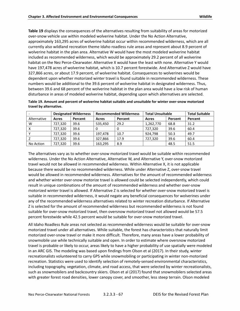
Chapter 3. Affected Environment and Environmental Consequences Wildlife
Nez Perce-Clearwater National Forests 3.2.3.3 - 67 DEIS for the Revised Forest Plan
Table 19 displays the consequences of the alternatives resulting from suitability of areas for motorized over-snow vehicle use within modeled wolverine habitat. Under the No Action Alternative, approximately 163,295 acres of wolverine habitat occur within recommended wilderness, which are all currently also wildland recreation theme Idaho roadless rule areas and represent about 8.9 percent of wolverine habitat in the plan area. Alternative W would have the most modeled wolverine habitat included as recommended wilderness, which would be approximately 29.2 percent of all wolverine habitat on the Nez Perce-Clearwater. Alternative X would have the least with none. Alternative Y would have 197,478 acres of wolverine habitat, which is 10.7 percent forestwide. And Alternative Z would have 327,866 acres, or about 17.9 percent, of wolverine habitat. Consequences to wolverines would be dependent upon whether motorized winter travel is found suitable in recommended wilderness. These numbers would be additional to the 39.6 percent of wolverine habitat in designated wilderness. Thus, between 39.6 and 68 percent of the wolverine habitat in the plan area would have a low risk of human disturbance in areas of modeled wolverine habitat, depending upon which alternatives are selected.
Table 19. Amount and percent of wolverine habitat suitable and unsuitable for winter over-snow motorized travel by alternative.
- Designated Wilderness Recommended Wilderness Total Unsuitable Total Suitable Alternative Acres Percent Acres Percent Acres Percent Percent W 727,320 39.6 535,450 29.2 1,262,770 68.8 31.2 X 727,320 39.6 0 0 727,320 39.6 60.4 Y 727,320 39.6 197,478 10.7 924,798 50.3 49.7 Z 727,320 39.6 327,866 17.9 727,320 39.6 60.4 No Action 727,320 39.6 163,295 8.9 48.5 51.5
The alternatives vary as to whether over-snow motorized travel would be suitable within recommended wilderness. Under the No Action Alternative, Alternative W, and Alternative Y, over-snow motorized travel would not be allowed in recommended wilderness. Within Alternative X, it is not applicable because there would be no recommended wilderness. While under Alternative Z, over-snow travel would be allowed in recommended wilderness. Alternatives for the amount of recommended wilderness and whether winter over-snow motorize travel is allowed could be selected independently, which could result in unique combinations of the amount of recommended wilderness and whether over-snow motorized winter travel is allowed. If Alternative Z is selected for whether over-snow motorized travel is suitable in recommended wilderness, it would negate any beneficial consequences for wolverines under any of the recommended wilderness alternatives related to winter recreation disturbance. If Alternative Z is selected for the amount of recommended wilderness but recommended wilderness is not found suitable for over-snow motorized travel, then oversnow motorized travel not allowed would be 57.5 percent forestwide while 42.5 percent would be suitable for over-snow motorized travel.
All Idaho Roadless Rule areas not selected as recommended wilderness would be suitable for over-snow motorized travel under all alternatives. While suitable, the forest has characteristics that naturally limit motorized over-snow travel or make it more difficult. Therefore, many areas have a lower probability of snowmobile use while technically suitable and open. In order to estimate where oversnow motorized travel is probable or likely to occur, areas likely to have a higher probability of use spatially were modeled in an ARC GIS. The modeling was based upon findings from Olson et al (2017). In their study, winter recreationalists volunteered to carry GPS while snowmobiling or participating in winter non-motorized recreation. Statistics were used to identify selection of remotely-sensed environmental characteristics, including topography, vegetation, climate, and road access, that were selected by winter recreationalists, such as snowmobilers and backcountry skiers. Olson et al (2017) found that snowmobilers selected areas with greater forest road densities, lower canopy cover, and smoother, less steep terrain. Olson modeled

Chapter 3. Affected Environment and Environmental Consequences Wildlife
Nez Perce-Clearwater National Forests 3.2.3.3 - 68 DEIS for the Revised Forest Plan
these areas on the Nez Perce-Clearwater using parameters from her study in Colorado. In order to validate the models, the forest plan revision team met with Forest Service staff who had on-the-ground expertise of where snowmobile use occurs on the forest and used data such as spatial data for groomed routes and roads layers. The forest plan revision team was also provided with information from winter motorized user groups about where their members use areas on the landscape. This information was used to verify whether the models reasonably predict snowmobile recreation in the plan area. The areas with higher probability of use based on spatial data matched up well with use information provided by Forest Service staff and user groups. Many other areas of the Nez Perce-Clearwater had low predicted probability of use because of the higher amounts of canopy cover, steep or broken terrain, or lack of roads. The percent or amount of area with these characteristics represent a much smaller portion of the plan area than where these activities are technically allowed. Areas that had a higher probability of use in modeled wolverine habitat include the Great Burn area near Lolo Pass and some portions of areas near the Gospel-Hump. Most other areas had a low probability of use by snowmobilers. These models do not apply to snow bikes that have an easier time navigating through trees. Alternative W would have the lowest percentage of modeled habitat where motorized over-snow vehicle use would be suitable at about 31 percent. The No Action Alternative maintains the existing percentage, which is about 51.4 percent. Motorized over-snow vehicle use would be suitable on 60.4 percent of modeled maternal habitat under Alternative X and Z. Under Alternative Y, the amount of wolverine habitat suitable for over-snow use would be 49.7 percent. Alternatives for suitable wild and scenic rivers would have environmental consequences that could potentially benefit wolverines. While management in suitable wild and scenic rivers would not be directed towards wolverines, management of suitable rivers could have some indirect beneficial consequences to wolverines as several rivers considered for suitability have wolverine habitat within the river corridor, which is a quarter mile. These protections are present even when the suitable river is within designated wilderness. Table 20 below shows the amount of modeled wolverine habitat within suitable wild and scenic river corridors by alternative. These areas would receive restrictions on dam building, which could flood wolverine habitat and potentially create a barrier to dispersal. Depending upon whether they are classified as wild or scenic, they would receive a level of protection from road and trail construction that could have minor effects on their habitat. Rivers found suitable under Alternative Z would protect about 2.8 percent of wolverine habitat, while Alternative Y would protect 1.2 percent and Alternative W would protect almost 1 percent of wolverine habitat within the river corridors. Alternative X does not propose any suitable wild and scenic rivers. In and of themselves, the area of the river corridors for suitable wild and scenic rivers under the alternatives represent only very small differences overall. The area of wolverine habitat potentially flooded could be much higher than the footprint of the river corridor depending upon the location of the dams if dams were constructed on any of these rivers under the revised plan. While dam construction is unlikely, they would be possible. Rivers found suitable for wild and scenic river designation would be less likely to have dams constructed on them. Most of the rivers considered for suitability lay within Idaho Roadless Rule areas or designated wilderness areas so the protections are only slightly better than the surrounding landscape for wolverine habitat. However, two alternatives have the potential to influence land management in the roaded front. A small portion of Meadow Creek, the upper sections of the North Fork Clearwater River, small sections of Cayuse Creek, and portions of Crooked Fork each have small portions where the potential suitable wild and scenic rivers have wolverine habitat and occur within the managed front. Alternatives that include these rivers or portions of these rivers could provide small acres with increased protection outside of Roadless Rule areas or wilderness areas.
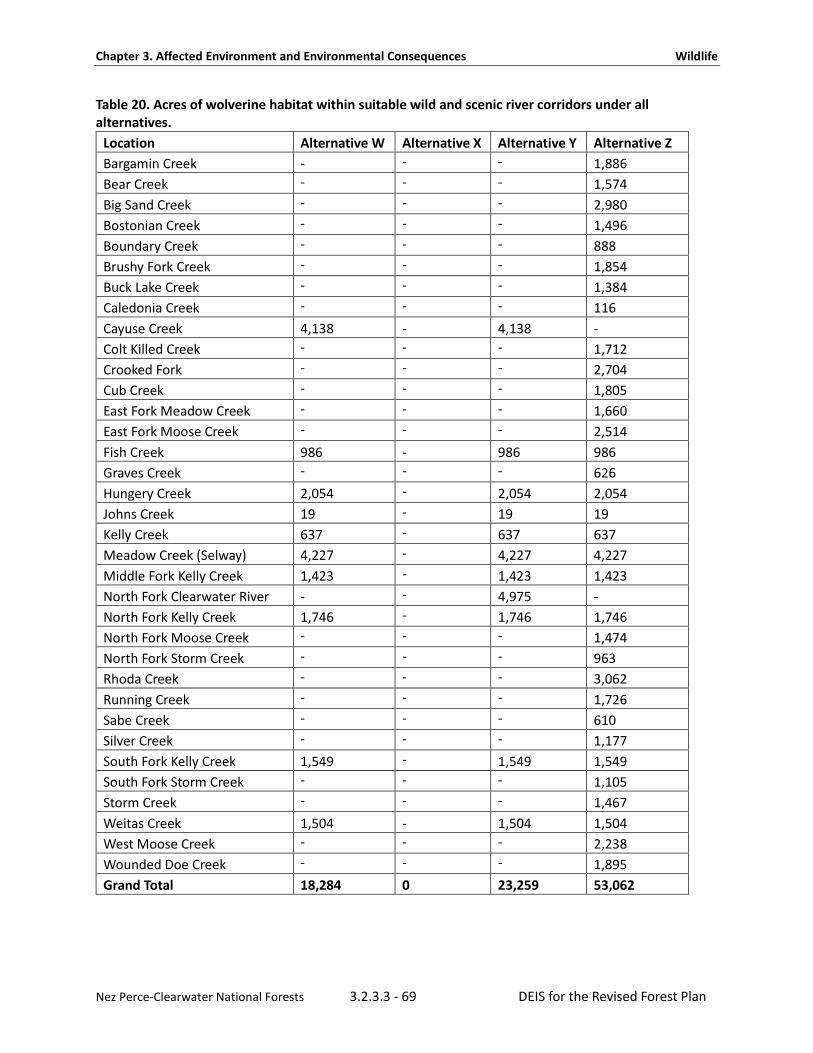
Chapter 3. Affected Environment and Environmental Consequences Wildlife
Nez Perce-Clearwater National Forests 3.2.3.3 - 69 DEIS for the Revised Forest Plan
Table 20. Acres of wolverine habitat within suitable wild and scenic river corridors under all alternatives.
Location Alternative W Alternative X Alternative Y Alternative Z Bargamin Creek - - - 1,886 Bear Creek - - - 1,574 Big Sand Creek - - - 2,980 Bostonian Creek - - - 1,496 Boundary Creek - - - 888 Brushy Fork Creek - - - 1,854 Buck Lake Creek - - - 1,384 Caledonia Creek - - - 116 Cayuse Creek 4,138 - 4,138 - Colt Killed Creek - - - 1,712 Crooked Fork - - - 2,704 Cub Creek - - - 1,805 East Fork Meadow Creek - - - 1,660 East Fork Moose Creek - - - 2,514 Fish Creek 986 - 986 986 Graves Creek - - - 626 Hungery Creek 2,054 - 2,054 2,054 Johns Creek 19 - 19 19 Kelly Creek 637 - 637 637 Meadow Creek (Selway) 4,227 - 4,227 4,227 Middle Fork Kelly Creek 1,423 - 1,423 1,423 North Fork Clearwater River - - 4,975 - North Fork Kelly Creek 1,746 - 1,746 1,746 North Fork Moose Creek - - - 1,474 North Fork Storm Creek - - - 963 Rhoda Creek - - - 3,062 Running Creek - - - 1,726 Sabe Creek - - - 610 Silver Creek - - - 1,177 South Fork Kelly Creek 1,549 - 1,549 1,549 South Fork Storm Creek - - - 1,105 Storm Creek - - - 1,467 Weitas Creek 1,504 - 1,504 1,504 West Moose Creek - - - 2,238 Wounded Doe Creek - - - 1,895 Grand Total 18,284 0 23,259 53,062

Chapter 3. Affected Environment and Environmental Consequences Wildlife
Nez Perce-Clearwater National Forests 3.2.3.3 - 70 DEIS for the Revised Forest Plan
Connectivity Connectivity has been identified as an important facet to wolverine conservation (Idaho Department of Fish and Game, 2014; M. K. Schwartz et al., 2009). The alternatives differ in the extent to which they provide connectivity, primarily stemming from the allocation of recommended wilderness. As noted above, the most important areas for connectivity on the Nez Perce-Clearwater are along the Idaho-Montana border. Other areas that are important for connectivity are along the ridges above the Salmon River between Sabe Creek and MacKay Bar. The area above the Salmon River is already designated wilderness. Those alternatives that propose recommended wilderness lands in these areas would provide more connectivity than those that do not. Recommended wilderness areas that occur along the Idaho-Montana Border include Hoodoo, Meadow Creek Upper North Fork, and Rawhide.
The No Action Alternative, Alternative W, Alternative Y, and Alternative Z all include all, or a portion, of Hoodoo as recommended wilderness; only Alternative X does not. However, the alternatives vary by how much of the Hoodoo area is included as recommended wilderness.
Table 21. Amount of recommended wilderness by alternative that occurs within areas predicted to have high importance to connectivity of wolverines.
Recommended Wilderness Name No Action
Alternative Alternative W Alternative Y Alternative Z
Hoodoo 98,307 127,267 82,796 124,557
Meadow Creek - Upper North Fork - 42,396 - 41,240
Rawhide - - - 5,679
North Fork Spruce - White Sand 7,959 17,791 - 7,456
Sneakfoot Meadows 9,464 22,068 - 18,327
Total by alternative 115,730 209,522 82,796 197,259
Collectively, Alternative W provides the greatest amount of areas important to wolverine connectivity (Idaho Department of Fish and Game, 2014; M. K. Schwartz et al., 2009) under the alternatives while Alternative X provides the least amount with zero. Alternative Z provides just slightly less acres than Alternative W followed by the No Action Alternative. Alternative Y is second to last. These areas also contain some of the areas in the forest that may provide denning habitat for female wolverines.
While recommended wilderness provides the greatest amount of protection of connectivity areas, the management under the Idaho Roadless Rule would still keep these lands relatively free from human development, which is the primary cause of loss of connectivity.
These recommended wilderness areas, combined with designated wilderness areas, include most of the areas in the Nez Perce-Clearwater identified by Schwartz et al (2009) as important to wolverine connectivity, save for the checkerboard area near Lolo Pass. This area appears to be an important connectivity area for lynx, fisher, and wolverine. Desired conditions would apply to decisions about this area as follows: FW-DC-LND-01. Land ownership, rights-of-way, and conservation easements allow the Nez Perce-Clearwater to meet forest plan desired conditions, provide access for recreation, and facilitate restoration and/or conservation of high value resources, including habitat for Species of Conservation Concern and listed fish and wildlife species and significant cultural sites.

Chapter 3. Affected Environment and Environmental Consequences Wildlife
Nez Perce-Clearwater National Forests 3.2.3.3 - 71 DEIS for the Revised Forest Plan
Denning Habitat While modeled wolverine habitat from the composite model predicts wolverine habitat across the landscape, female denning habitat is thought to be much more limited. Protecting denning habitat may be important to the conservation of the wolverine. Copeland et al (2010) modeled female denning habitat based upon female den locations across the global range of the wolverine (J. P. Copeland et al., 2010). The modeled female denning habitat was based upon the amount of persistent spring snow. Copeland et al (2010) produced a model that delineated areas of the western United States predicted to be maternal wolverine habitat, which are areas predicted to be suitable for use by reproductive females. Areas that have persistent spring snow are much more limited and could be important for wolverine denning.
Heinemeyer et al (2017) studied the response of wolverines to winter recreation in in Idaho, Wyoming, and Montana. In that study, wolverines avoided areas of both motorized and non-motorized winter recreation with off-road recreation, eliciting a stronger response than road-based recreation. Female wolverines exhibited stronger avoidance of off-road motorized winter recreation and experienced higher indirect habitat loss than male wolverines. Wolverines showed negative functional responses to the level of recreation exposure within the home range, with female wolverines showing the strongest functional response to motorized winter recreation. Hienemeyer et al (2017) suggested indirect habitat loss, particularly to females, could be of concern in areas with higher recreation levels. They speculated that the potential for backcountry winter recreation to affect wolverines may increase under climate change if reduced snow pack concentrates winter recreationists and wolverines in the remaining areas of persistent snow cover (K. S. Heinemeyer et al., 2017). These findings suggest that the amount of female wolverine denning habitat affected by the alternatives could have meaningful consequences to the conservation of the wolverine on the Nez Perce-Clearwater. The amount of modeled female wolverine denning habitat that falls within recommended wilderness varies by alternative and is displayed in Table 22. Alternative W has the most acres of modeled female wolverine denning habitat, while Alternative X has none and Alternative Z and the No Action Alternative have similar amounts. Alternative Y has the second lowest amount. More modeled female denning habitat in recommended wilderness would better conserve the wolverine because these areas would receive greater protection against development and human disturbances, such as winter recreation.
The Hoodoo recommended wilderness area contributes the most acres of female wolverine habitat and varies by alternative with between 35,727 acres in Alternative W to 18,455 acres in Alternative Y. The Bighorn-Weitas area contains the second largest amount of modeled female wolverine denning habitat at about 6,813 acres with the Mallard-Larkins area a close third. The Mallard-Larkins area varies by alternative with minor changes to the amount of modeled wolverine habitat across the alternatives that range between 6,295 and 6,193 acres (See Table 22).

Chapter 3. Affected Environment and Environmental Consequences Wildlife
Nez Perce-Clearwater National Forests 3.2.3.3 - 72 DEIS for the Revised Forest Plan
Table 22. Amount of modeled female wolverine denning habitat by alternative and recommended wilderness area.
Recommended Wilderness Name No Action Alternative
Alternative W Alternative X Alternative Y Alternative Z
Bighorn - Weitas - 6,813 - - -
Hoodoo 35,038 35,727 - 18,455 35,359
Mallard-Larkins 6,193 6,295 - 6,295 6,279
Meadow Creek - Upper North Fork - 1,065 - - 1,061
Moose Mountain - 2,492 - - -
North Fork Spruce - White Sand 2,379 3,404 - - 847
North Lochsa Slope - 777 - - -
Pot Mountain - - - - 1,646
Rawhide - - - - 685
Sneakfoot Meadows 1,910 2,006 - - 1,851
Totals 45,520 58,580 0 24,750 47,728
No Action Alternative Under the No Action Alternative, the extent to which wolverines are conserved is intermediate to the best alternative for wolverines (Alternative W) and those that provide the least protections (Alternatives X and Z,) with some 48.5 percent of the wolverine habitat not suitable for over-snow motorized travel and 51.5 percent suitable for over-snow motorized travel. The No Action Alternative provides intermediate amounts of recommended wilderness in areas important to wolverine connectivity more than Alternatives X and Y but less than Alternatives W and Z. The No Action Alternative contributes at an intermediate level towards modeled female wolverine denning habitat with 45,520 acres.
Alternative W In terms of the ability to conserve wolverine habitat, Alternative W would provide for the conservation of wolverine more than any other alternative. Areas suitable to over-snow motorized travel would only be on about 31.2 percent of modeled wolverine habitat in the plan area. This alternative would be the best to reduce potential probability of adverse consequences to wolverine habitat use. The amount of recommended wilderness under Alternative W provides the most areas for wolverine connectivity. This alternative also provides the largest acreage that contains modeled female wolverine denning habitat with 58,580 acres, which is a 28.6 percent increase over the No Action Alternative.
Alternative X In comparison with Alternative W, Alternative X would not identify any recommended wilderness. Thus, all roadless rule areas would be suitable for winter motorized travel, resulting in about 60.4 percent of the modeled wolverine habitat on the Nez Perce-Clearwater as suitable for winter motorized recreation while leaving 39.6 percent unsuitable. This alternative, along with Alternative Z, conserves wolverines the least, at least in terms of recommended wilderness and suitable over-snow motorized travel. Alternative X does not have any connectivity areas in recommended wilderness areas.

Chapter 3. Affected Environment and Environmental Consequences Wildlife
Nez Perce-Clearwater National Forests 3.2.3.3 - 73 DEIS for the Revised Forest Plan
Alternative Y Alternative Y is intermediate for wolverine conservation and intermediate to Alternative X and Alternative W with moderate amounts of recommended wilderness closed to motorized travel. Under this alternative, approximately 49.7 percent of modeled wolverine habitat is suitable for oversnow motorized travel and 50.3 percent unsuitable. Alternative Y is modest in the amount of wolverine habitat within recommended wilderness. The amount of modeled female wolverine habitat captured within recommended wilderness under this alternative is modest relative to the other alternatives. This alternative represents a 45.6 percent decrease compared to the No Action Alternative.
Alternative Z While the amount of recommended wilderness under Alternative Z is intermediate to Alternative W and X, the effects on wolverine conservation are more similar to Alternative X because any recommended wilderness would be suitable for over-snow travel under this alternative. Effectively, this would leave 60.4 percent of modeled wolverine habitat as suitable and 39.6 percent as unsuitable; thus, equivalent in terms of conservation of wolverines compared to Alternative X. Alternative Z provides the second most amount of wolverine connectivity in recommended wilderness with only slightly less than Alternative W. Alternative Z is similar but slightly more than the No Action Alternative in the amount of modeled female wolverine denning habitat with about 47,728 acres. While it contains similar acres, the amount of protection this affords female denning habitat is negated by the allowance of winter motorized recreation as a suitable use.
Cumulative Effects Land Management The majority of wolverine habitat is located in higher-elevation areas that are largely designated wilderness, recommended wilderness, and Idaho Roadless Rule areas, or lands that are relatively unavailable for development. Forest plan direction for other National Forests in the northern Rocky Mountains for activities, such as timber harvest, livestock grazing, and motorized use of forest roads and trails, are not expected to negatively affect wolverines or their habitat. Diverse prey items are available for wolverines throughout the cumulative effects’ analysis area so prey should continue to be available. The U.S. Fish and Wildlife Service concurred with the Northern Region determination that management activities commonly conducted on the National Forests would not jeopardize the wolverine.
Lands managed by the State of Idaho and private lands include areas surrounding the Nez Perce-Clearwater on the west. Cumulative adverse effects to the wolverine are not expected as a result of management actions on state lands. Both state and private lands are not generally located in modeled wolverine habitat, though some modeled wolverine habitat exits on these lands.
The Idaho Fish and Game prioritized wolverine conservation in their wolverine conservation plan (Idaho Department of Fish and Game, 2014). They identified areas with wolverine habitat as Tier I, Tier 2, and Tier3, where Tier I receives the highest priority. Most areas on the Nez Perce-Clearwater were identified as Tier II or Tier III areas. They stated that many areas in the state were not ranked as Tier I due to permanent protections provided by wilderness and roadless designations, which limit potential threats. The Idaho management plan for the Conservation of Wolverines in Idaho identifies seven objectives for actions that would help conserve wolverines. These objectives address concerns about threats to wolverines and would not be inconsistent with this plan.

Chapter 3. Affected Environment and Environmental Consequences Wildlife
Nez Perce-Clearwater National Forests 3.2.3.3 - 74 DEIS for the Revised Forest Plan
Highways Collisions are unlikely to occur on National Forest System roads, which are traveled at slower speeds and have lighter traffic volumes than highways. Comparatively few paved roadways traverse through the Nez Perce-Clearwater. The longest paved roadways include Highway 12 along the Lochsa River, the Salmon River Road, portions of the Selway River Road, and Highway 14 along the Southfork Clearwater River. Other paved roadways include Highway 8 and Highway 3 through limited portions of the Palouse District and a few other portions of paved roads that end shortly after entering National Forest lands. Highway 12 and Highway 14 allow traffic speeds between 45 to 50 miles per hour so it may be possible on rare occasions for a wolverine to be struck by a moving vehicle on these roads. Highway 12 crosses through areas of wolverine habitat near Lolo Pass. Other paved roads cross through modeled wolverine habitat for minor stretches, if any. However, these roads have comparatively low traffic volumes and the majority of these road miles do not travel through wolverine habitat because of their lower elevation. There are no major roadways that travel north to south in the plan area. Few if any wolverine are known to have been killed on the paved roads in the plan area. The overall impact from these roads are low because roads in on the Nez Perce-Clearwater only travel through a limited portion of the plan area (small scope) and the severity is slight and not expected to impact more than 10 percent of the wolverine population during the life of the plan because most paved roads do not travel through wolverine habitat and few wolverine are expected to be struck on these roads. Perhaps the most significant impact is to wolverine habitat connectivity where Highway 12 crosses Lolo Pass. These roads currently represent only minor impacts to connectivity because of their limited distribution in wolverine habitat. The Nez Perce-Clearwater is a largely intact block of land with few higher speed roads and provides connectivity and remote locations for wolverines. Squires et al (2007) concluded that wolverine movements are unpredictable and are not easy to incorporate in the planning of structural highway mitigation projects.
Major highways are not abundant in north central Idaho and most of them do not cross through modeled wolverine habitat. In Montana, Highway 93 and I-90 may affect wolverine dispersal and gene flow, as well as developments in western Montana. I-90 may also represent a barrier to connectivity from wolverines in Canada.
Trapping Access during the winter season may indirectly affect the area accessible for trapping. Any cumulative effects to the wolverine resulting from trapping in relation to winter recreation access on the Nez Perce-Clearwater and surrounding lands are not available at this time. However, incidental trapping of wolverines are a rare event in Idaho as evident from data (Idaho Department of Fish and Game, 2014) and, in many cases, the wolverine can be released alive. Some wolverines may cross from the Nez Perce-Clearwater into Montana where wolverine trapping is allowed.
Changing Climate According to the models used in an assessment by McKelvey et al (2011), the Nez Perce-Clearwater, northern Montana, the southern Bitterroot Mountains, and the Greater Yellowstone Ecosystem will retain significant spring snow in the next 50 years; whereas, central Idaho south of the Nez Perce-Clearwater is projected to lose significant spring snow. There are variations in climate models, but models generally indicate earlier snowmelt in the northern Rockies in the future, a pattern that has been ongoing since at least the 1950s. Although wolverines are known to spend the majority of their time at high elevations, the degree to which earlier snowmelt may affect wolverines and the connectivity of metapopulations is uncertain. McKelvey predicted that the geographic extent and connectivity of suitable wolverine habitat in western North America will decline with continued global warming.
Chapter 3. Affected Environment and Environmental Consequences Wildlife
Nez Perce-Clearwater National Forests 3.2.3.3 - 75 DEIS for the Revised Forest Plan
At a regionwide scale, the preliminary Northern Rockies Adaptation Partnership risk assessment for the wolverine (NRAP, 2015) states that there is no evidence that wolverines in the northern Rocky Mountains can persist in areas distant from extensive areas of spring snow, and their adaptive capacity appears to be low. The authors estimated that the magnitude of effects would be low in 2030 and moderate in 2050, with a high likelihood of effects across all time periods. Across the northern Rockies as a whole, losses of current levels of persistent spring snowpack are estimated to be around 30 percent by mid-century (NRAP, 2015). However, it is likely that snow will persist on some slopes and aspects at higher elevations. Due to the low density of wolverine populations, there may continue to be sufficient snow to meet the needs of the population as a whole. There may be microsites important to wolverines, such as mountain cornices, shaded cirque basins, or talus areas that retain snow during most years or retain snow longer into the spring than surrounding areas. McKelvey et al (2011) stated “although wolverine distribution is closely tied to persistent spring snow cover, we do not know how fine-scale changes in snow patterns within wolverine home range may affect population persistence.” The U.S. Fish and Wildlife Service concurred with this finding, stating that “an improved understanding of how microclimatic variation alters the habitat associations of wolverines at fine spatial scales is needed” (U.S. Department of Interior, 2014c).
Wolverines are a highly wide-ranging species. Recent research in Glacier National Park has demonstrated that habitat connectivity from Glacier National Park to Canada currently provides for wolverine movement (Jeffrey P. Copeland & Yates, 2006).
Plan components provide for connectivity of wolverine habitat. The natural range of variation for persistent spring snowpack on the Nez Perce-Clearwater is unknown but variation from year to year is common. High-elevation areas with persistent spring snow at least five years out of seven are more likely to retain snow as the climate changes; whereas, lower-elevation areas that retain persistent spring snow only one year out of seven are more likely to lose snow in the future as the climate changes. The Nez Perce-Clearwater provides over 727,320 acres of habitat available to wolverines that is remote and difficult to access by any means during the time periods when wolverines may be sensitive to disturbance.
The 2012 Planning Rule requires the Nez Perce-Clearwater to determine whether the plan components provide the ecological conditions necessary to conserve proposed and candidate species. Key ecosystem characteristics for the wolverine, a proposed species, include high elevations with persistent spring snow, habitat for dispersal, and features, such as rocky alpine areas, glacial cirque basins, and avalanche chutes, that provide food sources, such as marmots, voles, and ungulate carrion. Maternal and natal denning habitat with relatively low levels of human development are important, although the thresholds are unknown.
The northern Rocky Mountains portion of the North American wolverine distinct population segment is thought to be the largest subpopulation and the most genetically resilient of the current subpopulations (U.S. Department of Interior, 2013a). The Nez Perce-Clearwater does not anticipate substantial changes to wolverine maternal or natal denning habitat over the anticipated life of the plan but, if conditions change in the future, or if research or monitoring indicates there is a need to address specific threats that are within Forest Service authority or capability to manage, the forest plan may be amended or revised in the future if necessary.

Chapter 3. Affected Environment and Environmental Consequences Wildlife
Nez Perce-Clearwater National Forests 3.2.3.3 - 76 DEIS for the Revised Forest Plan
Grizzly Bear Recovery The historical range of the grizzly bear in the continental United States extended from the central Great Plains, west to California, and south to Texas and Mexico. Between 1800 and 1975, grizzly bear populations in the lower 48 states declined from over 50,000 to less than 1,000. As European settlement expanded westward, the grizzly bear was extirpated from most of its historical range (U.S. Department of Interior, 1993).
Five areas in Montana, Wyoming, Idaho, and Washington currently support grizzly bear populations. These areas are the Greater Yellowstone Ecosystem (GYE), Northern Continental Divide Ecosystem (NCDE), Cabinet-Yaak Ecosystem (CYE), Selkirk Ecosystem (SE), and Northern Cascades Ecosystem (NCE). These areas represent a small fraction (less than two percent) of the grizzly bear’s historical range (U.S. Department of Interior, 1993). See Appendix A for a map of the grizzly bear recovery zones.
The Selway-Bitterroot Wilderness and the Frank Church-River of No Return Wilderness make up the core of the Bitterroot Ecosystem Recovery Area for the federally listed threatened grizzly bear. These two wildernesses make up the largest contiguous blocks of federal land remaining in the United States and the largest block of wilderness in the Rocky Mountains. The Bitterroot Ecosystem is currently unoccupied by grizzly bears, but this ecosystem represents one of six grizzly bear recovery zones. Reestablishment of grizzly bear in this recovery zone is currently through natural dispersal.
The grizzly bear recovery plan (U.S. Department of Interior, 1993) identified recovery zones that encompass the above five areas as well as the Bitterroot Ecosystem and the San Juan Ecosystem. The recovery zones, referred to ecosystems in the recovery plan, were delineated to contain a large proportion of federal lands, including wilderness and national park lands that are protected from the influence of many types of human uses and activities occurring on lands elsewhere. Recovery zones are defined as areas that are necessary for the recovery of the species and are to be managed with an emphasis on conserving grizzly bear habitat.
The Bitterroot Ecosystem is approximately 5,500 square miles in size and lies almost entirely within the Selway-Bitterroot Wilderness and the Frank Church-River of No Return Wilderness. Four National Forests have acreage within the Bitterroot Ecosystem – the Bitterroot, Payette, Nez Perce-Clearwater, and Salmon-Challis National Forests. The Bitterroot Ecosystem overlaps with the southeast side of the Nez Perce-Clearwater. On the Nez Perce-Clearwater, the Bitterroot Ecosystem lies almost entirely within the Selway-Bitterroot Designated Wilderness and the Frank Church-River of No Return Wilderness, the only exception is the Magrueder road. About 23.6 percent of the Nez Perce-Clearwater is included within the Bitterroot Ecosystem grizzly bear recovery zone.
Table 23. Acres of Nez Perce-Clearwater inside and outside of the Bitterroot Recovery Zone National Forest Acres Percent
Acres within the Bitterroot recovery zone 933,361 23.6%
Acres outside the Bitterroot recovery zone 3,005,695 76.3%
Total acres 3,939,056 100%
The grizzly bear recovery plan anticipated that grizzly bears can and will exist outside the boundaries of the recovery zones. However, only grizzly bears that reside within the recovery zones are crucial to achieving recovery goals. Inside the recovery zone, it is a priority to manage or conserve grizzly bear habitat while outside the recovery zones that level of emphasis is not necessary.
Chapter 3. Affected Environment and Environmental Consequences Wildlife
Nez Perce-Clearwater National Forests 3.2.3.3 - 77 DEIS for the Revised Forest Plan
It is to be expected that any grizzly bears outside the recovery zones are likely to experience a higher level of adverse impacts and will occur at lower densities than within the recovery zones. That being said, Section 9 of the Endangered Species Act prohibition against “taking” applies irrespective of where the animal occurs, and the areas outside recovery zones can play a significant role in supporting movement of bears between recovery areas. Successful dispersal of bears is important to enable recolonization of vacant habitat; bolster small populations, such as in the Cabinet-Yaak Ecosystem; and provide genetic connectivity for the isolated population in the Greater Yellowstone Ecosystem.
Records of Occurrence and Status of Grizzly Bears on the Nez Perce-Clearwater The grizzly bear is native to and was once common in the Bitterroot Ecosystem of Montana and Idaho (Servheen, 1993b). Members of the Lewis and Clark expedition killed at least seven grizzly bears, including one female and two cubs, while camped near present-day Kamiah, Idaho. Lewis and Clark noted that a major influx of hunters, trappers, and settlers around the turn of the century killed substantial numbers of grizzly bears. Conservative estimates indicate trappers and hunters killed 25 to 40 grizzly bears annually in the Bitterroot Mountains until the early 1900s. Sheepherders killed many more in subsequent decades. Ultimately, the grizzly bear population in this area was lost due to excessive human-caused mortality. The last verified death of a grizzly bear in the Bitterroot Ecosystem was in 1932 and the last verified tracks were documented in the 1940s (Servheen, 1993b). In the past half century, a number of studies, including annual aircraft wildlife surveys by state wildlife personnel, black bear studies, DNA hair snares, and remote camera surveys, have been conducted that were designed to or were likely to have incidentally identified grizzly bear presence in the Bitterroot Ecosystem. However, no grizzly bears were detected by those studies.
In 2007, a male grizzly bear was accidentally shot and killed on the North Fork Ranger District near Kelly Creek by a hunter who mistook the bear for a black bear. This bear was genetically tested and found to be most closely related to bears in the Selkirk Ecosystem. The distance from the nearest boundary of the Selkirk Ecosystem to the spot where this bear was killed is 141 air miles.
Melquist (1985) conducted a survey on the Clearwater National Forest using ground and aerial surveys and grizzly bear observations and compiled 88 reports of grizzly bears between 1900 and 1984. No signs of bears were found during aerial or ground surveys. No verifiable observations were reported. Of the 88 reports, there were 2 confirmed – one from around Grangemont in 1909 and one along Colt Killed Creek near Powell in 1956. However, the 1956 observation was subsequently found to NOT be a grizzly bear. Groves (1987) compiled and reviewed 175 historical grizzly bear reports from central and northern Idaho, including 77 reports on all National Forests except the Sawtooth and Bitterroot from within the Bitterroot Grizzly Bear Recovery Area. Most of the reports (62) came from the Clearwater National Forest. Groves did not document any additional evidence that confirmed any of the reports. Servheen et al (1990) and Kunkel et al (1991) surveyed for grizzly bears during two summers in the Upper North Fork using remote cameras. No photos of grizzly bears were recorded; however, the small area and low camera densities were cited as a reason to caution against confirming the absence of bears. More recently, from 2008 to 2009, Servheen and Shoemaker (2010) conducted a camera and DNA survey of the Bitterroot Mountains. No grizzlies were detected during either the 2008 or 2009 surveys.
The U.S. Fish and Wildlife Service systematically surveyed for grizzly bears throughout the northern Bitterroot Mountains between U.S. Highway 12 in Idaho and Montana Highway 200 and between Missoula, Montana, and Avery, Idaho during 2008 and 2009. Barbed wire DNA hair corrals and remote cameras were deployed. No grizzly bears were detected. A lack of detection is not conclusive evidence that bears were absent; however, to avoid detection, there would have to have been very few individuals occurring at very low densities. The U.S. Fish and Wildlife Service considers the Bitterroot Ecosystem to be unoccupied (U.S. Department of Interior, 2011).

Chapter 3. Affected Environment and Environmental Consequences Wildlife
Nez Perce-Clearwater National Forests 3.2.3.3 - 78 DEIS for the Revised Forest Plan
The Northern Continental Divide Ecosystem population has been expanding its distribution and a few grizzly bears have been documented to move southward recently. There have been a handful of verified grizzly bear observations in the northwest portion of the Bitterroot Valley and in the Sapphire Mountains. In 2002, a grizzly bear was verified on private property on Sunset Bench southeast of Stevensville, Montana. That bear is thought have crossed the Sapphire Range from the Rock Creek drainage. In October of 2018, a young male grizzly bear was trapped at the Whitetail Golf Course east of Stevensville and relocated to the southern end of the Northern Continental Divide Ecosystem. This bear was trapped about 11 miles from the eastern boundary of the Bitterroot Ecosystem.
A two-year-old male augmentation bear was released in the West Cabinet Mountains near Spar Lake on July 21, 2018. An augmentation bear is a bear transplanted into the Cabinet Yaak Ecosystem to increase genetic diversity. Transplanted bears often wander in an attempt to return to where they were from. The bear moved south from the release site and crossed the Clark Fork River. The animal spent much of the summer in this area before moving north back into the West Cabinet Mountains to den for the 2018-2019 winter. The animal emerged in late March and crossed the Clark Fork River, moving south in late April. This bear crossed I-90 on June 4, 2019, and headed south into the Nez Perce-Clearwater into the Mallard-Larkins Pioneer Area. Nearly as soon as he entered into the Nez Perce-Clearwater, he was photographed by game cameras operated by an outfitter and guide who has a permit to guide on the Nez Perce-Clearwater. The outfitter reported the observation to the Idaho Fish and Game and the Forest Service shortly after detecting the bear. This bear continued to move southeast through the plan area and crossed into the Bitterroot Ecosystem near Lolo Pass. A few anecdotes can be inferred from this event. First, the bear was detected quickly after it entered the Nez Perce-Clearwater, suggesting that, if there were other grizzly bears present, they might also be quickly detected on camera traps and bear bait stations. Second, the ability of this bear to cross through the northern half of the Nez Perce-Clearwater and into the Bitterroot Ecosystem suggests that the Nez Perce-Clearwater is relatively permeable at least for male grizzly bears on the move.
The Final Environmental Impact Statement (U.S. Department of Interior, 2000) for the establishment of the Bitterroot Ecosystem defined a population as “…verified evidence within the previous six years, consisting of photos within the area, verified tracks and/or sightings by reputable scientists or agency personnel, of at least two different female grizzly bears with young or one female seen with different litters in two different years in an area geographically distinct from other grizzly bear populations.” Thus, the Bitterroot Ecosystem continues to be considered unoccupied by grizzly bears despite a male grizzly bear traveling into the Bitterroot Ecosystem.
Grizzly Bear Ecology Grizzly bears are large animals that have high metabolic demands during the non-denning season. Adequate nutritional quality and quantity are important factors for successful reproduction. Grizzly bears are omnivorous and use a wide variety of habitats, including meadows, shrublands, and forests from valley bottoms through alpine habitats, to locate food sources. Available food sources vary annually, seasonally, and even day-to-day (Servheen, 1993a). Grizzly bears are dependent upon learned food locations within their home ranges and can switch food habits according to which foods are available (Keith Edward Aune & Kasworm, 1989; Kendall, 1986; Mace & Jonkel, 1986; Servheen, 1983).
Grizzly bears use a wide variety of habitats. Since grizzly bears are generalists with a high variability in diet among individuals, seasons, and years (Keith Edward Aune & Kasworm, 1989; Felicetti et al., 2004; LeFranc Jr., Moss, Patnode, & Sugg III, 1987; David J. Mattson, Blanchard, & Knight, 1991; David J. Mattson, Gillin, Benson, & Knight, 1991; C. C. Schwartz, Miller, & Haroldson, 2003; Servheen, 1981; U.S. Department of Interior, 2013d), they generally have an omnivorous diet (Jacoby et al., 1999; C. C. Schwartz et al., 2003).

Chapter 3. Affected Environment and Environmental Consequences Wildlife
Nez Perce-Clearwater National Forests 3.2.3.3 - 79 DEIS for the Revised Forest Plan
Adult grizzly bears are normally solitary, except females with cubs or during short breeding relationships. They will tolerate other grizzly bears at closer distances when food sources are concentrated, and siblings may associate for several years following weaning from their mother (Egbert and Stokes, 1974). Home ranges of subadult females generally overlap with the maternal home range (Blanchard & Knight, 1991). Males consistently exhibit greater indices of movement and less fidelity to home ranges than females (Blanchard & Knight, 1991).
Home range size varies with the availability of food resources, sex, age, reproductive status, and other factors (Blanchard & Knight, 1991; LeFranc Jr. et al., 1987). Across their range, home range sizes for female grizzly bears are approximately 150 square miles (96,000 acres) (LeFranc Jr. et al., 1987). Females with cubs-of-the-year have the smallest home range sizes (Blanchard & Knight, 1991; Mace & Roberts, 2011). The annual home range of adult male grizzly bears in the lower 48 States is typically 2 to 3 times the size of an adult female’s annual home range (LeFranc Jr. et al., 1987).
Home range sizes are smaller in the Northern Continental Divide Ecosystem than in the Greater Yellowstone Ecosystem. For example, in the Northern Continental Divide Ecosystem, female annual home range size (95 percent isopleth using the fixed kernel method) ranged from an average of about 50 square miles for females with cubs-of-the-year to an average of about 93 square miles for subadult females (Mace & Roberts, 2011). In the Greater Yellowstone Ecosystem, average home range size (using the minimum convex polygon method) was 108 square miles for all adult females and 141 square miles for subadult females (Blanchard & Knight, 1991). Annual home range size for adult males in the Greater Yellowstone study area averaged 337 square miles.
Grizzly bears usually excavate their dens for hibernation in areas that will be covered with a blanket of snow (Craighead & Craighead, 1972). Grizzly bears generally enter their dens from September to November and remain until mid-March or late April (Dood, Atkinson, & Boccadori, 2006). Males typically enter dens later in the fall and emerge earlier in the spring than do females. Both males and females have a tendency to use the same general area for hibernation year after year but the same den is rarely reused by an individual (Linnell, Swenson, Anderson, & Barnes, 2000). In the Northern Continental Divide Ecosystem, most grizzly bear dens were documented at elevations above 6,400 feet in northwestern Montana (Mace & Waller, 1997) with the average elevation somewhat higher on the Rocky Mountain front (Keith E. Aune, 1994). Upon emergence from the den, grizzlies move to lower elevations, drainage bottoms, avalanche chutes, and big game winter ranges to exploit spring food resources.
Historically, grizzly bear populations persisted in landscapes without permanent human presence where the frequency of contact with humans was low (David J. Mattson & Merrill, 2002). Maintaining large blocks of secure habitat is important to the survival and reproductive success of grizzly bears, especially females (Mace, Waller, Manley, Ake, & Wittinger, 1999; C. C. Schwartz, Haroldson, & White, 2010). The most important predictors of survival in the Greater Yellowstone Ecosystem were the amount of secure habitat within a bear’s home range and road densities outside of secure habitat (C. C. Schwartz et al., 2010). In the Northern Continental Divide Ecosystem, human-caused mortality was the most important factor driving grizzly bear survival rates (Mace et al., 2012). The majority of management removals of grizzly bears resulted from human-bear conflicts at sites with frequent or permanent human presence and unsecured attractants, such as garbage, human foods, pet and livestock foods, and orchard fruit.
Numerous studies using various methods have documented that excessive road densities in grizzly bear habitat affects behavior and habitat use and can lower a bears’ survival rate during the non-denning season (Boulanger & Stenhouse, 2014; D. J. Mattson, Herrero, Wright, & Pease, 1996; David J. Mattson, Knight, & Blanchard, 1987; McLellan & Shackelford, 1988; Waller & Mace, 1997). Research has clearly demonstrated that the presence of roads and associated human activities impact grizzly bears during the

Chapter 3. Affected Environment and Environmental Consequences Wildlife
Nez Perce-Clearwater National Forests 3.2.3.3 - 80 DEIS for the Revised Forest Plan
non-denning season by displacing them from important habitats and lowering their survival rates (Boulanger & Stenhouse, 2014; Mace & Waller, 1996; David J. Mattson et al., 1987; McLellan & Shackelford, 1988). Motorized access can affect bears by increasing human interaction and the potential for conflict, displacing bears from important habitats, increasing the chance of habituation to humans, and increasing energetic requirements related to disturbance by humans (U.S. Department of Interior, 2011). The amount and pattern of motorized access in grizzly bear habitat is a stressor that can be influenced by Forest Service management of National Forest System lands.
Boulanger and Stenhouse (Boulanger & Stenhouse, 2014) demonstrated a strong relationship between grizzly bear population trends and the average density of open roads in their analysis of 142 grizzly bears monitored in Alberta from 1999 to 2012. The roads in their study area were almost entirely (96.5 percent) gravel secondary roads associated with settlements and industrial resource extraction activities and were open for public use year-round. There were no motorized trails in their study area. Threshold values for average road densities as related to grizzly bear survival and recovery are summarized in Table 24. The thresholds provide some useful benchmarks for evaluating potential effects of motorized route density on grizzly bears.
Table 24. Threshold values for open road density in Alberta and how they were applied.
Population objective described in the Alberta study
Reported density
Converted to English units How the threshold was applied in this analysis
Grizzly bear presence – most collared bears occurred in areas with road densities of 1.5 km/km2 or less
1.5 km/km2
2.4 mi/mi2 Used to evaluate the ability of an analysis area to provide for bear presence and movement between recovery zones.
Occupancy by females – adult females occupied habitat with road densities of 1.25 km/km2 or less. If lower survival rate of females with dependent young is considered, the threshold of road density that can be tolerated is lower
1.25 km/km2
2.0 mi/mi2 There is no specific goal for occupancy by females in the action area.
Grizzly bear mortality risk – most grizzly bear mortalities occurred at road densities greater than 1.0 km/km2, except for adult males where mortalities occurred across all road densities
1.0 km/km2 1.6 mi/mi2
Used to identify areas with elevated risk of mortality for subadult male and female grizzly bears.
Alberta core conservation area – road density of 0.75 km/km2 or less allows for high enough survival of females with dependent offspring to support an increasing population
0.75 km/km2
1.2 mi/mi2 Road densities of 1.2 mi/mi2 or less will likely sustain a stable to increasing population of grizzly bears. This exceeds the management objective for the action area but provides a benchmark for analysis purposes.

Chapter 3. Affected Environment and Environmental Consequences Wildlife
Nez Perce-Clearwater National Forests 3.2.3.3 - 81 DEIS for the Revised Forest Plan
Existing Conditions and Effects of Proposed Plan Components and Alternatives on Bitterroot Recovery Zone A forest plan provides an integrated plan for land and resource management. There currently are no species-specific plan components for grizzly bears within the proposed plan components and alternatives. While there are no species-specific plan components, nothing in the plan precludes the Nez Perce-Clearwater from contributing to the recovery of grizzly bears. The revised plan will not change the boundaries or characteristics of the Bitterroot Recovery Zone in how it contributes to the recovery of the grizzly bear because it is composed of congressionally designated wilderness, which will not be changing in the revised plan. Thus, the Bitterroot Recovery Zone will continue to provide the ecological conditions necessary to contribute to grizzly bear recovery under all alternatives. Designated wilderness and its associated management direction is the government mechanism that provides the ecological conditions needed to contribute towards the recovery of grizzly bears within the Bitterroot Recovery Zone.
The Bitterroot Recovery Zone within the Nez-Perce Clearwater only has one road, the Magruder Road or FS 468, which passes through about five miles of the recovery zone before it passes into the Bitterroot National Forest. This road is the only road that passes through any of the Bitterroot Recovery Zone in the plan area. No other roads are allowed within designated wilderness areas.
The Bitterroot Recovery Zone on the Nez Perce-Clearwater is largely ungrazed, save for a very small portion of one allotment that overlaps a very small portion of the recovery zone near the Big Mallard Creek trailhead. The allotment is currently vacated and is not currently grazed.
Timber harvest, silviculture treatments, fuels projects, and other vegetation management projects are generally not allowed within designated wilderness areas. The plan components contain some direction to encourage treatment of noxious weeds in wilderness areas. These components and activities would have negligible effects on grizzly bears.
New developed recreation sites are not allowed within designated wilderness. There are a few campgrounds near the boundary of the Bitterroot Recovery Zone. There are two developed recreation camp sites along the Magruder Road, which are on the boundary of the recovery zone near the Frank Church-River of No Return Wilderness. There are two other developed campgrounds near the Selway Bitterroot Wilderness – one near Elk Summit and another near Big Fog Saddle. These developed sites are outside of the recovery zone but near the boundary. Farther away are nine developed campgrounds along the Lochsa River that could potentially attract grizzlies outside of the recovery zone.
New minerals and energy developments are not allowed in designated wilderness. These would continue to be prohibited under the revised plan in the Bitterroot Recovery Zone.
The plan does not have components for the management of food or attractants within the recovery zone. These activities are generally used to direct the public to store food or attractants away from bears. Food storage orders can be implemented by the Forest Supervisor outside of the Forest Plan in a special order if grizzly bears become established within the Bitterroot Ecosystem. Food storage is unnecessary at this time because the Bitterroot Ecosystem is currently unoccupied by grizzly bears.
Essentially the Bitterroot Ecosystem Recovery Zone will continue to provide the ecological conditions to contribute to the recovery of the grizzly bear under all alternatives. However, because grizzly bears must disperse naturally into the Bitterroot Recovery Zone in order to become established, the way the plan provides for connectivity for grizzly bears is a key consideration for how the revised plan will contribute to the recovery of the grizzly bear and is evaluated below.
Chapter 3. Affected Environment and Environmental Consequences Wildlife
Nez Perce-Clearwater National Forests 3.2.3.3 - 82 DEIS for the Revised Forest Plan
Connectivity Dispersal between disjunct populations can play an important role in the persistence of a species by increasing genetic diversity in the receiving population, facilitating colonization and recolonization of unoccupied habitats, and augmenting the numbers of small populations (Hanski & Gilpin, 1997; David J. Mattson & Merrill, 2002). In this section, the effect of the Nez Perce-Clearwater Forest Plan is evaluated in this larger context.
During the establishment of the Bitterroot Recovery Zone, alternatives were considered for how grizzly bears would become established within the Bitterroot Ecosystem. The selected alternative was for dispersal to happen naturally rather than through transplants. The Bitterroot Recovery Zone lies between populations of grizzly bears in other ecosystems. Thus, dispersing bears from one or more of the ecosystems is important to the establishment of bears into the Bitterroot Ecosystem. The plan area contributes to this dispersal from grizzly bear ecosystems north or east of the Nez Perce-Clearwater, namely the North Continental Divide, Cabinet-Yaak, and Selkirk Ecosystems. The Nez Perce-Clearwater would not provide connectivity for grizzly bears between the Greater Yellowstone Ecosystem and Bitterroot Ecosystem, as bears would not travel through the Nez Perce-Clearwater t to get there. However, connectivity for gene flow from the Greater Yellowstone Ecosystem to the Northern Continental Divide, Cabinet-Yaak, and Selkirk Ecosystems would be important to the recovery of the grizzly bear in the Northern Rockies because it would potentially provide gene flow between these ecosystems into the Greater Yellowstone Ecosystem. In order for the Bitterroot Ecosystem to have a population of grizzly bears, female grizzly bears would need to become established. Thus, the ability of the Nez Perce-Clearwater to provide connectivity both into and between the ecosystems for female grizzly bears is a key indicator for this analysis.
Grizzly bears live at relatively low population densities, disperse slowly, and are vulnerable to human-caused mortality. Female grizzly bear dispersal occurs gradually over several years and over short distances (McLellan & Hovey, 2001; Michael F. Proctor, McLellan, Strobeck, & Barclay, 2004; M. F. Proctor et al., 2015). A genetic analysis to estimate dispersal distances in Canada estimated the average dispersal for female grizzly bears was about 8.9 miles and about 26 miles for males away from their natal home ranges (Michael F. Proctor et al., 2004). Another study used radio collared and marked bears to estimate dispersal after family break up (McLellan & Hovey, 2001). McLellan and Hovey (2001) measured the distances between the home range center of a mother and her dispersed offspring over 20 years. Their study looked at 30 offspring, 12 females, and 18 males. This study suggested that female bears dispersed about six miles from their natal home range between one to four years after the family break up. Males in this study dispersed on average 18.5 miles from their natal home range. The farthest distances dispersed were 41.6 miles for males and 12.42 miles by females in this study.
Proctor et al (2012) used genetic data from 3,134 grizzly bears along with radio telemetry location data from 792 grizzly bears across the distribution in western Canada and northern United States to assess large-scale movement patterns and genetic connectivity among bear populations. In the northern more remote portion of their distribution, grizzly bear populations were found to be well connected with movement, dispersal, and gene flow influenced by distance and natural topographic features such as icefields, as would be expected. In contrast, in the southeastern part of their distribution, rates of movement and genetic interchange were impaired. Population fragmentation in these areas was associated with human settlements, highways, and human-caused mortality. Maintaining or improving connectivity is critical for isolated populations, such as the Greater Yellowstone Ecosystem; small populations, such as in the Cabinet-Yaak Ecosystem; and unoccupied areas, such as the Bitterroot Ecosystem. Proctor et al (2012) found that male grizzly bears generally move more frequently and over longer distances than females. The maximum dispersal distances estimated by Proctor et al were about
Chapter 3. Affected Environment and Environmental Consequences Wildlife
Nez Perce-Clearwater National Forests 3.2.3.3 - 83 DEIS for the Revised Forest Plan
47 miles for a female and 104 miles for a male. The distance between the currently occupied areas around the Northern Continental Divide Ecosystem to the Bitterroot Ecosystem are approaching or within the dispersal range of female bears.
Appendix A shows the location of the Bitterroot recovery zone in relation to areas occupied by grizzly bears and the other recovery zones. The nearest areas occupied by grizzly bears are from the Northern Continental Divide Ecosystem population where grizzly bears have become established outside the boundaries of the Northern Continental Divide Ecosystem. The edge of this occupied polygon is about 15 miles from the nearest Bitterroot Ecosystem boundary and about 13.5 miles from the boundary of the Nez Perce-Clearwater at the nearest locations, as measured in ArcGIS. This distance is near the maximum dispersal distance recorded by McLellan and others for female grizzly bears (McLellan & Hovey, 2001). Based upon these distances, the most likely source of female bears to show up in the Bitterroot Ecosystem by natural dispersal may be those from the Northern Continental Divide Ecosystem. Despite the proximity, bears face significant barriers coming from Northern Continental Divide Ecosystem into the Nez Perce-Clearwater because of human development along the I-90 corridor (Servheen, Waller, & Sandstrom, 2003).
The boundary of the Cabinet-Yaak Ecosystem is about 35.8 miles from the northern boundary of the Nez Perce-Clearwater and about 69 miles from the nearest boundary from the Bitterroot Recovery Zone. The Selkirk Ecosystem is about 86.9 miles from the nearest Nez Perce-Clearwater boundary and 172 miles from the nearest Bitterroot Ecosystem boundary, as measured in ArcGIS. However, the incidences noted above from male bears that were observed in or near the Nez Perce-Clearwater have come from the Cabinet-Yaak (2019), Selkirk (2007), and Northern Continental Divide Ecosystem (2018) populations.
Table 25. Distance between Nez Perce-Clearwater and Bitterroot Ecosystem Recovery Zone from areas occupied by grizzly bears.
The majority of the area of the Nez Perce-Clearwater north of the Bitterroot Ecosystem boundaries are composed of either recommended wilderness or Idaho Roadless Rule areas. Provided a grizzly bear advances into the Nez Perce-Clearwater, these areas provide low road densities and allow for connectivity to the Bitterroot Ecosystem. In the figure below, the areas that are managed as general forest are the checker board areas near Lolo Pass comprising Forest Service and private lands, the area around Deception Point southwest of Hoodoo Pass, and the areas south of the Mallard Larkin area. These areas have higher road densities and may not be as suitable for dispersing bears. Grizzly bears that enter the Nez Perce-Clearwater from the north or east would most likely enter into recommended wilderness or Idaho Roadless Rule areas. See Appendix A for a map of the Bitterroot Ecosystem in relation to the Nez Perce-Clearwater management areas composed of Idaho Roadless Rule areas and wilderness areas.
Grizzly Bear Recovery Zone or Ecosystem
Distance in miles from the Nez Perce-Clearwater boundary to nearest area occupied by grizzly bears
Distance in miles from the Bitterroot Ecosystem Boundary from nearest area occupied by grizzly bears
North Continental Divide Ecosystem 13.5 15
Selkirk Ecosystem 86.9 172
Cabinet-Yaak Ecosystem 35.8 69
Chapter 3. Affected Environment and Environmental Consequences Wildlife
Nez Perce-Clearwater National Forests 3.2.3.3 - 84 DEIS for the Revised Forest Plan
The Nez Perce-Clearwater is bordered on the north, east, and south by other Forest Service lands. Few Forest Service activities disrupt animal movements across the landscape. The landscape feature most important to the disruption of connectivity for grizzly bears is the road system.
To assess the effects on grizzly bears within the Nez Perce-Clearwater, the road densities within two HUC08’s that cover the majority of the northern portion of the Nez Perce-Clearwater were assessed - – the Upper North Fork Clearwater HUC08 and the Lochsa HUC08. See Appendix A for a map. Open motorized routes, such as National Forest System roads, county roads, state highways, U.S. highways, and motorized trails, that exist within the Nez Perce-Clearwater were identified using the Nez Perce-Clearwater’s Geographic Information System (GIS). The Nez Perce-Clearwater used the “select by location” tool to select roads in GIS within these two watersheds and then the miles of road were calculated from this selection. Road densities were calculated by dividing the miles of road by the square miles of area within the two HUC08’s. This analysis was conducted in the area north of the Bitterroot Recovery Zone within two HUC08’s that cover the most likely areas where grizzly bears could enter the Nez Perce-Clearwater based upon proximity to other grizzly bear recovery zones. The miles of motorized routes open to the public either yearlong or seasonally during the non-denning season were included in the analysis. Roads receiving only administrative use or that are closed were excluded from the analysis because the use is infrequent and there is no associated risk of human-caused mortality. These types of analysis are usually conducted within bear analysis units but there are no bear analysis units delineated on the Nez Perce-Clearwater because grizzly bears are not known to occur at this time.
The open road density within these two HUC08’s overall was about 0.96, with the North Fork Clearwater HUC08 at 1.06 miles per square mile and about 0.86 miles per square mile in the Lochsa HUC08. These numbers slightly overestimate road densities in these HUC’s because the “select by location” tool selected some road segments that actually fall outside of these two HUC08’s.
Roads are concentrated within certain areas within these watersheds. Areas managed as general forest had higher road densities than this but in broad areas of this landscape the road densities were much lower. Areas with higher road densities within these watersheds are also the areas where grizzly bear connectivity is not emphasized. The road densities through these two watersheds are less than those published by Boulanger et al (Boulanger & Stenhouse, 2014) that serve as core areas for grizzly bears. This analysis suggests that, currently, road densities at this scale are such that they should not prevent grizzly bear females from connecting to the Bitterroot Ecosystem. Note that the use of motorized wheeled vehicles off of existing designated roads and trails is not permitted on the Clearwater portion of the National Forest, except for travel to dispersed campsites within 300 feet of an open route (USDA, 2017). Roads and trails closed to public motorized use remain available to Forest Service personnel for administrative purposes, including wildfire suppression, search and rescue, medical emergencies, permit administration, data collection, noxious weed treatments, general management, and other activities (USDA, 2017).

Chapter 3. Affected Environment and Environmental Consequences Wildlife
Nez Perce-Clearwater National Forests 3.2.3.3 - 85 DEIS for the Revised Forest Plan
Figure 1. Bitterroot Ecosystem and Lochsa and North Fork Clearwater HUC08's used in road analysis for road density.
Bitterroot Ecosystem = bright green
Watersheds used for road density analysis = pale green
Areas in Management Area 3 within these watersheds have motorized route densities that are higher locally and may exceed the thresholds identified by Boulanger et al (Boulanger & Stenhouse, 2014). The area near Lolo Pass that has checker board ownership has substantial acreage of private land and many miles of private roads. The existing high motorized route densities, along with the potential for higher levels of human presence and activities on adjoining private lands, suggest that grizzly bears may be displaced and the risk of mortality could be elevated to a level that would not provide for connectivity in this area. This suggests that any bears present in this area may experience adverse impacts from habitat displacement and increased risk of mortality. Similarly, the general forest management areas of Deception Point and south of the Mallard Larkin area around Indian Henry Ridge had higher road density. An Idaho Roadless Rule area called the Mallard Larkin Roadless Rule Area has a backcountry restoration theme that provides passage between these two areas but is not considered as recommended wilderness in any alternative.
As described above, a substantial body of literature has documented the negative impacts of motorized routes on grizzly bear habitat use and survival. Grizzly bears may also modify their behavior in response to roads and vehicular traffic. Northrup et al (2012) found that grizzly bears in southwestern Alberta increased their use of areas near roads and moved across roads during the nighttime hours when traffic use was low. During the day, bears crossed and used the areas near roads that had low use (less than 20 vehicles per day) but avoided roads with moderate (20-100 vehicles per day) and high (greater than 100 vehicles per day) traffic volumes. Mace et al (1996) evaluated seasonal use by grizzly bears of areas within a 0.3-mile buffer surrounding roads in the Swan Mountains, Montana. Most grizzly bears exhibited either neutral or positive selection for buffers surrounding closed roads and roads receiving less than 10 vehicles per day but avoided buffers surrounding roads having greater than 10 vehicles per day. Ruby (2014) found that grizzly bear activity near open motorized routes and human developments in Swan Valley, Montana, peaked during time periods when humans were likely to be less active. Because motorized trails are unlikely to be used at nighttime, there might be less impact on bears from the network of motorized trails than would be suggested by the Boulanger and Stenhouse (Boulanger & Stenhouse, 2014) thresholds. The amount of road use on most of the roads in the two HUC08 watersheds are assumed to be low but exact numbers are not available.

Chapter 3. Affected Environment and Environmental Consequences Wildlife
Nez Perce-Clearwater National Forests 3.2.3.3 - 86 DEIS for the Revised Forest Plan
Effects of Forest Plan Direction on Grizzly Bear Connectivity The Forest Plan does not make travel management decisions at a site-specific level. Instead it sets the broad direction under which travel management decisions would occur in future projects under the plan. Plan direction that can influence travel management decisions include management area direction, Idaho Roadless Rule direction, wilderness designations, recreation opportunity spectrum settings, individual plan components, and suitability determinations.
The Idaho Roadless Rule area boundaries will not change during forest plan decisions. Idaho Roadless Rule area themes generally will not change in the plan unless the Idaho Roadless Rule area is selected as recommended wilderness. In that case, the Idaho Roadless Rule area theme would be managed as a Wildland Recreation Area. Idaho Roadless Rule areas do not allow new permanent road construction but do allow motorized trails to be constructed.
Secondly, the recreation opportunity spectrum classifications dictate the types of access allowed. The summer recreation opportunity spectrum is most relevant to grizzly bears while the winter recreation opportunity spectrum would not likely have effects on dispersing bears because they would be hibernating during winter travel. The summer recreation opportunity spectrum varies by alternative, primarily because selection of recommended wilderness areas would change the recreation opportunity spectrum setting.
Plan Components The plan components contain provisions for connectivity. See Sections 2.1 and 2.3 for terrestrial ecosystem and wildlife plan components. The plan does not propose any connectivity areas because the Nez Perce-Clearwater is already a contiguous block of land containing many acres of lands well preserved by management area direction, such as the Idaho Roadless Rule, designated wilderness, and recommended wilderness.
Plan components for elk can help keep road densities lower. The 1987 Plans, under the No Action Alternative, have standards for elk that require management of roads to attain or maintain 25, 50, 75, and 100 percent elk habitat effectiveness (Lyon, 1983) within elk analysis units. According to Lyon, 50 percent elk habitat effectiveness is predicted with a road density of 2 miles per square mile. Generally speaking, most of the managed front, or Management Area 3, consists of areas managed for 25 to 50 percent habitat effectiveness while Idaho Roadless Rule areas were managed for 75 to 100 percent habitat effectiveness.
Elk plan components under the action alternatives will continue to contribute to grizzly bear connectivity indirectly. Under the alternatives, the plan components for elk move away from a focus on elk habitat effectiveness and use a more integrated approach at the landscape scale that considers high quality summer forage, probability of use as influenced by road density, and slope and vegetation interspersion. This new approach is consistent with new scientific findings that suggest that forage and road distribution interact to drive elk distribution and habitat use. See Section 2.3.2 for Multiple Uses Wildlife-Elk plan components.
Plan components for aquatic and riparian conservation would help provide both connectivity and forage resources for grizzly bears. Specifically, plan components that provide streams for riparian management zones would also provide habitat for dispersing bears. Taken as a whole, the aquatics plan components should also help improve fisheries that can provide forage for grizzly bears.
Chapter 3. Affected Environment and Environmental Consequences Wildlife
Nez Perce-Clearwater National Forests 3.2.3.3 - 87 DEIS for the Revised Forest Plan
Effects of Alternatives for Recommended Wilderness For dispersing grizzly bears, the amount and location of recommended wilderness may have a beneficial effect on connectivity from the other grizzly bear recovery areas. The recommended wilderness areas in the northern portion of the Nez Perce-Clearwater would contribute to connectivity for dispersing bears heading for the Bitterroot Recovery Zone.
The alternatives propose various amounts of recommended wilderness. Alternative W provides the most acres of recommended wilderness while Alternative X proposes no recommended wilderness and instead all current recommended wilderness areas would be managed as Idaho Roadless Rule areas. Alternative Y proposes similar amounts as the No Action Alternative but modifies and reduces some of those areas currently recommended as wilderness under the No Action Alternative. Alternative Z proposes some of the same areas as recommended wilderness as the No Action Alternative but adds Pot Mountain, Meadow Creek-Upper North Fork, and Rawhide. Regardless of alternative, recommended wilderness areas that best provide for grizzly bear connectivity include Mallard-Larkin, Meadow Creek North-Upper North Fork, Rawhide, Hoodoo, Sneakfoot, and Northfork Spruces White Sand. These areas would provide opportunities for bears to travel from the north into the Bitterroot Ecosystem.
The extent to which recommended wilderness improves connectivity for grizzly bears over Idaho Roadless Rule management depends upon the roadless rule theme but, in general, it is only a slight improvement from an already well-connected condition. The general management areas in Management Area 3 do not change between alternatives, except for where wild and scenic rivers are found suitable. Suitable wild and scenic rivers would provide only slight benefits to grizzly bear connectivity. Those rivers that provide the most connectivity for grizzly bears are the North Fork Clearwater River, Lake Creek, North Fork Kelly Creek, Middle Fork Kelly Creek, South Fork Kelly Creek, Crooked Fork, and Colt Killed Creek. These rivers are identified because they are located near where grizzly bears may cross into the Nez Perce-Clearwater and some of them run either away from or towards the Bitterroot Ecosystem and may provide some corridors towards the Bitterroot Ecosystem. Crooked Fork is perhaps the most important proposed suitable wild and scenic river for grizzly bears because it crosses the checkerboard area near Lolo Pass, which could potentially be the most challenging place for grizzly bear passage because of the amount of private land and roads in that area. Alternatives W and Z would select many of these rivers as suitable to be wild and scenic rivers.
Connectivity Cumulative Effects The analysis of cumulative effects provides a larger context in which to evaluate existing conditions and the effects of continuing to implement the forest plan. This section discusses the effects of management on adjoining federal, state, and private lands; the potential for connectivity between recovery areas; and the ongoing effects of climate change.
Other Federal Lands The Nez Perce-Clearwater is flanked on the north by the St. Joe National Forest, the northeast by the Lolo National Forest, the east by the Bitterroot National Forest, and the south by the Payette National Forest. Management on these National Forests are unlikely to disrupt connectivity for grizzly bears. The Nature Conservancy mapped landscape permeability for the Pacific Northwest (McRae et al., 2016), including western Montana, by classifying areas as having high, moderate, or low landscape permeability. Overall, their analysis indicated that the network of federal lands in north central Idaho provides a high degree of landscape permeability for wildlife.
Chapter 3. Affected Environment and Environmental Consequences Wildlife
Nez Perce-Clearwater National Forests 3.2.3.3 - 88 DEIS for the Revised Forest Plan
Idaho Department of Lands The Idaho Department of Lands manages lands adjacent to the west of the Nez Perce-Clearwater. These lands are primarily managed for timber production and are heavily roaded. These lands mostly occur to the west of the plan area where grizzly bear dispersal is not expected to occur. In the event a grizzly bear enters these lands, the management of these lands are not likely to pose a barrier to dispersal. However, the higher road densities and increased human activities may cause some bear-human conflict that could result in removal of dispersing bears.
Private Lands In Idaho, large tracts of private lands are owned to the east of the Nez Perce-Clearwater boundaries. Large portions of these lands are managed for timber production and are heavily roaded but are not populated. A much lesser portion of private lands in these areas are residences or farmlands. These land areas are not located where bears are expected to disperse from the other ecosystems.
The human population in northwest Montana has grown at a relatively high rate during the past few decades and growth is expected to continue. Increasing residential development and demand for recreational opportunities can result in habitat loss, habitat fragmentation, and increases in human-grizzly bear conflicts. Private lands continue to account for a disproportionate number of conflicts and grizzly bear mortalities in Montana. These impacts are likely to intensify, although appropriate residential planning, outreach to landowners about how to avoid conflicts, tools such as bear-resistant containers and electric fencing, and assistance in resolving conflicts can help prevent or reduce these impacts.
Increasing development on private lands and the accompanying risk of human-grizzly bear conflicts has the potential to have cumulative adverse effects on grizzly bears that are moving towards the Bitterroot Ecosystem.
Highways and Development North of Nez Perce-Clearwater In order for grizzly bears to reach the Nez Perce-Clearwater, they must pass one or more highways. Some of these highways have developments that may pose a challenge to the dispersal of grizzly bears into the Nez Perce-Clearwater (Servheen et al., 2003). The combination of highways and developments poses significant barriers to grizzly bear dispersal into the Bitterroot Ecosystem. Servheen (2003) predicted linkages that would allow dispersal. These linkages will be evaluated for effects to dispersing grizzly bears.
The most significant barriers to connectivity include the I-90 corridor, Montana Highway 200, and Montana Highway 93 and associated human development. Servheen (2003) predicted several linkage areas through these developed areas into the Bitterroot Ecosystem. Passage of bears through these linkage areas may dictate where bears enter the Nez Perce-Clearwater and the Bitterroot Ecosystem to some extent.
Most fragmentation between the Northern Continental Divide and Bitterroot Ecosystems occurs along the I-90 corridor between Missoula, Montana, and Superior, Montana, and along U.S. Highway 93 North of Missoula from Evaro Hill to Ravalli Hill. Missoula is a rapidly growing city and suburban development has been rapidly spreading west and north along these major highway corridors. Some connectivity areas were available between Alberton, Montana, and Superior, Montana; between Superior, Montana, and St. Regis, Montana; and northwest of St. Regis (Servheen et al., 2003). Bears traveling through these linkage areas would most likely enter the Nez Perce-Clearwater through the Hoodoo or Mallard Larkin areas. The area between Lolo, Montana, and Lolo Hot Springs along U.S. Highway 12 is well connected. Bears traveling through this area would have little trouble passing into the plan area and would do so near Lolo Pass.

Chapter 3. Affected Environment and Environmental Consequences Wildlife
Nez Perce-Clearwater National Forests 3.2.3.3 - 89 DEIS for the Revised Forest Plan
Servheen (2003) did not evaluate connectivity south of Lolo, Montana. The spread of the Northern Continental Divide Ecosystem population southward may enable this area to serve as a path through which bears may disperse. Bears dispersing through this area would also face significant barriers through Highway 93 and associated development into the Bitterroot Ecosystem area. However, if they made it through these areas, bears would have an easy time reaching the Bitterroot Ecosystem because they would enter into the Bitterroot National Forest and be a short distance away from the Bitterroot Ecosystem boundary.
State Management of Grizzly Bears The Montana Department of Fish, Wildlife, and Parks completed a grizzly bear management plan for western Montana in 2006 (Dood et al., 2006) and a grizzly bear management plan for southwestern Montana in 2013 (Montana Fish Wildlife and Parks, 2013). Grizzly bear management plans establish goals and strategies to manage and enhance grizzly bear populations and to minimize the potential for grizzly bear-human conflicts. A long-term goal is to allow the populations in western and southwestern Montana to reconnect through intervening currently unoccupied habitats.
The Montana Department of Fish, Wildlife, and Parks is very active in providing public information and education about conserving grizzly bears and their habitat. Several bear management specialists, including one stationed nearby in Missoula, work with landowners and educate the public in an effort to avoid or resolve grizzly bear-human conflicts and to reduce grizzly bear mortalities. Bear specialists provide information and assistance to landowners on appropriate ways to secure food and bear attractants and respond to reports of conflicts with black bears and grizzly bears. These programs have a proven track record of success in informing the public, reducing the availability of attractants to bears on private and public lands, and reducing human-caused mortalities of grizzly bears.
Montana and Idaho regulate hunting for black bears and other wildlife species. Hunting of grizzly bears has not been allowed in Montana since 1991. There is a potential for grizzly bear mortality by hunters to occur as a result of mistaken bear identification or self-defense, especially in proximity to the carcasses of harvested animals. The Montana Department of Fish, Wildlife, and Parks provides a variety of public information and education programs, including a mandatory black bear hunter testing and certification program, to help educate hunters in distinguishing the two species. Black bear hunting seasons have been shortened in recent years, reducing the potential for mistaken identity. These efforts have helped to decrease legal and illegal shooting mortalities. No adverse cumulative effects are anticipated due to management actions of the Montana Department of Fish, Wildlife, and Parks.
Idaho’s strategy for grizzly bears, outlined in their Statewide Wildlife Action Plan, includes continuing conservation partnerships, reducing or preventing illegal and accidental mortalities, reducing anthropogenic attractants and other potential for human-bear conflicts, and managing access to limit conflict and disturbance. The Idaho Fish and Game allows liberal black bear hunting, including over bait. They engage the public in education about the difference between black and grizzly bears and notify the public about the potential to encounter a grizzly bear in the Clearwater region.
Climate change The rate of change and the impacts from climate change are accelerating. The U.S. Fish and Wildlife Service examined climate change and potential future effects on the grizzly bear in its five-year status review (U.S. Department of Interior, 2011). The most likely ways in which climate change may potentially affect grizzly bears are reduction in snowpack levels, shifts in the denning season, shifts in the abundance and distribution of some natural food sources, and changes in fire regimes due to summer drought.

Chapter 3. Affected Environment and Environmental Consequences Wildlife
Nez Perce-Clearwater National Forests 3.2.3.3 - 90 DEIS for the Revised Forest Plan
Reduced snowpack or a shorter winter season could improve over-winter survival of bears, assuming that sufficient bear foods are available later in the fall and earlier in the spring. However, a shorter denning period could increase the potential for spring and fall encounters between grizzly bears and hunters and recreationists, which in turn would increase the risk of mortality to grizzly bears (Servheen & Cross, 2010). The extent and rate to which individual plant species or plant communities will be impacted by climate change is not possible to foresee with any level of confidence (Fagre, Peterson, & Hessl, 2003; Walther et al., 2002). However, there is general consensus that grizzly bears are flexible enough in their diet that they will not be impacted directly by plant community changes in response to climate change (Servheen & Cross, 2010). Fire frequency and severity are predicted to increase in the western United States as a result of climate change. Large, severe wildfires that convert mature forest to early successional condition alter the availability of grizzly bear foods and cover, potentially changing how bears use the landscape. Decreases in forest cover could benefit grizzly bears by increasing the production of shrubs, berries, and root crops in the years following large fires (Blanchard & Knight, 1996). The potential positive and negative effects of climate change would likely be variable and are difficult to predict. Grizzly bears are habitat generalists and opportunistic omnivores, which may make them less susceptible to changes in plant communities than some other species of wildlife. There is a high degree of uncertainty, but the continuing effects of climate change are unlikely to reduce the ability of the Nez Perce-Clearwater to support occasional bears moving into or through the action area. Conclusions The plan area and alternatives would contribute to the recovery of grizzly bears because nothing in the plan would preclude the Bitterroot Ecosystem from providing the ecological conditions to provide for grizzly bears in the likelihood they reach the recovery zone. The key factor in that happening is whether the plan provides connectivity from the Northern Continental Divide, Cabinet-Yaak, or Selkirk Ecosystems. Bears would most likely have to pass through the northern portion of the Nez Perce-Clearwater to enter this ecosystem. The northern portion of the Nez Perce-Clearwater provides the ecological conditions to provide connectivity because it has low road densities and management areas, such as Idaho Roadless Rule areas that restrict motorized development. Forest management is unlikely to affect connectivity for grizzly bears. The alternatives provide varying amounts of recommended wilderness, which would slightly enhance connectivity for grizzly bears over Idaho Roadless Rule area management. The proposed Mallard-Larkin, Meadow Creek North-Upper North Fork, Rawhide, Hoodoo, Sneakfoot, and Northfork Spruces White Sand recommended wilderness areas would provide the most benefits to connectivity for dispersing bears to enter into the Bitterroot Ecosystem. These are found in various combinations under the alternatives and would be best for grizzly bear connectivity in the following order – Alternative W, Alternative Z, the No Action Alternative, Alternative Y, and Alternative X. Alternatives for wild and scenic river suitability would provide some connectivity for bears because they would provide linear corridors for travel in various amounts that could be followed by dispersing bears. The benefits of these alternatives for grizzly bear connectivity from highest to lowest are in the following order – Alternative W, Alternative Z, Alternative Y, and Alternative X. Cumulative effects outside of Forest Service control may make it difficult for bears to enter into the Nez Perce-Clearwater and the Bitterroot Ecosystem from the other ecosystems to the north of the Nez Perce-Clearwater. The most significant barrier is highways, such as I-90, Montana Highway 200, and Montana Highway 93, and the associated human development around these highways that pose the most significant challenges for dispersing grizzly bears to make it into the Bitterroot Ecosystem. Based upon the linkage areas identified in Servheen and others (2003), the most likely places for bears to enter the Nez Perce-Clearwater are between the Mallard-Larkin area and the Hoodoo area. Once bears cross the highways and associated development in and around Missoula, Montana, they should be able to be connected to the Bitterroot Ecosystem.

Chapter 3. Affected Environment and Environmental Consequences Wildlife
Nez Perce-Clearwater National Forests 3.2.3.3 - 91 DEIS for the Revised Forest Plan
Literature Cited Adams, L. (1959). An analysis of a population of snowshoe hares in northwestern Montana. Ecological
Monographs, 29(2), 141-170. Aubry, K. B., McKelvey, K. S., & Copeland, J. P. (2007). Distribution and broadscale habitat relations of the
wolverine in the contiguous United States. Journal of Wildlife Management, 71(7), 2147-2158. doi:http://dx.doi.org/10.2193/2006-548
Aune, K. E. (1994). Comparative ecology of black and grizzly bears on the Rocky Mountain Front, Montana. In International Association for Bear Research and Management (Ed.), Bears: Their biology and management: Vol. 9, part 1: A selection of papers from the Ninth International Conference on Bear Research and Management, Missoula, Montana, February 23-28, 1992 (Vol. Vol. 9, Part 1, pp. 365-374). doi:10.2307/3872723
Aune, K. E., & Kasworm, W. (1989). Final report: East front grizzly bear study. Retrieved from Helena, MT: Barber, J., Bush, R., & Berglund, D. (2011). The Region 1 existing vegetation classification system and its
relationship to Region 1 inventory data and map products (Numbered Report 11-10). Retrieved from Missoula, MT: https://www.fs.usda.gov/Internet/FSE_DOCUMENTS/stelprdb5332073.pdf
Bell, H., Broderdorp, K., Cummings, J., Holt, B., McCollough, M., Parkin, M., . . . Zelenak, J. (2016). Canada lynx expert elicitation workshop - October 13-15, 2015 - Bloomington, Minnesota: Final report. Retrieved from Bloomington, MN: https://www.fws.gov/mountain-prairie/es/species/mammals/lynx/SSA2016/Appendices/2016%2004%2018%20FINAL%20Lynx%20SSA%20EE%20Workshop%20Report%202%20jzeds.pdf
Berg, N. D., Gese, E. M., Squires, J. R., & Aubry, L. M. (2012). Influence of forest structure on the abundance of snowshoe hares in western Wyoming. Journal of Wildlife Management, 76(7), 1480-1488. doi:http://dx.doi.org/10.1002/jwmg.385
Bittner, S. L., & Rongstad, O. J. (1982). Snowshoe hare and allies. In J. A. Chapman & G. A. Feldhamer (Eds.), Wild mammals of North America: Biology, management, economics (pp. 146-163): John Hopkins University Press.
Blanchard, B. M., & Knight, R. R. (1991). Movements of Yellowstone grizzly bears. Biological Conservation, 58(1), 41-67. doi:http://dx.doi.org/10.1016/0006-3207(91)90044-A
Blanchard, B. M., & Knight, R. R. (1996). Effects of wildfire on grizzly bear movements and foraging strategies. In J. M. Greenlee (Ed.), Proceedings of the second biennial scientific conference on the Greater Yellowstone Ecosystem (pp. 117-122). Fairfield, WA: International Association of Wildland Fire.
Bollenbacher, B., Bush, R., & Lundberg, R. (2009). Estimates of snag densities for northern Idaho forests in the northern region (09-06 v1.3). Retrieved from Missoula, MT:
Bonn, J. (2008). Nez Perce National Forest 2008 Lynx hair snare surveys final report. White Bird, ID: U.S. Department of Agriculture, Forest Service, Nez Perce National Forest
Boulanger, J., & Stenhouse, G. B. (2014). The impact of roads on the demography of grizzly bears in Alberta. PLoS One, 9(12), 22. doi:http://dx.doi.org/10.1371/journal.pone.0115535
Boutros, D., Breitenmoser-Wursten, C., Zimmermann, F., Ryser, A., Molinari-Jobin, A., Capt, S., . . . Breitenmoser, U. (2007). Characterisation of Eurasian lynx (Lynx lynx) den sites and kitten survival. Wildlife Biology, 13(4), 417-429. doi:http://dx.doi.org/10.2981/0909-6396%282007%2913%5B417%3ACOELLL%5D2.0.CO%3B2
Cegelski, C. C., Waits, L. P., Anderson, N. J., Flagstad, O., Strobeck, C., & Kyle, C. J. (2006). Genetic diversity and population structure of wolverine (Gulo gulo) populations at the southern edge of their current distribution in North America with implications for genetic viability. Conservation Genetics, 7(2), 197-211. doi:http://dx.doi.org/10.1007/s10592-006-9126-9
Cheng, E., Hodges, K. E., & Mills, L. S. (2015). Impacts of fire on snowshoe hares in Glacier National Park, Montana, USA. Fire Ecology, 11(2), 119-135. doi:http://dx.doi.org/10.4996/fireecology.1102119
Chapter 3. Affected Environment and Environmental Consequences Wildlife
Nez Perce-Clearwater National Forests 3.2.3.3 - 92 DEIS for the Revised Forest Plan
Chew, J. D., Moeller, K., & Stalling, C. (2012). SIMPPLLE Version 2.5 user's guide. (Gen. Tech. Rep. RMRS-GTR-268WWW). Fort Collins, CO: U.S. Department of Agriculture, Forest Service, Rocky Mountain Research Station Retrieved from https://www.treesearch.fs.fed.us/pubs/40241
Conway, L., & Hanvey, G. (2017). Biological assessment for Canada lynx designated critical habitat: Northern Rockies lynx management direction. Missoula, MT: U.S. Department of Agriculture, Forest Service, Northern Region
Copeland, J. P. (1996). Biology of the wolverine in central Idaho. (M.S.). University of Idaho, Moscow, ID. Retrieved from https://www.researchgate.net/profile/Jeffrey_Copeland/publication/34538098_Biology_of_the_wolverine_in_Central_Idaho/links/00463529a13d401802000000.pdf
Copeland, J. P., Mckelvey, K. S., Aubry, K. B., Landra, A., Persson, J., Inman, R. M., . . . May, R. (2010). The bioclimatic envelope of the wolverine (Gulo gulo): do climatic constraints limit its geographic distribution? Canadian Journal of Zoology, 88(3), 233-246. doi:http://dx.doi.org/10.1139/Z09-136
Copeland, J. P., Peek, J. M., Groves, C. R., Melquist, W. E., McKelvey, K. S., McDaniel, G. W., . . . Harris, C. E. (2007). Seasonal habitat associations of the wolverine in central Idaho. The Journal of Wildlife Management, 71(7), 2201-2212. doi:http://dx.doi.org/10.2193/2006-559
Copeland, J. P., & Yates, R. E. (2006). Wolverine population assessment in Glacier National Park: Spring 2006 progress report. Retrieved from Missoula, MT:
Craighead, F. C. J., & Craighead, J. J. (1972). Grizzly bear prehibernation and denning activities as determined by radiotracking. Wildlife Mongraphs, 32(Nov), 3-35.
Cushman, S. A., Landguth, E. L., & Flather, C. H. (2012). Evaluating the sufficiency of protected lands for maintaining wildlife population connectivity in the U.S. northern Rocky Mountains. Diversity and Distributions, 18(9), 873-884. doi:10.1111/j.1472-4642.2012.00895.x
Dennison, P. E., Brewer, S. C., Arnold, J. D., & Moritz, M. A. (2014). Large wildfire trends in the western United States, 1984-2011. Geophysical Research Letters, 41(8), 2928-2933. doi:10.1002/2014gl059576
Devineau, O., Shenk, T. M., White, G. C., Doherty, P. F., Jr., Lukacs, P. M., & Kahn, R. H. (2010). Evaluating the Canada lynx reintroduction programme in Colorado: patterns in mortality. Journal of Applied Ecology, 47(34), 524-531. doi:http://dx.doi.org/10.1111/j.1365-2664.2010.01805.x
Dood, A. R., Atkinson, S. J., & Boccadori, V. J. (2006). Grizzly bear management plan for western Montana: Final programmatic environmental impact statement 2006-2016. Retrieved from Helena, MT: http://fwp.mt.gov/fishAndWildlife/management/grizzlyBear/managementPlan.html
Ellsworth, E., Wirsing, A. J., Shipley, L. A., & Murray, D. L. (2013). Do measures of plant intake and digestibility from captive feeding trials align with foraging patterns of free-ranging snowshoe hares? Wildlife Research, 40(5), 349-357. doi:10.1071/wr13106
Fagre, D. B., Peterson, D. L., & Hessl, A. E. (2003). Taking the pulse of mountains: Ecosystem responses to climatic variability. Climatic Change, 59(1-2), 263-282. doi:http://dx.doi.org/10.1023/A:1024427803359
Felicetti, L. A., Schwartz, C. C., Rye, R. O., Gunther, K. A., Crock, J. G., Haroldson, M. A., . . . Robbins, C. T. (2004). Use of naturally occurring mercury to determine the importance of cutthroat trout to Yellowstone grizzly bears. Canadian Journal of Zoology, 82(3), 493-501. doi:http://dx.doi.org/10.1139/Z04-013
Griffin, P. C., & Mills, L. S. (2004). Snowshoe hares (Lepus americanus) in the western United States. In H. R. Akcakaya, M. A. Burgman, O. Kindvall, C. C. Wood, p. Sjogren-Gulve, Jeff S., & m. A. McCarthy (Eds.), Species conservation and management - case studies (pp. 438-449): Oxford University Press.

Chapter 3. Affected Environment and Environmental Consequences Wildlife
Nez Perce-Clearwater National Forests 3.2.3.3 - 93 DEIS for the Revised Forest Plan
Griffin, P. C., & Mills, L. S. (2007). Precommercial thinning reduces snowshoe hare abundance in the short term. Journal of Wildlife Management, 71(2), 559-564. doi:http://dx.doi.org/10.2193/2004-007
Groves, C. (1987). A compilation of grizzly bear reports for central and northern Idaho: Threatened and endangered species investigations study III, Job 1: Grizzly bear investigation. Boise, ID: Idaho Department of Fish and Game
Halofsky, J. E., Peterson, D. L., Dante-Wood, S. K., Hoang, L., Ho, J. J., & Joyce, L. A. (2018a). Climate change vulnerability and adaptation in the northern Rocky Mountains: Part 1. (Gen. Tech. Rep. RMRSGTR-374). Fort Collins, CO: Department of Agriculture, Forest Service, Rocky Mountain Research Station
Halofsky, J. E., Peterson, D. L., Dante-Wood, S. K., Hoang, L., Ho, J. J., & Joyce, L. A. (2018b). Climate change vulnerability and adaptation in the northern Rocky Mountains: Part 2. (Gen. Tech. Rep. RMRSGTR-374). Fort Collins, CO: U.S. Department of Agriculture, Forest Service, Rocky Mountain Research Station
Hanski, I., & Gilpin, M. E. (1997). Metapopulation biology. San Diego, CA: Academic Press. Hanvey, G. (2017). [ITS Letter of March 10, 2017]. Heinemeyer, K. (2012). Central Idaho wolverine and winter recreation research study, February, 2012,
project update. Retrieved from Salt Lake City, UT: Heinemeyer, K., & Squires, J. R. (2013). Wolverine – winter recreation research project: Investigating the
interactions between wolverines and winter recreation. 2013 progress report. Retrieved from Salt Lake City, UT: http://wolverinefoundation.org/wp-content/uploads/2014/03/Final-Idaho-Wolverine-Winter-Recreation-Project-2013-Progress-Report-16Nov13.pdf
Heinemeyer, K., & Squires, J. R. (2014). Wolverine – winter recreation research project: Investigating the interactions between wolverines and winter recreation. 2014 progress report. Retrieved from Salt Lake City, UT: http://wolverinefoundation.org/wp-content/uploads/2015/01/Wolverine-Winter-Recreation-Project-2014-Progress-Report-Final.pdf
Heinemeyer, K. S., Squires, J. R., Hebblewhite, M., Smith, J. S., Holbrook, J. D., & Copeland, J. P. (2017). Wolverine – winter recreation research project: Investigating the interactions between wolverines and winter recreation. Final report. Tetonia, ID: The Wolverine Foundation
Holbrook, J. D., Squires, J. R., Bollenbacher, B., Graham, R., Olson, L. E., Hanvey, G., . . . Lawrence, R. L. (2018). Spatio-temporal responses of Canada lynx (Lynx canadensis) to silvicultural treatments in the northern Rockies, U.S. Forest Ecology and Management, 422, 114-124. doi:10.1016/j.foreco.2018.04.018
Holbrook, J. D., Squires, J. R., Olson, L. E., DeCesare, N. J., & Lawrence, R. L. (2017). Understanding and predicting habitat for wildlife conservation: the case of Canada lynx at the range periphery. Ecosphere, 8(9), 1-25.
Holbrook, J. D., Squires, J. R., Olson, L. E., Lawrence, R. L., & Savage, S. L. (2017). Multiscale habitat relationships of snowshoe hares (Lepus americanus) in the mixed conifer landscape of the Northern Rockies, USA: Cross-scale effects of horizontal cover with implications for forest management. Ecol Evol, 7(1), 125-144. doi:10.1002/ece3.2651
Hornocker, M. G., & Hash, H. S. (1981). Ecology of the wolverine in northwestern Montana. Canadian Journal of Zoology, 59(7), 1286-1301. doi:http://dx.doi.org/10.1139/z81-181
Idaho Department of Fish and Game. (2014). Management plan for the conservation of wolverines in Idaho 2014–2019. Retrieved from Boise, ID:
IDFG. (2014). Management plan for the conservation of wolverines in Idaho. Retrieved from Boise, ID: Inman, R., Aber, B., Seidler, R., Walker, N., Ivan, J., Cain, S., . . . Zimmer, J. (2011). Monitoring wolverines
in the western United States - pilot effort, winter 2010-2011. Retrieved from Washington, DC:
Chapter 3. Affected Environment and Environmental Consequences Wildlife
Nez Perce-Clearwater National Forests 3.2.3.3 - 94 DEIS for the Revised Forest Plan
Inman, R. M. (2013). Wolverine ecology and conservation in the western United States. (Doctoral thesis). Swedish University of Agricultural Sciences, Uppsala, Sweden.
Inman, R. M., Brock, B. L., Inman, K. H., Sartorius, S. S., Aber, B. C., Giddings, B., . . . Chapron, G. (2013). Developing priorities for metapopulation conservation at the landscape scale: Wolverines in the Western United States. Biological Conservation, 166, 276-286. doi:http://dx.doi.org/10.1016/j.biocon.2013.07.010
Inman, R. M., Magoun, A. J., Persson, J., & Mattisson, J. (2012). The wolverine's niche: linking reproductive chronology, caching, competition, and climate. Journal of Mammalogy, 93(3), 634-644. doi:http://dx.doi.org/10.1644/11-mamm-a-319.1
Inman, R. M., Magoun, A. J., Persson, J., Pedersen, D. N., Mattisson, J., & Bell, J. K. (2007). Chapter 3: Reproductive chronology of wolverines. Retrieved from
Inman, R. M., Packila, M. L., Inman, K. H., Mccue, A. J., White, G. C., Persson, J., . . . Sartorius, S. S. (2012). Spatial ecology of wolverines at the southern periphery of distribution. Journal of Wildlife Management, 76(4), 778-792. doi:http://dx.doi.org/10.1002/jwmg.289
Interagency Lynx Biology Team. (2013). Canada lynx conservation assessment and strategy (3rd ed.). Retrieved from Missoula, MT: https://www.fs.fed.us/biology/resources/pubs/wildlife/index.html
Jacoby, M. E., Hilderbrand, G. V., Servheen, C., Schwartz, C. C., Arthur, S. M., Hanley, T. A., . . . Michener, R. (1999). Trophic relations of brown and black bears in several western North American ecosystems. The Journal of Wildlife Management, 63(3), 921-929. doi:10.2307/3802806
Kendall, K. C. (1986). Grizzly and black bear feeding ecology in Glacier National Park, Montana. Retrieved from West Glacier, MT: http://ecoshare.info/uploads/ccamp/synthesis_paper_tools/huckleberry/Kendall_1986.pdf
Koehler, G. M. (1990). Population and habitat characteristics of lynx and snowshoe hares in north central Washington. Canadian Journal of Zoology, 68(5), 845-851. doi:http://dx.doi.org/10.1139/z90-122
Koehler, G. M., & Brittell, J. D. (1990). Managing spruce-fir habitats for lynx and snowshoe hares. Journal of Forestry, 88(10), 10-14.
Koehler, G. M., Hornocker, M. G., & Hash, H. S. (1979). Lynx movements and habitat in Montana. The Canadian Field-Naturalist, 93, 441-442.
Kolbe, J. A., Squires, J. R., & Parker, T. W. (2003). An effective box trap for capturing lynx. Wildlife Society Bulletin, 31(4), 980-985.
Kolbe, J. A., Squires, J. R., Pletscher, D. H., & Ruggiero, L. F. (2007). The effect of snowmobile trails on coyote movements within lynx home ranges. Journal of Wildlife Management, 71(5), 1409-1418. doi:http://dx.doi.org/10.2193/2005-682
Kosterman, M. K. (2014). Correlates of Canada lynx reproductive success in northwestern Montana. (Master's thesis). University of Montana, Missoula, Montana. Retrieved from http://scholarworks.umt.edu/cgi/viewcontent.cgi?article=5406&context=etd
Kosterman, M. K., Squires, J. R., Holbrook, J. D., Pletscher, D. H., & Hebblewhite, M. (2018). Forest structure provides the income for reproductive success in a southern population of Canada lynx. Ecological Applications. doi:10.1002/eap.1707
Krebs, J., Lofroth, E., Copeland, J., Banci, V., Cooley, D., Golden, H., . . . Shults, B. (2004). Synthesis of survival rates and causes of mortality in North American wolverines. Journal of Wildlife Management, 68(3), 493-502.
Krebs, J., Lofroth, E. C., & Parfitt, I. (2007). Multiscale habitat use by wolverines in British Columbia, Canada. Journal of Wildlife Management, 71(7), 2180-2192. doi:http://dx.doi.org/10.2193/2007-099
LeFranc Jr., M. N., Moss, M. B., Patnode, K. A., & Sugg III, W. C. (1987). Grizzly bear compendium. Retrieved from Washington, DC: https://archive.org/details/grizzlybearcompe1987lefr

Chapter 3. Affected Environment and Environmental Consequences Wildlife
Nez Perce-Clearwater National Forests 3.2.3.3 - 95 DEIS for the Revised Forest Plan
Linnell, J. D. C., Swenson, J. E., Anderson, R., & Barnes, B. (2000). How vulnerable are denning bears to disturbance? Wildlife Society Bulletin, 28(2), 400-413.
Lutes, J. (2019). Lynx habitat mapping update 2018: Mapping process/steps. Lyon, L. J. (1983). Road density models describing habitat effectiveness for elk. Journal of Forestry, 81(9),
592-613. Mace, R. D., Carney, D. W., Chilton-Radandt, T., Courville, S. A., Haroldson, M. A., Harris, R. B., . . .
Wenum, E. (2012). Grizzly bear population vital rates and trend in the Northern Continental Divide Ecosystem, Montana. Journal of Wildlife Management, 76(1), 119-128. doi:http://dx.doi.org/10.1002/jwmg.250
Mace, R. D., & Jonkel, C. J. (1986). Local food habits of the grizzly bear in Montana. Ursus, 6, 105-110. Mace, R. D., & Roberts, L. L. (2011). Northern Continental Divide Ecosystem grizzly bear monitoring team
annual report, 2009-2010. Retrieved from Kalispell, MT: http://fwp.mt.gov/fishAndWildlife/management/grizzlyBear/monitoring.html
Mace, R. D., & Waller, J. S. (1996). Grizzly bear distribution and human conflicts in Jewel Basin Hiking Area, Swan Mountains, Montana. Wildlife Society Bulletin, 24(3), 461-467.
Mace, R. D., & Waller, J. S. (1997). Final report: Grizzly bear ecology in the Swan Mountains Montana. Retrieved from Helena MT:
Mace, R. D., Waller, J. S., Manley, T. L., Ake, K., & Wittinger, W. T. (1999). Landscape evaluation of grizzly bear habitat in western Montana. Conservation Biology, 13(2), 367-377. doi:http://dx.doi.org/10.1046/j.1523-1739.1999.013002367.x
Mace, R. D., Waller, J. S., Manley, T. L., Lyon, L. J., & Zuuring, H. (1996). Relationships among grizzly bears, roads and habitat in the Swan Mountains, Montana. Journal of Applied Ecology, 33(6), 1395-1404. doi:http://dx.doi.org/10.2307/2404779
Magoun, A. J., & Copeland, J. P. (1998). Characteristics of wolverine reproductive den sites. Journal of Wildlife Management, 62(4), 1313-1320. doi:http://dx.doi.org/10.2307/3801996
Mattson, D. J., Blanchard, B. M., & Knight, R. R. (1991). Food-habits of Yellowstone grizzly bears, 1977-1987. Canadian Journal of Zoology, 69(6), 1619-1629. doi:http://dx.doi.org/10.1139/Z91-226
Mattson, D. J., Gillin, C. M., Benson, S. A., & Knight, R. R. (1991). Bear feeding activity at alpine insect aggregation sites in the Yellowstone ecosystem. Canadian Journal of Zoology, 69(9), 2430-2435. doi:http://dx.doi.org/10.1139/z91-341
Mattson, D. J., Herrero, S., Wright, R. G., & Pease, C. M. (1996). Science and management of Rocky Mountain grizzly bears. Conservation Biology, 10, 1013-1025.
Mattson, D. J., Knight, R. R., & Blanchard, B. M. (1987). The effects of developments and primary roads on grizzly bear habitat use in Yellowstone National Park, Wyoming. International Association for Bear Research and Management, 7, 259-273. doi:http://dx.doi.org/10.2307/3872633
Mattson, D. J., & Merrill, T. (2002). Extirpations of grizzly bears in the contiguous United States, 1850-2000. Conservation Biology, 16(4), 1123-1136. doi:http://dx.doi.org/10.1046/j.1523-1739.2002.00414.x
McCord, C. M., & Cardoza, J. E. (1982). Bobcat and lynx (Felis rufus and F. lynx). In J. A. Chapman & G. A. Feldhamer (Eds.), Wild mammals of North America: Biology, management, economics (pp. 728-766). Baltimore: John Hopkins University Press.
McKelvey, K. S., Aubry, K. B., & K., O. Y. (1999). Chapter 8: History and distribution of lynx in the contiguous United States. In L. F. Ruggiero, K. B. Aubry, S. W. Buskirk, G. M. Koehler, C. J. Krebs, K. S. McKelvey, & J. R. Squires (Eds.), Ecology and conservation of lynx in the United States. Gen. Tech. Rep. RMRS-GTR-30www (pp. 207-264). Fort Collins, CO: U.S. Department of Agriculture, Forest Service, Rocky Mountain Research Station.

Chapter 3. Affected Environment and Environmental Consequences Wildlife
Nez Perce-Clearwater National Forests 3.2.3.3 - 96 DEIS for the Revised Forest Plan
McKelvey, K. S., & Buotte, P. C. (2018). Chapter 8: Effects of climate change on wildlife in the northern Rockies. In J. E. Halofsky & D. L. Peterson (Eds.), Climate change and Rocky Mountain ecosystems (pp. 143-167). Switzerland AG: Springer International Publishing.
McKelvey, K. S., Claar, J. J., McDaniel, G. W., & Hanvey, G. (1999). National Lynx Detection Protocol. McKelvey, K. S., Copeland, J. P., Schwarts, M. K., Littell, J. S., Aubry, K. B., Squires, J. R., . . . Mauger, G. S.
(2011). Climate change predicted to shift wolverine distributions, connectivity, and dispersal corridors. Ecological Applications, 21(8), 2882-2897. doi:http://dx.doi.org/10.1890/10-2206.1
McLellan, B. N., & Hovey, F. W. (2001). Natal dispersal of grizzly bears. Canadian Journal of Zoology-Revue Canadienne De Zoologie, 79(5), 838-844. doi:http://dx.doi.org/10.1139/cjz-79-5-838
McLellan, B. N., & Shackelford, D. M. (1988). A comparison of grizzly bear harvest data from Montana and southeastern British Columbia. Wildlife Society Bulletin, 16(4), 371-375.
McRae, B., Popper, K., Jones, A., Schindel, M., Buttrick, S., Hall, K., . . . Platt, J. (2016). Conserving nature's stage: Mapping omnidirectional connectivity for resilient terrestrial landscapes in the Pacific Northwest. Retrieved from Porltand, OR: http://nature.org/resilienceNW
Mills, L. S., Griffin, P. C., Hodges, K. E., McKelvey, K., Ruggiero, L., & Ulizio, T. (2005). Pellet count indices compared to mark-recapture estimates for evaluating snowshoe hare density. Journal of Wildlife Management, 69(3), 1053-1062.
Mills, L. S., & Johnson, H. E. (2013). Wildlife population dynamics. In P. R. Krausman & J. W. Cain III (Eds.), Wildlife management and conservation: Contemporary principles and practices (pp. 360). Baltimore, MD: The Wildlife Society and Johns Hopkins University Press.
Moen, R., Burdett, C. L., & Niemi, G. J. (2008). Movement and habitat use of Canada lynx during denning in Minnesota. Journal of Wildlife Management, 71(7), 1507-1513. doi:http://dx.doi.org/10.2193/2008-072
Montana Fish Wildlife and Parks. (2013). Grizzly bear management plan for southwestern Montana 2013: Final programmatic environmental impact statement. Retrieved from Helena, MT: http://fwp.mt.gov/fishAndWildlife/management/grizzlyBear/
Montana Fish Wildlife and Parks. (2016). Incidental lynx take 2000-2015--Montana. Retrieved from Murray, D. L., & Boutin, S. (1991). The influence of snow on lynx and coyote movements: Does
morphology affect behavior? Oecologia, 88(4), 463-469. Murray, D. L., Boutin, S., & O'Donoghue, M. (1994). Winter habitat selection by lynx and coyotes in
relation to snowshoe hare abundance. Canadian Journal of Zoology, 72(8), 1444-1451. doi:http://dx.doi.org/10.1139/z94-191
Northrup, J. M., Stenhouse, G. B., & Boyce, M. S. (2012). Agricultural lands as ecological traps for grizzly bears. Animal Conservation, 15(4), 369-377. doi:http://dx.doi.org/10.1111/j.1469-1795.2012.00525.x
NRAP. (2015). Northern Rockies Adaptation Partnership: Vulnerability assessment summaries (draft). Retrieved from
Oliver, C. D., & Larson, B. C. (1996). Forest stand dynamics (Update ed.). New York, NY: John Wiley and Sons.
Olson, L. E., Squires, J. R., Roberts, E. K., Ivan, J. S., & Hebblewhite, M. (2018). Sharing the same slope: Behavioral responses of a threatened mesocarnivore to motorized and nonmotorized winter recreation. Ecology and Evolution, 8(16), 8555-8572. doi:10.1002/ece3.4382
Olson, L. E., Squires, J. R., Roberts, E. K., Miller, A. D., Ivan, J. S., & Hebblewhite, M. (2017). Modeling large-scale winter recreation terrain selection with implications for recreation management and wildlife. Applied Geography, 86, 66-91. doi:10.1016/j.apgeog.2017.06.023
Proctor, M. F., McLellan, B. N., Strobeck, C., & Barclay, R. M. R. (2004). Gender-specific dispersal distances of grizzly bears estimated by genetic analysis. Canadian Journal of Zoology-Revue Canadienne De Zoologie, 82(7), 1108-1118. doi:http://dx.doi.org/10.1139/z04-077

Chapter 3. Affected Environment and Environmental Consequences Wildlife
Nez Perce-Clearwater National Forests 3.2.3.3 - 97 DEIS for the Revised Forest Plan
Proctor, M. F., Nielsen, S. E., Kasworm, W. F., Servheen, C., Radandt, T. G., Machutchon, A. G., & Boyce, M. S. (2015). Grizzly bear connectivity mapping in the Canada-United States trans-border region. Journal of Wildlife Management, 79(4), 544-558. doi:http://dx.doi.org/10.1002/jwmg.862
Proctor, M. F., Paetkau, D., Mclellan, B. N., Stenhouse, G. B., Kendall, K. C., Mace, R. D., . . . Strobeck, C. (2012). Population fragmentation and inter-ecosystem movements of grizzly bears in western Canada and the northern United States. Wildlife Monographs(180), 1-46. doi:http://dx.doi.org/10.1002/wmon.6
Ruby, M. (2014). Evaluation of grizzly bear (Ursus arctos) movement and habitat use in relationship to human development in the Swan-Clearwater Valleys, Montana. (MS thesis). University of Montana, Missoula, MT. Retrieved from http://scholarworks.umt.edu/etd/4344/ (Paper 4344)
Ruediger, B., Claar, J., Gniadek, S., Holt, B., Lewis, L., Mighton, S., . . . Williamson, A. (2000). Canada lynx conservation assessment and strategy. Retrieved from Missoula, MT:
Schwartz, C. C., Haroldson, M. A., & White, G. C. (2010). Hazards affecting grizzly bear survival in the Greater Yellowstone ecosystem. Journal of Wildlife Management, 74(4), 654-667. doi:http://dx.doi.org/10.2193/2009-206
Schwartz, C. C., Miller, S. D., & Haroldson, M. A. (2003). Grizzly bear (Ursus arctos). In G. A. Feldhamer, B. C. Thompson, & J. A. Chapman (Eds.), Wild Mammals of North America: Biology, Management, and Conservation. (Second ed., pp. 556-586). Baltimore, MD: Johns Hopkins University Press.
Schwartz, M. K., Copeland, J. P., Anderson, N. J., Squires, J. R., Inman, R. M., McKelvey, K. S., . . . Cushman, S. A. (2009). Wolverine gene flow across a narrow climatic niche. Ecology, 90(11), 3222-3232. doi:http://dx.doi.org/10.1890/08-1287.1
Servheen, C. (1981). Grizzly bear ecology and management in the Mission Mountains, Montana. (Ph.D. PhD dissertation). University of Montana, Missoula, MT.
Servheen, C. (1983). Grizzly bear food habits, movements, and habitat selection in the Mission Mountains, Montana. Journal of Wildlife Management, 47(4), 1026-1035.
Servheen, C. (1993a). Grizzly bear recovery plan. Retrieved from Missoula, MT: Servheen, C. (1993b). Grizzly bear recovery plan: Bitterroot ecosystem recovery plan chapter. Missoula,
MT: U.S. Fish and Wildlife Service, Forestry Sciences Laboratory, University of Montana Servheen, C., & Cross, M. (2010). Climate change impacts on grizzly bears and wolverines in the Northern
U.S. and transboundary Rockies: Strategies for conservation. Retrieved from Missoula, MT: http://www.igbconline.org/index.php/y-reports/228-climate-change-grizzlies-and-wolverines-transboundary-workshop-report
Servheen, C., & Shoemaker, R. (2010). Bitterroot Mountains bear DNA and camera survey: 2008-2009 final report. Retrieved from Missoula, MT:
Servheen, C., Waller, J. S., & Sandstrom, P. (2003). Identification and management of linkage zones for wildlife between the large blocks of public land in the northern Rocky Mountains. Retrieved from Missoula, MT:
Squires, J. R., Copeland, J. P., Ulizio, T. J., Schwartz, M. K., & Ruggiero, L. F. (2007). Sources and patterns of wolverine mortality in western Montana. Journal of Wildlife Management, 71(7), 2213-2220. doi:http://dx.doi.org/10.2193/2007-053
Squires, J. R., Decesare, N. J., Kolbe, J. A., & Ruggiero, L. F. (2008). Hierarchical den selection of Canada lynx in western Montana. Journal of Wildlife Management, 72(7), 1497-1506. doi:http://dx.doi.org/10.2193/2007-396
Squires, J. R., Decesare, N. J., Kolbe, J. A., & Ruggiero, L. F. (2010). Seasonal resource selection of Canada lynx in managed forests of the northern Rocky Mountains. The Journal of Wildlife Management, 74(8), 1648-1660. doi:http://dx.doi.org/10.2193/2009-184
Squires, J. R., DeCesare, N. J., Olson, L. E., Kolbe, J. A., Hebblewhite, M., & Parks, S. A. (2013). Combining resource selection and movement behavior to predict corridors for Canada lynx at their southern
Chapter 3. Affected Environment and Environmental Consequences Wildlife
Nez Perce-Clearwater National Forests 3.2.3.3 - 98 DEIS for the Revised Forest Plan
range periphery. Biological Conservation, 157, 187-195. doi:http://dx.doi.org/10.1016/j.biocon.2012.07.018
Squires, J. R., & Laurion, T. (1999). Chapter 11: Lynx home range and movements in Montana and Wyoming: Preliminary results. In L. F. Ruggiero, K. B. Aubry, S. W. Buskirk, G. M. Koehler, C. J. Krebs, M. K. S., & J. R. Squires (Eds.), Ecology and conservation of lynx in the United States. Gen. Tech. Rep. RMRS-GTR-30www. (pp. 337-350). Fort Collins, CO: U.S. Department of Agriculture, Forest Service, Rocky Mountain Research Station.
Squires, J. R., McKelvey, K. S., & Ruggiero, L. F. (2004). A snow-tracking protocol used to delineate local lynx, Lynx canadensis, distributions. The Canadian Field-Naturalist, 118(4), 583-590.
Squires, J. R., Olson, L. E., Turner, D. L., DeCesare, N. J., & Kolbe, J. A. (2012). Estimating detection probability for Canada lynx Lynx canadensis using snow-track surveys in the northern Rocky Mountains, Montana, USA. Wildlife Biology, 18, 215-224.
Squires, J. R., & Ruggiero, L. F. (2007). Winter prey selection of Canada lynx in northwestern Montana. Journal of Wildlife Management, 71(2), 310-315. doi:http://dx.doi.org/10.2193/2005-445
Squires, J. R., Ruggiero, L. F., Kolbe, J. A., & DeCesare, N. J. (2006). Lynx ecology in the intermountain west. Retrieved from Missoula, MT: http://www.rmrs.nau.edu/people/jsquires/index.shtml?awa=yeshttp://www.rmrs.nau.edu/publications/Lynx_Research_Program_Summary7_19_06_Final/Lynx_Research_Program_Summary7_19_06_Final.pdf
U. S. Department of Agriculture, Forest Service. (2008). Roadless area conservation national forest system lands in Idaho final environmental impact statement. Washington, DC: U.S. Department of Agriculture, Forest Service, Idaho National Forests
U. S. Department of Agriculture, Forest Service. (2014a). 1.0 Terrestrial and aquatic ecosystems and watersheds. In Nez-Perce-Clearwater National Forests: Forest plan assessment (pp. 1-1 to 1-152). Boise, ID: U.S. Department of Agriculture, Forest Service, Nez Perce-Clearwater National Forests.
U. S. Department of Agriculture, Forest Service. (2014b). 3.0 System drivers. In Nez-Perce-Clearwater National Forests: Forest plan assessment (pp. 3-1 to 3-23). Boise, ID: U.S. Department of Agriculture, Forest Service, Nez Perce-Clearwater National Forests.
U.S. Department of Agriculture, Forest Service. (2007a). Northern Rockies lynx management direction final environmental impact statement - summary. Missoula, MT: U.S. Department of Agriculture, Forest Service, Region 1
U.S. Department of Agriculture, Forest Service. (2007b). Northern Rockies lynx management direction final environmental impact statement, Volume 1. Retrieved from Missoula, MT:
U.S. Department of Agriculture, Forest Service. (2007c). Northern Rockies lynx management direction final environmental impact statement, Volume 2. Retrieved from Missoula, MT:
U.S. Department of Agriculture, Forest Service. (2014). 5.0 Threatened, Endangered, Proposed, and Candidate Species. In Nez Perce-Clearwater National Forests Forest Plan Assessment (pp. 5-3 to 5-83). Boise, ID: U.S. Department of Agriculture, Forest Service, Nez Perce-Clearwater National Forests.
U.S. Department of Interior, Fish and Wildlife Service. (1993). Grizzly bear recovery plan. Retrieved from Missoula, MT:
U.S. Department of Interior, Fish and Wildlife Service. (2000). Final environmental impact statement grizzly bear recovery in the Bitterroot ecosystem. Retrieved from Missoula, MT:
U.S. Department of Interior, Fish and Wildlife Service. (2003). Endangered and threatened wildlife and plants; notice of remanded determination of status for the contiguous United States distinct population segment of the Canada lynx; Clarification of findings; Final rule. Federal Register Retrieved from https://www.fws.gov/mountain-prairie/species/mammals/lynx/lynxremandfrnotice.pdf

Chapter 3. Affected Environment and Environmental Consequences Wildlife
Nez Perce-Clearwater National Forests 3.2.3.3 - 99 DEIS for the Revised Forest Plan
U.S. Department of Interior, Fish and Wildlife Service. (2005). Recovery outline: Contiguous United States distinct population segment of Canada lynx. Retrieved from Helena, MT:
U.S. Department of Interior, Fish and Wildlife Service. (2007). Biological opinion on the Northern Rockies lynx management decision. Retrieved from Helena, MT:
U.S. Department of Interior, Fish and Wildlife Service. (2009). 50 CFR part 17, endangered and threatened wildlife and plants; Revised designation of critical habitat for the contiguous United States distinct population segment of the Canada lynx; Final rule. Federal Register / Vol. 74, No. 36 / Wednesday, February 25, 2009 / Rules and regulations/Pages 8615 - 8702 [FR DOC # E9-3512]. Washington, DC: U.S. Fish and Wildlife Service
U.S. Department of Interior, Fish and Wildlife Service. (2011). Grizzly bear (Ursus arctos horribilis) 5-year review: Summary and evaluation. Retrieved from Missoula, MT: https://ecos.fws.gov/docs/five_year_review/doc3847.pdf
U.S. Department of Interior, Fish and Wildlife Service. (2012). 2012 amended incidental take statement in response to Nov. 17, 2011, request for review of Flathead National Forest updated baseline for grizzly bear. Retrieved from Helena, MT:
U.S. Department of Interior, Fish and Wildlife Service. (2013a). Endangered and Threatened Wildlife and Plants; Establishment of a Nonessential Experimental Population of the North American Wolverine in Colorado, Wyoming, and New Mexico. Federal Register, 78(23), 7890-7905.
U.S. Department of Interior, Fish and Wildlife Service. (2013b). Endangered and threatened wildlife and plants; Threatened status for the distinct population segment of the North American wolverine in the contiguous United States. Federal Register, 78(211), 65248-65249.
U.S. Department of Interior, Fish and Wildlife Service. (2013c). Endangered and threatened wildlife and plants; threatened status for the distinct population segment of the North American wolverine occurring in the contiguous United States. Federal Register, 78(23), 7864-7890.
U.S. Department of Interior, Fish and Wildlife Service. (2013d). Northern Continental Divide Ecosystem grizzly bear conservation strategy draft. Retrieved from http://www.fws.gov/mountain-prairie/species/mammals/grizzly/NCDE_Draft_CS_Apr2013_Final_Version_corrected_headers.pdf
U.S. Department of Interior, Fish and Wildlife Service. (2014a). 50 CFR Part 17 Endangered and threatened wildlife and plants; Revised designation of critical habitat for the contiguous United States distinct population segment of the Canada Lynx and revised distinct population segment boundary; Final rule. Federal Register Vol. 79 (No. 177), September 12, 2014. Washington, DC: U.S. Fish and Wildlife Service Retrieved from https://www.fws.gov/mountain-prairie/species/mammals/lynx/CHFinalRule2014/20140912_Lynx_CH_Final_Rule_Fed_Reg.pdf
U.S. Department of Interior, Fish and Wildlife Service. (2014b). 50 CFR Part 17, Threatened Status for the Distinct Population Segment of the North American Wolverine occurring in the Contiguous United States. U.S. Department of the Interior, Fish and Wildlife Service. Proposed rules; withdrawal. Federal Register / Vol. 79, No. 156 / Wednesday, August 13, 2014 / Proposed Rules, 47522-47545. Retrieved from http://www.regulations.gov/ Retrieved from http://www.archives.gov/federal-register/cfr/about.html
U.S. Department of Interior, Fish and Wildlife Service. (2014c). Endangered and threatened wildlife and plants; threatened status for the distinct population segment of the North American wolverine occurring in the contiguous United States; establishment of a nonessential experimental population of the North American wolverine in Colorado, Wyoming, and New Mexico. Federal Register, 79(156), 47522-47545.
U.S. Department of Interior, Fish and Wildlife Service. (2014d). Final environmental assessment: Revised designation of critical habitat for the contiguous United States distinct population segment of the
Chapter 3. Affected Environment and Environmental Consequences Wildlife
Nez Perce-Clearwater National Forests 3.2.3.3 - 100 DEIS for the Revised Forest Plan
Canada lynx. Retrieved from Denver, CO: http://www.fws.gov/mountain-prairie/species/mammals/lynx/
Ulizio, T., Squires, J., & Claar, J. (2007). Nez Perce National Forest 2007 lynx surveys final report. Retrieved from
Vanbianchi, C. M., Murphy, M. A., & Hodges, K. E. (2017). Canada lynx use of burned areas: Conservation implications of changing fire regimes. Ecol Evol, 7(7), 2382-2394. doi:10.1002/ece3.2824
Waller, J. S., & Mace, R. D. (1997). Grizzly bear habitat selection in the Swan Mountains, Montana. Journal of Wildlife Management, 61(4), 1032-1039. doi:http://dx.doi.org/10.2307/3802100
Walther, G.-R., Post, E., Convey, P., Menzel, A., Parmesan, C., Beebee, T. J. C., . . . Bairlein, F. (2002). Ecological responses to recent climate change. Nature, 416(6879), 389-395. doi:http://dx.doi.org/10.1038/416389a
Webb, S. M., Anderson, R. B., Manzer, D. L., Abercrombie, B., Bildson, B., Scrafford, M. A., & Boyce, M. S. (2016). Distribution of female wolverines relative to snow cover, Alberta, Canada. Journal of Wildlife Management, 80(8), 1461-1470. doi:http://dx.doi.org/10.1002/jwmg.21137
Westerling, A. L., Hidalgo, H. G., Cayan, D. R., & Swetnam, T. W. (2006). Warming and earlier spring increase western U.S. forest wildfire activity. Science, 313(5789), 940-943. doi:http://dx.doi.org/10.1126/science.1128834
“Not in EndNote” Literature Cited Aubry, K. B., Koehler, G. M., & Squires, J. R. (1999). Ecology of Canada lynx in southern boreal forests. In
L. F. Ruggiero, K. B. Aubry, S. W. Buskirk, G. M. Koehler, C. J. Krebs, K. S. McKelvey, & J. R. Squires (Eds.), Ecology and Conservation of Lynx in the United States, General Technical Report RMRS-GTR-30WWW. (pp. 373-396): USDA, Forest Service, Rocky Mountain Research Station.
Center for Biological Diversity v. Otter, No. 1: 14-CV-258-BLW (D. Idaho Jan. 24, 2018).
Egbert, A. L., & Stokes, A. W. (1974, June). The social behaviour of brown bears on an Alaskan salmon stream. In International Conference on Bear Research and Management (Vol. 3, pp. 41-56).
Kunkel, K. E., Clark, W. E., & Servheen, C. (1991). A remote camera survey for grizzly bears in low human use areas of the Bitterroot grizzly bear evaluation area. Idaho Dep. Fish and Game, Boise.
Lucid, M., Robinson, L., & Ehlers, S. (2016). Multi-species Baseline Initiative Project Report: 2010–2014. Idaho Department of Fish and Game, Coeur d’Alene.
Magoun, A. J., Robards, M. D., Packila, M. L., & Glass, T. W. (2017). Detecting snow at the den-site scale in wolverine denning habitat. Wildlife Society Bulletin, 41(2), 381-387.
Melquist, W.E. (1985). A preliminary survey to determine the status of grizzly bears (Ursus arctos horribilis) in the Clearwater National Forest of Idaho. Unpublished report, Forest, Wildlife, and Range Experiment Station, University of Idaho, Moscow.
Ruggiero, L. F., Aubry, K. B., Buskirk, S. W., Koehler, G. M., Krebs, C. J., McKelvey, K. S., & Squires, J. R. (1999). Ecology and conservation of lynx in the United States. Fort Collins, CO: USDA Forest Service, Rocky Mountain Research Station. Retrieved from https://www.fs.fed.us/rm/pubs/rmrs_gtr030.html, https://www.treesearch.fs.fed.us/pubs/4546.
Servheen, C., Nadeau, M., & Queen, C. (1990). A survey for grizzly bears in the Bitterroot Grizzly Bear Evaluation Area. Idaho Department of Fish and Game. Unpublished Report. Boise, Idaho.
Squires, J. R., & Laurion, T. (2000). Lynx home range and movements in Montana and Wyoming: Preliminary results. In L. F. Ruggiero, K. B. Aubry, S. W. Buskirk, G. M. Koehler, C. J. Krebs, K. S. McKelvey, & J. R. Squires (Eds.), Ecology and conservation of lynx in the United States. (Vol.

Chapter 3. Affected Environment and Environmental Consequences Wildlife
Nez Perce-Clearwater National Forests 3.2.3.3 - 101 DEIS for the Revised Forest Plan
General Technical Report RMRS-GTR-30WWW, pp. 337-350). Fort Collins, CO: USDA Forest Service, Rocky Mountain Research Station.
Stone, D., Holland S., Dressen M., Bonn, J., Sauder, J., Squires, J., and Schwartz, M. (2013). Nez Perce National Forest Multi-Species Meso-Carnivore Surveys Winter 2013. US Forest Service, Rocky Mountain Research Station. 15 pp.
USDA. (2017). Clearwater Travel Plan.
U.S. Fish and Wildlife Service. (2012). Letter to Rick Brazell RE Canada Lynx.