4.0 environmental setting
TRANSCRIPT
City of Rancho Mirage 4.0-1 Section 31 Specific Plan Project Meridian Consultants July 2019
4.0 ENVIRONMENTAL SETTING
This section of the Draft Environmental Impact Report (Draft EIR) provides a general overview of the
existing environmental setting of the Project Site as well as an overview of related projects that are
considered as part of the future conditions in evaluating potential cumulative environmental impacts. The
City of Rancho Mirage (City), acting as Lead Agency for the proposed Section 31 Specific Plan
Project ("Specific Plan Project" or "Project"), is preparing this Draft EIR in compliance with the
provisions of the California Environmental Quality Act (CEQA). Section 15125 of the CEQA
Guidelines requires the environmental impact analysis of a proposed project to include a
description of the physical environmental conditions in the vicinity of a proposed project at the time
the Notice of Preparation of an EIR is published. Section 15125 further states that this environmental
setting will normally constitute the baseline physical conditions used to determine if an impact is
significant. The purpose of describing and defining the environmental setting is to define the
baseline physical conditions to determine the significance of the environmental impacts resulting
from the Project.
A. REGIONAL ENVIRONMENTAL SETTING
1. Regional Location
The Project Site is located in the central part of the Coachella Valley, a low valley sandwiched between
the Little San Bernardino Mountains to the north, the Santa Rosa Mountains to the south, and the San
Jacinto Mountains to the west. The valley is part of the Colorado Desert Geomorphic Province, an area
that includes both sides of the lower Colorado River and the Coachella and Imperial Valleys of
California. The Project Site consists of land located entirely within the City of Rancho Mirage. As shown in
Figure 3.0-1: Regional Location Map, the City is bounded by the communities of Thousand Palms to the
north, Palm Desert to the east, Indian Wells to the southeast, and Palm Springs and Cathedral City to the
west.
2. Regional Planning Considerations
Air Quality Management Plan
The Project Site is located within the Salton Sea Air Basin (SSAB), which spans the Coachella Valley
portion of the County of Riverside and the entire County of Imperial. Air quality management of the
Riverside County portion of the SSAB is overseen by the South Coast Air Quality Management District
(SCAQMD). The Riverside County portion of the SSAB is bound by the San Jacinto Mountains to the
west and spans eastward up to the Palo Verde Valley.
SCAQMD and the Southern California Association of Governments (SCAG) are responsible for
formulating and implementing the Air Quality Management Plan (AQMP) for the SSAB. The AQMP is a
comprehensive
4.0 Environmental Setting
City of Rancho Mirage 4.0-2 Section 31 Specific Plan Meridian Consultants July 2019
plan that includes control strategies for stationary and area sources, as well as for on-road and off-road
mobile sources. The Project would comply with SCAQMD authority and air quality regulations.
Coachella Valley PM10 State Implementation Plan
The SSAB is designated as a serious nonattainment area for particulate matter (PM) 10. The attainment
date for serious nonattainment areas to achieve the PM10 National Ambient Air Quality Standards
(NAAQS) was 2001. After years of demonstrating attainment of the PM10 standards prior to 1999, PM10
levels during the next three years (1999-2001) did not demonstrate attainment of the annual average
PM10 NAAQS. Under the federal Clean Air Act, an area can request an extension of up to five years to
attain the PM10 NAAQS if certain requirements are met, including creation of a State Implementation
Plan (SIP) that demonstrates expeditious attainment of the standards. Thus, SCAQMD established
additional strategies for the control of PM10 in the Coachella Valley PM10 State Implementation Plan
(CVSIP), which was most recently updated in 2003. The 2003 CVSIP updates the emission inventories,
emission budgets, and attainment modeling for the SSAB.
2016 Air Quality Management Plan
The most recent adopted comprehensive plan is the 2016 AQMP, adopted in March 2017, which
incorporates substantial new scientific data primarily in the form of updated emissions inventories,
ambient measurements, new meteorological episodes, and new air quality modeling tools. Additionally,
the AQMP provides local guidance for the SIP, which provides the framework for air quality basins to
achieve attainment of the State and federal ambient air quality standards. Areas that meet ambient air
quality standards are classified as attainment areas, while areas that do not meet these standards are
classified as nonattainment areas.
The 2016 AQMP proposes attainment of the federal 24-hour particulate matter (PM) 2.5 standard by 2019
in the South Coast Air Basin through adoption of all feasible measures. The annual PM2.5 standard,
however, cannot be met by 2021 by implementing all feasible measures due to prolonged drought
conditions. Accordingly, as a “serious” nonattainment area, four more years are provided to attain the
annual PM2.5 standard by 2025. The 2016 AQMP proposes attainment of the federal 2008 8-hour ozone
standard by 2031; additionally, due to overlaps in emissions and control strategies, the 2016 AQMP
includes revisions to the attainment demonstrations for the federal 1997 8-hour and 1979 1-hour ozone
standards, which have proposed attainment years of 2023 and 2022, respectively.
The AQMP also includes an update on the current air quality status of the SSAB. The Coachella Valley
Planning Area, the desert portion of Riverside County in the SSAB, is designated as a nonattainment area
for the federal 2008 and 1997 8-hour ozone standards as well as the federal 2006 24-hour PM10 standard.
4.0 Environmental Setting
City of Rancho Mirage 4.0-3 Section 31 Specific Plan Meridian Consultants July 2019
The 2016 AQMP does not include new modeling efforts for PM10; since the mid-1990s, peak 24-hour
average PM10 concentrations have not exceeded the current federal standard (150 µg/m3) other than on
days with windblown dust from natural events, which can be excluded upon USEPA concurrence.
Regardless, the USEPA has requested additional ambient monitoring prior to consideration of re-
designation. With further implementation of cleaner technologies, the 2016 AQMP anticipates the
Coachella Valley Planning area to be in attainment of the federal 1997 8-hour ozone standard by the end
of 2018 and the 2008 8-hour ozone standard by 2023, as well as progress towards attainment of the 2015
8-hour ozone standard to be evaluated in a later AQMP.
Southern California Association of Governments
The Southern California Association of Governments (SCAG) is a council of governments representing
Imperial, Los Angeles, Orange, Riverside, San Bernardino, and Ventura Counties. SCAG is the federally
recognized Metropolitan Planning Organization (MPO) for this region, which encompasses over 38,000
square miles. SCAG is a regional planning agency and a forum for addressing regional issues concerning
transportation, the economy, community development, and the environment. SCAG is also the regional
clearinghouse for projects requiring environmental documentation under federal and State law. In this
role, SCAG reviews proposed development and infrastructure projects to analyze their impacts on regional
planning programs. As the southern California region’s MPO, SCAG cooperates with SCAQMD, the
California Department of Transportation (Caltrans), and other agencies in preparing regional planning
documents. SCAG has developed regional plans to achieve specific regional objectives.
Regional Transportation Plan
SCAG is the authorized regional agency for intergovernmental review of programs proposed for federal
financial assistance and direct development activities. SCAG consists of local governments from Los
Angeles, Ventura, Orange, San Bernardino, Riverside, and Imperial counties. SCAG is also responsible for
the designated Regional Transportation Plan (RTP) including its Sustainable Communities Strategy (SCS)
component pursuant to Senate Bill (SB) 375. The Sustainable Communities Strategy has been formulated
to reduce greenhouse gas (GHG) emissions from passenger vehicles by 8 percent per capita by 2020 and
by 13 percent per capita by 2035 compared to 2005 targets set by the California Air Resources Board
(CARB).
The 2016–2040 RTP/SCS links the goal of sustaining mobility with the goals of fostering economic
development, enhancing the environment, reducing energy consumption, promoting transportation-
friendly development patterns, and encouraging fair and equitable access to residents affected by
socioeconomic, geographic, and commercial limitations. The Project’s consistency with the applicable
RTP/SCS policies is analyzed further in Section 5.10: Land Use and Planning of this Draft EIR.

4.0 Environmental Setting
City of Rancho Mirage 4.0-4 Section 31 Specific Plan Meridian Consultants July 2019
Coachella Valley Association of Governments
The Coachella Valley Association of Governments (CVAG) is a sub-regional organization within SCAG.
CVAG operates as the lead agency and as part of larger jurisdictional or regional teams within the
Coachella Valley, made up of ten cities, Riverside County, and two Native American Indian tribes. CVAG
represents member local governments and agencies throughout the Coachella Valley seeking cooperative
sub-regional and regional planning, coordination and technical assistance on issues of mutual concern.
CVAG comprises several departments, including an Energy and Environmental Resources Department that
monitors and implements both regional and local plans related to energy and air quality issues, waste
management, water quality, habitat conservation planning, and trails issues.
B. LOCAL ENVIRONMENTAL SETTING
1. Location and Land Use
The Project consists of the application of the Section 31 Specific Plan for the approximately 618-acre
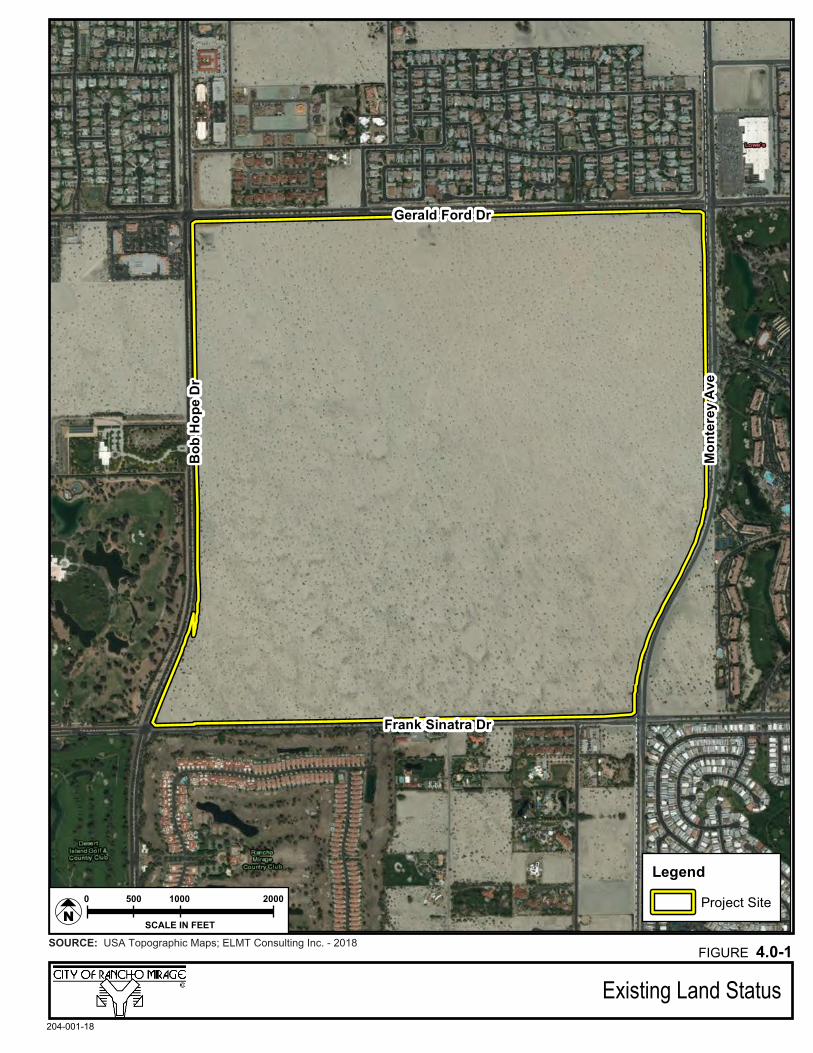
Project Site. The Project Site is located entirely within the City of Rancho Mirage, as shown in Figure 3.0-
2: Local Vicinity Map. The Project Site is surrounded by properties within the City of Rancho Mirage to its
north, south, southeast, and west, and by properties within the adjacent City of Palm Desert to its east.
The Project Site is bound by Gerald Ford Drive on the north, Monterey Avenue on the east, Frank Sinatra
Drive on the south, and Bob Hope Drive on the west. The current status of the Project Site and surrounding
properties is shown in Figure 4.0-1: Existing Land Status. The existing characteristics of the Project Site
from the four major surrounding intersections (Monterey Avenue and Gerald Ford Drive, Monterey
Avenue and Frank Sinatra Drive, Frank Sinatra Drive and Bob Hope Drive, and Bob Hope Drive and Gerald
Ford Drive) are illustrated in Figure 4.0-2a: Project Site Photographs and Figure 4.0-2b: Project Site
Photographs.
The Project Site is undeveloped and consists of approximately 618 acres of relatively undisturbed desert
lands within the Coachella Valley, located in the broader Colorado Desert Geomorphic Province of
California. This province consists of numerous north-south trending mountain ranges, such as the San
Bernardino Mountains to the north, the Santa Rosa Mountains to the south, and the San Jacinto
Mountains to the west.
Legend
Project Site
Bob
Hop
e D
r
Mon
tere
y Av
e
Gerald Ford Dr
Frank Sinatra Dr
Existing Land Status204-001-18
SOURCE: USA Topographic Maps; ELMT Consulting Inc. - 2018FIGURE 4.0-1
SCALE IN FEET
10005000 2000
N
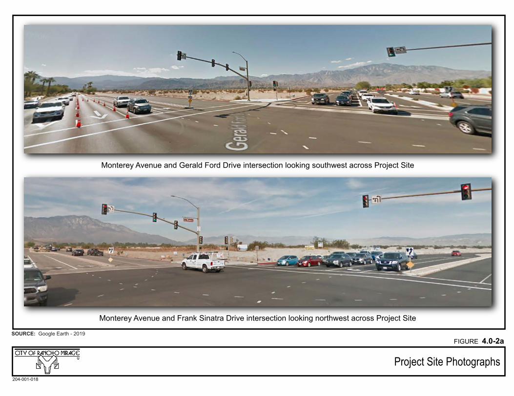
Monterey Avenue and Frank Sinatra Drive intersection looking northwest across Project Site
Monterey Avenue and Gerald Ford Drive intersection looking southwest across Project Site
Project Site Photographs
SOURCE: Google Earth - 2019
204-001-018
FIGURE 4.0-2a
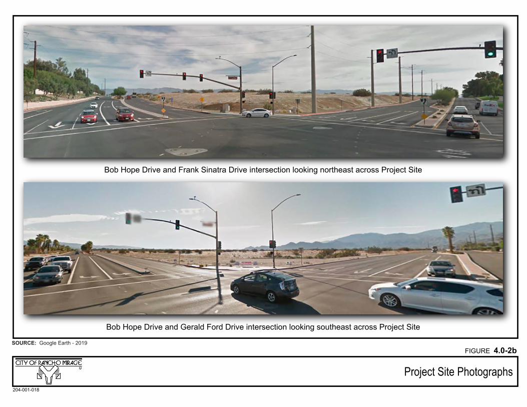
Bob Hope Drive and Gerald Ford Drive intersection looking southeast across Project Site
Bob Hope Drive and Frank Sinatra Drive intersection looking northeast across Project Site
Project Site Photographs
SOURCE: Google Earth - 2019
204-001-018
FIGURE 4.0-2b
4.0 Environmental Setting
City of Rancho Mirage 4.0-8 Section 31 Specific Plan Meridian Consultants July 2019
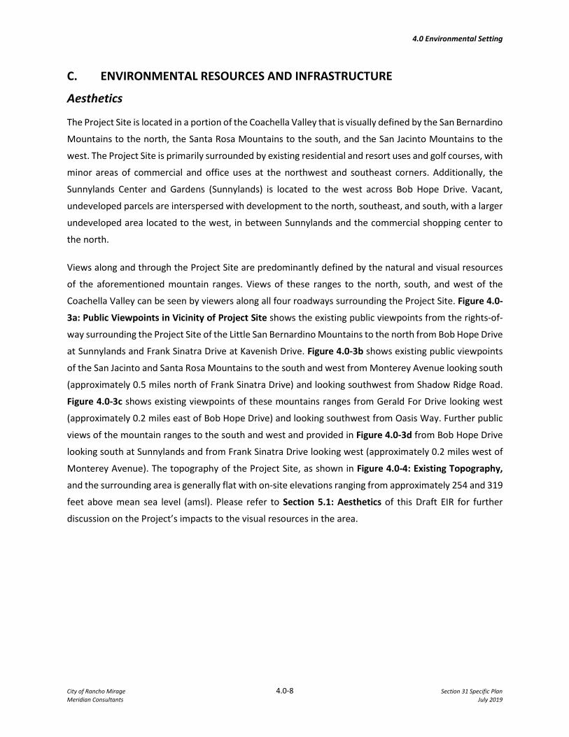
C. ENVIRONMENTAL RESOURCES AND INFRASTRUCTURE
Aesthetics
The Project Site is located in a portion of the Coachella Valley that is visually defined by the San Bernardino
Mountains to the north, the Santa Rosa Mountains to the south, and the San Jacinto Mountains to the
west. The Project Site is primarily surrounded by existing residential and resort uses and golf courses, with
minor areas of commercial and office uses at the northwest and southeast corners. Additionally, the
Sunnylands Center and Gardens (Sunnylands) is located to the west across Bob Hope Drive. Vacant,
undeveloped parcels are interspersed with development to the north, southeast, and south, with a larger
undeveloped area located to the west, in between Sunnylands and the commercial shopping center to
the north.
Views along and through the Project Site are predominantly defined by the natural and visual resources
of the aforementioned mountain ranges. Views of these ranges to the north, south, and west of the
Coachella Valley can be seen by viewers along all four roadways surrounding the Project Site. Figure 4.0-
3a: Public Viewpoints in Vicinity of Project Site shows the existing public viewpoints from the rights-of-
way surrounding the Project Site of the Little San Bernardino Mountains to the north from Bob Hope Drive
at Sunnylands and Frank Sinatra Drive at Kavenish Drive. Figure 4.0-3b shows existing public viewpoints
of the San Jacinto and Santa Rosa Mountains to the south and west from Monterey Avenue looking south
(approximately 0.5 miles north of Frank Sinatra Drive) and looking southwest from Shadow Ridge Road.
Figure 4.0-3c shows existing viewpoints of these mountains ranges from Gerald For Drive looking west
(approximately 0.2 miles east of Bob Hope Drive) and looking southwest from Oasis Way. Further public
views of the mountain ranges to the south and west and provided in Figure 4.0-3d from Bob Hope Drive
looking south at Sunnylands and from Frank Sinatra Drive looking west (approximately 0.2 miles west of
Monterey Avenue). The topography of the Project Site, as shown in Figure 4.0-4: Existing Topography,
and the surrounding area is generally flat with on-site elevations ranging from approximately 254 and 319
feet above mean sea level (amsl). Please refer to Section 5.1: Aesthetics of this Draft EIR for further
discussion on the Project’s impacts to the visual resources in the area.
Frank Sinatra Drive at Kavenish Drive looking north
Bob Hope Drive at Sunnylands looking north
Public Viewpoints in Vicinity of Project Site
SOURCE: Google Earth - 2019
204-001-018
FIGURE 4.0-3a
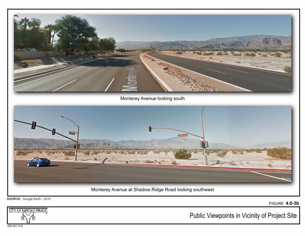
Monterey Avenue at Shadow Ridge Road looking southwest
Monterey Avenue looking south
Public Viewpoints in Vicinity of Project Site
SOURCE: Google Earth - 2019
204-001-018
FIGURE 4.0-3b
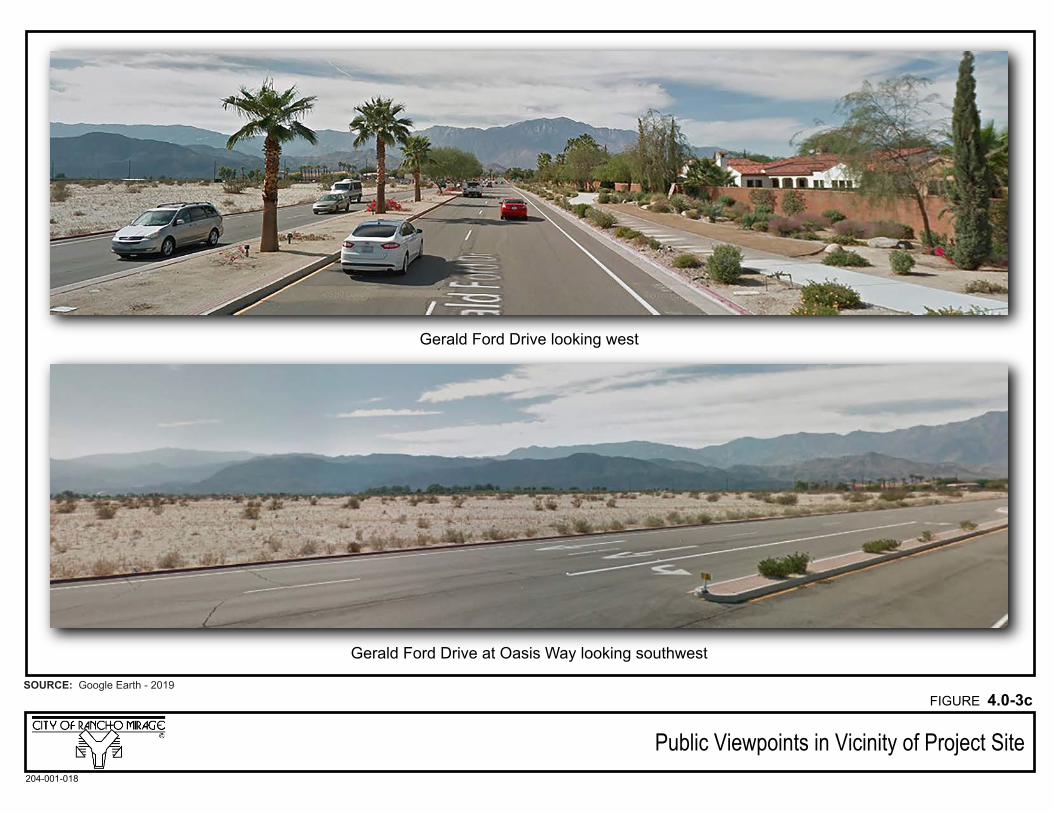
Gerald Ford Drive at Oasis Way looking southwest
Gerald Ford Drive looking west
Public Viewpoints in Vicinity of Project Site
SOURCE: Google Earth - 2019
204-001-018
FIGURE 4.0-3c
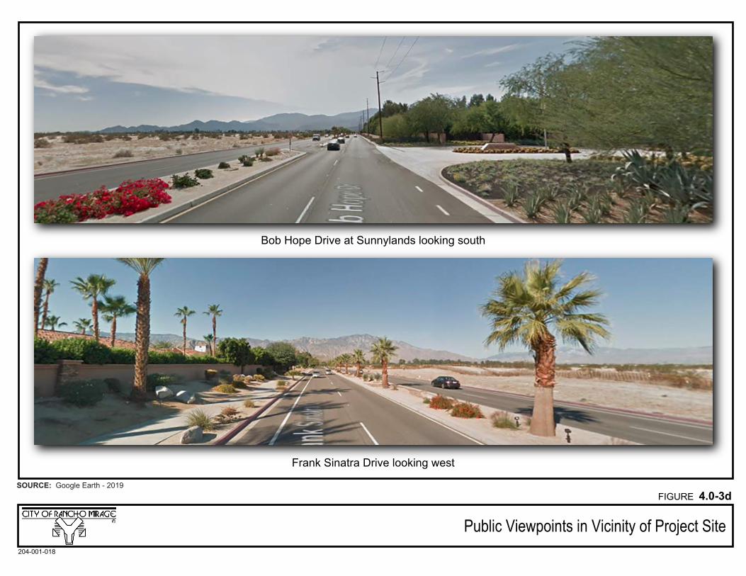
Frank Sinatra Drive looking west
Bob Hope Drive at Sunnylands looking south
Public Viewpoints in Vicinity of Project Site
SOURCE: Google Earth - 2019
204-001-018
FIGURE 4.0-3d
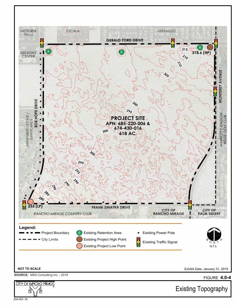
Exhibit Date: January 31, 2019
GERALD FORD DRIVEEVIRD EP
OH BOB
EUNEVA YERETNO
M
FRANK SINATRA DRIVE
VICTORIAFALLS
ESCALA VERSAILLESA
NN
ENBE
RG E
STA
TE /
SUN
NYL
AN
DS
R RR
GELSON'SCENTER
MA
RRIO
TT'S
SHA
DO
WRI
DG
E G
OLF
CLU
B
RANCHO MIRAGE COUNTRY CLUB
255 (LP)
318.6 (HP)
PROJECT SITEAPN: 685-220-006 &
674-430-016618 AC.
Legend:Project Boundary
N.T.S.
N
O R T
HCity Limits
R Existing Retention Area
Existing Project High Point
Existing Power Pole
Existing Traffic SignalExisting Project Low Point
Existing Topography
NOT TO SCALE
204-001-18
SOURCE: MSA Consulting Inc. - 2019FIGURE 4.0-4
4.0 Environmental Setting
City of Rancho Mirage 4.0-14 Section 31 Specific Plan Meridian Consultants July 2019
Air Quality and Greenhouse Gas Emissions
The Project Site lies within the SSAB, which spans the Coachella Valley portion of the County of Riverside
and the entire County of Imperial. Air quality management of the Riverside County portion of the SSAB is
overseen by the SCAQMD. The Riverside County portion of the SSAB is bound by the San Jacinto
Mountains to the west and spans eastward up to the Palo Verde Valley. The SSAB and the adjacent Mojave
Desert Air Basin were previously included in a single large air basin known as the Southeast Desert Air
Basin. However, the CARB has subdivided this larger basin into the two separate air basins that are in
place today.
The SSAB is classified as having a desert climate characterized by low precipitation, hot summers, mild
winters, low humidity, and strong temperature inversions. The annual average temperature varies little
throughout the SSAB, ranging from the low 40s to the high 100s, measured in degrees Fahrenheit (°F).
The Western Regional Climate Center (WRCC) maintains historical climate information for the western
U.S., including the City of Palm Springs. The closest meteorological monitoring station to the Project Site
is in the City of Palm Springs and is monitored by WRCC Station ID No. 046635. According to this Station,
the average maximum temperature in the local vicinity is 108.2°F in July. The average minimum
temperature is reported at 42.3°F in December and January.
In relation to other areas of southern California, the City of Rancho Mirage has good air quality. In the
past few decades, however, noticeable deterioration of air quality has occurred due to transport of
pollutants from coastal air basins to the west, primarily ozone, and locally generated PM10 as a result of
increased development and population growth, traffic, construction activity, and various site
disturbances. The Project’s potential air quality and greenhouse gas impacts are discussed in Section 5.2:
Air Quality and Section 5.7: Greenhouse Gas Emissions, respectively, of this Draft EIR.
Biological Resources
The Project Site is historically undeveloped vacant land that consists of partially stabilized shielded sand
fields, with the dominating vegetation being that of the Sonoran creosote bush scrub community. There
are three small stormwater retention basins existing within the Project Site along Gerald Ford Drive. These
basins currently retain off-site street flows and will be functionally replaced by the proposed drainage
system. There are no potential jurisdictional waters or wetland areas that are present on the Project Site.
The Project Site is located within the Coachella Valley Multiple Species Habitat Conservation Plan
(CVMSHCP) Area. The CVMSHCP was prepared for the entire Coachella Valley and surrounding mountains
to address current and potential future State and federal Endangered Species Act issues therein. The
biological field surveys performed for the Project identified one CVMSHCP-covered plant species on site,
4.0 Environmental Setting
City of Rancho Mirage 4.0-15 Section 31 Specific Plan Meridian Consultants July 2019
the Coachella Valley milk-vetch. In addition, it was determined that the Project Site has a moderate
potential to support eight sensitive plant species that are not covered under the CVMSHCP, including
Borrego milk-vetch, ribbed cryptantha, winged cryptantha, pointed dodder, Abram’s spurge, Arizona
spurge, flat-seeded spurge, and slender cottenheads. All other special-status plant species covered and
non-covered are presumed absent.
Based on habitat requirements for specific species and the availability and quality of habitats needed by
each sensitive wildlife species, it was determined that the Project Site has a moderate or higher potential
to support five CVMSHCP-covered wildlife species, including Coachella giant sand treader cricket, Palm
Springs pocket mouse, flat-tailed horned lizard, Coachella Valley fringe-toed lizard, and Coachella Valley
round-tailed ground squirrel. In addition, the Project Site has a moderate or higher potential to support
three special-status wildlife species that are not covered under the CVMSHCP, including loggerhead
shrike, Costa’s hummingbird, and black-tailed gnatcatcher. Costa’s hummingbird and black-tailed
gnatcatcher were the only special-status wildlife species observed within the Project Site.
There are no specific wildlife corridors that were identified within or adjacent to the Project Site. The
Project’s potential impacts to biological resources are further discussed in Section 5.3: Biological
Resources of this Draft EIR.
Cultural Resources
The Project Site is located in a portion of the Coachella Valley identified as having low to moderate
prehistoric/ethnohistoric cultural resource sensitivity. The Coachella Valley consists of alternating
lacustrine and fluvial sediments, termed the Lake Cahuilla beds, which have previously yielded fossil
remains representing diverse freshwater diatoms, land plants, sponges, ostracods, mollusks, fish, and
small terrestrial vertebrates. The Project Site consists of property that historically has been undeveloped
with minimal human activity and does not contain any historical resources of significance. The Project’s
impacts on cultural resources are analyzed in Section 5.4: Cultural Resources of this Draft EIR.
A number of California Native American tribes have been historically associated with the broader
Coachella Valley and Project area, as identified by the Native American Heritage Commission. The Project
Site has never been developed and currently consists of relatively undisturbed desert lands. There are no
known historical resources within the Project Site, nor did the cultural resources survey conducted for the
Project Site identify any historical resources. Pursuant to Government Code (GC) Section 65352.3 (Senate
Bill [SB] 18) and PRC Section 21080.3.1 (Assembly Bill [AB] 52), the City has actively engaged with tribes
historically associated with the Project area. Comments were received from the five following tribes: the
San Manuel Band of Mission Indians (SMBMI), the Agua Caliente Band of Cahuilla Indians (ACBCI), the
Augustine Band of Cahuilla Indians (ABCI), the Twenty-Nine Palms Band of Mission Indians (TNPBMI), and
4.0 Environmental Setting
City of Rancho Mirage 4.0-16 Section 31 Specific Plan Meridian Consultants July 2019
the Pala Band of Mission Indians (PBMI). While none of these tribes identified specific tribal cultural
resources (TCRs) that may be affected by the Project, ACBCI requested formal consultation under SB 18
and AB 52 and requested a copy of the records search with associated survey reports and site records
from the information center, a cultural resources inventory of the Project area be performed by a qualified
archaeologist prior to any development activities, and a copy of any cultural resource documentation
(report and site records) generated in connection to the Project. ABCI recommended notification of other
tribes historically associated with the area, contracting a monitor qualified in Native American cultural
resources to be present on-site during pre-construction and construction activities, and immediate
notification of ABCI should any cultural resources be discovered during implementation of the Project.
The City intends to actively coordinate with California Native American tribes that have requested
consultation as the Project progresses. For further information related to TCRs, please refer to Section
8.1: Effects Not Found Significant of this Draft EIR.
Energy
Energy in the State of California (State) is regulated by Title 24, Part 6, of California's Energy Efficiency
Standards for Residential and Nonresidential Buildings. The Energy Efficiency Standards for Residential
and Nonresidential Buildings were established in 1978 in response to a legislative mandate to reduce
California's energy consumption. New standards went into effect in October 2005.
Energy sources are made available by private entities and public agencies in the City of Rancho Mirage.
Major energy providers for electricity and natural gas in Coachella Valley include Southern California
Edison (SCE) and the Southern California Gas Company (SoCalGas), respectively. The Rancho Mirage
Energy Authority (RMEA), a locally run power program commissioned by the Rancho Mirage City Council,
conveys power to City consumers via SCE infrastructure.
Geology and Soils
The Project Site is located within the Coachella Valley in the northern part of the Colorado Desert
Geomorphic Province with elevations ranging from approximately 254 to 319 feet amsl, generally sloping
from the northeast to the southwest. The Colorado Desert Geomorphic Province consists of numerous
north-south trending mountain ranges, such as the San Bernardino Mountains to the north, the Santa
Rosa Mountains to the south, and the San Jacinto Mountains to the west. Additionally, this Province is
bound on the east by the Colorado River, on the south by the Baja California border, on the north by the
Transverse Ranges Province, on the northeast by the Mojave Desert Province, and on the west by the
Peninsular Ranges Province.
4.0 Environmental Setting
City of Rancho Mirage 4.0-17 Section 31 Specific Plan Meridian Consultants July 2019
The Coachella Valley is heavily prone to wind-blown sand erosion hazards as a result of the fierce winds
that funnel through the steep mountain ranges. Areas at the base of the mountains are more sheltered
from these hazards since the winds are not as strong. The regional tectonic subsidence along the Coachella
Valley floor along with the uplift of adjacent mountains is responsible for the rapid deposition of poorly
consolidated soils susceptible to consolidation and/or collapse.
The Project Site is located in a moderately active seismic region, with the San Andreas Fault Zone being
the major structural feature for the region. Ground shaking due to earthquakes should be anticipated
during the life of the proposed improvements at the Project Site. The US Geological Survey (USGS) and
California Geology Survey (CGS) have identified 28 active, or potentially active, faults located within
approximately 60 miles of the Project Site. Each of these faults is believed to be capable of producing
sizeable earthquake events with significant ground motions that would be experienced at the Project Site.
Lastly, the Project Site contains recent alluvium soils which have a low potential to contain significant
paleontological resources. On-site geologic features such as sand and soil types are not unique to the
Project Site, instead being common in the area and extensive in the Coachella Valley. Potential impacts to
geology and soils as a result of the Project are further discussed in Section 5.6: Geology and Soils of this
Draft EIR.
Hazards and Hazardous Materials
As an extension of the State Emergency Plan, the City of Rancho Mirage maintains a Multi-Hazard
Functional Plan (MHFP) that addresses the planned response to extraordinary emergency situations
associated with natural or human caused disasters, technological incidents, and nuclear defense
operations. Additionally, the City of Rancho Mirage falls under the Riverside County Hazardous Waste
Management Plan (HWMP), which serves to provide a framework for the management of the County’s
hazardous substances.
The Project Site is not identified to be on a list of hazardous materials sites as defined in Government Code
Section 65962.5. The Project Site has historically been undeveloped and vacant with little evidence of any
human disturbance. According to the Phase I Environmental Site Assessment (ESA) and Phase I ESA Update
that were prepared, the Project Site does not use or store any hazardous materials, nor does it exhibit the
presence or likely presence of hazardous substances or petroleum products or an existing, past, or
material threat of a release thereof. The Project’s potential impacts to hazards and hazardous materials
are discussed in Section 5.8: Hazards and Hazardous Materials of this Draft EIR.
4.0 Environmental Setting
City of Rancho Mirage 4.0-18 Section 31 Specific Plan Meridian Consultants July 2019
Hydrology and Water Quality
The Project Site is within the boundaries of the Coachella Valley planning area of the Colorado River Basin
(Region 7), which is under the jurisdiction of the Colorado River Basin Regional Water Quality Control
Board (CRWQCB). Region 7 covers approximately 13,000,000 acres (20,000 square miles) in the
southeastern portion of California, and includes all of Imperial County and portions of San Bernardino,
Riverside, and San Diego Counties. The Coachella Valley planning area consists of the Whitewater River
Watershed and East Salton Sea Watershed, with the Project Site being within the Whitewater River
Watershed. The Whitewater River passes approximately three miles southwest of the Project Site.
Based on surface topography, drainage across the Project Site is generally from the northeast to the
southwest towards the Frank Sinatra Drive and Bob Hope Drive intersection via sheet flow following
natural drainage courses. There are two small retention basins existing within the Project Site along Gerald
Ford Drive, as well as four stormwater inlets along Monterey Avenue, that currently retain off-site street
flows. However, these basins will be functionally replaced by the proposed drainage system. According to
the Federal Emergency Management Agency (FEMA) Flood Insurance Rate Map (FIRM) Map Number
06065C1595G, effective August 28, 2008, the Project Site is not located within a designated 100-year flood
hazard area. The Project’s potential impacts on hydrology and water quality are analyzed in Section 5.9:
Hydrology and Water Quality of this Draft EIR.
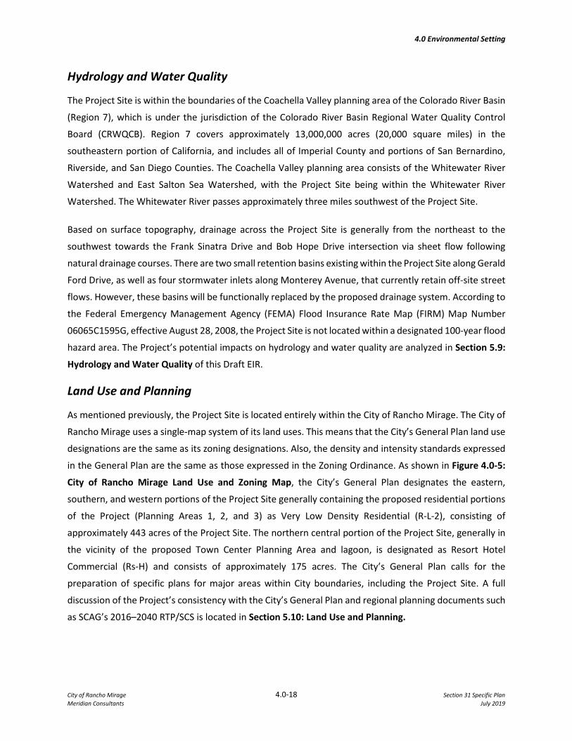
Land Use and Planning
As mentioned previously, the Project Site is located entirely within the City of Rancho Mirage. The City of
Rancho Mirage uses a single-map system of its land uses. This means that the City’s General Plan land use
designations are the same as its zoning designations. Also, the density and intensity standards expressed
in the General Plan are the same as those expressed in the Zoning Ordinance. As shown in Figure 4.0-5:
City of Rancho Mirage Land Use and Zoning Map, the City’s General Plan designates the eastern,
southern, and western portions of the Project Site generally containing the proposed residential portions
of the Project (Planning Areas 1, 2, and 3) as Very Low Density Residential (R-L-2), consisting of
approximately 443 acres of the Project Site. The northern central portion of the Project Site, generally in
the vicinity of the proposed Town Center Planning Area and lagoon, is designated as Resort Hotel
Commercial (Rs-H) and consists of approximately 175 acres. The City’s General Plan calls for the
preparation of specific plans for major areas within City boundaries, including the Project Site. A full
discussion of the Project’s consistency with the City’s General Plan and regional planning documents such
as SCAG’s 2016–2040 RTP/SCS is located in Section 5.10: Land Use and Planning.
4.0 Environmental Setting
City of Rancho Mirage 4.0-19 Section 31 Specific Plan Meridian Consultants July 2019
Noise
Noise in an urban setting is primarily generated by vehicular traffic, but can also be generated by
stationary sources of noise, such as mechanical equipment. Temperature, wind speed and direction,
ground surfaces, vegetation, walls, and buildings affect noise transmission and perceived noise levels.
Noise levels are measured in terms of the A-weighted decibel (dBA). A-weighting is a frequency correction
that correlates overall sound pressure levels to the frequency response of the human ear, with the normal
range of human hearing extending from approximately 0 dBA to 140 dBA. The noise rating scale used in
California for land use compatibility assessment is the Community Noise Equivalent Level (CNEL). The
CNEL scale represents a time-weighted, 24-hour average noise level based on the A-weighted decibel.
Noise levels in the Project Site are influenced primarily by vehicular traffic on surrounding roadways,
including Gerald Ford Drive, Monterey Avenue, Frank Sinatra Drive, and Bob Hope Drive. As shown in
Figure 4.0-6: Noise Monitoring Locations, there were eight sites set up within proximity to the Project
Site to measure existing CNEL noise levels with noise levels ranging from a low of 69.1 dBA to a high of
73.8 dBA at approximately 75 feet from the roadway centerline. Existing noise sensitive land uses located
near the Project Site include single-family residential uses to the north along Gerald Ford Drive and to the
south along Frank Sinatra Drive, the Marriott Shadow Ridge Resort and Villages to the east along Monterey
Avenue, and the Sunnylands estate and visitor center to the west along Bob Hope Drive. Refer to Section
5.11: Noise of this Draft EIR, for further information concerning existing noise conditions in the Project
Site and an analysis of this Project’s impacts on the local noise environment.
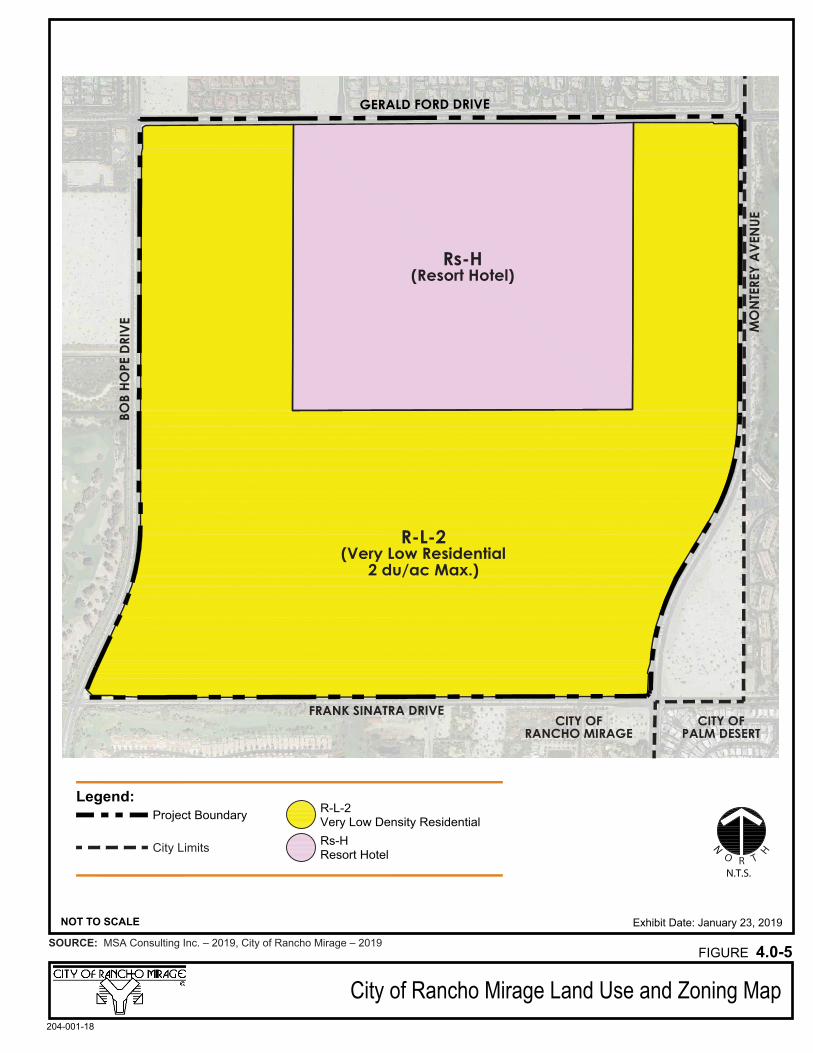
Exhibit Date: January 23, 2019
GERALD FORD DRIVEEVIRD EP
OH BOB
EUNEV
A YERETN
OM
FRANK SINATRA DRIVE
Rs-H(Resort Hotel)
R-L-2(Very Low Residential
2 du/ac Max.)
Legend:Project Boundary Very Low Density Residential
R-L-2
N.T.S.
N
O R T
HCity Limits Resort HotelRs-H
City of Rancho Mirage Land Use and Zoning Map
NOT TO SCALE
204-001-18
SOURCE: MSA Consulting Inc. – 2019, City of Rancho Mirage – 2019FIGURE 4.0-5
Noise Monitoring Locations
FIGURE 4.0-6SOURCE: Google Earth - 2019
204-001-18
APPROXIMATE SCALE IN FEET
10005000 2000
N
Legend: Project Site
Noise Monitoring Locations
11
22 33 44
556677
88
4.0 Environmental Setting
City of Rancho Mirage 4.0-22 Section 31 Specific Plan Meridian Consultants July 2019
Population and Housing
According to the California Department of Finance (DOF), as of January 1, 2018, the City of Rancho Mirage
had a population of 18,738 with 14,492 housing units and an average household size of 2.025 persons.
The Project’s impacts on population and housing are discussed in Section 5.12: Population and Housing
of this Draft EIR.
Public Services
Fire Protection and Emergency Medical Services
The Riverside County Fire Department provides fire protection and emergency medical services to the City
of Rancho Mirage. The Riverside County Fire Department is administered under contract by Cal Fire, and
participates in a Regional Integrated and Cooperative Fire Protection System. This system provides local
jurisdictions and surrounding areas with additional regional resources to respond to fire service calls when
required. Fire protection services include response to vegetation and structure fires, hazmat, and public
assists. There are currently two fire stations within the City of Rancho Mirage, Station 69 located at 71-
751 Gerald Ford Drive (approximately 0.3 miles west of the Project Site), and Station 50 located at 70-801
Highway 111 (approximately 3.0 miles southwest of the Project Site). Additionally, RCFD stations in the
adjacent communities of Thousand Palms and Palm Desert are proximate to the Project Site. Please refer
to Section 5.13.1: Fire Protection and Emergency Medical Services, for further discussion on the Project’s
potential impacts to fire and emergency medical services.
Law Enforcement
The Project Site is currently located in an area that served by local law enforcement that enforces local,
State, and federal laws pertaining to public safety, traffic, and public order. The City of Rancho Mirage
contracts with the Riverside County Sherriff’s Department for police protection services.
Since the City of Rancho Mirage does not currently have any public police stations within the City
boundaries, the closest station to the Project Site is located at 73-705 Gerald Ford Drive in Palm Desert
(approximately 0.51 miles east of Project Site). Please refer to Section 5.13.2: Law Enforcement, of this
Draft EIR for further discussion of the Project’s potential impacts to police protection services.
Schools
The City of Rancho Mirage is served by two public school districts: the Palm Springs Unified School District
(PSUSD) and the Desert Sands Unified School District (DSUSD). The majority of the City falls within the
boundaries of the PSUSD, with the southeastern portion of the City within the boundaries of the DSUSD.
The Project Site is a part of the PSUSD attendance boundaries. The schools that would serve the Project

4.0 Environmental Setting
City of Rancho Mirage 4.0-23 Section 31 Specific Plan Meridian Consultants July 2019
Site are Rancho Mirage Elementary, Nellie N. Coffman Middle School, and Rancho Mirage High School.
Please refer to Section 5.13.3: School Services, of this Draft EIR for further discussion on the Project’s
potential impacts to the local schools.
Libraries
The City of Rancho Mirage is served by the Rancho Mirage Public Library and Observatory, located at 71-
100 Highway 111 (approximately 3.6 miles south of the Project Site). The Rancho Mirage Public Library
operates independently from the Riverside County Library System (RCLS) but serves the City and broader
Coachella Valley. Please refer to Section 5.13.4: Library Services, of this Draft EIR for further discussion
on the Project’s potential impacts to the City’s library services.
Recreation
The City of Rancho Mirage provides a vast amount of recreational opportunities for its residents and
visitors, including golf courses, tennis and basketball courts, playgrounds, and hiking trails. The City
adopted their Conservation and Open Space Element of the General Plan to define and establish goals,
policies, and programs toward preserving and effectively managing the valuable natural resources in the
City. Previously, the City prepared its Parks Master Plan to assess the community’s local park needs to
ensure sufficient recreational opportunities are available for its residents. The Parks Master Plan also
identifies the cross-utilization of recreational facilities between the Cove Communities (Palm Desert,
Indian Wells, and Rancho Mirage). Please refer to Section 5.14: Recreation of this Draft EIR, for further
discussion on the Project’s potential impacts to parks and recreational facilities.
Traffic and Transportation
Regional facilities include Interstate 10, located approximately 1.25 miles north of the Project Site.
Highway 111, located to the south of the Project Site, is a major arterial roadway linking Rancho Mirage
with other cities throughout the Coachella Valley and Imperial Valley. Additionally, the UPRR located to
the north of the Project Site accommodates two mainline tracks used for commercial and passenger rail
traffic.
Access to the Project Site is provided in all directions with the existing local roadway network including
Gerald Ford Drive, Monterey Avenue, Frank Sinatra Drive, and Bob Hope Drive. Existing AM and PM peak
period traffic volume counts were counted for 30 intersections in the broader vicinity of the Project Site.
All but three existing study intersections currently operate at an acceptable level of service (LOS) during
peak hours. Further, both roadway segments analyzed (between Dinah Shore Drive and Gerald Ford Drive
and between Gerald Ford Drive and Frank Sinatra Drive) operate at an acceptable LOS
4.0 Environmental Setting
City of Rancho Mirage 4.0-24 Section 31 Specific Plan Meridian Consultants July 2019
Alternative modes of transportation also exist within proximity to the Project Site. The SunLine Transit
Agency provides bus line services to several communities and cities within the Coachella Valley. Line 32
directly serves the Project Site, with a stop at the corner of Gerald Ford Drive and Bob Hope Drive.
Additionally, the Coachella Valley has a subscription-based transit service is available to residents with
disabilities who need regular repetitive stops. Furthermore, the City of Rancho Mirage currently maintains
a variety of golf cart/electric vehicle (EV), bicycle, and pedestrian paths which are accessible to the public.
A full discussion of the Project’s existing traffic conditions and potential impacts is presented in Section
5.15: Traffic and Transportation of this Draft EIR.
Utilities and Service Systems
The Coachella Valley Water District (CVWD) provides water and wastewater services for the City of Rancho
Mirage. Domestic, landscape irrigation, and fire protection water supply would also be provided by the
CVWD in combination with the Mission Hills Pressure Zone and at least one private well to supply water
to the Grand Oasis Crystal Lagoon. The Project would tie into an existing 18-inch water main which runs
along Gerald Ford Drive and forms the northern boundary of the Project Site. The Project would connect
into the existing 24-inch sewer main beneath Country Club Drive and served by water reclamation plant
(WRP) 10, located in the city of Palm Desert. The Project Site would contain vegetative retention areas for
storm water on site in addition to existing catch basins and drainage inlets on surrounding roadways.
Storm water would generally be conveyed by topography to the southeastern and southwestern corners
of the Project Site. Existing stormwater drainage facilities within the City of Rancho Mirage are maintained
by the Public Works Department, and a future reclaimed water line is proposed along Frank Sinatra Drive.
Burrtec Waste and Recycling currently provides solid waste collection services. Solid waste is first taken
to the Edom Hills transfer station in Cathedral City then sent to one to Burrtec’s regional landfills within
Riverside County. Southern California Edison (SCE) is the purveyor of electricity for the area, with existing
transmission lines along the southern boundary of the Project Site on Frank Sinatra Drive and a variety of
other existing electrical facilities in the surrounding roadway system. As mentioned previously, RMEA
conveys power to City consumers via SCE infrastructure. Natural gas is provided by the Southern California
Gas Company with high pressure distribution lines located north, east, and south of the Project Site on
Gerald Ford Drive, Monterey Avenue, and Frank Sinatra Drive, respectively. Lastly, Frontier
Communications currently provides telephone service and Spectrum provides cable television services.
Please refer to Section 5.16: Utilities and Service Systems of this Draft EIR for further discussion on the
Project’s potential impacts to existing infrastructure.
4.0 Environmental Setting
City of Rancho Mirage 4.0-25 Section 31 Specific Plan Meridian Consultants July 2019
D. RELATED PROJECTS
Section 15130 of the CEQA Guidelines requires that cumulative impacts are to be discussed where they
are considered significant. It further states that the discussion of cumulative impacts reflects the severity
of the impacts and their likelihood of occurrence, but that it does not need to be in as great level of detail
as provided for the Project alone. Cumulative impacts are defined by Section 15355 to be “…two or more
individual effects which, when considered together are considerable or which compound or increase
other environmental impacts.” Cumulative impacts represent the change caused by the incremental
impact of a project when added to other proposed or committed projects in the vicinity.
The CEQA Guidelines (Section 15130 (b)(1)) further state that the information utilized in an analysis of
cumulative impacts should come from one of two sources, either:
(A) A list of past, present and probable future projects producing related cumulative impacts, including,
if necessary, those projects outside the control of the agency; or
(B) A summary of projections contained in an adopted general plan or related planning document
designed to evaluate regional or area-wide conditions.
The cumulative impact analyses contained in the various topical sections of Section 5.0: Environmental
Impact Analysis, considers related projects in the City of Rancho Mirage based on the City of Rancho
Mirage “Development Activity Summary,” dated May 13, 2019. In addition, the projections in the City’s
General Plan are used in the assessment of potential cumulative impacts, where appropriate, as well as
related projects in proximate jurisdictions such as the Agua Caliente Band of Cahuilla Indians Reservation,
City of Palm Desert, and Riverside County.
The analysis of traffic impacts in the study area was conducted using the Rancho Mirage General Plan
Transportation Analysis Model (RMGPM), a derivative the Riverside County Transportation Analysis
Model (RIVTAM) with additional detail added to the roadway network and socioeconomic land use data
consistent with Rancho Mirage General Plan assumptions. For use in the Traffic Study included as
Appendix I.1 of this Draft EIR, the RMGPM was updated to be consistent with the 2016–2040 SCAG
RTP/SCS growth projections with updated 2012 base year and 2040 future year land use assumptions. The
base year roadway network was also updated to include improvements built between 2008 and 2012,
and the future year roadway network was updated to assume funding of all 2016–2040 SCAG RTP/SCS
projects.
4.0 Environmental Setting
City of Rancho Mirage 4.0-26 Section 31 Specific Plan Meridian Consultants July 2019
The following pending and approved development projects in the vicinity of the Project Site are not
included in City of Rancho Mirage General Plan Model assumptions and were added to the future year
socioeconomic dataset for future forecasting:
• Section 24 Specific Plan – The approved specific plan allows development of up to 3,138,600 square feet of commercial, retail, office, restaurant, hotel and entertainment uses, and up to 2,406 residential units. Land uses for Section 24 are specified in the Section 24 Specific Plan;
• The zoning on a 40-acre parcel of land just south of the Rancho Mirage High School is being changed from High Density Residential (nine maximum dwelling units per acre) to Mixed Use. The M-U zone allows residential densities up to 6.5 dwelling units per acre and will also introduce a commercial component to the property;
• Rancho Mirage Country Club – This is an existing project that proposes a land use change for the development of a hotel and associated residential units. The zone change affects approximately 25 of the 40 acres in this existing country club development;
• City-initiated General Plan Zoning Map Amendment (GPZMA) on two 5-acre parcels at the southwest corner of Monterey and 35th/Dick Kelly Drive. The current GPZMA of the 10-acres is RM (Medium Density Residential) and the proposed change is to Community Commercial; and
• Agua Caliente Resort and Casino Expansion – The Agua Caliente Casino Resort & Spa Expansion project is a proposal to expand the current casino resort and spa, including additional hotel rooms and gaming area in the casino in Phase 1 and future retail commercial uses in Phase 2. Specifically, Phase 1 involves the addition of 310 hotel rooms, 58,000 square feet of gaming space, 41,000 square feet of meeting space, 12,320 square feet of retail space, 12,700 square feet of restaurant space, and 5,200 square feet of health/fitness club space. Phase 2 involves the addition of 120,000 square feet of retail space.
Additionally, the City of Palm Desert is located immediately east of the Project Site across Monterey
Avenue and contains a number of ongoing and foreseeable projects. Table 4.0-1: Related Projects in the
City of Palm Desert, lists related projects in the adjacent City of Palm Desert. This list is based on
consultation with City of Palm Desert staff.

4.0 Environmental Setting
City of Rancho Mirage 4.0-27 Section 31 Specific Plan Meridian Consultants July 2019
Table 4.0-1 Related Projects in the City of Palm Desert
No. Project Address Description
1 Ponderosa Homes Dinah Shore Drive and Dick Kelly Drive
111 single-family and 114 multifamily residential units
2 Millennium Portola Road and Gerald Ford Drive
116 single-family and 550 multifamily residential units, 551,000 sq. ft. of commercial space, and 250 hotel rooms
3 Villa Portofino Portola Road and Country Club Drive
161 Skilled nursing, 150 assisted living, 288 villas, 182 casitas
4 Dolce Gerald Ford Drive and Gateway Drive 159 single-family residential units
5 Spanish Walk Apartments Gerald Ford near Frank Sinatra Drive 150 multifamily residential units
6 Falling Waters Gateway Drive and Dick Kelly Drive 159 single-family residential units
7 University Park Portola Road and Gerald Ford Drive
773 single-family and 336 multifamily residential units
8 Monterey Specific Plan Monterey Avenue and Dick Kelly Drive
384 multifamily residential units and 120,000 sq. ft. commercial
9 Landmark Specific Plan
Miriam Way and Dinah Shore Drive
1,339 multifamily residential units, 20,000 sq. ft. commercial space, and 250,000 sq. ft. storage facility
10 Wolff Cottages Country Club Drive and Portola Road 167 independent living units
11 128-Acres Rembrandt Parkway and Frank Sinatra Drive
400 single-family and 200 multifamily residential units
12 Monterey Crossings Monterey Avenue and Dinah Shore Drive 120,000 sq. ft. commercial space
13 DSRT Surf Desert Willow Drive and Country Club Drive
6-acre surf lagoon, 350 hotel rooms, 12,500 sq. ft. spa, and 88 villa units
Source: Eric Ceja, Principal Planner, City of Palm Desert, email correspondence, May 20, 2019.