5.6 geology and soils - riverside, california
TRANSCRIPT

City of Riverside General Plan and Supporting Documents EIR Section 5.6 – Geology and Soils
Certified November 2007 Albert A. WEBB Associates 5.6-1
5.6 GEOLOGY AND SOILS The six components of the project analyzed herein are:
1) Adoption and implementation of the General Plan; 2) Adoption and implementation of the revised Zoning Code; 3) Adoption and implementation of the revised Subdivision Code; 4) Adoption and implementation of amendment to the Noise Code; 5) Adoption and implementation of the Magnolia Avenue Specific Plan (MASP); and 6) Adoption and implementation of the Citywide Design and Sign Guidelines.
Of the six project components, the Zoning Code, Subdivision Code, Noise Code Amendment, and the Citywide Design and Sign Guidelines address site planning, building design and community aesthetics, rather than physical changes to the land, and are thus, not considered to have impacts related to geology and soils and will not be analyzed further in this section. However, in regard to Geology and Soils, the Magnolia Avenue Specific Plan and General Plan address land use designations that could physically impact the land. The MASP land use is included within the General Plan document and thus, will not be analyzed further in this section. Impacts related to the adoption and implementation of the General Plan will be addressed herein.
The Geology and Soils Section of this EIR has been changed from the previously circulated EIR. In addition to the overall changes listed in the Project description Section of this EIR, background information and analysis was added for the Planning Area. Information for all topics within this Section was verified and updated as necessary.
Since an initial study was not prepared with the issuance of the Notice of Preparation, the focus of the following discussion is related to the potential impacts to people or structures due to seismic activity and seismic hazards; soil erosion; and unstable and unsuitable soils.
In addition to other reference documents, the following references were used in the preparation of this section of the EIR:
Appendix E contains the Geologic and Seismic Technical Background Report performed by Wilson Geosciences, Inc., which includes detailed information regarding the City of Riverside’s geologic conditions.
California Department of Conservation, Division of Mines and Geology, Fault Rupture Hazard Zones in California, revised 1997, Supplements 1 and 2 added 1999.
California Geological Survey, Alquist-Priolo Earthquake Fault Zones. (Available at http://www.consrv.ca.gov/CGS/rghm/ap/)
County of Riverside, Riverside County Integrated Project General Plan, October 2003.
P&D Environmental, Public Safety Existing Conditions Report, September 2003.
U.S Department of Agriculture Soil Conservation Service, General Soil Map, Riverside and Western Part of Riverside Counties, California, compiled 1971.

City of Riverside General Plan and Supporting Documents EIR Section 5.6 – Geology and Soils
Certified November 2007 Albert A. WEBB Associates 5.6-2
SETTING
Topography and Geology
The City of Riverside lies within the northern end of the Peninsular Ranges, approximately 12 miles south of the intersection with the Transverse Range. The Santa Ana Mountains are approximately 15 miles south and southwest of the City, while the San Jacinto Mountains are approximately 10 miles east and northeast of the City of Riverside. The San Bernardino Mountains are about 20 miles north of the City.
A series of hills and small mountains surround the Planning Area. These hills and mountains are between the two dominant San Jacinto and Santa Ana mountain ranges. They include La Sierra/Norco Hills, Mt. Rubidoux, Box Springs Mountains, Sycamore Canyon and the many smaller ranges south of the City. Within the City, surface elevations range from about 700 feet above mean sea level (amsl) near the Santa Ana River to over 1,400 feet amsl west of La Sierra. The highest point in the southern Sphere of Influence is Arlington Mountain, standing at 1,853 feet amsl approximately 1.5 miles northwest of Lake Mathews. Additionally, portions of Box Springs Mountain Reserve located in the northern Sphere of Influence area extend as high as 2,000 feet.
Mountains and hills typically have slopes of 15 to 50 percent; valley and basin areas usually have slopes of less than 15 percent. Within the City of Riverside, most natural slopes are very flat, generally less than 15 percent, with some slopes ranging from 15 to 25 percent in eastern and western portions of the City of Riverside. Many slopes in the Sphere of Influence are steeper than within the City. Areas around Lake Mathews and the Box Springs Mountain are much steeper. Slopes along a substantial portion of the area west and south of Lake Mathews and along the northeastern line exceed 30 percent and are depicted on Figure 5.6-1, Areas Underlain by Steep Slope.
The Planning Area and much of the hills in the Planning Area are made up of granite and adamellite (gra), mesozoic granitic rock (gr ), granodiorite(grg), mesozoic basic intrusive rocks (bi), and alluvium (Qal) (located around the Santa Ana River). Most are dated from the Mesozoic period, except for the alluvium, which dated from the Quaternary.
Seismic Activity
No Fault-Rupture Hazard Zone, as designated by the California Department of Conservation, Alquist-Priolo Earthquake Fault Zone (1999) exists within the Planning Area. However, the City is located in a region with several active fault lines. Figure 5.6-2, Faults and Fault Zonesshows the most significant faults affecting the Planning Area, including the San Jacinto, and Elsinore faults. The San Andreas fault lies outside of the Planning Area in the County of San Bernardino.

WoodRd
VictoriaAve
TylerSt
Adams St
MagnoliaAve
ElSobranteRd
DaySt
Monroe St
CajalcoRd
JurupaAve
WatkinsDr
Center St
La Sierra Ave
KrameriaAve
Nandina
Ave
BartonSt
CentralAve
SierraAve
LaSierraAve
La Sierra Av
e
Overlo okPkwy
ElSobranteRd
MarySt
Gentian
Ave
RobertsRd
Proposed
"B" Dr
CajalcoRd
RansomRd
CanyonCrest
Dr
Mt.VernonAve
RiverwalkPkwy
SantaA
naRiver
Sant
aAnaRiver
LakeMathews
ElCerritoDr
PorterAve
MariposaAve
IrisAve
DauchyAve
ChicagoAve
BartonRd
Mitch
ellAve
NorwoodAve
Cam
pbellAve
JonesAve
Cook Ave
Sierra V
istaSt
HarrisonSt
Golden Ave
CollettAve
FremontSt
PierceSt Schuyler
Ave
ViewLn
Golden S
tar Ave
GramercyPl
SpruceSt
Jefferson
St
Third
St
LincolnAve
CypressAve
Pierce
St
Markham
St
BradleySt
HoleAve
FourteenthSt
ColumbiaAve
GrandAve
Polk S
t
Brockton Ave
Challen
Ave
DeweyAve
LindenSt
UniversityAve
Hi
llsideA
ve
HarrisonSt
DufferinAve
"A"St
Orchard
CottonwoodAve
Sycamore Canyon
Blvd
Victoria Ave
RamonaDr
KansasAve
CanyonCrestDr
IowaAve
AtlantaSt
McAllisterSt
MissionGrovePkwy
John
F.Kennedy
Dr
SierraRidge
Dr River
RunDr
Dan
Kipper Dr
ViaVistaDr
Com
munityDr
Grove
Dr
RustinAve
MarlboroughAve
MichiganSt
MulberrySt
PhilbinAve
PalmAve
Orange
St
Van Buren Blvd
ChicagoAve
RiversideAve
Orange
TerracePkwy
RiveraS
t
Jackso
n St
RutlandAve
StrongSt
Golden Ave
FillmoreSt
BlaineSt
Maude St
Arlington
Ave
WellsAve
CridgeSt
CenturyAve
CentralAve
Loch
moo r
First St
MarketSt
Tenth
St
LimeSt
MissionInnAve
Olivewo
odAve
Oleander
Ave
Merrill Ave
EagleRidgeDr
NorthgateSt
Proposed
"A"Dr
Isle
Fair
Box Spr ings
MainS
t
WashingtonSt
LaCad
enaDr
ColoradoAve
Trautwein
Rd
Buchanan St
MadisonSt
AlessandroBlvd
Fifth
St
CaliforniaAve
JurupaAve
ColeAve
McAllister St
CentralAve
Alessand
ro Blvd
VanBuren
Blvd
Blvd
MartinLutherKingBlvd
Tyler St
IndianaAve
MainSt
Citrus
St
CajalcoRd
ArlingtonAve
WashingtonSt
ArlingtonAve
Mo
ckin
gbirdCan
yonRd
VanBu renB lvd
ColumbiaAve
Palmyrita
Ave
IowaAve
Magno
liaAve
Bandini Ave
HermosaDr
§̈a#
§̈a#
% &h (
% &h (
?z
?z
?Æ
Flabob
Airport
MarchAir
Reserve
Base/March
InlandPort
Riverside
MunicipalAirport
A St
MainSt
VanBurenBlvd
JurupaRd
PedleyRd
ClarkSt
BainSt
GraniteHillDr
PigeonPassRd
BrownSt
6thSt
C
LakeMathewsDr
58thSt
MackSt
SampsonAve
Reche Canyon Rd
GrahamSt
Old Elsino
re Rd
EtiwandaAve
GavilanRd
RubidouxBlvd
HeacockSt
tonAve
Martin
St
56thSt
WinevilleAve
Camin
oReal
Parkrid
geAve
StevenDr
PromenadeAve
E
agleCa
nyonRo
ad
EastridgeAve
LimoniteAve
HiddenValley
Pkwy
68thSt
A
IronwoodAve
BellegraveSt
thillPky
SeatonAve
PostRd
AgateSt
Van Buren B
lvd
LukensLn
Clay St
Rimpau Ave
Limonite
Ave
34thSt
IndianaAve
MarlattSt
ElsworthSt
FourthSt
FelsparSt
CrestaRd
Armstrong
Rd
GalenaSt
J
Box
Springs
Rd
PeraltaPl
PacificAv
e
TemescalCanyonRd
BeachSt
20thSt
Market St
G
AvonSt
WebsterAve
OrangeAve
FrederickSt
NeilSt
RutileSt
DeckerRdNuevoRd
RiderSt
MissionBlvd
AlexanderSt
CaliforniaAve
NuC
Fifth
St
Cajalco
Rd
DaySt
Markham
St
Nandina
Ave
MagnoliaAve
McKinleySt
NorcoHil
lsRd
CaliforniaAve
Sunn
ymead
Ranch P
ky
LEGEND AREASUNDERLAIN
BYSTEEPSLOPE
Figu
re5.
6-1
RIV
ERSI
DE
PR
OP
OS
EDSP
HE
RE
OF
INFL
UEN
CE
RIV
ERSI
DE
CIT
YBO
UN
DAR
Y
SOU
RC
E:R
IVE
RS
IDE
CO
UN
TYG
ISD
ATA
The
City
ofR
iver
side
mak
esno
war
rant
yas
toth
eac
cura
cyor
cont
ento
fthe
data
show
non
this
map
.Th
ism
apsh
alln
otbe
repr
oduc
edor
dist
ribut
ed.
Cop
yrig
ht20
06,C
ityof
Riv
ersi
de,C
alifo
rnia
.C
ityof
Riv
ersi
deda
tacu
rrent
to12
-15-
06.
01
2M
iles
05,
000
10,0
00Fe
et
SLOPE 0
-10%
10-1
5%
15-3
0%
30%
+

% &h (
§̈a#
§̈a#
% &h (
% &h (
?Æ
?z
?z
MarchAir
Reserve
Base/March
InlandPort
Riverside
MunicipalAirport
Flabob
Airport
Orange
St
LaSierraAve
MagnoliaAve
CajalcoRd
VictoriaAve
UniversityAve
ArlingtonAve
ElSobranteRd
CajalcoRd
LEGEND
FAULTSAND
FAULTZONES
Figu
re5.
6-2
FAU
LTZO
NE
S
RIV
ERSI
DE
PR
OP
OS
EDSP
HE
RE
OF
INFL
UEN
CE
RIV
ERSI
DE
CIT
YBO
UN
DAR
Y
SOU
RC
E:R
IVE
RS
IDE
CO
UN
TYG
ISD
ATA
The
City
ofR
iver
side
mak
esno
war
rant
yas
toth
eac
cura
cyor
cont
ento
fthe
data
show
non
this
map
.Th
ism
apsh
alln
otbe
repr
oduc
edor
dist
ribut
ed.
Cop
yrig
ht20
06,C
ityof
Riv
ersi
de,C
alifo
rnia
.C
ityof
Riv
ersi
deda
tacu
rrent
to12
-15-
06.
J ACI NTO
FAULT
COUNT Y
F AUL T
F AU LT
ELSI NORE
FAU
LTLI
NES
Feet
Mile
s
05,
000
10,0
00
01
2
LAKEMATHEWS
SAN COUNT Y
F AUL T

City of Riverside General Plan and Supporting Documents EIR Section 5.6 – Geology and Soils
Certified November 2007 Albert A. WEBB Associates 5.6-5
The San Andreas Fault is at its closest point 11 miles from Downtown Riverside, abutting the San Bernardino Mountains. The San Andreas Fault extends 600 miles from Eureka in Northern California’s Humboldt County south to the Mexican border. The San Andreas Fault is estimated to have the capability of producing up to an 8.3 magnitude (M) earthquake. The San Jacinto fault runs as close as 7 miles from Downtown. This fault runs more than 125 miles, from northwest of El Centro in Imperial County to northwest of San Bernardino, passing through the intersection of Interstates 10 and 215, the City of Loma Linda and the Box Springs Mountains. This fault is estimated to have the capability of producing up to a 7.0M earthquake. The Elsinore fault passes within 13 miles of Downtown, extending approximately four miles west of Lake Mathews and Corona and south into the City of Lake Elsinore. This northwest-southwest trending fault is estimated to have the capability of producing up to a 6.0M earthquake.
Although no active or potentially active fault has been mapped at the surface within the City, one northwest-southeast trending unnamed fault is projected toward the southwest corner of the Planning Area south of Lake Mathews in the southern Sphere of Influence. Additional faults are predicted to occur south of Lake Mathews, west of Lake Mathews near Mockingbird Canyon, and near the Box Springs Mountains.
Seismic Hazards
People and structures in the Planning Area are subject to risks from the hazards associated with earthquakes. Seismic activity poses two types of hazards: primary and secondary. Primary hazards include ground rupture, ground shaking, ground displacement, and subsidence and uplift from earth movement. Primary hazards can induce secondary hazards such as ground failure (lurch cracking, lateral spreading, and slope failure), liquefaction, water waves (tsunamis and seiches), movement on nearby faults (sympathetic fault movement), dam failure, and fires. Potential seismic hazards affecting the Planning Area include ground shaking, ground failure, and liquefaction.
Seismic shaking is the geological hazard that has the greatest potential to severely impact the Planning Area, given that the area is located near several significant faults that have the potential to cause moderate to large earthquakes. According to Geotechnical Report, prepared by Wilson Geosciences, Inc., the Planning Area could experience ground acceleration greater than 35 to 43 percent. These probabilistic ground motion values for the Planning Area are within the limits for current structural design (CBC/UBC) for non-critical structures, including most residential, commercial, and industrial buildings.
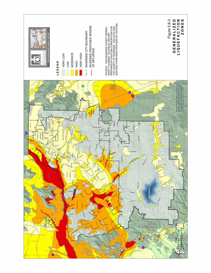
The major geologic hazards associated with ground shaking include liquefaction and ground failure. Liquefaction occurs when ground shaking causes water-saturated soils to become fluid and lose strength. Liquefaction historically has been responsible for significant damage, creating problems with bridges, buildings, buried pipes and underground storage tanks. The City is underlain by areas susceptible to varying degrees of liquefaction, ranging from moderate to very high. Liquefaction hazards are particularly significant along watercourses. The primary liquefaction areas are within the City limits including the area along the Santa Ana River, a broad area south and west of the Riverside Municipal Airport, a portion in western Riverside spanning La Sierra Avenue and a smaller area along the City’s southern boundary. Most of the

City of Riverside General Plan and Supporting Documents EIR Section 5.6 – Geology and Soils
Certified November 2007 Albert A. WEBB Associates 5.6-6
southern Sphere of Influence area is not susceptible to liquefaction, except for alluvial drainages leading into Lake Mathews. Figure 5.6-3, Generalized Liquefaction Zones illustrates the areas within the City susceptible to liquefaction hazards. The characteristics of the various liquefaction hazard zones are detailed in Table 5.6-A.
Table 5.6-A General Liquefaction Zones
Rank Groundwater Depth General Sediment Type High Less than 30 feet Very Susceptible
Moderate Less than 30 feet 30-50 feet
Susceptible Very Susceptible
Low Greater than 30 feet Susceptible
Very Low 30-50 feet 50-100
Susceptible Very Susceptible
Extremely Low 50-100 feet Susceptible
None Greater than 100 feet No Data
Susceptible Bedrock
Notes: 1 Groundwater depth is based on the historic high measurement. 2 Very susceptible sediment type includes generally granular Holocene sediments; susceptible includes generally granular Pleistocene sediments.Source: County of Riverside 2003 RCIP EIR
Strong ground motions can also worsen existing unstable slope conditions, particularly if coupled with saturated ground conditions. Seismically induced landslides and rockfalls would be expected in the northeastern area associated with the Box Springs Mountain, the southern and southwestern areas associated with the Cajalco Ridge and La Sierra Hills, the western area associated with the Norco Hills and at Mt. Rubidoux adjacent to the Santa Ana River in the event of a major earthquake or human activity. Factors contributing to the stability of slopes include slope height and steepness, engineering characteristics of the earth materials comprising the slope, and intensity of ground shaking. It is estimated that a ground acceleration of at least 0.10 g in steep terrain is necessary to induce earthquake-related rockfalls, although exceeding this value does not guarantee that rockfalls will occur. Because there are several faults capable of generating peak ground accelerations of over 0.10 g in Riverside County, there is a high potential for seismically induced rockfalls and landslides to occur. The areas of high susceptibility to seismically induced landslides and rockfalls correspond to steep slopes in excess of 30 percent as depicted on Figure 5.6-1, Areas Underlain by Steep Slope.
Soils
The Planning Area contains the following general soil associations: Cajalco-Temescal-Las Posas, Traver-Domino-Willows, Cieneba-Rock Land-Fallbrook, Monserate-Arlington-Exeter and Hanford-Tujunga-Greenfield associations. Soil associations in the Planning Area are generally well-drained sandy loams that are moderately deep. The specific soil types generally found in the Planning Area are listed on Figure 5.6-4, Soils. The characteristics of the various soil types are detailed in Table 5.6-B.
WoodRd
VictoriaAve
TylerSt
Adams St
MagnoliaAve
ElSobranteRd
DaySt
Monroe St
CajalcoRd
JurupaAve
WatkinsDr
Center St
La Sierra Ave
KrameriaAve
Nandina
Ave
BartonSt
CentralAve
SierraAve
LaSierraAve
La Sierra Av
e
Overlo okPkwy
ElSobranteRd
MarySt
Gentian
Ave
RobertsRd
Proposed
"B" Dr
CajalcoRd
RansomRd
CanyonCrest
Dr
Mt.VernonAve
RiverwalkPkwy
SantaA
naRiver
Sant
aAnaRiver
LakeMathews
ElCerritoDr
PorterAve
MariposaAve
IrisAve
DauchyAve
ChicagoAve
BartonRd
Mitch
ellAve
NorwoodAve
Cam
pbellAve
JonesAve
Cook Ave
Sierra V
istaSt
HarrisonSt
Golden Ave
CollettAve
FremontSt
PierceSt Schuyler
Ave
ViewLn
Golden S
tar Ave
GramercyPl
SpruceSt
Jefferson
St
Third
St
LincolnAve
CypressAve
Pierce
St
Markham
St
BradleySt
HoleAve
FourteenthSt
ColumbiaAve
GrandAve
Polk S
t
Brockton Ave
Challen
Ave
DeweyAve
LindenSt
UniversityAve
Hi
llsideA
ve
HarrisonSt
DufferinAve
"A"St
Orchard
CottonwoodAve
Sycamore Canyon
Blvd
Victoria Ave
RamonaDr
KansasAve
CanyonCrestDr
IowaAve
AtlantaSt
McAllisterSt
MissionGrovePkwy
John
F.Kennedy
Dr
SierraRidge
Dr River
RunDr
Dan
Kipper Dr
ViaVistaDr
Com
munityDr
Grove
Dr
RustinAve
MarlboroughAve
MichiganSt
MulberrySt
PhilbinAve
PalmAve
Orange
St
Van Buren Blvd
ChicagoAve
RiversideAve
Orange
TerracePkwy
RiveraS
t
Jackso
n St
RutlandAve
StrongSt
Golden Ave
FillmoreSt
BlaineSt
Maude St
Arlington
Ave
WellsAve
CridgeSt
CenturyAve
CentralAve
Loch
moo r
First St
MarketSt
Tenth
St
LimeSt
MissionInnAve
Olivewo
odAve
Oleander
Ave
Merrill Ave
EagleRidgeDr
NorthgateSt
Proposed
"A"Dr
Isle
Fair
Box Spr ings
MainS
t
WashingtonSt
LaCad
enaDr
ColoradoAve
Trautwein
Rd
Buchanan St
MadisonSt
AlessandroBlvd
Fifth
St
CaliforniaAve
JurupaAve
ColeAve
McAllister St
CentralAve
Alessand
ro Blvd
VanBuren
Blvd
Blvd
MartinLutherKingBlvd
Tyler St
IndianaAve
MainSt
Citrus
St
CajalcoRd
ArlingtonAve
WashingtonSt
ArlingtonAve
Mo
ckin
gbirdCan
yonRd
VanBu renB lvd
ColumbiaAve
Palmyrita
Ave
IowaAve
Magno
liaAve
Bandini Ave
HermosaDr
§̈a#
§̈a#
% &h (
% &h (
?z
?z
?Æ
Flabob
Airport
MarchAir
Reserve
Base/March
InlandPort
Riverside
MunicipalAirport
A St
MainSt
VanBurenBlvd
JurupaRd
PedleyRd
ClarkSt
BainSt
GraniteHillDr
PigeonPassRd
BrownSt
6thSt
C
LakeMathewsDr
58thSt
MackSt
SampsonAve
Reche Canyon Rd
GrahamSt
Old Elsino
re Rd
EtiwandaAve
GavilanRd
RubidouxBlvd
HeacockSt
tonAve
Martin
St
56thSt
WinevilleAve
Camin
oReal
Parkrid
geAve
StevenDr
PromenadeAve
E
agleCa
nyonRo
ad
EastridgeAve
LimoniteAve
HiddenValley
Pkwy
68thSt
A
IronwoodAve
BellegraveSt
thillPky
SeatonAve
PostRd
AgateSt
Van Buren B
lvd
LukensLn
Clay St
Rimpau Ave
Limonite
Ave
34thSt
IndianaAve
MarlattSt
ElsworthSt
FourthSt
FelsparSt
CrestaRd
Armstrong
Rd
GalenaSt
J
Box
Springs
Rd
PeraltaPl
PacificAv
e
TemescalCanyonRd
BeachSt
20thSt
Market St
G
AvonSt
WebsterAve
OrangeAve
FrederickSt
NeilSt
RutileSt
DeckerRdNuevoRd
RiderSt
MissionBlvd
AlexanderSt
CaliforniaAve
NuC
Fifth
St
Cajalco
Rd
DaySt
Markham
St
Nandina
Ave
MagnoliaAve
McKinleySt
NorcoHil
lsRd
CaliforniaAve
Sunn
ymead
Ranch P
ky
GENERALIZED
LIQ
UEFACTIO
NZONES
Figu
re5.
6-3
LEGEND
The
City
ofR
iver
side
mak
esno
war
rant
yas
toth
eac
cura
cyor
cont
ento
fthe
data
show
non
this
map
.Th
ism
apsh
alln
otbe
repr
oduc
edor
dist
ribut
ed.
Cop
yrig
ht20
06,C
ityof
Riv
ersi
de,C
alifo
rnia
.C
ityof
Riv
ersi
deda
tacu
rrent
to12
-15-
06.
VER
YLO
WLO
WM
OD
ERAT
EH
IGH
VER
YH
IGH
RIV
ERSI
DE
CIT
YBO
UN
DAR
YR
IVER
SID
EP
RO
PO
SED
SPH
ER
EO
FIN
FLU
ENC
E
12Miles
5,000
10,000Feet
00
SOU
RC
E:19
76R
IVE
RS
IDE
CO
UN
TYSE
ISM
ICSA
FETY
ELEM
EN
TTE
CH
NIC
AL
RE
POR
T,PR
EP
ARE
DB
YE
NVI
CO
MC
OR
POR
ATI
ON
FOR
THE
CO
UN
TYO
FR
IVE
RSI
DE
.TH
ISD
ATA
WAS
DIG
ITIZ
ED
FRO
MM
AP
SP
RO
VID
ED
BY
EN
VIC
OM
.

A St
HamnerAve
MainSt
VanBurenBlvd
Jurupa
Rd
PedleyRd
ClarkSt
BainSt
GraniteHillDr
PigeonPassRd
BrownSt
6thSt
LakeMathewsDr
58thSt
MackSt
Sampson
Ave
Reche Canyon Rd
GrahamSt
Old Elsino
re Rd
EtiwandaAve
GavilanRd
RubidouxBlvd
HeacockSt
Fullerton
Ave
MartinSt
56thSt
WinevilleAve
Camin
oReal
Parkrid
geAve
StevenDr
PromenadeAve
E
agleCany
onRoad
EastridgeAve
LimoniteAve
HiddenValley
Pkwy
68thSt
IronwoodAve
BellegraveSt
FoothillPky
SeatonAve
PostRd
AgateSt
Van Buren B
lvd
LukensLn
Clay St
Rimpau Ave
LimoniteAve
34thSt
IndianaAve
MarlattSt
ElsworthSt
FourthSt
FelsparSt
CrestaRd
ArmstrongRd
GalenaSt
BoxSpringsRd
PeraltaPl
PacificAv
e
g Ave
TemescalCanyonRd
BeachSt
20thSt
Market St
G
AvonSt
WebsterAve
OrangeAve
FrederickSt
NeilSt
RutileSt
DeckerRd
NuevoRd
RiderSt
MissionBlvd
AlexanderSt
CaliforniaAve
Nu
FifthSt
CajalcoRd
DaySt
Markham
St
NandinaAve
MagnoliaAve
Ave
McKinleySt
NorcoHi
llsRd
CaliforniaAve
Sun
nymea
d Ranch P
k y
WoodRd
VictoriaAve
TylerSt
Adams St
MagnoliaAve
ElSobranteRd
DaySt
Monroe St
CajalcoRd
JurupaAve
WatkinsDr
CenterSt
La S ierra Ave
KrameriaAve
NandinaAve
BartonSt
CentralAve
SierraAve
LaS ierraAve
La Sierra A
ve
Over lookPkw
y
ElSobranteRd
MarySt
Gentian
Ave
RobertsRd
Proposed"B"Dr
CajalcoRd
R ansomRd
CanyonCrest
Dr
Mt.VernonAve
RiverwalkPkwy
SantaA
na
River
Sant
aAnaRiver
LakeMathews
ElCerritoDr
PorterAveMariposaAve
IrisAve
DauchyAve
ChicagoAve
BartonRd
Mitc
hell A
ve
NorwoodAve
Cam
pbellAve
JonesAve
Cook Ave
Sierra V
istaSt
HarrisonSt
Golden Ave
CollettAve
FremontSt
PierceSt Schuyler
Ave
ViewLn
Golden S
tar Ave
GramercyPl
SpruceSt
Jefferson St
Third
St
LincolnAve
CypressAve
Pierce
St
Markham
St
BradleySt
HoleAve
FourteenthSt
ColumbiaAve
GrandAve
PolkSt
Brockton Ave
Challen
Ave
Dewey
Ave
LindenSt
UniversityAve
Hi
llside
Ave
HarrisonSt
DufferinAve
"A"St
Orchard
CottonwoodAve
Sycamore Canyo n
Blvd
Victoria Ave
RamonaDr
KansasAve
CanyonCrestDr
IowaAve
AtlantaSt
McAllisterSt
MissionGrovePkwy
JohnF.
Kennedy
Dr
SierraRidgeDr
Rive rRunDr
Dan
KipperDr
ViaVistaDr
Com
munit yDr
Grove
Dr
RustinAve
MarlboroughAve
MichiganSt
Mulberry
St
PhilbinAve
PalmAve
OrangeSt
Van Buren Blvd
ChicagoAve
RiversideAve
Orange
TerracePkwy
RiveraS
t
Jackson St
RutlandAve
StrongSt
Golden Ave
FillmoreSt
BlaineSt
Maude St
Arlington
Ave
WellsAve
CridgeSt
CenturyAve
CentralAve
Lochm
o o
r
First St
MarketSt
Tenth
St
LimeSt
MissionInnAve
Olivewo
odAve
Oleander
Ave
MerrillAve
EagleRidgeDr
NorthgateSt
Proposed
"A"Dr
Isle
Fair
Box Spr ings
MainS
t
WashingtonSt
LaCaden
aDr
ColoradoAve
Trautwein
Rd
Buchana
n St
MadisonSt
AlessandroBlvd
Fifth
St
CaliforniaAve
Jurupa
Ave
ColeAve
McAllister St
Central Ave
Alessand
ro Blvd
Van
BurenBlvd
Blvd
MartinLutherKingBlvd
Tyler St
IndianaAve
MainSt
CitrusSt
CajalcoRd
ArlingtonAve
WashingtonSt
ArlingtonAve
Mo
ckin
gbirdCanyo
n Rd
Van
Bure nBlvd
ColumbiaAve
PalmyritaAve
IowaAve
Magno
liaAve
Bandini Ave
Hermosa
Dr
Flabob
Airport
MarchAir
Reserve
Base/March
InlandPort
Riverside
MunicipalAirport
§̈a#
§̈a#
%&h(
%&h(
?z
?z
?Æ
LEGEND
SOILS
Figu
re5.
6-4
RIV
ERS
IDE
PR
OPO
SED
SPH
ER
EO
FIN
FLU
ENC
E
RIV
ERS
IDE
CIT
YBO
UN
DAR
Y
SO
UR
CE
:S
OIL
SU
RV
EY
OF
WE
STE
RN
RIV
ER
SID
EA
RE
A,C
ALI
FOR
NIA
,NO
VE
MB
ER
,197
1.
The
City
ofR
iver
side
mak
esno
war
rant
yas
toth
eac
cura
cyor
cont
ento
fthe
data
show
non
this
map
.Th
ism
apsh
alln
otbe
repr
oduc
edor
dist
ribut
ed.
Cop
yrig
ht20
06,C
ityof
Riv
ersi
de,C
alifo
rnia
.C
ityof
Riv
ersi
deda
tacu
rrent
to12
-15-
06.
01
2M
iles
05,
000
10,0
00Fe
et
ALTA
MO
NT
ANZA
ARLI
NG
TON
AULD
BON
SALL
BOSA
NKO
BUC
HE
NA
UBU
RE
N
CAJ
ALC
OC
HIN
OC
IEN
EBA
CO
RTI
NA
CR
OU
CH
DEL
HI
DEL
LO
DO
MIN
OES
CO
ND
IDO
EXET
ER
FALL
BRO
OK
FRIA
NT
GO
RG
ON
IOG
RA
NG
EVIL
LE
GR
EEN
FIE
LDH
ANFO
RD
HO
NC
UT
LAS
POS
ASLO
DO
MAD
ER
AM
ETZ
MO
NS
ER
ATE
MO
TTS
VILL
EPA
CH
APPA
PLAC
EN
TIA
POR
TER
VIL
LER
AMO
NA
SAN
EMIG
DIO
SAN
TIM
OTE
O
TEM
ESC
AL
TUJU
NG
AVI
STA
YOKO
HL
YSID
OR
AD
AMS
GR
AVE
LP
ITS
GU
LLIE
DLA
ND
MAD
ELA
ND
RIV
ER
WA
SH
RO
CK
LAN
DTE
RR
AC
EE
SCAR
PM
ENTS

City of Riverside General Plan and Supporting Documents EIR Section 5.6 – Geology and Soils
Certified November 2007 Albert A. WEBB Associates 5.6-9
Table 5.6-B Soil Types
Soil Type Map Symbol Erosivity Permeability
Shrink-Swell
Potential
Depth (inches) Texture
Altamont AaD Slight to Moderate Slow High 0-23 Clay; cobbly in places
Anza AdC Slight to Moderate Moderately rapid Low 0-69 Fine sandy loam
0-24 Loam
24-36 Weakly cemented sandy loam Arlington
AnC, AnD, AoA, AoC, AoD, ApB, ArB, ArD
Slight to moderate Moderately slow Low to
Moderate 36-60 Loamy coarse sand 0-28 Clay Auld AuD Moderate to
High Moderately slow Moderate to High 28-44 Loam
0-13 Loam Bonsall BdC, BdD High Very slow Moderate
13-30 Clay
Bosanko BfC, BfD Slight to Moderate Moderately rapid High 0-32 Clay
Buchenau BhA, BhC, BkC2 Moderate Moderately slow
over very slow Moderate 0-52 Loam
0-37 Clay loam Buren
BuC2, BuD2,
BvD3, BxC2
Slight to Moderate
Moderately slow over very slow Moderate
37-52 Weakly cemented loam
0-13 Fine sandy loam Cajalco
CaC2, CaD2, CaF2, CbD2,
CbF2 High Moderate Moderate
13-22 Loam Chino Cf Slight Moderately slow Moderate 0-60 Silty clay loam
Cieneba ChC, ChD2, ChF2, CkD2,
CkF2, Cr High Rapid Low 0-22 Gravelly coarse sandy
loam
Cortina ClC High Rapid Low 0-60 Cobbly and gravelly
loamy sand and sandy loam
Crouch CyE2 Slight to Moderate Moderate Low 0-28 Sandy loam
Delhi DaD2 Water: Slight Wind: High Rapid Low 0-64 Fine sand and loamy fine
sand
Dello DgB, DmA, DoA, DrA Slight Moderately rapid
to rapid Low 0-62 Loamy fine sand, loamy sand and sand
0-27 Silt loam
27-36 Loam, weakly to strongly cemented with lime Domino Du Slight Moderate over
very slow Moderate
36-63 Loam
Escondido EcC2, EcD2, EcE2, EfF2 Moderate Moderate Low 0-34 Very fine sandy loam
0-16 Sandy loam and very fine sandy loam
16-37 Loam 37-50 Indurated hardpan
Exeter EnC2, EpC2 Slight Moderate Moderate
50-60 Coarse sandy loam 0-14 Sandy loam
14-24 Sandy clay loam Fallbrook
FaD2, FkD2, FaE2, FbC2, FbF2, FcD2, FcF2, FfC2
Moderate Moderate Moderate 24 Weathered granite

City of Riverside General Plan and Supporting Documents EIR Section 5.6 – Geology and Soils
Certified November 2007 Albert A. WEBB Associates 5.6-10
Table 5.6-B Soil Types
Soil Type Map Symbol Erosivity Permeability
Shrink-Swell
Potential
Depth (inches) Texture
Friant FwE2, FyE2, FyF2 Moderate Moderate Low 0-13 Fine sandy loam
0-20 Loamy sand 20-60 Gravelly loamy sand Gorgonio GhC, GhD,
GkD, GlC Slight to Moderate Rapid Low
0-60 Gravelly or cobbly loamy sand
Grangeville GoB, GtA, GuB, GwA,
Gs Slight Rapid to moderate Low 0-60
Loamy fine sand, fine sandy loam, sandy loam,
coarse sand and fine sandy loam.
0-43 Sandy loam Greenfield GyA, GyC2, GyD2
Slight to Moderate Moderate Low
43-60 Loam 0-40 Coarse sandy loam
40-60 Loamy sand and gravelly coarse sand
0-30 Cobbly coarse sandy loam Hanford
HaC, HcA, HcC, HcD2, HfD, HgA
Slight to Moderate
Moderately rapid to rapid Low
30-60 Loamy coarse sand
Honcut Hnc, HuC2 Moderate Moderate Low 0-60 Sandy loam that is cobbly in places
0-12 Loam, clay loam 12-32 Clay Las Posas LaC, LaD2,
LaE3, LcD2 Moderate Moderate High 32 Weathered gabbro
Lodo LoF2, LpF2 High to Very High Moderate Low 0-8 Gravelly loam
0-19 Fine sandy loam 19-26 Clay 26-37 Indurated hardpan Madera MaB2 Slight Very slow High
37-62 Loam
Metz MfA Slight Rapid to very rapid Low 0-30 Loamy fine sand
0-10 Sandy loam
10-28 Sandy clay loam Monserate
MmB, MmC2, MmD2, MmE3, MnD2, MnE3
Moderate Moderately slow over very slow Moderate
28-45 Indurated hardpan
Mottsville MoC Moderate Rapid Low 24-60 Loamy sand
0-20 Fine sandy loam Pachappa PaA, PaC2 Slight to
Moderate Slow to Moderate Low to Moderate 20-63 loam
Placentia PIB, PID Moderate Very slow High 0-18 Fine sandy loam and loam that is cobbly in places
Porterville PrD, PtB, PvD2 Slight Slow High 0-66 Clay that is cobbly in
places

City of Riverside General Plan and Supporting Documents EIR Section 5.6 – Geology and Soils
Certified November 2007 Albert A. WEBB Associates 5.6-11
Table 5.6-B Soil Types
Soil Type Map Symbol Erosivity Permeability
Shrink-Swell
Potential
Depth (inches) Texture
0-36 Clay
36 Calcareous marl or sandstone
0-23 Sandy loam 23-68 Sandy clay loam 68-74 Fine sandy loam 0-12 Sandy loam
12-36 Clay loam Ramona
RaB2, RaB3, RaD2, RdD2, RdE3, ReC2,
RfC2
Moderate Moderately slow Low
36 Calcareous consolidated sediment
0-60 Fine sandy loam San Emigdio SeC2, SfA,
SnE2 Moderate Moderate to moderately rapid Low
0-40 Fine sandy loam
San Timoteo SmE2 High Moderate Low 0-22 Loam
0-17 Loam Temescal TaF2, TbF2 High Moderate Moderate 17 Fractured Latiteporphyry 0-10 Loamy sand
10-60 Sand Tujunga TuB, TvC, TwC
Water: slight, Wind: high Rapid Low
0-60 Gravelly loamy sand
0-24 Coarse sandy loam that is gravelly in places Vista
VsC, VsD2, VsF2, VtF2,
Vr Moderate Moderately rapid Low
24 Weathered granodiorite
0-10 Loam that is cobbly in places
10-26 Clay Yokohl YbC, YbD2, YkE2 Moderate Very slow High
26 Indurated hardpan
0-12 Very fine sandy loam
Ysidora YrD2, YsE2 Moderate Slow to very slow Moderate
0-12 Gravelly very fine sandy loam
Source: U.S. Department of Agriculture, 1971
Soil Erosion
Soil erosion is the process by which soil particles are removed from a land surface by wind, water, or gravity. Most natural erosion occurs at slow rates; however, the rate of erosion increases when land is cleared or altered and left in a disturbed condition. The primary factors that influence erosion include soil characteristics, vegetative cover, topography, and climate. Soil characteristics that determine the erosivity of a soil are particle size and gradation, organic content, soil structure, and soil permeability. Soils with a high proportion of silt and very fine clays are generally the most erodible. Organic matter creates a favorable soil structure, improving soil stability and permeability, which increases the soil's capacity for the infiltration of water, delays the start of erosion, and reduces the amount of runoff. In addition, the less permeable the soil, the higher the likelihood for erosion. Vegetative cover assists in erosion

City of Riverside General Plan and Supporting Documents EIR Section 5.6 – Geology and Soils
Certified November 2007 Albert A. WEBB Associates 5.6-12
control by shielding the soil surface from the impact of falling rain or blowing wind. Vegetation slows the velocity of runoff, permits greater infiltration, maintains the soil's capacity to absorb water, and holds soil particles in place.
Topography and the length and steepness of slopes, are crucial to determining the volume and velocity of runoff. As slope length and/or steepness increases, the rate of runoff increases and the potential for erosion is magnified. Climate is a fundamental factor affecting the potential for soil erosion. When and where precipitation is frequent, intense, or prolonged, the potential for soil erosion is increased.
The likelihood of a soil to erode is indicated in under “Erosivity” in Table 5.6-B. The City is underlain by areas susceptible to varying degrees of erosion, ranging from slight to very high. Most soils in the Planning Area are described as being well drained with slow to moderate runoff and slow to moderate permeability. Planning Area slopes greater than 30 percent (see Figure 5.6-1, Areas Underlain by Steep Slope) are subject to a higher degree of erosion.
Soil Permeability
Soil permeability is the ability of a soil to transmit air or liquid. The rates given in Table 5.6-B are for soils as they occur in place within the Planning Area. The use a septic tank filter fields is impacted by soil limitations. Within the Planning Area, the limitations range from slight to severe. Criteria for the use of a septic system is generally in areas where the water table is deep and the soil has moderate permeability.
Expansive Soil
Expansive soils are soils with a significant amount of clay particles that have the ability to give up water (shrink) or take on water (swell). Fine-grained soils, such as silts and clays, may contain variable amounts of expansive clay minerals. When these soils swell, the change in volume exerts significant pressures on loads that are placed on them. This shrink/swell movement can adversely affect building foundations, often causing them to crack or shift, with resulting damage to the buildings they support. The shrink-swell potential for soils located in the Planning Area will have to be determined on a site-by-site basis. Figure 5.6-5, Soils with High Shrink-Swell Potential shows general areas where the potential for shrink/swell occur. Table 5.6-B identifies the soil types with shrink-swell potential, ranging from low to high.

A St
MainSt
VanBurenBlvd
JurupaRd
PedleyRd
ClarkSt
BainSt
GraniteHillDr
PigeonPassRd
BrownSt
6thSt
C
LakeMathewsDr
58thSt
MackSt
I
SampsonAve
Reche Canyon Rd
GrahamSt
Old Elsino
re Rd
EtiwandaAve
GavilanRd
RubidouxBlvd
HeacockSt
tonAve
Martin
St
56thSt
WinevilleAve
Camin
oReal
Parkrid
geAve
StevenDr
PromenadeAve
E
agleCa
nyonRoad
EastridgeAve
LimoniteAve
HiddenValley
Pkwy
68thSt
A
IronwoodAve
BellegraveSt
hillPky
SeatonAve
PostRd
AgateSt
Van Buren B
lvd
LukensLn
Clay St
Rimpau Ave
Limonite
Ave
34thSt
IndianaAve
MarlattSt
ElsworthSt
FourthSt
FelsparSt
CrestaRd
Armstrong
Rd
GalenaSt
J
Box
Springs
Rd
PeraltaPl
PacificAv
e
TemescalCanyonRd
BeachSt
20thSt
Market St
G
AvonSt
WebsterAve
OrangeAve
FrederickSt
NeilSt
RutileSt
DeckerRdNuevoRd
RiderSt
MissionBlvd
AlexanderSt
CaliforniaAve
NuC
Fifth
St
Cajalco
Rd
DaySt
Markham
St
Nandina
Ave
MagnoliaAve
McKinleySt
NorcoHil
lsRd
CaliforniaAve
Sunn
ymead
Ranch P
k y
WoodRd
VictoriaAve
TylerSt
Adams St
MagnoliaAve
ElSobranteRd
DaySt
Monroe St
CajalcoRd
JurupaAve
WatkinsDr
Center St
La Sierra Ave
KrameriaAve
Nandina
Ave
BartonSt
CentralAve
SierraAve
LaSierraAve
La Sierra Av
e
OverlookPk wy
ElSobranteRd
MarySt
Gentian
Ave
RobertsRd
Proposed
"B" Dr
CajalcoRd
RansomRd
CanyonCrest
Dr
Mt.VernonAve
RiverwalkPkwy
SantaA
naRiver
Sant
aAnaRiver
LakeMathews
ElCerritoDr
PorterAve
MariposaAve
IrisAve
DauchyAve
ChicagoAve
BartonRd
Mitch
ell Ave
NorwoodAve
CampbellAve
JonesAve
Cook Ave
Sierra V
istaSt
HarrisonSt
Golden Ave
CollettAve
FremontSt
PierceSt Schuyler
Ave
ViewLn
Golden S
tar Ave
GramercyPl
SpruceSt
Jefferson
St
Third
St
LincolnAve
CypressAve
Pierce
St
Markham
St
BradleySt
HoleAve
FourteenthSt
ColumbiaAve
GrandAve
Polk S
t
Brockton Ave
Challen
Ave
DeweyAve
LindenSt
UniversityAve
Hi
llside
Ave
HarrisonSt
DufferinAve
"A"St
Orchard
CottonwoodAve
Sycamore Canyon
Blvd
Victoria Ave
RamonaDr
KansasAve
CanyonCrestDr
IowaAve
AtlantaSt
McAllisterSt
MissionGrovePkwy
John
F.Kennedy
Dr
SierraRidge
Dr River
RunDr
Dan
Kipper Dr
ViaVistaDr
Com
munityDr
Grove
Dr
RustinAve
MarlboroughAve
MichiganSt
MulberrySt
PhilbinAve
PalmAve
Orange
St
Van Buren Blvd
ChicagoAve
RiversideAve
Orange
TerracePkwy
RiveraS
t
Jackso
n St
RutlandAve
StrongSt
Golden Ave
FillmoreSt
BlaineSt
Maude St
Arlington
Ave
WellsAve
CridgeSt
CenturyAve
CentralAve
Loch
moo r
First St
MarketSt
Tenth
St
LimeSt
MissionInnAve
Olivewo
odAve
Oleander
Ave
Merrill Ave
EagleRidgeDr
NorthgateSt
Proposed
"A"Dr
Isle
Fair
Box Spr ings
MainS
t
WashingtonSt
LaCad
enaDr
ColoradoAve
Trautwein
Rd
Buchanan St
MadisonSt
AlessandroBlvd
Fifth
St
CaliforniaAve
JurupaAve
ColeAve
McAllister St
CentralAve
Alessand
ro Blvd
VanBuren
Blvd
Blvd
MartinLutherKingBlvd
Tyler St
IndianaAve
MainSt
Citrus
St
CajalcoRd
ArlingtonAve
WashingtonSt
ArlingtonAve
Mo
ckin
gbirdCan
yonRd
VanBurenBlvd
ColumbiaAve
Palmyrita
Ave
IowaAve
Magno
liaAve
Bandini Ave
HermosaDr
Flabob
Airport
MarchAir
Reserve
Base/March
InlandPort
Riverside
MunicipalAirport
§̈a#
§̈a#
% &h (
% &h (
?z
?z
?Æ
LEGEND SOILSWITHHIG
HSHRINK-SWELL
POTENTIAL
Figu
re5.
6-5
RIV
ERSI
DE
PR
OP
OS
EDSP
HE
RE
OF
INFL
UEN
CE
RIV
ERSI
DE
CIT
YBO
UN
DAR
Y
SOU
RC
E:S
OIL
SU
RV
EYO
FW
ES
TER
NR
IVER
SID
EAR
EA
,CA
LIFO
RN
IA,N
OVE
MBE
R,1
971
The
City
ofR
iver
side
mak
esno
war
rant
yas
toth
eac
cura
cyor
cont
ento
fthe
data
show
non
this
map
.Th
ism
apsh
alln
otbe
repr
oduc
edor
dist
ribut
ed.
Cop
yrig
ht20
06,C
ityof
Riv
ersi
de,C
alifo
rnia
.C
ityof
Riv
ersi
deda
tacu
rrent
to12
-15-
06.
01
2M
iles
05,
000
10,0
00Fe
et
SOIL
TYPE
SIN
CLU
DE
D:
ALTAMONT:
AaD
,AaE
2,A
aF
AULD:
AuD
BONSALL:
BdC
,BdD
BOSANKO:
BfC
,BfD
LASPOSAS:
LaC
,LaD
2,La
E3,
LcD
2
MADERA:
MaB
2,M
aD2,
MbC
2
PLACENTIA:
PlB
,PlD
,Pm
E
PORTERVILLE:
PrD
,PtB
,PvD
2
VALLECITOS,THICKSOLUMVARIANT:
VeF2
YOKOHL:
YbC
,YbD
2,Y
kE2
SO
ILS
WIT
HH
IGH
SHR
INK
SWEL
LPO
TEN
TIAL

City of Riverside General Plan and Supporting Documents EIR Section 5.6 – Geology and Soils
Certified November 2007 Albert A. WEBB Associates 5.6-14
Thresholds of Significance
The City of Riverside has not established local CEQA significance thresholds as described in Section 15064.7 of the State CEQA Guidelines. Therefore, significance determinations utilized in this Section are from Appendix G of the CEQA Guidelines. A significant impact will occur if implementation of the Project:
exposes people or structures to potential substantial adverse effects, including the risk of loss, injury, or death involving: 1) rupture of a known earthquake fault, as delineated on the most recent Alquist-Priolo Earthquake Fault Zoning Map issued by the State Geologist or based on other substantial evidence of a known fault; 2) strong seismic ground shaking; 3) seismic-related ground failure, including liquefaction; or 4) landslides;
results in substantial soil erosion or the loss of topsoil;
is located on a geologic unit or soil that is unstable, or that would become unstable as a result of the project, and potentially result in on- or off-site landslide, lateral spreading, subsidence, liquefaction, or collapse;
is located on expansive soil as defined in Table 18-1-B of the Uniform Building Code (1994), creating substantial risks to life or property; or
Has soils incapable of adequately supporting the use of septic tanks or alternative wastewater disposal systems where sewers are not available for the disposal of wastewater.
Related Regulations
Uniform Building Code
The Uniform Building Code (UBC) is published by the International Conference of Building Officials. It forms the basis of about half the State building codes in the United States, including California’s, and has been adopted by the State legislature together with Additions, Amendments, and Repeals to address the specific building conditions and structural requirements in California.
California Building Code
California Code of Regulations (CCR), Title 24, Part 2, the California Building Code (CBC), provides minimum standards for building design in the State, consistent with or more stringent than UBC requirements. Local codes are permitted to be more restrictive than Title 24, but are required to be no less restrictive. Chapter 16 of the CBC deals with General Design Requirements, including regulations governing seismically resistant construction (Chapter 16, Division IV) and construction to protect people and property from hazards associated with excavation cave-ins and falling debris or construction materials. Chapter 18 and Appendix Chapter 33 deal with site demolition, excavations, foundations, retaining walls, and grading,

City of Riverside General Plan and Supporting Documents EIR Section 5.6 – Geology and Soils
Certified November 2007 Albert A. WEBB Associates 5.6-15
including requirements for seismically resistant design, foundation investigations, stable cut and fill slopes, and drainage and erosion control. Seismic Hazards Mapping Act
California Geological Survey (CGS) provides guidance with regard to seismic hazards. Under CGS Seismic Hazards Mapping Act, seismic hazard zones are identified and mapped to assist local governments in land use planning. The intent of this Act is to protect the public from the effects of strong ground shaking, liquefaction, landslides, ground failure, or other hazards caused by earthquakes. In addition, CGS Special Publication 117, Guidelines for Evaluating and Mitigating Seismic Hazards in California, provides guidance for the evaluation and mitigation of earthquake-related hazards for projects within designated zones of required investigations.
National Pollution Discharge Elimination System (NPDES)
A Stormwater Pollution Prevention Plan (SWPPP) prepared in compliance with a National Pollutant Discharge Elimination System (NPDES) Phase I Permit describes the project area, erosion and sediment controls, runoff water quality monitoring, means of waste disposal, implementation of approved local plans, control of post construction sediment and erosion control measures and maintenance responsibilities, and non-stormwater management controls. Discharges are also required to inspect construction sites before and after storms to identify stormwater discharge from construction activity, and to identify and implement controls where necessary.
The Santa Ana Regional Water Quality Control Board in 2002 issued to the Riverside County Permittees municipal separate storm sewer system (MS4) Permits. It incorporates programs developed since 1993. These are the third MS4 permits issued by each Regional Board and are referred to as the “Third-term” MS4 Permits. In this region, the City of Riverside is a permittee under the Third-term MS4 Permits. Under this permit, the City is required to enforce and comply with storm water discharge requirements. The City has to maintain and control discharges to the MS4’s.
City of Riverside Municipal Code (Public Utilities)
The Riverside Municipal Code Title 14, Section 14.08.030 – Connection to public sewer required, states all homes and any other structures must be properly connected to a public sewer whenever the property abuts upon a right-of-way in which there exists a public sewer to which connection may be made. Additionally if a house or structure is located within an area where the use of a septic tank poses a potential contamination risk to the City’s drinking water wells in the area, as specified by resolution of City Council, all new houses or structures located within such area must be properly connected to the public sewer system. (Ord.6623 1, 2002; Ord. 6172 1, 1994: prior code 27.28).

City of Riverside General Plan and Supporting Documents EIR Section 5.6 – Geology and Soils
Certified November 2007 Albert A. WEBB Associates 5.6-16
City of Riverside Municipal Code (Grading)
The Riverside Municipal Code Title 17 – Grading, requires provisions for hillside/arroyo grading (Section 17.28.020). The Municipal Code states where grading is proposed on any parcel having an average natural slope of 10% or greater, or which is zoned Residential Conservation (RC), or which is located within or adjacent to the Mockingbird Canyon, Woodcrest, Prenda, Alessandro, Tequesquite, or Springbrook Arroyos, or a blue line stream identified on USGS Maps, or other significant arroyo, the grading must be confined per this Chapter and limited to the minimum grading necessary to provide for a house, driveway, garage and limited level yard. The ungraded terrain must be left in its natural form for the remainder of the site.
City of Riverside Subdivision Code
A comprehensive update of the City’s Subdivision Code (Title 18, RMC) is also part of the Project analyzed in this EIR. The City of Riverside Subdivision Code was last updated comprehensively in 1978. Since then, several changes to the State Subdivision Map Act have occurred. This revision of the City’s Subdivision Code has been accomplished to bring the Subdivision Code up to date with current law, to simplify review processes (for example, allowing administrative approval of parcel maps) and to create a more logical organization of the Code. Application and implementation of several sections (Sections 18.090.050, 18.200.020, 18.200.010) of the Subdivision Code will reduce potential geologic impacts.
Proposition R and Measure C
In 1979, City of Riverside voters passed Proposition R: “Taxpayer’s Initiative to Reduce Costly Urban Sprawl by Preserving the City of Riverside’s Citrus and Agricultural Lands, Its Unique Hills, Arroyos, and Victoria Avenue.” The two main features of Proposition R relate to: 1) preservation of agriculture through application of the RA-5-Residential Agricultural Zone to two specific areas of the City: and 2) protection of hillside areas through application of the RC-Residential Conservation Zone to areas of the City based on slopes over 15 percent. City of Riverside also adopted in 1987 Measure C, an amendment to Proposition R, entitled, “Citizen’s Rights Initiative to Reduce Costly Urban Sprawl to Reduce Traffic Congestion, to Minimize Utility Rate Increases, and to Facilitate Preservation of Riverside’s Citrus and Agriculture Lands, its Scenic Hills, Ridgelines, Arroyos and Wildlife Areas.” The purpose of Proposition R and Measure C is to limit development and preserve agriculture and open space in certain areas of the City. These initiatives will thereby minimize ground disturbance and development-related erosion.
The City recognizes that Proposition R and Measure C provide special protections for the City's hillside areas and the City is committed to fulfilling the terms of both Proposition R and Measure C. (See General Plan Land Use Policy LU-4.1.) In fact, it is the City's stated objective to minimize the extent of urban development in the hillsides and mitigate any adverse impacts associated with urbanization. (See General Plan Objective LU-4.) The City will not and legally cannot without a vote of the residents of the City, amend Proposition R and Measure C. It should be noted, that Proposition R and Measure C only apply to limited areas of the City and not to the Sphere Areas. Numerous policies in the General Plan are intended to provide general guidance to

City of Riverside General Plan and Supporting Documents EIR Section 5.6 – Geology and Soils
Certified November 2007 Albert A. WEBB Associates 5.6-17
the City as a whole. Proposition R and Measure C provide more specific development guidance than the general policies in the General Plan. They implement the General Plan’s goals and policies by establishing regulations that describe which goals and policies can be achieved in the hillside areas of the City.
Related General Plan Policies
The General Plan Public Safety Element contains measures to minimize exposure to these hazards.
Seismicity and Faulting
Policy PS-1.1: Ensure that all new development in the City abides by the most recently adopted City and State seismic and geotechnical requirements.
Policy PS-1.2: Locate important public facilities of City importance outside of geologically hazardous areas.
Policy PS-1-3: Provide the public with information on how to be prepared for a seismic event, and minimize any related damage or threat to health and public safety.
Policy PS-1-4: Use open space easements and other regulatory techniques to prohibit development and avoid creating public safety hazards where geologic instability is identified and cannot be mitigated.
Policy PS-1-5: Coordinate efforts between public safety, building officials, communication staff and others to create innovative public awareness programs.
Multi-Hazard Functional Planning and Interagency Response
Policy PS-9.8: Reduce the risk to the community from hazards related to geologic conditions, seismic activity, flooding and structural and wildland fires by requiring feasible mitigation of such impacts on discretionary development projects.
Related Subdivision Code Sections
The project includes a comprehensive update of Riverside’s Subdivision Code (Title 18 of the Riverside Municipal Code). Application and implementation of several sections of the Subdivision Code will reduce potential geologic impacts:
Section 18.090.050 requires that geological/soils studies be prepared for land division proposals to identify and avoid/mitigate geologic and seismic hazards.

City of Riverside General Plan and Supporting Documents EIR Section 5.6 – Geology and Soils
Certified November 2007 Albert A. WEBB Associates 5.6-18
Section 18.200.020 requires all development activity to comply with erosion control standards.
Section 18.200.010 requires that grading plans be prepared for proposed subdivisions of land.
Section 18.200.020 sets forth erosion control standards to which all development activity must comply. Also, all development activity is required to comply with erosion control standards in Section 18.200.020.
Environmental Impacts Before Mitigation
Threshold: Expose people or structures to potential substantial adverse effects, including the risk of loss, injury, or death involving: 1) rupture of a known earthquake fault, as delineated on the most recent Alquist-Priolo Earthquake Fault Zoning Map issued by the State Geologist or based on other substantial evidence of a known fault; 2) strong seismic ground shaking; 3) seismic-related ground failure, including liquefaction; or 4) landslides.
Seismic activity is to be expected in Southern California. The Alquist-Priolo Earthquake Fault Zone specifies types of faults and specific faults that are considered sufficiently active and well defined as to constitute a potential hazard to structures from surface faulting or fault creep. Cities are to use the policies and criteria in the exercise of their responsibility to prohibit the location of developments and structures for occupancy across the trace of active faults. In the City of Riverside and in the Sphere of Influence, there are no Alquist-Priolo zones. For this reason, no impact will occur with the proposed General Plan related to Alquist-Priolo Earthquake Fault Zone.
The General Plan would continue much of the City’s existing pattern of land uses. The fault zones, specifically the San Jacinto fault zone, located in the northeastern portion of the Planning Area and the Elsinore fault zone, which is located in the southern portion of the Planning Area, has the potential to cause moderate to large earthquakes that would cause intense ground shaking in its vicinity. Policies in the General Plan ensure that adverse effects caused by seismic and geologic hazards are minimized by limiting the densities and intensity of uses in this area. Additionally, new development would be required to comply with the building design standards of the CBC Chapter 33 for construction of new buildings and/or structures related to seismicity and specific engineering design and construction measures would be implemented to anticipate and avoid potential impacts from seismic activity. Compliance with CBC regulations and policies included in the General Plan would ensure that impacts related to strong seismic ground shaking are reduced to less than significant levels.
Strong ground shaking can result in liquefaction. The City is underlain by areas susceptible to varying degrees of liquefaction, ranging from moderate to very high (areas along the Santa Ana River), while most of the Sphere of Influence is not susceptible to liquefaction (see Figure 5.6-3). Liquefaction potential does not necessarily limit development potential, as site-specific geotechnical studies would be required to determine the soil properties and specific potential for liquefaction in specific areas prior to individual development.

City of Riverside General Plan and Supporting Documents EIR Section 5.6 – Geology and Soils
Certified November 2007 Albert A. WEBB Associates 5.6-19
Strong ground shaking can also worsen existing unstable slope conditions. Areas in northeastern Riverside are also designated with low to locally moderate susceptibility to landslides and rock falls (see Figure 5.6-1). Compliance with the standards in the current CBC would require an assessment of hazards related to landslides and liquefaction and the incorporation of design measures into structures to mitigate this hazard if development were considered feasible. The Municipal Code requires provisions to grading and development on or near hillsides. The City has included policies in its Public Safety Element to achieve the goal of minimizing the risk of injury, loss of life, and property damage caused by earthquake hazards or geologic disturbances (Policies PS-1.1-1.5 & Policy PS-9.8). With compliance of applicable regulations as well as policies identified in the General Plan, impacts are considered less than significant.
Threshold: Result in substantial soil erosion or the loss of topsoil.
Topsoil is the uppermost layer of soil, usually the top six to eight inches. It has the highest concentration of organic matter and microorganisms, and is where most biological soil activity occurs. Topsoil erosion is of concern when the topsoil layer is blown or washed away, which makes plant life or agricultural production impossible. Substantial amounts of construction project erosion and loss of topsoil could occur during development. All individual construction project activities greater than one acre will be subject to the State’s General Permit for Construction Activities that is administered by the California Regional Water Quality Control Board (RWQCB). Employment of Best Management Practices (BMPs) implemented through a Storm Water Pollution Prevention Plan (SWPPP) would be required to limit the extent of eroded materials from a construction site. Development that is one acre or more would be required to comply with the provisions of the NPDES regulations concerning the discharge of eroded materials and pollutants from construction sites and prepare and implement a SWPPP.
Further, the Subdivision Code, as described above, sets forth erosion control standards to which all development activity must comply. The City's Grading Code (Title 17) also requires implementation of BMPs and other measures designed to minimize soil erosion. Compliance with the policies contained in the General Plan, Subdivision Code, and Grading Code would further ensure that new development would not result in substantial soil erosion or loss of topsoil. Also, for operational activities, complying with the Water Quality Management Plan would minimize effects from erosion and ensure consistency with NPDES requirements. Future development projects implemented under the General Plan would have less than significant impact to soil erosion or topsoil by implementing the NPDES program as well as following the Subdivision Code and Grading Code.
Threshold: Be located on a geologic unit or soil that is unstable, or that would become unstable as a result of the project, and potentially result in on- or off-site landslide, lateral spreading, subsidence, liquefaction, or collapse.
Impacts related to landslides and liquefaction is addressed above. This analysis addresses impacts related to unstable soils, or compressible and expansive soils, as a result of lateral spreading, subsidence, or collapse due to the implementation of the General Plan. Dry to partially saturated sediments not susceptible to liquefaction may be susceptible to ground subsidence. The amount of subsidence will not be consistent from location to location because of

City of Riverside General Plan and Supporting Documents EIR Section 5.6 – Geology and Soils
Certified November 2007 Albert A. WEBB Associates 5.6-20
the heterogeneous nature of the alluvial deposits throughout the Planning Area. There is no specific data in the City that can accurately identify locations that are vulnerable to subsidence; subsidence risk would need to be evaluated on a site-by-site basis.
Land sliding may occur from heavy rainfall, erosion, and removal of vegetation, seismic activity or other factors. Slope stability depends on many factors and their interrelationships. Rock type, pore water pressure are important factors, as well as slope steepness. Where slopes have failed before, they may fail again.
The general topography of the Planning Area ranges from flat to hilly. Most of the Planning Area is generally flat and so is not vulnerable to landslides. Northeastern, southern and western Riverside has areas of slopes greater than 30% (see Figure 5.6-1). This would be in areas susceptible to landslides.
As part of the construction permitting process and reflected in the Subdivision Code (Section 18.090.050), the City requires completed reports of soil conditions at specific construction sites to identify potentially unsuitable soil conditions including landslides, liquefaction and subsidence. The reports must be written by a registered soil professional, and measures to eliminate inappropriate soil conditions must be applied. The design foundation support must conform to the analysis and implementation criteria described in CBC Chapter 15. Additionally, if any development is proposed on terrain where slopes are greater than 10%, provisions will have to meet to comply with Title 17, Grading, of the City’s Municipal Code.
Compliance to the City’s existing codes and policies contained in the General Plan would ensure the maximum practical protection available for users of buildings and infrastructure. With these requirements, the proposed Project would have a less than significant impact.
Threshold: Be located on expansive soil as defined in Table 18-1-B of the Uniform Building Code (1994), creating substantial risks to life or property.
Soils containing high clay content often exhibit a relatively high potential to expand when saturated and to contract when dried out. Within the Planning Area, expansive soils are widely scattered and are found in hillside areas as well as low lying alluvial basing. Implementation of the proposed General Plan may result in the construction and occupation of structures within areas that have expansive soils. Development under the General Plan would be required to comply with applicable provisions of the Subdivision Code as well as the CBC with regard to soil hazards such as expansive soils. Policies included in the General Plan would also help reduce impacts related to expansive soils. Due to these regulatory requirements this impact is considered less than significant.
Threshold: Have soils incapable of adequately supporting the use of septic tanks or alternative wastewater disposal systems where sewers are not available for the disposal of wastewater.
Generally, septic tanks are to be located in areas where the water table is deep and the soil has moderate permeability. Some of the City and Sphere Areas are on septic systems and have soils capable of sustaining septic tanks. The majority of the City of Riverside is served by developed

City of Riverside General Plan and Supporting Documents EIR Section 5.6 – Geology and Soils
Certified November 2007 Albert A. WEBB Associates 5.6-21
sewer infrastructure and it is anticipated the majority of the new development in the Planning Area would not require the use of septic tanks. To reduce the potential risk of contamination to groundwater in the North Orange Well Field, areas in North Orange are restricted from having any on-site sewage disposal. New development in the North Orange Area are required by Ordinance No. 6623 to connect to a public sewer unless the location of the development does not pose any potential risk to the drinking water wells in the area. For any development, including the North Orange Well Area, proposing to use septic systems, MM Geo 1 will be implemented in order to reduce project impacts to a less than significant level.
Proposed Mitigation Measures
An Environmental Impact Report is required to describe feasible mitigation measures, which could minimize significant adverse impacts (CEQA Guidelines, Section 15126.4). Mitigation measures were evaluated for their ability to eliminate the potential significant adverse impacts upon geology/ soils or to reduce impacts to below the level of significance.
No significant impact with respect to people or structures due to seismic activity, seismic hazards, soils erosion, and unstable and unsuitable soils are anticipated as a result of the General Plan implementation. Thus, no mitigation is required as General Plan policies PS-1.1 through 1.5 & Policy PS-9.8 would require that development not be located on unstable soils or geologically hazardous areas; Subdivision Code Sections 18.090.050, 18.200.010 & 020 requires all developments to have geological studies identify and avoid/mitigate hazards and comply with erosion control standards; California Building Code Chapters, 15, 16, 18, and 33 requires development to comply with the general design requirements; and the National Pollution Discharge Elimination System (NPDES) which requires new development to prepare a Storm Water Pollution Prevention Plan (SWPPP), to help control runoff and erosion.
For impacts related to soils suitable for septic tanks, mitigation is required in order to ensure septic systems are not placed in areas that are not geologically suitable.
The following mitigation measure is needed to reduce the significance of potential geologic impacts.
MM Geo 1: To mitigate any potential adverse effects related to use of septic systems in new development, prior to approval of any discretionary action presented to the City of Riverside, an investigation shall be conducted by a registered hydrologist and geotechnical or soils engineer that addresses the site’s suitability for septic systems and its impact to groundwater supplies, if such systems are proposed. Also, lots must be at least one acre in size. Prior to installation of septic systems, approval must come from the County of Riverside Environmental Health Department and the Regional Water Quality Control Board.

City of Riverside General Plan and Supporting Documents EIR Section 5.6 – Geology and Soils
Certified November 2007 Albert A. WEBB Associates 5.6-22
Summary of Environmental Effects After Mitigation Measures Are Implemented
With adherence to and implementation of the above General Plan policies, existing regulations and Codes as well as a mitigation measure related to future septic systems, the Project’s potential geologic impacts will be reduced below a level of significance at the programmatic level.
The significance of geologic impacts resulting from specific future development projects will be evaluated on a project-by-project basis and General Plan policies and objective as well as City standards and practices will be applied, individually or jointly, as necessary and appropriate. If project-level impacts are identified, specific mitigation measures will be required per CEQA.