6. environmental scoping study – bio-physical aspects
TRANSCRIPT

Draft Environmental Scoping Report for the proposed pumped storage power generation facility in the Steelpoort area, Limpopo and Mpumalanga Provinces
Environmental Scoping Study – Bio-physical 6-1 13/11/2006
6. ENVIRONMENTAL SCOPING STUDY – BIO-PHYSICAL ASPECTS
This ESR documents the results of an Environmental Screening Investigation (ESI) report
and additional desk-top and field investigations in some specialist studies for the
proposed Pumped Storage Scheme, undertaken by the environmental consultant.
Assessments covered all three alternative sites, together with a number of scheme
options for each site (for a description of the scheme options studied, refer to Chapter 3
– Alternatives). The following aspects were assessed in terms of the bio-physical
environment (aspects not considered within the ambit of the ESI, but studied as part of
the ESS, are indicated and italicized):
• Biophysical aspects
o Terrestrial Ecology (including fauna and flora)
o Riverine Ecology
o Water Quality
o Hydrology
o Assessment of Ground Water (ESS)
o Wetlands (ESS)
o Soils and Agricultural potential
6.1. Description of Affected Environment
6.1.1. Location and Topography
The sites are located in the Limpopo and/or Mpumalanga Provinces (there is uncertainty
at the provincial government level as to the precise location of the Limpopo /
Mpumalanga provincial boundary). The alternative sites are located on the eastern
escarpment of the Nebo Plateau, to the west of the Steelpoort River, with altitudes
varying between 800 and 2000 meters above mean sea level (mamsl). These alternative
sites are located within the Sekhukhuneland Cross Boundary District Municipality with
Sites A and B situated within the Greater Groblersdal Local Municipality, and Site C
located within the Makhudutamaga Local Municipality. Townships are located on the
escarpment in close proximity to the alternative sites, with cultivation occurring on the
level areas in the valleys and plateau.
6.1.2. Drainage
The major river in the B4 sub-drainage region is the Steelpoort River and its smaller
tributaries. The Steelpoort River forms the Western border of the region, while the
Spekboom River drains the eastern part of the region and has its origin near the town of
Lydenburg, and flows into the Steelpoort River near the end of the region. The Dwars
River drains the area between the Steelpoort and Spekboom River and the main reservoir
of this area is the Buffelskloof Dam which is situated in the Dwars River.

Draft Environmental Scoping Report for the proposed pumped storage power generation facility in the Steelpoort area, Limpopo and Mpumalanga Provinces
Environmental Scoping Study – Bio-physical 6-2 13/11/2006
6.1.3. Land Use
The main land use features in this region are agriculture (mainly in the form of citrus,
vegetables and maize), low industrial development, various mining activities, residential
areas and tourism.
The lower and upper dam sites at Sites A and B are relatively undisturbed and no current
farming occurs on these sites. The site of the upper dams at Site C are currently being
used for agricultural activities, while the Site C lower dam site is the proposed De Hoop
Dam.
6.1.4. Climate
Precipitation and evaporation data
Rainfall patterns in the area are typical of the eastern half of South Africa, with the
highest rainfall occurring during the summer months (October to March). Annual rainfall
for the area is approximately 878mm, with the highest 24-hour rainfall occurring in
December. Only desktop rainfall and evaporation calculations were conducted during the
scoping phase.
The B41C Quaternary Catchment receives an annual average rainfall of 694 mm, the
majority of which falls during the months of October to March, according to the Surface
Water Resources of South Africa report (Water Research Commission 1990). The month
of January has the highest average monthly rainfall of 123.1 mm. Mean annual
evaporation for this region is 1500 mm.
Mean rainfall and evaporation data for the B41C and B41D Quaternary Catchments can
be found in Appendix J (Air Quality Assessment Report), together with the average
monthly rainfall for the Lydenburg weather station. The rainfall is typical of the summer
rainfall region of South Africa. The annual average of 132.2 mm recorded at Lydenburg is
considered to be low for the Lydenburg-Witbank area. This is probably due to the data
availability of 83% recorded for the Lydenburg station during February. The average
monthly rainfall for the Witbank weather station is included in Appendix J for purposes of
comparison. The annual average rainfall of 540.4 mm received at Witbank is considered
to be more representative of rainfall in the Lydenburg-Witbank area.
Frost occurs yearly for an average of 25 days per year, normally between May and
September, but it may occur as early as March and as late as October (Soil and Irrigation
Research Institute, 1987).

Draft Environmental Scoping Report for the proposed pumped storage power generation facility in the Steelpoort area, Limpopo and Mpumalanga Provinces
Environmental Scoping Study – Bio-physical 6-3 13/11/2006
Temperature and humidity
Temperatures generally vary between 7°C and 20°C, with the highest recorded
temperature being 32°C and the lowest -8°C (South African Weather Service, 2006).
Table 6.1: Average temperatures for the region
Month T max T min
January 23 12
February 22 12
March 22 11
April 20 8
May 18 4
June 15 1
July 16 1
August 18 3
September 22 6
October 22 8
November 22 10
December 23 11
Reference: South African Weather Services, 2006.
Relative humidity in the study area is lowest during winter and early spring
(Appendix J).
6.1.5. Nature and Extent of the Impacts
It is not anticipated that the proposed project will have any impact on the local climate or
topography, or vice versa. Potential impacts on drainage are discussed in the section on
Hydrology and potential impacts of dust (which might be either ameliorated or
exacerbated by climatic aspects such as precipitation and wind) are discussed in the
section on Air Quality. It is therefore recommended that no further studies are required
with regards to topography or climate.
Table 6.2: Rating Of Impact: Topography and Climate
RATING OF IMPACT: TOPOGRAPHY AND CLIMATE
Dimension During construction During operation
Duration Short term Long term
Extent Regional Regional
Probability Highly unlikely Highly unlikely
Significance Negligible Negligible
Significance* Negligible Negligible
Status Neutral Neutral
Draft Environmental Scoping Report for the proposed pumped storage power generation facility in the Steelpoort area, Limpopo and Mpumalanga Provinces
Environmental Scoping Study – Bio-physical 6-4 13/11/2006
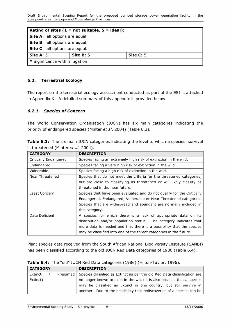
Rating of sites (1 = not suitable, 5 = ideal):
Site A: all options are equal.
Site B: all options are equal.
Site C: all options are equal.
Site A: 5 Site B: 5 Site C: 5
* Significance with mitigation
6.2. Terrestrial Ecology
The report on the terrestrial ecology assessment conducted as part of the ESI is attached
in Appendix K. A detailed summary of this appendix is provided below.
6.2.1. Species of Concern
The World Conservation Organisation (IUCN) has six main categories indicating the
priority of endangered species (Minter et al, 2004) (Table 6.3).
Table 6.3: The six main IUCN categories indicating the level to which a species’ survival
is threatened (Minter et al, 2004).
CATEGORY DESCRIPTION
Critically Endangered Species facing an extremely high risk of extinction in the wild.
Endangered Species facing a very high risk of extinction in the wild.
Vulnerable Species facing a high risk of extinction in the wild.
Near Threatened Species that do not meet the criteria for the threatened categories,
but are close to classifying as threatened or will likely classify as
threatened in the near future.
Least Concern Species that have been evaluated and do not qualify for the Critically
Endangered, Endangered, Vulnerable or Near Threatened categories.
Species that are widespread and abundant are normally included in
this category.
Data Deficient A species for which there is a lack of appropriate data on its
distribution and/or population status. The category indicates that
more data is needed and that there is a possibility that the species
may be classified into one of the threat categories in the future.
Plant species data received from the South African National Biodiversity Institute (SANBI)
has been classified according to the old IUCN Red Data categories of 1986 (Table 6.4).
Table 6.4: The “old” IUCN Red Data categories (1986) (Hilton-Taylor, 1996).
CATEGORY DESCRIPTION
Extinct / Presumed
Extinct)
Species classified as Extinct as per the old Red Data classification are
no longer known to exist in the wild; it is also possible that a species
may be classified as Extinct in one country, but still survive in
another. Due to the possibility that rediscoveries of a species can be

Draft Environmental Scoping Report for the proposed pumped storage power generation facility in the Steelpoort area, Limpopo and Mpumalanga Provinces
Environmental Scoping Study – Bio-physical 6-5 13/11/2006
made the category is sometimes referred to as Presumed Extinct.
Endangered Taxa in danger of extinction and which are unlikely to survive if the
current situation continues.
Vulnerable Taxa that are likely to move into the Endangered category in the
near future if the factors causing the decline continue to be present.
Rare Rare taxa are taxa with small populations that are not classified as
Endangered or Vulnerable, but are at risk as an unexpected threat
may cause a critical decline in the population.
Indeterminate Taxa known to be in one of the four above categories, but insufficient
information is available to determine which of the four categories.
Insufficiently Known Insufficiently Known taxa are suspected to belong to one of the
above categories, but this is not known for certain as there is a lack
of information available on the species
Not Threatened Taxa that are no longer included in any of the threatened categories
due to an increase in the population size or the discovery of more
individuals of populations.
No Information Taxa without any information available.
The Out of Danger category is used for taxa that have formerly been included in one of
the threat categories, but are now considered relatively secure (Hilton-Taylor, 1996).
The Rare category is therefore seen as similar to the Near Threatened category in the
new classification and the Insufficiently Known category seems to be similar to the Data
Deficient category in the new classification.
The Transvaal Nature Conservation Ordinance (no 12 of 1983) lists species protected in
the old Transvaal area (now the North West, Limpopo, Mpumalanga and Gauteng
Provinces). Species noted as protected in the tables below are protected in accordance
with this Ordinance.
In Sections 6.2.2 and 6.2.3 below, species of concern have been identified that have a
possibility of occurring at the three sites.
6.2.2. Flora
The alternative sites are located on two vegetation types described by Low and Rebelo
(1998):
• Mixed Bushveld (18)
• Moist Sandy Highveld Grassland (38)
Acocks (1988) also indicates two vegetation types occurring on the site, but with
different distributions:
• Mixed Bushveld (18)
• Sourish Mixed Bushveld (19)
Vegetation Type 18 (Mixed Bushveld) covers nearly 29% of the Limpopo Province but
only 1.57% is conserved, while Vegetation Type 38 (Moist Sandy Highveld Grassland)

Draft Environmental Scoping Report for the proposed pumped storage power generation facility in the Steelpoort area, Limpopo and Mpumalanga Provinces
Environmental Scoping Study – Bio-physical 6-6 13/11/2006
covers only 0.04% of the Limpopo Province without any current conservation status.
Almost 7.5% of Vegetation Type 19 (Sourish Mixed Bushveld) is conserved in the
Limpopo Province.
The sites are also located within the Sekhukhuneland Centre of Endemism, which is
located within the rain shadow of the Drakensberg and is therefore relatively arid
compared to the surrounding areas. Climatically this region comprises an arid (karoid)
subtropical (lowveld) enclave surrounded by areas that are temperate (frost in winter)
and much wetter (particularly towards the north, east and south) (van Wyk and Smith
2001).
The major plant communities found within the centre relates to soil properties, aspect
and terrain (Siebert et al 2003), which explains why this area is floristically noteworthy in
that many rare and endemic species with localised distribution correlate with the
geological substrate that occurs here (Siebert et al 2003).
Siebert (2001) conducted a survey on the vegetation of the Sekhukhuneland Centre of
Endemism as part of his Philisophiae Doctor Degree. Six basic vegetation types were
recorded during the study; five of the communities occur on the alternative sites. The
communities of interest are the following (descriptions in Appendix K):
1. Fuirena pubescens – Schoenoplectus corymbosus Wetland Vegetation
2. Themeda triandra – Senecio microglossus Cool Moist Grasslands
3. Combretum hereroense – Grewia vernicosa Open Mountain Bushveld
4. Kirkia wilmsii – Terminalia prunioides Closed Mountain Bushveld
5. Hippobromus pauciflorus – Rhoicissus tridentate Rock Outcrop Vegetation
A number of protected plant species occur in the Sekhukhuneland Centre of Endemism (a
list of species of concern that may occur in the study area, is attached in Appendix K).
These species are most likely to occur in areas with little disturbance:
• Six taxa of Zantedeschia
• 17 taxa of Aloe
• Four species of Kniphofia
• Gloriosa superba
• Littonia modesta
• Agapanthus inapertus
• Three species of Eucomis
• Nerine rehmannii
• Brunsvigia radulosa
• Three species of Crinum
• Ammocharis coranica
• Three species of Cyrthanthus
• Five species of Dioscorea

Draft Environmental Scoping Report for the proposed pumped storage power generation facility in the Steelpoort area, Limpopo and Mpumalanga Provinces
Environmental Scoping Study – Bio-physical 6-7 13/11/2006
• Schizostylis coccinea
• Four species of Dierama
• Babiana hypogea var. hypogea
• 10 taxa of Gladiolus
• 35 taxa of Orchids
• Tinospora fragosa
• Spirostachys africana
• Euphorbia barnardii
• Four species of Cussonia
• Erica alopecurus var alopecurus
• Erica cerinthoides var cerinthoides
• Pachypodium saundersii
• Four species of Brachystelma
• Eight taxa of Ceropegia
• Riocreuxia picta
• Tavaresia barklyi
• Six species of Heurnia
• Huerniopsis atrosanguinea
• Duvalia polita
• Two species of Stapelia
• Orbea tapscottii
• Pachycymbium keithii
• Two species of Orbeopsis
• Three species of Streptocarpus
6.2.3. Fauna
Due to the wide range of habitats occurring at the sites, it can be expected that a large
number of fauna can occur there.
The Groothoek Greeff Private Nature Reserve is located a short distance to the north of
Site A, between Site A and Site B. Some of the species that occur on the Private Reserve
are likely to migrate to suitable areas surrounding the site.
• Avifauna
Bird life in the area is very rich, due to the diverse habitat present in the area. The
quarter degree grid 2529BB provides habitat to 305 bird species (Sites A and B).
Site C is located within the quarter degree grid 2429DD, in which 171 bird species
have been identified.
Five species of birds classified as vulnerable may possibly utilise the site. The
remaining species of concern which could also utilise the sites, are classified as near

Draft Environmental Scoping Report for the proposed pumped storage power generation facility in the Steelpoort area, Limpopo and Mpumalanga Provinces
Environmental Scoping Study – Bio-physical 6-8 13/11/2006
threatened. According to the Transvaal Nature Conservation ordinance, all bird
species except for the most common species are protected.
• Mammals
A total of 78 mammal species may possibly utilise the site. Large mammal species
such as the red hartebeest, wildebeest and warthog have been observed during site
visits. It is expected that various other large and small mammals occur in the area.
Only 2 Red Data mammal species may utilise the sites. The remaining species have
been identified as species of concern.
• Reptiles
A large number of reptile species possibly occur in the various habitats on the site.
One tortoise species, one terrapin species, 38 snake species and 15 lizard species
can possibly occur on the site.
No Red Data reptiles species where identified as possibly occurring that the sites.
According to the Transvaal Nature Conservation Ordinance all reptile species are
protected except for the Water and Rock Monitor, and all snake species.
• Amphibians
Small wetlands are important for frogs and play a large role in the meta-population
dynamics of certain taxa (Channing 1995). Frogs can be seen as bio-indicator
species, whose abundance and diversity reflect the general health and well-being of
aquatic systems. Nine amphibians may possibly utilise the riverine areas at Sites A
and B (Minter et al. 2004). No Red Data amphibian species are expected at any of
the three sites (see Photograph 6.1).
No Red Data or Protected species were identified that could possibly utilise the sites.

Draft Environmental Scoping Report for the proposed pumped storage power generation facility in the Steelpoort area, Limpopo and Mpumalanga Provinces
Environmental Scoping Study – Bio-physical 6-9 13/11/2006
Photograph 6.1: Habitat for amphibians (Tributary at Site A Lower)
• Invertebrates
Southern Africa has an extremely high diversity of insects, with more than
80 000 species already recorded. Insects are the most abundant and successful
terrestrial species, occupying almost every habitat type except the ocean. Insects
are essential in various roles within ecosystems, e.g. nutrient recycling, plant
pollination, maintenance of plant community composition and other insectivorous
animals. Each insect forms part of a wider ecosystem, and if lost, the complexities
and abundance of other life will be affected. While some insects have a negative
effect on human lives, others are necessary to our survival (Scholtz & Holm 1989;
Gullan & Cranston 1994). In many ecosystems insects are the main grazers and
play a vital role in the decomposition of plant and animal wastes (Picker et al. 2004).
Scorpions occur in every terrestrial habitat in Southern Africa and in many cases
some have a preference for highly specialised habitats (Leeming 2003). In general,
scorpion species are not protected by the Conservation Ordinance (1983) but an
increase in knowledge regarding distribution data as well as potential threats
represented by habitat fragmentation and destruction has led to some species being
recognised as being in need of protection.
It is expected that due to the high biodiversity, a large number of invertebrate
species will utilise the site. The invertebrate species that are protected under the
Transvaal Nature Conservation Ordinance, which could potentially occur on the sites,
are listed below in the table below.

Draft Environmental Scoping Report for the proposed pumped storage power generation facility in the Steelpoort area, Limpopo and Mpumalanga Provinces
Environmental Scoping Study – Bio-physical 6-10 13/11/2006
6.2.4. Site-specific Ecological Evaluation
• Site A
Upper Dam
Three of the vegetation communities (nr. 2, 4 and 5) mentioned in Section 6.2.2
above and described in Appendix K, occur at this site, of which community 4 is
dominant, with some patches of communities 2 and 5. The site is still intact, with
very little disturbance.
Lower Dam
Four of the five vegetation communities occur here (nr. 1, 2, 3, 4) (see Photograph
6.2). The dominant vegetation communities are community 2 and 3. Only a small
patch of community 4 is present on the site and the riverine areas are represented
by community 1. Community 2 is very important due to the high number of species
of concern that may utilise this community. The site has been disturbed in some
areas due to the construction of electricity lines and other infrastructure. The
disturbance is however limited to these areas and therefore localised.
Photograph 6.2: Panorama of Site A Lower Dam
This community has a high sensitivity due to the high biodiversity and number of
species of concern that may utilise the site.
• Site B
Upper Dam
Only two vegetation communities occur at this site (1 and 2) (Photograph 6.3).
Community 2 is the dominant community and community 1 is represented in the
drainage area. The site is still fairly intact with some ruins occurring on the edge of
the site.

Draft Environmental Scoping Report for the proposed pumped storage power generation facility in the Steelpoort area, Limpopo and Mpumalanga Provinces
Environmental Scoping Study – Bio-physical 6-11 13/11/2006
Photograph 6.3: Site B Upper
Lower Dam
The dominant community at all options at this site is community 3, with community
1 representing the perennial stream on site. The site is still intact, with very little
disturbance.
The site has a high sensitivity due to the low level of disturbance and the presence of
a perennial drainage line.
• Site C
Upper Dam
The site is highly disturbed (Photograph 6.3). Maize (Zea mays) is planted on a
large portion of the site and the rest of the site is old cultivated fields colonised by
Tagetus minuta, Eragrostis sp., Pogonarthria squarrosa, Hyparrhenia sp., Bidens sp.,
as well as various other grass and forb species. Several of these species are
indicators of disturbance.
Photograph 6.4: Site C Upper Dam
The site has a low sensitivity due to the intense disturbance at the site.

Draft Environmental Scoping Report for the proposed pumped storage power generation facility in the Steelpoort area, Limpopo and Mpumalanga Provinces
Environmental Scoping Study – Bio-physical 6-12 13/11/2006
• Site selection summary – terrestrial ecology
Site A is slightly disturbed, but is still fairly intact and offers habitat to a high
number of species. All the communities are present at the two locations for the
dams at Site A. Habitat diversity is very high at this site.
Site B is the most intact habitat. A large number of species of concern occur in
these habitats; however, the richness is lower than that possibly occurring at site A
due to the lower habitat diversity.
After the screening process it was determined that Site C is the least ecologically
sensitive, therefore this site would be preferable from an environmental perspective
for the pumped storage scheme upper reservoir.
Table 6.5 below summarizes the ratings given to the various alternative sites and the
options within them. For an outline of the ratings used, please refer to Chapter 5 –
Approach.
Table 6.5: Alternative site ratings based on terrestrial ecology
• Nature and Extent of Impacts
The general area is located within the Sekhukhuneland Centre of Endemism and the
number of species of concern is therefore high. Although there might be alternative
habitat available for the species, a more detailed study would be necessary. Some of
the species of concern have only been discovered recently and therefore very little is
known about them. The specific habitat requirements of some of the species are
also unknown. The sites should therefore be investigated in detail prior to
decreasing the risk of loss of sensitive species and habitat. This will be done during
the EIA phase of this project. Detailed, site-specific management and mitigation
measures will be developed during the EMP phase and must be strictly adhered to
during the construction, operational and decommissioning phases. All activities
onsite must be monitored by an Environmental Control Officer (ECO).
Table 6.6: Potential impact on Terrestrial fauna and flora
RATING OF IMPACT: TERRESTRIAL FAUNA AND FLORA
Dimension During construction During operation
Duration Short term Long term
Extent Localised Localised
Locatio
n
Site A
Option 1
Site A
Option 2
Site A
Option 3
Site B
Option 1
Site B
Option 5
Site B
Option 7
Site C
Option 1
Rating 2 2 3 2 2 2 4

Draft Environmental Scoping Report for the proposed pumped storage power generation facility in the Steelpoort area, Limpopo and Mpumalanga Provinces
Environmental Scoping Study – Bio-physical 6-13 13/11/2006
Probability Highly probable Highly probable
Significance High Medium-high
Significance * Medium-low Medium-low
Status Negative Negative
Rating of sites (1 = not suitable, 5 = ideal): Site A: Slightly disturbed, but with very high habitat diversity.
Site B: Most intact, but with lower habitat diversity.
Site C: Least ecologically sensitive.
Site A: 2 – 3 Site B: 2 Site C: 4
Recommended studies for EIA phase:
More detailed studies to be done during EIA phase. At this stage site C appears to
be preferred from an ecological perspective.
* Significance with mitigation
Due to the sensitivity of most sites, detailed studies are required on the preferred
site in the EIA phase to identify sensitive areas and habitats that could be avoided
and provide suitable recommendations and mitigation measures, such as possible
relocation of specimens of sensitive plant species. The entire footprint of the
proposed dams will not incorporate an extremely large area, therefore habitat that
may be lost due to the placement of the dams will still be present and should be
conserved for the remaining fauna and flora.
6.3 Riverine Ecology
The riverine ecology assessment that was conducted as part of the ESI is contained in
Appendix K. A detailed summary of this appendix is provided below.
6.3.1. Sites A and B
Riverine ecology was considered for screening at the lower reservoirs (all options)
comprising site A and B. The upper reservoirs do not influence riverine ecosystems and
have therefore not been investigated at the screening / scoping level. The lower
reservoir for Site C is the proposed De Hoop Dam.
The assessment of riverine ecology that could be affected by the lower dam at Sites A
and B is based on the findings of the Olifants River Water Resources Development Project
Environmental Assessment Specialist Study on Aquatic Ecology, conducted by R Palmer,
2004.
The small tributary of the Steelpoort River which will be affected by the proposed dam at
Site A is similar in nature to the Klip River which will be inundated by the construction of
the proposed De Hoop Dam. The information obtained in the proposed De Hoop EIA for
the Klip River is thus relevant to this environmental screening.

Draft Environmental Scoping Report for the proposed pumped storage power generation facility in the Steelpoort area, Limpopo and Mpumalanga Provinces
Environmental Scoping Study – Bio-physical 6-14 13/11/2006
Photograph 6.5: Klip River streambed (left) tributary at Site A (right)
• Riverine Habitat
The habitat of the Klip River contains some well-developed small riffles and runs with
larger rocks and backwaters that provide good cover. The site also supports well
developed marginal vegetation that provides good cover for fish. Site A Tributary is
expected to have the same characteristics.
Habitat integrity for both in-stream and riparian components in the vicinity of the
Klip River tributary is considered to be Natural (Category A) (Figure 6.5).
Discussions with farmers at Site A identified that during high flood events, massive
boulders roll down the river bed which has led to significant alteration of the channel
morphology and has resulted in the destruction of the road bridge below the planned
option A3 location. It is expected that a more detailed examination of this
phenomenon would be required as part of the detailed engineering and
environmental studies.

Draft Environmental Scoping Report for the proposed pumped storage power generation facility in the Steelpoort area, Limpopo and Mpumalanga Provinces
Environmental Scoping Study – Bio-physical 6-15 13/11/2006
INSTREAM HABITAT ITEGRITYSteelpoort
0
20
40
60
80
100
SECTOR NO (---> FLOW DIRECTION)
HAB
ITAT
INTE
GRIT
Y (%
)
INSTREAM HABITAT INTEGRITY (%) 88 78 86 64 52 49 98 94
WATER ABSTRACTION (IMPACT 1 - 25) 5 6 6 9 11 13 1 3
FLOW MODIFICATION ( (IMPACT 1 - 25) 4 4 4 5 6 6 1 2
BED MODIFICATION (IMPACT 1 - 25) 4 15 5 12 14 15 1 2
CHANNEL MODIFICATION (IMPACT 1 - 25) 5 6 5 16 16 16 1 2
WATER QUALITY (IMPACT 1 - 25) 5 5 5 6 12 15 0 2
INUNDATION (IMPACT 1 - 25) 0 0 0 0 0 0 0 0
EXOTIC MACROPHYTES (IMPACT 1 - 25) 0 0 0 0 0 0 0 0
EXOTIC FAUNA (IMPACT 1 - 25) 0 0 0 0 0 0 0 0
RUBBISH DUMPING (IMPACT 1 - 25) 0 0 4 5 6 7 0 2
S1 S2 S3 S4 S5 S6 K1 K2
A: NATURAL, >90 %B: LARGELY NATURAL,80-90%C: MODERATELY MODIFIED,60-79%D: LARGELY MODIFIED,40-59%E: SERIOUSLY MODIFIED,20-39%F:CRITICALLY MODIFIED,0-19%
A
B
C
D
E
F
0
20
40
60
80
100
SECTOR (-> FLOW DIRECTION)
HAB
ITAT
INTE
GR
ITY (%
)
RIPARIAN ZONE HABITAT INTEGRITY 88 86 88 36 42 26 100 95
VEGETATION REMOVAL (IMPACT 1 - 25) 5 6 8 16 16 16 0 2
EXOTIC VEGETATION (IMPACT 1 - 25) 3 3 2 6 8 17 1 1
BANK EROSION (IMPACT 1 - 25) 6 6 5 16 11 15 0 2
CHANNEL MODIFICATION (IMPACT 1 - 25) 6 6 5 15 15 15 0 2
WATER ABSTRACTION (IMPACT 1 - 25) 2 4 3 5 5 7 0 1
INUNDATION (IMPACT 1 - 25) 0 0 0 0 0 0 0 0
FLOW MODIFICATION (IMPACT 1 - 25) 1 1 0 2 2 2 0 0
WATER QUALITY (IMPACT 1 - 25) 1 1 0 2 3 3 0 1
S1 S2 S3 S4 S5 S6 K1 K2
A: NATURAL, >90 %B: LARGELY NATURAL,80-90%C: MODERATELY MODIFIED,60-79%D: LARGELY MODIFIED,40-59%E: SERIOUSLY MODIFIED,20-39%F:CRITICALLY MODIFIED,0-19%
A
B
C
D
E
F
RIPARIAN HABITAT INTEGRITYSteelpoort
Figure 6.1: Habitat integrity at various sites in the vicinity of the proposed De Hoop
Dam, assessed in August 2004 (Site K2 is the reference site for Site A Tributary).
• Invertebrates
The only invertebrate taxon which is sensitive to water pollution and needs flowing
water was the stonefly Neoperla spio. This species was present in the Klip River,
indicating that the Klip River provides an important refuge area for sensitive taxa.
• Fish Community
Eleven of fifteen expected fish species were recorded during the survey at the Klip
River. A total of 131 specimens were collected and the catch per unit effort was 3.1
fish/minute, which is higher than those recorded in the Steelpoort River. The
presence of an additional two species is related to available habitat conditions
present at the site and being in a relatively well-conserved tributary. Analysing the

Draft Environmental Scoping Report for the proposed pumped storage power generation facility in the Steelpoort area, Limpopo and Mpumalanga Provinces
Environmental Scoping Study – Bio-physical 6-16 13/11/2006
expected and observed fish diversity in terms of habitat preferences, it is evident
that that all habitat preference categories were less impacted at this site than at any
of the other sites in the Steelpoort River. The Klip River most likely serves as refuge
for highly sensitive species such as Opsaridium peringueyi and Amphilius
uranoscopus from where they can repopulate the Steelpoort River during favourable
conditions. This site is also potentially one of the few sites that may still support
some specimens of Barbus lineomaculatus that has not been collected in this river
since 2000. Overall, this site in terms of fish was classified as Slightly Impaired
(Category B).
A variety of small barbs such as Barbus lineomaculatus, Barbus paludinosus, B.
trimaculatus and B. unitaeniatus have been recorded from this area and they need
access to inundated marginal vegetation during summer to spawn. The maintenance
of shallow, slow-flowing vegetated backwaters as nursery areas, during the breeding
season is also essential.
The proposed dam is expected to inundate the Site A Tributary. This is certain to
eliminate all flow-dependent fish species, particularly the Barred minnow
(Opsaridium peringueyi) and the Shortspine rock catlet (Chiloglanis pretoriae). The
Barred minnow listed in the Red Data book for fish as Rare – Indeterminate (Skelton
1987). These flow-dependent species are currently found in the lower sections of
Klip River. There is also a risk that alien fish species, such as black bass, which are
currently absent from this stream, may colonise the stream.
• Disruption of Fish Migration
The proposed dams are certain to create a permanent barrier to upstream fish
migration and isolate the river fish population into two distinct populations, with
consequent long-term implications for genetic diversity and vigour. Species that will
be most affected by this barrier to migration include Largescale yellowfish
(Labeobarbus marequensis) and Labeo (Labeo molybdinus).
• Birds
Inundation of the Steelpoort River will be highly detrimental to a number of riverine
bird species (Barnes 2000). However, a wide range of aquatic species are likely to
benefit from the proposed impoundments. At least 64 species of birds that are
commonly associated with water or wetlands have been recorded in the vicinity of
the proposed De Hoop Dam. It is likely that many of these bird species will benefit
from the impoundments and that the remainder will be very little affected by the
change.

Draft Environmental Scoping Report for the proposed pumped storage power generation facility in the Steelpoort area, Limpopo and Mpumalanga Provinces
Environmental Scoping Study – Bio-physical 6-17 13/11/2006
• Mammals and Reptiles
It is possible that crocodiles will inhabit the new impoundments, as they occur in the
nearby Flag Boshielo Dam on the Olifants River and may migrate to the proposed De
Hoop Dam, at a similar altitude. Crocodiles were also recently recorded about 5km
upstream of Steelpoort Bridge. Crocodiles are listed as Vulnerable in the South
African Red Data book of reptiles and amphibians (Branch 1988). The only other
aquatic reptile listed in the Red Data book that is expected to occur in the area is the
Water monitor (Leguan), also listed as Vulnerable.
At least 23 species of mammals that are commonly associated with water or
wetlands are expected to occur or have occurred in the vicinity of the proposed De
Hoop Dam and thus could be expected at Site A Lower Dam. Of these, only three
species are commonly associated with water or wetlands: clawless otter, spotted
necked otter and water mongoose. It is likely that water mongooses, which are
common throughout South Africa, will benefit from the higher water level. It is
possible that water mongoose could carry rabies. There are presently no known
hippos in the area and they are not expected to colonise the dam. However, hippos
are known to travel long distances, particularly after floods, and there is a small
chance that they could establish in the impoundments.
• Eutrophication and Emission of Greenhouse Gases
The conversion of a large area from a terrestrial to an aquatic ecosystem leads to the
decomposition of vegetation and subsequent release of nutrients and emissions of
significant quantities of greenhouse gasses. Elevated nutrients can lead to the
development of blue-green algae, such as Microcystis and Anabaena, which can be
toxic.
The main gasses of concern are carbon dioxide, which is foreseen to be released
under aerobic conditions within the epilimnion of the new impoundments, and
methane, which will be released under anaerobic conditions within the hypolimnion.
Both gases contribute to the greenhouse effect, but methane is by far the more
potent of the two. The proposed dam basins contain significant numbers of large
Acacia galpinii and Combretum trees that characterise the riparian zone. The
vegetation survey estimated that there are in the order of 10 000 Acacia galpinii
trees that will be inundated.
• Increased Bilharzia
Bilharzia snails were not found during the baseline survey in August 2004, and a
detailed survey of aquatic snail distribution in the Olifants River Catchment
conducted between 1958 and 1970 failed to find urinary bilharzia snails (Bulinus
spp.) in the Steelpoort River Catchment (de Kock et al 1983). However,
intermediate host snails for rectal bilharzia (Biomphalaria pfeifferi), were recorded

Draft Environmental Scoping Report for the proposed pumped storage power generation facility in the Steelpoort area, Limpopo and Mpumalanga Provinces
Environmental Scoping Study – Bio-physical 6-18 13/11/2006
from two tributary streams in the vicinity of the proposed dam (de Kock et al 1983).
These snails are usually not found at altitudes above 914 m (Schutte and Frank
1964). The proposed dams, with a FSL of 1000 m, are therefore in excess of the
altitudinal distribution range for rectal bilharzia
6.3.2. Site C
The upper reservoirs are located in the upper reaches of the catchment within a drainage
line and not within a clearly defined river system.
6.3.3. Site selection summary – riverine ecology
Table 6.7: Alternative site ratings based on riverine ecology
Location Site A
Option 1
Site A
Option 2
Site A
Option 3
Site B
Option 1
Site B
Option 5
Site B
Option 7
Site C
Option 1
Rating 2 2 2 2 2 2 4
6.3.4. Nature and Extent of Impacts
The proposed dam is expected to inundate the Site A Tributary, if this site is selected.
This will eliminate all flow-dependent fish species. There is also a risk that alien fish
species, such as black bass, which are currently absent from this stream, may colonise
the stream.
The proposed dams will furthermore create a permanent barrier to upstream fish
migration and isolate the river fish population into two distinct populations, with
consequent long-term implications for genetic diversity and vigour.
Inundation of the Steelpoort River is likely to be highly detrimental to a number of
riverine bird species; however, a wide range of aquatic species are likely to benefit from
the proposed impoundments. It is likely that many of the water-associated bird species
recorded in the vicinity of the proposed De Hoop Dam (including certain Red Data
species) will benefit from the impoundments and that the remainder will be very little
affected by the change.
It is possible that crocodiles will inhabit the new impoundments. It is likely that water
mongooses will benefit from the higher water level; however, it is possible that water
mongoose could carry rabies. There is a slight chance that hippos might migrate to and
establish in the impoundments.
Decomposition of plant material inundated by filling of the dams may lead to
eutrophication and emission of greenhouse gases, notably carbon dioxide and methane.
It is unlikely that the risk of Bilharzia will increase with the project.

Draft Environmental Scoping Report for the proposed pumped storage power generation facility in the Steelpoort area, Limpopo and Mpumalanga Provinces
Environmental Scoping Study – Bio-physical 6-19 13/11/2006
Sites A and B seem not to be very suitable for the proposed development. Site C
appears to be the most favourable location from the perspective of riverine ecology, as it
is not situated within a drainage line or within a clearly defined river system.
Table 6.8: Rating Of Impacts on Riverine Ecology
RATING OF IMPACT: RIVERINE ECOLOGY
Dimension During construction During operation
Duration Short term Long term
Extent Localised – sub-regional Localised – sub-regional
Probability Possible – highly probable Possible – highly probable
Significance Medium – high Medium – high
Significance* Medium Low – medium
Status Negative Negative
Rating of sites (1 = not suitable, 5 = ideal):
Site A: All options are equal and not very favourable.
Site B: All options are equal and not very favourable.
Site C: Site C option 1 is considered favourable.
Site A: 2 Site B: 2 Site C: 4
Recommended studies for EIA phase:
More detailed studies to be done during EIA phase. At this stage site C appears to be
preferred from the perspective of riverine ecology.
*Significance with mitigation
6.4. Water Quality
The State of the Rivers report for the Olifants River (2001) describes the ecological state
of the Steelpoort River as fair to unacceptable. Land-use practices such as overgrazing
has led to erosion, which causes high silt levels in the river. Runoff from mines and other
activities in the area also contributes to reduced water quality.
The pumped storage scheme must be viewed as an inter-basin transfer scheme and while
the effects on the three alternative upper dam sites will be similar, a more detailed
assessment is required to determine the implications of catchment transfer impacts.
Various water quality studies undertaken along the Steelpoort River are reviewed and the
main water quality concerns addressed at each proposed site location.
6.4.1. Site A
An EIA undertaken for Site A in 1999 assessed the water quality situation of the
Steelpoort River. The DWAF monitoring station on the Steelpoort River on Buffelskloof
was used to assess the water quality in the River downstream of the position of the
proposed dam location. Data obtained for the period 1987 to 1999 found the water to be

Draft Environmental Scoping Report for the proposed pumped storage power generation facility in the Steelpoort area, Limpopo and Mpumalanga Provinces
Environmental Scoping Study – Bio-physical 6-20 13/11/2006
of relatively good quality, although problems with high salinity were observed (Wates,
Meiring and Barnard, 1999).
In the feasibility study of the Steelpoort Pumped Storage Scheme (Louwinger et al.,
2000), water from the stream at the upper reservoir site and the Steelpoort River was
found to meet the SABS standard for drinking water.
It is therefore expected that since the water quality of the river is good, the relative
changes that may occur as a result of dam construction would be internal. Such water
quality impacts may be the result of:
• The formation of a chemocline after filling as inorganic particles are dissolved into
the water and the breakdown of organic matter (vegetation) has a similar effect
• The formation of a hypolimnion (depending on the depth of the dam) leading to an
anaerobic bottom layer in the layer
• The development of elevated levels of nutrient enrichment through the process of
vegetative breakdown. This is a reduced risk as the breakdown process happens over
time and there are no external sources of nutrient enrichment which would lead to
eutrophication. It is expected that the dam would be oligotrophic.
The implications on water quality regarding bush clearing and pure flooding would need
to be considered during later phases of the project and is not considered here because:
• There is no available water quality data for the river; and
• The impacts would be similar for all sites.
6.4.2. Site B
No studies have been carried out regarding the water quality at the proposed site
(alternative site B). However, it is anticipated that water quality issues addressed by
various studies undertaken for Site A and C will be similar for Site B Option 7 due to its
location along the Steelpoort River.
A similar impact to Site A is expected at the Option B5 site, but with one difference.
Development plans for the area immediately upstream of the dam include a conference
centre. The impact of the conference centre could be significant on the quality of the
water in the dam, in terms of the following:
• Increased paved areas accelerate the potential for oil contamination of the dam;
• Increased landscaping and maintenance could increase the level of suspended
sediment in the dam
• The additional fertilizers in garden maintenance could increase the level of nutrients
in the system (i.e. eutrophication)
• The treatment of waste water from the centre may add a nutrient load to the dam
resulting in eutrophic conditions

Draft Environmental Scoping Report for the proposed pumped storage power generation facility in the Steelpoort area, Limpopo and Mpumalanga Provinces
Environmental Scoping Study – Bio-physical 6-21 13/11/2006
While the assessment of Site B is considering the impact of the dam on the environment,
it is important to take into account future development plans for the catchment. The
potential increase in turbidity could affect the lifespan of the pumps. Additionally, the
potential increase in eutrophication would increase the risk for additional enrichment and
associated impacts not only in the river section downstream of the dam and ultimately
the proposed De Hoop Dam, but also the upper reservoir and its downstream catchment
which is relatively unaffected at present.
6.4.3. Site C
Various studies (Palmer, 2001; Palmer and Rossouw, 2001; Claassen et al., 2004) have
been undertaken regarding the water quality situation of Steelpoort River due to the
proposed development at Site C.
Previous studies by Palmer (2001) and Palmer and Rossouw (2001) indicated that the
Steelpoort River was in a fair state for water quality (Class C). Significant increases in
total dissolved salts in the downstream parts of the river were observed. This can be
attributed to mining activities, irrigation and land-use practices in the area. The increase
in total dissolved salts was found to be highly seasonal with high concentrations recorded
during the low flow months. Nutrients were slightly elevated as a result of treated
domestic effluent from Burgesfort (Palmer and Rossouw, 2001).
As part of an EIA in 2004, a water quality assessment was undertaken to identify the
expected water quality impacts associated with the development of the proposed De
Hoop Dam. The potential water quality impact was assessed during each developmental
phase of the dam i.e. construction, filling and operational phase (Claassen et al., 2004).
6.4.4. Nature and Extent of the Impacts
During the construction phase, water quality will be influenced by increased sediment
levels and water contamination could potentially occur due to the storage of chemicals
on-site. However, the impact will be for a short duration and will be limited to the
construction period. Within the dam basin, contamination may occur due to human
activities or due to eutrophication. Both these contaminants will have a serious impact on
the water quality, should appropriate mitigation measures not be used. Impacts
associated with the filling phase are associated with a reduction in flow and changes in
the water quality though alterations in the sediment load, turbidity, temperature,
oxygen, nutrients, salts, toxicants and introduced species. The impact will be continuous
and will remain over the life time of the dam. Other impacts such as changes in
temperature, oxygen, turbidity and sedimentation will also occur over the life time of the
dam (Claassen et al., 2004).

Draft Environmental Scoping Report for the proposed pumped storage power generation facility in the Steelpoort area, Limpopo and Mpumalanga Provinces
Environmental Scoping Study – Bio-physical 6-22 13/11/2006
Overall, the residual impact is expected to be within the compliance requirements of the
ecological Reserve and not influence existing water users if reasonable mitigation
measures are employed during the construction and operational phase of the dam
(Claassen et al., 2004).
As part of the same EIA, Donohue (2004) addressed health impacts associated with the
proposed De Hoop Dam development. Potential water quality impacts were also
addressed in the document, with particular emphasis on human health. Water quality
concerns are associated with faecal contamination, eutrophication, organic chemicals and
heavy metals contamination. Diseases such as bilharzias are anticipated to increase as a
result of the development. Dam usage for recreation and agriculture should be limited to
maintain water quality (Donohue, 2004).
The water quality assessment for the proposed De Hoop Dam also considered that the
resultant water quality in the dam would be corrosive (implications for construction) and
turbid (implications for lifespan of pumps). Additionally, has indicated that off-channel
storage schemes may offer a reduced risk for siltation as filling from the river typically
happens on a continuous basis during base flow conditions. This reduces the potential
impact on turbidity within the impoundment.
The upper dam water quality will reflect the quality of the proposed De Hoop Dam.
Table 6.9: Rating Of Impacts on Water Quality
RATING OF IMPACT: WATER QUALITY
Dimension During construction During operation
Duration Short term Long term
Extent Localised – sub-regional Localised – sub-regional
Probability Highly probable Possible
Significance Medium – high Medium – high
Significance* Medium Low – medium
Status Negative Negative
Rating of sites (1 = not suitable, 5 = ideal):
Site A: Water quality currently relatively good. Relative changes that may occur as a
result of dam construction are expected to be internal.
Site B: Planned development upstream could result in turbidity which could reduce
the lifespan of the SPSS.
Site C: Water quality currently fair.
Site A: 4 Site B: 3 – 4 Site C: 2
Recommended studies for EIA phase:
More detailed studies to be done during EIA phase. At this stage site A (all options)
appears to be preferred from the perspective of water quality.
*Significance with mitigation

Draft Environmental Scoping Report for the proposed pumped storage power generation facility in the Steelpoort area, Limpopo and Mpumalanga Provinces
Environmental Scoping Study – Bio-physical 6-23 13/11/2006
6.4.5. Site Selection Summary – Water Quality
Table 6.10: Alternative site ratings based on water quality
Location Site A
Option 1
Site A
Option 2
Site A
Option 3
Site B
Option 1
Site B
Option 5
Site B
Option 7
Site C
Option 1
Rating 4 4 4 3 4 3 2
6.5. Hydrology, Surface Water and Groundwater
The hydrological, surface water and groundwater assessments can be found in
Appendix K (ESI) and Appendix L (of this draft ESR.
6.5.1. Methodology
The study comprised a desktop study of available information. All hydrological data was
based on preliminary desktop analyses. The “Project Lima Supplementary Feasibility
Study- Phase 1 Site Selection Study Main Report Volume 1” conducted by BKS Palace
Consortium during May 2006, was consulted for the purposes of this study. A number of
potential sites were identified and ranked during the BKS study. The Geohydrological
division at the Department of Water Affairs and Forestry (DWAF) in Pretoria was
requested to provide borehole locations, measured yields, drilled depths, and chemistry
data for any existing boreholes from their data base within the proposed study area
(reference block coordinates S: 24° 55’ - 25° 08 ‘ and E: 29° 45’ - 30° 00’)This data
provided additional information for use in the geohydrological screening study.
Although all the available borehole information within the provided grid coordinates were
provided by DWAF, only the applicable farms on which the three actual options (Site A,
B, and C) are located, were considered.
6.5.2. The study area
The study area comprises various properties, which is situated within the lower parts of
the B41C Quaternary Catchment as well as within the middle to lower parts of the B41D
Quaternary Catchment.
The following catchment characteristics have been noted:
• The general geology of these quaternary catchments comprises Bushveld Igneous
Complex rocks and basic/mafic and ultramafic intrusives.
• Soils in this region vary from moderate to deep sandy loam, with steep relief.
• Vegetation for this area comprises of savannah (Simplified Acocks Veld Types).

Draft Environmental Scoping Report for the proposed pumped storage power generation facility in the Steelpoort area, Limpopo and Mpumalanga Provinces
Environmental Scoping Study – Bio-physical 6-24 13/11/2006
The major river in the B4 sub-drainage region is the Steelpoort River and its smaller
tributaries. The Steelpoort River forms the western border of the region. The Spekboom
River drains the eastern part of the region and has its origin near the town of Lydenburg,
and flows into the Steelpoort River near the end of the region. The Dwars River drains
the area between the Steelpoort and Spekboom River.
6.5.3. Hydrogeology
The main points identified during the ESS phase from a hydrogeological perspective,
were the following:
• Geologically the formations underlain by the study area belong to the Bushveld
Igneous Complex and comprise felsic rocks of the Rashoop Granophyre Suite
overlying the mafic rocks of the upper and main zones of the Rustenburg Layered
Suite. The high plateau is underlain by granophyre in the south of the area by mixed
granite and granophyre in the north.
• The aquifer type is intergranular (i.e. weathered) and fractured.
• Groundwater occurs typically in faults and shear zones.
• The mean annual recharge is between 27-37 mm per annum.
• The contribution of groundwater to the base flow of streams and rivers in the area is
considered negligible.
• The average depth to groundwater is between 10 and 20 m.
• The harvest potential1 for the Steelpoort area is seen to be between 10 000 and
15 000 m3/km2/annum.
• The factor restricting the harvest potential in this area is the limited effective
storage. Recharge occurs regularly most years but cannot all be absorbed into the
aquifer because of low storage. The limiting factor is how much groundwater can be
storing the wet season to bridge abstraction during the drier season.
Isolated alluvial aquifers are recognised to form in association with Steelpoort River. The
regional mapping and data sources do not indicate any alluvial aquifers on any of the
three candidate sites. These aquifers, if present, will be assessed during the EIA phase of
work, i.e. when site-specific data is compiled.
Static water levels
Static water levels for all boreholes within the two quarter-degree grids, within site C in
2429DD, and Sites A and B in 2529BB were provided by DWAF. The information provided
was with the exception of the farm names or coordinates and consequently no
unnecessary information, not being applicable to the three sites, could be discarded.
1 The harvest potential is defined as “the maximum volume of groundwater that may annually be abstracted per surface area of an aquifer system to preserve a sustained abstraction”.
Draft Environmental Scoping Report for the proposed pumped storage power generation facility in the Steelpoort area, Limpopo and Mpumalanga Provinces
Environmental Scoping Study – Bio-physical 6-25 13/11/2006
Areas of shallow groundwater levels, typically located in the valley, within the alluvial and
weathered (shallow) aquifers are more vulnerable to surface contamination. All three
sites have incidents of shallow groundwater, thus no one site is more vulnerable than the
next.
Yields
Site C has enhanced groundwater potential, due to underlying geological structures,
these resultant high yielding aquifers have the potential to be utilised in the future and
are thus recognised to be of more value than the lower yielding boreholes on sites A and
B.
Groundwater Chemistry
Although all the available borehole chemistry results within the requested grid
coordinates were provided by DWAF, only the applicable farms covering the three actual
sites (Sites A, B, and C) were investigated. Data covering farms that would not be
affected by the 10 preliminary options for Sites A-C were discarded. No preferential site
can be selected based on the available hydrochemical data.
6.5.4. Site Selection Summary – Groundwater
The three possible sites (Site A, B, and C) which have been identified during the pre-
feasibility study, are discussed for their significance from a hydrogeological point of view:
• Site A:
Possible seepage through the bedrock at the upper reservoir position for option 1 as a
result of dolerite dykes (resulting in contact metamorphism and enhanced
groundwater potential) makes this a less favourable option than the upper off-
channel option which is not situated on such structures.
Stripping of 0.5 m of overburden material at this preferred upper reservoir position
also favours it more as more fill material will be available opposed to the in-stream
option.
From a groundwater point of view neither the off-stream nor the in-stream lower
reservoir options will be more beneficial as no significant faults or shear zones occur
within any of the two options that may influence groundwater recharge positively or
negatively. Though the in-stream option may be more beneficial towards groundwater
recharge during the drier months, as the impoundment is likely to contribute towards
groundwater recharge and baseflow, as the water table will be situated lower than the
dam. During the wetter months the opposite is likely to happen, the water table will
be more elevated and likely to contribute flow towards the impoundment.

Draft Environmental Scoping Report for the proposed pumped storage power generation facility in the Steelpoort area, Limpopo and Mpumalanga Provinces
Environmental Scoping Study – Bio-physical 6-26 13/11/2006
Thus, either Option 3 or 4 is preferred at Site A.
• Site B:
Options B5 and B6 are the least favourable options from a groundwater point of view,
as the lower reservoir position is situated directly south-east of the Steelpoort Fault.
The possibility, therefore, exists that faults or shear zones, associated and parallel to
the main fault, may occur in the vicinity of the planned impoundments. This implies
that grouting beneath the plinth of the rock fill embankment may be required in order
to prevent large scale groundwater seepage losses.
Constructing the tunnel line through the Steelpoort Fault and associated shear and
fracture zones may result in groundwater inflows (and associated dewatering), which
makes options B1 and B2 less favourable.
Constructing the pressure tunnel, machine, and transformer halls for options 3, 5,
and 7 may possibly intercept water bearing shear or fracture zones that may also
result in increased groundwater ingress. This also applies specifically to the prominent
lineation crossing the underground waterways for option 5, which should be avoided
during the siting optimisation of the power station caverns and constructing the surge
chamber.
The impact of the geological structures, which can act as preferential flow paths, can
result in large inflows of groundwater into the workings and also the need for
dewatering, which can impact on groundwater users and resources in the area.
This favours B4 and B8 as the two most favourable options.
The high incidence of geological structures and the location of the major Steelpoort
Fault, in relation to site B, increase the probability that this project will impact on the
groundwater resources in this area. These impacts can be both artificial recharge and
dewatering.
• Site C:
Groundwater seepage through the trench at the lower reservoir overlying two limbs of
the Steelpoort fault may be substantial.
Constructing the headrace tunnel, surge shaft, pressure shaft, and tunnel through
potentially a number of northwest-trending fracture zones running parallel to the
tunnel alignment may be troublesome if they are water bearing and high yields may
be encountered.

Draft Environmental Scoping Report for the proposed pumped storage power generation facility in the Steelpoort area, Limpopo and Mpumalanga Provinces
Environmental Scoping Study – Bio-physical 6-27 13/11/2006
The proximity of site C to the Steelpoort Fault (enhanced groundwater potential) and
the proposed De Hoop Dam (isostacy) indicates that this site may impact more
readily on the groundwater regime. This is a fatal flaw.
Site C is, from a hydrogeological perspective fatally flawed. It can therefore
not be further considered as a possible site for the proposed SPSS.
6.5.5. Surface water quantity
• Catchment boundaries
The study area is located within the Steelpoort River Catchment and its tributaries.
The Steelpoort River catchment drains into a northerly direction and eventually flows
into the Olifants River. The boundaries of the catchment are occupied by some
dense rural residential related activities, some small scale farming activities, as well
as some game farming areas. The affected watercourse that would be impacted
upon would be the Steelpoort River.
Identified sites are located towards the downstream western side of the Steelpoort
River. This selection may be contributed to the plateau height (to the west of the
river), which is required to achieve sufficient hydraulic head.
Site A is located close to the current De Hoop Dam scheme. The site lends itself to
both on- and off-channel options for the lower reservoir. Four different storage
options have been identified for this site. Site B has one preferred location for an
upper reservoir, with different locations for the lower reservoir. Eight different
storage options have been identified for this site. Site C is located opposite the
western edge of the proposed De Hoop Dam, which would serve the common
purpose as lower reservoir for the Pumped Storage scheme. Two options have been
identified for this site.
• Virgin Mean Annual Run-off
The virgin mean annual run-off (MAR) for both quaternary catchment areas has been
estimated. Water Research Commission publications (Surface Water Resources of
South Africa- Volume 1) were used to obtain the MAR for each Quaternary drainage
regions. The B41B Quaternary Catchment has an estimated MAR of 17.8 x10⁶ m3
per annum while the B41D Quaternary Catchment has an estimated MAR of 16.6
x106 m3 per annum. No actual stream flow data was obtained during this study.
• Flood Peaks and Volumes
Flood calculations will be determined as part of the feasibility process. Water storage
reservoirs will be classified according to Chapter 12 of the National Water Act, 1998

Draft Environmental Scoping Report for the proposed pumped storage power generation facility in the Steelpoort area, Limpopo and Mpumalanga Provinces
Environmental Scoping Study – Bio-physical 6-28 13/11/2006
(Act 36 of 1998) and relevant Government Notices, as dams with a Safety Risk.
Social, economic, and environmental impacts will be used during the classification
process. Freeboard and spillway sizes will be determined according to the relevant
SANCOLD (South African Commission on Large Dams) publications. This will be done
during the detailed design process.
6.5.6. Site Selection Summary – Surface Water and General Hydrology
• Favourability of the alternative sites and options
o Site A
At Site A, Option 1 is the least favoured as both the lower and the upper reservoirs
will be located in-stream, which will result in high sedimentation yields which is a
direct result of the high erodibility index for the study area. Both the in-stream
options will also influence the hydrological regime for the streams they are located in
negatively.
Option 2 is the second least favoured. For the same reasons as above, although the
upstream reservoir will be off-stream, the lower reservoir will still be in-stream.
Option 4 is the third least favoured. Although both impoundments will be situated
off-stream, a higher storage capacity (larger surface area) will be susceptible to
higher evaporative losses. Less run-off will also be available to sustain the
hydrological regime.
From a surface water and general hydrological perspective, Option A3 appears at
this scoping stage to be the most suitable option at Site A. Both the upper and lower
reservoirs will be off-stream. Less storage capacity than that suggested in option 4
implies a smaller surface area susceptible to less evaporative losses. More run-off
will also be available annually to sustain the hydrological regime, downstream of the
impoundments.
o Site B
Options B1, B3, B5, and B7 appear at this stage to be the more favourable options
at Site B from the perspective of surface water and general hydrology, as these
impoundment options will contain less (10 hours) storage oppose to the other
alternatives which will contain 20 hours. The former options will favour the
hydrological regime more as less run-off will require to be stored. Smaller storage
volumes that will occupy smaller surface areas will also be susceptible to evaporative
losses.
o Site C
Site C is the least favoured of the site options as the study area represents a lower
MAR (16.6 x 10⁶m3) apposed to Site A & B which represents a MAR of 17.8 x 10⁶m3.

Draft Environmental Scoping Report for the proposed pumped storage power generation facility in the Steelpoort area, Limpopo and Mpumalanga Provinces
Environmental Scoping Study – Bio-physical 6-29 13/11/2006
This implies generally speaking sites A & B have more available run-off available to
be stored, thereby influencing the hydrological regime less negatively than the Site C
option. Secondly on plan it appears that the lower reservoir Site C option will cover a
much larger surface area than the other two options, which will be more susceptible
to evaporative losses.
6.5.7. Nature and Extent of the Impacts
The proposed water storage reservoirs will consist of concrete faced rock-fill dams. It is
anticipated that the surface areas of the upper reservoirs will be in the order of 80 ha,
while the lower reservoirs would be 50 ha. It is also anticipated that an initial start up
volume of 15 x106 m3 per annum would be required for these dams and that 2 x10⁶ m3
per annum would be required as top-up water due to evaporative and seepage losses. It
is also anticipated that water would be supplied to local communities along the Nebo
plateau from this Pumped Storage Scheme, but this has to be clarified. Water would be
pumped from the De Hoop Dam in a pipeline to the water storage reservoirs.
• Surface water
Some potable water will be required for construction purposes as well as for the
construction camp during the construction phase. These volumes will be abstracted
over the whole length of the construction period for construction as well as for day-
to-day operations in the camp. It is, however, still unclear what the workforce will
consist off and what the level of service will be.
Most water losses in the reservoirs would occur due to evaporation of water from the
open water bodies. Some seepage and frictional losses will also occur. It is quite
possible that water emanating from the dam wall as a result of seepage through the
internal drainage system, will be measured and discharged back to the receiving
water bodies. This volume may be small and can be considered as negligible.
The impact on the Mean Annual Run-off (MAR) as well as on the yield of De Hoop
Dam has not been determined yet, as no detailed design has been formalised.
Increase in run-off and flow velocities are expected as a result of the increased
impermeable surface areas and mitigation measures should be implemented to
prevent the degradation of the watercourses. Soil conservation measures should be
implemented at identified areas. Storm water collection and conveyance systems
should be engineered.
• Groundwater
o Site C is located on the most complex geology, which has resulted in enhanced
groundwater potential

Draft Environmental Scoping Report for the proposed pumped storage power generation facility in the Steelpoort area, Limpopo and Mpumalanga Provinces
Environmental Scoping Study – Bio-physical 6-30 13/11/2006
o Groundwater, associated with geological structures, intercepted during
construction will result in groundwater ingress into the workings. Dewatering will
be required which will impact on groundwater uses and resources on the sites.
o All three sites have incidents of shallow groundwater, thus no one site is more
vulnerable than the next.
o Site C has high yielding aquifers and enhance groundwater potential, due to
underlying geological structures, and is thus recognised to be of more value than
the lower yielding aquifers on sites A and B.
o No preferential site can be selected based on the available hydrochemical data.
o Site A is the preferred site when compared to sites B and C, based on geological
stability, groundwater / aquifer development, and potential dewatering impacts.
In summary, the preliminary groundwater assessment conducted during the ESS on
the three candidate sites indicates that site A or B could be considered for evaluation
in the EIA process, from a groundwater perspective.
• General hydrology
The damming up of small tributaries is expected to negatively impact on the current
hydrological regime and future hydrological functioning. One of the main impacts of
impoundments is that they change the timing, size and frequency of flow and flood
events in the river. Altered flow patterns also lead to changes in sediment dynamics,
habitat integrity, thermal and chemical (abiotic) conditions in rivers. Fluctuating
discharges constantly change conditions through each day and season, creating
mosaics of areas inundated and exposed for different lengths of time. The resulting
physical heterogeneity determines the local distribution of species: higher physical
diversity enhances biodiversity. The foreseen impacts on the Ecological and Basic
human needs reserve will be negligible, since water released by the relevant
reservoirs will be intercepted by the De Hoop dam, and may be lost due to
evaporation, seepage or releases from the dam.
For the Site A alternative, Option A3 was found during the ESS to be the most
favourable, as both the upper and lower reservoirs will be off-stream. Less storage
capacity than that suggested in option 4 implies a smaller surface area susceptible to
evaporative losses. More run-off will also be available annually to sustain the
hydrological regime, downstream of these impoundments.
For the Site B alternative, Options B1, B3, B5 and B7 are the more favourable
options as these impoundment options will contain less (10 hours) storage as
opposed to the other alternatives which will contain 20 hours. At this stage, no
distinction can be made between the four most favoured Site B options as mentioned
above, but ultimately the option with the least upper reservoir storage capacity will
be the most favoured with regards to impacts on the hydrological regime, as it will
Draft Environmental Scoping Report for the proposed pumped storage power generation facility in the Steelpoort area, Limpopo and Mpumalanga Provinces
Environmental Scoping Study – Bio-physical 6-31 13/11/2006
impact the least on the hydrological regime downstream. The reservoir with the
smallest surface area will also be least susceptible to evaporative losses.
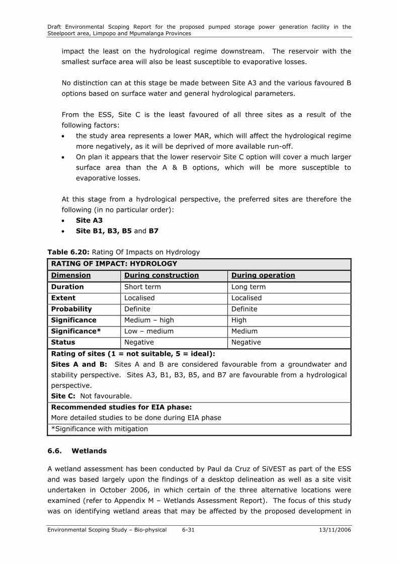
No distinction can at this stage be made between Site A3 and the various favoured B
options based on surface water and general hydrological parameters.
From the ESS, Site C is the least favoured of all three sites as a result of the
following factors:
• the study area represents a lower MAR, which will affect the hydrological regime
more negatively, as it will be deprived of more available run-off.
• On plan it appears that the lower reservoir Site C option will cover a much larger
surface area than the A & B options, which will be more susceptible to
evaporative losses.
At this stage from a hydrological perspective, the preferred sites are therefore the
following (in no particular order):
• Site A3
• Site B1, B3, B5 and B7
Table 6.20: Rating Of Impacts on Hydrology
RATING OF IMPACT: HYDROLOGY
Dimension During construction During operation
Duration Short term Long term
Extent Localised Localised
Probability Definite Definite
Significance Medium – high High
Significance* Low – medium Medium
Status Negative Negative
Rating of sites (1 = not suitable, 5 = ideal):
Sites A and B: Sites A and B are considered favourable from a groundwater and
stability perspective. Sites A3, B1, B3, B5, and B7 are favourable from a hydrological
perspective.
Site C: Not favourable.
Recommended studies for EIA phase:
More detailed studies to be done during EIA phase
*Significance with mitigation
6.6. Wetlands
A wetland assessment has been conducted by Paul da Cruz of SiVEST as part of the ESS
and was based largely upon the findings of a desktop delineation as well as a site visit
undertaken in October 2006, in which certain of the three alternative locations were
examined (refer to Appendix M – Wetlands Assessment Report). The focus of this study
was on identifying wetland areas that may be affected by the proposed development in

Draft Environmental Scoping Report for the proposed pumped storage power generation facility in the Steelpoort area, Limpopo and Mpumalanga Provinces
Environmental Scoping Study – Bio-physical 6-32 13/11/2006
keeping with the aim of scoping to identify major potential issues, and thus provided
input on site selection in the context of wetland protection. A detailed wetland
assessment will be conducted on the preferred site during the EIA phase, and site-
specific mitigation and management measures will be developed during the EMP phase.
6.6.1. Methodology
The first stage of the wetland assessment was undertaken using desktop methodologies.
This included analysis of ortho photographs and 1:50 000 topographical maps.
Orthophotos of the site were examined to identify any wetland areas that may exist
within the footprint of the proposed scheme alternatives. During the site visit undertaken
on 18 October 2006, certain of the locations for the proposed scheme were examined for
evidence of wetland habitat.
6.6.2. Evaluation of the ESI
The BKS screening report did not specifically assess the occurrence of wetlands on the
three alternative sites. The report identified a number of vegetation communities which
exist on the sites. One of the sites is described as Fuirena pubescens – Schoenoplectus
corymbosus wetland vegetation, which is found in suitably saturated locations alongside
watercourses in the river valleys and on seeps within mountain slopes and plateaus. This
community is assessed to exist at the lower dam site at Site A and Site B (in the riverine
areas), and at the upper dam site at Site B (it should be noted that the lower dam site at
the Site C – the proposed De Hoop Dam – is not discussed in the BKS report).
As part of an assessment of agricultural potential, the screening report examined soil
types found on the various sites. The screening report has concluded that type B soils
(i.e. soil forms typical of wetland areas) occur at the lower dam sites of Sites A and B.
The report concludes however that the wetland soils do occur in conjunction with red
soils, which are not wetland soils and have good agricultural potential.
6.6.3. Site assessment
• Site A Upper Dam
Examination of the orthophotos for the eastern upper dam site (Site A3 upper reservoir
site) did not reveal evidence of any wetlands within the footprint of the dam. The site
was investigated during the site visit and the desktop findings were confirmed. There is
no evidence of wetland habitat on this site, with the soils appearing well-drained and
yellow in colouration. Furthermore, in most places over the footprint of the dam, there is
evidence of bedrock-outcropping on the surface, thus entailing that soils would be
shallow and not conducive to wetland formation.

Draft Environmental Scoping Report for the proposed pumped storage power generation facility in the Steelpoort area, Limpopo and Mpumalanga Provinces
Environmental Scoping Study – Bio-physical 6-33 13/11/2006
The footprint of the second upper dam site (further to the west) would affect a wetland.
The dam wall would be constructed along a narrow drainage line rising at the eastern end
of Sehlakwane, and draining into a steep poort through the escarpment. A relatively
narrow wetland (approximately 10-15m in width) occurs within the valley bottom. There
is evidence of typical wetland vegetation as well as dark, clayey soils. There was also
evidence of surface water flow through the wetland, suggesting that parts of the wetland
are permanently wet (considering the site was inspected at the end of the dry season).
Should the dam wall be constructed at this site, a certain portion of wetland habitat
would be inundated, and would thus be lost.
• Site A Lower Dam
In the ESI, two options are indicated for the lower dam at Site A. One would dam the
Steelpoort River, and the other would dam a tributary of the Steelpoort River which
drains the escarpment. The second dam site is the preferred lower dam site at Site A.
Accordingly this site was assessed for occurrence of wetland habitat. Desktop analysis
indicated that a drainage line / river would be flooded by the dam. A riparian zone
adjacent to the drainage line was evident, but analysis of the orthophotos did not seem
to indicate any wetland habitat. This was confirmed by the site visit in which the river in
the vicinity of the proposed dam wall was investigated. The river contained a well-defined
riparian zone in which large indigenous trees existed, but there was no evidence of
wetland habitat. The channel in the vicinity of the dam wall had eroded down to bedrock
and thus there were no wetland soils within the channel, or within the riparian zone. It is
at this stage uncertain whether wetland soils may exist further upstream; however,
considering the nature of the terrain and soils in the vicinity of the dam wall, which seem
to be similar to that upstream, this seems unlikely. Further investigation will be
conducted on the preferred site during the EIA phase.
• Site B Upper Dam
One dam site has been selected for the upper dam at Site B. Analysis of the orthophotos
for the site indicated that there does not appear to be any wetlands on the site. The site
visit to the upper dam location at Site B confirmed that there was no wetland habitat on
the site. Although part of the approximate footprint of the dam is located within a slight
depression, the soils and vegetation on the site did not indicate that the site was a
wetland.
• Site B Lower Dam
Four possible locations have been indicated for the lower dam at Site B. Analysis of their
approximate footprint on orthophotos indicated that there was unlikely to be any
wetlands present within the footprints of the four dam locations. The actual location of
the ‘preferred’ location at site B was not visited; however an area close to the site was

Draft Environmental Scoping Report for the proposed pumped storage power generation facility in the Steelpoort area, Limpopo and Mpumalanga Provinces
Environmental Scoping Study – Bio-physical 6-34 13/11/2006
visited. The site assessment of this area in close proximity to the site did not indicate any
wetland habitat.
• Site C Upper Dam
Two possible locations have been indicated for the upper dam at Site C. The site was not
visited during the site visit due to the fatal flaw that has already been identified by the
ESI (the presence of the Steelpoort Fault). In addition there was no orthophoto coverage
of the upper dam locations at Site C. Thus assessment of wetland occurrence at Site C
could not be undertaken, and the assessment has to revert to the results of the BKS
screening report which listed no wetland habitat at Site C upper.
• Site C Lower Dam
The proposed De Hoop Dam would be the lower reservoir at site C. As the area to be
inundated by the reservoir has been already assessed in terms of the Environmental
Impact Assessment conducted for the proposed dam, analysis of Site C lower has not
been undertaken.
6.6.4. Studies to be conducted during the EIA phase
The location of the borrow pit areas have not as yet been finalised by the project
engineers – this will, however, be available during the EIA-phase studies. One of the
possible borrow pit areas for site A is situated in the fields adjacent to the Steelpoort
River. These may well contain wetland soils, and thus the assessment of borrow pit
locations for the existence of wetlands will be undertaken during the EIA phase.
The location of ancillary infrastructure such as roads, and housing (if needed) have also
not yet been established. The location of these will need to be further investigated in the
EIA phase with regards to wetlands.
The findings of this scoping report are based largely on desktop investigation with very
limited site investigation. During the EIA phase, a more detailed site investigation will be
conducted utilising the four indicators of wetland occurrence (as listed in the DWAF
guidelines for the delineation of wetlands and riparian areas (DWAF, 2003)). The findings
of this report are subject to more detailed studies (including pedological and vegetation
studies) that may need to be undertaken in the EIA phase of the project.
6.6.5. Site selection
The BKS screening report lists Site A as the ‘preferred’ site from an environmental point
of view. The scoping-level assessment has indicated that there is likely to only be
wetland habitat at the western location for the upper dam at Site B. None of the other
sites were assessed to have wetland habitat present although there is a low confidence

Draft Environmental Scoping Report for the proposed pumped storage power generation facility in the Steelpoort area, Limpopo and Mpumalanga Provinces
Environmental Scoping Study – Bio-physical 6-35 13/11/2006
level in the assessment for the lower dam locations at Site B, and Site C could not be
assessed due to a lack of data (site C is however, fatally flawed in terms of geological
factors, notably the presence of the Steelpoort Fault).
From a wetland point of view only the western location of the upper reservoir at Site A
should be avoided. Other than this, there is no clear preference in terms of the three
sites (Sites A, B and C) in the context of the avoiding of destruction of wetland habitat,
as long as the western location for the upper reservoir site at Site A is avoided.
6.6.6. Nature and extent of impacts
The creation of ‘on-line’ reservoirs (i.e. reservoirs constructed across an existing drainage
line) at certain of the sites i.e. the lower reservoir site at Site A, and Site B may have
implications for wetland functioning (if wetlands occur further upstream or downstream
of the reservoir) in the context of the catchment in which the dam is located. The
creation of a reservoir which would effectively remove water from a catchment to be
used in the pump storage scheme may have implications for the functions performed by
wetlands in that catchment in a greater catchment context. If the site taken through into
EIA investigations contains such an online reservoir, the implications of the proposed
development on upstream wetland functioning in that catchment and in a greater
catchment context will need to be investigated in further detail during the EIA phase of
the project.
Table 6.21: Rating Of Impacts on Wetlands
RATING OF IMPACT: WETLANDS
Dimension During construction During operation
Duration Short term Long term – Permanent
Extent Local Local
Probability Unlikely (all sites and options
except A1) – Likely (Site A1)
Unlikely (all sites and options
except A1) – Likely (Site A1)
Significance Medium – high High
Significance* Low (all sites and options
except A1) – medium (Site
A1)
Low (all sites and options except
A1) – medium (Site A1)
Status Negative Negative
Rating of sites (1 = not suitable, 5 = ideal):
Site A: Western upper dam site (forms part of Site A1) should be avoided. All other
options acceptable. Site A3 acceptable.
Site B: All options acceptable (based on the relatively limited scoping-level studies).
Site C: All options acceptable (based on limited scoping-level study).
Recommended studies for EIA phase:
More detailed studies to be done during EIA phase
*Significance with mitigation

Draft Environmental Scoping Report for the proposed pumped storage power generation facility in the Steelpoort area, Limpopo and Mpumalanga Provinces
Environmental Scoping Study – Bio-physical 6-36 13/11/2006
6.7. Geology
The geological assessment conducted during the ESI for the proposed project is
contained in Appendix K.
The rocks in the area fall within the Bushveld Igneous Complex and comprise felsic rocks
of the Rashoop Granophyre Suite overlying the mafic rocks of the Upper and Main Zones
of the Rustenburg Layered Suite. The high plateau is underlain by granophyre in the
south of the area and by mixed granite and granophyre in the north. These felsic rocks
are several hundred metres thick and form the steep scarp slopes. Below the bottom of
the scarp at the base of the felsic rocks is a leptite formation approximately 250m thick,
dipping approximately 10 degrees westwards into the slope. This is in turn underlain by
diorite beneath the pediment slope, grading into olivine-bearing diorite and gabbro
beneath the valley floor. These mafic rocks underlying the leptite formation contain
bands of anorthosite and magnetite, and all of the horizons dip around 10 degrees
towards the west.
All of the rocks discussed above have been intruded by dolerite/lamprophyre dykes,
generally trending northeast (roughly parallel to the Steelpoort fault) and west of
northwest (roughly perpendicular to the fault).
6.7.1. Nature and Extent of the Impacts
Geology plays an important role in the construction of dams, as unstable geological
conditions may damage the structure of the dams. Failure of a dam structure would lead
to significant down-stream damage as a result mainly of flooding, causing loss of lives
(should the downstream area be inhabited) and damage to infrastructure.
It is important to note the Steelpoort Fault, situated in the Site C study area. In light
of the significant risk not only to the project but to downstream communities and existing
infrastructure, the Fault is considered a fatal flaw. Site C is therefore no longer
considered a feasible alternative and Sites A and B remain as the only feasible site
alternatives for the proposed SPSS. At this stage, these two sites seem to be equally
suitable, but detailed geo-technical investigations will form an integral part of the detail
engineering design stage in order to ensure that the selected site poses no risk in this
regard.
Table 6.22: Rating Of Impacts on Geology
RATING OF IMPACT: GEOLOGY
Dimension During construction During operation
Duration Short term Long term
Extent Localised Localised
Probability Definite Unlikely
Significance Medium Low
Draft Environmental Scoping Report for the proposed pumped storage power generation facility in the Steelpoort area, Limpopo and Mpumalanga Provinces
Environmental Scoping Study – Bio-physical 6-37 13/11/2006
Significance* Low – medium Low
Status Negative Negative
Rating of sites (1 = not suitable, 5 = ideal):
Sites A and B: Considered equally suitable at this stage.
Site C: Fatal flaw in the form of the Steelpoort Fault.
Site A: 2 – 3 Site B: 3 – 4 Site C: 4
Recommended studies for EIA phase:
More detailed studies to be done during EIA phase and as part of the detail design
phase.
*Significance with mitigation
6.7. Soils and Agricultural Potential
The soils and agricultural assessment conducted during the ESI for the proposed project
is contained in Appendix K.
6.7.1. Land Types
Land types have been denoted for area with a uniform terrain form, soil pattern and
climate. The different land types differ in one of these three characteristics. The
dominant land types recorded for this area are Ba, Bc and Ib.
The B land types are plinth catena from the upland duplex and margalitic soils. These
soils are typical wetland soils. These soils may have a thick organic layer (such as peat),
be grey in colour or have mottles indicating a fluctuating water table. The soil forms
present in these soil types are therefore mostly wetland soils including, but not limited
to, Rensburg, Willowbrook, Katspruit and Champagne soil forms. The soil forms can only
be classified as land type B if these soils are the dominant soil forms. Some other soils
may however be patchily distributed in the area.
The Ib land type indicates areas with exposed rock on the soil surface. The rock should
cover 60 – 80% of the area. The underlain soil may qualify the area to be classified into a
different land type, if not for the rockiness.
6.7.2. Terrain Form and Terrain type
The terrain type has two parts, viz. slope and length. The slope is indicated by:
• A: more than 80% of the area has slopes less than 8%
• B: 50 – 80% of the area has slopes less than 8%
• C: 20 – 50% of the area has slopes less than 8%
• D: less than 20% of the area has slopes less than 8%

Draft Environmental Scoping Report for the proposed pumped storage power generation facility in the Steelpoort area, Limpopo and Mpumalanga Provinces
Environmental Scoping Study – Bio-physical 6-38 13/11/2006
The length of the slope is divided into six classes:
• Class 1: 0 – 30
• Class 2: 30 – 90 m
• Class 3: 90 – 150 m
• Class 4: 150 – 300 m
• Class 5: 300 – 900 m
• Class 6: >900 m
6.7.3. Terrain Unit
The terrain unit, a homogenous portion of land in terms of form and slope, was identified
for all the soil forms identified. Five terrain units are used and each soil form was limited
to one of these terrain units. The terrain units are the following:
• crest (1)
• scarp (2)
• midslope (3)
• footslope (4)
• valley bottom / flood plain (5).
Figure 6.4: Schematic of terrain units
For a description of the terrain in terms of range in percentage slope, range in length,
shape and area in hectares at each of the site alternatives, please refer to Appendix K.
6.7.4. Nature and Extent of the Impacts
Site A lower dam is located within the Ba land type and Site B lower dam in the Bc land
type. Both of these land types have wetland soils; however, the wetland soils occur in
conjunction with red soils. Red soils in general are good agricultural soils. Portions of
these land types may not be suitable for ploughing. It is expected that cultivation
activities at these sites may be successful. It should however be taken into account that,
according to the Conservation of Agricultural Resources Act (Act No 43 of 1983) (CARA),
no agricultural activities may take place within 10 m horizontal of a drainage line or
wetland. These sites therefore have high agricultural potential.

Draft Environmental Scoping Report for the proposed pumped storage power generation facility in the Steelpoort area, Limpopo and Mpumalanga Provinces
Environmental Scoping Study – Bio-physical 6-39 13/11/2006
Site A upper dam and Site B upper dam both occur within the Ib land type, and we
assume that Site C also falls within this land type. Site C is however less rocky, probably
due to small scale variation in the land type.
Site A upper dam is very rocky and may contain metals in the soil. The site is therefore
unsuitable for agricultural activities. Thus the agricultural potential is low.
Site B upper dam has large boulders and is very rocky, thereby prohibiting ploughing of
the soil. Some drainage areas also occur on the site and are protected by CARA. This site
is not suitable for agriculture, and the agricultural potential is therefore low.
Site C is currently utilised in patches for agricultural activities. No large boulders are
evident at the site. Portions of the area are currently being cultivated but some portions
that have been cultivated in the past are not under cultivation any more and are
colonised by pioneer species. The reason for this may be that these portions do not yield
a good crop. Although the site is suitable for agriculture it is not prime agricultural land.
Thus the agricultural potential is medium.
Construction and inundation of the dams forming part of the SPSS as well as the
proposed administrative building and possible visitors centre, will effectively destroy any
agricultural land forming part of the area inundated, or on which the buildings are to be
constructed. Agriculture on the upper plateau (upper dam site) generally takes the form
of subsistence farming, which makes a very small contribution to the economy.
However, it provides these subsistence farmers with a livelihood. Destruction of
agricultural land would therefore have significant impacts on their ability to generate
income. On the lower level (lower dams) commercial farming contributes significantly to
the local economy.
Construction of the proposed PSS at Site A or Site B is anticipated to have a low
significance in terms of impacts on agricultural potential.
Table 6.23: Rating Of Impacts on Agricultural Potential
RATING OF IMPACT: SOILS AND AGRICULTURAL POTENTIAL
Dimension During construction During operation
Duration Short term Long term
Extent Localised Localised
Probability Definite Definite
Significance Low (Sites A & B), Medium-
high (Site C)
Low (Sites A & B), Medium-high
(Site C)
Significance* Low Low
Status Negative Negative
Rating of sites (1 = not suitable, 5 = ideal):

Draft Environmental Scoping Report for the proposed pumped storage power generation facility in the Steelpoort area, Limpopo and Mpumalanga Provinces
Environmental Scoping Study – Bio-physical 6-40 13/11/2006
Site A: Rocky soil containing metals. Low agricultural potential.
Site B: Rocky soil. Low agricultural potential.
Site C: Currently used patchily for agriculture. Medium agricultural potential.
Site A: 4 Site B: 3 – 4 Site C: 2
Recommended studies for EIA phase:
More detailed studies to be done during EIA phase.
*Significance with mitigation
6.7.5. Site Selection Summary
Table 6.24: Site selection – agricultural potential – ESI
Locatio
n
Site A
Option 1
Site A
Option 2
Site A
Option 3
Site B
Option 1
Site B
Option 5
Site B
Option 7 Site C
Option 1
Rating 4 4 4 3 4 4 2

Draft Environmental Scoping Report for the proposed pumped storage power generation facility in the Steelpoort area, Limpopo and Mpumalanga Provinces
Environmental Scoping Study – Bio-physical 13/11/2006
7-41