8 build a desirable urban form - mississauga
TRANSCRIPT
Mississauga Official Plan – Part 2 Draft: March 2010 Build a Desirable Urban Form 8-1
8 Build a Desirable Urban Form
1.0 Introduction
Urban form refers to the physical layout and design
of the city. Urban design is the art of shaping the
interaction between people and places through the
arrangement, appearance and functions of cities. It
addresses the natural and built environments and
influences the processes that lead to successful
cities. Or, more succinctly, how do buildings fit
together to make quality spaces.
The focus of this chapter is on the achievement of a
sustainable urban form for Mississauga, based on
the urban system and city structure, with high
quality urban design and a strong sense of place that
is culturally vibrant, attractive, livable and functional,
and protects or enhances natural and built heritage
features. It is organized on the basis of
intensification areas where growth will be directed
and other areas where limited growth will occur.
Mississauga envisions that growth will be directed
to Intensification Areas comprised of the
Downtown, Major Nodes, Community Nodes,
Corporate Centres, Intensification Corridors and
Major Transit Station Areas. Established
residential Neighbourhoods, the Natural Areas
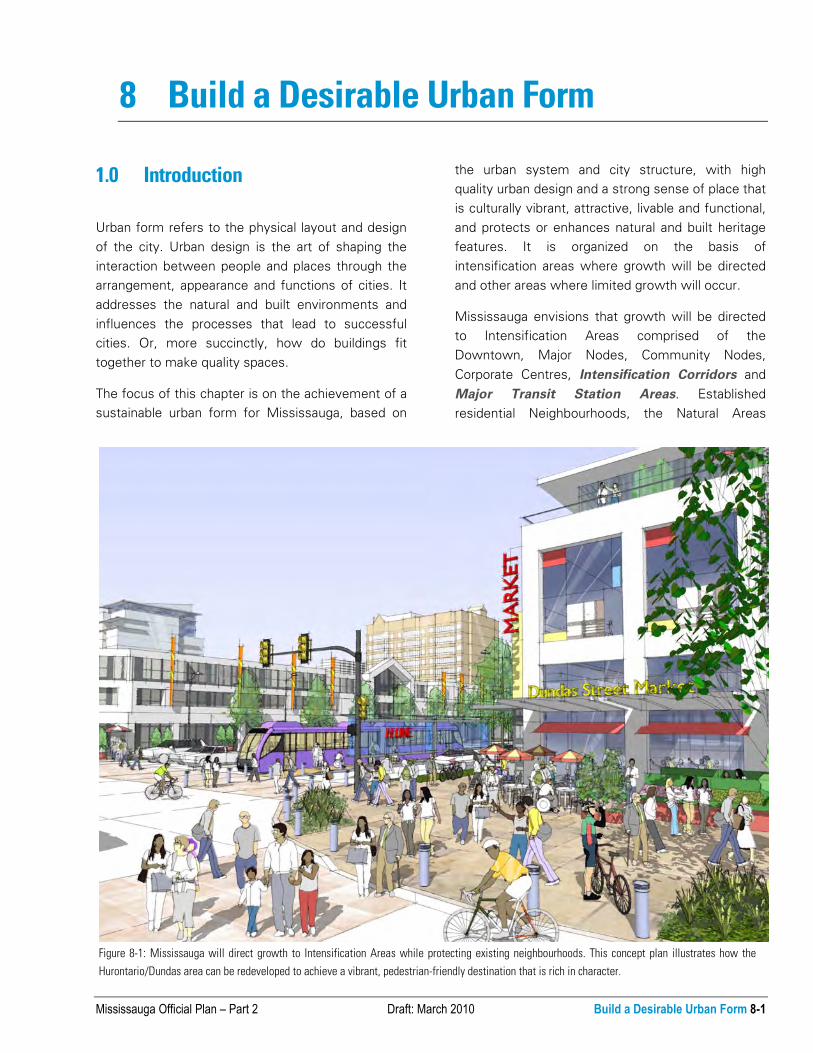
Figure 8-1: Mississauga will direct growth to Intensification Areas while protecting existing neighbourhoods. This concept plan illustrates how the
Hurontario/Dundas area can be redeveloped to achieve a vibrant, pedestrian-friendly destination that is rich in character.

8-2 Build a Desirable Urban Form Draft: March 2010 Mississauga Official Plan – Part 2
System and valuable cultural heritage resources will
be protected and strengthened with infill and
redevelopment compatible with the existing or
planned character. Employment Areas, Special
Purpose Areas – University of Toronto Mississauga
and the Airport - and Corridors will also receive
growth compatible with their planned vision.
Appropriate infill in both Intensification Areas and
Non-Intensification Areas will help to revitalize
existing communities by replacing aged buildings,
developing vacant or underutilized lots and by
adding to the variety of building forms and tenures.
It is important that infill “fits” within the existing
urban context and minimizes undue impacts on
adjacent properties. Redevelopment projects include
a range of scales, from small residential
developments to large scale projects, such as
redeveloping strip malls. Redevelopment must also
be sensitive to the existing urban context and
minimize undue impacts on adjacent properties.
An appropriate urban form will guide development,
infill and redevelopment in a manner that protects,
enhances and restores the green system and
cultural heritage features, while sensitively
integrating these features into the city pattern.
Mississauga will achieve an attractive, comfortable
and functional public realm as an integral component
of its urban form. Public realm is composed of public
lands with a focus on streets and boulevards and
edges of private properties as they are visible from,
and as they interface with the public streets.
Policies regarding the public realm address matters
such as the arrangement of streets and blocks, civic
buildings, landmarks, gateways, views, public art
and open spaces.
A desirable urban form frames and supports all
movement systems in the City. It addresses the
interdependent relationship among built form and
various modes of movement, including accessibility.
As greater emphasis is placed on transit and active
transportation, urban form needs to support these
various modes while still having regard for the
importance of vehicular and goods movement to the
economic functioning of the city.
Site development is the layout and design of all
features on a property including buildings,
structures, parking, driveways, landscaping and
utilities. Site development policies are directed at
the creation of buildings and spaces which not only
satisfy the needs of its own users and those who
will live and work in the area, but also the needs of
future generations. Site development will:
● respect the experience, identity and character of
the surrounding context;
● ensure the sustainability of natural systems and
urban living;
● protect the quality of life of residents,
employees and visitors;
● ensure the connectivity and integration of
surrounding uses; and
● require properties to develop in a manner that
contributes to the overall vision for the city.
8.1.1 Mississauga will develop an urban form based
on the urban system and the hierarchy identified in
the city structure as shown on Schedule 1: Urban
System.
8.1.2 Within Intensification Areas an urban form that
promotes a diverse mix of uses and supports transit
and active transportation modes will be required.
See Appendix I: Transit Oriented Development.
8.1.3 Infill and redevelopment within
Neighbourhoods will respect the existing and
planned character.
8.1.4 Development within Employment Areas and
Special Purpose Areas will promote good urban
design that respects the function of the area.
8.1.5 Development on Corridors will be consistent
with existing or planned character, seek
opportunities to enhance the Corridor and provide
appropriate transitions to neighbouring uses.
8.1.6 The urban form of the city will ensure that the
Green System is protected, enhanced and

Mississauga Official Plan – Part 2 Draft: March 2010 Build a Desirable Urban Form 8-3
contributes to a high quality urban environment and
quality of life.
8.1.7 Mississauga will promote a built environment
that protects and conserves heritage resources.
8.1.8 Mississauga will transform the public realm to
create a strong sense of place and civic pride.
8.1.9 Urban form will support the creation of an
efficient multi-modal transportation system that
encourages a greater utilization of transit and active
transportation modes.
8.1.10 Site development will support the city vision
by:
a. respecting the urban hierarchy;
b. utilizing best sustainable practices;
c. demonstrating context sensitivity, including the
public realm;
d. promoting universal accessibility and public
safety; and
e. employing design excellence.
8.1.11 A distinct character for each community will
be created or enhanced through the road pattern,
building massing and height, streetscape elements,
preservation and incorporation of heritage resources
and prominent placement of institutions and open
spaces.
8.1.12 An urban form will be developed to take
advantage of the Lake Ontario waterfront through
connections, views and access.
8.1.13 Development will have positive, restorative,
ecological benefits on a site through the practice of
sustainable building and site design.
8.1.14 Mississauga may undertake or require
studies that develop additional policies, guidelines
and design control tools that may contain more
specific urban form requirements.
Figure 8-2: Building frontages will frame the
streets and provide a contiguous built form.
Figure 8-3: New development will frame adjacent street by locating
buildings parallel to the street with consistent frontyard setbacks.
Development on a corner should address both adjacent street frontages
to give prominence to the corner.

8-4 Build a Desirable Urban Form Draft: March 2010 Mississauga Official Plan – Part 2
8.2 City Pattern
City pattern provides the visual framework of the
city. The city pattern that defines Mississauga
includes:
● Intensification Areas;
● Non-Intensification Areas;
● Green System; and
● Cultural Heritage.
The city pattern is a reflection of policies and land
use decisions that direct growth. It is the major
driver of the city’s image – it creates order, scale, a
sense of place, purpose and identity.
Mississauga will develop a city pattern that is more
sustainable and supports complete communities by
directing growth to Intensification Areas and
managing growth in other areas. It is intended to
create a pattern marked by a greater mixture of land
uses in a more compact form of development that
supports, and is integrated with a multi-modal
transportation system.
City pattern does not establish land use, but rather it
directs the form in which permitted development
should be undertaken. Urban form requirements will
vary in accordance with the envisioned city pattern.
The following policies for the city pattern will
implement the city structure as shown on Schedule
2: Urban System: City Structure and Schedule 3:
Urban System: Corridors while protecting the Green
System (Schedule 1: Urban System: The Green
System) and heritage resources.
Figure 8-5: The city pattern will respect the urban hierarchy with the Downtown containing the greatest heights, densities and mix of uses.
Figure 8-4: A sustainable city pattern will support complete
communities.

Mississauga Official Plan – Part 2 Draft: March 2010 Build a Desirable Urban Form 8-5
8.2.1 Intensification Areas
Intensification Areas are the principal location for
future growth and consist of:
● Downtown;
● Major Nodes;
● Community Nodes;
● Corporate Centres;
● Intensification Corridors; and
● Major Transit Station Areas.
Intensification Areas are a major building block of
the city pattern and, as such, will be expected to
exhibit high standards of urban design that will
result in vibrant and memorable urban places. They
are intended to create order and a sense of place
with a scale that varies with their intended purpose
and role in the urban hierarchy.
In order to achieve the vision for Intensification
Areas as vibrant, mixed use areas, serviced by multi-
modal transportation, the physical form, the
relationship among buildings and spaces and the
quality of the built environment will be critical in
making these areas successful.
8.2.1.1 Development will create distinctive places
and locales.
8.2.1.2 Design excellence will create a vibrant
Downtown complemented by communities that
retain their own identity and contribute to an overall
strong city identity.
8.2.1.3 Built form should provide for the creation of
a sense of place through, among other matters,
distinctive architecture, streetscaping, public art and
cultural heritage recognition.
8.2.1.4 Mississauga will encourage a high quality,
compact and urban built form to reduce the impact
of extensive parking areas, enhance pedestrian
circulation, complement adjacent uses, and
distinguish the significance of the Intensification
Areas from surrounding areas.
Figure 8-6: Over time, Eglinton Avenue and Hurontario Street will
intensify with a built form that frames the streets and provides a quality
public realm, ensuring a vibrant pedestrian environment.

8-6 Build a Desirable Urban Form Draft: March 2010 Mississauga Official Plan – Part 2
Figure 8-7: A compact, urban built form with a mix of uses will be incorporated in Cooksville and other Intensification Areas.

Mississauga Official Plan – Part 2 Draft: March 2010 Build a Desirable Urban Form 8-7
8.2.1.5 Small land parcels should be assembled to
create efficient development parcels.
8.2.1.6 Mississauga will encourage the consolidation
of access points and shared parking, service areas
and driveway entrances.
8.2.1.7 Development proponents may be required to
provide concept plans that show how the site will
be developed with surrounding lands.
8.2.1.8 The preferred location of tall buildings will
be in proximity to existing and planned Major
Transit Station Areas.
8.2.1.9 Where the right-of-way width exceeds 20 m,
a greater building height may be required to achieve
appropriate street enclosure in relation to the right-
of-way width.
8.2.1.10 Appropriate height and built form
transitions will be required between sites and their
surrounding areas.
8.2.1.11 Tall buildings will be sited and designed to
enhance the area’s skyline.
8.2.1.12 Tall buildings will be sited to preserve,
reinforce and define view corridors.
8.2.1.13 Tall buildings will be appropriately spaced
to provide privacy and permit light and sky views.
8.2.1.14 In appropriate locations, tall buildings will
be required to incorporate podiums to mitigate wind
impacts on the pedestrian environment and
maximize sunlight on the public realm.
8.2.1.15 Tall buildings will address pedestrian scale
through building articulation, massing and materials.
8.2.1.16 Tall buildings will minimize adverse
microclimatic impacts on the public realm and
private amenity areas.
8.2.1.17 Principal streets should have continuous
building frontages that provide continuity of built
form from one property to the next with minimal
gaps between buildings.
8.2.1.18 Existing large blocks will be reconfigured to
incorporate a fine grained block structure with public
roads and on-street parking to support at-grade
uses.
8.2.1.19 The public realm and the development
interface with the public realm will be held to the
highest design standards.
8.2.1.20 Mississauga will develop identifiable civic
buildings, structures, and spaces as community and
city focal points.
8.2.1.21 Development will contribute to pedestrian-
oriented streetscapes and have an urban built form
that is attractive, compact and transit-supportive.
8.2.1.22 Development will be designed to support
and incorporate pedestrian and cycling connections.
8.2.1.23 Active uses will be required on principal
streets with direct access to the public sidewalk.
8.2.1.24 Development will face the street.
8.2.1.25 Buildings should have active facades
characterized by features such as lobbies, entrances
and display windows. Blank building walls will not
be permitted facing principal street frontages and
intersections.
8.2.1.26 For non-residential uses, at-grade windows
will be required facing major streets and must be
transparent.
8.2.1.27 Development will create a sense of
gateway to the Intensification Area with prominent
built form and landscaping.
Figure 8-8: On wider streets, taller buildings may be required to
provide appropriate street enclosure.

8-8 Build a Desirable Urban Form Draft: March 2010 Mississauga Official Plan – Part 2
8.2.1.28 Built form will relate to and be integrated
with the streetline, with minimal building setbacks
where spatial enclosure and street-related activity is
desired.
8.2.1.29 Development will have a compatible bulk,
massing and scale of built form to provide an
integrated streetscape.
8.2.1.30 Development will provide open space,
including squares and plazas appropriate to the size,
location and type of the development.
8.2.1.31 Buildings should be positioned along the
edge of the public streets and public open spaces,
to define their edges and create a relationship with
the public sidewalk.
8.2.1.32 Buildings should be oriented to, and
positioned along the street edge with clearly defined
primary entry points that directly access the public
sidewalk, pedestrian connections and transit
facilities.
8.2.1.33 Open spaces will be designed to promote
social interaction.
8.2.1.34 Development will utilize streetscape
design to provide visual connections to open space,
providing enhanced sidewalk and trail connections
near open spaces.
8.2.1.35 Buildings and streetscapes will be situated
and designed so as to encourage pedestrian
circulation.
8.2.1.36 Streetscape improvements including trees,
pedestrian-scale lighting, special paving and street
furniture in sidewalks, boulevards, open spaces and
walkways, will be coordinated and well designed.
8.2.1.37 Developments should minimize the use of
surface parking in favour of underground or
aboveground structured parking. All surface parking
should be screened from the street and be designed
to ensure for natural surveillance from public areas.
Aboveground structured parking should be lined
with residential, commercial or office uses.
8.2.1.38 Parking lots and structures should not be
located adjacent to major streets.
8.2.1.39 Signage will be integrated with the scale
and character of built form and will follow universal
design principles.
8.2.2 Non-Intensification Areas
Non–intensification areas will experience limited
growth and change; consequently, intensive growth
will not be directed to them. Non-intensification
Areas consist of:
● Neighbourhoods;
● Employment Areas;
● Special Purpose Areas; and
● Corridors.
Non-intensification areas will have lower densities,
lower building heights and more homogeneous land
uses than Intensification Areas.
Neighbourhoods are stable areas where limited
growth is anticipated. Development in
Neighbourhoods will be required to be context
sensitive and respect the existing or planned
character and scale of development.
Employment Areas will continue to develop for a
mixture of employment uses, including land
extensive uses many of which will have a one to
two storey urban form.

Mississauga Official Plan – Part 2 Draft: March 2010 Build a Desirable Urban Form 8-9
Where increases in density and a variety of land
uses are considered in Neighbourhoods and
Employment Areas they will be directed to
Corridors. Appropriate transitions to adjoining areas
that respect variations in scale, massing and land
uses will be required.
Special Purpose Areas – the University of Toronto
Mississauga and the Airport - will be developed in a
manner that reflects the unique role these areas
play within the city and the region. While these
areas will undergo limited urban development in the
traditional sense, master plans for these areas will
guide development that responds to their particular
functions and development needs.
8.2.2.1 Heights in excess of four storeys will be
required to demonstrate that an appropriate
transition in height and built form that respects the
surrounding context will be achieved.
8.2.2.2 Tall buildings will generally not be
permitted.
8.2.2.3 While new development need not mirror
existing development, new development in
Neighbourhoods will:
f. respect existing lotting patterns;
g. respect the continuity of front, rear and side
yard setbacks;
h. respect the scale and character of the
surrounding area;
i. minimize overshadowing and overlook on
adjacent neighbours;
j. reduce impervious surfaces;
k. preserve mature high quality trees and ensure
replacement of the tree canopy; and
l. be designed to respect the existing scale,
massing, character and grades of the
surrounding area.
8.2.2.4 Employment Areas adjacent to residential
areas, sensitive land uses and major roads will be
required to meet higher standards of design and to
mitigate adverse impacts on adjacent uses.
8.2.2.5 The City will work with landowners of
Special Purpose Areas to encourage:
a. the preservation and enhancement of Natural
Areas;
b. design for safety;
c. design excellence;
d. sustainable development; and
e. the achievement of the overall intent, goals,
Figure 8-10: Development in Non-Intensification Areas will be sensitive to the existing or planned character of the neighbourhood and the natural
environment.
Figure 8-9: New development in neighbourhoods does not need to
mirror existing development, but will be required to respect and be
compatible with the surrounding area.

8-10 Build a Desirable Urban Form Draft: March 2010 Mississauga Official Plan – Part 2
objectives and policies of this Plan.
8.2.2.6 Development on Corridors will be
encouraged to:
a. assemble small land parcels to create efficient
development parcels;
b. face the street, except where predominate
development patterns dictate otherwise;
c. not locate parking between the building and the
street;
d. site buildings to frame the street and where
non-residential uses are proposed to create a
continuous street wall;
e. provide entrances and transparent windows
facing the street for non-residential uses;
f. support transit and active transportation
modes;
g. consolidate access points and encourage shared
parking, service areas and driveway entrances;
and
h. provide concept plans that show how the site
can be developed with surrounding lands.
8.2.3 Green System
The Green System provides vital relief from the built
environment. It helps satisfy human needs for rest,
quiet and escape from the built environment. It is
generally characterized by vegetated open areas
ranging from manicured spaces and playing fields to
expansive natural areas. Where buildings are sited,
they tend to occupy a small proportion of the site
and be small in scale except for public buildings,
such as community centres and schools.
Urban form has a role to play in protecting the
environment by being sensitive to natural areas in
site design, utilizing sustainable design practices and
supporting active modes of transportation.
8.2.3.1 Development will be sensitive to the site and
ensure that Natural Areas Systems are protected,
enhanced and restored.
8.2.3.2 All development will utilize sustainable
design practices.
8.2.3.3 Mississauga will coordinate the design,
function and location of parks with adjacent land
uses.
8.2.3.4 Open space areas will be high quality, usable
and physically and visually linked to streets, parks
and pedestrian routes.
Figure 8-11: Kariya Park in Downtown Mississauga provides a reprieve
from the built environment and is an essential component of the urban
structure.
Mississauga Official Plan – Part 2 Draft: March 2010 Build a Desirable Urban Form 8-11
8.2.4 Cultural Heritage Resources
Cultural heritage resources are valued and should be
preserved for future generations. Heritage
properties, districts and landscapes create a unique
sense of place and local identity. In addition to their
historic associations, cultural heritage resources are
landmarks and focal points that contribute to the
overall city image.
8.2.4.1 Opportunities to conserve and incorporate
cultural heritage resources into community design
and development should be undertaken in a manner
that enhances the heritage resources and makes
them focal points for the community.
8.2.4.2 Development and open spaces adjacent to
significant cultural heritage resources will:
a. contribute to the conservation of the heritage
attributes of the resource and the heritage
character of the area;
b. emphasize the visual prominence of cultural
heritage resources; and
c. provide a proper transition with regard to the
setting, scale, massing and character to cultural
heritage resources.
8.2.4.3 Streetscape components such as signage,
furniture and lighting, within areas with cultural
heritage resources should be sympathetic to the
character of the heritage area.
Figure 8-14: The Middle Road Bridge, located at the end of Sherway Drive
at the Etobicoke Creek, is an engineering wonder. Built in 1909, it is the
first concrete bow bridge of its kind in Canada.
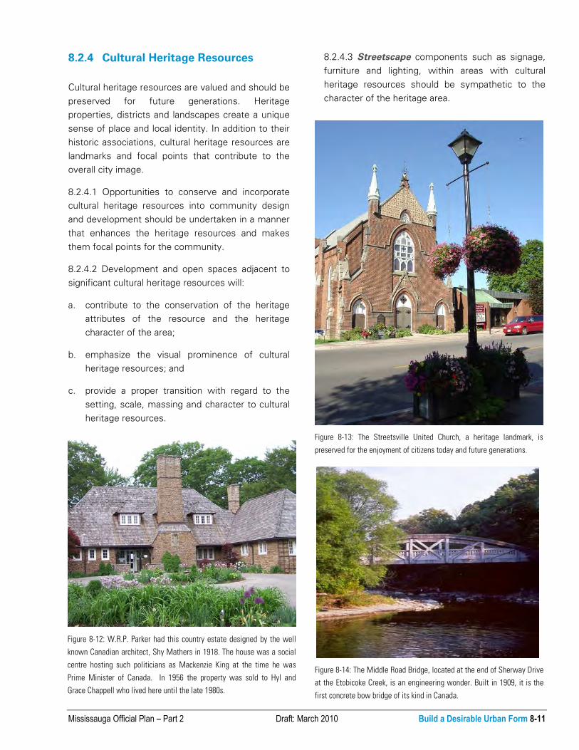
Figure 8-13: The Streetsville United Church, a heritage landmark, is
preserved for the enjoyment of citizens today and future generations.
Figure 8-12: W.R.P. Parker had this country estate designed by the well
known Canadian architect, Shy Mathers in 1918. The house was a social
centre hosting such politicians as Mackenzie King at the time he was
Prime Minister of Canada. In 1956 the property was sold to Hyl and
Grace Chappell who lived here until the late 1980s.
8-12 Build a Desirable Urban Form Draft: March 2010 Mississauga Official Plan – Part 2
8.3 Public Realm
The public realm consists of streets and boulevards,
public open spaces, squares and civic buildings and
is an integral component of the urban form of the
city. The arrangement of streets and blocks within
the public realm provides a foundation for the city’s
built environment, which in turn influences the
shape and layout of the public realm.
The creation of landmarks, routes and gateways
within the public realm contributes to the unique
experience, legibility, sense of orientation and views
and vistas. Public art, open space and landmark
buildings in the public realm enriches the urban
experience.
8.3.1 Streets and Blocks
Streets are public spaces that connect buildings,
structures, parks, communities, natural resources
and other significant public amenities. Blocks are the
spaces between streets where buildings, structures
and other elements, including parks and open
spaces, are located. A streetscape is the image
created by the buildings, sidewalks, signage, street
trees, landscaping, street furnishings, open spaces,
and other elements along streets.
8.3.1.1 Street patterns, development blocks and
public open spaces together should create
distinctive communities.
8.3.1.2 Mississauga will ensure that urban form,
street patterns and public open space systems are
coherent, orderly and legible.
8.3.1.3 Major roads and their
streetscapes should be designed to
create spaces that are integral parts of
the adjacent communities, thus serving
to link communities.
8.3.1.4 Development will be designed
to:
a. respect natural heritage features,
such as forests, ridges, valleys,
hills, lakes, rivers, streams and
creeks;
b. respect cultural heritage features
such as designated buildings,
landmarks and districts;
c. accentuate the significant identity
of each Character Area, its open
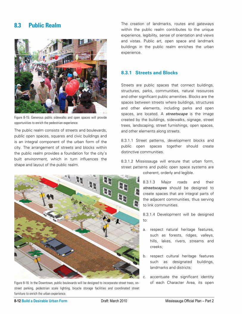
Figure 8-15: Generous public sidewalks and open spaces will provide
opportunities to enrich the pedestrian experience.
Figure 8-16: In the Downtown, public boulevards will be designed to incorporate street trees, on-
street parking, pedestrian scale lighting, bicycle storage facilities and coordinated street
furniture to enrich the urban experience.

Mississauga Official Plan – Part 2 Draft: March 2010 Build a Desirable Urban Form 8-13
spaces, landmarks and cultural heritage
resources;
d. achieve a street network that connects to
adjacent streets and neighbourhoods at regular
intervals, wherever possible;
e. meet universal accessible design principles;
f. address new development and open spaces;
g. be pedestrian-oriented and scaled and support
transit use;
h. be attractive, safe and walkable;
i. accommodate a multi-modal transportation
system; and
j. allow common rear laneways or parallel service
streets to provide direct access for lots fronting
arterial roads and major collector roads, when
appropriate.
8.3.1.5 The improvement of existing streets and the
design of new streets should enhance connectivity
by:
a. developing a fine-grained system of roads;
b. using short streets and small blocks as much as
possible, to encourage pedestrian movement;
c. avoiding street closures; and
d. minimizing culs-de-sac and dead-end streets.
8.3.1.6 Where culs-de-sac and dead-end streets
exist, accessible paths that provide shortcuts for
walking and cycling and for vehicular access should
be created, where possible.
Figure 8-17: A fine grain system of streets, incorporating small blocks will encourage pedestrian access and movement within Intensification Areas.

8-14 Build a Desirable Urban Form Draft: March 2010 Mississauga Official Plan – Part 2
8.3.1.7 Streetscapes will be designed to create a
sense of identity through the treatment of
architectural features, forms, massing, scale, site
layout, orientation, landscaping, lighting and signage.
8.3.1.8 The design of developments at intersections
and along major streets should be of a highly
attractive urban quality, recognizing that streets are
important civic spaces and linkages.
8.3.1.9 Development and elements within the public
realm will be designed to provide continuity of the
streetscape and minimize visual clutter.
8.3.1.10 Reverse frontage lots will not be permitted,
except for infill development where a street pattern
has already been established.
8.3.2 Civic Buildings and Spaces
Civic buildings and spaces are an important
component of the public realm. These elements
have the opportunity to become landmark buildings
and spaces and should set the standard for
development within the city. Civic buildings and
spaces may also act as a catalyst for further
development on surrounding lands.
8.3.2.1 Civic buildings and spaces will:
a. be built to a high standard of design excellence;
b. incorporate sustainable site development and
buildings practices;
c. strive to achieve a minimum standard of LEED
Silver or custom green development standards;
and
d. be sited for prominence, visibility and universal
accessibility.
8.3.2.2 Universal accessibility design principles will
be applied in the development of, or renovation to
City facilities including civic buildings, open space
recreation uses, transit and pedestrian facilities.
Figure 8-18: Development will incorporate street patterns where existing communities and built-up areas have a particular block structure and
characteristic street pattern.
Figure 8-19: Public views of City Hall, an important heritage landmark,
must be protected as it contributes to the identity of local government,
the Downtown and the city as a whole.
Mississauga Official Plan – Part 2 Draft: March 2010 Build a Desirable Urban Form 8-15
8.3.3 Gateways, Routes, Landmarks
and Views
Gateways, routes and landmarks are important
building blocks of the city and contribute to city
pattern and urban experience. Some sites within the
city are uniquely located, given their topography,
views or gateway condition. The design and function
of these sites have the opportunity and
responsibility to contribute to an area’s character.
Public buildings and structures with a prominent role
and function should stand out from their context to
support their role as landmarks.
Public views of important natural or man-made
features along streets and scenic routes need to be
protected since they add value to the built form and
contribute to neighbourhood identity. When
opportunities arise, new development must
maintain, and in some cases, enhance those views
and vistas to prominent features.
8.3.3.1 An appropriate gateway treatment will be
created at city boundaries, major Provincial highway
interchanges and at entry points to Intensification
Areas through high quality development, massing of
buildings, open spaces, landscaping and
streetscape.
8.3.3.2 Tall buildings have a greater presence on
the skyline and are required to have the highest
quality architecture.
8.3.3.3 Sites with prominence, high visibility and
access should be considered as a priority for civic
buildings and community infrastructure.
8.3.3.4 Buildings that serve the community such as
places of religious assembly, colleges and hospitals,
should be designed to be the focus of the
community, highly visible, universally accessible and
attractive and serve as landmarks for future
generations.
8.3.3.5 Special attention will be given to major
intersections to create a sense of enclosure and
identity, as well as heightened architectural interest.
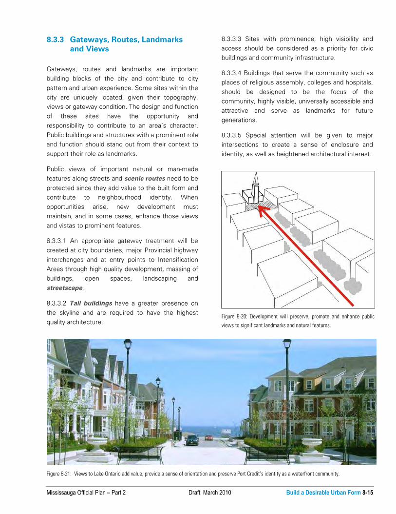
Figure 8-21: Views to Lake Ontario add value, provide a sense of orientation and preserve Port Credit’s identity as a waterfront community.
Figure 8-20: Development will preserve, promote and enhance public
views to significant landmarks and natural features.

8-16 Build a Desirable Urban Form Draft: March 2010 Mississauga Official Plan – Part 2
8.3.3.6 Developments on major corners, prominent
sites or that terminate a view will be held to a higher
design standard.
8.3.3.7 New streets may be introduced to create
prominent view corridors.
8.3.3.8 Views of significant natural and man-made
features should be created, maintained and
enhanced where appropriate.
8.3.3.9 Development will preserve, promote and
enhance public views to the Lake Ontario
waterfront.
8.3.3.10 Special care will be taken with
development along scenic routes to preserve and
complement the scenic historical character of the
street.
8.3.3.11 Lands abutting the Mississauga Road
right-of-way between the St. Lawrence and Hudson
Railway and Lakeshore Road West (frontage,
flankage and rear yards) is a designated scenic route
and will be subject to the following:
a. direct frontage lots with direct access or
flankage lots with buildings that have front
doors facing Mississauga Road will be
encouraged;
b. service road and reverse frontage lot
development will be discouraged;
c. existing residential lot frontages will be retained;
d. building massing, design and setback should be
consistent with buildings on surrounding lots;
e. projecting garages will be discouraged;
f. tree preservation, enhancement and
replacement on private lands will be required;
g. alternative on-site turn-arounds, such as
hammerhead driveways, will be encouraged, to
reduce reverse movements and the number of
driveway entrances. Circular driveways will be
evaluated on an individual basis;
h. preservation of existing landscape features
(retaining walls, fences, hedgerows) will be
encouraged; and
i. the location of utilities should minimize the
impact on existing vegetation.
Figure 8-22: Landmark buildings such as hospitals and places of religious assembly serve as focal points for communities as illustrated by the Credit Valley
Hospital (Carlo Fidani Cancer Centre and the Richard and Annettte Bloch Cancer Survivor Park) and Saviour of the World Chinese Church.
Mississauga Official Plan – Part 2 Draft: March 2010 Build a Desirable Urban Form 8-17
8.3.4 Public Art
Public art and culture enhances the quality of life for
residents and visitors by contributing to the identity
and unique character of the city and its various
destinations. Incorporating public art into the
experience of the city has the power to create a
compelling, enriched environment and a place
people will want to live in and return to.
Public art can range from the architecture of
buildings to the design of elements within the public
realm such as light features and seating. It may
include memorials, sculptures, water features,
murals, lighting or individual art installations; it may
be integrated with building and landscape design;
and art may also include functional elements such
as street furniture and utility boxes
Public art can serve as a focus in a public square or
open space, or simply provide visual relief in high
density areas. All gateway locations and public view
terminus sites are candidates for public art.
Public art should be considered at a variety of scales
and in diverse contexts. This includes larger
installations at visually strategic locations such as
the terminus of street corridors, at gateways, on
prominent corners or in public open spaces. It also
includes smaller or more unexpected installations
such as along sidewalks, in interior courtyards, in
associations with buildings (entrances, lobbies) and
in alternative public spaces such as parking lots and
garages.
8.3.4.1 Mississauga will encourage public art on
public and private lands.
8.3.4.2 Public art will be incorporated into the public
realm particularly in appropriate locations to serve as
landmarks and as gateway features.
8.3.4.3 Public art will be incorporated into public
works, whenever feasible.
8.3.4.4 Development proponents are encouraged to
incorporate public art into their developments.
Intensification Areas will be priority locations for the
installation of public art.
8.3.4.5 Public art is encouraged throughout the city,
particularly in Intensification Areas and along the
Lake Ontario waterfront.
8.3.4.6 Public art should have a prominent presence
throughout the city and contribute to a high quality
urban design. Public art should:
a. be encouraged as an integral component of
public works, land development and open space
planning;
b. include pieces that serve as orienting devices
for moving about and wayfinding or as focal
points in public open spaces;
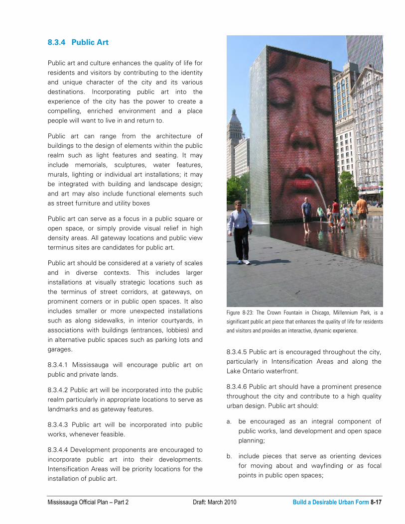
Figure 8-23: The Crown Fountain in Chicago, Millennium Park, is a
significant public art piece that enhances the quality of life for residents
and visitors and provides an interactive, dynamic experience.

8-18 Build a Desirable Urban Form Draft: March 2010 Mississauga Official Plan – Part 2
c. contribute to the animation of public spaces
through its design, which may include pieces
that are used as street furniture, play areas
and/or other interactive uses; and
d. correspond to the visual prominence of the site
on which it is located.
8.3.5 Open Spaces and Amenity Areas
Open spaces include both public and private space
as well as on-site amenities and are one of the most
significant contributors to an area’s character and
quality of life. It is important that they not only be
well designed and beautiful, but also that they be
well connected and integrated with adjacent uses
and other open spaces. The provision of open space
is an essential component of residential and non-
residential development.
8.3.5.1 Mississauga will promote public open space
design that is fully integrated with the urban design
and built form of the community.
8.3.5.2 Open space will contribute to community
aesthetics and enhance the Green System.
8.3.5.3 Natural features, parks and open spaces will
contribute to a desirable urban form by:
a. assisting with the conservation and connectivity
of the Natural Areas System, identified in
Schedule 3;
b. connecting to the city’s system of trails and
walkways;
c. connecting to other Natural Areas, Parks, and
Open Spaces, including streets, schools,
cemeteries and civic spaces;
d. ensuring that all new parks and Open Spaces
address the street, providing clear visibility,
access and safety;
e. ensuring that adjacent uses, buildings and
structures front onto them, with direct access,
and encouraging natural surveillance; and
Figure 8-24: In Port Credit, the Wave Park is the principle focus of the square with at-grade retail uses located at the edges to secure a vibrant,
animated open space.

Mississauga Official Plan – Part 2 Draft: March 2010 Build a Desirable Urban Form 8-19
f. appropriately sizing parks and open spaces to
meet the needs of a community and ensuring
they are able to accommodate social events and
individual needs, inclusive of recreation,
playgrounds, sports and community gardens,
where possible.
8.3.5.4 Open spaces will be designed as places
where people can socialize, recreate and appreciate
the environment.
8.3.5.5 Private open space and/or amenity areas will
be required for all development.
8.3.5.6 Residential developments of significant size,
except for freehold developments, will be required
to provide common outdoor on-site amenity areas
that are suitable for the intended users.
8.3.5.7 Residential developments will provide at-
grade amenity areas that are located and designed
for physical comfort and safety. In Intensification
Areas, alternatives to at-grade amenities may be
considered.
8.3.5.8 Landscaped, outdoor on-site amenities areas
will be encouraged for employment uses.
8.4 Movement
A guiding principle of this Plan is to connect people
with places through coordinated urban design, land
use and transportation planning. Development
should ensure the ease of movement between the
built form and transit facilities and active
transportation routes.
While vehicular and goods movement will continue
to be an essential element of the transportation
system, a priority for Mississauga is to increase the
appeal of transit and active transportation modes
for people of all ages and abilities. Mississauga is
committed to accessibility through barrier free
universal design. The design and relationships of
development and of open spaces adjacent to
streets, has a significant role to play in fulfilling
these objectives.
8.4.1 Transit and Active Transportation
Urban form is fundamental to fostering transit and
active transportation choices. Site and building
design will improve connections and accessibility for
Figure 8-25: A transit and pedestrian supportive urban form with active building facades and animated public realm is anticipated for Dundas Street, along
with other Intensification Areas and Corridors in Mississauga.

8-20 Build a Desirable Urban Form Draft: March 2010 Mississauga Official Plan – Part 2
transit users and promote pedestrian and cycling
transportation modes. Mississauga will consider the
convenience, comfort and safety of pedestrians and
cyclists through urban design.
Mississauga will ensure that pedestrian, cycling,
transit and vehicular systems achieve a high
standard of urban design and are an integral
component of the city’s visual image.
8.4.1.1 The design of all development will foster the
improvement of connections and accessibility for
transit users and promote active transportation
modes.
8.4.1.2 A transit and active transportation
supportive urban form will be required in
Intensification Areas and along Corridors and
encouraged throughout the rest of the city.
8.4.1.3 Development will support transit and active
transportation by:
a. locating buildings at the street edge, where
appropriate;
b. requiring front doors that open to the public
street;
c. ensuring active/animated building facades and
high quality architecture;
d. ensuring buildings respect the scale of the
street;
e. ensuring appropriate massing for the context;
f. providing pedestrian safety and comfort; and
g. providing secure bicycle parking.
8.4.1.4 Development will provide for pedestrian
safety through visibility, lighting, natural surveillance
and minimizing vehicular conflicts.
8.4.1.5 The design of transit facilities will consider
the convenience, comfort and safety of pedestrians
and cyclists.
8.4.2 Vehicular and Goods Movement
Although a priority for Mississauga is to increase the
appeal of transit and active transportation, urban
form must also consider the needs of vehicular and
goods movement, especially in areas where it forms
the dominant mode of transportation. Building and
site design in employment areas must carefully
consider goods movement and the potential for
conflict with transit and active transportation
modes.
8.4.2.1 Urban form will balance the needs of
vehicular and goods movement with transit and
active transportation modes.
8.4.2.2 In areas where vehicular and goods
movement is the primary mode of transportation,
regard for the needs and safety of transit users,
pedestrians and cyclists will be required.
8.4.2.3 Where buildings and structures are
separated from roadways by parking lots, efforts to
upgrade pedestrian access to buildings through
landscaping, site design and the development of
street-related frontages is encouraged.
Figure 8-26: Bicycle parking is an essential urban amenity that nurtures
transit usage and active transportation choices. (Research in Motion,
Airport Corporate Centre)

Mississauga Official Plan – Part 2 Draft: March 2010 Build a Desirable Urban Form 8-21
8.4.3 Accessibility
As Mississauga’s population ages, the need for
access will increase. Physical access to open spaces
and buildings should be provided throughout the
city. Further, the owners of existing buildings will be
encouraged to retrofit them to be universally
accessible.
8.4.3.1 Mississauga is committed to the creation of
an accessible city. The design of the physical and
built environment should have regard for universal
accessible design principles.
8.4.3.2 All development will be required to have
regard for the Mississauga Accessibility Design
Handbook.
8.5 Site Development and Buildings
A significant part of the urban experience takes
place as people move from one building to another.
Focusing on the relationship between buildings and
the spaces that surround them is critical to quality
urban form.
The quality and character of different communities
and areas will be conserved, in part, by establishing
a proper transition between them.
Figure 8-27: Mississauga’s Accessibility Advisory Committee was
established in 2003. Its role is to promote and facilitate a barrier-free
Mississauga for citizens of all abilities.
Figure 8-28: Architecturally expressed entrance features and defined
landscaping, provide a welcoming gesture and denote the sense of
principal access to the building. (Biovail Pharmaceutical Corporation,
Meadowvale Business Park)

8-22 Build a Desirable Urban Form Draft: March 2010 Mississauga Official Plan – Part 2
In the planning and design of sites for development,
consideration should be given to the existing site
conditions, surrounding context, the public realm
and proposed uses. Protecting and enhancing the
natural forms and features in the city will contribute
to sustainable site development.
Buildings, through their location and massing, help
define the use and character of streets and open
spaces with a memorable sense of place and
history. The orientation and placement of a building
on a property creates a relationship with the
adjacent context and helps define the quality and
character of the public realm.
Good urban form results in a pedestrian friendly,
safe, inviting and aesthetically appealing urban
environment. Matters such as landscaping, parking,
servicing and signage need to be appropriately
addressed.
8.5.1 Context
Context addresses how developments demonstrate
compatibility and integration with surrounding land
uses and vegetation by ensuring that an effective
transition in built form is provided between areas of
different development densities and scale and the
protection of natural features.
8.5.1.1 Building and site design will be compatible
with site conditions, the surrounding context and
surrounding landscape of the existing or planned
character of the area.
8.5.1.2 Developments should be compatible and
provide appropriate transition to existing and
planned development by having regard for the
following elements:
a. natural environment;
b. natural hazards (flooding and erosion);
c. natural and cultural heritage features;
d. street and block patterns;
e. the size and configuration of properties along a
street, including lot frontages and areas;
f. continuity and enhancement of streetscapes;
g. the size and distribution of building mass and
height;
h. front, side and rear yards;
i. the orientation of buildings, structures and
landscapes on a property;
j. views, sunlight and wind conditions;
k. the local vernacular and architectural character
as represented by the rhythm, textures and
building materials;
l. privacy and overlook; and
m. the function and use of buildings, structures and
landscapes.
8.5.1.3 Site designs and buildings will create a
sense of enclosure along the street edge with
heights appropriate to the surrounding context.
Figure 8-29: An appropriate transition of built form will be required to the existing and planned context.

Mississauga Official Plan – Part 2 Draft: March 2010 Build a Desirable Urban Form 8-23
8.5.1.4 Buildings, in conjunction with site design and
landscaping, will create appropriate visual and
functional relationships between individual buildings,
groups of buildings and open spaces.
8.5.1.5 Developments will provide a transition in
building height and form between Intensification
Areas and adjacent Neighbourhoods with lower
density and heights.
8.5.1.6 Existing vegetation patterns and preservation
and/or enhancement the Urban Forest will be
addressed in all new development.
8.5.17 Developments adjacent to public parkland will
complement the open space and minimize negative
impacts.
8.5.1.8 Proposed development should encourage
public open space connections that link public parks
and community facilities through the use of
walkways, bikeways and bridges.
8.5.1.9 Development proposals will demonstrate
compatibility and integration with surrounding land
uses and the public realm by ensuring that adequate
privacy, sunlight and sky views are maintained and
that micro-climatic conditions are mitigated.
Figure 8-30: Development will respect the existing context and provide an appropriate transition in built form to low rise residential areas.
Figure 8-31: The height and massing of buildings should not obstruct
sunlight from reaching the public sidewalk.

8-24 Build a Desirable Urban Form Draft: March 2010 Mississauga Official Plan – Part 2
8.5.1.10 Where employment and commercial uses
are adjacent to noise sensitive uses, noise
mitigation should be provided at the source of the
noise to ensure compatibility and acceptable noise
levels.
8.5.1.11 New residential development abutting
major roads should be designed with a built form
that mitigates traffic noise and ensures the
attractiveness of the thoroughfare.
8.5.1.12 Noise will be mitigated through appropriate
built form and site design. Mitigation techniques
such as fencing and berms will be discouraged.
8.5.1.13 Buildings with exposure to Provincial
Highways or public streets in areas of site plan
control will be subject to a higher standard of design
to achieve upgraded building elevations and
landscaping, including principal doors and window
fenestration.
8.5.1.14 Sites that have exposure to parks or double
exposure to both Provincial Highways and public
streets will be required to be designed with
upgraded building elevations and landscaping facing
all parks, public highways and public streets.
8.5.1.15 Development in proximity to landmark
buildings or sites, or to natural or cultural heritage
resources should be designed to:
a. respect the prominence, character, setting and
connectivity of these buildings, sites and
resources; and
b. ensure an effective transition in built form
through appropriate height, massing, character,
architectural design, siting, setbacks, parking,
amenity and open spaces.
8.5.2 Site Development
The arrangement of elements on a site, as well as
their massing and design, should contribute to
achieving the City’s vision and the intended
character for the area. The development of a
property may include one or more buildings or
structures, services and utilities, parking areas and
driveways and landscaping. Incorporating
stormwater best management practices in site
design will assist in achieving sustainable
development.
8.5.2.1 High quality, diverse and innovative design
will be promoted in a form that reinforces and
enhances the local character, respects its immediate
context and creates a quality living or working
environment.
8.5.2.2 Developments will be sited and massed to
Figure 8-32: Building facades should be parallel to the street edge with an appropriate architectural expression addressing the Highway 401 frontage.
(Airport Corporate Centre)

Mississauga Official Plan – Part 2 Draft: March 2010 Build a Desirable Urban Form 8-25
contribute to a safe and comfortable environment
for pedestrians by:
a. providing walkways that are connected to the
public sidewalk, are well lit, attractive and safe;
b. fronting walkways and sidewalks with doors and
windows and having visible active uses inside;
c. avoiding blank walls facing pedestrian areas; and
d. providing opportunities for weather protection,
including awnings and trees.
8.5.2.3 Development proponents will be required to
ensure that pedestrian circulation and connections
are accessible, comfortable, safe and integrated into
the overall system of trails and walkways.
8.5.2.4 Where direct vehicular access to
development is not permitted from major roads,
buildings should be designed with front doors of
individual units oriented towards the major road with
vehicular access provided from a side street, service
roads or rear laneways.
8.5.2.5 Development proponents may be required to
up-grade the public boulevard and contribute to the
quality and character of streets and open spaces by
providing:
a. street trees and landscaping and relocating
utilities, if required;
b. lighting;
c. weather protection elements;
Figure 8-34: Bioretention features, such as stormwater best
management practices, are encouraged to be incorporated in site
development.
Figure 8-35: Generous landscape islands help to minimize the urban
heat island effect.
Figure 8-33: Permeable paving is used to enhance tree preservation
efforts and to promote stormwater infiltration at Dominican University, in
River Forest, Illinois.

8-26 Build a Desirable Urban Form Draft: March 2010 Mississauga Official Plan – Part 2
d. screening of parking areas;
e. bicycle parking;
f. public art; and
g. street furniture.
8.5.2.6 Development proponents will be required to
demonstrate the successful application of universal
accessible design features and compliance with
legislated standards.
8.5.2.7 Site development should respect and
maintain the existing grades on-site.
8.5.2.8 Site designs that conserve energy will be
encouraged. Energy conservation will be addressed
at the development application stage and during the
preparation of building and site designs. Buildings
should be designed, oriented, constructed and
landscaped to minimize interior heat loss and to
capture and retain solar heat energy in the winter
and to minimize solar height penetration in the
summer.
8.5.2.9 Site designs will be encouraged to minimize
the consumption of water and to utilize stormwater
best management practices.
8.5.2.10 Site development will be encouraged to
meet a minimum standard of LEED Silver or custom
green development standards.
8.5.2.11 Development should incorporate
techniques to minimize the urban heat island effect.
8.5.2.12 Site development will be required to:
a. incorporate stormwater best management
practices;
b. provide enhanced streetscape;
c. provide landscaping that complements the
public realm;
d. include the use of native non-invasive plant
material;
e. protect and enhance habitat;
f. preserve significant trees on public and private
lands;
g. provide planting and surface treatment to
address urban heat island effect; and
h. provide landscaping that beautifies the site and
complements the building form.
8.5.2.13 Heating, venting and air conditioning
equipment and mechanical/utility functions will be
Figure 8-36: The Hazel McCallion Academic Learning Centre at the University of Toronto Mississauga demonstrates the importance of high quality
architecture and the use of sustainable building materials to conserve energy.
Mississauga Official Plan – Part 2 Draft: March 2010 Build a Desirable Urban Form 8-27
located away from the public realm and not be
visible from public view.
8.5.2.14 External lighting for site development:
a. should be energy efficient;
b. should utilize dark skylight fixtures; and
c. will not infringe on adjacent properties.
8.5.3 Buildings
Buildings are often the most noticeable aspect of
site development and, therefore, the quality of their
design and the materials selected is fundamental to
good urban form. The articulation of a building is
often what gives it a human scale and a sense of
quality through attention to detail. The entrance of a
building is often the most recognizable and used
part of the façade and should be prominent,
recognizable and accessible.
All buildings should be designed to incorporate
sustainable technologies. Where tall buildings
occur, they are prominent features of the urban
form and should be designed to the highest of
standards.
8.5.3.1 Buildings will be designed to create a sense
of identity through the site layout, massing, forms,
orientation, scale, architectural features, landscaping
and signage.
8.5.3.2 Buildings must clearly address the street
with principal doors and fenestrations facing the
street in order to:
a. ensure main building entrances and at-grade
uses are located and designed to be prominent,
face the public realm and be clearly visible and
directly accessible from the public sidewalk;
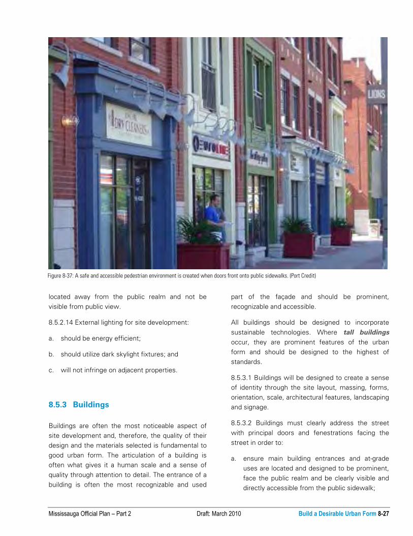
Figure 8-37: A safe and accessible pedestrian environment is created when doors front onto public sidewalks. (Port Credit)

8-28 Build a Desirable Urban Form Draft: March 2010 Mississauga Official Plan – Part 2
provide strong pedestrian connections and
landscape treatments that link the buildings to
the street; and
b. ensure public safety.
8.5.3.3 Building facades should be articulated to
include changes in materials, or material treatments,
as well as the indication of transition between floors
and interior spaces to provide visual interest and
relief.
8.5.3.4 Principal building entrances should be
covered with a canopy, awning, recess or similar
device to provide visual prominence and pedestrian
weather protection.
8.5.3.5 Front building façades should be parallel to
the street. Consideration may be given to allow for
periodic indentation for visual relief and features
such as urban plazas.
8.5.3.6 Street facing façades should have the
highest design quality. Materials used for the front
façade should be carried around the building where
any façades are exposed to the public view at the
side or rear.
8.5.3.7 Buildings will be pedestrian-oriented through
the design and composition of their façades,
including their scale, proportion, continuity, rhythms,
texture, detailing and materials.
8.5.3.8 Buildings should avoid blank street wall
conditions. Blank walls resulting from phased
development, will require upgraded architectural
treatment.
8.5.3.9 Tall buildings will minimize undue physical
and visual negative impact relating to:
a. micro-climatic conditions, including sun, shadow
and wind;
b. noise;
c. views;
d. skyview; and
e. adjacent cultural heritage resources, open
spaces, the public realm, community
infrastructure and residences.
8.5.3.10 The lower portion of tall building
developments will include a built form that achieves
street frontage and at-grade relationships to support
a pedestrian-oriented environment.
8.5.3.11 Building materials should be chosen for
their functional and aesthetic quality, sustainability
and ease of maintenance.
8.5.3.12 Ensure that building materials minimize the
risk for bird collisions.
8.5.3.13 Buildings should be designed to conserve
energy and incorporate sustainable materials.
8.5.3.14 Buildings should be designed to minimize
the consumption of water and to utilize stormwater
best management practices.
8.5.3.15 Buildings should coordinate and integrate
vehicular and servicing access to minimize their
visual prominence.
8.5.3.16 Mechanical equipment, vents and metering
devices will be integrated into the building design
and will not be visible from the public realm.
8.5.3.17 Roof-top mechanicals and appurtenances
will be integrated into building design and will not be
visual from the public realm and residential
developments.
Figure 8-38: Green roofs are an effective stormwater best management
practice and contribute to the reduction of the urban heat island effect

Mississauga Official Plan – Part 2 Draft: March 2010 Build a Desirable Urban Form 8-29
8.5.3.18 It will be the responsibility of proponents of
development applications will be responsible to
comply with Airport height restrictions.
8.5.4 Relationship to Public Realm
The public realm is an integral part of any site
development. The relationship between buildings,
site layout and elements within the public realm has
a great impact on the urban form and the experience
of those who live, work and play in the city.
8.5.4.1 Development proposals should enhance
public streets and the open space system by
creating a desirable street edge condition.
8.5.4.2 An attractive and comfortable public realm
will be created through the use of landscaping, the
screening of unattractive views, protection from the
elements, as well as the buffering of parking,
loading and storage areas.
8.5.4.3 The sharing and reduction of access
points/driveways will be encouraged to promote
pedestrian safety and provide the opportunity for a
continuous streetscape.
8.5.4.4 Along Corridors where an urban character is
appropriate, buildings should be located close to and
aligned with the street to enclose the street.
Figure 8-39: Attractive and comfortable public spaces enhance the
pedestrian experience. (Streetsville)
Figure 8-40: The public realm in an urban environment constitutes an array of publicly accessible spaces which create a memorable sense of place.
Wide public sidewalks with street trees, special pavement, animation and buildings framing the street contribute to a desirable public realm.

8-30 Build a Desirable Urban Form Draft: March 2010 Mississauga Official Plan – Part 2
8.5.4.5 Built form will relate to the width of the
street right-of-way.
8.5.4.6 Outdoor storage should not be located
adjacent to, or visible from city boundaries, the
public realm or residential lands by the use of
appropriate setbacks, screening, landscaping and
buffering.
8.5.4.7 Display areas are to be an integral part of the
overall site design and evaluated based on their
visual impact on the streetscape.
8.5.5 Parking, Servicing and Loading
The design of parking, servicing and loading areas is
a key component in the development of sites.
These areas serve a functional need, but should be
designed in a manner that screens less desirable
aspects and provides high quality treatment of
exposed areas while addressing safe and efficient
movement of pedestrians and vehicles. Parking
surfaces are a contributor to the urban heat island
effect and, as such, should be designed to mitigate
the heat effects.
8.5.5.1 Parking should be located underground,
internal to the building or to the rear of buildings.
8.5.5.2 Above grade parking structures should be
screened in such a manner that vehicles are not
visible from public view and have appropriate
directional signage to the structure.
8.5.5.3 Where surface parking is permitted, the
following will apply. Parking should:
a. not be located between the building and the
street;
b. incorporate stormwater best management
practices, such as, permeable paving, bio-
retention areas and tree clusters;
c. provide safe and legible raised walkways, with
curb ramps, within parking areas to buildings
and streets;
d. incorporate the principle of universal accessible
design;
e. be configured to permit future development;
f. have appropriate landscape treatment including
trees and lighting, throughout parking lots;
g. provide appropriate landscape treatment to
provide shading of parking areas; and
h. provide landscape buffering at the street edge.
8.5.5.4 Shared parking between developments will
be encouraged, where appropriate.
8.5.5.5 Development will provide secure bicycle
parking.
8.5.5.6 Site plans will demonstrate the ability for
shared servicing access between adjacent
developments.
8.5.5.7 Service, loading and garbage storage areas
should be internal to the building or located at the
rear of the building and screened from the public
realm.
Figure 8-41: Service and loading areas should be discreet, located on-
site, recessed into the building and not be a dominant element of the
streetscape.
Mississauga Official Plan – Part 2 Draft: March 2010 Build a Desirable Urban Form 8-31
8.5.6 Safety
Crime Prevention Through Environmental
Design (CPTED) concepts and principles with the
objective of promoting safe living and working
environments. Following CPTED principles, the
public and private environment will be maintained at
a level that enhances the public perception of safety
and buildings, landscaping and site layout and will be
designed to enhance personal safety.
8.5.6.1 Site layout, buildings and landscaping will be
designed to promote natural surveillance and
personal safety.
8.5.6.2 Active building frontages should be designed
to face public spaces including entries and windows
to ensure natural surveillance opportunities.
8.5.6.3 Development should clearly define areas of
access and egress to avoid the creation of
entrapment areas.
8.5.6.4 Development should incorporate lighting to
ensure all designated areas of circulation, entrance,
and connections are appropriately illuminated.
8.5.7 Signage
Signage is a significant element of the city’s identity
and character. Signage is both public and private.
Signs include street names, interpretative and
commemorative plaques, advertising and
identification of uses.
8.5.7.1 Signage should:
a. orient people as they move through the city;
b. identify businesses and services;
c. promote and enhance an area’s character;
d. identify significant sites, community uses,
destinations and landmarks;
e. recognize cultural heritage resources; and
f. follow universal design principles.
8.5.7.2 Building and site designs will integrate
signage and have regard for the character of the
building, landscape and context. Signage should
identify and inform as well as complement and
enliven the streetscape. Signage must be designed
to minimize visual clutter.
8.5.7.3 Except for wayfinding and commemorative
plagues, only facia signs will be permitted within
Intensification Areas
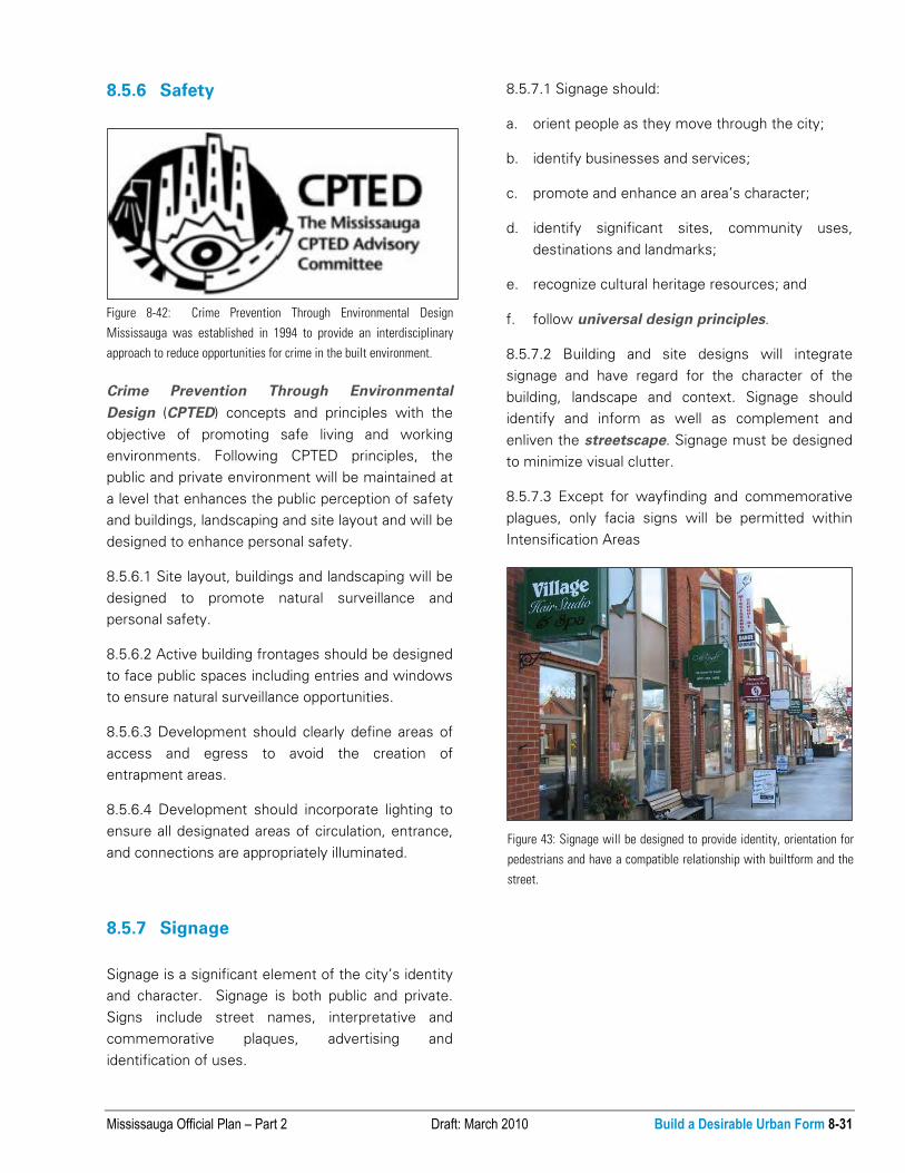
Figure 8-42: Crime Prevention Through Environmental Design
Mississauga was established in 1994 to provide an interdisciplinary
approach to reduce opportunities for crime in the built environment.
Figure 43: Signage will be designed to provide identity, orientation for
pedestrians and have a compatible relationship with builtform and the
street.