876 mciver road, vershire, vt - files.usmre.comfiles.usmre.com/5071/marketing brochure -...
TRANSCRIPT
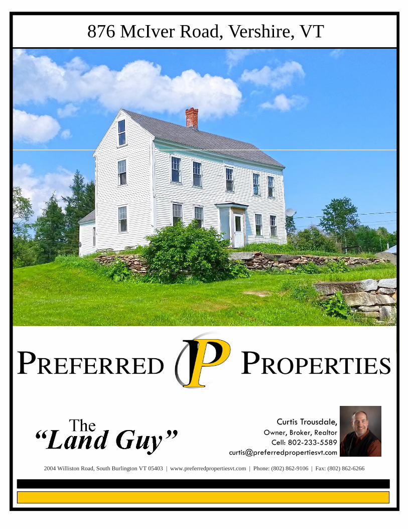
876 McIver Road, Vershire, VT
2004 Williston Road, South Burlington VT 05403 | www.preferredpropertiesvt.com | Phone: (802) 862-9106 | Fax: (802) 862-6266
Curtis Trousdale,Owner, Broker, Realtor
Cell: [email protected]

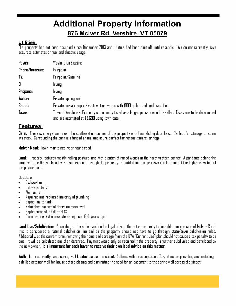
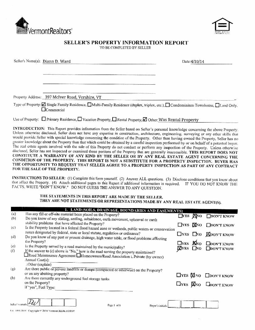
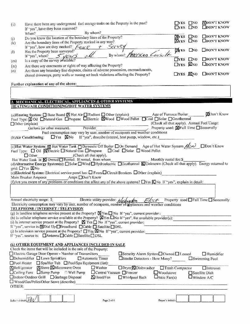
Utilities: The property has not been occupied since December 2013 and utilities had been shut off until recently. We do not currently have accurate estimates on fuel and electric usage.
Power: Washington Electric
Phone/Internet: Fairpoint
TV: Fairpoint/Satellite
Oil: Irving
Propane: Irving
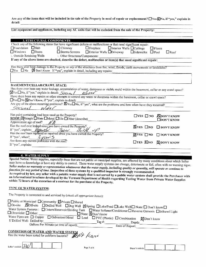
Water: Private, spring well
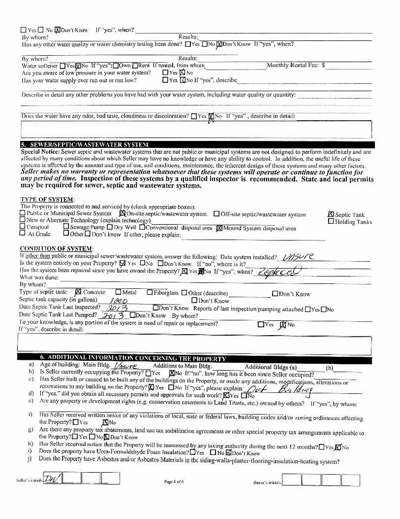
Septic: Private, on-site septic/wastewater system with 1000 gallon tank and leach field
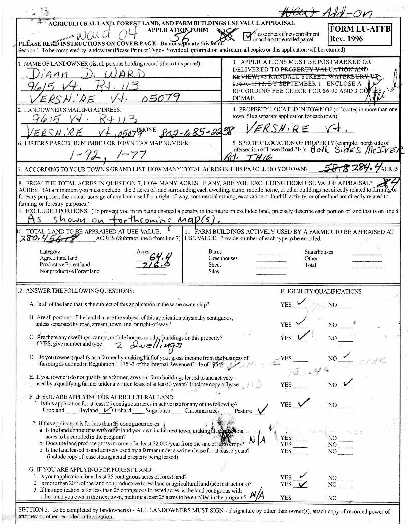
Taxes: Town of Vershire - Property is currently taxed as a larger parcel owned by seller. Taxes are to be determined
and are estimated at $2,690 using town data.
Features:
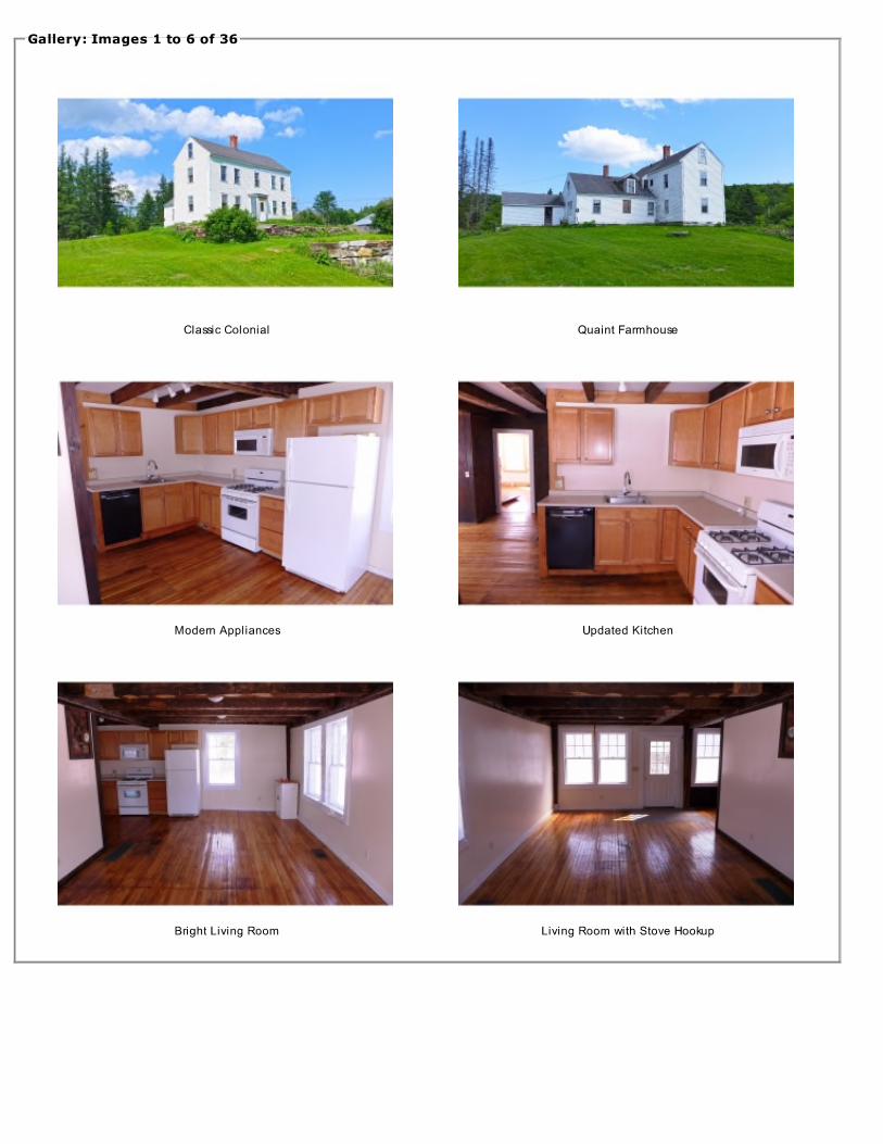
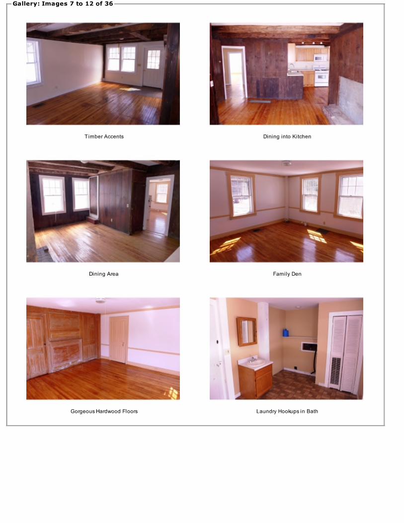
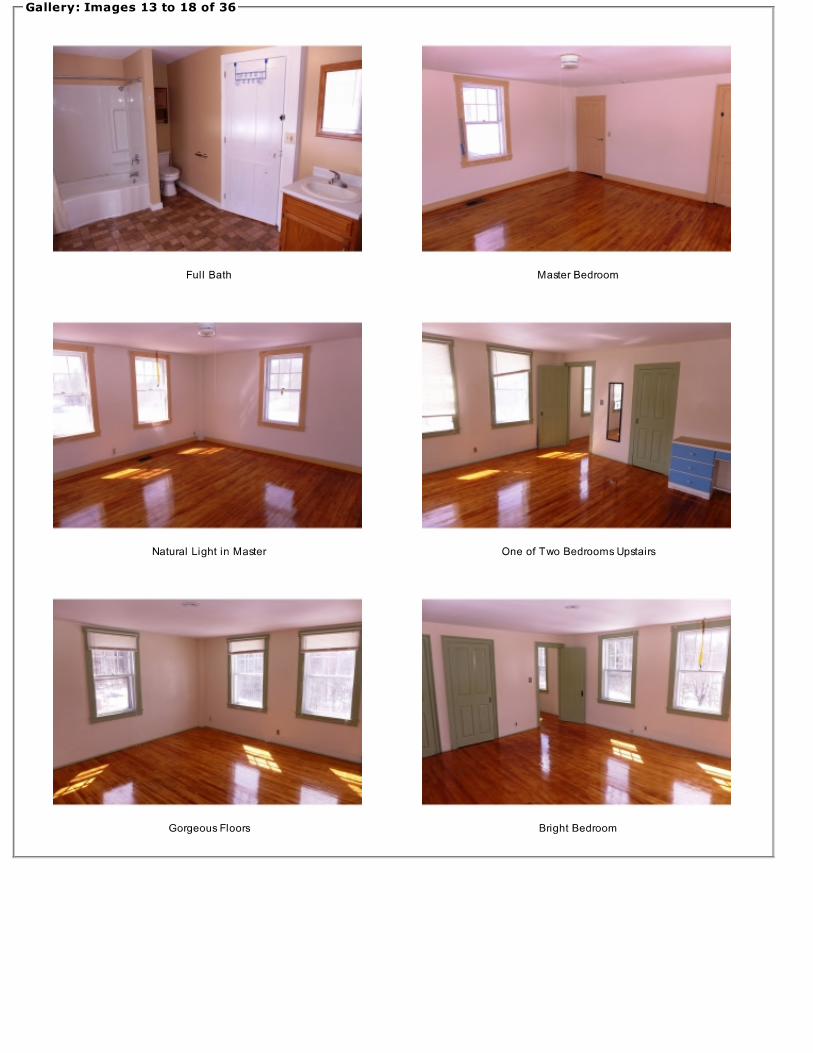
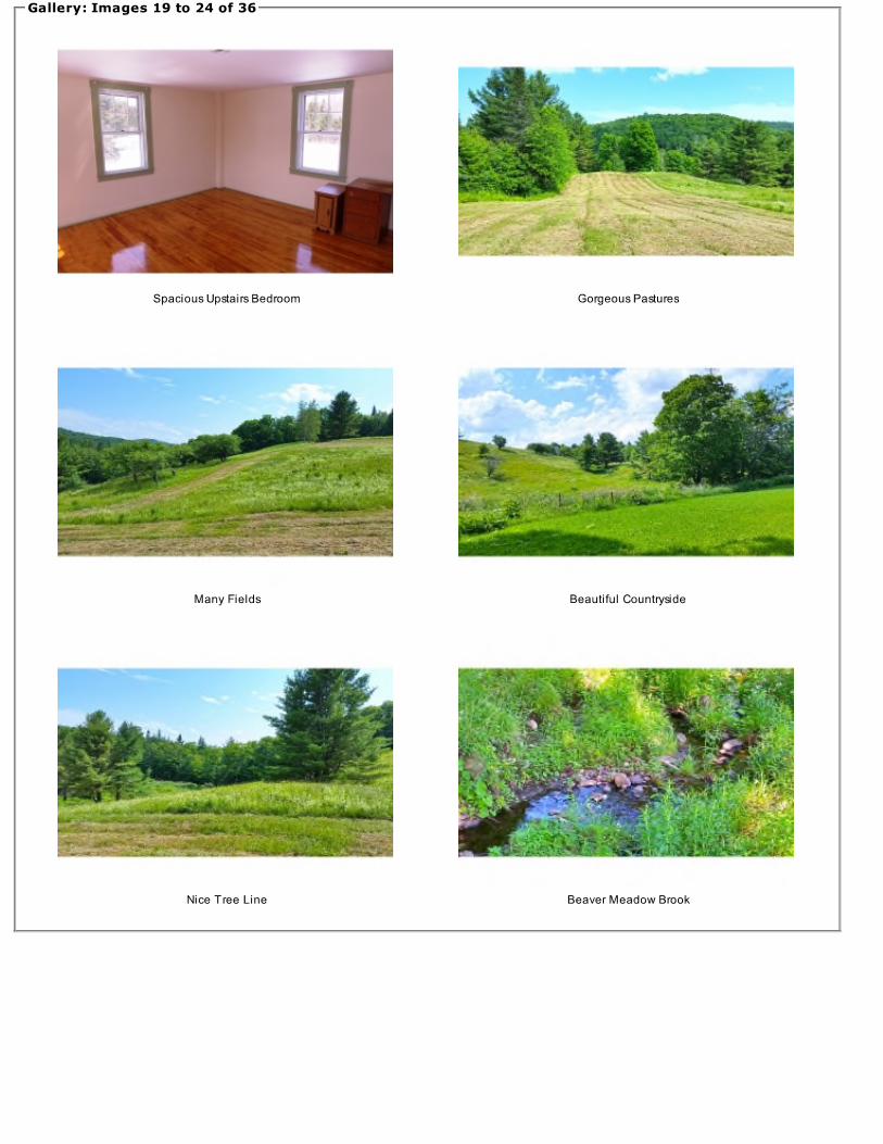
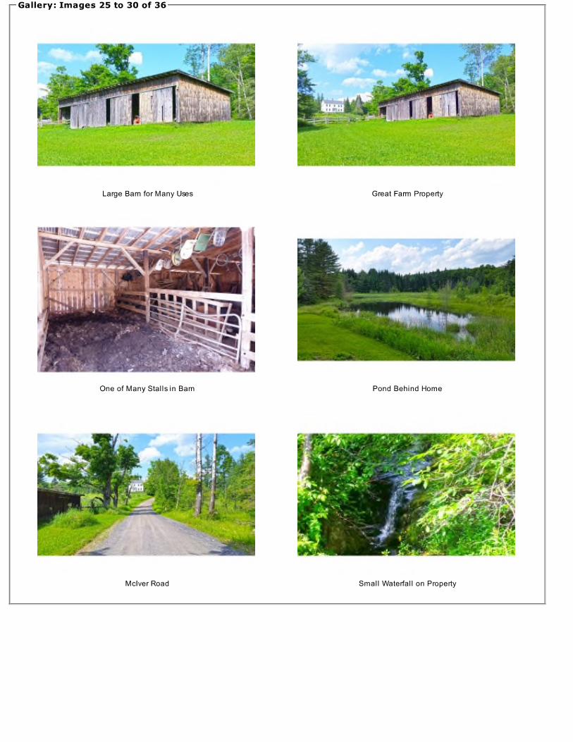
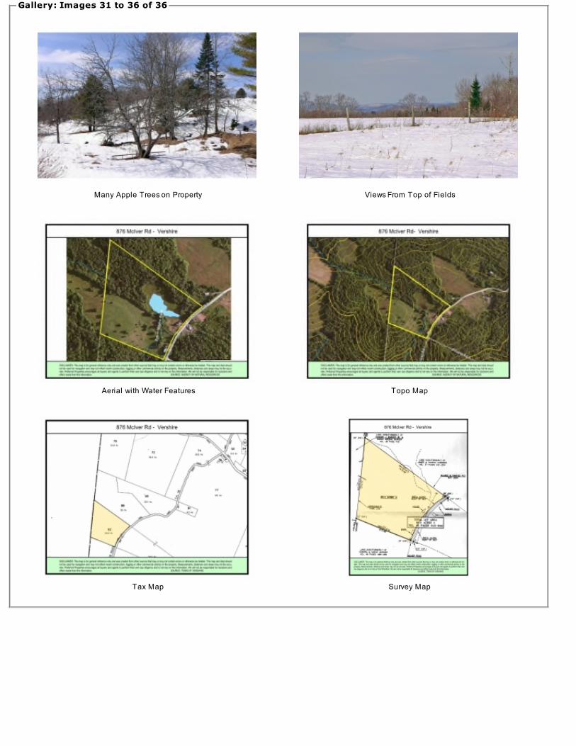
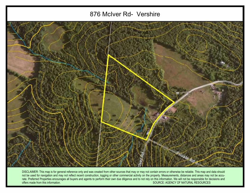
Barn: There is a large barn near the southeastern corner of the property with four sliding door bays. Perfect for storage or some livestock. Surrounding the barn is a fenced animal enclosure perfect for horses, steers, or hogs. McIver Road: Town-maintained, year round road. Land: Property features mostly rolling pasture land with a patch of mixed woods in the northwestern corner. A pond sits behind the home with the Beaver Meadow Stream running through the property. Beautiful long range views can be found at the higher elevation of the pasture land. Updates: Dishwasher Hot water tank Well pump Repaired and replaced majority of plumbing Septic line to tank Refinished hardwood floors on main level Septic pumped in fall of 2013 Chimney liner (stainless steel) replaced 8-9 years ago Land Use/Subdivision: According to the seller, and under legal advice, the entire property to be sold is on one side of McIver Road, this is considered a natural subdivision line and so the property should not have to go through state/town subdivision rules. Additionally, at the current time, removing the home and acreage from the UVA “Current Use” plan should not cause a tax penalty to be paid. It will be calculated and then deferred. Payment would only be required if the property is further subdivided and developed by the new owner. It is important for each buyer to receive their own legal advice on this matter.
Well: Home currently has a spring well located across the street. Sellers, with an acceptable offer, intend on providing and installing a drilled artesian well for house before closing and eliminating the need for an easement to the spring well across the street.
Additional Property Information
876 McIver Rd, Vershire, VT 05079
Vershire, VTVershire is located in the center of
Orange County, near the borders ofCorinth, Bradford, Newbury, Topsham,W. Fairlee, Orange, Washington andChelsea.
The town and a village were named"Ely" after the Ely Mining Company,which mined copper. The name changedin 1883, when 200 miners seized theplant demanding back wages. Fivecompanies of the National Guard werecalled out to suppress the miners
It is the home of The Mountain School ofMilton Academy, a selective independentsemester program that providesacademically motivated high schooljuniors from across the country theopportunity to live and work on an organicfarm.
The commonly accepted explanationfor the current name is that it was coinedby the Legislature, combining VER(mont)and (New Hamp)SHIRE. Population was629 at the 2000 census.
Area InformationNearby Cities:Montpelier, VT
41 Minutes
Burlington, VT
1 Hour, 14 Minutes
Concord, NH
1 Hour,48 Minutes
Boston, MA
2 Hours, 48 Minutes
Albany, NY
3 Hours, 23 Minutes
New York, NY
5 Hours, 6 Minutes
Stillwater State Park1 hour, 4 Minutes - Groton StateForest, with over 26,000 acres, is thesecond largest land block administeredby the Dept of Forests, Parks &Recreation. The forest contains over 17miles of hiking trails and over 20 milesof gravel roads and multi-use trailssuitable for mountain biking andhorseback riding.
Link: Stillwater State Park
Black Mountain State Forest, NH59 Minutes — Visitors to BlackMountain in Haverhill and Benton willhike about 2 miles up through a variety
of forested habitats, including anuncommon red pine forest, and end upon a partly open rocky summit with sub-alpine plants and natural communities.There are great views of theConnecticut River valley and nearby Mt.
Moosilauke. Link: Black Mountain
Podunk Wildlife Management Area20 Minutes — Podunk WildlifeManagement Area (WMA) is located inthe east central Vermont town ofStrafford, due west of Miller Pond. TheWMA is 924 acres in size, is owned bythe State of Vermont and managed bythe Vermont Fish & Wildlife
Department. Access to the WMA canbe gained from the west via JustinMorrill Highway to Old City Falls Road,and then to Pennock Road, whicheventually turns into an unmaintainedClass 4 town road that bisects the
WMA. Link: Podunk Wildlife
Mt. Ascutney State Park53 Minutes— One of the first VT StateParks. Built Between 1935 and 1938through the Civilian Conservation Corpsaimed at putting young men to work.The park has 4 trailheads, 12 miles ofhiking trails, tent/trailer sites, sheltersand is a favorite for hang glider.
Lebanon Municipal Airport - NH37 Minutes A regional, tower-controlledairport located in western NewHampshire, on the border of Vermont.Daily commercial service connectspassengers to Boston and White Plains,New York.
Burlington International Airport:1 Hour, 20 Minutes Regional hubserviced by major airlines, connecting toairports across the country.
Rutland State Airport:1 hour, 30 minutes Located just fivemiles south of Vermont’s second largestcity, Southern Vermont Regional Airportis a modern convenience nestled in theheart of the beautiful Green Mountains.
Logan International Airport:2 Hours, 38 Minutes Boston LoganInternational Airport is New England’slargest transportation center andgenerates $7 billion in economic activity
each year. It is a city within a city on a1,700 acre footprint of land.
Albany, NY International Airport :3 Hours, 4 Minutes The AlbanyInternational Airport offers a wide-rangeof facilities and services. A recentlycompleted multi-million dollar capitalredevelopment project included a new230,000 square foot terminal, parkinggarage, Air Traffic Control Tower, andcargo facility.
Nearby Airports and Trains:
Nearby State Parks & Forests
About The Town
Rivers and Lakes
Page 2Area Information
Skiing, Snowmobiling, SnowshoeingSnowmobileThe VAST trail system Corridor110 intersects and runs alongMcIver Road.
Bolton Valley1 Hour, 13 Minutes—BoltonValley sits high in the GreenMountains of Vermont. It is aunique, high mountain alpinevillage surrounded by over 5,000pristine acres. At Bolton Valley,the recreational opportunitiesare as numerous as the views
are spectacular. Link: BoltonValley
Sugarbush1 Hour, 20 Minutes—Sixdistinct peaks of unleashedpotential. Two uncrowdedmountain areas. 2,000 acres ofbackcountry in the Slide BrookBas in. I t ’s no surpr iseSugarbush was recently named“Best Ski Town in the East” byOutside Magazine. Link:Sugarbush
Stowe1 Hour, 11 Minutes—In a placewhere the history, communityand landscape are legendary forhospitality and adventure, StoweMountain Resort in StoweVermont has reinforced itsinternationally respected brandwith world-class improvementsboth on and off the mountain.Link: Stowe
Lake Morey538 acres with a maximumdepth of 43 feet. The publicboat launch offers a concreter a m p a n d ye a r - r o u n drecreat ion is permit ted.Common fish species includeYellow Pirch, Northern Pike,Large & Smallmouth Bass,Bullhead, and Panfish.
Waits RiverThe Waits River is located in awooded va l ley in thenortheastern por t ion of
Vermont. There is a three milesection that is of most interestto boaters located about a milebelow the Waits River town putin.
Lake FairleeLake Fairlee offers 463 acresof year round fishing, fromboating in the summer to icefishing in the winter. The lakefeatures a concrete State ofVermont boat launch and isknown for its Trout, Perch,Bass and more!
Lake GrotonLake Groton (422 acres) is longand narrow in shape and lies ina north-south direction. LakeGroton is popular for all typesof water-based recreationalactivities and has two stateparks. The fish populationconsists of smallmouth bass,largemouth bass, chainpickerel, yellow perch, brownbullheads, and sunfish.
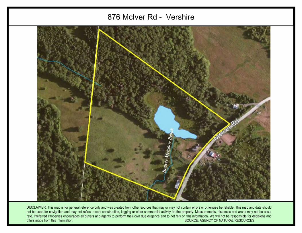
DISCLAIMER: This map is for general reference only and was created from other sources that may or may not contain errors or otherwise be reliable. This map and data shouldnot be used for navigation and may not reflect recent construction, logging or other commercial activity on the property. Measurements, distances and areas may not be accu-rate. Preferred Properties encourages all buyers and agents to perform their own due diligence and to not rely on this information. We will not be responsible for decisions andoffers made from this information. SOURCE: AGENCY OF NATURAL RESOURCES
876 McIver Rd - Vershire
DISCLAIMER: This map is for general reference only and was created from other sources that may or may not contain errors or otherwise be reliable. This map and data shouldnot be used for navigation and may not reflect recent construction, logging or other commercial activity on the property. Measurements, distances and areas may not be accu-rate. Preferred Properties encourages all buyers and agents to perform their own due diligence and to not rely on this information. We will not be responsible for decisions andoffers made from this information. SOURCE: AGENCY OF NATURAL RESOURCES
876 McIver Rd- Vershire
DISCLAIMER: This map is for general reference only and was created from other sources that may or may not contain errors or otherwise be reli-able. This map and data should not be used for navigation and may not reflect recent construction, logging or other commercial activity on theproperty. Measurements, distances and areas may not be accurate. Preferred Properties encourages all buyers and agents to perform their owndue diligence and to not rely on this information. We will not be responsible for decisions and offers made from this information.
SOURCE: TOWN OF VERSHIRE
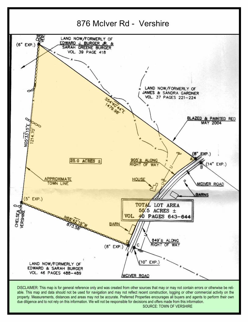
876 McIver Rd - Vershire
DISCLAIMER: This map is for general reference only and was created from other sources that may or may not contain errors or otherwise be reliable. This map and data shouldnot be used for navigation and may not reflect recent construction, logging or other commercial activity on the property. Measurements, distances and areas may not be accu-rate. Preferred Properties encourages all buyers and agents to perform their own due diligence and to not rely on this information. We will not be responsible for decisions andoffers made from this information. SOURCE: TOWN OF VERSHIRE
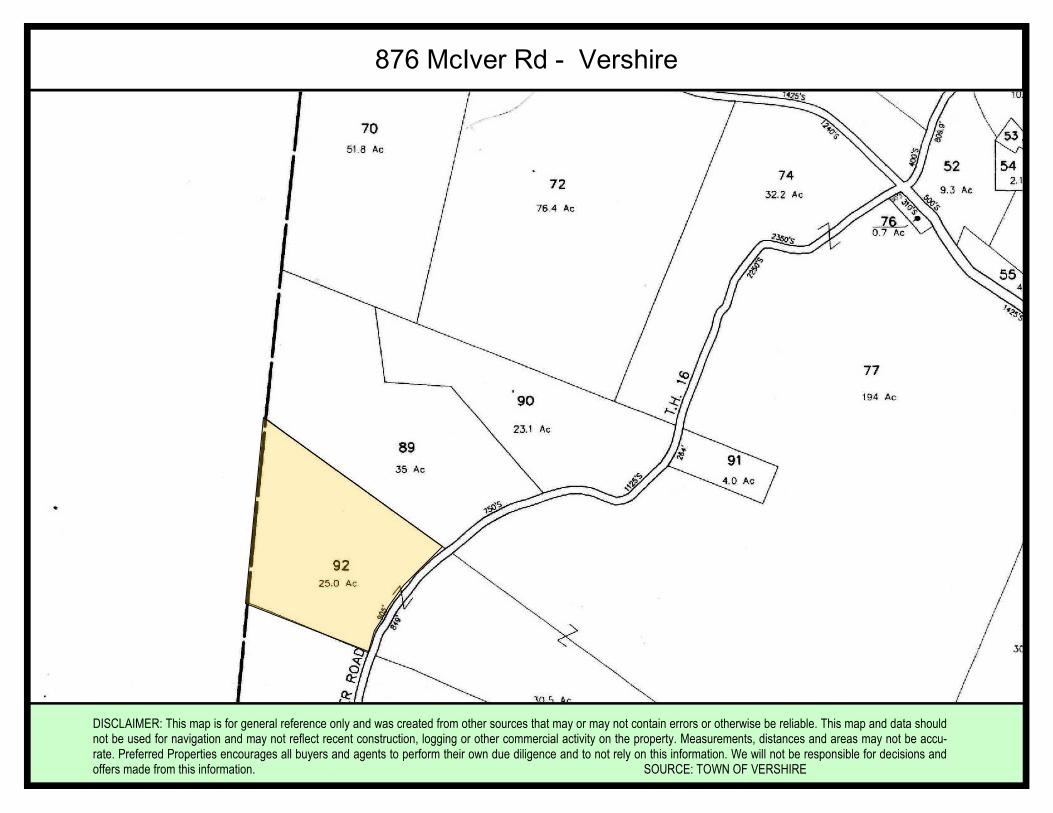
876 McIver Rd - Vershire