vershire town plan - trorc.orgvershire town plan adopted 10/31/2017 page | 3 the natural environment...
TRANSCRIPT

Vershire Town Plan
Vershire Town
Plan
Adopted
October 31, 2017
Prepared by the Vershire Planning Commission
Bill Baylis, Chair Margaret Darrow
Ken Bushey Chas Cook
Gene Sobeck
Written with assistance from and funded through the Two Rivers-Ottauquechee Regional Commission

Vershire Town Plan
TABLE OF CONTENTS
I. INTRODUCTION............................................................................................................................... 1 A. VISION STATEMENT .......................................................................................................................... 1 B. WHY HAVE A PLAN? – PURPOSE ...................................................................................................... 1 C. DEFINING OUR RURAL CHARACTER ................................................................................................. 2 D. GENERAL GOALS .............................................................................................................................. 3
II. POPULATION .................................................................................................................................... 4 A. POPULATION PATTERNS .................................................................................................................... 4 B. AGE OF POPULATION ........................................................................................................................ 5
III. ECONOMIC DEVELOPMENT ................................................................................................... 6 A. EMPLOYMENT AND JOBS ................................................................................................................... 6 B. INCOME OF POPULATION ................................................................................................................... 7 C. TAXES ............................................................................................................................................... 7 D. GOALS, POLICIES AND RECOMMENDATIONS ..................................................................................... 8
IV. HOUSING ....................................................................................................................................... 9 A. INTRODUCTION ................................................................................................................................. 9 B. NUMBER OF HOUSING UNITS ............................................................................................................ 9 C. TYPES OF HOUSING AND OWNERSHIP CHARACTERISTICS ................................................................10 D. AFFORDABLE HOUSING ...................................................................................................................10 E. ELDERLY HOUSING ..........................................................................................................................11 F. CHILDCARE ......................................................................................................................................11 G. GOALS, POLICIES AND RECOMMENDATIONS ....................................................................................11
V. UTILITIES AND FACILITIES .......................................................................................................13 A. TOWN CENTER .................................................................................................................................13 B. TOWN OFFICES ................................................................................................................................13 C. TOWN GARAGE ................................................................................................................................13 D. SOLID WASTE SERVICES: DURGIN HILL ROAD ................................................................................14 E. WATER SUPPLY AND WASTEWATER TREATMENT FACILITIES .........................................................14 F. TELECOMMUNICATIONS AND INTERNET ...........................................................................................15 G. CAPITAL BUDGET AND PROGRAM ....................................................................................................18 H. GOALS, POLICIES AND RECOMMENDATIONS ....................................................................................18
VI. EMERGENCY SERVICES .........................................................................................................21 A. AMBULANCE ....................................................................................................................................21 B. VERSHIRE FIRE & RESCUE ...............................................................................................................21 C. POLICE .............................................................................................................................................21 D. EMERGENCY PLANNING ...................................................................................................................22 E. GOALS, POLICIES AND RECOMMENDATIONS ....................................................................................22
VII. EDUCATIONAL FACILITIES ...................................................................................................23 A. INTRODUCTION ................................................................................................................................23 B. EDUCATIONAL FACILITIES ...............................................................................................................23 C. STUDENT ENROLLMENT ...................................................................................................................23 D. ADULT EDUCATION .........................................................................................................................24 E. GOALS, POLICIES AND RECOMMENDATIONS ....................................................................................24

Vershire Town Plan
VIII. TRANSPORTATION ...................................................................................................................25 A. INTRODUCTION ................................................................................................................................25 B. TOWN ROADS AND ROAD MAINTENANCE ........................................................................................25 C. ACCESS MANAGEMENT....................................................................................................................26 D. OTHER MODES OF TRAVEL ..............................................................................................................27 E. TRANSPORTATION AND LAND USE PATTERNS .................................................................................28 F. GOALS AND POLICIES.......................................................................................................................28
IX. CURRENT AND FUTURE LAND USES ...................................................................................30 A. INTRODUCTION ................................................................................................................................30 B. OVERALL LAND USE GOALS ............................................................................................................30 C. CURRENT LAND USE ........................................................................................................................30 D. PROPOSED LAND USE ......................................................................................................................31 E. VILLAGE CENTER AREA...................................................................................................................32 F. OPEN SPACE AREA...........................................................................................................................33 G. RURAL RESIDENTIAL AREA .............................................................................................................34 H. FLOOD HAZARD AREA .....................................................................................................................35 I. TRANSPORTATION AND LAND USE PLANNING .................................................................................35
X. NATURAL RESOURCES ................................................................................................................37 A. WETLANDS ......................................................................................................................................37 B. WATER RESOURCES .........................................................................................................................38 C. WILDLIFE AND FOREST RESOURCES ................................................................................................40 D. MINERAL RESOURCES ......................................................................................................................42
XI. FLOOD RESILIENCE .................................................................................................................44 A. BACKGROUND ..................................................................................................................................44 B. FLOOD HAZARD AND RIVER CORRIDOR AREAS IN TOWN ................................................................45 C. GOALS, POLICIES, AND RECOMMENDATIONS ...................................................................................46
XII. SCENIC AND HISTORIC RESOURCES AND RECREATION ............................................47 A. EAGLE HOLLOW...............................................................................................................................48 B. PATTERSON MOUNTAIN & SURROUNDING AREA .............................................................................48 C. TOWN CENTER .................................................................................................................................49 D. ELY MINE ........................................................................................................................................49 E. GOALS AND POLICIES.......................................................................................................................49
XIII. ENERGY........................................................................................................................................50 A. OVERVIEW .......................................................................................................................................50 B. ENERGY USE ....................................................................................................................................50 C. CURRENT ENERGY SOURCES ...........................................................................................................51 D. ENERGY EFFICIENCY........................................................................................................................51 E. MUNICIPAL ROLE IN ENERGY EFFICIENCY .......................................................................................52 F. RENEWABLE ENERGY ......................................................................................................................53 G. ENERGY AND LAND USE POLICY .....................................................................................................54 H. GOALS, POLICIES AND RECOMMENDATIONS ....................................................................................55
XIV. RELATIONSHIP TO OTHER PLANS ......................................................................................58
XV. IMPLEMENTATION ...................................................................................................................59 A. PUTTING THE PLAN INTO ACTION ....................................................................................................59 B. ADOPTION OF THE PLAN ..................................................................................................................59 C. ONGOING PLANNING ........................................................................................................................59 D. IMPLEMENTATION TOOLS ................................................................................................................60 E. GUIDELINES FOR GROWTH ...............................................................................................................61 F. RESPONSIBILITY FOR IMPLEMENTATION ..........................................................................................63

Vershire Town Plan
APPENDIX A: 2016 VERSHIRE COMMUNITY SURVEY ..................................................................64
APPENDIX B: VERSHIRE ENERGY DATA .........................................................................................71
Table of Figures
Figure 1 – Vershire Population ....................................................................................................................... 4 Figure 2 - Vershire Population Distribution by Age Group ........................................................................... 5 Figure 3 - Occupations in Vershire ................................................................................................................. 6 Figure 4 - Vershire Average Yearly ............................................................................................................... 7 Figure 5 - 2017 Effective Property Tax Rates in Surrounding Area (per $100) ............................................. 8 Figure 6 - Total Housing Units in Vershire .................................................................................................... 9 Figure 7 - Vershire Types of Housing Units .................................................................................................10 Figure 8 - Source: Building Energy Plan, Vershire Town Garage 2010 .......................................................13 Figure 9 - Average Daily Membership ..........................................................................................................23 Figure 10 - Total Road Mileage ....................................................................................................................25
Table of Maps
Map 1: Current Land Use Map 2: Future Land Use Map 3: Transportation Map 4: Natural Resources Map 5: Utilities and Facilities Map 6: Flood Resiliency Map 7: Forest Blocks

Vershire Town Plan
Adopted 10/31/2017 Page | 1
I. Introduction
A. Vision Statement The Vershire Planning Commission hopes for a town where people respect and use the land well, where forestry and wild lands, agriculture, small businesses and commuters live comfortably together. We hope for a town that feels like a home to come back to, for both vacationers and year-rounder’s, where children are brought up to care about the town and land, and where all work together for the Town's betterment. We have written this Plan to further this vision.
B. Why Have A Plan? – Purpose Vershire is a small, rural town that has remained relatively untouched by the changes that have occurred in surrounding towns. Vershire has not greatly suffered from the stresses that a growing population can put on public utilities and services. However, Vershire is close to the Upper Valley, a population center with rapid growth in the State of Vermont. As a result, our population is growing. In the decade between 2000-2010, our population increased from 629 to 730 residents, an overall increase of 16%. Continued population expansion will affect the character of our town. The influx of people will involve schools for their children, expanded and improved road systems and most certainly put a higher burden on our other town services. Change stimulates the need for our community to examine its current condition and to evaluate its prospects for the future. Change can be beneficial, but is not necessarily so. We must understand the problems and opportunities facing the community, so that we can ascertain goals for the future and direct the change for the best possible outcome. Here are some specific reasons to have a Town Plan:
1. A guide for our community – Information in the Plan can be used by the Selectboard, among other things, developing a capital budget, community services, emergency services, recreation and municipal facilities.
2. Support for grant applications and planning studies – Many state run grant programs available to Vershire consider whether or not the town has stated a need for its grant request in the Town Plan. Studies are often called for within a plan, and the funding for such projects can come from state resources.
3. A guide for future development – In towns with no zoning, a Town Plan can be the only tool for local control of development. The District Environmental Commission considers Town Plans during an Act 250 hearing, which is why the Plan should clearly explain to developers what types of development are preferred in our town and where and how they should be located.

Vershire Town Plan
Adopted 10/31/2017 Page | 2
C. Defining Our Rural Character The District Environmental Commission will often look to a Town Plan for guidance with regard to the issue of “rural character.” Too often this concept is poorly defined and/or too vague to be useful in a legal proceeding under Act 250. Therefore, for the purposes of this document, it is necessary for the Planning Commission to attempt to define what residents view as the “rural character” of Vershire. In a survey carried out in the summer of 2016, the Planning Commission asked the residents of Vershire what they would like their town to be in the future. There was near unanimous agreement that "Vershire’s major strengths are its people and its beautiful rural setting" and strong support for the statement that "Our Town Plan should seek to preserve the rural character of Vershire." These survey results are entirely in line with responses to previous surveys, for example, one in 2005. They imply that Vershire should remain much like it is. Questions about the desirability of commercial development drew more mixed responses, with a third to a half of responses being neutral or negative. To the extent that residents approve the prospect of commercial development, they prefer it to be small businesses concentrated in the center of the village that is along Route 113. Vershire is a small, quiet, bedroom community.
Residents have indicated that they prefer types of development that include residences, small home based businesses, professional offices, bed and breakfasts and eco/agri tourism. In the village of Vershire, residents would prefer a denser form of development that could include any of the above, but also restaurants and small retail shops. It is felt that development of this nature would be compatible with the present rural character of Vershire.
An issue that has emerged since the last Vershire Town Plan and the survey that preceded it is the spread of new communications technologies--internet and cell phone--and of alternative energy technologies, primarily solar arrays and wind towers. Although Vershire residents appreciate and hope to benefit from these technologies, they are concerned about how the necessary infrastructure may affect Vershire's rural character. The survey reveals the most support for private solar arrays and the least for wind towers and commercial energy development of any sort. A large majority agree that access to high-speed internet and cell phone service is very important, they are concerned about where such things as cell phone tower and solar panel arrays would be located.
The Church-Orr House – home to VerShare, the Vershire Community Library, MIV Shop and the Stage Coach Hostel

Vershire Town Plan
Adopted 10/31/2017 Page | 3
The natural environment of Vershire marked by deep valleys and high hills, is part of what makes Vershire’s rural character important to its citizens. There is limited flat land in the Town and steep slopes and shallow soils predominate. Several streams rise from springs in the highlands, flowing into the White, Waits or Ompompanoosuc rivers. Some of these stream valleys are almost completely wild and feel very remote, though civilization is nearby. Many pockets where deep soils occur tend to be wet and poorly drained. There are many small wetlands and boggy areas in Vershire, in which grow bog plants ranging from orchids to white cedar. Largely untouched areas such as Hawkins and Patterson Mountain to the Southwest and Eagle Hollow to the Northeast are excellent examples of these valuable natural resources, and they are a great recreational asset to the Town. It is important to the residents of Vershire that the rural nature of these areas be protected.
D. General Goals The following goals are important to our town:
1. Strive toward sensible development and orderly growth to maintain the rural characteristics of Vershire.
2. Maintain the continuance of agricultural activities in Vershire. 3. Maintain conservation and proper management of our natural resources. 4. Supply quality community facilities within an expressed plan at a minimum cost,
i.e., roads, fire protection and police protection. 5. Provide recreational opportunities for townspeople to more fully enjoy their
leisure time.

Vershire Town Plan
Adopted 10/31/2017 Page | 4
II. Population
A. Population Patterns Population, when considered in terms of past, present, and future statistics, represents an important factor in the overall development of our Town. Vershire's population reached its height in the census of 1880 with a total of 1875 residents; its low point came in 1960 with 236 residents. Since that date the population has increased to 730 in the 2010 census. So far, although significant, Vershire's population growth has been sufficiently slow to be incorporated without major problems. We do not foresee at this time a change in the patterns of population growth that have obtained over the past three or four decades. Such population growth benefits Vershire, adding people with new insights, energy and enthusiasm, as well as increasing the town's tax base. However, rapid and unanticipated population increases can compromise rural character, create a demand for new and expanded municipal services, and strain the financial ability of a town to provide public services economically.
Figure 1 – Vershire Population - Source: 2010 U.S. Census

Vershire Town Plan
Adopted 10/31/2017 Page | 5
B. Age of Population Between 2000 and 2010, population increases occurred primarily in the 35-54 year old range. In the 55-64 age group this reflects the ongoing effect of the baby boomer generation. As was the case in the last update to the Vershire Town Plan, there appears to be a continued influx of new residents age 35 - 54.
Figure 2 - Vershire Population Distribution by Age Group
Source: 2010 U.S. Census
The jump in population aged 55-59 (from 21 individuals in 2000 to 59 in 2010) represents a 180% increase in that age group. Overall in the State, the number of Vermonters 45-54 years of age increased 49% while in Vershire that age group experienced only an 8.8% increase over the 2000-2010 decade. Also of note, is the large (153%) increase in population within the 20-24 year-old age group indicated in the 2010 US Census Data for Vershire. When compared with the numbers from the 2000 US Census, this population increase could imply that younger Vershire residents are choosing to remain here and are not moving out of town or out of state.

Vershire Town Plan
Adopted 10/31/2017 Page | 6
III. Economic Development
A. Employment and Jobs Agriculture, logging and maple sugaring have long provided Vershire’s economic base. With the exception of the Ely Mine era, the town has not been home to large industrial developments, but rather small home-based businesses. Presently, residents have a number of home occupations including, but not limited to:
• Artisans • Farmers • Truckers • Furniture & Cabinet making • Wood products • Construction
Figure 3 - Occupations in Vershire
Source: 2011-2015 American Community Survey
Vershire does not serve as an economic hub for commercial and industrial activity. Residents go to the towns of Bradford, Chelsea, Randolph, Thetford, Norwich, Hanover and West Lebanon for banking, professional and related services. According to the 2011-2015 American Community Survey, 75% of the working population in Vershire works outside of Vershire, many in Hanover or Lebanon, NH. As a result, Vershire does not

Vershire Town Plan
Adopted 10/31/2017 Page | 7
have a well-defined commerce center. Most commercial development is of a scale that is appropriate in the rural countryside, and is consistent with this Plan.
B. Income of Population The average household income in Vershire in 2015 is $59,498, a slight increase from 2014, as seen in Figure 5 below.
Figure 4 - Vershire Average Yearly Wage
Source: American Community Survey, 2011- 2015 5 Year Estimates
C. Taxes Vershire has the one of the highest tax rates in its surrounding area. Our higher than average tax rate can be attributed to Vershire’s smaller population and smaller tax base than most of our neighboring towns, as well as a number of other things including: on the municipal side - the purchase of new town highway equipment in recent years. The high cost of education in the Rivendell Interstate School District (“RISD”) is the other large contributing factor to rapidly increasing taxes. In 2000, Vershire joined with West Fairlee to build a new K-5 Elementary School in West Fairlee. That, combined with the very high cost per pupil spending in the RISD, has driven up dramatically Vershire’s education costs.

Vershire Town Plan
Adopted 10/31/2017 Page | 8
Figure 5 - 2018 Effective Homestead Property Tax Rates in Surrounding Area (per $100)
Source: Vermont State Department of Taxes
D. Goals, Policies and Recommendations Goals
1. Promote a healthy economy which provides jobs & healthy activities for Vershire residents and helps to support the town.
2. Manage population growth to promote an economy of scale, i.e., increase Vershire’s tax base without straining municipal services.
Policies
1. Encourage business growth that will enhance the rural environment that its residents so strongly value.
2. Consider ways to encourage the kinds of business that will support and enhance the life of the Town.
3. Support the manufacture of locally produced value-added products, particularly those that are agricultural or silvicultural in nature.
4. Commercial development that requires trucking and freight handling must only locate on roads which can effectively handle the size of vehicle needed.
5. Commercial development must not have an adverse impact on the rural nature of the community.
Recommendations
1. The Town should apply for state-designation as a Village Center, to receive priority consideration for state grants and other resources.

Vershire Town Plan
Adopted 10/31/2017 Page | 9
IV. Housing
A. Introduction A major function of local housing planning is to meet two community objectives - first, safe and affordable housing for its present and future population and second, suitable density and distribution of housing throughout the community. Growth in housing affects the Town’s capacity to provide facilities and services to our town and the character of the area. Housing built without adequate planning for schools, roads, and other public services can overburden the ability of the taxpayers to pay for these services, and also can lower adjacent property values and negatively affect the rural character of the town.
B. Number of Housing Units
Figure 6 - Total Housing Units in Vershire
Source: U.S. Census 2010 Vershire’s total number of housing units have been increasing since the 1970’s, while growth in housing stock jumped substantially between 1990 and 2000 it has slowed somewhat between 2000 and 2010.

Vershire Town Plan
Adopted 10/31/2017 Page | 10
C. Types of Housing and Ownership Characteristics
Figure 7 - Vershire Types of Housing Units
Source: American Community Survey, 2011-2015, 5 Year Estimate
The U.S. Census defines a “housing unit” to include: conventional houses, apartments, mobile homes, and rooms for occupancy. According to Vermont Housing Data, Vershire has a total of 430 housing units. Like most of the towns throughout Vermont, they are predominantly single-family homes, with mobile homes being a distant second. Although the majority of Vershire’s housing stock is owner-occupied, an unusually large amount, about one quarter, is dedicated to seasonal, recreational or occasional use. When a town has a large number of homes that are not occupied year-round, it can have unforeseen impacts on town services. For example Vershire, like many other Vermont towns, has a volunteer fire department. This department depends on full-time residents to staff its fire department and a lack of full-time residents can make acquiring staff difficult because the pool of candidates is reduced.
D. Affordable Housing Affordable housing is defined as that which a household making the county's median income could afford if no more than 30% of its income were spent on housing costs. For homeowners, housing costs include payments for principal and interest on a mortgage, taxes, etc. For renters, housing costs include rent and utilities. In Vershire, the average price of primary residences sold in 2010 was $166,950, which is less than the Orange County average of $174,255 and the statewide average of $222,436. In general, most homeowners in Vershire are paying about 23% of their income for

Vershire Town Plan
Adopted 10/31/2017 Page | 11
homeowner costs, but according to information collected between 2005-2009, 24% of households were paying more than 30% of their income for the same expenses. The median gross rent in Vershire is $692 per month, including utilities. When compared to Orange County ($746) and the Vermont average ($781), the rental rates in Vershire are a bit more affordable. For example, residents making an average income of $29,439 are paying nearly 28% of their income for the median gross rental rate, which is considered affordable, but barely so.
E. Elderly Housing According to the 2010 US Census, there are 73 individuals in Vershire who are 65 or older. 18% of homeowners in Vershire are 65 or older, but according to the 2010 census, there are no renters in Vershire who are in that age group. There are few options for elderly housing in Vershire, with only 8 beds dedicated to residential care (Level 3) in town. Given the aging population the need for such housing, both assisted and unassisted, will only increase. However, according to survey results, this is not an issue that worries many residents, perhaps because of facilities in nearby towns, like Chelsea.
F. Childcare Vershire has few options for childcare. According to the State of Vermont’s inventory of childcare facilities, Vershire has a single registered childcare facility with six full-time and four part-time spaces. Most residents currently arrange for care with relatives, or take their children to childcare facilities beyond the borders of Vershire to neighboring towns like Chelsea and West Fairlee. According to the 2011-2015 American Community Survey 5-Year Estimates, there were 81 children under the age of 10 in Vershire, a 22% increase from 2000. This seems to indicate that there is a need for additional childcare services in Vershire. A majority of Vershire residents who responded to the survey agree that “…Vershire needs to provide more opportunities for our children and young people.” Westshire Elementary School in West Fairlee has provided free pre-school for children in Vershire and surroundings towns since 2015. This is a great option for parents who have young children ages 3-5.
G. Goals, Policies and Recommendations Goals
1. Provide the opportunity for Vershire residents to have access to quality affordable housing.
2. Retain existing housing and construction of new housing which meets the natural population growth.
3. Preserve historic structures in ways that appropriately serve the need for housing.

Vershire Town Plan
Adopted 10/31/2017 Page | 12
4. Encourage additional affordable rental properties, especially in the village, provided that they do not put an undue burden on Town services and facilities and do not negatively impact the rural character of the village center.
5. Encourage the development of affordable senior housing within Vershire. 6. Encourage affordable childcare in Vershire.
Policies
1. Ensure that the timing and rate of new housing construction or rehabilitation does not exceed the community's ability to provide adequate public facilities (e.g. schools and municipal services).
2. Keep housing affordable by planning for: • Appropriately sized lots; • Accessory apartments; and • Clustered developments.
3. Encourage the location of future housing so as to complement existing or planned employment patterns, travel times, and energy requirements.
4. Location of housing, related amenities and land uses should be planned with due regard to the physical limitations of the site and location to current or planned public and private services such as roads and commercial/service centers.

Vershire Town Plan
Adopted 10/31/2017 Page | 13
V. Utilities and Facilities
A. Town Center The Town Center building provides space for town meetings, community events, and private functions. With the recent addition of a generator through a matching grant from the Vermont Emergency Management Program, the Town Center can be used as an emergency shelter. Adjacent to the building is a combination soccer-baseball-recreation field and picnic area as well as an outdoor bread oven/pavilion which is used for recreation and community events.
B. Town Offices The Town Office building, built 1978, contains the town records, office for the town clerk and treasurer, and meeting and work space for the Selectboard, Lister’s, Planning Commission/Board of Adjustment, and other town officials. The building is in good shape; Selectmen and Town Clerk see to the maintenance of the space using Town funds.
C. Town Garage Located one-half mile up the Vershire Center Road from Vermont Route 113, the Town Garage provides garaging for town equipment and a stockpile area for sand/salt for winter operations. It is maintained by the Vershire Highway Department. In 2010 a building energy audit was conducted on the Town Garage. The audit identified potential energy efficiency improvements that, if implemented, could save the town more than $4000 in operating expenses, but estimated improvements would cost over $28,000.
Energy Efficiency Improvement
Potential $ Savings
Cost with Rebate
Savings to Investment Ratio
Upgrade Lighting $ 243 $ 1,032 5 Improve Walls $ 1,051 $ 11,409 4 Improve Attic $ 1,479 $ 9,324 6
Weatherize Doors $ 96 $ 1,000 0.48 Reduce Modine Cycling $ 768 $ 2,400 3
Air Seal Walls $ 701 $ 3,500 8 Note: Savings to investment ratio is the present value of savings divided by the cost.
The higher the SIR the better the return on the investment.
Figure 8 - Source: Building Energy Plan, Vershire Town Garage 2010 A reduction in yearly expenses for this building would benefit the community as a whole. Any improvements planned for the Town Garage should take into consideration the results of the energy audit or these costs should be directed toward establishing an

Vershire Town Plan
Adopted 10/31/2017 Page | 14
entirely new and more efficient facility. Regardless of whether the present building is refurbished or a new structure is built, the town has a fund for this purpose. The State of Vermont has had concerns with the location of the Town Garage and the potential for causing pollution damage to a nearby stream. The Town has purchased a 27.9-acre lot on Durgin Hill Road to relocate the Town Garage at the time of this writing. Vershire has developed a committee to oversee the construction of the new building.
D. Solid Waste Services: Durgin Hill Road Vershire belongs to the 10-town Greater Upper Valley Solid Waste Management District (GUVSWMD). As a part of the district, Vershire sends its solid waste to the lined landfill in Lebanon, NH, and residents can take their household hazardous waste (HHW) to the special collection site at the Hartford landfill or to any other special collections held within the district throughout the year. The town purchased property at the corner of VT Route 113 and Durgin Hill Road is being temporarily used as the town recycling center. Beginning in September, 2015, the site opened to the public on Saturday mornings. In 2016, the town installed a gate to prevent off-hour dumping. Returnable bottles and cans collected there fund Vershire Fire and Rescue. In addition there are periodic collections of metal and tires. The program operates with one part-time employee. Residents purchase official Vershire trash bags--currently costing $2 apiece in order to dispose of non-compostable, non-recyclable & non-returnable waste which defrays part of the cost of the program. The total cost of solid waste collection (including the recycling program) was ~$45,000.00 in 2015, which includes the price of maintenance on the packer truck. The new arrangement for the disposal of Vershire's solid waste has been a success. The previous Town Plan (2011) indicated more needed to be done to encourage recycling. Under the new program, the amount of recyclable material collected has increased while the amount of trash going to the landfill has decreased. Residents complained in the survey about the restricted hours for trash disposal, especially problematic for people who work on Saturdays, or leaving town for the weekend.
E. Water Supply and Wastewater Treatment Facilities The town has no public water or sewer system. Individual wells supply water, and septic systems handle sewage disposal. Design and construction of on-site sewage systems requires a Potable Water and Wastewater permit from the Vermont Agency of Natural Resources.

Vershire Town Plan
Adopted 10/31/2017 Page | 15
F. Telecommunications and Internet Fairpoint Communications was bought out by Consolidated Communications at the time of this writing, who is the incumbent provider of landline voice communication services in Vershire. It has lines throughout the town. Residents may choose competing local and long distance providers. Consolidated offers digital subscriber line (DSL) service that provides internet access to many residents of Vershire. The last revision of the Town Plan in 2011 declared that Consolidated Communications covered most of the land-line telecommunications services for the town, and that there was little in the way of cell phone coverage in Vershire. This is no longer the case. Since 2011, East Central Vermont Community Fiber Network (ECFiber) has been building its presence in Vershire, with the objective to make high speed fiber optic internet service available to every residence and business. ECFiber offers symmetrical internet access (same upload as download), and a choice of five speeds that do not vary by time of day or according to the weather. It also offers telephone service. From an initial cable along VT Route 113 installed in 2013, ECFiber’s coverage has grown so that of the thirty-nine miles of maintained roads in Vershire, twenty-three are within range of connecting to existing fiber-optic. Total parcels in town are 489, and 26% of these are already subscribers. Optical fiber is far superior to the few existing alternative available here, and ECFiber’s goal is to offer it to the rest of the town as soon as possible. Wireless Voice and Data Verizon Wireless and AT&T provide wireless voice and data communications that reach locations in Vershire, depending on the accessibility of the locations from existing telecommunications facilities built along VT Route 113 (small cell technology located on existing telephone poles along the road). In some locations in town, this coverage is good, in other moderate or weak, and in still others nonexistent. As the technology has continued to evolve and change, many homes now also utilize micro-cell devices to allow the use of cell phones through internet connection in their homes in Vershire. Under present standards, transmission towers are the dominant telecommunications facilities. As land uses, these towers have emerged as planning concerns. To ensure adequate transmission of signals in mountainous areas, towers and related facilities prefer to be located on hilltops or high elevation points, often creating conflicts with scenic landscapes. Some of the Town's principal scenic resources are its ridgelines and mountainsides. These areas are significant contributors to the maintenance and enjoyment of rural character. Today, our ridges are predominately undeveloped and provide an unbroken skyline viewed from the valley floor. But ridgelines are not the only areas that are under assault for locating towers. In 2016, the Public Utilities Commission (PUC), formerly known as the Public Service Board, approved an application to build a cell tower in Vershire. Although not sited along a ridgeline, the tower did not meet with the Town of Vershire for approval in its location. In the face of opposition from the Selectboard, the Planning Commission, and the Two Rivers-Ottauquechee Regional Commission, the developer, T-Mobile, was still granted a permit by the PUC to locate its facility.

Vershire Town Plan
Adopted 10/31/2017 Page | 16
At the time of this writing, Vershire is developing both an Energy Plan and a Guideline for the Siting of Telecommunication Facilities. Those documents are incorporated herein by reference and as such, shall be considered an integral part of this document. With proper regulation, the use of ridges for telecommunication towers and related facilities can be minimized, and when done, undertaken in a manner that does not detract or adversely affect these scenic values. Protection of these areas from insensitive development is a matter of public good. Under Vermont law (24 V.S.A. Chapter 117), municipalities may require that certain standards be met prior to the construction of telecommunication facilities. Local bylaws may regulate the use, dimension, location, and density of towers, however, Federal Communications Commission (FCC) rules are preemptive of local and State law where conflicts exist. Act 250 jurisdiction requires a permit prior to the construction of a communications tower or similar structure over 50 feet in height. Both Act 250 and local regulations are superseded if the tower is part of a network regulated by the PUC. The recommendations of this section serve as a clear written community standard intended to preserve the aesthetics or scenic beauty of the Town of Vershire. Accordingly, it is the intent that this section be utilized by the District Environmental Commission, the Vermont Environmental Board, and the PUC as part of their review for all wireless communications facilities. However, as mentioned in the previous paragraph, the Town is very aware of the importance of telecommunication in general and would encourage additional transmission/cell towers to be located within its borders. Available Technologies and Topographic Issues An assessment of current technologies indicates that wireline technologies will provide the highest quality communication services to Vershire. Favoring wireline technology is consistent with the goal of the State of Vermont under 30 V.S.A. Chapter 202c (b) (10) for universal availability of broadband of at least 100 Mbps in both directions by 2024. The 2014 State Telecommunications Plan state that currently only fiber technology is capable of meeting this goal. Below is a discussion of technologies that cites advertised speeds by providers. According to the Federal Communications Commission (FCC), in 2014 wireline providers averaged 101% of advertised speeds nationally, with results varying by technology. Service delivery of most wireline and wireless providers is often asymmetrical, that is, download speeds are faster than upload speeds. Fiber-optic cable transmits data at speeds that significantly exceed current DSL or cable modem speeds, typically by tens or even hundreds of Mbps. Currently, ECFiber’s highest internet speed is greater than 500 Mbps, with basic service at 10 Mbps. Fiber-optic cables can be long lasting, and as higher data rates are needed, the provider can replace electronic devices at the end of each fiber to accommodate faster speeds. Cable modem service enables cable operators to provide broadband using the same coaxial cables that delivers pictures and sound to television sets. Most cable modems are
Vershire Town Plan
Adopted 10/31/2017 Page | 17
external drives that have two connections: on to the cable wall outlet, the other to a computer. Comcast offers this service in options ranging from 3-150 Mbps, with its higher speeds only available to some areas that it serves. DSL transmits data over copper telephone lines already installed to homes and businesses if they are close enough to the relevant telephone company facility. Consolidated offers residential DSL options ranging from 4-30 Mbps. Wireless cellular technology transmits data over a portion of the radio wave spectrum and requires the construction of towers and antennae. Verizon Wireless states that is 4G LTE provides speeds between 5-12 Mbps. Actual user experience is significantly affected by topography, vegetation, proximity to a tower, and human-made structures that may affect the quality of the signal. Satellite access is generally provided either through low earth orbit satellites or geostationary satellites. Signals from these satellites allow a user with a dish to have an internet connection. HughesNet offers speeds between 5-15 Mbps. The quality of the signal is affected by the clarity of the sky and speeds can be significantly reduced during storms. Small cell technology can expand the availability of voice and data services provided by either a wireline or wireless network. Small transmitters and receivers with a range of approximately half a square mile can be mounted on utility poles or buildings. Small cells have been installed in other parts of Vermont, including elsewhere in Orange County. Vershire’s topography presents significant challenges for wireless communications. Because the town already hosts a widespread utility line network and associated rights-of-way, it may be better suited for deployment of wireline communications technology augmented by small cells. The vertical nature of Vershire, with its ridges and valleys, limits the reach of wireless cell towers and encourages either proliferation of those towers or great height, which have a significant effect on the scenic character of this rural town that contains few structures above tree line. Current Telecommunications Regulations Vershire currently regulates wireless telecommunication facilities though a bylaw adopted at town meeting in 2008. The bylaw states a purpose to protect the scenic qualities of Vershire’s natural environment and to guide development that may have adverse health, safety or visual impacts. It requires conditional use review of proposed facilities. Among other provisions, the bylaw requires that the height of the facility shall not exceed 35 feet. Telecommunications facilities may also require a land use permit under Act 250 (10 V.S.A Chapter 151). Specifically, Act 250 requires a permit to build a support structure that is primarily for communication or broadcast purposes and that extends 50 feet or more in height above ground level or 20 feet or more above the highest point of an attached existing structure. The Vershire telecommunications bylaw, including its height restriction, constitutes a clear, written community standard intended to preserve aesthetics and scenic beauty.

Vershire Town Plan
Adopted 10/31/2017 Page | 18
A Certificate of Public Good (CPG) may be obtained from the PUC prior to construction or installation of telecommunications facilities under 30 V.S.A Chapter 248a. Telecommunications facilities approved under Section 248a option are exempt from Act 250 land use law or local bylaws. Under current law, the option expires July 1, 2017. Before issuing a CPG, the PUC must find that the facility will promote the general good of the state. The PUC is required to give “substantial deference” to the applicable local land use plan and the recommendations of the municipal legislative body and municipal and regional planning commission. “Due consideration” to most but not all of the environmental and land use criteria found in Act 250 is also required.
G. Capital Budget and Program State statute enables communities to create a Capital Budget and Program for the purposes of planning and investing in long-range capital planning. Although most communities have some form of capital account where they save money, many do not have a true Capital Budget and Program. A capital budget outlines the capital projects that are to be undertaken in the coming fiscal years over a five-year period. It includes estimated costs and a proposed method of financing those costs. Also outlined in the Program is an indication of priority of need and the order in which these investments will be made. Any Capital Budget and Program must be consistent with the Town Plan and shall include an analysis of what effect capital investments might have on the operating costs of the community. Vershire does have a Capital Equipment Schedule created in 2015 to replace the Highway Department equipment over the next ten years. This does not include the backhoe or the grader.
H. Goals, Policies and Recommendations Goals
1. Provide community facilities and services that meet the needs of the residents of Vershire.
2. Preserve the rural character and appearance in Vershire. 3. Protect the scenic, historic, environmental, and natural resources.
Policies:
1. Growth and development shall not exceed the capacities of local facilities and services.
2. Any increase in infrastructure shall be designed to have minimal aesthetic impact on the community.
3. Facilitate telecommunication services while minimizing the adverse visual effects of towers and related facilities by providing specific recommendations for design and siting standards.

Vershire Town Plan
Adopted 10/31/2017 Page | 19
4. Telecommunication facilities and other tower development shall be screened utilizing trees and landscaping located upon the land of the developer or lands leased by the developer.
5. No public burden from private development shall ensue. Recommendations:
1. Management plans for each public structure, addressing both immediate needs and long term requirements, should be developed.
2. Towers for wireless service providers and/or broadband shall be required to allow other providers to co-locate on their facilities when feasible, subject to reasonable terms and conditions.
3. To minimize conflicts with scenic values, telecommunication tower design and construction shall follow these guidelines, whenever possible:
a. Be located in non-residential areas and away from visually sensitive areas, prominent scenic areas and historic areas;
b. Be located in forested areas when possible, or camouflaged on buildings; c. Be sufficiently landscaped to screen related ground fixtures from public
vantage points, such as trails, roads or water bodies; d. Utilize materials, forms (including asymmetrical tree shapes), color
schemes, mass, minimal height and other design elements to promote aesthetic compatibility with surrounding uses and to avoid adverse visual impacts;
e. Screening must be located on the owned or leased property of the project; f. Where construction of access roads is involved, it should be situated to
generally follow the contour of the land and to avoid open fields or meadows to minimize its visibility;
g. Towers should not be illuminated by artificial means and not display strobe lights, except when required by the Federal Aviation Administration (FAA);
h. Towers shall avoid breaking the silhouette of peaks and ridges by locating downslope whenever feasible, and be sited in areas minimally visible to the traveling public, public recreation and the Cross-Rivendell Trail; and
i. The height for towers, antennae and tower-related fixtures shall be as close to mature tree height as possible while still achieving the coverage objective.
j. In planning for telecommunication facilities, due consideration should be given to the environmental limitations of any given site. Impacts of the use on wildlife habitats, soil erosion, forestry and agricultural lands and similar resources should be carefully addressed. Projects that materially impact these resources are discouraged. The design plans for telecommunication projects situated on lands owned by the State shall be compatible with current Management Plans for Public Lands adopted by the Agency of Natural Resources.

Vershire Town Plan
Adopted 10/31/2017 Page | 20
k. Towers, antennae and related fixtures that fall into disuse or are discontinued shall be removed. Local and State land use permits shall incorporate removal of inactive fixtures as a condition of approval.

Vershire Town Plan
Adopted 10/31/2017 Page | 21
VI. Emergency Services
A. Ambulance Emergency medical transportation is provided by Upper Valley Ambulance, Inc. (UVA), based at the Fairlee Fire Station. UVA serves an eight-town region; each town is represented by a director appointed by that town's Selectboard. In addition to emergency transport at the paramedic level, UVA serves as the focal point for training fire departments and FAST squads from the eight-town region. UVA provides its services on a fee-per-capita basis; in 2011 the fee was $42.00 UVA is dispatched through Hanover Dispatch.
B. Vershire Fire & Rescue In 2005 the Vershire FAST Squad and the Vershire Volunteer Fire Department merged to become one organization known as the Vershire Fire & Rescue (“VF&R” hereafter), an independent organization with tax-exempt 501(c) 3 status. VF&R is an all-volunteer group providing emergency fire and medical assistance for Vershire and part of West Fairlee. Calls are received and dispatched by Hanover Dispatch with Upper Valley Ambulance able to respond to all dispatch calls. The rescue members of the VF&R are licensed EMTs. The VF&R serves Vershire and is also part of the mutual aid network. In 2016, the VF&R responded to 69 calls. The VF&R has 5 active members at this writing. There is always a need for volunteers to serve as firefighters and rescue personnel, to help raise money, and to help care for the equipment. All firefighters have taken the basic firefighters course, and additional trainings are conducted on a regular basis to ensure that all volunteers are well-trained. Vershire votes annually on the VF&R budget request. Additional revenue comes from donations, often from those served. The Vershire Fire and Rescue Support Squad is a newly formed organization whose mission is to offer support to the VR&R. The Support Squad assists on fire and medical calls (as runners, helpers, information gatherers), helps organize and staff fundraising activities, and provide general support to the VF&R.
C. Police The Town of Vershire does not have a town constable and this position will remain vacant for the foreseeable future on recommendation of the Selectboard. Currently, the State Police barracks in St. Johnsbury provides police contracted coverage to the town. The State Police outpost in Bradford is dispatched from the St. Johnsbury barracks.

Vershire Town Plan
Adopted 10/31/2017 Page | 22
D. Emergency Planning As recommended in the 2011 Vershire Town Plan and also propelled by the experience of Hurricane Irene in the same year, Vershire sought funding and provided Red Cross training to prepare for future emergencies by creating an emergency shelter in the Town Center. The installation of a generator completed these preparations. As a result, the Town Center became a designated Red Cross shelter that can house 48 guests at night and 96 guests during the day.
E. Goals, Policies and Recommendations Goals
1. To provide suitable emergency and police protection services for town residents. 2. To provide every household a 911 Emergency Locator number.
Policies
1. Encourage interested residents, particularly those who work in town, to volunteer with the Fire Department or Fast Squad and become certified members of those departments.
2. Ensure that town 911 Emergency Locator maps are kept current. 3. Ensure that the Vershire Local Emergency Operations Plan is kept up-to-date.
Recommendations
1. Complete revisions of/additions to existing road signs to make the Emergency Locator maps useful and effective.
2. Annually review and develop the disaster plan, including chain of command, command center, and relationship to county and state services.
3. Assign an E911 coordinator for the Town of Vershire.

Vershire Town Plan
Adopted 10/31/2017 Page | 23
VII. Educational Facilities
A. Introduction In 1998, voters in Vershire agreed to join the towns of West Fairlee, Fairlee and Orford, NH, in the creation of the Rivendell Interstate School District, the first of a few interstate K-12 programs in the United States. Students in grades K-4 now attend Westshire Elementary School in West Fairlee, built in 2000. Vershire students in grades 5-6 attend Samuel Morey Elementary School in Fairlee, while kids 7-12 attend Rivendell Academy in Orford, NH.
B. Educational Facilities Mountain School of Milton Academy The Mountain School, owned by the Milton Academy, is located on Mountain School Road in Vershire. It is a selective independent school that only takes high school juniors from around the country to learn, live and work on an organic farm.
C. Student Enrollment Enrollments of Vershire students in the Rivendell Interstate School District (RISD) are reported annually to the Vermont Department of Education. Based upon annual student resident counts from the Department, average daily membership (ADM) at the school for grades (K-12) in recent years has been as follows:
Year Westshire Samuel Morey Rivendell 2016-2017 24 20 45 2015-2016 31 21 33 2014-2015 26 17 36 2013-2014 24 17 38
Figure 9 - Average Daily Membership
Source, Vermont Department of Education The Vermont educational system on the whole has been experiencing a decline in student enrollments and the same is true in RISD. The district has been struggling to find a way to maintain the high-quality of education that they offer in the face of increasing costs of special education and declining enrollment. All of the towns in this district are continuing to have a dialogue about this.

Vershire Town Plan
Adopted 10/31/2017 Page | 24
D. Adult Education Because Vershire is effectively a bedroom community, adult residents seek their educational opportunities elsewhere. Vermont Technical College, located in Randolph, is the nearest institution for higher education, followed by Dartmouth College in Hanover, NH. There are branches of Community College of Vermont located in Montpelier, Hartford and St. Johnsbury, VT. Oxbow, NH also hosts an adult technical school. The citizen run nonprofit organization, VerShare, hosts a Wednesday morning “Civics Klatch,” guest speakers, movies and local authors throughout the year.
E. Goals, Policies and Recommendations Goals
1. To provide a safe and secure learning environment where quality educational opportunities are provided to all students.
2. To enable the best opportunity to educate our students at the most equitable cost to the town's taxpayers.
Policy
1. Provide sufficient and appropriate physical space and personnel to meet current and projected enrollments.

Vershire Town Plan
Adopted 10/31/2017 Page | 25
VIII. Transportation
A. Introduction The Vermont Agency of Transportation and the Vershire Selectboard jointly determine Vershire’s road classification. There are four road classifications used by the State of Vermont. The classification determines the rate of State financial aid in the repair and maintenance of town roads (there is no State aid for class four roads). The classes are:
• Class 1: town highways which form the extension of a state highway route and which carry a state highway route number.
• Class 2: important town highways, often paved, with the primary purpose of
linking towns and high traffic areas such as village settlements and state highways.
• Class 3: all traveled town highways other than Class 1 or Class 2 highways that
are negotiable under normal conditions, all seasons of the year by a standard manufactured pleasure car.
• Class 4: all other town highways on which public use is limited.
B. Town Roads and Road Maintenance Vershire has a total of 51.77 miles of town roads, consisting mostly of Class 3 roads. This does not include the 7.73 miles of Vermont Route 113 that runs through Vershire and is maintained by the State.
Class Mileage 1 (7.73) 2 4.96 3 27.21 4 19.6
Figure 10 - Total Road Mileage
Source: VT Dept. of Transportation Vershire has a Town Road Policy on file in the Town Offices that specifies the requirements for maintenance, improvement, discontinuance, laying out and acceptance of Town Highways. Variation in quality of Class 3 roads represents a balance between limited town resources and demands for services. Vershire also has in place a speed/traffic and all-terrain vehicle ordinance enacted by Title 23 VSA and 24 VSA respectively.

Vershire Town Plan
Adopted 10/31/2017 Page | 26
Most of Vershire's residential properties are on Class 2 and Class 3 roads. There are about 53 residential properties on Class 4 roads in Vershire. Many of these are summer homes and camps. Rowell Road, with six residences, is the Class 4 road with the most residential parcels on it. State law requires that all towns keep their Class 1, 2 and 3 highways and bridges “in good and sufficient repair during all seasons of the year”. This requirement does not apply to class 4 highways. Commonly maintenance of Class 4 roads only includes the replacement of culverts and maintenance of bridges in order to keep them passable by an off-road vehicle. It is up to the Selectboard to set policy with regard to the upkeep of Class 4 roads. Residents who locate homes on these roads are responsible for maintenance including snow removal and grading. Residents who have homes located on Class 4 roads may request that the town allow the road to be improved to Class 3. The decision to do so rests with the Selectboard. Generally, the resident will have to bear all or a portion of the cost to improve the road. The maintenance of roads impacts the tax burden of all residents in Vershire. Improving Class 4 roads to Class 3 (thus requiring more maintenance) is only considered when it clearly benefits the community as a whole. Culvert Maintenance Vershire maintains an up-to-date list of culverts and culvert condition, and will complete a comprehensive culvert inventory in fall 2017. As part of this process, priority projects will be identified and cost estimates will be generated to prioritize culvert upgrades for damaged and undersized structures. Vermont Agency of Transportation Codes and Standards, which the Town of Vershire adopted on April 25, 2013, require a minimum size of 18 inches for new culverts. The process of upgrading culverts is ongoing.
C. Access Management According to the Vermont Agency of Transportation (VTrans) definition, access management is a process that provides or manages access to land development while simultaneously preserving the flow of traffic on the surrounding road system in terms of safety, capacity needs, and speed. Access management is an important process to provide reasonable accessibility to adjacent land uses while maintaining a safe and efficient flow of traffic. Transportation professionals have established that a single, well-designed access to a public highway presents few concerns for the traveling public. However, if access has been poorly designed and/or its frequency increases, the road's health declines proportionally. The result is increased traffic congestion, crash rates, and road maintenance obligations to handle surface water improperly channeled to the road surface or shoulders. Ironically, these factors eventually compromise access to all land uses along the affected roadway. In many instances, towns are forced into costly highway expansion projects.

Vershire Town Plan
Adopted 10/31/2017 Page | 27
The town should consider amending the an access management policy to include some of the following strategies for all public and private transportation and development projects impacting local and state public roads as well as private roads:
• Utilize State of Vermont design standards for all temporary and permanent access, to include emphasis on drainage, sight distance, and access for emergency services;
• Encourage use of shared driveways and/or permitting access that may result in a future shared driveway;
• Require the review of access for existing development whenever a change of use, ownership, or other application process is brought before the Town;
• Encourage commercial properties to use existing development codes in order to preserve or create road segments with few accesses;
• When practical, approve subdivisions with private and public road designs that allow shared access with other adjacent subdivisions and/or have the private rights-of-way reserved so an access may be built to connect to existing and future development;
• Encourage permanent landscaping and roadside enhancements to visually define access points and contribute to the roadway's aesthetic character;
• Use sight-distance standards based on the actual travel speeds and not the posted speed limits. If no such data exists or is not current, then the town will work with the Regional Planning Commission to obtain the appropriate data.
D. Other Modes of Travel Public Transportation Because of Vershire’s location, there is limited access to public transit in town. However, Vershire is within the service area of Stagecoach Transportation Services. Stagecoach has several public transit routes, including the “River Route” which allows rider’s access to Dartmouth Hitchcock Medical Center and commercial areas in West Lebanon, NH. Vershire residents can take advantage of Stagecoach’s Medicaid program and its “Ticket to Ride” program for senior citizens (60+) and persons with disabilities when there is not available transportation in the household or the person requesting the trips is unable to drive on the day of the trip. Bicycles and Pedestrians Many residents bike or walk on town roads in Vershire. In the more rural areas of town, bicycle and pedestrian travel is reasonably safe. Route 113 goes right through Vershire Center, and has been known as less safe due to higher traffic volume and speed, lack of available shoulders, and poor pavement quality.

Vershire Town Plan
Adopted 10/31/2017 Page | 28
Rail and Air Facilities Vershire has no rail service. The nearest railroads are the New England Central Railroad (NERC) line that goes through Randolph and the Washington County Railroad that provides heavy haul freight services along the Connecticut River through Fairlee. Vershire has no airports within its jurisdiction. The closest airports are Post Mills in Thetford, Rutland Regional Airport and the West Lebanon Municipal Airport in New Hampshire.
E. Transportation and Land Use Patterns Land use patterns are greatly responsible for the development of roads in Vershire. Any new developments that are proposed in town should be encouraged to locate adjacent to existing roads. Commercial development that requires trucking and freight handling shall only locate on roads which can effectively handle the size of vehicle needed. The Selectboard will only consider adding additional roads in Vershire if it serves the greater public good.
F. Goals and Policies Goals
1. Maintain Vershire’s town roads. 2. Future development does not unnecessarily or unreasonably endanger or strain
Vershire’s road system. 3. Support local, regional and statewide efforts to provide transportation systems
that meet the needs of all population segments and not just those who use automobiles.
4. Provide pedestrians and bicyclists with safe areas to travel within the Village of Vershire.
5. Provide regular maintenance and upgrades to transportation equipment and facilities provided that the costs of which do not put an undue burden on the people of Vershire.
Policies
1. Any new access, new construction, change of use, and any development of a land parcel that would create impacts on Vershire's road system shall be reviewed by the town. Where such development requires improvements to town highways, such costs shall be borne by the developer, in consultation with the Selectmen, and the Selectmen shall have sole power to change the classification of the road.
2. Any new residential or commercial development or changes of existing use must provide adequate off-road parking.
3. It is in the public interest to maintain the town’s current highways, bridges, and related facilities, as it is necessary to ensure the current level of service.

Vershire Town Plan
Adopted 10/31/2017 Page | 29
4. The town, as written in V.S.A. Title 19 Section 310 does not maintain Class 4 Highways, excepting bridges and culverts. The policy of the Selectboard is that before the town would consider adopting a new road or upgrading an existing highway, the abutting property owners shall be responsible for the cost of improving and/or building the road to town specifications. Final decision regarding the nature of the improvement rests with the Selectboard.
5. Given the interest in and benefits from biking, hiking, snowmobiling, cross-country skiing, and similar outdoor recreational activities, the town should, as an alternative to complete discontinuance of a highway, give full consideration to preserving Class 4 roads for recreational use by downgrading their status to a legal trail and thus retaining the public’s interest in them.
6. An integral scenic element of the rural countryside is the network of back roads comprising the town’s highway system. These byways are both visually and economically important to the town. If improvements are needed to accommodate increased traffic, it is important to consider the relationship of the road to the surrounding features of the landscape.
7. Strip development is not encouraged as a land use pattern. Such development occurs in a linear path along a right-of-way which often restricts visual and physical access to interior lands.
8. Minimize curb cuts to insure the proper function and performance of a town highway.
9. Design of access roads and related facilities provide for proper alignment of new or relocated driveways along a roadway.
10. The health of trees along town roads shall be periodically reviewed. Trees that are unhealthy or otherwise pose a substantial risk to travelers shall be removed.
11. Maintain Class 1, 2 and 3 roads according to the requirements of State Statute and to maintain Class 4 roads only to the extent required by law.
12. When considering upgrades of Class 4 Roads to Class 3, the Selectboard shall only do so if there is a clear benefit to the community and the cost of the improvement is shared by the residents requesting the improvement.
13. Any new developments that are proposed in town should be encouraged to locate adjacent to existing roads. Commercial development that requires large vehicle access (such as trucks) should only locate on roads which can effectively handle the size of vehicle needed.
Recommendation 1. The town should continue to maintain and update town bridge and culvert
inventories. This information should be used to develop a schedule to replace undersized culverts.

Vershire Town Plan
Adopted 10/31/2017 Page | 30
IX. Current and Future Land Uses
A. Introduction As discussed in chapter one, the “rural character” of Vershire is reflected in the natural environment of the town. Efforts to maintain the rural character of Vershire should not keep residents from making a living, provided that their occupation does not create great change to or overburden the town. Vershire residents strongly indicated in recent surveys that we do not want strip development, large-scale commercial development and such endeavors that would dramatically increase traffic flow or use up valuable agricultural land with no regard for the natural appearance of Vershire. However, we welcome small industries, businesses and developments that can coexist within an area as rural and remote as Vershire.
B. Overall Land Use Goals Vershire residents approve of the current land use pattern of denser settlement in the village area, surrounded by low-density residential, rural and agricultural areas and undeveloped open space. This is the style and character of land use that the community-at-large wishes to promote in the future. Respondents to the 2016 survey strongly indicated that they would like the town to stay much the same as it is presently. Residents would encourage businesses that are consistent with their definition of “rural character,” such as home-based businesses, small retail shops, small restaurants, professional offices, eco/agri-tourisim and inns or bed and breakfasts to locate in the Village Center Area. They would like to see commercial energy and telecommunications installations such as cell phone towers, solar arrays and wind towers located outside of the Village Center Goals:
1. Channel the growth of Vershire so as to enhance its rural character, wildlife habitats, historic resources, and scenery.
2. Respect the community's identity and share qualities of scale and form with existing development.
3. Allow landowners to realize a reasonable and customary return from his or her land.
4. Balance the rights of landowners against the overall vision of the town. 5. Focus development so as to minimize the expansion of town services, specifically
roads, and maximize open space.
C. Current Land Use The only concentrated settlement in Vershire is the village which stretches approximately a mile along both sides of Vermont Route 113, the major route that crosses the town from

Vershire Town Plan
Adopted 10/31/2017 Page | 31
east to west. Most of the public buildings are also located along or near this strip of highway including the Town Office building, the Vershire Bible Church, the Village Cemetery, the Town Center Building with its bread oven playing fields and playground and the Church-Orr House, owned and operated by a 501(c) 3 organization known as VerShare, that contains the Vershire Community Library, the Made in Vershire Shop, and Stagecoach Stop, a hostel. In 2009 the town’s registered voters approved the construction of a covered footbridge over the Ompompanoosic River. This would offer a direct route for pedestrian foot travel from the Town Office and Church-Orr House to the Vershire Town Center Building. Private fund raising for this project will be addressed in the coming years. Outside of the village area are the few remaining farms, a number of year-round and seasonal houses, and many large areas of forest. Few farms are maintained on a strictly commercial basis but many include some ancillary commercial activity such as raising animals for slaughter, growing fruit and vegetables, sugaring and tree farming. Year-round residences are generally along the major roads; seasonal vacation homes and camps are generally located in more remote areas. Approximately eight square miles of the southwestern corner of the town and four square miles of the northeastern corner, although crisscrossed by old roads and trails, remain all but uninhabited.
D. Proposed Land Use This Plan recognizes that not all land is equally suited for all types and intensities of development. It is the basic premise of this Plan that future land uses be sensitive to the physical limitations of a site and that in planning for the development of a parcel, more than market value of property be recognized. Accordingly, we designate three separate geographical areas in this section: the Village Center Areas; the Open Space Areas; and the Rural Residential Area. The physical boundaries of each are defined on the appended Land Use Map. For each area below, the purpose is stated and policies are offered in terms of the compatible types of development, intensity of use, and the conservation of natural resources. Furthermore, while we recognize that existing use of land and structures may not be entirely consistent with these proposals, it is the goal of this Plan that all future land development be in conformance with these policies and that Vershire’s Development Ordinance be consistent with the intent of this document per V.S.A. Title 24, Ch. 117 § 4410. Abandoned properties are seen as an eye-sore to the rural character of Vershire. An abandoned property is defined as private property in which the owner has left and has not transferred the property to another owner. An abandoned property can be deemed unsafe by the Fire Chief and the Health Officer.

Vershire Town Plan
Adopted 10/31/2017 Page | 32
E. Village Center Area It is a fundamental premise of this Plan to make every reasonable effort to ensure and promote the continued use and enjoyment of the Village Center as a dynamic community center. Community activity in Vershire revolves around our village center. It is the recognized place for civic, economic and social interaction. Two limitations to the further development of this area are the Ompompanoosuc River and the limited available land. Nonetheless we hope that future development of retail and commercial uses, offices and community facilities will occur in this area along Vermont Route 113. Density within the village center should continue to be high, allowing for development to be tightly clustered within the area. The current zoning density of 1 acre shall be maintained. Goals
1. This area is intended for community facilities, small businesses, and residence. Any development shall be planned to protect stream banks, scenic quality, village feel, and to harmonize with the Ompompanoosuc River.
2. Maintain a viable village center through proper planning and responsible development.
Policies
1. The density and location of development in this area should reflect existing settlement patterns, land capability, and the availability of utilities for expansion.
2. Shops and services, small businesses, professional offices and public facilities, at a scale and design appropriate to the existing characteristics, are encouraged.
3. Conversion of structures and older buildings of historic merit is encouraged to enable new and more economical uses of property and to avoid obsolescence.
4. Where new development is being planned, efforts should be directed to ensure that such development is reasonably complementary and compatible to the configuration of existing buildings and streetscape, and respects traditional scales, proportions, and shapes of the surrounding neighborhoods.
5. Major public investments should be encouraged and endorsed only on finding that they will not unreasonably or unnecessarily jeopardize or endanger the character of the Village Center. Planners are encouraged, prior to the commencement of plans, to consult with the town and affected property owners regarding these types of activities.
6. The Plan supports pedestrian enhancements that will promote safety, provided that they do not put an undo financial burden on the town.
Recommendation
1. The Selectboard should develop an ordinance to classify abandoned or destroyed properties and how to deal with them.

Vershire Town Plan
Adopted 10/31/2017 Page | 33
F. Open Space Area History, geography, economics and far-sighted land management have all come together to give Vershire some special gifts, in the form of some unusually large areas of nearly uninhabited land. The town is fortunate to own Eagle Hollow Park and Patterson Mountain Municipal Forest, both located in those areas. These large areas are excellent for wildlife, especially bear, bobcat and moose, but have marked benefits for Vershire's people as well and also benefit our neighbors in other towns. These areas provide opportunities for hiking, hunting, snowmobiling, cross-country skiing and horseback riding. The fact that these areas remain largely undeveloped has greatly reduced the demand for expensive town services. Since the land is generally held in large pieces and has good soils for forests, it should be able to serve as a working forest for a long time to come. The policies set forth in the Plan for the town’s Rural Residential Area should do a good job of protecting the bulk of the town from unwise large-scale development. However, it is understood that those policies will still allow building of residences and camps throughout much of that area. The creation of conservation areas with specific, restrictive policies recognizes that a line must be drawn around certain areas if they are to be protected. This is a tradeoff: allowing slow development in most of the town to continue much as it has, while setting aside specific areas where development will be closely reviewed. To maintain the open spaces and recreational opportunities available in the Open Space Area, this Plan encourages residential development in this area only if it is located near existing roads. The areas in the northeastern and southwestern corners were designated as open space areas because they have been seen over the years to be special; they connect to large undisturbed areas in adjoining towns, are largely uninhabited, are known to be favorable wildlife habitat, contain substantial wetlands and ridge tops in public view, and have large areas with steep slopes, all of which are things which townspeople wish to protect. Revising the Development Ordinance to require that any non-forestry development in these areas be reviewed and approved by the Town Board of Adjustment would increase the protection of this area. Goal
1. This area is intended as open space, for forestry, recreation and wildlife. Strive to keep the area open and wild.
Policies
1. Forestry operations are encouraged. Seasonal camps, other small-scale recreational facilities, and single-family homes are suitable for this area, provided that they do not unduly alter the rural and undeveloped character of these outlying areas. All other development is discouraged.
2. Development which occurs in this area should be located near existing roads so as to not require the expansion of Vershire’s road system.

Vershire Town Plan
Adopted 10/31/2017 Page | 34
3. Impact on wildlife shall be considered prior to development. Monitoring and identification of necessary and significant wildlife habitat should be continued.
Recommendation 1. Consider revising the Development Ordinance to require Board of Adjustment
review of any non-forestry development in this area.
G. Rural Residential Area In this area, as in all locations in Vershire, future development will depend heavily on the availability of land to support on-site wastewater disposal systems and private water supply systems. Also steep slope areas have very low suitability for residential development. The soils in these areas are generally very shallow and prone to erosion once disturbed. The cost of siting buildings, driveways and septic systems in these areas is generally high, and the cost of public services such as road maintenance to these areas can be very high. For these reasons, the Planning Commission will discourage development on slopes greater than 20%. We believe that favorable conditions for construction of buildings and wastewater disposal facilities should not be the sole determinant for development in Rural Residential Areas. New development needs to occur at a reasonable rate of growth so as not to unduly burden the ability of the town to provide services. Special or unique resources, including critical wildlife habitats (e.g. deer wintering areas), historic sites, archeological sites and wetlands must be evaluated and planned for when developing projects in the Rural Residential Area. Goal
1. Development of housing does not adversely affect the rural character. Policies
1. Sites should be planned so as to concentrate development and maximize open space, while providing for privacy.
2. Maintenance of a rural living environment is the primary goal for the Rural Residential Area. Projects which adversely affect the rural setting and conflict with existing rural land uses should not be located in this area.
3. Residential and agricultural uses are to be the primary and dominant land uses in the Rural Residential Area. Commercial or industrial projects are considered less desirable in this area.
4. The establishment and operation of small entrepreneurial enterprises are consistent with the general purpose of this area.
5. Residents are free to conduct an occupation in their homes provided that the nature of the occupation is customary or appropriate in rural residential areas.
6. Any home business, commercial development or light industry - defined as a business which manufactures or processes materials or finished goods - shall be sited on a lot large enough and screened such that there is no significant odor or

Vershire Town Plan
Adopted 10/31/2017 Page | 35
visual or audible effect of the project at the property boundary, and comply with state pollution laws. These enterprises should not cause an undue burden on the ability of the town to provide services, such as highways and fire protection.
7. Year-round operations/dwellings are encouraged to locate with frontage on class 1, 2, and 3 roads, not on Class 4 roads.
H. Flood Hazard Area The Flood Hazard area runs from the Ompompanoosuc River Crossing at bridge 20 to the border of Vershire and West Fairlee along the Ompompanoosuc River. Floodplains are often excellent agricultural land due to the thick layers of river-borne soil deposited there. Floodplains also provide natural storage of floodwaters resulting from snowmelt or severe or prolonged rainstorms. Floodplains are poorly suited for structural development. "One-hundred-year" flooding in Vermont has now become nearly an annual event, and it seems only a matter of time before the Ompompanoosuc has its turn. It is prudent town policy from a public safety standpoint to discourage structural development in floodplain areas. In 2010, the town adopted a Flood Hazard Ordinance and is participating in the National Flood Insurance Program. Goal
1. Keep as intended; agricultural use on the high-quality soils of the floodplain. Policies
1. Agriculture is encouraged in this area. 2. New development within the limits of the 100-year floodplain are discouraged.
Improvements to existing structures in the floodplain are acceptable, provided that careful planning is done to insure against unnecessary loss of property or public endangerment.
Recommendations
1. Consider revising the Development Ordinance to require Board of Adjustment review of any development other than agriculture in this Area.
I. Transportation and Land Use Planning Vermont planning law provides a mechanism to address the inherent problems posed by transportation in relation to land use. Public investment priorities for state and town roads can be managed to minimize land use impacts that are not in accordance with policies set forth in this plan. The Town of Vershire is rural, with a compact village, whose resident’s value and cherish its small-town appeal.

Vershire Town Plan
Adopted 10/31/2017 Page | 36
Goals
1. Support land use policies and development projects which complement existing transportation investments.
2. Only projects of a size and scale which do not materially interfere with the function, safety, and efficiency of town and state highways should be permitted.
3. Increases in traffic should not create unreasonable congestion or unsafe conditions; developments which generate considerable round-trip truck or automobile travel should be limited.

Vershire Town Plan
Adopted 10/31/2017 Page | 37
X. Natural Resources
A. Wetlands Wetlands are ecologically fragile areas and how these lands are managed have a direct bearing on the quality and quantity of water resources. The Vermont Agency of Natural Resources estimates that wetlands comprise less than 5 percent of the surface area of Vermont. In addition to being Vermont's most productive ecosystem, wetlands serve a wide variety of functions beneficial to the health, safety and welfare of the general public, including the following:
• Retaining storm water run-off, reducing flood peaks and thereby reducing flooding;
• Improving surface water quality through storage of organic materials, chemical decomposition and filtration of sediments and other matter from surface water;
• Providing spawning, feeding and general habitat for fish; • Providing habitat for a wide diversity of wildlife and rare, threatened or
endangered plants; and • Contributing to the open space character and the overall beauty of the rural
landscape. In 1986, Vermont adopted legislation for the protection and management of wetlands (10 V.S.A., Chapter 37). Determination of whether a wetland merits protection is based on an evaluation of the extent to which it serves the general functions outlined in the bulleted list above. Under the Rules, if land development can be expected to impact a protected wetland, such activity cannot commence unless the Vermont Agency of Natural Resources first grants a Conditional Use Determination (CUD). A CUD will be granted when it is determined that the proposed use will not have an undue adverse impact on the function of the wetland. In many cases, such approvals are granted with conditions to mitigate impacts and to more readily serve the purposes of wetlands protection. For Vershire, as well as the State, the most significant wetlands have been mapped and are included as part of the National Wetlands Inventory (NWI) prepared by the U.S. Fish and Wildlife Service. These wetlands have been delineated on U.S. Geological Survey (USGS) topographic maps, and by reference are made a part of this Plan. Other smaller wetlands often do not show on these maps, so a field determination by a qualified biologist is needed for most activities that involve state permits. It is important to note that future investigations of wetlands within Vershire may result in additional areas being determined as significant or important for conservation.

Vershire Town Plan
Adopted 10/31/2017 Page | 38
Goal
1. Identify and encourage land use development practices that avoid or mitigate adverse impacts on significant wetlands.
Policies
1. Structural development or intensive land uses are discouraged from locating in significant wetlands or within buffer zones to significant wetlands.
2. Developments adjacent to wetlands should be planned so as not to result in undue disturbance to wetland areas or their function. Mitigating measures to protect the function of a wetland are an acceptable measure.
B. Water Resources Vershire's water resources include aquifers (groundwater) and surface waters. Sustainable yields of quality water are necessary for the lives and livelihood of citizens of Vershire. The Vermont Agency of Natural Resources, in cooperation with federal and other state agencies, has evaluated aquifer recharge areas serving systems involving 10 or more connections or 25 or more people. These recharge areas are acknowledged and are recognized as important for protection. Land developments that are potential threats to water quality and significant aquifers are discouraged from locating in these areas. In recent years, underground fuel storage tanks have been identified as major threats to water quality. Studies conducted by the U.S. Environmental Protection Agency (EPA) have shown that the average fuel tank is likely to leak within 15 years from installation. To lessen the risk of contamination, the Vermont Agency of Natural Resources has promulgated rules to monitor underground tanks with a capacity of 1,100 gallons or more. Tanks in excess of this capacity must be registered with the town. In addition, replacement of underground tanks are subject to rigid standards. The Ely Mine in South Vershire was operational in the 1800’s to early 1900’s and at one time was one of the biggest copper mining operations in North America. The site was proposed listed on the EPA’s National Priorities List for environmental pollution in 2001 and there has recently been a proposed plan from the EPA for cleanup of the site. Currently, the mine has several unstable mine waste (slag) piles that are leaching metals and other pollutants into the surface waters of the area and subsequently into several tributaries of the Ompompanoosuc River. The investigations at the Ely Mine Superfund Site have also revealed some groundwater contamination in areas beneath and adjacent to the mines waste areas. A preliminary map of the extent of groundwater contamination was developed by EPA. The groundwater contamination associated with the waste areas appears to be contained within the Ely Mine Site and the residential wells in the area were found to be clean.

Vershire Town Plan
Adopted 10/31/2017 Page | 39
A second area of concern regarding groundwater contamination is the underground workings associated with the former Ely Mine. The tunnels extend very deep below the ground surface and will be the focus of additional investigations by EPA. As a precautionary measure, EPA would advise that water supply wells not be installed in close proximity to the underground workings. The proposed plan to clean up the Ely Copper Mine site was presented at a public meeting in August of 2011. Any remedial action by the Federal EPA and the State of Vermont DEC would certainly impact the areas in and around the Ely Copper Mine site. The site is off limits for residential development and the land around it may need to be monitored for ground water contamination in the years to come. Goals
1. Maintain or enhance the quality and quantity of drinking quality groundwater resources.
2. Allow use of groundwater resources by new development in such a manner to protect the public right to adequate quality and quantity of the resource.
3. Consider surface water and groundwater impacts and effects related to proposed or existing uses of land.
4. Maintain or improve surface water quality and quantity. Policies
1. Water withdrawal from underground sources should ensure that existing groundwater users are not adversely affected.
2. Aquifers and surface waters should not be significantly depleted and water should be properly allocated between actual and potential uses.
3. Land use activities which potentially threaten groundwater quality should be carefully reviewed and monitored to prevent undue loss of quality to groundwater.
4. Maintenance or enhancement of water resources for recreation, fisheries, necessary wildlife habitats and quality aesthetics are high priorities. Water resource policy and practices should protect these uses.
5. The location, sizing and density of on-site sewage disposal facilities should be determined by the capacity of the soil, the natural limitations of the site, and underlying substrata conditions, such as depth to bedrock and seasonal high water tables.
6. Preservation of the natural state of streams should be encouraged by: • Protection of adjacent wetlands and natural areas; • Protection of natural scenic qualities; and • Maintenance of existing stream bank and buffer vegetation including trees,
together with wildlife habitat. 7. Municipal buildings should be situated as to avoid potential contamination of the
water supply.

Vershire Town Plan
Adopted 10/31/2017 Page | 40
Recommendations
1. Encourage a community water quality monitoring program for the Ompompanoosuc River.
2. Investigate maintaining and improving public access to the river for recreational use.
3. Consider revising the Development Ordinance to include a suitable setback and buffer from the top of the banks of any perennial stream.
4. Support efforts to map aquifer recharge areas.
C. Wildlife and Forest Resources Forests Healthy forests provide a significant number of benefits to our communities, including environmental benefits (such as clean water supply, clean air, mitigation against climate change, wildlife habitat, and biological diversity), and economic benefits (such as tourism, recreation, and the wood products industry). Trends in forest health have changed over the past decade. In the 2013 US Forest Service’s National Forest Inventory and Analysis Program report, figures indicated that since 2007 there has been a continuing, though gradual, loss of about 75,000 acres of forestland in Vermont. Developed land in Vermont increased significantly between 1980-2010 (67%). The pattern of development growth has led to significant forest fragmentation throughout the state. Forest Fragmentation Forest fragmentation is the breaking of large, contiguous forested areas into smaller pieces of forest. For natural communities and wildlife habitat, the continued dividing of land with naturally occurring vegetation and ecological processes into smaller and smaller areas creates barriers that limit species’ movement and interrupt ecological processes. Since the 1980s, Vermont has experienced “parcelization,” which is the result of larger tracts of land being divided into smaller ownerships or land holdings. The more individuals that own smaller parcels of forest, the more likely that the land will ultimately be developed with infrastructure (such as roads and utilities) and buildings. Forest fragmentation affects water quality and quantity, fish and wildlife populations, and the biological health and diversity of the forest itself. When many small habitat losses occur over time, the combined effect may be as dramatic as one large loss. Forest fragmentation can disrupt animal travel corridors, increase flooding, promote the invasion of exotic vegetation, expose forest interiors, and create conflicts between people and wildlife. Habitat loss reduces the number of many wildlife species and totally eliminates others. To help mitigate the effects of human population growth and land consumption, many scientists and conservationists urge governments to establish protected corridors, which

Vershire Town Plan
Adopted 10/31/2017 Page | 41
connect patches of important wildlife habitat. These corridors, if planned correctly, allow wildlife to move between habitats and allow individual animals to move between groups, helping to restore or maintain genetic diversity that is essential both to the long-term viability of populations and to the restoration of functional ecosystems. Important corridors have been mapped in Vershire, in relation to work done by the Linking Lands Alliance. Wildlife Wildlife is one of the popular attractions to the area and provides some citizens of Vershire with direct and indirect livelihoods from sports, tourism or direct harvest of wildlife. Additionally, the interconnection of wildlife with their environment has an impact on the natural environment. Wildlife management requires management of human activities around animals as much as management of animals around human activities. Managing for specific species is not as desirable as managing for the entire ecosystem supporting the species. Vershire’s fields, forests, wetlands and streams are home to a diverse and healthy wildlife population that includes bear, bobcat, moose, deer, otter, geese, ducks and mink, to name only a few. Nearly all open space provides habitat for game and non-game species. There are, however, some areas in Vershire which provide critical habitat that should remain intact. These areas include wetlands, deer wintering areas, bear mast stands, and edge zones (the transition zone between two cover types, such as field and forest). Development or logging in or adjacent to these areas should consider wildlife implications during the planning process. Wintering areas are an important habitat requirement for deer during the critical winter months when snow depth and climate are limiting factors to survival. Typically these areas consist of mature softwood stands, at low elevations or along stream beds, which provide cover and limit snow depths. Southerly facing slopes are also beneficial due to good sun exposure and may be utilized even in areas of limited softwood cover. More specific factors, such as percent canopy closure, species of softwoods, and stand age, also figure into the quality of the wintering area. Most important when considering development and its impact on wildlife is the concept of habitat fragmentation. Forests provide habitat to a diverse population of wildlife, which are negatively impacted when forested land is fragmented through development Goals
1. Maintain or enhance the natural diversity and population of wildlife, including natural predators in proper balance.
2. Restore stable populations of endangered or threatened wildlife in appropriate habitat areas.
3. Maintain or improve the natural diversity, population, and migratory routes of fish.
Vershire Town Plan
Adopted 10/31/2017 Page | 42
4. Allow sport and subsistence hunting of ecologically sound intensities to provide continued success of the species.
5. Reduce the fragmentation of forestlands. 6. Provide the community with access to quality forestland for recreational use.
Policies
1. Wildlife populations and natural diversity should be maintained or enhanced. 2. Long-term protection of major habitats through conservation easements, land
purchases, leases and other incentives is encouraged. 3. Deer wintering areas and endangered species sites should be protected from
developments and other uses that adversely impact the resources. 4. Development other than isolated houses and camps shall be designed so as to
preserve continuous areas of wildlife habitat. Fragmentation of wildlife habitat is discouraged. Effort shall be made to maintain connecting links between such areas.
5. Preference shall be given to development that utilizes existing roads and field lines.
6. New developments shall take reasonable steps to avoid disruption or loss of major identified wildlife corridor crossings.
7. The construction of utilities, roads, or other physical modifications in the priority areas identified in this Plan as important forest blocks and habitat connectors is incompatible with this Plan.
Recommendations
1. Consider revising the Development Ordinance to include a suitable setback from all state-defined wetlands, and state-defined necessary wildlife habitat for endangered species.
2. Encourage owners of necessary habitat for threatened species to contact the state for assistance in developing a management plan for these sites.
D. Mineral Resources Background The use and management of Vershire's earth and mineral resources are matters of public good. Maintenance of sustainable quantities of gravel, sand, crushed rock, and other materials are essential for the development industry as well as state and local highways. In spite of this, public and private interests are oftentimes in conflict over utilization of the resource. It is in the interest of the Vershire business owners and residents to enable utilization of these resources when such uses do not significantly inhibit or conflict with other existing or planned land uses, or are in conflict with other stated goals in this plan. Goals
1. Appropriate utilization of mineral resources are enabled.

Vershire Town Plan
Adopted 10/31/2017 Page | 43
2. Extraction and processing of the resource where such activities are appropriately managed and the public interest is clearly benefited thereby are encouraged.
Policy
1. Existing and proposed mineral extraction and processing facilities should be planned, constructed, and managed: • So as not to adversely impact existing or planned uses within the vicinity of
the project site; • To not significantly interfere with the function and safety of existing road
systems serving the project site; • To minimize any adverse effects on water quality, fish and wildlife habitats,
and adjacent land uses; and • To reclaim and re-vegetate sites after their useful life.

Vershire Town Plan
Adopted 10/31/2017 Page | 44
XI. Flood Resilience A. Background Following the impact of Tropical Storm Irene in 2011, the Vermont Legislature added a requirement that all communities address flood resilience as part of their municipal plans. Interpreted broadly, “resilience” means that an entity—a person, neighborhood, town, state, region or society— when faced with a particular situation or event, has the ability to effectively return to its previous state or adapt to change(s) resulting from the situation or event without undue strain. As such, “resilience” is an overall preparedness for a future event. For the purposes of this chapter, flood resilience will mean the ability of Vershire to effectively understand, plan for, resist, manage and, in a timely manner, recover from flooding. Floodplains and river corridors fill an important need, as flood waters and erosive energy must go somewhere. Development in the floodplain can lead to property damage and risks to health and safety. Development in one area of the floodplain or river corridor can also cause increased risks to other areas by diverting flood flows or flood energy. Debris carried by the floodwater from one place to another also poses a danger. Flooding is worsened by land uses that create impervious surfaces that lead to faster runoff, and past stream modifications that have straightened or dredged channels, creating channel instability. Historic Flood Events One of the worst flood disasters to hit the Town of Vershire, as well as the overarching region and the State of Vermont, occurred on November 3, 1927. This event was caused by up to 10 inches of heavy rain from the remnants of a tropical storm that fell on frozen ground. A more recent flood event that devastated the region and the state was the result of Tropical Storm Irene, which occurred on August 28, 2011. Record flooding was reported across the state and was responsible for several deaths, as well as hundreds of millions of dollars of home, road, and infrastructure damage. Due to the strong winds, some in an excess of 60 mph, 50,000 Vermont residents were initially without power, and many did not have electricity restored to their homes and businesses for over a week. September 2008 was the subject of another flooding event. Thunderstorms with heavy rainfall in a moist atmosphere moved through central and southern Vermont during the afternoon and evening hours. 2-3 inches of rain fell on already saturated soils, resulting in flooding. This flooding event caused $9,345.17 in Vershire according to FEMA’s public assistance database. Tropical Storm Irene caused widespread damage to property and infrastructure in the Town of Vershire due to an estimated 6-7 inches of rain that fell during the storm, some of the highest precipitation totals in Orange County. It is thought that the flooding that occurred as a result of Tropical Storm Irene was close to or equal to a 500-year flood, or a flood that has a .2% chance of occurring every year. Much of Vershire’s road infrastructure was damaged by the storm, including Eagle Hollow Road, Eastmen Cross

Vershire Town Plan
Adopted 10/31/2017 Page | 45
Road, North Road, Parker Road, South Vershire Road, and Vershire Center Road. The county-wide damage for Orange County totaled $5 million. The storm damage for Vershire totaled $113,743.71 according to FEMA’s public assistance database, which captures at least 70% of the total damage. At the time of this writing, heavy widespread rainfall hit the region on July 1, 2017 that caused extensive damage. Some local communities experienced up to 6 inches of rain that took several roads out. It is estimated that four to five thousand dollars in road damage occurred in Vershire.
B. Flood Hazard and River Corridor Areas in Town Flood Hazard and River Corridor Areas There are two sets of official maps that govern development in floodplains in Vermont. They are the Federal Emergency Management Agency’s (FEMA) Flood Insurance Rate Maps (FIRMs) and VT Agency of Natural Resource’s River Corridor area maps. The FIRMs show the floodplain that FEMA has calculated would be covered by water in a 1% chance annual inundation event also referred to as the “100 year flood” or base flood. This area of inundation is called the Special Flood Hazard Area (SFHA). FIRMs may also show expected base flood elevations (BFEs) and floodways (smaller areas that carry more current). FIRMS are only prepared for larger streams and rivers. Vershire has FEMA FIRM maps that are used in the administration of their Flood Hazard Bylaw administration. FEMA FIRM Maps were last updated for the Town of Vershire on January 17, 1975. No Flood Insurance Studies (FIS) have been conducted for Vershire. FEMA FIRM Maps are available for the Main Branch of the Ompompanoosuc River. Vershire contains 128 acres of floodplain, with no mapped floodway, the deepest, fastest flowing area in a flood. The floodplain comprises 1% of the town. In the Town and Village of Vershire, 11 total structures reside in the special flood hazard area, meaning they have 1% chance of flooding every year. These structures consist of 8 single family dwellings, 1 camp, 1 mobile home, and 1 other residential dwelling. If all of the structures in the Special Flood Hazard Area were damage or destroyed in a flooding event, the damage would total approximately $1,443,000. Additionally there are 25 structures that reside within the mapped River Corridor. These consist of 3 mobile homes, 1 multi-family dwelling, and 20 single-family dwellings. If all of these structures were damaged and destroyed, the damage would total approximately $3,215,798. In an effort to help reduce the risk to health, structures, and road infrastructure, it is important to restore and improve the flood storage capacity of existing floodplains and to increase the overall area for retention of floodwaters in Vershire. Flood Hazard Regulations The Town of Vershire has a Flood Hazard Bylaw that was adopted on March 2, 2010. In order to build in the Special Flood Hazard Area, a permit must be issued by the Town’s Development Administrator, and significant construction must also receive Conditional Use Approval by the Board of Adjustment. The Flood Hazard Bylaw applies to all lands

Vershire Town Plan
Adopted 10/31/2017 Page | 46
in the Town of Vershire, and specifically aims to regulate development of lands in the Special Flood Hazard Area, or the areas near rivers, streams, and brooks, that have a 1% chance of flooding annually A flood hazard development permit is required for all construction in the Special Flood Hazard Area. This is the only permit that is required for minor improvements to existing structures that do not involve fill and do not decrease structure setbacks from any streams, for at-grade parking areas that are at least 50 feet from the top of the bank; and non-enclosed accessory structures. Along with a development permit, Conditional Use Approval is required for new structures, substantial improvements to existing structures, and fill or excavation in the Special Flood Hazard Area. The purpose of the Flood Hazard District is to minimize and prevent the loss of life and property, the disruption of commerce, the impairment of the tax base, and extraordinary public expenditures and demands on public services that result from flooding and other flood related hazards, and that it makes the municipality and individuals eligible for federal flood insurance and other disaster recovery and hazard mitigation funding. The Flood Hazard Area Bylaw prohibits development or any encroachments, except for improvements to existing structures, within the floodway. These exceptions require Conditional Use Approval prior to permitting, and must demonstrate through hydrologic studies that the proposed development will not increase flood levels. In the Special Flood Hazard Area, all development must be designed so that it is reasonably safe from flooding; designed anchored to prevent flotation, collapse, or lateral movement during flooding; constructed with materials that are resistant to flood damage; constructed by methods and practices that minimize flood damage; and contain service facilities are designed and located to prevent water from entering and accumulating during flooding. New construction of residential and non-residential development in the Special Flood Hazard Area shall have its lowest floor elevated to at least one foot above base flood elevation. The River Corridor Area is not subject to specific regulatory conditions in the Town and of Vershire Flood Hazard Area Bylaw.
C. Goals, Policies, and Recommendations Goals
1. Maintain and improve the quality of Vershire’s surface and ground waters. 2. Enhance and maintain use of flood hazard areas as open space, greenways, non-
commercial recreation and/or agricultural land. 3. Ensure no net loss of flood storage capacity in an effort to minimize potential
negative impacts. These impacts include the loss of life and property, disruption of commerce, and demand for extraordinary public services and expenditures that result from flood damage.

Vershire Town Plan
Adopted 10/31/2017 Page | 47
4. Protect municipal infrastructure and buildings from the potential of flood damage.
Policies
1. Use sound planning practices to address flood risks so that Vershire’s citizens, property, economy, and the quality of the town’s rivers as natural and recreational resources are protected.
2. Vershire prohibits all new fill and construction of buildings in mapped floodways (Mapped areas, unless corrected by FEMA).
3. Do not build Vershire’s emergency services, power substations, and municipal buildings in the Special Flood Hazard or River Corridor Areas.
4. Maintain Vershire’s upland forests and watersheds predominately in forest use to ensure high quality valley streams and to ensure that flood flows reduced.
5. All wetlands which provide flood storage functions shall remain undeveloped. In the long term, restoration and enhancement of additional wetlands should be pursued in order to improve Vershire’s flood resilience.
6. After flood events, recovery and reconstruction within the river area should be managed according to the Vermont River Program’s best practices in order to avoid negative impacts downstream.
Recommendations
1. All substantial improvements to structures should be elevated 2 feet above base flood elevation (BFE).
2. Vershire should work with VTrans and TRORC on advocating for and improving the flood capabilities of state or town-owned transportation infrastructure.
3. Vershire should continue working to update hazard mitigation plans and emergency preparedness and recovery procedures.
4. The Selectboard should continue to send a representative to regularly attend and participate in the region’s Local Emergency Planning Committee (LEPC #12).
5. The town should continue to maintain and update town bridge and culvert inventories. This information should be used to develop a schedule to replace undersized culverts.
XII. Scenic and Historic Resources and Recreation

Vershire Town Plan
Adopted 10/31/2017 Page | 48
Scenic resources are those that are considered valuable by the community for their visual beauty or distinctive rural character. Many of these areas have the benefit of offering recreational opportunities to the community. The Town of Vershire, like Vermont as a whole, has a wide range of scenic and historic resources. While these may not have achieved the stature of nationally significant landmarks they are, nonetheless, vital in shaping the community and, in fact, make it what it is. Preservation of these buildings and landscapes, whether it be a building such as Village Center, or a landscape, such as the Patterson Mountain, is critical to the health of the community. The following areas have been identified as scenic and culturally significant to the Town of Vershire.
A. Eagle Hollow In December 1986 John and Marie McArthur gave the town 108 acres of land on Eagle Ledges to be used as a town park. The land, donated in the name of Truman and Nettie Bixby Parshley, is called Eagle Hollow Park. The land must never be sold, no commercial activity will be allowed, and the land must be kept in its natural state. There is a management plan for this area. The ledges are used by local rock climbers; some erosion has been noted on a number of informal paths leading to the climbing routes. It is unlikely that such use will lead to substantial degradation of the area, but this area should be monitored for any increase in use or damage. In addition to the town-owned park, much of the northeastern corner of Vershire remains relatively undeveloped. This makes it a prime area for wildlife habitat and provides the community with a wide range of outdoor recreational opportunities. It is recommended in the Land Use section of this plan that this area remain within the area designated as Open Space and be protected from development accordingly.
B. Patterson Mountain & Surrounding Area In January 1985 Sarah Drew donated 26.5 acres on Patterson Mountain to be used as a municipal forest. Development rights on adjacent lands were donated to the Upper Valley Land Trust by the Ashley family in 1991. The donation includes a right of way from the Vershire Center Road. A trail has been cut following this right of way and is maintained by the Cross Rivendell Trail Project. An interpretive trail guide for this trail has been written and copies are provided at the trailhead. Two fields near the summit provide fine views and have been kept open by the Drew family using access from the south leading from Coburn Road. That access is also used by snow-shoers and skiers in winter. There is a management plan in place for this property. In addition to the town owned property on Patterson Mountain, surrounding areas include Hawkins Mountain, which represents a substantially valuable scenic and recreational resource. Because of this value, it is recommended in the Land Use section of this plan,

Vershire Town Plan
Adopted 10/31/2017 Page | 49
that this area remain within the area designated as Open Space and be protected from development accordingly.
C. Town Center Vershire’s main community owned historic resource is the Town Center building. The building is a converted church, obtained by the Vershire Historical Society, moved from South Vershire in 1978, and given to the town. It provides space for town meetings, community events, and private functions. The Town Center also houses the Historical Society’s artifact collection. An addition was started in 2000 and finished in 2004 to house local historical artifacts from around Vershire.
D. Ely Mine The Ely Mine, located in southern Vershire, was one of the largest copper mines in New England, which ceased operation in the early 1900’s. Currently, the Vershire Historical Society conducts tour of the old mine. The 350 acre area is a Superfund Site under the EPA and it is the Historical Society’s wish to preserve historical structures still present during cleanup that includes; foundations, stone walls, smoke flues, and underground mine tunnels.
E. Goals and Policies Goals
1. Protect and preserve the character and nature of Vershire’s scenic and historic resources.
2. Provide the citizens of Vershire with ample opportunity for high quality outdoor recreation.
Policies
1. Ensure that land uses within areas designated as scenic and culturally significant are limited only to those that are appropriate when considering the character and nature of the area.
2. Work with local organizations that are attempting to preserve land within the Patterson Mountain or Eagle Hollow areas.

Vershire Town Plan
Adopted 10/31/2017 Page | 50
XIII. Energy
A. Overview Historically, energy supply has been taken for granted because it is relatively abundant and cheap. Only during “crisis” has society considered the finite supply of non-renewable energy sources. Although earth’s limited supply of natural resources for energy production is a global problem, steps taken at a local level can have a significant impact if taken by all towns. Local land use planning affects how much energy is needed and used in a town. Dispersed and uncoordinated development can waste both land and energy resources and lead to costs, such as additional or upgraded roads that could have been avoided. Siting and design of buildings and selection of building components and energy systems for energy efficiency can save money over the long run and reduce exposure to volatile energy markets that are driven by state, national, and international forces. The overall goals of this energy plan are: (1) to encourage the responsible development of local renewable energy sources and to reduce dependence on outside energy sources. (2) To promote the installation and use of energy efficiency measures that are cost-effective over their life and to encourage the use of renewable energy to meet the remaining demand. Vershire’s Energy Data can be reviewed in Appendix B of this plan, this data was provided by TRORC and should be used to ensure compliance with the requirements of Act 174 and “Enhanced Energy Planning.”
B. Energy Use Most of the residences in Vershire use oil, propane (bottled gas), or wood. Some homes use electricity as a primary or secondary heat source. In those residences where domestic water supply is not heated by a central heating system (furnace) it is normally heated by propane or electricity. Residential use of photovoltaic panels and active solar water heating has increased. Of the 299 year-round occupied homes in Vershire, approximately 50% heat with oil, 33% heat with wood, and 15% with gas. According to data provided to the state by utility companies, Vershire households use approximately 5746 kWh of energy per household annually. According to the U.S. Energy Information Administration’s “Vermont State Energy Profile” (2013), 60% of all energy consumed in Vermont is petroleum based. Vershire, like most other towns, depends on fossil fuels primarily for residential home heating and transportation needs. Vershire residents are almost entirely reliant on driving for commuting purposes and personal needs.

Vershire Town Plan
Adopted 10/31/2017 Page | 51
C. Current Energy Sources Electricity from utilities: Electricity is provided within their franchise areas by Green Mountain Power (GMP) and the Washington Electric Cooperative (WEC). Most of the town is supplied only with single phase service. Developments in applicable state law and utility resource plans focus on increasing the availability of this electricity from renewable resources. This is especially true for those in GMP’s territory since all of WEC’s energy sources are already from renewable sources. Specifically, starting in 2017, GMP and WEC will be subject to Vermont’s newly enacted Renewable Energy Standard (RES), which requires each utility to meet 55 percent of its demand through renewable energy, rising to 75 percent by 2032. GMP’s 2014 integrated resource plan – created before adoption of the RES – projected that 52 percent of its 2017 power mix would be from plants that meet Vermont’s definition of renewable energy. However, that plan also indicated that GMP would sell, to other utilities, the renewable energy credits (RECs) associated with some of that power. Power for which a utility does not own the “environmental attributes” embodied by the RECs will not count toward meeting the RES. WEC’s 2014 integrated resource plan – also created before adoption of the RES – stated that WEC’s power mix is entirely from renewable resources and that WEC also sells RECs from some of these resources. The newly enacted RES contains provisions to encourage utilities like WEC to remain 100 percent renewable in the future, backed by ownership of RECs.
D. Energy Efficiency
There are a number of ways to encourage meeting Vershire’s energy needs by lowering demand. Decreasing Energy Use by Implementing Energy Efficiency Residents, businesses, farms, and town buildings can apply the principles of energy efficiency to use less energy to cost-effectively provide the same level and quality of service. There is an exception to the Residential Building Energy Standards (RBES) for residential construction by the owner, if various conditions are met. Among these conditions is that the owner must disclose the noncompliance in writing to a prospective buyer. The Department of Public Service (DPS) has developed a residential “stretch” code that promotes energy efficiency measures in buildings that go beyond the minimum requirements. Projects subject to Act 250 (10 V.S.A. chapter 151) have to meet this stretch code and municipalities may choose to adopt the stretch code. Commercial development is subject to the Commercial Building Energy Standards (CBES). They apply to all commercial buildings and residential buildings four stories or greater. DPS is developing a commercial building stretch code.

Vershire Town Plan
Adopted 10/31/2017 Page | 52
E. Municipal Role in Energy Efficiency
Municipalities can have an impact on energy use within their communities, including their own energy use.
Building Energy State law requires a municipal administrative officer to provide a copy of the applicable building energy standard (RBES or CBES) when an application to issue a municipal land use permit for a structure is received, although the administrative officer may supply a copy of the DPS residential energy code handbook in lieu of the full residential standard. In addition, because enforcement is limited at the state level, a municipality may encourage compliance with the building energy standards in its land use review processes to promote energy efficiency. A municipality may use its general authority to adopt bylaws promoting energy conservation to condition land use permits for development on the submission of the certificate of compliance with the building standards (if applicable) and, in the case of the exception for construction by the owner, the disclosure of noncompliance. These actions would encourage energy efficiency by providing additional avenues to support compliance with the building energy standards and helping to assure that prospective buyers become aware of homes that are noncompliant. In addition, a municipality may adopt a bylaw that requires compliance with the RBES or CBES stretch codes, or both. This action would encourage energy efficiency in construction that exceeds the minimum requirements of the RBES and CBES. State law specifically allows towns voluntarily to adopt the RBES stretch code. In addition, a town’s general authority to adopt bylaws promoting energy conservation would support a bylaw that requires compliance with the CBES stretch code. Energy Committee Vershire does not have an energy committee. An Energy Committee acts as an advisory board to the Selectboard and Planning Commission on all things energy related. It is this board that would take an active role in auditing town buildings for energy use or creating an energy strategy for Vershire, much of which could help the Planning Commission draft the Energy Chapter of the town plan. An active energy committee can help the town and residents save money while saving energy by becoming involved in municipal energy efficiency and outreach to homeowners on energy efficiency and renewable energy generation. Auditing Municipally Owned Buildings Many towns in Vermont own buildings that are old and inefficient in many respects. For instance, older buildings often have insufficient insulation, wasteful heating and cooling systems, and out-of-date lighting. These kinds of infrastructure problems result in higher energy use with the resulting cost passed onto taxpayers. The Vershire Town Center and Garage has been audited and has led to cost-saving improvements. However, the audit’s recommendations have not been fully implemented. In addition, the town could conduct

Vershire Town Plan
Adopted 10/31/2017 Page | 53
audits on additional town buildings in order to determine what improvements are necessary, and which projects would have the highest cost-benefit ratio in terms of energy and financial savings. Property Assessed Clean Energy (PACE) Vermont enacted legislation in May 2009 (Act 45) that authorizes local governments to create districts (Clean Energy Assessment District) to provide financing to property owners for renewable energy and energy-efficiency projects. Voter approval is required to establish a financing district. Eligible renewable-energy technologies include solar water and space heating, photovoltaic (PV), biomass energy heating systems, small wind systems, and micro-hydroelectric systems. Property-Assessed Clean Energy (PACE) financing effectively allows property owners to borrow money to pay for energy improvements. The amount borrowed is typically repaid via a special assessment on the property over a period of up to 20 years. Many communities have voiced concerns over what could be potentially difficult and expensive administration of the PACE program. Recognizing that small towns such as Vershire do not have the funds nor the staff to administer a complicated program like PACE, there are efforts to create a state-level clearinghouse for municipal PACE programs. If implemented it is likely that Efficiency Vermont might become responsible for administration on behalf of communities that have voted to create a PACE district.
F. Renewable Energy
The State of Vermont has adopted a statutory energy policy, codified at 30 V.S.A. § 202a, that encourages the “efficient use of energy resources” and the “wise use of renewable resources and environmentally sound energy supply.” It also had adopted various statutory goals that promote increased use of renewable energy to meet the energy needs of Vermonters. These include:
• By January 1, 2017, 55 percent of the State’s electricity consumption to be from
renewable sources, rising to 75 percent by 2032.
• Reducing total fossil fuel consumption across all buildings by one-half percent each year, leading to a total reduction of six percent annually by 2017 and 10 percent annually by 2025. 10 V.S.A. § 581.
• By 2025, at least 25 percent of all energy consumed in Vermont to be from renewable sources. 10 V.S.A. § 580.
• By 2028, reducing greenhouse gas emissions by 50 percent from a 1990 baseline. 10 V.S.A. § 578.
In the 2011 Comprehensive Energy Plan (CEP), the DPS set out an ambitious goal that, by 2050, 90 percent of all energy consumed in the State be from renewable resources.

Vershire Town Plan
Adopted 10/31/2017 Page | 54
The CEP sets an energy policy vision for Vermont and issuing the CEP is a statutorily required duty of the DPS. Vermont law defines renewable energy generally as energy produced using a technology that relies on a resource that is being consumed at a harvest rate at or below its natural regeneration rate. It allows methane or other flammable gases produced by landfills or anaerobic digestion of agricultural or food wastes to be considered renewable, but nuclear, coal, oil, propane, and natural gas may not be considered renewable. The Commercial generation of energy through renewable resources is controlled at the state level by the Department of Public Service. Energy generation facilities must apply to DPS for a “Certificate of Public Good” (CPG). The Certificate of Public Good allows commercial energy generators to bypass local land use regulations. The only opportunity Vershire has to be involved with the permitting of a commercial energy generating facility is during the public comment period provided during the CPG process. The types of renewable energy found in Vermont are:
• Solar Power • Wind Power • Biomass • Biofuels • Hydropower • Cow Power (Biogas)
G. Energy and Land Use Policy Towns are limited in how they can influence the reduction of energy use through land use regulations, but there are tools that can help. State statute prohibits zoning language that prohibits or “has the effect of prohibiting” access to renewable resources. But, state policy encourages communities to do what they can to promote energy efficiency and conservation through good land use policy. Because transportation is such a substantial portion of local energy use, it is in the interest of the community to encourage any new developments that are proposed in Vershire to locate adjacent to existing roads. In particular, dense residential developments should be located within or adjacent to existing village centers. Commercial development that requires trucking and freight handling should only locate on roads which can effectively handle the size of vehicle needed. Through subdivision regulations, planners can influence where buildings are situated on a parcel so that they are able to take advantage of solar gain. Likewise, subdivision regulations can require screening that reduces the effects of prevailing winds, thus conserving heat.

Vershire Town Plan
Adopted 10/31/2017 Page | 55
H. Goals, Policies and Recommendations Goals
1. Encourage a continued pattern of settlement and land use that uses energy efficiently.
2. Promote the installation and use of energy efficiency measures that are cost-effective over their life and to encourage the use of renewable energy to meet the remaining demand.
3. To encourage the responsible development of local renewable energy sources and to reduce dependence on outside energy sources.
Policies 1. The town encourages the use of energy sources that are the most energy efficient
and cost-effective and the least environmentally damaging sources of energy. Those factors shall be determined on a life cycle basis, including all costs related to extraction, processing, refinement, transportation, transmission, reliability, and generation and disposition of waste and pollutants.
2. Major public investments, such as public recreational areas, and municipal facilities, as well as major commercial or residential developments need to be situated within or in close proximity to the village.
3. Promote compliance with RBES and CBES and any RBES and CBES “stretch” codes adopted by the Department of Public Service.
4. Make PACE available to leverage installation of cost-effective residential energy efficiency measures in Vershire.
5. Encourage residents and owners of existing buildings, including the town, to obtain an energy audit of the buildings with a focus on identifying and making cost-effective improvements in energy efficiency.
6. Promote energy efficient travel by residents by encouraging carpooling, increased use of public transportation, telecommuting, and home businesses.
7. Encourage use of renewable energy systems for self- generation in both off-grid and net metering scenarios. Encourage new construction to be solar-ready.
8. Generation, transmission, and distribution facilities or service areas shall be encouraged only when they complement the recommended land use patterns set forth in this Plan.
9. Site power generation projects in town, the purpose of which is primarily to sell power onto the electrical grid, provided each of the following is true:
a. The generation facilities involved in the project use renewable fuels, and the renewable energy credits from the facilities are applied toward the Renewable Energy Standard.
b. The project meets other policies of this plan 10. Exclude new energy generation, transmission, and distribution projects from the
following areas because of their distinctive value: a. Floodways shown on FEMA Flood Insurance Rate Maps (except as
required for hydroelectric facilities) b. Fluvial erosion hazard areas shown on the Fluvial Erosion Hazard Area
maps( except as required for hydroelectric facilities)

Vershire Town Plan
Adopted 10/31/2017 Page | 56
c. Wetlands as indicated on Vermont State Wetlands Inventory maps or identified through site analysis.
d. Rare, threatened or endangered species habitat or communities. 11. Site and design all new generation, transmission, and distribution projects to
avoid or, if no other reasonable alternative exists, to minimize and mitigate adverse impacts to the following:
a. Historic districts, landmarks, sites and structures listed, or eligible for listing, on state or national registers.
b. Public parks and recreation areas, including state and municipal parks, forests and trail networks.
c. Scenic roads, vistas, and view sheds. Determine the existence of scenic roads and scenic vistas and view sheds from those roads in accordance with policy 8 under Significant Natural and Scenic Areas.
d. Special flood hazard areas identified by National Flood Insurance Program maps (except as required for hydroelectric facilities)
e. Public and private drinking water supplies, including mapped source protection areas.
f. Primary agricultural soils mapped by the U.S. Natural Resources Conservation Service.
g. Forest land. For the purpose of this policy, fragmentation of forest land constitutes an adverse impact.
h. Necessary wildlife habitat, natural communities, and wildlife migration and travel corridors. For the purpose of this policy, fragmentation of these resources constitutes an adverse impact. Project designers must gather information and analyze the effects of the project on habitat and natural communities in the project area, and wildlife residing in the area and its migratory routes.
12. Use screening to reduce the visual impacts of energy generation, transmission, and distribution projects as seen from public roads and neighboring properties in accordance with the following:
a. Without interfering with the project’s function, make the maximum use possible of preexisting vegetation, structures, and topographical features that screen the project on site.
b. Install screening such as vegetation or topographic features to distract the viewer from the project and break up the view of the project.
13. Distribution line reconstructions and extensions subject to Act 250 jurisdiction do not conform to this plan unless the applicant demonstrates that:
a. Electricity delivered through the distribution line is more cost-effective and has lower environmental costs than on-site electricity generation from renewable sources or a combination of such generation with demand-side measures, calculated in accordance with policy 1.
b. All feasible measures have been taken to minimize the visual impact and to avoid and, if not avoidable, minimize the natural resource impact of the reconstructed line or line extension.

Vershire Town Plan
Adopted 10/31/2017 Page | 57
c. With respect to a line reconstruction or extension outside a village district identified in the development bylaw, the reconstruction or extension will not cause or contribute to additional development.
14. To provide input on behalf of the citizens of Vershire in any Public Utility Commission Certificate of Public Good application relative to the generation of energy.
15. Any commercial energy generation facility proposed in Vershire should be developed so as to avoid negative impacts on the rural character of the area in which they are proposed to be located. Developers should make all possible efforts to minimize damage to important natural areas as identified in the Natural Resource section of this Plan. Additionally, such facilities should be located as close to existing roads as possible to avoid any increase in the services provided by the town.
Recommendations 1. The town should work to increase public awareness and use of energy
conservation practices through educational efforts and consider alternative energy sources in public facilities.
2. Develop and implement a Town Energy Committee to investigate ways to reduce the cost of municipal energy use.
3. The Planning Commission should identify areas in town that are appropriate for large scale energy production such as wind and solar through an Enhanced Energy Plan.
4. Once established, the Town Energy Committee should continue the PACE program.
5. Vershire should include energy efficiency and use of renewable energy when planning for capital investments.
6. Municipal officials should participate in the Public Utilities Commission review of new and expanded generation and transmission facilities in Vershire to ensure that local energy, resource conservation and development objectives are identified and considered in future utility development.

Vershire Town Plan
Adopted 10/31/2017 Page | 58
XIV. RELATIONSHIP TO OTHER PLANS Vershire is bounded by Chelsea, Corinth, Strafford, Tunbridge, and West Fairlee. All of these towns have planning programs and planning commissions. Four of these towns have plans in effect; Chelsea 2023, Strafford 2025, Tunbridge 2025, and West Fairlee 2025. Corinth’s Plan expire in 2017. These towns have land use regulations as follows:
• Chelsea: Has zoning bylaws with districts, including a historic design and review overlay district in the Village Area.
• Corinth: Has no zoning ordinance or districts but adopted subdivision regulations in 1995.
• Strafford: Has had multi-district zoning bylaw for at least 15 years, and was one of the first towns in the area to have zoning, along with a subdivision bylaw.
Strafford shares part of the area known as Taylor Valley with Vershire. Unlike Vershire, Strafford has not created any land use areas intended to protect this valuable wild and natural area (although private citizens have conserved land in this area). Strafford’s two-acre minimum lot size covers the entire community. Although unlikely, there is the potential for extensive residential development to take place across the border from Vershire in Strafford, thus fragmenting Taylor Valley and potentially damaging its value as a wildlife corridor. Vershire shares numerous activities and services with surrounding towns, including school services, rescue squad and fire protection. The town is also a member of the Two Rivers-Ottauquechee Regional Commission (TRORC). TRORC’s Regional Plan covers 30 towns including Vershire. Since the preparation of the Vershire Town Plan was done with the assistance of the Regional Commission, no conflicts between the two have arisen. In fact, the two plans have similar policy statements regarding the need for development that does not overburden services. In addition, no specific development goals in this plan conflict with any regional goals.
The neighboring plans have been read in the context of the proposed Vershire Town Plan. Once again, no conflicts exist in either general philosophy or specific development proposals along town borders. Recommendations
1. To encourage continued communication and cooperation between Vershire and its neighboring towns.
2. To continue participation in the Two Rivers-Ottauquechee Regional Commission.

Vershire Town Plan
Adopted 10/31/2017 Page | 59
3. To exchange planning information and development data with neighboring communities.
XV. Implementation
A. Putting the Plan into Action Vermont law requires a Town Plan to contain a “recommended program for the implementation of the objectives of the development plan.” [24 V.S.A. §4382(7).] While it is not required by law that communities implement any of the policies or recommendations in a municipal plan, it is important to recognize that in order to meet the vision of the Plan, it must be implemented wherever possible.
B. Adoption of the Plan Adoption of the Vershire Town Plan by the Selectboard, in accordance with the procedures outlined in the Vermont Planning and Development Act (24 V.S.A., Chapter 117), is the first step in putting this Plan into action. Through its adoption, the town accepts the principles and policies as set forth in this Plan as in the public interest and as a guide for the future growth and development decision affecting Vershire.
C. Ongoing Planning Planning for change is a continual process for the town and will require the involvement of the Planning Commission and the public to ensure that the goals and policies of the Plan are integrated into the decisions affecting land use, taxation, and public investments in Vershire. The Vershire Town Plan is not a permanent document on community desires or values. Its life is limited to 8 years by statute (24 V.S.A., Section 4387). The Planning Commission is responsible for the maintenance, implementation, and amendment of the plan. Within the next five years following adoption of the plan, the Planning Commission will need to evaluate the plan in light of new conditions and needs. Re-adoption of an updated plan will require notice to the townspeople and finally action by the Selectboard. At any time following adoption of the plan, the Selectboard may request the Regional Commission to approve the Plan or amendments to a plan. Before approving a plan, the Regional Commission shall find that the plan meets four basic tests [24 V.S.A., Section 4350(b)]. Approval of the plan provides an improved legal standing for the town to influence and integrate its planning policies with State agency planning affecting land use. After January 1991, State agency plans will need to be adjusted to the policies and priorities of this plan to the extent feasible.

Vershire Town Plan
Adopted 10/31/2017 Page | 60
D. Implementation Tools Vermont law enables the town to implement the adopted Vershire Town Plan through a variety of ways. Regulation of land use and development through rules adopted by the voters is one possible method. Because these regulations are susceptible to legal challenge and must clearly benefit the public, discretion must be used. Well-recognized and utilized means include zoning bylaws and subdivision regulations. Examples of potential implementation tools include:
Regulatory Non-Regulatory Zoning & Subdivision bylaws Design a Capital Budget & Program Strengthening Town Plan language to clearly influence state regulatory proceedings (use of direct language)
Advisory Committees
Official Map Education/Outreach on important issues Access permit – Town highways Only (Selectboard)
Purchase or acceptance of development rights
Flood Regulations & National flood Insurance Program
Follow-up on recommendations for action in Plan
Zoning Bylaws - Zoning bylaws are a commonly used method for guiding development at the local level. Zoning may regulate:
• Uses of land • The placement of buildings on lots • The relationship of buildings to open space, and • The provision of parking, signs, landscaping and open space
Zoning generally involves partitioning the town into districts or zones that have a different set of uses, densities, and other standards for development. Zoning districts must be reasonably consistent with the Town Plan. Subdivision Regulations - The town does have subdivision regulations, which were adopted in the 1990’s. These regulations are administered by the Planning Commission. Subdivision regulations can ensure that land development reflects land capability, that critical open spaces and resources are protected from poor design or layout. Flood Hazard Bylaws - Under Vermont law (24 V.S.A., Section 4424), the Town of Vershire may regulate the use of land in a defined flood hazard area adjacent to streams and ponds.
Capital Budget – A Capital Budget and Program is a financing approach that benefits the town greatly in the selection, prioritization and costing of capital projects. Under the capital budget, a project is selected (i.e. bridge refurbishment), a funding source

Vershire Town Plan
Adopted 10/31/2017 Page | 61
determined (i.e. general taxes, and general obligation bond) and priority year given for each activity (i.e. construction in 2006). Act 250 - Since 1970, Vermont has had in place a statewide review system for major developments and subdivisions of land. Exactly what constitutes a "development" or "subdivision" is subject to a rather large and involved set of definitions. However, generally, commercial and industrial projects on more than one acre of land; construction of 10 or more units of housing; subdivision of land into 6 or more lots; construction of a telecommunication tower over 20 feet in height; and development over 2,500 feet in elevation qualifies. Section 248 - Section 248 establishes requirements for the approval of in-state electric transmission and generation construction projects, as well as certain other types of projects. Prior to beginning site preparation or constructing a proposed project, the petitioner must receive a certificate of public good from the PUC. When determining whether to grant a certificate of public good for a proposed project, the Board considers whether the proposed project meets ten statutory criteria (see 30 V.S.A. § 248, Appendix A). These criteria include site-specific environmental criteria incorporated from Act 250, in addition to general issues such as need, reliability, and economic benefit.
E. Guidelines for Growth The following guidelines are intended to help town officials, residents and developers work together to plan and design developments consistent with the goals and policies of this Plan. These guidelines are suggested ways to implement the Plan. They are not mandatory and are not intended to be strictly adhered to in every case. They are offered to give landowners and officials a common, but flexible framework for preparing plans and making decisions. Siting New Development - New development should be sited to:
1. Be compatible with the historic settlement pattern; 2. Maintain functional integrity of deer wintering areas; 3. Be cost efficient for municipal services; and 4. Conserve the agricultural potential of primary agricultural soils by:
• Keeping primary agricultural soils available for agricultural production unless the only economically viable use of the land would be from incompatible uses;
• And utilizing creative planning and design to minimize the reduction of agricultural potential.
Designing New Development - Landowners should design and phase new development, particularly large residential development to:
1. Avoid overloading public facilities and services;

Vershire Town Plan
Adopted 10/31/2017 Page | 62
2. Protect and promote the harmonious balance between buildings and useful, well-defined open space, and a human-scaled character of structures and settlements;
3. Be compatible with desired habitat conditions, public outdoor recreation; 4. Take advantage of opportunities to enhance and/or restore habitats by establishing
native vegetative diversity or provide other wildlife benefits; 5. Mitigate the effects of proposed actions on identified archeological sites; 6. Be compatible with the qualities that make historic areas, structures or sites
significant; 7. Protect the community trail system from activities which would unduly
compromise desired trail experiences and uses; and 8. Incorporate the following visual elements:
• Unobtrusive heights of buildings; • Vegetative screening; • Preservation of native vegetation; • Unobtrusive location of utilities; and • Minimal alterations to topography.
Public Facilities and Services - Major new developments should pay a proportionate fair share of the increased cost of providing public facilities or services to the development. Roads - New roads, private or public, should be designed and constructed to:
• Minimize impacts to large woodlands and wildlife corridors (if roads and trails are desired, locate them along the outer edge of the areas and limit trail use to low-impact activities compatible with the habitat objectives);
• Meet town road standards; and • Minimize impacts on desired habitat conditions, water quality and
other ecological functions. If the Selectboard approves the upgrade of Class 4 roads to Class 3, landowners requesting the upgrades should expect to pay the costs of the necessary improvements. (19 V.S.A., Section 711). New private development roads should remain the responsibility of the residents. If stream crossings are necessary for new development, efforts should be made to minimize their impacts on aquatic life. Vegetation Management - Timber harvesting should be consistent with the Vermont Forest, Parks and Recreation's Acceptable Management Practices. Deer wintering areas should be managed according to the Vermont Department of Fish and Wildlife's Management Guide for Deer Wintering Areas in Vermont, (1990).

Vershire Town Plan
Adopted 10/31/2017 Page | 63
When managing timber along streams designated as important wildlife corridors, avoid harvesting trees within 100 feet of a stream. Involvement with the Regional Economy - Ideally, a new or expanding business affecting Vershire should:
• Create community pride and have a positive effect on the community's image; • Strengthen and preserve the community's assets, particularly those identified in
the Town Plan as important; • Provide fiscal revenues that exceed direct and indirect costs; • Invest in the community (e.g., sponsor groups and activities, allow community
use of land and buildings, build affordable housing, provide day care); • Help keep money circulating in the community (e.g., be owned by local residents;
hire local people; use local resources or products; provide services or products presently obtained from outside community);
• Produce products or services that meet community needs and will benefit the community;
• Add value to a local renewable resource or product (e.g., dairy, cheese factory, furniture manufacturer);
• Be committed to reducing negative environmental impacts; and • Minimize traffic impacts.
F. Responsibility for Implementation In order to ensure that the policies of this Plan are implemented, it is essential to identify what municipal panel, organization or citizen is most suited to act on them. Throughout this Plan, the Planning Commission has identified recommendations for action. Generally, responsibility for implementation of the Plan will rest with the Planning Commission in areas relating to land use such as implementing changes to land use bylaws and to the Selectboard in areas such as implementing municipal policy for town roads. However, advisory committees as well as other community organizations could also have responsibilities for implementation. In addition to assigning responsibility, the Planning Commission should also keep track of progress made toward implementing the goals, policies and recommendations of this Plan. This information will be useful to identify areas where additional effort needs to be applies to achieve implementation. It can also be used to describe how successful the community has been at implementation in the next iteration of this Plan, and to guide future policy.

Vershire Town Plan
Adopted 10/31/2017 Page | 64
Appendix A: 2016 Vershire Community Survey
Survey of Vershire Residents The Vershire Planning Commission is beginning the process of updating the Town Plan as we are required to do every 5 years. To ensure the new Plan reflects the views of the community, we ask you to fill out this confidential survey and mail it back in the enclosed stamped, self-addressed envelope by June 7.
Survey Directions: For each of the following statements, please indicate whether you: Strongly agree, Agree, are Neutral, Disagree or Strongly disagree. This is an opinion survey; there are no right or wrong answers. At the end of the survey is space for you to comment on any of the statements, make suggestions, raise other issues, and in general make any comments that you think will be helpful to creating Vershire's Town Plan. 1. Among Vershire's major strengths are its people and its beautiful rural setting.
Strongly Agree 35_ Agree 37_Neutral 5_Disagree 1_Strongly disagree 1_ no ans. 1
2. Another strength is Verhire's sense of community.
Strongly agree 19_ Agree 40_Neutral 13_Disagree 2 _Strongly disagree 2_ no ans. 3
3. I am proud of the way we pulled together as a community to respond to Hurricane Irene. Strongly agree 13_Agree 24_Neutral30_Disagree3_Strongly disagree 2_no ans. 7 4. The VerShare organization plays an important role in strengthening our community. Strongly agree 23_Agree 34_Neutral 10_Disagree 7_Strongly disagree 2_no ans.
3 5. I support country-store type retail development in Vershire.
Strongly agree 21_Agree 32_Neutral 12__Disagree5_Strongly disagree 5_no ans 4
6. Vershire should develop more of a town village center.
Strongly agree 13_Agree 25_Neutral 23_Disagree 10_Strongly disagree 5_ no ans 3
7. Vershire needs more retail business.
Strongly agree13_Agree 24_Neutral 23_Disagree 9_Strongly disagree 5_ no ans5 8. Vershire should encourage recreation-related businesses and activities that make use of the town's property.

Vershire Town Plan
Adopted 10/31/2017 Page | 65
Strongly agree 10_Agree 28_Neutral_23_Disagree 12_Strongly disagree 2_no ans4
9. Vershire should provide local venues for artists, authors, craftspeople and musicians.
Strongly agree 15_Agree 30_Neutral 19_Disagree 12_Strongly disagree 0 _no ans3
10. Given the challenges we faced with Hurricane Irene, Vershire should strengthen its emergency management capabilities to be ready for future storms and other natural disasters.
Strongly agree 18_Agree 36 _Neutral 17_Disagree 4_Strongly disagree 0_ no ans 4
11. I support the development of private alternative energy, such as wind towers.
Strongly agree 14_Agree 21_Neutral 16 _Disagree 12_Strongly disagree 12_ no ans4
12. I support the development of private alternative energy, such as solar arrays.
Strongly agree 22_Agree 31_Neutral 10_Disagree 5 _Strongly disagree 8 _ no ans 3
13. I support the development of commercial alternative energy, such as wind and solar.
Strongly agree 11_Agree 22_Neutral 16_Disagree 6_Strongly disagree 17_no ans 7
14. Universal cell phone and high speed internet services in Vershire are very important.
Strongly agree 43_Agree 20_Neutral 9_Disagree 0_Strongly disagree 5_no ans3 15. Vershire should have the sole right to determine the placement of cell towers, wind towers and solar arrays.
Strongly agree 23_Agree 10_Neutral 14_Disagree 14_Strongly disagree 14_ no ans 4
16. Our Town Plan should seek to preserve the rural character of Vershire. Strongly agree 33_Agree 24_Neutral 14_Disagree 3_Strongly disagree 2 _ no ans
4 17. Vershire should do something about abandoned properties & excessive unregistered vehicles on private property.
Strongly agree 30_Agree 17_Neutral 10_Disagree 10_Strongly disagree 8_ no ans 3

Vershire Town Plan
Adopted 10/31/2017 Page | 66
18. Vershire and its appointed or elected officials shall be able to enforce health and safety regulations on properties that are allowed to go to waste by whatever legal means necessary.
Strongly agree 19_Agree 26 _Neutral 11_Disagree 6_Strongly disagree 11_no ans 6
19. Vershire needs to provide more opportunities for our children and young people.
Strongly agree 11_Agree 34_Neutral 23_Disagree 3_Strongly disagree 5_no ans 3 20. Vershire provides adequate services for our aging population.
Strongly agree 2_Agree 19_Neutral 32__Disagree 18_Strongly disagree 4_no ans 3
21. The town should encourage senior housing to be developed in the village area.
Strongly agree 6 Agree 31_Neutral 22_Disagree 12_Strongly disagree 6_ no ans 2
22. Vershire should develop an educational nature trail on Durgin Hill property.
Strongly agree 7_Agree 18_Neutral 31_Disagree 9_Strongly disagree 9_no ans 5 23. Vershire should actively seek to expand protection of land in or near the village and restrict energy projects like solar, wind, and cell towers to designated areas.
Strongly agree 12_Agree 24 _Neutral 14_Disagree 10_Strongly disagree 13__no ans 6
24. Vershire should pursue gifts and grants to build a footbridge across the river in the village to connect the activities and parking areas of the Town office, Center building and Church-Orr house.
Strongly agree 11_Agree 15_Neutral 27_Disagree 10_Strongly disagree 12_no ans 4
These final questions (25 & 26) are for demographic purposes: 27. How long have you lived in Vershire? Less than 5 yrs 10; 5-10 yrs 13; 11-30 yrs 31; 30+ 19 no ans 4 ; seasonal 1 28. How many adults in the home? one: 22; two: 44; three or more 6 How many residents under the age of 21? none: 54; one 7 two/three 6 (total of 27 residents under 21) 29. If there are students in the household, how many attend RISD? total of 14 students in RISD, in 9 families. 30. How or where do you get local information?
List serve/email? 40_____ Signage at Town Office? 19_____ Newspapers? 41_____ If so, which newspapers?

Vershire Town Plan
Adopted 10/31/2017 Page | 67
Valley News 29 Randolph Herald 7 Bradford Journal Opinion 11 Times Argus 2 __________________________________________
Interacting with others at the recycle center? 20__Would an information kiosk be useful there? YES 25; NO 6
Other answers: Word of mouth 2; Post Office 1; Vershire newsletter 2______
Thank you very much for taking the time to help this planning effort. Please mail this completed questionnaire in the enclosed stamped envelope by June 7 to Vershire Planning Commission, 6894 VT rte 113, Vershire VT 05079
Residents' comments questions 25 and 26
25:
1. Tolence (sic)--Live one's own life and not try to overly control what others are doing. Try more to understand what and why things happen the way they do. How can you understand and offer help to change a situation?
4. Welcome to Vershire signs on Rte 113. 5. Protect agriculture (state-wide designated) from development. Develop senior
housing cite(s). Attract a store or support one in nearby town. Childcare in town. 6. Public transportation. 7. Senior housing in town low income--outside of town w/transportation. 9. Food bank 10. Strengthen and support our climate action committee 11. Lower taxes so the average family can afford to live here 14. Road grading needs improvement. I've notices large rocks (tire punctures!!) left
in road after grading is done. This has been going on for several years now. 15. Other, more creative & focused ways to get input in Vershire's future. 16. Property owners should have more rights about the use of their property
regardless of what part of town it is in. Ex: village area should not be restricted when other areas are not.
17. Vershire needs to think more about not allowing residents to drag old mobile homes into town & park them in their front yards & devalue their neighbors (sic) properties & also when there is not the proper septic systems to hook up to-- this should not be allowed.
19. It would be good to get an active conservation committee restarted. I'd like to get invasive plants monitored and contained if possible.
21. Upgrade roads--plan for elderly housing & transportation. 23. Don't overregulate. We live here to be free to make our own choices. 25. Find a way to drop off Green Bags of Garbage other than Saturday morning-
Vershire residents should not fell like a criminal to leave it at Garage. 27. Zoning, so commercial business and residential areas are separated.

Vershire Town Plan
Adopted 10/31/2017 Page | 68
28. Doing more to regulate scofflaws and to enforce existing laws & rules. Getting more or better police presence. Expanding reasonable rules and ordinances regarding property use. Looking as possibilities for zoning in different parts of Vershire
30. Vershire should aggressively seek to develop the Ely mine site into a solar farm to benefit Vershire residents. We should also seek grants and other funding to develop a bike path or alternative foot travel within the town to get folks walking or riding off 113. Reducing the speed limit thru town.
31. We need to keep better track of our seniors. 32. Adherence to reasonable zoning & regulations 35. Move the recycling center fac to the fire dept--where it belongs. 41. Cell tower & large alternative energy placement should be joint with the state
preferably outside the village center 44. It is private property mind your own business 47. Public transportation 49. Clean water--protection of rivers & streams. Protection against big scale
development 53. Office expansion, where is town office septic when was it last pumped? Why is
there a depression in the town parking lot? 54. Issues? why do we need to create more issues? Stop please. 55. Water quality 62. Public transportation to all compass points. Encourage roadside cleanup. 63. More available open hours at the town office--open longer. and having garbage
bags available at the recycling/garbage center 65. A new garage facility 66. Improve connection to RISD 71. Please plan to keep Vershire Vershire. To prohibit people/individuals from
developing their property because they live in the village is wrong. and to impose more taxes on the already over taxed is also wrong.
76. Lower property taxes 77. Commuter bus/van
26:
1. I am not attempting to shot (sic) down good creative ideas for town's people of all
ages. But many of these are not written as questions but a statement and sounds very biases (sic). I do not think that the Town Plan should be controlling private property. I guess I should read the Town Plan.
3. Do as little planning as possible. 4. The Vershire Day celebration w/chicken BBQ is great! Also Fire works and music 8 We would like the choice to pick which school our kids would attend. 10. Town wide fair property appraiser. Also stop kissing the trust funders (sic) asses. 13. This questionnaire is poorly worded. There should be one question per question.
Compare (sic) to the White River Valley--first--fifth branches; Vershire had minimal affects due to Irene.
15. We need green energy--however nature of & relationship of private and commercial ventures need to be carefully considered--past history essential funding,

Vershire Town Plan
Adopted 10/31/2017 Page | 69
control, responsibility & liabilities. Basically the application process & community research & input needs to be ample & guarded for open, democratic expression.
More could be done to beautify Vershire--more attractive Welcome to Vershire signage. More & more attractively located trees in town village center. Convince USPS to build more attractive post office.
19. It is good to encourage an ongoing summer day camp for kids that has been so successful over the years. Bravo to VerShare also for "senior lunch" and soup Night both v. important opportunities to connect with people and good food.
20. Being able to bring recycling to Durgin Hill at anytime or more times than just Saturday. Not speaking of trash but I personally would be able to recycle much more if I could bring it up at other times of the week. thank you for your considerations. Also I sincerely appreciate the Vershire newsletters as well as things like these surveys asking the community for their input, thank you all for all your hard work. It does not go unappreciated.
25. Town of Vershire is being bun as a business not township--wages, new equipment are less important than the jobs to be done.
28. Vershire has been a great place to live and this household appreciates very much the fine people in town and the excellent little institutions that we have. it would be very good to do more to deal more effectively with residents who seem just to do whatever they please, however. Whether it's neglecting animals, dumping or leaving garbage in unapproved places (or disposing of trash without paying), encroaching on or misusing others' property, or some other concern, some residents seem to get away with quite a lot.
30. The planning Commission is an integral part of town government and should be meeting more often than once per month. They should also get a stipend for the important work they do. An energy committee and a conservation committee are badly needed. We should be pushing for both. Zoning, real zoning is something else we also need in town and now might be the time to push for that. Beefed up development regulation now will only protect us later on down the line.
32. We would add to our "strongly agree" on Question #10 that the residents town management need to consider preparation for even more serious calamities that might occur in the future because of climate changes & the erratic events this environmental phenomenon may cause.
33. All town employees, elected or hired/appointed should have to be current on property taxes.
35. Move the recycling center back to the fire department. 41. An updated website would be a big help for the town. Understand it is more of an
effort with the public meeting regulations but it would be helpful to current/prospective residents.
47. In question 18 "Properties that are allowed to go to waste" is extremely subjective. Of course we should be allowed to enforce our regulations, evenhandedly, across the board. "Necessary" should be changed to "appropriate."
Question 23 is two separate questions. Agree to the first. If "commercial" were added to the second question, I agree. Residential energy projects should be allowed in the village. Insulation, tight windows, retrofits, for example, and solar.
48. Regarding #17, I think it's shameful that some people don't take pride in keeping up their properties. I am ashamed o have friends visit because some properties look like

Vershire Town Plan
Adopted 10/31/2017 Page | 70
3rd world. I hate abandoned cars, falling down buildings, etc. Bring down value of our properties. These individuals should be held accountable.
49. Fix bulletin board outside town office. 51. Please look at how much of this speaks of rules and development. Is no Vershire
beautiful now? 53. #17--Control salvage yards not just automobiles. #21--There are no public
services for seniors. Need transportation & local [grocery?) as a minimum + side walks on 113. #15. I support a stronger voice in placement & a strong town plan & the will to send the lawyer to represent our case so it doesn't get lost. #19 What form?
54. Please let Vershire be Vershire. We are a small town that never was nor needs to be like a big town with a "program" to run everything. A quiet bedroom community where people are just "folks" and can live quietly, free from big town politics. Please stop big talk and heavy-handedness
55. Please be more specific on alternative energy projects 56. Don't keep thinking of things that raise taxes 57. Clean up junk and messes around this property and keep it clean not messy! It's a
disgrace to see that as you go by and see that mess on the man highway it sure looks Bad. So hope you get it cleaned up.
60. Stop regulations. Vershire beautiful already. 64. Wow! Too much regulations! 65. I think we have the best road crew in Vermont. I also think that we have a good
number of excellent citizens who work hard to make good things happen. Lastly we have some real dead beats as well.
69. Vershire shouldn't allow wind, cell or solar if it can be seen by any landowner other than the person whose land the energy project resides. Most of us who chose willingly to live here did so because of the rural beauty, which should not be compromised for energy and /or cell service. Small banks of solar would be the least unsightly. A cell tower or two would be a negative regarding the view. Wind turbines should NOT be allowed no matter the energy benefit.
71. People have moved here for years because they liked what they found here. There is plenty of development in nearby towns if we need to go to a dance or a show Most people didn't know until his death that Eddie Nelson was from New Jersey. Why? Because he didn't move here to make Vershire just like New Jersey. As long as the people are paying their overburden of taxes, the town should keep their busybody noses out of individual homes.
72. Vershire is beautiful, keep it country. 76. Junk yards should be stopped before they begin. (Nip it in the bud) 77. All towers not in village. Solar/wind pass OK. Not commercial size though.

Vershire Town Plan
Adopted 10/31/2017 Page | 71
Appendix B: Vershire Energy Data
Page 1Town of Vershire- April 28, 2017
Municipal Template - Energy DataThe following is an explanation of the information displayed in the Municipal Template for Vershire.
The intent of the Municipal Template is to provide the municipality with data that can be used to ensure compliance with the requirements of Act 174 and “Enhanced Energy Planning” (24 V.S.A. 4352). The spreadsheet contains data that estimates current energy use and provides targets for future energy use across all sectors (transportation, heating, and electricity). It also sets a target for renewable energy generation within the municipality.
This data is meant to be a starting point for the municipality to begin planning its energy future and to talk about the changes that may need to occur within the municipality to ensure that local, regional and state energy goals are met. This includes the goal that 90% of all energy demand be met by renewable sources by 2050.
Estimates of current energy use consist primarily of data available from the American Community Survey (ACS), the Vermont Agency of Transportation (VTrans), the Vermont Department of Labor (DOL), and the Vermont Department of Public Service (DPS). Targets for future energy use are reliant upon the Long-range Energy Alternatives Planning (LEAP) analysis for the region completed the Vermont Energy Investment Corporation (VEIC). Targets for future energy generation have come from the regional planning commission and DPS. Targets for both future energy use and energy generation have been generally developed using a “top down” method of disaggregating regional data to the municipal level. This should be kept in mind when reviewing the template. It is certainly possible to develop “bottom up” data. For those municipalities interested in that approach, please see the Department of Public Service’s Analysis and Targets Guidance.
There are some shortcomings and limitations associated the data used in the Municipal Template. For instance, assumptions used to create the LEAP analysis are slightly different than assumptions used to calculate current municipal energy use. Regardless, the targets established here show the direction in which change needs to occur to meet local, regional and state energy goals. It is important to remember that the targets established by LEAP represents only on way to achieve energy goals. There may several other similar pathways that a municipality may choose to take in order to meet the 90x50 goal.
American Community Survey (ACS)
Vermont Department of Labor (DOL)
Vermont Department of Public Service (DPS)
Energy Information Administration (EIA)
Efficiency Vermont (EVT)
Long-range Energy Alternatives Planning (LEAP)
Vermont Energy Investment Corporation (VEIC)
Vermont Agency of Transportation (VTRANS)
Figure 1 - Data Sources

Page 2 Town of Vershire- April 28, 2017
1A. Current Municipal Transportation Energy Use
Transportation Data Municipal DataTotal # of Vehicles (ACS 2011-2015) 487Average Miles per Vehicle (VTrans) 11,356Total Miles Traveled 5,530,372Realized MPG (VTrans) 18.6Total Gallons Use per Year 297,332Transportation BTUs (Billion) 36Average Cost per Gallon of Gasoline (RPC) 2Gasoline Cost per Year 686,837
This table uses data from the American Community Survey (ACS) and Vermont Agency of Transportation (VTrans) to calculate current transportation energy use and energy costs.
1B. Current Municipal Residential Heating Energy Use
Fuel Source
MunicipalHouseholds
(ACS 2011-2015)Municipal % of
HouseholdsMunicipal Square Footage Heated
Municipal BTU(in Billions)
Natural Gas 2 0.7% 222,720,000 0Propane 43 14.9% 4,788,480,000 5Electricity 0 0.0% 0 0Fuel Oil 127 44.1% 12,583,680,000 13Coal 0 0.0% 0 0Wood 112 38.9% 12,096,000,000 12Solar 0 0.0% 0 0Other 4 1.4% 445,440,000 0No Fuel 0 0.0% 0 0Total 288 100.0% 30,136,320,000 30
This table displays data from the ACS that estimates current municipal residential heating energy use.
Below is a worksheet by worksheet explanation of the Municipal Template spreadsheet:
1. Municipal SummaryThe Municipal Summary worksheet summarizes all data that is required to be in the Municipal Plan if the plan is to meet the “determination” standards established by the Vermont Department of Public Service.

Page 3Town of Vershire- April 28, 2017
1C. Current Municipal Commercial Energy Use
Commercial Establishments in Municipality
(VT DOL)
Estimated ThermalEnergy BTUs
per CommercialEstablishment
(in Billions) (VDPS)
Estimated ThermalEnergy BTUs
by CommercialEstablishments in
Municipality (in Billions)Municipal Commercial Energy Use 8 0.725 6
The table uses data available from the Vermont Department of Labor (VT DOL) and the Vermont Department of Public Service (DPS) to estimate current municipal commercial establishment energy use in the municipality.
1D. Current Electricity Use *
Use Sector Current Electricity UseResidential (kWh) 2,287,258 Commercial and Industrial (kWh) 1,622,477 Total (kWh) 3,909,735
*This table displays current electricity use within the municipality with data from the ACS, DPS, and VT DOL. More accurate data will be available soon from Efficiency Vermont (EVT).
1E. Residential Thermal Efficiency Targets
2025 2035 2050
Residential - Increased Efficiency and Conservation(% of municipal households to be weatherized) 33% 67% 100%
This table displays targets for thermal efficiency for residential structures based on a methodology developed by DPS using data available from the regional Long-range Energy Alternatives Planning (LEAP) analysis and ACS. The data in this table represents the percentage of municipal households that will need to be weatherized in the target years.
1F. Commercial Thermal Efficiency Targets
2025 2035 2050
Commercial - Increased Efficiency and Conservation(% of commercial establishments to be weatherized) 6% 9% 18%
This table shows the same information as Table 1E, but sets a target for commercial thermal efficiency. Information from the VT DOL is required to complete this target.

Page 4 Town of Vershire- April 28, 2017
1G. Thermal Fuel Switching Targets(Residential and Commercial) - Wood Systems
2025 2035 2050
New Efficient Wood Heat Systems (in units) 0 0 0
This target was calculated using data from LEAP and ACS. This table provides a target for new wood heating systems for residential and commercial structures in the municipality for each target year. Due to the LEAP model forecasting a large decrease in wood use resulting in a negative number of targets we have put zero in for this section. Towns are encouraged to use efficient wood heat.
1H. Thermal Fuel Switching Targets(Residential and Commercial) - Heat Pumps
2025 2035 2050
New Heat Pumps (in units) 29 77 162
This table provides a target for new heat pump systems for residential and commercial structures in the municipality for each target year. This target was calculated using data from LEAP and ACS.
1I. Electricity Efficiency Targets
2025 2035 2050
Increase Efficiency and Conservation -0.6% 5.7% 9.9%
Data in this table displays a target for increased electricity efficiency and conservation during the target years. These targets were developed using regional LEAP analysis. Towns are encouraged to consider increased efficiency targets.
1J. Use of Renewables - Transportation
2025 2035 2050
Renewable Energy Use - Transportation 9.6% 23.1% 90.3%
This data displays targets for the percentage of transportation energy use coming from renewable sources during each target year. This data was developed using the LEAP analysis.

Page 5Town of Vershire- April 28, 2017
1K. Use of Renewables - Heating
2025 2035 2050
Renewable Energy Use - Heating 49.3% 61.7% 92.9%
This data displays targets for the percentage of heating energy use coming from renewable sources during each target year. This data was developed using information from the LEAP analysis.
1L. Use of Renewables - Electricity
2050
Renewable Energy Use - Electricity (MWh) 4,098- 5,009
This data displays the target for electricity generation coming from renewable sources within the municipality for 2050. This data was developed using information from the regional planning commission and DPS. This data is the same as the data in Table 1Q.
1M. Transportation Fuel Switching Target - Electric Vehicles
2025 2035 2050
Electric Vehicles 45 320 665
This tables displays a target for switching from fossil fuel based vehicles (gasoline and diesel) to electric vehicles. This target is calculated on Worksheet 2 by using LEAP and ACS data.
1N. Transportation Fuel Switching Target - Biodiesel Vehicles
2025 2035 2050
Biodiesel Vehicles 79 149 252
This tables displays a target for switching from fossil fuel based vehicles to biodiesel-powered vehicles. This target is calculated on Worksheet 2. by using LEAP and ACS data.

Page 6 Town of Vershire- April 28, 2017
1O. Existing Renewable Generation
Renewable Type MW MWh
Solar 0.20 245Wind 0.00 0Hydro 0.00 0Biomass 0.00 0Other 0.00 0Total Existing Generation 0.20 245
Table 1O shows existing renewable generation in the municipality as of 2015, in MW and MWh, based on information available from the Vermont Department of Public Service.
1P. Renewable Generation Potential
Renewable Type MW MWh
Rooftop Solar 0 402Ground-mounted Solar 381 467,105Wind 2,524 7,737,051Hydro 0 7Biomass and Methane 0 0Other 0 0Total Renewable Generation Potential 2,905 8,204,565
Renewable generation potential is based on mapping completed by the regional planning commission that is based on the Municipal Determination Standards and associated guidance documents developed by DPS. The renewable generation potential is expressed in MW and MWh by the type of renewable resource (solar, commercial wind, hydro, etc.).
1R. Sufficient Land
Y/NRenewable Sources YSurplus of Generation 180062%
This table shows whether or not there is sufficient land in the municipality to meet the renewable generation targets based on the renewable generation potential in the municipality.
1Q. Renewable Generation Target
2050Total RenewableGeneration Target(in MWh)
4,098- 5,009
Renewable generation target for municipalities was developed by the town’s population percentage within the region.

Roof-Mounted PV
Ground-mountedPV: Fixed Rack
Ground-mountedPV: Fixed Rack
Existing Energy GenerationBIOMASS KW19
20 - 375
HYDRO KW15 - 100
101 - 500
501 - 2000
2001 - 37400
SOLAR KW15 - 25
26 - 100
101 - 500
501 - 2200
Substations
3 Phase Power Lines
Transmission Lines
Lakes/Ponds
0 1 20.5Miles
t r o r c . o r g
This map was created as part of a Regional Energy Planning Initiativebeing conducted by the Two Rivers-Ottauquechee Regional Commission,
and the Vermont Public Service Department.Created:2017
VERSHIRE

VERSHIRE
113VT ROUTE 113
TAYLOR VALLEY RD
PARKER RD
MCIVE
R RD
VERSHIRE CENTER RD
AYERS RD
S VERSHIRE RD
DURGIN HILL RD
BEAVER MEADOW RD
REED RD
EAGL
E HOL
LOW
RD
KINGDOM RD
NORTH RD
ROWELL RD
MOODY HILL RD
GOOSE GREEN RD
TENNEY HILL RD
DARLING HILL RD
MILLE
R PON
D RD
MUD L
N
BROWN RD
MERO
RD
TURNPIKE RD
CHAMBERLAIN HILL RD
STAC
EY RD
BARSTOW RD
PRIVATE RD 3
VERSHIRE RIDING SCHOOL RD
PRIVATE RD 1
EASTMAN CROSS RD
PRIVATE RD 4
PARS
HLEY
RD
EWING RD
PRIVA
TE RD 7
FAIRBROTHERS RD
COBURN RD
PRIVATE RD 5
RICHARDSON RD
PRIVATE RD 2
MOUNTAIN ASH RD
RAVE
NWOO
D RD
RISLE
Y CUT
OFF R
D
POWELLS RD
S AME
RICA R
D
CHELSEA RD
BIOMASS Energy Potential
ConservedPublic Cons
Private Cons
Substations
3 Phase Power Lines
Transmission Lines
Lakes/Ponds
Rivers/Streams
Woody Biomass
BiomassMethodology: This map shows areas of potential for woodybiomass production and harvest. The map also illustrates otherconditions that may limit the feasibility of extensive harvesting ofwood for energy use. These limiting factors are referred to asconstraints. The map does not show areas where other types ofbiomass, such as biomass from grasses or agricultural residue,could be grown/harvested.Constraints: Physical features or resources that makeextensive harvesting infeasible are considered Level 1 constraints.Level 1 constraints include: FEMA floodways, river corridors, federalwilderness areas, rare and irreplaceable natural areas (RINAs),vernal pools, and class 1 and 2 wetlands. These areas have beenremoved and are not shown in any way on this map.
0 1 20.5Miles
This map was created as part of a Regional Energy Planning Initiative.Created: 2017
t r o r c . o r g
VERSHIRE
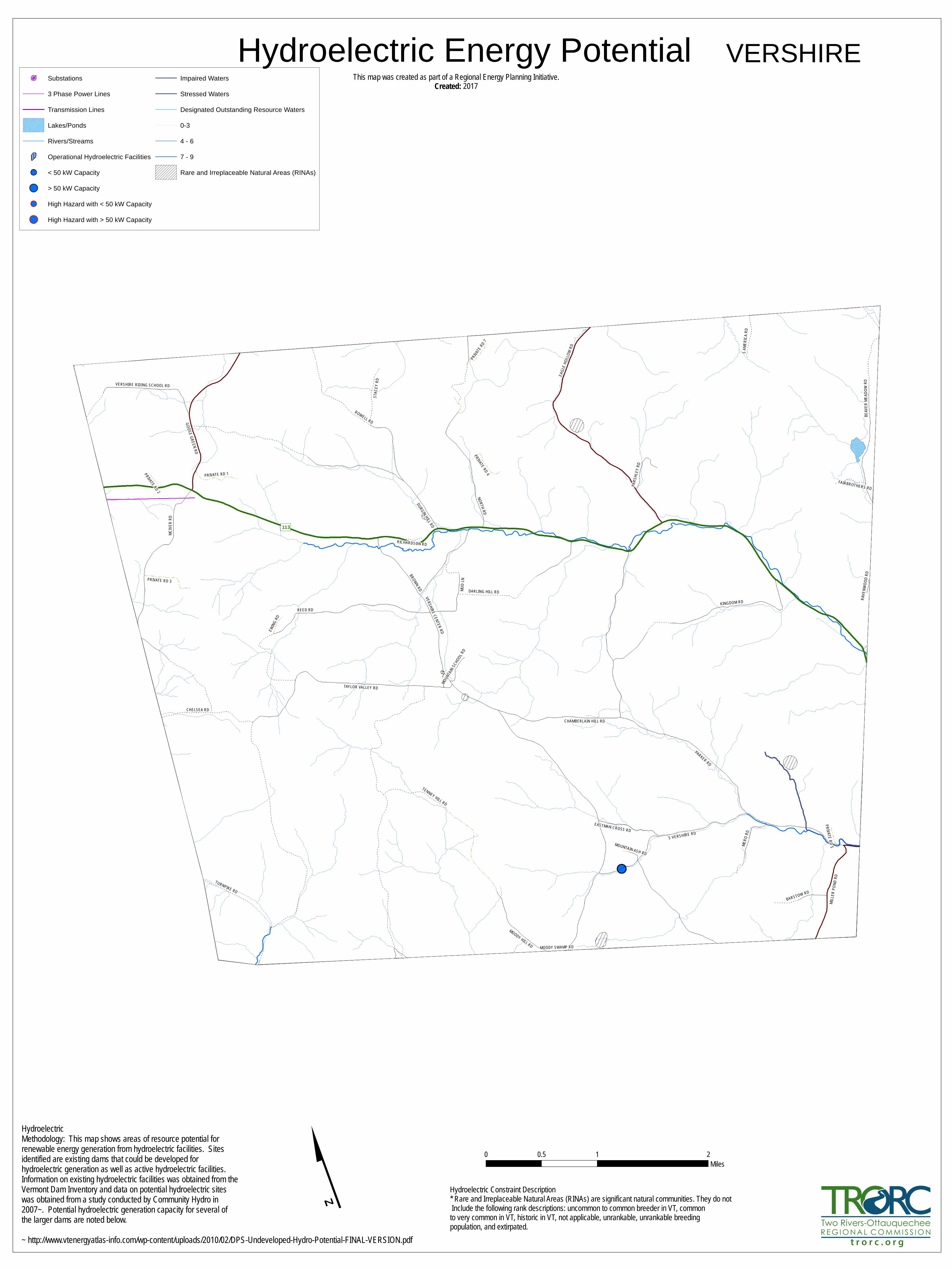
113
TAYLOR VALLEY RD
PARKER RD
MCIVE
R RD
VERSHIRE CENTER RD
S VERSHIRE RD
DURGIN HILL RD
BEAV
ER M
EADO
W RD
REED RD
EAGL
E HOL
LOW
RD
KINGDOM RD
NORTH RD
ROWELL RD
MOODY HILL RD
GOOSE GREEN RD
TENNEY HILL RD
DARLING HILL RD
MILL
ER PO
ND RD
MUD L
N
BROWN RD
MERO
RD
TURNPIKE RD
CHAMBERLAIN HILL RD
STAC
EY RD
BARSTOW RD
PRIVATE RD 3
VERSHIRE RIDING SCHOOL RD
PRIVATE RD 1
EASTMAN CROSS RD
PRIVATE RD 4
PARS
HLEY
RD
EWING
RD
PRIVA
TE RD 7
FAIRBROTHERS RD
PRIVATE RD 5
RICHARDSON RD
MOUNTAI
N SCH
OOL RD
MOODY SWAMP RD
PRIVATE RD 2
MOUNTAIN ASH RDRA
VENW
OOD R
D
S AME
RICA R
D
CHELSEA RD
Hydroelectric Energy PotentialSubstations
3 Phase Power Lines
Transmission Lines
Lakes/Ponds
Rivers/Streams
Operational Hydroelectric Facilities
< 50 kW Capacity
> 50 kW Capacity
High Hazard with < 50 kW Capacity
High Hazard with > 50 kW Capacity
Impaired Waters
Stressed Waters
Designated Outstanding Resource Waters
0-3
4 - 6
7 - 9
Rare and Irreplaceable Natural Areas (RINAs)
0 1 20.5Miles
HydroelectricMethodology: This map shows areas of resource potential forrenewable energy generation from hydroelectric facilities. Sitesidentified are existing dams that could be developed forhydroelectric generation as well as active hydroelectric facilities.Information on existing hydroelectric facilities was obtained from theVermont Dam Inventory and data on potential hydroelectric siteswas obtained from a study conducted by Community Hydro in2007~. Potential hydroelectric generation capacity for several ofthe larger dams are noted below.~ http://www.vtenergyatlas-info.com/wp-content/uploads/2010/02/DPS-Undeveloped-Hydro-Potential-FINAL-VERSION.pdf
Hydroelectric Constraint Description* Rare and Irreplaceable Natural Areas (RINAs) are significant natural communities. They do not Include the following rank descriptions: uncommon to common breeder in VT, commonto very common in VT, historic in VT, not applicable, unrankable, unrankable breedingpopulation, and extirpated.
This map was created as part of a Regional Energy Planning Initiative.Created: 2017
t r o r c . o r g
VERSHIRE

15002000
1000
1500 1500
2000
1500
2000
1500
20002000
2000
2000
1000
2000
2000
1500
2000
Reed RD
Parker RD
Taylor Valley RD
Ayers RD
Van D
yke R
D
Eagle
Hollo
w RD
Mcive
r RD
Kingdom RD
Durgin Hill RD
Rowell RD
Tenney Hill RD
Vershire Center RD
North RD
Moody Hill RD
Brown RD
Turnpike RD
S Vershire RD
Chamberlain Hill RD
Stace
y RD
Darling Hill RD
Goose G
reen R
D
Mero
RD
Beav
er Me
adow
RD
Mud LN
Private Rd 3
Miller
Pond
RD
Vershire Riding School RD
Eastman Cross RD
S Am
erica
RD
Private Rd 4Parshley RD
Barstow RD
Private R
d 7
Ewing
RD
Fairbrothers RD
Coburn RD
Richardson RD
Rave
nwoo
d RD
Powells RD
Beav
er Me
adow
RD
Chelsea RD
Goose Green RD
Cross RD
Taylor Valley RD
Darling Hill RD
Durgin Hill RD
Tenney Hill RDMciver RD
North RD
Eagle Hollow RD
North
RD
Taylor
Valley
RD
Tullar RD
Mero
RD
Parker RD
Vershire Center RD
Beaver Meadow RD
Vershire Center RD
Kingdom RD
Goose Green RD
S Vershire RD
Mciver RD
Mciver RD
Parker RD
Mud L
N
Reed RD
S Vershire RD
Miller
Pond
RD
Moody Hill RD
Rowell RD
Mud LN
Kingdom
RD
Chelsea RD
Taylor
Valley
RD
Tulla
r RD
Durgin Hill RD
Barstow RD
Versh
ire Ce
nter R
D
WestBra
nch
Om pompan oosuc
River
Old City Brook
BeaverMea
dow Brook
Om pom pan oosucRiver
Om pom pan oosucRiver
Om pom pan oosucRiver
Meadow Brook
OldCityBrook
Meadow Brook
Old City Brook
Jail Brook
JailBrook
Meadow Brook
Jail BrookOldCityBrook
OldCityBrook
Old City Brook
Om pom pan oosucRiver
OldCityBroo
k
Om pom pan oosucRiverMead
ow
Brook
OldCityBrook
Solar Energy Potential
0 1 20.5Miles
SolarThis map shows areas of potential electricity generation from solarenergy. It includes areas with good access to solar radiation andalso considers other conditions that may limit the feasibility of solarenergy development. These limiting factors are referred to asconstraints. Areas of prime solar potential exist where the naturalconditions make development feasible and no constraints are present.These maps are designed to initially identify areas and follow-upon-site work is required to verify the areas are feasible for projects.They are subject to revision and are NOT intended to green-light orfast-track projects. DARK GREEN Prime: No Constraints within 1 mile 3 phase powerGREEN Prime: No Constraints no known or possible constraints presentORANGE Constraints no known but at least one or more possible constraintsBLUE GREEN Raw potential with constraints
t r o r c . o r g
This m ap was created as part of a Region al Energy Plan n in g Initiative.Created: 2017
Substations
3 Phase Power Lines
Transmission Lines
Structures w/1ac buffer
ConservedPublic Cons
Private Cons
SOLAR POTENTIALSuitability
Prime
Constraints
Prime 1m 3phase
RAW solar
VERSHIRE
Kn ow n Con straintsVern al Pools (con firm ed and un con firm ed layers)DEC River CorridorsFEMA FloodwaysState-sig n ificant Natural Com m un ities and Rare, Threatened, and Endan gered SpeciesWildern ess Areas, includin g Nation al Wildern ess AreasClass 1 and Class 2 Wetlands (VSWI and advisory layers)Possible Con straintsAg ricultural Soils (VT Ag riculturally Im portant Soil U n its)FEMA Special Flood Hazard AreasProtected Lands (U pdated 07/26/2016.)Act 250 Ag ricultural Soil Mitigation areasDeer Winterin g AreasANR’s Verm on t Con servation Desig n Highest Priority Forest Block DatasetsForest Blocks - Con n ectivityForest Blocks - InteriorForest Blocks - Physical Land DivisionHydric SoilsTRORC U n suitable areas (included in k n ow n con straints)FEMA FloodwaysWildern ess Areas, includin g Nation al Wildern ess AreasClass 1 Wetland

Old City Brook
JailBrook
WestBranch
Om pompan oosu
cRiver
Om pom pan oosucRiver
BeaverMeadow RD
Tullar
RD
MountainAsh RD
North RD
Beav
erMe
adow
RD
GooseGreen RD
Vershire
Center RD
Cross RD
Raven
wood
RD
S Vershire RD
TaylorValley RD
Coburn RD
Mud L
N
Mero RD
Ewing
RD
MoodyHill RD
Goos
eGr
een R
D
BeaverMeadow RD
S Vershire RD
MoodySwamp RD
Tullar RD
Richardson RD
Mud LN
Beaver
Meadow RD
Barstow RD
Private R
d 7
Kingdom RD
Barstow RD
Vershi
reRidin
gScho
ol RD
Taylor
Valle
y RD
Fairbrothers RD
Mciver RD
S Vers
hire R
D
Vershi
reCent
er RD
S Vershire RD
Eagle Hollow RD
Mud LN
S Ame
rica R
D
Private Rd 4
Miller
Pond
RD
Chelsea RD
Vershire Center RD
Kingdom RD
GooseGreen RD
Mero
RD
PrivateRd 1
Chelsea RD
Parshley RD
Mcive
r RD
Beav
er Me
adow
RD
Vershire Center RD
Tullar RD
Darling Hill RD
Vershire Center RD
Private Rd 3
Miller
Pond
RD
Parker RD
DurginHill RD
Moody Hill RD
Stace
y RD
VershireCenter RD
North RD
Eastman Cross RD
Tenney Hill RD
Taylor Valley RD
North RD
Mciver RD
Rowell RDBrown RD
S Vershire RD
Goose Green RD
Versh
ire Ce
nter R
D
Turnpike RD
Reed
RD
Darling Hill RD
Beav
er Me
adow
RD
Rowell RD
S Vershire RD
Durgin Hill RD
VershireRidingSchool RD
Mcive
r RD
Mood
y Hill
RD
Parke
r RD
Ayers RD
Durgin Hill RD
Chamberlain Hill RD
Taylor Valley RD
Kingdom RD
Vershire Center RD
Tenn
ey Hi
ll RD
Van Dyke RD
Reed RD
Parker RD
Eagle
Hollo
w RD
Taylor Valley RD
20002000
2000
1500
2000
20001500
2000
1500
1500
2000
2000
2000
1000
1500
1000
1500
2000
1500
Colton Hill2380ft
GilmanHill2020ft
Hawkins Mtn2363ft
PattersonMtn2292ft
Beanville
BrimstoneCorner
Mill Village
South Vershire
Vershire
Vershire Center
VershireHeights
EagleHollowNotch
Wind Energy PotentialThis m ap was created as part of a Region al Energy Plan n in g Initiative.
Created:2017
0 1 20.5Miles
WindThis map shows areas of potential wind energy development. Itincludes areas with good access to wind resources and alsoconsiders other conditions that may limit the feasibility of windenergy development. These limiting factors are referred to asconstraints. Areas of prime wind potential exist where the naturalconditions make development feasible and no constraints are present.These maps are designed to initially identify areas and follow-upon-site work is required to verify the areas are feasible for projects.They are subject to revision and are NOT intended to green-light orfast-track projects. DARK GREEN Prime: No Constraints within 1 mile 3 phase powerGREEN Prime: No Constraints no known or possible constraints presentORANGE Constraints no known but at least one or more possible constraintsBLUE GREEN Raw potential with constraints
t r o r c . o r g
VERSHIRE
Kn ow n Con straintsVern al Pools (con firm ed and un con firm ed layers)DEC River CorridorsFEMA FloodwaysState-sig n ificant Natural Com m un ities and Rare, Threatened, and Endan gered SpeciesWildern ess Areas, includin g Nation al Wildern ess AreasClass 1 and Class 2 Wetlands (VSWI and advisory layers)Possible Con straintsAg ricultural Soils (VT Ag riculturally Im portant Soil U n its)FEMA Special Flood Hazard AreasProtected Lands (U pdated 07/26/2016.)Act 250 Ag ricultural Soil Mitigation areasDeer Winterin g AreasANR’s Verm on t Con servation Desig n Highest Priority Forest Block DatasetsForest Blocks - Con n ectivityForest Blocks - InteriorForest Blocks - Physical Land DivisionHydric SoilsTRORC U n suitable areas (included in k n ow n con straints)FEMA FloodwaysWildern ess Areas, includin g Nation al Wildern ess AreasClass 1 Wetland
BLUE GREEN Raw potential with no constraints
Substations
3 Phase Power Lines
Transmission Lines
Lakes/Ponds
Rivers/Streams
Conserved
Public Cons
Private Cons
Structures w/1ac buffer
Wind PotentialSuitability, HubHeight
Prime, 50
Prime, 70
Constraints, 50
Constraints, 70
Prime 1m 3phase
RAW wind