› __data › assets › pdf_file › 0018 › 6633 › app... · 2011 detailed modelling results...
TRANSCRIPT

AECOM
Bulla Bypass / Melbourne Airport Link Planning Study
22-Aug-2013 Prepared for – VicRoads – ABN: 61 760 960 480
Appendix A
2011 Detailed Modelling Results
AECOM
Bulla Bypass / Melbourne Airport Link Planning Study
22-Aug-2013 Prepared for – VicRoads – ABN: 61 760 960 480
a-1
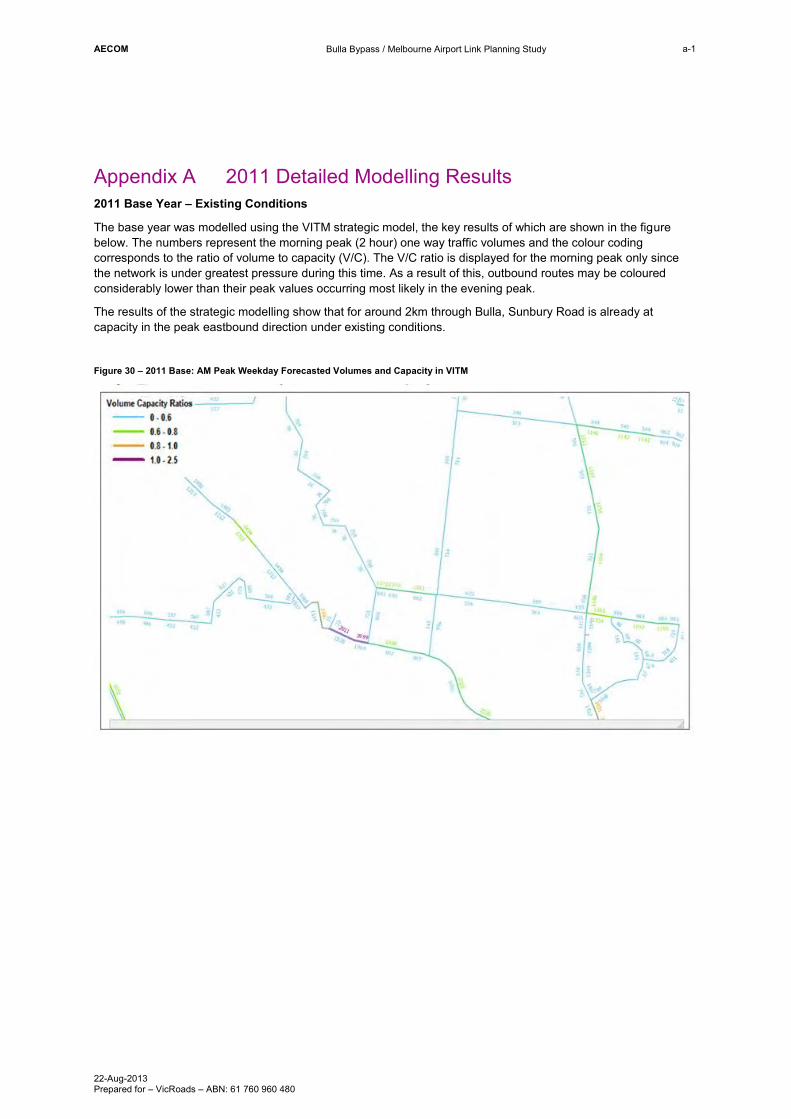
Appendix A 2011 Detailed Modelling Results 2011 Base Year – Existing Conditions
The base year was modelled using the VITM strategic model, the key results of which are shown in the figure below. The numbers represent the morning peak (2 hour) one way traffic volumes and the colour coding corresponds to the ratio of volume to capacity (V/C). The V/C ratio is displayed for the morning peak only since the network is under greatest pressure during this time. As a result of this, outbound routes may be coloured considerably lower than their peak values occurring most likely in the evening peak.
The results of the strategic modelling show that for around 2km through Bulla, Sunbury Road is already at capacity in the peak eastbound direction under existing conditions.
Figure 30 – 2011 Base: AM Peak Weekday Forecasted Volumes and Capacity in VITM
AECOM
Bulla Bypass / Melbourne Airport Link Planning Study
22-Aug-2013 Prepared for – VicRoads – ABN: 61 760 960 480
Appendix B
2046 Detailed Modelling Results

AECOM
Bulla Bypass / Melbourne Airport Link Planning Study
22-Aug-2013 Prepared for – VicRoads – ABN: 61 760 960 480
b-1
Appendix B 2046 Detailed Modelling Results 2046 Results
Tests were conducted for 2046 as a future complete project year. All the options modelled include OMR and the upgrade of Sunbury Road to four lanes. Figure 31 shows the options modelled for 2046. Figure 31 2046 Option Tree
The results for the 2046 VITM Reference Case as well as the options shown above for 2046 are provided below.
AECOM
Bulla Bypass / Melbourne Airport Link Planning Study
22-Aug-2013 Prepared for – VicRoads – ABN: 61 760 960 480
b-2
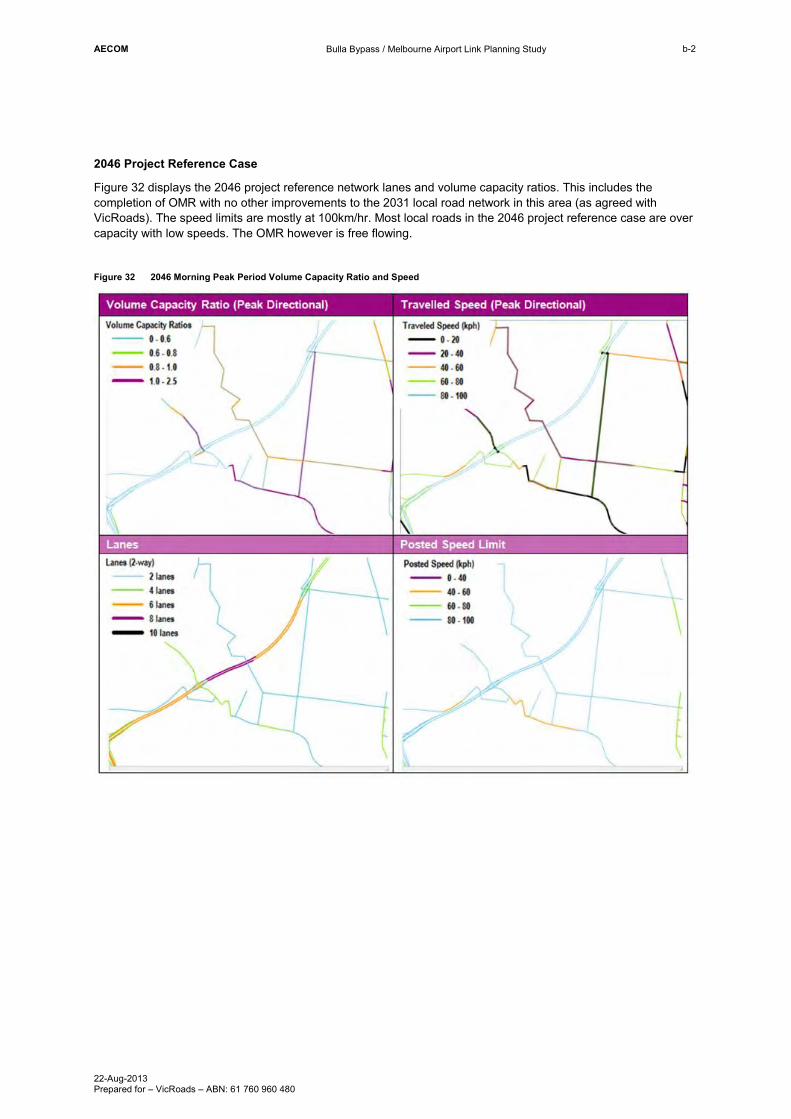
2046 Project Reference Case
Figure 32 displays the 2046 project reference network lanes and volume capacity ratios. This includes the completion of OMR with no other improvements to the 2031 local road network in this area (as agreed with VicRoads). The speed limits are mostly at 100km/hr. Most local roads in the 2046 project reference case are over capacity with low speeds. The OMR however is free flowing.
Figure 32 2046 Morning Peak Period Volume Capacity Ratio and Speed
AECOM
Bulla Bypass / Melbourne Airport Link Planning Study
22-Aug-2013 Prepared for – VicRoads – ABN: 61 760 960 480
b-3
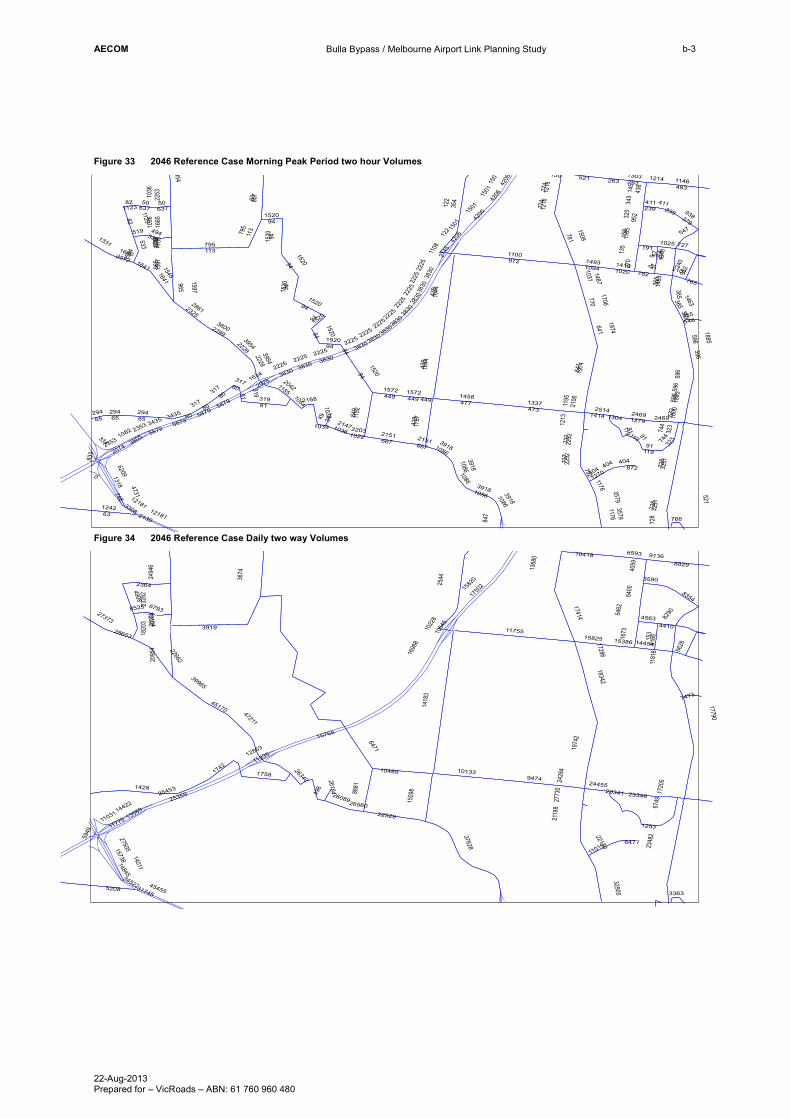
Figure 33 2046 Reference Case Morning Peak Period two hour Volumes
Figure 34 2046 Reference Case Daily two way Volumes
972
439
728
110063
113795
1644
94
3251
473
781
354
122
81 477
419
6209
641
82
1318
849
807
133780
0
2074
1508
65
1458
667
1767
521
1974
319
748
1152
2353
1520
2325
2861
2151
317
483
449
965
294
15451641
4206
95224
0
770
379
938
1123
1036
1665
1501
737
14931094
12792469
263
50
39542228
1108
1146
596
158
2745
10311487
57
1572
1597
12422130
1634
2978
3149
5879
1706
320
1176
404
774
3579
572
3435
2253
323
744
10822147
912232
12181
1185
1303
36002299
1195
792
1885
2168
1039
2106
14142514
191
3805
3830
145
436
365
4731
14191020
254
637
782
135
270
2225
1270
1216
2572
1600
1800
1213
533
765
1331
119
411
979
1463
954
1025
239
3308
1648
1214
1054
39181086
1422 727
343
150
1765
1584
10222203
1155
2042
519 547494338
833
872
334
766
1304
2101
847
355546
596
2151
449
365
91
521
1520
2225
737
4206
50
3435
1501
1597
1086
2232
323
404
1086
365
3918
2353
1974
1520
119
2228
667
119
3830
1123
319 1572
113
122
65
411774
4206
239
1644
728
439
1520
94
80
1176
383094
596
63
1216
3954
3918
2225
94
3830
294
1039
2225
1520
641
3579
744
3830
94
952
965
1501
795
263
3830
2225
3830
1520
2225
404
317
1501
6522
25
0
3830
1520
94
3251
294
596
2225
1463
3830
5879
4206
3830
81
12181
94
94
3918
0
1086
1641
2469
2225
1036
91
80
728
637
317
3830
449
1086
1520
94
365
82
596
5879
2225
57
941520
1885
1036
5879
2225
80
15768
1698
814
183
117553919
25359
2348
2
1750
21582
0
25453
9474
2544
2750515738
11031
8881
11770
17414
3674
10133
1509
86471 19
742
2095
4
5208
1758
6749
45455
140114908
659321
188
39965
22529
10418
13589
22662
14845
2364
1742
8829
14422
1428
1673
5628
2328
2 8354
47211
15825
5949
23348
1054
5
17286
1022
8
10489
11235
31745
12863
5462
18342
11019
32905
6400
37628
2494
6
153
26089
498
26194
45170
17790
2428
4
24455
15386
4563
4059
4410
1368
0
9166
9136
28653
1720
5
2773
0
8290
6793
22170
1181
8
27373
26340
34522
14454
1253
3590
3363
13104 2033
4
26560
8525
7473
23341
6477
1820
3
AECOM
Bulla Bypass / Melbourne Airport Link Planning Study
22-Aug-2013 Prepared for – VicRoads – ABN: 61 760 960 480
b-4
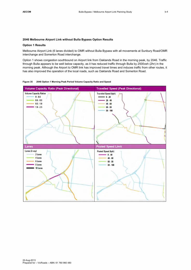
2046 Melbourne Airport Link without Bulla Bypass Option Results
Option 1 Results
Melbourne Airport Link (6 lanes divided) to OMR without Bulla Bypass with all movements at Sunbury Road/OMR interchange and Somerton Road interchange.
Option 1 shows congestion southbound on Airport link from Oaklands Road in the morning peak, by 2046. Traffic through Bulla appears to be well below capacity, as it has reduced traffic through Bulla by 2500veh (2hr) in the morning peak. Although the Airport to OMR link has improved travel times and induces traffic from other routes, it has also improved the operation of the local roads, such as Oaklands Road and Somerton Road.
Figure 35 2046 Option 1 Morning Peak Period Volume Capacity Ratio and Speed

AECOM
Bulla Bypass / Melbourne Airport Link Planning Study
22-Aug-2013 Prepared for – VicRoads – ABN: 61 760 960 480
b-5
Figure 36 2046 Option 1 Morning Peak Period two hour Volumes
Figure 37 2046 Option 1 Daily two way Volumes
3
980
292
123
1239
29
905
970
57
822
985
117
473
607383
1377
3051
2
152540
2099
1507
0
1671
548
431
829
637
3665
78
29252415
524
6070
229
779
376
942
71
13
1167
1854
1691
1043
1311
649
775
1428
294
85
40602340
145
5987
1382
1073
1760
1053
80 1331
10501569
2273
4339
3100
49 31
1593
325
927
2310
322
86
11569
691
1440
1130
402
2030
1138
59
36922400
827
1821
1200
1991
17812716
976
1783
272477
59
153
4249
870213
13501210 26
9
495
705
872 837
109
1858
106
673
68
2576
1692
1727
1260
1189
534
338
9382
359
16351644
1329
6483
811
2497
2141
4714
978
1340
727
948 1107
253422
3329
1256
8041
486
1241
1921
2643
4823
1417
1566
88
631
320
4757
131
151
3328
1835
591
3003
79
502
135
723
511
500
5105
2418
26781641
802254
612
1655
666
828
1933
448
430
471
260470
786
1207
1407
614
810
161
11654366
815
877
96
9236
754
1247
3118
11654
294
1247
6070
1043
3328
135
2643
1821
79
6070
11654
4714
322
79
57
6483
1329
3328
402
691
359
79
78
7759
2497
4714
71
1644
1858
96
96
2643
637
6483
133328
430
123
71
1256
2497
4060
422
1329
1189
59
430
78
1933
359
0
591
591
253
4714
591
815
3329
13
705
2340
2643
83
13
7759
9382
637
1641
13
1167
6070
431
723
1783
83
2678
13
1783
1329
68
135
80
448
6483
85
13
1783
591
691
430
811
1854
4823
3118
1329
359
1329
775
1329
7759
1635
59430
13
13
30
2643
811
0
810
402
2030
1569
292
591
905
93821329
3665
7759
3329
1340
1050
1329
13
3551
2778 12401
26118
2279
4
2365
22044
0
25706
34986
38067
33007
362
3006
5
2582
8
31484
3570
2657115739
3617
2933133297
13652
13544
13377
17127
3776
14352
3628330524
5449 1910
1
2199
4
3056
5618
1857
6869
43631
9377
5136
6144
12950
1955
9
42496
13978
10190
12741
24233
12759
2563
1840
8493
12054
5799
1490
1686
5337
2308
3 8340
12810
16134
26084
50178
2339
5
29811
2869
16689
2004
1
5211
2920
17202
16158
17632
10948
31237
6219
2493
9
106
47950
17397
2369
7
27329
15624
4213
3864
4107
3022
1316
3
8699
8837
29940
1685
4
2626
5
7690
6346
20558
1129
3
28512
32608
3040
9
14605
2578
9
3417
1371
3667
3114
13246 2020
6
8473
5655
7630
26092
6341
1874
5
AECOM
Bulla Bypass / Melbourne Airport Link Planning Study
22-Aug-2013 Prepared for – VicRoads – ABN: 61 760 960 480
b-6
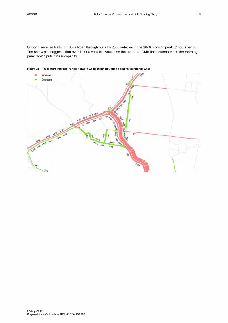
Option 1 reduces traffic on Bulla Road through bulla by 2500 vehicles in the 2046 morning peak (2 hour) period. The below plot suggests that over 10,000 vehicles would use the airport to OMR link southbound in the morning peak, which puts it near capacity.
Figure 38 2046 Morning Peak Period Network Comparison of Option 1 against Reference Case
AECOM
Bulla Bypass / Melbourne Airport Link Planning Study
22-Aug-2013 Prepared for – VicRoads – ABN: 61 760 960 480
b-7
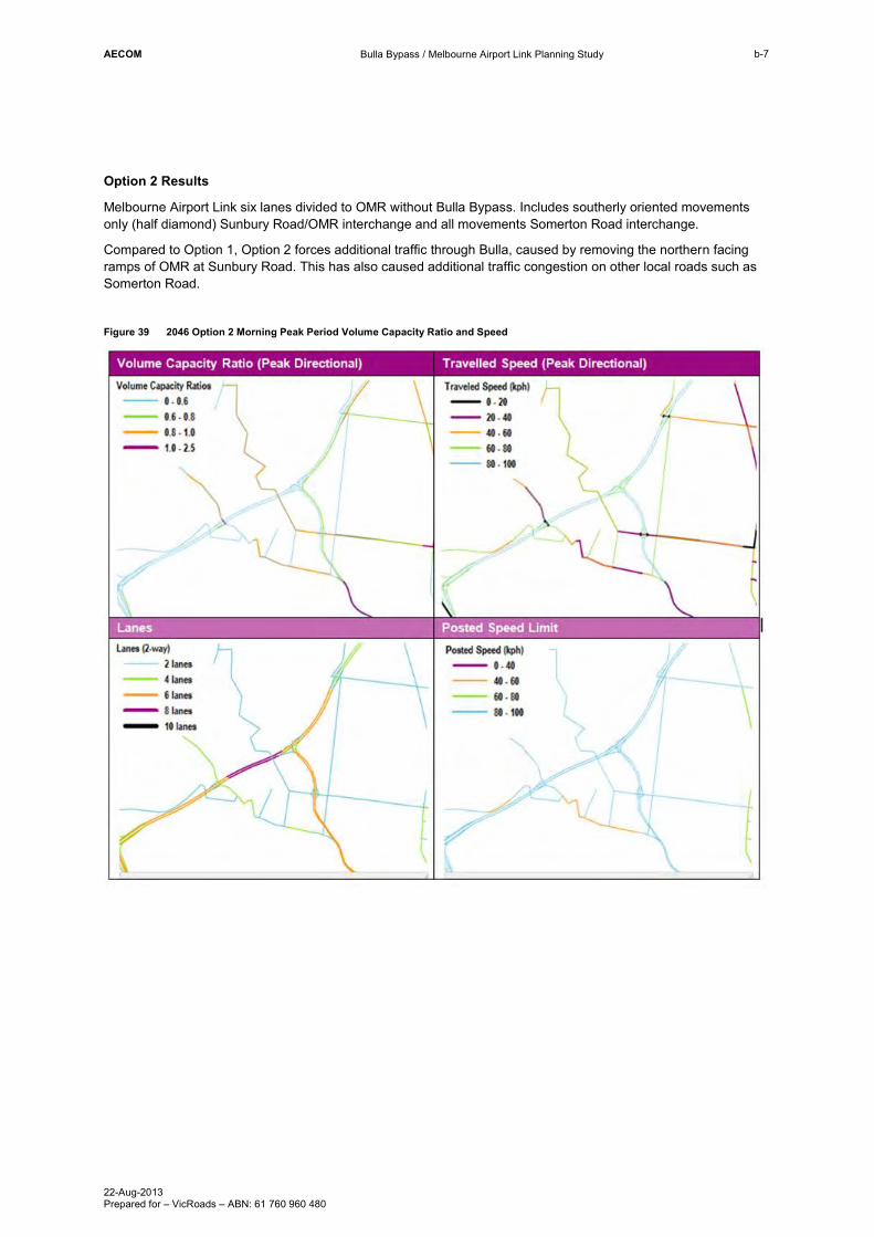
Option 2 Results
Melbourne Airport Link six lanes divided to OMR without Bulla Bypass. Includes southerly oriented movements only (half diamond) Sunbury Road/OMR interchange and all movements Somerton Road interchange.
Compared to Option 1, Option 2 forces additional traffic through Bulla, caused by removing the northern facing ramps of OMR at Sunbury Road. This has also caused additional traffic congestion on other local roads such as Somerton Road.
Figure 39 2046 Option 2 Morning Peak Period Volume Capacity Ratio and Speed

AECOM
Bulla Bypass / Melbourne Airport Link Planning Study
22-Aug-2013 Prepared for – VicRoads – ABN: 61 760 960 480
b-8
Figure 40 2046 Option 2 Morning Peak Period two hour Volumes
Figure 41 2046 Option 2 Daily two way Volumes
935
141
270
1177
950
967
840
980
385
187
597184
1348
208
433
528
1516
2115
1506
0
1661
687
545
282
896
642
4002
209
2016
2767
519
541
6104
230
788
942376
45
1182
1846
1685
1010
746
1287
309
89
38391861
145
6018
10671366
1665
1019
71 1498
1586
13162277
4952
49
1588
299
909
1116
86
653
2313
324
11726
701
1775
808
109
251
1987
1105
1140
50
1098
1955
3501
1194
798
1835
1972
18072732
989
1688
334577
56
350
144
4475
1187
222869
1335 272119
716
857 827
101
1621
68
15512381
1744
1229
1166
525
330
8773
359
1403
1477
1291
1663
2099
795
3151
955
1357
924
406242
12253298
1074
7513
1234
2448
31
54601814
1437
1574
609
322
5442
1120
776
3017
1831
1880
590
2315
1638
70
482
134
511
538
5778
2873
87
26931667
12
836
810253
879
1682
711
1672
1327
446
280
1412
1109
95
271
1144
471
1219
1283
610
824
148
11517362
817
853
8644
910
764
3102
590
1835
95
5901357
808
8773
5460
0
3017
270
134
2448
50
1987
109
70
4952
11517
5778
11517
4952
1621
1403
141
1291
68
45
7756
109
71
642
11726
817
1010
209
1291
7756
824
1291
1105
4952
5460
18461291
950
25124
48
1672
109
4952
5778
1688
7756
590
3017
134
6104
1807
590
1291
1667
324
251
1861
6104
6104
109
1688716
282
2448
590
2693
84
746
280
3151
1663
3298
406
910
701
1477
3017
1291
16633839
109
1291
446
3017
5460
3102
359
400250
359
1586
7756
3298
109
3151
2448
1291
687
109
0
280
4952
309
1182
359
134
1166
701
1688
1225
3151
109
8773
134
89
4216
19205
110694480
17062
27815
2273
2
2315
41972
8
28295
35454
38310
2839
1
2401
3
3525
2694215482
5574
1876224591
14358
12918
4402
13596
17080
4517
13699
2613519614
6728 1916
9
2057
6
5732
1473
6880
44346
4994
6098
1961
1
13283
37142
21923
10649
10092
14219
20587
1144
13352
2369
1456
8459
13937
1694
5149
2282
4 8329
10811
15580
5775
25850
43866
11040
2288
7
16626
1824
5
6412
30034
5089
17594
11010
31335
6209
2452
1
252
25687
500
25631
42041
17502
2370
9
27073
15248
4106
3919
27111
3854
1307
5
8770
8800
9090
1697
3
2631
8
7920
7060
20596
1136
9
26049
25654
32956
2167
0
14228
1675
3
1348
3620
3198
13200 1985
4
26257
8746
7594
6390
AECOM
Bulla Bypass / Melbourne Airport Link Planning Study
22-Aug-2013 Prepared for – VicRoads – ABN: 61 760 960 480
b-9
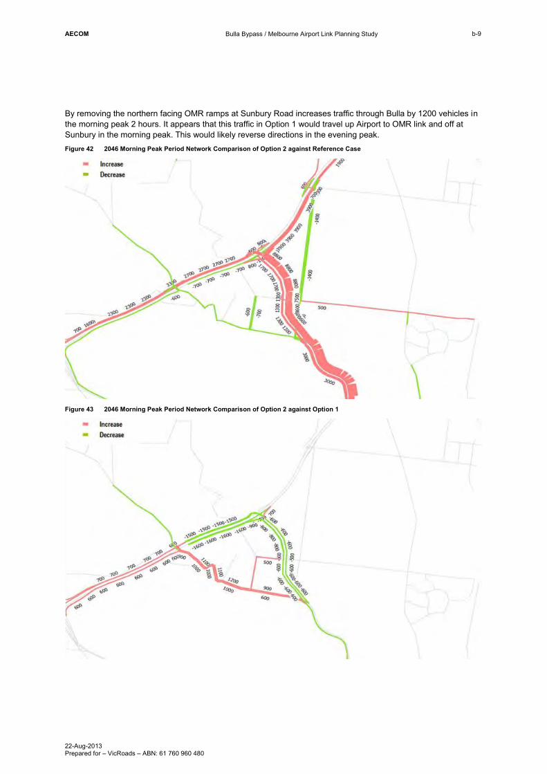
By removing the northern facing OMR ramps at Sunbury Road increases traffic through Bulla by 1200 vehicles in the morning peak 2 hours. It appears that this traffic in Option 1 would travel up Airport to OMR link and off at Sunbury in the morning peak. This would likely reverse directions in the evening peak. Figure 42 2046 Morning Peak Period Network Comparison of Option 2 against Reference Case
Figure 43 2046 Morning Peak Period Network Comparison of Option 2 against Option 1
AECOM
Bulla Bypass / Melbourne Airport Link Planning Study
22-Aug-2013 Prepared for – VicRoads – ABN: 61 760 960 480
b-10
2046 Melbourne Airport Link with Bulla Bypass Option Results
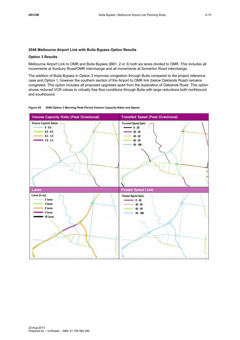
Option 3 Results
Melbourne Airport Link to OMR and Bulla Bypass (BB1, 2 or 3) both six lanes divided to OMR. This includes all movements at Sunbury Road/OMR interchange and all movements at Somerton Road interchange.
The addition of Bulla Bypass in Option 3 improves congestion through Bulla compared to the project reference case and Option 1, however the southern section of the Airport to OMR link (below Oaklands Road) remains congested. This option includes all proposed upgrades apart from the duplication of Oaklands Road. This option shows reduced VCR values to virtually free flow conditions through Bulla with large reductions both northbound and southbound.
Figure 44 2046 Option 3 Morning Peak Period Volume Capacity Ratio and Speed
AECOM
Bulla Bypass / Melbourne Airport Link Planning Study
22-Aug-2013 Prepared for – VicRoads – ABN: 61 760 960 480
b-11
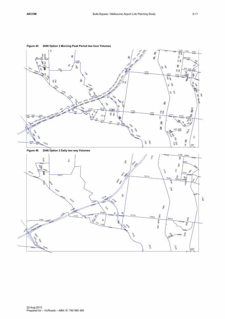
Figure 45 2046 Option 3 Morning Peak Period two hour Volumes
Figure 46 2046 Option 3 Daily two way Volumes
118
303
86
12291010
2220
852
37
809
509
616682
1360
543
10661557
2104
1506
0
8
10831704
4118
541
456
754
5062
2754
1949
631
3599
2439
3004
515
6146
230
770
959376
79
15 1873
1837
1044
1013
739
14231281
294
2378
4159
148
6077
1386
1049
1710
43
1051
88 4055
10271748
60
2181
3623
2215
14
1609
895
312
69
653
2302
322
59
11628
730
1328
1125
780
424
27371956
2007
1127
66
740
2432
3785
1189
791
1829
2009
27711896
975
1733
259377
92
354
143
4206
1188
932228
1345 273
534
850 815
106
1876
67
16982580
1737
1221
1170
555
338
7488
360
15591714
1306
4522
2117
735
789
956
1348
141
951 1105
425242
3325
1216
7153
1238
2617
4696
341290
1429
57
787
323
4842
158
48
122629
3339
1953
590
2950
2504
87
587
137
120
511
527
4927
70
17522729
822254
574
1767
711
1985
444
454
98
375580
2065
1226
1407
612
807
166
11803
794
9943
1008
767
1256
3114
0
4251013
2378
1748
3339
631
69
3339
1985
2617
1733
322
74882950
2950
424
2950
4696 1752
1256
37
303
6146
4927
11803
1170
66
7792
1306
1985
98
1348
1306
43
590
590
534
11803
794
1216
1829
15
1733
43
87
852
15
4522
1306
4159
730
780
98
82
7792
137
2007
130677
92
11803
35994696
1714 2617
424
6146
120
66
740
79
43
3325
4696
590
2729
57
3339
15
4522
67
4927
15
739
1044
294
456
118
1306
454
1306
740 7488
7792
0
3339
1306
4522
15
444
1873
34
3114
2617
1559
740
360
360
454
15
8826
17
1306 0
2950
730
590
807
69
590
15
360
1733
6146
3325
4522
1027
360
137
15
3367
2615 12212
25731
2279
2
2376
02028
7
23942
37176
39137
17902
251
2997
2
2580
3
15360
3494
2663715270
4608
3116134744
13240
14903
3611
13425
17134
15733
2132614615
5143 1905
7
2251
8
1041
5454
2176 37782
346
6828
8115
43281
4651
6186
12661
1957
1
43557
727
13819
10183
12306
577
11470
24618
2092
2160
8554
10702
1790
1664
5370
2382
8 8360
12729
16061
27140
51479
5111
2352
2
16783
1901
2
43042
11363
1541
28079
13990
90
17652
10972
736
31278
6208
2521
9
148
37687
152
49164
17466
2367
4
28414
15655
4147
3908
3999
1311
2
8701
8909
383
30280
1693
6
2629
3
7884
6896
20572
1135
8
28773
30723
14662
1292
1390
3605
3207
13152 2055
2
13443
8971
6015
7631
6382
AECOM
Bulla Bypass / Melbourne Airport Link Planning Study
22-Aug-2013 Prepared for – VicRoads – ABN: 61 760 960 480
b-12
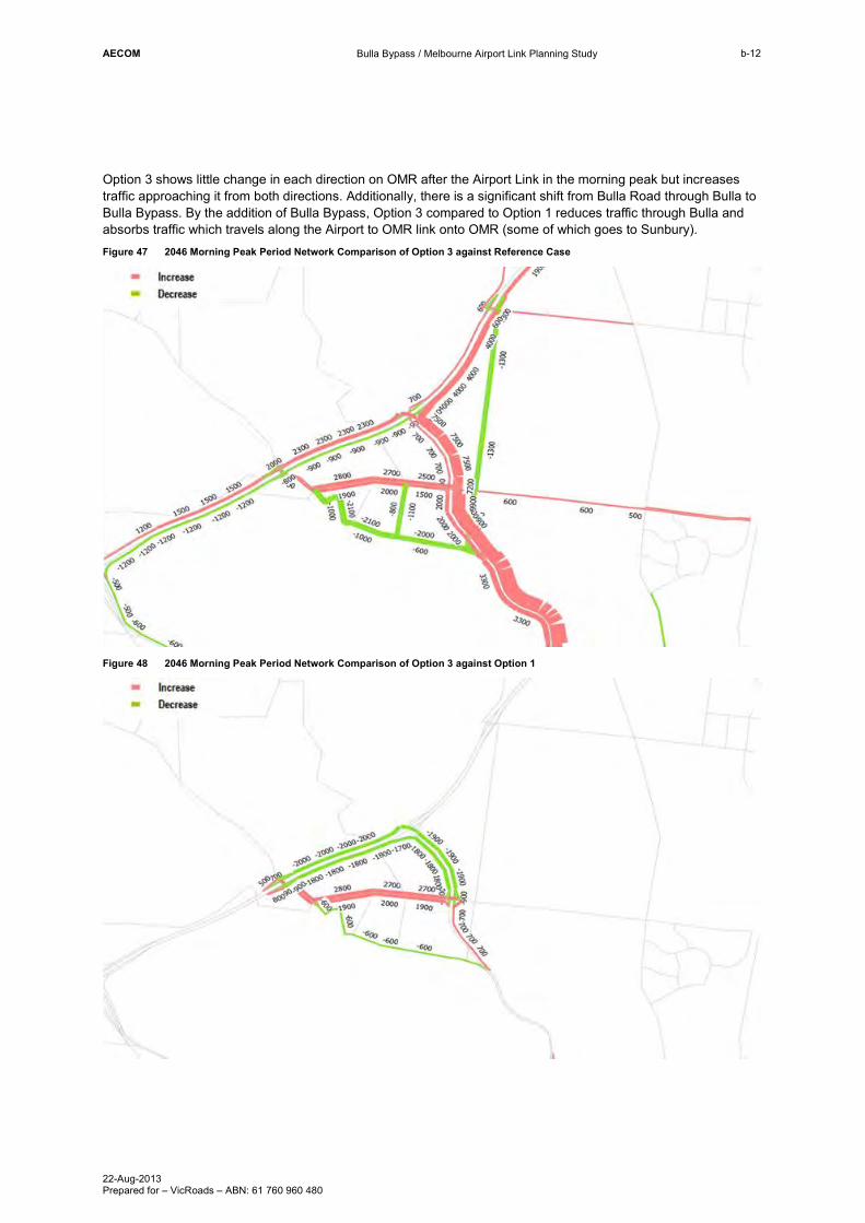
Option 3 shows little change in each direction on OMR after the Airport Link in the morning peak but increases traffic approaching it from both directions. Additionally, there is a significant shift from Bulla Road through Bulla to Bulla Bypass. By the addition of Bulla Bypass, Option 3 compared to Option 1 reduces traffic through Bulla and absorbs traffic which travels along the Airport to OMR link onto OMR (some of which goes to Sunbury). Figure 47 2046 Morning Peak Period Network Comparison of Option 3 against Reference Case
Figure 48 2046 Morning Peak Period Network Comparison of Option 3 against Option 1

AECOM
Bulla Bypass / Melbourne Airport Link Planning Study
22-Aug-2013 Prepared for – VicRoads – ABN: 61 760 960 480
b-13
Option 4 Results
Melbourne Airport Link to OMR and Bulla Bypass (BB1, 2 or 3) both six lanes divided to OMR. This includes southerly oriented movements only at Sunbury Road/OMR interchange and all movements at Somerton Road interchange.
As per Option 3, Option 4 also has issues southbound on OMR to Airport link from Somerton Road, this link possibly needs to be widened to 6 lanes with over 40,000 vehicles each way each day. The Bulla Bypass has improved the congestion seen in Option 8 by removing the northern facing ramps to OMR at Sunbury Road Interchange. Figure 49 2046 Option 4 Morning Peak Period Volume Capacity Ratio and Speed
AECOM
Bulla Bypass / Melbourne Airport Link Planning Study
22-Aug-2013 Prepared for – VicRoads – ABN: 61 760 960 480
b-14
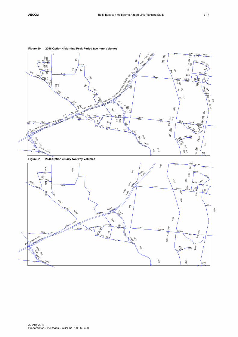
Figure 50 2046 Option 4 Morning Peak Period two hour Volumes
Figure 51 2046 Option 4 Daily two way Volumes
961
203
87
1098
20
818
1248
37
830
607283
1339
1106
672
1540
2113
1494
0
1123
8
1685
4118
1205
457
804
5162
23052944
627
3775
43
29522204
503
5820
230
775
951377
50
15 1873
1021
1835
1023
757
14391255
292
40672095
147
5205
10781422
1686
1036
80 23464310
1002
1284
60
2206
4520
14
1619
909
310
663
2306
321
59
11603
734
1480
1144
785
425
23122928
2041
1145
57
835
37102169
1191
810
1841
2012
19192738
1708
111
283162
59
143
1164
908241
1361
269
476
101572
834 806
773
1564
108
67
2438
1648
1747
1249
1143
548
335
6715
365
15151542
1365
2149
802
942
140
934
419
3317
12391093
5705
2398
4944
1317
1573
58
649
324
3759
174
48
124
3228
1940
595
2500
2607
79
545
138
121
541
5256
2385
512
91
27011778
791254
677
1789
711
2045
448
455
343526
2343
1186
1367
610
707
180
11639360
827
881
97
9254
22
786
425131
07
544
3228
365
2041
3228
15
2500
241
11639
2500
1365
1361
4944
321138
5820
365
457
111
2500
11639
6259
1841
2500
43
4520
1778
121
595
5820
365
6259
734
595
4944
1515
627
1708
785
80
37
419
15
455
101
6259
3775
48
1542
1778
50
1239
448
2607
15
757
734
5256
79
0
1873
1778
0
4520835
3228
4944
1365
1002 15
835
818
1023
1365
835
3317
2398
2701
595
827
1021
1248
1365
48
1365
292
15
15
595
97
4520
15
67
57
335
425
1708
2095
1143
1365
57
595
83
6715
455
15
3107
2398
425
1708
2398
15
2398
97
6715
1365
11603
3228
2045
0
203
4067
707 58
20
6259
1361
455
4520
3317
1365
572
138
5686
15563
113642658
12250
26413
2298
8
2282
01982
5
25169
37832
39663
270
2666
7
2414
6
3356
2654915140
4977
3145634037
13501
14999
13467
17079
4072
15822
2142915595
5229 1917
9
2242
5
1039
5549
2034 41925
346
6855
43433
8582
4737
6069
12872
1961
5
41847
706
10559
10063
12945
555
23296
11668
12001
2159
2018
8441
1656
1681
5185
2357
5 8305
10243
15637
27238
49240
2202
7
16826
1857
3
47318
1691
28401
5082
17699
10953
718
31300
6183
2502
9
144
41869
152
47143
17509
2379
7
28506
15276
4218
3947
4074
1302
8
8815
8793
29302
9605
1698
5
2633
5
962
7839
6954
20614
1129
3
27965
31154
1922
9
14276
1308
1393
3573
3279
13223 2036
88887
6376
7672
6356
AECOM
Bulla Bypass / Melbourne Airport Link Planning Study
22-Aug-2013 Prepared for – VicRoads – ABN: 61 760 960 480
b-15
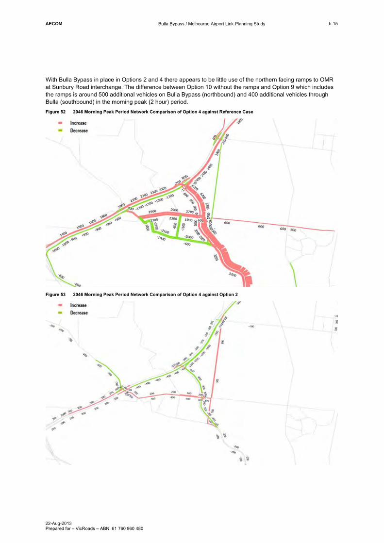
With Bulla Bypass in place in Options 2 and 4 there appears to be little use of the northern facing ramps to OMR at Sunbury Road interchange. The difference between Option 10 without the ramps and Option 9 which includes the ramps is around 500 additional vehicles on Bulla Bypass (northbound) and 400 additional vehicles through Bulla (southbound) in the morning peak (2 hour) period. Figure 52 2046 Morning Peak Period Network Comparison of Option 4 against Reference Case
Figure 53 2046 Morning Peak Period Network Comparison of Option 4 against Option 2
AECOM
Bulla Bypass / Melbourne Airport Link Planning Study
22-Aug-2013 Prepared for – VicRoads – ABN: 61 760 960 480
b-16
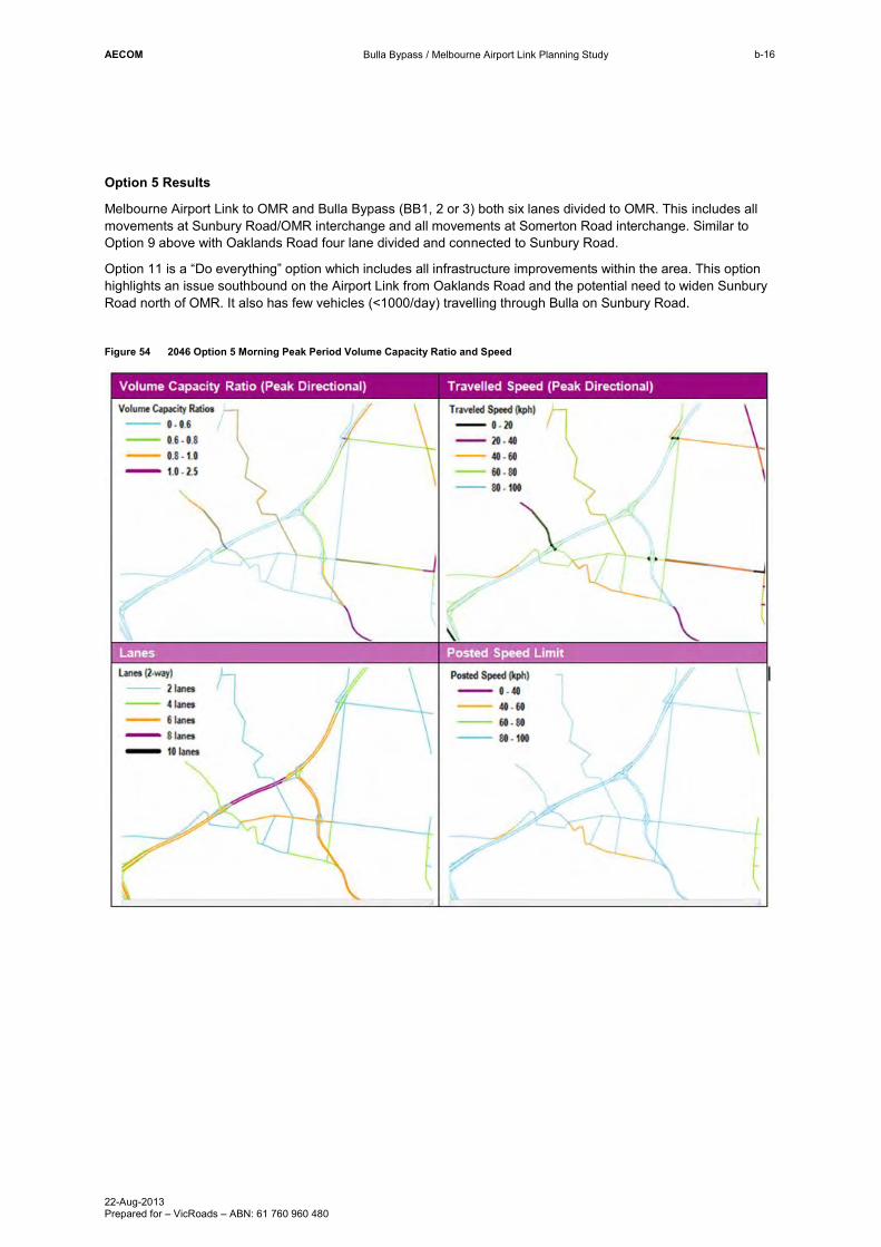
Option 5 Results
Melbourne Airport Link to OMR and Bulla Bypass (BB1, 2 or 3) both six lanes divided to OMR. This includes all movements at Sunbury Road/OMR interchange and all movements at Somerton Road interchange. Similar to Option 9 above with Oaklands Road four lane divided and connected to Sunbury Road.
Option 11 is a “Do everything” option which includes all infrastructure improvements within the area. This option highlights an issue southbound on the Airport Link from Oaklands Road and the potential need to widen Sunbury Road north of OMR. It also has few vehicles (<1000/day) travelling through Bulla on Sunbury Road.
Figure 54 2046 Option 5 Morning Peak Period Volume Capacity Ratio and Speed
AECOM
Bulla Bypass / Melbourne Airport Link Planning Study
22-Aug-2013 Prepared for – VicRoads – ABN: 61 760 960 480
b-17
Figure 55 2046 Option 5 Morning Peak Period two hour Volumes
Figure 56 2046 Option 5 Daily two way Volumes
546
10081247
20
875
37
820
799
622482
1357
3450
2
15441093
1110
2103
1508
0
8
1691
4118
533
450
2711
5061
1941
631
3681
43
2441
2981
519
6141
230
773
936376
15 1849
1826
1044
1014
759
14211289
290
2381
4135
147
6077
1376
1059
1739
85
1052
88 19813999
10341721
59
2183
3719
2232
14
1589
300
916
65
637
2293
322
11625
712
811
1299
1130
795
418
19472695
1998
1156
66
764
2436
3762
1191
1822
1983
27511914
995
1761
259175
87
370
148
4140
1196
909222
1343 272
564
854 819
758
106
1865
67
2578
1706
1731
1240
1173
549
342
7351
361
15591707
4596
2109
788
962
1348
140
951 1105
242406
3298
1238
6959
1237
2629
4694
1283
1434
58
810
321
4620
48
124919
2998
1952
588
2967
2466
87
560
137
120
512
4980
517
69
17742714
254800
540
1786
682
2015
445
448
96
351559
2056
1208
1415
604
831
166
11533
357
821
9755
1064
22
789
1261
3089
1288 588
588
137
564
11533
2629
1774
15
1761
7587
87
1761
137
15
11625
448
1034
87
2998
15 4596
418
2998
1721
1348
15
2629
1998
661044
34
4694
6141
2381
96
7351
7587
1288
15
1822
712
29980
1014
1288
712
821
1849
361
66
0
137
1288
361
4980
66
448
2967
0
1238
7587
1288
271426
29
67
15
445
322
120
15
9755
4135
588
37
406
2998
7587
120
85
1288
290
1288
22
450
96
1559
764
875
4596
6141
588
448
2967
1707
2629
11533
764
87
11533
4596
96
588
1288
6141
82
59
1761
1173
764
418
3681
030
89
1288
3298137
2967
795
546
88
631
759
15
361
12043
15
4694
3298
2015
7351
759 11533
4718
2600 12372
25783
2280
5
2367
42039
2
23904
37032
38735
17839
250
2888
2
2583
4
15489
3620
2673315303
6290
3085333606
13307
14917
13398
17240
3361
15734
2019714798
4886 1896
1
2262
3
1037
5409
2167 37799
346
6857
43342
8033
4756
6098
12637
1011119
351
43668
723
13844
12385
573
11448
24596
2231
2150
86
8489
10598
1785
1698
5455
2381
3 8290
12681
16070
27212
51598
11511
2344
4
16673
1893
5
42810
1646
28058
13974
5194
17541
10954
738
31049
6212
2531
2
37703
152
49291
17264
2359
4
28481
15606
4249
3927
4164
1306
7
8624
8840
442
30242
1672
8
2609
1
104
7746
6737
20361
1117
9
28711
30723
14577
1287
1388
3595
3591
13151 2070
1
13148
8748
6178
7600
6357
AECOM
Bulla Bypass / Melbourne Airport Link Planning Study
22-Aug-2013 Prepared for – VicRoads – ABN: 61 760 960 480
b-18
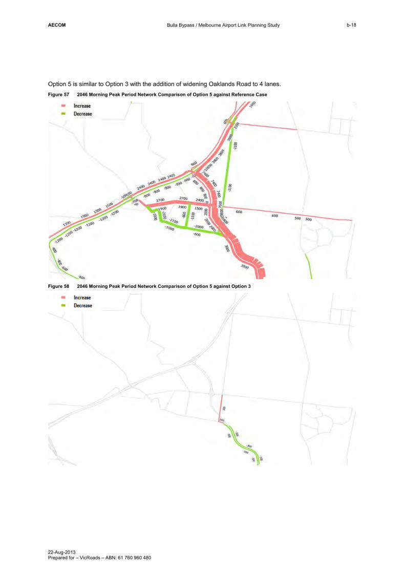
Option 5 is similar to Option 3 with the addition of widening Oaklands Road to 4 lanes. Figure 57 2046 Morning Peak Period Network Comparison of Option 5 against Reference Case
Figure 58 2046 Morning Peak Period Network Comparison of Option 5 against Option 3
AECOM
Bulla Bypass / Melbourne Airport Link Planning Study
22-Aug-2013 Prepared for – VicRoads – ABN: 61 760 960 480
b-19
2046 Results Summary
The following provides a summary of each of the modelled options, for 2046.
- Option 1 and 2 attract traffic onto the Airport to OMR link, from across the network, which reduces travel time for Airport trips. However by not providing a Bulla Bypass, there remains substantial traffic and congestion through Bulla. Because the northern facing ramps are not provided in Option 2, the traffic issues through Bulla are amplified further.
- Options 3 and 4 are similar to options 1 and 2 respectively but include Bulla Bypass (alignment 1, 2 or 3). Including the bypass in these options resolves the issues highlighted above of congestion through Bulla.
Due to additional traffic caused by providing this more direct route Options 1-4 show congestion on the Airport to OMR link south of Oaklands.
Option 3, 4 and 5 provide the most comprehensive solutions, however this is to be expected as they are “Do Everything” options.
AECOM
Bulla Bypass / Melbourne Airport Link Planning Study
22-Aug-2013 Prepared for – VicRoads – ABN: 61 760 960 480
b-20
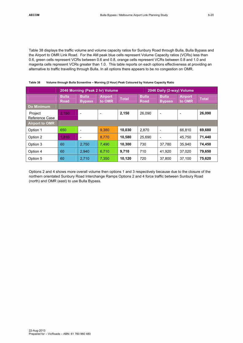
Table 38 displays the traffic volume and volume capacity ratios for Sunbury Road through Bulla, Bulla Bypass and the Airport to OMR Link Road. For the AM peak blue cells represent Volume Capacity ratios (VCRs) less than 0.6, green cells represent VCRs between 0.6 and 0.8, orange cells represent VCRs between 0.8 and 1.0 and magenta cells represent VCRs greater than 1.0. This table reports on each options effectiveness at providing an alternative to traffic travelling through Bulla. In all options there appears to be no congestion on OMR.
Table 38 Volume through Bulla Screenline – Morning (2 Hour) Peak Coloured by Volume Capacity Ratio
2046 Morning (Peak 2 hr) Volume 2046 Daily (2-way) Volume
Bulla Road
Bulla Bypass
Airport to OMR Total Bulla
Road Bulla Bypass
Airport to OMR Total
Do Minimum
Project Reference Case
2,150 - - 2,150 26,090 - - 26,090
Airport to OMR
Option 1 650 - 9,380 10,030 2,870 - 66,810 69,680
Option 2 1,810 - 8,770 10,580 25,690 - 45,750 71,440
Option 3 60 2,750 7,490 10,300 730 37,780 35,940 74,450
Option 4 60 2,940 6,710 9,710 710 41,920 37,020 79,650
Option 5 60 2,710 7,350 10,120 720 37,800 37,100 75,620
Options 2 and 4 shows more overall volume then options 1 and 3 respectively because due to the closure of the northern orientated Sunbury Road Interchange Ramps Options 2 and 4 force traffic between Sunbury Road (north) and OMR (east) to use Bulla Bypass.


AECOM
Bulla Bypass / Melbourne Airport Link Planning Study
22-Aug-2013 Prepared for – VicRoads – ABN: 61 760 960 480
Appendix C
Limitations of Strategic Modelling
AECOM
Bulla Bypass / Melbourne Airport Link Planning Study
22-Aug-2013 Prepared for – VicRoads – ABN: 61 760 960 480
c-1
Appendix C Limitations of Strategic Modelling The Victorian Integrated Transport Model is a strategic multi-modal model used to estimate levels of transport demand for future transport corridors or for major transport infrastructure projects. The model estimates the demand response to changes in land use and changes in the transport supply. In doing so the model uses mathematical equations and assumptions, which are in part determined by the availability of data and computing constraints. To achieve a practical and workable model, a number the model simplifies some real life behaviour. It is important to understand the limitations of the model when making an assessment based on outputs from the model. Some of the key model limitations and implications of the limitations are discussed below.
Reliance and uncertainty of land use forecasts
VITM requires land use forecasts, such as population, employment, school enrolments, and retail locations, to be available at the transport zone level, covering the entire modelled area for each of the future modelled years. The land use forecasts have a direct impact on the model performance and changes in the magnitude or distribution of land use inputs can have a material impact on the network behaviour. There is significant growth forecast for Sunbury and the timing of when precisely the growth will occur has a high level of uncertainty being dependant on factors such as birth and death rates, overseas and interstate migration as well as economic growth.
Use of unconstrained public transport capacity
VITM can be operated in a way that provides constraints on public transport so that as public transport services become more crowed, they also become less attractive. This crowding constraint is used to prevent public transport services being modelled with over-capacity loadings. However, the implementation of this capacity constraint can considerable extend the model run time and adds a level of complexity to the model that needs to be carefully managed. Therefore, for the purpose of this assessment, to reduce model run times the public transport constraint was not utilised. A potential implication of this is that public transport services may operate at over capacity levels meaning that road traffic demand is under-estimated.
The use of fixed time period demand
The proportion of total daily travel that occurs in each of the modelled time periods is assumed to be constant when considering a particular mode and trip purpose. For example, of all daily car trips, the percentage journey to work trips that will occur in the two hour AM peak is the same for all modelled years and scenarios. In reality, if peak congestion increases to unacceptable levels, some trips may switch time periods to less congested conditions. This has the potential impact of overestimating demand in the peak periods.
Unlimited parking availability
The model applies some parking charges to car trips going to the CBD and some other inner suburbs. However, there is no cap on parking availability that limits the number of car trips to a particular destination. This may have some implications to how traffic is modelled to the Melbourne Airport with a possible over-estimation of car demand to the Airport, but it is unlikely to have a major impact for the remainder of the Bulla and Sunbury study area.
Intersection not explicitly modelled
VITM uses link based speed flow curves to calculate the vehicle travel times as a function of the level of traffic. These functions are based on the average observed behaviour of particular link types across the metropolitan area. In reality, each section of road will have a unique operational behaviour, which is generally largely determined by the operation of the intersection. VITM does not calculate different delays to different turning movements at intersections or the impact of queuing and blocking back from one intersection to another. It is recommended that more detailed operational models are applied to assess any operation implications of schemes that are taken forward from this assessment.
Fixed travel behaviour
The parameters and functions within VITM were calibrated against observed travel data and therefore represent current travel behaviour. It is possible that behaviour may change over time either increasing or decreasing the
demand for travel. It is recommended that travel behaviour is monitored, and model sensitivity test be undertaken if behavioural changes are observed.

AECOM
Bulla Bypass / Melbourne Airport Link Planning Study
22-Aug-2013 Prepared for – VicRoads – ABN: 61 760 960 480
Appendix D
Induced Demand Sensitivity Test
AECOM
Bulla Bypass / Melbourne Airport Link Planning Study
22-Aug-2013 Prepared for – VicRoads – ABN: 61 760 960 480
d-1
Appendix D Induced Demand Sensitivity Test Accessibility Induced Land Use Changes of Bulla Bypass
Improved accessibility due to additional capacity and connections in the transport network may lead to changes in land use distribution. This issue of induced demand was a key issue arising from previous studies. The VITM considers some elements of induced demand (in particular mode switching and suppressed demand) but not land use changes enabled by changes in relative accessibility. Table 39 lists the main elements of induced demand and how VITM deals with each of these. Consequently, ignoring any accessibility induced land use changes may underestimate the ‘true’ demand (including induced demand) for the Melbourne Airport link or the Bulla Bypass.
For the purpose of this study, we have quantified the accessibility induced land use changes that may be attributable to Bulla Bypass (Option 3).
Table 39 Elements of Induced Demand
Demand Response VITM treatment
Change route Highway and public transport assignment
Change time of journey Assumes changes of time of journey occur within the two hour AM peak and three hour PM peak periods
Travel to new destinations Destination choice model
Change mode Mode choice model
Switch from car passenger to car driver Not modelled
Changes in trip rates Trip rates are fixed by purpose and by location
Changes in land use Land use is calculated external to VITM
Elasticity of Land Use to Accessibility
To estimate any changes in land use that may be attributable to changes in accessibility, the elasticity of different land uses to changes in relative accessibility needs to be estimated. This is done by estimating the regression equations to obtain historical, statistically valid relationship between relative accessibility and different land uses.
In this study, we estimate free flow travel time matrices for each SLA in Melbourne Statistical Division (metropolitan Melbourne) for 1996, 2001, 2006 and 2011 using VITM. The accessibility of a SLA is the sum of the inverse of the travel time weighted with total destination trips. The total destination trips to each SLA is used as a proxy for that SLA’s ‘attractiveness’ / ‘importance’ in the economic geography of metropolitan Melbourne.
Relative accessibility was then derived with the SLA with highest absolute accessibility index (namely Melbourne (C) – Inner) was given a rating of 1 and lowest absolute accessibility index (namely Mornington Peninsula (S) – South for 1996, 2001 and 2006 and Yarra Ranges (S) – Central for 2011) given a rating of 0; and other SLAs were given a rating based on how well they faired relative to the most accessible SLA and the least accessible SLA.
The following figure shows the estimated change in relative accessibility between 1996-01, 2001-06 and 2006-11. This shows that the relative accessibility of North East, North West and Western suburbs improved significantly over the five years to 2001, principally due to the Western Ring Road and the CityLink.
Between 2001 and 2006, the northern and the south eastern suburbs experienced an improvement in the relative accessibility due to opening of Craigieburn Bypass and the Pakenham Bypass. Between 2006 and 2011, the Deer Park Bypass and the EastLink came online, which in turn led to the improvement in the relatively accessibility of the north east and south east suburbs and the outer western suburbs.

AECOM
Bulla Bypass / Melbourne Airport Link Planning Study
22-Aug-2013 Prepared for – VicRoads – ABN: 61 760 960 480
d-2
Figure 59 Percent Change in Relative Accessibility, 1996-01, 2001-06 and 2006-11

AECOM
Bulla Bypass / Melbourne Airport Link Planning Study
22-Aug-2013 Prepared for – VicRoads – ABN: 61 760 960 480
d-3
Based on the above estimated relative accessibility indices, we derive the regression equation to estimate the sensitivity of jobs and households in metropolitan Melbourne. Separate regressions for each of the 5 industry supergroups and households were derived.
The dependent variable for employment is the employment in each supergroup industry and SLA (sourced from ABS Census Journey to Work/ Place of Work (JTW/ PoW) data). The independent variables were:
- relative accessibility of each SLA.
Similarly, the dependent variable for households is households in each SLA (sourced from ABS Census). The independent variables are:
- share of metropolitan total employment in each SLA; and
- relative accessibility of each SLA.
The regression was derived using panel data regression. This allows to effectively capture the spatial (SLA) and the time dimensions to the data. The regression also allowed for SLA specific constants to take into account the “individuality” of each SLA by allowing the constant to vary for different SLAs.
Table 40 provides the summary results of the regression analysis.
Table 40 Results from regression to measure elasticity of land use to accessibility
Relative Accessibility Coefficient
t-Statistic Adjusted R-squared
Households 0.0133 4.0316 0.998
Primary Industry -0.0246 5.5256 0.893
Industrial 0.0157 2.9366 0.887
Professional Services 0.0324 1.5964 0.654
Other Services 0.0098 7.2950 0.989
Retail 0.0178 2.4175 0.968
The coefficients for relative accessibility indicate the magnitude of the effect that changes in relative accessibility has on the dependent variable. The t-statistics indicate whether the coefficients are statistically significant. The examination of the t-statistics suggests that all the variables are statistically significant at 85% level of confidence and all the regression equations have relatively high adjusted r-squared, indicating that the model can reasonably explain the variation in the distribution of employment and housing to variations in relative accessibility.
The coefficients suggests that if a SLAs relative accessibility improves from 0 (least accessible) to 1 (most accessible) then, relative to the base case, that SLA’s share of metropolitan household growth will increase by 1.3 percent points. Similarly, its share of metropolitan growth in:
- primary industry jobs will decline by 2.5 percent points;
- industrial jobs will increase by 1.6 percent points;
- professional services jobs will increase by 3.2 percent points;
- other services jobs will increase by 0.98 percent points; and
- retail jobs will increase by 1.8 percent points.

AECOM
Bulla Bypass / Melbourne Airport Link Planning Study
22-Aug-2013 Prepared for – VicRoads – ABN: 61 760 960 480
d-4
Land Use Changes due to Accessibility Improvements Attributable to Bulla Bypass
In order to estimate the land use changes that will be brought about by the accessibility improvements from Bulla Bypass (Option 3), free flow travel time matrices under the with and without Bulla Bypass option was estimated using VITM. Similar to the historical relative accessibility discussed above, the changes in relatively accessibility that will be brought about by the Bulla Bypass (Option 3) was estimated. The resultant changes in the relative accessibility for 2031 and 2046 is summarised in Table 41 and Table 42. The results are only shown for the three SLA’s that are in close proximity to the project. All other SLA’s in Melbourne have changes in population of less than ± 10 people.
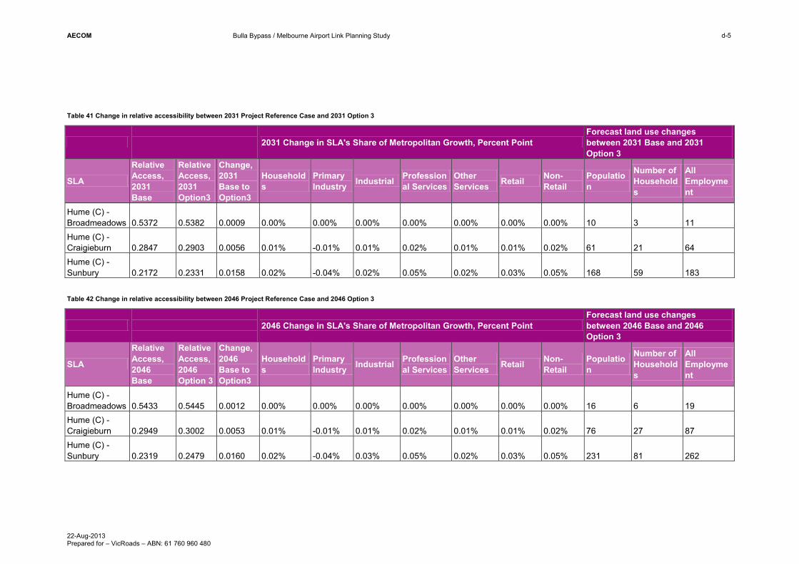
The reported regression coefficients along with estimated changes in relative accessibility that will be brought about by the Bulla Bypass were used to determine the changes in land use. The analysis suggests that relative to the project reference case the Sunbury SLA will have an additional 59 households and 183 jobs in 2031. Craigieburn would have 21 additional households and 64 jobs. Broadmeadows only receives a very small increase in population and employment. The majority of other SLA’s have a small decrease in the population and employment as this shift to the Hume area. As the accessibility improves in this area the relative accessibility of other areas decreases and this drives the shift in population and employment from other areas of Melbourne to Hume. The changes in 2046 are similar in percentage terms and therefore lead to a larger amount of induced population and employment.
AECOM
Bulla Bypass / Melbourne Airport Link Planning Study
22-Aug-2013 Prepared for – VicRoads – ABN: 61 760 960 480
d-5
Table 41 Change in relative accessibility between 2031 Project Reference Case and 2031 Option 3
2031 Change in SLA's Share of Metropolitan Growth, Percent Point Forecast land use changes between 2031 Base and 2031 Option 3
SLA
Relative Access, 2031 Base
Relative Access, 2031 Option3
Change, 2031 Base to Option3
Households
Primary Industry Industrial Profession
al Services Other Services Retail Non-
Retail Population
Number of Households
All Employment
Hume (C) - Broadmeadows 0.5372 0.5382 0.0009 0.00% 0.00% 0.00% 0.00% 0.00% 0.00% 0.00% 10 3 11 Hume (C) - Craigieburn 0.2847 0.2903 0.0056 0.01% -0.01% 0.01% 0.02% 0.01% 0.01% 0.02% 61 21 64 Hume (C) - Sunbury 0.2172 0.2331 0.0158 0.02% -0.04% 0.02% 0.05% 0.02% 0.03% 0.05% 168 59 183 Table 42 Change in relative accessibility between 2046 Project Reference Case and 2046 Option 3
2046 Change in SLA's Share of Metropolitan Growth, Percent Point Forecast land use changes between 2046 Base and 2046 Option 3
SLA
Relative Access, 2046 Base
Relative Access, 2046 Option 3
Change, 2046 Base to Option3
Households
Primary Industry Industrial Profession
al Services Other Services Retail Non-
Retail Population
Number of Households
All Employment
Hume (C) - Broadmeadows 0.5433 0.5445 0.0012 0.00% 0.00% 0.00% 0.00% 0.00% 0.00% 0.00% 16 6 19 Hume (C) - Craigieburn 0.2949 0.3002 0.0053 0.01% -0.01% 0.01% 0.02% 0.01% 0.01% 0.02% 76 27 87 Hume (C) - Sunbury 0.2319 0.2479 0.0160 0.02% -0.04% 0.03% 0.05% 0.02% 0.03% 0.05% 231 81 262

AECOM
Bulla Bypass / Melbourne Airport Link Planning Study
22-Aug-2013 Prepared for – VicRoads – ABN: 61 760 960 480
d-6
The induced population and employment shown in Table 41 and Table 42 represent an immaterial increase in the population and employment from a transport modelling perspective. Table 43 shows the induced population and employment as a percentage of the total population and employment of the key SLA’s. This tiny change in population and employment when factored into the transport model would not produce a measurable impact on congestion or travel times.
Under this methodology the results suggest that the project would not result in a change in accessibility large enough to cause significant land use changes.
Table 43 Induced population and employment in 2031
SLA Population of SLA
Induced Population Increase
% Increase in Population
Employment of SLA
Induced Employment Increase
% Increase in Employment
Hume (C) - Broadmeadows 80,047 10 0.023% 67,595 11 0.027% Hume (C) - Craigieburn 220,676 61 0.038% 46,509 64 0.179% Hume (C) - Sunbury 107,173 168 0.233% 28,133 183 0.886%


AECOM
Bulla Bypass / Melbourne Airport Link Planning Study
22-Aug-2013 Prepared for – VicRoads – ABN: 61 760 960 480
Appendix E
Client Brief

Page 1
PS1 Copy No.
Contract No.
Q25-03685
Specification for:
Quotation Contract– Detailed Transport Modelling and Economic Analysis for Melbourne Airport Link to Outer Metropolitan Ring/Bulla Bypass Business Area:
Network and Asset Planning
Page 2
CONTRACT NO. Q25-03685
CONTENTS SECTION II SCHEDULES
Schedule 1 Schedule of Fees Schedule 2 Rate for Variation Purpose Schedule 6 Statement of Conformance Schedule 28 Key Personnel Schedule 32 Schedule of Methods
SECTION III PROFESSIONAL SERVICES AGREEMENT
Terms of Engagement Annexure The Assignment
SECTION IV PROVIDER REQUIREMENTS OCCUPATIONAL HEALTH AND SAFETY APPENDIX A - SAFE WORK METHOD STATEMENT DECLARATION APPENDIX B - VICROADS CONTRACTOR SAFE WORK METHOD STATEMENT
CHECKLIST ADDITIONAL Post Tender Pre Award Correspondence DOCUMENTATION Schedule 7 Receipt of Addenda and Clarifications

Page 3
SECTION II – SCHEDULES

Page 4
SECTION III - PROFESSIONAL SERVICES AGREEMENT

Page 5
TERMS OF ENGAGEMENT 1. This Agreement shall be governed by Victorian law and the parties shall submit to the Victorian Courts. The parties shall
explore Alternative Dispute Resolution alternatives prior to entering into litigation.
2. Any written notice or instructions to be served on the Provider under this Agreement shall be deemed to have been served when handed to the Provider or its Nominated Principal or posted to or left at the Provider's Business Address in the Form of Tender or subsequent address notified by the Provider to the Corporation in writing.
3. The Provider shall from the Commencement Date perform the services required:
(a) in accordance with sound practice employing due professional skill care and diligence; and
(b) in accordance with all Australian and Victorian statutes, by laws, rules regulations and practices in respect of the assignment; and
(c) carry out the assignment under principles and practices of quality management as specified or of relevant Australian and/or international standards where not otherwise specified or agreed; and
(d) ensure that, having due regard to the assumptions that a competent provider can reasonably be expected to make in accordance with sound professional practice:
(i) all information and data it is required to produce is accurate and correct; and
(ii) the Provider's services will have been carried out in accordance with sound practice employing due professional skill, care and diligence in accordance with the Project Brief and delivered by the Completion Date.
The Provider shall comply with and require all its principals, servants and agents to comply with the Occupational Health and Safety Act 2004 and regulations or similar laws and incorporate into the quality plan where one is appropriate an element covering the management of occupational health and safety.
The Superintendent shall be the officer nominated in the Annexure.
4. The Provider shall liaise with the Superintendent and keep the Superintendent informed as to the program, progress and outcomes of the assignment. If the Provider is delayed in performing the assignment by any act, omission or breach of this Agreement by the Corporation or its servant or agents or any cause (except any act, omission or breach by or on behalf of the Provider), the Provider if it desires to claim an extension of time for completing this assignment, may not later than 28 days after the cause of delay arose, give to the Superintendent a written notice of claim together with detailed statement of facts on which the claim is based. The Superintendent will act reasonably in assessing any claims for an extension of time.
The Superintendent may at any time and at the Superintendent's option, notwithstanding that the Provider has not made a claim for an extension, extend the time for completion by notifying the Provider of the later Completion Date.
The Corporation will not pay any costs incurred by the Provider in respect of any extensions of time granted unless such costs were incurred as a result of any breach of this Agreement or by any other act or omissions on the part of the Corporation or its servants or agents.
5. The Provider shall not subcontract any part of the assignment without the prior written consent of the Superintendent. Approval by the Superintendent of any assignment shall not relieve the Provider of any liabilities under this Agreement: the Provider shall be responsible for the acts, defaults or neglects of any subcontractor as if they were the Provider's own acts, defaults or neglects.
6. The Provider shall not vary the execution of the assignment without the written approval of the Superintendent obtained beforehand.
7. The Superintendent may direct the Provider to perform additional work or to delete work from the assignment and the Provider shall comply with such directions. Work in addition to or in deletion from the assignment shall be paid for or deducted on the basis of charges that have been agreed in writing prior to the changes being directed by the Superintendent. The Superintendent shall act honestly and reasonably in assessing extensions of time, measuring work and calculating payments.
8. Provided the Provider performs the work under the Agreement as specified or subsequently required, the Corporation shall pay to the Provider the total sum specified in the Form of Tender or subsequently agreed in writing. VicRoads shall make payment within 28 days of receipt of a valid tax invoice.

Page 6
9. The Provider shall indemnify and keep indemnified the Corporation in respect of any legally enforceable claims, demands actions, suits or proceedings, costs and expenses whatsoever which may have been instituted against the Corporation arising out of any breach of contract or wilful or negligent acts or omissions by the Provider in any way connected with the Provider's work under this Agreement. The Provider shall during the course of the assignment and for the period afterwards set out in the annexure carry and maintain the various insurances to the levels as set out in the Annexure. Any excesses applicable to the policy shall be to the account of and payable by the Provider and not by the Corporation.
The indemnity clauses in this Agreement are not intended to and do not extinguish the rights in law provided under the Victorian Wrongs (Amendment) Act 2000. The Provider shall not be liable for any liability of loss to the extent that it is the fault of the Corporation. Where negligence is found to have been contributory, each party shall bear responsibility in accordance with that party’s fault.
10. The Provider and its servants, agents and subcontractors shall keep confidential this Agreement, together with all information provided by the Corporation or generated by the Corporation or the Provider in the course of this Agreement and shall not disclose to any person this assignment or any information related thereto. If required by the Corporation the Provider shall arrange for its employees, agents and/or subcontractors to give written confidentiality undertakings in a form approved by the Corporation.
The Provider agrees in respect of Personal Information held in connection with this Agreement:
(a) that it shall be bound by the Information Privacy Principles and any applicable Code of Practice with respect to any act done or practice engaged in by the Provider for the purpose of this Agreement, in the same way and to the same extent as VicRoads would have been bound by the Information Privacy Principles and any applicable Code of Practice in respect of that act or practice had it been directly done or engaged in by VicRoads; and
(b) to immediately notify the Superintendent where it becomes aware of a breach of (a) above, by it or any of its agents or employees (past or present).
In this clause:
"Code of Practice" means a code of practice as defined in, and approved under, the Information Privacy Act (Vic) 2000;
"Information Privacy Principles" means the principles so identified and set out in the Information Privacy Act (Vic) 2000;
"Personal Information" means information or an opinion (including information or an opinion forming part of a database) that is recorded in any form and whether true or not, about an individual whose identity is apparent, or can be reasonably ascertained, from the information or opinion.
This Clause 10 shall continue to have effect after the termination or expiration of this Agreement.
11. The Provider warrants that as at the date of this Agreement no conflict of interest exists or is likely to arise during the course of this Agreement. If a conflict of interest or risk of conflict of interests arises, the Provider shall notify the Corporation immediately of the conflict or risk.
12. Any intellectual property arising in the course of or out of the provision of services under this Agreement shall upon creation vest exclusively in the Corporation. Where the assignment involves ideas which were the Provider's own ideas created prior to the assignment and not created in the course of it, the Provider may use those ideas freely, without obligation to the Corporation, in the course of the Provider's practice.
In performing the work under this assignment the Provider shall not infringe any other person's intellectual property, and shall ensure in respect of systems and outcomes that no royalties or fees are payable by the Corporation to any third persons. The Provider shall indemnify the Corporation against any suit or claim, together with associated costs and damages, whether arising directly or indirectly by reason of any infringement by the Provider of any intellectual property by the Provider or supplied by the Provider for the purposes of this Agreement.
The Corporation shall be entitled as it sees fit and at no cost either directly or through any other Provider or otherwise to make use of any ideas, designs, data, reports or other products or outcomes used or developed by the Provider in conjunction with this assignment which are not subject to royalties or patent rights for carrying out additional or similar work. The Provider shall not be liable to the Corporation or third parties in any way for such use of these outcomes or products.
13. The Provider warrants that:
(a) it has obtained valid consents from all relevant authors in the creation of any copyright work under this Agreement so that the use by the Corporation or its assignees of such work will not infringe any copyright, including any author's moral rights under the Copyright Act 1968; and

Page 7
(b) the consents permit the Corporation in its absolute discretion, reproducing, publishing, copying, adapting, performing, communicating to the public, materially distorting or in any other way changing or using the work (or a substantial part of adaptation of it) –
(i) with or without attribution of authorship;
(ii) with no title, the same title or any other title; and
(iii) in any way it sees fit.
The Provider indemnifies the Corporation and agrees to keep the Corporation indemnified in respect of any actual or threatened breach of any of the above warranties.
14. If the Provider fails to either:
(a) perform the work under this Agreement as required; or
(b) comply with a direction of the Superintendent; or
(c) proceed continuously and diligently with the carrying out of work under this Agreement and complete it by the Completion Date or any extension of time granted; or
(d) comply with any of the conditions of Agreement; or
if the Provider becomes insolvent or enters into an Agreement with creditors or goes into liquidation or has a receiver and manager or administrator appointed whether voluntarily or compulsorily then without prejudice to any other remedies or rights the Corporation may have under this Agreement or at common law the Corporation may without prior notice to the Provider by written notice signed by its Director Contract Services and served upon the Provider determine this Agreement. From and after proven receipt of such notice this Agreement shall be terminated in which event the Provider shall deliver up all documents relating to this assignment which it has in its possession or control. Any costs or expenses incurred or damage sustained by the Corporation in remedying such breach or in any way arising out of the Provider's default shall become a debt due and payable to the Corporation by the Provider and may be recoverable from the Provider by deduction from any moneys held on account of the Provider or by action at law.
If the Corporation defaults in payment of any monies due and payable to the Provider under this Agreement and that default continues for 14 days, the Provider may give the Corporation written notice specifying the default and requesting its rectification within a period of not less than 14 days from the date of service of the notice. If the Corporation fails to rectify the breach within the period specified in the notice, the Provider may, without further notice, forthwith suspend or terminate this Agreement.
15. The Corporation agrees to pay the relevant GST on receipt of a valid tax invoice. The Corporation will be required to apply withholding tax from payments to suppliers who do not provide an Australian Business Number.

PROFESSIONAL SERVICES ASSIGNMENT

Page 1
1
DETAILED TRANSPORT MODELLING AND ECONOMIC ANALYSIS CONSULTANT TASK BRIEF
Melbourne Airport Link to OMR and Bulla Bypass Detailed Transport Modelling and Economic Analysis
Page 2
2
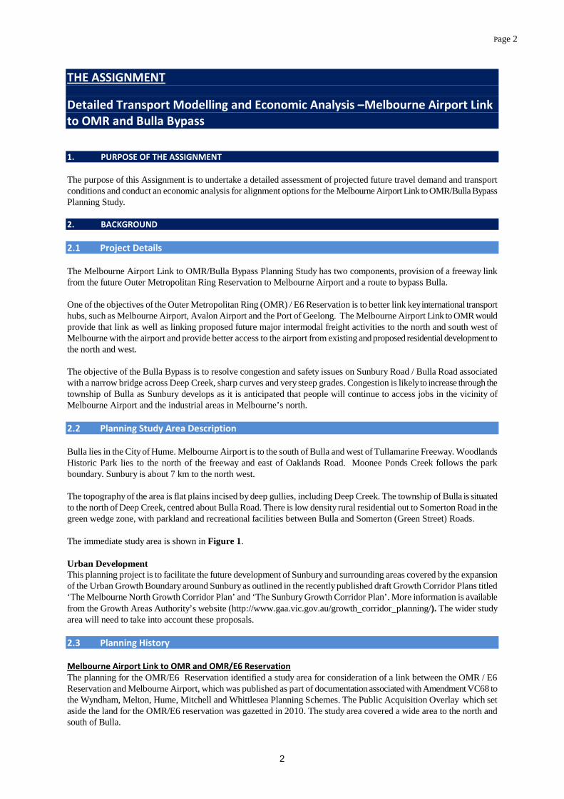
THE ASSIGNMENT Detailed Transport Modelling and Economic Analysis –Melbourne Airport Link to OMR and Bulla Bypass 1. PURPOSE OF THE ASSIGNMENT The purpose of this Assignment is to undertake a detailed assessment of projected future travel demand and transport conditions and conduct an economic analysis for alignment options for the Melbourne Airport Link to OMR/Bulla Bypass Planning Study. 2. BACKGROUND 2.1 Project Details The Melbourne Airport Link to OMR/Bulla Bypass Planning Study has two components, provision of a freeway link from the future Outer Metropolitan Ring Reservation to Melbourne Airport and a route to bypass Bulla. One of the objectives of the Outer Metropolitan Ring (OMR) / E6 Reservation is to better link key international transport hubs, such as Melbourne Airport, Avalon Airport and the Port of Geelong. The Melbourne Airport Link to OMR would provide that link as well as linking proposed future major intermodal freight activities to the north and south west of Melbourne with the airport and provide better access to the airport from existing and proposed residential development to the north and west. The objective of the Bulla Bypass is to resolve congestion and safety issues on Sunbury Road / Bulla Road associated with a narrow bridge across Deep Creek, sharp curves and very steep grades. Congestion is likely to increase through the township of Bulla as Sunbury develops as it is anticipated that people will continue to access jobs in the vicinity of Melbourne Airport and the industrial areas in Melbourne’s north. 2.2 Planning Study Area Description Bulla lies in the City of Hume. Melbourne Airport is to the south of Bulla and west of Tullamarine Freeway. Woodlands Historic Park lies to the north of the freeway and east of Oaklands Road. Moonee Ponds Creek follows the park boundary. Sunbury is about 7 km to the north west. The topography of the area is flat plains incised by deep gullies, including Deep Creek. The township of Bulla is situated to the north of Deep Creek, centred about Bulla Road. There is low density rural residential out to Somerton Road in the green wedge zone, with parkland and recreational facilities between Bulla and Somerton (Green Street) Roads. The immediate study area is shown in Figure 1. Urban Development This planning project is to facilitate the future development of Sunbury and surrounding areas covered by the expansion of the Urban Growth Boundary around Sunbury as outlined in the recently published draft Growth Corridor Plans titled ‘The Melbourne North Growth Corridor Plan’ and ‘The Sunbury Growth Corridor Plan’. More information is available from the Growth Areas Authority’s website (http://www.gaa.vic.gov.au/growth_corridor_planning/). The wider study area will need to take into account these proposals. 2.3 Planning History Melbourne Airport Link to OMR and OMR/E6 Reservation The planning for the OMR/E6 Reservation identified a study area for consideration of a link between the OMR / E6 Reservation and Melbourne Airport, which was published as part of documentation associated with Amendment VC68 to the Wyndham, Melton, Hume, Mitchell and Whittlesea Planning Schemes. The Public Acquisition Overlay which set aside the land for the OMR/E6 reservation was gazetted in 2010. The study area covered a wide area to the north and south of Bulla.

Page 3
3
Bulla Bypass In addition to developing the Melbourne Airport Link to OMR, preliminary work was undertaken in 2010/11 to investigate three corridors for the bypass of Bulla; a southern corridor, inner Bulla corridor and a northern corridor. As a result of desktop studies and assessment of environmental, economic and technical constraints and opportunities, VicRoads refined the number of corridors. This resulted in the elimination of the southern and inner Bulla corridors, with the northern corridor taken forward for further investigation. Northern Corridor Options Figure 1 also illustrates the Melbourne Airport Link to OMR and the Bulla Bypass Corridor with its variants BB1, BB2, BB3 and BB4. Melbourne Airport Link to OMR This alignment begins at the end of Tullamarine Freeway (east of Melbourne Airport). It then travels northwards towards Somerton Road. After Somerton Road, this alignment then heads north to north west and connects into the future proposed OMR. The alignment is about 8,000 metres in length. This link will be an ultimate six lane freeway standard facility with a freeway to freeway interchange with the OMR. Two ramps would be provided in each direction. The ultimate configuration for the OMR would be eight lanes with two auxiliary lanes from the Sunbury Road Interchange. Bulla Bypass This 6 lane ultimate arterial road begins at the end of Tullamarine Freeway (east of Melbourne Airport). It then travels north to Somerton Road, before it turns westwards and travels along the various alignments along/in the vicinity of Somerton Road. It then continues on and crosses Deep Creek and connects in with Sunbury Road. All alignments (ie, BB1, BB2, BB3 and BB4), are about 11,500 metres long. All alignment options with the exception of BB4 will connect to the OMR via an interchange at Sunbury Road. This interchange is likely to provide southerly orientated ramps only (ie in direction of Calder Freeway) once the OMR is constructed. In the interim, the route may link into Sunbury Road along its existing alignment. This route may be staged constructed as a 4 lane arterial road and link to a duplicated (4 lane arterial) Oaklands Road between Somerton Road and Sunbury Road or along the proposed alignment of the Melbourne Airport Link to OMR. 2.4 Summary of Previous Consultation The Preliminary Traffic Analysis was conducted by VicRoads. VicRoads has had preliminary discussions regarding the model outcomes with the following stakeholders:
- Hume City Council; - Melbourne Airport; - Growth Areas Authority; - Department of Transport
The outcomes of these discussions will be provided during the inception meeting. 2.5 Additional Information Preliminary Traffic Analysis The Preliminary Traffic Analysis completed in 2011 has indicated that both a Bulla Bypass and the OMR link would be required in the longer term ie 2046. The analysis indicated that the two routes would perform different functions. The Melbourne Airport Link to OMR would cater for longer distance (ie north to south travel), to the Airport, while the Bulla Bypass would provide an east-west route from Sunbury to the Airport and to the industrial suburbs of North Melbourne. Both would provide for travel demand to the CBD via the Tullamarine Freeway.

Page 4
4
The Calder Freeway is the current preferred route to the CBD from Sunbury. The preliminary analysis indicated that construction of a Bulla Bypass would result in a significant shift of traffic from the Calder Freeway to the Bypass. Consideration will need to be given to the impacts of widening of the Calder and Tullamarine Freeways on travel demand and timing of construction VITM Model The VITM model has been calibrated to take account of the latest (2011) possible transport and transport infrastructure projects for bus and rail including regional rail links, road network updates and current Victoria in future data supporting the Growth Areas Authority Growth Corridor Plans in relation to land use, population and employment. 3. AGREEMENT OBJECTIVES The objectives of this Assignment, by which the performance of this contract will be assessed in addition to the other requirements outlined within the Professional Services Agreement and Brief, are defined as follows:
1. Validate and calibrate VITM for the planning study area; 2. Assess each option and its impact on the surrounding road network;
3. Provide current and forecast traffic volumes and traffic conditions for an average weekday in 2011, 2026 and
2046 for each alignment shown in Figure 2’;
4. Undertake an economic assessment of each option;
5. Provide a fully functional copy of the transport model (including OD matrices, highway networks and highway assignment component) for the base year and future options (Cube platform);
6. Provide induced benefits; and
7. Provide a fully functional copy of electronic spreadsheet(s) with a full listing of assumptions and justifications
and input files used for economic assessment. 4. ASSIGNMENT SCOPE 4.1 General 4.1.1 Methods Conduct the Assignment in accordance with the method submitted to and approved by the Superintendent (using Schedule 32), prior to the commencement of the works. 4.1.2 Health and Safety The Provider is responsible for the safety of all persons engaged in the Detailed Transport Modelling and Economic Analysis and shall undertake all things necessary to ensure their safety including (without limitation) complying with the requirements of any Act or Ordinance in Victoria relating to safety.
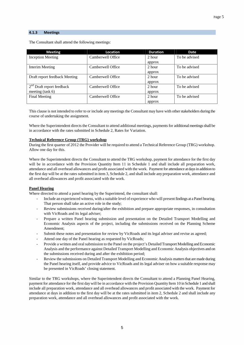
Page 5
5
4.1.3 Meetings The Consultant shall attend the following meetings:
Meeting Location Duration Date Inception Meeting Camberwell Office 2 hour
approx To be advised
Interim Meeting Camberwell Office 2 hour approx
To be advised
Draft report feedback Meeting
Camberwell Office 2 hour approx
To be advised
2nd Draft report feedback meeting (task 6)
Camberwell Office 2 hour approx
To be advised
Final Meeting Camberwell Office 2 hour approx
To be advised
This clause is not intended to refer to or include any meetings the Consultant may have with other stakeholders during the course of undertaking the assignment. Where the Superintendent directs the Consultant to attend additional meetings, payments for additional meetings shall be in accordance with the rates submitted in Schedule 2, Rates for Variation. Technical Reference Group (TRG) workshop During the first quarter of 2012 the Provider will be required to attend a Technical Reference Group (TRG) workshop. Allow one day for this. Where the Superintendent directs the Consultant to attend the TRG workshop, payment for attendance for the first day will be in accordance with the Provision Quantity Item 11 in Schedule 1 and shall include all preparation work, attendance and all overhead allowances and profit associated with the work. Payment for attendance at days in addition to the first day will be at the rates submitted in item 3, Schedule 2, and shall include any preparation work, attendance and all overhead allowances and profit associated with the work. Panel Hearing Where directed to attend a panel hearing by the Superintend, the consultant shall:
- Include an experienced witness, with a suitable level of experience who will present findings at a Panel hearing. That person shall take an active role in the study;
- Review submissions received during/after the exhibition and prepare appropriate responses, in consultation with VicRoads and its legal adviser;
- Prepare a written Panel hearing submission and presentation on the Detailed Transport Modelling and Economic Analysis aspects of the project, including the submissions received on the Planning Scheme Amendment;
- Submit these notes and presentation for review by VicRoads and its legal adviser and revise as agreed; - Attend one day of the Panel hearing as requested by VicRoads; - Provide a written and oral submission to the Panel on the project’s Detailed Transport Modelling and Economic
Analysis and the performance against Detailed Transport Modelling and Economic Analysis objectives and on the submissions received during and after the exhibition period;
- Review the submissions on Detailed Transport Modelling and Economic Analysis matters that are made during the Panel hearing itself, and provide advice to VicRoads and its legal adviser on how a suitable response may be presented in VicRoads’ closing statement.
Similar to the TRG workshops, where the Superintendent directs the Consultant to attend a Planning Panel Hearing, payment for attendance for the first day will be in accordance with the Provision Quantity Item 10 in Schedule 1 and shall include all preparation work, attendance and all overhead allowances and profit associated with the work. Payment for attendance at days in addition to the first day will be at the rates submitted in item 2, Schedule 2 and shall include any preparation work, attendance and all overhead allowances and profit associated with the work.

Page 6
6
4.2 Information to be Provided by the Superintendant to the Provider To assist the Consultant in the assignment, the following information will be provided by VicRoads:
- The Superintendent will provide aerial photos (if required), and plans showing the proposed alignments; - 2011 traffic survey data in the study area (including traffic volumes and travel time); - Map-based identification of options with possible intersections / interchanges; - Construction and other costs for each option, as required for economic assessment.
The Consultant will be responsible for obtaining any other data considered appropriate to the Study, the costs of which are to be indicated in the Consultant’s submission. 5. TASK DESCRIPTION 5.1 General Information The Provider shall use the VITM transport model together with Cube Voyager software or VISUM software for macro modelling and VISSIM for micro modelling. The modelling services will include:
1. Refinement of the Victorian Integrated Transport Model (VITM) for the Melbourne Airport Link to OMR/Bulla Bypass. This refinement is expected to include:
a. checking of model’s highway network in the study area; the consultant would define the study area for the model, subject to VicRoads’ approval;
b. calibration / validation of modelled traffic volumes and travel times for competing parallel routes, where data is available to do so, or can be collected without impacting on the delivery date;
2. Assessing the impact of the options separately and combined. (refer below for more information). 3. Documentation of results in a detailed report with summary of findings. 4. Select link analysis at selected locations specified in this brief. 5. To take into account induced benefits, modelling should be carried out according to the method specified
in: a. the National Guidelines for Transport System Management in Australia, Volume 4, Urban
Transport (Australian Transport Council 2006), or b. Economic evaluation manual, Volume 1 (NZ Transport Agency 2010).
This means the full 4-step process needs to be run for each of the alignment options, as well as any matrix calculation or cross-assignments required to estimate the induced benefits.
5.2 Detailed Task Descriptions The consultant shall undertake the following tasks: Task 1 Review of background information Review of preliminary traffic analysis and traffic survey report completed to date. This is to be provided by VicRoads. Task 2 Calibration and validation of base case Transport modelling is to be based on a road network and traffic zoning system suitable to address the Planning Study objectives. A validation of model results against baseline conditions for 2011 is to be conducted for the Melbourne Airport Link to OMR/Bulla Bypass for each time period 2011, 2026, 2046. The validation is to include directional traffic volume and travel time comparisons for the AM peak period, where data is available, or where the collection of the required data will not affect the delivery date. Validation targets and convergence criteria will be in accordance with. VicRoads Modelling Validation and Calibration Guidelines.

Page 7
7
The Provider shall require VicRoads signoff on transport data to be used for model calibration versus model validation. A detailed Model Calibration and Validation Report documenting the process and outcomes are to be submitted to VicRoads Superintendent for approval, prior to commencement of the modelling of options. If matrix estimation is used to satisfy the validation criteria, the consultant shall document the criteria used in the matrix estimation process in the report. The consultant shall justify how the adjustment be made to future year matrices, bearing in mind that the matrices for the options can be quite different from those for the base. Task 3 Conduct modelling of options The Provider is required to allow for modelling:
- Current-year base run (2011) i.e. existing conditions; - Future-year base run(s) (2026 and 2046); - Options to be modelled. These are shown in Figure 2:
Melbourne Airport Link to OMR without Bulla Bypass:
1. with all movements at Sunbury Road/OMR interchange, all movements at Somerton Road interchange. 2. with southerly oriented movements only at Sunbury Road/OMR interchange, all movements at Somerton
Road interchange.
Melbourne Airport Link to OMR with Bulla Bypass: 3. Encompasses (BB1, 2 & 3) - with all movements at Sunbury Road/OMR interchange, all movements at
Somerton Road interchange. 4. Encompasses (BB1, 2 & 3) - with southerly oriented movements only at Sunbury Road/OMR interchange,
all movements at Somerton Road interchange. 5. No OMR connection to Bulla Bypass (BB4), with all movements at Sunbury Road/OMR interchange, all
movements at Somerton Road interchange.
Bulla Bypass without Melbourne Airport Link to OMR: 6. Encompasses (BB1, 2 and 3) - with roundabout at intersection of bypass with Sunbury Road/ Bulla
Diggers Rest Road/ Bulla Road, to existing intersection with Oaklands Road, and existing intersection at Oaklands Road/ Sunbury Road.
7. BB4 - with roundabout at intersection of bypass with Sunbury Road/ Bulla Diggers Rest Road/ Bulla Road, to existing intersection with Oaklands Road, and existing intersection at Oaklands Road/ Sunbury Road.
8. Encompasses (BB1,2 and 3) – with roundabout at intersection of bypass with Sunbury Road/ Bulla Diggers Rest Road/Bulla Road, intersection in Somerton Road with new alignment following proposed Melbourne Airport Link to OMR alignment.
9. BB4 – with roundabout at intersection of bypass with Sunbury Road/ Bulla Diggers Rest Road/Bulla Road, intersection in Somerton Road with new alignment following proposed Melbourne Airport Link to OMR alignment.
- The Melbourne Airport Link to OMR is to be considered as a freeway with 6 lanes divided in all options. - The Bulla Bypass is to be considered as an arterial road, 4 lanes divided for options 6-9 and 6 lanes
divided for options 3-5 and 8-9. - Modelling is required for all four time periods (AM, IP, PM, OP) for economic evaluation. However,
only AM (7-9am) Peak and 24-hour results need to be presented in reports. - Year(s) to be Modelled include:2011, 2026 and 2046.

Page 8
8
- Assess the impact of widening the Calder Freeway at a time to be agreed on one option of the Bulla Bypass.
Specific activities that the Provider is required to undertake in fulfilling the technical requirements of the Assignment include, but are not limited to:
- Prepare plots of the study area showing the modelled volume/capacity ratios, volumes and other required attributes (e.g. average vehicle speed, freight volumes etc.) for the base year scenario and future year scenarios (ie 2026, 2046) for the options above. The modelling shall consider seasonal and weekday/weekend traffic variations, including tourist and recreational traffic (where applicable) and its impact on the road network.
- Provide all results in a GIS format agreed with VicRoads Superintendent
For each modelled year and option, the scenario-modelling report must include the following in the study area:
- Plots of road networks (number of lanes and speed limits) - Plots of traffic volumes for all vehicles and trucks (7-9am 1-way and 24-hour 2-way). The 24-hour volumes
should be derived from the full period of the model;
- Plots of traffic volume/capacity ratios (7-9am peak direction);
- Plots of change in volumes (increases and reductions) between base and option (7-9am 1-way);
- Select link plots (7-9am peak direction) – Sunbury Road immediately south of connection to Bulla Bypass and north of OMR Link. – details to be discussed.
Note the following hold points for the project:
- Study area: the study area must be approved by the Project Manager prior to the commencement of model calibration and validation.
- Model calibration and validation: the Model Validation Report and associated model must be approved by the
Project Manager prior to development of the road networks for alignment options. - Plots of road networks: plots of road networks for the different alignment options and forecast years must be
approved prior to the commencement of scenario modelling. Task 4 Detailed economic analysis Prior to undertaking Task 4, there will be a hold point. The length of this hold point will be advised by the Superintendent. The Provider must undertake a detailed economic analysis of Options, Melbourne Airport Link to OMR, Bulla Bypass BB1, BB2, BB3 considered as one option and BB4 and/or variants of them. Should there be sufficient variation in cost between BB1, BB2 and BB3 these may be considered separately at a later date. This will include an assessment of the effect of staged development opportunities, taking into account key section links, link speed, interchanges, accident savings, road user costs and benefits. The methodology employed for the analysis will consider induced benefits and take account of the documents listed in 5.1 General Information. The analysis will:
1. include an assessment of how well each proposed corridor option would meet future traffic demands, improve travel time and reduce road accidents;
2. produce outputs for each corridor option including: Discounted Project (road agency)Cost, Net Present Value (NPV) and Benefit/Cost Ratios (BCRs). The analysis should be presented so that costs can be refined and BCR’s and NPV’s etc. modified by VicRoads at a later stage;

Page 9
9
3. provide a detailed project summary of yearly costs for capital expenditure, yearly estimates of fuel
consumption maintenance, travel time, vehicle operation, greenhouse gas savings and accident savings for each proposed route option;
4. the benefits should be derived from the full period (AM, IP, PM, OP) of the model, rather than factoring up the AM results.
5. use the existing Sunbury/Bulla Roads within the Study Area as the base case for the analysis; 6. include a full assessment of diversion of traffic from the existing highway and local roads to the proposed
[corridors/route options]; 7. adopt a discount rate of 7% for an examination period of 30 years, with sensitivity analysis carried out at
both 4% and 10%; 8. in addition to sensitivity analysis in relation to the discount rate, conduct other sensitivity analysis including
project costs (up to 20% increase), and construction time change (no more than 5 years) 9. assume a construction time table as provided by VicRoads 10. The economic evaluation should be for a period of 30 years. As the forecast years for the traffic model are
2026 and 2046, the benefits and costs for other years in the evaluation period may be obtained by interpolation.
A clearly documented electronic copy of the calculations shall be provided to VicRoads with a full listing of assumptions and justifications. Task 5 Assessment of Options The Superintendent is using an Objective Based Evaluation Matrix (OBEM) to help assess the performance of each of the options. The Superintendent will collate the assessments of all specialist consultants into an evaluation matrix, which will be used to facilitate discussion with the community and in formal statutory processes to obtain environmental and planning approvals. Project Objectives The “Project Objectives” for the project as a whole will be supplied by the Superintendent separately. The Provider shall examine these objectives and nominate the one (or more) objective which is relevant to this Assignment. Sub-objectives At the start of the Assignment the Provider shall propose “Sub-objectives” for each “Project Objective”. These “Sub-objectives” will generally be derived from legislation, national, State and local policy and planning schemes. Assessment Criteria The Provider shall also propose the “Assessment Criteria” to be used for each “Sub-objective” and nominate the verifiable data which would be used to support the assessments. For example, a flora and fauna consultant might nominate “hectares of habitat to be removed” to support an assessment of a sub-objective dealing with impacts on certain endangered species. Hold Point: The Superintendent will reach agreement with the Provider on the relevant “Project Objective(s)”, the “Sub-objectives” and their related “Assessment Criteria” to be used for this Assignment. Assessment The Provider shall then provide an assessment of the extent to which the existing route and each proposed option meets each nominated project objective. The Provider shall use the sub-objectives, assessment criteria and also provide verifiable data to support this assessment. The assessment shall be in the form of an answer to the question “How well does the proposal meet each nominated project objective?” To ensure consistency, the following scale should be used:
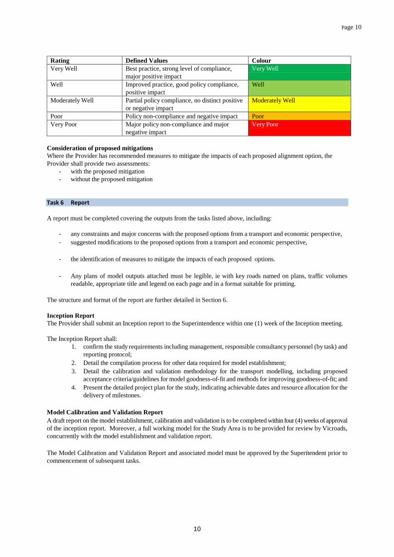
Page 10
10
Rating Defined Values Colour Very Well Best practice, strong level of compliance,
major positive impact Very Well
Well Improved practice, good policy compliance, positive impact
Well
Moderately Well Partial policy compliance, no distinct positive or negative impact
Moderately Well
Poor Policy non-compliance and negative impact Poor Very Poor Major policy non-compliance and major
negative impact Very Poor
Consideration of proposed mitigations Where the Provider has recommended measures to mitigate the impacts of each proposed alignment option, the Provider shall provide two assessments:
- with the proposed mitigation - without the proposed mitigation
Task 6 Report A report must be completed covering the outputs from the tasks listed above, including:
- any constraints and major concerns with the proposed options from a transport and economic perspective, - suggested modifications to the proposed options from a transport and economic perspective, - the identification of measures to mitigate the impacts of each proposed options. - Any plans of model outputs attached must be legible, ie with key roads named on plans, traffic volumes
readable, appropriate title and legend on each page and in a format suitable for printing. The structure and format of the report are further detailed in Section 6. Inception Report The Provider shall submit an Inception report to the Superintendence within one (1) week of the Inception meeting. The Inception Report shall:
1. confirm the study requirements including management, responsible consultancy personnel (by task) and reporting protocol;
2. Detail the compilation process for other data required for model establishment; 3. Detail the calibration and validation methodology for the transport modelling, including proposed
acceptance criteria/guidelines for model goodness-of-fit and methods for improving goodness-of-fit; and 4. Present the detailed project plan for the study, indicating achievable dates and resource allocation for the
delivery of milestones. Model Calibration and Validation Report A draft report on the model establishment, calibration and validation is to be completed within four (4) weeks of approval of the inception report. Moreover, a full working model for the Study Area is to be provided for review by Vicroads, concurrently with the model establishment and validation report. The Model Calibration and Validation Report and associated model must be approved by the Superitendent prior to commencement of subsequent tasks.
Page 11
11
Interim Transport Modelling Report A draft Interim Transport Modelling report showing the modelling outcomes for the options as outlined in task 3 above is to be provided within seven (7) weeks of the approval of the Model Calibration and Validation Report. Moreover, a full working model for the Study Area is to be provided for review by VicRoads. Final Study Report A draft Final Study report on the assessment of options, including economic assessment, is to be provided within four (4) weeks after the hold point is to be provided for review by VicRoads. The Provider shall notify the Superintendent immediately on the discovery of any significant issues which arise as a result of the investigations and to notify the superintendent immediately of any other issues that VicRoads should be made aware of. 6. Deliverables 6.1 Timing of Reports Step Timing Details 1. Provider to submit Draft Inception Report
Within one weeks of Inception meeting
The inception report shall confirm the study requirements and reporting protocols, details the compilation process for the data required for the model establishment, detail the calibration and validation methodology for the transport modelling and present a detailed project plan.
Hold Point The provider shall not proceed to the model calibration and validation until the inception report is approved by the Superintendent
2. Provider to submit Model Calibration and Validation Report
Within four weeks after completion of task 1.
The provider is to provide a report on the model establishment, calibration and validation. A full working model for the Study is to be provided for review by the Superintendent.
Hold Point The provider shall not proceed to the traffic analysis until the calibration and validation report is approved by the Superintendent
3. Provider to submit Draft Report Traffic Analysis
Within seven weeks after completion of Task 2.
A draft report will be required for the Superintendent to review within 7weeks after completion of Task 2. An electronic copy of the completed draft report is to be provided to the Superintendent in Microsoft Word format (Doc), along with electronic copies of all maps, drawings and photos in the format agreed with the Superintendent. The report shall also have provision of the full working model incorporating each option modelled. If the report is incomplete or inappropriately structured, the Superintendent may request the draft to be revised prior to reviewing.
4. VicRoads to review Draft Report
Two weeks after receiving Draft Report
The Provider may be requested to consider changes based on the reviewers comments before the report is finalised. VicRoads will collate comments from the Technical Working Group. Where the Provider has concerns about any review comments, there are to be discussed with VicRoads prior to the finalisation of the report.
Technical Reference Group to review report
Four weeks after receiving Draft Report, while be reviewed by VicRoads
Hold Point The provider shall not proceed to the economic analysis until the traffic modelling is approved by the Superintendent
5. Provider to submit Draft Report on Economic Analysis
Within four weeks of agreement to Traffic Analysis draft report
A draft report will be required for the Superintendent to review within 4 weeks after completion of Task 2. An electronic copy of the completed draft report is to be provided to the Superintendent in Microsoft Word format (Doc), along with electronic copies of all maps, drawings and photos in the format

Page 12
12
Step Timing Details agreed with the Superintendent. The report shall also have provision of the full working model incorporating each option modelled. If the report is incomplete or inappropriately structured, the Superintendent may request the draft to be revised prior to reviewing.
6. VicRoads to review Draft Report
Two weeks after receiving Draft Report
The Provider may be requested to consider changes based on the reviewers comments before the report is finalised. VicRoads will collate comments from the Technical Working Group. Where the Provider has concerns about any review comments, there are to be discussed with VicRoads prior to the finalisation of the report.
Technical Reference Group to review report
Four weeks after receiving Draft Report, while be reviewed by VicRoads
5. Provider to submit final Traffic and Economic Analysis Report
No more than two weeks after receipt of VicRoads comments on draft final Traffic and Economic Analysis report.
An electronic copy of the final report should be provided to VicRoads in a secured Adobe Portable Document File (PDF) format as well as a Word Format. A digital copy should also be provided in a format agreed with VicRoads. One unbound and three bound copies of the final report (including colour figures and plates), should be presented to VicRoads including the full working model with options incorporating any modification required from VicRoads review.
Superintendent’s acceptance of final report
The final report will only be accepted after all changes required by VicRoads, and agreed by the Provider, have been completed.
6.2 Report Structure Subject to any specific modifications required for this Assignment, it is expected that the report will have the following chapter headings:
- Executive summary - Introduction/background - Methodology - Results - Discussion - Objective Based Evaluation Matrix (remove if not applicable) - Conclusions - Recommendations including mitigation - Glossary of terms - References - A copy of this Assignment brief as Appendix 1 - Other Appendices, as required
It is also expected that the report will contain:
- A Cover Page with the Project name, type of consultancy, author’s name and date - A Table of Contents with a list of maps, drawings, tables and Appendices - Footers on each page including the date and version number (for both hard copy and electronic files) - Numbering of all pages, and - Text that is readable and not less than 10 point Verdana, or approved equivalent - Acknowledgements for persons and organisations that have contributed to the report
Page 13
13
6.3 Format of Reports All reports shall conform to the following requirements:
• Margins: o Binding margin: 25mm o Open margin: 10mm (NB. In practical terms, provide the 25mm margin on both sides of each page so
that VicRoads can produce double-sided documents.) o Top margin: 10mm o Bottom margin: 10mm
• Fonts: o Fonts to be generally no smaller than 12 point.
• Layout: o Start each section on the right hand page. o Start Chapter 1 on the right hand page. Start all other chapters as they occur. o First page of Chapter 1 is Page 1. o All preceding pages to be in Roman numerals. o Odd numbered pages to be right hand pages.
• Content: o Colour figures (including plans) should be capable of being reproduced in black and white. o Supply clean artwork (not photography). o Supply unfolded plans if greater than A4 size. o Supply loose photographic prints. o Where continuous corridor drawings are broken down to A3 size drawings, all annotation and
text shown on the continuous corridor drawings must be self-contained within each A3 drawing. It is also expected that the report will contain:
- The version number (for both hard copy and electronic files) - Numbering of all pages.
6.4 Format of Electric Versions of Maps, Drawings and Photos Maps are to be produced using GIS software. GIS data should be provided in ESRI Shapefile format. GPS locations should be provided on GDA94 Lat/Long datum to at least and accuracy of 1m, or another similar standard agreed with the Superintendent prior to the assignment being awarded]. Drawings should be provided in a CADD file Microstation Version 8 or dxf, (coordinates in MGA, zone 54) or another similar standard agreed with the Superintendent prior to the agreement being awarded]. Photos are to be in jpeg format and taken with at least a 5 megapixel camera or another similar standard agreed with the Superintendent prior the agreement being awarded. The consultant must ensure they adhere to the appropriate colour requirements specified by Department of Planning and Community Developments document titled ‘Communicating data with Colour’ (April 2011) Guidelines. 6.5 Web Accessibility As provided within Appendix C, the Provider must ensure that the draft and final reports submitted to the Superintendent conforms to the VicRoads Accessibility Requirements for contracted work.