a guide for multiple use waterway management · the u.s. coast guard, ... the static surface...
TRANSCRIPT

MULTIPLE USEA Guide for
Waterway Management
Second Edition

MULTIPLE USEA Guide for
Waterway Management
Second Edition
Produced by the National Water Safety Congress, Inc. in partnership with the
National Association of State Boating Law Administrators
Principal InvestigatorDr. Deborah A. Gona
Gona & Associates, Lexington, Kentucky Graphic Design
Michelle Huber-Kropp Direct Response, Inc., Lexington, Kentucky
Produced under a grant from the Aquatic Resources (Wallop-Breaux) Trust Fund administered by the U.S. Coast Guard
A Guide for Multiple Use Waterway Management ii
Copyright © 2004 National Water Safety Congress P.O. Box 1632 Mentor, Ohio 44061 440.209.9805
Printed in the United States
ISBN 0-9744655-0-X Price: 75.00
All rights reserved. Inquiries for use should be directed to:
Cecilia Duer, Executive Director National Water Safety Congress 440.209.9805 [email protected]

Acknowledgments iii A Guide for Multiple Use Waterway Management
? ? ?Acknowledgments
A Guide for Multiple Use Waterway Management is but one tool for resource managers, planners, regulators and otherwaterway stakeholders and professionals who are trying to make sense of an evolving body of information about multiple usewaterway issues and conflicts and site-appropriate ways for coming to terms with them. This body of information, whichgrounds the analysis and presentations within the Guide, is made up of research reports, management plans, processsummaries, academic and governmental studies, conference and workshop proceedings, meeting minutes, media articles, andInternet-based sites produced or maintained by public, private and non-profit agencies and organizations. But the "making sense" part of this project would not have been as rich and multi-layered if it had not been for the activeengagement and guidance of individuals and organizational representatives in formal and informal project input and feedbackopportunities in 2002 and 2003. They helped to shape this edition by sharing their real-life professional experiences and theirvarying and valuable perspectives on waterway and multiple use issues and management priorities and approaches. The National Water Safety Congress (NWSC) and the National Association of State Boating Law Administrators (NASBLA)thank all of the boating and water safety specialists, waterway managers and planners, academic and government researchers,and other professionals representing recreational, commercial, industrial, environmental and military arenas and interests forproviding a wealth of expertise, insights and reference materials. The project’s principal investigator acknowledges the guidance and tireless efforts of the following: The National Water Safety Congress, its Board of Directors, and in particular, Ron Riberich, who served as NWSC Presidentduring the Guide’s production, provided ongoing guidance and expertise, and demonstrated exceptional patience for asometimes tedious process. His and the board members’ strong interest in assuring the relevance of this second edition tocontemporary waterway issues and approaches offered an opportunity for the investigator to craft an updated documentwith a structure and scope reflecting the evolution in waterway issues and approaches. The members and officers of the National Association of Boating Laws Administrators, the NASBLA Waterways ManagementCommittee, and in particular, Eleanor Mariani, who served as Committee Chair and expertly guided its oversight efforts onbehalf of the larger organization. Her leadership and the Committee’s participation in the planning, research, and reviewphases afforded critical input by way of case studies, resources, issues and format suggestions and general feedback not onlyduring its meetings of 2002 in Daytona Beach and Cleveland, but also in 2003 in Portland, Ore. and the months between. The varied group of professionals who participated in breakout sessions of the International Boating and Water SafetySummit in Daytona Beach in 2002 and in Las Vegas in 2003, who listened intently to project plans and status reports, andwho identified for exploration a wealth of potential case studies and examples illustrating specific methods, managementresolutions, plans and planning processes, waterway conflict issues and regional variations.The U.S. Coast Guard, for producing the 1983 report on managing recreational boating areas that eventually would lead to thecommission of expanded work in the form of the first edition of this Guide, and in particular, John Malatak, who on this roundled the expert technical review team intent on ensuring that this latest edition not only would contain technically accurateinformation, but also could be easily accessed and used by the varied audiences.All of the individuals and organizational representatives who provided early commentary on potential enhancements for thisupdated document or served as members of the core Guide Advisory Committee during initial planning phases or served onthe document draft review team over the course of several months. Representing the project’s partnering organizations,governmental authorities and agencies, and industry interests – and some of whom served in similar capacities in guiding thedevelopment of the first edition – they willingly offered sound advice on the project parameters and direction, much needededits, and sometimes much needed humor. They are (in alphabetical order): Paul Donheffner, Susan Engle, Monita Fontaine,Bill Gossard, Jeff Hoedt, Tom Hood, John Johnson, Eleanor Mariani, Elizabeth Raymond, Alan Richard, Ron Riberich, ToniRushing, Ron Sarver, Frank Trent, Ted Woolley. While their contributions came at different stages and varied in length, theywere, nonetheless, greatly appreciated and needed. To all of these individuals and organizations and to others who might have been inadvertently overlooked in this litany, thesincerest thank you. All are in some way responsible for the "success" of this project. The investigator alone is responsible forany shortcomings.


v A Guide for Multiple Use Waterway ManagementTable of Contents
Acknowledgments . . . . . . . . . . . . . . . . . . . . . . . . . . . . . . . . . . . . . . . . . . . . . . . . . . . . . . . . . . . . . . . . . . . .iiiForeword . . . . . . . . . . . . . . . . . . . . . . . . . . . . . . . . . . . . . . . . . . . . . . . . . . . . . . . . . . . . . . . . . . . . . . . . . . . .ixOn Using This Guide — Quick Reference . . . . . . . . . . . . . . . . . . . . . . . . . . . . . . . . . . . . . . . . . . . . . . . . . .xiIntroduction . . . . . . . . . . . . . . . . . . . . . . . . . . . . . . . . . . . . . . . . . . . . . . . . . . . . . . . . . . . . . . . . . . . . . . . . . .1
Origins of the Guide . . . . . . . . . . . . . . . . . . . . . . . . . . . . . . . . . . . . . . . . . . . . . . . . . . . . . . . . . . . . . . .3Revisiting Multiple Use Waterway in the New Reality . . . . . . . . . . . . . . . . . . . . . . . . . . . . . . . . . . .3Focus of the Second Edition . . . . . . . . . . . . . . . . . . . . . . . . . . . . . . . . . . . . . . . . . . . . . . . . . . . . . . . .5Organization of the Second Edition . . . . . . . . . . . . . . . . . . . . . . . . . . . . . . . . . . . . . . . . . . . . . . . . . .6
Section 1: Trends And Emerging IssuesWhat’s shaping waterway uses, demands and conflicts? . . . . . . . . . . . . . . . . . . . . . . . . . . . . . . . . . . . . . .9
Dramatic demographic and societal changes — there’s more of us and more variety in our lives . . . . . . . . . . . . . . . . . . . . . . . . . . . . . . . . . . . . .10
Increasing, more intensive uses of public waters — it seems like there’s more of everything out there . . . . . . . . . . . . . . . . . . . . . . . . . . . . . . . . . . .10
Evolution in watercraft, combinations of activities and variations in water users and craft operators’ experience, skill and consideration —
they’re on, in and hovering above the water … and some users may just be better at it than others . . . . . . . . . . . . . . . . . . . . . . . . . . . . . . . . . .13
The static surface acreage of the public waters and the booming development of commercial and residential activities along the shoreline —
there’s only so much water … only so many ways to get to it…and these days, it might just be through someone’s backyard . . . . . . . . . . . . . . . . . . . . . . . . . .16
Varied attitudes and social perspectives about recreation and water resources —our individual and collective diversity is showing . . . . . . . . . . . . . . . . . . . . . . . . . . . . . . . . . . . .18
Increased visibility and prominence of environmental issues and interests —shaping the context of individual responsibility … and the regulatory environment . . . . . . .19
Section 2: Developing Plans and Solutions for Multiple Use Waterway Issues and ConflictsThings to consider … even if you don’t want to . . . . . . . . . . . . . . . . . . . . . . . . . . . . . . . . . . . . . . . . . . .27
So, what are you planning?Slide out of crisis mode, start looking ahead … and be prepared to work with what you discover . . . . . . . . . . . . . . . . . . . . . . . . . . . . . . . . . . .28
Table of Contents

A Guide for Multiple Use Waterway Management vi Table of Contents
Table of Contents
Not another meeting …Create meaningful, transparent participation processes, for waterway stakeholders, including the general public . . . . . . . . . . . . . . . . . . . . . . . . . . . . . .31
Plain talk … up-front …Set out management intent and objectives . . . . . . . . . . . . . . . . . . . . . . . . . . . . . . . . . . . . . . . . .35
Taking a look through the wide-angle lens …Plan with the region or system in mind, if you can . . . . . . . . . . . . . . . . . . . . . . . . . . . . . . . . . . .35
So, who is responsible for what?Map out and peel through the layers of jurisdiction, existing regulations and policies . . . . . . . . . . . . . . . . . . . . . . . . . . . . . . . . . . . . . . . . . . . . . . . . . .36
A complex mix of problemsTake time to sort through and define your problems before you start to look at alternatives . . . . . . . . . . . . . . . . . . . . . . . . . . . . . . . . . . . . . . . . . . . .36
Defend with a clear rationale … not rationalizationsMake reasoned, principled and science-based decisions . . . . . . . . . . . . . . . . . . . . . . . . . . . . . . .38
Perception or science? ….Pay attention to both, at different times and for different reasons . . . . . . . . . . . . . . . . . . . . .38
That’s what it says, but is that what it means?Use caution when interpreting and applying data and information . . . . . . . . . . . . . . . . . . . . .42
But, in that study …Understand and learn from others’ experiences, issues and methods,but work and act within your framework and situation . . . . . . . . . . . . . . . . . . . . . . . . . . . . . .43
Section 3: A Closer Look at Multiple Use Waterway ManagementApproaches, Tools and ProcessesTailoring the methods to the priorities and objectives . . . . . . . . . . . . . . . . . . . . . . . . . . . . . . . . . . . . . .49
Basic Waterway Management Tools and TechniquesAnd some thoughts about "selecting" from the menu… . . . . . . . . . . . . . . . . . . . . . . . . . . . . . .53Information & Education
User information and education about how to use,protect and enjoy the waterway . . . . . . . . . . . . . . . . . . . . . . . . . . . . . . . . . . . . . . . . . . . . . . .54Boating guides and maps, navigational charts and aids . . . . . . . . . . . . . . . . . . . . . . . . . . . . .54Network of numbered and lighted buoys or markers . . . . . . . . . . . . . . . . . . . . . . . . . . . . . .56

vii A Guide for Multiple Use Waterway Management
Table of Contents
Law Enforcement & Boater RegulationsStepped up rules/regulations, enforcement and patrols . . . . . . . . . . . . . . . . . . . . . . . . . . . . .56Age minimums . . . . . . . . . . . . . . . . . . . . . . . . . . . . . . . . . . . . . . . . . . . . . . . . . . . . . . . . . . . . . .57Education, certification, and licensing . . . . . . . . . . . . . . . . . . . . . . . . . . . . . . . . . . . . . . . . . . .57
Water Use Activity Controls & Traffic ManagementZoning . . . . . . . . . . . . . . . . . . . . . . . . . . . . . . . . . . . . . . . . . . . . . . . . . . . . . . . . . . . . . . . . . . . .57
Zoning for certain activities . . . . . . . . . . . . . . . . . . . . . . . . . . . . . . . . . . . . . . . . . . . . . . . . .58Special event zones . . . . . . . . . . . . . . . . . . . . . . . . . . . . . . . . . . . . . . . . . . . . . . . . . . . . . . .58Anchorage / no anchoring zones and mooring / no mooring areas . . . . . . . . . . . . . . . . .59Pass through zones . . . . . . . . . . . . . . . . . . . . . . . . . . . . . . . . . . . . . . . . . . . . . . . . . . . . . . . .59Time or day zoning . . . . . . . . . . . . . . . . . . . . . . . . . . . . . . . . . . . . . . . . . . . . . . . . . . . . . . . .59"No wake" zoning . . . . . . . . . . . . . . . . . . . . . . . . . . . . . . . . . . . . . . . . . . . . . . . . . . . . . . . . .59"No boat" zones and "restricted" areas for hazard management . . . . . . . . . . . . . . . . . . .60"Speed in proximity" zones . . . . . . . . . . . . . . . . . . . . . . . . . . . . . . . . . . . . . . . . . . . . . . . . .60
Speed limits . . . . . . . . . . . . . . . . . . . . . . . . . . . . . . . . . . . . . . . . . . . . . . . . . . . . . . . . . . . . . . . .62Noise regulations and ordinances . . . . . . . . . . . . . . . . . . . . . . . . . . . . . . . . . . . . . . . . . . . . . .62Watercraft horsepower limitations . . . . . . . . . . . . . . . . . . . . . . . . . . . . . . . . . . . . . . . . . . . . .63Permits and permit systems . . . . . . . . . . . . . . . . . . . . . . . . . . . . . . . . . . . . . . . . . . . . . . . . . . .63User fees . . . . . . . . . . . . . . . . . . . . . . . . . . . . . . . . . . . . . . . . . . . . . . . . . . . . . . . . . . . . . . . . . .63Rotational watercraft traffic patterns . . . . . . . . . . . . . . . . . . . . . . . . . . . . . . . . . . . . . . . . . . .64Speed lanes for hazard management . . . . . . . . . . . . . . . . . . . . . . . . . . . . . . . . . . . . . . . . . . .64Commercial traffic lanes and information . . . . . . . . . . . . . . . . . . . . . . . . . . . . . . . . . . . . . . .64
Access Distribution & Development ControlsDistribution of launch ramps and access points . . . . . . . . . . . . . . . . . . . . . . . . . . . . . . . . . . .65Support facilities size and location . . . . . . . . . . . . . . . . . . . . . . . . . . . . . . . . . . . . . . . . . . . . .65Entrance gates . . . . . . . . . . . . . . . . . . . . . . . . . . . . . . . . . . . . . . . . . . . . . . . . . . . . . . . . . . . . . .65Shoreline and vicinity management . . . . . . . . . . . . . . . . . . . . . . . . . . . . . . . . . . . . . . . . . . . .65
Taking a Look at Alternative Management MethodsLimits and exclusions? Or self-regulation and education? … . . . . . . . . . . . . . . . . . . . . . . . . . .68
Carrying capacity: it’s not just by the numbers … . . . . . . . . . . . . . . . . . . . . . . . . . . . . . . . . . . . . .70Data collection on the waterways … it’s counts and a lot more . . . . . . . . . . . . . . . . . . . . . . . . . .74
Section 4: References and ResourcesA point for further exploration . . . . . . . . . . . . . . . . . . . . . . . . . . . . . . . . . . . . . . . . . . . . . . . . . . . . . . . . .81Subject Index . . . . . . . . . . . . . . . . . . . . . . . . . . . . . . . . . . . . . . . . . . . . . . . . . . . . . . . . . . . . . . . . . . . . . . .101
Table of Contents

A Guide for Multiple Use Waterway Management viii Table of Contents
Table of Contents
Boxed informationSome of the trends and forces affecting multiple use waterways and their management . . . . . . . . . .9Recreational versus commercial navigation conflicts — how significant? . . . . . . . . . . . . . . . . . . . . . . .12Trends in water-based outdoor recreation participation . . . . . . . . . . . . . . . . . . . . . . . . . . . . . . . . . . . . .14How many days spent on the water? . . . . . . . . . . . . . . . . . . . . . . . . . . . . . . . . . . . . . . . . . . . . . . . . . . . . .15Enhancing the federal lakes . . . . . . . . . . . . . . . . . . . . . . . . . . . . . . . . . . . . . . . . . . . . . . . . . . . . . . . . . . . .16When the "boating season" doesn’t end, and the tourists don’t go home . . . . . . . . . . . . . . . . . . . . . . . .17PWCs — the compact craft that provokes a big reaction . . . . . . . . . . . . . . . . . . . . . . . . . . . . . . . . . . . . .19Endangered Species Act — from Endangered Rivers to Piping Plover habitat . . . . . . . . . . . . . . . . . . . .20EPA 2006 emission standards . . . . . . . . . . . . . . . . . . . . . . . . . . . . . . . . . . . . . . . . . . . . . . . . . . . . . . . . . . .21Shorthand reminders for planning and decision making… . . . . . . . . . . . . . . . . . . . . . . . . . . . . . . . . . . .27Some principles that can guide waterways management planning . . . . . . . . . . . . . . . . . . . . . . . . . . . . .28Continuous planning: the Delaware Inland Bays Water Use Plan . . . . . . . . . . . . . . . . . . . . . . . . . . . . . .30Getting stakeholders’ "informed consent" . . . . . . . . . . . . . . . . . . . . . . . . . . . . . . . . . . . . . . . . . . . . . . . . .32Can the media help us find common values among dissimilar groups? . . . . . . . . . . . . . . . . . . . . . . . . . .33A bi-national structure for stakeholder involvement:
The Lake St. Clair/ St. Clair River Management Plan . . . . . . . . . . . . . . . . . . . . . . . . . . . . . . . . . . . . .34So, what’s your problem? . . . . . . . . . . . . . . . . . . . . . . . . . . . . . . . . . . . . . . . . . . . . . . . . . . . . . . . . . . . . . .37Deciding on decision criteria . . . . . . . . . . . . . . . . . . . . . . . . . . . . . . . . . . . . . . . . . . . . . . . . . . . . . . . . . . . .39So, that’s an ‘asymmetric conflict’ … . . . . . . . . . . . . . . . . . . . . . . . . . . . . . . . . . . . . . . . . . . . . . . . . . . . .40The ‘oddity’ of perceptions . . . . . . . . . . . . . . . . . . . . . . . . . . . . . . . . . . . . . . . . . . . . . . . . . . . . . . . . . . . . .41Regional guidance to local waterway planning:
Managing the waterways of Hampton Roads . . . . . . . . . . . . . . . . . . . . . . . . . . . . . . . . . . . . . . . . . . .52Boosting public awareness when a regulatory approach isn’t feasible:
the North Landing River Waterway Use Conflict Memorandum of Agreement . . . . . . . . . . . . . . .55To zone or not to zone?: the Virginia Coastal Program’s model
for determining potential for shallow water use conflicts . . . . . . . . . . . . . . . . . . . . . . . . . . . . . . . . .58Updating a lake management plan … and creating uniform management actions:
Lake Travis and Highland Lakes Recreation Management Plans . . . . . . . . . . . . . . . . . . . . . . . . . . .60Taking a comprehensive look at harbor facilities: Lake Superior’s North Shore Harbors Plan . . . . . . .66Increasing public access through redevelopment and private land acquisition . . . . . . . . . . . . . . . . . . .67Assessing the alternatives:
the Lake Mead National Recreation Area Lake Management Plan . . . . . . . . . . . . . . . . . . . . . . . . . .69Collaborating on a non-regulatory approach:
Southwest Florida’s Anchorage Management Program . . . . . . . . . . . . . . . . . . . . . . . . . . . . . . . . . . .71Evaluating methods for determining capacity:
Tims Ford Reservoir Recreational Boating Capacity Study . . . . . . . . . . . . . . . . . . . . . . . . . . . . . . . . .73Gathering the information: Boating on Ohio Waterways —
A Plan for Access and Use Management . . . . . . . . . . . . . . . . . . . . . . . . . . . . . . . . . . . . . . . . . . . . . . .75Boat traffic and impact studies: Waterway characteristics that weigh into your strategies,
and newer technologies for doing the work . . . . . . . . . . . . . . . . . . . . . . . . . . . . . . . . . . . . . . . . . . . .76

Foreword ix A Guide for Multiple Use Waterway Management
The National Water Safety Congress (NWSC), in partnership with the National Association of StateBoating Law Administrators (NASBLA), is pleased to present the second edition of A Guide forMultiple Use Waterway Management. This updated Guide revisits many of the topics presented in the edition first published by the NWSCin 1996. But its perspective, structure and scope reflect the evolution in experience with multiple usewaterway issues and management strategies over time, as well as the tremendous amount ofinformation that is rapidly becoming available electronically via the Internet. While the hallmark of the first edition was a six-step process that could be adapted by users todevelop responsible multiple use waterway management plans, this update begins by taking a look atthe trends, factors, opportunities and even stumbling points involved in planning for and managingthose multiple use public waterways today. At its core are "lessons worth learning" when it comes toformulating viable multiple use strategies, plans and solutions.Since those lessons continue to be learned by resource managers, planners and other waterwaystakeholders, we hope that this new edition will be just the start of a longer-term goal to inform andfacilitate ongoing exchanges about the planning, management and regulation of multiple usewaterways and the ultimate outcomes of those efforts.We would like to offer personal thanks to all of the professionals who provided valuable input to thedevelopment of this Guide, whether in project meetings, conference sessions, or in untold hoursreviewing drafts. Without their cooperation and valuable insights, this project would not have beenpossible.
Foreword
Bob PharrPresidentNational Water Safety Congress
Ronald J. RiberichImmediate Past PresidentNational Water Safety Congress


On Using This Guide – Quick Reference xi A Guide for Multiple Use Waterway Management
At the core of this edition of A Guide for Multiple Use Waterway Management and as recommendedreading for all users, new to the field and veterans alike, are a set of "lessons worth learning" — keythings to keep in mind as gleaned from the experiences of many who have gone through the processof developing viable multiple use waterway strategies, plans and solutions (pp. 27-47).As you get into the "real work," though, you may need to refer back to this Guide for ideas abouthow to resolve a particular type of problem, take on a task, or just refresh your memory about aresource, method or topic area. The Table of Contents and the Subject Index (p. 101) are the primarynavigational tools, but here is a set of quick pointers to sections or pages addressing areas aboutwhich you might have questions.
Where do I look if I want to …Get a shorthand version of those "lessons worth learning"? p. xiiLearn more about how we can involve other agencies, citizens and other waterway stakeholders in planning forand managing our multiple use waterway? p. xiiFind out how we can isolate the problems on our multiple use waterway? p. xiiLearn how we can make more sound decisions, or at least make decisions we can explain to the boaters,landowners, interest groups and others who have a stake in the waterway? p. xiiFind out about participation trends for water-based outdoor recreation so we can compare them to oursituation? p. xiiRead some examples of multiple use management and planning experiences? p. xii-xiiiLearn more about strategies for monitoring boat traffic on our waterway? p. xiiiFigure out whether we should "zone" to manage conflict between different water-based activities? p. xiiiFigure out how to manage PWCs on our waterway? p. xiiiFind out how we can address user conflicts without creating more regulations? p. xiii-xivLearn more about the possible effects of adding to or distributing waterway access points? p. xivFind the technical detail for implementing the methods described in the Guide (for example, how to locate andsize waterway support facilities, like marinas and parking areas)? p. xivFind out how we can plan and manage specifically for multiple uses and users on an inland lake? p. xivLearn more about user surveys? p. xvGet the "menu" of management techniques that are available for us to consider? p. xvLearn just about those techniques that can address some of the biggest complaints we get, like noise andovercrowding? p. xvLearn about specific things that we can do to make our multiple use waterway as safe as possible? p. xv
On Using This Guide – Quick Reference

A Guide for Multiple Use Waterway Management xii On Using This Guide – Quick Reference
Where do I look if I want to …Get a shorthand version of those "lessons worth learning"?
See p. 27 for the boxed information titled "Shorthand reminders for planning and decisionmaking…"
Learn more about how we can involve other agencies, citizens and other waterwaystakeholders in planning for and managing our multiple use waterway?
See pp. 27-29 and pp. 31-35 for information about participation methods, stakeholderinvolvement in meetings, a method for achieving consent, and reasons why "process" isbecoming important to problem resolution.
Find out how we can isolate the problems on our multiple use waterway?They are not very clear-cut are they? See pp. 36-37, and in particular, the boxed informationtitled, "So, what’s your problem?" It is not the only resource, but it is one way of workingthrough the process of identifying and describing your problem, separating the problem fromthe symptoms, and targeting what needs resolution.
Learn how we can make more sound decisions, or at least make decisions we can explain tothe boaters, landowners, interest groups and others who have a stake in the waterway?
See pp. 38-40 for reasons why principled, science-based decisions are important, and even why"perceptions," and your understanding of them, can play a role in decision-making aboutmultiple use waterways. See p. 39, for an example of "decision criteria" you might want toadapt to suit your situation.
Find out about participation trends for water-based outdoor recreation so we can comparethem to our situation?
See p. 14, and the boxed information for key results from the National Survey on Recreationand the Environment 2000. For other discussions of boating participation and variations in howwe define and calculate that "participation," see p. 10-11. For other major trends affecting orlikely to affect the uses, demands and conflicts on waterways, see pp. 9-26.
Read some examples of multiple use management and planning experiences?The Guide is based on and cites hundreds of resources, plans, and other materials and examples
relevant to multiple use waterway management (see Section 4: References and Resources, pp.81-99, and the detailed endnotes following each section). But within each section, you also willfind highlights of certain aspects of the planning, decision-making, stakeholder participation,management, monitoring techniques and other processes used by selected jurisdictions for theirwaterways. For more detail on each, always go directly to the source information thataccompanies the descriptions. What you apply from these experiences ultimately should be based upon the unique nature ofyour waterway and users. Among the illustrations that might be of interest to you:
Boating on Ohio Waterways: A Plan for Access and Use Management, p. 75

On Using This Guide – Quick Reference xiii A Guide for Multiple Use Waterway Management
Delaware Inland Bays Water Use Plan, p. 30Hampton Roads Waterway Management Study, p. 52Lake Mead National Recreation Area Lake Management Plan, p. 69The Lake St. Clair/St. Clair River Management Plan, p. 34Lake Travis and Highland Lakes Recreation Management Plans, pp. 60-61North Shore Harbors Plan (Lake Superior), p. 66North Landing River Waterway Use Conflict Memorandum of Agreement, p. 55Southwest Florida Anchorage Management Program, p. 71Tims Ford Reservoir Boating Capacity Study and process, p. 73Virginia Coastal Program model for shallow water use conflicts, p. 58
Learn more about strategies for monitoring boat traffic on our waterway? See pp. 74-76 for more about data collection on and about the waterways, and especially p.76for some strategies for monitoring traffic and the factors that should weigh into your decision.Take a look at p. 70 and pp. 72-74 for more information on issues surrounding boating capacityon the waterways, and p. 73 for an illustration of a process used in a boating capacity study fora reservoir.
Figure out whether we should "zone" to manage conflict between different water-based activities?See pp. 57-60 and p. 62 for more about "zoning" as just one method for managing activity onthe surface of multiple use waterways, and the pros and cons of employing different types ofzones on different types of waterways.
Figure out how to manage PWCs on our waterway?The Guide presents information, statistics and resources related to a variety of recreationalboats, including personal watercraft, muscle-powered or paddle craft, motorboats, sailboats andother craft. See the Subject Index (p. 101), especially, for pages on which different craft receivesignificant mention, and Section 4: References and Resources (p. 81-99). There are, as describedon pp. 49-76, some controls that are more effective and appropriate on certain types ofwaterways for managing conflicts between different types of users and crafts or betweencertain crafts and the environmental resources. Your management objectives for the waterway— including your understanding of the role perceptions play in reactions to certain types ofusers and activities (see boxed information on p. 40; and pp. 18-19 and pp. 38-41 for example)— will affect the approaches you take and your selection of techniques. But a premise of this Guide, as with the first, is that there is inherent value in comprehensiveplanning for and management of multiple use waterways based on a shared, long-term visionand goals for what a particular waterway should be like, for what the recreational experiencecan be, and on assessments of alternatives based on sound, supporting data. That is, not solelyon the basis of singling out the latest craft on the waterway. See the question, "Where do I lookif I want to … read some examples of multiple use management and planning experiences?" (p.xii) for more illustrations of management and planning strategies that jurisdictions have usedto acknowledge, resolve, or even thwart certain problems.
Find out how we can address user conflicts without creating more regulations?See pp. 50-51, p. 53, and pp. 68-70, for some of the reasons why alternative methods ofresolving conflict — such as efforts to raise boater awareness, education, and collaboration ofstakeholder agencies and jurisdictions in voluntary agreements — are among the first steps you

A Guide for Multiple Use Waterway Management xiv On Using This Guide – Quick Reference
might take to deal with conflict. Take a look at p. 55 and p. 71 for illustrations of managementplans that use memoranda of agreement between agencies or jurisdictions and voluntarycompliance from boaters to try to achieve waterway goals.
Learn more about the possible effects of adding to or distributing waterway access points?See pp. 64-67 for some of the implications associated with the way access points aredistributed, launch ramps are placed, and support facilities are added to shoreline development.See pp. 53-64, too, because the application of other management techniques also will affect thedegree, ease and frequency of user "access" to a multiple use waterway.
Find the technical detail for implementing the methods described in the Guide (for example,how to locate and size waterway support facilities, like marinas and parking areas)?
For one answer, see p. 65. But as with other tools and techniques in Section 3: A Closer Look atMultiple Use Waterway Management Approaches, Tools and Processes (pp. 49-80), you willneed to consult the sources, print and Internet-based, that are cited in the endnotes. One Guidecannot authoritatively cover all the detail necessary for implementing each technique.
Find out how we can plan and manage specifically for multiple uses and users on an inland lake?If you are looking for information that applies to lakes, reservoirs or impoundments, there aremany parts of the Guide you will want to consult. Given that at least one national survey a fewyears back reported nearly 60 percent of boaters go out on freshwater lakes andimpoundments, the number of references included in the Guide should not be surprising.But that is a good question because what happens in managing a large lake, perhaps withtransient users, may be very different than managing a small lake with a residentialdevelopment along the shoreline. While there will be comparability in the basic planning andparticipation processes and the application of decision-making techniques, there will beinevitable differences in the alternatives, strategies and techniques that you can consider andeffectively apply. For some of the management techniques and caveats applicable to lakes, see especially pp. 58-59 (zoning for fishing, swimming, water skiing, special events; zoning linked to times or days;or zoning to achieve "no wake"); p. 62-64 (discussions of management practices like theimposition of speed limits, horsepower limits, or even rotational water patterns); and p. 70 andpp. 72-74 (regarding the evolution of "carrying capacity," particularly as the concept has beenapplied to the management of inland lakes).For some illustrations of stakeholder involvement in planning for lakes, see p. 34, pp. 60-61 andp. 69; for illustrations of attempts to create uniform management approaches across a systemof lakes or to think regionally in planning for different kinds of public recreation, see pp. 60-61and p. 1, respectively. For a capacity study involving the creation of "managementclassifications" within a system of reservoirs, see p. 73. And, finally, see "Where do I look if Iwant to … read some examples of multiple use management and planning experiences?" (p. xii-xiii), for more illustrations of management and planning strategies.

On Using This Guide – Quick Reference xv A Guide for Multiple Use Waterway Management
Learn more about user surveys?See especially p. 33 (on using surveys as one way of involving waterway stakeholders), pp. 38,40 (on the importance of understanding user perceptions to better interpret the results ofthese surveys), p. 42 (for other caveats you should be aware of as you interpret surveys), andpp. 74-76 (for more information regarding data collection processes. As always, consult theendnotes linked to the text.
Get the "menu" of management techniques that are available for us to consider?See pp. 53-67, "Basic Waterway Management Tools and Techniques" for those associated withthe physical aspects of waterways, the crafts and users on them, and the shoreline activities.Although many are interrelated, each technique has been slotted into one of four broadcategories: Information & Education; Law Enforcement & Boater Regulations; Water UseActivity Controls & Traffic Management; and Access Distribution & Development.
Learn just about those techniques that can address some of the biggest complaints we get,like noise and overcrowding?
For some of the pages where you will find key information about "noise complaints" andpotential ways of alleviating them, see p. 59 ("no wake zoning"), p. 62 (imposing noiseregulations and ordinances), and p. 63 (regarding horsepower limitations). For some interestingpoints regarding other factors that affect our perceptions of noise, see p. 41, and for an exampleof management actions used to deal with these and other complaints in a uniform way across asystem of lakes, see p. 60-61.When it comes to crowds and "over"crowding, once again perceptions will play a role in howyou address it. See pp. 41 for some of those differences based on boater age, experience andexpectations. For specific techniques that have been used in other places to addressovercrowding, and that may — depending on your situation — become part of a broadermanagement plan, see p. 54 (user information), p. 63 (imposition of user fees), and p. 65(distribution of launch ramps and access points). See also, p. 71, for an example of a non-regulatory approach to address the declining quality of anchorages due in part to periodicovercrowding.
Learn about specific things that we can do to make our multiple use waterway as safe aspossible?
Far too may pages to cite here! This Guide — in the information it conveys, the principles itpresents, the illustrations it cites — is intended to assist waterway planners, managers andregulators in sorting through, proactively planning for, and then managing and monitoring thewaterways to achieve a quality boating experience, a quality and sustainable resource tosupport recreational activities, and above all, to strive for the safety of the waterway users.


xvii
? ? ?
A Guide for Multiple Use Waterway Management
1INTRODUCTION A Guide for Multiple Use Waterway Management
Introduction
"... [The water is] filled with the equivalent ofbicycles, rollerbladers, trucks, cars, buses … As it getsbusier and busier, that’s going to present a realchallenge to public safety…" — Owner of a water taxiservice quoted in a New York Times article on overcrowding in New York Harbor 1
"…Whether as a ship owner, ship pilot, port owner,port authority, the Coast Guard or others involved inmarine transportation … your perspective on thesystem comes from a professional or perhapseconomic standpoint. By comparison, mostrecreational boaters take to our nation’s waterwayssimply to play … whether it’s fishing, sailing, skiing,cruising or whatever … they don’t share [the same]vision of waterways as working harbors. Bridgingthat disconnect poses a tremendous challenge forpromoting safety and a responsibility for sharing thewaterways in a safe manner. It also represents a greatopportunity for groups such as harbor safetycommittees to play a key role in communicating andcoordinating on local waterways so we can safelyshare and minimize the conflicts that can occur withmultiple use…" — State boating law administrator addressingthe delicate balancing act between recreational boating and themarine transportation system 2
"… Boaters and shore residents need to recognizethat there are limits to growth and the time when aboater could go anywhere and do anything on thewater has passed. There are just too many of us doingour thing on the water. … Government at every levelis reacting to conflicting and competing uses byimposing regulations that serve as ‘fences’ in coastalwaters…. [But] the only way that competing userscan enjoy boating is through cooperation. Sailboaters,power-boaters, jet skiers, fishermen, all have to learnhow to accommodate each other…" — Universityprofessor emeritus and coastal recreation expert commenting onFlorida’s boating future and the need for self-regulation and cooperation among waterway users 3
"... Originally, our [lakes] program offered multiple-use of traditional activities, which by their naturewere complementary, or at the least not conflictingof each other, such as fishing, camping andpicnicking. In recent years, however, [it] has evolvedto reflect public interest in water contact activities …and boating preferences…. In contrast to the lack ofconflict with the earlier traditional activities, thesenew uses and users arrived with inherent conflictswith each other and extraordinary conflicts with ourculture of traditional users. Having ten reservoirs inour system gave us the luxury of accommodatingmultiple interests on a system-wide basis, which hasallowed us to maintain higher standards in terms ofsafety and quality of experience…. Still we have nosmall amount of competition … for ‘prime’ lakeswhere a combination of time and zone managementare employed to minimize conflict where it cannot beeliminated entirely…" — Lakes program manager on theregional nature of multiple use planning for public recreation on water supply reservoirs in southern California 4
The nation’s public waterways — ourvaluable, finite resources, often servingmultiple purposes — can conjure up aspectrum of images.And depending on your proximity, point ofview, preferences, expectations, needs, mostrecent experiences and encounters — andeven your role in managing or planningactivities on them — the mental picturesyou develop about those waterways maychange hue over time and become verymuch like or very much at odds withsomeone else’s. One person’s exhilarating hub ofrecreational activity is another’sovercrowded, intolerant and noisy place.Another’s tranquil refuge and scenicbackdoor vista is somebody’s inaccessiblespace. Someone’s productive workplace or

2A Guide for Multiple Use Waterway Management Introduction
corridor of military or commercial activity isanother user’s competitive, intolerant passageway.It’s a paradox, but one that in a curious wayoffers not only significant challenges, butalso unique opportunities for multiple usewaterway managers and planners.For one thing, it means stepping into anincreasingly vital role in setting, meetingand even exceeding the expectations ofwaterway users, and — particularly in thecase of recreational waters — shaping,"selling" and then maintaining the qualityand safety of the waterway experience forpopulations with less and less leisure time tospend and a rapidly-growing menu ofcompeting recreational options andactivities to fill it.But it also means recognizing and acceptingthat the most critical aspects of resourcemanagement today and well into the futurewill go beyond tending to the safety, care,enjoyment and efficiency of the waters tomediating the not-always compatibleinterests of those who take pleasure fromthem, live nearby, make their living on,study or otherwise rely on access to thewaterways. That can be a tough assignment because likeother treasured resources serving more thanone viable use public waterways are boundto have more than one source of potentialconflict. Different users and behaviors.Different advocates. New watercraft. Newwater contact activities. Changes in accesspoints. Shifting priorities. Adjacent activities.Policies and political structures that caninadvertently contribute to clashes. The list goes on.For managers and planners already strappedfor time and resources, then, the thought ofwading through and untangling all of the
factors, arguments and assorted informationto craft logical responses to multiple usechallenges or take advantage of strategicopportunities can be overwhelming. Somuch so that shortcuts to planning anddecision-making might seem attractiveoptions, at least at first.But as some have already learned, there canbe unexpected costs — and missedopportunities — in not taking the time to
• Set clear management objectives; • Gather solid information and
scientific data; • Develop credible, straightforward
processes; • Become familiar with relevant
trends and human behaviors; • Weigh alternatives; • Apply appropriate strategies and
techniques; and then• Continually measure to see whether
those objectives are being achieved.Without these steps, even the most well-intentioned efforts at the outset may nothave very satisfying outcomes in the long-run.A Guide for Multiple Use WaterwayManagement, second edition, is a tool forresource managers, planners, regulators andother professionals and stakeholders whoare trying to make sense of an evolving andsomewhat unwieldy body of knowledgeabout multiple use waterway issues andconflicts and the methods and processes forcoming to terms with them. By design, thisGuide — itself representing an evolutionfrom the first edition — is intended both toinform and facilitate ongoing learning andexchanges about planning, management andregulation of multiple use waterways andthe outcomes of those efforts.

3
Origins of the GuideIn the early 1990s — responding to acommission by the U.S. Coast Guard, signs ofescalating competition for the use of limitedwater space and prospects for increasinglyunsafe waterways — the National WaterSafety Congress (NWSC), in cooperationwith a broader group of concernedorganizations and waterway managementprofessionals, set to work on the first editionof A Guide for Multiple Use WaterwayManagement.5
Released in 1996 by the NWSC, the Guideaddressed the management of multiple usewaterways in a broad way by offering thebasics on a range of management tools andtechniques; encouraging users to examinethem more completely through otherresources before adapting them to meettheir situations; and exposing readers to theseeds of complicated concepts like "carryingcapacity," that even today continue to bedebated and refined. The Guide represented a collaborative effortto identify and introduce helpful ideas, toolsand techniques for what was rightfullydescribed in its Preface as the "rapidlyexpanding" and "increasingly complex field"of waterway management, and particularly,multiple use management for recreationalpurposes. Perhaps the hallmark of the first edition,though, was its promotion ofcomprehensive, systematic research andanalysis, and from those activities, thedevelopment of responsive and responsiblemultiple use waterway management plans. While the Guide’s authors acknowledgedthat there were "very few solutions onwhich all affected parties" could agree, the
common ground was a belief in "more andbetter planning and management."6 In thatspirit, the Guide outlined a generic six-stepplanning process to introduce users tofundamentals, from "planning for the plan"to monitoring the outcomes of implementeddecisions.7
Though its basic content remainedinstructive, the Guide was due for revisitingafter nearly six years of use. The NationalWater Safety Congress and the NationalAssociation of State Boating LawAdministrators partnered in late 2001 totake another look at what was happening inthis "rapidly expanding" and "increasinglycomplex field." After months of research, informationsearches, and various forums that incombination gleaned the insights of boatingand water safety specialists, waterwaymanagers, academic researchers and otherprofessionals representing a range ofperspectives from the recreational,commercial, military and environmentalarenas, at least one thing became clear:"increasingly complex" might have been a bitof an understatement in describing multipleuse waterway management.Just as in other aspects of life, society, workand policy-making, things have becomemore complicated in the realm of multipleuse waterways and in the problem-identification, problem solving and decision-making associated with them.
Revisiting Multiple Use WaterwayManagement in the New RealityMultiple use of the public waters did notalways spell serious conflict, and it does notassure conflict today. There are and can be
Introduction A Guide for Multiple Use Waterway Management

4A Guide for Multiple Use Waterway Management Introduction
many compatible water-based and adjacentactivities, complementary either by theirvery nature or as a result of effectiveplanning and management. Even the growing diversity in thebackgrounds and interests of water usersdoes not, in itself, herald conflict. After all,the need for and quality of water forrecreation and other waterway activities cansometimes be tough to separate from theneed for quality water for environmentaland other purposes.8 Introducing more anddifferent people to the waterways could justmean that a larger group of users comes toappreciate the variety of uses and benefitsof the public waters, and takes responsibilityfor safe behaviors and protection of the resources. Or it could mean something entirely different.A few years ago, during a listening sessionconducted by the U.S. Army Corps ofEngineers on what role federal agenciesshould play in America’s water resourceissues, one participant said, "… balance theneeds of various recreation types, and findsuitable multiple-use management solutions."9
That challenge could have been directed toany number of agencies at other levels inother venues around the country. Butdepending on who would have issued thechallenge, their experiences, and whichbodies of water were in question, what theymeant by balance, needs, suitable, evensolutions likely would have been different —and that just in the context of recreationalwaterways and activities.
Why? There is no single answer, but insteadthere is an unusual combination of trendsand happenings at work, among them the
• Increasing, more intensive and in some areas,new uses of public waters;
• Continuing evolution in the kinds andcombinations of watercraft and watercontact activities;
• Relatively static surface acreage of the publicwaters;
• Rapid commercial and residentialdevelopment along shorelines;
• Expanded boating seasons;• Enhanced visibility and prominence of
environmental issues; and• Increasing interest in the resource impacts
associated with watercraft, water contactand shoreline development activities.
When you toss in other critical elements,like the
• Dramatic demographic and societal changesover the last few decades, and the everydaylife style and leisure time changes showingup in outdoor recreation;
• Variations in water users’ and craftoperators’ experience, skill levels, education,interests and even consideration for andunderstanding of other user groups;
• Varied attitudes and social perspectivesabout recreation, water resources and theenvironment in general;
• A changing regulatory environment; and the• Increasingly strident involvement of citizens,
stakeholders and various interest groups inpublic management and policy decisions.
And mix them up, you get• Heightened concerns about the safety and
capacities of the public waters;• A jumble of water user needs and values that
may be tough to unravel;• Intensified demands on the very resources
that support water-related activities; and• Sometimes wildly different interpretations of
the impacts of those demands.
5Introduction A Guide for Multiple Use Waterway Management
Finding the common ground on thosesuitable multiple use management solutions,then, becomes more problematic. Expertsnote that it is a sure signal resourcemanagers, planners and regulators must beprepared to not only continuously learn andadapt to new knowledge, information andcircumstances, but also pay attention toseemingly obvious, yet sometimesoverlooked fundamentals.10 This secondedition of the Guide is just one tool tofacilitate that process.
Focus of the Second Edition Readers familiar with the first edition of AGuide for Multiple Use Waterway Managementmay wonder whether the only commonbond between it and this Guide is the title.In fact, while this second edition uses thefirst as a springboard and revisits many ofthe management topics introduced in theoriginal, it employs a different perspective,structure and scope that reflects both theevolution in multiple use waterway issuesand management strategies and the wealthof information becoming available on theInternet.11
And while the heart of the first edition wasthe six-step planning process that could beadapted in developing responsible multipleuse waterway management plans, at thecore of this update is a set of "lessons worthlearning" when it comes to formulatingviable multiple use strategies, plans and solutions.Before taking a closer look at the foursections that follow, readers will want tobecome familiar with how some terms andexamples are used in this Guide.As it was in the first edition, the termwaterway is used prominently in the title
and throughout this Guide. For purposes ofthis Guide and its general discussions,waterway is used as a generic reference toany type of public body of water includingrivers and streams, lakes, ponds, reservoirs,canals, bays, coastal waters, and harbor andport areas. When a specific type of waterbody is relevant to the description ordiscussion, its appropriate name is used. Andthough the focus is on public waterways, theGuide does touch upon some of the issuesthat may put private activities around thewaters at odds with public use, oralternately, may successfully blend publicand private interests.The phrase waterway management — whichcan include all sorts of management andmaintenance of the waters and shorelands,from ditching and dredging to flood controland more — is used primarily to refer tomanagement of the surface waters forrecreational, commercial and environmentalpurposes and to the relevant factors thataffect their management. When otheraspects are critical to discussion, they are noted.And finally, while this Guide draws uponillustrations of multiple use waterways fromacross the country, and presents issues froma variety of recreational, commercial,environmental and social settings, the depthof other water uses, issues and potentialconflicts — such as those involving drinkingwater, irrigation, agriculture, groundwater,and the like — are not and cannot beadequately covered in this single document.However, some of the references cited inthe last section of this Guide do addressthese aspects in more detail.
6A Guide for Multiple Use Waterway Management Introduction
Organization of the Second EditionThe Guide is organized into four sections.Readers interested in an introduction tomultiple use waterway management orgaining the broadest possible context forthinking about waterway issues andmanagement approaches might find ithelpful to "begin at the beginning," and readall the way through. Others might find itmore useful to focus on a particular sectiondescribed below. All will likely find it helpful to read Section 2— Developing Plans and Solutions forMultiple Use Waterway Issues and Conflicts:Things to consider … even if you don’t wantto, and to make use of Section 4 —References and Resources A starting pointfor further exploration.Section 1 — Trends and Emerging Issues:What’s shaping waterway uses, demandsand conflicts?From changes in recreational and commercialwaterway uses to boating statistics,demographics, and leisure time andenvironmental attitude shifts, this sectiontouches lightly on recent past and emergingissues and trends affecting the planning,management and regulation of multiple usewaterways.Section 2 — Developing Plans and Solutionsfor Multiple Use Waterway Issues andConflicts: Things to consider … even if youdon’t want toGrounded in an exploration of emerging trendsand issues, the evolution in thinking aboutmanagement concepts, and the experiences ofdifferent jurisdictions, this section poses a set ofsometimes-overlooked but critical elements tofactor in along the way to developing viable,credible, defensible and accepted multiple-usemanagement strategies, plans and resolutions.
Section 3 — A Closer Look at Multiple UseWaterway Management Approaches, Toolsand Processes: Tailoring the methods to thepriorities and objectivesAn expansion of the first edition’s offering onWaterway Management Techniques,12 thissection takes a fresh look at the methods,approaches and tools in light of shifts in howthey are being applied to multiple usewaterways, what is triggering their use, and theframeworks that are guiding the decisions to usethem. And while the Guide makes liberalreference throughout of "real-life" examples, thissection takes a little deeper dive into multipleuse situations where particular strategies andtechniques have been implemented. Section 4 — References and Resources: A starting point for further explorationThis edition would not have been possiblewithout the briefs, reports, books, conferenceand workshop proceedings, media articles,meeting minutes, process summaries,management plans, academic studies andInternet-based sites and documentationproduced by a range of public, private and non-profit agencies, organizations, institutions andassociations throughout the United States, andeven Canada and Australia. Representing varyingperspectives on waterways, issues, multiple useconflicts, and management concepts, this sectionincorporates over 200 reference items withInternet addresses, as available, and hundredsmore organizational and web resources.13

Introduction A Guide for Multiple Use Waterway Management7
1 From Andrew C. Revkin, "A Crowded, Uneasy Mix in Hudsonand Harbor." September 6, 1998. The New York Times.Reproduced on New Jersey Fishing, FishNet USA, atwww.fishingnj.org/artnyharbor.htm.
2 From Paul Donheffner, "A Balancing Act: The ‘Bubba Factor’ andthe Marine Transportation System." March 8, 2000. TheMotivators Report. See www.motivatorsconference.com/report/feat_2.htm.
3 Dr. Gustavo Antonini, "Boating Expert Provides Look at theFuture of Boating." Fall 1995. Fathom Magazine. Vol. 7, Issue 3.See www.flseagrant.org/science/library/fathom_magazine/volume-7_issue-3/expert.htm.
4 Jim Brown, Lakes Program Manager for the San Diego CityLakes Program, commenting in an email message in May 2002.For more information on the program, see www.sannet.gov/water/recreation/index.shtml.
5 The 1996 edition had its origins in A Guide to ManagingRecreational Boating Areas, produced by the U.S. Coast Guard in1983. The increases in boating and waterway uses, changes intypes and speeds of watercraft, variety of new water sportproducts, and the recognized complexities of balanced resourcemanagement prompted the Coast Guard to commission anupdated, expanded version.
6 See pp. 3-4. A Guide for Multiple Use Waterway Management.1st ed. 1996. National Water Safety Congress.
7 The planning process described in the first edition of A Guide forMultiple Use Waterway Management was offered foradaptation to fit the unique circumstances of specific bodies ofwater. There is at least one example of its adaptation by theHampton Roads (Va.) Planning District Commission in awaterway management study and development of two pilotplans for local areas. See Managing Multiple Recreational UseConflicts in the Waters of Hampton Roads. March 1998. Vol. 1,Waterway Planning Guidance, and Vol. 2. Pilot WaterwaysStudies. Hampton Roads Planning District Commission.www.hrpdc.org.
8 From Water Use Conflicts in the West: Implications ofReforming the Bureau of Reclamation's Water Supply Policies.August 1997. Congressional Budget Office. Seewww.cbo.gov/showdoc.cfm?index=46&sequence=0.
9 From one of 16 listening sessions conducted by the U.S. ArmyCorps of Engineers between June and November 2000 on whatthe federal role should be in addressing water resources. See ANational Dialogue About America’s Water Resource Challengesfor the 21st Century: National Report on Identified WaterResources Challenges and Water Challenge Areas atwww.iwr.usace.army.mil/iwr/waterchallenges/Docs/National_Report.pdf and Challenge: Recreation at www.iwr.usace.army.mil/iwr/waterchallenges/Docs/FactRecreation.pdf.
10 From Glenn E. Haas, Visitor Capacity on Public Lands andWaters: Making Better Decisions. 2002. A Report of the FederalInteragency Task Force on Visitor Capacity on Public Landssubmitted to the Assistant Secretary for Fish and Wildlife andParks, U.S. Dept. of the Interior, Washington, D.C.
11 The 1996 Guide is no longer in print. However, readersinterested in that edition, and in particular the planning processand methods described in it, may obtain a .pdf file atwww.nasbla.org (National Association of State Boating LawAdministrators).
12 See pp. 29-50. A Guide for Multiple Use Waterway Management.1st ed. 1996. National Water Safety Congress.
13 Readers should be aware that there is no guarantee of thepermanence of Internet sites or their contents. As moreinformation and documents are added to sites, webmasters maychange their original locations or move materials off of activepages and into "archives." In the event a document or otherpiece of information is not available at a stated Internet address,check the home or main page of the organization, agency ormedia in question.


Section 1: Trends & Emerging Issues 9
? ? ?
A Guide for Multiple Use Waterway Management
"…As a greater percentage of the coastal land isdeveloped, there will be a greater pressure on theundeveloped land and bay water resources. Thepressures will be from conflicting directions, as somewill want to develop it to provide access for theincreasing populations, while others will want tokeep things the way they are. Many managementdecisions will be made; some … in completeignorance of the realities of the boating situation,some … with correct facts but wrong interpretationof what the facts mean, and many … as ‘emergency'reactions to trends that were never anticipated. Thesuccess stories will come from the managers whocorrectly anticipate future trends, are able to readthe moods as well as the actual movements of theboating population, and work out solutions toproblems before they become crises …" — Researchercommenting on the future of recreational boating trafficmonitoring1
"…Waterways users and managers — both the publicand private sectors — are increasingly concernedabout safety, environmental protection, systemefficiency, and effective management. Some of thefactors that affect the capacity of waterways andchannels include types and mix of vessels, access, andimpacts on a variety of other users. Many ports andwaterways are facing significant increases incommercial shipping, growth in passenger ferryoperations, a trend towards much larger ships,growth in recreational uses, and numerous changesdifficult to predict…. For these and many otherreasons, a national perspective is needed concerningthe capacity and condition of the U.S. waterwaysystem to safely and efficiently handle projectedgrowth and diverse uses. …" — Testimony of chairperson ofMarine Board Seminar on Waterway and Harbor Capacity to U.S.House committee 2
A mixed bag of trends, issues and forces isshaping the context for planning andmanaging multiple activities on and alongthe public waterways.
SECTION 1: TRENDS AND EMERGING ISSUES What’s shaping waterway uses, demands and conflicts?
Some of the trends and forces affectingmultiple use waterways and theirmanagement• Increasing, more intensive and in some areas, new
uses of public waters;• Continuing evolution in the kinds and combinations
of watercraft and water contact activities;• Relatively static surface acreage of the public
waters;• Rapid commercial and residential development
along shorelines;• Expanded boating seasons;• Enhanced visibility and prominence of
environmental issues;• Increasing interest in the resource impacts
associated with watercraft, water contact andshoreline development activities;
• Dramatic demographic and societal changes overthe last few decades, and the everyday life styleand leisure time changes showing up in outdoorrecreation;
• Variations in water users’ and craft operators’experience, skill levels, education, interests andeven consideration for and understanding of otheruser groups;
• Varied attitudes and social perspectives aboutrecreation, water resources and the environment ingeneral;
• A changing regulatory environment; and the• Increasingly strident involvement of citizens,
stakeholders and various interest groups in publicmanagement and policy decisions.
In this section, we scan the data, research,expert forecasts, user group and industryadvocacy, and even "conventional wisdom"— not only to create a composite picture,but also to learn what these differentsources have to say about the roles thatcertain factors might be playing in thegrowth, diversity of demands, and conflictson multiple use waterways.

10A Guide for Multiple Use Waterway Management Section 1: Trends & Emerging Issues
Dramatic demographic and societalchanges — there’s more of us and more varietyin our livesAt a 2001 national symposium on the futureof recreational boating, participants wereasked to look beyond trends that hadobvious links to watercraft or safety — likenumbers of boats or accident rates — toshifts in everyday life and work patterns.3
Like the fact that there are simply more people inthe U.S., and more diverse people and households.There is increasing differentiation in education,income, knowledge and values. There is increasing transportation gridlock, andthere will be a point that when we do things willdepend on when we can get there. There is a "mass" customization of work that isnarrowing the gap between weekdays and weekends.
Among the speculations about what theseand other changes might mean generally forthe boating world, were several tip-offsabout the future of water use, congestion,and even user conflict on multiple use waterways:
There could be more people using watercraft, andif there are, the users are likely to be more diverse.There likely will be more variation in theknowledge and skill level of operators.There could be more conflict concerning whatconstitutes appropriate watercraft behavior andetiquette.Attitudes toward marine life, fishing and theprotection of marine culture and theenvironment will vary more dramatically.
Watercraft likely will be used at more diversetimes of the day or night, weekdays or weekends,cycles and times of the year.
Some would argue the future is already here.
Increasing, more intensive uses of publicwaters — it seems like there’s more ofeverything out thereThere is more of everything out there, fromwatercraft of various shapes and sizes toparticipants with different interests. Butprecisely how many, and how much growththere has been and will be well into thefuture can make for lively debate inplanning and management circles.Forty years ago, there were an estimated 2.5million recreational boats nationwide. Bythe dawn of the new millennium, almost12.8 million boats were registered in thestates and territories.4 In the last 10 yearsalone, boat registrations have risen nearly 16percent, though not uniformly as about 20states account for nearly three-quarters ofthe registration total. But that count represents registered craft.What happens to the national picture whenestimates of other, non-registered craft, arefactored in? One definition of recreational "boatownership" — combining numbers ofregistered and non-registered recreationalwatercraft, from motor boats to canoes —puts the national count at around 17.3million,5 comprising, as one boating expertput it, "…America’s largest fleet, dwarfingthe total vessels in merchant shipping,commercial fishing, passenger traffic, theNavy, and the U.S. Coast Guard."6
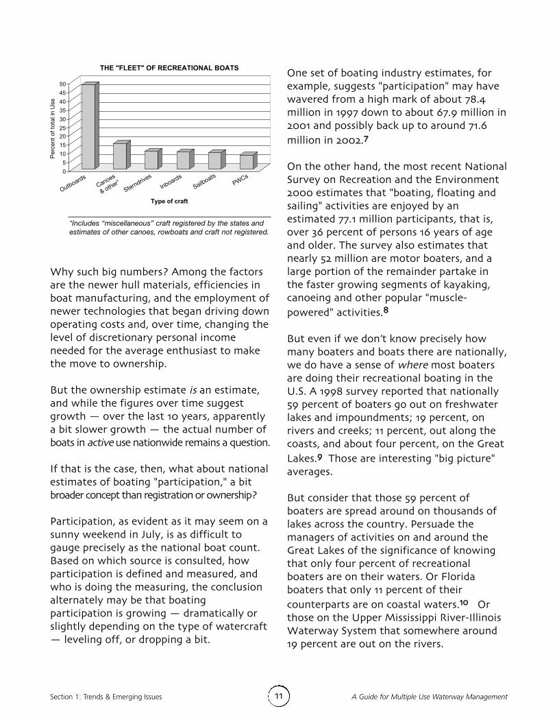
Section 1: Trends & Emerging Issues A Guide for Multiple Use Waterway Management
Why such big numbers? Among the factorsare the newer hull materials, efficiencies inboat manufacturing, and the employment ofnewer technologies that began driving downoperating costs and, over time, changing thelevel of discretionary personal incomeneeded for the average enthusiast to makethe move to ownership.But the ownership estimate is an estimate,and while the figures over time suggestgrowth — over the last 10 years, apparentlya bit slower growth — the actual number ofboats in active use nationwide remains a question.If that is the case, then, what about nationalestimates of boating "participation," a bitbroader concept than registration or ownership? Participation, as evident as it may seem on asunny weekend in July, is as difficult togauge precisely as the national boat count.Based on which source is consulted, howparticipation is defined and measured, andwho is doing the measuring, the conclusionalternately may be that boatingparticipation is growing — dramatically orslightly depending on the type of watercraft— leveling off, or dropping a bit.
One set of boating industry estimates, forexample, suggests "participation" may havewavered from a high mark of about 78.4million in 1997 down to about 67.9 million in2001 and possibly back up to around 71.6million in 2002.7
On the other hand, the most recent NationalSurvey on Recreation and the Environment2000 estimates that "boating, floating andsailing" activities are enjoyed by anestimated 77.1 million participants, that is,over 36 percent of persons 16 years of ageand older. The survey also estimates thatnearly 52 million are motor boaters, and alarge portion of the remainder partake inthe faster growing segments of kayaking,canoeing and other popular "muscle-powered" activities.8
But even if we don’t know precisely howmany boaters and boats there are nationally,we do have a sense of where most boatersare doing their recreational boating in theU.S. A 1998 survey reported that nationally59 percent of boaters go out on freshwaterlakes and impoundments; 19 percent, onrivers and creeks; 11 percent, out along thecoasts, and about four percent, on the GreatLakes.9 Those are interesting "big picture"averages.But consider that those 59 percent ofboaters are spread around on thousands oflakes across the country. Persuade themanagers of activities on and around theGreat Lakes of the significance of knowingthat only four percent of recreationalboaters are on their waters. Or Floridaboaters that only 11 percent of theircounterparts are on coastal waters.10 Orthose on the Upper Mississippi River-IllinoisWaterway System that somewhere around19 percent are out on the rivers.
11
*Includes “miscellaneous” craft registered by the states and
estimates of other canoes, rowboats and craft not registered.

12A Guide for Multiple Use Waterway Management Section 1: Trends & Emerging Issues
Especially when the craft on their waters —and those in and around many jurisdictions— aren’t just recreational.11 They arecommercial fishing boats, naval vessels anda variety of craft making up commercialmarine transportation.All states east of the Mississippi River, and41 states overall, are served by commerciallynavigable waterways.12 Cargo traffic,tankers, tow and tug vessels, passengercruise ships, passenger ferries and watertaxis are out there with those millions ofrecreational craft. And while the number ofbig ships is not growing as rapidly as othercraft, the amount of cargo is. That increasedtonnage means larger and deeper ships onthe waterways.13
Add to this the resurgence in manymetropolitan areas of an interest inpassenger water transportation. At mostrecent count, there were about 70 high-speed ferries operating in the U.S.,14 butwith more crowded highways, the increasein waterfront real estate development inurban areas and the rehabilitation ofobsolete or underused maritime facilities,the implementation of passenger ferry plansis expected to quicken.15 That is anattractive alternative to some, but a sourceof concern about safety, collision risk andenvironmental pollution to others.16
At least according to available aggregatenumbers, then, there are more watercraftaround today — maybe not all seaworthyand maybe not all out on the waters, butmore of them. And in some areas, there areindicators of more intensive use of thewaterways — though national averagesalternately tend to mask or overplay thelevels of intensity and fluctuations in usethat often show up in state or local levelboater studies.
Recreational versus commercial navigationconflicts — how significant?At least one study suggests that commercial andrecreational navigation conflicts might not be assignificant as once thought. The Upper MississippiRiver-Illinois Waterway System Navigation Study tooka look at the phenomenon of commercial shippers andrecreational boaters using system locks in the passagebetween pools. The concerns were whether theconflicts encountered were significant; whether or notthese conflicts caused or increased commercial delays;and whether or not the system could adequatelyaccommodate both competing activities. The analysiswas based on trends in the number of lockages,lockage delays and vessels locked. The study found that • The greatest number of commercial delays, total
hours of delay and average hours per delayoccurred at locks with the greatest concentrationof commercial traffic, and generally the leastrelative recreational traffic;
• Lock sites with the greatest concentrations ofrecreational craft being locked experienced lowlevels of commercial delay. These sites alsoappeared to more efficiently lock recreational craft,as measured by average number of boats perlockage; and
• Based on data trends, correlation analysis, andrecreational craft lockage capacity, it did notappear that there were significant conflictsbetween commercial and recreational users of thenavigation system resulting in increasedcommercial delays.
The U.S. Army Corps of Engineers’ Districts of Rock Island, St. Louisand St Paul conducted the UMR-IWW System Navigation Study underthe authority of Section 216 of the Flood Control Act of 1970. Thestudy scope was to examine the feasibility of navigationimprovements to the river and waterway to reduce delays tocommercial navigation traffic. It has since, however, refocused onenvironmentally sustainable development of the river system. Thesechanges were made in consideration of a set of recommendationsfrom the National Research Council and input from a federal agencytask force.
But while there might not be firmagreement on those numbers and what theymean now and for the near future, evenobservation bears out assertions that thecombinations of what and who is on andaround the waterways are different than 10,20 and certainly 40 years ago when the firstlarge-scale outdoor recreation surveys wereconducted.17

Section 1: Trends & Emerging Issues A Guide for Multiple Use Waterway Management
Evolution in watercraft, combinations ofactivities … and variations in water usersand craft operators’ experience, skill andconsideration — they’re on, in andhovering above the water … and some usersmay just be better at it than othersEvery few decades — perhaps morefrequently now because of technologicalleaps — watercraft have pushed the limits ofconventional design and capability, andmaybe even the capability of potential users. For the longest time, as one boatingprofessional described, the "traditionalboater" was someone who had a yacht, asmall sailboat, a rowboat or a canoe.18Often, their deliberate purpose for being outon the water was hunting, fishing, campingor some other related activity.By the middle of the 20th century, the"traditional boater" included the owners ofthose boats, plus the cruiser in a woodenrunabout or a fisherman in a small outboardmotorboat. From the 1950s to the 1970s,fiberglass runabouts and water skiers wereadded to the mix.19 In the 1960s and 1970s,paddlers made their push into kayaks, andthen whitewater rafts. Personal watercraft— known by assorted names, and capable ofmoving at greater speeds, through tighterareas and in shallower waters — were nexton the scene, picking up participants to thetune of about 20 million, surpassing waterskiing in popularity by the turn of themillennium.20
So nowadays, it’s not just outboards, inboards,sterndrives, and sailboats, and not justboaters out on the water to cruise, sail, fish,water-ski, swim and sunbathe. It’s waterusers with sailboards, high-performancespeedboats, hovercraft, airboats and flyingboats built to operate on and fly above the
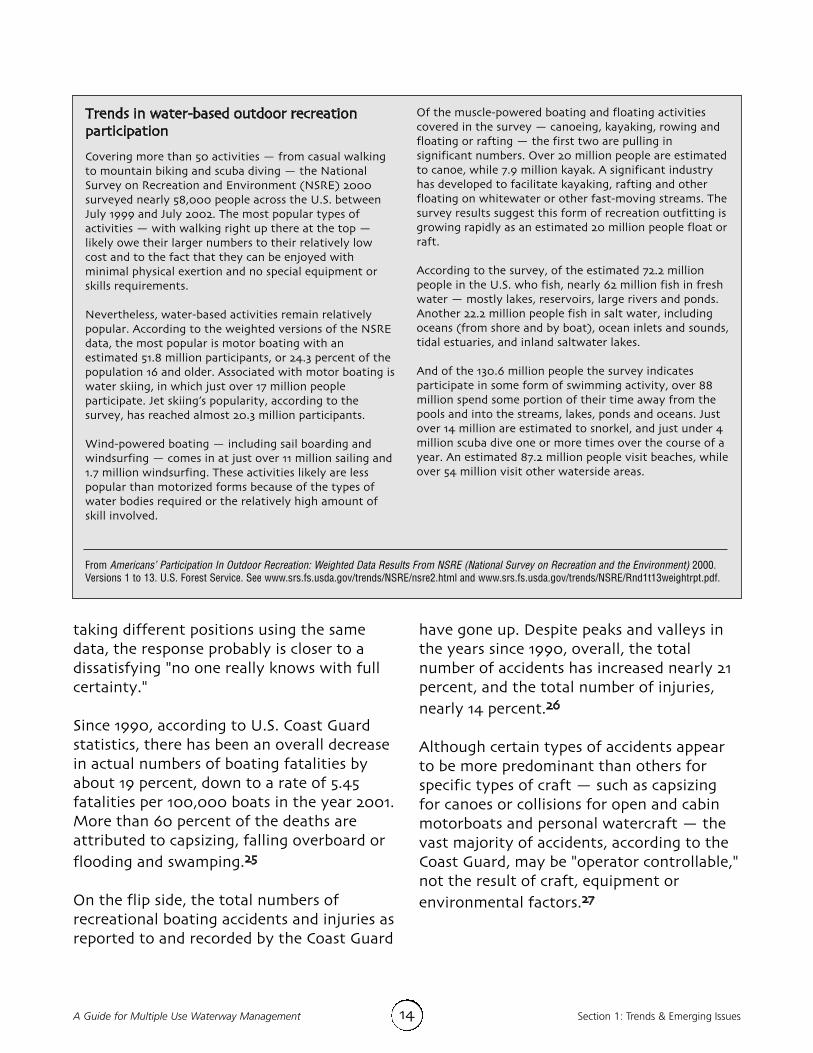
water surface. It’s craft of varying shapes,sizes, speeds, conditions and seaworthiness.21 Add these to the muscle-powered boating and floating craft and thesum, depending on your perspective, eitherrepresents a wonderful array of recreationalopportunity or an odd and incompatiblecombination.It isn’t likely to end here either. Technologicalinnovation and the development of newmaterials are expected to transform boatdesign and production well into the future,and there are signs that the quest forsomething different in outdoor activities willcontinue."Traditional boating" and activities thatboaters and other users might have pursuedon or around the waters — like sunbathing,swimming, water-skiing and fishing — areshowing evidence of only modest growthsince the mid-1990s relative to otheroutdoor activities, and in the case of fishing,showing evidence of holding steady ordeclining in popularity.22
What has been and what likely will continuegrowing in popularity, though, are opposingpursuits along the outdoor recreationspectrum — viewing and learning activitiesand risk adventure activities — both on landand on the waterways.23 That combinationinvites the potential not only for evengreater diversity of activities, but also formore ready-made incompatibilities amongwaterway users.24
What, if anything, does this ongoingevolution in craft and activities signal forthe safety of multiple use waterways andwhat might it foretell for the future?Although regulators and user and industrygroups and advocates on all sides have been
13
14A Guide for Multiple Use Waterway Management Section 1: Trends & Emerging Issues
taking different positions using the samedata, the response probably is closer to adissatisfying "no one really knows with fullcertainty."Since 1990, according to U.S. Coast Guardstatistics, there has been an overall decreasein actual numbers of boating fatalities byabout 19 percent, down to a rate of 5.45fatalities per 100,000 boats in the year 2001.More than 60 percent of the deaths areattributed to capsizing, falling overboard orflooding and swamping.25
On the flip side, the total numbers ofrecreational boating accidents and injuries asreported to and recorded by the Coast Guard
have gone up. Despite peaks and valleys inthe years since 1990, overall, the totalnumber of accidents has increased nearly 21percent, and the total number of injuries,nearly 14 percent.26
Although certain types of accidents appearto be more predominant than others forspecific types of craft — such as capsizingfor canoes or collisions for open and cabinmotorboats and personal watercraft — thevast majority of accidents, according to theCoast Guard, may be "operator controllable,"not the result of craft, equipment orenvironmental factors.27
Trends in water-based outdoor recreationparticipationCovering more than 50 activities — from casual walkingto mountain biking and scuba diving — the NationalSurvey on Recreation and Environment (NSRE) 2000surveyed nearly 58,000 people across the U.S. betweenJuly 1999 and July 2002. The most popular types ofactivities — with walking right up there at the top —likely owe their larger numbers to their relatively lowcost and to the fact that they can be enjoyed withminimal physical exertion and no special equipment orskills requirements. Nevertheless, water-based activities remain relativelypopular. According to the weighted versions of the NSREdata, the most popular is motor boating with anestimated 51.8 million participants, or 24.3 percent of thepopulation 16 and older. Associated with motor boating iswater skiing, in which just over 17 million peopleparticipate. Jet skiing’s popularity, according to thesurvey, has reached almost 20.3 million participants. Wind-powered boating — including sail boarding andwindsurfing — comes in at just over 11 million sailing and1.7 million windsurfing. These activities likely are lesspopular than motorized forms because of the types ofwater bodies required or the relatively high amount ofskill involved.
Of the muscle-powered boating and floating activitiescovered in the survey — canoeing, kayaking, rowing andfloating or rafting — the first two are pulling insignificant numbers. Over 20 million people are estimatedto canoe, while 7.9 million kayak. A significant industryhas developed to facilitate kayaking, rafting and otherfloating on whitewater or other fast-moving streams. Thesurvey results suggest this form of recreation outfitting isgrowing rapidly as an estimated 20 million people float orraft. According to the survey, of the estimated 72.2 millionpeople in the U.S. who fish, nearly 62 million fish in freshwater — mostly lakes, reservoirs, large rivers and ponds.Another 22.2 million people fish in salt water, includingoceans (from shore and by boat), ocean inlets and sounds,tidal estuaries, and inland saltwater lakes.And of the 130.6 million people the survey indicatesparticipate in some form of swimming activity, over 88million spend some portion of their time away from thepools and into the streams, lakes, ponds and oceans. Justover 14 million are estimated to snorkel, and just under 4million scuba dive one or more times over the course of ayear. An estimated 87.2 million people visit beaches, whileover 54 million visit other waterside areas.
From Americans’ Participation In Outdoor Recreation: Weighted Data Results From NSRE (National Survey on Recreation and the Environment) 2000.Versions 1 to 13. U.S. Forest Service. See www.srs.fs.usda.gov/trends/NSRE/nsre2.html and www.srs.fs.usda.gov/trends/NSRE/Rnd1t13weightrpt.pdf.
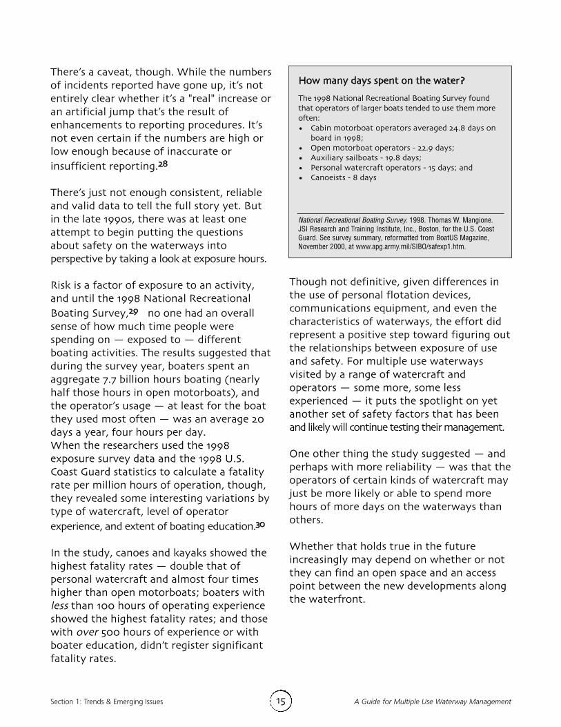
Section 1: Trends & Emerging Issues A Guide for Multiple Use Waterway Management
There’s a caveat, though. While the numbersof incidents reported have gone up, it’s notentirely clear whether it’s a "real" increase oran artificial jump that’s the result ofenhancements to reporting procedures. It’snot even certain if the numbers are high orlow enough because of inaccurate orinsufficient reporting.28
There’s just not enough consistent, reliableand valid data to tell the full story yet. Butin the late 1990s, there was at least oneattempt to begin putting the questionsabout safety on the waterways intoperspective by taking a look at exposure hours. Risk is a factor of exposure to an activity,and until the 1998 National RecreationalBoating Survey,29 no one had an overallsense of how much time people werespending on — exposed to — differentboating activities. The results suggested thatduring the survey year, boaters spent anaggregate 7.7 billion hours boating (nearlyhalf those hours in open motorboats), andthe operator’s usage — at least for the boatthey used most often — was an average 20days a year, four hours per day. When the researchers used the 1998exposure survey data and the 1998 U.S.Coast Guard statistics to calculate a fatalityrate per million hours of operation, though,they revealed some interesting variations bytype of watercraft, level of operatorexperience, and extent of boating education.30
In the study, canoes and kayaks showed thehighest fatality rates — double that ofpersonal watercraft and almost four timeshigher than open motorboats; boaters withless than 100 hours of operating experienceshowed the highest fatality rates; and thosewith over 500 hours of experience or withboater education, didn’t register significantfatality rates.
15
How many days spent on the water?The 1998 National Recreational Boating Survey foundthat operators of larger boats tended to use them moreoften: • Cabin motorboat operators averaged 24.8 days on
board in 1998; • Open motorboat operators - 22.9 days; • Auxiliary sailboats - 19.8 days; • Personal watercraft operators - 15 days; and• Canoeists - 8 days
National Recreational Boating Survey. 1998. Thomas W. Mangione.JSI Research and Training Institute, Inc., Boston, for the U.S. CoastGuard. See survey summary, reformatted from BoatUS Magazine,November 2000, at www.apg.army.mil/SIBO/safexp1.htm.
Though not definitive, given differences inthe use of personal flotation devices,communications equipment, and even thecharacteristics of waterways, the effort didrepresent a positive step toward figuring outthe relationships between exposure of useand safety. For multiple use waterwaysvisited by a range of watercraft andoperators — some more, some lessexperienced — it puts the spotlight on yetanother set of safety factors that has beenand likely will continue testing their management.One other thing the study suggested — andperhaps with more reliability — was that theoperators of certain kinds of watercraft mayjust be more likely or able to spend morehours of more days on the waterways thanothers.Whether that holds true in the futureincreasingly may depend on whether or notthey can find an open space and an accesspoint between the new developments alongthe waterfront.
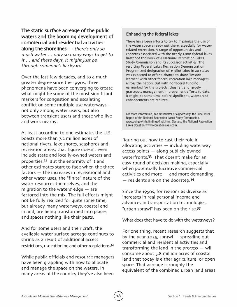
16A Guide for Multiple Use Waterway Management Section 1: Trends & Emerging Issues
The static surface acreage of the publicwaters and the booming development ofcommercial and residential activitiesalong the shorelines — there’s only somuch water … only so many ways to get toit … and these days, it might just bethrough someone’s backyardOver the last few decades, and to a muchgreater degree since the 1990s, threephenomena have been converging to createwhat might be some of the most significantmarkers for congestion and escalatingconflict on some multiple use waterways —not only among water users, but alsobetween transient users and those who liveand work nearby. At least according to one estimate, the U.S.boasts more than 7.2 million acres ofnational rivers, lake shores, seashores andrecreation areas; that figure doesn’t eveninclude state and locally-owned waters andproperties.31 But the enormity of it andother estimates start to fade when the threefactors — the increases in recreational andother water uses, the "finite" nature of thewater resources themselves, and themigration to the waters’ edge — arefactored into the mix. The full effects mightnot be fully realized for quite some time,but already many waterways, coastal andinland, are being transformed into placesand spaces nothing like their pasts.And for some users and their craft, theavailable water surface acreage continues toshrink as a result of additional accessrestrictions, use rationing and other regulations.32
While public officials and resource managershave been grappling with how to allocateand manage the space on the waters, inmany areas of the country they’ve also been
Enhancing the federal lakesThere have been efforts to try to maximize the use ofthe water space already out there, especially for water-related recreation. A range of opportunities andconcerns associated with the nearly 1,800 federal lakeshastened the work of a National Recreation LakesStudy Commission and its successor activities. Theresulting Federal Lakes Recreation DemonstrationProgram and designation of 31 pilot lakes in 20 stateswas expected to offer a chance to share "lessonslearned" with other federal recreation lake managersacross the nation. But with no federal fundingearmarked for the projects, thus far, and largelygrassroots management improvement efforts to date,it might be some time before significant, widespreadenhancements are realized.
For more information, see Reservoirs of Opportunity, the June 1999Report of the National Recreation Lakes Study Commission.www.doi.gov/nrls/findings/final.html. See also the National RecreationLakes Coalition www.recreationlakes.com.
figuring out how to cast their role inallocating activities — including waterwayaccess points — along publicly ownedwaterfronts.33 That doesn’t make for aneasy round of decision-making, especiallywhen potentially lucrative commercialactivities and more — and more demanding— residents are on the doorstep.34
Since the 1950s, for reasons as diverse asincreases in real personal income andadvances in transportation technologies,"urban sprawl" has been on the rise.35
What does that have to do with the waterways?For one thing, recent research suggests thatby the year 2025, sprawl — spreading outcommercial and residential activities andtransforming the land in the process — willconsume about 5.8 million acres of coastalland that today is either agricultural or openspace. That acreage is roughly theequivalent of the combined urban land areas

Section 1: Trends & Emerging Issues A Guide for Multiple Use Waterway Management17
in the New York, Boston, Chicago, LosAngeles and San Francisco metropolitanregions.36
On top of that are the real population shiftsthat have been creating more demands onthe Atlantic and Gulf coastal areas.37 Whathas been described as an "unprecedentedinflux of residents" — an estimated 41million persons from a variety of otherplaces around the country — is turningseasonal resort towns into year-roundcommunities, with year-round demands andthe prospect of year-round pressures on thewaterways.38 Add the inland residents withsecond homes near the shores, and thecount goes up by several million. To get some perspective, that means morethan one in seven Americans live in a countyadjacent to the eastern or southernseaboard. Analysts suggest that barring amajor disruption in current demographic,economic and social trends, thisaccompanying growth pattern along thecoasts is not likely to stop anytime soon.39Even in other parts of the country, thoughnot in as dramatic fashion, the move is andlikely will continue to be on to develop andlive near the waters — inland lakes, rivers,reservoirs. The attraction to the water isthat strong.But for all of the attraction and benefitsassociated with this development,increasingly there have been unanticipateddownsides, from significant strains on theinfrastructure and environment of thetowns, shorelines and waterways to growingtension between the residents and the waterusers themselves.
When the "boating season" doesn’t end, andthe tourists don’t go home…For decades, according to the USA Today analysis thattook a closer look at the changing coastal populations,permanent Cape Cod residents "gathered on highwayoverpasses to wave goodbye —and good riddance —to hordes of summer visitors heading home in bumper-to-bumper Labor Day traffic." But increasingly, thetourists aren't leaving. This once sparsely populated coastal resort for 10months of the year has become a suburbanizedextension of metropolitan Boston. In just five years,the year-round population increased 12 percent, andaccording to the analysis, growth is likely to continuegiven that a third of the Cape’s land remains availablefor development.Each day, on average, six new homes are built on theCape. There have been increased incidents of well-water pollution from septic tanks, which serve 86percent of the homes. Even the tidal Mashpee Riverhas algae buildup created by increased run-off fromthe septic systems. Runoff from new roads and parkinglots is being blamed for higher levels of contaminatedwater.Some shellfishing areas have been restricted, in partbecause of coliform counts.To the South, in Beaufort County, S.C., another areareaping the benefits and the detriments of rapid andexplosive coastal growth, the transplants are comingfrom the East Coast, Midwest and Southeast, and itsresidences hold an appeal to people across theeconomic spectrum. Since 1990, the county’s population has grown 31percent, three times the national average. "People used to come Memorial Day and leave LaborDay. Now they're here to stay," sighed the owner ofthe general store in Bluffton, population 800, andsurrounded by the growth. "It's sad. It's the end of anera. Our small town is gone."
From "Growth reshapes coasts." USA TODAY (on-line) 7/28/00. OwenUllmann, Paul Overberg and Rick Hampson, www.usatoday.com.

Section 1: Trends & Emerging IssuesA Guide for Multiple Use Waterway Management 18
Among the unexpected by-products of thefusion of increasing development andincreasing user pressures on the waterwaysare disagreements and lawsuits overresource quality, user conflicts, landownerrights, easements and restrictions to publicaccess to navigable waters — even whenthose additional access points potentiallycould redistribute use and reduce some ofthe congestion and conflict.40
Varied attitudes and social perspectivesabout recreation and water resources —our individual and collective diversity is showing Whether it’s the newer landowners alongthe shorelines, the long-time residents, thenewcomers to the waterways or theexperienced operators, each has a differentcontext for the experience of living, workingor just being on the waterways. The realitydoesn’t always match up.Researchers have been taking a closer lookat the social and attitude adjustments thataccompany development-related reductionsin public access to the shorelines, theconversion of once pristine areas toresidential and commercial uses, overcrowding,the competition for limited resources, andthe deterioration of resource quality.41
The days of living without thought to theimpact of actions are long gone. Whetherby default or formal regulation, peopleincreasingly are being restricted from usingthe water and shoreline resources in waysthat otherwise would have been possible ifthe areas had remained underdeveloped anduninhabited.42
And there is an unexpected twist: none ofthe affected groups — typically andsimplistically labeled as "boaters" and
"property owners" and "environmentalists"— is likely to be satisfied with therestrictions and decisions for very long.Instead, put simply, depending on wherethey "sit" on or along the waterways, theymay be:
a) Happy to know that personal watercraft won’toperate all hours of the weekend on the waterout their back door, and paddlers with crafthoisted on their car roofs won’t be drivingalongside their property to get onto the water;but unhappy because the more developmentthere is (the same development that broughtthem there), the less scenic the view out theirback window — their shoreline experience justisn’t the same anymore.
Or,
b) Happy to know that another type of watercraftuser — who used to annoy them anyway — willno longer be adding to the numbers on thealready crowded water; but unhappy becausethe more development there is, the less scenicthe view, and the more likely it is that their craftwill be next on the restricted list — their boatingexperience just isn’t the same anymore.
Or,
c) Happy to know that watercraft are beingrestricted so that they won’t damage the aquaticvegetation and pollute the waters; but unhappybecause it was development of the shorelinesthat precipitated the restrictions in the firstplace — their waterway just isn’t the sameanymore.
To make things even more complicated,there’s likely even some mix and match ofsentiment, because the labels attributed to"boaters" or "property owners" or"environmentalists" aren’t mutually exclusive.

Section 1: Trends & Emerging Issues A Guide for Multiple Use Waterway Management
Increasingly, and into the future, then,managers and planners of multiple usewaterways face the prospect of peelingthrough layers of issues and concerns thathave collapsed on each other, layers ofincremental decisions, and layers of intereststhat have been organized in recent years torepresent a spectrum of opinions onrecreation, residential and commercialactivity, the environment, and more.And no set of issues has surged to theforefront and become entangled with moreaspects of boating, water-related activities,and multiple use waterways themselves than
those multifaceted issues related to theenvironment.
Increased visibility and prominence ofenvironmental issues and interests —shaping the context of individualresponsibility … and the regulatory environment From the Marine Mammal and EndangeredSpecies Protection Acts to the NationalEnvironmental Policy and Clean Water Acts;from wilderness, refuge and sanctuarydesignations to essential fish habitats and
19
PWCs — the compact craft that provokes a big reactionThe fodder of lawsuits, recent National Park Servicedecisions, and local ordinances and proposals intended torestrict or outright ban their operation, personal watercraft –and their operators – seem to elicit a spectrum of reactionsfrom other recreational boaters, environmental interests,enforcement officers and resource managers, among others.And the relative scarcity of scientific data on the specificimpacts of their use does not do much to help inform thedebates and problem-solving about their role in multiple useconflicts, in accidents and other incidents, or in damage tothe environment or the more intangible "quality of life" onor around the waterway. But are the "clashes" between traditional recreationalboaters and PWC operators really so unlike that of past"conflicts" that occurred when newer and different types ofcraft were introduced on the waterways? The Recreational Boat Building Industry took a look at pastoutdoor recreation conflicts to see whether or not conflictreduction used in those cases might be applied in thisupdated scenario. For the most part, they found that thecurrent conflicts parallel the conflicts that have arisen in thepast. How so? • They have been technology driven. Many recreational
conflicts have involved newer more intrusive —noisy,faster, wider ranging, greater environmental impact —technologies;
• Many recreational conflicts of the past can becharacterized as mechanized versus non-mechanized,and though it might be a bit of a stretch, since PWCsare so fast and intrusive compared to some otherboats, the latter might almost be considered "non-mechanized" in comparison;
• The conflicting groups have tended to be of differentages and lifestyles. In current case, the average motorboater tends to be older, while PWC operators tend tobe younger, and perhaps more tolerant of differentlifestyles than older people. If nothing else, thestereotypes would suggest that PWC operators seekadventure and physically demanding recreation withstrong social experiences, while more traditionalrecreational boaters tend to seek quieter, relaxing,nature oriented, non-physical leisure experiences;
• One group generally was well established before theother came along. In this updated case, traditionalrecreational boaters had the water to themselves for along time. PWCs are a recent development on the"boaters’ water"; and,
• And, as in other conflicts, there has never beenunanimity of "annoyance." Some members of the"offended group" have not been and will not beoffended. There are recreational boaters and shorelineresidents who are tolerant of PWCs and theiroperators.
All of which suggests that PWCs and PWC operators are justsome of the more recent in the evolutionary lineup ofwatercraft and "new" boaters on the waterways.
See Discussion of the Boaters vs. PWCs Conflict Based on the Research Literature. Recreational Boat Building Industry. See www.rbbi.com/white/conflict/discuss.htm, and Personal Watercraft (PWC) Management Guide: a Comprehensive Reference Handbook. July 2002. Shari Currey. Prepared for theMassachusetts Office of Coastal Zone Management and Massachusetts Bays National Estuary Program. www.state.ma.us/czm/pwcmgntguide.htm.

20A Guide for Multiple Use Waterway Management Section 1: Trends & Emerging Issues
everything in between — keeping up withthe nuances of legislation and layers ofregulations and designations to protect orredirect resources can be a challenge initself.43 Another challenge these days?Keeping track of the status and outcomes oflitigation.Conservation and protection issues havebeen a part of our often-contentiousenvironmental history as a nation. Andwhile the demand for and strains onresources may be unprecedented, theenvironmental concerns and clashesthemselves are not as new as we might think.44
Where we seem to be parting companyfrom the past is in the volume and variety ofspecial protections for a variety of resourcesand of formal groups advocating on behalfof those resources and interests; in theincreasing reliance on lawsuits; and in morerecent years, in the framing of a range ofvery significant waterways-relatedenvironmental issues in ways that have hadthe effect of squaring recreationists againstrecreationists, recreationists against shoreresidents, recreationists and tourists againstgovernment and industries, and — addingyet another dimension to the concept ofconflict among users of the waterways —squaring recreationists, tourists and industryagainst manatees, waterfowl, submergedaquatic vegetation and other wildlife formsalong and in the waterways.And today, there often is more debate aboutobservations of the impacts of recreationalactivity and boating on the waterways,shorelines and marine wildlife, waterfowland vegetation, than there is scientific andcausal evidence of the exact nature of thoseimpacts, their cumulative effects, and therelative impacts of different types of craftand activities.45
Why? One reason is that sorting throughand pinpointing the effects or the severityof effects of watercraft and water contactactivities from those of other possiblesources calls for longer-term and moreconsistent monitoring.46 Despite the factthat the outcomes of such monitoringmight thwart the need for repeatedamendments to actions taken in theabsence of complete information, the
Endangered Species Act — from EndangeredRivers to Piping Plover habitat The Endangered Species Act — its intent andapplication — has been at the center of controversiesranging from water levels to maintenance dredging. In April 2002, American Rivers released its America’sMost Endangered Rivers Report, with the MissouriRiver at the top of the list. Using a National Academyof Science (NAS) report of the Missouri River as thebackdrop, the American Rivers report pointed to NASfindings that indicated "dam operations — with steadynavigation flows ‘counter to established river science’— had cost the region ‘nearly one million recreation-based days of hunting, fishing, sightseeing, andboating annually" for the benefit of "just a handful ofbarges on the lower river." The American Riversassessment ended with a plea for the Corps — and aplea to the U.S. Congress — to select the "flexible flow"alternative in its environmental impact statement andin doing so, satisfy its obligations to the EndangeredSpecies Act. In another incident, the Gulf Intracoastal CanalAssociation (GICA), originally organized in 1905 topromote the idea of a single channel that wouldconnect all major Gulf coast ports, listed among itsinitiatives, "defending the (Gulf Intracoastal)waterway from ‘misguided’ attempts to apply theEndangered Species Act on several fronts." More specifically, it was referring to Louisiana’s Coast2050 Program, along with the U.S. Fish and WildlifeService’s proposal to designate thousands of acres ofGulf Coast wetlands as critical Piping Plover habitat,thereby threatening the "viability of the waterway.""Left unanswered," GICA argued, "these initiativeshave the power to stop all maintenance dredging on thewaterway."

Section 1: Trends & Emerging Issues A Guide for Multiple Use Waterway Management21
long-term process flies in the face of whathas increasingly become a national, perhapseven media-driven, "need to know … now"orientation.And whether perceived as "good" or"flawed," this combination of availableinformation and arguments — based onrhetoric, science, observation, research,speculation and everything in between —has contributed to the content of decision-and policy-making in recent years. Theoutcomes will continue to affect how and towhat extent multiple use waterways aremanaged well into the future.
EPA 2006 emission standardsAs much a "multiple use" waterway conflict as twoboaters vying for the same spot of water, the "clashes"between polluting, inefficient, noisy watercraft andthe perceived and real quality of the boating andresource experience have spawned regulatory andbehavioral shifts in recent years. When the Environmental Protection Agency issued arule revising the Clean Air Act of 1990 and setting a2006 deadline to reduce hydrocarbon emissions fromspark ignition marine outboards and personalwatercraft engines by 75 percent, perhaps few wouldhave predicted that the marine industry could meetthe compliance schedule. But part of the way into thenine-year phase-in program — which began with the1998 model year and was intended to becomeprogressively tighter each year through 2006 —engine manufacturers are priding themselves onmeeting and even exceeding the requirement with thedevelopment of new four-stroke and direct-injectiontwo-stroke engines. And though the less efficient andless clean pre-1997 marine engines remain "legal" onthe waters,1 the push is on to get the older equipmentinto "early retirement," not only through aggressivetechnological improvements, but also industrymarketing and even state-level consumer educationefforts.For the language of the EPA final rule, seewww.epa.gov/fedrgstr/EPA-AIR/1997/August/Day-07/a20821.htm.
1 All waters except Lake Tahoe and specific reservoirs in California.
At the beginning of this section, the openingquote speaks to the management "successstories" that will come from those who"correctly anticipate" trends and "work outsolutions to problems before they becomecrises." But even then, as the second quotesuggests, there will still be those "numerouschanges difficult to predict."
" … The greatest threat along the river is from asmall vessel loaded with explosives that could bedetonated near an oil tanker or a cruise ship…"— Remarks of a U.S. Senator at a hearing conducted in New
Orleans early in 2002 47
Whatever definitions we had for safety andsecurity and even conflict on the waterwaystook on entirely new dimensions andreexamination after the horrific nationalevents of September 11, 2001.48
With impacts ranging from minorinconvenience to severe restriction, a seriesof actions and alerts have added to thealready-complex operations andmanagement of some multiple use waterways. Existing security zones49 have beenmodified and expanded to safeguard navalvessels and other waterside facilities and toprevent recreational and commercialwatercraft from interfering with militaryoperations. For the first time since WorldWar II, and continuing as of this writing,100-yard security zones are in effect aroundall U.S. naval vessels.50
Recreational boaters have been called uponto report suspicious activity and serve asextra eyes to the U.S. Coast Guard, nowhoused in a recently created Department ofHomeland Security and remaining on aheightened state of alert and patrol. And asof this writing, in some parts of the country,

Section 1: Trends & Emerging IssuesA Guide for Multiple Use Waterway Management 22
boaters entering municipal water supplyreservoirs that double as recreation areashave to get used to the possibility that theirvessels may be inspected upon entry to thewaterway.51
A different world since 9-11, making forthose "numerous changes difficult to predict."All the more reason for the managers,planners and regulators of multiple usewaterways to prepare for continuousobservation, learning and adaptation.52

Section 1: Trends & Emerging Issues A Guide for Multiple Use Waterway Management23
1 From Paul W. Box, Bottom-Up Simulation for Evaluation ofRecreational Boat Traffic Monitoring. 1997. Dissertation.University of Florida. See www.gis.usu.edu/~sanduku/public_html/dissertation/outline/node1.html.
2 From the testimony of Rodney Gregory, Chair of the MarineBoard Seminar on Waterway and Harbor Capacity, to the U.S.House Committee on Transportation and Infrastructure,Subcommittee on Coast Guard and Maritime TransportationOversight Hearing on Port and Maritime Congestion, May 23,2001. The Marine Board of the National Research Council’sTransportation Research Board conducted the seminar on April,23, 2001, Washington, D.C. For Gregory’s testimony, seewww.nas.edu/trb/publications/MarineBoard/2001Waterway&Harbor/GregoryTestimony.pdf.
3 From remarks by Geoffrey Godbey, The Pennsylvania StateUniversity, at The Futures Forum on Recreational BoatingHighlights. April 1-3, 2001, St. Petersburg, Fla. Sponsored by theNational Association of State Boating Law Administrators(NASBLA), and produced under a grant from the AquaticResources (Wallop-Breaux) Trust Fund administered by the U.S.Coast Guard. See www.nasbla.org/pdf/Forum_Highlights.pdf.
4 Calculated from Boating 2002, State Recreational BoatRegistrations (using state figures compiled and provided by theU.S. Coast Guard), National Marine Manufacturers Association(NMMA) Facts & Figures, online, www.nmma.org/facts. Whilethese figures suggest a 429 percent increase over time, cautionmust be exercised in using registration counts as a sole point ofreference. There are many small, non-powered craft that are notrequired to be registered by the states or are not registered byowners; those non-registered craft include large categories suchas canoes and utility boats.
5 Calculated from Boating 2002, 2002 Population Estimates,National Marine Manufacturers Association (NMMA) Facts &Figures, online at www.nmma.org/facts. Just over 48 percent ofthe estimated 17.3 million boats owned are outboard motorboats, according to industry figures. Sterndrives represent about10 percent; inboards, 9.8 percent of the total; sailboats, 9.3percent; and personal watercraft, 7.8 percent. "Miscellaneous"and "other" craft — that is, canoes, rowboats, dinghies, andothers, whether registered or not by the states — account for alarger portion of the total. They represent about 14.6 percent.
6 "A Profile Of Recreational Boating In The United States." 1999.Ryck Lydecker and Margaret Podlich. From Proceedings of aWorkshop, January 22, 1999, Washington, D.C. in Trends andFuture Challenges for U.S. National Ocean and Coastal Policy.August 1999. Cicin-Sain, B., R. W. Knecht, and N. Foster, eds.Center for the Study of Marine Policy, University of Delaware.See www.nos.noaa.gov/Products/retiredsites/natdia_pdf/14boatus.pdf.
7 Calculated from Boating 2001, 2001 Population Estimates, andBoating 2002, 2002 Population Estimates, National MarineManufacturers Association (NMMA) Facts & Figures, online,www.nmma.org/facts.
8 See the "The National Survey on Recreation and theEnvironment 2000," U.S. Forest Service, atwww.srs.fs.usda.gov/trends/Nsre/Rnd1t13weightrpt.pdf.
9 National Recreational Boating Survey. 1998. Thomas W.Mangione. JSI Research and Training Institute, Inc., Boston, forthe U.S. Coast Guard. See survey summary, reformatted fromBoatUS Magazine, November 2000, at www.apg.army.mil/SIBO/safexp1.htm.
10 In just one example of the importance of distinguishing localactivity from national boating averages, a study on southwestFlorida boating activity reported that while there had been a100 percent increase in the number of registered recreationalboats nationwide in the period 1973 to 1989, there had been a300 percent increase in the state’s southwest coastal countiesduring the same period. See Gustavo Antonini and Paul Box, Aregional waterway systems management strategy for southwestFlorida. 1996. Technical Report TP-83, Florida Sea Grant CollegeProgram, University of Florida, Gainesville. As reported in Box,Bottom-Up Simulation for Evaluation of Recreational BoatTraffic Monitoring.
11 For information on the Marine Transportation System, and"Vision 2020," an initiative to develop a common vision of thefuture of the MTS, see www.dot.gov/mts. For a PowerPointbriefing on the MTS, see www.dot.gov/mts/document/Brief forD8 CO Conf – Nov 00.ppt
12 From Navigation – Waterways Facts. U.S. Army Corps ofEngineers. See http://education.wes.army.mil/navigation/waterwy.html.
13 Marine Board (of the National Research Council’sTransportation Research Board) Seminar on Waterway andHarbor Capacity, April 23, 2001. Washington, D.C. SeeIntroduction, www.nas.edu/trb/publications/MarineBoard/2001Waterways&Harbor/Introduction.pdfSee Transcripts,www.nas.edu/trb/publications/MarineBoard/2001Waterway&Harbor/Transcript 1.pdf and www.nas.edu/trb/publications/MarineBoard/2001Waterway&Harbor/Transcript 2.pdf. See Testimonyof Rodney Gregory (Seminar Chair), House Committee onTransportation and Infrastructure, Subcommittee on CoastGuard and Maritime Transportation Oversight Hearing on Portand Maritime Congestion, May 23, 2001. www.nas.edu/trb/publications/MarineBoard/2001Waterway&Harbor/GregoryTestimony.pdf
14 From Lt. Alan L. Blume, Office of Vessel Traffic Management,U.S. Coast Guard Headquarters, "Waterway Management andthe Operation of High-Speed Ferries. 2001." Marine Log FerriesConference on TEA-21 Funding for Ferries and Terminals,Orlando, Fla., Nov. 2001. See www.uscg.mil/hq/g-m/mw/documents/wwm and operation of HS Vsls.pdf
15 Narragansett Bay Summit 2000 (April 24-25, 2000, Providence,R.I.), Reports and Recommendations. "White Paper CommercialMarine Transportation On Narragansett Bay: Status, Trends &Issues," see www.nbep.org/summit/pdf/marinetrans.pdf."Marine Recreation and Tourism in Narragansett Bay: CriticalValues and Concerns," see www.nbep.org/summit/pdf/rectour.pdf."Summit Recommendations," see www.nbep.org/summit/pdf/rep2000.pdf.
16 For more on the concerns associated with operating thesevessels at higher speeds, see Blume, "Waterway Managementand the Operation of High-Speed Ferries."

24A Guide for Multiple Use Waterway Management Section 1: Trends & Emerging Issues
For example, according to Blume, two nautical miles is aprobable range at which the operator of a high-speed vessel islikely to detect and monitor small commercial and recreationalvessels. Many commercial vessels, including most high-speedones, are fitted with an automatic radar plotting aid (ARPA).However, the operator of a vessel fitted with an ARPA unitcannot rely exclusively on it to track other vessels, such as seakayaks or other small recreational vessels that might only bedetected and tracked under certain favorable conditions. Mosthigh-speed vessels in the U.S. currently operate at speedsbetween 30 and 40 knots, and the vessels that will most likelybe overtaken within three minutes or less will probably besmaller commercial vessels and a significant portion of therecreational fleet.For commentary on the prospects of pollution and otherenvironmental concerns, see Fast Ferries: Clean Water Transitor More Dirty Diesel? See www.bluewaternetwork.org/campaign_ss_ferries.shtml. For information from the HighSpeed Ferry Task Force of Long Island Sound, formed to discussand resolve safety and environmental issues in that area, seewww.fastferryinfo.org.
17 Begun in 1960 by the congressionally-created OutdoorRecreation Resources Review Commission, the first NationalRecreation Survey was a four-season, in-the-home survey ofoutdoor recreation participation in the U.S. Since that time, fiveadditional surveys have been conducted in 1965, 1970, 1972,1977, and 1982-83, and two National Surveys on Recreation andthe Environment in 1994-95 and 2000-2001. Seewww.srs.fs.usda.gov/trends/Nsre/nsre2.html.
18 From Jeffrey Hoedt, "Recreational Boating – Are the WatersToo Crowded?" Report prepared for the 1999 Congress onRecreation and Resource Capacity, Aspen, Colo.,November/December 1999.
19 Ibid.20 See the "The National Survey on Recreation and the
Environment 2000," U.S. Forest Service, atwww.srs.fs.usda.gov/trends/Nsre/Rnd1t13weightrpt.pdf.
21 For an extreme example of "varying" sea worthiness, see theunusual case of a "dock-turned-boat" — an effort by oneConnecticut family with a deeded right of way on a inland laketo be free of their town’s zoning regulations by transformingtheir dock into a "boat," complete with temporary boatingregistration. See Jennifer A. Peyton, "A floating disagreement,"Waterbury Republican-American, Sunday, Jan. 5, 2003 atwww.rep-am.com.
22 See especially, Participation in Boating and Fishing: A LiteratureReview—Executive Summary and Full Report. September 2000.Anthony J. Fedler. Human Dimensions Consulting, Gainesville,Fla., for the Recreational Boating and Fishing Foundation. Seewww.rbff.org/research/ExecSumm-LitReview.pdf (ExecutiveSummary) and www.rbff.org/research/Lit-Review-Final.pdf (FullReport); and Factors Related to Recreational BoatingParticipation in the U.S.: A Review of the Literature FinalReport. August 16, 2000. Responsive Management, Inc.,Harrisonburg, Va., for the National Association of State BoatingLaw Administrators. See www.nasbla.org/pdf/Boating Participationreport.pdf
23 See remarks of Ken Cordell, U.S. Forest Service, on "TheNational Survey on Recreation and the Environment 2000,"from the Futures Forum on Recreational Boating Highlights.April 1-3, 2001, St. Petersburg, Fla. Sponsored by the NationalAssociation of State Boating Law Administrators (NASBLA), andproduced under a grant from the Aquatic Resources (Wallop-Breaux) Trust Fund administered by the U.S. Coast Guard. See www.nasbla.org/pdf/Forum_Highlights.pdf
24 According to Cordell, the National Survey on Recreation and theEnvironment 2000 and preceding recreation surveys even showvery different demographic and socioeconomic "footprints" oftraditional boaters. See "The National Survey on Recreation andthe Environment 2000," from the Futures Forum onRecreational Boating Highlights. See www.nasbla.org/pdf/Forum_Highlights.pdf
25 See U.S. Coast Guard Recreational Boating Accident ReportDatabase and Recreational Boating Statistics for given years.See www.uscgboating.org/stats.htm; and Factors Related toRecreational Boating Participation in the United States. August16, 2000. Responsive Management, Harrisonburg, Va. Seewww.nasbla.org/pdf/Boating_Participation_report.pdf.
26 Ibid. 27 From "2000 Recreational Boating Statistics, Accidents by Boat
Type," in Resources and Statistics, 2002 North American SafeBoating Campaign. See www.art4use.com/02statistics/02statbook.pdf.
28 See Hoedt, "Recreational Boating – Are the Waters TooCrowded?"; and Shari Currey, Personal Watercraft (PWC)Management Guide: a Comprehensive Reference Handbook.July 2002. Prepared for Massachusetts Office of Coastal ZoneManagement and Massachusetts Bays National EstuaryProgram. See www.state.ma.us/czm/pwcmgntguide.htm.
29 From Thomas W. Mangione, National Recreational BoatingSurvey. 1998. Conducted by JSI Research and Training Institute,Inc., Boston, for the U.S. Coast Guard. See survey summary,reformatted from BoatUS Magazine, November 2000, atwww.apg.army.mil/SIBO/safexp1.htm.Boat owners, operators and renters in 46 states and the U.S.Virgin Islands were surveyed about their boating experiences in1998. The survey had an 80 percent response rate out of a totalsample of 36,000.
30 Ibid. To get the number of fatalities per million hours ofboating, the results were compared to the 1998 U.S. CoastGuard boating fatality statistics.
31 From Mary Bielen, et. al., Providing Public Access in CoastalAreas: Options for Landowners. 1996. A fact sheet produced bythe Great Lakes Sea Grant Network, Coastal Land UseCommittee. See www.cce.cornell.edu/seagrant/tourism/publicaccessfs.html.
32 Despite the amount of recent publicity on personal watercraft,the users of those craft are not the only ones affected byrestrictions. The demand for river recreation floatingopportunities has caused river managers to limit and ration use.At last count, about 19 popular river segments in the westernU.S. had rationed use limits in place, most for more than 20years. See more in session paper abstract, "Comparison ofStrategies for Rationing and Managing use on Selected Western
Section 1: Trends & Emerging Issues A Guide for Multiple Use Waterway Management
Rivers in the United States in 1986 and 1998." 1999 CongressOn Recreation And Resource Capacity Book Of Abstracts. SusanScott Lundquist and Glenn E. Haas, Compilers. Nov. 29 – Dec. 2,1999, Aspen, Colo. Hosted by The Human Dimension in NaturalResources Unit, College of Natural Resources, Colorado StateUniversity, Fort Collins, Colo. See www.cnr.colostate.edu/nrrt/capacity.
33 See for example, "Marine Recreation and Tourism inNarragansett Bay: Critical Values and Concerns," NarragansettBay Summit 2000 (April 24-25, 2000, Providence, R.I.), Reportsand Recommendations. See www.nbep.org/summit/pdf/rectour.pdf.
34 Competing demands for use of the shoreline and the increasingvalue of waterfront property have displaced many traditionalwaterfront activities. State and local governments haveresponded with innovative policies and techniques to preservewater-dependent uses and traditional working waterfronts.Today, state and local policies that give preference to water-dependent uses cover 97 percent of the U.S. shoreline. See"Preserving Waterfronts for Water Dependent Uses," KennethWalker and Matt Arnn. In NOAA's State of the Coast Report1998. Silver Spring, Md.: National Oceanic and AtmosphericAdministration. See http://oceanservice.noaa.gov/websites/retiredsites/sotc_pdf/wdu.pdf.
35 From "Coastal Urban Sprawl Projected to Consume 5.8 MillionAcres in Next 25 Years." 12-07-00. Illinois-Indiana Sea GrantCollege Program. See www.seagrantnews.org. ResearcherDaniel McGrath, Coastal Business and Environmental Specialistfor Illinois-Indiana Sea Grant and a Fellow at the University ofIllinois at Chicago's Great Cities Institute, has been studying theurban sprawl patterns of the top 20 coastal metropolitanregions ranked by population. Using population statistics fromthe 1990 U.S. Census and urban land area data from the pastfive decades, McGrath arrived at his forecast for the year 2025.
36 Ibid.37 From Owen Ullmann, Paul Overberg and Rick Hampson,
"Growth reshapes coasts." USA TODAY (on-line), 7/28/00.,www.usatoday.com.
38 Ibid. According to the USA Today analysis, the West Coast hasnot experienced the same recent mass migration, because itsbeaches and bluffs are more protected from potentialdevelopment. Climate also is a factor. Unlike the north-flowingGulf Stream, which tempers surf temperatures along the EastCoast, the south-flowing California current isn’t quite as warm.
39 It may have to slow at some point, however. The expectationhas been that as America’s 78 million baby boomers age, theyare going to look for more pleasant surroundings to spend theirretirement years. Until the years 2001-2002, boomers wereexpected to have the financial resources to fulfill theirretirement hopes. But a lengthy period of economic and stockmarket downturns that have put personal financial retirementplans in jeopardy may modify at least some of the earlier trendline projections.
40 See the examples in "Recreational Boating Carrying Capacity: AFramework for Managing Inland Lakes: Proceedings of aWorkshop," August 23, 1995. 1996. Edward M. Mahoney andDaniel J. Stynes. Sponsored by Michigan Boating IndustriesAssociation and the Department of Park, Recreation andTourism Resources, Michigan State University. See
www.msu.edu/course/prr/879/spring2000/boatrcc.doc41 See Box, Bottom-Up Simulation for Evaluation of Recreational
Boat Traffic Monitoring, and examples of attitude changesamong recreational users of Florida's coastal environmentsdocumented in Gustavo Antonini and Paul Box, A regionalwaterway systems management strategy for southwestFlorida. 1996. Technical Report TP-83, Florida Sea Grant CollegeProgram, University of Florida, Gainesville; Gustavo Antoniniand Charles Sidman, Feasibility of a non-regulatory approach tobay water management. 1994. Technical Report 74, Florida SeaGrant College Program, University of Florida, Gainesville; andGustavo Antonini, et.al. Boat live-aboards in the Florida Keys:A new factor in waterfront development. 1990. TechnicalReport SGR-98, Florida Sea Grant College Program, Universityof Florida, Gainesville.
42 See Box, Bottom-Up Simulation for Evaluation of RecreationalBoat Traffic Monitoring.
43 For just one example of how environmental designations mightbe used or interpreted in ways unintended or unexpected, see"Apostle Island Proposal would limit boating," Boating IndustryInternational Online, 7/26/2002, www.boating-industry.com.The U.S. National Park Service (NPS) sought public commentas part of an ongoing wilderness study for Apostle IslandsNational Lakeshore. According to a press release issued by agroup called the All Volunteer Yacht Club (AVYC), environmentalgroups seeking restrictions on motorboat access in the LakeSuperior, Wisconsin area had submitted most of the responseto the alternative development phase. The AVYC argued thatwhile the Park Service was maintaining that a wildernessdesignation would not infringe on motorboat access to theislands as the waters of Lake Superior were not included in thearea under consideration, the designation had the potential to‘severely restrict where docks are located’ and ‘prohibit thedevelopment of new docks and visitor use facilities, in effectlimiting power/sail boat access’ since much of the shoreline isshallow, rocky and exposed to the elements. The Park Servicehas maintained that existing docks will not have to be removedif a wilderness designation is made because they extend outinto the lake and rest on state-owned submerged land. Boththe AVYC and the Park Service, however, do seem to agree thatany goal of a sailboat- or motorboat-free Lakeshore is notentirely feasible as the NPS jurisdiction only extends a quarterof a mile from shore.
44 From the plenary remarks of Professor Louis Warren,University of California-Davis, on U.S. environmental history atthe 1999 Congress On Recreation And Resource Capacity, Nov.29 – Dec. 2, 1999, Aspen, Colo. Hosted by The HumanDimension in Natural Resources Unit, College of NaturalResources, Colorado State University, Fort Collins, Colo. SeeBook Of Abstracts. Susan Scott Lundquist and Glenn E. Haas,Compilers. www.cnr.colostate.edu/nrrt/capacity.
45 For more detail, see references in Section 4. References andResources: A starting point for exploration, in this Guide. Also,see Shari Currey, Personal Watercraft (PWC) ManagementGuide: a Comprehensive Reference Handbook. July 2002.Prepared for Massachusetts Office of Coastal ZoneManagement and Massachusetts Bays National EstuaryProgram. See www.state.ma.us/czm/pwcmgntguide.htm. Seeespecially pages 15-47 for discussion, and pages 40-47 for morereferences on noise, marine engine emissions, wildlife, andsubmerged aquatic vegetation.
25

Section 1: Trends & Emerging IssuesA Guide for Multiple Use Waterway Management 26
46 Ibid. For more detail, see references in Section 4. Referencesand Resources: A starting point for exploration.
47 Remarks attributed to U.S. Senator John Breaux, D-La.,chairman of the Senate Surface Transportation and MerchantMarine Subcommittee at a hearing in New Orleans, La., andincluded in a presentation by Joan M. Bondareff, "Boating in anInsecure World: Recreational Boating’s Role in Port & HarborSecurity," at the International Boating and Water SafetySummit, April 30, 2002, Daytona Beach, Fla. Originallyreported in "Plugging Security Gaps," Bill Hensel, Jr., January 21,2002, JoC (The Journal of Commerce) Week. Seewww.joc.com/jocweek.
48 Even before the terrorist attacks on the World Trade Centerand the Pentagon, the U.S. Navy had been reviewing all aspectsof its anti-terrorism and force protection posture in response tothe earlier attack on the USS COLE.
49 Security zones, established under the Magnuson Act (50 USC191), are intended to protect ports against sabotage orsubversive acts. They can be permanent or temporary, overland or water, and can move. Safety zones, established underthe Ports and Waterways Safety Act (33 USC 1221) for safety orenvironmental purposes, can be permanent or temporary, overwater or land, and the zone can move.
50 Boats must operate at minimum speed within 500 yards of anynaval vessel. If a boat needs to pass within 100 yards in orderto ensure safe passage in accord with the Navigation Rules ofthe Road, the operator must contact the vessel on VHF-FMchannel 16. Violations are more than serious, with charges as afelony offense, punishable by up to six years in prison and/orup to 250,000 in fines. Also as of this writing, the Coast Guard remains on heightenedstate of alert at over 361 major ports, and continues to escortcruise ships in Miami, Honolulu, New Orleans, Hampton Roads,Los Angeles and San Diego.
51 For example, the San Diego City Lakes Program website, warnsboaters that "due to increased security measures, vessels maybe inspected as a requirement for entry into the lakes. Formore information on the program, see www.sannet.gov/water/recreation/index.shtml.
52 See discussion on pages 3-5 of this Guide and in Glenn E. Haas,Visitor Capacity on Public Lands and Waters: Making BetterDecisions. 2002. A Report of the Federal Interagency TaskForce on Visitor Capacity on Public Lands submitted to theAssistant Secretary for Fish and Wildlife and Parks, U.S. Dept.of the Interior, Washington, D.C.

Section 2: Developing Plans & Solutions 27 A Guide for Multiple Use Waterway Management
? ? ?
"Most solution-finding exercises fail because peopledo not properly identify what they don’t like and whyit’s happening. That is, they don’t properly define theproblem and show what is causing it. … you maythink you already know what the problem is, what iscausing it, and therefore how a [restriction] will bethe answer. Perhaps you think the problem is thatthere are too many boats on your lake and that thereare no rules to stop them from traveling too fast, toooften, or too close to shore. But that’s not theproblem. It is merely a symptom of what might be aproblem. …" — Canadian regulatory process expert in the localauthorities guide on Boating Restrictions1
" … [T]hey don’t properly define theproblem and show what is causing it. …"That’s one of the potential hazards of takingshortcuts in planning and decision-making.Even if you don’t take shortcuts, though,there are plenty of other things that cancomplicate the problem identification,problem solving and management activitiesassociated with multiple use waterways. Like the implications of those broad trends,issues and forces touched upon in theprevious section, or the unique circumstancesof a waterway and its surroundings.In this section, we offer some things to mullover along the way to developing viable,credible and defensible multiple usemanagement strategies, plans and resolutions.Some are fundamental in any efforts toidentify issues, analyze and solve problems,balance interests or resolve conflict. Someare based on simple but timely "lessonsworth learning," "reminders" and "things tobe aware of," offered by resource managers,
planners, regulators and other waterwaystakeholders. Some, read at a comfortabledistance from the epicenter of a conflict,might seem "obvious."Sometimes, we just overlook them.
SECTION 2: DEVELOPING PLANS AND SOLUTIONS FOR MULTIPLE USE WATERWAY ISSUES AND CONFLICTS
Things to consider … even if you don’t want to
• Bring waterway stakeholders from other agencies andorganizations "to the table" early on and allow them toreveal their different, perhaps disconnected or conflictingagendas, objectives and priorities. • Make an effort to gather and understand the views ofthe "general public." • Decide and state upfront what you want to accomplishin your planning activities … and what you and otherstakeholders want to achieve for the future of thewaterway.• Create indicators that can be measured and monitoredover time to determine whether your strategies arebringing those hoped-for conditions closer to reality.• Factor in the broader regional or systemic impact ofyour decisions when you are considering managementchanges.• Pay attention to the layers of jurisdiction over yourwaterway and shorelines, and the complex regulatoryand policy frameworks that could affect your plans andactions.• Develop explicit decision criteria that factor ineverything from the degree to which a managementdecision is backed by science to how a decision mightaffect the integrity of the recreational experience or theenvironment.• Get a better handle on the perceptions of partiesaffected by waterway management decisions in order toimprove your information gathering, participation,communication and implementation approaches. • Learn to use data and information appropriately inyour planning, management and monitoring activities. • Become well informed about what’s happening inother places, but set management priorities based onyour understanding of your users and the features ofyour waterway.
Shorthand reminders for planning anddecision making...

28A Guide for Multiple Use Waterway Management Section 2: Developing Plans & Solutions
So, what are you planning?Slide out of crisis mode, start looking ahead… and be prepared to work with what youdiscoverThe first edition of the Guide put thespotlight on the "how-to’s" and benefitsassociated with responsible multiple usewaterway management planning at a timewhen there was little else in the way ofguidance for developing these sorts of plans.2
Today there’s more planning advice and alot more activity that has assumed the"planning" label. Over time, strategic and management andother kinds of planning processes gravitatedfrom the private into the public sector forapplication in all sorts of functional areas. After a bit of trial and error, though, itbecame increasingly clear that someplanning components and activities wouldhave to be rearranged or tweaked toaccommodate the often-uniquecircumstances of planning for publicmatters, including public multiple usewaterways. Like the fact that legislationmay not only dictate that you have amanagement plan before you take action,but also how you develop and conduct it. Nevertheless, some things about planningjust seem to transcend sectors.3
Things like how difficult it can be togenerate widespread interest in initiating amethodical, time-consuming planningprocess when there’s no crisis to propel it.Or how it can be even more difficult tomaintain a high level of interest in pushingplans toward implementation andmonitoring and evaluation. Or how hard it
Some principles that can guide waterwaysmanagement planning “Community” support and understanding • For the plan to be relevant and accepted, the
community should be involved in decisions about thevision, objectives and strategies for management.
• Involve the community in decisions about trade-offsbetween short- and long-term managementobjectives (for example, short-term economic gainversus long-term environmental sustainability).
Gain the best-available understanding of the waterway system• Having an understanding of the system will facilitate
and inform decision making and planning.• For true long-term sustainability, a multidisciplinary
approach encompassing a broad range of biological,physical and socioeconomic views is essential.
• Recognize the knowledge gaps that may preventattainment of the most effective management of thewaterway.
Work with the system• Plan management options within appropriate spatial
and temporal scales.• When information or understanding is limited, adopt
a conservative management approach.Consistency with other plans and strategies• The waterway management plan should
acknowledge and as much as possible be consistentwith existing management strategies.
Evaluate past management decisions• The waterway management plan should learn from
and build upon what has gone before.Consider legislation, regulations and policy• Objectives and strategies within a plan should be in
accord with state and federal laws, regulations and policies.Be internally consistent• Objectives and strategies should not conflict with
one another; otherwise implementation of the planwill be difficult, if not impossible.
• Each objective or strategy needs to mesh with theothers so that the plan works as an integrated wholeto achieve the vision.
Consider social, cultural and scientific requirements• Objectives and strategies need to be understood and
accepted by the community, and need to betechnically and scientifically correct and achievable.
• Where an issue is highly contentious, or where thereis scientific uncertainty, a process of facilitation andnegotiation may be required.
Adapted from Planning for Waterways Management: An Overview.Water and Rivers Commission Waterways WA (Western Australia)Program. April 2001. See www.wrc.wa.gov.au/public/RiverRestoration/publications/rr11/.

Section 2: Developing Plans & Solutions A Guide for Multiple Use Waterway Management
can be to convince participants — afterthey’ve just spent months pulling togetherthe planning document — that planning isan ongoing process.In the world of multiple use waterways,management plans and studies may noteven be initiated until someone notices thatthe waterway’s uses or traffic or quality orconflicts are somehow different than before.By the time complaints and concerns areraised about the nature of that use, thekinds of watercraft, the users’ behaviors,safety, and the possible environmental andother impacts, there’s not much left to do but react.There might not even be baseline data tomake comparisons or enough informationabout implications to either counter or backarguments in favor of certain actions,restrictions or other changes on the waterway.And it might be hard to turn everyone’s eyesaway from the current aggravations for atime and get them to take the long view andenvision the future of the waterway — theexperience they want to create for users orthe context in which they want thewaterway to operate.4 Any "planning" thattakes place, then, may not have a broadenough framework to guide decisions aboutproblems or opportunities that come up later.Not the best set of circumstances,particularly given some of the trends andissues described in Section 1 of this Guide.But visioning, goal and objective setting andthen planning and devising managementstrategies to achieve them can — and does— happen, even under less-than-idealcircumstances. Often, it takes a "champion"from among the waterway’s stakeholders tofacilitate and take ownership of the
management planning process to ensurethat it gets done, and its results getmeasured and monitored. Those champions can help ensure that whatcomes out of the planning process ends upbeing more than a book on a shelf.
29
Continued on page 31...

30A Guide for Multiple Use Waterway Management Section 2: Developing Plans & Solutions
Planning, indeed, is a continuous process. The water useplan for Delaware’s inland bays had its roots in surveysand studies begun in the mid 1980s — starting off with arecreation use survey in 1986, followed a few years laterby aerial surveys to document peak use boating activityand phone surveys to gauge residents’ opinions on wateruse issues, and then, the formation of a water use planwork group to oversee a plan and marina assessmentstudy. Though that plan fell short of making firmrecommendations to control water use activities in thebay, the work pressed on. A 1992 study, which includedboth field and mail surveys of bay users, identifiedprimary concerns of the many groups who used theinland bays for recreation. By 1995, when the Inland BaysEstuary Program completed a ComprehensiveConservation and Management Plan (CCMP), one of itsnine key goals was to develop a comprehensive water useplan for the bays. In 1999, the Inland Bays ComprehensiveWater Use Plan was completed.1Why such an interest? The outlook on the population andtourism in the area. With the expectation that theresident population of Sussex County would increase 35percent by the year 2020 and that tourism growth incoastal areas of the county would be on a similar rise,there was concern about escalating demands on theresources of the inland bays. In fact, when the water useplan was identified among the CCMP’s nine goals, it wasplaced under the Habitat Protection Action Plan toindicate the priority of the ecosystem's natural resources.So, with the intent of striking a balance betweenprotecting those resources and allowing public use for thecurrent and future generations, the valued aquatichabitats, living resources and human activities were allconsidered in the use plan.But the plan didn’t address all of the issues and problemsfacing the bay waters, such as those related to theagriculture industry, or concerns related to landdevelopment or land use on a large scale. And at the timeof the planning, there were no attempts to eliminate any
traditional bay uses or create zones for any specific uses.Yet it did identify conflicts between uses and varioususers, identified a number of user impacts on theenvironment, recommended actions to decreaseenvironmental impacts, and encouraged safer uses of thebays to minimize accidents and personal injuries. During the plan development process, 15 key issues wereidentified by stakeholder groups ranging from privatecitizens to governmental representatives and othersinterested in the bays’ future. Organized into three majorclassifications, the issues were: 1) Habitat, or thoseaddressing environmental impacts; 2) Use, pertaining toactivities and water user concerns of safety, conflicts orother people impacts; and 3) Habitat/Use, related to bothenvironmental and user concerns. From these 15 issues, more than 45 targeted actions —including enforcement, education and awareness,administrative, regulatory, waterway improvement, andother actions — were recommended to help alleviate theproblem areas. After the plan’s initial completion in June1999, a water use plan implementation committee wasappointed to oversee progress, and various state agenciesand organizations with interest in the bays have sincetaken leadership roles to insure that the actions arecompleted and that periodic reviews of progress are undertaken.
For more information, see Recreational Boating on Delaware’s Inland Bays: Implications for Social and Environmental Carrying Capacity. 1992. J. Falk,et.al. Delaware Sea Grant Report. Water Use Planning in Delmarva’s Coastal Bays: Addressing Carrying Capacity Issues. James M. Falk. University ofDelaware Sea Grant College Program. See www.epa.gov/maia/html/dl3-wate.html. And Water Use Planning and Management: Delaware Inland Bays.SeaGrant, University of Delaware. www.ocean.udel.edu/mas/wateruse.html - inlandbays
1 The University of Delaware Sea Grant College Program coordinated the plan’s development. See http://www.ocean.udel.edu/mas/wateruse.html#inlandbays
Continuous planning: the Delaware InlandBays Water Use Plan

Section 2: Developing Plans & Solutions A Guide for Multiple Use Waterway Management31
Not another meeting …Create meaningful, transparent participationprocesses for waterway stakeholders,including the general publicTown meetings, task forces, blue ribboncommissions, public hearings and advisorygroups are but a handful of the dozens ofevents and methods used to bring folks fromoutside of immediate management andplanning circles into some aspects ofdeliberations, reviews, decision-making andmonitoring. But whether you’re doing it under mandateor because somebody said it was a goodidea, if the thought of another meeting isenough to make you cringe, you’re probablynot alone in your sentiment. Those who endup on your "invite list" may feel the sameway, because these potentially valuable andproductive in-person opportunities forinvolving the citizens and groups who aregoing to be most affected by decisions andfor engaging key agencies that have tosupport or implement them often end upyielding less than expected. That’s assuming,of course, that there are any expectations inthe first place.In reality, participants often don’t have aclear idea of why they are being broughttogether or what they’re supposed tocontribute or accomplish. They might feel they don’t get enoughinformation or, alternately, that there’s toomuch for them to absorb in one sitting. Theymight suspect that the "real" decisions havealready been made and they’re just there"for show." They might come away with thesense that their individual ideas haven’treally been "heard" because they didn’t comewith a particularly vocal group.
Yet meaningful and clear processes that donot overshadow the reasons for doing themcan be devised. Some are simple; somerequire more commitment. All involvewaterway "stakeholders" — the individuals,agencies and organized groups, both publicand private, that have good reason to careabout decisions made regarding the publicwaterways. They have a personal orprofessional interest in what goes on now orin the future, because they or somethingthey hold in value or in the public trust is orwill be affected in some way.5
They are the parties you hope will "buy in"to any planning and decision processes andhelp create successful outcomes — or atleast not deliberately stop or sidetrack aprocess or outcomes that other stakeholdersstrongly support.
Continued on page 32...

Section 2: Developing Plans & SolutionsA Guide for Multiple Use Waterway Management 32
Whatever their interests, these stakeholders,with their varied experiences or positions orthe insights they bring to the table, canserve different and valuable roles andfunctions: from identifying waterway needs,problems and opportunities toimplementing, managing and monitoringtheir solutions.
Getting to know who they are (not justthose who share the same perspectives),what they’re thinking, and what theirpriorities are can be an accomplishment in itself. Indeed, when it comes to agency andorganizational stakeholders, their separateand targeted missions likely will meanthey’re going to have different,
For more information see Getting The Public And Other Stakeholders Involved. Processes You Can Use. Information on Systematic Development ofInformed Consent (SDIC). Also, Citizen Participation Handbook for Public Officials and Other Professionals Serving the Public. Hans Bleiker. TheInstitute for Participatory Management and Planning, Monterey, Calif. See www.ipmp-bleiker.com/.
Getting stakeholders’ "informed consent"To guide them through the intricacies and controversiesof engaging very diverse, many times contentiousaudiences in comprehensive public involvement planning,some state and local government agencies and otherpublic organizations have taken to using the SystematicDevelopment of Informed Consent (SDIC) process or amodification of it. The intent of SDIC is not only toestablish the public agency's "legitimate role" (in part bycasting its program as one aimed at problem-solving), butalso to communicate to the public the very serious natureof the problem the agency is trying to address. The premise is that accomplishing these two objectives —in combination with a thorough public involvementprocess that connects the techniques and methods ofinvolvement to the specific objectives — will allow anagency to achieve "informed consent." This "consent"usually falls short of unanimous support or consensus, butis agreement enough that each interest or individual whoholds veto power over a proposed course of actionactually is persuaded they can live with its consequences. The SDIC process is rigorous, identifying 15 citizenparticipation objectives along the way to developing thisinformed consent. These objectives are grouped into thecategories "responsibility," "responsiveness" and"effectiveness" and pose a detailed set of questions togauge what the agency and agency personnel know abouteach or still need to do about each.The Responsibility Objectives (how responsible you areand are perceived to be) are to:
1. Establish the Legitimacy of your Agency and yourProject
2. Maintain the Legitimacy of Your Agency and YourProject
3. Establish the Legitimacy of Your Processes4. Maintain the Legitimacy of Your Processes
5. Establish and Maintain the Legitimacy ofAssumptions and Earlier Decisions
The Responsiveness Objectives (how responsive, howsensitive you are and are perceived to be) are to:
6. Get to Know All your Potentially Affected Interests7. Get to See the Project Through Their Eyes8. Identify All Potentially Relevant Problems9. Generate Solutions10. Articulate and Clarify the Key Issues
The Effectiveness Objectives (dealing with credibility,effective two-way communication, and de-polarizing polarizedinterests) are to:
11. Nurture and Protect Your Credibility12. Have Your Communications Received and
Understood13. Receive and Understand Information that's
Communicated to You14. Search for Common Ground among Polarized
Potentially Affected Interests15. Mediate Between Polarized Interests
So, what’s the background behind this intricate process?The developers argue that SDIC is the outcome of years ofobserving the methods and strategies of public officialswho routinely get their proposals implemented, asopposed to sidetracked, stalled or flat out stopped. Thepoint, they argue, is that these public officials andagencies use citizen participation solely as a "tool" forgetting informed consent, not as an end in itself. Andwhile over the years there’s been growing mistrusttoward public agencies and professionals, the developerssay the research shows that it is feasible for them to earnconsent provided that they know how to "be brutallyhonest with all their various publics," "be the harshestcritics of their own work," and "look at what they aredoing from the points of view of people who have differentvalues and concerns."

Section 2: Developing Plans & Solutions A Guide for Multiple Use Waterway Management
disconnected, maybe even conflictingagendas, objectives and priorities — fromyours, from each other, and maybe evenfrom the general public’s.6
Do yourself and them a favor by bringingthem to the table to reveal those thingsupfront. An overall positive experiencemight even lead to new levels of coordinationand reductions in the replication of activitieslike research or data collection.7
And do look for ways to gather andunderstand the views of those stakeholdersknown collectively and generically as the"general public." Their opinions may not beas polarizing as those of some competing,organized stakeholder groups, and theymight actually help you mark out some ofthe common ground on highly controversialissues.8
As important as knowing who thesedifferent types of stakeholders are andwhere they fall along the spectrum ofinterests in the waterways, though, isknowing when and how they should be,maybe even want to be involved, and howthe lines of communication need to be setup to get their most effective participation.9
After all, "involving" the stakeholders canrange from soliciting their opinions in asurvey or bringing them in for preliminaryconversations on their concerns to formallyengaging affected agencies as collaboratorsover the life of a waterway planning processand its implementation.
33
Can the media help us find common valuesamong dissimilar groups?Despite its sometimes polarizing and oftenoversimplified presentations of very complex issues,the media, and particularly news accounts of theactions of groups, may actually help planners find thecommon values among seemingly disparate groups. Atleast that’s what an interdisciplinary team of TexasA&M researchers looking at media representations ofstakeholders in legal disputes over the EdwardsAquifer, the sole water supply for San Antonio, hassuggested. The project team analyzed a year's worth ofnewspaper articles about Edwards Aquifer conflictsfrom two databases, with the intent of finding theways that various stakeholders "framed," orrepresented, two important aspects of the conflict —their values and their beliefs about what it would taketo manage or resolve the conflict. Their analysis showed that the value and conflictframes were systematically related. One of theresearchers remarked, "This is a public dispute, andthat's what makes media important. Groups may nottalk to each other, but they look at how each presentsitself in the media." Then, too, the media presentationsshowed that the groups had multiple interests andvalues, making it more likely they could indeed findsomething in common and therefore solve conflicts,the researchers concluded. While the findings might seem like a no-brainer tosome, the research team said that conflict resolutionoften requires parties to step back and think about theways they communicate, sometimes with the help ofconsultants or others outside the conflict.
From "Good News: Water Conflicts Can Be Solved, (Texas A&M)Researchers Say." June 1, 1998. Steve Hill. See http://agnews.tamu.edu/dailynews/stories/RPTS/Jun0398a.htm.
Continued on page 34...

Section 2: Developing Plans & SolutionsA Guide for Multiple Use Waterway Management 34
And since not every type of stakeholder isgoing to be effective at every stage in everyprocess, you’ll need to carefully considerwhere each of them best "fits in."10 Localresidents around a waterway, as oneexample, may be key players in a processthat calls for input on user preferences forcertain types of water and shorelineactivities. But they’re not going to beeffective players in the technical design ofan environmental impact assessment.Why all this talk of process? For a variety ofreasons, the process used to arrive at awaterway decision, management action,plan, program or some other kind of activityis becoming part of the solution. How theprocess is conducted, who’s involved, and its
overall credibility and outcomes end upbeing as critical as the decisions that result.There’s not much tolerance nowadays fordecision-making behind closed doors, withlittle regard for what anybody outside thinks. In certain situations, managers and plannerseven have found that involving several typesof stakeholders — from waterway users toagency administrators — in the ongoingmanagement and monitoring of thewaterway is a useful way of anticipating andreducing user conflict, encouragingsustainable use of the resource, andimproving the acceptance of decisions. But for stakeholders to be involved thatway, they have to be fully integrated intothe process. Their participation will be
A bi-national structure for stakeholderinvolvement: The Lake St. Clair/St. Clair RiverManagement PlanAuthorized by the federal Water Resources DevelopmentAct of 1999, this comprehensive management plan —intended to identify causes of environmental problemsfacing Lake St. Clair and the St. Clair River andrecommend measures to address them — might not seemunusual at first glance. But it has a slight twist. The U.S.Army Corps of Engineers and Great Lakes Commissionhave been developing it in collaboration with a range ofU.S., Canadian and tribal/First Nation stakeholders.This bi-national structure features:• A project management team with representatives
from U.S., Canadian and tribal/First Nation agenciesthat have planning and management responsibilitiesfor Lake St. Clair and the St. Clair River and theirwatersheds. Its role: to provide overall leadership anddirection in developing the management plan andserve as the primary mechanism for coordinatingpublic agency participation.
• A management plan advisory committeeencompassing a larger group of local agencies and
nongovernmental stakeholders with an interest in thelake and river. This committee’s role: to provide inputon the purpose and scope of the management plan,review and comment on the draft plan, and plan a"State of the Lake" conference.
• Technical workgroups composed primarily of agencystaff with technical knowledge related to specificsections of the plan. The workgroups’ role: to serve asthe primary mechanism for drafting the major topicalchapters of the final management plan.
Taking an ecosystem approach that considers the fullrange of issues affecting the lake and river, the planningeffort’s goals are to: evaluate the causes of environmentalstress to the St. Clair River and Lake St. Clair; determinemanagement goals and objectives; review ongoingmanagement activities; and develop recommendationsfor management priorities. Each chapter — includingones on the vision for the waterways, land use andcoastal management, recreational boating andcommercial navigation, monitoring and datamanagement, and economic benefits and impacts — isintended to reflect the different issues on the U.S. andCanadian sides of the lake and river, and discuss bi-national issues and recommendations.
Lake St. Clair is the smallest lake within the Great Lakes system and is located between Huron and Erie.For more information see the Management Planupdate at www.glc.org/stclair/update. Also see The Lake St. Clair/St. Clair River Management Plan: An Overview. Management Plan Update: A PeriodicStatus Report on the Lake St. Clair/St. Clair River Comprehensive Management Plan (March 2002) at www.glc.org/stclair/documents/mpupdate1.pdf;and Management Plan Update: A Status Report on the Lake St. Clair/St. Clair River Comprehensive Management Plan (October 2002) atwww.glc.org/stclair/documents/mpupdate2.pdf.

Section 2: Developing Plans & Solutions A Guide for Multiple Use Waterway Management35
different, much more intensive, and may callfor something more akin to an ongoingforum for raising concerns, identifyingconflicts, and studying environmentalimpacts or any of a range of issues that canarise within multiple use waterways. Moretraditional forms of participation, like one-time opportunities to sit in public hearingsor input meetings, just won’t allow them toengage in continuing dialogue, learn fromone another or develop trust and workingrelationships.11
No matter the mode of participation or thecomposition of the stakeholders’ group,though, there may be at least one thing theyhold in common — they’re going to bereluctant to spend their time on endlessdiscussions or processes that don’t have aclear intent or objectives.12
Plain talk … up-front …Set out management intent and objectives Key to meaningful stakeholder participationand to creating a transparent process,whatever form it takes, is determining andsaying upfront what you want toaccomplish, and not just what you want toaccomplish by the end of a meeting. It’swhat you, your agency and those stakeholdershope to achieve for the future of themultiple use waterway — the desired conditions.Management objectives are those judgmentsof what should be, and with indicators thatcan be measured and monitored, theybecome the yardsticks for evaluatingwhether or not the chosen managementdecisions and strategies are bringing thosehoped-for conditions closer to reality.If a particular action isn’t working, then itmight be time to consider other protections
or approaches to bring the conditions backinto alignment with the objectives.13
Why is this so important to talk aboutupfront? Because it emphasizes the greaterexpectations for the future of the waterway,and helps shift us away from our naturalinclination to look at parochial interests,limitations and restrictions. It helpsstakeholders think "big." It gives resourcemanagers and planners a context fordeveloping alternative strategies.But make those objectives meaningful andmeasurable, not clichés or generalities.Develop them with stakeholder input andclear understanding of their preferences.Develop them with a sense of the tradeoffsthat might be associated with achievingthem. And develop them with acommitment to systematically collect dataand information about what’s happening onyour waterway.
Taking a look through the wide-angle lens …Plan with the region or system in mind, if you can Thinking that a planning effort youundertake or a management decision youmake for your multiple use waterway won’taffect somebody or someplace else could bea miscalculation. Whether a limit, expansion or some otherchange, the execution of even well-intendeddecisions made in the absence of broaderthinking, consultation, maybe even formalcoordination, could produce unintendedconsequences — like steps taken to easecongestion and environmental concerns onone waterway that end up aggravatingsafety issues and environmental qualityconcerns or even diminishing therecreational or commercial value for

Section 2: Developing Plans & SolutionsA Guide for Multiple Use Waterway Management 36
another; or imposing restrictions thatconflict in a significant way with those ofothers in the area or system and end upfrustrating and confusing water users,maybe even hindering their compliance.Unfortunately, there aren’t yet reliablemethodologies to pinpoint exactly howrestrictions or other management changeson one or several waterways — particularlyrecreational waters — will negatively affectthe use or quality of others in the sameregion or system.14 But taking intoconsideration the broader impact of yourdecisions could have some tangible overall benefits.For example, planning different waterwaysfor different management objectives —perhaps designating different bodies ofwater within a reasonable distance of eachother to accommodate different types ofwatercraft or water-contact activities —might actually yield some opportunities toreduce multiple use conflicts, promotesafety and balance user opportunities.And taking a regional or system-wideapproach to management and planningmight alleviate some of that pressure toaccommodate every possible activity andinterest, which may not be the bestmanagement strategy in all cases.15
Sometimes, it’s just not possible, andsometimes, it just might not make sense.
So, who is responsible for what? …Map out and peel through the layers ofjurisdiction, existing regulations and policies If, after having read all of what’s precededthis sentence, you’re still not convinced thatyou have to involve other stakeholders in
your decisions or planning, or that you’renot going to have to look beyond your ownwaterway to see the broader implications ofyour decisions and actions, then this mightbe the point where you discover that wasjust wishful thinking.Waterways can cross a number ofjurisdictional boundaries. Local, state andfederal authorities often overlap, and onewaterway may encompass resources orspecific uses that are managed by differentagencies.16
In just one small example, while state lawsmay relate to water surface use, they alsomay recognize or delegate to localjurisdictions the authority to regulate in theinterests of public health, safety, welfare, orof preserving the state’s natural resources.And they may set out the types of localregulations that are permissible.As a resource manager or planner orregulator of a multiple use waterway, then,you’re going to have to pay close attentionto the multiple layers of jurisdiction overyour waterway and shorelines, and theincreasingly complex federal, state and localregulatory and policy frameworks that arevery likely to affect any management plans,decisions and actions.17
A complex mix of problems Take time to sort through and defineyour problems before you start to look atalternatives.When it comes to multiple use waterways,the problems may not be very clear-cut.Often at their core are interconnected,changing mixes of activities, waterconditions, user behaviors, attitudes and
36

Section 2: Developing Plans & Solutions A Guide for Multiple Use Waterway Management37
other, equally hard-to-separate factors andimpacts.18
That complexity, though, is not likely todiscourage water users, property owners,concerned citizens, and other waterwaystakeholders from offering hearty and vocalpronouncements as to the exact nature ofthe problem. It may not even deter resourcemanagers, planners and regulators frommaking quick declarations. But as the opening excerpt of this sectionsuggests, solution-finding exercises can failfor want of a more precise identification ofwhat is happening that people don’t likeand, every bit as critical, why it’s happening.Defining a problem based on a narrowassessment or a specific incident could leadto a "fix" that gets rid of symptoms, butdoesn’t address what’s really going on.Worse yet, it could create problems younever would have anticipated.Sometimes, just taking the time to separatethe problem from the behaviors that areexacerbating it, or even "reframing" aproblem — deliberately examining it fromdifferent perspectives — can help targetwhat really needs to be solved.19
So, knowing what your problem is beforedeciding on a solution and defining it in away that gives each alternative solution areal chance at consideration sounds prettyelementary, but it couldn’t be more important.20
So, what’s your problem? Three "keys" to identifying and describing a problem:
1. Separate the problem itself from the behaviorscausing the problem. Identify all of the possiblebehaviors that might be contributing to any oreach problem;
2. Write a statement of the problem in the widestcontext possible. Create a problem statementthat leaves open the widest range of options; and
3. Don’t describe the problem in terms of the lack ofyour preferred solution. The statement of theproblem is not just the opposite of one solutionor the absence of a solution. The problemstatement shouldn’t dictate one and only onesolution. Instead, describe the problem as a threatto something.
When you try to define the problem:1. Describe the extent of the problem;2. Describe what people or things are doing to
create or cause the problem (what behaviors?);and
3. Describe who’s doing what and why? Who arethe different groups of people who have thesebehaviors?
The third step in defining the problem helps youdiscover whether people are deliberately and knowinglycreating a problem or whether they never knew orthought about the consequences. If you find they justdon’t know what they should do, then that signals aninformation gap, not a need for a restriction. On theother hand, if they know what they should do, and justdon’t do it, then a restriction of some sort may be inorder; but you’ll need to have law enforcementavailable.
These "keys" to identifying and defining a problem were adapted fromthe Boating Restrictions: The Local Authorities Guide. March 1998. 2nded. Office of Boating Safety, Canadian Coast Guard. Made under theprovision of the Boating Restriction Regulations Canada Shipping Act.Canada Shipping Act, Ottawa, Ontario K1A 0N7.
Section 2: Developing Plans & SolutionsA Guide for Multiple Use Waterway Management 38
Defend with a clear rationale … not rationalizationsMake reasoned, principled and science-baseddecisionsDecision-making is complicated for a lot ofreasons, not the least of which is that asindividuals we can approach the very samesituation from very different perspectivesand concerns. And although we might notwant to admit it, researchers tell us we justnaturally have a limited capacity forconsidering the multiple factors that will beimportant to a decision. Those reasons alone seem to pretty muchstack the deck against multiple usewaterway decision-making. But as resource experts have described, it ispossible to make complex decision-makingfor multiple use waterways moremanageable and defendable by using explicitdecision criteria that factor in anything fromthe degree to which a potential decision issupported by science to how the decisionwould affect the integrity of the waterway’srecreational experience or the environment. Adopted early on with the help and blessingof waterway stakeholders, criteria like thesecan help make the decision process moreopen, credible and trackable.21 They mighteven force more studied consideration of thepotential "residual impacts" of multiple usewaterway management decisions — like theeconomic or revenue fallout or benefitsassociated with decisions to limit, alter orenhance waterway uses or development.
Perception or science? … Pay attention to both, at different times andfor different reasonsAs some resource managers have discovered,the involvement of stakeholders in decision-making also means that more questions —coming from more directions — will beraised about a lot of things, includingcomplicated actions and policies. But it’s hard to effectively and consistentlyexplain complex policies if they were shapedlargely by individual judgment, attitudes orperceptions of problems and issues ratherthan scientific documentation.22 That’s justone reason for developing a set of decision criteria. So, taken in that context of makingdecisions based on perceptions andpersonally-held attitudes or values instead ofreplicable scientific evidence and valid data,it’s easy to see why "perception" might havepicked up a not-so-favorable connotationamong some circles in recent years.In reality, though, understanding thevarying perceptions of affected parties canhelp shape the approaches you may need toeffectively gather information, solicitparticipation, structure yourcommunications and implement decisions.23
It also can offer a better context forinterpreting waterway user surveys, or forshaping a more "accurate" set ofexpectations about the waterway experiencefor the user, or perhaps unbelievably, forhelping locate the common ground amongwhat might seem on the surface to be polaropposite viewpoints.
Continued on page 40...

Section 2: Developing Plans & Solutions A Guide for Multiple Use Waterway Management39
Deciding on decision criteria A set of criteria, developed early in a planning processwith stakeholder and public input, can help makecomplicated decisions a little less complex and decision-making more transparent and trackable. They can formthe basis for developing a set of alternative actions.The following criteria were adapted from a report of theFederal Interagency Task Force on Visitor Capacity inPublic Lands as a tool for assessing the overallconsequences of decision alternatives related to "visitorcapacity" on public lands and recreation areas. But thecriteria can be modified to assess potential consequencesof multiple use waterway management decisions andalternatives, particularly in recreational areas.Do you need such a long list? Not necessarily. But thenumber should reflect the complexity of the decision tobe made. As complexity increases, the number needed tofairly reflect the situation will increase as well.Effects on ecological integrity. Degree to which thealternative:
• affects unique or sensitive resources locally,regionally or nationally;
• affects the ecological integrity of the site, localvicinity, or bio-region;
• may compromise desired future conditions orquality standards;
• affects the important or priority resources or valuesthe area is being managed to protect;
• helps to build or connect a larger regional systemof resources;
• provides an appropriate recreation experience bythe least intrusive means on the importantresources;
• has irreversible effects or the effects cannot berestored or recovered.
Supported by science. Degree to which the alternative:• is supported by scientific study and consensus;• is supported by professional staff, advisors and
consultants;• may lead to consequences that are highly uncertain
or risky;• is based on unavailable or incomplete scientific
information;• will secure needed scientific information;• and its consequences can and will be monitored.
Level of public support. Degree to which the alternative:• is controversial among or is supported by visitors,
locals, regional and national publics;• contributes to the desired welfare of stakeholders;• builds meaningful and appropriate partnerships
with collaborators;• causes harm or a disproportionate share of negative
consequences to less advantaged people; • preserves opportunities and options for future generations.
Effects on integrity of the recreation experience. Degreeto which the alternative:
• affects the integrity of the recreation experiencethe area is managed for;
• is appropriate and consistent with the managementobjectives for the area;
• may compromise desired future conditions orquality standards;
• affects existing appropriate recreation opportunities;• affects unique or rare recreation opportunities
locally, regionally, or nationally;• is the same or similar to opportunities available
locally or regionally;• contributes to a large regional system of recreation
opportunities;• will make recreation opportunities more available
to less advantaged publics;• will attract visitors who otherwise would not visit;• considers the latent or unmet demands or those
publics not visiting;• provides an appropriate recreation experience by
the least intrusive means on other visitors;• allows for personal choice, freedom and
spontaneity among visiting publics.Consistent with management suitability and capability.Degree to which the alternative:
• affects commemorative integrity (legislatedpurpose) of the area;
• may affect public health and safety or contribute topublic risks;
• addresses consequences of delaying or not taking action;• can be changed or adapted given new science,
information or circumstances;• complements other important resource uses and users;• sets precedent for future actions;• represents a future decision or commitment in principle;• and its cumulative effects are likely to be significant;• requires reallocated or increased resources in
services, personnel, facilities, etc.;• is administratively feasible;• will affect other management programs and services;• consequences can be mitigated.
Adapted from Visitor Capacity on Public Lands and Waters: Making Better Decisions. A Report of the Federal Interagency Task Force on Visitor Capacityin Public Lands. 2002. Glenn E. Haas. Submitted to the Assistant Secretary for Fish and Wildlife and Parks, U.S. Dept. of the Interior, Washington, D.C.
Section 2: Developing Plans & SolutionsA Guide for Multiple Use Waterway Management 40
For whether you’ve discovered it throughresearch studies or learned by experienceand observation, water users and lawenforcement and managers and plannersoften see things differently. So do waterusers and property owners. And so dodifferent groups of water users.24 In somecases, users who participate in a variety ofactivities — or who share the characteristicsof several groups — may actually have moreempathy and tolerance for other users.25
Equipped with knowledge andunderstanding of what’s behind thoseperceptions, then, resource managers andplanners may be in a better position toincrease tolerance and reduce some of theconflict — perhaps through education orawareness programs, information andexperience sharing between groups or otherstrategies that acknowledge and make gooduse of those perceptions.
So, that’s an ‘asymmetric conflict’ …The study, Recreational Confllicts and CompatibilityBetween Motorboat Owners, Personal WatercraftOwners and Coastal Landowners Along New York’sGreat Lakes Coast, conducted along New York’s GreatLakes coast, found a series of "asymmetric conflicts" —that is between landowners who were bothered byboth personal watercraft (PWC) users andmotorboaters; motorboaters who were bothered byPWC users, but not much by landowners; and PWCusers who did not seem to be affected by eithermotorboaters or landowners. The series of asymmetrical conflicts points out apotential problem in multiple use areas when severalconflicting uses may be present at the same time. Theresearchers suggest that recreation planners andmanagers may have to identify the groups experiencing moreinterference and minimize potential conflict for them.Failing to maintain the recreation quality for users andlandowners who are most sensitive to interference andconflict, they suggest, could cause the affected groupsto be even more dissatisfied and increase theirsensitivity to interference and conflict. But the study results also suggested that educationprograms might help to reduce the conflict as well asoffer opportunities to enhance user’s knowledge ofboating regulations and increase tolerance amongdifferent user groups. In this study, PWC usersperceived that other users did not appreciate them andthey thought safety issues and their behaviors werenot as bad as other groups thought. Motorboatersperceived interference from jet skiing, but did notperceive that they also caused problems to landowners.To make things more interesting, though, bothmotorboaters and landowners with PWCs had moresympathy for PWC use and users, likely because thesepeople had similar recreational motivations as PWCusers and perceived what PWC users wereexperiencing during their activities. A similar situationhappened between motorboaters and landowners.Landowners with motorboats were not againstmotorboating as much as landowners without watercraft. This suggests that people who participate in multipleactivities, with the potential conflicts, may have moreempathy and tolerance for other types of visitors.Therefore, the researchers suggest that recreationmanagers may reduce some perceived recreationconflict by increasing users’ tolerance throughunderstanding or "experience sharing" among differentuser groups.
From Recreational Confllicts and Compatibility Between MotorboatOwners, Personal Watercraft Owners and Coastal Landowners AlongNew York’s Great Lakes Coast. July 1, 2000. Cheng-Ping Wang andChad P. Dawson. See www.cce.cornell.edu/seagrant/great-lakes-marinas/pwcreport.html
Continued on page 42...
Section 2: Developing Plans & Solutions A Guide for Multiple Use Waterway Management41
Who’s got access rights? — the (mis-)perceptions of land ownership According to data collected by the Oregon State MarineBoard as part of a larger needs assessment, privately-owned lands above normal high water accounted for 76percent or 4,075 miles of all lands along rivers andstreams; public ownership was limited to the remaining1,300 miles. While ownership patterns often are mixedalong popular recreation rivers, the finding of apredominance of private lands was considered surprising.It would come as a surprise to area boaters and anglers,too. According to the assessment findings, they perceived
that the public owned most of the land along the rivers.In fact, when asked to estimate the percentage of publicand private lands along the segments they used, 66percent indicated that they believed ownership was inpublic hands. This discrepancy between actual andperceived ownership, the assessment noted, could havebeen one explanation for many of the problems andconflicts that had been occurring between users andlandowners on the rivers. That such a severe anomalyexisted even among the more knowledgeable users, suchas club members, suggested a strong need for better andmore readily available information about land ownershipalong the rivers.
For more information, see Managing River Recreation: A Statewide Assessment of Needs for Boating Access, Facilities, Enforcement, and Education.December 1998. Oregon State Marine Board. Report to the Joint Legislative Interim Committee on Navigability. See www.marinebd.osmb.state.or.us/Library/finalreport.pdf
Different frames of reference … the newcomers versus ‘oldtimers’In Tennessee, one of the findings of the Tims FordReservoir boating capacity study was that boaters withmore experience — generally greater than five years —were more likely to want to return to past, less crowdedconditions or, at the very least, to maintain the statusquo. A simultaneous finding was that greater numbers ofcomplaints about crowding and noise were coming fromshoreline property owners than from ramp users. Signspointed to an automatic increase in user conflict withincreased populations.
But the analysis offered some additional food for thoughtabout what could happen in the future. The relativenewcomers — holding a different frame of reference andcontext for the boating experience — might just end upaccepting higher density conditions and the prospect ofmore frequent conflicts as they become a larger part ofthe boating population and as long timers stop or reducetheir boat usage because of age or infirmities. So, even asdensity on the waters increases, complaints may actuallydecrease.
For more information, see Tims Ford Reservoir Recreational Boating Capacity Study. February 2002. Park Studies, Inc., for the Tennessee ValleyAuthority.
Visitors and perceived crowding ... what makes the difference? A long-term study of crowding perceptions amongboaters at the Apostle Islands National Lakeshore— usingdata from 1975, 1985 and 1997 — revealed someinteresting findings. The number of overnight boatervisits had increased from just over 7,000 in 1975 to nearly16,000 in 1985, but then remained roughly the samethrough 1997. Yet the "1997 boaters" reported feelingmore crowded than the 1985 boaters. What had changedabout the Islands’ visitors that made them evaluatecrowding so differently? Using an equation that factored in visitors’socioeconomics, perceptions and behaviors, the studyresults showed unique characteristics and responsepatterns for each sample. For one thing, the analysis
showed an "aging" population of boaters in 1997. Whilethe average age in 1975 and 1985 was roughly 36 yearsold, the average age of the 1997 boaters was 44. And theyfelt "crowded." The 1985 boaters, on the other hand, weremore likely than boaters in the other years of the studyto actually prefer more encounters with other boats whileanchored or to have no real preference for more or lesscontact. They felt less crowded. To complicate matters,the results also showed that boaters with moreexperience at the Apostle Islands in 1975 and 1985 feltmore crowded, while that experience level for the 1997boaters did not predict crowding. The moral? Accordingto the researcher, know that visitor composition within asingle activity can change dramatically over time, andthese changes can mean significant shifts in the visitors’evaluations of their experience. Just one more reason toconsider long-term monitoring.
For more information, see "Changing Visitor Composition and Perceived Crowding Across 22 Years at the Apostle Islands National Lakeshore: Tracking aMoving Target," a report prepared by Dr. Thomas A. Heberlein, University of Wisconsin – Madison for the 1999 Congress on Recreation and ResourceCapacity, Aspen, Colo., November/December 1999.
The ‘oddity’ of perceptions

Section 2: Developing Plans & SolutionsA Guide for Multiple Use Waterway Management 42
That’s what it says, but is that what it means?Use caution when interpreting and applyingdata and informationLearning to use data and informationappropriately — that is, figuring out whatthey really mean, how and when to applythem, what their limitations are, and whattheir "shelf life" is — can be time consuming.But it’s an important foundation forplanning, managing and monitoring multipleuse waterways. Why? For one thing, information iseverywhere, and savvy waterwaystakeholders aren’t necessarily going to relysolely on what you provide them. With theaid of the Internet and rapid communicationoutlets like news groups, on-line forums,email and electronic media, they’re morelikely than ever before to find, pull, shareand use data and information from sourcesnear and far so that they can offer input,raise issues, make arguments, suggest causallinks and question decisions. Not all of the information will be "good" andnot all of it will be applicable, but they —and maybe even you — might be tempted touse it anyway because it’s readily availableand seems credible, particularly when it’sbeen repeated enough times in enough places.But while there’s no shortage of what passesfor data and information, what’s out theremay not meet your real requirements. Whether to answer questions, identifyalternate management strategies, supportdecisions, measure objectives or cope withand monitor impacts associated withchanges in the water surface, shoreline,traffic and other aspects of the waterways,you’ll need useful, systematic data and
information gathered over time. Even theprocess of gauging diverse tastes and needsamong water users calls for the methodicalcollection of both quantitative andqualitative data on their preferences andcharacteristics.26
The breadth, detail, specificity and reliabilityof data you really need may not be at yourfingertips. And some managers and plannershave found out the hard way that the dataand analysis from many major, readilyavailable and otherwise solid, state andnational level studies are neither meant fornor designed to feed into local decision-making.27
That means you’ll have to sort through thedata with a discriminating eye, acknowledgewhat’s useful, work within their limits, anddismiss or accept them as warranted.28
As for knowing the "shelf life" of the datayou use or collect yourself? How longthey’re "good for" — that is, how long theyremain meaningful and applicable to yoursituation — will depend on the data, howthey were collected and for what purposes. In the case of user surveys, as one example,if the groups that were surveyed have beenpretty stable — they haven’t changed verymuch over time — then the data may beapplicable for a little longer. But if you arerelying on the results of a five-year-oldsurvey to help you make decisions about ahigh growth area with more new users whohave very little experience on the waters,the data probably won’t be too meaningful— except as a point of comparison for howmuch things have changed.29

Section 2: Developing Plans & Solutions A Guide for Multiple Use Waterway Management43
But, in that study …Understand and learn from others’experiences, issues and methods, but workand act within your framework andsituation.This Guide references and relies on hundredsof waterways-related studies that have beenconducted for a variety of purposes by arange of interest groups, research andacademic institutions, government agenciesand other organizations. Representingdifferent jurisdictions, perspectives andissues, conflicts and management conceptsand approaches, these studies are valuablefor their examples and insights and theirfindings. But resource managers and planners have toremember that there can be hugedifferences between a national experienceand a local experience, between differentregions of the country or a state, andbetween different types of sites. Evenvariations in regulatory settings, policies anddefinitions — for words seemingly as simpleas "vessel" or "personal watercraft" or"owner" — can cause confusion ininterpreting policies or in translating themfrom one jurisdiction to another.30
And if you’re not paying attention, youcould inadvertently find yourself adopting aset of practices, processes or actions thatdon’t really suit your situation.There is little question, for example, thatwhat happens in the management of a largelake with transient users in the middle of anational park setting can be extremelyinstructive. Concepts can be transferred,insights into user impacts and solutions canbe shared, and some of what is happeningon that lake might even foretell what could
happen on your waterway at some point inthe future. But if your waterway is a small reservoirwith residential and commercialdevelopment nearby, then transplanting anintriguing approach or conflict resolutionfrom that national park setting, withoutthoroughly studying or even modifying it,might not be fruitful or appropriate fordealing with your local issues. It might noteven be necessary. After all, you may havemore ongoing opportunities to becomeintimately aware of your users’ needs,behaviors, values and preferences, and howbest to approach their conflicts and craftsolutions because, relatively speaking, theyjust might be your neighbors. Does that mean you shouldn’t pay attentionto those other studies or examples? If it did,you certainly wouldn’t have any need toread beyond this point. Do read through national studies and theirresults. Read results from studies conductedby other states and localities. Become wellinformed about the bigger picture ofmultiple use waterway management. But understand who your users are and thefeatures of your waterway, and thenidentify and set priorities based on issuesthat you and your stakeholders discover —not solely on what transpired or was evidentfrom another setting. When it comes to multiple use waterwaysmanagement you’ll likely find that moreoften than not the "one size fits all" principledoesn’t apply.In the next section — an update of whatappeared in the first edition of this Guide —we’ll take a look at management tools,

Section 2: Developing Plans & SolutionsA Guide for Multiple Use Waterway Management 44
methods, and approaches in light of shifts inhow they’re being applied to multiple usewaterways, what’s prompting their use, andthe frameworks that are guiding the real-lifedecisions to use them — from education andself-regulation to restrictions and enforcement.

Section 2: Developing Plans & Solutions A Guide for Multiple Use Waterway Management45
1 From Boating Restrictions: The Local Authorities Guide. March1998. 2nd ed. Office of Boating Safety, Canadian Coast Guard,Made under the provision of the Boating RestrictionRegulations Canada Shipping Act. Canada Shipping Act,Ottawa, Ontario K1A 0N7.
2 Readers interested in the first edition of the Guide, and inparticular, the generic planning process described in it, mayobtain a .pdf file at www.nasbla.org.
3 As an example, the National Environmental Policy Act of 1969(also known as NEPA) provides very specific guidance toensure environmental protection is addressed within theplanning of major actions. It establishes policy, sets goals, andprovides a means for carrying out the policy. The proceduresrequire that natural, cultural, historical and social informationbe available to officials and the public before decisions aremade and any action is taken. Accurate and available scientific analysis, expert agencycomments, and public review and comment are essentialcomponents, then, in completing the policy standards setwithin the NEPA guidelines. The process is intended to helpofficials make decisions that are based on an understanding ofenvironmental consequences, develop methods and proceduresto protect these resources, and consider economic andtechnical considerations.
4 As one example, Florida planners involved in implementing amemorandum of agreement that established a non-regulatoryapproach to anchorage management acknowledged that thelack of dramatic and widespread problems associated withanchoring "may suggest to the casual observer that there is noneed for action. However, planners, resource managers, andinformed users agree there must be a management frameworkin place now to deal with potential problems associated withincreasing use — problems such as ecological damage, userconflicts, availability of support services, and declining qualityof anchorages subject to periodic overcrowding." See theSouthwest Florida Anchorage Management Program atwww.flseagrant.org/science/anchorage.
5 Sometimes the ways that particular stakeholders are affectedwill be narrow, tangible and direct — like waterwaymanagement decisions that directly affect boat owners’ use oftheir craft, commercial fishermen’s ability to fish in particularzones, property owners’ placement of docks, or an agency’sneed to redirect resources to enforce new restrictions.However, in other cases, stakeholders’ interests in the impactsmay be much broader and perhaps less easy to decipher — likelocal residents’ concerns about regulations and activities thataffect their "quality of life," a concept that can be interpretedand defined a variety of ways.
6 As an example, because of their separate missions, someagencies may promote increased use of the waters, whileothers may push for limits. Indeed, this can occur withinagencies as well. So while some resource managers may feelcompelled to limit or restrict recreational boating activity, forany of a variety of reasons, others may promote increases toboating or water-related activity and participation.
7 See for example, discussions in Marine Protected Areas: Adiscussion with stakeholders in the Gulf of Maine Summer &Fall 2001. Report by the New England Aquarium and
Massachusetts Institute of Technology Sea Grant. ReleasedNovember 22, 2001. See summary, www.atlantisforce.org/gommpaexec.html.
8 See for example, findings of Florida Fish and WildlifeConservation Commission (Strategic Planning) StakeholderInput. 2002. See http://floridaconservation.org/planning/index.html, for strategic planning survey and related documentsassociated with planning process attended by over 90 leadersof organizations that use the Commission’s products and services.
9 See for example, discussions in Marine Protected Areas: Adiscussion with stakeholders in the Gulf of Maine Summer & Fall 2001.Communication with stakeholders may require expandingtraditional methods of outreach for disseminating informationand educational materials on particular topics or policies. These"traditional methods," such as newspaper announcements andFederal Register notices, have been criticized for not alwaysreaching all of the stakeholders relevant to the process anddiscussion. But just as the mode of outreach affects whether ornot the information gets to stakeholders, the timing ofoutreach matters as well. There are certain times during theday or year when they are more likely to pay attention. Acombination of methods, then, including newspapers,newsletters, emails, phone calls, information posted at publicplaces, news radio and so on, might end up being moreeffective. It’s equally important to disseminate informationwhen it’s most convenient and appropriate for the stakeholderpopulations. For example, if the resident population along lakesand ponds is largely seasonal, then it would be unfair toconduct a public forum on a policy change in the middle ofwinter and expect balanced input. There is no question,though, that making these kinds of accommodations requiresmuch more awareness and knowledge about the stakeholdersand their preferences.
10 Ibid. Some stakeholders want to be involved before policyproposals are made so that they can help shape the proposals.Others would rather get involved after a proposal has beenmade by an agency with authority for implementation.
11 One format for encouraging more systematic and ongoingparticipation from a cross-section of stakeholders can be foundin Harbor Safety and related local coordinating committees.While the composition of these entities varies from place toplace, the committees are intended to engage a spectrum ofwaterway users — from governmental agencies, maritime laborand industry organizations to public interest groups andeverything in between — in local issues critical to the MarineTransportation System (safety, security, mobility andenvironmental protection). For example, the Ports and Waterways Safety Committee wasformed over 10 years ago as a consolidated effort to deal withthe problem of recreational fishing vessels anchored in themarked navigation channel of the Columbia River andimpeding passage of commercial vessels. Since then, this 40-member committee, typically meeting on a quarterly basis, hasevolved into a forum for discussing a wider variety of safetyissues affecting vessel operations on the Columbia RiverSystem. In another example, the Cuyahoga River Safety TaskForce — a multi-agency group consisting of law enforcement,industry, commercial and recreational users, andrepresentatives of the city and entertainment district — wasestablished in the late 1980s to focus on resolving conflicts
Section 2: Developing Plans & SolutionsA Guide for Multiple Use Waterway Management 46
between recreational and commercial users of the river whichruns through Cleveland, Ohio. To provide a "cyber-forum" for communication among variousparticipating local committees and elevating the safety issuesand concerns that cannot be solved locally, the U.S. CoastGuard has established a Harbor Safety Committee website atwww.uscg.mil/hq/g-m/harborsafety/.
12 See discussions in Marine Protected Areas: A Discussion withStakeholders in the Gulf of Maine Summer and Fall 2001.
13 See discussions in Edward M. Mahoney and Daniel J. Stynes,Recreational Boating Carrying Capacity: A Framework forManaging Inland Lakes: Proceedings of a Workshop, August 23,1995. 1996. Sponsored by Michigan Boating IndustriesAssociation and the Department of Park, Recreation andTourism Resources, Michigan State University. Seewww.msu.edu/course/prr/879/spring2000/boatrcc.doc.
14 See discussions in Mahoney and Stynes, Recreational BoatingCarrying Capacity: A Framework for Managing Inland Lakes.
15 The San Diego City Lakes Program offers an example ofproviding multiple recreational opportunities within a system-wide approach. See San Diego City Lakes Program. Seewww.sannet.gov/water/recreation/index.shtmlSee also Recreational Conflicts and Compatibility BetweenMotorboat Owners, Personal Watercraft Owners and CoastalLandowners along New York's Great Lakes Coast. July 1, 2000.Cheng-Ping Wang and Chad P. Dawson. Study funded by NewYork Sea Grant Institute, New York Sea Grant Extension andState University of New York College of Environmental Science& Forestry at Syracuse, N.Y. www.cce.cornell.edu/seagrant/great-lakes-marinas/pwcreport.html. The study results revealed aseries of "asymmetrical conflicts" implying that multiple userecreation at the site under study might not be the best strategy.
16 Conflicts can arise when local, state and federal agencies try toregulate the same waterways, particularly when their statutoryconcerns are different. See discussion in "Purposes and Cross-Purposes to Waterway Management." June 1996. In NorthwestIndiana Public Work Group Reports: 865 Annotations by theIndiana Dept. of Natural Resources. www.in.gov/nrc_dnr/lakemichigan/3v5wetdr/3v5wetdr2.html
17 One of the things to consider is that there may already be astate law or rule on the books to handle a specific problem andstricter enforcement, rather than additional restrictions, maybe needed.
18 See discussions in Edward M. Mahoney and Daniel J. Stynes,Recreational Boating Carrying Capacity: A Framework forManaging Inland Lakes: Proceedings of a Workshop, August 23,1995. 1996. Sponsored by Michigan Boating IndustriesAssociation and the Department of Park, Recreation andTourism Resources, Michigan State University. Seewww.msu.edu/course/prr/879/spring2000/boatrcc.doc.
19 From Glenn E. Haas, "A Reframing of Visitor Capacity," Parks &Recreation, July 2001, Vol. 36, No. 7. pp. 68-79.
20 From Boating Restrictions: The Local Authorities Guide. March1998. 2nd ed. Office of Boating Safety, Canadian Coast Guard,Made under the provision of the Boating RestrictionRegulations Canada Shipping Act. Canada Shipping Act,Ottawa, Ontario K1A 0N7.
21 From Glenn E. Haas, Visitor Capacity on Public Lands andWaters: Making Better Decisions. 2002. A Report of theFederal Interagency Task Force on Visitor Capacity on PublicLands submitted to the Assistant Secretary for Fish andWildlife and Parks, U.S. Dept. of the Interior, Washington, D.C.
22 See discussions in Tims Ford Reservoir Recreational BoatingCapacity Study. February 2002. Tennessee Valley Authority.
23 In at least one methodology for citizen and stakeholderparticipation, the Systematic Development of InformedConsent, one of the objectives involves seeing the problemthrough the eyes of the "potentially affected interests" — thatis, how those "PAIs" perceive the problems that an agency isworking on, what their major likes and dislikes are, how theyperceive the agency, and so on. See “Getting stakeholders’‘informed consent,’ ” on page 32 of this Guide. Also see GettingThe Public And Other Stakeholders Involved. Processes You CanUse. Information on Systematic Development of InformedConsent (SDIC), and Citizen Participation Handbook for PublicOfficials and Other Professionals Serving the Public. HansBleiker. The Institute for Participatory Management andPlanning, Monterey, Calif. See www.ipmp-bleiker.com/.
24 See discussions in Edward M. Mahoney and Daniel J. Stynes,Recreational Boating Carrying Capacity: A Framework forManaging Inland Lakes: Proceedings of a Workshop, August 23,1995. 1996. Sponsored by Michigan Boating IndustriesAssociation and the Department of Park, Recreation andTourism Resources, Michigan State University. Seewww.msu.edu/course/prr/879/spring2000/boatrcc.doc.Recreational boaters may weigh encounters with other boatersand recreational users quite differently depending on thenature of the encounter. Watercraft speeds and the activitiesof boaters (e.g., fishing, power boating, sailing, etc.) along withcongestion at launch sites can explain more variation inperceived crowding than actual numbers of boats on the lake.A single incident of an unsafe or discourteous boater can havea greater influence on perceived satisfaction of the experiencethan the actual overall numbers of boats or activities takingplace on the water.
25 As one example, in a study that used observational and surveydata to describe and understand encounters among groups ofboaters on the Colorado River in the Grand Canyon, as well asthe effects on their experiences and the changes over time,there were significant differences between commercial motor,commercial oar, and private boaters in perceptions ofcrowding. Motor passengers were least sensitive and privateboaters most sensitive. Despite increases in the total number ofboaters over the past 25 years, however, perceptions ofcrowding and the number of encounters did not increasedramatically. See more from "Evaluating Social Conditions onthe Colorado River in the Grand Canyon: Effects on Experiencesand Changes Over Time," in 1999 Congress On Recreation AndResource Capacity Book Of Abstracts. Susan Scott Lundquistand Glenn E. Haas, Compilers. Nov. 29 – Dec. 2, 1999, Aspen,Colo. Hosted by The Human Dimension in Natural ResourcesUnit, College of Natural Resources, Colorado State University,Fort Collins, Colo. See www.cnr.colostate.edu/nrrt/capacity.

Section 2: Developing Plans & Solutions A Guide for Multiple Use Waterway Management47
26 See for example, discussions in Tims Ford ReservoirRecreational Boating Capacity Study. February 2002. TennesseeValley Authority.Also, see Jeffrey Hoedt, "Recreational Boating – Are the WatersToo Crowded?" Report prepared for the 1999 Congress onRecreation and Resource Capacity, November/December 1999,for a discussion of some of the cautions in interpreting use orsatisfaction surveys. Some surveys have asked boaters if theywould like to see fewer boats on the waterways, a questionthat leads many to respond "yes." But upon follow-up withsome of these individuals, they say they gave an affirmativeresponse because they perceived that their own access on thewaterway would not be restricted, and that they would be onthe water to actually "see fewer boats" there. Their answermight have been different if they had been asked the questionin this way: "Would you like there to be fewer boats on thewater, even if it means your access to the waterway would berestricted?"
27 From Arrowhead Regional Development Commission.Director’s Report for May 2002. May 16, 2002. Seewww.ardc.org/info/exec/edr0502.pdf.
28 See Hoedt, "Recreational Boating – Are the Waters TooCrowded?" for a discussion of some of the caveats associatedwith data on boating accidents and injuries and the problemsof determining whether density and activity can be shown todirectly affect safety. For example, Hoedt notes that there aretimes when boating activity is at its peak and accidents occur.But some pertinent questions — such as How many boats werein a given area around the accident scene at the time of theaccident? What were the other craft doing at the time? Werethey stationary? Moving? At what speed? And what types ofboats were they? — have not been addressed.
Also the U.S. Coast Guard’s recreational boating statistics,which include national and state-by-state statistics on boatingaccidents, fatalities and property damage are based only onthose incidents where boating accident reports have beensubmitted.
29 See discussions in Tims Ford Reservoir Recreational BoatingCapacity Study. February 2002. Tennessee Valley Authority.
30 For example, in state statutes or regulations, "vessel" iscommonly defined as "every description of watercraft used orcapable of being used as a means of transportation on thewater." However, other definitions specifically excludeseaplanes. Some states distinguish between commercial andnon-commercial vessels in their definition and others excludewatercraft less than a certain size. State definitions of "personal watercraft" vary too, though twocommon elements include the motive powering mechanismand from what position the craft is operated. For more information on variations in state regulations, seeReference Guide to State Boating Laws, 2000. 6th ed. NationalAssociation of State Boating Law Administrators. Seewww.nasbla.org/pdf/Nasbla Ref Guide 6.pdf.


Section 3: Approaches, Tools and Processes 49
? ? ?
A Guide for Multiple Use Waterway Management
SECTION 3: A CLOSER LOOK AT MULTIPLE USE WATERWAYMANAGEMENT APPROACHES, TOOLS AND PROCESSES
Tailoring the methods to the priorities and objectives
" … The combination of natural recreational useincrease, increased requests for marina and public usearea expansions, and new residential developmentswith associated private water use facilities created ascenario for decision making in which theinformation that would fuel the decision was lacking.Add to it an influx of the recreation public from otherparts of the region seeking a less crowded boatingexperience, and the TVA faced a critical need to studythe issue and explore ways that it could effectivelyanswer the questions of whether the [visitor]experience was overcrowded and unsafe and whetherthe area could handle additional pressure." — On a Tims Ford Reservoir pilot project that collected boatingdata and evaluated a methodology for assessing recreationalboating capacity on the Tennessee River system1
"… Some surveys have asked boaters if they wouldlike to see fewer boats on the waterway, which leadsmany people to respond ‘yes.’ Upon follow-updiscussion with some of these individuals, they [saythey] stated ‘yes’ because they perceived that theiraccess to boat on the waterway would not berestricted, and that they would be on the water toactually ‘see fewer boats’ there. What if they hadbeen asked, ‘Would you like there to be fewer boatson the water, even if it means your access to thewaterway would be restricted?’"— A former state boating law administrator on boaters’perceptions of questions about waterway limits and theiropportunity to boat 2
" … [In past public input efforts,] staff had met withindividual stakeholder groups and conducted largeworkshops to receive public information on issuesand critiques on proposed management actions. . .While the large workshops provided forums forvarious vocal boating groups, they seemed to leavethe average user without a comparable forum. As aresult, staff used a different process for involving thepublic and their representatives [in the update]… Astakeholder committee representing 22 differentgroups whose members or constituents would beaffected by the management actions assembled toevaluate staff’s recommendations and, by consensus,propose alternative methods for solving problems.The incentive? If [the committee] could not come upwith [100 percent] consensus solutions, then thestaff-driven recommendations would prevail…." — Onone element of the Lower Colorado River Authority’s process forupdating the Lake Travis Recreation Management plan3
"… With nearly 15 different rowing organizations inthe area, including high school, private club anduniversity teams, the problem [of rowers and rowingclubs using the Tennessee River’s main channel andnot paying as much attention to commercial traffic asthey needed to] was increasing. A meeting ensuedwith area rowers, commercial marine operators, theU.S. Coast Guard, the Coast Guard Auxiliary, the U.S.Army Corps of Engineers, and the Tennessee ValleyAuthority. The result?: a tentative operating plan forrowers to allow them to operate safely on a specificstretch of the river. The Coast Guard issued a MarineSafety Information Bulletin for commercial trafficalerting the towing industry of the rowers in thatarea. Recommendations also were made for rowers touse more safety equipment, including PFDs andilluminated markings on their craft, when practicingfor their events…." — On establishing a safety operation planto head off conflict between commercial operators and participantsin the growing sport of rowing in the Tennessee Valley4

50A Guide for Multiple Use Waterway Management Section 3: Approaches, Tools and processes
" … ‘Regulatory approaches to keeping boats fromanchoring in various locations left many boatersbewildered …’ Cities and counties were developingtheir own restrictions on where and how long a boatcould anchor. [Yet] few cities and counties … had theresources to enforce their regulations. Meanwhile,sea grass beds and corals in the most popular spotswere getting torn up as anchors were dropped andpulled up. ‘… Boaters were anchoring in the wrongplaces and didn't know they were impacting grassesand corals…. So we're giving them information onplaces to anchor and how many boats can anchor ateach site without harming grasses and corals. …We're not just asking them to make safety decisions,but environmental decisions as well. That's new …‘ —University professor emeritus and coastal recreation expert on anon-regulatory approach to anchorage management 5 6
… The river’s configuration and broad range of on-water uses — commercial (including barge traffic)and private recreational boat traffic (includingfishing, water and jet skiing, canoeing and kayaking)— gave rise to a number of user conflicts … A WaterUse Conflict Memorandum of Agreement [MOA]established four categories of voluntary water useareas segregating potentially conflicting uses andprotecting fragile wetlands. … The intent was thatthe cities and the resource agencies with river andadjacent land management responsibility use theMOA map and categories in boater safety programs,literature, signage and other educational programs.… A second aspect of the public awareness strategywould involve siting new boat launching facilities inlocations minimizing on-water use conflicts, visualimpact on natural surroundings, and adverse impactson aquatic and shoreline ecosystems. Signatoryagencies would agree to consult before siting suchfacilities. … Why the voluntary route on water use?For one thing, many problems were attributed to lackof public awareness about the location ofenvironmentally sensitive areas and the impact ofhuman activities. MOA partners thought many riverusers might not be aware of the areas most suitablefor their activities, leading to conflicts betweendifferent uses and causing damage to fragile areas ofthe river. — On creating a Water Use Conflict Memorandum ofAgreement for the North Landing River in southeast Virginia7
"… Staff became concerned about the consistentcomplaint that the lake was too crowded with boats.Although this was not new … it was apparent thatsomething had changed. The increased presence of jetskis seemed to be the catalyst. The existing boatingcapacity of 40 vessels had been in place for over 20years and had served as a realistic upper limit of useuntil the recent increase of personal watercraft useelevated the boat accident rates over the normal lowrate of 2-3 per year to 10-11 per year. … [So] staffresearched the varying methods that several parkshad used to establish boating carrying capacity. Itbecame very apparent that the method fordetermining the capacity is a very individual situationand differed markedly from park to park. The essenceof the existing information on boat capacity was thatthere is no formula that works for all the many variedwaters that have vessel use. The method advocatedwas to use local conditions and site-specificmanagement mechanisms in combination with inputfrom local users to solve capacity issues…" — Coloradostate park manager on the individual nature of boat capacitydecisions8
"… There is no single solution for how to optimize abalance between the goals of safety, mobility andnatural resources. So what constitutes an appropriatesolution for reducing risk on one waterway may notbe appropriate for another…." — Resource expert on"reframing" the concept of "capacity" on public waters9

Section 3: Approaches, Tools and Processes A Guide for Multiple Use Waterway Management
At first read, this litany of waterwaymanagement excerpts might seem littlemore than a random collection ofapproaches and ideas. On second read,though, it might become more evident thatas a collective they speak to some of thesignificant shifts in multiple use waterwayplanning and management in recent years,and four areas of increasing emphasis:
• More recognition that gathering andinterpreting sound information isessential to addressing questions youneed, not just want, to answer;
• Active incorporation of a wider range ofwaterway stakeholders into multiple useproblem solving and managementdecision making — and, as important,modification of participation processesthat haven’t yielded meaningful results;
• Serious consideration of non-regulatory,voluntary and education-orientedapproaches as viable first steps or asalternatives to adopting new restrictionsand regulations; and
• Growing acknowledgment that a single,meaningful template or formula forresolving all waterway capacity issuesreally doesn’t exist.
The first edition of this Guide — in itsofferings on Waterway ManagementTechniques10 and Research, Planning andManagement Guidelines11 — touched uponaspects of each of those areas, but gave fullvoice to that final point:"… Some [waterway management] techniques are
easy to define, while others are troublesome anddifficult to administer. … Various waterway conflictsand carrying capacity problems often require theapplication of different techniques. … The techniquesin this section are not recommendations. Rather,there are many … from which to choose, given yourparticular waterway area and circumstance. There isno one single, best technique. ..."
In this section, we’ll revisit some of the basicwaterway management techniques outlinedin the original Guide, focusing primarily onthose most applicable to multiple usesituations in today’s environment. Many willbe familiar to readers of the 1996 document,prompting some to ask, "So what really isthe difference in this ‘update’?" The biggest differences it turns out are notso much in the "tools" of the waterwaymanagement trade itself — there remainonly so many from which managers andplanners can choose to ease or resolveconflicts between waterway uses, alter thequality of the experience for the waterwayuser, or respond to shifts in waterway conditions.Instead, some of the major differences, asevidenced in examples drawn from acrossthe country, are in:
• Which techniques are being applied, howthey’re being applied, and in whatcombinations — decisions that in manyinstances are being influenced by thetrends and issues described in Section 1 ofthis Guide.
• The "yardsticks" that are being used tomeasure their effectiveness, and the pushto ensure that science plays a primaryrole in gauging their potential impacts.
• The integration of individual techniquesand tools into longer-term strategies andmore comprehensive planning anddecision making frameworks that lookbeyond the most immediate "annoyance"to a vision of the total waterwayexperience, as described in Section 2 ofthis Guide.
• The players in the decision-making —"who" is involved in the critical decisionsto use, keep and modify those techniquesover time?
51
52A Guide for Multiple Use Waterway Management Section 3: Approaches, Tools and Processes
Regional guidance to local waterway planning:Managing the waterways of Hampton RoadsThe Hampton Roads region of Virginia, one of the fastestgrowing in the state, is made up of a vast network ofcanals, rivers, bays and oceanfront holding naturalresources integral to the region's identity, character,economy and quality of life. Those waterways alsoprovide the region and its growing numbers ofrecreational enthusiasts, a wide variety of outdooropportunities, including boating, fishing, water skiing,sailing, windsurfing, surfing, swimming and natureobservation. But in recent years, those increased numbers have beengiving rise to conflicts and incompatibilities betweenrecreational users, the natural resources and waterfrontresidents. Left unaddressed, they were expected toincrease, and eventually diminish the public safety,recreational, and environmental qualities of thewaterways.Intent on taking a comprehensive approach to multipleuse waterway planning — addressing public safety,environmental and recreational issues in resolving useconflicts — the Hampton Roads Planning DistrictCommission (HRPDC), with a grant from the VirginiaCoastal Program, initiated a waterway management studyin 1996. As part of that effort, it also developed pilotmanagement plans for two waterways in the region: theHampton River and the Lynnhaven River system. Using a modified version of the planning guidanceprovided in the first edition of A Guide for Multiple UseWaterway Management, HRPDC staff held meetings andinterviews with representatives from state and localagencies and regional interest groups to gatherinformation about current waterway use conflicts andany obstacles to conflict resolution.1 State park managersand officials from local parks and recreation, planning andmarine patrol officers were invited to share potentialmanagement alternatives. Information from asimultaneous study on boating safety by the state’sDepartment of Game and Inland Fisheries also wasintegrated into the waterway management study, as wasinput received during public meetings and local advisorycommittee meetings.
The Waterway Management Study identified two keyissues of concern in the region:
• A lack of awareness by the recreational public ofexisting natural resources in waterways and theeffects their activities may have on these resources;and
• A lack of understanding by watercraft operators ofexisting waterway regulations and rules ofnavigation and safety.
What the study also uncovered were legal, fiscal andinteragency issues that restricted efforts to managewaterway uses, among them: limited funding, confusionabout the extent of state and local authority on publiccoastal waters, a lack of interagency communication onwaterway use issues, and a lack of legal authority by thestate’s Department of Game and Inland Fisheries to passrules to protect natural resources from recreational water uses. As significant as the study’s findings was the preparationof those pilot waterway management plans to help guidelocal waterway planning efforts should they beundertaken in a more comprehensive manner. The plansprovided information on the legal and institutionalwaterway use management framework, andrecommended management options and actions — fromeducational and administrative to legal and financial — toreduce waterway use conflict in the region. But while the plans emphasized — as the preferredmanagement alternative — the need to improve thepublic's knowledge of existing natural resources on thewaterways and of existing rules and regulations (byposting signs and developing comprehensive boaterguides), they also provided for supplemental regulatorymeasures to reduce certain waterway use conflicts. Those regulatory measures recommended by the plansincluded: establishing a "slow-no wake zone" within 50feet of all vessels, shorelines, docks, swimmers and otherwaterway users; restricting vessel parking along beachesin narrow waterways to a designated vessel parking area;and prohibiting fishing in heavily trafficked areas tocertain hours. The plans also recommended increasingpublic access in areas identified as potential access sites.
See also, Boosting public awareness when a regulatory approach isn’t feasible: the North Landing River Waterway Use Conflict Memorandum ofAgreement, p. 55 of this edition. And Managing Multiple Recreational Use Conflicts in the Waters of Hampton Roads. March 1998. Vol. 1, WaterwayPlanning Guidance, and Vol. 2. Pilot Waterways Studies. Hampton Roads Planning District Commission. See www.hrpdc.org.
1 Representatives included staff from the Virginia Coastal Program, Department of Environmental Quality, U.S. Coast Guard, U.S. Coast Guard Auxiliary,Department of Game and Inland Fisheries, Virginia Marine Resources Commission, Department of Conservation and Recreation, and the HamptonRoads Recreational Safe Boating Coalition.
Section 3: Approaches, Tools and Processes A Guide for Multiple Use Waterway Management53
In this section, we’ll also take a look at threeareas of increasing interest, and in somerespects controversy, in the realm ofmultiple use waterway management: what’sfueling the interest in non-regulatory andvoluntary approaches to managing multipleuses; the evolution of carrying capacity andrethinking of the effectiveness of waterwaylimits and restrictions based on numbersalone; and data collection for thewaterways, particularly in monitoring boattraffic and in gaining knowledge aboutboaters and their opinions as input to planning.But before we begin the exploration, a wordof caution similar to that extended in thefirst Guide: the descriptions and discussionsof waterway management techniques, theissues surrounding them, and examples oftheir use throughout this Guide, are meantneither as recommendations nor asendorsements.In the case of some illustrations here and inother sections of the Guide, even theimplementers likely would agree their workreally is "not done," and is being "tweaked"to better meet management goals andobjectives. In others, implementation hasn’tbeen underway long enough to collect thevolume or quality of data that will revealhow close they are to achieving longer-termobjectives. But these examples — as well as thediscussions on methods, tools and processes— are presented in the spirit of this edition’sprimary intent: to inform and to facilitateongoing learning and exchanges aboutmultiple use planning, management andregulation and the outcomes of these efforts.
Basic Waterway Management Tools and TechniquesAnd some thoughts about "selecting" fromthe menu …When the first edition of the Guidepresented these techniques, it did so afterdescribing a generic management planningprocess, a framework for recommendationson everything from the "physical element" –the water surface and shoreline – to theoperational, legal, financial and promotionalelements necessary for implementing awaterway management plan. The techniques presented in this updatefocus primarily on those associated with thephysical aspects of the multiple usewaterway, the craft and users on it, and theshoreline activities. For reference, thoughinterrelated in many cases, they are groupedunder four broad categories similar to thosepresented in the first edition: Information &Education, Law Enforcement & BoaterRegulations, Water Use Activity Controls &Traffic Management, and AccessDistribution & Development.Before you read the "menu," keep in mind:
• Section 2 of this Guide offerspreparatory information aboutprinciples that can guide waterwaysmanagement planning (page 28),keys to identifying waterwayproblems (page 37), and possibledecision criteria that can form thebasis for developing and weighingalternative actions (page 39).
• The tools you use should be drivenby the objectives and priorities youand your stakeholders set for thewaterway and its users.
54A Guide for Multiple Use Waterway Management Section 3: Approaches, Tools and Processes
• Several important conditions andcharacteristics will influence thetypes of controls you can select — ifindeed, controls are an integral partof the strategies that will helpachieve your objectives — and theywill dictate how well certaintechniques will work. They include:the waterway type; its size, depthand shape; the presence or prospectof shoreline development; thewaterway’s relationship to others inthe region; environmental factors;accident and safety records;waterway use patterns; and thecompatibility or incompatibility ofuses and watercraft that youdetermine through observation,data collection and analysis.
INFORMATION & EDUCATIONSeveral types of informational andeducational products can complement othertechniques. Whether rules and regulationsor some other less restrictive tools areadopted, accompanying information andeducational materials could make a majordifference in compliance — mandatory orvoluntary.User information and education abouthow to use, protect and enjoy thewaterway
Information media and materials thatcan educate users and make them moreaware of how to have a safe experience,along with their ethical responsibilitiesfor protecting natural resources and thequality of the experience for themselvesand other waterway users, can be used tohelp lessen or even prevent activity
conflicts, reduce accidents, or mediateuser overcrowding and overuse of resources. "Traditional" media, such as tried andtrue print education packets, mightinclude summaries of boating rules andregulations — something particularlyimportant for rentals and boaters fromout-of-state; lists of special boatingregulations for the waterway and safeboating practices and commoncourtesies; boater safety checklists; awaterway boaters’ guide; boaters’ rulesof the road; and special highlights of anyspeed or proximity rules.But newer and younger water usersmight be more attuned to electronictechnologies for tapping into thisinformation, such as websites that theycan search before arrival, or on-sitelaunch ramp kiosks with colorful,interesting graphics, like interactive mapsoutlining restricted areas and eveninformation about watchable wildlife andfowl on or near the waterway.
Boating guides and maps, navigationalcharts and aids
Mentioned above, these graphicdepictions of boating rules andregulations, including any restricted andlimited boating use areas or potentiallyhazardous areas, can be incorporatedinto well-designed, clearly writtenguides. Navigation charts, maps,waterway markers and vessel trafficsystems also can be used to help reducewater use conflicts and promote safety,especially at larger, heavily used waterways.But it pays to remember that justbecause you post signs and markers orput up charts doesn’t mean that boaters
Continued on page 56...

Section 3: Approaches, Tools and Processes A Guide for Multiple Use Waterway Management55
Boosting public awareness when a regulatoryapproach isn’t feasible: the North LandingRiver Waterway Use Conflict Memorandum ofAgreementThe North Landing River, designated as a state scenicriver and part of the Intercoastal Waterway, is located insoutheastern Virginia in the cities of Chesapeake andVirginia Beach. Its narrowing and winding configuration,broad range of on-water uses – including a large volumeof commercial traffic and private recreational boat traffic– and rare and unique wetlands types, have combined togive rise to user conflicts. To begin addressing these concerns, the Hampton RoadsPlanning District Commission (HRPDC) coordinatedcreation of a Waterway Use Conflict Memorandum ofAgreement (MOA), intended to establish a set ofvoluntary waterway use areas that would segregatepotentially conflicting uses and protect fragile wetlands.The need for the MOA actually emerged during goalsetting for the Southern Watershed Area ManagementProgram, which had its own goal of achieving a set ofmanagement enhancements intended to balance naturalresource protection and sustainable economic development.The North Landing River MOA was designed with twoprimary goals in mind:• To promote safe boating through increased public
awareness of existing and potential waterway useconflicts; and
• To protect rare and unique ecosystems from damageby on-water uses, most notably by raising publicawareness of the importance of these nativeecosystems to the river’s health and the continuedviability of this important natural and recreational resource.
It features use categories ranging from low-impact andgeneral recreational to high speed and special use. Whatare the differences?
Low Impact Recreation – To promote safe boating byseparating conflicting uses and to protect and preservewetlands areas. Recommended policies include the useof no wake speeds, the avoidance of high speedrecreation, and the encouragement of activities bestsuited to the areas, including wildlife observation,canoeing, kayaking and fishing.General Recreation – To promote motorizedrecreational activities in the safest areas whileminimizing adverse environmental impact.Recommended policies include keeping motorized
boating 500 feet from shore where possible and nowake speeds within 500 feet of shore or low impact usesand non-motorized craft.Special Use/High Speed Recreation – To focus highspeed motorized recreation in the safest and leastenvironmentally sensitive areas. Recommendedpolicies include encouraging jet skiing, water skiingand other high speed uses only, and discouraging otherrecreational activities in these areas.
A map included with the MOA depicts the recommendeduse areas, but adherence is strictly voluntary, with nointention that the categories or the map be used as awater zoning system or as a basis for enforcement action.Instead, the two cities and the resource agencies withmanagement responsibility on the North Landing Riverand adjacent lands can use the map and use categories inboater safety programs, literature, signage and othereducational programs.A second aspect of the MOA’s public awareness strategyinvolves the appropriate siting of new boat launchingfacilities. The intent is that new facilities be located tominimize on-water use conflicts, and designed tominimize the visual impact on natural surroundings andadverse impacts on aquatic and shoreline ecosystems.Signatory agencies would agree to consult with eachother before siting such facilities, but again, theinformation exchanged would be purely advisory.Why? It was the most feasible approach. Many of theproblems were attributed to a lack of public awarenessabout the location of environmentally sensitive areas andthe impact of human activities. Partners in the effortthought that many river users simply might not be awareof the locations most suitable for their activities, thusleading to conflicts between uses and damage to fragileareas. There were other reasons too. For one, HRPDCresearch indicated that a regulatory approach to useconflicts was not possible since Virginia lacked an existingenabling authority to regulate waterway activities for thesake of environmental protection; then there was a lackof available resources for enforcement. What was the framework for developing the MOAapproach? It was a product of the earlier study onManaging Multiple Use Conflicts in the Waters ofHampton Roads (see "Regional guidance to localwaterway planning: Managing the waterways ofHampton Roads," p. 52 of this edition). That effortprovided the methodology for addressing waterwayconflicts and solutions in the region.
For more information, see "Water Use Map for the Northlanding River." 2000. Virginia Coastal Program News. Publication of the Virginia Dept. ofEnvironmental Quality. Special Edition 2000. p. See www.deq.state.va.us/coastal/images/news2000.pdf. Also see, "Final Agreement Approved for NorthLanding River." Winter 2002. Hampton Roads Review. Quarterly Publication of the Hampton Roads Planning District Commission. p. 2. Seewww.hrpdc.org/publications/newsletters/winter2002.pdf; and See also www.hrpdc.org/pep/presentations/NorthLandingMOAJuly00_files/frame.htm andwww.hrpdc.org/xx_archive/northlanding/moa.shtml for the Draft MOA

56A Guide for Multiple Use Waterway Management Section 3: Approaches, Tools and Processes
will necessarily notice them, fullyunderstand or obey them. If yourwaterway has more transient boaters,then more signs at launch ramps andaccess points may help. More regulars?— then more written guides and brochuresmight be the key.13
Network of numbered and lighted buoysor markers.
In darkness or poor visibility andespecially on larger waterways withirregular or heavily-populated shorelines,navigation systems of numbered andlighted buoys or fixed marks positionedso that the watercraft user can see thenext one in the line of travel from anyother buoy, can give useful assistance toboaters. There can be drawbacks, though,primarily from the costs andmaintenance of such markers and thedifficulties of publicizing them both tolocals and transient users. Some jurisdictions have alreadydiscovered another drawback: with theconvergence of the development ofshoreline properties, the use of restrictedareas along the waterway, and theexacerbation of conflicts between privatelandowners and other water users, comesome unique problems in ensuringmarkers’ uniformity. At least one statehad to enact a new set of provisions tostop private landowners and localauthorities from a growing practice ofplacing signs of their choice along thewaters.14
LAW ENFORCEMENT & BOATERREGULATIONSFrom tighter enforcement to boaterlicensing, these are surely morestraightforward than some othermanagement tools that might be consideredmore "creative." But with today’s fiscalenvironment and increasingly strainedresources, these more "traditional" means ofmanaging multiple use waterways mightneed some innovation to ensure they servetheir purposes and yield results.Stepped up rules/regulationsenforcement and patrols
Increased patrols and more strict andconsistent enforcement of existing rulesand restrictions — especially during thewaterway’s peak use periods, weekendsand holidays — can make watercraftoperators and water users more cautious,impart an implicit safety message, anddemonstrate that rules will be enforced.While it might not be a pleaser withevery group along the waterway, stricterenforcement, though costly, is morelikely to be favored by users over thecreation of more rules and regulations. But in the future, any common wisdomabout what constitutes "peak periods"and when to increase patrols and officers— including cooperative arrangementswith local police departments for patrols— could give way as a result of shifts inleisure time and opportunities. It's alsolikely that "different," not just "more"law enforcement will be needed.15
Section 3: Approaches, Tools and Processes A Guide for Multiple Use Waterway Management57
Age minimums At most recent count, 40 states, plus theDistrict of Columbia, had imposed agerestrictions for operating motor poweredwatercraft. Of those states imposingminimum ages on vessel operations,about 80 percent require adultsupervision. Forty-six states, plus theDistrict, had imposed a minimumpersonal watercraft operator (PWC) age.And of the states imposing minimumages on PWC operations, 63 percentrequire adult supervision.16
Education, certification, and licensing Although not mandatory in alljurisdictions, boater education andlicensing — intended to make waterwayssafer and to potentially reduce conflictand reckless behavior — are becomingmore prevalent methods of managing useon the waterways than they used to be. The 1988 Boating Safety Manualproduced by the U.S. Coast Guardrevealed at the time that no states hadmandated operator licensing or boatingsafety education. Today, the states havea mix of requirements affectingoperators of different ages and ofdifferent types of craft, such as personalwatercraft. As of spring 2003, 39 states,plus the District of Columbia, Puerto Ricoand the Virgin Islands, required someform of operator education, while severalothers had legislation pending. Four hadmandatory licensing provisions, onerequiring education along with the licensing.17
WATER USE ACTIVITY CONTROLS& TRAFFIC MANAGEMENTFrom zoning and speed limits to permitissuance and commercial traffic lanes, thesetechniques are among the options availablefor managing the surface and activities onmultiple use waterways. But each has a setof requirements, and if used improperly orwithout a significant investment of time toeducate and inform users, can end upcreating confusion and discontent ratherthan harmonious compliance.ZoningThere are several kinds of zoning policiesbriefly described here that can beimplemented on multiple use waterways,but each needs to be responsive to theunique waterway situation. And whilezoning the waterway or areas within it maywell separate incompatible watercraft andwater contact activities, heighten safety,control congestion, keep traffic moving, orhave any number of other desiredoutcomes,18 there can be costs to using — orover-using — it as a primary managementtechnique.With concerns among some waterway usersabout increasingly inaccessible waters andlimited water space, it’s important toremember that zoning does reduce the areathat everyone gets to use. At the same time,there can be additional direct costsassociated with purchasing markers, creatinginformational materials, and enforcing thezones to make them meaningful. But itmight be the "hidden" costs that end upthwarting zoning’s effectiveness, particularlyif its use is not adequately couched in abroader view of the waterway andunderstanding of the waterway users.

58A Guide for Multiple Use Waterway Management Section 3: Approaches, Tools and Processes
Consider the prospect of a family with amotorboat, personal watercraft, and acouple of swimmers in the pack. Zoning foreach activity might have one of at least twooutcomes: splitting up the family, perhapscreating more discipline and behavioralproblems on the water, or spurring them tolook elsewhere for their recreationalopportunity. Just another reason tocarefully weigh alternatives and makestudied decisions about any of the techniqueslisted here.• Zoning for certain activities
• Fishing zones. To preserve fishingquality, these zones may be created inupstream or cove areas, and establishedby making an area "No wake" (see "Nowake" zoning, p. 59 of this Guide) or bysetting a watercraft speed limit below 6mph. Alternately, an area can be markedwith buoys or indicated on a map.
• Swim zones. On lakes, ocean bays andflat water rivers, swim zones may beestablished by sectioning off an areawith floating buoys. Placing a set ofnavigational "No Boat" buoys beyondthe swim area also can create a"buffered" zone where neitherswimmers nor boaters are allowed.
• Water skiing and other activity areazones. Whether marked by buoys orindicated on a map, these zones may beused on lakes and bays for safetypurposes and to reduce activity conflicts.
• Special event zones For lakes, ocean bays and flat waterrivers that host high-speed events suchas water skiing tournaments and boatraces, segregated special event zoningmay be an option to consider. Highlyspecialized zones, such as competitive
To zone or not to zone?: the Virginia CoastalProgram’s model for determining potential forshallow water use conflictsAs Virginia’s coastal population has continued to grow,recreational and commercial demands – everything fromboating to aquaculture – have been placed on the nearshore, shallow waters that also provide critical ecologicalfunctions and habitats for a variety of finfish, shellfish,marine mammals, sea turtles and birds. Would there be a way – beyond zoning – to handlegrowing conflicts and ensure that each type of use gotthe space and conditions it needed? The Virginia Coastal Program posed that question to theVirginia Institute of Marine Science (VIMS) beginning in1999, when the concern was a perceived conflict betweenrestoration of submerged aquatic vegetation (SAV) andclam culturing operations on the bayside of the easternshore. But with the population growth in the area, theconcern expanded to include all uses and all coastal waters.With funding from the Coastal Program, the Institute ofMarine Science began creating a mapping model thatwould allow managers to see where uses could overlapand where conflicts could arise.To build the model, the Institute laid out the following steps:
• Identify all potential uses;• Identify environmental conditions required for the uses;• Map where conditions are appropriate for particular uses;• Analyze the use conflict areas to determine if one
use impacts or precludes the other;• In areas of potential use conflict, weigh the
ecological, social and economic value of each activity;• Identify the policy options to optimize use of an area;• Review existing legal and regulatory mechanisms; and• Involve stakeholders in development of use plan
Though VIMS and the Coastal Program recognize thatthere are likely "many gaps" in their understanding ofrequired environmental conditions and their locations,already some uses have been mapped. For example,VIMS has developed charts of required environmentalconditions for recreational swimming and boating, shellfishaquaculture and fisheries. One map overlays potentialcrab scraping, swimming, SAV and recreational boatingin Mobjack Bay and then color codes areas by the number ofpotential conflicting uses – from one use to four uses –that could occur. In the initial mapping of that Bay, onlya very small area showed a potential for high conflict.
For more information, see "Shallow water use conflicts." 2002. LauraMcKay. Virginia Coastal Management. Publication of the VirginiaDepartment of Environmental Quality (www.deq.state.va.us). Spring/Summer 2002. pp. 4-5. www.deq.state.va.us/coastal/documents/magazine.pdf.

Section 3: Approaches, Tools and Processes A Guide for Multiple Use Waterway Management59
water sport areas, would havepermanent courses isolated from otherwater traffic and activity.
• Anchorage / no anchoring zones andmooring / no mooring areas.
Intended to prevent obstructions andcongestion on heavily used channels andscenic areas or to protect water qualityand prevent damage to sensitive aquaticareas, these zoning techniques canalternately keep water traffic on themove or offer boaters safe anchoragelocations for overnight or extendedperiods of time (see an example of ananchorage management program inCollaborating on a non-regulatoryapproach: Southwest Florida’s AnchorageManagement Program on page 71 of thisSection).19
• Pass through zonesAlong rivers and narrow waterwaysegments, especially those near privatewaterfront developments, "pass through"zones and regulations can help moveboat traffic more safely and reduceconflicts between recreational wateractivity and adjacent development. Thezone serves solely as a transportationchannel prohibiting recreational activities.
• Time or day zoning For areas where certain water activitiesbring high traffic density or spacelimitations, especially on particular daysor at particular times of the day, thiszoning can be used to help reduceconflict and competition for space. Forexample, a lake with higher levels ofactivity on weekends could prohibit
water skiing and high-speed traffic incoves or other areas to increase safety.Or areas that experience very different,incompatible activities over limited waterspace could be managed with differenttime zones or alternate days foractivities. Like other zoning types,though, compliance often requires astrong public awareness program and lawenforcement presence.
• "No wake" zoningAlternately called "no wake" or "slow andno wake," this zoning also can be impliedby setting speed limits for watercraft inthe range of 5 or 6 mph. A recent surveyof the states’ practices on inland lakessuggests that about 40 percent use "nowake" or its equivalent on the entirewaterway.20
Applied typically within 100 to 300 feetof shorelines or in other areas withshallow depth or submerged objects, thiszoning has been used with the intent ofreducing activity conflicts; addressingnoise complaints from shorelineresidents; alleviating shoreline erosionand damage to sensitive wildlife, plantlife and natural areas; preventingdamage to shoreline structures and craftmoored in shallow waters or tied todocks; or preventing collisions,groundings and swamping. If shoreline erosion is a primary concernon your waterway, remember that windwakes create erosion as well. Knowingmore about the science and causes ofdamage is always critical before youautomatically assume that implementingand enforcing this type of zone is goingto clear up resource damage.

60A Guide for Multiple Use Waterway Management Section 3: Approaches, Tools and Processes
At least according to one universitystudy, though, a "no wake zone" or asteerage speed zone – the minimumspeed necessary to maintain steerage ofthe craft while producing no wake –might really be better than using the "nowake-implied" lowered speed limit toprevent the pollution and water qualityproblems that can occur when boats stirup a lake bottom.21 The findings suggestthat imposing a uniform speed limitcould lead to significantly differentimpacts for boats of different sizes.Between 6 and 8 mph, in watersshallower than 6 to 8 feet, there ismaximum potential for prop wash to stirup lake sediments. An 8 mph speed limit,then, could actually aggravate ratherthan reduce turbulence problems.
• "No boat" zones and "restricted" areas forhazard management
These zones can be used to preventwatercraft from operating too close todams, spillways, power lines, waterfallsand other potentially life-threateninghazards. Where a strong current exists orsteady water flows over dams or falls,warning signs and buoys would be placedfar upstream and downstream from thehazardous area. Having a means ofportage available also could help boaterstrying to get past hazardous areas.
• "Speed in proximity" zonesThis zoning requires watercraft tooperate at slower speeds within adesignated distance of other watercraftand water users. For example, it mightrequire watercraft to slow down to 5mph or "no wake" when it comes within
Updating a lake management plan … andcreating uniform management actions: LakeTravis and Highland Lakes RecreationManagement PlansThe Highland Lakes Recreation Area — comprised oflakes Buchanan, Inks, LBJ, Marble Falls and Travis, andlocated northwest of Austin, Texas —has become one ofthe more popular areas in the state for boating andother recreational activities. With one exception, theLower Colorado River Authority (LCRA) manages thesurface of each of the Highland Lakes. It prepares lakemanagement plans to fulfill its responsibilities for waterquality, parks and recreation, and lake surfacemanagement in the lower Colorado River basin. Thegoal is to preserve the safety and quality of the lakesand their recreational opportunities, and the objectivesinclude improving water safety and user enjoyment;maintaining and improving the water quality of thelakes; and providing public access to the lakes atappropriate locations.In the case of Lake Travis, the LCRA prepared the firstrecreation management plan in response to a stateParks and Wildlife Department report that showed thewaterway as having 51 boating accidents in a five-yearperiod, the most reported in the state. Beginning in 1993, the LCRA gathered information onlake management issues and proposed solutionsthrough a series of user group meetings and communityworkshops; based on that input it identified andaddressed a number of issues in the 1994 plan. Theyincluded law enforcement; voluntary boater education;lake levels and navigation and hazard buoys; regulatoryneeds; lake access; boater information andcommunications; and fishing enhancements. Over the next two years, the LCRA undertook 52separate actions, among the major ones: purchasing asecond patrol boat; stepping up enforcement ofprovisions against boating while intoxicated, excessivespeed, and reckless operation; installing mile marker andchannel marker buoys; and designating "no swimming"areas within 50 feet of public boat ramps. Another wasto hire a consultant to conduct a capacity study, theresults of which would provide the baseline snapshot ofboating conditions that could be compared to the resultsof future studies to determine trends in use and safety.1
The LCRA updated the 1994 plan, using not only datafrom that capacity study, but also input from fivecommunity workshops and 10 stakeholder meetings.This time, the updated plan would contain 24 additionalactions, including focusing law enforcement on the highuse/high conflict areas of the lake and preparing a
Continued on page 61...Continued on page 62...

responsive law enforcement plan, and developing anddistributing voluntary construction standards for privateboat docks.By 1999, it was clear that since the last planning process,the population base of central Texas had grown rapidly,with more residents and more boats around Lake Travis.These factors, along with an increasing number ofcomplaints about deteriorating recreation conditions onthe Lake —especially noise and speed often associatedwith personal watercraft and high-performance boats —prompted the LCRA staff to consider revising the 1996 plan.To gauge the trends in lake use and conflicts, the LCRAsponsored a second snapshot of lake conditions andcomparison of the two to determine how well theprevious management actions had worked; to identifycontinuing and new problems; and to solicit new solutions. For the 2000 Lake Travis plan update, though, therewould be some changes to the public involvement andrepresentation process. For one thing, a stakeholdercommittee representing 22 different groups whosemembers or constituents would be affected by themanagement actions was assembled to evaluate staffrecommendations and, by consensus, propose alternativemethods for solving problems. As part of the process, theLCRA established general expectations and guidance and"job descriptions" for those representatives.2 The groundrules were that the committee needed to arrive at 100percent consensus for its solutions; if the memberscouldn’t, then the staff-driven recommendations would prevail.Another change involved conducting a public hearing onthe proposed rules that the LCRA Board would considerfor the Lake. And finally, the LCRA’s Lake Travis web pagewas upgraded to include copies of previous plans, otherpertinent legal information, the planning schedule and anexperimental issues discussion forum.The six problem areas in which LCRA staff madepreliminary recommendations for the stakeholdercommittee to evaluate were: watercraft noise, theprimary reason boaters cited for avoiding some areas ofLake Travis; watercraft speed; watercraft congestion and
conflicts; boating and swimming education; lawenforcement; and private boat docks and marinas. Inevaluating alternatives and selecting the proposed rulesand other recommendations, each had to meet fivecriteria —be understandable; legally defensible;enforceable; affordable; and technically achievable. In making the recommendations, though, staff recognizedthat lake conditions and the rules and managementactions on one lake might affect recreational use of theother LCRA-managed Highland Lakes. For example, onelake’s ban of personal watercraft on summer holidayweekends could force those boaters to visit other lakes,creating congestion at boat ramps and on the water. Forthat reason, the LCRA considered applying some of therules and management actions to all of the lakes, anaction that would help the public remember theregulations as they moved between lakes and wouldallow for more uniform law enforcement. At the time of the Lake Travis planning process, the LCRAalso was preparing management plans for two other lakesand was set to begin a plan for a third the followingspring. Staff waited until new Lake Travis rules andmanagement actions were adopted by the LCRA Boardand then incorporated what was appropriate into thethree new plans. Staff also reviewed the 1998 plan foranother lake and recommended changes. Ultimately, theLake Travis stakeholder committee adopted 33 proposals,LCRA’s Board of Directors adopted the plan in January2000, and the Board later extended the Highland LakesRecreational Management Plan (which incorporated theTravis recommendations) to lakes Buchanan, Inks, LBJand Marble Falls.Among the uniform management actions: setting thewatercraft noise regulation of 92 decibels, as measuredusing the Society of Automotive Engineers standardJ2005 for pleasure boats; establishing a rule that noperson may operate a vessel within 50 feet of theshoreline, structures or swimmers at a speed greater thanthe minimum speed necessary to maintain steerage andheadway (a no wake speed); adding law enforcementpersonnel; and continuing the requirement thatwatercraft not operate faster than 20 mph or theminimum planing speed at night on the lakes.
Section 3: Approaches, Tools and Processes A Guide for Multiple Use Waterway Management61
For more information, see the Lower Colorado River Authority website at www.lcra.org; the 1999 Lake Travis Boating Recreation Study:Recommendations on Key Issues. September 1999. Park Studies, Inc., for the Lower Colorado River Authority; and the Highland Lakes (Texas)Recreation Management Plan. 2000. Lower Colorado River Authority. See www.lcra.org/lands/lakeplan/.
1 With the understanding that recreational carrying capacity was not a "magic" number of boats or an arbitrary space standard, the LCRA used aprocess to tap public perceptions and take into consideration the environment, safety and recreational quality. The LCRA hired U.S. Army Corps ofEngineers’ researchers to perform the capacity study using random boat counts and on-site and mail-back surveys to gather information from shorelineproperty owners, marina slip renters, and boaters using public launch ramps.
2 Those groups included the local and county governments; chamber of commerce; neighborhood council; powerboat, bass club, marina, sportsmenconservationist, jet ski, yacht, and environmental associations; and the LCRA and Texas Parks and Wildlife Department. All meetings were open to thepublic and conducted by professional facilitators.

62A Guide for Multiple Use Waterway Management Section 3: Approaches, Tools and Processes
100 or 200 feet of moored vessels, fixedobjects, swimmers, anglers, water skiersor the shoreline. But, as with other methods describedhere, there are caveats. The water users’and enforcement officers’ perceptions,the type and size of the waterway, andbank and shoreline situations are allimportant considerations. For example,even though water users might prefergreater distances between themselvesand other users doesn’t mean that thistype of distance regulation can begeneralized to all areas. It might beappropriate in large open water areas,but might not even be feasible fornarrower rivers or bays.22 Then again,watercraft operators and enforcementofficers alike might have some difficultyaccurately judging the prescribeddistance.
Speed limitsOn heavily used waterways, speed limitscan be established to reduce water useconflicts and enhance boating safety.Limits can be imposed for day and nightor might be imposed only during peakuse periods. Multiple speed zoning, usingtwo or more speed zones, can be appliedon larger bodies of water with moderateto high-density traffic and with manyislands, coves and channels.A recent survey of the states’ practiceson inland lakes suggests that about 70percent have provisions for some methodof lake wide speed limits, but themajority of those use lake wide limits ona quarter or less of their water bodies.23
Just how difficult, though, is it to use andenforce this technique? Written
materials and posted speed limits atpublic and commercial launch ramps andmarinas can be used to inform waterwayusers of the limits. But enforcement maybe a problem for a variety of reasons,including the technical difficulties ofdetermining accurate boat speeds, thelack of a speedometer or a functioningone on the watercraft, and the personnelrequired to enforce the speed limits.
Noise regulations and ordinancesWatercraft noise — interfering withsome users’ or landowners’ overallenjoyment of a waterway or at"expected" quiet times, like earlymorning or late evening — has spawnedvarious types of mitigating methods.Though sometimes difficult to evaluate— particularly with variations in soundtravel during certain climatic conditions— noise mitigation includes restrictingwatercraft hours of operation, keeping"noisier" craft at further distances fromthe shore or "quieter" water useactivities, or actual limits on themaximum noise levels emitted from watercraft. As of the most recent survey of thestates, 30 had set maximum noise levelsfor motorboats, with the standard formaximum noise level ranging from 75 to90 decibels. Twelve jurisdictions allowlocal governments to enact ordinancesgoverning boat noise. The standards usedby most states are SAE J-2005(stationary test) and SAE J-1970(shoreline test), sound testing proceduresdeveloped by the Society of AutomotiveEngineers to measure the decibel level ofstationary and moving motorboats,respectively.24

Section 3: Approaches, Tools and Processes A Guide for Multiple Use Waterway Management
Watercraft horsepower limitations Limits on horsepower or motor sizelimits, as a management tool on multipleuse waterways, might be desirable forcontrolling noise from varied craft,controlling wakes, and even preservingwildlife viewing. Since it can also serve asa not-so-subtle means of controllingaccess by certain types of craft, onceagain, the physical features of thewaterway, a good understanding of boatusage and users, and overall objectivesshould be factored into any decision touse horsepower limits.This technique usually means no motors,electric motors only or, generally, lessthan 10 horsepower. A recent survey ofmanagement practices on inland lakessuggests that nearly 70 percent of thestates have provisions for horsepowerlimits, with over 60 percent of those for"no motors," and nearly 70 percent ofthose for "electric only."25
Permits and permit systemsFor multiple use waterways that holdspecial events, like fishing tournamentsor regattas, a permit process may be oneway of preventing scheduling conflicts —assuming users are informed beforehand— and of determining accountability ifany problems do arise. In a broader sense, though, permitsystems can serve other ongoingmanagement purposes. For example,permit issuance is one method forcontrolling the number or specific type ofusers within a given area on a waterwaybetween designated controlled accesspoints. These systems, which have
developed their own level of controversyamong paddlers in particular, most oftenare used during peak seasons atwhitewater paddling areas. Typically, theissuance of these permits — via first-come-first-served, price, lottery, merit oradvanced reservation system — isallocated between private boaters andcommercial outfitters on a percentage basis.26
Apart from controlling numbers of users,though, permit systems also can serve asa way of informing and educatingwaterway users — get a permit, receive amap of the waterway, buoy system andenvironmentally sensitive areas, and alist of facilities, rules and regulations —and of offsetting management costs.
User feesAnother, somewhat related way ofproducing revenues to help defraymanagement and maintenance costs ofmultiple use waterways, is the impositionof user fees. Many jurisdictions that managerecreation resources and provide publicfacilities and services have foundthemselves resorting to fees due toreductions in other traditional revenuesources. In other cases, though, user fees are partof a conscious decision to ration, controlovercrowding, and reduce conflicts andresource overuse. But as with some ofthe other techniques, they also havedrawbacks. They may have theunintended effect of discouraging use, beunacceptable to many users, restrict useto those most able to afford higher fees— something that needs to be carefully
63

Section 3: Approaches, Tools and ProcessesA Guide for Multiple Use Waterway Management 64
weighed in the context of publicwaterways — and perhaps even increaseuser expectations about the experienceand level of service.
Rotational watercraft traffic patternsEspecially on small- to medium-sizedlakes and bays, with fairly round andregular shoreline configurations, a preset,marked pattern — applied to specificactivities, to activities within a waterarea or to the entire waterway — couldcreate a more uniform traffic flow thathelps ease congestion, and in the process,reduces activity conflicts and creates amore leisurely experience.
Speed lanes for hazard management Used for segregating high from lowspeed traffic and for managing waterwayhazards like submerged objects, thistechnique is intended to increase safetyby inhibiting the opportunity forwatercraft groundings, collisions withstumps, rocks and other objects, skiingaccidents and watercraft damage. Lanesare set up where no submerged objectsexist, thus creating a marked "safeboating" area. Use outside the designatedspeed lane is at the user’s risk.
Commercial traffic lanes and informationBig commercial and military vesselstypically must stay within markedchannels, and Rule 9 of the "rules of theroad" specifically states that smallwatercraft "shall not impede the passageof a vessel which can safely navigate onlywithin a narrow channel or fairway." Inheavy use areas such as harbors, portsand larger rivers then, commercial traffic
lanes or "safety areas" marked by buoysand indicated on charts and othernavigational information are used to helpreduce the potential for water conflicts. But these designations work mosteffectively when all users are informed,when recreational boaters are educatedabout the dangers of traveling too closeto these vessels and the constraintsunder which the big boats operate,27and when all parties involved in the useand management of the area canmonitor and collaborate on the mostappropriate management approaches.
ACCESS DISTRIBUTION &DEVELOPMENT CONTROLSIn reality, many of the techniques describedto this point — from time or day zoning touser fees — can affect the degree, ease andfrequency of "access" that a watercraftoperator or water user has to a multiple usewaterway. And as we’ve already seen among the trendsdescribed in Section 1 of this Guide, accesspolicies and practices are under themicroscope of a range of fervent and, insome instances, quite different kinds ofusers who aren’t uniformly happy to watchfrom the sidelines as their available watersurface acreage and access shrink in the faceof private commercial and residentialshoreline development, public waterfrontactivity, and increasingly, designations ofenvironmental, marine life and wildlifeprotected areas. That means the technical aspects of accesspoint distribution, launch ramp placementsand support facilities location need to be
Section 3: Approaches, Tools and Processes A Guide for Multiple Use Waterway Management
coupled with the broader and longer termanswers to that bigger question of what it isthat stakeholders want to achieve for thewaterway. And it means that managers andplanners need to become very familiar withriparian and water access laws.Distribution of launch ramps and accesspoints
The dispersion of launch ramps and otheraccess points along a waterway can havethe effects of thinning out its use andreducing congestion, perhaps evenenhancing the users’ experience. Theenvirons and the types of watercraft thatuse the waterway are among the factorsthat will dictate the types of access andthe distance between those points.Like launch ramp closings, though, themethod of distributing the access pointsalso may raise the ire of some waterwayusers. Moreover, distributing rather thanconcentrating access points —potentially more satisfying from thestandpoint of reducing "negativeinteractions" and downright conflictamong crowded users in a relativelysmall area — is likely to increaseoperation and maintenance costs.28
Support facilities size and locationThe location, number and size of supportfacilities29 —including parking areas,restrooms, marinas and campgrounds —have a direct relationship to the volumeof waterway use, and in many respects,to the waterway users’ overall experience. Distributing them more evenly along thewaterway may help alleviate overcrowdingand overuse. Or not. Thorough
examination of their potential futureimpact has to be a critical part of theplanning for support facilities and activity areas.
Entrance gatesFor controlling use levels, this techniquemay be applied at boat launch and otherindividual activity areas. When parkingareas fill up, gates are used to allowvehicles in only as others leave. But thisis less likely to be effective where largeprivate land holdings surround thewaterway, and where there arenumerous private slips and docks. Andapart the downside of requiringsignificant management effort, it’s alsolikely to be unpopular with "late risers,"as it benefits most those users who canget to the waterways fairly early in the day.
Shoreline and vicinity managementManagement of the water surface isimportant, but management of theshoreline and vicinity development isbecoming increasingly so, especially atsmaller and mid-sized waterways inurban areas and coastal resortlocations.30 Unplanned and uncontrolledwaterfront development can be a majorcause of activity conflicts, usurp primewaterway access, destroy a waterway’snatural appearance, and potentiallyaccelerate resource degradation. But the shoreline management approach,like most other management aspectsdescribed here, depends heavily on thesituation. Federal, state, county and localgovernments can have establishedregulations relating to shoreline andvicinity management,31 that includeeverything from wetlands protection and
65
Section 3: Approaches, Tools and ProcessesA Guide for Multiple Use Waterway Management 66
A number of studies conducted by Minnesota Sea Grant,the state’s Department of Natural Resources (DNR) andother organizations pointed to an unsatisfied demand forrecreational boat launching facilities, protected harbors,and to a lesser extent, marina slips on Lake Superior. Infact, a 1988 boater survey indicated that the greatestbarrier to more frequent use of the lake was a lack ofprotected harbors on the coastline, locally known as the"North Shore."In 1987, a North Shore Management Board (NSMB) wasestablished. As a state-funded, multi-jurisdictionalplanning agency — with representatives of localgovernment units and guided by citizen and technicaladvisory committees — the Board was deemedresponsible for developing comprehensive solutions toLake Superior coastal resource and development issues. With the increasing demand for harbors, the NSMBinitiated comprehensive planning to guide the locationand development of harbor facilities, to protect theresource value of the North Shore, and to ensure that thepublic would be involved in and supportive of the process.The North Shore Harbors plan was completed in 1991,following a two-year planning process.Under the plan guidelines, it would be the localgovernments’ role to initiate activities to develop, buildand operate the harbors, while the NSMB would becharged with monitoring their effectiveness in applyingand enforcing the management plan, and the state’s DNRwould cooperate in sighting, designing and finding fundsfor construction. The NSMB anticipated thatimplementation would be slow because the costs ofbuilding a harbor breakwater were likely to exceedexisting resources of local North Shore governments.Based on boating characteristics, surveys, existing use,boating registration growth, community interest andconcerns, and active projects along the North Shore,though, the NSMB still believed there was justificationfor a network of harbor facilities designed for multipleuse, provided that the design and implementation weresensitive to environmental and aesthetic resource values.At the same time, however, the Harbors Planacknowledged that a network of harbors could havecertain effects that communities needed to be aware of asthey proceeded with implementation, including thelikelihood that:
• A network of safe harbors would increase boating useon the lake;
• Increased boating use of Lake Superior would providea positive economic impact through increasedtourism dollars for the North Shore;
• Additional harbor facilities could increase thefinancial burden on local communities, though itwould be partially offset by revenues generated bythe harbor facilities;
• Development of additional harbor facilities andincreased boating use would create environmentalconcerns that would need to be carefully monitoredand considered in planning and design; and
• Increased boating use of Lake Superior wouldincrease the probability of boating-related accidentsor safety incidents on the North Shore, thus requiringboater safety training to accompany harborestablishment.
The initial belief that implementation would require amulti-year time frame, has proven correct. Implementation of the Harbors Plan and subsequentlegislation establishing safe harbors began in 1999 withthe completion of the Silver Bay safe harbor and marina.Taconite Harbor, a boat access and safe harbor only, wascompleted in fall 2001. More recently, state and federalfunds were appropriated for additional harbors andaccesses at Two Harbors and McQuade Road (Duluth). Allof the sites have active local participation. All facilitiesprovide boat access and protection from storms, andsome will provide gas, dockage, sewage pump outs, andother boating and fishing services.
For more information, see North Shore Harbors Plan, Recreational Boating Harbor Plan for the North Shore. 1991. North Shore Management Board.Duluth, Minnesota; Providing Public Access In Coastal Areas: Options For Landowners. A fact sheet produced by the Great Lakes Sea Grant Network,Coastal Land Use Committee. 1996. Mary Bielen, et.al. See www.cce.cornell.edu/seagrant/tourism/publicaccessfs.html; and the Minnesota 2004-2005Biennial Budget Background for the Department of Natural Resources, 11/26/02, p. 43. See www.finance.state.mn.us/budget/operating/200405/prelim/192358.pdf.
Taking a comprehensive look at harbor facilities: Lake Superior’s North Shore Harbors Plan

Section 3: Approaches, Tools and Processes A Guide for Multiple Use Waterway Management67
sewage disposal controls to tree andvegetation removal. In some cases, muchof the shoreline may be in publicownership for parks, natural areas andother public or institutional uses. Local governments, using authoritydelegated from the state and throughzoning ordinances, in particular, arelikely to play the biggest role inregulating the specific type and densityof land uses. Typically, these ordinancesregulate the types of permitted uses,development density, procedures forsubmitting development plans anddevelopment standards. At least untilrecently, most did not delve into
regulating the size, spacing andextension of docks; the number ofvessels allowed per dwelling or use; orthe number of anchoring buoys, floatsand other features at the waters’ edge.Some of that is changing, however, withthe rapid onset of "gated" and waterfrontcommunities and the increasingly vocalparticipation of residents along thewaterways.
Increasing public access throughredevelopment and private land acquisitionIn the mid 1990s, the Great Lakes Sea Grant Network’sCoastal Land Use Committee developed a fact sheet tohelp both government agencies and private landownersexamine the possibilities for expanding coastal access tothe public. As the authors described, private landownershave many options available to them, although thoseoptions and landowner liability differ according to statelaw. Some include arranging an easement with a landtrust or donating land to a not-for-profit organization orgovernment agency. Government agencies, by organizingagreements with private developers or directly purchasingcoastal property, also can increase public coastal access. But the authors cautioned of "lessons learned" aboutcoastal redevelopment as a result of looking at GreatLakes states’ case studies on each of the options forproviding public access. First, they warned,redevelopment actions are likely to take many years.Second, each step in the process requires a reassessmentof the public goals for the project. Finally, alternativemeans of achieving each priority goal must be assessed.As they suggested, in some cases priority goals might beachieved more effectively and efficiently under privatedevelopment.
In yet another lesson to be learned about coastalredevelopment, and as is often the case with "casestudies," there’s bound to be change. One project, the development of Whiskey Island Marina(Cleveland, Ohio) through a public-private agreement,was highlighted for meeting a significant public need on alakefront that lacked varied opportunities for publicaccess. Another benefit was the revitalization of anobsolete industrial site "into a new enterprise withpositive economic impact." The Whiskey Island Partners,owners of the full service marina entered into anagreement with the state to develop 10 acres for publicaccess within eight years, a provision that became part ofthe lease. Additionally, according to the authors, the cityof Cleveland agreed to contribute to the project byfinancing improvements to the marina's main access road.In testimony to the complexity of public-private relations,though, after years of marina development andoperation, in December 2002, the Cleveland-CuyahogaCounty Port Authority adopted a resolution approvingand authorizing a purchase offer for the lakefrontproperty owned by the Partners, including the marina andan area of green space.
For more information, see Providing Public Access In Coastal Areas: Options For Landowners. A fact sheet produced by the Great Lakes Sea GrantNetwork, Coastal Land Use Committee. 1996. Mary Bielen, et.al. See www.cce.cornell.edu/seagrant/tourism/publicaccessfs.html. And Cleveland-Cuyahoga County Port Authority Report Update. January 2003. Lynn Tick. League of Women Voters of Cleveland. Seewww.lwvcef.org/newsletter/jan03/port.htm.

68A Guide for Multiple Use Waterway Management Section 3: Approaches, Tools and Processes
Taking a Look at AlternativeManagement MethodsLimits and exclusions? Or self-regulation andeducation?…"…A first approach is to use ‘planning’ and‘information and education’ techniques. Strictenforcement of existing rules and regulations mightalso be part of this initial approach. These techniquesare usually more subtle and generally are morewidely accepted among waterway users than heavy-handed techniques, such as using entrance gates. …An overall approach is to move through a continuumof progressively more difficult techniques, whilecontinuing to monitor their success and eventuallyarriving at the ‘best’ solution." — Advice from the firstedition of A Guide for Multiple Use Waterway Management on theselection of appropriate techniques.
Astute readers probably noticed that theword "ban," as in bans or exclusions ofwatercraft, technically did not appearamong the items in the managementtechniques menu just presented — althoughthe same readers likely would haverecognized that an outcome of using a toolor some combination of tools could be theexclusion of particular watercraft or usersfrom the waterways.Some readers familiar with the first editionof this Guide might even have noticed thatthe word "plan" did not appear in the list asa separate management technique, thoughit did in the original document. Neither was an oversight. In the case of "plan," given the title andcontent of Section 2 of this Guide, it shouldbe pretty clear there’s an assumption thatsome level of planning and analysis willresult in goals and objectives and inweighing alternative solutions for a multipleuse waterway before specific techniques areselected for implementation. After all, in the
absence of a broader, guiding framework, anindividual decision to restrict a particulartype of watercraft or user could meanrevisiting the "drawing board" when thenext offending craft or misbehaver arrives onthe waterway.Now, regarding "ban." If goals and objectivesare developed and alternative solutionsweighed, then a "ban" — or any of the othertechniques that severely limit or restrict use— might not be the first choice forimplementation. But if it is, then it would bewith the understanding that the decisionwas made with the input of stakeholders,the analysis of sound data, and adetermination that it represents that "bestsolution" and preferred direction for thefuture of the waterway.There is no doubt, though, that in someareas serious questions about environmentalimpacts, safety, and perceived or realovercrowding have been producing morecalls for more intensive managementapproaches and limits on boating use in thegenre of a "carrying capacity" or formulaestimates of the preferred number or type ofcraft on the waterways.Yet academic and "in the field" researchfindings have consistently concluded thatrather than heading directly for use limits tomitigate negative impacts, greater attentionshould probably be paid to soundmanagement, user education andenforcement of rules already in place.32
And if user perceptions are any indication ofcompliance, then starting off with less,rather than more regulation might be theway to go. When faced with a list ofpotential management methods and askedto indicate how effective each might be in
Continued on page 70...

Section 3: Approaches, Tools and Processes A Guide for Multiple Use Waterway Management69
The Lake Mead National Recreation Area1 includes LakeMead with its massive water surface and shoreline area,but also takes in the smaller Lake Mohave. While ageneral management plan and environmental impactstatement from the mid-1980s had spelled out land-basedmanagement zones and strategies for meeting the goalsand general purposes of the area, by the early 1990s theincreased recreational use of the lakes, visitor conflictsand safety, potential impacts of water-related recreationon park resources, and personal watercraft (PWC) use2demanded new or renewed attention. In May 1993, park managers initiated the lakemanagement planning effort and environment impactassessment that when completed would guidemanagement actions for 15 to 20 years. After a lengthyprocess of developing criteria to characterize the"recreational opportunity spectrum" (primitive, semi-primitive, rural natural, urban natural and urban parksettings), set out desired future conditions, and developand modify management alternatives based on publiccomment gathered at various points and in various ways,the interdisciplinary planning team came down to fouralternatives presented in a draft environmental impactstatement/lake management plan released for publicreview in April 2002.The four alternatives — three taking action of varyingdegrees, and one essentially staying within the directionset in the earlier general management plan — identifiedproposed actions related to recreational and shorelinezoning, developed areas, facilities and recreationalservices, recreational conflict, sanitation and litter,resource protection and park operations. Each alternativewas evaluated for its impact on air quality, geology andsoils, water resources, vegetation and shorelinevegetation, wildlife and wildlife habitat, threatened andendangered species, cultural resources, soundscapes,visitor use and experience, safety, park operations, andsocioeconomic resources.
Ten thousand comment letters later, and following anevaluation to determine whether further modification ofthe alternatives or their issues and impacts was required,the "preferred alternative" C was modified slightly andpresented in the Final Environmental Impact Statement /Lake Management Plan in January 2003; on April 8, 2003,the notice of the approved record of decision waspublished in the Federal Register. Among the key elements of the approved management plan:• Five percent of the park waters are designated primitive
or semi-primitive, with the former managed for non-motorized uses and the latter managed for flat-wakespeed in all areas except one.
• PWCs are prohibited in those areas, but may be used onthe remaining 95 percent of the lakes.
• The total number of boats to be allowed at any onetime on both lakes – through limits on parking spacesat each of the lakes’ access sites – is 5,055. This figurewas based on capacity studies conducted prior to themanagement plan preparation and additionalinformation gathered during its preparation.
• In response to public comments and Nevada andArizona state agency requests to establish a safershoreline environment, a 200-foot flat-wake zone isestablished around beaches occupied by bathers,around boats at the shoreline, and persons in the wateror at the shoreline.
• The NPS is to work with the states of Nevada andArizona to develop uniform boating laws andmandatory education programs.
• Beginning December 31, 2012, boats not meeting theEPA standard for gasoline spark-ignition marineengines will be prohibited; only four-stroke engines,direct-injection two-stroke engines, or equivalenttechnology will be allowed.
Assessing the alternatives: the Lake Mead National Recreation Area Lake Management Plan
For detail, see www.nps.gov/lame/planning.
1 The National Park Service (NPS) and the Bureau of Reclamation jointlyadminister portions of the recreation area.
2 This is an abbreviated version of PWC use issues and related eventsthat paralleled development of the lake management plan; a discussion ofPWC operations in the National Park System, and as applicable to theLake Mead National Recreation Area, can be found in documentation atwww.nps.gov/lame/planning.
In light of emerging findings about PWC impacts and escalatingcontroversy, the NPS reevaluated its method of grouping the craft withother vessels for regulatory purposes, and subsequently stopped PWCuse in seven park units by imposing horsepower restrictions,management plan revisions, and park-specific regulations. In 1998, theBluewater Network petitioned the NPS to prohibit PWC use system-wide.
In response, the NPS issued an interim policy requiring superintendentsof parks where PWC use could – but never did – occur, to close the parksto their use until a regulation could be finalized. After public commentsand further review of a proposal premised on differences between PWCsand other craft, the NPS amended the regulation, and allowed thedesignation of PWC areas by special regulation in 11 parks, includingLake Mead, and by amendment to the superintendents’ compendiums in10 others. Bluewater sued, challenging the selective continuation of PWCuse. A negotiated settlement stipulated that the NPS’s park-specificregulations to continue PWC use be based on environmental analysesconducted in accord with the National Environmental Policy Act.Moreover, PWC use would be prohibited unless appropriate for the parkunit. On April 9, 2003, the NPS issued a final rule authorizing PWC use inthe Lake Mead recreation area (Federal Register Vol. 68, No. 68),consistent with the modified preferred alternative described in the Recordof Decision for the Management Plan (Federal Register Vol. 68, No. 67).
Section 3: Approaches, Tools and ProcessesA Guide for Multiple Use Waterway Management 70
helping to address problems and conflicts,users are more likely to pick strategies andapproaches that are non-regulatory or self-regulatory in nature — that is, volunteerprojects, information, education andcooperative efforts over fees, limits on useand additional rules and regulations.33
Is this just another indication of users notwanting to be told what to do, or is itsomething else?Though it’s still a bit unclear, some researchsuggests that the sheer diversity of andoften the inconsistencies in the applicationof boating restrictions from one place to thenext might not only hinder compliance andcreate frustration, but also inadvertentlylead to the very things managers, plannersand regulators are trying to avoid —negative impacts on environmentally fragileareas, on local economies, the boatingbusiness, safety and the "waterwayexperience." Another reason might be thatself-imposed regulation and conformitysimply come from an internal recognition ofthe benefits of doing so.34
Then again, it might be that there isn’t muchof a choice.At least some coastal resource andrecreation experts are convinced that non-regulatory or self-regulatory approaches —coupled with intensive public education,close coordination among and monitoring byagencies, and the knowledge that somethingstronger will be on the way if they don’twork — offer waterway stakeholders likeboaters and shore residents an opportunityto have a say in determining their destiny inusing the waterway resources. Perhaps asimportantly, they argue that boaters aregenuinely hungry for the information that
will not only make their experience moreenjoyable, but also afford them theopportunity to do the "right thing" —because, if they don’t become pro-active bytaking needed corrective actions,government will react and imposerestrictions.35
All of this "non-regulation" and voluntarycompliance through user awareness, though,doesn’t come easy. With these approaches,"less" really does mean "more." They call forthe adoption of bottom-up, group-developedgoals and "codes of conduct," well-developedcommunication strategies for conveyingthem, methods for monitoring results, waysto arbitrate complaints and issues, and agood idea of what comes next if they don’tchange behaviors.36
They require "buy-in" from and a lot ofconsultation between the affected agencies,waterway users and other stakeholders. Andbecause of that, self-regulation might not bethe most feasible alternative for waterwaysthat have a lot of users just passing through.
Carrying capacity: it’s not just bythe numbers …So, what about that more restrictive notionof "carrying capacity" mentioned earlier?The concept got a fair amount of coveragein the first edition of this Guide, and withgood reason: it has a long history and hasreceived a lot of attention in academic andresource planning circles, particularly in themanagement of inland lakes.37
Yet while it seems on the surface to bestraightforward and easy to understand and
Continued on page 72...
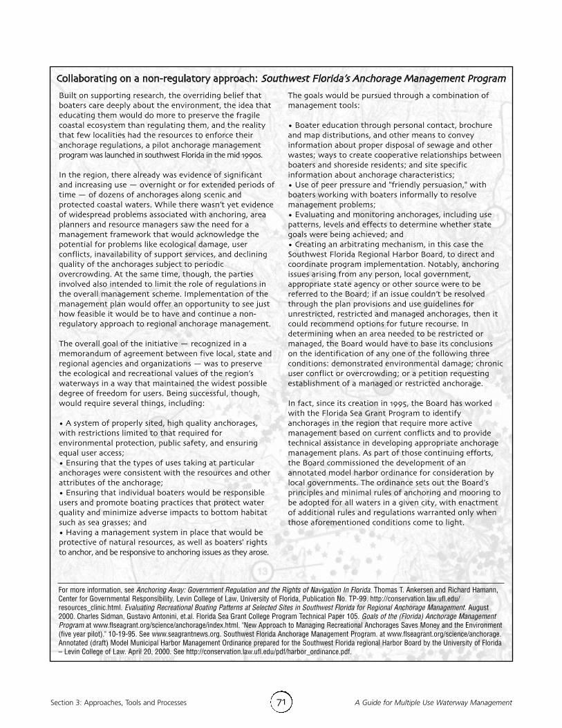
Section 3: Approaches, Tools and Processes A Guide for Multiple Use Waterway Management71
Built on supporting research, the overriding belief thatboaters care deeply about the environment, the idea thateducating them would do more to preserve the fragilecoastal ecosystem than regulating them, and the realitythat few localities had the resources to enforce theiranchorage regulations, a pilot anchorage managementprogram was launched in southwest Florida in the mid 1990s.In the region, there already was evidence of significantand increasing use — overnight or for extended periods oftime — of dozens of anchorages along scenic andprotected coastal waters. While there wasn’t yet evidenceof widespread problems associated with anchoring, areaplanners and resource managers saw the need for amanagement framework that would acknowledge thepotential for problems like ecological damage, userconflicts, inavailability of support services, and decliningquality of the anchorages subject to periodicovercrowding. At the same time, though, the partiesinvolved also intended to limit the role of regulations inthe overall management scheme. Implementation of themanagement plan would offer an opportunity to see justhow feasible it would be to have and continue a non-regulatory approach to regional anchorage management.The overall goal of the initiative — recognized in amemorandum of agreement between five local, state andregional agencies and organizations — was to preservethe ecological and recreational values of the region’swaterways in a way that maintained the widest possibledegree of freedom for users. Being successful, though,would require several things, including:• A system of properly sited, high quality anchorages,with restrictions limited to that required forenvironmental protection, public safety, and ensuringequal user access;• Ensuring that the types of uses taking at particularanchorages were consistent with the resources and otherattributes of the anchorage;• Ensuring that individual boaters would be responsibleusers and promote boating practices that protect waterquality and minimize adverse impacts to bottom habitatsuch as sea grasses; and• Having a management system in place that would beprotective of natural resources, as well as boaters' rightsto anchor, and be responsive to anchoring issues as they arose.
The goals would be pursued through a combination ofmanagement tools: • Boater education through personal contact, brochureand map distributions, and other means to conveyinformation about proper disposal of sewage and otherwastes; ways to create cooperative relationships betweenboaters and shoreside residents; and site specificinformation about anchorage characteristics;• Use of peer pressure and "friendly persuasion," withboaters working with boaters informally to resolvemanagement problems;• Evaluating and monitoring anchorages, including usepatterns, levels and effects to determine whether stategoals were being achieved; and• Creating an arbitrating mechanism, in this case theSouthwest Florida Regional Harbor Board, to direct andcoordinate program implementation. Notably, anchoringissues arising from any person, local government,appropriate state agency or other source were to bereferred to the Board; if an issue couldn’t be resolvedthrough the plan provisions and use guidelines forunrestricted, restricted and managed anchorages, then itcould recommend options for future recourse. Indetermining when an area needed to be restricted ormanaged, the Board would have to base its conclusionson the identification of any one of the following threeconditions: demonstrated environmental damage; chronicuser conflict or overcrowding; or a petition requestingestablishment of a managed or restricted anchorage.In fact, since its creation in 1995, the Board has workedwith the Florida Sea Grant Program to identifyanchorages in the region that require more activemanagement based on current conflicts and to providetechnical assistance in developing appropriate anchoragemanagement plans. As part of those continuing efforts,the Board commissioned the development of anannotated model harbor ordinance for consideration bylocal governments. The ordinance sets out the Board’sprinciples and minimal rules of anchoring and mooring tobe adopted for all waters in a given city, with enactmentof additional rules and regulations warranted only whenthose aforementioned conditions come to light.
For more information, see Anchoring Away: Government Regulation and the Rights of Navigation In Florida. Thomas T. Ankersen and Richard Hamann,Center for Governmental Responsibility, Levin College of Law, University of Florida, Publication No. TP-99. http://conservation.law.ufl.edu/resources_clinic.html. Evaluating Recreational Boating Patterns at Selected Sites in Southwest Florida for Regional Anchorage Management. August2000. Charles Sidman, Gustavo Antonini, et.al. Florida Sea Grant College Program Technical Paper 105. Goals of the (Florida) Anchorage ManagementProgram at www.flseagrant.org/science/anchorage/index.html. "New Approach to Managing Recreational Anchorages Saves Money and the Environment(five year pilot)." 10-19-95. See www.seagrantnews.org. Southwest Florida Anchorage Management Program. at www.flseagrant.org/science/anchorage.Annotated (draft) Model Municipal Harbor Management Ordinance prepared for the Southwest Florida regional Harbor Board by the University of Florida– Levin College of Law. April 20, 2000. See http://conservation.law.ufl.edu/pdf/harbor_ordinance.pdf.
Collaborating on a non-regulatory approach: Southwest Florida’s Anchorage Management Program

72A Guide for Multiple Use Waterway Management Section 3: Approaches, Tools and Processes
assess, it actually is a complicated conceptthat can be difficult to define, enforce andmanage. One result of a wealth of researchon carrying capacity over nearly 40 years isa set of many and varying definitions.Among some of the more basic:
• Physical carrying capacity, defined interms of absolute space standards andrepresenting the maximum number ofcraft or craft per acre that can beaccommodated at one time, usually forsafety and efficiency reasons. Thewaterway capacity is "exceeded" whenthere are more boats in use at aparticular time and location.
• Social carrying capacity, referring to theeffects of use levels and intensity on thequality of recreational experiences. Auser’s satisfaction, then, is influencednot only by numbers, but also by typesof encounters between users.
• Ecological carrying capacity, concernedwith the effects of recreational use onthe natural environment, and defined asthe maximum level of use, in terms ofnumbers and types of activities, beforean unacceptable or irreversible decline inecosystem values occurs.
But along with these and other definitionshas come widespread debate andcontroversy among researchers andpractitioners as to the overall merits of theconcept, the usefulness of what some havecalled "simplistic" formula estimates ofcapacity, and the limits of their scientificbasis and applicability to differentwaterways and situations.38
In the last decade, though, were the seeds ofa change in the concept and in the processesused to arrive at "capacity." The emphasis
began to shift from more cumbersome,time-consuming and extremely expensivecapacity "planning" processes — like Limitsof Acceptable Change (LAC)39 and VisitorEnjoyment and Resource Protection (VERP),used by the U.S. Forest Service and theNational Park Service — to somewhatleaner, less time-consuming "decision-making" based systems, like QualityUpgrading and Learning (QUAL).40
In many ways, these changes represented abend in the philosophy behind carryingcapacity. While the concept by its naturelimits numbers to prevent deterioration ofresources and social conditions, later workon the processes used to arrive at capacitybegan turning attention away from"preventing" and toward identifying andmaintaining the "desired" future resourceand social conditions through monitoringand management.In fact, heading into the current decade,there have been significant efforts toimprove the overriding concept of carryingcapacity, not only by suggesting that itsmoniker be changed to "visitor capacity," butalso by improving the tools used in thosecapacity decision-making and decision analysis.41
"Visitor capacity," the argument now goes,should be based on things like well-definedmanagement objectives, desired futureconditions, quality standards, currentresource and experiential conditions, trends,foreseeable events or changes, managementcapability, best available science, publicpreference, the regional supply of same orsimilar opportunities, the expected quality ofthe future monitoring program, and thelevel of uncertainty and risk surroundingdecision consequences.42
Continued on page 74...

Section 3: Approaches, Tools and Processes A Guide for Multiple Use Waterway Management73
The Tims Ford Reservoir, a nearly 11,000 acreimpoundment on the Elk River in Tennessee, was selectedby the Tennessee Valley Authority (TVA) in 2000 as aninitial pilot project to evaluate a methodology forassessing recreational boating capacity and gatheringboating data related to balancing and optimizingcompeting demands on the Tennessee River system. Thehope was that the project would create an informationbase to support implementation of an existing land planstrategy; address anticipated increases in the reservoir’suse, shoreline development and new and expandingcommercial and marina facilities; and help determine howbest to protect the reservoir’s resources and preserve thequality and diversity of recreational opportunities.An obstacle to the TVA's goal of achieving balance among
social, resource and management conditions had been theabsence of a systematic process for giving managers thedata they needed to fulfill or reject requests for new orexpanding facilities and uses. Add to that, citizenstakeholders questioning whether the reservoirs couldaccommodate the prospect of more boat traffic in the faceof more or larger access points.To develop that systematic process and take a step towarddetermining the reservoirs’ capacities, TVA elected to pilota proactive approach in its Tims Ford Reservoir boatingcapacity study. Drawing upon a hybrid of the QualityUpgrading and Learning Process (QUAL) and RecreationManagement Information System (RMIS), the project wasintended to move beyond boating capacity as a limit onthe number of boats that a reservoir system could support.Instead, it would characterize the reservoir setting interms of resource conditions, social conditions andmanagerial conditions. The intent was to obtain usefuldata for understanding future desired boating conditionsand offer resource managers choices for alteringmanagement strategies.The model called for a three-phase, five-step process, eachresulting in a product that could be distributed or accessedvia the Internet, thereby enhancing communication andthe credibility of decision makers with the public andagency partners. The Tims Ford study, though, stopped atthe end of the first two steps, which are described here;when the study team deemed it had enough data andfindings to support improved management decisions. Step 1 Identifying Management Goals and Study Objectives
• Defining desired future conditions of a reservoirsetting by developing different scenarios;
• Using these parameters to formulate specific goalsand objectives for conducting the study.
Step 2 Conducting the Study: Inventory Reservoir ExistingConditions
• Inventorying existing reservoir conditions bycollecting boating survey and on-water boat countdata within defined service areas or "lakes within alake" with unique attributes;
• Coding and entering data into a geographicinformation system (GIS) database for retrieval andspatial analysis with accompanying map products;
• Creating "management compartments" –reconfigured service areas developed by visuallyanalyzing the boat survey spatial responses andweekend boat count composite maps to identifylogical breaks in user patterns and to facilitate theformation of management strategies; and
• Integrating boat density with boater conflictinformation using a classification criteria matrix thatranks management compartments from the highestdensity and conflict to the least.
Ultimately, the pilot project came in on time and budget,and according to the study team, proved to be flexibleenough to apply to any TVA reservoir. But the project alsoyielded important findings for management. For example,it showed that the reservoir as a whole had not reached acritical threshold for capacity; that it had a higherpercentage of PWCs than reservoirs of similar sizenationally; and that adding new water-basedinfrastructure would likely improve some boaters’recreation experience. The project also yieldedinformation about how boaters spend their time on thereservoir and their preferences for calm waters, fewwakes, solitude and the presence of fewer boats. Along with these findings, though, the analysis offeredseveral important considerations for developingmanagement strategies in the form of desired conditionsfor each of the management compartments. Some examples of strategies suggested by the study data?
• Using the data and the compartment classificationsystem, reservoir managers can anticipate how newdevelopment is likely to affect recreational activitywithin a specific reach. A key strategy would be todirect development to places with adequate watersurface area and adjacent shorelines capable ofsustaining more watercraft activity and shoreline growth.
• The management compartment classifications can beused to develop a sense of where enforcementproblems are most likely to occur and provide a roadmap for state and local law enforcement officials toredirect their limited resources.
• Management strategies and actions to protect andmaintain the unique conditions of escape coves – theminimally developed, quiet areas especially important tousers – could preserve these recreational opportunities.
For more information, see the Tims Ford Reservoir Recreational Boating Capacity Study. February 2002. Park Studies, Inc., for the Tennessee Valley Authority.
Evaluating methods for determining capacity: Tims Ford Reservoir Recreational Boating Capacity Study

Section 3: Approaches, Tools and ProcessesA Guide for Multiple Use Waterway Management 74
Easier said than done. But it is certainlytestimony to the notion that capacity goesbeyond "just the numbers" and encompassesan entire package of qualities and conditions. And while much of the work has centered onpublic lands, it still holds value for assessingmultiple use waterway managementdecisions and alternatives, especially thosewith a recreational emphasis. One of the more helpful and transferableresults has been the development of decisioncriteria that can be adapted to gauge thedegrees to which management alternativescontaining some sort of "visitor capacity"element are likely to affect critical aspects ofwater use. An adaptation of these criteriaappears in Section 2, page 39 of this Guide.43
What is another unexpected benefit of theefforts to improve the capacity concept andprocesses? The efforts are focusingattention squarely on the importance ofinformation and systematic processes,whether as a prelude to discussions ofdesired conditions or as a way ofunderstanding user preferences and perceptions. They depend upon good data and informationand sound processes for collecting them.
Data collection on the waterways…it’s counts and a lot more"…While censuses and boat counts will continue tobe an integral part of boat traffic monitoring, thosewho rely on those techniques alone will be workingwith an incomplete picture of their traffic situation.To effectively monitor boat traffic one needs athorough understanding of who the boaters are andwhat makes individual boaters tick. Those who fail torecognize boat traffic as an aggregate manifestationof many individual agendas will either beoverwhelmed by the complexity of the situation, or
draw oversimplifying conclusions that satisfy nobody.You must know boaters to know boat traffic." — Oneresearcher’s perspective on what it takes to do effective boattraffic monitoring44
Interesting point. And whether informationis being gathered for the first time, or thefirst time in a long time, or is being gatheredas part of a ongoing monitoring process todetermine whether strategies are kicking inand what sorts of impacts are becomingevident from water use activity, it’s worthconsidering.What this researcher suggests, at least in thecase of recreational watercraft traffic, is thatthe studies that hone in on boatermotivations, their reasons for selectingdestinations, and the values and perceptionsthat these users hold toward the waterwayresource are likely to yield more valuableinsights into the overall system thantraditional counts and censuses.45
Why? Because while a census will yieldinformation about what is there at the timeof the study, an "attitude picture" will tellyou why those patterns are there, and whatpatterns to expect in the future givencertain changes. Censuses and boat countswill play a role in short-term managementgoals, but an understanding of the system interms of individuals’ motivations will helpbuild pro-active policies toward longer term goals.Does that mean you do one or the other? Aboat count or a boater opinion survey?Simulations? Or something else entirely?Several of the illustrations presented in thisGuide, from boating capacity studies tomore comprehensive management planscouched in the results of data gathered onmany aspects of their problem areas, suggestthat these and other kinds of information

Section 3: Approaches, Tools and Processes A Guide for Multiple Use Waterway Management75
Gathering the information: Boating on OhioWaterways — A Plan for Access and UseManagementRecognizing the need to work in a targeted way toimprove the quality of boating in the state — especially inlight of the prospect of increasing pressure, greaterdiversity and more widely varying user expectations alongthe waterways in the future — the Ohio Division ofWatercraft embarked on a Strategic Plan for the 21stCentury. The planning process, supported by customerinput, identified six strategic priority issues. Water useconflicts and crowding were up there among the six, andfollowing some investigation, the final report in 1999called for more study and work on waterway congestion,especially on inland, unlimited horsepower lakes; theavailability and quality design of launch ramps andmarina facilities; and environmental issues. The Boating on Ohio Waterways Plan project wassubsequently launched to create a framework for futurelocal and state planning efforts in these strategic areas; inthe process it would gather and analyze a lot ofinformation via inventories, focus groups, and surveysabout boater wants and needs, the ease of boating accessto Ohio waterways, existing regulations, andopportunities to create a more favorable boatingenvironment. Apart from tapping the insights of waterway managers,facility grant recipients and marine patrol grantrecipients in open-ended questionnaires and focus groups,the Waterways Plan process incorporated focus groups ofOhio boaters in various locations around the state over aseven-month period. The efforts yielded about 25 broadcategories of waterway issues widely ranging fromboating on Lake Erie and inland lakes, to lake amenities,
paddler access, user conflicts and crowding, and launchramp designs.Using the identified issues as guidance, the next step wasto conduct a survey of a random sample of registeredOhio boaters in 2002 to add to the information cache.Among the areas addressed in the eight-pagequestionnaire:
• the types and features of boats used most often byhousehold members;
• the waterway locations most frequented during2002;
• the importance of features at marinas, launch rampsand at put-in/carry-in access points;
• boater satisfaction with availability of ramps at thewaterways they frequent;
• boater experience with accumulations of silt andnatural debris in the waterway;
• frequency of overnight stays and boater experienceswith destinations and facilities;
• the relative importance of particular features oninland lakes;
• boater ratings of the need for speed limits or forhorsepower limits; and
• how often boaters experienced selected conditionsthat caused a problem for them.
An interesting preliminary result? Of more than 1,300responses, “other boaters’ lack of knowledge” and “otherboaters’ discourtesy” were two areas at the top of the listof situations that caused the most problems.At the time of this writing, the results of the survey,along with those of a survey of the states regardinghorsepower and speed limits management practices, werebeing analyzed for inclusion in the final Plan, which wasscheduled for release in 2003.
For more information, see Boating on Ohio Waterways: A Plan for Access and Use Management. Ohio Department of Natural Resources Division ofWatercraft. See www.dnr.state.oh.us/watercraft/plan/default.htm.
activities can play significant roles in helpingmanagers and planners learn more aboutwhat’s happening on the waterways.As we’ve already touched upon in Section 2of this Guide, though, there can be danger inassuming too much about what the data"say," in collecting data with one purpose inmind only to find that they would havebetter served another, or in collecting themover too short a period of time.
So, if you’re interested in environmentalimpacts from watercraft or water contactactivities, a weekend count of boats alongthe waterway will tell you something, butprobably not what you’d hoped to learn.Long-term collections, counts andmeasurements will be the key.46
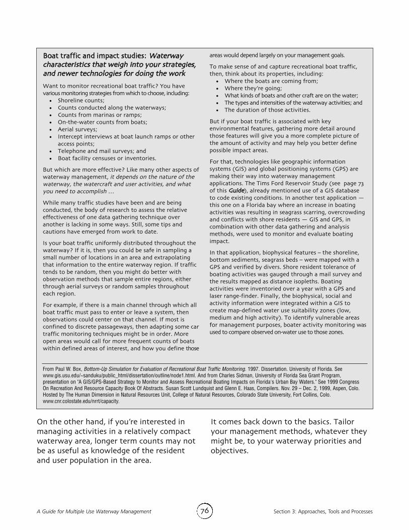
76A Guide for Multiple Use Waterway Management Section 3: Approaches, Tools and Processes
On the other hand, if you’re interested inmanaging activities in a relatively compactwaterway area, longer term counts may notbe as useful as knowledge of the residentand user population in the area.
It comes back down to the basics. Tailoryour management methods, whatever theymight be, to your waterway priorities andobjectives.
Boat traffic and impact studies: Waterwaycharacteristics that weigh into your strategies,and newer technologies for doing the workWant to monitor recreational boat traffic? You havevarious monitoring strategies from which to choose, including:
• Shoreline counts;• Counts conducted along the waterways;• Counts from marinas or ramps;• On-the-water counts from boats;• Aerial surveys;• Intercept interviews at boat launch ramps or other
access points;• Telephone and mail surveys; and• Boat facility censuses or inventories.
But which are more effective? Like many other aspects ofwaterway management, it depends on the nature of thewaterway, the watercraft and user activities, and whatyou need to accomplish …While many traffic studies have been and are beingconducted, the body of research to assess the relativeeffectiveness of one data gathering technique overanother is lacking in some ways. Still, some tips andcautions have emerged from work to date.Is your boat traffic uniformly distributed throughout thewaterway? If it is, then you could be safe in sampling asmall number of locations in an area and extrapolatingthat information to the entire waterway region. If traffictends to be random, then you might do better withobservation methods that sample entire regions, eitherthrough aerial surveys or random samples throughouteach region. For example, if there is a main channel through which allboat traffic must pass to enter or leave a system, thenobservations could center on that channel. If most isconfined to discrete passageways, then adapting some cartraffic monitoring techniques might be in order. Moreopen areas would call for more frequent counts of boatswithin defined areas of interest, and how you define those
areas would depend largely on your management goals. To make sense of and capture recreational boat traffic,then, think about its properties, including:
• Where the boats are coming from; • Where they’re going;• What kinds of boats and other craft are on the water;• The types and intensities of the waterway activities; and• The duration of those activities.
But if your boat traffic is associated with keyenvironmental features, gathering more detail aroundthose features will give you a more complete picture ofthe amount of activity and may help you better definepossible impact areas.For that, technologies like geographic informationsystems (GIS) and global positioning systems (GPS) aremaking their way into waterway managementapplications. The Tims Ford Reservoir Study (see page 73of this Guide), already mentioned use of a GIS databaseto code existing conditions. In another test application —this one on a Florida bay where an increase in boatingactivities was resulting in seagrass scarring, overcrowdingand conflicts with shore residents — GIS and GPS, incombination with other data gathering and analysismethods, were used to monitor and evaluate boatingimpact.In that application, biophysical features – the shoreline,bottom sediments, seagrass beds – were mapped with aGPS and verified by divers. Shore resident tolerance ofboating activities was gauged through a mail survey andthe results mapped as distance isopleths. Boatingactivities were inventoried over a year with a GPS andlaser range-finder. Finally, the biophysical, social andactivity information were integrated within a GIS tocreate map-defined water use suitability zones (low,medium and high activity). To identify vulnerable areasfor management purposes, boater activity monitoring wasused to compare observed on-water use to those zones.
From Paul W. Box, Bottom-Up Simulation for Evaluation of Recreational Boat Traffic Monitoring. 1997. Dissertation. University of Florida. Seewww.gis.usu.edu/~sanduku/public_html/dissertation/outline/node1.html. And from Charles Sidman, University of Florida Sea Grant Program,presentation on "A GIS/GPS-Based Strategy to Monitor and Assess Recreational Boating Impacts on Florida's Urban Bay Waters." See 1999 CongressOn Recreation And Resource Capacity Book Of Abstracts. Susan Scott Lundquist and Glenn E. Haas, Compilers. Nov. 29 – Dec. 2, 1999, Aspen, Colo.Hosted by The Human Dimension in Natural Resources Unit, College of Natural Resources, Colorado State University, Fort Collins, Colo.www.cnr.colostate.edu/nrrt/capacity.

Section 3: Approaches, Tools and Processes A Guide for Multiple Use Waterway Management77
1 See discussions in Tims Ford Reservoir Recreational BoatingCapacity Study. February 2002. Tennessee Valley Authority.
2 "Recreational Boating – Are the Waters Too Crowded?"Nov/Dec 1999. Jeff Hoedt. Report for the 1999 Congress onRecreation and Resource Capacity. Nov. 29 – Dec. 2, 1999,Aspen, Colo. Hosted by The Human Dimension in NaturalResources Unit, College of Natural Resources, Colorado StateUniversity, Fort Collins, Colo. See www.cnr.colostate.edu/nrrt/capacity.
3 See 1999 Lake Travis Boating Recreation Study:Recommendations on Key Issues. September 1999. Park Studies,Inc., for the Lower Colorado River Authority, and HighlandLakes (Texas) Recreation Management Plan. 2000. LowerColorado River Authority. See www.lcra.org/lands/lakeplan/.
4 National Water Safety Congress, Board of Directors’ meeting,April 7, 2001, Nashville, Tenn.
5 Dr. Gustavo Antonini, University of Florida professor. "BoatingExpert Provides Look at the Future of Boating." Fall 1995.Fathom Magazine. Vol. 7, Issue 3. See www.flseagrant.org/science/library/fathom_magazine/volume-7_issue-3/expert.htm.
6 See "Educated Boaters Will Protect Coastal Environment(Florida)." 3-7-96, and especially the comments of Dr. GustavoAntonini. See http://news.ifas.ufl.edu/news.php.
7 "Final Agreement Approved for North Landing River." Winter2002. Hampton Roads Review. Quarterly Publication of theHampton Roads Planning District Commission. p. 2. Seewww.hrpdc.org/publications/newsletters/winter2002.pdf.
8 Comments by Chris Foreman, Park Manager, Highline LakeState Park Colorado Division of Parks in a panel on "BoatingCapacity Management Plans: Successful Case Studies" from the1999 Congress On Recreation And Resource Capacity. See BookOf Abstracts. Susan Scott Lundquist and Glenn E. Haas,Compilers. Nov. 29 – Dec. 2, 1999, Aspen, Colo. Hosted by TheHuman Dimension in Natural Resources Unit, College ofNatural Resources, Colorado State University, Fort Collins,Colo. See www.cnr.colostate.edu/nrrt/capacity.
9 For more information on changing concepts of capacity, seeGlenn E. Haas, "A Reframing of Visitor Capacity," Parks &Recreation, July 2001, Vol. 36, No. 7 and Visitor Capacity onPublic Lands and Waters: Making Better Decisions 2002. AReport of the Federal Interagency Task Force on VisitorCapacity on Public Lands. Submitted to the Assistant Secretaryfor Fish and Wildlife and Parks, Department of the Interior,Washington, DC.
10 See pp. 29-50. A Guide for Multiple Use Waterway Management.1st edition. 1996. National Water Safety Congress.
11 See pp. 51-73. A Guide for Multiple Use Waterway Management.1st edition. 1996. National Water Safety Congress.
12 See pp. 29-50. A Guide for Multiple Use Waterway Management.1st edition. 1996. National Water Safety Congress.
13 From Boating Restrictions: The Local Authorities Guide. March1998. 2nd ed. Office of Boating Safety, Canadian Coast Guard.Made under the provision of the Boating RestrictionRegulations Canada Shipping Act. Canada Shipping Act,Ottawa, Ontario K1A 0N7.
14 Uniform Waterway Markers in Florida Waters, Chapter 68D-23,Florida Administrative Code. See http://fac.dos.state.fl.us/faconline/chapter68.pdf. The new code is intended to providefor uniformity in design, construction and coloring of markersso that all watercraft operators can easily recognize, identifyand distinguish between authorized markers and unlawfullyplaced ones; provide a means by which law enforcement candetermine with reasonable certainty which boating restrictedareas are lawfully established and marked; and ensure thatregulatory markers giving notice of boat restricted areas areauthorized only for purposes of protecting human life and limb,vessel traffic safety and maritime property and manatees.At the same time, it was the intent of the new code that noboating restricted area be established, continued in effect, orenforced for the purpose of noise abatement or for theprotection of shoreline, shore-based structures or uplandproperty from vessel or shoreline wake. "The wake resultingfrom the reasonable and prudent operation of a vessel is aforce which should be anticipated by the owners of propertyadjacent to the navigable waters of [the] state." (Chapter 68D-23.101)The new provisions go into great detail defining only thesymbols and devices that can be used, but also the terms to beused on the regulatory markers, their placement, and thecriteria for approving those markers in restricted or exclusionareas (Chapter 68D-23.103-105).
15 See for example, some of the results regarding lawenforcement emerging from the Florida Fish and WildlifeConservation Commission (Strategic Planning) StakeholderInput. 2002. See http://floridaconservation.org/planning/index.html,for strategic planning survey and related documents. Lawenforcement is one way each group of users or stakeholderscan ensure that other groups are doing their part, and isincreasingly called upon to ensure compliance. If a group isexperiencing diminished use of a resource, they might want toensure others are still not reaping benefit. That means "more"law enforcement might not be the answer. Rather, the answermight be "different" law enforcement. The input fromstakeholders suggested that having a vision critical focus forlaw enforcement would be essential.
16 Reference Guide to State Boating Laws, sixth edition. NationalAssociation of State Boating Law Administrators, 2000.
17 From Reference Guide to State Boating Laws, sixth edition,with updated information from the NASBLA and statewebsites, and as compiled by the National TransportationSafety Board and U.S. Coast Guard, as of May 15, 2003.Note that nearly half of the states have implementedmandatory special education in response to concerns foroperators of personal watercraft. The Model PersonalWatercraft Operations Act developed by the PersonalWatercraft Industry Association (see www.pwia.org/modelbill.html) incorporates mandatory educationrequirements along with PWC operation regulations. The PWIAModel Bill addresses minimum operating age (16 years old/18to rent), requires mandatory education of all operators,prohibits nighttime and reckless operation, and requires alloperators and passengers to wear Coast Guard approvedpersonal floatation devices, and to use their lanyard stopswitches (for vessels so equipped).

78A Guide for Multiple Use Waterway Management Section 3: Approaches, Tools and Processes
18 In the state of Florida, it is manatees that have been at thecenter of continuous debate and in some cases lawsuits overfederal and state efforts to protect the large mammals fromharm through various zoning techniques while minimizingimpact on boating activities. Boaters, environmentalists, themarine industry, local governments and other waterwaystakeholders have been kept busy learning about and reviewingeverything from proposals designating special protectionregions or zones in which boat dock permits could be denied inthe face of unsatisfactory biological opinions to proposalsestablishing mandatory 25 or 30 mph or slow-speed zones inparticular areas. For more information on manatee zones andcomparisons of federal and state requirements, seehttp://myfwc.com/manatee/ on the Florida Fish and WildlifeConservation Commission website.
19 See also the Code of Federal Regulations, 33 CFR Part 109,which deals with anchorage grounds, anchorages under thePorts and Waterways Safety Act, and special anchorage areas.
20 February 2003 compilation of survey results on state boatingmanagement practices, conducted by the Ohio Division ofWatercraft as part of its development of a statewide boatingplan. See www.dnr.state.oh.us/watercraft/plan/history.htm.
21 "Pleasure Boat Speed Limits Can Stir Up Trouble in ShallowLakes." Nov. 16, 2001. David Hill and Michele Beachler. ThePennsylvania State University, University Park, Penn. Originallypresented at North American Lake Management SocietySymposium, Madison, Wisc., as "The Hydrodynamic Impacts ofRecreational Watercraft on Shallow Lakes." See www.engr.psu.edu/news/News/2001 Press Releases/November/boat.html
22 Recreational Conflicts and Compatibility Between MotorboatOwners, Personal Watercraft Owners and Coastal Landownersalong New York's Great Lakes Coast. July 1, 2000. Cheng-PingWang and Chad P. Dawson. Study funded by New York SeaGrant Institute, New York Sea Grant Extension and StateUniversity of New York College of Environmental Science &Forestry at Syracuse, N.Y. See www.cce.cornell.edu/seagrant/great-lakes-marinas/pwcreport.html.
23 February 2003 compilation of survey results on state boatingmanagement practices, conducted by the Ohio Division ofWatercraft as part of its development of a statewide boatingplan. See www.dnr.state.oh.us/watercraft/plan/history.htm.
24 Using the SAE J-2005 stationary test, most states set maximumnoise levels at 86 to 90 decibels; when the SAE J-1970 shorelinetest is used, the maximum noise level is commonly 75 decibels.See NASBLA Reference Guide to State Boating Laws, sixthedition, 2000.
25 February 2003 compilation of survey results on state boatingmanagement practices, conducted by the Ohio Division ofWatercraft as part of its development of a statewide boatingplan. See www.dnr.state.oh.us/watercraft/plan/history.htm.
26 In Western states alone there are at least 13 whitewater riversor river segments where boaters are required to possess aboating permit. On many of these rivers, an application feeplus a use fee is charged to those who receive one of thelimited numbers of permits available. Typically, this is a per-person fee on a per-trip or per-day basis. See Managing RiverRecreation: A Statewide Assessment of Needs for BoatingAccess, Facilities, Enforcement, and Education. December 1998.Oregon State Marine Board. Report to the Joint LegislativeInterim Committee on Navigability. See www.marinebd.osmb.state.or.us/Library/finalreport.pdf.
27 For example, it takes four to six minutes and 3,000 to 4,000feet for a ship to stop after its engines are reversed; larger,difficult-to-maneuver ships cannot successfully avoid smallercraft in narrow channels; and it often takes less than 10minutes for a fast ship to reach a craft once it’s spotted in clearweather; reduced visibility shortens this time.A "Collision Avoidance Checklist," or helpful information suchas Life Lines produced by the American Waterways OperatorsFoundation, can be provided to recreational boaters. Seewww.boatingsafety.com/wow/artframe.htm.
28 See the Design Handbook for Recreational Boating and FishingFacilities prepared for States Organization for Boating Accessby Waterways Development Public Sector Consultants, Inc.,April 1996. See www.sobaus.org for ordering information. TheDesign Handbook discusses considerations and possiblestandards for locating and acquiring launch sites, design andconstruction of landside facilities and waterside components,docking and fishing facilities, and ADA compliance. Also see the Operations and Maintenance Program Guidelinesfor Recreational Boating Facilities, also published by the StatesOrganization for Boating Access, September 1999. TheseGuidelines address risk management, operationalconsiderations, maintenance and signage.
29 Facility size can be determined by establishing standards as theminimum water frontage desired, the area needed for theintended launch ramp and amenities, and the area required tobuffer the site from neighbors. Most states recommendminimum frontages of 50 feet for launching canoes and othercar-top craft and 100 feet for larger boats. If demand cannot bemet at a single site on a given water body, multiple sites maybe considered. See the Design Handbook for RecreationalBoating and Fishing Facilities prepared for States Organizationfor Boating Access by Waterways Development Public SectorConsultants, Inc., April 1996. See www.sobaus.org for orderinginformation.
30 See "Preserving Waterfronts for Water Dependent Uses,"Kenneth Walker and Matt Arnn. In NOAA's State of the CoastReport 1998. Silver Spring, Md.: National Oceanic andAtmospheric Administration. See http://oceanservice.noaa.gov/websites/retiredsites/sotc_pdf/wdu.pdf.
Section 3: Approaches, Tools and Processes A Guide for Multiple Use Waterway Management79
31 See, as an example, the Tennessee Valley Authority’s newShoreline Management Policy, which became effectiveNovember 1, 1999. Working with the public, TVA began theShoreline Management Initiative (SMI) to examine the systemby which permits for docks and other shoreline developmentare granted. The primary goal of the SMI was to establish anew Valley-wide shoreline management policy that wouldimprove the protection of shoreline and aquatic resourceswhile allowing reasonable access to the water. Standardsaddress the type, size and design of boat docks. Among the keyelements: continuing to allow docks and other alterationsalong shorelines where access rights exist; requirements forvegetation management plans; a 50 foot shorelinemanagement zone retained on TVA land that adjoins newly-developed residential areas; promotion of best managementpractices for the construction of docks, management ofvegetation, stabilization of shoreline erosion and othershoreline alterations; and emphasis is on education activitiesand incentives as important components of shorelinemanagement. See TVA (Tennessee Valley Authority) ShorelinksII The Shoreline Management Policy: Key Elements. Seewww.tva.gov/river/landandshore/pdfs/shorelnk.pdf.
32 See Recreational Boating Carrying Capacity: A Framework forManaging Inland Lakes: Proceedings of a Workshop, August 23,1995. 1996. Edward M. Mahoney and Daniel J. Stynes.Sponsored by Michigan Boating Industries Association and theDepartment of Park, Recreation and Tourism Resources,Michigan State University. See www.msu.edu/course/prr/879/spring2000/boatrcc.doc.
33 See Managing River Recreation: A Statewide Assessment ofNeeds for Boating Access, Facilities, Enforcement, andEducation. December 1998. Oregon State Marine Board. Reportto the Joint Legislative Interim Committee on Navigability. Seewww.marinebd.osmb.state.or.us/Library/finalreport.pdf. TheMarine Board obtained information about boating and fishingon Oregon’s rivers from a variety of sources using a variety ofapproaches. The principal tools used included: questionnairesdistributed to clubs, organizations, and agencies; a telephonesurvey of randomly selected households in the state; and publicinformational meetings held in ten separate locations aroundthe state.
34 From Paul W. Box, Bottom-Up Simulation for Evaluation ofRecreational Boat Traffic Monitoring. 1997. Dissertation.University of Florida. See www.gis.usu.edu/~sanduku/public_html/dissertation/outline/node1.html
35 "Boating Expert Provides Look at the Future of Boating." Fall1995. Fathom Magazine. Vol. 7, Issue 3. See comments ofProfessor Emeritus Gustavo Antonini at www.flseagrant.org/science/library/fathom_magazine/volume-7_issue-3/expert.htm.
36 See also discussion in Boating Restrictions: The LocalAuthorities Guide. March 1998. 2nd ed. Office of BoatingSafety, Canadian Coast Guard. Made under the provision of theBoating Restriction Regulations Canada Shipping Act. CanadaShipping Act, Ottawa, Ontario K1A 0N7.
37 A comprehensive discussion of the problems associated withcarrying capacity can be found in Recreational BoatingCarrying Capacity: A Framework for Managing Inland Lakes:Proceedings of a Workshop, August 23, 1995. 1996. Edward M.Mahoney and Daniel J. Stynes. Sponsored by Michigan Boating
Industries Association and the Department of Park, Recreationand Tourism Resources, Michigan State University. Seewww.msu.edu/course/prr/879/spring2000/boatrcc.doc.
38 For example, the Michigan report describes a publication thatuses a "cookbook" method for estimating carrying capacity andprovides a Keyhole zoning ordinance. The ordinance establishesa base carrying capacity for lake usage and limits the size andtype of multi-boat launch and docking sites. The workshoppresenters argued that the publication, like many dealing withthe issue of carrying capacity, takes a rather simplistic formulaapproach to a very complicated issue. And they argued thatindividuals and lake associations that may have little or noknowledge of carrying capacity concepts could mistakenlyconclude that estimating carrying capacity is a relativelystraightforward calculation. The biggest problem, though, theyargued, is that most elected officials, local zoning officers,judges and attorneys have little experience with carryingcapacity concepts or methods.
39 "Limits of Acceptable Change" is a planning system that is analternative implementation of carrying capacity. While thelocus of a carrying capacity is that it limits numbers of peopleto prevent deterioration of resource and social conditions, thelimits of acceptable change or similar methodologies focus onmaintaining desired future resource and social conditionsthrough monitoring and management actions targeted atspecific problems.Why the name "limits of acceptable change"? In the process,participants select indicators of resource and social conditions.To do the rest, though, requires a systematic monitoring plan,to determine the point at which an indicator tells whether ornot the change — if there is one — is acceptable. Exceeding thestandard should trigger a management action. See Limits ofAcceptable Change Planning System: An AlternativeImplementation of Carrying Capacity. Ed Krumpe. Seewww.ets.uidaho.edu/rrt287/287lac7.pdf. Also, see What is theLimits of Acceptable Change (LAC) Process? Seewww.southernregion.fs.fed.us/gwj/nra/LACWhat is LAC.htm.
40 See "Evolving Concepts of Recreational Carrying CapacityManagement." Kenneth Chilman, et.al. Submitted paper fromTrends 2000: Shaping the Future, Sept. 17-20, 2000, Lansing,Mich., for discussions of the methods and three case examples,at www.prr.msu.edu/trends2000/pdf/chilmanCC.pdf. Theshorter 5-step capacity management process, QualityUpgrading and Learning (QUAL) was developed to facilitatemanagement communications. Two key elements wereidentified: 1) the need for place-specific "social inventories,"that is, counts and surveys of visitors at area access points oron water surfaces; and 2) the need for training in social datacollection and utilization so that managers could communicatemore effectively in decision situations. An outline ofprocedures for social data collection and utilization, or theRecreation Management Information System (RMIS), wasdeveloped for manager training. The QUAL process emphasizes two aspects of quality-of-visitexperiences: the reasons visitors choose the place for thedesired recreation activity (i.e., what is important to the visitorfor the experience), and the changes that visitors observe inthe area in the way of important visit attributes (i.e., if thevisitor is a repeat visitor).

80A Guide for Multiple Use Waterway Management Section 3: Approaches, Tools and Processes
The key step in planning, then, becomes the inventorying ofexisting conditions. That systematic measurement anddocumentation of existing conditions can then be used todiscuss desired conditions or objectives. Usually an examinationof conditions on large water areas will show diverse conditionsin various parts or zones, which can then be managed in waysthat provide different kinds of recreation opportunities fordifferent kinds of visitors.
41 See Haas, "A Reframing of Visitor Capacity," July 2001.42 Ibid.43 See Haas, Visitor Capacity on Public Lands and Waters: Making
Better Decisions. A Report of the Federal Interagency TaskForce on Visitor Capacity on Public Lands. Submitted to theAssistant Secretary for Fish and Wildlife and Parks, Departmentof the Interior, Washington, DC. 2002. The decision analysisapproach is intended to help ensure the decision is principled,reasoned and afforded the thoroughness and legal sufficiencyof a NEPA compliant planning process.
44 From Paul W. Box, Bottom-Up Simulation for Evaluation ofRecreational Boat Traffic Monitoring. 1997. Dissertation.University of Florida. See www.gis.usu.edu/~sanduku/public_html/dissertation/outline/node1.html
45 Ibid.46 Ibid.

Section 4: References & Resources
Aids to Navigation – Road Signs of the Waterway.U.S. Coast Guard Boating Safety. Seewww.uscgboating.org/safety/aton/system.htm.Americans’ Participation In Outdoor Recreation:Weighted Data Results From NSRE (National Surveyon Recreation and the Environment) 2000. Versions 1to 13. U.S. Forest Service. See www.srs.fs.usda.gov/trends/Nsre/Rnd1t13weightrpt.pdf.America’s Most Endangered Rivers. April 2002.American Rivers. See www.americanrivers.org."An Analysis of Recent Progress in Recreation ConflictResearch and Perceptions of Future Challenges andOpportunites." 1995. Alan E. Watson. LeisureSciences. 17 (3). p. 235. An Analysis of Recreational Use and AssociatedImpacts at Lake Mead National Recreation Area.August 1997. Alan Graefe and J. Holland. ThePennsylvania State University.Anchoring Away: Government Regulation and theRights of Navigation In Florida. Thomas T. Ankersenand Richard Hamann, Center for GovernmentalResponsibility, Levin College of Law, University ofFlorida, Publication No. TP-99. Seehttp://conservation.law.ufl.edu/resources_clinic.html.Annotated bibliography of selected articles on motorboat impacts. 1995. Timothy Asplund. Bureau ofResearch, Wisconsin Dept. of Natural Resources.An Assessment of Risk Management and HumanErrors in Recreational Boating Safety Applications.July 1999. Marine Safety Foundation, Inc.Farmingdale, N.J.
"Apostle Island Proposal would limit boating." July 26,2002. Boating Industry International Online. Seewww.boating-industry.com.Arkansas Headwaters Recreation Area ManagementPlan. January 2001. Seehttp://parks.state.co.us/arkansas/management.asp.Arkansas Headwaters Recreation Area Visitor Survey:Visitor Characteristics, Perceptions of Crowding andConflict, and Management Preferences at theArkansas Headwaters Recreation Area Summer 2001.January 19, 2002. Coal Creek Consultants, LLC. Seewww.parks.state.co.us/home/publications/AHRAvisitor survey.pdf.Arrowhead Regional Development Commission.Director’s Report for May 2002. May 16, 2002. Seewww.ardc.org/info/exec/edr0502.pdf.Assateague Island National Seashore, PersonalWatercraft Use. U.S. Dept. of the Interior. NationalPark Service 36 CFR Part 7 RIN 1024-AD02. Proposedrule as it appeared on Land-Use Issues at www.Off-Road.com. May 2002.Assessing Impacts of Motorized Watercraft on Lakes:Issue and Perceptions. 1991. K.J. Wagner, inProceedings of a National Conference on EnhancingStates' Lake Management Programs, May 1990.Northeastern Illinois Planning Commission, Chicago Ill."Balance The Rights Of All Parties." PersonalWatercraft Industry Association. Seehttp://www.pwia.org/Bal_Calm.htm.
81
SECTION 4: REFERENCES AND RESOURCESA starting point for further exploration
A Guide for Multiple Use Waterway Management
The references and organizational resources in this section represent varying perspectives onwaterways issues, multiple use conflicts, and management concepts and approaches. Their inclusion
does not constitute "endorsement." Rather all are presented in the spirit of fostering informationexchange and learning. Readers also should be aware that there is no guarantee of the permanence
of Internet sites or their contents. As more information and documents are added to sites,webmasters may change their original locations or move materials off of active pages and into
“archives.” In the event a document or other piece of information is not available at a stated Internetaddress, check the home or main page of the organization, agency or media in question.

82A Guide for Multiple Use Waterway Management Section 4: References & Resources
"A Balancing Act: The ‘Bubba Factor’ and the MarineTransportation System." March 8, 2000. PaulDonheffner. The Motivators Report. Seewww.motivatorsconference.com/report/feat_2.htm."Balancing Act: Can America Sustain a Population of500 million – Or even a Billion – by 2100?" Nov/Dec2000. Jim Motavalli. E: The Environmental Magazine.See www.emagazine.com/november-december_2000/1100feat1.html.Barnegat Bay (New Jersey) Personal Watercraft TaskForce: Issues Summary And Action Plan. May 1, 2000.J. Larson, ed. Rutgers Cooperative Extension of OceanCounty. See www.bbwa.org.Big Lake (Alaska), Lake Management Plan Draft.August 1998. See www.biglake-ak.com/council/bllmp.html. "Boater Contributions Help Protect Florida'sManatees." Fathom Magazine. Seewww.flseagrant.org/science/library/fathom_magazine/volume-7_issue-3/manatees.htm.Boater's Access and the Public Trust Doctrine. 1991.David C. Slade. Proceedings of 1991 StatesOrganization for Boating Access Conference, Seattle,Wash. pp. 95-106. "Boating Expert Provides Look at the Future ofBoating." Fall 1995. Fathom Magazine. Vol. 7, Issue 3. Seewww.flseagrant.org/science/library/fathom_magazine/volume-7_issue-3/expert.htm."Boating in an Insecure World: Recreational Boating’sRole in Port & Harbor Security." Joan M. Bondareff,Esq. Presentation at the International Boating andWater Safety Summit, April 30, 2002, Daytona Beach, Fla.Boating Professionals’ Attitudes Toward the Future ofBoating in the U.S. 2001. Responsive Management,Inc., Harrisonburg, Va., for the National Associationof State Boating Law Administrators. Seewww.nasbla.org/pdf/Professionals Attitudes.pdf. Boating on Ohio Waterways: A Plan for Access andUse Management. Ohio Dept. of Natural ResourcesDivision of Watercraft. See www.dnr.state.oh.us/watercraft/plan/default.htm.Boating Regulations – Maryland. See www.dnr.state.md.us/boating/regs.html - TheRegulatoryProcess.
Boating Restrictions: The Local Authorities Guide.March 1998. 2nd ed. Office of Boating Safety,Canadian Coast Guard, Made under the provision ofthe Boating Restriction Regulations Canada ShippingAct. Canada Shipping Act, Ottawa, Ontario K1A 0N7. Boating Statistics. National Marine ManufacturersAssociation. Boating 2002, see www.nmma.org/facts/boatingstats/2002; Boating 2001, see www.nmma.org/facts/boatingstatistics/2001; Boating 2000, seewww.nmma.org/facts/archive/boatingstats/2000stats/index.html; Boating 1999, see www.nmma.org/facts/archive/boatingstats/99stats/Default.htm;Boating 1998, see www.nmma.org/facts/archive/boatingstats/boating98.html; Boating 1997, seewww.nmma.org/facts/archive/boatingstats/boating97.html."Boat Traffic, Sediment Resuspension, and Turbidityin a Broadland River." 1987. P.N. Garrad and R.D. Hey.Journal of Hydrology. 95. pp. 289-297.Bottom-Up Simulation for Evaluation of RecreationalBoat Traffic Monitoring. 1997. Paul W. Box.University of Florida Dept. of Geography SkeletalDraft of Dissertation 3/11/98. See www.gis.usu.edu/~sanduku/public_html/dissertation/outline/node1.html. Buffer Zone Distances to Protect Foraging andLoafing Waterbirds from Disturbance by PersonalWatercraft in Florida. Annual Report. 2000. Bureauof Wildlife Diversity and Conservation. Study 7520."Canoes and Shared Use." Rusty Gates. Sept. 1999.The Riverwatch. (Quarterly Newsletter of TheAnglers of the Au Sable (Mich.)). Issue #32. Seewww.mich.com/~anglers/rw32/rw32.htm.Caught in the Wake- The Environmental and HumanHealth Impacts of Personal Watercraft. 1999. LaurieC. Martin. Izaak Walton League of America. Seewww.iwla.org/reports/pwc.html.Changes in MTBE and BTEX Concentrations in LakeTahoe, CA-NV, Following Implementation of a Ban onSelected 2-Stroke Marine Engines. Brant C. Allen andJohn E. Reuter. University of California-Davis: JohnMuir Institute for the Environment. Seehttp://trg.ucdavis.edu/research/annualreport/contents/lake/article8.html."Charlestown Says ‘No’ To Jet Skis." October 10, 2001.Tim Ryan. The Westerly (Rhode Island) Sun, onlinearchives. See www.thewesterlysun.com.
Section 4: References & Resources A Guide for Multiple Use Waterway Management
"Coastal Urban Sprawl Projected to Consume 5.8Million Acres in Next 25 Years." 12-07-00. Illinois-Indiana Sea Grant College Program. Seewww.seagrantnews.org. Coast 2050. A Regional Approach for StrategicCoastal Planning from Louisiana Coast Linespublished by the Louisiana Dept. of NaturalResources. See www.dnr.state.la.us/com/coastmgt/coastlns/lc1997.pdf.Coexistence of Boating Facilities and ThreatenedSpecies. 1992. Judith A. Wheeler. From Proceedings of1992 States Organization for Boating AccessConference. Springfield, Mo., pp. 189-193. Colorado River Management Plan EnvironmentalAssessment. See www.nps.gov/glca/corivpl.htm."Conflict Resolution in Coastal Waters: the Case ofPersonal Watercraft." 2000. J. Burger and J. Leonard.Marine Policy. Vol. 24. pp. 61-67."Congress not likely to get involved in watercraftban." July 25, 2002. Boating Industry InternationalOnline. See www.boating-industry.com. Originallyappeared on Las Vegas Review Journal online edition,article by Keith Rogers, July 24, 2002. 1999 Congress On Recreation And Resource CapacityBook Of Abstracts. Susan Scott Lundquist and GlennE. Haas, Compilers. Nov. 29 – Dec. 2, 1999, Aspen,Colo. Hosted by The Human Dimension in NaturalResources Unit, College of Natural Resources,Colorado State University, Fort Collins, Colo. Seewww.cnr.colostate.edu/nrrt/capacity. Critical Judgment: Understanding and PreventingCanoe and Kayak Fatalities. 2003. Gordon Black,David E. Jenkins and Dr. Alison Snow Jones. AmericanCanoe Association. See www.acanet.org/pdf/cjreport.pdf."A Crowded, Uneasy Mix in Hudson and Harbor."September 6, 1998. Andrew C. Revkin. The New YorkTimes. Reproduced on New Jersey Fishing, FishNetUSA, at www.fishingjn.org/artnyharbor.htm. "A Crowding Based Model of Social Carrying Capacity:Applications for Whitewater Boating Use." 1996.Michael A. Tarrant and Donald B.K. English. Journalof Leisure Research (National Recreation and ParkAssociation). Vol. 28. No. 3. pp. 155-168. Seewww.srs.fs.fed.us/trends/nantahalappr.pdf.
"Defining conflicts among river users: A case study ofMichigan's Au Sable River." 1975. B.L. Driver and J.Bassett. Naturalist. 26. pp. 19-23. Definition of Navigable Waters of the U.S. Authority:33 U.S.C. 401 et seq. See www.usace.army.mil/inet/functions/cw/cecwo/reg/33cfr329.htm.Delmarva Coastal Bays Conference III: Tri-StateApproaches to Preserving Aquatic Resources.Proceedings (Abstract). Nov. 12-13, 1999. AssateagueCoastal Trust. See www.epa.gov/maia/html/dl-abstr.html.DEP (New Jersey) Gets Green Light to Create State’sFirst Marine Conservation Zone. March 7, 2001. NewJersey Dept. of Environmental Protection NewsRelease 01/16. See www.state.nj.us/dep/newsrel/releases/01_0016.htm. Design Handbook for Recreational Boating andFishing Facilities. April 1996. WaterwaysDevelopment Public Sector Consultants, Inc., for theStates Organization for Boating Access. Seewww.sobaus.org for ordering information.Development Along Wisconsin's Lakeshores.Wisconsin Dept. of Natural Resources – ShorelandsDevelopment. See www.dnr.state.wi.us/org/water/wm/dsfm/shore/develop.htm.Discussion of the Boaters vs. PWCs Conflict Based onthe Research Literature. Recreational Boat BuildingIndustry. See www.rbbi.com/white/conflict/discuss.htm."Discussion of Issues Related to Key RecreationOpportunities" (Ch. 4). Paul H. Gobster. InChicagoRivers: People and the River. Seewww.ncrs.fs.fed.us/epubs/chicagoriver/people."The Displacement Process in Recreation." 1984. D.H.Anderson and P. Brown. Journal of Leisure Research16(1). pp. 61-73."Dredging Issues Confront New ICW Association."February 2001. The Boating News. Seewww.theboatingnews.com/0201_dredging_issues.htm."Economic Impact of Recreation Associated withMan-Made Lakes in the United States." February1999. The National Recreation Lakes Study. U.S.Dept. of the Interior. See www.doi.gov/nrls/economic/usecon.htm.
83

84A Guide for Multiple Use Waterway Management Section 4: References & Resources
"Educated Boaters Will Protect Coastal Environment(Florida)." 3-7-96. See http://news.ifas.ufl.edu/news.php."The Effect of Recreation Goals on ConflictPerception; The Case of Water Skiers and Fishermen."1981. James H. Gramann and Rabel J. Burdge. Journalof Leisure Research. 13(1). pp. 15-27."The Emergence of PAWSA (U.S.C.G Port &Waterway Safety Assessments) and a Growth ofExpectations." March 8, 2000. Robert G. Moore. TheMotivators Report. Vol. 1. No. 2. Seewww.motivatorsconference.com/report/feat_4.htm.
"The Environmental Impacts of Boating." March 1998.Richard Crawford, Nils Stolpe, Michael Moore, eds.Proceedings of a workshop held at Woods HoleOceanographic Institution, Woods Hole, Mass.,December 7-9, 1994. WHOI-98-03. Technical Report.For links to executive summary, introduction, andtable of contents, see www.whoi.edu/coastalresearch/boatimpact/TitleAcknContents.html.EPA (Environmental Protection Agency) 2006Standard. See www.epa.gov/fedrgstr/EPA-AIR/1997/August/Day-07/a20821.htm.Evaluating Recreational Boating Patterns at SelectedSites in Southwest Florida for Regional AnchorageManagement. August 2000. Charles Sidman, GustavoAntonini, et.al. Florida Sea Grant College ProgramTechnical Paper 105."Evolving Concepts of Recreational Carrying CapacityManagement." Kenneth Chilman, et.al. Submittedpaper from Trends 2000: Shaping the Future, Sept.17-20, 2000, Lansing, Mich. See www.prr.msu.edu/trends2000/pdf/chilmanCC.pdf.Factors Related to Recreational Boating Participationin the U.S.: A Review of the Literature Final Report.August 16, 2000. Responsive Management, Inc.,Harrisonburg, Va., for the National Association ofState Boating Law Administrators. Seewww.nasbla.org/pdf/Boating Participation report.pdf."Fast Ferries: Clean Water Transit or More DirtyDiesel?" See www.bluewaternetwork.org.
"Final Agreement Approved for North Landing River."Winter 2002. Hampton Roads Review. QuarterlyPublication of the Hampton Roads Planning DistrictCommission. p. 2. See www.hrpdc.org/publications/newsletters/winter2002.pdf.Final Environmental Impact Statement Lake CrescentManagement Plan Olympic National Park(Washington), U.S. Dept. of the Interior NationalPark Service Record Of Decision. October 1998. Seewww.nps.gov/olym/lceis/lc1.htm."FWC (Florida Fish and Wildlife ConservationCommission) Adopts New Manatee ProtectionZones." September 13, 2002. Release. See http://floridaconservation.org/whatsnew/postcomm-sep12-02.html.Florida Fish and Wildlife Conservation Commission(Strategic Planning) Stakeholder Input. 2002. Seehttp://floridaconservation.org/planning/index.html,for strategic planning survey and related documents. Georgia Rivers: An Initial Assessment. Aug. 10, 1998.Hon. Zell Miller; Jerry McCollum, RiverCare 2000Coordinating Committee; Lonice C. Barrett, Ga. Dept.of Natural Resources; Harold Reheis, EnvironmentalProtection Division; Alan Hallum, Water ProtectionBranch. Atlanta, Ga. See www.dnr.state.ga.us/dnr/environ/gaenviron_files/watrqual_files/rc2000.html.Getting The Public And Other Stakeholders Involved.Processes You Can Use. Information on SystematicDevelopment of Informed Consent (SDIC). Also,Citizen Participation Handbook for Public Officialsand Other Professionals Serving the Public. HansBleiker.The Institute for Participatory Managementand Planning, Monterey, Calif. See www.ipmp-bleiker.com. Glen Canyon National Recreation Area Planning Page.See www.nps.gov/glca/plan.htm.Goals of the (Florida) Anchorage ManagementProgram. See www.flseagrant.org/science/anchorage/index.html."Good News: Water Conflicts Can Be Solved, (TexasA&M) Researchers Say." June 3, 1998. Steve Hill. Seehttp://agnews.tamu.edu/dailynews/stories/RPTS/Jun0398a.htm. Great Egg Harbor River Boater and Landowner Study.1999. Michelle Adcock and Troy Hall, Virginia Tech,Department of Forestry, Blacksburg, Va. Prepared forthe National Park Service Philadelphia Support Office.

Section 4: References & Resources A Guide for Multiple Use Waterway Management
Great Lakes Waterways Management Forum. Seewww.uscg.mil/d9/wwm/forum/managementforum.htm.The Great Lakes: A waterways managementchallenge. Great Lakes Waterways ManagementForum. Ninth U.S. Coast Guard District. Seewww.greatlakes-seaway.com/en/pdf/waterwaysmanagement.pdf."Growth reshapes coasts." USA TODAY (on-line),7/28/00. Owen Ullmann, Paul Overberg and RickHampson, www.usatoday.com.Guidance for the Establishment and Development ofHarbor Safety Committees Under the MarineTransportation System (MTS) Initiative (includingGeneral Attributes of Successful Harbor SafetyCommittees). Navigation and Inspection Circular No.1-00. U.S. Coast Guard. COMDTPUB P16700.4 NVIC 1-00. See www.dot.gov/mts/document/n1-00.pdf.A Guide for Multiple Use Waterway Management.1996. Urban Research and Development Corporation.Prepared for the National Water Safety Congress, Inc.See www.nasbla.org."Guidelines for Recreational Boat LaunchingFacilities." 1991. Oregon State Marine Board. FromProceedings of 1991 States Organization for BoatingAccess Conference.Hartwell Lake Shoreline Management Plan forGeorgia and South Carolina. June 1, 1998. DistrictPamphlet No. 1130-2-18. See www.sas.usace.army.mil/hsmp/hsmplan.htm.Highland Lakes (Texas) Recreation ManagementPlan. 2000. Lower Colorado River Authority. Seewww.lcra.org/lands/lakeplan/.Hostile Waters: The Impacts of Personal WatercraftUse on Waterway Recreation. July 2002. David E.Jenkins. American Canoe Association. Seewww.acanet.org/hostilewaters.htm.How's the Water?: Planning for Recreational Use onWisconsin Lakes and Rivers. 2002. Tamara Dudiakand Robert Korth. See North American LakeManagement Society, Madison, Wisc., www.nalms.org/bkstore/pubs.htm.
The Impacts from Increased Recreation Use on theNon-Recreational Purposes and Benefits of FederallyManaged Man-made Lakes/Reservoirs. Final Report.1998. Glenn E. Haas. Colorado State University, FortCollins, Colo.Impacts of Motorized Boats on Shallow WaterSystems. Workshop Report and Workshop Abstracts.Nov. 7-8, 2000. Rutgers University. Convened by theNew Jersey Dept. of Environmental ProtectionCoastal Management Program and Jacques CousteauNational Estuarine Research Reserve. "An Intelligent Agent Based Model for Simulating andEvaluating River Trip Scenarios Along the ColoradoRiver in Grand Canyon National Park." 2000. H. RandyGimblett, et.al. In Integrating GIS and Agent basedmodeling techniques for Understanding Social andEcological Processes. H. R. Gimblett, ed. Oxford Press.pp. 245-275. See www.gcrtsim.org/SantaFe.pdf."International Solutions To Waterways ManagementProblems." Robert G. Moore, Coastwatch, Inc. PaperPresented at The SMART Forum Symposium, Seattle,Wash., February 27, 1997. See www.coastwatch.com."Jet-Ski Business Ready to Make a Splash." June 28,2001. Ellyn Moran Santiago. The Westerly (RhodeIsland) Sun, online archives. See www.thewesterlysun.com.Lake Berryessa, Napa, Calif. Federal Register Noticeof Intent to Prepare and EIS. See www.epa.gov/fedrgstr/EPA-Impact/2000/November/Day-07/i28454.htm; and Summary of Public Comments LakeBerryessa Visitor Services Plan. First Formal PublicComment Opportunity from Bulletin #2, May 2001.See www.mp.usbr.gov/berryessa/docs/AA_Scoping_Responses_July 2001_JanetEdits.pdf.Lake George (New York) Park Commission AnnualReport. March 2002. See www.lgpc.state.ny.us/spring02.pdf.Lake Mead (Arizona/Nevada) Lake ManagementPlan. Final Environmental Impact Statement.December 2002. See http://www.nps.gov/lame/planning.The Lake St. Clair/St. Clair River Management Plan:An Overview. Management Plan Update A StatusReport on the Lake St. Clair/St. Clair RiverComprehensive Management Plan (October 2002).See www.glc.org/stclair/documents/mpupdate2.pdf.
85
86A Guide for Multiple Use Waterway Management Section 4: References & Resources
1999 Lake Travis Boating Recreation Study:Recommendations on Key Issues. September 1999.Park Studies, Inc., for the Lower Colorado River Authority.Life Lines. American Waterways OperatorsFoundation. See www.boatingsafety.com/wow/artframe.htm.Limits of Acceptable Change Planning System: AnAlternative Implementation of Carrying Capacity. EdKrumpe. See www.ets.uidaho.edu/rrt287/287lac7.pdf.Local Boating And Recreational Use Management.Fact sheet #20 of the Shoreland Management andLake Classification Series. Tamara Dudiak-UWEX.Contributions from Timothy Asplund, Bureau ofResearch, Wisconsin Dept. of Natural Resources andJohn Lacenski, Bureau of Law Enforcement,Wisconsin Dept. of Natural Resources. Seewww.uwsp.edu/cnr/uwexlakes/fs_20.pdf.Local Restrictions on Personal Watercraft and/or TwoStroke Engines. California Dept. of Boating &Waterways. See www.dbw.ca.gov/MTBEList.htm."Local voices having greater impact on publicdeliberations." Summer 2000. Sylvia Lovely. City.Kentucky League of Cities. Vol 4. No. pp. 2-3.A Management Model for Determining AcceptableLevels and Types of Recreation at Public DrinkingWater Reservoirs. 1983. L.R. Klar, et.al. WaterResources Center, University of Massachusetts-Amherst.Publication Number 144.Managing Multiple Recreational Use Conflicts in theWaters of Hampton Roads. March 1998. Vol. 1,Waterway Planning Guidance, and Vol. 2. PilotWaterways Studies. Hampton Roads Planning DistrictCommission. See www.hrpdc.org.Managing River Recreation: A Statewide Assessmentof Needs for Boating Access, Facilities, Enforcement,and Education. December 1998. Oregon State MarineBoard. Report to the Joint Legislative Interim Committee onNavigability. See www.marinebd.osmb.state.or.us/Library/finalreport.pdf."Managing the Waterways of Hampton Roads."Spring 1998. Virginia Coastal Program News. VirginiaDept. of Environmental Quality. Seewww.deq.state.va.us/coastal/spring98.html.
"Manatee Protection — Refuges And Sanctuaries.Judge: Government must designate manatee refugesby Nov. 1." August 1, 2002. Jennifer Sergent. Seewww.NaplesNews.com.Marine Board (of the National Research Council’sTransportation Research Board) Seminar onWaterway and Harbor Capacity, April 23, 2001.Washington, D.C. See Introduction at www.nas.edu/trb/publications/MarineBoard/2001Waterways&Harbor/Introduction.pdf. See Transcripts at www.nas.edu/trb/publications/MarineBoard/2001Waterway&Harbor/Transcript 1.pdf and www.nas.edu/trb/publications/Marine Board/2001Waterway&Harbor/Transcript 2.pdf.See Testimony of Rodney Gregory (Seminar Chair),House Committee on Transportation andInfrastructure, Subcommittee on Coast Guard andMaritime Transportation Oversight Hearing on Portand Maritime Congestion, May 23, 2001, atwww.nas.edu/trb/publications/MarineBoard/2001Waterway&Harbor/GregoryTestimony.pdf.Marine Master Plan. November 2001. MarineIndustries Association of South Florida (MIASF).Policy and technical assistance provided by theFlorida Atlantic University (FAU) Joint Center forEnvironmental & Urban Problems, in partnershipwith the Urban Harbors Institute of the University ofMassachusetts-Boston and the FAU Center for VisualPlanning Technology.Marine Protected Areas: A discussion withstakeholders in the Gulf of Maine Summer & Fall2001. Report by the New England Aquarium andMassachusetts Institute of Technology Sea Grant.Released November 22, 2001. See executive summary,www.atlantisforce.org/gommpaexec.html.Marine Transportation System. See www.dot.gov/mts.Marine Transportation System Regional DialogSession. May 31 – June 1, 2000. Chicago, Ill. Seewww.dot.gov/mts/document/RDSChicago.pdf.McKenzie River Boater Study. 1996. T.E. Hall and B.Shelby. Report prepared for McKenzie RangerDistrict, Willamette National Forest and EugeneDistrict BLM.Minnesota Lakes Survey: Public Perceptions of theImpacts, Use and Future of Minnesota Lakes 1998.See www.seagrant.uwm.edu/water/survey.html.

Section 4: References & Resources A Guide for Multiple Use Waterway Management
Mission Bay Park (Calif.) Master Plan. Seewww.savemissionbay.org/."Motor boat impacts on water clarity, nutrientregeneration, and algal growth through sedimentresuspension." 1995. Timothy Asplund. Abstract from15th International Symposium on Lake, Reservoir andWatershed Management, November 6-11, 1995, NorthAmerican Lake Management Society, Toronto, Ontario. Nanticoke Watershed Alliance – Boating AssessmentStudy – Executive Summary. August 1997. Preparedfor the Nanticoke Watershed Alliance by theUniversity of Delaware Sea Grant Marine AdvisoryService. See www.nanticokeriver.org/proj8a.html.Narragansett Bay Summit 2000 (April 24-25, 2000,Providence, R.I.), Reports and Recommendations.White Paper Commercial Marine Transportation OnNarragansett Bay: Status, Trends & Issues, seewww.nbep.org/summit/pdf/marinetrans.pdf. MarineRecreation and Tourism in Narragansett Bay: CriticalValues and Concerns, see www.nbep.org/summit/pdf/rectour.pdf. Summit Recommendations, seewww.nbep.org/summit/pdf/rep2000.pdf.A National Dialogue About America’s Water ResourceChallenges for the 21st Century: National Report onIdentified Water Resources Challenges and WaterChallenge Areas. U.S. Army Corps of Engineers. Seewww.iwr.usace.army.mil/iwr/waterchallenges/Docs/National_Report.pdf. Also see Challenge: Recreationat www.iwr.usace.army.mil/iwr/waterchallenges/Docs/FactRecreation.pdf, and Listening Sessions from2000 at www.iwr.usace.army.mil/iwr/waterchallenges/listenses.htm.National Recreational Boating Survey. 1998. ThomasW. Mangione. JSI Research and Training Institute,Inc., Boston, for the U.S. Coast Guard. See surveysummary, reformatted from BoatUS Magazine, Nov.2000, at www.apg.army.mil/SIBO/safexp1.htm."Navigating Through Troubled Waters: The Case forCollaboration In Water Resource Conflicts." FloridaConflict Resolution Consortium. Excerpts fromSolutions Newsletter, Issue 6, February 1996. Seehttp://consensus.fsu.edu/solns.html."The Need for Waterway Management Planning."1990. C. Edwin Meadows. Proceedings of 1990 StatesOrganization for Boating Access Conference. pp. 111-120.
"New Approach to Managing RecreationalAnchorages Saves Money and the Environment (fiveyear pilot)." 10-19-95 .See www.seagrantnews.org."Norfolk Makes Way for Water Trails." March 11,2002. PPA (Professional Paddlesports Association)NEWS. See www.propaddle.com/news/norfolk.htm.North Shore Harbors Plan, Recreational BoatingHarbor Plan for the North Shore. 1991. North ShoreManagement Board. Duluth, Minnesota. "Of hammocks and horsepower: The noise issue atlakes." 1994. Kenneth J. Wagner. LakeLine (NorthAmerican Lake Management Society) June 1994: 24-28.Outboard Engine and Personal Watercraft Emissionsto Air and Water: A Laboratory Study. 2001.California Environmental Protection Agency. AirResources Board. El Monte, Calif.: Mobile SourceControl Division, Monitoring and Laboratory Division.Operations and Maintenance Program Guidelines forRecreational Boating Facilities. September 1999.States Organization for Boating Access."Paddler Access Rights and Rights of Navigation."American Canoe Association. See www.acanet.org."Paddle Canoeists’ Encounter Norms in Minnesota’sBoundary Waters Canoe Area Wilderness." 1996. M.S.Lewis, et.al. Leisure Sciences. 18(2). pp. 143-160.Participation in Boating and Fishing: A LiteratureReview–Executive Summary and Full Report.September 2000. Anthony J. Fedler. HumanDimensions Consulting, Gainesville, Fla., for theRecreational Boating and Fishing Foundation. Seewww.rbff.org/research/ExecSumm-LitReview.pdf(Executive Summary) and www.rbff.org/research/Lit-Review-Final.pdf (Full Report)."Past On-Site Experience and its Relationship toManaging River Recreation Resources." 1983. T.E.Hall, et.al. Forest Science. 29(2). pp. 262-266."Perceived Change in a River Environment and itsEffect on Visitor Use: A Case Study of Ozark NationalScenic Riverways." 1985. D.H. Anderson and D.I.Foster. Western Wildlands. 11(2). pp. 21-24."Personal watercraft banned in California county[Marin]." July 30, 2002. Boating IndustryInternational Online. See www.boating-industry.com.
87

88A Guide for Multiple Use Waterway Management Section 4: References & Resources
"Personal Water Craft Builders Strive for RegulatoryEquality." Jim Flannery. Reprinted in FathomMagazine with permission of Soundings Trade Only. Seewww.flseagrant.org/science/library/fathom_magazine/volume-7_issue-3/water_craft_builders.htm.Personal Watercraft Conflict Resolution. Websitesponsored by U.S. Power Squadrons, in cooperationwith Kawasaki Motors Corp., U.S.A.. Seewww.usps.org/national/pwc/index.html.Personal Watercraft (PWC) are Inappropriate for theNational Park System. November 13, 1998. Report ofBluewater Network. See www.bluewaternetwork.org.Personal Watercraft (PWC) Management Guide: aComprehensive Reference Handbook. July 2002. ShariCurrey. Prepared for Massachusetts Office of CoastalZone Management and Massachusetts Bays NationalEstuary Program. See www.state.ma.us/czm/pwcmgntguide.htm.Personal Watercraft, Recreation Values and AquaticHealth at Lake Tahoe. Online and Mail-in Survey.Jeffrey Englin, Klaus Moeltner, Scott Shonkwiler.Dept. of Applied Economics and Statistics, Universityof Nevada-Reno. See www.ag.unr.edu/moeltner/tahoe/ and www.ag.unr.edu/moeltner/tahoe/mailback.pdf.Planning for Waterways Management: An Overview.Water and Rivers Commission Waterways WA(Western Australia) Program. April 2001. Seewww.wrc.wa.gov.au/public/RiverRestoration/publications/rr11/.The Pleasant Bay (Massachusetts) ResourceManagement Plan. April 1998. Pleasant Bay ResourceManagement Alliance. See www.pleasantbay.org/plan.htm. Also see Chapter 12 ManagingEnvironmental and Safety Impacts from Boating atwww.pleasantbay.org/Chapter12.pdf."Pleasure Boat Speed Limits Can Stir Up Trouble inShallow Lakes." Nov. 16, 2001. David Hill and MicheleBeachler. The Pennsylvania State University,University Park, Penn. Originally presented at NorthAmerican Lake Management Society Symposium,Madison, Wisc., as "The Hydrodynamic Impacts ofRecreational Watercraft on Shallow Lakes." Seewww.engr.psu.edu/news/News/2001 PressReleases/November/boat.html.
"Plugging Security Gaps." January 21, 2002. BillHensel, Jr. JoC (Journal of Commerce) Week. See JoCOnline at www.joc.com/jocweek.Port & Waterways Safety Assessment. November 15,2001. Jorge Arroyo. Marine Transportation SystemR&D Symposium. See www.uscg.mil/vtm/briefs/pawsa/MTS_R&D_Symposium/PAWSA_MTS.ppt."The Prediction, Measurement and Analysis of WakeWash from Marine Vessels." 1999. Stanley C. Stumbo,et al. Marine Technology. Vol. 36. pp. 249."Preserving Waterfronts for Water Dependent Uses,"Kenneth Walker and Matt Arnn. In NOAA's State ofthe Coast Report 1998. Silver Spring, Md.: NationalOceanic and Atmospheric Administration. Seehttp://oceanservice.noaa.gov/websites/retiredsites/sotc_pdf/wdu.pdf."Prevention of conflicts between commercial andrecreational navigation." 1998. Session 2, Section II(Maritime Ports and Seaways) at 29th InternationalNavigation Congress. International NavigationAssociation. See www.pianc-aipcn.org/english/pi286.htm."Professor (Hudson Glimp) honored for buildingconsensus." March 13, 2002. John Trent. College ofAgriculture, Biotechnology, and Natural Resources,University of Nevada-Reno. See www.ag.unr.edu/coa/Newsletters/2002/03-12-glimphonored.html."A Profile Of Recreational Boating In The UnitedStates." 1999. Ryck Lydecker and Margaret Podlich.From Proceedings of a Workshop, January 22, 1999,Washington, D.C. in Trends and Future Challenges forU.S. National Ocean and Coastal Policy. August 1999.Cicin-Sain, B., R. W. Knecht, and N. Foster, eds.Center for the Study of Marine Policy, University ofDelaware. See www.nos.noaa.gov/Products/retiredsites/natdia_pdf/14boatus.pdf.Providing Public Access In Coastal Areas: Options ForLandowners. A fact sheet produced by the GreatLakes Sea Grant Network, Coastal Land Use Committee.1996. Mary Bielen, et.al. See www.cce.cornell.edu/seagrant/tourism/publicaccessfs.html.Public Participation In Larimer County Government.Subject: Bcc P#13a. Larimer County, Colo. Seewww.co.larimer.co.us.

Section 4: References & Resources A Guide for Multiple Use Waterway Management
"The Public's Right to Use Public Waters." 1989.Joseph Alexander. Proceedings of 1989 StatesOrganization for Boating Access Conference. pp. 18-21."Purposes and Cross-Purposes to WaterwayManagement." June 1996. In Northwest IndianaPublic Work Group Reports: 865 Annotations by theIndiana Department of Natural Resources. Seewww.in.gov/nrc_dnr/lakemichigan/3v5wetdr/3v5wetdr2.html.Putting the Public Trust Doctrine to Work. 1997. 2ndedition. Coastal States Organization. Washington,D.C. See www.sso.org/cso/doctrine.htm."Recreational Boaters and Commercial Ships:Learning These Tips Can Save Your Life." Oregon State Marine Board site. Seewww.marinebd.osmb.state.or.us/Library/site.html and www.marinebd.osmb.state.or.us/Library/SafePassage/Page3.htm.Recreational Boating Carrying Capacity: A Frameworkfor Managing Inland Lakes: Proceedings of aWorkshop, August 23, 1995. 1996. Edward M.Mahoney and Daniel J. Stynes. Sponsored byMichigan Boating Industries Association and theDepartment of Park, Recreation and TourismResources, Michigan State University. Seewww.msu.edu/course/prr/879/spring2000/boatrcc.doc."Recreational Boating – Are the Waters TooCrowded?" November/December 1999. Jeffrey Hoedt.Report prepared for the 1999 Congress on Recreationand Resource Capacity (see entry for 1999 Congress).Recreational Boating on Delaware’s Inland Bays:Implications for Social and Environmental CarryingCapacity. 1992. J. Falk, et.al. Delaware Sea Grant Report.Recreational Boating, Waterway Management andthe Environment. January 25, 2002. Holiday InnRiverwalk, Ft. Myers, Fla. Intermediate Level Course.Presented by The Florida Bar Continuing LegalEducation Committee, and the Environmental andLand Use Law Section, Florida Sea Grant, West CoastInland Navigation District, and the University ofFlorida College of Law. See www.eluls.org/jan2002_rec_boating_seminar.html.
Recreational Conflicts and Compatibility BetweenMotorboat Owners, Personal Watercraft Owners andCoastal Landowners along New York's Great LakesCoast. July 1, 2000. Cheng-Ping Wang and Chad P.Dawson. Study funded by New York Sea GrantInstitute, New York Sea Grant Extension and StateUniversity of New York College of EnvironmentalScience & Forestry at Syracuse, N.Y. Seewww.cce.cornell.edu/seagrant/great-lakes-marinas/pwcreport.html.Recreational Navigation and Nature, InternationalNavigation Association. 2002. Report of WorkingGroup 12, Recreational Navigation Commission.PIANC General Secretariat, Belgium. See summary atwww.pianc-aipcn.org/rc00012.html."Recreation Planning for a Small Urban Lake." 1984.R. Jaakson. Town Planning Review. 56. pp. 90-111.Reference Guide to State Boating Laws, 2000. 6th ed.National Association of State Boating Law Administrators.See www.nasbla.org/pdf/Nasbla Ref Guide 6.pdf."A Reframing of Visitor Capacity." July 2001. Glenn E.Haas. Parks & Recreation. Vol. 36. No. 7. pp. 68-79.A regional waterway systems management strategyfor southwest Florida. 1996. Gustavo Antonini andPaul Box. Florida Sea Grant College Program.University of Florida-Gainesville. Technical Report TP-83. Reservoirs of Opportunity. June 1999. Report of theNational Recreation Lakes Study Commission. Seewww.doi.gov/nrls/findings/final.html.Resources and Statistics: 2002 North American SafeBoating Campaign (www.safeboatingcampaign.com).See www.art4use.com/02statistics/02statbook.pdf forfull report. Restructured Upper Mississippi River - IllinoisWaterway System Navigation Study Interim Report.July 2002. U.S. Army Corps of Engineers Rock Island,St. Louis and St. Paul districts. Seewww2.mvr.usace.army.mil/umr-iwwsns/ and ExecutiveSummary at www2.mvr.usace.army.mil/umr-iwwsns/documents/IR072502ES.pdf."A Resurgence in Recreation Conflict Research:Introduction to the Special Issue." 1995. William W.Hendricks. Leisure Sciences. 17 (3). p. 157.
89

90A Guide for Multiple Use Waterway Management Section 4: References & Resources
"Rhode Island Bans Personal Watercraft from Ponds."May 16, 2002. Ryan Blessing. The Westerly (RhodeIsland) Sun, online archives. See www.thewesterlysun.com.Safe Maritime Operations Survey Results for the SanFrancisco Bay Region. Spring 2000. Joint project ofthe U.S. Coast Guard Marine Safety Office SanFrancisco Bay and the Prevention Through PeopleWork Group of the Harbor Safety Committee of theSan Francisco Bay Region.Safe Passage for Boaters. Oregon State Marine Board. Seewww.marinebd.osmb.state.or.us/Library/SafePassage.San Diego City Lakes Program. Seewww.sannet.gov/water/recreation/index.shtml.San Francisco, San Pablo And Suisun Bays HarborSafety Plan. June 2002. Harbor Safety Committee ofthe San Francisco Bay Region. Pursuant to theCalifornia Oil Spill and Prevention Act of 1990. Seewww.sfmx.org/Support/HSC_Intro.html; andwww.sfmx.org/Support/HSC_plan.html.State Boating Safety Education Requirements.Compiled by the National Association of StateBoating Law Administrators. Seewww.nasbla.org/education_requirements.htm.States Organization for Boating Access (SOBA)Conference Presentations Bibliography. Seewww.soba.gen.dc.us/Sobabib.htm.Revised Draft Sandy River Navigability Study Report.September 6, 2001. Oregon Division of State Lands.For Fact Sheet, see http://statelands.dsl.state.or.us/facts_sandy.htm; for Report, see http://statelands.dsl.state.or.us/sandy_study_revised.pdf.Sarasota County (Florida) Boat Facility Siting Plan.November 2001. Sarasota County EnvironmentalServices. See www.co.sarasota.fl.us/natural_resources/bfsp/toc.asp. "Science Before Policy: The Case for a NarragansettBay Use Plan." 2000. Dennis Nixon. maritimes. Vol.42. No. 3. pp. 9-12. See www.gso.uri.edu/maritimes/Text_Only/00fall/text/nixon.html and www.gso.uri.edu/maritimes/Text_Only/00fall/toc.html.The Science & Management of Docks and PiersWorkshop Summary. 2001. Massachusetts Office ofCoastal Zone Management. See www.state.ma.us/czm/dockpiersummary.htm.
Security Zone, San Diego Bay. January 31, 2002.Federal Register. Vol. 67, No. 21. [Rules andRegulations pp. 4664-4665]. See www.epa.gov/fedrgstr/EPA-IMPACT/2002/January/Day-31/i2358.htm."Seeking Agreement. The Channel Islands (NationalMarine Sanctuary, California) – Spatial Support andAnalysis Tool." From Engaging Communities:Participatory Strategies for Coastal Managerswebsite. NOAA Coastal Services Center. Seewww.csc.noaa.gov/communities/agreement.html."Services for the Public: U.S. Army Corps ofEngineers." See www.usace.army.mil/public.html."Shallow water use conflicts." 2002. Laura McKay.Virginia Coastal Management. Publication of theVirginia Dept. of Environmental Quality. Spring/Summer2002. pp. 4-5. See www.deq.state.va.us/coastal/documents/magazine.pdf."Shared Waters - Shared Responsibility." March 2001.David Pink. Bluewater’s Online Newsletter Seewww.bluewaterweb.com/news/3-01safe.htm."Social Psychological Explanations for the Persistenceof a Conflict Between Paddling Canoeists andMotorcraft Users in the Boundary Waters CanoeArea." 1986. Bonnie J.E. Adelman, et.al. LeisureSciences. 5 (1). pp. 45-61. "South River Comprehensive Vessel ManagementPlan." 1993. Jody M. Roesler. Proceedings of 1993States Organization for Boating Access Conference.pp. 207-248. Southwest Florida Anchorage Management Program.See www.flseagrant.org/science/anchorage.Special Area Management Planning document.Virginia Coastal Program, under the funding of theCoastal Zone Management Act of 1972. Seewww.deq.state.va.us/coastal/images/sampneed.pdf.The Spray. The newsletter of the Colorado WhiteWater Association. January 2002. "WhitewaterConservation 101," "Brown’s Canyon Permit SystemUpdate," "AHRA Management Plan and Quotas." Seehttp://coloradowhitewater.org/.State of the Coast Report. 1998. National Oceanic andAtmospheric Administration. See site index at http://oceanservice.noaa.gov/websites/retiredsites/supp_sotc_retired.html.

Section 4: References & Resources A Guide for Multiple Use Waterway Management
"Status and Some Common Misunderstandings of theNet Benefits Approach to Leisure." 2000. B.L. Driver,et.al. Submitted paper from Trends 2000: Shapingthe Future, Sept. 17-20, 2000, Lansing, Mich. Seewww.prr.msu.edu/trends2000/pdf/driver.pdf.Summary Of The Cleveland, Ohio Regional ListeningSession, Marine Transportation System. Day 1 – OpenPublic Forum and Day 2 Focus Group Session. April29-30, 1998. See www.dot.gov/mts/document/cleverls.htm.Survey for the Sarasota Bay National EstuaryProgram on public attitudes toward Sarasota Bay.1990. Social Science Laboratory, Florida AtlanticUniversity. Technical report.Tennessee River Waterway Management Plan.Revised June 2000. Joint Project of the TennesseeRiver Valley Association, Tennessee-CumberlandWaterways Council, U.S. Army Corps of Engineers,U.S. Coast Guard, and Tennessee Valley Authority.Time dependent material current through April 30,2001. See www.uscg.mil/d8/mso/paducah/trmp.pdf.TVA (Tennessee Valley Authority) ReservoirOperations Study. See www.tva.gov/feature_rostudy/; and Reaching a decision. TVAReservoir Operations Study Vol. 1 March 2002. Seewww.tva.gov/feature_rostudy/pdf/newsltr1.pdf.TVA (Tennessee Valley Authority) Shorelinks II TheShoreline Management Policy: Key Elements. Seewww.tva.gov/river/landandshore/pdfs/shorelnk.pdf.Tims Ford Reservoir Recreational Boating CapacityStudy. February 2002. Park Studies, Inc., for theTennessee Valley Authority. "Tranquil Waters: Federal, State and LocalGovernments Authority to Restrict or Exclude Vesselsin Florida Waters." October 2000. Jody L. Brooks.Section Reporter. See www.eluls.org."Trends in Citizen Participation in Outdoor Recreationand Resource Management: Manager vs. CitizenPerspectives." Dennis B. Propst and Stephen C.Bentley. Submitted paper from Trends 2000: Shapingthe Future, Sept. 17-20, 2000, Lansing, Mich. Seewww.prr.msu.edu/trends2000/pdf/probst_partic.pdf.Trends in Public Lands Recreation. Wildlands CenterFor Preventing Roads. See www.wildlandscpr.org.
"Tribe Says State Ban [of PWCs on ponds] Illegal."May 17, 2002. Ryan Blessing. The Westerly (RhodeIsland) Sun, online archives. Seewww.thewesterlysun.com."Two Success Stories: Los Angeles – Long BeachHarbor Safety Committee." March 8, 2000. Robert M.Barker. The Motivators Report. Seewww.motivatorsconference.com/report/feat_6.htm.Uniform Waterway Markers in Florida Waters.Chapter 68D-23, Florida Administrative Code. BoatingSafety and Waterway Management Section. Divisionof Law Enforcement. Florida Fish and WildlifeConservation Commission. See http://fac.dos.state.fl.us/faconline/chapter68.pdf.U.S. Army Corps of Engineers Education Center:Navigation Lessons. See http://education.wes.army.mil/navigation/lessons/home.html.U.S. Coast Guard Harbor Safety Committee list. Seewww.uscg.mil/hq/g-m/harborsafety/docs/html/hscsurvey.html.Visitor Capacity on Public Lands and Waters: MakingBetter Decisions. A Report of the Federal InteragencyTask Force on Visitor Capacity in Public Lands. 2002.Glenn E. Haas. Submitted to the Assistant Secretaryfor Fish and Wildlife and Parks, U.S. Dept. of theInterior, Washington, DC. "Visitor Response to Outdoor Recreation Conflict: AConceptual Approach." 1995. Ingrid Schneider andWilliam Hammitt. Leisure Sciences. 17 (3). p. 223. "Waterfront Everywhere But Arundel Offers FewPlaces to Splash in." June 21, 2001. Anita Huslin. The Washington Post. Pg. T8. See archives,www.washingtonpost.com."A Watershed Management Plan for Barnegat Bay."1993. Theresa A. Fowler. Proceedings of 1993 StatesOrganization for Boating Access Conference. pp. 144-205. Water Surface Use Management (Minnesota)Initiating local surface use zoning. Seewww.dnr.state.mn.us.Water Use Conflicts in the West: Implications ofReforming the Bureau of Reclamation's Water SupplyPolicies. August 1997. Congressional Budget Office. Seewww.cbo.gov/showdoc.cfm?index=46&sequence=0.
91

92A Guide for Multiple Use Waterway Management Section 4: References & Resources
"Water Use Map for the Northlanding River." 2000.Virginia Coastal Program News. Publication of theVirginia Dept. of Environmental Quality. SpecialEdition 2000. p. See www.deq.state.va.us/coastal/images/news2000.pdf.Water Use Planning in Delmarva’s Coastal Bays:Addressing Carrying Capacity Issues. James M. Falk.University of Delaware Sea Grant College Program.See www.epa.gov/maia/html/dl3-wate.html.Water Use Planning and Management: DelawareInland Bays. SeaGrant, University of Delaware. See www.ocean.udel.edu/mas/wateruse.html - inlandbays."Waterway Management and the Operation of High-Speed Ferries. 2001." Lt. Alan L. Blume, Office ofVessel Traffic Management, U.S. Coast GuardHeadquarters Marine Log Ferries Conference on TEA-21 Funding for Ferries and Terminals, Orlando, Fla.,Nov. 2001. See www.uscg.mil/hq/g-m/mw/documents/wwm and operation of HS Vsls.pdf.Waterways Matter, Our National Waterway System.See www.waterways.org/national.html."Westerly Targets Jet Skis." September 25, 2001. EllynMoran Santiago. The Westerly (Rhode Island) Sun,online archives. See www.thewesterlysun.com.What is the Limits of Acceptable Change (LAC)Process? Example. See www.southernregion.fs.fed.us/gwj/nra/LACWhat is LAC.htm."What Recreational Boaters Should Know AboutSharing the Water with Commercial Boats" and"What Recreational Boaters Navigating NearCommercial Shipping Can Do for Safety." October1989. U.S. Coast Guard Boating Safety Circular. Seewww.uscgboating.org/recalls/pdfs/BSC69.pdf.White Bear Lake (Minnesota) Conservation DistrictLake Use Study. Executive summary andrecommendations 1999-2000. White Bear LakeConservation District. See www.wblcd.org/lakeusestudy.htm.Wild & Scenic River Management Responsibilities.March 2002. See http://www.nps.gov/rivers/publications/management.pdf.Wildlife and Recreationists: Coexistence throughManagement and Research. 1995. R.L. Knight and K.J.Gutzwiller, eds. Washington, DC: Island Press.

Section 4: References & Resources A Guide for Multiple Use Waterway Management
ORGANIZATIONAL AND OTHER WEB RESOURCESAll About Rivers www.allaboutrivers.comAmerica Outdoors www.americaoutdoors.orgAmerican Association of Port Authorities www.aapa-ports.org/index.htmlAmerican Boat and Yacht Council www.abycinc.org American Canoe Association www.acanet.orgAmerican Professional Mariners Association www.webcom.com/maritime/apma.htmlAmerican Recreation Coalition www.funoutdoors.comAmerican Rivers www.americanrivers.orgAmerican Sailing Association www.american-sailing.com American Sportfishing Association www.asafishing.orgAmerican Watercraft Association www.watercraftassociation.com American Waterways Operators www.americanwaterways.comAmerican Whitewater www.americanwhitewater.orgArkansas Headwaters Recreation Area http://parks.state.co.us/arkansasAssateague Coastal Trust www.actforbays.orgAssateague Island National Seashore www.nps.gov/asis Association of State and Interstate Water Pollution Control Administrators www.asiwpca.org/ Barnegat Bay Personal Watercraft Task Force www.bbwa.orgBlue Ribbon Coalition www.sharetrails.orgThe Bluewater Network www.bluewaternetwork.orgBoating Industry International Online www.boating-industry.com Boating Safety Institute of America www.BoatSafety.orgBoatUS www.boatus.comBureau of Land Management www.co.blm.govBureau of Reclamation www.usbr.govCanadian Coast Guard www.ccg-gcc.gc.ca/
93
94A Guide for Multiple Use Waterway Management Section 4: References & Resources
Canadian Heritage Rivers System www.chrs.caCanadian Recreational Canoeing www.crca.caCenter for Watershed Protection www.cwp.orgChesapeake Bay Program Office www.epa.gov/r3chespk/index.htmChesapeake Bay Foundation www.savethebay.cbf.org/ Delaware Center for the Inland Bays www.udel.edu/CIBDelaware Coastal Management Program www.nos.noaa.gov/OCRM/czm/czmdelaware.htmlDelmarva Low Impact Tourism Experiences (DLITE) www.delmarvalite.comEnviroLink www.envirolink.orgEnvironmental Council of the States www.sso.org/ecosEnvironmental Defense Fund www.edf.org/pubs/Reports/ Environmental Law Institute: National Wetlands Newsletter www.eli.org/bookstore/nawene.htm Environmental Protection Agency River Corridor and Wetland Restorationwww.epa.gov/owow/wetlands/restoreEnvironmental Protection Agency Office of Wetlands, Oceans & Watersheds www.epa.gov/OWOWFederal Emergency Management Agency (FEMA) www.fema.govFederal Lakes Recreation Leadership Council www.doi.gov/nrls/index.htmlFlorida Inland Navigation District www.aicw.orgFlorida Keys National Marine Sanctuary www.fknms.nos.noaa.govFriends of the River www.friendsoftheriver.orgGlobal Rivers Environmental Education Network www.earthforce.org/green/Great Lakes Commission www.glc.orgGreat Lakes Regional Waterways Management Forum www.uscg.mil/d9/wwm/forum/managementforum.htmGulf Intracoastal Canal Association www.gicaonline.comHampton Roads Planning District Commission www.hrpdc.orgHarbor Safety Committees www.uscg.mil/hq/g-m/harborsafety/docs/html/hscsurvey.htmlInternational Association of Marine Investigators www.iamimarine.org

Section 4: References & Resources A Guide for Multiple Use Waterway Management
International Association for Probabilistic Safety Assessment and Management (IAPSAM) www.enre.umd.edu/IAPSAMInternational Rivers Network www.irn.orgIzaak Walton League www.iwla.orgInland River Ports & Terminals www.irpt.netInstitute for Participatory Management and Planning www.ipmp-bleiker.com Institute for Water Resources www.iwr.usace.army.milInteragency Wild and Scenic River Coordinating Council www.nps.gov/rivers/wildriverscouncil.htmlInternational Navigation Association www.pianc-aipcn.org Know Your Watershed www.ctic.purdue.edu/kyw/kyw.htmlLeave No Trace www.lnt.orgLower Colorado River Authority www.lcra.org MARC 2000, the Midwest Area River Coalition www.marc2000.orgMarine Retailers Association of America www.mraa.com Marine Transportation System Initiative www.dot.gov/mtsMaryland Coastal Bays Program www.dnr.state.md.us/mcbpMaryland Coastal Zone Management Program www.nos.noaa.gov/OCRM/czm/czmmaryland.htmlMassachusetts Office of Coastal Zone Management www.state.ma.us/czm Michigan Sea Grant Coast Watch www.coastwatch.msu.edu/index.htmlNational Association of Counties: Environmental Programs www.naco.org/programs/environ/index.cfm National Association of Recreation Resource Planners www.narrp.orgNational Association of State Boating Law Administrators www.nasbla.orgNational Association of State Park Directors www.naspd.orgNational Audubon Society www.audubon.org/ National Boating Federation www.boatopia.com/nbf/index.html National Boating Safety Advisory Council www.uscgboating.org/ National Center for Small Communities www.smallcommunities.org/ncscNational Marine Fisheries http://kingfish.ssp.nmfs.gov
95

96A Guide for Multiple Use Waterway Management Section 4: References & Resources
National Marine Manufacturers Association www.nmma.orgNational Marine Sanctuaries www.sanctuaries.nos.noaa.gov National Oceanic and Atmospheric Administration (NOAA) www.noaa.govNational Coastal Services Center www.csc.noaa.govNOAA Coastal Zone Management Program www.ocrm.nos.noaa.gov/czm National Outdoor Leadership School www.nols.edu/NOLShome.htmlNational Parks and Conservation Association www.npca.orgNational Park Service www.nps.gov National Recreation Lakes Coalition www.recreationlakes.com National Recreation and Park Association www.nrpa.orgNational Safe Boating Council www.safeboating.org National Safety Council www.nsc.orgNational Transportation Safety Board www.ntsb.govNational Water Safety Congress www.watersafetycongress.org National Waterways Conference www.waterways.orgNational Wildlife Federation www.nwf.org/water/ Natural Resources Defense Council www.nrdc.org/ Navigation Information Sharing http://f7784.lrh.usace.army.mil/default.htmNorth American Safe Boating Campaign www.safeboatingcampaign.com North American Lake Management Society www.nalms.org Northern Association of Boating Administrators www.nasbla.org/naba.htm North Shore Harbormasters Association www.harbormasters.org Ohio Dept. of Natural Resources Division of Watercraft www.dnr.state.oh.us/watercraftOregon State Marine Board www.marinebd.osmb.state.or.usOutward Bound www.outwardbound.orgPacific Rivers Council www.pacrivers.orgPersonal Watercraft Industry Association www.pwia.org

Section 4: References & Resources A Guide for Multiple Use Waterway Management
PWC Zone www.pwczone.comPrevention Through People – U.S. Coast Guard PTP Partnerships www.uscg.mil/hq/g-m/nmc/ptp/ptppart.htm Private Boaters Coalition www.privateboaters.org/PrivateBoatersMainFrame.htmProfessional Paddlesports Association www.propaddle.com Recreational Boat Building Industry www.rbbi.com Recreational Boating and Fishing Foundation www.rbff.orgRecreational Boating and Fishing Foundation Aquatic Science, Fishing and Boating Education web directorywww.rbff-education.org/directory/River Industry Bulletin Board (RIBB) www.ribb.comRiver Management Society www.river-management.orgSan Diego Marine Safety Information System www.sdmis.orgSave Our Wild Salmon www.wildsalmon.orgSierra Club www.sierraclub.org/ Society of Naval Architects and Marine Engineers (SNAME) www.sname.orgSouthern States Boating Law Administrators Association www.nasbla.org/ssblaa.htm States Organization for Boating Access www.sobaus.orgTennessee - Tombigee Waterway Development Authority www.tenntom.orgTennessee Valley Authority www.tva.govTrade Association of Paddlesports www.gopaddle.orgTread Lightly! www.treadlightly.orgTrends 2000 www.prr.msu.edu/trends2000 USA Canoe/Kayak www.usack.orgUS Army Corps of Engineers www.usace.army.milUSA Water Ski www.usawaterski.org US Coast Guard Harbor Safety Committee website www.uscg.mil/hq/g-m/harborsafetyUS Coast Guard (USCG) www.uscg.milUSCG Auxiliary www.cgaux.org USCG Office of Boating Safety www.uscgboating.org
97

98A Guide for Multiple Use Waterway Management Section 4: References & Resources
USCG Office of Investigation & Analysis www.uscg.mil/dotinfo/uscg/hq/g-m/moa/mao1.htmUSCG Office of Waterways Management Policy and Planning www.uscg.mil/hq/g-m/org-mw.htmUSCG MSO Hampton Roads (VA) www.uscg.mil/d5/mso/hamptonroads/lessons.htmUSCG Group Charleston (SC) www.awod.com/gallery/uscgUSCG MSO Portland (ME) www.biddeford.com/~msoport/USCG MSO LA/LB (CA) www.cglalb.com/USCG MSO Honolulu (HI) www.aloha.net/~msohono/USCG MSO San Francisco (CA) www.tcpet.uscg.mil/msosfUSDA Forest Service, Recreation, Wilderness, Urban Forest & Demographic Trends Research Groupwww.srs.fs.usda.gov/trendsUS Department of the Interior www.doi.gov US Environmental Protection Agency www.epa.govUS Fish and Wildlife Service www.fws.govUS Geological Survey http://water.usgs.gov/US Power Squadrons www.usps.orgUS Rowing Association www.usrowing.orgUS Sailing Association www.ussailing.org The Waterways Journal www.waterwaysjournal.netWaterways Work www.waterwayswork.orgWater Works Wonders www.waterworkswonders.orgWestern States Boating Administrators Association www.nasbla.org/wsbaa.htm Wild and Scenic Rivers www.nps.gov/rivers/World Resources Institute: Coastal and Marine Resources www.wri.org/biodiv/marihome.html
Section 4: References & Resources A Guide for Multiple Use Waterway Management
Sea Grant LinksAlabama (Mississippi/Alabama Sea Grant-MASGC) www.masgc.orgAlaska Sea Grant (AKU) www.uaf.edu/seagrantCalifornia Sea Grant (CUIMR) www-csgc.uscd.eduCalifornia (Southern) Sea Grant (SCU) www.usc.edu/org/seagrantConnecticut Sea Grant (CONN) www.seagrant.uconn.eduDelaware Sea Grant (DELU) www.ocean.udel.edu/seagrantFlorida Sea Grant (FLSGP) www.flseagrant.orgGeorgia Sea Grant (GAUS) www.marsci.uga.edu/gaseagrantHawaii Sea Grant (HAWAU) www.soest.hawaii.edu/SEAGRANTIllinois/Indiana Sea Grant (ILIN) www.iisgcp.org/Lake Champlain Sea Grant (LCSG) www.seagrant.sunysb.edu/LChamplainLouisiana Sea Grant (LSU) www.laseagrant.orgMaine Sea Grant (MEU) www.seagrant.umaine.eduMaryland Sea Grant (MDU) www.mdsg.umd.eduMIT Sea Grant (MIT) http://web.mit.edu/seagrantMichigan Sea Grant (MICHU) www.miseagrant.org/Minnesota Sea Grant (MINNU) www.seagrant.umn.eduMississippi/Alabama Sea Grant Consortium (MASGC) www.masgc.orgNational Sea Grant Office (SGO) www.nsgo.seagrant.org/New Hampshire Sea Grant (NHU) www.seagrant.unh.eduNew Jersey Sea Grant Consortium (NJMSC) www.njmsc.org/New York Sea Grant Institute (NYSGI) www.seagrant.sunysb.edu/North Carolina Sea Grant (NCU) www.ncsu.edu/seagrantOhio Sea Grant (OHSU) www.sg.ohio-state.edu/osgrant/o-osgrant.htmlOregon Sea Grant (ORESU/OREXT) www.seagrant.orst.eduPennsylvania Sea Grant (PENN) www.pserie.psu.edu/seagrantPuerto Rico Sea Grant (PRU) www.seagrant.uprm.eduRhode Island Sea Grant (RIU) www.seagrant.gso.uri.eduSouth Carolina Sea Grant Consortium (SCSGC) www.scseagrant.org/Southern California Sea Grant (SCU) www.usc.edu/org/seagrantTexas Sea Grant (TAMU) http://texas-sea-grant.tamu.edu/Virginia Sea Grant (VSGCP) www.virginia.edu/virginia-sea-grantWashington Sea Grant (WASHU) www.wsg.washington.eduWHOI Sea Grant (WHOI) www.whoi.edu/seagrantWisconsin Sea Grant (WISCU) www.seagrant.wisc.edu
99


Subject Index 101 A Guide for Multiple Use Waterway Management
Boldfaced Number indicates entry appears in boxed information onpageSee also endnotes in each section for additional Information,agencies and organizations not indexed here.
AAccess, waterways. See also Management tools, techniques,
approaches; TrendsDistribution, controls on, 64-67Entrance gates, 65Harbor planning (example), 66Launch ramps, other access points, 65Perceptions of land ownership in, 41Population shifts, impact on, 17Redevelopment, land acquisition, 67Restrictions, regulations impact on, 16, 64, 65 Rights, public, 41Shoreline development, impact on, 16, 17, 18, 65, 67Support facilities to, 65
BBoats, boating, boaters. See Recreational boating; Recreational boat
CCapacity, waterway, 51, 53
Carrying capacity, definitions, 70, 72Ecological carrying capacity, 72Physical carrying capacity, 72Social carrying capacity, 72Limitations of concept, definitions, 70, 72, 74Methods for assessing, 72Tims Ford Recreational Boating Capacity Study, 49, 73Planning processes associated with, 72Limits of Acceptable Change (LAC), 72Quality Upgrading and Learning (QUAL), 72Recreation Management Information System, 73Visitor Enjoyment and Resource Protection (VERP), 72Visitor capacity, more comprehensive label for, 72
Citizen, stakeholder participation processes, 31-35. See alsoManagement plans, planning; Stakeholders, waterway
Achieving consent in (example), 32Bi-national structure, example of, 34Decision criteria development, role in, 39Management solutions, part of, 34Objectives, 32Transparency in, 31
Clean Air Act of 1990, 21EPA 2006, revision to, 21
Commercial, naval. See also Conflicts; Management plans, planning; Stakeholders, waterway
Vessels, 12Recreational versus, 12
Conflicts. See also Management plans, planning; Management tools, techniques, approaches; Perceptions
Asymmetric, 40Between users and property owners, 18Commercial and recreational, 12, 49Demographic, social, 19Education, awareness programs to reduce, 40, 70, 71Environmental, ecological, 18, 20, 55, 58Media presentations of, 33Noise, 62Perceptions, role in 18, 38, 40-41, 49Personal watercraft and other boaters, 19Potential sources of, 2Problem identification, 36-37Recreational, 19Regional planning, role in reducing, 35Shoreline development, impact, 17-18Speed limits, to alleviate, 62Use conflict areas, identification:North Landing River Waterway Use Conflict
Memorandum of Agreement, 55Virginia Coastal Program model, shallow water use conflicts, 58User, general, 18User fees, to control, 63Zoning, to reduce, 57-60, 62
DData and information. See also Decision-making; Management
objectives; Management plans, planning; Monitoring; Perceptions; Science
Accidents, recreational boating, 14Boat traffic monitoring, counts, 53, 73, 74, 76Collection, 42, 53, 74Caveats in interpreting, applying, 42, 74, 75Fatalities, recreational boating, 14Injuries, recreational boating, 14Management classifications, based on, 73Management planning, emphasis, 27, 51Recreation participation surveys, 11Science, role of, 20, 38-39User awareness, creating through, 54-56User surveys, 42, 75
Decision-making. See also Data and information; Management plans, planning; Perceptions; Problem-solving
Criteria for, 27, 38, 39Interpreting data for, 42Perceptions, role in, 38Science-based, 38, 39
Demographic (population) trends, 9, 10, 16, 17. See also Trends
Subject Index

EEducation, awareness. See also Conflicts; Data and Information;
PerceptionsBoater regulations, 56-57
Education requirements, 57Licensing, certification, 57
Management techniques, tools, 54-56Boating guides, maps, 54Buoys, markers, 56Electronic media, 54Traditional media, 54
Non-regulatory, voluntary, educational tools, 50, 51, 53, 55, 68-70
Endangered Species Act, 20Environment, ecology. See also Conflicts; EPA 2006; Management
plans, planning; Monitoring; National Survey on Recreation and the Environment; Perceptions; Recreation; Science; Trends; Zoning
Comprehensive approach, assessing impact on as part of, 52Issues, 4, 9, 18, 19, 20, 55, 58Management alternatives, assessing effects on, 39Mapping conditions, 58Regulations, regulatory framework, 19, 20
EPA 2006, 21
FFederal agencies, authorities. See also Section 4 References and
ResourcesNational Park Service (NPS), 69, 72Tennessee Valley Authority (TVA), 73U.S. Army Corps of Engineers, 4, 12, 34U.S. Coast Guard, 3, 10, 14, 15, 21, 49, 57U.S. Department of Homeland Security, 21U.S. Environmental Protection Agency, 21U.S. Forest Service, 72
GA Guide for Multiple Use Waterway Management, first edition (1996)
Differences from second edition, 3, 5, 51Introduction of techniques, 51Origins, 3Planning guidance in, 3, 28, 68
Modified application from, 52
MManagement tools, techniques, approaches, 49-76. See also Data
and information; Management objectives; Management plans, planning; Monitoring; Trends
Alternative methods, 50, 51, 53, 68, 70Categories of, described, 53, 54-67:
Access distribution and development controls, 64-67Entrance gates, 65Launch ramp, access point distribution, 65Local governments, role in, 67Shoreline, vicinity management, 65Support facilities, 65
Information and education, 54-56Boating guides, maps, 54Buoys, markers, 56Media, electronic and traditional, 54
Law enforcement and boater regulations, 56-57Age minimums for operation, 57Education requirements, 57Enforcement of existing rules, preference over new
regulation, 56Licensing, certification, 57Impact of increased patrols, 56
Water use activity controls and traffic management, 57-64Commercial traffic lanes, information, 64Horsepower, motor limits, 63Noise regulations, ordinances, 62Permits, permit systems, 63Rotational traffic patterns, 64Speed lanes, 64Speed limits, 62User fees. 63Zoning, 57-60, 62
Activity zones:Fishing, 58Swim, 58Water skiing, 58
Anchorage, mooring, 59Southwest Florida Anchorage Management
Program, 71No boat, restricted areas, 60No wake, slow and no wake, 59Pass through, 59Pros, cons of use (general), 57-58Special event, 58-59Speed in proximity, 60Time, day, 59
Comprehensive frameworks for, 51Compliance, impact of inconsistencies in, 70Conditions for selecting controls, 54, 58Non-regulatory, voluntary, educational, 50, 51, 53
First steps, before regulation, 68-70Memorandum of agreement approach: North Landing
River Waterway Use ConflictMemorandum of Agreement, 50, 55
Southwest Florida Anchorage Management Program, 71Restrictions, regulations, 51Shifts in emphasis, application of techniques, 51Management objectives. See also Data and information;
Management plans, planning; Science Defined, 35Measurable indicators for, 35Planning different waterways for, 36
Management plans, planning. See also Data andInformation; Management tools, techniques, approaches;Monitoring; Perception
Assessing decision alternatives, criteria for, 39Citizen, stakeholder involvement in, 27, 28, 29, 31-35,
49, 51Comprehensive frameworks, growing emphasis on, 51, 52Continuous planning, 30Data and information for, 42-43Decision-making in, 38, 39Envisioning the future, 29Illustrations of plans, processes:
Boating on Ohio Waterways, 75Delaware Inland Bays Water Use Plan, 30Hampton Roads Waterway Management Study, 52
A Guide for Multiple Use Waterway Management 102 Subject Index

Subject Index 103 A Guide for Multiple Use Waterway Management
Lake Mead National Recreation Area LakeManagement Plan, 69
The Lake St. Clair/St. Clair River ManagementPlan, 34
Lake Travis and Highland Lakes RecreationManagement Plans, 60-61
North Shore Harbors Plan (Lake Superior), 66Southwest Florida Anchorage Management
Program, 71Tims Ford Reservoir Boating Capacity Study and
process,73Impact of overlapping jurisdictions' regulations, policies on,
27, 36Issue identification (examples), 30, 60-61Management classifications, 73Monitoring indicators, 27Objectives, setting, 27, 35Participation processes, citizen/stakeholder, 31-35Planning processes, difficulties in, 28-29Principles, 28, 29Priority-setting based on local situation, 27, 43, 50, 51Problem identification and definition in, 36-37Regional, system-wide considerations in, 35Regulatory impacts, 36Reminders, guidance in developing, 27-47Shifts in approach, 51Studies to support, 43Uniform management actions (example), 60-61
Marine enginesEmission controls, 21EPA 2006, 21
Monitoring, 72, 76. See also Data and information; Management tools, techniques, approaches; Management objectives; Management plans, planning; Perceptions; Science; Technologies; Trends
Indicators, development for, 27Strategies (boat traffic), 76Technologies, 76Watercraft effects on resources, importance of pinpointing, 20
Motor boats, motor boating. See also Conflicts; Management plans, planning; Marine engines; Noise; Perceptions; Recreational boating; Recreational boat
Accidents, 14Evolution in activity, 13Exposure, fatality rates, 15Operator restrictions, 57Operator time on water, estimates, 15Ownership estimates, 10Participation, 11, 14
NNational associations. See also Section 4 References and Resources
National Association of State Boating Law Administrators (NASBLA), 3
National Water Safety Congress (NWSC), 3National Recreational Boating Survey (1998), 15National Survey on Recreation and the Environment (NSRE 2000),
11, 14
PPaddle craft, muscle-powered. See also Conflicts; Management
plans, planning; Perceptions; Recreational boat; Recreational boating; Stakeholders, waterway
Accident statistics, 14Evolution in activity, 13Exposure, fatality rates, 15Operator time on water, estimates, 15Ownership estimates, 10, 11
Perceptions. See also Conflicts; Management tools, techniques, approaches; Science; Trends
Compliance and user perceptions, 68Decision-making, role of, 20, 27, 38Experience, age, effects on, 41Recreation and resources, variation in, 18Understanding, 38, 40Variations among waterway users, 40-41, 49
Personal watercraft (PWC). See also Conflicts; Management plans, planning; Perceptions; Recreational boat; Recreational boating;Stakeholders, waterway
Conflicts, 19, 40, 69Fatality rates, 15Operator time on water, estimates, 15
Plans. See Management plans, planningProblem-solving. See also Citizen, stakeholder participation
processes; Decision-makingProblem identification and definition, 36-37
RRecreation. See also National Survey on Recreation and the
EnvironmentAttitudes (about), 18Categories, based on use, 55Participation in, 14Recreation experience, assessing effects of management
alternatives on, 39Trends in outdoor water-based, 13-14, 16User expectations, role in managing, 2
Recreational boatingAccess to waters, 16Accident statistics, 14Conflicts with commercial/naval vessels, 12Exposure hours, 15Fatality statistics, 14Injury statistics, 14Motor boating, 10, 11, 13, 14, 15, 57Paddle craft, muscle-powered, 13, 14Participation estimates, 11Personal watercraft (PWC), 15, 19, 40, 69Trends in activity, 13Waterway types frequented by boaters, 11Wind-powered, 13, 14
Recreational boatOwnership estimates, 10, 11Registrations, 10Trends in watercraft types, 11, 13Variation in exposure, 15

Regional considerations. See also Management plans, planning Factor in waterway planning, 27, 35
Example in public recreation, 1Guidance for local planning (example), 52
RegulationsBoater, 56-57
Age minimums for operation, 57Education requirements, 57Enforcement of existing rules, preference for, 56Licensing, certification, 57
Non-regulatory, voluntary, educational approaches as first steps, 68-70
Regulatory environment, shifts in, 19-21Management plans, affected by, 27
SScience. See also Data and information; Monitoring
Boating impact, 19, 20, 51Management alternative, basis for assessment, 39
Security zones, 21Impact of 9-11 on, 21, 22
Shoreline developmentTrends, 16, 17Waterway access, impact from, 16, 17
Stakeholders, waterway, 29, 31. See also Citizen stakeholder participation processes; Management plans, planning; Trends
Champion of planning process, 29Communication with, 33Defined, 31Decision criteria for, 39Informed consent, 32Involvement in planning, decision-making, 34-35, 51Participation methods, 31, 33, 34, 35, 60-61Problem identification, 36-37Shifts in involvement, 51
TTechnologies. See also Monitoring
Geographic Information Systems (GIS), Geographic Positioning Systems (GIS), applications, 73, 76
User information, education applications, 54Trends, recent shifts
Access, 16, 64-67Affecting waterways and management of, 4, 9Attitudes, perspectives, 4, 9Boating season, 4, 9, 17Coastal growth, 17Development, commercial and residential pressures,
4, 9, 12, 16, 17Environmental issues, 4, 9, 19-21Management and planning, shifts in emphasis, 51Operators' experience, skills, 4, 9Population, societal, 4, 9, 10, 17Recreation, outdoor water-based, 13, 14Regulatory environment, 4, 9Resource impacts, 4, 9
Stakeholder involvement in management, decision making, 4, 9
Watercraft, evolution in, 9, 13Watercraft, numbers of, 10-12Waterway use, uses, 4, 9, 10
WWaterway
Defined, for Guide, 5Envision future of, 27Planning for, 27-47Types frequented by boaters, 11
Waterway managementDefined, for Guide, 5
ZZoning, 57-60, 62
Activity zones:Fishing, 58Swim, 58Water skiing, 58
Anchorage, mooring, 59Southwest Florida Anchorage Management Program
(example), 71No boat, restricted areas, 60No wake, slow and no wake, 59Pass through, 59Perceptions, role in implementing, 62Proper use, importance of, 57-58Pros, cons of use (general), 57-58, 62Special event, 58-59Speed in proximity, 60Time, day, 59
A Guide for Multiple Use Waterway Management 104 Subject Index

Produced by the National Water Safety Congressin partnership with the National Association of State Boating Law Administrators
Dr. Deborah A. Gona, Principal Investigator
For information or additional copies:440.209.9805 or [email protected]
www.watersafetycongress.org
Produced under a grant from the
Aquatic Resources (Wallop-Breaux) Trust Fund
administered by the U.S. Coast Guard.
Photo credits: (from top to bottom)Photo 1 – Kawasaki Motors Corp., U.S.A. Photos 2-5 – file photos. Photo 6 – Tennessee Valley Authority.
Cover map image courtesy Tennessee Valley Authority.