a pilot rapid assessment of selected ecosystem services ... · the teluk air tawar-kuala muda coast...
TRANSCRIPT
Seediscussions,stats,andauthorprofilesforthispublicationat:https://www.researchgate.net/publication/312043271
APILOTRAPIDASSESSMENTOFSELECTEDECOSYSTEMSERVICESPROVIDEDBYTHETELUKAIRTAWAR-KUALA...
TechnicalReport·October2016
DOI:10.13140/RG.2.2.24060.33927
CITATIONS
0
READS
125
2authors,including:
Someoftheauthorsofthispublicationarealsoworkingontheserelatedprojects:
InvestigationofIsopreneemissionfromtheterrestrialandmarinevegetationofwesterncoastof
AntarcticPeninsulaViewproject
CONSERVINGHORNBILLSBEFOREIT'STOOLATEPROJECTINPENINSULARMALAYSIAViewproject
ChinAikYeap
MalaysianNatureSociety
23PUBLICATIONS10CITATIONS
SEEPROFILE
AllcontentfollowingthispagewasuploadedbyChinAikYeapon04January2017.
Theuserhasrequestedenhancementofthedownloadedfile.

Page | 1
THE CONSERVATION AND WISE USE OF THE TELUK AIR TAWAR-KUALA MUDA COAST IMPORTANT BIRD &
BIODIVERSITY AREA (IBA), PULAU PINANG
A PILOT RAPID ASSESSMENT OF SELECTED ECOSYSTEM SERVICES PROVIDED BY THE TELUK AIR TAWAR-KUALA MUDA COAST IBA IN PULAU PINANG
Foong Swee Yeok, Yeap Chin Aik & Charlie Butt
October 2016

Page | 2
THE CONSERVATION AND WISE USE OF THE TELUK AIR TAWAR-KUALA MUDA COAST IMPORTANT BIRD &
BIODIVERSITY AREA (IBA), PULAU PINANG
A PILOT RAPID ASSESSMENT OF SELECTED ECOSYSTEM SERVICES PROVIDED BY THE TELUK AIR TAWAR-KUALA MUDA COAST IBA IN PULAU PINANG
Foong Swee Yeok, Yeap Chin Aik & Charlie Butt

Page | 3
Suggested citation:
Foong, S.Y., Yeap, C.A. and Butt, C. 2016. A Pilot Rapid Assessment of Selected Ecosystem Services
Provided by the Teluk Air Tawar-Kuala Muda Coast IBA in Pulau Pinang. Kuala Lumpur: Malaysian
Nature Society. (MNS Conservation Publication No. 16)
Cover photo: Fisherman boats in Teluk Air Tawar-Kuala Muda coast IBA (Tan Choo Eng/MNS).
Copyright © Malaysian Nature Society 2016
Printed by the Malaysian Nature Society
ISBN 978-983-9681-51-2
The copyright of the photographs used in this report belongs to the respective photographers: Dave
Bakewell, Tan Choo Eng, Foong Swee Yeok, Choy Wai Mun (MNS Penang Branch)
ACKNOWLEDGEMENTS
The Malaysian Nature Society (MNS) thanks CEMEX International and BirdLife International for
providing the financial support to conduct this pilot assessment under the BirdLife
International/CEMEX/MNS tripartite agreement. MNS is also thankful for all the assistance provided
by Fisheries Research Institute of Malaysia (Batu Maung and Gelugor) for providing fisheries statistics
for the IBA areas. Charlie Butt and Jenny Merriman (BirdLife International) provided guidance and
helpful feedback during the TESSA study period.
PROJECT TEAM
Tan Choo Eng (MNS Penang Branch)
Dave Bakewell (MNS Penang Branch)
Dr Simon Attwood (MNS Penang Branch)
Dr Foong Swee Yeok (MNS Penang Branch)
Kanda Kumar (MNS Penang Branch)
M.A. Muin (MNS Penang Branch)
Yeap Chin Aik (MNS Conservation Division)
Balu Perumal (MNS Conservation Division)
Charlie Butt (BirdLife International - Cambridge)

Page | 4
CONTENTS
ACRONYMS……………………………………………………………………………………………………………………………. 5
EXECUTIVE SUMMARY…………………………………………………………………………………………………………… 6
1.0 INTRODUCTION…………………………………………………………………………………………………………………. 9
1.1 The BirdLife International/CEMEX/MNS Biodiversity Action Plan Project...............…..... 9
1.2 Mangrove Ecosystem…………………………………………………………………………………………………. 9
1.3 Ecosystem Services provided by Mangroves………………………………………………………………. 10
1.4 The Need to Value Ecosystem Services of Mangroves………………………………………………… 12
1.5 Ecosystem Services Assessment…………………………………………………………………………………. 13
1.6 Objectives of the Study………………………………………………………………………………………………. 16
1.7 Limitations of the Study……………………………………………………………………………………………… 16
2.0 OVERVIEW OF STUDY SITE………………………………………………………………………………………………… 17
2.1 Location and Site Characteristics..................................……………………………………………….. 17
2.2 Site Administration……………………………………………………………………………………………………… 19
2.3 Biodiversity…………………………………………………………………………………………………………………. 19
2.4 Socio-economic Overview…………………………………………………………………………………………… 21
2.5 Key Threats…………………………………………………………………………………………………………………. 21
3.0 METHODOLOGY…………………………………………………………………………………………………………………. 26
3.1 The method and assessment process…………………………………………………………………………. 26
3.2 Current state………………………………………………………………………………………………………………. 26
3.3 Alternative state…………………………………………………………………………………………………………. 26
4.0 RESULTS OF THE ASSESSMENT………………………………………………………………………………..…………. 28
4.1 Global climate regulation……………………………………………………………………………………………. 28
4.2 Provision of wild goods (Fisheries)……………………………………………………………………………… 30
4.3 Coastal protection………………………………………………………………………………………………………. 31
4.4 Water quality improvement services………………………………………………………………………….. 32
4.5 Nature-based recreation…………………………………………………………………………………………….. 33
5.0 DISCUSSION AND SUMMARY…………………………………………………………………………………………….. 34
6.0 CONCLUSION…………………………………………………………………………………………………………………….. 36
REFERENCES……………………………………………………………………………………………………………………………… 37
ANNEXES…………………………………………………………………………………………………………………………………… 41
SELECTED PHOTOS FROM THE IBA……………………………………………………………………………………………. 46

Page | 5
ACRONYMS & ABBREVIATIONS
AGB Above-ground biomass BGB Below-ground biomass BP Blok Perancangan (Planning Block) C carbon CO2 carbon dioxide DBH Diameter at breast height (in cm) DOF Department of Fisheries EIA Environment Impact Assessment g C cm-3 Gram Carbon per cubic cm GRT Gross Registered Tonnage IBA Important Bird and Biodiversity Area IMF International Monetary Fund L litre Mg Metric ton (1,000 kilograms) Mg C-1 For every Metric ton Carbon MOTAC MNS
Ministry of Tourism and Culture Malaysian Nature Society
SPS SPU TAT-KM TESSA
Seberang Perai Selatan Seberang Perai Utara Teluk Air Tawar-Kuala Muda coast Toolkit for Ecosystem Service Site-based Assessment
WTP Willingness-To-Pay value

Page | 6
EXECUTIVE SUMMARY
For decades, mangrove and mudflat coastal ecosystems have been regarded as mosquito-infested wasteland ripe for development to other land uses. This misconception has resulted in the loss and degradation of these valuable coastal ecosystems in many parts of the world. In Penang State, where development pressure is high particularly in the coastal zones, mangrove and mudflats now cover less than 1.5% of the total land area. The Teluk Air Tawar-Kuala Muda coast (TAT-KM), a narrow strip of mangroves and mudflats lining the northern part of Seberang Perai Utara District on mainland Penang (Figure A), was first identified as one of the 55 Important Bird & Biodiversity Areas (IBA) in Malaysia by BirdLife International in 2007. This IBA is recognised internationally as it supports several globally threatened waterbird species such as the Spoon-billed Sandpiper, Nordmann’s Greenshank, Chinese Egret and Lesser Adjutant and significant flyway population of the Chinese Pond-Heron. More recently, its importance as a regional stopover and/or roost site for migratory shorebirds were further reiterated through a series of surveys and monitoring efforts in this IBA between 2013 and 2015. However, the importance and value of this IBA is not only ecological but also provides ecosystem services that possess economic values. In this pilot effort by the Malaysian Nature Society (MNS), several key ecosystem services that this IBA provides were identified and assessed using the “Toolkit for Ecosystem Service Site-based Assessment” (or in short TESSA). This pilot TESSA exercise highlighted the importance of TAT-KM IBA in terms of global climate mitigation with more than USD 21 million equivalent of carbon locked in the mangrove plant biomass and soil (see Tables A and B below). Other economic values generated from this site provide more than USD 6 million/year from ecosystem services such as fisheries, coastal protection, water quality improvement services and nature-based tourism. However, MNS strongly believes that these ecosystem services values of TAT-KM IBA are conservative, as many other services such as carbon sequestered in the mudflats and the water filtering of agricultural inputs such as pesticides and fertilizers by the mangroves were not possible to quantify in this exercise. Threats that could potentially impact the ecosystem integrity of the TAT-KM IBA are aquaculture development (both in the mangrove and the mudflats), coastal reclamation at the adjacent coast (Butterworth to Penaga) and development of incompatible tourism activities. By far the greatest threat to the TAT-KM IBA is the possible conversion of mangrove forests to aquaculture ponds. The practice of aquaculture farming requires the removal of all mangrove trees, whilst substrate excavation will diminish the ability of TAT-KM IBA to store carbon, transforming the ecosystem from a carbon sink to a carbon source. Stakeholders of this IBA should be well informed about the detrimental environmental consequences such as global warming from aquaculture farms build on ex-mangrove land and not just the ‘economic benefits’ to be derived. In order to sustain the full ecosystem services of the TAT-KM IBA, MNS advocates that this site be gazette as a protected or conservation area. In Peninsular Malaysia, mangrove habitat is under-represented in our protected area system e.g. Pulau Kukup and Tanjung Piai National Parks (Johor). It is worth noting that the TAT-KM IBA is the last remaining intact mangrove forest in Penang State thus merits consideration and inclusion into our protected area system. Several models of managing nature parks are Sungei Buloh Wildlife Reserve (Singapore), Kuala Selangor Nature Park (Selangor), Pulau Kukup National Park (Johor) and Kota Kinabalu City Wetlands Sanctuary (Sabah). The gazettement of this IBA would also greatly assist the Majlis Perbandaran Seberang Perai’s (MPSP) plans in promoting more ‘ecotourism’ site on mainland Penang.

Page | 7
Summary of the site and valuation Site name : Teluk Air Tawar – Kuala Muda coast State/District : Pulau Pinang / Seberang Perai Utara Area size : 200 ha Protection status : Unprotected (Stateland) TABLE A. Land cover of the Teluk Air Tawar-Kuala Muda coast IBA under the current and alternative states.
LAND COVER TYPE
CURRENT STATE ALTERNATIVE STATE
PERCENTAGE OF AREA (%)
AREA (ha) PERCENTAGE OF AREA
(%) AREA (ha)
Mangrove forest 98.5 197 3.5 7
Aquaculture Farm 1.5 3 96.5 193
TOTAL 100 200 100 200
TABLE B. Results of the valuation of the ecosystem services using TESSA.
ECOSYSTEM SERVICE TYPE
PRODUCT CURRENT STATE
ALTERNATIVE STATE DIFFERENCE
(USD) ANNUAL VALUE (USD)
Harvested wild goods (fisheries)
Fishermen’s income
3,737,948 0 3,737,948
Coastal protection
Preventive expenditure on protective coastal infrastructure
613,852 21,812 592,040
Water quality improvement services
Operative and maintenance costs for biological nutrient removal
935,356 33,236 902,120
Nature-based tourism
Willingness-to-pay value by visitors
757,175 0 757,175
TOTAL (ANNUAL VALUE) 6,044,331 55,048 5,989,283
CARBON STORAGE (ONE-OFF VALUE) 21,563,175 755,454 20,807,721
Note: The economic value of a small subset of ecosystem services was estimated using TESSA. Caution for the interpretation is needed.
Page | 8
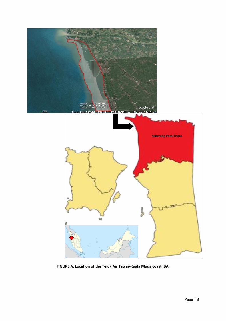
FIGURE A. Location of the Teluk Air Tawar-Kuala Muda coast IBA.
Seberang Perai Utara Seberang Perai Utara

Page | 9
1.0 INTRODUCTION
1.1 The BirdLife International/CEMEX/MNS Biodiversity Action Plan Project
BirdLife International and CEMEX share a common vision of achieving environmentally sustainable development and both recognize the business case for integrating biodiversity conservation into daily operations. CEMEX publically recognize their commitment to be a responsible steward of the land and to conduct activities in a sustainable manner. To this end, BirdLife International and CEMEX began a global partnership in 2007. The partnership demonstrates that corporates and NGOs with compatible aims and interests can generate significant gains, for both business and biodiversity, by working together. Through this partnership, CEMEX pioneered a strategic plan to prioritise action for biodiversity in the countries hosting CEMEX sites, resulting in the launch of the CEMEX-BirdLife Biodiversity Scoping Study in 2010. In the following year, the corporate Biodiversity Action Plan guidance (BAP) was launched. The guidance is intended to assist CEMEX develop BAPs for their operations regardless of location, proximity to areas with high biodiversity value or experience in biodiversity management. In 2013, BirdLife International, the CEMEX national operation and the Malaysian Nature Society (MNS) began a pilot project to test the BAP in Malaysia at Bukit Tambun, a quarry located on mainland Penang (or Seberang Perai). Under this collaboration, a comprehensive review of the historical and existing condition of areas in and surrounding the Bukit Tambun quarry site was done (Attwood et al. 2013). The review showed that current and post-quarrying opportunities for biodiversity enhancements and restoration at Bukit Tambun were limited and not cost-effective. In light of this, the review also included the broader landscape in Seberang Perai and evaluated several sites to optimize opportunities to achieve a net positive impact on biodiversity. The end results showed that the Teluk Air Tawar-Kuala Muda coast IBA (TAT-KM IBA) was the most ideal site in Seberang Perai to test the BAP. The Teluk Air Tawar-Kuala Muda coast IBA is recognised internationally as it supports several globally threatened waterbird species especially the Spoon-billed Sandpiper, Nordmann’s Greenshank, Chinese Egret and Lesser Adjutant and significant flyway population of the Chinese Pond-Heron. It is an important regional stopover and/or roost site for migratory shorebirds. However, the importance and value of this IBA is not only ecological but also provides ecosystem services that possess economic values. In this pilot effort, we identified several key ecosystem services that this IBA provides. Then, we used the “Toolkit for Ecosystem Service Site-based Assessment” (or TESSA) to assess these site-scale ecosystem services. The preliminary results from the TESSA exercise are intended to better inform Penang State policy and decision-makers, IBA site stakeholders and general public and advocate for the conservation of this IBA.
1.2 Mangrove Ecosystem Mangrove ecosystems lie at the interface of land and sea and mainly thrive in the wet tropics along the sheltered coasts. The plants in this ecosystem have evolved to withstand the harsh living conditions of changing salinity, strong tides, powerful wind, scorching sun and unstable anaerobic soil. A total of around 114 species of mangrove trees are recorded worldwide (Tomlinson 1986) and Malaysia has approximately 104 species of mangrove in the form of tree, shrub, palm and fern (Japar 1994).

Page | 10
The adaptations of these trees include special roots that allow the tree to stand in soft mud and aid root respiration in anaerobic mud (i.e. stilt root of the Rhizophora, pneumatophores of the Sonneratia and buttress of the Bruguiera trees). The trees manage the high salinity of their environs salt by excreting it through the roots or through the salt glands in its leaves. Many species are viviparous (seeds germinate while still attached to the mother tree) or the seedlings grow very fast once anchored at suitable sites. Despite the needs to battle a stressful life, mangrove is surprisingly one of the most productive ecosystems. This high productivity is tapped by the successful charcoal industries such as those at the Matang Mangrove Forest Reserves in the neighbouring state of Perak. The leaves from the mangrove trees form the base of the food web and support a multitude of lifeforms in and around the ecosystem. The high productivity also translates into a high capacity to trap atmospheric carbon dioxide through photosynthesis. Carbon that is fixed in the plant will remain trapped for many years and the plant detritus that is buried in the mud allow mangrove ecosystems to function as a long-term sink of carbon. Once a common feature of the muddy coast in the tropics, mangrove has experienced and still faces massive destruction and degradation due to human activities. Based on scarcity alone, mangrove is one of the very valuable assets to all as only 2% of total Malaysian land is covered with mangrove (Kainuma et al. 2013). Unfortunately, many harmful human activities are concentrated on the coastal zone. This has brought about undesirable consequences such as reclamation of mangrove forest for other land use. Penang State, where the TAT-KM IBA is located, was once lined by mangrove in most of its sheltered coast. Historical data revealed that mangrove forests has been reclaimed at an alarming rate since the 1950s (UPEN 1999b; Attwood et al. 2013). Many of the mangroves in Penang were lost due to development pressure for industrial land, port and airport especially in the east coast of Penang Island. Aquaculture (prawn farming), agricultural activities (oil palm plantations and rice production) and housing projects have converted most of the mangrove areas on the west coast of Penang Island (Balik Pulau) and in Seberang Perai. Besides coastal reclamation pressures, remaining mangroves in Penang face uncertainty as the coverage and land status (gazette, non-gazette or private land) are ill-defined and there is a need for a sustainable management plan. With mangrove representing only about 1% of tropical forest worldwide (FAO 2006), it is important to carry out public education to raise awareness on the importance of mangrove ecosystems. It is the realization on the ecological cost of destruction that could help restrain harmful practices on this precious and yet scarce coastal forest.
1.3 Ecosystem Services Provided by Mangroves
Much have been written on the value of mangroves to humans, both direct and indirectly (Chong 1998; Clough 1993; UPEN 1999a; Odum & de la Cruz 1963; Odum & Heald 1975; Lee et al. 2014; Saenger et al. 1983). Some of these values are highlighted below. (1) Coastal protection and sediment accretion The massive root systems in mangrove tree offer protection from tsunami wave flow pressure, especially on moderate tsunami impacted zones such as Penang. Mazda et al. (1997) reported that wave energy is reduced by 20% for every 100 metres of fully grown mangrove forest. Mangroves have also shown the ability to dampen erosion and accrete sediments vertically that help to increase coastal land area naturally based on the meta-analysis of 54 peer-reviewed ISI-rated papers published

Page | 11
between 1972 and 2005 by Dahdouh-Guebas & Jayatissa (2009). Furthermore, the role of mangroves in increasing soil volume vertically has been thoroughly researched in relation to sea level rise mitigation. (2) Carbon sequestration The role of mangrove ecosystems in the global carbon cycle has gained significant attention over the past decade (Matsui 1998; Donato et al. 2011; Kristensen et al. 2008; Twilley et al. 1992). A study spanning the Indo-Pacific region showed mangroves to be one of the most carbon-rich forests with 1,023 tonne stored carbon ha-1 (whole ecosystem including soil storage), as compared to other forest types (Donato et al. 2011/FIGURE 1). The carbon storage (or C storage) could be three to four times higher than tropical moist forest, temperate and boreal forest, with the majority of carbon locked below ground (Kainuma et al. 2013). Evidence collected in recent years suggested perturbation of these below ground C storage through activities such as clearing and drainage, conversion to aquaculture ponds could severely affect the capacity of mangrove soil to lock carbon (Donato et al. 2011).
FIGURE 1. Comparison of mangrove C storage with that of major global forest domains.
(Taken from Donato et al. 2011) (3) Siltation reduction in river channel The existence of mangroves on riverbanks help creates tidal asymmetry. The faster ebb current helps scour out the silt that otherwise will choke up the channel. An accessible channel is crucial to maintain free navigation for fisherman and help save tax-payers’ money in dredging cost. As pointed out by Wolanski et al. (1992) based on simulation data, removal of mangrove plants would potentially cause silting of river channels as observed in the Sungai Kerian in Penang (UPEN 1999a, 1999b). (4) Fisheries Mangrove waterways act as nursery and breeding grounds for many commercially important fish species. These range from pomfret (Pampus chinensis), prawn (especially the white prawn Penaeus merguiensis), mud crab (Scylla serrata) to shrimp (Acetes sp.). The blood cockle (Anadara granosa) bed that occur naturally adjacent to mangrove areas help generate many millions of ringgit every year; revenue not to be disregarded. An explicit study on the reliance of juvenile white prawn reinforced the role of mangrove detritus as main carbon source in prawn tissues. Chong et al. (2001) reported that juvenile prawns found at the upper estuaries of Matang mangroves has as high as 84% of its tissues made up of mangrove carbon. The reliance on mangrove carbon could still be detected (15%) up to 2 km off shore from the mangrove fringe.
Page | 12
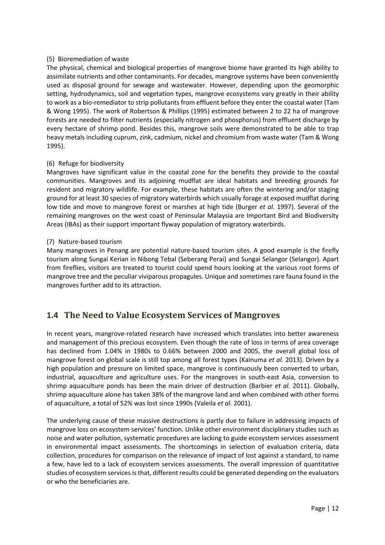
(5) Bioremediation of waste The physical, chemical and biological properties of mangrove biome have granted its high ability to assimilate nutrients and other contaminants. For decades, mangrove systems have been conveniently used as disposal ground for sewage and wastewater. However, depending upon the geomorphic setting, hydrodynamics, soil and vegetation types, mangrove ecosystems vary greatly in their ability to work as a bio-remediator to strip pollutants from effluent before they enter the coastal water (Tam & Wong 1995). The work of Robertson & Phillips (1995) estimated between 2 to 22 ha of mangrove forests are needed to filter nutrients (especially nitrogen and phosphorus) from effluent discharge by every hectare of shrimp pond. Besides this, mangrove soils were demonstrated to be able to trap heavy metals including cuprum, zink, cadmium, nickel and chromium from waste water (Tam & Wong 1995). (6) Refuge for biodiversity Mangroves have significant value in the coastal zone for the benefits they provide to the coastal communities. Mangroves and its adjoining mudflat are ideal habitats and breeding grounds for resident and migratory wildlife. For example, these habitats are often the wintering and/or staging ground for at least 30 species of migratory waterbirds which usually forage at exposed mudflat during low tide and move to mangrove forest or marshes at high tide (Burger et al. 1997). Several of the remaining mangroves on the west coast of Peninsular Malaysia are Important Bird and Biodiversity Areas (IBAs) as their support important flyway population of migratory waterbirds. (7) Nature-based tourism Many mangroves in Penang are potential nature-based tourism sites. A good example is the firefly tourism along Sungai Kerian in Nibong Tebal (Seberang Perai) and Sungai Selangor (Selangor). Apart from fireflies, visitors are treated to tourist could spend hours looking at the various root forms of mangrove tree and the peculiar viviparous propagules. Unique and sometimes rare fauna found in the mangroves further add to its attraction.
1.4 The Need to Value Ecosystem Services of Mangroves
In recent years, mangrove-related research have increased which translates into better awareness and management of this precious ecosystem. Even though the rate of loss in terms of area coverage has declined from 1.04% in 1980s to 0.66% between 2000 and 2005, the overall global loss of mangrove forest on global scale is still top among all forest types (Kainuma et al. 2013). Driven by a high population and pressure on limited space, mangrove is continuously been converted to urban, industrial, aquaculture and agriculture uses. For the mangroves in south-east Asia, conversion to shrimp aquaculture ponds has been the main driver of destruction (Barbier et al. 2011). Globally, shrimp aquaculture alone has taken 38% of the mangrove land and when combined with other forms of aquaculture, a total of 52% was lost since 1990s (Valeila et al. 2001). The underlying cause of these massive destructions is partly due to failure in addressing impacts of mangrove loss on ecosystem services’ function. Unlike other environment disciplinary studies such as noise and water pollution, systematic procedures are lacking to guide ecosystem services assessment in environmental impact assessments. The shortcomings in selection of evaluation criteria, data collection, procedures for comparison on the relevance of impact of lost against a standard, to name a few, have led to a lack of ecosystem services assessments. The overall impression of quantitative studies of ecosystem services is that, different results could be generated depending on the evaluators or who the beneficiaries are.

Page | 13
1.5 Ecosystem Services Assessment
Ecosystem services assessment has received growing interest in recent years. The method focuses on the measurement and valuation of ecosystem services to provide information of the wider (often hidden) benefits of ecosystems into the decision-making process of a conservation site. Evaluation especially on the economic value of mangrove ecosystem services enables direct comparison against economic value of alternative use. Many published studies including two meta-analyses have looked into ecosystem services assessment on mangroves over the years (Mahmoud Sarhan 2014; Brander et al. 2012). The methods used are categorized by Vegh et al. (2014) and as shown in TABLE 1. TABLE 2 summarizes some of the ecosystem services assessments conducted since 1990. The values of mangrove ecosystem services vary greatly due to different biophysical and socio-economic characteristics at each study site.

Page | 14
TABLE 1. Types of economic valuation methods. (Taken from Vegh et al. 2014)

Page | 15
TABLE 2: Ecosystem service assessments in mangrove area.
Reference Country/Region Ecosystem Service Type
Valuation Method Value (USD)
Lal (1990)
Fiji Water quality maintenance
Alternative Cost Method
US$5,820/ha/yr
Fiji Agriculture and aquaculture
Market value and shadow value
US$52/ha/yr
Carbrera et al. (1998)
Terminos Lagoon, Campeche, Mexico
Water qualities maintenance
Alternative Cost Method
US$1,193/ha/yr
Bann (1999)
Johor, Malaysia Capture fisheries, tourism and shoreline protection
Contingent Valuation Method
Direct use value US$1,375/ha/yr; Non-use value (base on tourist survey) US$7,512/ha/yr
Ronback (1999)
Global Capture fisheries Market value US$850-US$16,750/ha/yr
Barbier (2000)
Gulf of Thailand Estimate of change in mangrove area against shellfish and demersal fisheries
Production Function US$33-110/ha/yr
Brander et al. (2012)
Southeast Asia Fisheries, fuel wood, material, coastal protection
Meta-analysis US$4,185/ha/yr (mean); US$239/ha/yr (median)
Kuenzer & Vo (2013)
Can Gio district, Vietnam
Fisheries, forest goods, aesthetic/recreation, shoreline protection, climate leveling and carbon sequestration
Market value, Value transfer, socio-economic household survey
US$10,151/ha/yr to US$14,263/ha/yr
Page | 16
1.6 Objectives of the Study The objective of this study was to undertake a pilot assessment of the economic value using TESSA of the TAT IBA to demonstrate the range of benefits that the Teluk Air Tawar-Kuala Muda coast IBA provides to the people and promote greater awareness of the importance of this wetland by communicating the results of the assessment to local stakeholders and decision-makers with a view to promote an establishment of a protected area.
1.7 Limitations of the Study The value of ecosystem services of the Teluk Air Tawar-Kuala Muda coast IBA where estimated based on existing data due to resource constraints. Since only some of the major ecosystem services were identified and selected for assessment, these are conservative estimates. There is also a need for caution in the interpretation. The value of ecosystem services at TAT-KM IBA were estimated based on secondary data obtained
from various published reports. Questionnaire nor onsite sampling were not carried out due to limited resources. As such, environment service values estimated in this document are intended as pilot rapid assessment to make inferences about the overall services provided by the study site in its current form and at a degraded plausible state.
Access to statistics especially the fisheries dataset was limited. Most of the fisheries data were estimated based on outdated published documents. Attempts to access more current data from relevant authorities were unsuccessful.
Nature-based recreation potential of the current site was estimated based on survey done at other similar mangrove ecosystems and published statistic by the Ministry of Tourism and Culture.
The fundamental ecosystem services such as biodiversity, soil formation are not covered in the
valuation since those services cannot be measured with monetary value.
The monetary value will vary year by year along with the market situation.
It is uncertain that the estimated value would be maintained at the same level in future since the survey did not include the sustainability of resource use.

Page | 17
2.0 OVERVIEW OF STUDY SITE
2.1 Location and Site Characteristics Teluk Ayer Tawar-Kuala Muda coast IBA is located at the northern part of Seberang Perai in the state of Pulau Pinang (FIGURE 2). The area covers a patch of coastal fringing mangrove forest and its adjacent mud flat, stretching from the mouth or Sungai Muda (Muda River) at the north to the coastal boundary of Planning Blocks (Blok Perancangan) of Butterworth and Teluk Air Tawar (FIGURE 3). Description on the general land use changes over the wider area of Seberang Perai is reported in Attwood et al. 2013.
FIGURE 2. Location of Seberang Perai Utara District (in red) in Penang State.
Seberang Perai Utara Seberang Perai Utara

Page | 18
FIGURE 3. The ecological ‘boundary’ of the Teluk Air Tawar-Kuala Muda coast IBA. The TAT-KM IBA covers approximately 200 ha of mangrove forest (UPEN 1999b) and almost equal or even larger area of adjoining mudflat. It is important to include the mudflat beyond the coastline as these areas have relatively high invertebrate productivity. Polychaetes, bivalves and crustaceans teaming in mudflats are important food source for resident and migratory birds. The mudflats also help to dissipate wave energy and play a role in pollution sequestration. The TAT-KM IBA receives 2000 - 3000 mm rain/yr, with rainy days ranging from 150 - 200 days/yr. Climate is warm and humid recording 27 - 31°C. Wind predominantly blows from north and northeast direction (35% of time) and the south and southwesterly wind account for 20% of the time. The tidal flow at TAT-KM IBA is driven by semi-diurnal tides.
Sungai Muda
Aquaculture
ponds
Sungai
Tembus
Sungai
Lahar Endin
TAT-KM IBA Sungai
Penaga

Page | 19
2.2 Site Administration TAT-KM IBA is located in the district of Seberang Perai Utara (SPU). SPU is subdivided into 8 Planning Blocks (as Blok Perancangan in FIGURE 5). The red outline of TAT-KM IBA in FIGURE 4 shows the main part of the IBA are in the BP8 (Blok Perancangan Kuala Muda) and BP6 (Blok Perancangan Teluk Air Tawar). According to UPEN (1999b), the status of the mangrove land in the Kuala Muda – Penaga stretch was unknown i.e. it was neither Permanent Reserved Forest nor Stateland forest. This young patch of mangrove was first documented in the 1962 topography map (UPEN 1999a). However, the latest draft Local Area Plan of SPU (MPSP 2012) has included the entire TAT-KM IBA as Stateland and outlined in detail the plans for this area. Some of the proposed plans in the SPU Local Plan were aimed at protecting TAT-KM IBA as intact mangrove forest while others could potentially destroy and/or disrupt the ecological functions provided by the mangroves in this site.
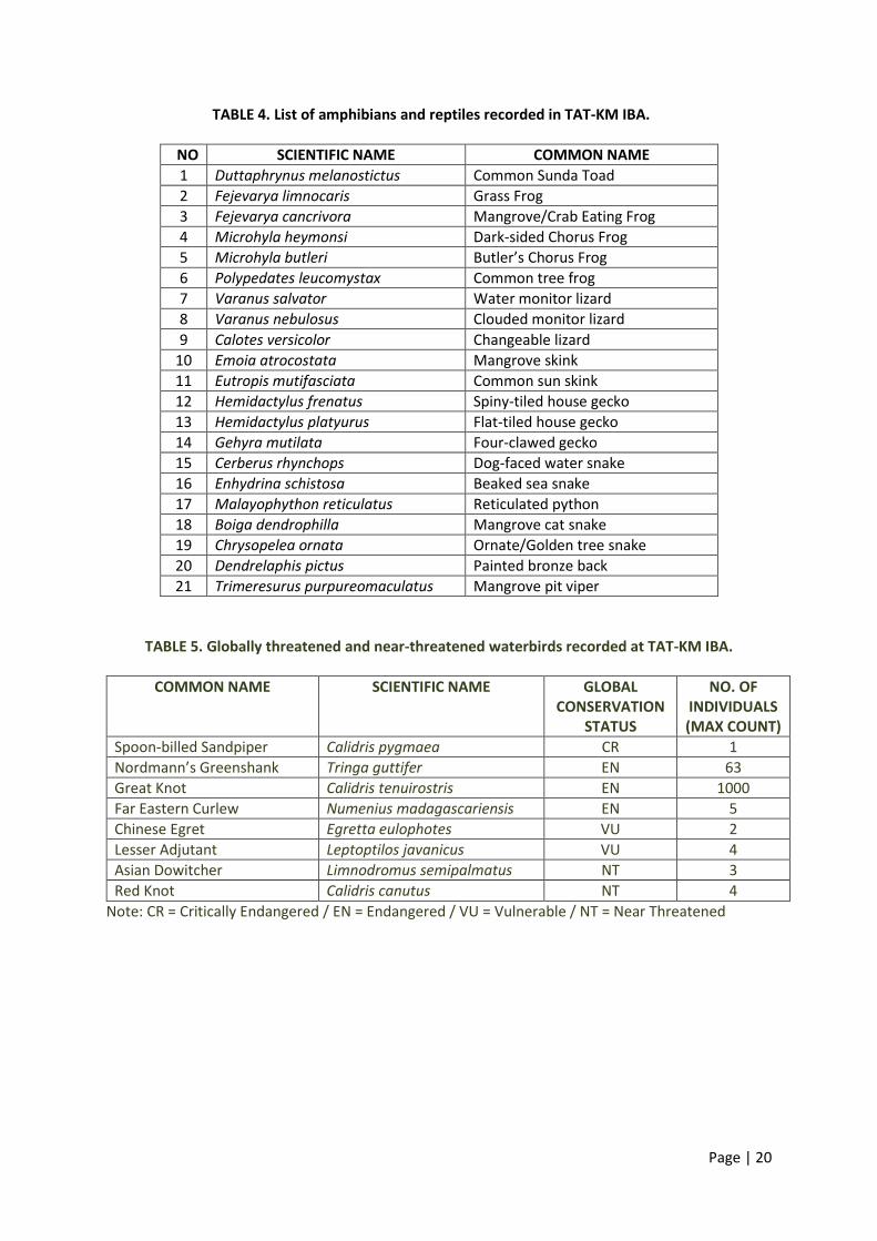
2.3 Biodiversity The biodiversity of the TAT-KM IBA has been surveyed and documented in Attwood et al. (2013) which covered several taxonomic group especially mangrove plants, birds, reptiles and amphibians. TABLE 3 summarizes the mangrove and its associated vegetation at the TAT-KM IBA. The main mangrove species found throughout the site is Avicennia marina. The northern part of the TAT-KM IBA immediately south from the river mouth of Sungai Muda has seen major erosion since the 1980s (EPU 1985). Rock bund structures at this part of the coastline has limited mangrove growth, but other than that, the forest is intact and in relatively good condition. For herpetofauna, a few mangrove frogs and snake species have been recorded (TABLE 4). In general, diversity of herpetofauna is low as compared to other tropical forest types due to the saline condition. However, it is quite the contrary for bird species. The Phase 1 survey on 16th February 2013 highlighted the outstanding value of TAT-KM IBA to six globally threatened and two near-threatened waterbirds and a total of 12,663 individuals (Attwood et al. 2013) (TABLE 5, PLATES 1-4).
TABLE 3. List of mangrove and associated flora recorded in TAT-KM IBA
NO SCIENTIFIC NAME COMMON/LOCAL NAME
1 Acrosticum aureum Piai Raya
2 Avicennia marina Api-api jambu
3 Bruguiera cylindrical Berus
4 Bruguiera parviflora Lenggadai
5 Caesalpinia crista Kuku tupai
6 Clerodendrum inerme Tulang-tulang
7 Derris trifoliate Ketui, malapari, salang, setui
8 Hibiscus tiliaceus Baru-baru
9 Leucophanes glaucum Moss
10 Rhizophora apiculata Bakau minyak
11 Sonneratia alba Perepat
12 Xylocarpus granatum Nyireh bunga
13 Casuarina equisetifolia Sea pine (Note: Non-mangrove species)
Page | 20
TABLE 4. List of amphibians and reptiles recorded in TAT-KM IBA.
NO SCIENTIFIC NAME COMMON NAME
1 Duttaphrynus melanostictus Common Sunda Toad
2 Fejevarya limnocaris Grass Frog
3 Fejevarya cancrivora Mangrove/Crab Eating Frog
4 Microhyla heymonsi Dark-sided Chorus Frog
5 Microhyla butleri Butler’s Chorus Frog
6 Polypedates leucomystax Common tree frog
7 Varanus salvator Water monitor lizard
8 Varanus nebulosus Clouded monitor lizard
9 Calotes versicolor Changeable lizard
10 Emoia atrocostata Mangrove skink
11 Eutropis mutifasciata Common sun skink
12 Hemidactylus frenatus Spiny-tiled house gecko
13 Hemidactylus platyurus Flat-tiled house gecko
14 Gehyra mutilata Four-clawed gecko
15 Cerberus rhynchops Dog-faced water snake
16 Enhydrina schistosa Beaked sea snake
17 Malayophython reticulatus Reticulated python
18 Boiga dendrophilla Mangrove cat snake
19 Chrysopelea ornata Ornate/Golden tree snake
20 Dendrelaphis pictus Painted bronze back
21 Trimeresurus purpureomaculatus Mangrove pit viper
TABLE 5. Globally threatened and near-threatened waterbirds recorded at TAT-KM IBA.
COMMON NAME SCIENTIFIC NAME GLOBAL CONSERVATION
STATUS
NO. OF INDIVIDUALS (MAX COUNT)
Spoon-billed Sandpiper Calidris pygmaea CR 1
Nordmann’s Greenshank Tringa guttifer EN 63
Great Knot Calidris tenuirostris EN 1000
Far Eastern Curlew Numenius madagascariensis EN 5
Chinese Egret Egretta eulophotes VU 2
Lesser Adjutant Leptoptilos javanicus VU 4
Asian Dowitcher Limnodromus semipalmatus NT 3
Red Knot Calidris canutus NT 4
Note: CR = Critically Endangered / EN = Endangered / VU = Vulnerable / NT = Near Threatened

Page | 21
2.4 Socio-economic Overview The TAT-KM IBA is surrounded by many villages. Fishing is still the major economic activity with five major fishing villages: Kuala Muda, Bakau Tua, Pulau Mertajam, Penaga and Teluk Ayer Tawar (UPEN 1999b). The number of fishermen in Seberang Perai Utara working on licensed fishing vessels registered with the Penang State Fisheries Department in 2013 was 1,313 (DOF 2014). Sixty-seven percent of the fishermen in Seberang Perai Utara are of ethnic Malay, 32% Chinese and 1% Indian (DOF 2014). Immediately outside of TAT-KM IBA, agriculture mainly paddy plantation occupies the rest of the land use in Seberang Perai Utara. The Kuala Muda fishing village is the main hub for fishing activities in this region (PLATE 5-6). In the Draft Local Area Plan for Seberang Perai Utara (MPSP 2012), Kuala Muda village has been identified as a socially sensitive area. This fishing village with its location far from main development centre has seen low social development in social security, economic development and education. Furthermore, the sea front village is at risk from natural disasters such as tsunamis that could disrupt its social economy structure (PLATE 7 & 8).
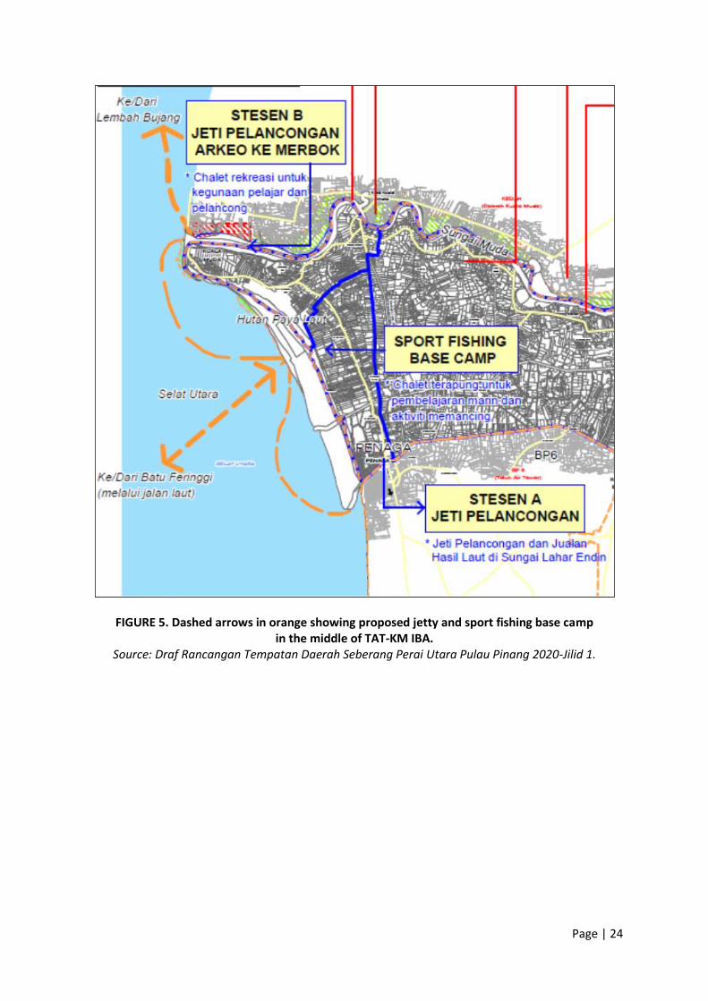
2.5 Key Threats The main and prevailing threat to the remaining mangrove forests, especially the TAT-KM IBA, in Penang State is land conversion to aquaculture ponds. In 2013, the Consumer Association of Penang (CAP) and Sahabat Alam Malaysia (SAM) highlighted a proposed aquaculture project in Penaga by the Aquaculture Operators Association of Penang (PENKUA) and the following year the felling of mangrove trees in Sungai Tembus by unknown parties or reason(s) (see APPENDIX A and B for details). This issue was again given prominence by a local newspaper Kosmo! in March 2016. The three-part coverage estimated that at least 193 ha of mangroves could be cleared for the proposed aquaculture project by PENKUA (APPENDIX C). If approved, the proposed project will effectively eliminate the entire TAT-KM IBA (97% of the total estimated area of 200 ha). Other possible threats could surface from proposed infrastructure and economic development projects for fisheries and tourism/recreation under the Draft Seberang Perai Utara Local Plan. These proposed projects include; (1) Land reclamation at adjacent Butterworth planning block (MPSP Structure Plan 2010, MPSP 2012).
(FIGURE 4) (2) Building of sport-fishing base camp south from the existing aquaculture ponds with floating
chalets and jetty facilities (FIGURE 5); (3) Building of jetty and infrastructure facilities for the sale of fishery product at the mouth of Sungai
Lahar Endin (FIGURE 6); and/or (4) Development of mussel aquaculture on the mudflat off coast of TAT-KM IBA (FIGURE 6). These proposed projects are sited either within the “ecological boundary” of the IBA or surrounding it which could negatively impact the IBA’s ecological integrity. Other threats identified with different ranking of threat levels are as summarized in TABLE 6.

Page | 22
TABLE 6. Existing and potential threats in TAT-KM IBA.
LAND USE
THREAT
Aq
uac
ult
ure
in m
angr
ove
fo
rest
Aq
uac
ult
ure
in m
ud
flat
En
cro
ach
men
t o
f h
um
an s
ettl
emen
t
Lan
d r
ecla
mat
ion
in a
dja
cen
t co
ast
To
uri
sm r
ela
ted
infr
astr
uct
ure
d
evel
op
men
t (j
etty
, cam
p s
ite,
res
ort
)
In
crea
se b
oat
act
ivit
ies
Sto
rm s
urg
es /
Tsu
nam
i
Co
asta
l Ero
sio
n
Agr
icu
ltu
re
Fu
el w
oo
d c
olle
ctio
n
Habitat lost
Habitat degradation
Increase water and solid waste pollution
Eutrophication
Increase human disturbance
Increase noise pollution (disrupting mating/signaling in wildlife especially birds)
Increase risk of coastal erosion
Reduce coastal protection from storm surge/tsunami
Increase changes in sediment accretion pattern
Changes in coastal current flow
Increase disruption in benthic food chain (lead to potential risk in food availability for birds)

Page | 23
FIGURE 4. Proposed land reclamation site in Butterworth, south from TAT-KM IBA. Sources: Draf Rancangan Tempatan Daerah Seberang Perai Utara Pulau Pinang 2020;
Penang Structure Plan 2020
Page | 24
FIGURE 5. Dashed arrows in orange showing proposed jetty and sport fishing base camp in the middle of TAT-KM IBA.
Source: Draf Rancangan Tempatan Daerah Seberang Perai Utara Pulau Pinang 2020-Jilid 1.

Page | 25
FIGURE 6. Proposed artificial reefs 10 km off coast from Kuala Muda, upgrade of pond
aquaculture and mussel aquaculture shown are some of the potential threats to the ecosystem’s integrity of TAT-KM IBA.
Source: Draf Rancangan Tempatan Daerah Seberang Perai Utara Pulau Pinang 2020-Jilid 1.
Upgrade of
aquaculture pond
Mussel
aquaculture
Land
reclamation

Page | 26
3.0 METHODOLOGY
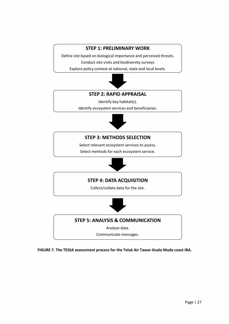
3.1 The method and assessment process TESSA (Toolkit for Ecosystem Service Site-based Assessment) is a relatively user-friendly tool for rapid ecosystem services assessment (Bagstad et al. 2013; Peh et al. 2013a, 2013b). Under Phase 2 of this project, given the resource constraints, TESSA has provided qualitative and quantitative assessments of the benefits stakeholders receive from conserving an ecosystem, by comparing the ecosystem services provided by the current state of the site (TAT-KM IBA) and a plausible alternative state. Through this assessment to identify ecosystem service benefits and beneficiaries of a site, stakeholders (especially decision-makers) can make better judgments supported by a sound evidence(s). The process of assessment is summarized below in FIGURE 7. Based on a scoping exercise conducted was done to identify main ecosystem services provided by TAT-KM IBA: (1) Global climate regulation (2) Harvested of wild goods (fisheries only) (3) Coastal protection (4) Water quality improvement (5) Nature-based recreation
3.2 Current State The assessment site is the TAT-KM IBA in its current state of having 197 ha of coastal Avicennia-dominated mangrove forest (TABLE 7).
3.3 Alternative State The alternative state represents the counterfactual scenario, that is, should the proposed conversion of the TAT-KM IBA into a 193 ha aquaculture project be implemented as featured in Kosmo! in March 2016 (APPENDIX C). Hence, only 3 ha of mangrove forest would be left (TABLE 7).
TABLE 7. Land cover of the Teluk Air Tawar-Kuala Muda coast IBA under the current and
alternative states.
LAND COVER TYPE
CURRENT STATE ALTERNATIVE STATE
PERCENTAGE OF AREA
(%) AREA (ha)
PERCENTAGE OF AREA
(%) AREA (ha)
Mangrove forest 98.5 197 3.5 7
Aquaculture Farm 1.5 3 96.5 193
TOTAL 100 200 100 200
Page | 27
FIGURE 7. The TESSA assessment process for the Teluk Air Tawar-Kuala Muda coast IBA.
STEP 1: PRELIMINARY WORK
Define site based on biological importance and perceived threats.
Conduct site visits and biodiversity surveys
Explore policy context at national, state and local levels.
STEP 2: RAPID APPRAISAL
Identify key habitat(s).
Identify ecosystem services and beneficiaries.
STEP 3: METHODS SELECTION
Select relevant ecosystem services to assess.
Select methods for each ecosystem service.
STEP 4: DATA ACQUISITION
Collect/collate data for the site.
STEP 5: ANALYSIS & COMMUNICATION
Analyse data.
Communicate messages.

Page | 28
4.0 RESULTS OF THE TESSA ASSESSMENT
4.1 Global climate regulation It has been estimated that 7-17% of global anthropogenic carbon dioxide emission is from deforestation and land-use changes (Harris et al. 2012; van der Werf et al. 2009). To mitigate climate change, it is important to monitor forest type that has high carbon density and under threat of reclamation for other land-use, i.e. the mangrove. Whole ecosystem C storage is assessed through measurement of C pools from above (plant biomass) and below ground (plant root and soil) in the mangrove forest. To estimate total above ground C at TAT-KM IBA, secondary data were extracted from published data at a similar mangrove plot in Penang with trees of mean 13.8 cm in diameter (DBH) (Foong et al. 2003). TABLE 8 shows comparability of the DBH measurement taken in Penang (Pantai Mas) with other mangrove forests in this region. To estimate carbon stocks in the mangrove forest, allometric equations of Komiyama et al. (2005) for general mangrove species (Above ground and below ground mangrove tree biomass) were used as shown in TABLE 9. The estimations of AGB and BGB for a mangrove tree average to about 80.9 kg and 36.8 kg respectively. With the average tree density of 1,350 tree ha-1 (Foong et al. 2003), the total AGB and BGB are estimated to about 109.2 ton ha-1 and 49.7 ton ha-1 respectively. The estimated AGB and BGB were then divided by the carbon fraction for mangrove tree (50%) according to Gifford (2000). For the C stock at the mangrove sediment component, we used the estimation provided in a meta-analysis on mangrove forest in Indo-Pacific region by Donato et al. (2011) i.e. 0.038 g C cm-3(estuarine sediment). TABLE 10 also shows the comparability of Donato et al. (2011) estimation with other meta-analyses of mangrove sediment globally.
TABLE 8. Related information for common allometric measurement of C pool of the mangrove forests near the region of TAT-KM IBA.
Site Location Stage of forest
Tree density (N ha-1)
DBH (cm) Reference
Pantai Mas, Penang National Park
5°25’20”N, 100°11’50”E
Secondary 1,350 1.6-26.7 (range),
13.8 (mean)
Foong et al. (2003)
Pang-nga , Thailand
8°20’N, 98°36’E
Secondary 1,446 52.4 (max) Komiyama et al. (2005)
Trat, Thailand 12°12’”N, 102°33’E
Secondary 1,682 53.7 (max) Komiyama et al. (2005)
Ranong, Thailand
9°58’N, 98°38’E
Primary 1,246 55 (max) Tamai et al. (1986)

Page | 29
TABLE 9. Allometric equations used in the estimation of above and below ground mangrove plant biomass. (p=Avicennia sp. wood density in 0.506 ton m-3, DBH= Diameter at breast height in cm)
Allometric equation Reference
Above ground biomass (AGB) AGB=0.251(p)(DBH)^2.46 Komiyama et al. (2005)
Below ground biomass (BGB) BGB=0.199(p)^0.899 (DBH)^2.22
TABLE 10. Meta-analysis of mangrove sediment carbon stocks
Mean soil C concentration ( g C cm-
3) Region Core length (m) Reference
0.055 Global 0.5 Chmura et al. (2003)
0.038 (Estuarine) 0.061 (Oceanic)
Indo-Pacific Up to 3 Donato et al. (2011)
0.015-0.115 Global Variable Pendleton et al. (2012)
The C stocks in the mangrove forests for the current state of TAT-KM IBA and the plausible alternative state were then presented in C monetary values based on US Government Social Cost Value of Carbon (Bell & Callan 2011) of USD 88.50 MgC-1 (TABLE 11). This C value has been adjusted to 2014 price based on IMF 2015 deflator index.
TABLE 11. Mean C stocks for TAT-KM IBA under its current and alternative states.
IBA Site Status
Mangrove area (ha)
Carbon Stock (Mg)
AGB (%) BGB (%)
Sediment (%)
Total Carbon Stock (Mg)
(A)
Carbon price (USD
MgC-1)
(B)
Total Carbon
price (USD 88.50 MgC-1)
(A x B)
Current State
197 10,756
(4.4) 4,896
(2) 228,000
(93.6) 243,652 88.50 21,563,175
Alternative State
7 382(4.5) 174 (2)
7,980 (93.5)
8,536 88.50 755,454
Notes: 1. The Carbon monetary value is at USD88.50 MgC-1 (2014 price). 2. Above Ground Biomass (AGB); Below Ground Biomass (BGB)
Page | 30
4.2 Provision of wild goods (Fisheries) Fishing is identified as the main provision of wild goods at the TAT-KM IBA. The data acquired from the Lembaga Kemajuan Ikan Malaysia (LKIM) shows that there are 5 main fish landing areas in TAT-KM IBA namely Teluk Air Tawar, Penaga, Kuala Muda, Bakau Tua and Pulau Mertajam with a total of 138 registered fisherman in the year of 2002 (LKIM 2009). This represents 72% of the total fisherman registered for the whole of Seberang Perai Utara (SPU) area in year 2002.
The average fisherman’s income recorded for the year of 2007/2008 from LKIM (2009) is RM1,758/month (adjusted to 2014 price based on IMF 2015 deflator index). With the estimated total number of fishermen in TAT-KM IBA of 945, the overall value of fishery provision comes to about RM19,935,720 per annum (USD4,983,930/yr). The fishing gear used were drift/gill nets (84%) (PLATE 9), single boat trawl net (11%) and traps (5%). Almost all of this fisherman operate in inshore coastal waters in Zone A, which is within 5 nautical miles (9.26 km) from coast using small fishing boat of less than 15 GRT (Gross Registered Tonnage) (PLATE 10). However, the latest fisheries statistic obtained from Department of Fisheries (DOF 2014) showed an increase in number of registered fisherman for Seberang Perai Utara from 138 in year 2002 to 1,313 in 2013. Unfortunately the DOF (2014) statistic did not provide subsetting of number of fishermen according to fishing village, we then relied on the fisheries statistic in year 2002 to derive the ratio of fishermen for the five major fish landing sites in TAT-KM IBA (72%). Based on this ratio of fishermen from the 2002 dataset, we postulated that the number of fisherman from the five fish landing areas totaled about 945 for the year of 2013 (72% x 1,313 = 945.36). The estimated number of fisherman agrees with the number estimated from a brief site survey done on three fish landing sites: Fishing boats counted at time before the full return of all fishermen for Sungai Lahar Endin (25-30 boats)(PLATE 11), Sungai Penaga (80 boats)(PLATE 12 & 13) and Sungai Tembus (60 boats) (PLATE 14), with average three fishermen working in one boat (Foong Swee Yeok pers. obs.). In the plausible alternative state, it is highly possible that aquaculture could result in disruption in local fisheries activities such as the relocation of landing jetties and villages which can negatively impact the fishermen’s income. Proposed aquaculture projects often involve land acquisition, changes to land status or site clearing. Informal coffeeshop dialogues with the local fishermen revealed that they are unwilling to operate from fish landing sites that are far away from their villages. When this happens, the total value of fishery provision that comes from this site would be equal to zero. Thus, traditional fisheries could no longer be tenable when an aquaculture project(s) takes place in the area. The above estimation for wild good provision from this sector is based on the assumption that 100% fishery is attributed to the ecosystem service of breeding and living grounds provided by the mangroves within the site. The same assumption was used in another TESSA project that looked at mangrove ecosystem services in West Madagascar (Ravaoarinorothsihoarana 2014). We also noted that: (i) There is no other natural ecosystem such as coral reef or sea grass bed within the 20 km radius
from the assessment site; and

Page | 31
(ii) Almost all of the fishermen boats were only licensed to fish in inshore coastal water (within Zone A1 that is 9.26 km from the coast).
However, Sasekumar et al. (1992, 1998) and Jothy (1984) reported that approximately 50% of the commercially important fish catches in west coast of Peninsular Malaysia could be linked to mangrove as living habitat and another 25% was attributed to its role as nursery ground for fishes. With this, we adjusted the value of the ecosystem services in terms of fisheries as shown in TABLE 12.
TABLE 12. The value of fisheries of TAT-KM IBA under its current and alternative states.
IBA Site Status Mangrove area (ha)
Living Habitat (50% of fish catch value)
(USD/yr)
(A)
Nursery Habitat (25% of fish catch value)
(USD/yr)
(B)
Total (USD/yr)
(A+B)
Current State 197 2,491,965 1,245,983 3,737,948
Alternative State 7 0 0 0
Note: The fish catch value is estimated to be USD4,983,930/yr.
4.3 Coastal protection Studies on the role of mangrove forests in coastal protection have intensified since the 2004 Indian Ocean tsunami. Coastal protection economic values are usually derived indirectly from the costs of constructing protective coastal infrastructures such as building and maintenance of dikes. In south-east Asia region alone, the economic value estimations vary in accordance to severity of wave impacts and socio-economic condition at each site as shown in TABLE 13.
TABLE 13. Selected economic value estimation conducted on coastal protection in Asia.
Coastal protection value (USD/ha/yr)
Study concept and scope Reference
3,116 Meta-analysis on 29 observations from countries mainly in Asia.
Salem & Mercer (2012)
2,990 Study in Surat Thani, Thailand. Preventive expenditure on coastal protection infrastructure for every 75 meter wide of mangrove.
Suthawan (1998)
1,504 Studies in a few mangrove areas in Vietnam. IUCN (2008)
35.84 Protection against coastal flooding and typhoon in Vietnam
Tri et al. (1996)
We opted for the coastal protection value (USD 3,116/ha/yr) by Salem & Mercer (2012) which was derived mostly on observations done in south-east Asia countries. Coastal protection value of TAT-
1 This zone is normally for the traditional fishermen (owner operated) and traditional anchovy purse seiner which operates up to 5 nautica-miles. Their boats should be <40 GRT (gross registered tonnes) (DOF 2015).

Page | 32
KM IBA totaled to about USD 601,388/yr and USD 21,812/yr under the current and alternative states respectively (TABLE 14). TABLE 14. The value of coastal protection of TAT-KM IBA under its current and alternative states.
IBA Site Status
Mangrove area (ha)
(A)
Coastal protection value (USD/ha/yr)
(Salem & Mercer 2012) (B)
Total (USD/yr)
(A x B)
Current State 197 3,116 613,852
Alternative State 7 3,116 21,812
4.4 Water quality improvement services Mangroves have a high growth rate and extensive root system acting as a very efficient nutrient filter and sediment trap by the coast. It has been estimated that mangrove ecosystems (plant and soil) have the potential to immobilize as high as 150-250 kg Nitrogen (N/ha) and 15-20 kg Phosphorus (P/ha) of nutrient yearly (Boto 1992). To estimate the economic value of the ecosystem service provided by mangrove forest to assimilate waste, we used the estimated cost provided by Salem & Mercer (2012) that was derived from four observations in Southeast Asia, USD 4,748/ha/yr. The total economic value of services provided by the 197 ha of mangrove forest at TAT-KM IBA that receives 2,500 mm rain/yr, sums up to about USD 935,356/yr (adjusted to 2014 price based on IMF 2015 deflator index). Whereas the alternative state will only be able to provide USD 33,236/yr (TABLE 15).
TABLE 15. The value of water quality coastal protection of TAT-KM IBA under its current and alternative states.
IBA Site Status
Mangrove area (ha)
(A)
Water quality improvement service value (USD/ha/yr)
(Salem & Mercer 2012)
(B)
Total (USD/yr)
(A x B)
Current State 197 4,748 935,356
Alternative State 7 4,748 33,236
4.6 Nature-based recreation The Willingness-To-Pay (WTP) method is commonly used and reliable to value nature-based recreation at various types of habitats and sites in Malaysia. For mangroves, a report on the total economic valuation of coastal and marine resources of Straits of Malacca (MPP-EAS 1999) estimated that tourism revenues in the mangrove area amounted to US$719/ha/yr in the Sarawak Mangrove
Page | 33
Reserve (Bennett & Reynolds 1993). TABLE 16 highlights other mangrove recreation value studies conducted in Malaysia. The TAT-KM IBA in its current state has very little nature-based recreation. Due to resource constraints, the potential nature-based recreation value of this IBA was estimated using the WTP method. MNS firmly believes that this IBA holds potential for nature-based recreation and tourism. We used the value of USD12.62/visitor/year which is derived from a contingent valuation study (Ahmad 2009) that was carried out on Larut Matang Mangrove Forest Reserve in Perak to predict the potential nature-based recreation value of TAT KM IBA because (1) both sites are relatively close to each other distance-wise, and (2) this is the most recent valuation study conducted in the habitat most similar to the TAT-KM IBA.
TABLE 16. Willingness To Pay value (WTP, adjusted to 2014 price based on IMF 2015 deflator index) of Malaysian mangroves.
Study Site WTP Value (USD/visitor/yr)
No. of Respondents
Reference
Benut Mangrove Reserve, Johor
13.60 120 Bann (1999)
Kapar mangrove forest, Selangor
3.41-17.25 220 Amiry et al. (2009)
Sarawak Mangrove Forest Reserves, Sarawak
4.04 316
Bon (2011)
Larut Matang Mangrove Forest Reserves, Perak
12.62 331 Ahmad (2009)
The Ministry of Tourism and Culture recorded a total of 5,999,864 tourist visitors to Penang in 2010 (49% local, 51% international) (MOTAC 2011). Hypothetically, if 1% of these tourists (i.e. ~60,000 tourist/yr or 164 daily visitor) landing in Penang would visit TAT-KM IBA, this could potentially generate the total amount of USD757,175/yr (or USD12.62/person/yr) in terms of revenue (TABLE 17). This revenue could be captured through entrance fee to a nature education centre. It is also worth noting that this amount is very close to the permit fee charged at Mai Po Marshes Nature Reserve in Hong Kong (USD 15.47/person), a 270 ha of wetland nature reserve that supports several globally threatened bird species and high waterbird diversity.
TABLE 17. The potential value of nature-based recreation in TAT-KM IBA under its current and alternative states.
IBA Site Status Mangrove area
(ha)
Estimated No. Tourist
(A)
WTP value (USD/prs/yr)
(B)
Total (USD/yr)
(A x B)
Current State 197 60,000 12.62 757,175
Alternative State 7 Very low / Negligible 12.62 0 (or negligible)

Page | 34
5.0 DISCUSSION AND SUMMARY One of the most important ecosystem services provided by TAT-KM IBA is valued at USD 21,563,175 in the form of C stored in plant biomass (above and below ground) and in mangrove mud (TABLE 11). On a global scale, the mangrove ecosystem functions as an important C trap to sequester CO2 and stores it in above and below ground compartments. On top of this, another USD 6,044,331/year of economic value is provided by TAT-KM IBA to the community under the current conservation status from services such as fisheries catch, coastal protection, water quality improvement services, nature-based recreation. This pioneer exercise demonstrated that the narrow strip of coastal mangrove and mudflat ecosystems play a vital role direct and indirectly to the community living in the vicinity and to wider benefits to regional and global beneficiaries. The mudflat serves as one of the most important IBAs for Peninsular Malaysia with good potential for nature-based tourism. In comparing the current and alternative states of the TAT-KM IBA, our estimations show the negative impacts of large scale aquaculture projects on global climate as compared to other ecosystem services (TABLE 18). With the limitation in time and budget, most of the data used in this assessment are secondary and in some cases, out of date. However, we have high level of confidence on the estimation of global climate regulation services provided by the TAT-KM IBA. This is due to estimation on the above ground C stock was done based on data collected from a similar Avicennia forest in Penang. Nonetheless, the economic value from the below ground carbon sediment stock was likely to be an under-estimation as only C stock in mangrove sediment was counted but not C stock in the adjacent mudflat. As for the wild good services provided in terms of fish harvest, it is at best a conservative estimation with the number of fisherman from TAT-KM IBA area was estimated from 2002 DOF data and by field observation by the authors. It should be noted that the coastal protection value of the mangrove forest in TAT-KM IBA was derived from a meta-analysis from mostly Asia countries (n=29). As the TAT-KM IBA is rated as high erosion site and under the threat of tsunami, a thorough study on hydrodynamic condition could shed light on the actual protection value of the mangrove forest to the human community who rely on the forest for protection during adverse weather events. We were also unable to make a good estimation on the value of mangrove forest in terms of water quality control, as no data is available to make reasonable estimation on the agrochemical used in the paddy field within the same water catchment system. The same applies to the estimation on the nature-based recreation value of TAT-KM IBA, as this site has not been developed for tourism activities such as bird watching. Forecast on the management cost and actual spending of the tourists are not done in this exercise. By proposing to convert more than 97% of the existing mangrove into aquaculture ponds, the carbon sequestered in the form of biomass and sediment will be greatly reduced. Of all the ecosystem services, provision of wild goods in the form of fisheries provide the highest value at the current site of TAT-KA IBA, followed by water quality improvement, potential nature-based tourism and coastal protection. These ecosystem services are predicted to be significantly reduced with the removal of mangrove forest as shown in the alternative state. Even though aquaculture activities provide considerable post-harvest economic return, the environmental impacts entail a two-magnitude order of carbon footprint. Teluk Air Tawar-Kuala Muda coast IBA at its present condition provides many ecosystem services to the immediate fisher communities and wider district (TABLE 19). However, the proposed conversion of 97% of 200 ha of the IBA will undoubtedly diminish the economic benefits currently enjoyed by many. Current economic activities dependent on this habitat will be hard hit and potential ones such

Page | 35
as nature-based recreation and tourism will not be realized. Large-scale aquaculture is expected to only benefit few stakeholders namely the owner(s) and hired workers. TABLE 18. Summary of the TESSA preliminary assessment of the ecosystem services of the TAT-KM
IBA.
ECOSYSTEM SERVICE TYPE
PRODUCT CURRENT STATE ALTERNATIVE STATE DIFFERENCE
(USD) ANNUAL VALUE (USD)
Harvested wild goods (fisheries)
Fishermen’s income 3,737,948 0 3,737,948
Coastal protection
Preventive expenditure on protective coastal infrastructure
613,852 21,812 592,040
Water quality improvement services
Operative and maintenance costs for biological nutrient removal
935,356 33,236 902,120
Nature-based tourism
Willingness-To-Pay value by visitors
757,175 0 757,175
TOTAL (ANNUAL VALUE) 6,044,331 55,048 5,989,283
CARBON STORAGE (ONE-OFF VALUE) 21,563,175 755,454 20,807,721
Note: The economic value of a small subset of ecosystem services was estimated using TESSA. Caution for the interpretation is needed (see 1.7 Limitations of the Study). TABLE 19. Beneficiaries of the economic benefits at TAT-KM IBA under the current and alternative
states.
ECONOMIC BENEFIT BENEFICIARY POPULATION CURRENT STATE ALTERNATIVE STATE
Climate regulation Global population
Harvested wild goods (fisheries)
Local inshore fishermen
Coastal protection Coastal adjacent dwellers in the district
Water quality improvement
Local communities in the district
Nature-based tourism Local communities in the district
Cultivated goods (land-based aquaculture)
Owners of the ponds, limited number of hired workers (local and/or foreign)

Page | 36
6.0 CONCLUSION This rapid assessment of Teluk Air Tawar-Kuala Muda coast IBA’s ecosystem services using the TESSA tool helps to highlight the importance of this narrow coastal fringing mangrove and mudflat ecosystems – the last remaining sizable intact mangrove habitat in Penang State. By estimating an economic value on the ecosystem services, decision-makers are better alerted to the true cost of destroying an ecosystem. That is what MNS hope to highlight in this report, pointing out all possible threats and their likely consequences. The key threat constantly faced by TAT-KM IBA is conversion to aquaculture ponds (mainly prawn farming). A great deal of research shows that mangrove soils are not suitable for aquaculture due to its high impacts on global C emission and potential to turn acidic. Many prawn ponds (as also in the case of the prawn ponds in TAT-KM IBA) have been abandoned or turned idle as the lime application treatment to counter the acidity soil condition is costly. Using TESSA shows very clearly that by converting mangrove and mudflat ecosystems into alternative use, as in the case of the alternative state (with removal of 97% of mangrove) could revert the ecosystem into a net C emitter. Mangrove conversion will also reduce its coastal protective qualities for the particular area thus exposing the local communities and villages to tsunamis and flooding. Another immediate threat to the TAT-KM IBA is the large scale land-reclamation proposal at the adjacent coast. As TAT-KM IBA mudflat serves as not only the most important habitat for resident and migratory birds in northern Peninsular Malaysia, but a globally important flyway site on the East Asian-Australasian Flyway, proactive strategies are needed to ensure land reclamation activities do not cause instability or even damage the mudflat. A comprehensive numerical study that combine wave changes, sediment transport and water quality on any scale of land reclamation proposed near TAT-KM IBA should be undertaken. This study also highlights the potential of TAT-KM IBA as a nature-based tourism site. The mangroves and mudflats support globally and regionally important biodiversity especially birds. To tap into the nature-based tourism potential of this IBA and maintain its ecological values, MNS strongly advocates for its protection as a State Park or nature park. The Sungei Buloh Wildlife Reserve (Singapore), Kuala Selangor Nature Park (Selangor), Pulau Kukup National Park (Johor) and Kota Kinabalu City Wetlands Sanctuary (Sabah) offer workable models for consideration. This vision is consistent with MPSP’s plans to promote ‘ecotourism’ at several sites in Seberang Perai including this IBA (Looi 2015). In the end, all Statelands in Malaysia are under the jurisdiction of the state government, the Majlis Perbandaran Seberang Perai has the autonomy to implement an appropriate development programme with the assistance of various committees and/or stakeholders. Sustainable management of TAT-KM IBA requires strong and continuing political commitment as well as sustained support from all those involved (from government, NGOs, scientists, local population and special interest groups) in various forms.

Page | 37
REFERENCES Ahmad, S. 2009. Recreational values of mangrove forests in Larut Matang, Perak. Journal of Tropical
Forest Sciences 21(2): 81-87. Amiry, S.A., Yacob, M.R., Radam, A., Samdin, Z. & Shuib, A. 2009. Recreational demand in bird
sanctuary: The case of Kapar Bird Sanctuary, Kelang, Malaysia. International Journal of Business & Management 4(12): 99-111.
Attwood, S., Bakewell, D., Yeap, C.Y, Tan, C.E., Foong, S.Y. & Muin, M.A. 2013. Biodiversity Action Plan for Bukit Tambun quarry and collaborative efforts at the Teluk Air Tawar - Kuala Muda coast Important Bird Area (Phase 1 Report). Kuala Lumpur: Malaysian Nature Society. (Unpublished).
Bagstad, K.J., Semmens, D.J., Waage, S. & Winthrop, R. 2013. A comparative assessment of decision-
support tools for ecosystem services quantification and valuation. Ecosystem Services 5: 27-39.
Bann, C. 1999. A Contingent Valuation of the Mangroves of Benut, Johor State, Malaysia. (Johor State Forestry Department/DANCED/Darudec: Preparation of an Integrated Management Plan for the Sustainable Use of the Johor Mangrove Forests). http://www.soc.uoc.gr/calendar/2000EAERE/papers/PDF/A6-Bann.pdf
Barbier, E.B. 2000. Valuing the environment as input: review of applications to mangrove-fishery linkages. Ecological Economics 35: 47-61.
Barbier, E.B., Hacker, S.D., Kennedy, C., Koch, E.W., Stier, A.C. & Silliman, B.R. 2011. The value of estuarine and coastal ecosystem services. Ecological Monographs 81: 169–193.
Bell, R.G. & Callan, D. 2011. More than meets the eye: the social cost of carbon in U.S. climate policy,
in plain English. Washington D.C.: World Resources Institute.
Bennett, E.L. & Reynolds, C.J. 1993. The value of a mangrove area in Sarawak. Biodiversity Conservation 2: 359–375.
Bon, A.S.Y. 2011. Factors influencing Willingness to Pay for Conservation of Deltaic Mangrove Forest Resources in District of Kuching. Master Dissertation. Kuching: University Malaysia Sarawak.
Boto, K.G. 1992. Nutrients and mangroves. In: Connel, D.W. & Hawker, D.W. (eds). Pollution in Tropical Aquatic Systems. CRC Press Inc., Ann Arbor, London: 129-145.
Brander L.M., Wagtendonk, A.J., Salman, S.H, McVittie, A., Verburg, P.H., de Groot, R.S. & van der Ploeg, S. 2012. Ecosystem service values for mangroves in Southeast Asia: A meta-analysis and value transfer application. Ecosystem Services 1: 62–69.
Burger, J., Niles, L. & Clark, K.E. 1997. Importance of beach, mudflat and marsh habitats to migrant
shorebirds on Delaware Bay. Biological Conservation 79: 283-292.
Cabrera, M.A., Seijo, J.C., Euan, J. & Perez, E. 1998. Economic values of ecological services from a
mangrove ecosystem. Intercoast Network 32: 1–2.
Chmura, G. L., Anisfeld, S.C., Cahoon, D.R. & Lynch, J.C. 2003. Global carbon sequestration in tidal, saline wetland soils. Global Biogeochemical Cycles 17(4): 1111 (doi:10.1029/2002GB001917)
Chong, V. C. 1998. Coastal aquaculture development in Malaysia and its environmental impacts, pp. 1–17. Workshop on Aquaculture and its Environmental Problems in the Southeast Asian Countries: 1998 March 27–28: Japan International Research Center for Agricultural Sciences, Tsukuba.
Chong, V.C., Low, C.B. & Ichikawa, T. 2001. Contribution of mangrove detritus to juvenile prawn nutrition: a dual stable isotope study in a Malaysian mangrove forest. Marine Biology 138: 77-86.
Clough, B. (ed.) 1993. The economic and environmental values of mangrove forests and their present state of conservation in the south-east Asia/Pacific region. ISME Mangrove Ecosystem Technical Reports, Vol. 1, Okinawa, Japan.
Dahdouh-Guebas, F. & Jayatissa, L.P. 2009. A bibliometrical review on pre- and post tsunami assumptions and facts about mangroves and other coastal vegetation as protective buffers. Ruhuna Journal of Science 4: 28–50.

Page | 38
DOF. 2014. Annual Fisheries Statistic 2013. Department of Fisheries Malaysia. DOF. 2015. National Plan of Action for the Management of Fishing Capacity in Malaysia (Plan 2).
Putrajaya: Department of Fisheries Malaysia. Donato, D.C., Manninen, M., Kauffman, J.B., Murdiyarso, D. Kurnianto, S. & Stidham, M. 2011.
Mangroves among the most carbon-rich forests in the tropics. Nature Geoscience 4:293-297. EPU. 1985. National Coastal Erosion Study, Final Report, Phase 1. Prepared by Standley Consultant Inc.
& others. Economic Planning Unit Malaysia. FAO. 2006. Global Forest Resources Assessment 2005: Progress towards Sustainable Forest
Management. Rome: Forestry Department, FAO.
Foong, S.Y., Kumaradevan, S. & Lock, C.H. 2003. Mangrove in Pantai Acheh Forest Reserve, Penang, Malaysia. In: Chan, L.K. (ed.) Pantai Acheh Forest Reserve: The Case for a State Park. 126-128 pp.
Gifford, R.M. 2000. Carbon Contents of Above-Ground Tissues of Forest and Woodland Trees. National
Carbon Accounting System Technical Report No. 22. Canberra: Australian Greenhouse Office.
Harris, N.L., Brown, S., Hagen, S.C., Saatchi, S.S., Petrova, S., Salas, W., Hansen, M.C., Potapov, P.V. &
Lotsch, A. 2012. Baseline map of carbon emissions from deforestation in tropical regions.
Science 336: 1573–1576. (doi: 10.1126/science.1217962)
IMF. 2015. International Monetary Fund World Economic Outlook Database.
http://www.imf.org/external/pubs/ft/weo/2015/01/weodata/index.aspx.
IUCN. 2008. Designing payments for ecosystem services: Report from the East Asian Regional Workshop. Hanoi, Vietnam.
http://iwlearn.net/abt_iwlearn/events/pesworkshop-hanoi/designing-payments-for-ecosystem-services-report-fromthe-east-asian-regional-workshop
Japar, S. 1994. Mangrove plant resources in the ASEAN region. In Wilkinson, C.R., Sudara, S. & Chou,
L.M. (eds). Proceedings Third ASEAN-Australia Symposium on Living Coastal Resources, Vol.1.
Status Reviews. Bangkok: Chulalongkorn University.
Jothy, A.A. 1984. Capture fisheries and the mangrove ecosystem. In Ong, J.E. and Gong, W.K. (eds.) Productivity of the mangrove ecosystem: management implications, 129-141 pp. Penang: Universiti Sains Malaysia.
Kainuma, M., Baba, S., Oshiro, N., Kezuka, M. & Chan, H.T. 2013. Current status of mangroves
worldwide. Global Environmental Research Vol. 17, No.2. 147-154. Association of International
Research Initiatives for Environmental Studies (AIRIES).
Komiyama, A., Poungparn, S. & Kato, S. 2005. Common allometric equations for estimating the tree
weight of mangroves. Journal of Tropical Ecology. 21: 471-477.
Kristensen, E., Bouillon, S., Dittmar, T. & Marchand, C. 2008. Organic matter dynamics in mangrove
ecosystems. Aquatic Botany 89(2): 201-219.
Kuenzer, C. & Vo, Q.T. 2013. Assessing the Ecosystem Services Value of Can Gio Mangrove Biosphere
Reserve: Combining Earth-Observation- and Household-Survey-based Analyses. Applied
Geography 45: 167-184.
Lal, P.N. 1990. Conservation or conversion of mangroves in Fiji: An ecological economic analysis.
Occasional Paper No. 11. Honolulu: East-West Environment and Policy Institute.
Lee, S.Y., Primavera, J.H., Dahdouh-Guebas, F., McKee, K., Bosire, J.O., Cannicci, S., Diele, K., Fromard, F., Koedam, N., Marchand, C., Mendelssohn, I., Mukherjee, N. & Record, S. 2014. Ecological role and services of tropical mangrove ecosystems: a reassessment. Global Ecology and Biogeography 23(7): 726-743.
LKIM. 2009. Fisherman Socio-Economic & Household data 2007/08. Ministry of Agriculture and Agro-Based Industry Malaysia. http://www.lkim.gov.my/c/document_library/get_file?uuid=34e84a10-138c-4bc4-8a84-74f9c33f2e69 (assessed 12 July 2015).
Page | 39
Looi, S-C. 2015. Penang to push mainland sites as eco-tourism hotspots. The Malaysian Insider (14 December 2015) http://www.themalaysianinsider.com/citynews/georgetown/article/penang-to-push-mainland-sites-as-eco-tourism-hotspots
Mahmoud Sarhan. 2014. The Economic Valuation of Mangrove Forest Ecosystem Services: A Review. United Kingdom: University of York.
Matsui, N. 1998. Estimated stocks of organic carbon in mangrove roots and sediments in
Hinchinbrook Channel, Australia. Mangroves and Salt Marshes 2(4): 199-204
Mazda, Y., Kanazawa, N. & Wolanski, E. 1995. Tidal asymmetry in mangrove creeks. Hydrobiologia 295:
51-58.
MOTAC. 2011. Tourist arrivals to Penang. Unpublished report on Penang’s tourism statistic.
MPP-EAS. 1999. Total economic valuation: Coastal and marine resources in the Straits of Malacca.
MPP-EAS Technical Report No. 2. Global Environment Facility/United Nations Development
Programme/International Maritime Organisation Regional Programme for the Prevention and
Management of Marine Pollution in the East Asian Seas (MPP-EAS)/ Partnerships in
Environmental Management for the Seas of East Asia (PEMSEA), Quezon City, Philippines.
MPSP. 2012. Draf Rancangan Tempatan: Daerah Seberang Perai Utara Pulau Pinang 2020.
www.mpsp.gov.my.
Odum, E. P. & de la Cruz, A. A. 1963 Detritus as a major component of ecosystems. A.I.B.S. Bulletin 13: 39-40.
Odum, W.E. & Heald, E.J. 1975. The detritus-based food web of an estuarine mangrove community. In L.E. Cronin (ed.). Estuarine Research. p. 265-286. New York: Academic Press, Inc.
Peh, K.S.-H., Balmford, A., Bradbury, R.B., Brown, C., Butchart, S.H.M., Hughes, F.M.R., Stattersfield,
A., Thomas, D.H.L., Walpole, M., Bayliss, J., Gowing, D., Jones, J.P.G., Lewis, S.L., Mulligan, M.,
Pandeya, B., Stratford, C., Thompson, J.R., Turner, K., Vira, B., Willcock, S. & Birch, J.C. 2013b.
TESSA: a toolkit for rapid assessment of ecosystem services at sites of biodiversity conservation
importance. Ecosystem Services 5: 51-57.
Peh, K.S.H., Balmford, A.P., Bradbury, R.B., Brown, C., Butchart, S.H.M., Hughes, F.M.R., Stattersfield,
A.J., Thomas, D.H.L., Walpole, M. & Birch, J.C. 2013a. Toolkit for Ecosystem Service Site-based
Assessment (TESSA) (Version 1.1). UK: Cambridge.
Pendleton, L., Donato, D.C., Murray, B.C., Crooks, S., Aaron Jenkins, W., Sifleet, S., Craft, C., Fourqurean, J.W., Boone Kauffman, J., Marba, N., Megonigal, P., Pidgeon, E., Herr, D., Gordon, D. & Baldera, A. 2012. “Estimating Global ‘Blue Carbon’ Emissions from Conversion and Degradation of Vegetated Coastal Ecosystems.” PLOS One 7(9): e43542. (doi:10.1371/journal.pone.0043542)
Robertson, A.I. & Phillips, M.J. 1995. Mangroves as filters of shrimp pond effluent: predictions and
biogeochemical research needs. Hydrobiologia 295: 311-321.
Ronback, P. 1999. The ecological basis for economic value of seafood production supported by
mangrove ecosystems. Ecological Economics 29: 235–252.
Ravaoariorotsihoarana, L. 2014. Measuring ecosystem service site site-based assessment. Case study: Locally managed marine area Velondriake, south west Madagascar. Madagascar: Blue Ventures Conservation.
Saenger, P., Hegerl, E.J. & Davie, J.D.S. 1983. Global Status of Mangrove Ecosystems. International
Union for Conservation of Nature and Natural Resources, Commission on Ecology Papers No.3.
88pp.
Salem, M.E. & Mercer, D.E. 2012. The economic value of mangroves: A meta-analysis. Sustainability 4:
359-383. (doi:10.3390/su4030359)

Page | 40
Sasekumar, A., Chong, V.C. & Phang, S.M. 1998. Marine and Coastal Resource Valuation for the
Straits of Malacca. University of Malaya. Report to the GEF/UNDP/IMO Regional Programme for
the Prevention and Management of Marine Pollution in the East Asian Seas.
Sasekumar, A., Chong, V.C., Leh, M.U. & D'Cruz, R. 1992. Mangroves as a habitat for fish and prawns.
Hydrobiologia 247: 195-207
Suthawan, S. 1998. Economic Valuation of Mangroves and the Roles of Local Communities in the Conservation of Natural Resources: the Case Study of Surat Thani, South of Thailand. EEPSEA Research Report Series, Economic and Environment Programme for Southeast Asia, Singapore.
Tam, N.F.Y. & Wong, Y.S. 1995. Mangrove soils as sinks for wastewater-borne pollutants. Hydrobiologia 295: 231-241.
Tamai, S., Nakasuga, T., Tabuchi, R. & Ogino, K. 1986. Standing biomass of mangrove forests in southern Thailand. Journal of Japanese Forest Society 68: 384–388.
Tomlinson, P.B. 1986. The botany of mangroves. United Kingdom: Cambridge University Press. Tri, N.H, Adger, N., Kelly, M., Granich, S. & Ninh, N.H. 1996. The Role of Natural Resource Management
in Mitigating Climatic Impacts; Mangrove Restoration in Vietnam. CSERGE Working Paper GEC 96-06. Norwich: Centre Social Economic Research on the Global Environment, University of East Anglia.
Twilley, R. R., Chen, R.H. & Hargis, T. 1992. Carbon sinks in mangrove forests and their implications to the carbon budget of tropical coastal ecosystems. Water, Air, & Soil Pollution 64: 265 – 288.
UPEN. 1999a. The Status of and Conservation Plans for the Mangroves of Penang. Final Report: Work
Group 1: Mangroves. Integrated Coastal Zone Management Project by State Economic Planning
Unit Penang and DANCED. 45 pp.
UPEN. 1999b. Penang Coastal Profile. Integrated Coastal Zone Management Project by State
Economic Planning Unit Penang and DANCED. 88 pp.
Valiela, I., Bowen, J.L. & York, J.K. 2001. Mangrove forest: One of the world’s major threaten tropical
environments. Bioscience 51(10): 807-815.
van der Werf, G.R., Morton, D.C., DeFries, R.S., Olivier, J.G.J., Kasibhatla, P.S., Jackson, R.B., Collatz,
G.J. & Randerson, J.T. 2009. CO2 emissions from forest loss. Nature Geoscience 2: 737–738.
Vegh, T., Jungwiwattanaporn, M., Pendleton, L. & Murray, B. 2014. Mangrove Ecosystem Services Valuation: State of the Literature. Nicholas Institute for Environmental Policy Solutions Working Paper (NI WP 14-06). Durham, NC: Duke University.
Wolanski, E., Y. Mazda & P. Ridd. 1992. Mangrove hydrodynamics. In A.I. Robertson & D.M. Alongi
(eds.). Tropical mangrove ecosystem. 436-463 pp. Washington D.C.: American Geophysical
Union

Page | 41
APPENDIX A PRESS STATEMENT (17 July 2013) – CONSUMER ASSOCIATION OF PENANG (CAP)
CAP and Sahabat Alam Malaysia (SAM) urge the state government of Penang to cancel the proposed implementation an aquaculture project in Penaga, Seberang Perai Utara (SPU) because of its potential impacts to the environment and local livelihoods. The aquaculture project would destroy mangrove forests, pollute the sea, threaten fisheries resources and livelihood of coastal fishers, besides exposing the people and paddy fields here to the threat of storms, effects of tsunami and saltwater intrusion. The shrimp farming project to be undertaken by the Aquaculture Operators Association of Penang (Persatuan Pengusaha Akuakultur Pulau Pinang - PENKUA) would cover an area of 204 hectares including mangrove forest from Kuala Bekah River in the south to Kuala Muda River in the north. We understand that the proposed project’s Environmental Impact Assessment (EIA) is yet to be approved. We believe that if this project is given the go ahead, there would be detrimental effects on the environment and the lives of people in the area. Our survey found that many people in the surrounding area do not know about this proposed project. Many among them especially the fishing community are concerned about the problems that would occur if the project is implemented. It is estimated that the livelihood of about 1,000 coastal fishermen in the surrounding area would be affected if the mangrove trees are felled and the sea on which they depend for their livelihood is threatened by pollution from shrimp pond effluent. Fish, shrimp, crabs, clams and molluscs that are a source of income for the fishers will disappear if the mangrove forests are destroyed for the development of aquaculture ponds. At the same time thousands of villagers living near the coast would be exposed to the threat of storms, tsunamis and coastal erosion in the future. And hundreds of hectares of paddy fields and agricultural land could be affected by salt water (sea water) intrusion when the mangrove forest which reduces wave energy and functions as windbreaker is destroyed. The implementation of large-scale aquaculture projects in the state is not a solution to the present shortage of seafood supply. Rather, the short supply of seafood stems from the environmental damage and destruction of mangroves, as occurred in Balik Pulau and Seberang Perai Selatan (SPS), Nearly 2,000 fishermen in these two areas have suffered 50% decline of catches over the past few years due to development and shrimp farming in their area. Source: www.consumer.org.my/index.php/development/environment/665-cancel-proposed-
aquaculture-project-in-penaga

Page | 42
APPENDIX B PRESS STATEMENT (30 September 2014) - Sahabat Alam Malaysia (SAM)
Investigate Mangrove Felling in Penaga
Sahabat Alam Malaysia (SAM) urges the Penang State Government to probe who has been felling
mangrove trees in Sungai Tembus near Penaga in the district of Seberang Perai Utara (SPU). SAM’s
survey here found signs of clear-felling of mangrove trees in the forest and we are unsure of the
reason for this destruction.
SAM is surprised because prior to this felling of mangrove trees, SAM and the Consumers
Association of Penang (CAP) had strongly opposed the proposal for aquaculture development
covering 204 hectares involving the mangrove forests in this area. To date, SAM and also local
residents who are predominantly fisher folk do not know the status of the proposed project. Thus
we are astounded as to why the mangrove forests here are being felled indiscriminately. Previously
SAM got to know that the proposed aquaculture development project has not yet received approval
of the Environmental Impact Assessment (EIA). Hence we question who is clearing the mangrove
forest here and for what reason. SAM requests the state government and the local authority to
disclose findings of their investigations and the latest status of the proposed aquaculture project in
the area.
SAM and CAP will continue to object to the aquaculture project planned in this area because it can
be disastrous to the environment due to the destruction of the mangrove forests and would
subsequently threaten marine life and jeopardize the livelihood of nearly 1,000 fishers here. The
project could also cause coastal erosion, affect nearby fishing villages, affect neighbouring
agricultural land and the exposed area will be threatened by storms, strong winds and the aftermath
of tsunami would be more severe. What is happening in Sungai Chenaam in Seberang Prai Selatan
(SPS) and Balik Pulau, Penang prove that aquaculture projects also contribute to pollution. Thus
SAM hopes that the state government will seriously consider the environmental and socio-economic
problems associated with aquaculture development and hence cancel the aquaculture project
planned in Penaga.
S.M.MOHAMED IDRIS
President
Sahabat Alam Malaysia
Source:
www.facebook.com/FriendsoftheEarthMalaysia/photos/a.388176314606863.92123.3749583592619
92/704739516283873/

Page | 43
APPENDIX C Coverage by Kosmo! on the proposed aquaculture project in the Teluk Air Tawar-Kuala Muda coast IBA (2 March 2016).

Page | 44

Page | 45

Page | 46
SELECTED PHOTOS FROM THE IBA
PHOTO 1. Spoon-billed Sandpiper, Teluk Air Tawar-Kuala Muda IBA, 25 Feb 2013.
(Dave Bakewell/MNS)
PHOTO 2. Nordmann’s Greenshanks, Teluk Air Tawar-Kuala Muda IBA, 26 Feb 2013.
(Dave Bakewell/MNS)
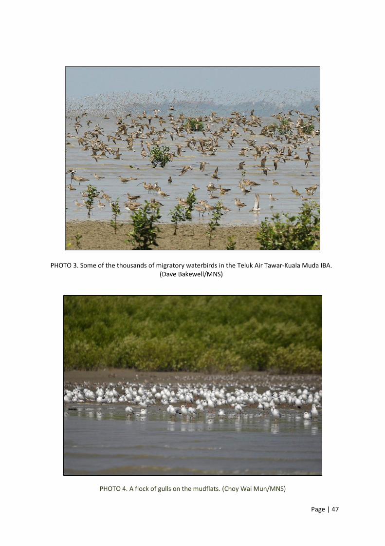
Page | 47
PHOTO 3. Some of the thousands of migratory waterbirds in the Teluk Air Tawar-Kuala Muda IBA. (Dave Bakewell/MNS)
PHOTO 4. A flock of gulls on the mudflats. (Choy Wai Mun/MNS)

Page | 48
PHOTO 5. Freshly caught prawns at the fish landings. (Tan Choo Eng/MNS)
PHOTO 6. Customers picking the freshest of fishes at the market. (Tan Choo Eng/MNS)

Page | 49
PHOTO 7. The Asian tsunami memorial at Kota Kuala Muda in Kedah. (Tan Choo Eng/MNS)
[Note: Kuala Muda is on Seberang Perai, Penang.]
PHOTO 8. Rock bund structure near the mouth of Sungai Muda.(Foong Swee Yeok/MNS)
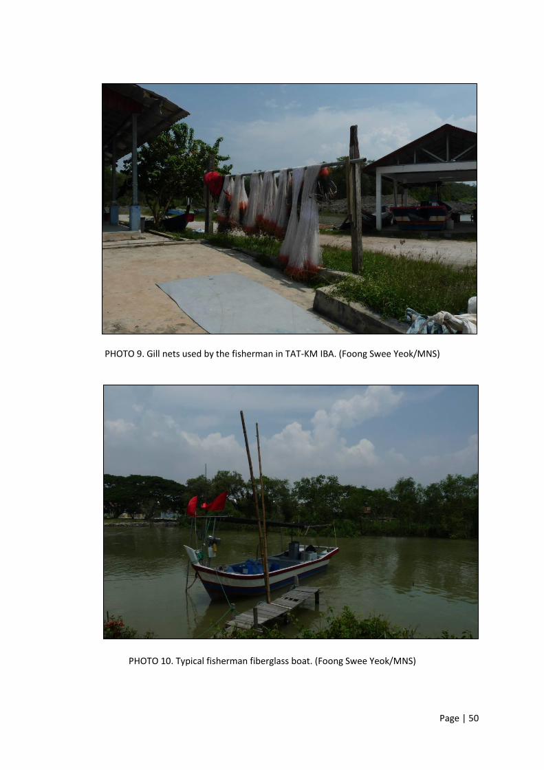
Page | 50
PHOTO 9. Gill nets used by the fisherman in TAT-KM IBA. (Foong Swee Yeok/MNS)
PHOTO 10. Typical fisherman fiberglass boat. (Foong Swee Yeok/MNS)

Page | 51
PHOTO 11. Fisherman Jetty at the mouth of Sungai Lahar Endin. (Foong Swee Yeok/MNS)
PHOTO 12. Fisherman jetty at the upper Sungai Penaga. (Foong Swee Yeok/MNS)
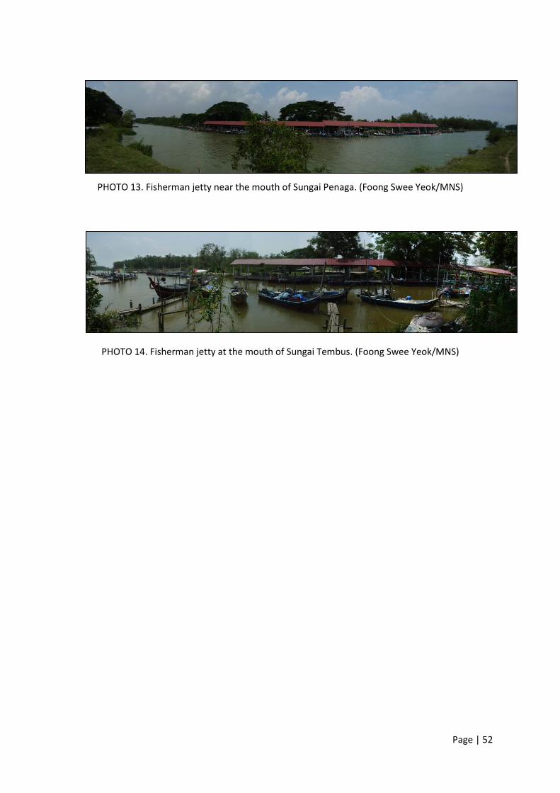
Page | 52
PHOTO 13. Fisherman jetty near the mouth of Sungai Penaga. (Foong Swee Yeok/MNS)
PHOTO 14. Fisherman jetty at the mouth of Sungai Tembus. (Foong Swee Yeok/MNS)

Page | 53
MNS MISSION
To promote the conservation of Malaysia’s natural heritage
www.mns.my
View publication statsView publication stats