a question of control - slogisug.org
TRANSCRIPT

A Question of Control: The Nature of the Relationship Between Mapping
for Land Surveying and Cadastral Purposes
in Santa Barbara County
Adrian Foster, LSIT 8235
Teñell Matlovsky, LS 8629
September 11, 2012
Santa Barbara County Surveyor’s Office GIS
Santa Barbara County Surveyor‟s Office GIS
Owing to its source and presentation, governmental geographic information may appear to be
authoritative and to be positionally accurate. However, users should recognize the associated
disclaimers and consider the various methodologies used for creating the data, as well as
review the metadata entries for purpose, use constraints, and positional accuracy.
At the local level, parcel maps primarily support local property taxation. However, they may
have varied levels of position accuracy. Likewise, most Santa Barbara County Surveyor GIS
data is not in true spatial position, but is created to provide a spatial index for land survey
records research.
An ideal Land Information System (LIS) would contain cadastral data that is not just
referential but that represents information from field-survey collected, high quality GPS
observations tied to control points. This presentation examines the history and status of Santa
Barbara County‟s land survey and tax parcel GIS data.

County Surveyor Duties
Santa Barbara County Surveyor‟s Office GIS
California Government Code
27556. The surveyor shall copy, plat, or trace each map filed for record in the office of the
county recorder, at the cost of the party filing the map, and is ex officio deputy recorder for the
county for such purposes. …
27557. The surveyor shall plat, trace, blueprint, or otherwise make all county, road, district,
and other maps and, at the request of the assessor, make all assessors' block-books for the
county.
Professional Land Surveyor’s Act
8773.2. Corner record filing. (e) A charge for examining, indexing, and filing the corner
record may be collected by the county surveyor, not to exceed the amount required for the
recording of a deed.
8774.5. County Surveyor, Index. (a) Upon the filing of a record of survey, amended record of
survey, or certificate of correction for recordation pursuant to this chapter, the surveyor or
engineer who prepared the document shall transmit a copy of the document, including all
recording information, to the county surveyor, who shall maintain an index, by geographic
location, of the documents.

County Assessor Duties
Santa Barbara County Surveyor‟s Office GIS
California Government Code, section 27421: “The county assessor in each county who is
designated to perform the duty of assessing property for a local taxing jurisdiction shall, upon
request of the governing body of such jurisdiction, excluding a school district, furnish not later
than May 15th of each year an estimate of the assessed valuation of property within such
jurisdiction for the succeeding fiscal year.”

1895-1946. County Surveyors
Santa Barbara County Surveyor‟s Office GIS

1850-1959. County Surveyor
Santa Barbara County Surveyor‟s Office GIS
In 1850 Santa Barbara County was one of the 26 original counties in California. In
1895, Frank F. Flournoy became the County Surveyor. In 1915, Owen Hugh O‟Neill, PLS 845,
was elected as County Surveyor. Until 1960, the County Surveyor was responsible for making
assessors‟ block-books. The assessor‟s mapping group has a complete microfilm set of these
historic Assessment maps from 1928-1962. A paper book index relates the pre-1960 series to
the current series.
The historic maps measure 18x26”. These maps are identified by a code, for
example 7-D-15. The first number is a code for an area and the last numbers are sheet
numbers. The maps were revised about every 4 years, so there are sets for 1928, 1932,
1936, 1940, etc. Each map also has property transfer and assessment data for the period
covered on microfilm in a card file. Each microfilm has 2-4 maps sheets and 2-4 ledger sheets
on it. These maps were often used as base maps for other county maps at that time such as
school and other districts.
City Assessment Maps from the same time period are also on microfilm. They
follow the same format as the unincorporated area maps and ledgers, except they were
mapped on 11x17” sheets.
In 1946, Wallace C. Penfield, RCE 3162, was appointed as County Surveyor.
Later in 1946, Francis E. Evans, PLS 1824 was appointed County Surveyor by the Board of
Supervisors. Penfield & Smith was founded by Penfield and Delbert D. Smith that same year.
-Emails to the author, Duane Gower and Mike Collie, 5/17/2010
Manual, 18x26” Drafting

1928-1959. County Surveyor, Assessor’s Block-Books
Santa Barbara County Surveyor‟s Office GIS
Manual, 18x26” Drafting

1928-1959. County Surveyor, Assessor’s Block-Books
Santa Barbara County Surveyor‟s Office GIS
Packard Addition to the City of Santa Barbara, edited 5-25-1950

1960-1991. County Assessor’s Block-Books
Santa Barbara County Surveyor‟s Office GIS
The current series of Assessor‟s maps was mandated by the state about 1960,
and was changed to an 11x17” format. Francis E. Evans was the County Surveyor when the
parcel mapping function went from the County Surveyor‟s Office to the County Assessor‟s
office. Government code section 27557 states that the County Surveyor will make Assessor‟s
block-books at the request of the Assessor.
The Assessor‟s Office mapping section honors tax and election regulations and
must have control over the timing of the changes to the cadastre and election precincts.
There is a basic mapping manual, Assessors‟ Handbook Section 215 manual re-revised in
April 2010 as Assessment Standards for Manual Systems issued by the State Board of
Equalization that specifies standards for county tax mapping.
Manual, 11x17” Drafting

1960-1991. County Assessor’s Block-Books
Santa Barbara County Surveyor‟s Office GIS
The 11x17” format began in 1960. Current page shown for APN 111-231-004

1992-1999. County Assessor GIS Beginnings
Santa Barbara County Surveyor‟s Office GIS
Kenneth A. Pettit was the County Assessor in 1996. “The GIS parcel base was
created over a period of 30 months during 1996, 1997 and 1998 by four individuals.” They
were Philip Packard, Chief Mapping Technician; Dennis Loyst, Mapping Technician II; Jared
Dawson, Mapping Technician II and Michelle Nyman, Mapping Technician I.
“They first scanned the 4300-4400 Assessor maps at approximately 300 DPI,
which were mapped at various scales from 1:20 to 1:1200. The scanned maps were then
digitized using „heads-up‟ techniques. AutoCAD had been used in the department since 1992,
and this tool was used to create accurate topology once all individual Assessor maps were „fit‟
together. Staff ensured that no gaps or overlaps existed and every parcel had a unique APN.”
-County of Santa Barbara Land Information Workflow Study, Dawn Robbins, 8/2007. Email to
the author, Dennis Loyst, 9/2012.
GIS Heads-Up Digitization

1992-1999. County Assessor GIS Beginnings
Santa Barbara County Surveyor‟s Office GIS
“More accurate basemaps were integrated into the County basemap from
surrounding organizations. These sources included the City of Santa Barbara (Penfield and
Smith), the Goleta Sanitary District and the City of Lompoc…. Later on, the base map was
compared with a GPS street centerline produced by Knopf. This source, along with
subsequent aerial imagery produced by AirPhoto USA, was used to ensure that parcels were
in the correct general location.
Overall, positional accuracy of the parcel database was assumed to be as good
as the Knopf street GPS centerlines and United States Geological Survey (USGS)
quadrangle maps in areas outside of the cities of Santa Barbara, Goleta, and Lompoc. Public
Works Flood Control aerial/topographical projects of the early 1990s were also used for
registration of the other urban-rural areas. All sources were projected into NAD83, State
Plane, Zone 5, US Foot. Within the cities of Santa Barbara, Lompoc, Goleta, and urban areas
surrounding Goleta, the accuracy of the basemap is considered to be approximately 2‟ to 5‟.
This covers approximately 40% of the parcels. Wherever there are Knopf centerlines,
positional accuracy is considered to be approximately 3‟ to 10‟. This covers an additional 45%
of the parcels. Where there was registration to Flood Control topographic data, accuracy is
approximately 5‟ to 15‟. This covers an additional 10% of parcels. In the remaining, rural areas
where USGS quads were used, accuracy is approximately 15‟ to 100.‟”
-County of Santa Barbara Land Information Workflow Study, Dawn Robbins, 8/2007
Sources Used for GIS Control

1992-1999. County Assessor GIS Beginnings
Santa Barbara County Surveyor‟s Office GIS
Entire parcel layer in GIS (2012 data shown)

1992-1999. County Assessor GIS Beginnings
Santa Barbara County Surveyor‟s Office GIS
Detail of parcel layer in GIS (2012 data shown)

1992-1999. County Assessor GIS Beginnings
Santa Barbara County Surveyor‟s Office GIS
-First estimate is from County of Santa Barbara Land Information Workflow Study, Dawn
Robbins, 8/2007. Second estimate is from Records of Surveys Metatada, 2012.
Sources Used for GIS Control in 1998

1992-1999. County Surveyor GIS Beginnings
Santa Barbara County Surveyor‟s Office GIS
Edmund R. Villa, PLS 6232, was the County Surveyor from 1994 to 1997.
Christine B. Brooks, PLS 7227, helped establish horizontal control for GIS use.
In late 1997, Mike Emmons, PLS 5899, was appointed as County Surveyor by the
Board of Supervisors. He was selected and recommended by Phil Demery, Public Works
Director, specifically to design and implement a Public Works GIS. Emmons had extensive
experience from his work in Orange County.
The County Assessor's Office had a parallel GIS program at that time and was
named as the lead of the County GIS by the Board of Supervisors. There was a County GIS
Committee consisting of the Assessor, Planning, Public Works and others. It was decided to
use the assessors office parcel layer as GIS base data.
Funding for the Surveyor‟s Office GIS came from the CAO and LAFCO. Emmons
hired Brenda Turner as a Mapping Technician in 1998 because she had mapping and
boundary experience from working in Kern County. After hiring Turner, Emmons hired
Zacharias Hunt from UCSB around 1999 for his GIS knowledge. Turner updated special
district maps as required by law. Her workflow began in AutoCAD, then she exported as
polygon shapefiles. This was the first modern GIS in the Surveyor's Office.
-Email to the author, Mike Emmons, 8/2012
GIS for District Mapping

2000-2008. County Assessor GIS
Santa Barbara County Surveyor‟s Office GIS
In 2002, Joseph E. Holland was elected as the County Clerk, Recorder and
Assessor. In 2007, Assessor staff included Jim McClure, Deputy Assessor; Chris Lyon,
Operations Division Manager and Duane Gower, Interim Supervisor. There were about 4,300
individual maps showing geographically joined groups of parcels. “For the 2007 secured
assessment roll, there are 127,329 individual Assessor parcels….The Assessor‟s mapping
staff is required to update the Assessor maps whenever ownership boundaries change, as in
the case when…[an activity] is noted and recorded…. The net affect of these , and related
activities, is the addition of 1000-1500 parcels per year, and approximately 3000 boundary
changes. These parcels must be updated on Assessor maps, estimated by the mapping staff
to be updates to approximately 320 maps per year….
Of the 4,300 Assessor Maps that comprise the County, approximately 15% have
been fully drawn or redrawn using CoGo (coordinate Geometry) techniques using AutoCAD
software. An additional 10% are considered hybrids where all the new parcels have been
cogoed and the remaining parcels on the page are left in their raster format. The remaining
75% of the maps that were hand-drawn have not required revision because there has been
no development affecting those parcels. All hand-drawn maps have been scanned,
subsequently digitized and used to help create the original GIS base map.”
-County of Santa Barbara Land Information Workflow Study, Dawn Robbins, 8/2007
Digital Assessor Map Formats

2000-2008. County Assessor GIS
Santa Barbara County Surveyor‟s Office GIS
Digital Assessor Map Formats
-County of Santa Barbara Land Information Workflow Study, Dawn Robbins, 8/2007.

2000-2008. County Assessor GIS
Santa Barbara County Surveyor‟s Office GIS
“CoGo techniques are always used in creating new parcels. If CoGo work is
complete and Survey tolerances are not met in the recorded source, mapping staff rectify the
problem by researching the conflicting survey data on surrounding properties. Differences can
be dozens of feet on large properties. The Assessor staff has rectified these types of
differences using existing and recorded information since the 1960‟s…
On recorded maps, where accurate information is available, including coordinates,
the information is used to improve the Basemap. Over the last five years, only 5-10 recorded
maps have coordinates and ties to the California High Precision Geodetic Network, which
provides real world coordinates. The cities of Santa Barbara and Lompoc provide maps with
ties to their own or this network about 25% of the time. The CoGo‟d attributes are saved in the
individual AutoCAD files (one per Assessor map)….An updated CoGo‟d parcel or group of
parcels is converted to a shapefile….It is positioned and rectified with any non-coincident
legal boundaries to the basemap.”
-County of Santa Barbara Land Information Workflow Study, Dawn Robbins, 8/2007
Parcel Creation and Editing Techniques

2000-2008. County Surveyor GIS
Santa Barbara County Surveyor‟s Office GIS
Mike Emmons, County Surveyor, hired Teñell Matlovsky in 2001 for his 3D
modeling, engineering, drafting, mapping, GIS, database, web design, and public sector
experience. Matlovsky worked with the field survey operation to evolve the County‟s data
collection, processing, modeling, mapping and CAD engineering standards. The improved
standards allowed the department more interoperability with GIS. In 2002, Emmons teamed
up Hunt and Matlovsky, creating the Public Works GIS Technical Committee to coordinate
spatial data needs for the department.
GIS Integration

2000-2008. County Surveyor GIS
Santa Barbara County Surveyor‟s Office GIS
2/11/2000 Shapefile for a LAFCO district, the Cuyama Valley Recreation and Park District
2/19/2002 Shapefile for city LAFCO activity, City of Santa Maria.
5/13/2002 Corner Record shapefile from field project S447 in Isla Vista
2002 Formation of the Public Works Department GIS technical committee
10/19/2002 Started CoGoing land grants
2003 Survey Engineering Design CAD standards adopted by Public Works Department
Pre 11/2004 Records of Surveys and Intersections Ties have index shapefile
Pre 8/2005 Maps (Tracts) and Parcel (Subdivision) maps have index shapefile
2007 Started Condominium Plans and Certificate of Correction Index shapefile
2007 Started Special Districts GDB for LAFCO indexing and boundary compilation
2007 Teñell Matlovsky appointed as Public Works GIS Analyst and acting supervisor
11/26/2008 Posted Corner Records and Intersection Ties index shapefile on web site (Ektron)
12/1/2008 Posted Records of Surveys, Maps (Tracts), Parcel (Subdivision) Maps and
Condominium Plans index shapefiles on web site (Ektron)

2000-2008. County Surveyor GIS
Santa Barbara County Surveyor‟s Office GIS
Indexing Records of Surveys

2000-2008. County Surveyor GIS
Santa Barbara County Surveyor‟s Office GIS
Indexing Corner Records

2000-2008. County Surveyor GIS
Santa Barbara County Surveyor‟s Office GIS
In 2005-2007, the Surveyor‟s Office GIS section produced a “street centerline file
created through the use of the most recent aerial imagery. The accuracy of this data has been
determined to be 6‟ to 8‟ in urban areas where more control is present, and 8‟ to 10‟ where control is
sparse.” This product was created for the Sheriffs dispatch system....
Survey mappers are capable of entering their data using highly accurate real-world
coordinates and CoGo….When updates to the GIS parcel base are provided by the Assessor, the
parcels position has shifted, resulting in misregistration of previously mapped reference polygons.
-County of Santa Barbara Land Information Workflow Study, Dawn Robbins, 8/2007, with
comments from the Surveyor’s Office.
Not all source data use the California Coordinate System. Also, using and creating
coordinate geometry can be time consuming. There is no policy or funding for survey grade control
GIS data to snap to.
Street Centerlines and Survey GIS Data Accuracy

2000-2008. County Surveyor GIS
Santa Barbara County Surveyor‟s Office GIS
An example of a misregistered index polygon

2008-2012. County Assessor, Current GIS
Santa Barbara County Surveyor‟s Office GIS
As of 2009, An average of 60 documents are received daily thru the Maps Module. An
average of 12 per day have Metes/Bounds or legal descriptions that are “missing, incomplete, or
incorrect.” For the ones with legal descriptions “insufficient to identify the property adequately,” a
letter is sent to the taxpayer or their representative with a general explanation in hope for a
response with assistance.
-Santa Barbara County Assessor’s Office, Mapping/GIS Section, Powerpoint presentation, 8/2009
“Very few communities can afford the cost of compiling parcel data directly from the
legal description on a deed because of the labor-intensive process of interpreting and resolving
discrepancies in legal descriptions found on many deeds….In most jurisdictions, it is not legally
required that the parcel descriptions in deeds be compiled and verified by a land surveyor. This
often leads to legal descriptions that are unclear, are nearly impossible to locate, and contain
geometry errors. This is a bigger problem than the technical issues, since most GISs contain the
tools needed to perform the coordinate geometry computations. It may take field work or legal
interpretations to resolve inconsistencies in legal descriptions in deeds.”
-National Land Parcel Data, Committee on Land Parcel Databases: A National Vision, Mapping
Science Committee, National Research Council, pages 91-92.
County Assessor Throughput

2008-2012. County Surveyor, Current GIS
Santa Barbara County Surveyor‟s Office GIS
12/8/2008 Adrian Foster hired as GIS Technician
2009 New revisions to maps of Cities and Special Districts
8/7/2009 Started Maps and Surveys index shapefile
11/30/2009 Developed Rights-of-Way index shapefile
4/15/2010 Deployment of Surveyor Information System Interactive Map
2011 1820 total actions counted for LAFCO special district and cities since 1855
2012 Mike Emmons Retires from Office of the County Surveyor
2012 Aleks Jevremovic, PLS 8378, appointed as County Surveyor by the Board of
Supervisors
7/1/2012 Teñell Matlovsky, PLS 8629, appointed as Public Works Survey Supervisor
2012 Total index polygon count is 17,438 for recorded maps

Santa Barbara County Surveyor‟s Office GIS
New revisions to maps of Cities and Special Districts
2008-2012. County Surveyor, Current GIS

Santa Barbara County Surveyor‟s Office GIS
Developed making shapefiles for Rights-of-Way for Flood Control and Transportation
2008-2012. County Surveyor, Current GIS

Santa Barbara County Surveyor‟s Office GIS
Deployed Surveyor Information System Interactive Map
2008-2012. County Surveyor, Current GIS

County Surveyor GIS Purpose
Santa Barbara County Surveyor‟s Office GIS
Abstract: These polygons are a graphical representation for reference to maps recorded in
Books of [book type], Records of Santa Barbara County, California.
Purpose: The data set was created to provide a spatial index for land survey records
research.
Use constraints: While every effort has been made to ensure that this data is complete and
reliable, the Office of the County Surveyor does not assume liability for any damages caused
by any errors or omissions in the data, nor as a result of improper use of the dataset. The
dataset is not intended to obtain coordinate values, distances or bearings.
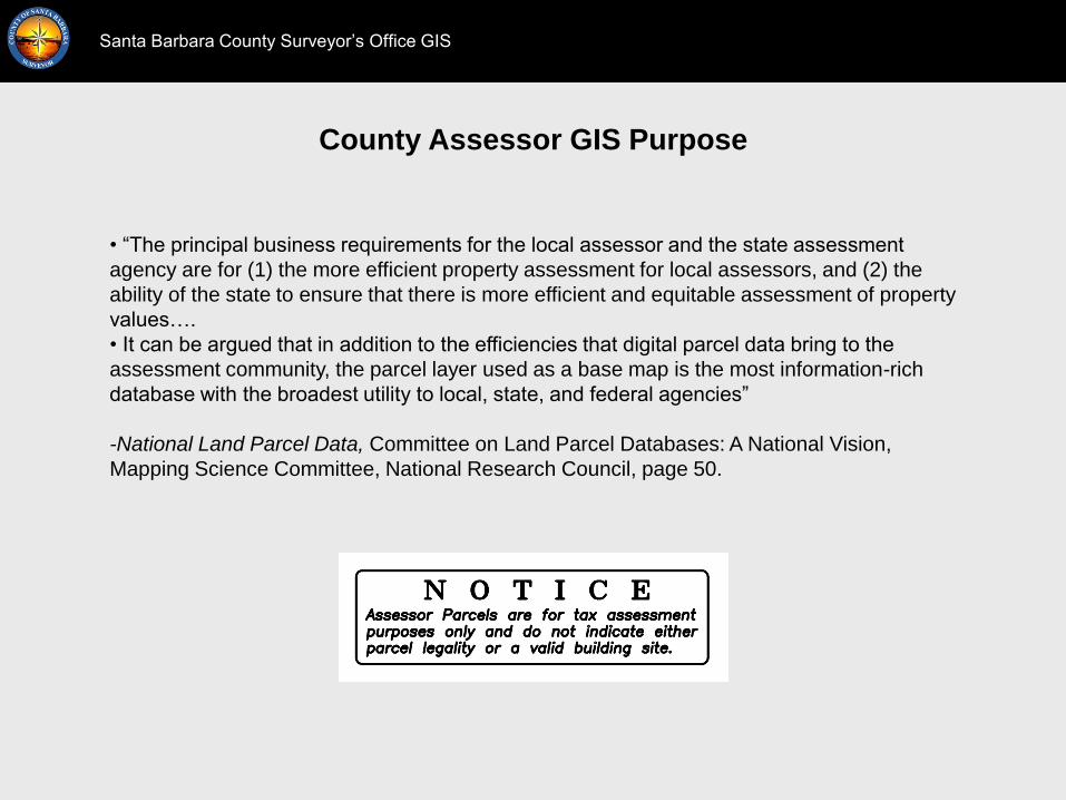
County Assessor GIS Purpose
Santa Barbara County Surveyor‟s Office GIS
• “The principal business requirements for the local assessor and the state assessment
agency are for (1) the more efficient property assessment for local assessors, and (2) the
ability of the state to ensure that there is more efficient and equitable assessment of property
values….
• It can be argued that in addition to the efficiencies that digital parcel data bring to the
assessment community, the parcel layer used as a base map is the most information-rich
database with the broadest utility to local, state, and federal agencies”
-National Land Parcel Data, Committee on Land Parcel Databases: A National Vision,
Mapping Science Committee, National Research Council, page 50.

Quality of Data Existing in Digital Parcel Maps
Santa Barbara County Surveyor‟s Office GIS
“At the local level, parcel maps primarily support local property taxation and are
usually adequate for that purpose. However, their underlying base maps can be many years
old and they are often georeferenced incorrectly, do not align with high-resolution
orthophotography, and may be internally inconsistent due to original source and methods
used to create the data. Poor quality control, especially in terms of geographic accuracy, is
understandable because of the cost of producing highly accurate data.”
-National Land Parcel Data, Committee on Land Parcel Databases: A National Vision,
Mapping Science Committee, National Research Council, page 91.

County GIS without Control Points
Santa Barbara County Surveyor‟s Office GIS
GIS data from different sources is not registered. GIS control points are needed.

Data Standards for Control
Santa Barbara County Surveyor‟s Office GIS
GIS for the Nation includes Geodetic Control and Boundary Points

Data Standards for Control
Santa Barbara County Surveyor‟s Office GIS
Geodetic Control: “Survey control network for local, regional and national geo-referencing.
Cadastral data should be tied to geodetic control. Orthoimagery and LiDAR should be tied to
the control. Geodetic control provides the basic reference for other data according to NGS
specifications for identification and capture.”
-GIS for the Nation Poster
See also the FGDC Cadastral Data Content Standard for the National Spatial Data
Infrastructure.
See also the FGDC Geospatial Positioning Accuracy Standards
GIS for the Nation and the FGDC

Data Standards for Control
Santa Barbara County Surveyor‟s Office GIS
Federal Geographic Data Committee, Graphic Information Framework Data Content Standard
Part 4: Geodetic Control
“Geodetic control provides a common reference system for establishing the coordinate
positions of all geographic data. It provides the means for tying all geographic features to
common, nationally used horizontal and vertical coordinate systems.
Geodetic control information plays a crucial role in developing all framework data and users‟
applications data, because it provides the spatial reference source to register all other spatial
data.
Geodetic control surveys are performed to far more rigorous accuracy and quality assurance
standards than those for local control surveys for general engineering, construction, or
topographic mapping purposes.
Although this part does not encompass non-geodetic control points, such as Public Land
Survey System points, local government control points, project control points for public and
private projects, aerial-photo control points, and so on, it can be used as a model for other
control points and coordinated points (see Annex D).”
FGDC: Geodetic Control

Data Standards for Control
Santa Barbara County Surveyor‟s Office GIS
Federal Geographic Data Committee, Graphic Information Framework Data Content Standard
Part 4: Geodetic Control.
Annex D (informative) Control points and coordinated points
There are various categories of points that are described with coordinates. The most general
category is coordinated points which can be any point on the ground or on a map for which
coordinates have been determined. There are also many methods for determining the
coordinates of these points. A subset category of coordinated points is control points. Control
points have several common characteristics:
• They are physical points on the ground which can be revisited or located for future use
• They are used for subsequent projects, that is to say, they themselves are not the end
product
• Their coordinates are determined using more accurate techniques because they will be
used to control or fit future spatial data activities
FGDC: Geodetic Control

Data Standards for Control
Santa Barbara County Surveyor‟s Office GIS
Federal Geographic Data Committee, Graphic Information Framework Data Content Standard
Part 4: Geodetic Control.
Annex D (informative) Control points and coordinated points
Geodetic control is one type or category of control points.
This part can be expanded with additional elements to make it fit the more general class of
control points. For example, one attribute that could be added is control point TYPES. Some
examples of these TYPES are:
• NSRS – geodetic control points whose coordinates have been verified and placed in a
national database
• PLSS – Public Land Survey System points whose coordinates have been determined
• Property corner – lot or property points, non-PLSS, whose coordinates have been
determined
• Photo control – photographic identifiable points set for aerial photography whose
coordinates have been determined
• Right-of-way – right-of-way points whose coordinates have been determined
• Local control – random control points whose coordinates have been determined that are
not multi-functional (that is to say, established for a single use) and are not NSRS
FGDC: Geodetic Control

Sources for Control Data
Santa Barbara County Surveyor‟s Office GIS
The GeoCommunicator Land Survey Information System or LSIS is the official federal
government Web site for the distribution of the Public Land Survey System (PLSS) data to
support the mapping of federal land parcels.
The Bureau of Land Management (BLM) Cadastral Survey Program is responsible for the
official boundary surveys of all federal-interest lands in the United States, which is over 700
million acres, nationwide. The Public Land Survey System is the foundation for many survey-
based geographic information systems.
-BLM. http://www.geocommunicator.gov/GeoComm/lsis_home/home/
BLM LSIS

Sources for Control Data
Santa Barbara County Surveyor‟s Office GIS
BLM California Public Land Survey Geodatabase

Sources for Control Data
Santa Barbara County Surveyor‟s Office GIS
Most recent County-wide control survey, from 2002

Sources for Control Data
Santa Barbara County Surveyor‟s Office GIS
Most recent County-wide control survey, from 2002

Sources for Control Data
Santa Barbara County Surveyor‟s Office GIS
Geodetic Control-NGS Continuously Operating Reference Stations

Sources for Control Data
Santa Barbara County Surveyor‟s Office GIS
Geodetic Control-California Spatial Reference Network

Sources for Control Data
Santa Barbara County Surveyor‟s Office GIS
Aerial Photo Control-CIRGIS 2010 Imagery

Sources for Control Data
Santa Barbara County Surveyor‟s Office GIS
Aerial Photo Control-CIRGIS 2010 Imagery
Sources for Control Data
Santa Barbara County Surveyor‟s Office GIS
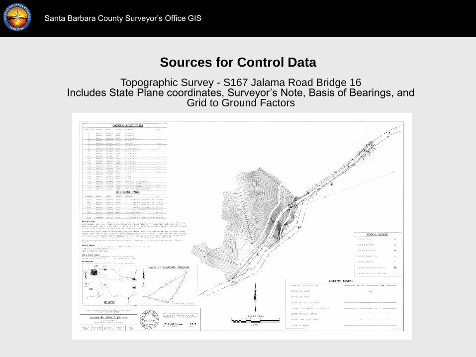
Topographic Survey - S167 Jalama Road Bridge 16 Includes State Plane coordinates, Surveyor‟s Note, Basis of Bearings, and
Grid to Ground Factors

Sources for Control Data
Santa Barbara County Surveyor‟s Office GIS
Topographic Survey - S167 Jalama Road Bridge 16 Includes State Plane coordinates, Surveyor‟s Note, Basis of Bearings, and
Grid to Ground Factors

Sources for Control Data
Santa Barbara County Surveyor‟s Office GIS
Record of Survey with State Plane coordinates – RS6671 Rancho Los Alamos

Sources for Control Data
Santa Barbara County Surveyor‟s Office GIS
Record of Survey with State Plane coordinates – RS6671 Rancho Los Alamos

countyofsb.org/pwd/pwsurveyor.aspx
Santa Barbara County Surveyor‟s Office GIS