a snapshot of caribou range
TRANSCRIPT
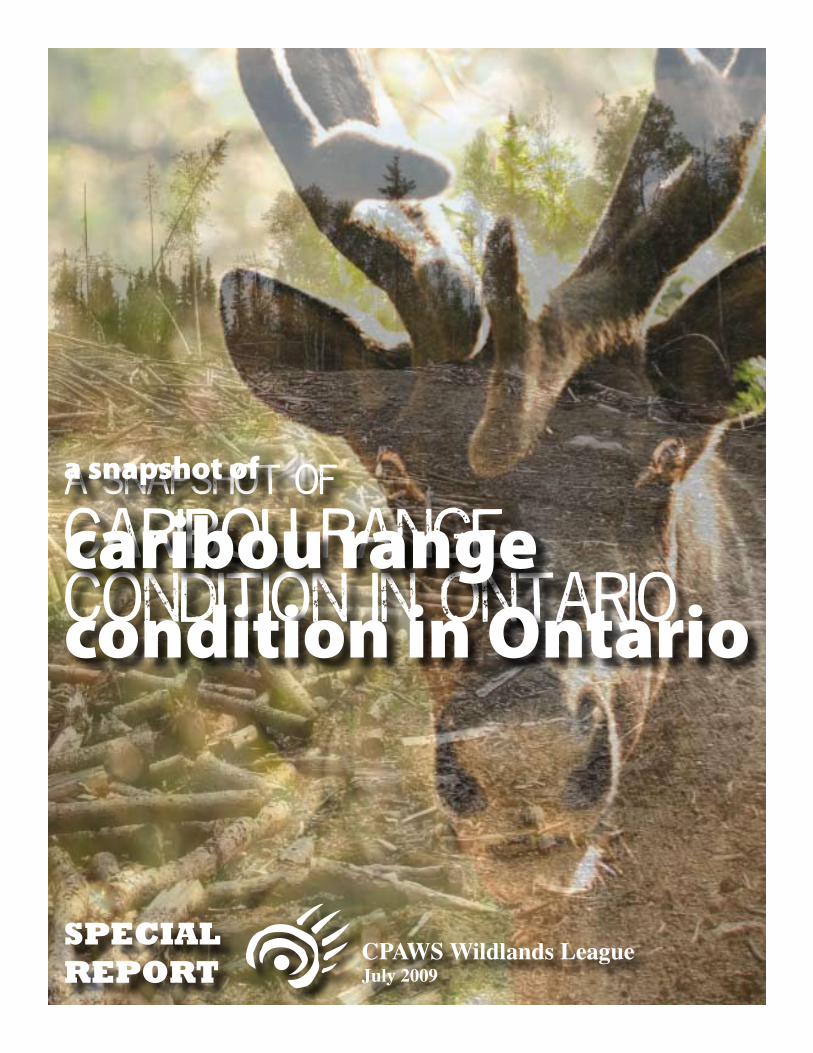
a snapshot of
caribou range condition in Ontario
SPECIALREPORT
CPAWS Wildlands LeagueJuly 2009
a snapshot of
caribou range condition in Ontario
a snapshot of caribou range conditions in Ontario2
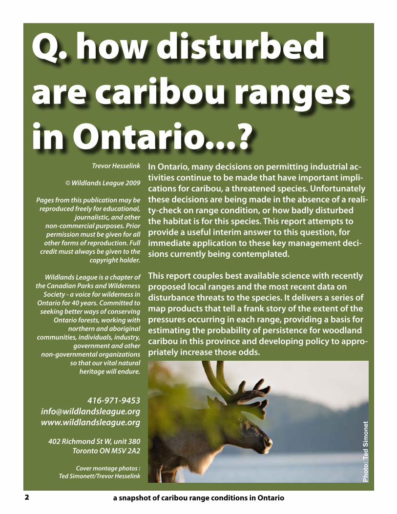
Q. how disturbed are caribou ranges in Ontario...?
In Ontario, many decisions on permitting industrial ac-tivities continue to be made that have important impli-cations for caribou, a threatened species. Unfortunately these decisions are being made in the absence of a reali-ty-check on range condition, or how badly disturbed the habitat is for this species. This report attempts to provide a useful interim answer to this question, for immediate application to these key management deci-sions currently being contemplated.
This report couples best available science with recently proposed local ranges and the most recent data on disturbance threats to the species. It delivers a series of map products that tell a frank story of the extent of the pressures occurring in each range, providing a basis for estimating the probability of persistence for woodland caribou in this province and developing policy to appro-priately increase those odds.
Trevor Hesselink
© Wildlands League 2009
Pages from this publication may be reproduced freely for educational,
journalistic, and othernon-commercial purposes. Prior permission must be given for all
other forms of reproduction. Full credit must always be given to the
copyright holder.
Wildlands League is a chapter of the Canadian Parks and Wilderness
Society - a voice for wilderness in Ontario for 40 years. Committed to
seeking better ways of conserving Ontario forests, working with
northern and aboriginal communities, individuals, industry,
government and other non-governmental organizations
so that our vital natural heritage will endure.
402 Richmond St W, unit 380Toronto ON M5V 2A2
Cover montage photos :Ted Simonett/Trevor Hesselink
Ph
oto
: Te
d S
imo
net

SPECIAL REPORT - CPAWS Wildlands League, July 2009 3
Q. how disturbed are caribou ranges in Ontario...?
assessing range disturbance Woodland caribou (Rangifer tarandus caribou) (forest-dwelling, boreal population) have disappeared from a significant portion of their historical range including widespread loss of habitat across the majority of the area allocated to “sustainable forest management” in Ontario. This range reces-sion is well-documented, contributing to the species status as “threatened” both provincially and nationally. One estimate suggests that the range of forest-dwelling woodland caribou has decreased by 40% to 50% since the mid-1800s (Ontario Woodland Caribou Recovery Strategy, 2008). The decline in caribou range and populations has been attributed to several things. All of these can be traced back to the rapid expansion of human industrial-scale access and disturbance into the habitat that has sustained the species for thousands of years. While the species is naturally adapted to disturbance by wildfire, this further layer of industrial disturbance is an added stress, and functionally different in many ways.
Range: Despite massive range loss, boreal caribou still occupy a large area of Ontario. This area is generally referred to as the area of occupancy, within which local populations occupy sub-areas known as “ranges.” The federal Science Advisory Group (SAG) defines range as, “a geographic area occupied by individuals of a local population that are subjected to the same influ-ences affecting vital rates over a defined time frame. Range is a function of both spatial extent and habitat conditions.”
Unknown Range Condition: While baseline and ongoing population sta-tus monitoring of caribou in Ontario have traditionally been underfunded and sporadic, recent direction demonstrates a commitment to investing in this gap. This direction also recognizes the local population range as a base unit. These population monitoring results however, are unlikley to be avail-able in the short-term to support the critical decisions being made at the policy level in the province. The recent “Scientific Review for the Identifica-tion of Critical Habitat for Woodland Caribou, Boreal Population in Canada,” offers another way of arriving at an interim understanding of range condi-tion, by focusing on extent of disturbance within a given population range. It is this tool that is the fundamental basis for the snapshot assessments provided here.
Disturbance as indicator of Range Condition: While aspects of habitat quality involving amount and arrangement of preferred vegetation are a component of range condition, these metrics are not the most predictive aspects of habitat quality. In fact, the ranges assessed here can be generally characterized as having appropriate levels of such vegetation cover histori-cally, as evidenced by a long history of caribou occupancy in this landscape. Instead, the condition of a given range is defined here as the level of total disturbance present as a percentage of the area of the range, including fire disturbance plus anthropogenic (human) disturbances. These indicators have been evaluated alongside population demography (as understood through calf recruitment) in a national meta-analysis of 24 documented ca-nadian boreal caribou populations. This analysis identified a strong negative relationship between the level of range disturbance and the ratio of calves to adult females in late winter population surveys. This ratio can be used as a known indicator of growth and decline of caribou populations.
Ph
oto
: W
ildla
nd
s L
eag
ue
Ph
oto
: W
ildla
nd
s L
eag
ue
Ph
oto
: W
ildla
nd
s L
eag
ue
Ph
oto
: W
ildla
nd
s L
eag
ue

a snapshot of caribou range conditions in Ontario4
applying best available scienceDespite having a paucity of local population data to work with in Ontario, it is possible to assess likely population trends for a given local popula-tion range based on a readily produced analysis of range disturbance.
The tool that this report is based on is the approach that has been identified by the recent federal Science Advisory Group in their report to Environment Canada, the “Scientific Review for the Identification of Criti-cal Habitat for Woodland Caribou, Boreal Population in Canada,” which established the strong negative relationship between range disturbance and calf recruitment and undertook the meta-analysis of studied popu-lations across the Boreal Forest in Canada. This work demonstrated that populations that experience more disturbance, due to forest fires and industry, show lower recruitment. Recruitment (the ratio of calves per fe-male) is a known indicator of growth and decline of caribou populations.
The Total Disturbance approachThe SAG approach followed Sorensen et al. (2008), where the relationship between recruitment and range condition was evaluated by comparing three candidate models: (a) fire disturbance, (b) anthropogenic distur-bance (including, for example: roads, reservoirs, railroads, croplands, settlement areas, and cutblocks), and (c) both fire and anthropogenic disturbance. The third candidate model of fire plus anthropogenic distur-bance, or “Total Disturbance” proved to be the most predictive indicator of population viability.
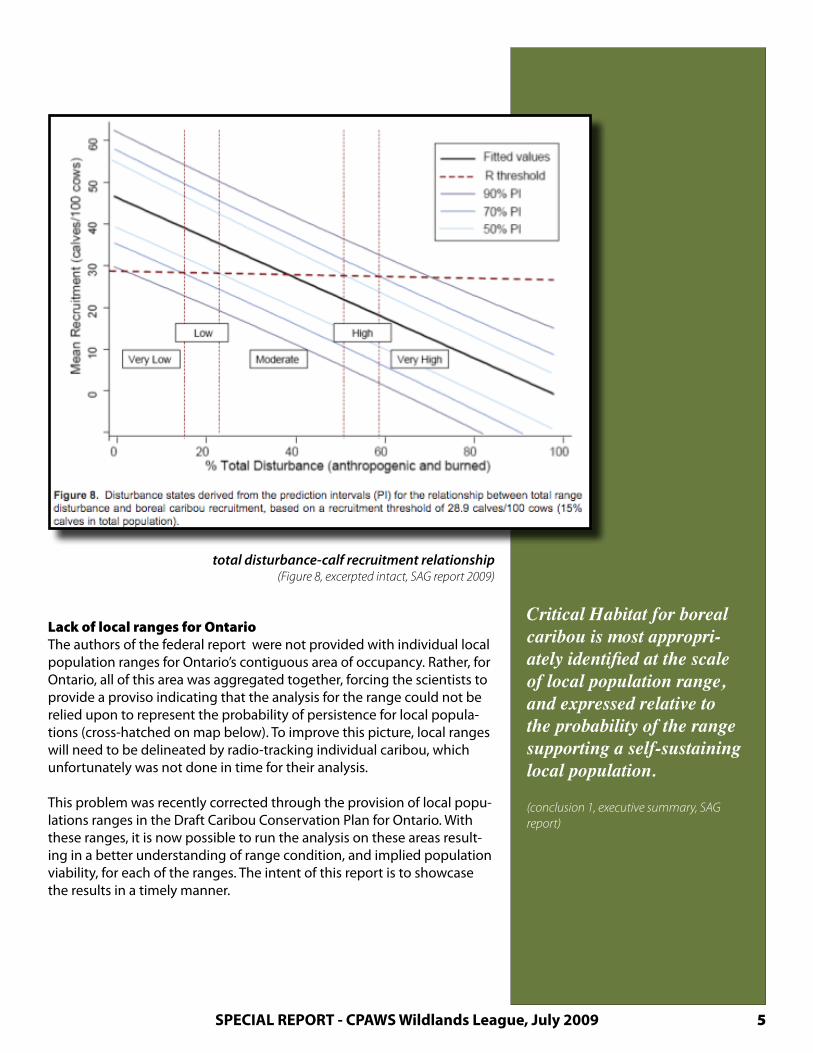
The resulting relationshipThe relationship established from the comprehensive meta-analysis of available Boreal population data is reproduced above, comparing re-cruitment rate to total disturbance. A recruitment rate of 28.9 calves per 100 females (see dotted red line on figure, next page) was determined as being the threshold separating a growing caribou populaiton from a declining one This “R threshold”, below which calf recruitment (and therefore population viability) drops into the domain of “not-self sustain-ing”, is met in this relationship at approximately 38% total disturbance. This is obviously not necessarily a universal, nor a precise threshold, given its derivation, but is a reasonable and credible reference from which a precautionary onset “zone of risk” should reasonably be assumed from a management perspective, as a population may begin decline before this mean value.
This relationship can serve as a reasonable surrogate for understanding the pressures on a local range by combining the most recent distur-bances from fire, plus anthropogenic disturbance information together to obtain a total disturbance footprint within the range, deriving an estimate for calf recruitment, and also for the likelihood of population persistence. It is not a replacement for seeking more accurate population metrics (as promoted elsewhere in the report), but it does provide a very useful stand-in that can be produced immediately with available data in the interim to get a picture of how viable local populations might be given disturbance factors in their ranges.
KEY RELATIONSHIPa very useful
relationship has been established between calf recruitment and
cumulative range disturbance
(1) Environment Canada. 2008. Scientific Review for the Identification of Critical Habitat for Woodland Caribou (Rangifer tarandus caribou), Boreal Population, in Canada. August 2008. Ottawa: Environ-ment Canada. 72 pp. plus 180 pp Appen-dices.
SPECIAL REPORT - CPAWS Wildlands League, July 2009 5
total disturbance-calf recruitment relationship(Figure 8, excerpted intact, SAG report 2009)
Lack of local ranges for OntarioThe authors of the federal report were not provided with individual local population ranges for Ontario’s contiguous area of occupancy. Rather, for Ontario, all of this area was aggregated together, forcing the scientists to provide a proviso indicating that the analysis for the range could not be relied upon to represent the probability of persistence for local popula-tions (cross-hatched on map below). To improve this picture, local ranges will need to be delineated by radio-tracking individual caribou, which unfortunately was not done in time for their analysis.
This problem was recently corrected through the provision of local popu-lations ranges in the Draft Caribou Conservation Plan for Ontario. With these ranges, it is now possible to run the analysis on these areas result-ing in a better understanding of range condition, and implied population viability, for each of the ranges. The intent of this report is to showcase the results in a timely manner.
Critical Habitat for boreal caribou is most appropri-ately identified at the scale of local population range, and expressed relative to the probability of the range supporting a self-sustaining local population.
(conclusion 1, executive summary, SAG report)

a snapshot of caribou range conditions in Ontario6
local ranges identifiedIn April, 2009, the Ontario Ministry of Natural Resources released a docu-ment entitled, “Draft Ontario Woodland Caribou Conservation Plan” (CCP). The CCP is the Minister’s formal response to the Caribou Recovery Strat-egy outlining, for the purposes of the Endangered Species Act, what it intends to undertake for caribou recovery. In it, some promising commit-ments regarding range-based assessment, research, and management are made.
Additionally, and most relevant for the purposes of this report, prelimi-nary delineations for key local population ranges are proposed (see below), though the large un-numbered portion of the area of continuous distribution has not yet been delineated into local population ranges, likely because of lack of sufficient data.
These ranges are a substantial step forward, as it provides a critical frame-work to examine the landscape through, and to base initial range condi-tion assessment upon.
preliminary delineations of local caribou population ranges(from Draft CCP, Figure 5)
Though the Draft Caribou Conservation Plan unfortunately stoped short of identifying prelimary range conditions or any estimates for local population viability, it does outline a research agenda that would likely fill key gaps over the long term. The critical missing direction is in how to address the management of threats to the species in the interim. The cur-rent implication is that ongoing industrial pressures can proceed in these ranges unchecked while the research is being carried out.
The map products produced in this report illustrate that preliminary range condition and, through the established relationship, an idea of population viability can be readily established for each of these local population ranges.
Ontario is adopting a range management approach to
woodland caribou recovery...
Planning decisions will consider all factors
influencing the well-being of caribou within the range
including direct and indirect human impacts.
Caribou ranges will be the basis for
evaluating habitat conditions and identifying caribou
habitat, assessing population trends, and assessing and
addressing cumulative impacts.
(2.1, Draft CCP)
LOCAL RANGEdelineation is a
critical first step
(2) Ontario Ministry of Natural Resources. 2009. Draft Ontario Woodland Caribou Conservation Plan.

SPECIAL REPORT - CPAWS Wildlands League, July 2009 7
the following map productsThe following map products have been undertaken to get a sense of the condition and, using the relationship established in the SAG report, to also appreciate the likely pressures present upon the local population within each of the ranges identified in Ontario.
MAP #1: SAG data - spatial extent of disturbances by rangeMAP #2: SAG data - percentge total disturbance by range
MAP #3: Best available data - spatial extent of disturbances by rangeMAP #4: Best available data - percentage total disturbance by range MAP #5: Best available data - management interpretation by range
Two datasetsTwo short series of three maps each are presented. Each series represents a different set of data used. For each, the same method for quantifiying total disturbance was used, based on the documented approach in the SAG report: 500 m buffered human disturbances, plus all fires <50 years old.
“SAG” data. The first dataset is the same data that was used during the analysis reported in the Federal Critical Habitat report, simply framed in the local population ranges now available in Ontario. In this way, this exercise “fills-in” some of the missing range resolution. MAP #1 and 2, and 3 were based on this data, referred to as “SAG data” on the map titles. It is also important to note that, although finer resolution data are available in some jurisdictions (as included in this report), it is useful to take this first step for direct comparison with other ranges analysed in the SAG report.
“Best available” data. The second dataset used is a compilation of the best available regional disturbance data to date. Because all data used for these purposes are dated to some extent, and the assembly of consistent national scale data intrinsically limits specificity, using the best avail-able data in any given region or range provides more accurate results. It should be noted that, even with the best data, fire disturbance is unpre-dictable requiring a precautionary use of the picture provided. See Best Available Data section for a case-study of the differences in the two data snapshots used here. MAP #3, 4, and 5 were based on this second dataset, referred to as “best available data” on the map titles.
Two perspectives for each datasetFor each dataset, two maps have been prepared that present the follow-ing themes:
(a) a spatial distribution of total disturbance (fire plus anthropogenic),(b) a categorization of disturbance vs population persistence, and
Management conclusionThe final map is a simplified management interpretation of range condi-tion results with a brief discussion of the implications of these findings.
TWO SETS OF MAPStwo separate sets of disturbance data were used to produce these maps
SAG” data sources:
(3) Anthropogenic Disturbance: “Com-bined Access”, Global Forest Watch Canada, 2009.
(4) Fire Disturbance: Large scale national fire database, Canadian Forest Service, 2008.
(5) Woodland Caribou Population Range Boundaries: Draft Ontario Woodland Conservation Plan, Ontario Ministry of Natural Resources, 2009.
additional “best available” disturbance data sources:
(6) Recent Forest Harvest (1997-2008), For-est Resource Inventory, Ontario Geospa-tial Data Exchange, 2009.
(7) Linear Features, MNR Road Segment, Land Information Ontario, 2009
total disturbance protocol :
(8) Sorensen, T., P.D. McLoughlin, D. Hervieux, E. Dzus, J. Nolan, B. Wynes, and S. Boutin. 2008. Determining sustainable levels of cumulative effects for boreal caribou. Journal of Wildlife Management 72:900-905: as employed by the Science Advisory Group: see also appendix 6.5, reference (1), 2009.

a snapshot of caribou range conditions in Ontario8
total disturbance using federal SAG report data
MAP #1 - spatial extent of disturbance by range
MAP #2 - percentage total disturbance by range
SPECIAL REPORT - CPAWS Wildlands League, July 2009 9
REGIONAL VARIATIONRelative amounts of disturbance types are different between the west and east
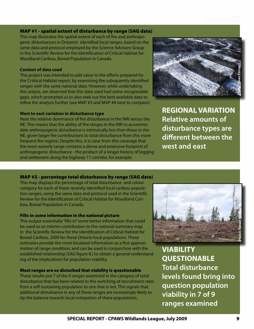
MAP #1 - spatial extent of disturbance by range (SAG data)This map illustrates the spatial extent of each of fire and anthropo-genic disturbances in Ontario’s identified local ranges, based on the same data and protocol employed by the Science Advisory Group in the Scientific Review for the Identification of Critical Habitat for Woodland Caribou, Boreal Population in Canada.
Context of data usedThis project was intended to add value to the efforts prepared for the Crtitical Habitat report, by examining the subsquently identified ranges with the same national data. However, while undertaking this anlysis, we observed that this data used had some recognizable gaps, which prompted us to also seek out the best available data to refine the analysis further (see MAP #3 and MAP #4 next to compare).
West to east variation in disturbance typeNote the relative dominance of fire disturbance in the NW versus the NE. This means that the ability of the ranges in the NW to accommo-date anthropogenic disturbance is intrinsically less than those in the NE, given larger fire contributions to total disturbance from this more frequent fire regime. Despite this, it is clear from this coverage that the most easterly range contains a dense and extensive footprint of anthropogenic disturbance - the product of a longer history of logging and settlement along the highway 11 corridor, for example.
Ph
oto
: E
van
Fer
rari
MAP #2 - percentage total disturbance by range (SAG data)This map displays the percentage of total disturbance and colour category for each of these recently identified local caribou popula-tion ranges, using the same data and protocol used in the Scientific Review for the Identification of Critical Habitat for Woodland Cari-bou, Boreal Population in Canada. Fills-in some information in the national pictureThis output essentially “fills-in” some better information that could be used as an interim contribution to the national summary map in the Scientific Review for the Identification of Critical Habitat for Boreal Caribou, 2009 for these Ontario local populations. These estimates provide the more localized information as a first approxi-mation of range condition, and can be used in conjunction with the established relationship (SAG figure 8.) to obtain a general understand-ing of the implications for population viability.
Most ranges are so disturbed that viability is questionableThese results put 7 of the 9 ranges examined in the category of total disturbance that has been related to the switching of recruitment rates from a self-sustaining population to one that is not. This signals that additional disturbance in any of these ranges are increasingly likely to tip the balance towards local extirpation of these populations.
VIABILITY QUESTIONABLETotal disturbance levels found bring into question population viability in 7 of 9 ranges examined
Ph
oto
: Tr
evo
r H
esse
link
a snapshot of caribou range conditions in Ontario10
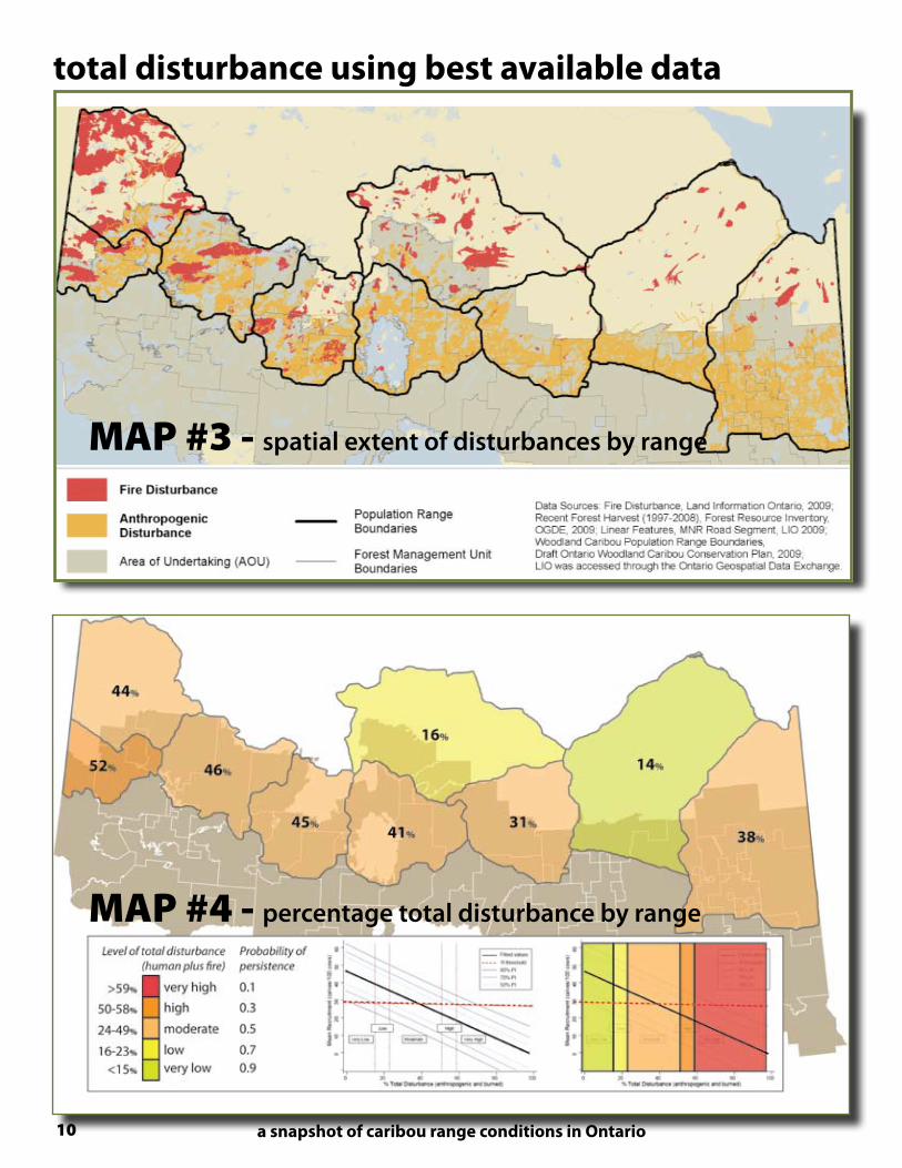
MAP #3 - spatial extent of disturbances by range
total disturbance using best available data
MAP #4 - percentage total disturbance by range

SPECIAL REPORT - CPAWS Wildlands League, July 2009 11
Ph
oto
: Tr
evo
r H
esse
link
MAP #3 - spatial extent of disturbances by range (best data)This map illustrates the spatial distribution of fire plus anthropo-genic disturbances based on the same protocol used in the Scien-tific Review for the Identification of Critical Habitat for Woodland Caribou, Boreal Population in Canada, but replacing the data inputs with best available Ontario-specific data, and shown here within the extents of Ontario local population ranges. More complete regional disturbance data was obtained Best available regional data for fire disturbance reveals several fires not captured in the federal database included in the SAG dataset. A greater anthropogenic footpint is also apparent in successive years between the two datasets. While fire is known to return amenable habitat conditions (assumed to be the case after 50 years in this analysis), cumulative anthropogenic disturbances have only been as-sociated with documented range recession to date.
Additionally, logging and other industrial disturbance data appears to have a distinct delay in its generation after the actual disturbance , sup-porting a conclusion that this type of data is likely to under-represent the actual level of anthropogenic disturbance for any given range and should therefore be used with an appropriate level of caution.
MORE DISTURBANCE using best available data revealed more anthropogenic andfire disturbance
MAP #4 - percentage total disturbance by range (best data)This map displays the percentage of total disturbance and colour category for each of these recently identified local caribou popula-tion ranges, using the same protocol used in the Scientific Review for the Identification of Critical Habitat for Woodland Caribou, Bo-real Population in Canada, but replacing the data inputs with best available Ontario-specific data. Better regional data indicates higher disturbanceThis best available data affects the total disturbance levels signifi-cantly, with % total disturbance rising for all ranges with the better data over the SAG data that produced MAP #2. In comparing this map to MAP #2, one range jumps from 24% to 46% total distur-bance over the SAG data results, almost doubling the disturbance. This particular case can be attributed both to under-represented fire distur-bance and several years of additional logging. Additionally, two other ranges jump to the next category of total disturbance over the original SAG data results. Six of the 9 ranges examined have total disturbance in excess of the “R” threshold associated with insufficient calf recruit-ment (~38% total disturbance). Another one, with over half of its area outside the area of commerical logging is slightly less disturbed but, with most of its logging area already accessed, still raises the question of the viability of its local caribou population.
VIABILITY QUESTION Caribou ranges within the commercial forest are most likely to have populations with ques-tionable viability
Ph
oto
: W
ildla
nd
s L
eag
ue
Ph
oto
: Tr
evo
r H
esse
link

a snapshot of caribou range conditions in Ontario12
MAP #5 - management interpretation (best data)The output produced on MAP #4 shows that the levels of disturbance for these ranges fall dominantly into the extremely wide 0.5 probability of persistence category (23-49% total disturbance). Because this wide range straddles the established R threshold (recruitment) intersect (of ~38% total disturbance), a manager may prudently choose to express the top portion of this category (the portion that exceeds the intersect value) dif-ferently than the lower portion.
This is because the populations in ranges that are disturbed to this extent (CRITICAL: coloured red) would be expected to be in decline. For these ranges, it is unlikely that any further room for industrial disturbance is available and actions should focus on actively removing this footprint. The remainder of the original category (ZONE OF RISK: coloured or-ange), may also be in decline but are expected to be fast approaching this point. Again, without better information, no additional disturbance should be introduced. The remaining zone (LOWER RISK: coloured yellow) encompasses ranges that are more likely to be self-sustaining, though permitting additional disturbance would only be reasonable after adequate population study to establish credible baseline conditions, in-clude careful mitigation, and consider proximate effects upon neighbour-ing ranges, particularly highly disturbed ones.
For circumstances like Ontario where population data is insufficient to provide better trend information, this snapshot analysis can be used to inform management on the viability risks at play in the interim.
MAP #5 best available data - management interpretation
HIGHLY DISTURBED local caribou ranges
along the northern limit of commercial
logging in Ontario are highly disturbed, and
trending towards more
management interpretation
CPAW
S Wild
lands
Leag
ue 20
09

SPECIAL REPORT - CPAWS Wildlands League, July 2009 13
conclusionThis analysis concludes that local ranges for boreal Caribou along the northern limit of commercial logging in Ontario are already highly disturbed. Based on this extensive disturbance, only 2 of the 9 ranges of this sensitive threatened species are likely to be self-sustaining populations, while 6 of the 9 ranges exceeding the threshold related to the decline of other studied Canadian popula-tions, and the last range well into the zone of risk .
These results highlight the critical track that most of these ranges are on in Ontario, and do not support any further industrial de-velopment in at least 7 of the 9 ranges examined here. Further industrial disturbance cannot be permitted until we confirm these findings and better understand the implications for each local pop-ulation. Instead, forward thinking and effective actions are required that can meet the spirit and intent of the new Endangered Species Act in Ontario. Specifically, the further expansion of forestry infra-structure into primary Boreal Forest must be stopped until credible research results can better inform such resource management deci-sions with the extent of the risks involved.
Acknowledgements:Wildlands League is grateful to the following assistance to make this report possible:
the federal Science Advisory Group for their outstanding and steadfast work in providing the best understanding of boreal caribou to decision-makers,
James Snider and WWF-Canada for GIS support and analysis,
the Global Forest Watch Canada crew for their data facilitation and advice,
all of the reviewers who have contributed their efforts to the quality of this project, and
The author retains full responsibility for any omissions, misrepresentations and conclusions made here.
Ph
oto
: Te
d S
imo
net
t
Ph
oto
: E
van
Fer
rari
NO NEW THREATSbased on these results, no new disturbances should be permitted in these ranges until their risks can be credibly assessed against the spirit and intent of the Endangered Species Act

HIGHLY DISTURBED. This analysis concludes that local ranges for boreal Caribou along the northern limit of commercial logging in Ontario are already highly disturbed. Based on this extensive disturbance, only 2 of the 9 ranges of this sensitive threatened species are likely to be self-sustaining populations, while 6 of the 9 ranges exceeding the thresh-old related to the decline of other studied Canadian populations, and the last range well into the zone of risk .
These results highlight the critical track that most of these ranges are on in Ontario, and do not support any further industrial development in at least 7 of the 9 ranges ex-amined here. Further industrial disturbance cannot be permitted until we confirm these findings and better understand the implications for each local population. Instead, for-ward thinking and effective actions are required that can meet the spirit and intent of the new Endangered Species Act in Ontario. Specifically, the further expansion of for-estry infrastructure into primary Boreal Forest must be stopped until credible research results can better inform such resource management decisions with the extent of the risks involved.
Q. how disturbed are caribou ranges in Ontario...?
CPAWS Wildlands League www.wildlandsleague.org1-866-510-WILD
NO NEW THREATS“based on these results, no new disturbances
should be permitted in these ranges until their risks can be credibly assessed against the spirit and
intent of the Endangered Species Act”