a study of altimeter height control in a gravity survey ... · pdf filea study of altimeter...
TRANSCRIPT
GEOSEA V Proceedings Vol. II , Geol. Soc. Malaysia, Bulletin20, August 1986; pp. 843- 855
A study of altimeter height control in a gravity survey around Kuala Pilah, Central Malaysia
C.A. Foss Department of Geology,
Universiti of Malaya, Kuala Lumpur.
Abstract: The survey was undertaken to determine the reliability of pressure-sensitive altimeters for surveys in Malaysia of areas with sparse elevation contro l (much of d1e country). It is shown that with 3 or 4 repeat measurements and with control measurements at no more than hourly intervals, that relative elevations can be determined to approximately metre accuracy with a resulting Bouguer gravity uncertainty of 0.2 milligals. It is suggested that for general applications altimeter controlled surveys are sufficient for del ineating anomalies greater than 5 milligals.
A previous single grav ity traverse had established a Bouguer gravity variation of over 30 milligals in tile Kuala Pilah area where tilere are botil a major granite contact and a proposed crustal suture. By extend.ing tile gravity coverage to unsurveyed areas it was possible to test if there was any separate evidence for the suture from a map of grav itational variation. The survey results show that tile Bouguer gravity contours parallel the granite contact and do not support any other sharp density variations within tile area mapped (although eitiler gradual or deep variations would not be recognised on til is local scale). Considerable lateral variation between profiles across the granite contact were mapped and simple 2-dimensional models are presented for these profiles.
INTRODUCTION
The major problem facing gravity surveys as a geophysical exploration technique in Southeast Asia is that of very sparse height control. Even on regional scale surveys there are problems with height control eg. as reported by Ryalla (1982) who had to resort in instances to reading heights from contoured 1:63, 360 scale topographic maps with estimated areas of up to 50 ft. (15 metres) . With elevation corrections (Freeair plus Bouguer) of c. 0.18 milligals/ metres, this represents an uncertainty of almost 3 milligals and errors of this magnitude on individual measurements are sufficient to strongly distort anomalies by as much as 20 milligals peak amplitude. A major purpose of this survey was to investigate the possible use of pressure-sensitive altimeters for height control, to estimate the magnitude of errors in the heights obtained, and to determine the dependance of these errors on time of day and frequency of control measurements. The Kuala Pilah area was selected because a regional survey by Loke (1981) had revealed a sharp change in Bouguer gravity values of over 30 milligals indicating that the field in thi s area could be reasonably delineated even with fairly poor height control. The anomaly is ascribed to the density variation between the Main Range Granite and denser metasediments to the east, but while this major cause of the variation has been clearly demonstrated by Loke (1981 ), as shown in figure 1, a deep crustal suture has been postulated in the area by Hutchison (1973) which might possibly contribute towards the anomaly. The suture and granite contact are roughly parallel regionally but it was thought that a more local survey where the granite contact changes direction might resolve any nonparallel component which could then be ascribed to deeper crustal structure.

844
30 N
0 Km 20
~Granite
C.A. Foss
102.
40
.--20 / Bouguer gravity from Loke 1981
,----/ Measurement profiles of Loke 1981
102°
Fig. l. Location of the study area.
~,
+ \ \ \
~ .;\Study 3° 1Area N
..._..

A STUDY OF ALTIMETER HEIGHT CONTROL rN A GRAVITY SURVEY 845
SOURCES OF ERROR IN ELEVATIONS DERIVED FROM PRESSURE SENSITIVE ALTIMETER MEASUREMENTS
Altimeters are available which are sensitive to pressure changes corresponding to elevation differences of .03 metres and less, so that instrument sensitivity need not be a constraint. The altimeter used in this survey has a vernier sensitivity of 2 ft. (0.6 metres) apparent height change. The poor accuracy of pressure-sensitive altimeter measurements compared to measurement precision is due to transforming from detected pressure changes to inferred height variation which requires 1) accurate scale calibration and 2) correction for transient atmospheric pressure variations. For surveys of high accuracy (ems to lOs of ems) the calibration factor needs to be temperature connected (eg. Stripling eta/. 1949), and the transcient pressure variation must be determined as a function of space as well as time using an array of base stations operating simultaneously. These controls were not applied in this survey because the extra resources required and the speed and mobility sacrific.ed could not be afforded. Verheijen and Ajakaiye (1980) investigated en·ors in such minimum resource barometric surveys carried out in Northern Nigeria. They report significant differences in the quality of survey results between the wet and dry seasons, with different optimum times of day for surveying in these two periods, and with elevation errors of between 1 and 2.5 metres for control measurement intervals of up to 2 hours during those optimum times. They found the major component of the diurnal variation to be quite regular and therefore predictable within either season with a superimposed 'residual ' random variation of short period which was the major cause of the elevation errors. Because atmospheric pressure changes are influenced by regional, latitudinal and local factors, these fi ndings cannot be applied to Southeast Asia without experimental validification, and indeed many of the details are expected to be different in this region.
ESTIMATION OF PRESSURE-SENSITIVE ALTIMETER ERRORS IN MALAYSIA
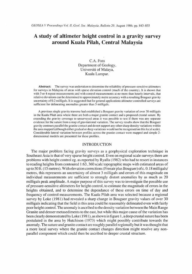
During the survey no instrument of sufficient sensitivity was available for continuous base recording, so diurnal variation was determined from discrete measurements. Figure 2B shows records for 3 days recorded in Kuala Lumpur as an initial investigation prior to the fieldwork. The records are constructed from measurements at 15 minute intervals over a 9 hour period from 9.00 to 18.00 local time. A smoothed average curve is shown in Figure 2A. Because of the short record lengths a frequency analysis was oot attempted, but the major factors are evident in a visual exan1ination of the records:
1) the range of pressure variation during the measurement period is approximately 30 metres apparent height change.
2) most of the variation is oflong period (in excess of9 hours) and components with period 30 minutes and less appear to be relatively small.
3) although all the records have similar general features, the exact details do vary significantly from day to day so that removal of a predicted diurnal variation would be umeliable.
An estimate of drift-correction errors was made using these curves by sampling the measurement set and comparing the samples excluded with their values as estimated by interpolation.
9·00 12·00 15 ·00 18· 00
Fig. 2. A). Smoothed diurnal pressure variation curve. B). Pressure variation curves for 3 individual days.
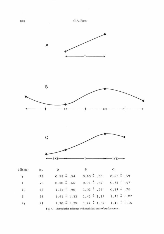
The results for 4 times of day are shown in Figure 3. At times A and D (11.00 and 16.00) when the curvature of the drift function is high, intervals between control measurements of an hour or less maintain drift errors of less than 1 metre, whereas for times Band C (13.00 and 14.30) control intervals of up to 2 hours maintain a similar 1 metre constraint on accuracy. That the optimum period for interpolation can be seen from the gmph to actually be the period of most rapid change of pressure indicates that it is the second differential and not the first which controls precision of approximation to a function by an interpolation (which is true for any interpolation function whether linear, polynomial, or a spline).
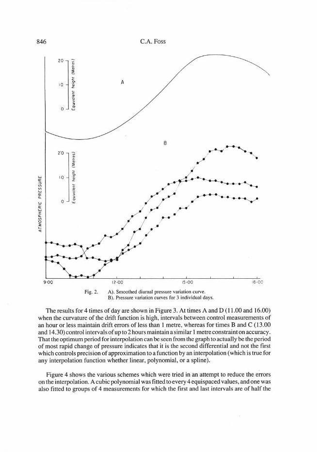
Figure 4 shows the various schemes which were tried in an attempt to reduce the errors on the interpolation. A cubic polynomial was fitted to every 4 equispaced values, and one was also fitted to groups of 4 measurements for which the first and last intervals are of half the

A STUDY OF ALTIMETER HEIGHT CONTROL IN A GRAVITY SURVEY 847
20 • 0 c 0
t.J Q:
.<:. u
::> VI V'l t.J Q: Q.
:c ~ 10
.~~ ·-.<:. "' - E c~
u ii:
.. 0 a.
t.J l: Q.
a. 0 <t
VI 0 :IE .... '<I
c D
9 00 15 ·00 18 ·00
.2 2 3 2
0 0
:c !2' "' -2 <: -2 c "' 0 a. a. 0 -4 -4 ~
~ "' E B 13 ·00 A 11 ·00
-6 6-Q: 0 Q: Q: t.J
:z: 0 ;:: u 4 .... Q: Q: 0 u
2 ..._ Q: a
4 D 16·00
j j j 2 l j
c 14 ·30
0 0
-2 -2
INTERVAL BE TWEEN CONTROL MEASUREMENTS (Hours)
Fig. 3. Plots of average error of drift correction (bars at ± I S.D.) for various intervals between control measurements and for various times of day.
848 C.A. Foss
A
-t/2 t/2-
t (hrs) n. A B c
~ 93 0.58 + . 54 0. 60 + . 55 0. 62 + .59 - - -
l 75 0. 80 + + .57 0 .7 2 + - .66 0.7 1 - - . 5 7
1~ 57 l. 21 + . 90 l. 01 + .76 0.87 + . 70 - - -
2 l. 61 + + 1 . 4 5 + I . 02 39 - l. 33 l. 4 3 - 1. 17 -
21, + + I . 4 5 + 1 . 1 6 2 1 1.70 - l. 29 l. 4 4 l. 32 -
Fig. 4. Interpolation schemes with statistical tests of perfom1ance.

A STUDY OF ALTIMETER HEIGHT CONTROL IN A GRAVITY SURVEY 849
length of the central interval (Figure 4C). Magnitudes of the errors arising with these different interpolations are given in the figure. As would be expected the difference between the linear and polynomial interpolations is very small for short intervals (of up to 1 hour) , but for longer intervals the more sophisticated interpolations which allow for curvature do slightly reduce the enors. It should be noted however that the reduction in interpolation error by using a polynomial is small compared to the reduction which could be effected by slightly shortening the control measurement interval, as can be seen from Figure 3.
FIELD TESTS
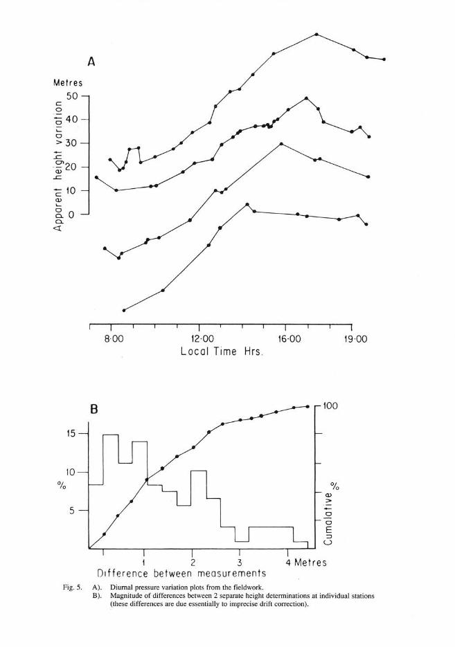
The true test of errors arising in altimeter surveys is dete1mined in actual field operation. Figure 5 is a plot of 4 diurnal pressure variation graphs measured during the fieldwork around Kuala Pilah. Each measurement on these graphs is the average of at least 3 repeat measurements made over a period of 1 to 2 'minutes . For those measurements which were accompanied by a gravity measurement a second set of3 measurements was made following the gravity measurement (a period of roughly 3 minutes) and the mean of the 2 sets was recorded. For those cases where there was considerable variation either witl1in or between sets of values, further measurements were made until a stable value was obtained, or in occassional cases when the values were erratic no altimeter measurement was recorded. Individual points on these graphs do not represent measurements made at one location, but those made at any position of known height. The graphs were inspected for signs of any systematic geographical influence, but none was evident. The extra irregularity compared to the laboratory graphs may be due to local temperature variations and minor pressure gradients, and to disturbance of the instrument during u·ansport, but the range of variation and general shape are very similar to the laboratory graphs, and the same characteristics have been observed in all surveys conducted so far in this region, including smveys in Selangor, Johore, Singapore, Kelantan and parts of Sabah, so that the general findings as to ilie accuracy of altimeter surveys should apply at least to surveys within Peninsular Malays ia and N01thern Borneo conducted in non-monsoon periods.
The average control interval in these field curves is roughly 40 minutes with the largest intervals of about 150 minutes. Figure SB is a histogram of the differences between drift corrected elevation estimates for those stations at which measurements were made at 2 separate times. At 50% of these stations there is a differenct: in estimated elevation ofless than 1 metre, and at almost 90% of the stations it is less than 3 metres . This is not of course a reliable estimate of the error in detennining the height for these stations, because as can be seen from Figure 3 there is a possibility of biased errors such that the accuracy is quite different to the precision of the measurements, however, for control intervals of one hour or less or for measurements not repeated at a single time of day, errors are randomised, and so can be reduced by further repetition and averaging. For 32 stations for which 3 measurements were made the average standard error on the estimated elevation was 0.59±0.23 metres, and for 9 stations at which 4 measurements were made it was 0.51±0.36 metres. With care to avoid bia·sed enors an overall unce1tainty in elevation of the stations should be one metre or less.
SURVEY RESULTS
The station distribution and the Bouguer gravity map obtained are shown in Figure 6. There are 320 stations distributed over an area of c. 1500 sq kms. Most of the stations are
Metres 50
c 0
·.;:: 40 0 '-0 > 30
~10 a> '-
g_o Cl.
<!
15
10
5
A
8·00 12·00
Local Time Hrs .
1 2 3 Difference between measurements
16·00
100
0
0
E ::::> u
4 Metres
19·00
Fig. 5. A). Diurnal pressure variation plots from the fieldwork. B). Magnitude of differences between 2 separate height determinations at individual stations
(these differences are due essentially to imprecise drift correction).

A STUDY OF ALTIMETER HEIGHT CONTROL IN A GRAVITY SURVEY 851
Fig. 6. Station distribution and contoured Bouguer gravity field.
852 C.A. Foss
closely spaced at intervals of 0.5-1 km along profiles across the granite contact, with other stations along the major roads throughout the area.ln Figure 7 the Bouguer gravity contours are superimposed on a geological map simplified from Khoo ( 1974 and 1975). The positions of steepest slope of the Bouguer gravity field coincide clo ely with the mapped contact on each of the measurement profiles except profile B-B ' where the geophysical indication of the contact is 1.5 kms to the east of the geologically mapped position. A line of steepest slope drawn on the Bouguer gravity map does not however follow the mapped contact very closely , mostly because the smooth interpolation between these profiles which are spaced approximately 5 and 10 kms apart in the northern and southern halves of the mapped area respectively, has an imposed sampling constraint (effectively an aliasing) which does not allow sharp changes in direction of the contact to be reproduced. However, only in the southern part of the map midway between profiles D-D' and E-E' does the departure between the two lines appear to be significant; most probably there is a density variation within the schists in this area which has not been resolved due to the poor sampling and which causes an apparent displacement of the contact as mapped by the gravity method.
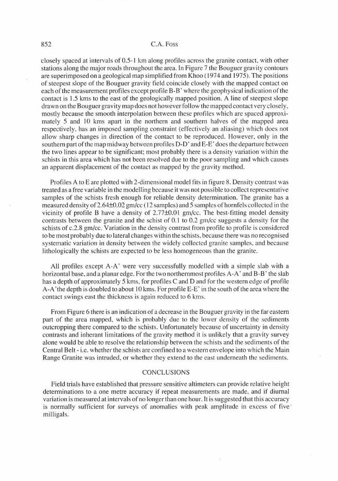
Profiles A toE are plotted with 2-dimensional model fits in figure 8. Density contrast was treated as a free variable in the modelling because it was not possible to collect representative samples of the schists fresh enough for reliable density determination . The granite has a measured density of2.64±0.02 gm/cc (12 samples) and 5 samples of hornfels collected in the vicinity of profile B have a density of 2.77±0.01 gm/cc. The best-fitting model density contrasts between the granite and the schist of 0.1 to 0.2 gm/cc suggests a density for the schists of c.2.8 gm/cc. Variation in the density contrast from profile to profile is considered to be most probably due to lateral changes within the schists, because there was no recognised systematic variation in density between the widely collected granite samples, and because lithologically the schists are expected to be less homogeneous than the granite.
All profiles except A-A' were very successfully modelled with a simple slab with a horizontal base, and a planar edge. For the two northernmost profiles A-A' and B-B' the slab has a depth of approximately 5 kms, for profiles C and D and for the western edge of profile A-A 'the depth is doubled to about 10 kms. For profile E-E' in the south of the area where the contact swings east the thickness is again reduced to 6 kms.
From Figure 6 there is an indication of a decrease in the Bouguer gravity in the far eastern part of the area mapped, which is probably due to the lower density of the sediments outcropping there compared to the schists. Unfortunately because of uncertainty in density contrasts and inherant limitations of the gravity method it is unlikely that a gravity survey alone would be able to resolve the relationship between the schists and the sediments ofthe Central Belt- i.e. whether the schists are confined to a western envelope into which the Main Range Granite was intruded, or whether they extend to the east underneath the sediments.
CONCLUSIONS
Field trials have established that pressure sensitive altimeters can provide relative height determinations to a one metre accuracy if repeat measurements are made, and if diurnal variation is measured at intervals of no longer than one hour. It is suggested that this accuracy is normally sufficient for surveys of anomalies with peak amplitude in excess of five · milligals.

A STUDY OF ALTIMETER HEIGHT CONTROL lN A GRAVITY SURVEY 853
+ + + +
+ + + + +
+ + +/ + +
+ + I + ~
/ I Bohou + + I + + .. ; ,./ .. I
+ + +
+ + +
+ +
+ + ,. 4~'
---~ · __ J )5 ------'
+ +
+
+
+
+
+ + +
+ + + i + ~
I
+ +
+ + + + -~--~ '- ·- ·- / _-~ ~--=--=-=±:- - ---:_~
+ + + + I --~-~ -~-: ·: ·:_- - )5
+/
/ Hic;Jhttt ~r Groditnt -if L
I
~ GronUt ----- -.---
- ---·--~
\ + + ...--- -to
-:----::.. D Ptrrnotria•lk Stdi!Mnll + +
' '""-. . + + -.z § Hornf ... oAd Sc::twtls ~ + ., + +
~- . ---------------- -~· \
' +
Fig. 7. Bouguer gravity field superimposed on a geological map simplified from Khoo (1974, 1975). The apparent position of the granite contact as determined from the gravity map is shown to be reasonably close to the geological mapped contact.
854
30 m gals
20
10
A'
deplh km.
0 10
30m gals
20
10
t:J.p:- 0 ·12Qm / cc
C.A. Foss
• • • •
PROFILE A' - A "
A"
8 10
15 20km
PROFILE c'- c"
depth
km 8
10
30 m gals
20
10
0
6 p :- 0 ·12Qm / cc
t>e ,- 0 IQm/ctl
depth 8 km 10
PROFILE o'- [)'
o"
depth
km 10
depl h km 10
Fig. 8. Models of the gravity profiles along lines as positioned in Figure 6.
This survey (which could not reasonably have been conducted without the use of altimeters for height determination) was successful in mapping the Bouguer gravity field over the eastern margin of the Main Range Granite around Kuala Pilah. Despite the proposed existence of a crustal suture in this area, the gravitational variation can be satisfactorily modelled as solely due to the contact between the granite and denser schists to the east. This does not deny the presence of a crustal suture within the area mapped, but it does restrict it to not producing any sharp lateral density variations. Modelling of the observed anomalies
A STUDY OF ALTIMETER HEIGHT CONTROL IN A GRAVITY SURVEY 855
indicates that the density contrast between the granite and the schists which is in the range of 0.1 to 0.2 gms/cc extends to depths (variable along the contact) of between 5 and 10 kilometers .
REFERENCES
HuTCH ISON C.S. , 1973. Synthesi o f crustal evolution in the Malay Peninsula. In Gobbett , D.J . and Hutchi son C.S. eds. Geology of the Malay Peninsula: West Malaysia and Singapore. Wiley- lnters ience, New York, pp. 330-334
KH oo K.K. , 1974. Geology oj1he Kuala Pilah Area, Shee1 104 Negri Sembilan. Malaysia Geo l. Survey Ann. Rept. , pp. 99-102
KH oo K.K. , 1975. Geology of the Jelai-Gemas Forest Reserve Area Sheel 104, Kuala Pilah. Malaysia Geol. Survey Ann. Rept., pp. 101-102
LOKE M.H. , 198 1. Regional gravily survey across Peninsular Malaysia to study crusta l struclure. M.Sc. thes is (unpubl.) Univ. Sains Malaysia. 217 p.
RYA LL P.J.C. , 1982. Some thoughts on the crustal structure o f Peninsular Malays ia- results of a gravity traverse. Geol. Soc. Ma laysia , Bull. 15, pp. 9-1 8
STRIPLI NG A.A. , BRODI a R.A. and WI LHELW E.S. , 1949. Elevation survey ing by precision barometric means. Geophysics, 14, pp.543-557
YER HEIJ EN P.J.T. and Al AKAIYE D.E., 1980. Analysis of errors in barometric elevations in northern Nigeria . Geophysics, 45 , pp. 11 44- 1152.
Manuscript received lith October 1984