a unified and regionally integrated noaa...core values regional knowledge and context matter...
TRANSCRIPT

A Unified and Regionally
Integrated NOAA
NOAA Regional Collaboration 2016 Annual Accomplishments Report

NOAA Regional Collaboration Network Vision:
A unified and regionally integrated NOAA
3
Exchange both National and Regional Insights that
Inform Action
4 5 Who We Are
6 2 0
1
5 1
1
Message from NOAA Deputy Under
Secretary for Operations
Improve the Understanding of and Respect for NOAA’s
Broad Mission and Capabilities
Address Regional Challenges by Connecting People and Resources
Contact NOAA in Your Region
Thank you to our Network and partners who made this report possible.
Table of Contents
Our Strategy Photo Credit: NOAA
Photo Credit: NOAA
2

Eight geographic regions are represented by Regional Collaboration Teams, comprised of dedicated NOAA employees representing line office mission interests and capabilities. The teams are led by senior level Regional Team Leads and full-time Regional Coordinators. At the national level, Network-wide endeavors are supported and overseen by an Advisory Group consisting of headquarters-level Line Office leadership, National Team Lead, and Headquarters Liaison.
NOAA's Regional Collaboration Teams address regional challenges by providing field-based information to leadership, facilitating internal NOAA connections within each region and serving as a focal point for NOAA expertise. The benefit of regional collaboration includes understanding community needs, fostering dialogue regarding products and services, and building relationships.
I continue to champion the work of the Regional Collaboration Teams as they connect NOAA leadership with regional issues and opportunities. Highlighted in this document are key accomplishments and projectsundertaken within each region across the United States and its territories.
Please join me in applauding the dynamic work of the Regional Collaboration Network showcased in this 2016 Annual Accomplishments Report.
Sincerely,
Benjamin P. Friedman Deputy Under Secretary for Operations, NOAA
“ NOAA is committed to growing and enhancing relationships with
stakeholders and Regional Collaboration is helping us to further that goal.”
-Ben Friedman
Dear Readers,
It is with great pleasure that I introduce this second annual accomplishments report for the NOAA Regional Collaboration Network. NOAA Regional Collaboration’s mission is to identify, communicate and respond to regional needs; catalyze collaboration; and connect people and capabilities to advance NOAA’smission and priorities.
Ben Friedman, NOAA Deputy
Under Secretary for Operations
Photo Credit: NOAA
A Message from NOAA Deputy Under Secretary for Operations
3
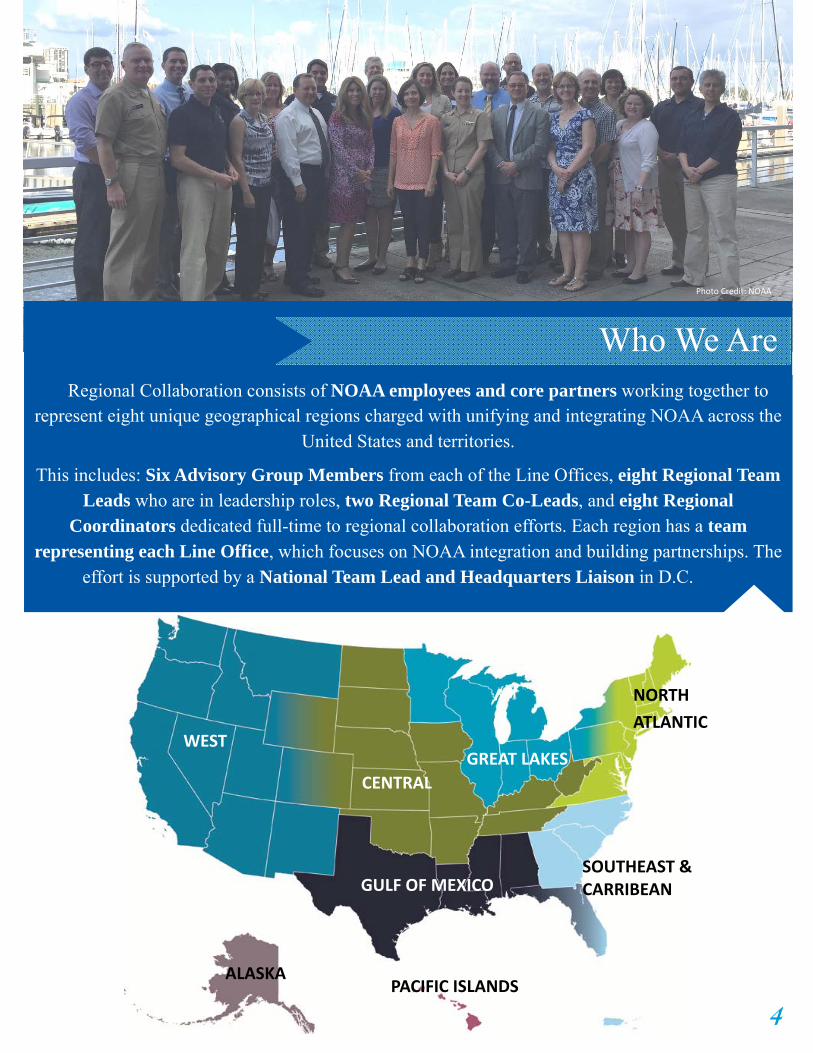
Photo Credit: NOAA
Regional Collaboration consists of NOAA employees and core partners working together to
represent eight unique geographical regions charged with unifying and integrating NOAA across the United States and territories.
This includes: Six Advisory Group Members from each of the Line Offices, eight Regional Team Leads who are in leadership roles, two Regional Team Co-Leads, and eight Regional
Coordinators dedicated full-time to regional collaboration efforts. Each region has a team representing each Line Office, which focuses on NOAA integration and building partnerships. The
effort is supported by a National Team Lead and Headquarters Liaison in D.C.
WEST
NORTH
ATLANTIC
SOUTHEAST & CARRIBEAN
GREAT LAKES
GULF OF MEXICO
PACIFIC ISLANDS ALASKA
WEST
CENTRAL
Who We Are
4

GOAL #1: Address region-al challenges by connecting people and resources
Our Strategy
166
Regional Collaboration Vision
A unified and regionally integrated NOAA
Regional Collaboration Mission
To identify, communicate, and respond to regional needs, catalyze collaboration; and connect people and capabilities to advance NOAA’s mission and priorities
NOAA Engagement Objective
Integrated services meeting the evolving demands of regional stakeholders
GOAL #3: Improve the understanding of and respect for NOAA’s broad mission and regional capabilities
GOAL #2: Exchange both national and regional in-sights that inform action
Gather information on place-based issues and impacts.
Identify and fill data, communication, coordina-tion, and resource gaps.
Develop and extend NOAA’s interdisciplinary capacity to improve regionally tailored cross-line office activities.
Enhance leadership understanding of regional issues and the interconnect-edness of NOAA expertise.
Search, gather, integrate, and disseminate information.
Provide guidance and support of NOAA-wide, cross-line regional programs.
Foster interaction among NOAA and with partners by serving as effective liaisons.
Elevate awareness and value of NOAA in the region.
Build a more informed NOAA workforce.
Core Values
Regional knowledge and context matter
Innovation and creativity are integral to executing NOAA’s
mission
Relationships are based on mutual trust and respect
Partnerships and shared
responsibility are foundational
Regional Teams spanning
the United States and
territories Team members from
across NOAA Line Offices and
Core Partners
NOAA Line Offices par cipa ng and contribu ng
Collaboration is essential to successful leadership
5

Many of the nation’s waterways suffer from water quality degradation, often caused by excess nutrient loading. Research has shown excess nutrients from non-point sources, such as agricultural runoff, significantly contribute to nutrient loading in water bodies. Nutrients can concentrate in coastal areas of the Great Lakes and Gulf of Mexico and contribute to harmful algal blooms and hypoxia development - a widespread and difficultchallenge with human health, ecological and economic impacts.
The Central Region Collaboration Team recognized the need to better connect expertise and resources between Central, Gulf of Mexico, and Great Lakes Regional Teams in an effort to provide decision support tools with the goal of reducing the impacts of nutrient loading andsupporting NOAA and NWS goals with regard to water resources as well as ecological forecasting priorities.
One outcome of this multi-region collaboration was increased awareness and expansion of the Runoff Risk Advisory Forecast (RAFF) developed in partnership with the state of Wisconsin to provide a first-of-its kind, real time environmental intelligence decision support tool for short-term planning to avoid recently
applied nutrients being transported off the fields and into nearby water bodies. The Wisconsin RRAF was wildly successful with state and local decision makers and as a result, interest in the
capability has grown throughout the regions. Great Lakes Restoration Initiative grant funds allowed the expansion of the Runoff Risk forecasting capability, providing the opportunity for improvements and refinement so each Great Lakes state has a fine-tuned tool to meet state specific needs.
The Central Region Collaboration Team continues to build relationships and coordinate activities with subject matter experts across regions and
Line Offices, develop education and outreach materials, and advocate for the Runoff Risk project as a valuable decision support tool.
Reducing Nutrient Runoff: A Multi Region Approach
“A common theme with these emerging ecological forecasting projects are the strong partnerships involved. Strong partnerships
will yield good results. NOAA Regional Collaboration has tremendous networking
capacity. Leveraging that capacity is a smart move.”
-George McKillop, North Atlantic Regional Collaboration
Team Member
Wisconsin’s Runoff Risk Advisory Forecast is a website
designed to utilize NWS modeling and data to provide real
time information for improved nutrient application timing.
Address Regional Challenges by ConnectingPeople and Resources
6

In recent years, the western United States has experienced a number of unusual environmental conditions including warm ocean waters in the eastern Pacific (also known as “The Blob”); an
unprecedented harmful algal bloom spanning the entire West Coast; and persistent and historic drought conditions in California and extending to other reaches of the region.
NOAA’s Western Regional Team (NOAA West) recognized that there is a significant amount of useful information on changing environmental conditions across NOAA and regional partner networks, but a gap in the compilation, synthesis, and communication of this information. The team was particularly interested in documenting the impacts of changing environmental conditions on the people and places in the region at seasonal timescales. To address this gap, NOAA West initiated a ten-month effort called the
Western Region Environmental Conditions and Impacts Coordination (WRECIC) project. WRECIC cataloged and communicated anomalous climate conditions and impacts on people and places in the region as a barometer of environmental change in the Western United States.
Beginning in the summer of 2015 the NOAA West Team hosted monthly WRECIC webinars for NOAA staff and stakeholders to share updates on recent anomalous weather and climate conditions, current El Niño Southern Oscillation conditions and predictions, and recent ecological and human system impacts as recorded through
media reports and participant input. Recognizing that decision makers and the public need to know how the changing environment is affecting people and places across the western United States, the team developed and broadly distributed a series of compelling human interest stories - called the NOAA West Watch. As a result of the work of NOAA West, the region has a more complete picture of environmental conditions and regional impacts during this unusual period of change.
In 2015, portions of the West Coast Dungeness crab fishery were closed
due to unsafe levels of domoic acid, a marine neurotoxin produced by
algae.
Photo Creidt: California Sea Grant. h ps://caseagrant.ucsd.edu/project/
frequently‐asked‐ques ons‐domoic‐acid‐in‐california‐crabs
Map showing position of sea surface temperature (SST) anomaly, aka
The Blob, in the northeast Pacific Ocean in March 2014. (Image :NOAA/
ESRL Physical Sciences Division at Boulder, CO)
Documenting Change: The NOAA Western Regional Environmental Conditions and Impacts Coordination
“During a time of climate anomalies like the last year and a half, meeting monthly was extremely helpful as conditions were shifting relatively rapidly. As a member of the side of NOAA where impacts are felt (Fisheries), rather than the side who are observing climate conditions (Weather), it was extremely helpful to have a
preview of likely future impacts to the resources.” - NOAA Northwest Fisheries Science Center 7

Alaska’s extensive and remote shorelines are some of the most critically under-instrumented coastal and nearshore areas in the United States. Yet accurate water level observations, both static and real-time, are a fundamental data requirement for flood forecasting, informed emergency response, ecosystem management, and safe navigation. To close this gap, the Alaska Regional Collaboration Team created a roadmap to establish an Alaska-wide Integrated Water Level Observing Network that was presented in a report released in July 2016 by the Alaska Ocean
Observing System (AOOS). The report included: prioritized locations for water level observations, options for obtaining coastal water level and inundation observations; and descriptions of the ability of different systems to address community and regional needs for observations and forecasts. This plan is part of the Alaska team’s effort with regional partners to increase coastal resilience by completing the
foundation needed to run coastal forecast and projection tools necessary for planning and resource management.
Louisiana includes freshwater and sediment diversions of the Mississippi River into surrounding areas as a key part of the Louisiana
Coastal Master Plan for restoration of the coastal zone. These diversions are designed to move sediment from the river channel out to build up land in places that are at risk of turning into or have become open shallow water. Diversions will have impacts on both human communities and the broader ecosystems. The
proposed diversions could be built at a scale not previously seen world-wide, and so the feasibility and impacts of projects at this scale have not been well studied. Questions arose whether the full suite of potential impacts (positive, negative, or neutral) could be predicted with existing engineering and ecosystem
modeling tools. The Gulf of Mexico Team partnered with Louisiana Sea Grant and the Louisiana Coastal Protection and Restoration Authority to hold a workshop about socioeconomic analysis and adaptive management plan development related to proposed river diversion projects. The Gulf of Mexico Team, a non-regulatory, cross-Line Office component of NOAA, in partnership with Louisiana Sea Grant, was well-positioned to facilitate the workshop and promote open conversations between resource managers, regulatory and research entities. Participants included representatives from federal and Louisiana state agencies, researchers, and academic institutions – gathering regulatory, ecosystem, social, economic, and legal experts to discuss how to consider socioeconomics in diversion project implementation and how to build a science-based adaptive management framework to guide decision-making during design, planning, and implementation. This workshop identified issues and strategies that could be further considered as plans for diversions progress.
Coastal Resilience Tools and the Alaska Water Level
Links between Proposed Mississippi River Diversions, Socioeconomics, and Adaptive Management
Tide gage installation during moderate low tide in Glacier Bay, Alaska. Gages such as this will help to create better forecasts.
Photo credit: NOAA
Freshwater diversion projects from the Mississippi can help to combat wetland loss.
Photo credit: NOAA
8

Ensuring Storm Readiness as Hurricane Season Approaches
Spreading the word about ways people can better prepare for hurricane season requires using a variety of methods to reach people. Webinars have become a useful tool across NOAA to respond to regional needs through information sharing, especially in the area of storm preparedness. In Fiscal Year 2016 both the Southeast and Caribbean Regional Team (SECART) and the Gulf of Mexico Regional Team (GoMRCT) stepped up and leveraged licenses, communication outlets, and the Regional Collaboration network to host webinars to help ensure storm readiness at the start of hurricane season. SECART organized four webinars (English and Spanish) with specialists from NOAA’s National Hurricane Center which focused on NOAA’s hurricane models and storm surge forecasting tools, including the Potential Storm Surge Flooding Map. By the last webinar, 410 attendees
had participated in the series that reached across the Gulf of Mexico, South Atlantic and U.S. Caribbean. The GoMRCT also organized a webinar on the 2016 Hurricane Seasonal Outlook and preparedness. In addition to storm readiness, the GoMRCT saw the potential in using webinars as a way to
promote communication across the region. The team now holds regularly-scheduled webinars to share awareness of the team's activities and Gulf priorities, and to address challenges within NOAA. These webinars provide a great opportunity for collaboration and can reach a broadened audience.
“It was just the information that I was looking for on the
models used for forecasting tropical systems. I look forward to the rest of the series.”
-Sylvia M. R. Dake Emergency Management Program Specialist
Connecticut Department of Emergency Services and Public Protection
Fishermen Collaborating with NOAA on Marine Forecast
Accurate marine forecasts are critical to the safety and success of the fishing industry. The North Atlantic Regional Team saw an opportunity to partner a longstanding Northeast Fisheries Science Center program with local weather forecast offices, the National Weather Service (NWS) Ocean Prediction Center and the NWS Observations Portfolio. NART approached NWS to purchase several meteorological instruments for the Northeast Fisheries Science Center’s cooperative fishing fleet. Two commercial fishing vessels were outfitted with WeatherPak2000s to collect air temperature, barometric pressure,
humidity, wind speed and direction; that was then telemetered to NOAA in Woods Hole, MA. The first unit resulted in over 1,000 hourly weather reports; a second vessel was outfitted in June 2016 and has also been operating well. A summary report delivered to NWS provides detailed documentation of the entire project including a discussion of possible next steps needed to make this an operational reality. Given the expense and difficulty of maintaining offshore buoys and the success of this project, it is feasible that dozens of offshore fishing vessels could make a relatively low-cost contribution to
NWS in the future.
Captain Phillips of the F/V Illusion
and post‐doc deciding where to
mount the sta on.
Photo Credit: NOAA
9

NOAA Gulf of Mexico Enhancing Data Synthesis Workshop
Protecting West Hawai’i’s Unique Marine Environment
The west coast of the island of Hawai’i is a unique habitat known for its clear waters and vibrant coral reefs. West Hawaiʻi contains one of the longest contiguous coral reefs in the state. The area is also home to several endangered or threatened species, such as Hawai’ian monk seals
(ʻīlio holo i ka uaua), humpback whales (Koholā), and green sea turtles (Honu). However, numerous threats are currently leading to habitat loss in the area. To combat this loss NOAA joined with regional partners to create the West Hawai’i Focus Area and developed an implementation plan for this site.
The plan aims to reduce the habitat’s vulnerability from climate change, inform communities on restoration efforts, reduce land-based pollutants, and provide tools for decision makers. While the immediate impact is focused on West Hawaii, this partnership will serve as a model for other place-based conservation efforts as a result of its successful partnership between NOAA, NGOs, academia, and community groups.
Knowing what data are available and having the ability to access, understand, and use these data is an underlying need for addressing Gulf priorities like resilience to hazards, ecosystem restoration, and water quality and quantity. To help tackle this data issue, the Gulf Team organized a Data Synthesis Workshop to look at NOAA’s Gulf of Mexico data holdings through the lens of improving user access and dissemination. The Workshop brought together eighteen representatives from NOAA offices, programs,
and partnerships to share information about existing data inventories, capabilities, and user needs. The group discussed how this effort fit into NOAA’s broader data initiatives, and explored opportunities to synthesize data into useful regional tools and products. Increasing awareness of NOAA data
services, activities, and capabilities in the Gulf is also a key component of this work. The group suggested potential portals for connecting and sharing information and ways to publicize available data, like through the use of story maps.
NOAA employees and partners are working to meet users
needs when it comes to data.
Nearly a quarter of the corals and fish that live along the West
Hawai’I Focus Area are found nowhere else in the world.
Photo Credit: NOAA
Photo Credit: NOAA
Exchange both National and Regional Insights that Inform Action
1 0

Promoting Resilience in Alaska Through Workshops
Western Alaska and the Aleutians are home to some of the most remote villages in the United States. With the growing intensity of weather events, these communities are facing increasing coastal storms causing dangerous erosion and disrupting economic activities. NOAA Regional Collaboration has been at the forefront of the coastal resilience effort in Alaska and has pulled together a coastal storms/inundation team to join a multi-partner, cross-NOAA Line Office coalition effort to share the latest coastal resilience tools and research with communities grappling with these environmental events.
The Alaska team hosted multiple two-day resilience workshops to bring together tribal, community, and federal managers and planners. The workshops started with a review of the latest science leading to breakout discussions on what is being seen in communities related to those topics. The second day focused on new tools and data sources, with presentations and Q&A,
feedback discussion on the utility/applicability of those tools. Each workshop built on the previous one(s) with the end result being a suite of tools
that decision makers find useful to make their communities more resilient to environmental events.
NOAA in the Caribbean
The Southeast and Caribbean Regional Team (SECART) has the unique responsibility of collaborating with the U.S. Caribbean. SECART initiated NOAA in the Caribbean (NOAA Carib) in 2011 with the goal of more effectively understanding, identifying and responding to local and regional challenges, needs, and shared priority opportunities through collaboration across NOAA and with NOAA partners. NOAA Carib hosted the third NOAA in the Caribbean Partners Meeting, in San Juan, Puerto Rico, in May of 2016. The meeting brought
together over 120 people from across the region to network, discuss recent activities in the region, and share successful projects and approaches
undertaken by NOAA and its partners. The outcomes from the meeting included: adding new information to the Ecosystem and Hazards goals of the Caribbean strategy, updating the 2011 inventory of NOAA activities, growing the NOAA in the Caribbean Partner list, and building relationships among
NOAA and its Caribbean partners.
Coastal erosion, as pictured here in the village of Shismaref, Alaska, is
impacting human habitat around the globe.
Photo Credit: Department of Commerce, Community and Economic Development; Division of Community and Regional Affairs’ Community Photo Library.
Photo Credit: NOAA
Volunteers planting mangrove seedlings on Range Cay, St.
Thomas, USVI.
Photo Credit: NOAA
1 1

Making Local Congressional Connections Austere budgets and the lingering effects of a Federal hiring freeze have limited NOAA’s ability, willingness, or even capacity to broaden legislative engagement efforts and partner with other NOAA offices in the region. To close this gap, NOAA’s North Atlantic Regional Team (NART) developed a successful model for thematic, state-based roundtables for district congressional staff that allows participants to better understand the contributions NOAA is making in their states and connect with valuable NOAA and partner resources.
The NART has held a dozen thematic-based engagements with district staffers, including four in FY16 around the theme of building community resilience in Hoboken, NJ, Burlington, VT, and Falmouth and Boston, MA. Through partner pairings, participants learned about climate trends, infrastructure needs, forecasting advances, pilot projects, restoration efforts, and efforts to support place-based education.
Building on the success of the NART, the Southeast and Caribbean Regional Team (SECART) hosted its first Congressional Roundtable focusing on "Climate Resilience in
South Florida.” NOAA staff described the science of sea level rise and the observing systems, data, and tools available to decision makers. Staff from the Cities of Ft. Lauderdale and Miami Beach, and Miami Dade County discussed their efforts to enhance coastal resilience and shared how they benefit from NOAA science, data, and training.
As a result, connections made during the briefing between Atlantic Oceanographic and Meteorological Laboratory (AOML) and the City of Miami Beach allowed NOAA to respond to
another climate driven topic in the region - nuisance flooding. City Commissioners and AOML were able to quickly work with the city’s Chief Resilience Officer to explain results and answer questions. This afforded NOAA the opportunity to be an honest broker of unbiased science to help inform responsible decision making and planning.
“Thanks for making it a
priority to come to us. It was great to talk about resiliency in a way that means something
to our constituents.” -Zach McCue Office of Senator Booker
“NOAA's approach to developing the agenda, and convening the right people and information, is just what we need.”
-Bonita Pothier Office of Senator King
Photo Credit: NOAA Photo Credit: NOAA
King tide event bringing flooding to the streets of
Miami.
Improve the Understanding of and Respect for NOAAs Broad Mission and Capabilities
1 2

NART alum David Vallee, Hydrologist-in-Charge for the Northeast River Forecast Center , and John Kocik, head of the Northeast Salmon Team for the Northeast Fisheries Science Center, owe their current partnership to enhance Salmon Team crew safety and optimize staff time and equipment to a NART sponsored congressional roundtable. Vallee and Kocik were paired together in Portland, ME to present on changing climate conditions. “Without that session, I would have never known about this need in NMFS for one of our products,” said Vallee. Vallee presented
on Northeast precipitation patterns; Kocik on the challenges of recovering diadromous fish
in these changing conditions. Each listened with interest to the other’s remarks and eventually arranged for a staff-level information exchange that created the basis for the partnership that exists today. Vallee and his team provide bi-weekly briefings on river flow predictions in the Penobscot and Kennebec Rivers, allowing fisheries
staff to plan field sampling, as well as identify potential impacts on fish passage at dams.
Congressional staff and NOAA and partner attendees at the
Waquoit Bay NOAA Estuarine Research Reserve in MA.
Photo Credit: NOAA
In September 2016, Hawaii hosted the World Conservation Congress (WCC). The WCC is the world’s largest conservation event, held every four years and organized by the International Union for the Conservation of Nature, the primary advisory body to the United Nations on conservation issues.
The WCC hosted over 8,000 delegates from around the world, including world leaders and representatives from governments, science, academia, indigenous peoples groups, businesses and conservation. The NOAA Pacific Islands Regional Collaboration Team was at the center of helping to showcase NOAA’s mission and
regional capabilities to representatives from around the world. Team members learned about
best practices in science and marine resource management from other countries and shared our best practices to promote conservation.
Approximately 60 NOAA staff members led presentations, workshops, posters, knowledge cafes, and field trips, and organized four booths with interactive displays on cross-cutting themes
that promoted OneNOAA in the Pacific Islands. NOAA also led 23 presentations on the Science on a Sphere on targeted themes that highlighted NOAA’s areas of expertise.
NOAA Support of the World Conservation Congress
Photo Credit: NOAA
In August, President Obama announced the expansion of the
Papahānaumokuākea Marine National Monument.
Photo Credit: The White House
1 3
Congressional Roundtable Added Benefit

Exploring Public Private Partnerships The Great Lakes Regional Collaboration Team (GLRCT) has forged strong bonds within the federal family and state and local agencies throughout the region and is now looking to new innovative and non-traditional partnership opportunities. The GLRCT is exploring public-private partnerships with key regional organizations that are strategically aligned with NOAA’s mission to provide the best available science and high-quality environmental information.
To this end, GLRCT has supported two University of Michigan graduate students in developing a strategic public-private partnership analysis that
evaluates NOAA’s priorities, and how these priorities align with organizations across the Great Lakes region. This student team is conducting a literature review and research on the development of public-private partnerships to provide the team with well-developed information on how to best proceed. The final report will provide a methodology, partnership evaluation rubric, and specific recommendations on desirable organizations. Completion
of this project will assist GLRCT in exploring partnership opportunities throughout the region, as well as assist in garnering public and private interest in mutually identified priority projects.
With increasing requests from decision-makers in local communities and regions for climate information, the Central Region Team identified a strategy to increase capacity among Climate Focal Points in NWS Weather Forecast Offices to strengthen regional climate service
delivery. The team organized a workshop with the High Plains Regional Climate Center to bring together key partners and 11 Climate Focal Points from eight offices in four states. Attendees included State Climatologists from each state, the Central Region Climate Services Director, NWS Central Region Climate Program Manager, NOAA Central Region and Great Lakes Regional Coordinators, and representatives from the National Drought Mitigation Center. The 2016 course built on recommendations from a 2015
pilot, resulting in a workshop tailored for targeted needs in the upper Missouri River Basin. Workshop content included an introduction to climate services, hands on practice with data tools, information-sharing on local projects, and how to better work with partners. Participants unanimously agreed the workshop was valuable, as it increased their abilities to use data, products, and information available from partners, and strengthened connections and opportunities to collaborate with other Forecast Offices and key partners. Climate Focal Points noted they would share the information learned with their home offices, extending the reach and impact of the workshop. Additionally, surveys specifically noted the workshop was incredibly beneficial in providing the first meeting allowing the State Climatologists to engage with each other and NWS Forecast Offices in neighboring states. The NOAA Central and Great Lakes Regional Teams are partnering to provide similar workshops with communities along Lake Michigan.
“Excellent idea to hold this kind of thing...definitely helps to bridge the ‘gap’
between various agencies and open communication lines better.”
- NWS Climate Focal Point
Regional Climate Services Workshop
Master student Zhanyang Gao and Great
Lakes Regional Team members learn
about 3D mapping .
Photo Credit: NOAA
1 4

Contact NOAA in Your Region
Western Region:
John Stein, Regional Team Lead: [email protected]
Michelle Stokes, Co-Lead: [email protected]
Timi Vann, Regional Coordinator: [email protected]
Central Region:
John Ogren, Regional Team Lead: [email protected]
Bethany Perry, Regional Coordinator: [email protected]
Pacific Islands Region:
Ray Tanabe, Regional Team Lead: [email protected] Kristina Kekuewa, Co- Lead: [email protected] Seema Balwani, Regional Coordinator: [email protected]
Alaska Region:
Doug DeMaster, Regional Team Lead: [email protected]
Amy Holman, Regional Coordinator: [email protected]
North Atlantic Region:
Jason Tuell, Regional Team Lead: [email protected]
Nicole Bartlett, Regional Coordinator: [email protected]
Great Lakes Region:
Debbie Lee, Regional Team Lead: [email protected]
Jennifer Day, Regional Coordinator: [email protected]
Louisa Koch, National Team Lead [email protected]
Meredith Cameron, Headquarters Liaison [email protected] (240) 533-9044
Headquarters Leadership Team Regional Collaboration Advisory Group
David Holst, National Ocean Service
Jennifer Lukens, National Marine Fisheries Service
Kelly Turner, National Environmental Satellite, Data,
and Information Service
Amanda McCarty, Office of Oceanic & Atmosphere Research
Donna Franklin, National Weather Service
Tajr Hull, Office of Marine and Aviation Operations
Frances Bothfeld, NOAA Legislative Affairs
Lisa Nakamura, Office of Education
Southeast and Caribbean Region:
Richard Bandy, Regional Team Lead: [email protected]
Geno Olmi, Regional Coordinator: [email protected]
Gulf of Mexico Region:
Brian LaMarre, Regional Team Lead: [email protected]
Kristen Laursen, Regional Coordinator: [email protected]
1 5

Photo Credits: Front Page : Top: Scien sts load onto a small boat marine debris collected at Midway Atoll in Papahānaumokuākea Marine
Na onal Monument. (NOAA)
Back Page: Top: Students par cipa ng in a NOAA Educa on program. (NOAA).