abel mine - risk assessment - coal mining - · pdf fileappendix c – abel mine, smp area...
TRANSCRIPT

HMS Consultants Australia Pty Ltd Tel: +61 2 4926 2855 PO Box 799, Newcastle 2300 Fax: +61 2 4926 1508 Level 5, 6 Bolton Street Email: [email protected] Newcastle NSW 2300 Web: www.hmsc.com.au AUSTRALIA
Donaldson Coal Pty Ltd
Abel Underground Mine
Subsidence Management Plan Area 2 Risk Assessment
Final Report
January 2011
HMS973

This Report is copyright and confidential and no reproduction in whole or in part is authorised without the prior written permission of Abel Management or HMS Consultants Australia Pty. Ltd.
This Report was prepared on the basis of information recorded by HMS Consultants Australia Pty Ltd during the risk assessment workshop held on 16
th September 2010, being group consensus opinion of the Abel Underground Mine Area 2 subsidence risk
issues.
File Report Prepared By
Reviewed By Date
20100927 HMS973 Abel SMP Area 2 RA Draft Report.docx Draft J Smith D Swan & T Sutherland Sept. 2010
20110104 HMS973 Abel SMP Area 2 RA Final Report.docx Final J Smith D Swan & T Sutherland Jan 2011
Donaldson Coal Pty Ltd
Abel Underground Mine
Subsidence Management Plan Area 2 Risk Assessment
Final Report
January 2011
HMS973
Client:
Mr Tony Sutherland - Technical Services Manager- Underground Operations, Donaldson Coal Pty. Ltd.
Authors:
Mr Jarrod Smith – Consultant, HMS Consultants Australia Pty. Ltd.
Mr David Swan – Managing Director, HMS Consultants Australia Pty. Ltd.

Abel Mine – Subsidence Management Plan Area 2 Risk Assessment
HMS Consultants Australia Pty Ltd January 2011
TABLE OF CONTENTS
1 EXECUTIVE SUMMARY .................................................................................................................... 1
2 INTRODUCTION ................................................................................................................................ 2
3 CONTEXT ........................................................................................................................................... 2
3.1 Background................................................................................................................................. 2
3.2 Purpose ...................................................................................................................................... 2
3.3 Scope .......................................................................................................................................... 3
3.4 Objectives ................................................................................................................................... 3
3.5 Assumptions & Limitations ......................................................................................................... 3
4 DEFINITIONS ..................................................................................................................................... 4
5 THE WORKSHOP TEAM ................................................................................................................... 5
6 METHOD ............................................................................................................................................ 6
6.1 Risk Assessment ........................................................................................................................ 6
6.2 Preliminaries ............................................................................................................................... 6
6.3 Process Areas & Sub-Areas ....................................................................................................... 7
6.4 Identification of Risk Issues ........................................................................................................ 7
6.5 Existing Controls and Planned Management Plans ................................................................... 7
6.6 Residual Risk Evaluation ............................................................................................................ 8
6.7 Risk Reduction Strategy ............................................................................................................. 8
6.8 Post Implementation Review/ Audit ............................................................................................ 8
7 RESULTS ........................................................................................................................................... 9
7.1 Risk Distribution .......................................................................................................................... 9
7.2 Consequence Distribution .......................................................................................................... 9
7.3 Action Plan................................................................................................................................ 11
APPENDIX A – Abel Mine, SMP Area 2 Risk Assessment – September 2010 – Action Plan
APPENDIX B – Abel Mine, SMP Area 2 Risk Assessment – Risk Table, September 2010 – Assessment Order
APPENDIX C – Abel Mine, SMP Area 2 Risk Assessment – Risk Table, September 2010 – Risk Rank Order
APPENDIX D – Abel Mine, SMP Area 2 Risk Assessment – Risk Table, September 2010 – Consequence Order
APPENDIX E – Donaldson Coal Risk Matrix
APPENDIX F – NSW Department of Mineral Resources Guideline for Subsidence Management Approvals – Appendix B
APPENDIX G – Abel Mine, SMP Area 2 Risk Assessment – MDG1014 Checklist

Abel Mine – Subsidence Management Plan Area 2 Risk Assessment
HMS Consultants Australia Pty Ltd January 2011 Page 1
1 EXECUTIVE SUMMARY
In September 2010, HMS Consultants Australia Pty Ltd (HMS) was engaged by Donaldson Coal to facilitate a qualitative risk assessment to examine Abel Mine’s (Abel) Area 2 mining plan, to identify and assess mine subsidence-related risk issues. The assessment considers potential loss impacts including effects on Abel’s operational objectives as well as third party and environmental aspects.
This assessment was carried out to support the development of the Abel – Subsidence Management Plan Area 2.
Pillar extraction commenced in Area 1 in July 2010. A significant subsidence risk control for the mining of Area 1 and Area 2 is the adoption of a proven pillar extraction method. This method of mining will provide flexibility in mine design as subsidence and environmental monitoring data is analysed. The Mine plan can then by optimised to provide the best outcome for subsidence impacts and resource recovery. It is a low risk method of mining as it enables flexibility in mining to provide protection to surface features where required.
This report details the methods used and the recommendations resulting from a risk assessment which was conducted at the Abel Mine Offices on the 16
th September 2010.
The reader should refer to Section 3 for the context of the risk assessment, including the scope, assumptions and limitations and also Section 7 for a summary of results. Risk ranking was undertaken in accordance with the Donaldson Coal Risk Matrix, provided in Appendix E.
There are thirty seven (37) risk issues identified in the Area 2 SMP risk register. Two (2) of these risk issues relate to Personal Injury (P), twenty (20) relate to Equipment or Material Damage (A), eleven (11) relate to Environment and four (4) relate to Reputation (R) type risks.
Of those risks assessed, there were nil (0) “High” risks identified, and ten (10) “Significant” risk issues identified by the risk assessment team. There were nil (0) “Catastrophic” consequences identified, and three (3) “Major” consequence identified by the risk assessment team. Of the “Major” consequence risks identified, only one was a single fatality that could potentially result from the Serviceability of public roads.
Appendix A presents an action plan of the further actions. Appendices B to D provide the full Area 2 SMP risk tables in assessment, risk rank and consequence order respectively.

Abel Mine – Subsidence Management Plan Area 2 Risk Assessment
HMS Consultants Australia Pty Ltd January 2011 Page 2
2 INTRODUCTION
HMS was engaged by Donaldson Coal to facilitate a qualitative risk assessment to examine Abel Mine’s (Abel) Area 2 mining plan, to identify and assess mine subsidence-related risk issues. The assessment considers potential loss impacts including effects on Abel’s operational objectives as well as third party and environmental aspects.
This assessment was carried out to support the development of the Abel – Subsidence Management Plan Area 2.
This report details the methods used and the recommendations resulting from a risk assessment which was conducted at the Abel Mine Offices on the 16
th September 2010.
3 CONTEXT
3.1 Background
Abel Mine is an underground bord and pillar mine located approximately 25km north-west of Newcastle, NSW. Mining operations commenced adjacent to the Donaldson Open Cut Coal Mine in March 2008. The mine utilises existing surface infrastructure and the Bloomfield Coal Handling and Preparation Plant, rail loader and rail loop for coal processing and loading on trains for transport to the Newcastle Coal Port for export.
Subsidence Management Plan Area 2
Figure 1 –Subsidence Management Plan Area 2
Subsidence Management Plan Area 2 (SMP Area 2) is delineated by the workings shown in red and labelled SMP Area 2 in Figure 1 – Subsidence Management Plan Area 2 above. It covers 221 ha. SMP Area 2 represents the current forward plan for Abel until mid 2013, mining the Upper Donaldson Seam only. The Area is divided into 13 panels and 2 areas of Main Headings with a depth of cover ranging from 95m to 150m.
3.2 Purpose
The purpose of this risk assessment was to identify and assess the surface and sub surface subsidence risks associated with mining of SMP Area 2 and identify management priorities.

Abel Mine – Subsidence Management Plan Area 2 Risk Assessment
HMS Consultants Australia Pty Ltd January 2011 Page 3
3.3 Scope
The scope of this risk assessment included:
Identify subsidence risks from all potential sources for Abel SMP Area 2 proposed pillar extraction both during and after mining for:
Surface:
Surface improvements / structures including private, public and mine assets, roads, tracks, power lines, utilities, etc
Natural features, e.g. watercourses, catchment areas, swamps, flora and fauna, drainage patterns and hydrology
Features of cultural and heritage significance
Sub-surface, geo-hydrology, water table, etc
The risk assessment considered loss scenarios, quantified risk and identified controls to eliminate or mitigate risk, as appropriate, in terms of:
Personal Injury (P)
Equipment or Material Damage (A)
Business Interruption (BI)
Environment (E)
Reputation (R)
3.4 Objectives
The aim of this risk assessment was to provide a structured and systematic process whereby the proposed SMP Area 2 layout undergoes critical yet objective assessment to ensure potential surface and sub surface subsidence risk issues are identified and controlled to an acceptable level.
The Objectives of the risk assessment were to:
Assist Abel in the identification and control of subsidence risks associated with pillar extraction in accordance with relevant:
Australian Standards
Planning, Environmental, OH&S, Mining and other Legislation
Facilitate and record the risk assessment for the identification of hazards and assessment of risk in accordance with Australian & New Zealand Standard for Risk Management AS/NZS ISO 31000:2009 and MDG1010 - Risk Management Handbook for the Mining Industry.
Provide a report detailing the outcomes of the risk assessment, including:
Risk Issues and causes
Identification of existing risk mitigation controls
Further actions to reduce risk
3.5 Assumptions & Limitations
The assumptions of the risk assessment were as follows:
Full extraction panels with the flexibility to retain long-term stable pillars for the protection of surface features
Subsidence protection by either first workings or partial extraction
No Pillar extraction below 50m depth of cover
Panel width of 160m with appropriately designed barrier pillars

Abel Mine – Subsidence Management Plan Area 2 Risk Assessment
HMS Consultants Australia Pty Ltd January 2011 Page 4
The limitations of the risk assessment were as follows:
The risk assessment only assessed mine subsidence risks associated with SMP Area 2.
4 DEFINITIONS
Consequence
The outcome of an event or situation expressed qualitatively or quantitatively, being loss, injury disadvantage or gain.
Hazard
A source of potential harm or a situation with a potential to cause loss.
Likelihood
Used as a qualitative description of probability and frequency.
Monitor
To check, supervise, observe critically, or record the progress of an activity, action or system on a regular basis in order to identify change.
Principal hazard
A source of potential harm or a situation with a potential to result in multiple fatalities.
Principal Residence
The main building on a property used by people.
Risk
The chance of something happening that will have an impact upon objectives. It is measured in terms of consequences and likelihood.
Risk Analysis
A systematic use of available information to determine how often specified events may occur and the magnitude of their likely consequences.
Risk Assessment
The overall process of risk analysis and risk evaluation.
Risk Control
The part of risk management that involves the provision of policies, standards and procedures to eliminate, avoid or minimise adverse risks facing an enterprise.
Risk Management
The systematic application of management policies, procedures and practices to the tasks of identifying, analysing, evaluation, treating and monitoring risk.
Schedule 2 Creek
A creek that has been designated as a stream order 2 using the Strahler classification system. It is a head water stream that is located in the upper reaches of the water shed. Second order streams normally form on steep slopes and flow quickly until they meet the next order waterway. It is feed by two streams of order 1.
Subsidence Control Zone (SCZ)
An area on the surface where subsidence is restricted to reduce the impact of subsidence on surface features.

Abel Mine – Subsidence Management Plan Area 2 Risk Assessment
HMS Consultants Australia Pty Ltd January 2011 Page 5
5 THE WORKSHOP TEAM
A key factor in the effectiveness of the risk assessment is the availability of relevant information and expertise. A workshop team made up of Donaldson Coal operational, technical and management personnel, technical and environmental consultants, community representatives and an independent facilitator were assembled to achieve this.
The role of team members was to provide their expertise, experience and technical knowledge, and to respect that provided by others. Outcomes were dependent upon group consensus.
The facilitator’s role was to understand the Client’s requirements and offer advice as to the best approach to meet the workshop scope and objectives. The Facilitator assisted the team by providing a systematic process of critical and objective assessment of the subject matter. HMS documented the workshop process and outcomes, and will offer post-workshop feedback to the Client and Team.
The team members are listed in Table 1 – Team Members following:
Name Position Company/ Mine Industry
Years Site Years
16
/09
/20
10
Phillip Brown Environment Manager Donaldson Coal 12 7 X
Tony Sutherland Technical Services Manager- Underground Operations
Donaldson Coal 25 3 X
Kevin Price Mine Surveyor Brunskill / Donaldson
44 3 X
Steven Ditton Civil Engineer Ditton Geotechnical Services
20 10+ X
Steve Perrens Principal Evans & Peck 30+ 10+ X
Alison Freeman Mining Engineer Donaldson Coal 11 1 X
Kent McTyer Geotechnical Engineer Donaldson Coal 8 5 X
Andrew Dawkins Managing Geoscientist Geoterra 25 3 X
Alan Brown Abel Mine Community Consultative Committee (CCC) representative
Abel CCC 30 - X
Adam Heeney Liaison Officer Donaldson Coal 4 - X
Grant Lord Mine Surveyor Grant Lord Survey 30 2 X
Andrew Fulton Hydro-geologist Aquaterra 12 2 X
David Swan Managing Director (Facilitator) HMS 30+ - X
Jarrod Smith Consultant (Assisting) HMS 3 - X
Table 1 – Team Members

Abel Mine – Subsidence Management Plan Area 2 Risk Assessment
HMS Consultants Australia Pty Ltd January 2011 Page 6
6 METHOD
6.1 Risk Assessment
Assessment of the risks was conducted in accordance with the Australian / New Zealand Standard for Risk Management AS/NZS ISO 31000:2009 and MDG1010.
6.2 Preliminaries
A workshop team of Donaldson Coal operational, technical and management personnel, technical and environmental consultants, community representatives and an independent facilitator were assembled. The name, position / title and experience of each team member was recorded.
The team was taken through a detailed presentation on the SMP Area 2 proposed mining, SMP Area 1 subsidence to date, as well as subsidence modelling and anticipated impacts.
The objectives and scope, assumptions and limitations of the risk identification workshop were discussed, agreed and recorded.
The Donaldson Coal Risk Matrix was used and definitions and its application discussed.

Abel Mine – Subsidence Management Plan Area 2 Risk Assessment
HMS Consultants Australia Pty Ltd January 2011 Page 7
6.3 Process Areas & Sub-Areas
The risk assessment process followed the structure presented in Table 2 – Process Areas & Sub-Process Areas, below, being those identified by the Team as the main process areas and sub-process areas for the Area 2 Subsidence.
Note: The NSW Department of Mineral Resources Guideline for Application for Subsidence Management Approvals – Appendix B listing was utilised as a basis of identification of Areas & Sub-Areas for consideration for the risk assessment. The list in its entirety is shown in Appendix F – NSW Department of Mineral Resources Guideline for Subsidence Management Approvals – Appendix B.
Process Areas # Sub-Process Areas
Natural Features 1.01 Schedule 2 Creeks
1.02 Tributaries
1.03 Aquifers, known groundwater resources
1.04 Land prone to flooding or inundation
1.05 Natural vegetation
Public Utilities 2.01 Roads (all types)
2.02 Culverts associated with Black Hill Road
2.03 Water pipelines
2.04 Electricity transmission lines (overhead / underground) and associated plants
2.05 Telecommunication lines (overhead / underground) and associated plants
2.06 State Survey Marks
Farm Land and Facilities 3.01 Agricultural utilisation or agricultural suitability of farm land
3.02 Internal access tracks
3.03 Fences
3.04 Farm dams
3.05 Wells, bores
3.06 Water Reticulation systems
3.07 Capped remediated Areas
Residential 4.01 Principal dwellings
4.02 Other surface structures
Areas of Archaeological and / or Cultural Significance
5.01 Areas of Archaeological and / or Heritage Significance
Table 2 – Process Areas & Sub-Process Areas
6.4 Identification of Risk Issues
The Risk Assessment Team systematically considered each Process Area and Sub-Process Area in turn to identify subsidence risk issues, causes and its effects on Abel’s strategic, business and operational objectives as well as third party and environmental aspects.
6.5 Existing Controls and Planned Management Plans
Once the risk issues were identified, the Risk Assessment Team identified existing controls that were in place and planned management plans to control the risk issues.
Abel Mine – Subsidence Management Plan Area 2 Risk Assessment
HMS Consultants Australia Pty Ltd January 2011 Page 8
6.6 Residual Risk Evaluation
Having identified the risk issues, causes and existing controls and planned management plans, the team was then asked to undertake a risk ranking exercise on the identified risk issues in consideration of the existing controls. The ranking of risk issues with existing controls, in consideration of their effectiveness is known as Residual Risk Ranking.
Whilst worst case scenarios were discussed by the risk assessment team, the worst case consequence scenario was not necessarily the consequence severity chosen for risk ranking. The risk assessment team used their industry and site experience, as well as their knowledge of the effectiveness of the actual Abel controls, to choose the most appropriate consequence severity for risk ranking. Likelihood was chosen relative to the agreed consequence severity.
Assessment was undertaken in accordance with the Donaldson Coal Risk Matrix, as presented in Appendix E – Donaldson Coal Risk Matrix, recording:
Consequence, and;
Likelihood
The actual impact type that the risk issue was rated on was recorded in the column headed “Loss Type”, being the most severe risk level.
6.7 Risk Reduction Strategy
During this stage of the assessment the Risk Assessment Team nominated further actions in order to eliminate or control the identified risk issue to an acceptable level.
6.8 Post Implementation Review/ Audit
It is strongly recommended that the Abel SMP Area 2 team undertakes post implementation review / auditing at times as appropriate to the action and level of risk to check / evaluate the adequacy of implementation of controls.

Abel Mine – Subsidence Management Plan Area 2 Risk Assessment
HMS Consultants Australia Pty Ltd January 2011 Page 9
7 RESULTS
There are thirty seven (37) risk issues identified in the SMP Area 2 risk register. Two (2) of these risk issues relate to Personal Injury (P), twenty (20) relate to Equipment or Material Damage (A), eleven (11) relate to Environment and four (4) relate to Reputation (R) type risks.
7.1 Risk Distribution
The following Table 3 – Risk Distribution by Risk Ranking summarises the risk distribution of all risks by risk rank.
RISK RANKING No. %
High 0 0
Significant 10 27
Moderate 17 46
Low 10 27
TOTAL 37 100
Table 3 – Risk Distribution by Risk Rank
7.2 Consequence Distribution
The following Table 4 – Risk Distribution by Consequence summarises the risk distribution of all risks by consequence.
CONSEQUENCE No. %
Catastrophic 0 0
Major 3 8.1
Moderate 12 32.4
Minor 20 54.1
Insignificant 2 5.4
TOTAL 37 100
Table 4 – Risk Distribution by Consequence
Note: There were nil (0) “Catastrophic” consequences identified, and three (3) “Major” consequences (Consequence rating 2) identified by the risk assessment team. A summary of the “Major” consequences identified is shown in Table 5 - Summary of “Major” Consequence Risk Issues following.

Abel Mine – Subsidence Management Plan Area 2 Risk Assessment
HMS Consultants Australia Pty Ltd January 2011 Page 10
Risk #
Process – Sub-Process Risk Issue Possible Causes Existing Controls and Planned Management Plans Additional Controls
2.04.01
Public Utilities – Electricity transmission lines (overhead / underground) and associated plants
Damage and / or loss of clearance to 330kV Transgrid Power line
1. Subsidence
2. Tilt
3. Strains
1. Cruciform footings
2. Conductor strings
1. Transgrid to review structural integrity and design of cruciform's
2. Continual dialogue with Transgrid re Supplied draft management plan
3. Investigate need for installation of pulleys on earth wires
4. Check conductor clearance
5. Pre-mining surveys
6. Subsidence data from Panels 1-4 will be available prior to mining under Transgrid 330kV powerlines
7. Review mine plan if required
2.01.01
Public Utilities - Roads (all types)
Serviceability of public roads
1. Cracking
2. Steps (Scarps)
3. Change in road profile
4. Reduction in sight distance on road
5. Change in drainage
6. Tree falling
1. Develop road management plan with Cessnock City Council
2. Develop Public Safety Management Plan
3. Ongoing consultation
4. Develop road management plan for 4wd tracks for fire fighting access
1.01.02
Natural Features - Schedule 2 Creeks
Hydraulic connection from surface to underground
1. Connective cracking from stream bed to seam
2. Pillar extraction within SCZ
1. Mine design and layout
2. Subsidence control zones (SCZ) 40m + to the 20mm subsidence contour (assumed 26.5 degrees for design purposes)
3. Pillar Extraction Management Plan (PEMP) including Authority to Mine (ATM)
4. Monitoring arrangements (Subsidence, surface and groundwater)
5. Environmental Monitoring Program (EMP)
6. Site water balance review
7. TARP
1. Include visual inspection of stream flow and pool depth in checklist
Table 5 - Summary of “Major” Consequence Risk Issues

Abel Mine – Subsidence Management Plan Area 2 Risk Assessment
HMS Consultants Australia Pty Ltd January 2011 Page 11
7.3 Action Plan
An action plan has been prepared (see Appendix A), listing the status of all Further Actions (additional controls) from the risk assessment. Actions required are listed in risk priority order, with timing and responsible person indicated for each.
A full listing of all results is shown in Appendices B to D, being the risk registers in assessment, risk rank and consequence order respectively.

Abel Mine –Subsidence Management Plan Area 2 Risk Assessment
HMS Consultants Australia Pty Ltd January 2011 Appendix A
APPENDIX A
Abel Mine
SMP Area 2 Risk Assessment
September 2010
Action Plan

Abel Mine –Subsidence Management Plan Area 2 Risk Assessment
HMS Consultants Australia Pty Ltd January 2011 Appendix A Page 1
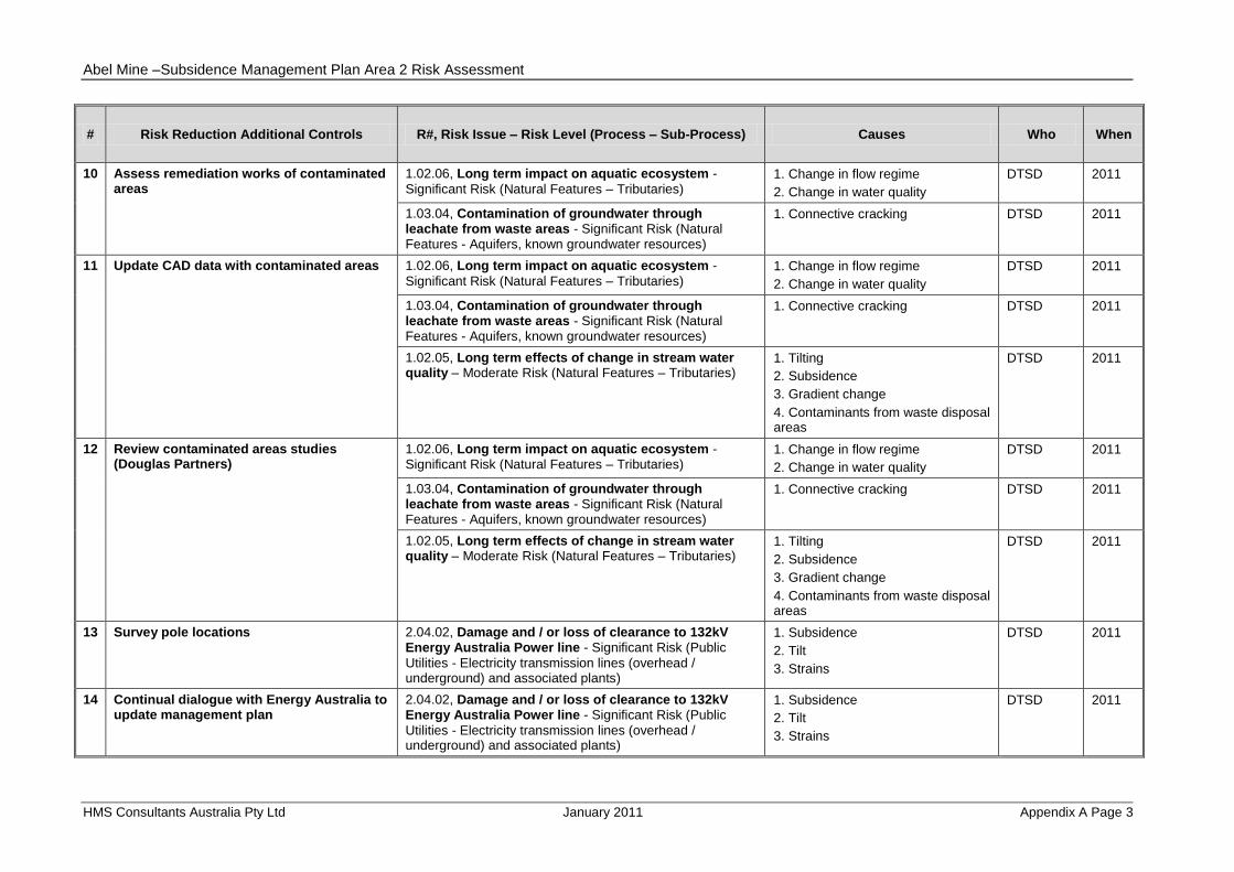
# Risk Reduction Additional Controls R#, Risk Issue – Risk Level (Process – Sub-Process) Causes Who When
1 Transgrid to review structural integrity and design of cruciform's
2.04.01, Damage and / or loss of clearance to 330kV Transgrid Power line - Significant Risk (Public Utilities -
Electricity transmission lines (overhead / underground) and associated plants)
1. Subsidence
2. Tilt
3. Strains
Donaldson Technical Services Department
(DTSD)
2011
2 Continual dialogue with Transgrid re Supplied draft management plan
2.04.01, Damage and / or loss of clearance to 330kV Transgrid Power line - Significant Risk (Public Utilities -
Electricity transmission lines (overhead / underground) and associated plants)
1. Subsidence
2. Tilt
3. Strains
DTSD 2011
3 Investigate need for installation of pulleys on earth wires
2.04.01, Damage and / or loss of clearance to 330kV Transgrid Power line - Significant Risk (Public Utilities -
Electricity transmission lines (overhead / underground) and associated plants)
1. Subsidence
2. Tilt
3. Strains
DTSD 2011
2.04.02, Damage and / or loss of clearance to 132kV Energy Australia Power line - Significant Risk (Public
Utilities - Electricity transmission lines (overhead / underground) and associated plants)
1. Subsidence
2. Tilt
3. Strains
DTSD 2011
2.04.03, Damage and / or loss of clearance to 11kV Energy Australia Power line - Significant Risk (Public
Utilities - Electricity transmission lines (overhead / underground) and associated plants)
1. Subsidence
2. Tilt
3. Strains
DTSD 2011
4 Check conductor clearance 2.04.01, Damage and / or loss of clearance to 330kV Transgrid Power line - Significant Risk (Public Utilities -
Electricity transmission lines (overhead / underground) and associated plants)
1. Subsidence
2. Tilt
3. Strains
DTSD 2011
2.04.02, Damage and / or loss of clearance to 132kV Energy Australia Power line - Significant Risk (Public
Utilities - Electricity transmission lines (overhead / underground) and associated plants)
1. Subsidence
2. Tilt
3. Strains
DTSD 2011
2.04.03, Damage and / or loss of clearance to 11kV Energy Australia Power line - Significant Risk (Public
Utilities - Electricity transmission lines (overhead / underground) and associated plants)
1. Subsidence
2. Tilt
3. Strains
DTSD 2011

Abel Mine –Subsidence Management Plan Area 2 Risk Assessment
HMS Consultants Australia Pty Ltd January 2011 Appendix A Page 2
# Risk Reduction Additional Controls R#, Risk Issue – Risk Level (Process – Sub-Process) Causes Who When
5 Pre-mining surveys 2.04.01, Damage and / or loss of clearance to 330kV Transgrid Power line - Significant Risk (Public Utilities -
Electricity transmission lines (overhead / underground) and associated plants)
1. Subsidence
2. Tilt
3. Strains
DTSD 2011
2.04.02, Damage and / or loss of clearance to 132kV Energy Australia Power line - Significant Risk (Public
Utilities - Electricity transmission lines (overhead / underground) and associated plants)
1. Subsidence
2. Tilt
3. Strains
DTSD 2011
2.04.03, Damage and / or loss of clearance to 11kV Energy Australia Power line - Significant Risk (Public
Utilities - Electricity transmission lines (overhead / underground) and associated plants)
1. Subsidence
2. Tilt
3. Strains
DTSD 2011
6 Subsidence data from Panels 1-4 will be available prior to mining under Transgrid 330kV power lines
2.04.01, Damage and / or loss of clearance to 330kV Transgrid Power line - Significant Risk (Public Utilities -
Electricity transmission lines (overhead / underground) and associated plants)
1. Subsidence
2. Tilt
3. Strains
DTSD 2011
7 Review mine plan if required 2.04.01, Damage and / or loss of clearance to 330kV Transgrid Power line - Significant Risk (Public Utilities -
Electricity transmission lines (overhead / underground) and associated plants)
1. Subsidence
2. Tilt
3. Strains
DTSD 2011
8 Mining height can be varied 1.02.02, Hydraulic connection from surface to underground - Significant Risk (Natural Features –
Tributaries)
1. Connective cracking from stream bed to seam
2. Shallow cover depth
3. Mining height
DTSD 2011
1.02.03, Ponding or reversal of flow - Significant Risk
(Natural Features – Tributaries) 1. Tilting
2. Subsidence
DTSD 2011
9 Extraction ratio can be varied 1.02.02, Hydraulic connection from surface to underground - Significant Risk (Natural Features – Tributaries)
1. Connective cracking from stream bed to seam
2. Shallow cover depth
3. Mining height
DTSD 2011
1.02.03, Ponding or reversal of flow - Significant Risk
(Natural Features – Tributaries) 1. Tilting
2. Subsidence
DTSD 2011
Abel Mine –Subsidence Management Plan Area 2 Risk Assessment
HMS Consultants Australia Pty Ltd January 2011 Appendix A Page 3
# Risk Reduction Additional Controls R#, Risk Issue – Risk Level (Process – Sub-Process) Causes Who When
10 Assess remediation works of contaminated areas
1.02.06, Long term impact on aquatic ecosystem -
Significant Risk (Natural Features – Tributaries) 1. Change in flow regime
2. Change in water quality
DTSD 2011
1.03.04, Contamination of groundwater through leachate from waste areas - Significant Risk (Natural Features - Aquifers, known groundwater resources)
1. Connective cracking DTSD 2011
11 Update CAD data with contaminated areas 1.02.06, Long term impact on aquatic ecosystem -
Significant Risk (Natural Features – Tributaries) 1. Change in flow regime
2. Change in water quality
DTSD 2011
1.03.04, Contamination of groundwater through leachate from waste areas - Significant Risk (Natural Features - Aquifers, known groundwater resources)
1. Connective cracking DTSD 2011
1.02.05, Long term effects of change in stream water quality – Moderate Risk (Natural Features – Tributaries)
1. Tilting
2. Subsidence
3. Gradient change
4. Contaminants from waste disposal areas
DTSD 2011
12 Review contaminated areas studies (Douglas Partners)
1.02.06, Long term impact on aquatic ecosystem - Significant Risk (Natural Features – Tributaries)
1. Change in flow regime
2. Change in water quality
DTSD 2011
1.03.04, Contamination of groundwater through leachate from waste areas - Significant Risk (Natural Features - Aquifers, known groundwater resources)
1. Connective cracking DTSD 2011
1.02.05, Long term effects of change in stream water quality – Moderate Risk (Natural Features – Tributaries)
1. Tilting
2. Subsidence
3. Gradient change
4. Contaminants from waste disposal areas
DTSD 2011
13 Survey pole locations 2.04.02, Damage and / or loss of clearance to 132kV Energy Australia Power line - Significant Risk (Public
Utilities - Electricity transmission lines (overhead / underground) and associated plants)
1. Subsidence
2. Tilt
3. Strains
DTSD 2011
14 Continual dialogue with Energy Australia to update management plan
2.04.02, Damage and / or loss of clearance to 132kV Energy Australia Power line - Significant Risk (Public
Utilities - Electricity transmission lines (overhead / underground) and associated plants)
1. Subsidence
2. Tilt
3. Strains
DTSD 2011

Abel Mine –Subsidence Management Plan Area 2 Risk Assessment
HMS Consultants Australia Pty Ltd January 2011 Appendix A Page 4
# Risk Reduction Additional Controls R#, Risk Issue – Risk Level (Process – Sub-Process) Causes Who When
15 Continual dialogue with Energy Australia to review existing management plan
2.04.03, Damage and / or loss of clearance to 11kV Energy Australia Power line - Significant Risk (Public
Utilities - Electricity transmission lines (overhead / underground) and associated plants)
1. Subsidence
2. Tilt
3. Strains
DTSD 2011
16 Energy Australia to review requirement for power line
2.04.03, Damage and / or loss of clearance to 11kV Energy Australia Power line - Significant Risk (Public
Utilities - Electricity transmission lines (overhead / underground) and associated plants)
1. Subsidence
2. Tilt
3. Strains
DTSD 2011
17 Review monitoring results regarding angle of draw
4.01.01, Damage to principal dwellings - Significant Risk
(Residential - Principal dwellings and proposed buildings within Catholic Diocese principal residence area)
1. Subsidence impacts DTSD 2011
4.02.01, Damage to other structures – Moderate Risk
(Residential - "Other surface structures") 1. Subsidence impacts DTSD 2011
18 Test monitoring of disused houses 4.01.01, Damage to principal dwellings - Significant Risk
(Residential - Principal dwellings and proposed buildings within Catholic Diocese principal residence area)
1. Subsidence impacts DTSD 2011
4.02.01, Damage to other structures – Moderate Risk
(Residential - "Other surface structures") 1. Subsidence impacts DTSD 2011
19 Include tributary management in PMP 1.02.04, Destabilisation of bank and / or bed - Significant
Risk (Natural Features – Tributaries) 1. Tilting
2. Subsidence
3. Gradient change
DTSD 2011
20 Include visual inspection of stream flow and pool depth in checklist
1.01.02, Hydraulic connection from surface to underground – Moderate Risk (Natural Features - Schedule 2 Creeks)
1. Connective cracking from stream bed to seam
2. Pillar extraction within SCZ
DTSD 2011
1.01.01, Loss of overland flow - Moderate Risk (Natural
Features - Schedule 2 Creeks) 1. Surface cracking of stream bed
2. Pillar extraction within SCZ
DTSD 2011
1.02.01, Cumulative loss of overland flow from tributaries – Moderate Risk (Natural Features –
Tributaries)
1. Surface cracking of stream bed DTSD 2011
21 Assess Optus MP 2.05.01, Damage to Optus Optical Fibre Cables –
Moderate Risk (Public Utilities - Telecommunication lines (overhead / underground) and associated plants)
1. Subsidence DTSD 2011

Abel Mine –Subsidence Management Plan Area 2 Risk Assessment
HMS Consultants Australia Pty Ltd January 2011 Appendix A Page 5
# Risk Reduction Additional Controls R#, Risk Issue – Risk Level (Process – Sub-Process) Causes Who When
22 Investigate durability of Optus cable 2.05.01, Damage to Optus Optical Fibre Cables –
Moderate Risk (Public Utilities - Telecommunication lines (overhead / underground) and associated plants)
1. Subsidence DTSD 2011
23 Subsidence data from Panels 1-4 will be available prior to mining under Optus Optical Fibre cable
2.05.01, Damage to Optus Optical Fibre Cables –
Moderate Risk (Public Utilities - Telecommunication lines (overhead / underground) and associated plants)
1. Subsidence DTSD 2011
24 Continual dialogue with Optus to confirm appropriate management plan
2.05.01, Damage to Optus Optical Fibre Cables –
Moderate Risk (Public Utilities - Telecommunication lines (overhead / underground) and associated plants)
1. Subsidence DTSD 2011
25 Consider independent assessment of asbestos risk
4.02.02, Exposure to asbestos substances in the disused dwellings – Moderate Risk (Residential - "Other surface structures")
1. Subsidence impacts DTSD 2011
26 Add inspection of culverts during mining to checklists
2.02.01, Serviceability of culverts – Moderate Risk (Public
Utilities - Culverts associated with Black Hill Road) 1. Cracking
2. Steps (Scarps)
3. Change in road profile
4. Change in drainage
DTSD 2011
27 Request HWC to install additional gate valve to minimise impact
2.03.01, Damage to HWC 200mm PVC pipe resulting in interruption to water supply – Moderate Risk (Public
Utilities - Water pipeline)
1. Strains DTSD 2011
28 Ground truthing of surface features 3.02.01, Damage to internal property access tracks –
Moderate Risk (Farm Land and Facilities - Internal Access tracks)
1. Cracking
2. Steps (Scarps)
3. Change in road profile
4. Reduction in sight distance on road
5. Change in drainage
6. Tree falling
DTSD 2011
29 Complete identification of water reticulation systems within SMP Area 2
3.07.01, Damage to water reticulation system resulting in loss of service – Moderate Risk (Farm Land and Facilities - Water Reticulation systems)
1. Subsidence impacts DTSD 2011
30 Confirm details on sites and location 5.01.01, Disturbance of archaeological significant area contained within Area 2 – Low Risk (Areas of
Archaeological and/or Cultural Significance - Areas of Archaeological and / or Heritage Significance)
1. Subsidence impacts DTSD 2011

Abel Mine –Subsidence Management Plan Area 2 Risk Assessment
HMS Consultants Australia Pty Ltd January 2011 Appendix A Page 6
# Risk Reduction Additional Controls R#, Risk Issue – Risk Level (Process – Sub-Process) Causes Who When
31 Confirm extent of current service 2.05.02, Damage to Telstra Local Copper Cables – Low
Risk (Public Utilities - Telecommunication lines (overhead/underground) and associated plants)
1. Subsidence DTSD 2011
32 Continual dialogue with Telstra to develop management plan
2.05.02, Damage to Telstra Local Copper Cables – Low
Risk (Public Utilities - Telecommunication lines (overhead/underground) and associated plants)
1. Subsidence DTSD 2011

Abel Mine –Subsidence Management Plan Area 2 Risk Assessment
HMS Consultants Australia Pty Ltd January 2011 Appendix B
APPENDIX B
Abel Mine
SMP Area 2 Risk Assessment
Risk Table
September 2010
Assessment Order
Abel Mine – Subsidence Management Plan Area 2 Risk Assessment
HMS Consultants Australia Pty Ltd January 2011 Appendix B - Page 1
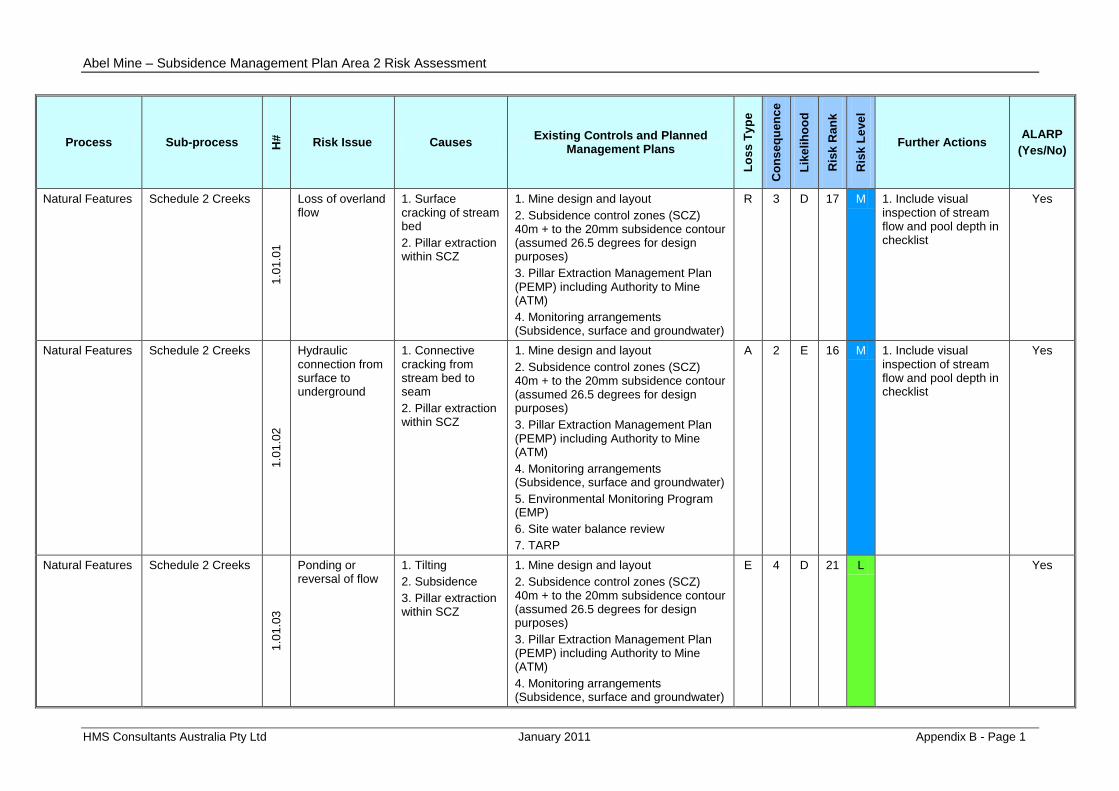
Process Sub-process H#
Risk Issue Causes Existing Controls and Planned
Management Plans
Lo
ss
Ty
pe
Co
ns
eq
uen
ce
Lik
eli
ho
od
Ris
k R
an
k
Ris
k L
eve
l
Further Actions ALARP
(Yes/No)
Natural Features Schedule 2 Creeks
1.0
1.0
1
Loss of overland flow
1. Surface cracking of stream bed
2. Pillar extraction within SCZ
1. Mine design and layout
2. Subsidence control zones (SCZ) 40m + to the 20mm subsidence contour (assumed 26.5 degrees for design purposes)
3. Pillar Extraction Management Plan (PEMP) including Authority to Mine (ATM)
4. Monitoring arrangements (Subsidence, surface and groundwater)
R 3 D 17 M 1. Include visual inspection of stream flow and pool depth in checklist
Yes
Natural Features Schedule 2 Creeks
1.0
1.0
2
Hydraulic connection from surface to underground
1. Connective cracking from stream bed to seam
2. Pillar extraction within SCZ
1. Mine design and layout
2. Subsidence control zones (SCZ) 40m + to the 20mm subsidence contour (assumed 26.5 degrees for design purposes)
3. Pillar Extraction Management Plan (PEMP) including Authority to Mine (ATM)
4. Monitoring arrangements (Subsidence, surface and groundwater)
5. Environmental Monitoring Program (EMP)
6. Site water balance review
7. TARP
A 2 E 16 M 1. Include visual inspection of stream flow and pool depth in checklist
Yes
Natural Features Schedule 2 Creeks
1.0
1.0
3
Ponding or reversal of flow
1. Tilting
2. Subsidence
3. Pillar extraction within SCZ
1. Mine design and layout
2. Subsidence control zones (SCZ) 40m + to the 20mm subsidence contour (assumed 26.5 degrees for design purposes)
3. Pillar Extraction Management Plan (PEMP) including Authority to Mine (ATM)
4. Monitoring arrangements (Subsidence, surface and groundwater)
E 4 D 21 L Yes

Abel Mine – Subsidence Management Plan Area 2 Risk Assessment
HMS Consultants Australia Pty Ltd January 2011 Appendix B - Page 2
Process Sub-process H#
Risk Issue Causes Existing Controls and Planned
Management Plans
Lo
ss
Ty
pe
Co
ns
eq
uen
ce
Lik
eli
ho
od
Ris
k R
an
k
Ris
k L
eve
l
Further Actions ALARP
(Yes/No)
Natural Features Schedule 2 Creeks
1.0
1.0
4
Destabilisation of bank and / or bed
1. Tilting
2. Subsidence
3. Gradient change
4. Pillar extraction within SCZ
1. Mine design and layout
2. Subsidence control zones (SCZ) 40m + to the 20mm subsidence contour (assumed 26.5 degrees for design purposes)
3. Pillar Extraction Management Plan (PEMP) including Authority to Mine (ATM)
4. Monitoring arrangements (Subsidence, surface and groundwater)
A 4 D 21 L Yes
Natural Features Schedule 2 Creeks
1.0
1.0
5
Change in stream water quality
1. Tilting
2. Subsidence
3. Gradient change
4. Pillar extraction within SCZ
1. Mine design and layout
2. Subsidence control zones (SCZ) 40m + to the 20mm subsidence contour (assumed 26.5 degrees for design purposes)
3. Pillar Extraction Management Plan (PEMP) including Authority to Mine (ATM)
4. Monitoring arrangements (Subsidence, surface and groundwater)
E 4 D 21 L Yes
Natural Features Schedule 2 Creeks
1.0
1.0
6
Long term impact on aquatic ecosystem
1. Change in flow regime
2. Change in water quality
3. Pillar extraction within SCZ
1. Mine design and layout
2. Subsidence control zones (SCZ) 40m + to the 20mm subsidence contour (assumed 26.5 degrees for design purposes)
3. Pillar Extraction Management Plan (PEMP) including Authority to Mine (ATM)
4. Monitoring arrangements (Subsidence, surface and groundwater)
E 3 D 17 M Yes

Abel Mine – Subsidence Management Plan Area 2 Risk Assessment
HMS Consultants Australia Pty Ltd January 2011 Appendix B - Page 3
Process Sub-process H#
Risk Issue Causes Existing Controls and Planned
Management Plans
Lo
ss
Ty
pe
Co
ns
eq
uen
ce
Lik
eli
ho
od
Ris
k R
an
k
Ris
k L
eve
l
Further Actions ALARP
(Yes/No)
Natural Features Tributaries
1.0
2.0
1 Cumulative loss
of overland flow from tributaries
1. Surface cracking of stream bed
1. EMP TARPs includes remediation and mine plan review
E 4 C 18 M 1. Include visual inspection of stream flow and pool depth in checklist
Yes
Natural Features Tributaries 1
.02
.02
Hydraulic connection from surface to underground
1. Connective cracking from stream bed to seam
2. Shallow cover depth
3. Mining height
1. Cover depth is greater than 100m
2. Mining height is less than 3.2m at this location
A 3 C 13 S 1. Mining height can be varied
2. Extraction ratio can be varied
Yes
Natural Features Tributaries
1.0
2.0
3 Ponding or
reversal of flow 1. Tilting
2. Subsidence
1. EMP TARPs includes remediation and mine plan review
2. Property Management Plans (PMP) to be developed
E 4 B 14 S 1. Mining height can be varied
2. Extraction ratio can be varied
Yes
Natural Features Tributaries
1.0
2.0
4 Destabilisation
of bank and / or bed
1. Tilting
2. Subsidence
3. Gradient change
1. EMP TARPs includes remediation and mine plan review
2. Property Management Plans to be developed
E 4 B 14 S 1. Include tributary management in PMP
Yes
Natural Features Tributaries
1.0
2.0
5
Long term effects of change in stream water quality
1. Tilting
2. Subsidence
3. Gradient change
4. Contaminants from waste disposal areas
1. EMP TARPs includes remediation and mine plan review
2. Property Management Plans to be developed
E 3 D 17 M 1. Update CAD data with contaminated areas
2. Review contaminated areas studies (Douglas Partners)
Yes

Abel Mine – Subsidence Management Plan Area 2 Risk Assessment
HMS Consultants Australia Pty Ltd January 2011 Appendix B - Page 4
Process Sub-process H#
Risk Issue Causes Existing Controls and Planned
Management Plans
Lo
ss
Ty
pe
Co
ns
eq
uen
ce
Lik
eli
ho
od
Ris
k R
an
k
Ris
k L
eve
l
Further Actions ALARP
(Yes/No)
Natural Features Tributaries
1.0
2.0
6
Long term impact on aquatic ecosystem
1. Change in flow regime
2. Change in water quality
1. EMP TARPs includes remediation and mine plan review
2. Property Management Plans to be developed
3. No known acid sulphate soils
4. No upward gradient of groundwater
E 3 C 13 S 1. Assess remediation works of contaminated areas
2. Update CAD data with contaminated areas
3. Review contaminated areas studies (Douglas Partners)
Yes
Natural Features Aquifers, known groundwater resources
1.0
3.0
1
Reduction in bore yield and adverse effects on groundwater dependent ecosystems
1. Connective cracking
1. No groundwater dependent ecosystems in area
2. No bores in area
E 5 C 22 L
Natural Features Aquifers, known groundwater resources
1.0
3.0
2
Additional flow to underground workings
1. Connective cracking
1. Water Management Plan
2. Pumping capacity is approximately 3 times current flows
3. Underground water storage area available
A 4 D 21 L
Natural Features Aquifers, known groundwater resources
1.0
3.0
3 Quality change
of groundwater inflows through mine workings
1. Aquifer depressurisation
1. Water Management Plan A 4 D 21 L

Abel Mine – Subsidence Management Plan Area 2 Risk Assessment
HMS Consultants Australia Pty Ltd January 2011 Appendix B - Page 5
Process Sub-process H#
Risk Issue Causes Existing Controls and Planned
Management Plans
Lo
ss
Ty
pe
Co
ns
eq
uen
ce
Lik
eli
ho
od
Ris
k R
an
k
Ris
k L
eve
l
Further Actions ALARP
(Yes/No)
Natural Features Aquifers, known groundwater resources
1.0
3.0
4
Contamination of groundwater through leachate from waste areas
1. Connective cracking
E 3 C 13 S 1. Assess remediation works of contaminated areas
2. Update CAD data with contaminated areas
3. Review contaminated areas studies (Douglas Partners)
Natural Features Natural Vegetation
1.0
8.0
1 Change in
habitat / fauna 1. Falling tree
2. Dieback
1. Mine design
2. Monitoring arrangements
3. Visual inspections
4. TARPs - remediation works
E 4 D 21 L
Natural Features Natural Vegetation
1.0
8.0
2
Visual impact 1. Falling tree
2. Dieback
1. Mine design
2. Monitoring arrangements
3. Visual inspections
4. TARPs - remediation works
5. Ongoing Consultation
R 4 D 21 L
Public Utilities Roads (all types)
2.0
1.0
1
Serviceability of public roads
1. Cracking
2. Steps (Scarps)
3. Change in road profile
4. Reduction in sight distance on road
5. Change in drainage
6. Tree falling
1. Develop road management plan with Cessnock City Council
2. Develop Public Safety Management Plan
3. Ongoing consultation
4. Develop road management plan for 4wd tracks for fire fighting access
P 2 D 12 S

Abel Mine – Subsidence Management Plan Area 2 Risk Assessment
HMS Consultants Australia Pty Ltd January 2011 Appendix B - Page 6
Process Sub-process H#
Risk Issue Causes Existing Controls and Planned
Management Plans
Lo
ss
Ty
pe
Co
ns
eq
uen
ce
Lik
eli
ho
od
Ris
k R
an
k
Ris
k L
eve
l
Further Actions ALARP
(Yes/No)
Public Utilities Culverts associated with Black Hill Road
2.0
2.0
1
Serviceability of culverts
1. Cracking
2. Steps (Scarps)
3. Change in road profile
4. Change in drainage
1. Develop road management plan with Cessnock City Council
2. Develop Public Safety Management Plan
3. Ongoing consultation
4. Preliminary inspections of culverts have been undertaken
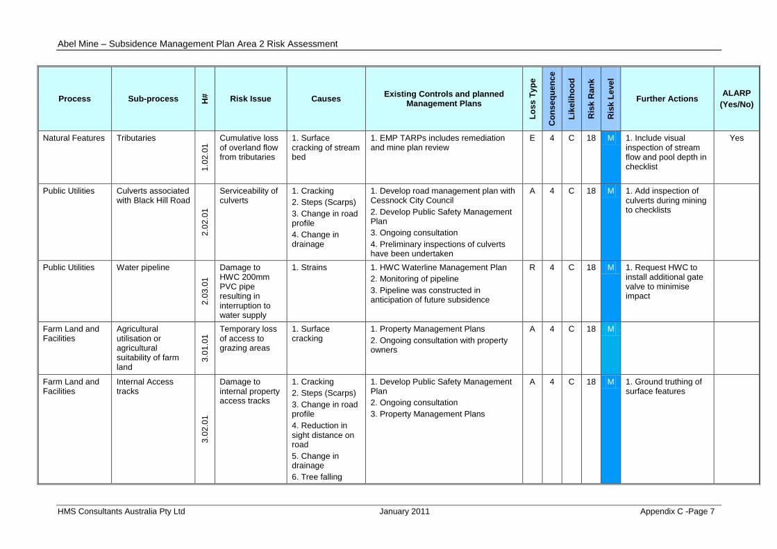
A 4 C 18 M 1. Add inspection of culverts during mining to checklists
Public Utilities Water pipeline
2.0
3.0
1
Damage to HWC 200mm PVC pipe resulting in interruption to water supply
1. Strains 1. HWC Waterline Management Plan
2. Monitoring of pipeline
3. Pipeline was constructed in anticipation of future subsidence
R 4 C 18 M 1. Request HWC to install additional gate valve to minimise impact
Public Utilities Electricity transmission lines (overhead / underground) and associated plants
2.0
4.0
1
Damage and / or loss of clearance to 330kV Transgrid Power line
1. Subsidence
2. Tilt
3. Strains
1. Cruciform footings
2. Conductor strings
A 2 C 8 S 1. Transgrid to review structural integrity and design of cruciform's
2. Continual dialogue with Transgrid re Supplied draft management plan
3. Investigate need for installation of pulleys on earth wires
4. Check conductor clearance
5. Pre-mining surveys
6. Subsidence data from Panels 1-4 will be available prior to mining under Transgrid 330kV power lines
7. Review mine plan if required

Abel Mine – Subsidence Management Plan Area 2 Risk Assessment
HMS Consultants Australia Pty Ltd January 2011 Appendix B - Page 7
Process Sub-process H#
Risk Issue Causes Existing Controls and Planned
Management Plans
Lo
ss
Ty
pe
Co
ns
eq
uen
ce
Lik
eli
ho
od
Ris
k R
an
k
Ris
k L
eve
l
Further Actions ALARP
(Yes/No)
Public Utilities Electricity transmission lines (overhead / underground) and associated plants
2.0
4.0
2
Damage and / or loss of clearance to 132kV Energy Australia Power line
1. Subsidence
2. Tilt
3. Strains
1. Timber poles more resilient to subsidence impacts
A 3 C 13 S 1. Check conductor clearance
2. Survey pole locations
3. Continual dialogue with Energy Australia to update management plan
4. Pre-mining surveys
5. Investigate need for installation of pulleys on earth wires
Public Utilities Electricity transmission lines (overhead / underground) and associated plants
2.0
4.0
3
Damage and / or loss of clearance to 11kV Energy Australia Power line
1. Subsidence
2. Tilt
3. Strains
1. Timber poles more resilient to subsidence impacts
2. Power line Management Plan
A 3 C 13 S 1. Check conductor clearance
2. Continual dialogue with Energy Australia to review existing management plan
3. Pre-mining surveys
4. Investigate need for installation of pulleys on earth wires
5. Energy Australia to review requirement for power line

Abel Mine – Subsidence Management Plan Area 2 Risk Assessment
HMS Consultants Australia Pty Ltd January 2011 Appendix B - Page 8
Process Sub-process H#
Risk Issue Causes Existing Controls and Planned
Management Plans
Lo
ss
Ty
pe
Co
ns
eq
uen
ce
Lik
eli
ho
od
Ris
k R
an
k
Ris
k L
eve
l
Further Actions ALARP
(Yes/No)
Public Utilities Telecommunication lines (overhead / underground) and associated plants
2.0
5.0
1
Damage to Optus Optical Fibre Cables
1. Subsidence 1. Optus have own internal management plan
2. Location of cable confirmed
3. Pre-mining audit has been carried out
4. Relocate fibre optic cable if required
A 3 D 17 M 1. Assess Optus MP
2. Investigate durability of Optus cable
3. Subsidence data from Panels 1-4 will be available prior to mining under Optus Optical Fibre cable
4. Continual dialogue with Optus to confirm appropriate management plan
Public Utilities Telecommunication lines (overhead / underground) and associated plants 2
.05
.02 Damage to
Telstra Local Copper Cables
1. Subsidence 1. Location of cable confirmed R 5 C 22 L 1. Confirm extent of current service
2. Continual dialogue with Telstra to develop management plan
Public Utilities State Survey marks
2.0
7.0
1 Use of disturbed
State Survey Marks
1. Disturbance of State Survey Marks due to subsidence
1. Location of marks known
2. Notify Department of Lands
A 3 D 17 M
Farm Land and Facilities
Agricultural utilisation or agricultural suitability of farm land
3.0
1.0
1 Temporary loss
of access to grazing areas
1. Surface cracking
1. Property Management Plans
2. Ongoing consultation with property owners
A 4 C 18 M

Abel Mine – Subsidence Management Plan Area 2 Risk Assessment
HMS Consultants Australia Pty Ltd January 2011 Appendix B - Page 9
Process Sub-process H#
Risk Issue Causes Existing Controls and Planned
Management Plans
Lo
ss
Ty
pe
Co
ns
eq
uen
ce
Lik
eli
ho
od
Ris
k R
an
k
Ris
k L
eve
l
Further Actions ALARP
(Yes/No)
Farm Land and Facilities
Internal Access tracks
3.0
2.0
1
Damage to internal property access tracks
1. Cracking
2. Steps (Scarps)
3. Change in road profile
4. Reduction in sight distance on road
5. Change in drainage
6. Tree falling
1. Develop Public Safety Management Plan
2. Ongoing consultation
3. Property Management Plans
A 4 C 18 M 1. Ground truthing of surface features
Farm Land and Facilities
Fences, gates and cattle grids
3.0
3.0
1 Damage to
fences and / or gates including resulting loss of livestock
1. Strain
2. Subsidence
3. Falling tree
1. Property Management Plans
2. Ongoing consultation with property owners
3. Monitoring arrangements
A 4 C 18 M
Farm Land and Facilities
Farm dams
3.0
4.0
1
Damage to dams resulting in loss of serviceability and integrity of dam wall
1. Cracking
2. Tilting
1. Dam monitoring and management strategy (DMMS) will be developed for all dams prior to mining impact
2. Statement of commitments to provide water in the event of interruption of supply of water from dam
A 4 C 18 M
Farm Land and Facilities
Water Reticulation systems
3.0
7.0
1
Damage to water reticulation system resulting in loss of service
1. Subsidence impacts
1. Property Management Plan
2. Monitoring arrangements
3. Statement of commitments to provide water in the event of interruption of supply of water from reticulation system
A 4 C 18 M 1. Complete identification of water reticulation systems within SMP Area 2
Farm Land and Facilities
Capping of remediated areas
3.0
8.0
1 Loss of integrity
of capping 1. Subsidence impacts
1. See above A 4 C 18 M

Abel Mine – Subsidence Management Plan Area 2 Risk Assessment
HMS Consultants Australia Pty Ltd January 2011 Appendix B - Page 10
Process Sub-process H#
Risk Issue Causes Existing Controls and Planned
Management Plans
Lo
ss
Ty
pe
Co
ns
eq
uen
ce
Lik
eli
ho
od
Ris
k R
an
k
Ris
k L
eve
l
Further Actions ALARP
(Yes/No)
Residential Principal dwellings and proposed buildings within Catholic Diocese principal residence area
4.0
1.0
1
Damage to principal dwellings
1. Subsidence impacts
1. Mine design and layout
2. Subsidence control zones (SCZ) to the 20mm subsidence contour (assumed 26.5 degrees for design purposes)
3. Pillar Extraction Management Plan (PEMP) including Authority to Mine (ATM)
4. Monitoring arrangements (Subsidence)
5. Mine Subsidence Board inspections to determine tolerable levels
6. Incorporate assessment of vibration into Property Management Plan
7. Mine schedule provides for substantial amount of subsidence data prior to first workings underneath principal dwellings
8. Recalibration of subsidence model after each panel
A 3 C 13 S 1. Review monitoring results regarding angle of draw
2. Test monitoring of disused houses

Abel Mine – Subsidence Management Plan Area 2 Risk Assessment
HMS Consultants Australia Pty Ltd January 2011 Appendix B - Page 11
Process Sub-process H#
Risk Issue Causes Existing Controls and Planned
Management Plans
Lo
ss
Ty
pe
Co
ns
eq
uen
ce
Lik
eli
ho
od
Ris
k R
an
k
Ris
k L
eve
l
Further Actions ALARP
(Yes/No)
Residential "Other surface structures"
4.0
2.0
1
Damage to other structures
1. Subsidence impacts
1. Mine design and layout
2. Monitoring arrangements (Subsidence)
3. Mine Subsidence Board inspections in conjunction with property owner and Abel to determine potential impacts, tolerable levels,
4. Management plan to be developed, incorporating responsibilities
5. Incorporate assessment of vibration into Property Management Plan
6. Mine schedule provides for substantial amount of subsidence data prior to workings underneath structures
7. Recalibration of subsidence model after each panel
A 4 C 18 M 1. Review monitoring results regarding angle of draw
2. Test monitoring of disused houses
Residential "Other surface structures"
4.0
2.0
2 Exposure to
asbestos substances in the disused dwellings
1. Subsidence impacts
1. Property Management Plan
2. Further inspections will be conducted prior to mining underneath
P 3 D 17 M 1. Consider independent assessment of asbestos risk
Areas of Archaeological and/or Cultural Significance
Areas of Archaeological and / or Heritage Significance 5
.01
.01 Disturbance of
archaeological significant area contained within Area 2
1. Subsidence impacts
1. Located within Viney Creek SCZ
2. ATM
3. PEMP
A 4 D 21 L 1. Confirm details on sites and location

Abel Mine –Subsidence Management Plan Area 2 Risk Assessment
HMS Consultants Australia Pty Ltd January 2011 Appendix C
APPENDIX C
Abel Mine
SMP Area 2 Risk Assessment
Risk Table
September 2010
Risk Rank Order

Abel Mine – Subsidence Management Plan Area 2 Risk Assessment
HMS Consultants Australia Pty Ltd January 2011 Appendix C -Page 1
Process Sub-process H#
Risk Issue Causes Existing Controls and planned
Management Plans
Lo
ss
Ty
pe
Co
ns
eq
uen
ce
Lik
eli
ho
od
Ris
k R
an
k
Ris
k L
eve
l
Further Actions ALARP
(Yes/No)
Public Utilities Electricity transmission lines (overhead / underground) and associated plants
2.0
4.0
1
Damage and / or loss of clearance to 330kV Transgrid Power line
1. Subsidence
2. Tilt
3. Strains
1. Cruciform footings
2. Conductor strings
A 2 C 8 S 1. Transgrid to review structural integrity and design of cruciform's
2. Continual dialogue with Transgrid re Supplied draft management plan
3. Investigate need for installation of pulleys on earth wires
4. Check conductor clearance
5. Pre-mining surveys
6. Subsidence data from Panels 1-4 will be available prior to mining under Transgrid 330kV power lines
7. Review mine plan if required
Public Utilities Roads (all types)
2.0
1.0
1
Serviceability of public roads
1. Cracking
2. Steps (Scarps)
3. Change in road profile
4. Reduction in sight distance on road
5. Change in drainage
6. Tree falling
1. Develop road management plan with Cessnock City Council
2. Develop Public Safety Management Plan
3. Ongoing consultation
4. Develop road management plan for 4wd tracks for fire fighting access
P 2 D 12 S

Abel Mine – Subsidence Management Plan Area 2 Risk Assessment
HMS Consultants Australia Pty Ltd January 2011 Appendix C -Page 2
Process Sub-process H#
Risk Issue Causes Existing Controls and planned
Management Plans
Lo
ss
Ty
pe
Co
ns
eq
uen
ce
Lik
eli
ho
od
Ris
k R
an
k
Ris
k L
eve
l
Further Actions ALARP
(Yes/No)
Natural Features Tributaries
1.0
2.0
2
Hydraulic connection from surface to underground
1. Connective cracking from stream bed to seam
2. Shallow cover depth
3. Mining height
1. Cover depth is greater than 100m
2. Mining height is less than 3.2m at this location
A 3 C 13 S 1. Mining height can be varied
2. Extraction ratio can be varied
Yes
Natural Features Tributaries 1
.02
.06
Long term impact on aquatic ecosystem
1. Change in flow regime
2. Change in water quality
1. EMP TARPs includes remediation and mine plan review
2. Property Management Plans to be developed
3. No known acid sulphate soils
4. No upward gradient of groundwater
E 3 C 13 S 1. Assess remediation works of contaminated areas
2. Update CAD data with contaminated areas
3. Review contaminated areas studies (Douglas Partners)
Yes
Natural Features Aquifers, known groundwater resources
1.0
3.0
4
Contamination of groundwater through leachate from waste areas
1. Connective cracking
E 3 C 13 S 1. Assess remediation works of contaminated areas
2. Update CAD data with contaminated areas
3. Review contaminated areas studies (Douglas Partners)

Abel Mine – Subsidence Management Plan Area 2 Risk Assessment
HMS Consultants Australia Pty Ltd January 2011 Appendix C -Page 3
Process Sub-process H#
Risk Issue Causes Existing Controls and planned
Management Plans
Lo
ss
Ty
pe
Co
ns
eq
uen
ce
Lik
eli
ho
od
Ris
k R
an
k
Ris
k L
eve
l
Further Actions ALARP
(Yes/No)
Public Utilities Electricity transmission lines (overhead / underground) and associated plants
2.0
4.0
2
Damage and / or loss of clearance to 132kV Energy Australia Power line
1. Subsidence
2. Tilt
3. Strains
1. Timber poles more resilient to subsidence impacts
A 3 C 13 S 1. Check conductor clearance
2. Survey pole locations
3. Continual dialogue with Energy Australia to update management plan
4. Pre-mining surveys
5. Investigate need for installation of pulleys on earth wires
Public Utilities Electricity transmission lines (overhead / underground) and associated plants
2.0
4.0
3
Damage and / or loss of clearance to 11kV Energy Australia Power line
1. Subsidence
2. Tilt
3. Strains
1. Timber poles more resilient to subsidence impacts
2. Power line Management Plan
A 3 C 13 S 1. Check conductor clearance
2. Continual dialogue with Energy Australia to review existing management plan
3. Pre-mining surveys
4. Investigate need for installation of pulleys on earth wires
5. Energy Australia to review requirement for power line

Abel Mine – Subsidence Management Plan Area 2 Risk Assessment
HMS Consultants Australia Pty Ltd January 2011 Appendix C -Page 4
Process Sub-process H#
Risk Issue Causes Existing Controls and planned
Management Plans
Lo
ss
Ty
pe
Co
ns
eq
uen
ce
Lik
eli
ho
od
Ris
k R
an
k
Ris
k L
eve
l
Further Actions ALARP
(Yes/No)
Residential Principal dwellings and proposed buildings within Catholic Diocese principal residence area
4.0
1.0
1
Damage to principal dwellings
1. Subsidence impacts
1. Mine design and layout
2. Subsidence control zones (SCZ) to the 20mm subsidence contour (assumed 26.5 degrees for design purposes)
3. Pillar Extraction Management Plan (PEMP) including Authority to Mine (ATM)
4. Monitoring arrangements (Subsidence)
5. Mine Subsidence Board inspections to determine tolerable levels
6. Incorporate assessment of vibration into Property Management Plan
7. Mine schedule provides for substantial amount of subsidence data prior to first workings underneath principal dwellings
8. Recalibration of subsidence model after each panel
A 3 C 13 S 1. Review monitoring results regarding angle of draw
2. Test monitoring of disused houses
Natural Features Tributaries
1.0
2.0
3 Ponding or
reversal of flow 1. Tilting
2. Subsidence
1. EMP TARPs includes remediation and mine plan review
2. Property Management Plans (PMP) to be developed
E 4 B 14 S 1. Mining height can be varied
2. Extraction ratio can be varied
Yes
Natural Features Tributaries
1.0
2.0
4 Destabilisation
of bank and / or bed
1. Tilting
2. Subsidence
3. Gradient change
1. EMP TARPs includes remediation and mine plan review
2. Property Management Plans to be developed
E 4 B 14 S 1. Include tributary management in PMP
Yes

Abel Mine – Subsidence Management Plan Area 2 Risk Assessment
HMS Consultants Australia Pty Ltd January 2011 Appendix C -Page 5
Process Sub-process H#
Risk Issue Causes Existing Controls and planned
Management Plans
Lo
ss
Ty
pe
Co
ns
eq
uen
ce
Lik
eli
ho
od
Ris
k R
an
k
Ris
k L
eve
l
Further Actions ALARP
(Yes/No)
Natural Features Schedule 2 Creeks
1.0
1.0
2
Hydraulic connection from surface to underground
1. Connective cracking from stream bed to seam
2. Pillar extraction within SCZ
1. Mine design and layout
2. Subsidence control zones (SCZ) 40m + to the 20mm subsidence contour (assumed 26.5 degrees for design purposes)
3. Pillar Extraction Management Plan (PEMP) including Authority to Mine (ATM)
4. Monitoring arrangements (Subsidence, surface and groundwater)
5. Environmental Monitoring Program (EMP)
6. Site water balance review
7. TARP
A 2 E 16 M 1. Include visual inspection of stream flow and pool depth in checklist
Yes
Natural Features Schedule 2 Creeks
1.0
1.0
1
Loss of overland flow
1. Surface cracking of stream bed
2. Pillar extraction within SCZ
1. Mine design and layout
2. Subsidence control zones (SCZ) 40m + to the 20mm subsidence contour (assumed 26.5 degrees for design purposes)
3. Pillar Extraction Management Plan (PEMP) including Authority to Mine (ATM)
4. Monitoring arrangements (Subsidence, surface and groundwater)
R 3 D 17 M 1. Include visual inspection of stream flow and pool depth in checklist
Yes
Natural Features Schedule 2 Creeks
1.0
1.0
6
Long term impact on aquatic ecosystem
1. Change in flow regime
2. Change in water quality
3. Pillar extraction within SCZ
1. Mine design and layout
2. Subsidence control zones (SCZ) 40m + to the 20mm subsidence contour (assumed 26.5 degrees for design purposes)
3. Pillar Extraction Management Plan (PEMP) including Authority to Mine (ATM)
4. Monitoring arrangements (Subsidence, surface and groundwater)
E 3 D 17 M Yes

Abel Mine – Subsidence Management Plan Area 2 Risk Assessment
HMS Consultants Australia Pty Ltd January 2011 Appendix C -Page 6
Process Sub-process H#
Risk Issue Causes Existing Controls and planned
Management Plans
Lo
ss
Ty
pe
Co
ns
eq
uen
ce
Lik
eli
ho
od
Ris
k R
an
k
Ris
k L
eve
l
Further Actions ALARP
(Yes/No)
Natural Features Tributaries
1.0
2.0
5
Long term effects of change in stream water quality
1. Tilting
2. Subsidence
3. Gradient change
4. Contaminants from waste disposal areas
1. EMP TARPs includes remediation and mine plan review
2. Property Management Plans to be developed
E 3 D 17 M 1. Update CAD data with contaminated areas
2. Review contaminated areas studies (Douglas Partners)
Yes
Public Utilities Telecommunication lines (overhead / underground) and associated plants
2.0
5.0
1
Damage to Optus Optical Fibre Cables
1. Subsidence 1. Optus have own internal management plan
2. Location of cable confirmed
3. Pre-mining audit has been carried out
4. Relocate fibre optic cable if required
A 3 D 17 M 1. Assess Optus MP
2. Investigate durability of Optus cable
3. Subsidence data from Panels 1-4 will be available prior to mining under Optus Optical Fibre cable
4. Continual dialogue with Optus to confirm appropriate management plan
Public Utilities State Survey marks
2.0
7.0
1 Use of disturbed
State Survey Marks
1. Disturbance of State Survey Marks due to subsidence
1. Location of marks known
2. Notify Department of Lands
A 3 D 17 M
Residential "Other surface structures"
4.0
2.0
2 Exposure to
asbestos substances in the disused dwellings
1. Subsidence impacts
1. Property Management Plan
2. Further inspections will be conducted prior to mining underneath
P 3 D 17 M 1. Consider independent assessment of asbestos risk
Abel Mine – Subsidence Management Plan Area 2 Risk Assessment
HMS Consultants Australia Pty Ltd January 2011 Appendix C -Page 7
Process Sub-process H#
Risk Issue Causes Existing Controls and planned
Management Plans
Lo
ss
Ty
pe
Co
ns
eq
uen
ce
Lik
eli
ho
od
Ris
k R
an
k
Ris
k L
eve
l
Further Actions ALARP
(Yes/No)
Natural Features Tributaries
1.0
2.0
1 Cumulative loss
of overland flow from tributaries
1. Surface cracking of stream bed
1. EMP TARPs includes remediation and mine plan review
E 4 C 18 M 1. Include visual inspection of stream flow and pool depth in checklist
Yes
Public Utilities Culverts associated with Black Hill Road
2.0
2.0
1
Serviceability of culverts
1. Cracking
2. Steps (Scarps)
3. Change in road profile
4. Change in drainage
1. Develop road management plan with Cessnock City Council
2. Develop Public Safety Management Plan
3. Ongoing consultation
4. Preliminary inspections of culverts have been undertaken
A 4 C 18 M 1. Add inspection of culverts during mining to checklists
Public Utilities Water pipeline
2.0
3.0
1
Damage to HWC 200mm PVC pipe resulting in interruption to water supply
1. Strains 1. HWC Waterline Management Plan
2. Monitoring of pipeline
3. Pipeline was constructed in anticipation of future subsidence
R 4 C 18 M 1. Request HWC to install additional gate valve to minimise impact
Farm Land and Facilities
Agricultural utilisation or agricultural suitability of farm land
3.0
1.0
1 Temporary loss
of access to grazing areas
1. Surface cracking
1. Property Management Plans
2. Ongoing consultation with property owners
A 4 C 18 M
Farm Land and Facilities
Internal Access tracks
3.0
2.0
1
Damage to internal property access tracks
1. Cracking
2. Steps (Scarps)
3. Change in road profile
4. Reduction in sight distance on road
5. Change in drainage
6. Tree falling
1. Develop Public Safety Management Plan
2. Ongoing consultation
3. Property Management Plans
A 4 C 18 M 1. Ground truthing of surface features

Abel Mine – Subsidence Management Plan Area 2 Risk Assessment
HMS Consultants Australia Pty Ltd January 2011 Appendix C -Page 8
Process Sub-process H#
Risk Issue Causes Existing Controls and planned
Management Plans
Lo
ss
Ty
pe
Co
ns
eq
uen
ce
Lik
eli
ho
od
Ris
k R
an
k
Ris
k L
eve
l
Further Actions ALARP
(Yes/No)
Farm Land and Facilities
Fences, gates and cattle grids
3.0
3.0
1 Damage to
fences and / or gates including resulting loss of livestock
1. Strain
2. Subsidence
3. Falling tree
1. Property Management Plans
2. Ongoing consultation with property owners
3. Monitoring arrangements
A 4 C 18 M
Farm Land and Facilities
Farm dams
3.0
4.0
1
Damage to dams resulting in loss of serviceability and integrity of dam wall
1. Cracking
2. Tilting
1. Dam monitoring and management strategy (DMMS) will be developed for all dams prior to mining impact
2. Statement of commitments to provide water in the event of interruption of supply of water from dam
A 4 C 18 M
Farm Land and Facilities
Water Reticulation systems
3.0
7.0
1
Damage to water reticulation system resulting in loss of service
1. Subsidence impacts
1. Property Management Plan
2. Monitoring arrangements
3. Statement of commitments to provide water in the event of interruption of supply of water from reticulation system
A 4 C 18 M 1. Complete identification of water reticulation systems within SMP Area 2
Farm Land and Facilities
Capping of remediated areas
3.0
8.0
1 Loss of integrity
of capping 1. Subsidence impacts
1. See above A 4 C 18 M

Abel Mine – Subsidence Management Plan Area 2 Risk Assessment
HMS Consultants Australia Pty Ltd January 2011 Appendix C -Page 9
Process Sub-process H#
Risk Issue Causes Existing Controls and planned
Management Plans
Lo
ss
Ty
pe
Co
ns
eq
uen
ce
Lik
eli
ho
od
Ris
k R
an
k
Ris
k L
eve
l
Further Actions ALARP
(Yes/No)
Residential "Other surface structures"
4.0
2.0
1
Damage to other structures
1. Subsidence impacts
1. Mine design and layout
2. Monitoring arrangements (Subsidence)
3. Mine Subsidence Board inspections in conjunction with property owner and Abel to determine potential impacts, tolerable levels,
4. Management plan to be developed, incorporating responsibilities
5. Incorporate assessment of vibration into Property Management Plan
6. Mine schedule provides for substantial amount of subsidence data prior to workings underneath structures
7. Recalibration of subsidence model after each panel
A 4 C 18 M 1. Review monitoring results regarding angle of draw
2. Test monitoring of disused houses
Natural Features Schedule 2 Creeks
1.0
1.0
3
Ponding or reversal of flow
1. Tilting
2. Subsidence
3. Pillar extraction within SCZ
1. Mine design and layout
2. Subsidence control zones (SCZ) 40m + to the 20mm subsidence contour (assumed 26.5 degrees for design purposes)
3. Pillar Extraction Management Plan (PEMP) including Authority to Mine (ATM)
4. Monitoring arrangements (Subsidence, surface and groundwater)
E 4 D 21 L Yes

Abel Mine – Subsidence Management Plan Area 2 Risk Assessment
HMS Consultants Australia Pty Ltd January 2011 Appendix C -Page 10
Process Sub-process H#
Risk Issue Causes Existing Controls and planned
Management Plans
Lo
ss
Ty
pe
Co
ns
eq
uen
ce
Lik
eli
ho
od
Ris
k R
an
k
Ris
k L
eve
l
Further Actions ALARP
(Yes/No)
Natural Features Schedule 2 Creeks
1.0
1.0
4
Destabilisation of bank and / or bed
1. Tilting
2. Subsidence
3. Gradient change
4. Pillar extraction within SCZ
1. Mine design and layout
2. Subsidence control zones (SCZ) 40m + to the 20mm subsidence contour (assumed 26.5 degrees for design purposes)
3. Pillar Extraction Management Plan (PEMP) including Authority to Mine (ATM)
4. Monitoring arrangements (Subsidence, surface and groundwater)
A 4 D 21 L Yes
Natural Features Schedule 2 Creeks
1.0
1.0
5
Change in stream water quality
1. Tilting
2. Subsidence
3. Gradient change
4. Pillar extraction within SCZ
1. Mine design and layout
2. Subsidence control zones (SCZ) 40m + to the 20mm subsidence contour (assumed 26.5 degrees for design purposes)
3. Pillar Extraction Management Plan (PEMP) including Authority to Mine (ATM)
4. Monitoring arrangements (Subsidence, surface and groundwater)
E 4 D 21 L Yes
Natural Features Aquifers, known groundwater resources
1.0
3.0
2
Additional flow to underground workings
1. Connective cracking
1. Water Management Plan
2. Pumping capacity is approximately 3 times current flows
3. Underground water storage area available
A 4 D 21 L
Natural Features Aquifers, known groundwater resources
1.0
3.0
3 Quality change
of groundwater inflows through mine workings
1. Aquifer depressurisation
1. Water Management Plan A 4 D 21 L

Abel Mine – Subsidence Management Plan Area 2 Risk Assessment
HMS Consultants Australia Pty Ltd January 2011 Appendix C -Page 11
Process Sub-process H#
Risk Issue Causes Existing Controls and planned
Management Plans
Lo
ss
Ty
pe
Co
ns
eq
uen
ce
Lik
eli
ho
od
Ris
k R
an
k
Ris
k L
eve
l
Further Actions ALARP
(Yes/No)
Natural Features Natural Vegetation
1.0
8.0
1 Change in
habitat / fauna 1. Falling tree
2. Dieback
1. Mine design
2. Monitoring arrangements
3. Visual inspections
4. TARPs - remediation works
E 4 D 21 L
Natural Features Natural Vegetation
1.0
8.0
2
Visual impact 1. Falling tree
2. Dieback
1. Mine design
2. Monitoring arrangements
3. Visual inspections
4. TARPs - remediation works
5. Ongoing Consultation
R 4 D 21 L
Areas of Archaeological and/or Cultural Significance
Areas of Archaeological and / or Heritage Significance 5
.01
.01 Disturbance of
archaeological significant area contained within Area 2
1. Subsidence impacts
1. Located within Viney Creek SCZ
2. ATM
3. PEMP
A 4 D 21 L 1. Confirm details on sites and location
Natural Features Aquifers, known groundwater resources
1.0
3.0
1
Reduction in bore yield and adverse effects on groundwater dependent ecosystems
1. Connective cracking
1. No groundwater dependent ecosystems in area
2. No bores in area
E 5 C 22 L
Public Utilities Telecommunication lines (overhead / underground) and associated plants 2
.05
.02 Damage to
Telstra Local Copper Cables
1. Subsidence 1. Location of cable confirmed R 5 C 22 L 1. Confirm extent of current service
2. Continual dialogue with Telstra to develop management plan

Abel Mine – Subsidence Management Plan Area 2 Risk Assessment
HMS Consultants Australia Pty Ltd January 2011 Appendix D
APPENDIX D
Abel Mine
SMP Area 2 Risk Assessment
Risk Table
September 2010
Consequence Order

Abel Mine – Subsidence Management Plan Area 2 Risk Assessment
HMS Consultants Australia Pty Ltd January 2011 Appendix D -Page 1
Process Sub-process H#
Risk Issue Causes Existing Controls and planned
Management Plans
Lo
ss
Ty
pe
Co
ns
eq
uen
ce
Lik
eli
ho
od
Ris
k R
an
k
Ris
k L
eve
l
Further Actions ALARP
(Yes/No)
Public Utilities Electricity transmission lines (overhead / underground) and associated plants
2.0
4.0
1
Damage and / or loss of clearance to 330kV Transgrid Power line
1. Subsidence
2. Tilt
3. Strains
1. Cruciform footings
2. Conductor strings
A 2 C 8 S 1. Transgrid to review structural integrity and design of cruciform's
2. Continual dialogue with Transgrid re Supplied draft management plan
3. Investigate need for installation of pulleys on earth wires
4. Check conductor clearance
5. Pre-mining surveys
6. Subsidence data from Panels 1-4 will be available prior to mining under Transgrid 330kV power lines
7. Review mine plan if required
Public Utilities Roads (all types)
2.0
1.0
1
Serviceability of public roads
1. Cracking
2. Steps (Scarps)
3. Change in road profile
4. Reduction in sight distance on road
5. Change in drainage
6. Tree falling
1. Develop road management plan with Cessnock City Council
2. Develop Public Safety Management Plan
3. Ongoing consultation
4. Develop road management plan for 4wd tracks for fire fighting access
P 2 D 12 S

Abel Mine – Subsidence Management Plan Area 2 Risk Assessment
HMS Consultants Australia Pty Ltd January 2011 Appendix D -Page 2
Process Sub-process H#
Risk Issue Causes Existing Controls and planned
Management Plans
Lo
ss
Ty
pe
Co
ns
eq
uen
ce
Lik
eli
ho
od
Ris
k R
an
k
Ris
k L
eve
l
Further Actions ALARP
(Yes/No)
Natural Features Schedule 2 Creeks
1.0
1.0
2
Hydraulic connection from surface to underground
1. Connective cracking from stream bed to seam
2. Pillar extraction within SCZ
1. Mine design and layout
2. Subsidence control zones (SCZ) 40m + to the 20mm subsidence contour (assumed 26.5 degrees for design purposes)
3. Pillar Extraction Management Plan (PEMP) including Authority to Mine (ATM)
4. Monitoring arrangements (Subsidence, surface and groundwater)
5. Environmental Monitoring Program (EMP)
6. Site water balance review
7. TARP
A 2 E 16 M 1. Include visual inspection of stream flow and pool depth in checklist
Yes
Natural Features Tributaries
1.0
2.0
2
Hydraulic connection from surface to underground
1. Connective cracking from stream bed to seam
2. Shallow cover depth
3. Mining height
1. Cover depth is greater than 100m
2. Mining height is less than 3.2m at this location
A 3 C 13 S 1. Mining height can be varied
2. Extraction ratio can be varied
Yes
Natural Features Tributaries
1.0
2.0
6
Long term impact on aquatic ecosystem
1. Change in flow regime
2. Change in water quality
1. EMP TARPs includes remediation and mine plan review
2. Property Management Plans to be developed
3. No known acid sulphate soils
4. No upward gradient of groundwater
E 3 C 13 S 1. Assess remediation works of contaminated areas
2. Update CAD data with contaminated areas
3. Review contaminated areas studies (Douglas Partners)
Yes

Abel Mine – Subsidence Management Plan Area 2 Risk Assessment
HMS Consultants Australia Pty Ltd January 2011 Appendix D -Page 3
Process Sub-process H#
Risk Issue Causes Existing Controls and planned
Management Plans
Lo
ss
Ty
pe
Co
ns
eq
uen
ce
Lik
eli
ho
od
Ris
k R
an
k
Ris
k L
eve
l
Further Actions ALARP
(Yes/No)
Natural Features Aquifers, known groundwater resources
1.0
3.0
4
Contamination of groundwater through leachate from waste areas
1. Connective cracking
E 3 C 13 S 1. Assess remediation works of contaminated areas
2. Update CAD data with contaminated areas
3. Review contaminated areas studies (Douglas Partners)
Public Utilities Electricity transmission lines (overhead / underground) and associated plants
2.0
4.0
2
Damage and / or loss of clearance to 132kV Energy Australia Power line
1. Subsidence
2. Tilt
3. Strains
1. Timber poles more resilient to subsidence impacts
A 3 C 13 S 1. Check conductor clearance
2. Survey pole locations
3. Continual dialogue with Energy Australia to update management plan
4. Pre-mining surveys
5. Investigate need for installation of pulleys on earth wires

Abel Mine – Subsidence Management Plan Area 2 Risk Assessment
HMS Consultants Australia Pty Ltd January 2011 Appendix D -Page 4
Process Sub-process H#
Risk Issue Causes Existing Controls and planned
Management Plans
Lo
ss
Ty
pe
Co
ns
eq
uen
ce
Lik
eli
ho
od
Ris
k R
an
k
Ris
k L
eve
l
Further Actions ALARP
(Yes/No)
Public Utilities Electricity transmission lines (overhead / underground) and associated plants
2.0
4.0
3
Damage and / or loss of clearance to 11kV Energy Australia Power line
1. Subsidence
2. Tilt
3. Strains
1. Timber poles more resilient to subsidence impacts
2. Power line Management Plan
A 3 C 13 S 1. Check conductor clearance
2. Continual dialogue with Energy Australia to review existing management plan
3. Pre-mining surveys
4. Investigate need for installation of pulleys on earth wires
5. Energy Australia to review requirement for power line
Residential Principal dwellings and proposed buildings within Catholic Diocese principal residence area
4.0
1.0
1
Damage to principal dwellings
1. Subsidence impacts
1. Mine design and layout
2. Subsidence control zones (SCZ) to the 20mm subsidence contour (assumed 26.5 degrees for design purposes)
3. Pillar Extraction Management Plan (PEMP) including Authority to Mine (ATM)
4. Monitoring arrangements (Subsidence)
5. Mine Subsidence Board inspections to determine tolerable levels
6. Incorporate assessment of vibration into Property Management Plan
7. Mine schedule provides for substantial amount of subsidence data prior to first workings underneath principal dwellings
8. Recalibration of subsidence model after each panel
A 3 C 13 S 1. Review monitoring results regarding angle of draw
2. Test monitoring of disused houses

Abel Mine – Subsidence Management Plan Area 2 Risk Assessment
HMS Consultants Australia Pty Ltd January 2011 Appendix D -Page 5
Process Sub-process H#
Risk Issue Causes Existing Controls and planned
Management Plans
Lo
ss
Ty
pe
Co
ns
eq
uen
ce
Lik
eli
ho
od
Ris
k R
an
k
Ris
k L
eve
l
Further Actions ALARP
(Yes/No)
Natural Features Schedule 2 Creeks
1.0
1.0
1
Loss of overland flow
1. Surface cracking of stream bed
2. Pillar extraction within SCZ
1. Mine design and layout
2. Subsidence control zones (SCZ) 40m + to the 20mm subsidence contour (assumed 26.5 degrees for design purposes)
3. Pillar Extraction Management Plan (PEMP) including Authority to Mine (ATM)
4. Monitoring arrangements (Subsidence, surface and groundwater)
R 3 D 17 M 1. Include visual inspection of stream flow and pool depth in checklist
Yes
Natural Features Schedule 2 Creeks
1.0
1.0
6
Long term impact on aquatic ecosystem
1. Change in flow regime
2. Change in water quality
3. Pillar extraction within SCZ
1. Mine design and layout
2. Subsidence control zones (SCZ) 40m + to the 20mm subsidence contour (assumed 26.5 degrees for design purposes)
3. Pillar Extraction Management Plan (PEMP) including Authority to Mine (ATM)
4. Monitoring arrangements (Subsidence, surface and groundwater)
E 3 D 17 M Yes
Natural Features Tributaries
1.0
2.0
5
Long term effects of change in stream water quality
1. Tilting
2. Subsidence
3. Gradient change
4. Contaminants from waste disposal areas
1. EMP TARPs includes remediation and mine plan review
2. Property Management Plans to be developed
E 3 D 17 M 1. Update CAD data with contaminated areas
2. Review contaminated areas studies (Douglas Partners)
Yes

Abel Mine – Subsidence Management Plan Area 2 Risk Assessment
HMS Consultants Australia Pty Ltd January 2011 Appendix D -Page 6
Process Sub-process H#
Risk Issue Causes Existing Controls and planned
Management Plans
Lo
ss
Ty
pe
Co
ns
eq
uen
ce
Lik
eli
ho
od
Ris
k R
an
k
Ris
k L
eve
l
Further Actions ALARP
(Yes/No)
Public Utilities Telecommunication lines (overhead / underground) and associated plants
2.0
5.0
1
Damage to Optus Optical Fibre Cables
1. Subsidence 1. Optus have own internal management plan
2. Location of cable confirmed
3. Pre-mining audit has been carried out
4. Relocate fibre optic cable if required
A 3 D 17 M 1. Assess Optus MP
2. Investigate durability of Optus cable
3. Subsidence data from Panels 1-4 will be available prior to mining under Optus Optical Fibre cable
4. Continual dialogue with Optus to confirm appropriate management plan
Public Utilities State Survey marks
2.0
7.0
1 Use of disturbed
State Survey Marks
1. Disturbance of State Survey Marks due to subsidence
1. Location of marks known
2. Notify Department of Lands
A 3 D 17 M
Residential "Other surface structures"
4.0
2.0
2 Exposure to asbestos substances in the disused dwellings
1. Subsidence impacts
1. Property Management Plan
2. Further inspections will be conducted prior to mining underneath
P 3 D 17 M 1. Consider independent assessment of asbestos risk
Natural Features Tributaries
1.0
2.0
3 Ponding or
reversal of flow 1. Tilting
2. Subsidence
1. EMP TARPs includes remediation and mine plan review
2. Property Management Plans (PMP) to be developed
E 4 B 14 S 1. Mining height can be varied
2. Extraction ratio can be varied
Yes
Natural Features Tributaries
1.0
2.0
4 Destabilisation
of bank and / or bed
1. Tilting
2. Subsidence
3. Gradient change
1. EMP TARPs includes remediation and mine plan review
2. Property Management Plans to be developed
E 4 B 14 S 1. Include tributary management in PMP
Yes

Abel Mine – Subsidence Management Plan Area 2 Risk Assessment
HMS Consultants Australia Pty Ltd January 2011 Appendix D -Page 7
Process Sub-process H#
Risk Issue Causes Existing Controls and planned
Management Plans
Lo
ss
Ty
pe
Co
ns
eq
uen
ce
Lik
eli
ho
od
Ris
k R
an
k
Ris
k L
eve
l
Further Actions ALARP
(Yes/No)
Natural Features Tributaries
1.0
2.0
1 Cumulative loss
of overland flow from tributaries
1. Surface cracking of stream bed
1. EMP TARPs includes remediation and mine plan review
E 4 C 18 M 1. Include visual inspection of stream flow and pool depth in checklist
Yes
Public Utilities Culverts associated with Black Hill Road
2.0
2.0
1
Serviceability of culverts
1. Cracking
2. Steps (Scarps)
3. Change in road profile
4. Change in drainage
1. Develop road management plan with Cessnock City Council
2. Develop Public Safety Management Plan
3. Ongoing consultation
4. Preliminary inspections of culverts have been undertaken
A 4 C 18 M 1. Add inspection of culverts during mining to checklists
Public Utilities Water pipeline
2.0
3.0
1
Damage to HWC 200mm PVC pipe resulting in interruption to water supply
1. Strains 1. HWC Waterline Management Plan
2. Monitoring of pipeline
3. Pipeline was constructed in anticipation of future subsidence
R 4 C 18 M 1. Request HWC to install additional gate valve to minimise impact
Farm Land and Facilities
Agricultural utilisation or agricultural suitability of farm land
3.0
1.0
1 Temporary loss
of access to grazing areas
1. Surface cracking
1. Property Management Plans
2. Ongoing consultation with property owners
A 4 C 18 M
Farm Land and Facilities
Internal Access tracks
3.0
2.0
1
Damage to internal property access tracks
1. Cracking
2. Steps (Scarps)
3. Change in road profile
4. Reduction in sight distance on road
5. Change in drainage
6. Tree falling
1. Develop Public Safety Management Plan
2. Ongoing consultation
3. Property Management Plans
A 4 C 18 M 1. Ground truthing of surface features

Abel Mine – Subsidence Management Plan Area 2 Risk Assessment
HMS Consultants Australia Pty Ltd January 2011 Appendix D -Page 8
Process Sub-process H#
Risk Issue Causes Existing Controls and planned
Management Plans
Lo
ss
Ty
pe
Co
ns
eq
uen
ce
Lik
eli
ho
od
Ris
k R
an
k
Ris
k L
eve
l
Further Actions ALARP
(Yes/No)
Farm Land and Facilities
Fences, gates and cattle grids
3.0
3.0
1 Damage to
fences and / or gates including resulting loss of livestock
1. Strain
2. Subsidence
3. Falling tree
1. Property Management Plans
2. Ongoing consultation with property owners
3. Monitoring arrangements
A 4 C 18 M
Farm Land and Facilities
Farm dams
3.0
4.0
1
Damage to dams resulting in loss of serviceability and integrity of dam wall
1. Cracking
2. Tilting
1. Dam monitoring and management strategy (DMMS) will be developed for all dams prior to mining impact
2. Statement of commitments to provide water in the event of interruption of supply of water from dam
A 4 C 18 M
Farm Land and Facilities
Water Reticulation systems
3.0
7.0
1
Damage to water reticulation system resulting in loss of service
1. Subsidence impacts
1. Property Management Plan
2. Monitoring arrangements
3. Statement of commitments to provide water in the event of interruption of supply of water from reticulation system
A 4 C 18 M 1. Complete identification of water reticulation systems within SMP Area 2
Farm Land and Facilities
Capping of remediated areas
3.0
8.0
1 Loss of integrity
of capping 1. Subsidence impacts
1. See above A 4 C 18 M

Abel Mine – Subsidence Management Plan Area 2 Risk Assessment
HMS Consultants Australia Pty Ltd January 2011 Appendix D -Page 9
Process Sub-process H#
Risk Issue Causes Existing Controls and planned
Management Plans
Lo
ss
Ty
pe
Co
ns
eq
uen
ce
Lik
eli
ho
od
Ris
k R
an
k
Ris
k L
eve
l
Further Actions ALARP
(Yes/No)
Residential "Other surface structures"
4.0
2.0
1
Damage to other structures
1. Subsidence impacts
1. Mine design and layout
2. Monitoring arrangements (Subsidence)
3. Mine Subsidence Board inspections in conjunction with property owner and Abel to determine potential impacts, tolerable levels,
4. Management plan to be developed, incorporating responsibilities
5. Incorporate assessment of vibration into Property Management Plan
6. Mine schedule provides for substantial amount of subsidence data prior to workings underneath structures
7. Recalibration of subsidence model after each panel
A 4 C 18 M 1. Review monitoring results regarding angle of draw
2. Test monitoring of disused houses
Natural Features Schedule 2 Creeks
1.0
1.0
3
Ponding or reversal of flow
1. Tilting
2. Subsidence
3. Pillar extraction within SCZ
1. Mine design and layout
2. Subsidence control zones (SCZ) 40m + to the 20mm subsidence contour (assumed 26.5 degrees for design purposes)
3. Pillar Extraction Management Plan (PEMP) including Authority to Mine (ATM)
4. Monitoring arrangements (Subsidence, surface and groundwater)
E 4 D 21 L Yes

Abel Mine – Subsidence Management Plan Area 2 Risk Assessment
HMS Consultants Australia Pty Ltd January 2011 Appendix D -Page 10
Process Sub-process H#
Risk Issue Causes Existing Controls and planned
Management Plans
Lo
ss
Ty
pe
Co
ns
eq
uen
ce
Lik
eli
ho
od
Ris
k R
an
k
Ris
k L
eve
l
Further Actions ALARP
(Yes/No)
Natural Features Schedule 2 Creeks
1.0
1.0
4
Destabilisation of bank and / or bed
1. Tilting
2. Subsidence
3. Gradient change
4. Pillar extraction within SCZ
1. Mine design and layout
2. Subsidence control zones (SCZ) 40m + to the 20mm subsidence contour (assumed 26.5 degrees for design purposes)
3. Pillar Extraction Management Plan (PEMP) including Authority to Mine (ATM)
4. Monitoring arrangements (Subsidence, surface and groundwater)
A 4 D 21 L Yes
Natural Features Schedule 2 Creeks
1.0
1.0
5
Change in stream water quality
1. Tilting
2. Subsidence
3. Gradient change
4. Pillar extraction within SCZ
1. Mine design and layout
2. Subsidence control zones (SCZ) 40m + to the 20mm subsidence contour (assumed 26.5 degrees for design purposes)
3. Pillar Extraction Management Plan (PEMP) including Authority to Mine (ATM)
4. Monitoring arrangements (Subsidence, surface and groundwater)
E 4 D 21 L Yes
Natural Features Aquifers, known groundwater resources
1.0
3.0
2
Additional flow to underground workings
1. Connective cracking
1. Water Management Plan
2. Pumping capacity is approximately 3 times current flows
3. Underground water storage area available
A 4 D 21 L
Natural Features Aquifers, known groundwater resources
1.0
3.0
3 Quality change
of groundwater inflows through mine workings
1. Aquifer depressurisation
1. Water Management Plan A 4 D 21 L

Abel Mine – Subsidence Management Plan Area 2 Risk Assessment
HMS Consultants Australia Pty Ltd January 2011 Appendix D -Page 11
Process Sub-process H#
Risk Issue Causes Existing Controls and planned
Management Plans
Lo
ss
Ty
pe
Co
ns
eq
uen
ce
Lik
eli
ho
od
Ris
k R
an
k
Ris
k L
eve
l
Further Actions ALARP
(Yes/No)
Natural Features Natural Vegetation
1.0
8.0
1 Change in
habitat / fauna 1. Falling tree
2. Dieback
1. Mine design
2. Monitoring arrangements
3. Visual inspections
4. TARPs - remediation works
E 4 D 21 L
Natural Features Natural Vegetation
1.0
8.0
2
Visual impact 1. Falling tree
2. Dieback
1. Mine design
2. Monitoring arrangements
3. Visual inspections
4. TARPs - remediation works
5. Ongoing Consultation
R 4 D 21 L
Areas of Archaeological and/or Cultural Significance
Areas of Archaeological and / or Heritage Significance 5
.01
.01 Disturbance of
archaeological significant area contained within Area 2
1. Subsidence impacts
1. Located within Viney Creek SCZ
2. ATM
3. PEMP
A 4 D 21 L 1. Confirm details on sites and location
Natural Features Aquifers, known groundwater resources
1.0
3.0
1
Reduction in bore yield and adverse effects on groundwater dependent ecosystems
1. Connective cracking
1. No groundwater dependent ecosystems in area
2. No bores in area
E 5 C 22 L
Public Utilities Telecommunication lines (overhead / underground) and associated plants 2
.05
.02 Damage to
Telstra Local Copper Cables
1. Subsidence 1. Location of cable confirmed R 5 C 22 L 1. Confirm extent of current service
2. Continual dialogue with Telstra to develop management plan

Abel Mine – Subsidence Management Plan Area 2 Risk Assessment
HMS Consultants Australia Pty Ltd January 2011 Appendix E
APPENDIX E
Donaldson Coal Risk Matrix

Abel Mine – Subsidence Management Plan Area 2 Risk Assessment
HMS Consultants Australia Pty Ltd January 2011 Appendix E -Page 1
DONALDSON COAL RISK MATRIX Likelihood
A
Certain
B
Probable
C
Possible
D
Remote
E
Improbable
Rating
Consequence
Note: Consequence may consist of a single event or may represent a cumulative impact over a period of 12 months
Will occur Likely to
occur
Could occur or have heard
of it happening in
the mining industry
Unlikely to occur
Practically impossible
Personal Injury Equipment or
Material Damage
Business Interruption
Environment Reputation
1.
Catastrophic
Multiple Fatalities
>$5M >3 months Massive leak or spill
International Impact
1 (H) 2 (H) 5 (H) 7 (S) 11 (S)
2.
Major Single Fatality $1M to $5M 1 – 3 months
Major leak or spill
National Impact 3 (H) 4 (H) 8 (S) 12 (S) 16 (M)
3.
Moderate
Serious/ Disabling Injury
$100K to $1M 1 week to 1 month
Localised leak or spill
Regional Public Impact
6 (H) 9 (S) 13 (S) 17 (M) 20 (L)
4.
Minor
Lost Time Injury
$10K to $100K 1 day to 1 week Minor leak or spill
Some Public Concern
10 (S) 14 (S) 18 (M) 21 (L) 23 (L)
5.
Insignificant
First Aid Treatment Only
Up to $10K Up to 1 day Slight leak or spill
No Public Concern
15 (S) 19 (M) 22 (L) 24 (L) 25 (L)

Abel Mine – Subsidence Management Plan Area 2 Risk Assessment
HMS Consultants Australia Pty Ltd January 2011 Appendix F
APPENDIX F
Abel Mine
NSW Department of Mineral Resources Guideline for Subsidence Management Approvals – Appendix B

Abel Mine – Subsidence Management Plan Area 2 Risk Assessment
HMS Consultants Australia Pty Ltd January 2011 Appendix F Page 1
Area # Sub-Area
Natural Features 1.01 Catchment areas and declared Special Areas
1.02 Rivers and creeks
1.03 Aquifers, known groundwater resources
1.04 Springs
1.05 Sea/lake
1.06 Shorelines
1.07 Natural dams
1.08 Cliffs / pagodas
1.09 Steep slopes
1.10 Escarpments
1.11 Land prone to flooding or inundation
1.12 Swamps, wetlands, water related ecosystems
1.13 Threatened and protected species
1.14 National parks
1.15 State recreation areas
1.16 State forests particularly areas zoned FMZ 1, 2 and 3
1.17 Natural vegetation
1.18 Areas of significant geological interest, and
1.19 Any other feature considered significant
Public Utilities 2.01 Railways
2.02 Roads (all types)
2.03 Bridges
2.04 Tunnels
2.05 Culverts
2.06 Water/gas/sewerage pipelines
2.07 Liquid fuel pipelines
2.08 Electricity transmission lines (overhead/underground) and associated plants
2.09 Telecommunication lines (overhead/underground) and associated plants
2.10 Water tanks, water and sewage treatment works
2.11 Dams, reservoirs and associated works
2.12 Air strips
2.13 Any other infrastructure items
Public Amenities 3.01 Hospitals
3.02 Places of worship
3.03 Schools
3.04 Shopping centres
3.05 Community centres
3.06 Office buildings
3.07 Swimming pools

Abel Mine – Subsidence Management Plan Area 2 Risk Assessment
HMS Consultants Australia Pty Ltd January 2011 Appendix F Page 2
Area # Sub-Area
3.08 Bowling greens
3.09 Ovals and cricket grounds
3.10 Race courses
3.11 Golf courses
3.12 Tennis courts
3.13 Any other amenities considered significant
Farm Land and Facilities 4.01 Agricultural utilisation or agricultural suitability of farm land
4.02 Farm buildings / sheds
4.03 Gas and / or fuel storages
4.04 Poultry sheds
4.05 Glass houses
4.06 Hydroponic systems
4.07 Irrigation systems
4.08 Fences
4.09 Farm dams
4.10 Wells, bores
4.11 Any other feature considered significant
Industrial, Commercial and Business Establishments
5.01 Factories
5.02 Workshops
5.03 Business or commercial establishments
5.04 Gas and / or fuel storages and associated plants
5.05 Waste storages and associated plants
5.06 Buildings, equipment and operations that are sensitive to surface movements
5.07 Surface mining (open cut) voids and rehabilitated areas
5.08 Mine infrastructure including tailings dams and emplacement areas
5.09 Any other feature considered significant
Areas of Archaeological and/or Heritage Significance
6.01 Areas of Archaeological and/or Heritage Significance
Items of Architectural Significance
7.01 Items of Architectural Significance
Permanent Survey Control Marks
8.01 Permanent Survey Control Marks
Residential Establishments 9.01 Houses
9.02 Flats / Units
9.03 Caravan parks
9.04 Retirement/aged care villages
9.05 Associated structures such as workshops, garages, on-site waste water systems, water or gas tanks, swimming pools and tennis courts
9.06 Any other feature considered significant
Abel Mine – Subsidence Management Plan Area 2 Risk Assessment
HMS Consultants Australia Pty Ltd January 2011 Appendix G -Page 1
APPENDIX G
Abel Mine
SMP Area 2 Risk Assessment
MDG1014 Checklist

Abel Mine – Subsidence Management Plan Area 2 Risk Assessment
HMS Consultants Australia Pty Ltd January 2011 Appendix G -Page 2
1. Mineral Resources MDG 1014 Checklist
To ensure this total risk assessment complies with the Minerals Resources MDG 1010 Risk Management Handbook, the following checklist/ sign-off (MDG 1014) has been included.
Sub-sections 1.1, 1.2 and 1.3 have been completed by Abel Management.