activities and future works on climate change and water ... · pdf fileactivities and future...
TRANSCRIPT

2012. 3. 142012. 3. 14
Activities and Future Works on Climate Change and Water Extremes in Korea
Activities and Future Works on Climate Change Activities and Future Works on Climate Change and Water Extremes in Koreaand Water Extremes in Korea
JapanJapan--ChinaChina--Korea Green Technology ForumKorea Green Technology Forum
DegDeg--Hyo Bae ([email protected])Hyo Bae ([email protected])
Professor, Dept. of Civil & Env. Engrg., Sejong Univ., KoreaProfessor, Dept. of Civil & Env. Engrg., Sejong Univ., Korea

Sejong University, Civil & Environ. Eng., Water Resources &GIS Laboratory
Necessity of this study
Korea has experienced many water-related problems
Sustainable development and climate change
Clean water, etc.
Backgrounds of this studyBackgrounds of this studyBackgrounds of this study
insufficient water supply
flood and drought
river restoration, etc.
Water extremes (flood and drought) are one of the important issues on green growth development
15 Global Challenges of the Millennium Project
<http://www.rakahn.com/millennium/index.html>
<Water & Green Growth>

Sejong University, Civil & Environ. Eng., Water Resources &GIS Laboratory
Flood, drought and green growth technologies
The objectives of this study
To introduce the current activities for the enhancement of flood and drought problems
To suggest and discuss the specific topics for collaborating the researches and technology
Floods & Droughts in Korea
대치 3동
GeumRiver
HanRiver
NakdongRiver
YeongsanRiver
Large National Projects

Sejong University, Civil & Environ. Eng., Water Resources &GIS Laboratory
Currnet Activities on Water Extremes in KoreaCurrnet Activities on Water Extremes in KoreaCurrnet Activities on Water Extremes in KoreaFlood control & management
Flood Control Office
River regime : 170-330 (Europe : 8-30)
Two-thirds of annual precipitation is concentrated on summer season.
River condition : steep slope, short length10-year averaged flood damage
KMA
Numerical Weather Forecasts data
Radar data
Observed Meteorological data
K-Water
Dam outflow
Dam storage level
Ministry of Construction & Transportation
Central Disaster Prevention & Safely Countermeasures Headquarters
Flood Control Office
Announcement and cancellation of flood forecast
To estimate possible outflow at several locations
Announcement to Public Related Agencies Resident in the
Regions

Sejong University, Civil & Environ. Eng., Water Resources &GIS Laboratory
Current flooding causes and their remedies
Abnormal Weather & Climate Change ImpactsAbnormal Weather & Climate Change ImpactsFlood vulnerability analysis, structural and nonstructural adaptation measures
Short Forecast Lead TimeShort Forecast Lead TimeUse of numerical weather forecast information for real-time short-term flood forecast
Urban Flood Damage ReductionUrban Flood Damage ReductionDevelopment of the coupled radar rainfall and urban flooding modeling system
Improvement of the Existing Forecasting ModelsImprovement of the Existing Forecasting ModelsDevelop a state space form of stochastic and dynamic Kalman filtering model for real-time prediction and updating system
Flash Flood Damage ReductionFlash Flood Damage ReductionIn addition to classical forecasting system, develop a new floodforecasting model

Sejong University, Civil & Environ. Eng., Water Resources &GIS Laboratory
RDAPS 48 hours forecast
GDAPS 10 days forecast
Han Basin
Nak Basin
SeomjinBasin
Youngsin Basin
Geum Basin
Threat score
Bias Score : 0.8~0.9Threat Score : 0.4Accuracy : 0.8RMSE : 2mm/12hr
~12hour : underestimate
~48hour : overestimate
~ 24hour : most accurate
Threat Score : 0.7 until 3days
Numerical Weather Prediction at KMA/MOST
Use of Numerical Weather Forecast for RealUse of Numerical Weather Forecast for Real--Time Flood Time Flood ForecastingForecasting
GDAPS for 110×110 and 220×220km
RDAPS for 30×30km (5-km res. Test)
Short-term(48hr), Weekly(48hr-7days), long-term(monthly, seasonal, bi-annual) weather forecast information are provied
Evaluation (date:2003.7.18.00-07.24.12)
Need to increase the spatial resolution from 30 km to 5kmEnhance the numerical weather forecasting accuracy and develop some adjustment techniquesUse of weather radar and satellite data for flood management
OBS 12hr 24hr 48hr

Sejong University, Civil & Environ. Eng., Water Resources &GIS Laboratory
Development of Radar Rainfall & Flood Forecasting System Development of Radar Rainfall & Flood Forecasting System for Urban Watershedsfor Urban Watersheds
Schematic of urban flood forecasting system for Jung-rang watershed
0 10 20 30 40 50Hours. Since 2003.6.11 00:00
0
2
4
6
8
DIS
CH
AR
GE
(cm
s)
Adj.CASE I_DischargeObs. Q(Jung-ranggyo)Sim. from AWSSim. from Radar_Adj.WPMMSim. from Radar_Adj.M&PSim. from Radar_Adj.LSF
048
12Adj.WPMM MAP
121086420
RA
INFA
LL (m
m)AWS MAP
048
12
RA
INFA
LL (m
m)
Adj.M&P MAP
048
12
Adj.Least-Square MAP
Method
Meterorlogical Forecasting ProcessHydrologic Observation ProcessHydrologic Modeling PreocessUrban Flood Frecasting & Warning Process
Major outcomes
To estimate and forecast real-time radar-driven rainfallsTo provide alogrithms for real-time flood forecast
Need to install local dual polarmetric X-band radar
Develop a coupled system between radar-based rainfall forecast and urban flooding system
AWS 1hr Accumulated Rainfall
LSF Radar Rainfall
Key Map 240 km150 km
50 km

Sejong University, Civil & Environ. Eng., Water Resources &GIS Laboratory
Enhancement of Operational Flood Forecasting ModelEnhancement of Operational Flood Forecasting Model
Deterministic continuous flood forecasting model (Sejong Univ. Rainfall Runoff, SURR)
Model applicationNakdong river basins
D01 B01
B02B03
C02C03
안동댐
B04
B05
C06
D02
임하댐
B06
B07
C08
B08
C09
B09
M01
지보
M02
죽전
B11
B10
C11B12
C13
B14
C15C16A
C16B
B16*α
M04낙동
B16*(1-α)
C19
C20
B19
M05
선산
B18
B17
C18
M06왜관
B20
B15
M03
용곡
B22
B23B24
C23C24C21
B25
C26B
C30
B26*(1-α)
M10
죽고
B29
C29
D03
합천댐
B28
B27
C28
M09
개진1
M08현풍
M07
동촌
C26A B26*α
B30
M12진동
C38
D04
남강댐
M11
거룡강C37
B36 C36
B34
C33
B35
B32
C39A
밀양2
C41 B41
B40
B39*α
삼랑진
B39*(1-α)
C39B C42
B42
M15
구포
C43
B21
B31
12
3
456
7
8
9
10
11
12
13
1415
16
17
2019
18
27
22
23
24
25 26
29
28
M14
M13
30 31 32
xx Node
Sub-basin
Channel
Dxx Dam site
Mxx Stream f low gaug e C32
B33
B37 B38
B43
B13
21
Verification PeriodSiteREV(%) REPF(%) RMSE(m3/s) ME(-)
Ji-bo -4.40 -3.08 79.40 0.90Yonggok 0.75 -9.48 81.28 0.90Nakdong -0.18 -10.34 144.55 0.97
Wae-gwan -3.50 -14.59 239.89 0.94Dongchon 27.37 -7.45 54.19 0.93
Hyeonpung 0.65 -9.20 201.69 0.98Jindong 13.01 34.71 557.66 0.91
Samrangjin 1.72 4.50 574.39 0.93Andong dam 8.11 9.83 79.33 0.73
Imha dam 11.62 -19.70 52.09 0.89Hapcheon dam 26.96 -14.76 102.05 0.70Namgang dam 9.64 -18.99 372.09 0.75
0 300 600 900 1200 15000
500
1000
1500
2000
Measured QSimulated Q
0 300 600 900 1200 15000
1500
3000
4500
6000
0 300 600 900 1200 15000
500
1000
1500
2000
0 300 600 900 1200 15000
300
600
900
1200
0 300 600 900 1200 15000
400
800
1200
1600
0 300 600 900 1200 15000
500
1000
1500
2000
Dis
char
ge (m
3 /s)
Jibo Wae-Gwan Dongchon
Andong Imha Hapcheon
Time(hr)

Sejong University, Civil & Environ. Eng., Water Resources &GIS Laboratory
Stochastic dynamic flood forecasting model (Sejong Univ. River Forecast, SURF)
ㆍㆍㆍn
ㆍㆍㆍn
ㆍㆍㆍn
ㆍㆍㆍn
1itx −− 1
itx +−
itx − i
tx +1
itx −+ 1
itx ++
1 1 1i it t ty y η− − −= +
1ty −
…
i it t ty y η= +
ty…
1 1 1i it t ty y η+ + += +
1ty +
…
1t − t 1t +
Ense
mb
le
mem
bers
of
observ
ati
on
Ens
em
ble
m
em
bers
of
sta
te v
ari
able
1itu − 1
itθ −
0
2000
4000
6000
8000
10000
Dis
char
ge (m
3 /s)
Qobs
Qsim,det
Qsim,sto
0 200 400 600 800 1000 1200Time (hr)
0x100
1x10⁵
2x10⁵
CA
E (m
3 /s)
Det.Sto.
Nakdong
0
2000
4000
6000
8000
10000
Dis
char
ge (m
3 /s)
Qobs
Qsim,det
Qsim,sto
0 200 400 600 800 1000 1200Time (hr)
0x100
2x10⁵
4x10⁵
CA
E (m
3 /s)
Det.Sto.
Wae-gwan
0
1000
2000
3000
4000
5000
Dis
char
ge (m
3 /s)
Qobs
Qsim,det
Qsim,sto
0 200 400 600 800 1000 1200 1400Time (hr)
0x100
5x10⁴
1x10⁵
CA
E (m
3 /s)
Det.Sto.
Nakdong
0
1400
2800
4200
5600
7000
Dis
char
ge (m
3 /s)
Qobs
Qsim,det
Qsim,sto
0 200 400 600 800 1000 1200 1400Time (hr)
0x100
1x10⁵
2x10⁵
CA
E (m
3 /s)
Det.Sto.
Wae-gwan
Need to couple SURF model with radar-rainfall forecast
Enhancement of SURF considering beam’s effect for 4 major rivers restoration project

Sejong University, Civil & Environ. Eng., Water Resources &GIS Laboratory
Development of Flash Flood Guidance System in KoreaDevelopment of Flash Flood Guidance System in Korea
Flash Flood Guidance (FFG)
RainfallRainfall FFGFFG
Soil Moisture Accounting ModelSoil Moisture Accounting Model
Excess RainfallExcess Rainfall
Routing ModelRouting Model
Flood StageFlood Stage
Threshold RunoffThreshold Runoff
Unit HydrographUnit Hydrograph
QQpeakpeak
>>BankfullBankfull
Peak FlowPeak Flow
SAC, TOPSAC, TOP
Amount of rainfall needed in a specified period of time to initiate flooding on small streams
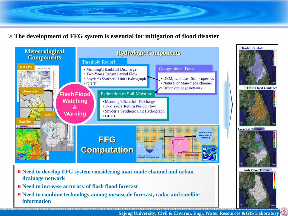
Sejong University, Civil & Environ. Eng., Water Resources &GIS Laboratory
Radar Rainfall
Need to develop FFG system considering man-made channel and urban drainage network Need to increase accuracy of flash flood forecast Need to combine technology among mesoscale forecast, radar and satellite information
Flash Flood Guidance
Forecast Rainfall
Flash Flood Threat
RDAPS
Satellite
Radar
MeteorologicalComponents
Observation
Hydrologic Components
• Manning’s Bankfull Discharge• Two Years Return Period Flow • Snyder’s Synthetic Unit Hydrograph• GIUH
• Manning’s Bankfull Discharge• Two Years Return Period Flow • Snyder’s Synthetic Unit Hydrograph• GIUH
Estimation of Soil Moisture
• DEM, Landuse, Soilproperties• Natural or Man-made channel• Urban drainage network
Geographical DataThreshold Runoff
THRESHOLD RUNOFF: Runoff neededto raise water level to bankfull stage
Current Water Level
Bankfull Stage
THRESHOLD RUNOFF: Runoff neededto raise water level to bankfull stage
Current Water Level
Bankfull Stage
Rainfall( mm/∆t )
Current Time
Runoff( mm/∆t )
t
Rainfall-RunoffRelationship
RainfallFFG
Run
off
Rainfall-RunoffRelationship
RainfallFFG
Run
off
Compare between FFGand forecasted rainfall
Rainfall Forecast
Flash FloodWatching &
Warning
Compare between FFGand forecasted rainfall
Rainfall ForecastRainfall Forecast
Flash FloodWatching &
WarningFFG Computation
Flash FloodWatching
& Warning
The development of FFG system is essential for mitigation of flood disaster

Sejong University, Civil & Environ. Eng., Water Resources &GIS Laboratory
Drought management and problems in Korea
KMA (Korea Meteorological Administration)
K-Water(Korea Water Resources Corporation)
KRC (Korea Rural Community Corporation)
NEMA (National Emergency Management Agency)
Drought Mornitoring & Management
Information : precipitation, temperature, long-term weather forecast, DDI, SPI, PDSI, PN, Decile
Compute various meteorological drought indices considering precipitation &temperature conditions
Information : MSWSI, Dam Storage Rate, Soil Moisture Index
Develop drought information system with hydrological drought indices (2006yr)
Information : Reservoir Drought Index, Integrated Agricultural Drought Index, Soil Moisture Index
Information : Socioeconomic Drought Index
Provide agriculture drought information on web site
Develop drought disaster info. system and contribute to reduce the drought damages
Insufficient understanding of each agency’s drought tasks
Inconsistent drought information between agencies
Drought monitoring is active, but drought outlook technology is primitiveProb
lem
s

Sejong University, Civil & Environ. Eng., Water Resources &GIS Laboratory
Considerations for real-time drought early warning system development
Construct DB for hydro-meteorological and geographical dataDevelop computation sub-modules for providing drought informationDevelop web-based real-time drought outlook system
Hydrometeorology
Analysis
Drought
Characteristics
Analysis
Field Operation
Drought Mornitoring & Outlook
LongLong--term Weather term Weather ForecastForecast
증발산량
자연유량
토양수분
Development of Drought Monitoring and Outlook Development of Drought Monitoring and Outlook System on East Asia DomainSystem on East Asia Domain
Develop land surface model in East Asia domainSpatial interactions analysis for drought phenomena within the domainContinental-scale drought outlook information in the domain
Generate high quality long-term weather forecast Interactions between atmosphere and hydrology simulation
Sejong University, Civil & Environ. Eng., Water Resources &GIS Laboratory
System structure & main information
Generate drought monitoring & outlook information by combining meteorological & hydrologic data
System Login & Main Page
Need to increase ensemble members for long-term weather forecastDevelop a real-time drought outlook evaluation method Improve the accuracy of drought oulook
Drought conditions are provided before & after 3 months on everyday
Meteorological Data
ASOS, AWS, GTS, United Model
PRCP Max Temp Min Temp Windspeed
지형자료
DEM
LanduseSoil Properties
Land Surface Model Drought Index Model
Runoff
HydrologicalInformation
Soil Moisture
Evapotranspiration
동아시아 및 한반도입력자료로 전환
Geographical Data
Missing & Error Data Quality Control
Convert the Input Data for East Asia & Korea
HydrologicalDrought Information
SRI
MeteorologicalDrought Information
SSI
Natural Drought Index
DDI
SPI(6)
SPI(3)
PDSI

Sejong University, Civil & Environ. Eng., Water Resources &GIS Laboratory
Analysis & estimation of recent heavy rainfall characteristics
0 12 24 36 48 60 72 84 960
20
40
60
80
100
Rai
nfal
l(mm
)
0
160
320
480
640
800 Accum
ulatedR
ainfall(mm
)
RainfallAccumulated Rainfall
0 12 24 36 48 60 72 84 96Time (hr)
0
20
40
60
80
100
Rai
nfal
l(mm
)
0
160
320
480
640
800 Accum
ulated Rainfall(m
m)
RainfallAccumulated Rainfall
0 12 24 36 48 60 72 84 96Time (hr)
0
20
40
60
80
100
Rai
nfal
l(mm
)
0
100
200
300
400
500 Accum
ulatedR
ainfall(mm
)
RainfallAccumulated Rainfall
0 12 24 36 48 60 72 84 96Time (hr)
0
20
40
60
80
100
Rai
nfal
l(mm
)
0
100
200
300
400
500 Accum
ulated Rainfall(m
m)
RainfallAccumulated Rainfall
Seoul : 286mm
Kangseo : 315mm
Seoul : 578mm
Kwanak : 493mm
2010 & 2011year heavy rainfall status
YearYear Rainy daysRainy days(Rate, %)(Rate, %)
Rainfall amountRainfall amount(mm)(mm)
2001 33 days ( - ) 981.1 mm
2010 56 day (69.70) 1394.6 mm
2011 47 day(42.42) 1640.1 mm
YearYear 33--hr max rainfall hr max rainfall regionregion
33--hr min rainfall hr min rainfall regionregion
2001 213.0 mm 155.0 mm
2010 198.5 mm 78.0 mm
2011 202.0 mm 100.0 mm
!(
!(
!(
!(
!(
!(
!(
서울
강북
강동
서초
관악
구로
은평
0
1000
2000
0
1000
2000
0
1000
2000
0
1000
2000
0
1000
2000
0
1000
2000
0
1000
2000
Amount of Rainfall for Flood Season
2001yr2010yr2011yr
Current Abnormal Weather & Climate ChangeCurrent Abnormal Weather & Climate ChangeCurrent Abnormal Weather & Climate Change
Increase of rainy days Increase of rainfall amount
Increased 3-hr rainfallRemarks
higher spatial rainfall difference among regions

Sejong University, Civil & Environ. Eng., Water Resources &GIS Laboratory
Downscaling Method (RegCM3, Sub-bats)
Climate Projection (ECHO-G/S)
Bias Correction
Frequency analysis
Estimation of Design Rainfall
Selection of emission scenarios (A2) D(duration, min)D(duration, min)Return Return Period(yr)Period(yr) 6060 180180 240240 360360 720720 14401440
10 76.5 142.5 157.5 182.6 223 282.7
30 93.5 176.7 195.6 225.4 273.9 354.5
50 101.2 192.3 212.9 245.0 297.2 387.3
80 108.3 206.6 228.8 262.9 318.5 417.3
100 111.7 213.3 236.3 271.3 328.6 431.5
S0S0
200 122.1 234.3 259.7 297.6 359.8 475.5
10 95.9 179.9 183.4 195.7 251.7 407.6
30 121.7 232.7 230.9 242.5 314.2 539.1
50 133.5 147.8 252.4 263.9 342.8 599.5
80 144.2 271.3 272.2 283.5 369.0 654.7
100 149.4 280.8 283.3 292.7 381.4 681.0
S1S1
200 165.3 310.5 310.8 321.4 419.7 762.3
-2 -1 0 1 2 3 4 5 6Reduced Variate
0
100
200
300
400
500
Rai
ndep
th(m
m)
3H Rainfall Freq. AnalysisS0:1971-2000S1:2011-2040S2:2041-2070S3:2071-2100
S0 S1• In 60min design rainfall, 30-year return period of S0
is similar to 10-year return period design rainfall of S1 period.•In 240, 360min design rainfall, 100-year return period of S0 is similar to 50-year return period design rainfall of S1 period.
Climate Change Impact Assessment on Water ExtremesClimate Change Impact Assessment on Water Extremes
Future design rainfall analysis using high resolution climate change scenariosMethodology
Produce 5x5 km climate scenario using RegCM3 and Sub-bats algorismPerform future design rainfall analysis after bias correction of climate scenario

Sejong University, Civil & Environ. Eng., Water Resources &GIS Laboratory
Develop our own urban flood design method through domestic and
international case studies
Re-evaluate urban design rainfall & discharge computation
Perform the flood risk assessment & optimal allocation for design flood
Develop a flash flood forecasting technology in Seoul
Mannual for urban drainage system management considering climateMannual for urban drainage system management considering climate changechange
Operation of the Urban Experimental Basin
< Urban Experimental Basin : Junrang river>
The main measure for flood prevention in Seoul

Sejong University, Civil & Environ. Eng., Water Resources &GIS Laboratory
Future Works & Collaborations on Water Extreme
Future Works & Collaborations on Water Future Works & Collaborations on Water ExtremeExtreme
Activities & Experiences
Storm
Needs Requirements
WaterExtreme
FloodFlood
DroughtDrought
ClimateClimateChangeChange
Share the predicted storm path information
Share the design method of flood control structures
Share the long-term weather data & drought index
Share drought outlook in East Asia
Share the AR5 high resolution climate change scenarios & hydrologic results Promote joint project on climate change adaptation strategies
Future Works & Collaborations
Share the technology of radar rainfall estimation

Sejong University, Civil & Environ. Eng., Water Resources &GIS Laboratory
모전교 오간수교 무학교고산자교
계획홍수위(2.57m)
위험홍수위(2.11m)
허리 높이(1.86m)
경계홍수위(1.78m)
무릎 높이(1.36m)
산책로(0.86m)
Flood control & management
Nonstructural MeasuresNonstructural MeasuresShare the predicted storm
path information
Development of urban flash flood Guidance (FFG)
Structural MeasuresStructural Measures
Share the technology of radar rainfall estimation
Share the design technologies of flood control structures
CountryCountry PurposesPurposes SpecificationsSpecifications
Wadayayoi,Japan
(Main) D8.5mX2.2km(Branch) D3.0mX4.7km
Seoul, Korea
Improve water qualityMitigate flood risk (Main) D 3.5m X 2.0km
Before After

Sejong University, Civil & Environ. Eng., Water Resources &GIS Laboratory
Drought control & management
DEM
Landuse
Soil
InternetNetwork
IntranetDatabase WebModel Process
External Network
Server
SPI
SRI
SSI
PDSI
1 2 3 4 5 6 7 8 9 10 11 12 1 2 3 4 5 6 7 8 9 10 11 12Time(Month)
0
30
60
90
120
150
180
PN(%
)
KyungGiKangwonChungCheongCheonNamKyungSang
1 2 3 4 5 6 7 8 9 10 11 12 1 2 3 4 5 6 7 8 9 10 11 12Time(Month)
0
30
60
90
120
150
180
PN(%
)
KyungGiKangwonChungCheongCheonNamKyungSang
1 2 3 4 5 6 7 8 9 10 11 12 1 2 3 4 5 6 7 8 9 10 11 12Time(Month)
0
30
60
90
120
150
180
PN(%
)
KyungGiKangwonChungCheongCheonNamKyungSang
1 2 3 4 5 6 7 8 9 10 11 12 1 2 3 4 5 6 7 8 9 10 11 12Time(Month)
0
30
60
90
120
150
180
PN(%
)
KyungGiKangwonChungCheongCheonNamKyungSang
Report
CRED
AWCI
LSM1
LSM2
LSM3
LSMn
t
t
t
t
Korea
China
Japan
GCM1
GCM2
GCM3
GCM13
RCM
Sharing the Observation Data
Domain for Drought Estimation
Need to develop a technology for hydro-meteorological & drought outlook in East Asia domain through collaboration of 3 countries
Drought occurs progressively, but damage scale is extensive in comparison with flood

Sejong University, Civil & Environ. Eng., Water Resources &GIS Laboratory
Future works on Climate Change
Sharing the high resolution climate change scenarios and their hydorologic results
Performing joint projects on climate change impact assessment and adaptation strategies in tri-countries
Sharing the ideas for design rainfall and their hydrologic analysis
To develop the adaptation technique for water resource fields

Sejong University, Civil & Environ. Eng., Water Resources &GIS Laboratory
Thank youThank you