adaptive multi-agent path planning for distributed uav...
TRANSCRIPT

Adaptive Multi-Agent Path Planning forDistributed UAV Systems
CS 229 Autumn 2017 Final ProjectCategory: Theory & Reinforcement Learning
Lloyd Mazalmaza
Cameron McMillancmac12
Introduction
In recent years, unmanned aerial vehicles (UAVs) have become increasingly prevalent in themodern world. These systems are used for a wide variety of applications, from recreationand entertainment to warfare and espionage. UAVs are favored for their low cost andlow risk, not to mention their ability to execute tasks in environments which might beinaccessible or dangerous to humans.In tactical scenarios, there is an increased demand for the use of cooperative, distributedsystems of UAVs which enable more complex and larger objectives. Oftentimes, thesesystems require the use of centralized, human-in-the-loop control approaches to accomplishtheir goals which may be slow, inaccurate, and computationally intensive. As a result,autonomy and decentralization are desirable traits for any such system of UAVs.This project makes use of a modified Q-Learning technique to allow UAVs to learn inreal time to navigate a contested environment that is initially unknown. Missions containdifferent surveillance target layouts and the UAVs learn from their observations. TheUAVs’ path planning is rewarded for balancing danger against path length. The UAVswork cooperatively to explore the unknown environment by sharing information about therisk environment seen by each agent in the system.The simulation environment for this project is built in MATLAB. In this environment,risks and targets can be programmatically generated. This simulation is able to replicateentire missions, including all the relevant risk, observation, and performance informationof the UAVs, threats, and targets.
Related Work
The field of robotic path planning contains many approaches, that do not fully solvethe problem of online learning in a multi-agent dynamic environment. The first set ofapproaches that struggle with this scenario is traditional Q-learning. The work done byWatkins and Dayan works well for single UAV systems, but in a multi-agent scenario, thisfails[1]. Because Q-learning requires many simulations to estimate the reward function,this problem becomes exceedingly complex with multiple-agents.More recent work, such as by Das, et al., doesn’t solve this problem either[2]. Manyalgorithms, such as those by Luna and Bekris, fail as well because they require centralizedplanning[3]. This approach is inappropriate for this use case because centralized control isunrealistic in many complex UAV missions. Planning using genetic algorithms, such as byNikolos, Zografos, and Brintaki[4], perform well in static environments, but are difficult to
1

extend for dynamic environments. Finally, deep Q-learning methods work well for largestate spaces, but require millions of training samples, as shown by Mnih, et all[5]. Thislarge simulation requirements excludes this possibility from being used in online learning.Even extended methods, as presented by He, et all[6], require significant training outsidethe possibility of an onboard UAV computer.
Simulation environment
In the scenarios where the UAVs operate, there are three sets of actors: threats, targets,and UAVs. Each plays a role in how the scenario unfolds. These scenarios are run ona discretized 2D grid representing the state space of the UAVs. All system agents areassumed to lay in this grid.Threats are static dangers that can represent terrain or anti-UAV systems. All threats areinitially unknown to the UAVs and must be discovered by a UAV before they are consideredby the path planning algorithm. Before a threat is uncovered, the UAV assumes there isno danger in that region. A threat is found by a UAV when the center of the threat fallsinside the observation radius of a UAV. Once discovered by one UAV, the information isshared to all others. In these scenarios, threats are modeled as 2D Gaussian distributions.The mean (location) and covariance (area of effect) may vary between threats.Targets are the second category of objects in a scenario. They can represent intelligencetargets or aerial imagery assigned points. The positions of all targets are known to allUAVs from the start of a scnario. The UAVs can communicate and work together to assigna target to a UAV.UAVs are the agents in each scenario. They are tasked with moving to as many targetlocations as they can before they run out of fuel. Each UAV has an observation radiuswithin which it can discover threats. A scenario is finished when the UAVs visit all targetsor all run out of fuel. A UAV must pass directly over the target point for the target tomarked as visited.
Methods
The principal reinforcement learning technique used in this project was the Cooperativeand Geometric Learning Algorithm (CGLA). This algorithm was proposed by a group ofresearchers primarily based out of Beihang University in China in 2013 [7]. It is an onlinelearning approach which was specifically designed for helping multi-agent UAV systemsnavigate through uncertain environments, so it is unsurprising that it was deemed a usefulstarting point for this project.The algorithm effectively generates a cost matrix, G, for each state in the map, then eachUAV runs through the lowest-cost path toward its target. CGLA is model-free, meaningthe UAVs do not require a prior estimate of the distribution of threats on the map, and anefficient path can always be found to a target based on what is known. In addition, thecost matrix can be iteratively updated as new threats are encountered, and will continueto encode a memory of all obstacles encountered during the scenario.The precursor to the cost matrix is a so-called "weight matrix," A, which for a square mapof dimension n is an n2×n2 matrix defining the Euclidean distance and integral risk from astate i to every other state j, as seen in Equation 1. Note that the function F (x, y) simplyrepresents the combined PDFs of each known risk distribution evaluated at a point x, y.Initially when no threats are known to any of the UAVs, the risk of traveling between anytwo states is zero. Gradually as more threats are encountered, the risk becomes a muchmore significant factor in the weight matrix. Additionally, the parameter K represents therelative weighting of risk and distance in the A matrix such that for larger values of K,
2

the path planning algorithm will favor less risky paths.
Ai, j = di, j +K
∫ j
iF (x, y)d (1)
After computing all values of the weight matrix, the cost matrix is found using the approachoutlined in Algorithm 1. Finally, each UAV is set on a path toward its target which resultsin the minimum total cost. In the event that any UAV encounters a previously unseenthreat within its observation radius, the cost matrix A is recomputed to account for thenew source of risk, and the entire procedure is repeated. A scenario is considered completeonce all target points have been visited.
Algorithm 1 Cooperative and Geometric Learning AlgorithmInput: Weight matrix of the known map A1: Initialize G0
t = 0 for the target state t of the given UAV2: Initialize G0
i =∞ for all other states i ∈(1, n2
)\ {t} on the map
3: repeat4: for Each state i, j ∈
(1, n2
)do
5: Gk+1i = min
{Gk
i , Ai,j +Gkj
}6: end for7: until Gk+1 = Gk
Output: Gk
It should be noted that this algorithm extends very naturally to a scenario with multipleUAVs and multiple threats. Since the weight matrix A encodes the risk of traveling betweenany two states, its values are fixed for a given map of known threats. When new threatsare discovered by any UAV, this information is shared among all UAVs by updating theunderlying shared A matrix. Each UAV then has its own cost matrix G, with the soledistinction between them being the target state associated with that UAV.
Experiments and Results
Various scenarios were run to verify the performance of the algorithm under different testconditions. These scenarios were comprised of different threat distributions, numbers ofUAVs, and numbers of targets. In every case the map was discretized into a 20× 20 grid,since it was determined that this level of detail offered a fair compromise between mapfineness and computational complexity.Before running any particular simulation, however, it was useful to run a few experimentsto gain a sense of how the algorithm’s tuning parameters affected performance. The twoparameters of interest were identified as the factor K (the relative weighting between pathdistance and risk) and the observation radius of the UAVs. To this end, a representativescenario with a single UAV and single target was run subject to variable values of K andobservation radius, with the path planning outcomes summarized in Tables 1 and 2 below.Note that while the path distance and danger are not assigned units, this is unimportantsince the relative values of each are the only relevant takeaway.Based on the results below, K was set generally between a value of 1000 and 2000. Noticethat above this point, the path planning algorithm becomes focused on risk avoidance tothe point that it takes overly-circuitous routes and winds up accumulating more risk on itslong path. A similar survey of the effect of varying the UAV observation radius is shownin Table 2. Notice the large drop-off in danger between a radius of sizes 2 and 3; basedupon this, the radius of 3 was selected for all simulations to balance between generating
3

Table 1: Relative path distance and dan-ger for various levels of K
K Distance Danger10 23.56 0.2148100 26.38 0.06691000 26.97 0.05925000 59.94 0.0684
Table 2: Relative path distance and dan-ger for various observation radii
Radius Distance Danger1 20.38 0.56422 26.38 0.26783 27.80 0.05824 26.97 0.0131
safe paths and not overexposing the UAV to the entire map.Upon tuning these two parameters, the key features of the algorithm were tested in relevantscenarios. The first and most important of these was the ability to learn to navigate safelyto the target in an initially unknown environment. As seen in the bottom right of Figure 1,a map was set up with threats distributed such that the UAV (in red) had to find a smallgap which would allow it to travel safely to the target (in blue). Initially, the UAV definesa naive path diagonally across the map as seen in the top-left plot. After progressing alongthis path, it encountered a threat which completely obstructed its path, and thus generateda new path that routed around the threat. This process repeated two more times until theUAV was able to pass through the gap and safely reach the target.
Figure 1: Progression of a single UAV learning an unknown environment (starting fromtop-left) compared with the true threat distribution (bottom-right)
In a similar vein, it was important to assess the cooperative nature of CGLA by compar-ing the performance of single- and multi-UAV teams acting on the same map. A scenariowas set up with threats on opposite sides of the map such that a single UAV could not beinitialized with full knowledge of the threat environment (see Figure 2). In one case, a loneUAV was placed on the map and initialized with knowledge of only one threat (note the
4
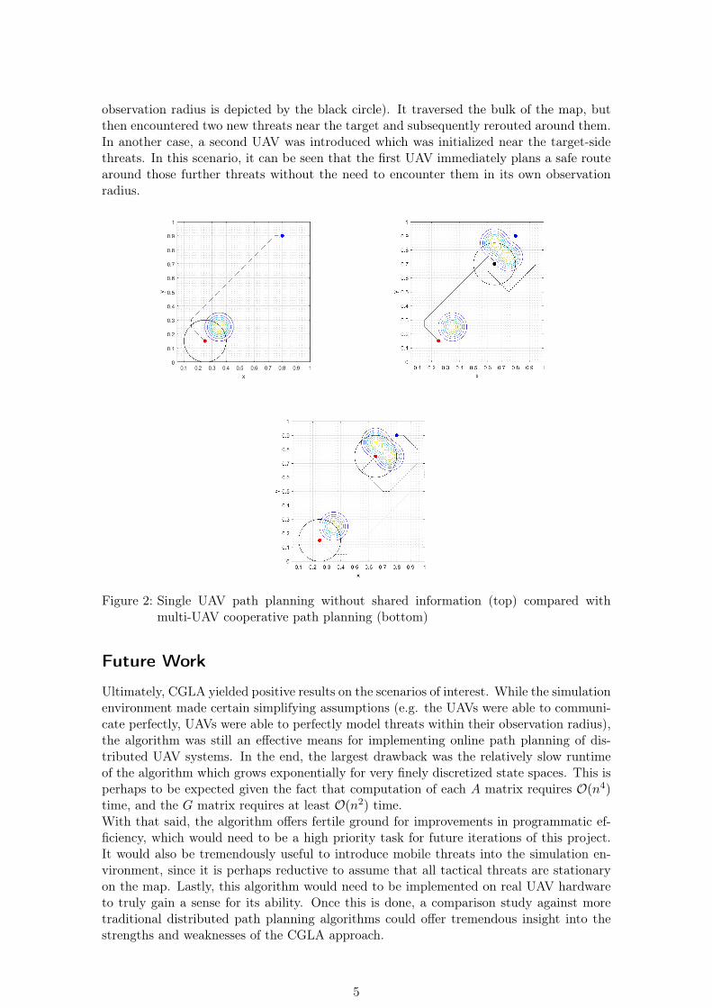
observation radius is depicted by the black circle). It traversed the bulk of the map, butthen encountered two new threats near the target and subsequently rerouted around them.In another case, a second UAV was introduced which was initialized near the target-sidethreats. In this scenario, it can be seen that the first UAV immediately plans a safe routearound those further threats without the need to encounter them in its own observationradius.
Figure 2: Single UAV path planning without shared information (top) compared withmulti-UAV cooperative path planning (bottom)
Future Work
Ultimately, CGLA yielded positive results on the scenarios of interest. While the simulationenvironment made certain simplifying assumptions (e.g. the UAVs were able to communi-cate perfectly, UAVs were able to perfectly model threats within their observation radius),the algorithm was still an effective means for implementing online path planning of dis-tributed UAV systems. In the end, the largest drawback was the relatively slow runtimeof the algorithm which grows exponentially for very finely discretized state spaces. This isperhaps to be expected given the fact that computation of each A matrix requires O(n4)time, and the G matrix requires at least O(n2) time.With that said, the algorithm offers fertile ground for improvements in programmatic ef-ficiency, which would need to be a high priority task for future iterations of this project.It would also be tremendously useful to introduce mobile threats into the simulation en-vironment, since it is perhaps reductive to assume that all tactical threats are stationaryon the map. Lastly, this algorithm would need to be implemented on real UAV hardwareto truly gain a sense for its ability. Once this is done, a comparison study against moretraditional distributed path planning algorithms could offer tremendous insight into thestrengths and weaknesses of the CGLA approach.
5

Contributions
The work on this project has been an even split. Both team members spent equal amountsof time working on literature review, implementation of CGLA, feature development, andassembly of deliverables.
References
[1] Watkins, Christopher JCH, and Peter Dayan. "Q-learning." Machine learning 8.3-4(1992): 279-292.
[2] Das, Pradipta K., et al. "An improved Q-learning algorithm for path-planning of amobile robot." International Journal of Computer Applications 51.9 (2012).
[3] Luna, Ryan, and Kostas E. Bekris. "Efficient and complete centralized multi-robotpath planning." Intelligent Robots and Systems (IROS), 2011 IEEE/RSJ InternationalConference on. IEEE, 2011.
[4] Nikolos, Ioannis, Eleftherios Zografos, and Athina Brintaki. "UAV path planning usingevolutionary algorithms." Innovations in Intelligent Machines-1 (2007): 77-111.
[5] Mnih, Volodymyr, et al. "Playing atari with deep reinforcement learning." arXivpreprint arXiv:1312.5602 (2013).
[6] He, Frank S., et al. "Learning to play in a day: Faster deep reinforcement learning byoptimality tightening." arXiv preprint arXiv:1611.01606 (2016).
[7] Zhang, B., Mao, Z., Liu, W., et. al. "Geometric Reinforcement Learning for PathPlanning of UAVs," Journal of Intelligent and Robotic Systems, Volume 77, No. 2,2015, pp 391–409.
[8] Zhang, B., Mao, Z., Liu, W., et. al. "Cooperative and Geometric Learning Algorithm(CGLA) for path planning of UAVs with limited information," Automatica, Volume50, No. 3, 2014, pp 809-820.
6