aeronautics and space report of the president - nasa · 4 aeronautics and space report of the...
TRANSCRIPT

Aeronautics and Space Reportof the President
Fiscal Year2015 Activities

Fiscal Year 2015 Activities
Aeronautics and Space Report of the President

Ae
ro
na
ut
ic
s
an
d
Sp
ac
e
Re
po
rt
o
f
th
e
Pr
es
id
en
t The National Aeronautics and Space Act of 1958 directed
the annual Aeronautics and Space Report to include a
“comprehensive description of the programmed activities and
the accomplishments of all agencies of the United States in the
field of aeronautics and space activities during the preceding
calendar year.” In recent years, the reports have been prepared
on a fiscal-year basis, consistent with the budgetary period now
used in programs of the Federal Government. This year’s report
covers activities that took place from October 1, 2014, through
September 30, 2015. Please note that these activities reflect
the Federal policies of that time and do not include subsequent
events or changes in policy.
On the title page, clockwise from the top left: 1. Pluto is seen from the Long Range Reconnaissance Imager (LORRI) aboard NASA’s New Horizons spacecraft, taken on July 13, 2015, when the spacecraft was 476,000 miles (768,000 kilometers) from the surface. Credits: NASA/Applied Physics Laboratory (APL)/Southwest Research Institute (SwRI). 2. A DHC-3 Otter is flown in NASA’s Operation IceBridge-Alaska survey of mountain glaciers in Alaska. Credit: NASA/Chris Larsen, University of Alaska-Fairbanks. 3. This image shows an artist’s concept of NASA’s Soil Moisture Active Passive (SMAP) mission. Credit: NASA/Jet Propulsion Laboratory (JPL)–California Institute of Technology. 4. Engineers at Orbital ATK prepare to test the largest, most powerful booster ever built for NASA’s new rocket, the Space Launch System (SLS). Credit: Orbital ATK. 5. NASA astronaut Scott Kelly works outside the International Space Station (ISS) on the 190th spacewalk in support of ISS assem-bly and maintenance. Credit: NASA. 6. This schlieren image of shock waves created by a T-38C in supersonic flight was captured using the sun’s edge as a light source and then processed using NASA-developed code. Credit: NASA.

Fi
sc
al
Y
ea
r
20
15
A
ct
iv
it
ie
s
Table of ConTenTs
National Aeronautics and Space Administration 1
Human Exploration and Operations Mission Directorate 1
Science Mission Directorate 19
Aeronautics Research Mission Directorate 43
Space Technology Mission Directorate 52
Department of Defense 61
Federal Aviation Administration 77
Department of Commerce 85
Department of the Interior 99
Federal Communications Commission 117
U S Department of Agriculture 121
National Science Foundation 131
Department of State 141
Department of Energy 147
Smithsonian Institution 155
Appendices
A-1 U S Government Spacecraft Record 162
A-2 World Record of Space Launches Successful in Attaining Earth Orbit or Beyond 163
B Successful Launches to Orbit on U S Vehicles 164
C Human Spaceflights 166
D-1A Space Activities of the U S Government—Historical Table of Budget Authority in Millions of Real-Year Dollars 167
D-1B Space Activities of the U S Government—Historical Table of Budget Authority in Millions of Inflation-Adjusted FY 2015 Dollars 168
D-2 Federal Space Activities Budget 169
D-3 Federal Aeronautics Activities Budget 170
Acronyms 171

iv
Ae
ro
na
ut
ic
s
an
d
Sp
ac
e
Re
po
rt
o
f
th
e
Pr
es
id
en
t
This page is intentionally left blank.

1
Fi
sc
al
Y
ea
r
20
15
A
ct
iv
it
ie
s
naTional aeronauTiCs and spaCe adminisTraTion
NASA
Human Exploration and Operations Mission Directorate
International Space Station
The International Space Station (ISS) continued its focus on research and tech-
nology development in such disciplines as biology, human research, biotechnology,
Earth science, physical science, astrophysics, and satellite servicing during FY 2015.
Also during FY 2015, Space Exploration Technologies Corporation (SpaceX) com-
pleted two commercial cargo missions and Japan’s H-II Transfer Vehicle (HTV)
completed one cargo mission. NASA continued modifications to docking ports
that will allow the ISS to accommodate two docking ports for visiting vehicles,
enabling traffic flexibility and port redundancy for U.S. operating segment crew
and cargo vehicle missions.
FY 2015 presented one of the ISS Program’s toughest logistical challenges. Over
the course of eight months, the ISS Program lost three cargo resupply vehicles
in launch mishaps: Orbital-ATK’s Orbital 3 failed immediately after launch on
October 28, 2014; Russia’s Progress 59P, just before reaching orbit on April 28, 2015;
and SpaceX-7, a few minutes into flight on June 28, 2015. The ISS Program man-
aged to mitigate the impacts; consumables remained in good shape and research
was stockpiled on board, waiting to be executed. The ISS Program successfully
planned for contingencies, evidenced by the fact that after losing three cargo
resupply flights in about eight months, the Station supported six crewmembers

2
Ae
ro
na
ut
ic
s
an
d
Sp
ac
e
Re
po
rt
o
f
th
e
Pr
es
id
en
t
and continued a full research utilization program. The Russian Progress returned
to flight in June 2015; Orbital ATK planned to return to flight in December 2015;
and SpaceX plans to return to flight in early 2016.
During 2015, NASA continued planning the ISS’s extension to at least 2024 to
align with the Obama administration’s announced intent. The extension allows
NASA a decade to help transition low-Earth orbit from exclusive to accessible;
offers scientists and engineers the time they need to assure the future of explora-
tion, scientific discoveries, and economic development; and presents important new
opportunities to develop the tools needed for future missions to deep space, such
as testing essential technologies and hardware related to long-duration journeys.
Expedition 42 crewmembers NASA astronaut Terry Virts, Roscosmos cosmo-
naut Anton Shkaplerov, and European Space Agency (ESA) astronaut Samantha
Cristoforetti joined the Expedition 41 crew on the ISS on November 23, 2014.
Crewmembers performed three extravehicular activities (EVAs) to prepare for the
arrival and installation of the International Docking Adapters, which will provide
additional docking capabilities for visiting vehicles. SpaceX-5 launched on January
10, 2015, delivering 3,700 pounds of pressurized and unpressurized cargo, includ-
ing research experiments, food, crew provisions, and exercise equipment, plus the
Cloud-Aerosol Transport System (CATS) to measure and characterize cloud and
aerosol effects to improve climate models.
On March 27, 2015, Expedition 43 crewmembers NASA astronaut Scott Kelly,
and Russian cosmonauts Mikhail Kornienko and Gennady Padalka joined the
Expedition 42 crew on the ISS. NASA began a one-year, U.S.-Russian joint human
health and performance research project with Scott Kelly and Mikhail Kornienko,
who will stay aboard the Station for one year. While Kelly lives on board the
Station, his identical twin brother, retired NASA astronaut Mark Kelly, is par-
ticipating in the study on Earth, allowing NASA to better isolate the deleterious
effects of spaceflight on the human body and aid in the development of counter-
measures for these effects. This research should be invaluable to the preparation for
future missions to study the effects of long-duration space missions on the human
body. SpaceX-6 launched on April 14, 2015, delivering 4,200 pounds of research
experiments, food, crew provisions, and exercise equipment. The cargo included
20 mice for the second Rodent Research investigation to continue the study of

3
Fi
sc
al
Y
ea
r
20
15
A
ct
iv
it
ie
s
accelerated bone and muscle loss in space, which could lead to new treatments for
osteoporosis and muscle wasting on Earth, as well as the Robotic Refueling Mission
Phase 2 (RRM-P2) equipment to continue the robotic servicing investigation for
satellite servicing.
The loss of Russia’s Progress 59P on April 28, 2015, delayed the return of the
Expedition 42 crew to Earth for four weeks and the launch of the Expedition 43
crew for eight weeks. The Expedition 42 crew returned to Earth on June 11, 2015,
after spending six months on orbit. On June 28, 2015, the SpaceX-7 cargo resup-
ply vehicle failed a few minutes into flight, resulting in the loss of all cargo on
board. The Russian Progress returned to flight on July 3, 2015, after a thorough
investigation, carrying 1,900 pounds of propellant, oxygen, water, food, and experi-
ment hardware. With this delivery, the ISS had sufficient supplies to last until
October 2015.
The Expedition 44 crewmembers—NASA astronaut Kjell Lindgren, Russian
cosmonaut Oleg Kononenko, and JAXA astronaut Kimiya Yui—joined the
Expedition 43 crew on the ISS on July 22, 2015. The arrival of the three crewmem-
bers returned the Station’s crew complement to six. Russian crewmembers con-
ducted a six-hour spacewalk on August 10, 2015, to install new equipment on the
Russian segment and conduct a detailed photographic inspection of the exterior
of the Station. On August 19, 2015, Japan’s HTV-5 launched with 10,000 pounds
of cargo and science materials, including critical spares lost on SpaceX-7, as well
as the CALorimetric Electron Telescope (CALET), designed to search for dark
matter, measure cosmic rays, and observe sources of high-energy phenomena in the
galaxy. These crewmembers became the first to harvest and eat crops grown aboard
the Station in the Veggie hardware, another necessary advance for astronauts trav-
eling on deep space missions.
Finally, Expedition 45 crewmembers Russian cosmonaut Sergey Volkov, ESA
astronaut Andreas Mogensen, and Kazakh cosmonaut Aidyn Aimbetov launched
on September 2, 2015, joining Expedition 43 and 44 crew to support ten days of
nine crew operations for the first time since 2013. On September 15, 2015, Kelly
and Kornienko reached the halfway point of their one-year mission to advance
understanding of the medical and psychological challenges astronauts face during
long-duration spaceflight.

4
Ae
ro
na
ut
ic
s
an
d
Sp
ac
e
Re
po
rt
o
f
th
e
Pr
es
id
en
t
Launch Services
During FY 2015, the Launch Services Program (LSP) successfully launched
two major science missions: the Soil Moisture Active Passive (SMAP) and the
Magnetospheric Multiscale (MMS). SMAP launched on January 31, 2015, aboard a
Delta II rocket from Vandenberg Air Force Base in California. MMS launched on
March 12, 2015, aboard an Atlas V rocket from Cape Canaveral Air Force Station
in Florida. The LSP also continued to provide launch-related systems engineering,
launch integration, and mission design and analysis support to over 40 NASA-
sponsored missions in various phases of development. To learn more about these
and other NASA science missions, see the Science Mission Directorate (SMD)
section in this report.
The LSP continued its efforts to expand the selection of launch vehicles,
working across the launch-vehicle industry to support the continued growth of
the U.S. commercial space sector by providing competitive opportunities to U.S.
commercial launch providers. In FY 2015, the program acquired launch services
for three future science missions: the Ionospheric Connection Explorer (ICON),
the Transiting Exoplanet Survey Satellite (TESS), and the Solar Probe Plus (SPP).
ICON will launch on Orbital ATK’s Pegasus XL from Kwajalein Atoll in the
Marshall Islands, followed by TESS on a SpaceX Falcon 9 v1.1 and SPP on United
Launch Services’ Delta IV Heavy rocket launching from the Cape.
NASA and LSP also partnered with several universities to launch small
research satellites through the Educational Launch of Nanosatellites project and
the CubeSat Launch Initiative, which provides rideshare opportunities for small-
satellite payloads to fly on upcoming launches when space is available. These
partnerships provide educational opportunities for students in science, technol-
ogy, engineering, and mathematics disciplines, thereby strengthening the Nation’s
future workforce. In addition, as CubeSats continue to play an increasingly larger
role at NASA, LSP began work to develop a new Venture Class Launch Service
(VCLS) in order to create an alternative to the current rideshare approach and
foster a commercial launch market dedicated solely to flying small-satellite pay-
loads. On September 30, 2015, NASA awarded three VCLS contracts to Firefly
Space Systems, Inc.; Rocket Lab USA; and Virgin Galactic LLC, with the first

5
Fi
sc
al
Y
ea
r
20
15
A
ct
iv
it
ie
s
demonstration launch scheduled for summer 2017. To date, CubeSats have been
selected from 29 states across the United States, with 43 launched and 14 mani-
fested on NASA, National Reconnaissance Office, U.S. Air Force, and commercial
missions. The LSP also completed the certification effort for SpaceX’s Falcon 9 v1.1
rocket in May 2015 and certified it as a medium-risk launch vehicle as defined in
NASA policy, with a single certification exception. SpaceX is working to correct
the issue that caused the exception, and LSP has put the appropriate steps in place
to mitigate the technical risk.
Space Communications and Navigation
In FY 2015, the Space Communications and Navigation (SCaN) Program Office
remained focused on the critical sustainability and development of the ground and
space components of the networks that provide space communications for NASA’s
missions. The three networks—the Near Earth Network (NEN), the Space
Network (SN) Tracking and Data Relay Satellite System (TDRSS), and the Deep
Space Network (DSN)—continued to meet the space communications needs, such
as Earth monitoring and support of deep space science missions, of a wide range
of customers, both internal and external to NASA. SCaN continued to surpass its
requirement of 95 percent proficiency in FY 2015, with at least 99 percent profi-
ciency in all of its networks, providing communication and navigation services to
all science and human missions.
SCaN completed some key milestones during FY 2015:
• SCaN successfully supported all pre-mission verification testing, the
launch, and the mission through splashdown of the Exploration Flight
Test–1 (EFT-1) Orion mission on December 5, 2014.
• SCaN successfully completed TDRS-12 Initial Operational Capability
(IOC) testing on January 25, 2015, and placed it into service as TDRS-
East on February 12, 2015.
• SCaN completed the SN Blossom Point Ground Station, which is provid-
ing operational support to customers.
• TDRS-M successfully completed all system and environmental testing
and has been placed in storage, pending launch in October 2017.

6
Ae
ro
na
ut
ic
s
an
d
Sp
ac
e
Re
po
rt
o
f
th
e
Pr
es
id
en
t
• The Space Network Ground Segment Sustainment (SGSS) Project suc-
cessfully completed project rebaseline by completing Critical Design
Review (CDR) closeout, termination review, and rebaseline review
(updated Key Decision Point–C [KDP-C]).
• The SGSS project completed Increment A4 development and integration,
including fleet management and additional signal-processing capabilities.
• The NEN project successfully completed Launch Communications
System (LCS) CDR. This accomplishment paved the way for the buildup
of the Kennedy Uplink Station (KUS) and Ponce De Leon (PDL) tracking
station required for Exploration Mission–1 (EM-1) for Orion and Space
Launch System (SLS) early ascent coverage.
• The DSN Aperture Enhancement Project successfully completed its
first new 34-meter deep space beam waveguide antenna in Canberra,
Australia. The new Deep Space Station–35 is now fully operational and
meets the requirements of NASA’s missions.
• The DSN complexes at Goldstone, Madrid, and Canberra provided flaw-
less mission support to the critical approach and flyby phases of New
Horizons Pluto flyby.
• SCaN replanned the Laser Communication Relay Demonstration (LCRD)
due to changes in the available funding in FY 2015 and FY 2016 with a
new launch date of June 2019 (a change of six months). The 1.25-gigabit-
per-second-data-rate ground modem successfully demonstrated interoper-
ability with the test bed at the Massachusetts Institute of Technology’s
(MIT) Lincoln Laboratory. The demonstration is a major first step toward
commercializing laser communications for near-Earth users and has seen
significant response from industry in an FY 2015 open call for Guest
Investigators during its full demonstration beginning in 2019.
• The SCaN Testbed (STB) continued operations externally on the ISS
and has logged over 2,500 hours of operations since its launch in 2012.
In FY 2015, the STB developed several important technologies advanc-
ing the future of SCaN networks and has partnered with ten commercial
companies, eight universities, and three other Government agencies. The
project demonstrated the capability of transmission at a data rate of nearly

7
Fi
sc
al
Y
ea
r
20
15
A
ct
iv
it
ie
s
1 gigabit per second over that of the Ka-band, winning a NASA Silver
Achievement Medal for the team’s efforts. Separate work on the Digital
Video Broadcast Second Generation transmission from space demon-
strated a better downlink to a ground station through improved quality in
video reception. Commercial standards derived from the SCaN-developed
technologies help future NASA networks be more interoperable, increase
network throughput, and enhance spectrum efficiency by allowing greater
amounts of data to be transmitted in a given bandwidth and adjusting
data rates according to radio-frequency link conditions.
• The Spectrum Management Program continued to work with the White
House, Congress, national regulators, and interagency partners in imple-
menting the President’s Broadband Initiative.
• The Consultative Committee for Space Data Systems (CCSDS) is a major
international organization comprising 11 international space agencies; it
develops internationally agreed-upon and interoperable space commu-
nications standards that enable joint international missions and reduce
cost and risk to space missions. In 2015, SCaN engineers led CCSDS
working groups in completing many new standards and took leader-
ship of the new working group chartered to develop new standards for
optical communications.
• SCaN continued in its role as the Executive Director of the National
Space-Based Positioning, Navigation, and Timing (PNT) Advisory Board,
an august body of PNT experts from within industry and the interna-
tional community.
Human Spaceflight Capabilities
By the end of FY 2015, the Rocket Propulsion Test (RPT) Program had safely
performed 453 tests. Test time totaled over 116,262 seconds, with more than
10,062 seconds of hot fire at various levels of thrust. During this period, the test
facilities had six facility-caused test delays resulting in a 98.7 percent facility readi-
ness, far exceeding the 90 percent RPT Annual Performance Indicator.

8
Ae
ro
na
ut
ic
s
an
d
Sp
ac
e
Re
po
rt
o
f
th
e
Pr
es
id
en
t
In FY 2015, Stennis Space Center (SSC) had several test programs under way,
including RS-25 in support of the SLS Program, as well as flight certification test-
ing for the Aerojet Rocketdyne RS-68 engine in support of the United States Air
Force (USAF) and United Launch Alliance (ULA). Development testing contin-
ued for NASA’s Morpheus lander, as well as subscale testing of the SpaceX Raptor
engine. Refurbishment and repair activities continued for critical enabling infra-
structure, including replacing both the B-leg and the A-leg of the high-pressure
industrial water system and restoring the B-2 test stand for SLS core stage testing.
In 2015, following the completion of the J-2X engine in FY 2014, SSC tran-
sitioned the SSC A-2 test stand to a mothball status. In January 2015, after the
completion of facility modifications and the design and manufacturing of the
necessary Special Test Equipment (STE), SSC completed the first test of the SLS
RS-25 engine on the SSC A-1 test stand. In addition to the testing in support of
the SLS Program, SSC began a test campaign supporting the development of a
self-pumping diffuser for the White Sands Test Facility (WSTF) Orion European
Service Module test campaign. Other activities at SSC included the buildup of
systems in the E-Complex required to support the joint Department of Defense
(DOD)–NASA hydrocarbon boost program and the Aerojet Rocketdyne Liquid
Oxygen (LOX) and Refined Petroleum (Rp) development program.
Marshall Space Flight Center (MSFC) continued testing engine components
manufactured using advanced technologies, including components built using
select laser melting. In addition to testing the components manufactured using
advanced technologies, MSFC tested articles using LOX, liquid methane (LCH4),
and new LOX Rp combustion techniques.
WSTF continued the buildup and preparation of Test Stand 301 to support 2016
testing of the Orion ESA Service Module (SM) and began construction activities
on Test Stand 301A to support the Boeing Company’s CST-100 crew abort system
and SM testing. In addition to the two SM programs, WSTF also provided test
support for Boeing, the Missile Defense Agency (MDA), the USAF Minuteman,
and the USAF Peacekeeper demilitarization.
Glenn Research Center’s (GRC) Plum Brook Station (PBS) collaborated with an
Agency high-altitude balloon program to perform a long-duration thermal vacuum
test on a payload package during a standard facility Integrated Systems Test (IST).

9
Fi
sc
al
Y
ea
r
20
15
A
ct
iv
it
ie
s
The test ran continuously for 1,770 minutes and accomplished all objectives. In
addition to the high-altitude balloon test, PBS began preparations for a 2016 IST
that will perform a hot fire test in a simulated space environment.
Commercial Crew Development
The Commercial Crew Program is facilitating the development of safe, reliable,
and cost-effective U.S. human space transportation to and from low-Earth orbit
and the ISS. NASA is using a unique approach for this program whereby private
industry is responsible for the development of the space transportation systems and
NASA is certifying them as safe to transport the Agency’s astronauts.
In September 2014, NASA announced contracts with Boeing and SpaceX to
continue development and certification efforts under the Commercial Crew
Transportation Capabilities (CCtCap) contracts, with a goal of ending the Nation’s
sole reliance on Russia for crew transportation to and from the ISS. One of the
competing corporations subsequently protested the award and, in January 2015,
the General Accounting Office rendered a decision in favor of NASA, allowing
NASA and the two CCtCap partners (Boeing and SpaceX) to proceed with work
in earnest.
During the fiscal year, both commercial partners continued making technical
and programmatic progress in maturing their respective commercial crew trans-
portation systems.
• Both partners completed their respective Certification Baseline Reviews,
the first major milestone under the CCtCap contracts.
• Throughout the year, both partners continued identifying and submitting
variances, alternate standards, and hazard reports necessary for NASA’s
crew transportation system certification efforts.
• Boeing began modifications to Cape Canaveral Air Force Station’s
Launch Pad 41 and performed several wind tunnel and landing tests.
• SpaceX completed a pad abort test and continued the company’s efforts to
modify Launch Pad 39A to enable crewed missions.
Through the Commercial Crew Program, NASA is ensuring that the
Agency’s commercial partners’ crew transportation systems are safe, reliable, and

10
Ae
ro
na
ut
ic
s
an
d
Sp
ac
e
Re
po
rt
o
f
th
e
Pr
es
id
en
t
cost-effective. The certification process assesses progress throughout the produc-
tion and testing of the partners’ systems, which include the launch vehicle, the
spacecraft, and ground operations.
Advanced Exploration Systems
The Advanced Exploration Systems (AES) Division is pioneering new ways to
rapidly develop prototype systems, demonstrate key capabilities, and validate opera-
tional concepts to reduce the risk and cost of future human exploration missions.
In FY 2015, the AES Division continued the successful execution of 26 research
and technology development activities employing 572 civil servants spread across
all NASA Centers. In FY 2015, AES had a goal to complete at least 80 percent of
the 72 annual milestones. The team accomplished 56 milestones (78 percent) on
schedule and within the available resources.
In November 2014, AES demonstrated the first 3D printer for in-space manufac-
turing of spare parts and tools on the ISS. The printer produced over 20 parts that
returned to Earth for post-flight testing. AES also conducted two public crowd-
sourcing challenges that involved over 600 students to design a handrail clamp and
a container that could be 3D-printed on the ISS.
In December 2014, the AES Radiation Sensors activity flew radiation envi-
ronment monitors on the EFT-1 mission. These sensors measured the radiation
environment inside the Orion crew capsule as it passed through the Van Allen
radiation belts. The Radiation Sensors project also completed the Preliminary
Design Review for the sensors that will be flown on EM-1.
AES’s Automated Systems and Operations activity demonstrated an advance
caution and warning system on EFT-1 to help mission controllers identify and
diagnose imminent failures in the Orion power system. The activity also developed
and tested software for autonomous monitoring and control of a Cascade Distiller
System for wastewater processing.
The Bigelow Expandable Activity Module (BEAM) flight hardware arrived
at Kennedy Space Center (KSC) in July 2015, after integration of the inflatable
module with the Passive Common Berthing Mechanism and the completion of
all structural testing and payload safety reviews. A public-private partnership with

11
Fi
sc
al
Y
ea
r
20
15
A
ct
iv
it
ie
s
Bigelow Aerospace developed BEAM, which is expected to launch to the ISS on
the SpaceX-8 mission in January 2016.
AES’s Spacecraft Fire Safety project completed the fabrication, assembly, and
environmental testing of three Saffire flight experiments that will study large-scale
fire propagation in microgravity. The first experiment (Saffire-I) is planned for
launch on the Cygnus vehicle in March 2016.
AES issued the Next Space Technology Exploration Partnerships (NextSTEP)
Broad Agency Announcement (BAA) in October 2014. This solicitation requested
proposals for public-private partnerships to develop habitation and life-support sys-
tems, advanced electric propulsion, and small satellites. The partnerships required
at least 50 percent cost sharing from industry or universities. AES selected 12 pro-
posals for award in April 2015. Bigelow Aerospace, Boeing, Lockheed Martin, and
Orbital ATK received contracts for conceptual studies of habitats beyond Earth
orbit. Dynetics, UTC Aerospace Systems, and Orbitec received contracts for life-
support-system components. Ad Astra, Aerojet Rocketdyne, and MSNW received
contracts to develop 100-kilowatt electric propulsion systems and to test them in
the laboratory for 100 continuous hours. Lockheed Martin and Morehead State
University received contracts to develop CubeSats for launch as secondary pay-
loads on EM-1.
Working with NASA’s Science Mission Directorate and Space Technology
Mission Directorate, AES developed systems requirements and preliminary design
concepts for three payloads on the Mars 2020 mission to address strategic knowl-
edge gaps for human exploration. The Mars Oxygen In Situ Resource Utilization
Experiment (MOXIE) will demonstrate the production of oxygen from the Martian
atmosphere to enable in situ propellant production for future human missions. The
Mars Environmental Dynamics Analyzer (MEDA) is a surface weather station that
will measure temperature, pressure, winds, and dust to characterize the environ-
mental conditions that may be encountered by human explorers. Both MOXIE and
MEDA completed their Instrument Accommodation Reviews to ensure their fit
on the Mars 2020 rover. In addition, AES committed to re-flying the Mars Entry,
Descent, and Landing Instrumentation (MEDLI) experiment to further charac-
terize the entry environment for future landings on Mars by robotic and human
missions. The MEDLI-2 project completed its Systems Requirements Review.

12
Ae
ro
na
ut
ic
s
an
d
Sp
ac
e
Re
po
rt
o
f
th
e
Pr
es
id
en
t
AES continued the development of three CubeSats that will be launched as sec-
ondary payloads on EM-1. The payloads include Biosentinel, which will investigate
the effects of deep space radiation on yeast DNA; the Lunar Flashlight, which will
search for volatiles in shadowed craters on the Moon; and the Near-Earth Asteroid
(NEA) Scout, which will use a solar sail to fly by an asteroid. BioSentinel com-
pleted its biosensor payload Preliminary Design Review, and the Lunar Flashlight
and NEA Scout completed their initial safety reviews and developed FlatSat test
beds for their spacecraft avionics.
AES’s Lunar Cargo Transportation and Landing by Soft Touchdown (Lunar
CATALYST) activity worked with three commercial partners to develop lunar
landers for delivering small payloads by providing engineering expertise, test
facilities, software, and loaned hardware to the partners. In 2015, Astrobotic
Technologies completed an end-to-end mission simulation, Moon Express com-
pleted a tethered flight of their test vehicle, and Masten Space Systems completed
a Preliminary Design Review of their lander’s propulsion system.
The AES Resource Prospector continued mission formulation activities this
year. AES conducted a field test of a prototype rover carrying a sampling drill and
several prospecting instruments in the rock yard at Johnson Space Center (JSC)
to simulate mission operations. AES initiated a study agreement with Taiwan to
develop design concepts for the Resource Prospector lander.
AES continued to advance next-generation spacesuit capabilities by conducting
human-in-the-loop testing of a new Portable Life Support System and assembling
a new Z-2 suit garment.
The AES Life Support Systems project completed the Systems Requirements
Review for the Spacecraft Atmosphere Monitor that will detect contaminants in
the air inside the ISS; the project also completed the Critical Design Review for a
Cascade Distiller System that will process wastewater.
The AES Core Flight Software team certified core flight software for use on
human spaceflight systems and tested it on the Orion backup computer.
AES demonstrated automated loading of liquid-oxygen and liquid-hydrogen
propellants at KSC. AES also demonstrated the liquefaction of hydrogen. This
capability will reduce ground-operations costs for fueling the SLS.

13
Fi
sc
al
Y
ea
r
20
15
A
ct
iv
it
ie
s
An astronaut on board the ISS demonstrated supervisory control of the
European Space Agency’s Eurobot rover on the ground using Disruption Tolerant
Networking communications protocols.
The AES Logistics Reduction activity delivered a Multi-Purpose Cargo Transfer
Bag that can be repurposed to provide acoustic insulation around the treadmill on
the ISS. AES assembled and tested a Heat Melt Compactor for processing trash.
In collaboration with the U.S. Department of Energy, the AES Nuclear Thermal
Propulsion activity fabricated a representative graphite composite reactor fuel ele-
ment and tested it in a hot hydrogen flow to simulate the environment inside a
nuclear rocket engine.
AES matured the Evolvable Mars Campaign (EMC) series of human explora-
tion architecture studies beyond encompassing the capabilities of the ISS, Orion,
SLS, short cislunar habitation, and Asteroid Redirect Mission (ARM) to include
a broader scope with Agency-wide participation and cooperative robotic mission
planning with the SMD. The campaign included the analysis of capabilities real-
ized through the NextSTEP BAA habitation and life-support systems studies,
along with emerging plans of international partners. The EMC focused on a hybrid
in-space transportation system using solar electric propulsion and chemical propul-
sion to efficiently transport crew to the Mars environment and back. The Evolvable
Mars Campaign will ensure that future architectures have sustainable and resilient
capabilities at minimum cost and risk for human spaceflight missions.
AES coordinated multiple integration and strategic planning discussions for
Human Exploration and Operations Mission Directorate (HEOMD) leadership
and completed the publication NASA’s Journey to Mars: Pioneering Next Steps in
Space Exploration in October 2015. This document, coordinated across the Agency
and with external communities, captured and communicated the Agency’s human
spaceflight plans to domestic stakeholders and the Nation’s international partners.
AES funded and co-led the planetary protection workshop for future human
missions in March 2015. Planetary protection requirements exist for robotic mis-
sions, but there is insufficient scientific and technological knowledge to establish
effective quantitative requirements for the development of human spaceflight
systems. To prepare for such future missions, HEOMD needed to increase knowl-
edge in microbial and human health monitoring, technology and operations for

14
Ae
ro
na
ut
ic
s
an
d
Sp
ac
e
Re
po
rt
o
f
th
e
Pr
es
id
en
t
contamination control, and natural transport of contamination on Mars while
iteratively developing an appropriate set of requirements. The workshop captured
the current state of knowledge and identified additional research to appropriately
inform planetary protection requirements development for the human exploration
of Mars.
Space Life and Physical Sciences Research and Applications
Human Research Program
In 2015, the Human Research Program (HRP) prepared for the release of a
Cooperative Agreement Notice for a Translational Research Institute. This
institute will replace the current NASA Space Biomedical Research Institute for
supporting NASA’s human research effort by engaging the skills of the external
biomedical research community. The Translational Research Institute is a key
component of NASA’s strategy to address the key issues in human health and per-
formance for the next generation of space exploration.
The Human Research Program put a major effort into increasing the effective-
ness of its utilization of research facilities, beginning with the ISS. Through this
effort, HRP removed five investigations from the ISS utilization plan and reduced
the on-orbit resource requirements of 14 others. This effort made almost 30 percent
of the crew time previously planned for HRP research available for other NASA
research. HRP also established partnerships to enable access to unique facilities
needed to evaluate risks in long-duration exploration missions. Working with the
German Aerospace Center (DLR), HRP arranged access to the :envihab facility
in Cologne to conduct long-duration mission simulations. HRP also arranged,
through an agreement with the National Science Foundation (NSF), to conduct
research on behavioral performance and group dynamics at the NSF’s facilities
in Antarctica.
ISS Research—Biological and Physical Sciences
The Space Biology Program took major steps toward implementing a vision
of broader participation in space research by the biological sciences community
with the continuing maturation of the GeneLab project. GeneLab released a

15
Fi
sc
al
Y
ea
r
20
15
A
ct
iv
it
ie
s
searchable database of existing research results online in 2015, and the GeneLab
Data System 1.0 Web site won a 2015 Webby award for ease of navigation out of
over 13,000 entries.
In cooperation with the Human Research Program, the Veggie plant research
facility grew lettuce that the astronauts aboard the ISS ate. Space Biology plans
follow-on demonstrations of crop growth on orbit.
Space Biology initiated the Microbial Tracking project in 2015 to respond to
a high-priority recommendation, made by the National Research Council’s 2011
Decadal Survey for space life and physical sciences, to conduct an integrated
“microbial observatory” investigation of the evolving microbiome of the ISS.
Recognizing the need to achieve greater efficiency in the use of crew time
for investigations with large crew-time requirements like rodent research, Space
Biology began plans for a cooperative project with a National Laboratory–
sponsored investigation. The joint project, tentatively planned for launch in 2017,
is expected to return a comprehensive dataset for analysis by the space biology
community, maximizing the potential return from these valuable opportunities.
The Cold Atom Laboratory (CAL), a project that aims to create the lowest mea-
surable temperature in the universe aboard the ISS in a facility intended to support
a range of world-class investigations in atomic physics, held a successful Critical
Design Review on its way to a planned 2017 launch. CAL science team member
Holger Mueller (a physicist at the University of California, Berkeley) and colleagues
highlighted the possibility of using observations of atomic physics in ultra-cold
facilities like CAL to directly observe dark energy, the existence of which has only
been inferred from calculations, in a paper published in the journal Science in
August 2015.
Heat pipes see wide use on Earth and in space to cool electronics, among many
heat-transfer applications, but surprisingly little work has been done to observe
and understand the behavior of the working fluid that carries the thermal energy
inside the heat pipe. In a paper published in the journal Science in May 2015,
Professor Peter Wayner of the Rensselaer Polytechnic Institute and his colleagues
described their observations from a series of experiments with heat pipes aboard
the ISS. They observed an unpredicted and unexpected fluid mechanical instabil-
ity that appears to limit the performance of heat pipes in space-based applications.

16
Ae
ro
na
ut
ic
s
an
d
Sp
ac
e
Re
po
rt
o
f
th
e
Pr
es
id
en
t
With this insight, it may be possible to redesign space-based heat pipes to avoid
the instability.
NASA Physical Sciences established, through the Physical Sciences Informatics
project, a database with the raw data from a number of flight experiments available
online. In its first effort to stimulate broader use of flight results by the research
community, NASA released a NASA Research Announcement (NRA) specifically
inviting research projects based on the analysis of flight experiment data. The
Agency received proposals in October 2015.
Exploration Systems Development
Three programs—SLS, Orion spacecraft, and Ground Systems Development
and Operations (GSDO)—are an integrated effort to achieve deep space explora-
tion. The SLS is an advanced launch vehicle for a new era of exploration beyond
Earth’s orbit, launching astronauts in the Orion spacecraft on missions to an aster-
oid and eventually to Mars while opening new possibilities for other payloads, such
as robotic scientific missions to Mars, Saturn, and Jupiter. GSDO continued prepa-
rations at KSC to process and launch the next-generation rocket and spacecraft.
Exploration Systems Integration (ESI) continued to integrate the developmental
schedules of all three programs to ensure that critical milestones would be met as
Exploration Mission–1 moves toward its planned launch window in 2018. Life-cycle
reviews across the SLS, Orion, and GSDO proceeded as planned, with the SLS
CDR completed in August, Orion’s CDR completed in October, and GSDO’s CDR
planned for late fall 2015.
Orion Program
The Orion Program passed a major milestone with the successful flight of
Exploration Flight Test–1 in December 2014. The program designed EFT-1 to take
the Crew Module farther from Earth than any human-rated spacecraft has trav-
eled since Apollo, testing the capsule’s primary reentry systems, including the heat
shield and parachute systems, at conditions far exceeding those experienced during
return from low-Earth orbit. Technicians fitted EFT-1 with hundreds of sensors to
provide information on loads, acceleration, acoustics, vibration, and other factors
that affect vehicle performance and crew survival. The mission also allowed the

17
Fi
sc
al
Y
ea
r
20
15
A
ct
iv
it
ie
s
Orion and GSDO teams to experience the process of working together through-
out assembly, testing, and launch operations and for the Mission Control teams
at KSC and JSC to test procedures and handoffs. The results of EFT-1 produced
specific improvements in the design and manufacturing process for both the heat
shield and the pressure vessel, as well as enhancements in control of the parachute
motion upon reentry and the evaluation of improvements to the Crew Module
Uprighting System.
Orion also made major progress on flight hardware and test capabilities. In
FY 2015, the Orion Program began machining the Exploration Mission–1 Crew
Module primary structure, or Pressure Vessel—the living space within Orion.
Ahead of the machining and welding of each EM-1 flight part, the program also
machined and then welded a pathfinder version to test the design and procedures.
The program completed and opened a major test facility, the Integrated Test
Laboratory, in Denver during the fourth quarter of FY 2015.
Also in the fourth quarter of FY 2015, Orion passed its Key Decision Point–C
review. The data gained from EFT-1 became critical to maturing the prelimi-
nary design, allowing the team to advance to its CDR, which was completed on
October 21, 2015.
Space Launch System Program
The SLS Program continued to make substantial and sustained progress toward
first flight on EM-1. The SLS accomplished two major propulsion test milestones
during the reporting period. In 2015, the SLS conducted a series of seven develop-
ment tests of the RS-25 core stage engine, the first test of an RS-25 since the Space
Shuttle Program completed engine testing in 2010. In March 2015, the SLS also
successfully conducted the first of two planned booster qualification motor test
firings, QM-1.
The SLS Program also made progress on the production capability of the
217-foot-tall core stage flight articles. In January 2015, the SLS discovered a tool
alignment problem in the Vertical Assembly Center (VAC) welding tool at the
Michoud Assembly Facility in New Orleans, Louisiana, and began remediation; the
new date for VAC tool acceptance is now in the first quarter of FY 2016. The VAC

18
Ae
ro
na
ut
ic
s
an
d
Sp
ac
e
Re
po
rt
o
f
th
e
Pr
es
id
en
t
is the largest welding tool of its kind in the world and will enable the assembly of
the SLS Core Stage barrel sections using advanced friction stir welding.
The SLS met major design review milestones with the successful completion
of CDRs for SLS elements, including the Spacecraft Payload Integration and
Evolution CDR-1 in April 2015 and culminating with the successful completion of
the SLS program-level CDR in July 2015.
Exploration Ground Systems Program
For the Exploration Ground Systems (EGS) Program, modernization and com-
patibility efforts continued in FY 2015 to support the EM-1 launch. EGS completed
major infrastructure enhancements to prepare launch pad 39B for the EM-1 mis-
sion and future flights. Enhancements such as the flame trench, flame deflector,
ignition overpressure, and sound suppression system will safely channel the extraor-
dinary energy released by the rocket away from critical systems. To provide ground
crew with access to the launch vehicle and Orion while on the mobile launcher,
upgrades continued to the aging ground support equipment and umbilical outfit-
ting on the upper stage, core stage, and crew access arm. NASA completed the
design for the new adjustable high-bay access in the Vehicle Assembly Building and
awarded a construction contract.
As noted earlier, EGS supported Orion EFT-1 landing and recovery operations in
FY 2015. EFT-1 completed the under way recovery tests of the EFT-1 mission Crew
Module while ongoing landing recovery planning and design continued in support
of EM-1. EGS worked on end-to end spaceport command and control system appli-
cations and displays, along with transmission, imagery, and voice communication.
Integrated verification and validation activity began in order to assure mission
success and seamless integration and launch site processing during EM-1.

19
Fi
sc
al
Y
ea
r
20
15
A
ct
iv
it
ie
s
Science Mission Directorate
The NASA Science Mission Directorate (SMD) and the Nation’s science com-
munity use space observatories to conduct scientific studies of Earth and the sun
from space, to visit and return data and samples from other bodies in the solar sys-
tem, and to peer into the vast reaches of the galaxy and beyond. SMD’s four science
divisions—Earth Science, Heliophysics, Planetary Science, and Astrophysics—
along with its Joint Agency Satellite Division (JASD) and the James Webb Space
Telescope (JWST) program office—contribute significantly to national and
Agency goals.
In FY 2015, SMD successfully launched the Soil Moisture Active Passive satel-
lite, the Cloud-Aerosol Transport System, the International Space Station–Rapid
Scatterometer (ISS-RapidScat), the Magnetospheric Multiscale mission, the Deep
Space Climate Observatory (DSCOVR) satellite, a flight demonstration of a super-
pressure balloon, eight scientific balloons, and 21 sounding rockets. SMD’s research
laid the intellectual foundation for future robotic and human expeditions while
meeting current scientific needs to address national goals, as well as informing the
Nation’s decision makers, first responders, and communities by providing observa-
tions and predictions on climate and extreme weather, space weather, and poten-
tially hazardous near-Earth objects (NEOs).
Although many of NASA’s instruments and spacecraft have exceeded their
prime design lifetimes, they continued to provide necessary long-term measure-
ments during this fiscal year. NASA’s space assets routinely gathered measurements
for operational use by NASA’s interagency and international partners. SMD led
public engagement in NASA’s activities, documenting over 12 billion Twitter
impressions in a single week during the Pluto New Horizons flyby. SMD collabo-
rated with NASA’s Space Technology Mission Directorate (STMD) to develop new
technologies and to study small-satellite potential.
As a part of NASA’s commitment to education, SMD’s Science Education pro-
gram enabled NASA scientists and engineers to engage more effectively with learn-
ers of all ages. Sally Ride internships have improved retention rates of underserved/
underrepresented students in science, technology, engineering, and mathematics
(STEM) careers, and a partnership with the Office of Education will expand the

20
Ae
ro
na
ut
ic
s
an
d
Sp
ac
e
Re
po
rt
o
f
th
e
Pr
es
id
en
t
scope of the Undergraduate Student Instrument Project (USIP), which provides
undergraduate students with the opportunity to conduct hands-on research. In
addition, SMD released the fifth Hands-On Project Experience (HOPE) solicita-
tion for NASA civil service early-career teams to develop a flight project.
Earth Science Division
Through SMD’s satellite development, research, applications, and Earth-focused
technology advancement programs as well as leveraging continued partnerships
with agencies maintaining forecast and decision-support systems (e.g., the National
Oceanic and Atmospheric Administration [NOAA], United States Geological
Survey [USGS], and Environmental Protection Agency [EPA]), SMD improved
national capabilities to predict climate, weather, and natural hazards; to manage
resources; and to develop environmental policy. SMD’s Earth Science Division
(ESD) made essential contributions to understanding global change in service
to society.
ESD had numerous successes in FY 2015, including the launch of SMAP to mon-
itor global soil moisture and to study future trends in water availability, the mea-
surement of rapidly transforming Arctic and Antarctic ice regions by Operation
IceBridge (OIB), and the onset of both the Orbiting Carbon Observatory 2
(OCO-2) to study carbon’s role in climate change and RapidScat to measure surface
ocean wind speeds in support of weather forecasting, ocean prediction, and climate
studies. The Cloud-Aerosol Transport System launched to the ISS to measure par-
ticulate and aerosol impacts, while the Global Precipitation Measurement (GPM)
mission, launched in February 2014, produced its first routine global maps of rain
and snowfall. NASA started several important Earth Science missions in FY 2015
that are planned for launch in the near future: the Global Ecosystem Dynamics
Investigation (GEDI) as the first systematic probe of Earth’s forests from space;
Landsat-9 to extend NASA’s accurate, continuous measurements of Earth’s land
cover to 50 years; and the Pre-Aerosol, Clouds, and ocean Ecosystem (PACE) mis-
sion to advance our understanding of the marine life response to climate change.
During FY 2015, the Gravity Recovery and Climate Experiment Follow-On
(GRACE-FO) project made significant technical progress toward a planned launch

21
Fi
sc
al
Y
ea
r
20
15
A
ct
iv
it
ie
s
in 2017. The Cyclone Global Navigation Satellite System (CYGNSS), designed to
study hurricane genesis and intensification using Global Positioning System (GPS)
signals reflected from the ocean surface, completed its Mission Critical Design
Review. The NASA–Indian Space Research Organisation (ISRO) Synthetic
Aperture Radar (NISAR) also successfully completed a key review in its progress
toward an unprecedented look at complex Earth processes.
In FY 2015, ESD played a pivotal role in tracking typhoons and providing
invaluable information for earthquake disaster relief efforts. NASA sponsored the
Global Learning and Observations to Benefit the Environment (GLOBE) Science
Education Program. Innovative low- to moderate-cost projects competed under the
Earth Venture class of missions. Finally, the Tropical Rainfall Measuring Mission
(TRMM) satellite ended a remarkably long-lived 17-year measurement of tropical
rainfall, reentering Earth’s atmosphere over the southern Indian Ocean.
Antarctic and Arctic Deployments Measure Rapidly Evolving Sea and Land
Ice Regions
OIB completed its sixth deployment of research flights over Antarctica to
study changes in the continent’s ice sheets, glaciers, and sea ice, accomplishing
22 science flights between October and November 2014. During the six-week-long
deployment from Punta Arenas, Chile, researchers aboard NASA’s DC-8 airborne
laboratory measured land and sea ice from above to continue building a record of
change in the Antarctic. OIB also completed its seventh Arctic deployment in
May 2015, conducting 33 flights comprising numerous science targets, such as the
Arctic Basin and Jakobshavn Glacier, and collecting data over sea and land ice
regions that have been evolving rapidly over the last decade.
Orbiting Carbon Observatory 2 Studies Carbon Contribution to Climate Change
OCO-2 prime operations officially began in October 2014, and its first data were
made available to the public in January 2015, as planned. The satellite gathers
detailed global measurements of Earth’s carbon (around 100,000 measurements
daily) to answer important questions about precisely where carbon is coming from
and where it is being stored.

22
Ae
ro
na
ut
ic
s
an
d
Sp
ac
e
Re
po
rt
o
f
th
e
Pr
es
id
en
t
International Space Station–Rapid Scatterometer Measures Ocean Wind Speeds
from Space
ISS-RapidScat, which launched on September 20, 2014, has been collecting
data following its successful installation and activation on the exterior of the ISS’s
Columbus module. RapidScat became the first science payload to be robotically
assembled in space since the Space Station itself, as well as the first U.S. instru-
ment designed and developed to operate from the exterior of the Station. It is
measuring near-surface ocean wind speeds and direction in Earth’s low and middle
latitudes during its two-year mission to support weather and marine forecasting—
including tracking storms and hurricanes—and climate studies.
Terra Satellite Tracks Super-Typhoon Hagupit
The 22nd tropical weather system (and 11th typhoon) of the year in the north-
western Pacific Ocean had the potential to be one of the most damaging of 2014.
In early December 2014, Super-Typhoon Hagupit approached the Philippines as
a major and slow-moving typhoon threatening to hit the islands with torrential
rain and a large storm surge. The Moderate Resolution Imaging Spectroradiometer
(MODIS) on NASA’s Terra satellite acquired storm images, and local authorities
evacuated hundreds of thousands of people in the lead-up to the storm. At the
time, forecasters predicted Hagupit as a Category 5 super-typhoon with sustained
winds of 155 knots (180 miles or 290 kilometers per hour) and the fourth Category
5 typhoon of the year in the western Pacific. Forecasters issued the final advisory
on Hagupit on December 11–12, 2014, as the Terra satellite tracked the storm’s
center spinning down off the coast of southern Vietnam. NASA data proved
instrumental in informing evacuation efforts.
Optical and Radar Satellites Support Gorkha Earthquake Relief Efforts
NASA data and expertise provided invaluable information for disaster relief
efforts in the magnitude 7.8 Gorkha earthquake on April 25, 2015, in Nepal. The
quake triggered a humanitarian crisis and significant regional damage. It was the
strongest earthquake to occur in the vicinity since the 1934 magnitude 8.0 earth-
quake, which caused more than 10,000 fatalities. NASA and its partners developed
products using optical and radar satellites to support analysis and assessment efforts.

23
Fi
sc
al
Y
ea
r
20
15
A
ct
iv
it
ie
s
Collectively, the partnership harnessed the best science available, ran models, cre-
ated maps and tools, and disseminated results to key users to support near-real-time
disaster response and recovery.
Cloud-Aerosol Transport System Measures Particulate and Aerosol Coverage Impacting
Global Climate
In January 2015, CATS launched to the ISS to measure clouds and the loca-
tion and distribution of pollution, dust, smoke, and other particulates and aero-
sols in the atmosphere using a light identification detection and ranging (lidar)
system. Using CATS, scientists hope to create a better model of Earth’s climate
feedback processes.
Soil Moisture Active Passive Satellite Launches to Align Models of Future Trends in
Water Availability
Scientists view future water resources as a critical societal impact of climate
change; scientific understanding of how such change may affect water supply and
food production is crucial for policy makers. Climate model uncertainties have
resulted in disagreement on whether there will be more or less water regionally
compared to today. The SMAP satellite launched in January 2015. The six-meter-
diameter antenna unfurled and deployed in late February. SMAP science opera-
tions began in April 2015. NASA released preliminary level 1 data in July, with
a full beta set of preliminary calibrated geophysical products scheduled for release
in FY 2016. SMAP data enable the alignment of climate models regarding future
trends in water resource availability. On July 7, 2015, the SMAP active radar
instrument ceased to operate, and all recovery efforts have been unsuccessful. The
SMAP observatory and radiometer instrument continue to operate, routinely pro-
ducing global soil moisture and ocean salinity data with 35-kilometer resolution.
Tropical Rainfall Measuring Mission Satellite Is Remarkably Long-Lived, Measuring
Tropical Rainfall for 17 Years
The TRMM satellite, a joint project by the United States and Japan, reentered
Earth’s atmosphere on June 15, 2015, over the southern Indian Ocean. Designed
for a three-year life, the satellite produced valuable data for more than 17 years

24
Ae
ro
na
ut
ic
s
an
d
Sp
ac
e
Re
po
rt
o
f
th
e
Pr
es
id
en
t
(1997 to 2015). TRMM became the first mission dedicated to measuring tropi-
cal and subtropical rainfall through microwave and visible infrared sensors, and it
included the first spaceborne rain radar. By using a low-altitude orbit of 217 miles
(350 kilometers), TRMM’s complement of instruments provided more accurate
measurements than previously existed. These measurements increased scientists’
knowledge of how rainfall releases heat energy that drives atmospheric circulation.
Global Precipitation Measurement Produces First Global Rainfall and Snowfall Map
for Global Precipitation Dataset
The GPM mission expands and improves on the TRMM legacy. GPM produced
its first global map of rain- and snowfall from its initial months of data collection.
By April 2015, the mission had produced the full planned suite of GPM individual
and merged data products and made them available to researchers and the opera-
tional community. The foundation of the GPM mission is the Core Observatory
satellite; data collected from the GPM Core Observatory serve as a reference stan-
dard to unify precipitation measurements from research and operational satellites
launched by a consortium of GPM partners in the United States, Japan, France,
India, and Europe. The GPM constellation of satellites observes precipitation over
the entire globe every two to three hours. The GPM Core Observatory measured
rain and snow using two science instruments: the GPM Microwave Imager (GMI)
and the Dual-frequency Precipitation Radar (DPR). The GMI captured precipi-
tation intensities and horizontal patterns, while the DPR provided insights into
the three-dimensional structure of precipitating particles. Together, these two
instruments provided a database of measurements against which partner satellites’
microwave observations can be meaningfully compared and combined to make a
global precipitation dataset.
Gravity Recovery and Climate Experiment Follow-on Programmatic and
Technical Maturity
Scheduled for launch in 2017, the GRACE-FO Project successfully completed
the final design of all instrument and spacecraft components. Most of the
flight hardware has been manufactured, and all three of its science instruments
(Microwave Instrument, Laser Ranging Interferometer, and Accelerometers) are

25
Fi
sc
al
Y
ea
r
20
15
A
ct
iv
it
ie
s
completing final assembly and testing in preparation for delivery for spacecraft
integration. GRACE-FO passed its Systems Integration Review (SIR) conducted in
July 2015 and Key Decision Point–D in August 2015. NASA designed GRACE-FO
to measure variations in gravity over Earth’s surface, producing a new map of the
gravity field every 30 days to demonstrate how the planet’s gravity differs not only
from one location to another, but also from one period of time to another.
Cyclone Global Navigation Satellite System Develops Processes to Probe Hurricane
Genesis and Intensification
CYGNSS successfully completed its Mission Critical Design Review and KDP-D
in August 2015. CYGNSS consists of a constellation of microsatellites scheduled
for launch in October 2016. The mission’s primary science goal is to better under-
stand how and why hurricane winds intensify by probing key air-sea interaction
processes taking place near the inner core of storms, which change rapidly and
play significant roles in the genesis and intensification of hurricanes. CYGNSS
measurements also may provide information to the hurricane forecast community.
Global Ecosystem Dynamics Investigation Will Provide Unique 3D View of Earth’s
Forests to Study the Carbon Cycle
The GEDI lidar completed its successful KDP-B in August 2015. GEDI has been
designed to be the first systematic probe of Earth’s forests from space. The system
is one of two instrument proposals selected and started in September 2014 for
NASA’s Earth Venture Instrument program.
Landsat-9 Project Extends Earth Observations Program to Half a Century
NASA and USGS initiated the Landsat-9 project in March 2015 with plans to
launch no later than 2023. The Landsat program has provided accurate measure-
ments of Earth’s land cover since 1972. Landsat satellite data have allowed ecolo-
gists to track deforestation in South America, water managers to monitor irrigation
of farmland in the American West, and researchers to watch the growth of cities
worldwide. The program’s open archive has helped firefighters to assess the severity
of wildfires and scientists to map the retreat of mountain glaciers.

26
Ae
ro
na
ut
ic
s
an
d
Sp
ac
e
Re
po
rt
o
f
th
e
Pr
es
id
en
t
Pre-Aerosol, Clouds, and Ocean Ecosystems to Advance Understanding of
Marine Life Response to a Changing Climate
NASA initiated the PACE mission in December 2014, to be executed in a novel
design-to-cost approach involving explicit iteration and balancing of mission capa-
bilities, risks, schedule, and costs. Tentatively scheduled to launch in 2022, PACE
has been designed to extend critical climate measurements of Earth’s oceans and
atmosphere and address the uncertainty in our understanding of how clouds and
small airborne particles called aerosols affect Earth’s climate.
NASA–ISRO Synthetic Aperture Radar Progresses Toward Goal of Unprecedented
Look at Complex Earth Processes
This year, the joint NISAR satellite successfully completed its KDP-B review.
Using NISAR, scientists hope to learn more about the evolution and state of
Earth’s crust, better understand our planet’s processes and changing climate (mani-
fested through phenomena like ecosystem disturbances and ice-sheet collapse), and
aid future resource and hazard management during such disasters as earthquakes,
tsunamis, volcanoes, and landslides.
NASA Announces Competition for Innovative Low- to Moderate-Cost Projects for
Earth Venture
NASA released the solicitation for the Earth Venture Instrument–3 (EVI-3)
in March 2015 and received proposals in June 2015, with selections expected in
early 2016. NASA released the Earth Venture Mission–2 (EVM-2) Announcement
of Opportunity in September 2015, with selections expected in September 2016.
A part of NASA’s Earth System Science Pathfinder program, the Earth Venture
program encourages investigations using cutting-edge instrumentation carried on
airborne platforms, on small space missions, or as secondary instruments or hosted
payloads on larger platforms.

27
Fi
sc
al
Y
ea
r
20
15
A
ct
iv
it
ie
s
NASA Sponsors Global Learning and Observations to Benefit the Environment
Science Education Program: Reflecting Commitment to Science, Technology,
Engineering, and Mathematics
The GLOBE science and education program, created on Earth Day in 1995,
connects students, teachers, and professional and citizen scientists with opportuni-
ties to participate in science data collection by conducting real, hands-on science
in their local communities. NASA has been one of the proud sponsors of GLOBE
since its inception. The 19th GLOBE annual meeting successfully adjourned in
July 2015 after a week of discussions between the United States and international
partners, as well as GLOBE teachers. A total of 223 students from 33 countries
participated, including 29 U.S. students from Alaska, California, Colorado, Ohio,
Michigan, and Texas.
Heliophysics Division
Heliophysics improves our understanding of fundamental processes of the sun,
which is the major driver of energy in the solar system. The domain of heliophysics is
vast, ranging from the interior of the sun, to the upper atmosphere of Earth, and out-
ward to a region far beyond Pluto where the sun’s influence wanes against the forces
of interstellar space. The sun periodically sends out powerful coronal mass ejections
and flares that drive the aurora and powerful electric currents on Earth, inflate the
Van Allen radiation belts, violently churn the ionosphere and uppermost layers of
the atmosphere, and can disrupt our technologies and be harmful to astronauts.
The Heliophysics Division (HPD) had a fruitful 2015, including the successful
launch of the Magnetospheric Multiscale mission to study the little-understood
magnetic reconnection phenomenon. Solar Probe Plus (SPP) achieved a key
milestone in preparing for its upcoming visit to the sun’s atmosphere; Ionospheric
Connection Explorer (ICON) completed a design review milestone for its imminent
mission of an unprecedented look at how Earth weather impacts space weather;
and Global-scale Observations of the Limb and Disk (GOLD) has been confirmed
to enter its implementation phase as it prepares to study the atmospheric response
to solar forcing. In addition, HPD conducted an external review of 11 CubeSat
nanosatellite proposals and launched 21 sounding rockets providing low-cost sci-
ence opportunities.

28
Ae
ro
na
ut
ic
s
an
d
Sp
ac
e
Re
po
rt
o
f
th
e
Pr
es
id
en
t
Magnetospheric Multiscale Launches to Study Magnetic Reconnection Phenomenon
The MMS mission successfully launched in March 2015 and deployed all four
observatories. Science operations began in September 2015, with an expected
completion of September 2017. MMS consists of four identical spacecraft orbiting
Earth through the dynamic magnetic system surrounding our planet to study a
little-understood phenomenon called magnetic reconnection, which occurs when
magnetic field lines cross and release a gigantic burst of energy that can be studied
only in situ in our solar system and is most accessible in near-Earth space. MMS
has already detected its first magnetic reconnection event.
Solar Probe Plus Successful Mission Critical Design Review Preparing to Visit Our
Sun’s Atmosphere
The SPP project successfully conducted a Mission Critical Design Review in
March 2015. SPP is designed to repeatedly sample the near-sun environment, revo-
lutionizing our knowledge and understanding of coronal heating and the origin
and evolution of the solar wind, as well as improving our ability to characterize and
forecast the radiation environment for future space explorers.
ICON Confirmed for Implementation to Study How Earth Weather Impacts
Space Weather
The ICON mission completed its Preliminary Design Review (PDR) and
has been confirmed to proceed to its implementation phase (KDP-C). ICON is
designed to study the area where terrestrial weather meets space weather (or where
the thermosphere and ionosphere overlap) by measuring how motions in the lower
atmosphere get transmitted into space at a height of 360 miles for a view of what is
happening from the lowest reaches of space up to 250 miles.
Global-scale Observations of the Limb and Disk Mission Moves to Implementation
Phase as It Prepares to Study Atmospheric Response to Solar Forcing
The GOLD mission successfully completed its KDP-C and is confirmed to enter
the implementation phase. GOLD is an imaging instrument designed to fly on
a commercial communications satellite in geostationary orbit to examine the
response of the upper atmosphere to forcing from the sun, the magnetosphere, and
the lower atmosphere.

29
Fi
sc
al
Y
ea
r
20
15
A
ct
iv
it
ie
s
Sounding Rockets Provide Low-Cost, High-Risk Science Opportunities
In FY 2015, NASA launched 21 sounding rockets to help calibrate NASA’s Solar
Dynamics Observatory (SDO) instruments, develop and test new instruments, and
conduct experiments on Earth’s atmosphere. Since 1959, sounding rockets have
proved cost-effective and time-efficient for testing instruments for satellites and
spacecraft and providing information about the sun, stars, galaxies, and Earth’s
atmosphere and radiation.
CubeSat Initiative Furthers Nanosatellite Technology While Attracting Students to
STEM Disciplines
This year, the Heliophysics Division conducted an external review of 11 CubeSat
(cube-shaped satellite) proposals received in response to the 2017/2018 Human
Exploration and Operations Mission Directorate Exploration Mission–1 (EM-1)
opportunity. NASA’s CubeSat Launch Initiative (CSLI) provides opportunities for
nanosatellites (measuring approximately four inches long with a volume of about
one quart and weighing about three pounds) to fly as auxiliary payloads on rockets
planned for upcoming launches.
Planetary Science Division
Planetary science continues to expand our knowledge of the solar system, with
missions to Earth’s Moon, other planets and their moons, asteroids and comets,
and icy bodies of the outer solar system. Robotic exploration is NASA’s princi-
pal method of exploring the solar system and an essential precursor to human
exploration of space. Ground-based observations and analysis of extraterrestrial
materials supplement our space-based assets. Each progression—from flybys, to
orbiting spacecraft, to landers and rovers, to sample return missions—advances
our understanding of planetary bodies, the chemical and physical history of the
solar system, and the conditions for sustaining life.
In FY 2015, the Planetary Science Division (PSD) saw the historic New Horizons
flyby of Pluto that completed the initial reconnaissance of the major bodies in
the solar system. During Comet Siding Spring’s once-in-a-lifetime, extremely close
flyby of Mars, NASA spacecraft made atmospheric observations before and after

30
Ae
ro
na
ut
ic
s
an
d
Sp
ac
e
Re
po
rt
o
f
th
e
Pr
es
id
en
t
the comet’s arrival to assess the comet’s impact on the planet’s atmosphere. The
Dawn mission went into orbit around the dwarf planet Ceres to study the evolution
of our solar system. NASA’s mission to Europa passed a key milestone toward its
planned search for evidence of conditions suitable for life on Jupiter’s icy moon.
The Mars 2020 rover successfully completed its KDP-B review and is one step closer
to the investigation of Mars’s habitability. The Interior Exploration Using Seismic
Investigations, Geodesy and Heat Transport (InSight) project completed a review
milestone toward its mission to drill deep beneath the Martian surface.
PSD also celebrated several mission milestones. MErcury Surface, Space
ENvironment, GEochemistry, and Ranging (MESSENGER) ended a successful
four-year mission as the first orbiter of Mercury, impacting Mercury’s surface after
finally running out of propellant. The unexpectedly long-lived Mars Odyssey com-
pleted a major milestone of 60,000 total orbits of Mars since arriving at the Red
Planet in 2001. Mars Exploration Rover Opportunity completed the first extrater-
restrial marathon (having traveled more than 26.2 miles since landing in 2004),
and Mars Rover Curiosity sampled and analyzed sedimentary rocks that scientists
believe formed in the presence of water.
From Mountains to Moons: Discoveries by New Horizons’ Historic Flyby of Pluto
NASA completed the goal of visiting of all of the major bodies in the solar
system with the first-ever flyby of Pluto by New Horizons on July 14, 2015. NASA’s
New Horizons mission made several discoveries, including icy mountains on Pluto
and a new, crisp view of its largest moon, Charon. A new close-up image of an
equatorial region near the base of Pluto’s bright, heart-shaped feature showed a
mountain range made of ice, with peaks jutting as high as 11,000 feet (3,500 meters)
above the surface. The mountains on Pluto likely formed no more than 100 mil-
lion years ago—mere youngsters in a 4.56-billion-year-old solar system—making it
one of the youngest surfaces we have ever seen in the solar system and suggesting
that the close-up region, covering about one percent of Pluto’s surface, may still be
geologically active today. NASA celebrated the flyby as one of the Agency’s most
successful media operations, with Pluto images gracing the front pages of nearly
450 newspapers worldwide on July 15 and appearing in more than 14,000 media
reports from July 14 to 20. The Web site nasa.gov reported 18.5 million page views

31
Fi
sc
al
Y
ea
r
20
15
A
ct
iv
it
ie
s
for July 13–15 alone. On social media, New Horizons tweets and replies made
70 million impressions on Twitter; New Horizons/Pluto posts reached 144 million
Facebook users; and all New Horizons posts across 21 social media platforms had
a potential reach of 12.1 billion viewers. In the hour before the Pluto flyby, 42 per-
cent of all Government Web traffic occurred at nasa.gov. New Horizons continues
to perform well, remaining the top mission page on nasa.gov months after the
flyby, with new images and data posted each week.
Very Close Encounters: Comet Siding Spring’s Once-in-a-Lifetime Flyby of Mars
Comet Siding Spring’s very close approach (within about 87,000 miles
[139,500 kilometers]) to Mars took place on October 19, 2014. All Mars orbiters took
precautions during the period of greatest risk from dust impacts while preserving
opportunities to gather valuable scientific data and obtaining up-close observations
of the comet flyby. Mars Atmosphere and Volatile Evolution (MAVEN) and Mars
Reconnaissance Orbiter (MRO) made atmospheric observations before and after
the comet’s arrival to assess the comet’s impact on the Martian atmosphere. Dust
from the comet impacted Mars and vaporized high in the atmosphere, likely pro-
ducing an impressive meteor shower. This debris resulted in significant temporary
changes to the planet’s upper atmosphere and possible longer-term perturbations.
Dawn Mission Orbits Second Celestial Body to Study the Evolution of Our
Solar System
In the first visit ever to a dwarf planet, the Dawn spacecraft went into orbit
around the dwarf planet Ceres on March 6, 2015. Dawn is the first spacecraft
to orbit two different bodies in our solar system. During its nearly decade-long
mission, the Dawn mission has completed its study of the asteroid Vesta and is
currently studying the dwarf planet Ceres; scientists hope to compare the differ-
ent evolutionary paths each took and increase our knowledge of how the solar
system formed. Vesta is a dry, differentiated object showing signs of resurfacing and
resembling the rocky bodies of the inner solar system, including Earth. Ceres, by
contrast, has a primitive surface containing water-bearing minerals and perhaps
possessing a weak atmosphere, appearing to have many similarities to the large icy
moons of the outer solar system.

32
Ae
ro
na
ut
ic
s
an
d
Sp
ac
e
Re
po
rt
o
f
th
e
Pr
es
id
en
t
MESSENGER Impacts Mercury’s Surface After Successful Four-Year Mission
After more than four years in orbit, the MESSENGER spacecraft impacted the
surface of Mercury on April 30, 2015, ending its successful exploration of the previ-
ously never-orbited planet. Traveling at over 8,700 miles per hour (3.91 kilometers
per second), the MESSENGER spacecraft collided with Mercury’s surface, creating
a crater estimated at 52 feet (16 meters) in diameter. MESSENGER acquired over
250,000 images and other extensive datasets during its mission. Among its many
accomplishments, the MESSENGER mission determined Mercury’s surface com-
position, revealed its geological history, discovered that its internal magnetic field
is offset from the planet’s center, and verified the composition of its polar deposits
as dominantly water ice.
Europa Mission Prepares to Look for Conditions Suitable for Life
NASA announced instrument selections for a mission to Jupiter’s moon Europa
in May 2015. The Europa mission passed KDP-A in June 2015 and has proceeded
into Phase A. The mission will investigate whether the mysterious icy moon could
harbor conditions suitable for life. NASA’s Galileo mission yielded strong evidence
that Europa, about the size of Earth’s moon, has an ocean beneath a frozen crust of
unknown thickness.
Mars Reconnaissance Orbiter Confirms That Liquid Water Flows on Mars Today
In September 2015, NASA reported new findings from the MRO that provide
the strongest evidence yet that liquid water flows intermittently on present-day
Mars. Using an imaging spectrometer, researchers detected signatures of hydrated
minerals on slopes with mysterious streaks, known as recurring slope lineae, that
darken and appear to flow down steep slopes during warm seasons (when the tem-
perature is above minus ten degrees Fahrenheit [–23 degrees Celsius]) and then fade
in cooler seasons. Scientists suspect that the hydrated salts indicate the presence of
a liquid brine. The hydrated salts would lower the freezing point of the brine, just as
salt on roads here on Earth causes ice and snow to melt more rapidly. Scientists say
that the water is likely a shallow subsurface flow, with enough water wicking to the
surface to explain the darkening. Earlier in the year, MRO data revealed deposits

33
Fi
sc
al
Y
ea
r
20
15
A
ct
iv
it
ie
s
of glass within impact craters on Mars, possibly preserving ancient signs of life and
opening up a potential new strategy in the search for ancient Martian life.
Mars Exploration Rover Completes First Martian Marathon
On March 24, 2015, or Sol 3968, the Mars Exploration Rover (MER) Opportunity
passed the 26.2-mile mark, setting the record as the only vehicle ever to traverse
a marathon on the surface of another world. Opportunity’s original three-month
prime mission in 2004 yielded evidence of past Martian environments with liquid
water soaking the ground and flowing on the Red Planet’s surface. As the rover
continues to operate far beyond expectations for its lifespan, scientists chose the
rim of Endeavour Crater as its long-term destination. Since 2011, examinations
of Endeavour’s rim have provided information about ancient wet conditions less
acidic and more favorable for microbial life than the environment found earlier in
the mission.
Curiosity Detects Organic Molecules on Mars and Evidence of Ancient Lakes
Using the Sample Analysis at Mars (SAM) instrument suite, NASA’s Curiosity
rover made the first definitive detection of organic molecules and the first detec-
tion of nitrogen on Mars, both of which add to the evidence that ancient Mars
could have supported life. Curiosity performed a multipart study of the variation
of chemistry within sedimentary rocks on the surface of Mars using the turret-
mounted brush and Alpha Particle X-ray Spectrometer (APXS). The Pahrump Hills
region contains sedimentary rocks that scientists believe formed in the presence
of water. A new study from the team behind NASA’s Curiosity has confirmed that
billions of years ago, Mars was capable of storing water in lakes over an extended
period of time. Using data from the Curiosity rover, the team has determined that,
long ago, water helped deposit sediment into Gale Crater, where the rover landed
more than three years ago. The sediment was deposited as layers that formed the
foundation for Mount Sharp, the mountain found in the middle of the crater today.
Mars 2020 Successful Gate Review: Toward Investigation of Red Planet Habitability
The Mars 2020 Rover mission successfully completed the KDP-B gate review.
The Mars 2020 mission is a future rover designed to investigate key questions about

34
Ae
ro
na
ut
ic
s
an
d
Sp
ac
e
Re
po
rt
o
f
th
e
Pr
es
id
en
t
the habitability of Mars, assess natural resources and hazards in preparation for
future human expeditions to the Red Planet, and store a collection of rock and soil
samples for potential return to Earth.
InSight Completes Project Review
The InSight project completed and passed its Systems Integration Review in
February 2015. The InSight mission will place a lander on Mars designed to drill
beneath the surface and investigate the planet’s deep interior using a seismometer
and a heat-flow probe to better understand Mars’s evolution as a rocky planet.
Unanticipated Long Life of Mars Odyssey: Achieving 60,000 Orbits Around Mars
In June 2015, the unexpectedly long-lived Mars Odyssey completed the major
milestone of 60,000 total orbits of Mars since arriving in 2001. The mission com-
pleted the first global map showing the amount and distribution of many chemical
elements and minerals composing the Martian surface. Maps of hydrogen distri-
bution led scientists to discover vast amounts of water ice in the polar regions
buried just beneath the surface. Odyssey also recorded the radiation environment
in low-Mars orbit to determine the radiation-related risk to any future human
explorers who may one day travel to Mars. The Odyssey orbiter has also existed as
a communications relay for the Mars Exploration Rovers, Spirit and Opportunity,
transmitting over 95 percent of the data from the rovers to Earth.
Astrophysics Division
SMD’s astrophysics missions explore the extreme physical conditions of the uni-
verse and study the building blocks of our own existence at the most basic level:
the space, time, matter, and energy that created the universe. Our space telescopes
have already measured the current age of the universe to be about 13.7 billion years
and uncovered remarkable new phenomena, such as the mysterious dark energy
dominating the universe; in the future, they will probe the origin and destiny of
the universe, from the first moments after the Big Bang to black holes, dark energy,
dark matter, and gravity. Our space missions use nearly the full electromagnetic
spectrum to observe the cosmos in our efforts to understand the diversity of planets

35
Fi
sc
al
Y
ea
r
20
15
A
ct
iv
it
ie
s
and planetary systems in our galaxy. We have confirmed the existence of over
1,900 planets orbiting stars other than Earth’s sun and discovered thousands of
candidate planets around other stars.
The Astrophysics Division had a successful 2015, with a salute to the breathtak-
ing ongoing work of the Hubble Space Telescope—as it celebrated its 25th anniver-
sary of revolutionizing astronomy—and the Stratospheric Observatory for Infrared
Astronomy’s (SOFIA) continuing mission as Earth’s largest airborne observatory.
The Kepler Space Telescope planet-hunting mission announced the discovery of
the closest analog yet to an Earth-sun system, while the Chandra X-ray Observatory
and Spitzer Space Telescope continued making ground-breaking observations
of the universe. This year, the European Space Agency’s Laser Interferometer
Space Antenna (LISA) Pathfinder, with NASA’s Disturbance Reduction System
on board, arrived at its launch site; the ISS–Cosmic Ray Energetics and Mass
(CREAM) completed testing and arrived at Kennedy Space Center; and JAXA’s
ASTRO-H observatory with NASA’s Soft X-ray Spectrometer completed integra-
tion and testing. All three should launch before the end of 2016 or early in 2017.
NASA launched an around-the-world test flight of a super-pressure balloon.
Astrophysics also met several milestones: the division cleared the Transiting
Exoplanet Survey Satellite (TESS) for its next design phase toward its mission of
the first all-sky survey of nearby exoplanets, and the Neutron star Composition
and Interior Explorer (NICER) began integration and test activities geared toward
a launch to the International Space Station. The Wide-Field Infrared Survey
Telescope (WFIRST) had a successful pre-acquisition strategy meeting, and SMD
announced the selection of three Small Explorer proposals and two Explorer
Mission of Opportunity proposals for competitive Phase A studies. In addition,
SMD updated the Astrophysics Implementation Plan to reflect NASA planning
and priorities in December 2014.
Hubble Space Telescope: One of the Most Productive Scientific Instruments in History
The Hubble Space Telescope celebrated its 25th anniversary in April 2015 with
celebrations and public lectures. Hubble has made more than one million observa-
tions, and astronomers using Hubble data have published more than 12,000 sci-
entific papers, making Hubble one of the most productive scientific instruments

36
Ae
ro
na
ut
ic
s
an
d
Sp
ac
e
Re
po
rt
o
f
th
e
Pr
es
id
en
t
ever built. The telescope was initially tasked to measure the expansion rate of
the universe, find very distant galaxies, and investigate black holes, but Hubble’s
research has covered nearly every frontier in deep space astronomy: the expan-
sion and acceleration rate of the universe, the apparent link between galaxy mass
and central black hole mass, early galaxy formation shortly after the Big Bang,
strange transient events in space, and the chemistry and potential habitability of
planets orbiting other stars. Hubble has also provided a fascinating view of Earth’s
own dynamic solar system, revealing colliding asteroids, showing changing aurorae
and weather on planets and moons, and even enabling the detection of previously
unknown moons.
Chandra Observes the Hot, Turbulent Regions of the “X-Ray Universe”
The Chandra X-ray Observatory viewed the largest x-ray flare ever detected
from the supermassive black hole at the center of the Milky Way Galaxy. Chandra
allows scientists from around the world to obtain unprecedented x-ray images and
spectra of violent, high-temperature events and objects, helping us better under-
stand the structure and evolution of our universe.
Spitzer’s Infrared Observations Peer into Hidden Cosmic Regions
The Spitzer Space Telescope confirmed the discovery of the nearest rocky exo-
planet, HD 219134b, a mere 21 light-years away. Spitzer detects infrared radiation,
which is primarily heat radiation. Spitzer’s highly sensitive instruments allow sci-
entists to peer into cosmic regions hidden from optical telescopes, including dusty
stellar nurseries, the centers of galaxies, and newly forming planetary systems, as
well as cooler objects in space, like failed stars (brown dwarfs), extrasolar planets,
giant molecular clouds, and organic molecules that may serve as signatures of life
on other planets.
SOFIA Continues as Earth’s Largest Airborne Observatory
Following a successful heavy maintenance visit in late 2014 at Lufthansa
Technik in Germany, the SOFIA Observatory conducted a successful six-week
science deployment in the Southern Hemisphere while stationed at Christchurch,
New Zealand, during the late spring/summer of 2015. SOFIA spent the rest of 2015

37
Fi
sc
al
Y
ea
r
20
15
A
ct
iv
it
ie
s
conducting science missions from its home base in Palmdale, California. SOFIA is
a modified Boeing 747SP and the largest airborne observatory in the world, capable
of making observations impossible for even the largest and highest ground-based
telescopes. SOFIA is used to study many different kinds of astronomical objects
and phenomena, including star birth and death; the formation of new solar systems;
the identification of complex molecules in space; planets, comets, and asteroids in
our solar system; nebulae and dust in galaxies (ecosystems of galaxies); and black
holes at the centers of galaxies.
Kepler Space Telescope Discovers Kepler 452b: Earth’s Bigger, Older Cousin
The Kepler Space Telescope discovered Kepler 452b, the closest analog yet to an
Earth-sun system. The planet is characterized not as an Earth twin, but as Earth’s
larger, older cousin. The Kepler planet-hunting mission surveyed a region of the
Milky Way Galaxy to discover Earth-sized and smaller planets in or near the habit-
able zone—the region around a star in which planets with sufficient atmospheric
pressure can support liquid water at their surfaces—and determine the fraction of
the hundreds of billions of stars in our galaxy that might have such planets. With
that survey completed, Kepler is continuing to search for rocky planets around
other stars and to study planets in our solar system as well as distance galaxies.
Laser Interferometer Space Antenna Pathfinder Tests Technology Required to Detect
“Space Tremors”
The ESA LISA Pathfinder spacecraft, including the NASA Disturbance
Reduction System (DRS) instrument, arrived at its launch site in August 2015.
This technology demonstration mission is designed to test techniques needed for a
future space-based gravitational wave detection observatory. Passing gravitational
waves would ripple space and time, revealing their presence by altering the motion
of a future observatory’s ultrasensitive detectors.
ASTRO-H Orbiting Observatory to Study Extreme Energetic Processes in the Universe
JAXA’s ASTRO-H spacecraft, including NASA’s contribution to the Soft X-ray
Spectrometer (SXS) instrument and Soft X-ray Telescope, completed integra-
tion and environmental testing during 2015. ASTRO-H is a facility-class mission

38
Ae
ro
na
ut
ic
s
an
d
Sp
ac
e
Re
po
rt
o
f
th
e
Pr
es
id
en
t
scheduled for launch in early 2016 into low-Earth orbit. The ASTRO-H mission
objectives include tracing the growth history of the largest structures in the uni-
verse, providing insights into the behavior of material in extreme gravitational
fields, determining the spin of black holes and the equation of state of neutron
stars, tracing shock acceleration structures in clusters of galaxies, and investigating
the detailed physics of jets.
Transiting Exoplanet Survey Satellite Cleared for Next Phase in Design as First All-Sky
Survey for Nearby Exoplanets
In October 2014, TESS gained approval to proceed into the manufacturing
and assembly phase. This marks a significant step for the TESS mission, which is
designed to search the entire sky for nearby planets outside our solar system, known
as exoplanets. TESS is expected to find more than 5,000 exoplanet candidates,
including 50 Earth-sized planets, and a wide array of exoplanet types, ranging from
small, rocky planets to gas giants. Some of these planets could be the right sizes—
and orbit at the correct distances from their stars—to potentially support life.
WFIRST Prepares for Investigation of Dark Energy, Galaxy Evolution, Exoplanets
WFIRST conducted a successful pre-acquisition strategy meeting in April 2015
and delivered the final report of the WFIRST–Astrophysics Focused Telescope
Assets (AFTA) Science Definition Team, including the Design Reference Mission,
in March 2015. The goals for WFIRST include science objectives in exoplanet
exploration, dark energy research, and galactic and extragalactic surveys. WFIRST
is being designed to have a widefield camera for cosmology surveys and a corona-
graph that masks the bright disk of a star so that faint planets near the star can
be studied.
Neutron Star Composition and Interior Explorer Closer to Revealing the Physics of
Neutron Stars: The Zombies of the Cosmos
NICER accepted delivery of all flight hardware in summer 2015 and should
complete payload integration and testing by early 2016 for a 2017 launch. NASA
selected NICER in 2014 not only to reveal the physics making neutron stars the
densest objects in nature, but also to demonstrate a groundbreaking navigation

39
Fi
sc
al
Y
ea
r
20
15
A
ct
iv
it
ie
s
technology that could revolutionize the Agency’s ability to travel to the far reaches
of the solar system and beyond. Neutron stars have been called the zombies of the
cosmos: they shine even though they are technically dead, and they occasionally
feed on neighboring stars that venture too close.
ISS–Cosmic Ray Energetics and Mass to Measure Cosmic Rays and Their Origin
ISS-CREAM completed integration and environmental testing and was then
shipped to Kennedy Space Center in August 2015. ISS-CREAM is designed to be
the first instrument to detect cosmic rays at the necessary higher energy ranges
and over such an extended duration in space. Scientists hope to discover whether
cosmic rays are accelerated by a single cause, believed to be supernovae.
Super-Pressure Balloons Maintain Constant Altitude at the Brink of Space
NASA demonstrated super-pressure balloon (SPB) capability with an around-
the-world test flight in mid-latitudes from New Zealand in March–April 2015.
NASA conducted additional zero-pressure balloon campaigns from New Mexico,
Hawaii, and Antarctica. The SPB is designed to maintain a positive internal pres-
sure and shape irrespective of its environment, keeping the balloon at a constant
float altitude. NASA’s scientific balloons offer low-cost, near-space access for scien-
tific payloads weighing up to 8,000 pounds for conducting scientific investigations
in fields such as astrophysics, heliophysics, and atmospheric research.
Explorer Proposals Selected for Competitive Phase A Studies
SMD announced the selection of three Small Explorer proposals and two
Explorer Mission of Opportunity proposals for competitive Phase A studies in
July 2015. The Explorer series is designed to provide frequent, low-cost access
to space using principal investigator–led space science investigations relevant to
NASA’s astrophysics and heliophysics programs. The 5 Phase A studies selected
included the Polarimeter for Relativistic Astrophysical X-ray Sources (PRAXyS);
the Spectrophotometer for the History of the Universe, Epoch of Reionization,
and Ices Explorer (SPHEREx); the Imaging X-ray Polarimetry Explorer (IXPE),
the Galactic/Extragalactic Ultra-Long Duration Balloon (Gal/Xgal U/LDB)

40
Ae
ro
na
ut
ic
s
an
d
Sp
ac
e
Re
po
rt
o
f
th
e
Pr
es
id
en
t
Spectroscopic–Stratospheric Terahertz Observatory (GUSTO), and U.S. partici-
pation in JAXA’s LiteBIRD Cosmic Microwave Background Polarization Survey.
James Webb Space Telescope
A large infrared telescope with a 6.5-meter primary mirror, Webb is designed to
cover longer wavelengths of light and have greatly improved sensitivity over that of
the Hubble Space Telescope, as well as to significantly advance our understanding
of the origin and destiny of the universe, the creation and evolution of the first
stars and galaxies after the Big Bang, the formation of stars and planetary systems
within the Milky Way Galaxy, and the characteristics of planetary systems, includ-
ing our own.
Webb remains on schedule for launch in October 2018. The program achieved
several important milestones during FY 2015, including completion of the sec-
ond cryo-vacuum test of the integrated science instrument module, the first cryo-
vacuum test of the Pathfinder Telescope, the flight telescope backplane and its
delivery to Goddard Space Flight Center (GSFC), and the first annual user train-
ing in Webb data analysis at the Space Telescope Science Institute.
Joint Agency Satellite Division
In FY 2010, NASA established the JASD within SMD to manage satellite devel-
opment work for other agencies on a fully reimbursable basis. JASD applies standard
NASA project management processes to ensure mission success for our partners,
with a focus on the efficient management of operational satellite acquisitions.
In FY 2015, JASD partnered with NOAA and the U.S. Air Force to launch the
DSCOVR satellite to measure solar storms before they reach Earth. Four of the five
instruments for the first Joint Polar Satellite System (JPSS)-1 mission, which will
provide for improved weather-forecasting efficiency and accuracy, successfully com-
pleted integration with the spacecraft. NASA, on behalf of NOAA, awarded a con-
tract for the JPSS-2 spacecraft, the follow-on mission to JPSS-1. Additionally, the
Geostationary Operational Environmental Satellite–R (GOES-R) spacecraft suc-
cessfully completed thermal vacuum testing in anticipation of its upcoming launch.

41
Fi
sc
al
Y
ea
r
20
15
A
ct
iv
it
ie
s
Deep Space Climate Observatory Satellite Positioned to Monitor and Warn of
Potentially Harmful Solar Storms
The DSCOVR spacecraft successfully launched on February 11, 2015, and sub-
sequently reached its orbit position (Lagrange point 1)—approximately one million
miles away from Earth in the direction of the sun—giving the satellite a unique
vantage point on the two bodies. From this location, the satellite is measuring solar
storms before they reach Earth. After its commissioning was complete, NASA’s
Earth Polychromatic Imaging Camera on board DSCOVR returned its first view of
the entire sunlit side of Earth from one million miles away. DSCOVR is a partner-
ship between NOAA, NASA, and the U.S. Air Force designed to monitor and
warn of harmful solar activity that could impact Earth. JASD completed the space-
craft’s Post-Launch Assessment Review in September 2015 in order to formally
hand over the DSCOVR spacecraft to NOAA as the new operator. NOAA plans
to operate and manage the spacecraft’s post-launch commissioning activities until
it becomes fully operational and is able to replace the Advanced Composition
Explorer (ACE) spacecraft that currently provides the space weather data to
NOAA’s Space Weather Prediction Center (SWPC).
Joint Polar Satellite System 1 Sets the Groundwork for Improved Efficiency and
Accuracy in Weather Forecasting
In 2015, the JPSS-1 satellite made significant progress by successfully complet-
ing its Mission System Integration Review and Mission Operations Review, set-
ting the groundwork for the satellite’s mission of improving weather-forecasting
efficiency and accuracy. JPSS is the restructured civilian portion of the National
Polar-Orbiting Operational Environmental Satellite System (NPOESS). The sys-
tem includes satellites and sensors supporting civil weather and climate measure-
ments and a shared ground infrastructure with the Department of Defense weather
satellite system.
GOES-R Completes Thermal Testing in Anticipation of Upcoming Launch
The GOES-R spacecraft successfully completed its Pre-Environmental Review
in April 2015 and thermal vacuum testing in September 2015. GOES is a joint
NASA-NOAA effort consisting of a series of four next-generation geostationary

42
Ae
ro
na
ut
ic
s
an
d
Sp
ac
e
Re
po
rt
o
f
th
e
Pr
es
id
en
t
weather satellites designed to help meteorologists observe and predict weather
events, including thunderstorms, tornadoes, fog, flash floods, and other severe
weather. The first satellite of the GOES-R series is scheduled to launch in 2016.
Jason-3 to Monitor Earth’s Oceans and Predict Cyclone Intensity from the Vantage
Point of Space
The Joint Altimetry Satellite Oceanography Network (Jason)–3 mission suc-
cessfully completed its Operations Readiness Review and the spacecraft pre-ship
review. The mission also successfully completed several launch-vehicle readiness
reviews in preparation for an initially planned August 2015 launch date. However,
the new launch readiness date has been pushed to January 2016, pending the out-
come of the SpaceX CRS-7 launch failure investigation. Jason-3 continues a 23-year
effort to monitor Earth’s global ocean: tracking sea-level rise, ocean heat content,
and sea-surface height. Jason-3 is an international partnership led by NOAA
with participation from NASA, France’s Centre National d’Études Spatiales
(CNES), and the European Organisation for the Exploitation of Meteorological
Satellites (EUMETSAT).
International Cooperation Results in Meteorological Operational Satellite Program–C
The Meteorological Operational Satellite Program (MetOp)–C mission success-
fully completed an annual activation test on its payload module; the U.S.-provided
instruments performed nominally. The payload module has been returned to stor-
age until the launch readiness date, currently planned for October 2018. MetOp is a
European meteorological satellite network (with MetOp-A and MetOp-B currently
operating on orbit) and the result of multinational cooperation and teamwork.

43
Fi
sc
al
Y
ea
r
20
15
A
ct
iv
it
ie
s
Aeronautics Research Mission Directorate
The Aeronautics Research Mission Directorate (ARMD) implemented a new
program structure in FY 2015 to align with the new ARMD strategic vision
described in the FY 2014 NASA Strategic Plan. The restructured organization
most effectively manages the research needed to address the six new strategic
research thrusts: safe, efficient growth in global operations; innovation in com-
mercial supersonic aircraft; ultra-efficient commercial vehicles; a transition to low-
carbon propulsion; real-time, systemwide safety assurance; and assured autonomy
for aviation transformation. The new structure includes four programs commit-
ted to transforming aviation: the Airspace Operations and Safety Program, the
Advanced Air Vehicles Program, the Integrated Aviation Systems Program, and
the Transformative Aeronautics Concepts Program.
In FY 2015, NASA celebrated the 100th anniversary of the establish-
ment of the National Advisory Committee for Aeronautics, the organization
from which NASA was created in 1958, marking the Agency’s long research
heritage in advancing airframe and engine technologies. Many of the tech-
nological advances realized during the past fiscal year can trace their origins
to lessons learned about aviation during the past century. More information is
available online at http://www.nasa.gov/naca100 and http://www.nasa.gov/aero/
airplanes-or-langleys-and-other-tales-of-the-NACA.
Airspace Operations and Safety Program
During FY 2015, NASA contributed specific research and technology to enable
the continued development of the Next Generation Air Transportation System
(NextGen) and beyond and to address current and future safety risks.
Two NASA-developed software tools for helping the Federal Aviation
Administration (FAA) better manage air traffic through the National Airspace
System (NAS) moved from concept to reality during FY 2015. One of these tools,
Terminal Sequencing and Spacing (previously called TSS, now TSAS), helps air
traffic controllers manage airspace within a doughnut-shaped region of sky that
begins five miles from a major airport and extends outward about 35 miles and

44
Ae
ro
na
ut
ic
s
an
d
Sp
ac
e
Re
po
rt
o
f
th
e
Pr
es
id
en
t
allows pilots to better use flight deck automation to fly fuel-efficient, optimized-
profile descents, which streamlines glide paths toward the runway, reducing fuel
use and approach noise to an airport. TSAS safely permits more flights to merge
together at a point where they can be cleared for final approach and landing. The
FAA and NASA completed an operational integration assessment of the tool in
May 2015 at the FAA’s William J. Hughes Technical Center. The FAA received
a final investment decision for the program, meaning that the agency intends to
deploy the capability in the NAS beginning with nine major airports located in
Phoenix, Houston, Atlanta, Seattle, San Francisco, Las Vegas, Charlotte, Denver,
and Los Angeles between 2018 and 2022. More information is available online
at http://www.nasa.gov/press-release/nasa-developed-air-traffic-management-tool-
flies-into-use. The other tool, Airborne Spacing for Terminal Arrival Routes
(ASTAR), gives pilots specific speed information and guidance so that planes can
be more precisely spaced, enabling pilots to fly a “follow the leader” approach to
their destination airport. This type of approach would minimize flightpath devia-
tions, allow more efficient use of existing airspace, and possibly reduce noise over
communities surrounding airports—all of which could lead to reductions in com-
mercial flight delays. NASA tested the software on the Boeing ecoDemonstrator
787 Test Airplane as part of the Boeing Company’s ecoDemonstrator Program.
During the flight tests, a NASA engineer operated ASTAR on a laptop in the
rear of the aircraft. As a second aircraft flew in front of the ecoDemonstrator 787,
ASTAR computed and displayed the speed required to follow safely behind. The
engineer then communicated those speed commands to the ecoDemonstrator
787 pilots. This demonstration is part of the lead-up to flight trials for the Air
Traffic Management Technology Demonstration #1 expected in 2017. More
information is available online at http://www.nasa.gov/press/2014/december/
nasa-tests-software-that-may-help-increase-flight-efficiency-decrease-aircraft/.
A third tool, known as Traffic Aware Planner (TAP), helps air carriers save
time and reduce fuel consumption and carbon emissions. During FY 2015, Virgin
America and Alaska Airlines adopted the tool for testing by their pilots during
the next three years. TAP connects directly to the aircraft avionics information
hub on the aircraft and reads the current position and altitude of the aircraft,
its flight route, and other real-time information that defines the plane’s current

45
Fi
sc
al
Y
ea
r
20
15
A
ct
iv
it
ie
s
situation and active flight plan. Then, it automatically looks for a variety of route
and/or altitude changes that could save fuel or flight time and displays those solu-
tions directly to the flight crew. TAP also can connect with the plane’s Automatic
Dependent Surveillance–Broadcast (ADS-B) receiver and scan the ADS-B sig-
nals of nearby air traffic to avoid potential conflicts in any proposed flightpath
changes, making it easier for air traffic controllers to approve a pilot’s route change
request. More information is available online at http://www.nasa.gov/press-release/
nasa-developed-technology-aims-to-save-commercial-airlines-fuel-time.
Also during FY 2015, NASA continued its research in the phenomenon of ice
crystal icing conditions at high altitude. When ice crystals hit warm aircraft engines,
they start to melt and evaporate, cooling the engine core surfaces to temperatures
below freezing. The cooling engine causes the melted ice crystal water to refreeze,
and ice accumulates inside the engine core, which may cause temporary power loss
or engine blade damage. During the month of August, NASA’s DC-8 completed
flights in Florida aimed at collecting data on high-altitude crystals for the High
Ice Water Content (HIWC) mission. The campaign collected almost 72 hours of
in-flight meteorological and radar data associated with adverse weather and thun-
derstorms. This NASA-led research campaign, which also involved the FAA, the
Boeing Company, and other industry partners, recorded both instrumented weather
and standard radar data as the plane flew in known HIWC conditions, and, then,
it saw if a potential HIWC radar signature could be identified by comparing the
data. Researchers plan to use the data to develop technology that can be used on
board commercial aircraft to avoid high-ice-water-content conditions and provide a
safer flight for passengers. More information is available online at http://www.nasa.
gov/aero/nasa-completes-high-ice-water-content-radar-flight-campaign-in-florida.
Public attention to unmanned aircraft systems and their growing presence in
the NAS stimulated widespread interest in a conference cohosted by NASA and
held during July 2015 in California. The three-day Unmanned Aircraft Systems
(UAS) Traffic Management (UTM) convention brought together a domestic and
international audience of representatives from Government and academia, as well
as the aviation, agriculture, and film industries, among others. Through discus-
sions held at this conference, and with others, NASA worked toward developing a
well-coordinated plan for incorporating UTM operations into the NAS to inform

46
Ae
ro
na
ut
ic
s
an
d
Sp
ac
e
Re
po
rt
o
f
th
e
Pr
es
id
en
t
regulatory actions taken in the future by the Federal Aviation Administration.
Then, in late August, NASA’s UTM project successfully completed its Build 1
Demonstration flight test. Objectives included demonstration of UTM capabilities/
procedures, navigation performance, and aircraft tracking. The project collected
data on noise signatures and observations for weather models.
Advanced Air Vehicles Program
The Agency kicked off the calendar year at a public forum in Florida in which
NASA shared results from the previous spring’s second round of Alternative Fuel
Effects on Contrails and Cruise Emissions (ACCESS II) research flights. Forum
attendees included many of the 24 member nations that make up the International
Forum for Aviation Research (IFAR). Several IFAR members partnered with
NASA for the ACCESS II research. It was the first time NASA was able to brief
IFAR members since project researchers had announced initial results the previous
September. The ACCESS II campaign used NASA’s DC-8, burning biofuel and
Jet-A, and aircraft from two partner nations, Germany and Canada, to fly sam-
pling missions. The campaign also completed ground sampling of emissions from
an idling DC-8. Data from this ACCESS II test, as well as from predecessor tests,
are publicly available online at https://aero-fp.larc.nasa.gov. More information is
available online at http://www.nasa.gov/aero/nasa-reports-alternative-jet-fuel-research-
results.html.
In FY 2015, NASA completed a set of performance milestones in commercial
supersonic aircraft research that represent the culmination of more than six years
of work by a multi-Center NASA team, supported by U.S. partners in industry
and academia. The work delivered new computational tools and design approaches
that have created a breakthrough capability to design supersonic aircraft adept at
flying overland without creating annoying sonic-boom noise. These tools can fully
simulate the supersonic flow around an aircraft, including details of the flow and
the sonic-boom shock wave that are affected by the engine inlet and nozzle. Wind
tunnel testing validated the analysis tools in a variety of facilities. The tools and
design approaches have been transferred to NASA’s U.S. industry partners and
applied in the successful conceptual design of small supersonic civil airliners and a

47
Fi
sc
al
Y
ea
r
20
15
A
ct
iv
it
ie
s
subscale low-boom X-plane that could be used to demonstrate the acceptability of
low-boom supersonic flight over land.
In support of this ongoing development of commercial supersonic technology,
NASA continued its efforts related to another challenging environmental problem
for commercial supersonic vehicles—propulsion noise generated while the vehicle
is at the airport. In FY 2015, NASA developed models of the types of advanced
nozzles needed for a small, low-boom aircraft to predict the noise generated by the
propulsion system. Future testing should validate the accuracy of these models.
Additionally, industry and university research studies complemented these efforts
to further address sonic-boom propagation, nozzle noise, and high-altitude emis-
sions from supersonic jets. More information is available online at http://www.nasa.
gov/press-release/nasa-invests-in-future-of-aviation-with-supersonic-research-projects.
In FY 2015, NASA also completed testing on an advanced, hybrid wing body air-
craft configuration that has significant potential to be more efficient in flight—dra-
matically reducing needed fuel. The configuration also included mounted engines
located on top of the vehicle rather than below the wing as is done currently.
NASA completed this testing in the National Transonic Wind Tunnel at NASA
Langley Research Center in Virginia in partnership with another Government
agency and an airframe manufacturer. Additionally, in FY 2015, NASA completed
the designs for significantly enhanced optical access ports for the 11-foot and 9- by
7-foot (9×7) Wind Tunnels at Ames Research Center in Moffett Field, California.
Key components have been acquired, and, when complete, the visibility into the
wind tunnel test sections should greatly enhance understanding of the flows affect-
ing the models of next-generation, highly fuel-efficient aircraft.
Because lighter-weight aircraft are generally more fuel-efficient than heavier
ones, NASA is investing in advancing lightweight composite materials for aircraft.
In FY 2015, NASA made advances in bringing computational modeling and predic-
tion capabilities to bear on the challenge of fully exploiting the potential of these
composite materials. Specifically, NASA conducted detailed testing and inspection
of various types of damage that may affect composite structures and is preparing
to compare these data with calculated predictions of such damage. The ability to
predict how such damage may occur and progress would enable more confidence
in the use of composite materials in advanced aircraft design and manufacturing.

48
Ae
ro
na
ut
ic
s
an
d
Sp
ac
e
Re
po
rt
o
f
th
e
Pr
es
id
en
t
Working toward ultra-efficient vehicles also requires the advancement of
technologies to address other environmental factors, such as noise. In the area of
vertical-lift (rotorcraft) vehicles, in FY 2015, NASA conducted flight tests using
a pair of helicopters to validate a computer-based model known as Fundamental
Rotorcraft Acoustic Modeling for Experiments (FRAME), which predicts when
and where rotorcraft noise might become a problem as the vehicle flies in different
conditions and altitudes. Results of the flight testing enabled the validation of
this prediction tool, which in turn should enable onboard tools and techniques
to allow helicopter pilots to adjust their flight profiles based on readily available
information on how the noise signature is hitting the ground. More information
is available online at http://www.nasa.gov/langley/nasa-researcher-develops-model-
that-could-quiet-down-noisy-helicopters and http://www.nasa.gov/langley/feature/
nasa-langley-honored-for-landmark-contributions-to-vertical-flight.
In FY 2015, NASA conducted research in hybrid gas-electric propulsion system
concepts that could enable very-low- or nearly no-carbon emission propulsion.
Detailed design began for the first fully superconducting machine (with both a
superconducting rotor and stator) at power levels of interest to designers of air-
craft. This 0.75-megawatt machine is based on a heritage Air Force rotor and
NASA-designed stator. Additionally, NASA established feasibility for achieving
substantially high efficiencies and power densities in nonsuperconducting motors,
which hold potential for hybrid gas-electric aircraft without the need for cryogen-
ics. NASA also completed laying the foundation for two new test bed capabilities.
The first, located at Armstrong Flight Research Center, is designed to investigate
the power and control design and integration challenges associated with a one-
megawatt hybrid electric vehicle. The second, located at Glenn Research Center,
is designed to provide the capability to test megawatt-class electric drive systems.
At the end of FY 2015, NASA collaborated with the German Aerospace
Center (DLR) by supplying several key measurement instruments for the DLR’s
Emissions and Climate Impacts of Alternative Fuels (ECLIF) experiments. NASA
has designed and installed an exhaust sampling system and provided detailed
particle emission characterization measurements for the ground tests, the results
of which should help interpret the airborne observations and validate a model
to predict cruise emissions from engine certification measurements. Under this

49
Fi
sc
al
Y
ea
r
20
15
A
ct
iv
it
ie
s
activity, NASA placed instruments about 100 feet (30 meters) behind a parked
DLR Airbus 320. These instruments then measured the exhaust from the jet as
it burned eight different types of standard and alternative fuels that contained
varying amounts of aromatic compounds and sulfur impurities. Emissions cov-
ering a total of about nine hours of ground-based jet engine operations were
sampled, and the data were recorded and analyzed as part of NASA’s contribu-
tion to the German-led effort. Data analysis is getting under way, but prelimi-
nary results appear consistent with those from ACCESS-II and indicate that
fuels with reduced aromatic and sulfur content produce lower particle emissions.
ECLIF data should help confirm and supplement information gathered during
NASA’s own research with the Alternative Aviation Fuel Experiment (AAFEX)
activities in 2009 and 2011 and during the ACCESS flight research campaigns in
2013 and 2014. More information is available online at http://www.nasa.gov/aero/
nasa-instruments-head-to-germany-for-alternative-fuels-research.
Integrated Aviation Systems Program
During FY 2015, NASA’s Environmentally Responsible Aviation Project con-
cluded its final year with eight successfully completed Integrated Technology
Demonstrations that enable industry to build advanced, ultra-efficient commercial
vehicles. For airplanes flying in the 2020–25 timeframe, NASA research is aimed
at cutting fuel use in half, reducing emissions up to 75 percent during takeoff and
landing, and quieting aircraft noise by 42 decibels below current standards.
Two of these demonstrations took place this year aboard Boeing’s
ecoDemonstrator 757 flying laboratory. The first studied how small jets embed-
ded in an aircraft’s vertical tail and blowing air over its surfaces could provide
enough force to safely allow smaller tails on future aircraft designs, resulting in
saved weight, reduced drag, and a decrease in fuel usage of up to 0.5 percent—
a small number that quickly adds up to big savings. The project tested active
flow control technology during six flights in a variety of configurations and
flight conditions—including simulated engine failures—which appeared to
work as expected, duplicating the results of wind tunnel tests conducted in

50
Ae
ro
na
ut
ic
s
an
d
Sp
ac
e
Re
po
rt
o
f
th
e
Pr
es
id
en
t
2013. More information is available online at http://www.nasa.gov/press-release/
nasa-wraps-up-first-green-aviation-tests-on-boeing-ecodemonstrator.
The second demonstration studied how well special coatings worked to prevent
sticky bug residue from building up on the leading edge of an airplane wing and
increasing drag. Fewer remains would smooth airflow and help reduce fuel con-
sumption. NASA and Boeing engineers made 15 flights into bug-filled skies near
Shreveport Regional Airport testing nonstick wing coatings. Although more testing
needs to be done, one of the five coatings tested showed promising results by reduc-
ing bug counts and residue about 40 percent. More information is available online
at http://www.nasa.gov/langley/nasa-tests-aircraft-wing-coatings-that-slough-bug-guts.
Ever-increasing levels of automation and autonomy are transforming aviation.
Safe integration of Unmanned Aircraft Systems—colloquially known as drones—
into the National Airspace System requires research in multiple areas, including
communications, human-machine interfaces, sense-and-avoid, and separation
assurance. NASA’s aeronautical innovators addressed each of these areas during
FY 2015. In May 2015, the Radio Technical Commission for Aeronautics–Special
Committee 228 (RTCA-SC228) held working group meetings in Washington, DC,
at which NASA’s UAS in the NAS project representatives participated. The spe-
cial committee is responsible for developing Minimum Operational Performance
Standards (MOPS) for flying UAS in the NAS. NASA researchers provided
input including data, analysis, and recommendations based on integrated flight
tests involving both simulated and live vehicles traversing airspace and interact-
ing with other aircraft. Section areas briefed for the committee’s report included
guidance, alerting, human-machine interface, aircraft performance, terminology,
system-specific performance requirements, and equipment test procedures. The
Preliminary MOPS incorporated this information, which the RTCA Program
Management Council approved in FY 2015.
UAS activity for FY 2015 wrapped up with the successful demonstration of a
prototype Detect-and-Avoid (DAA) system using NASA’s remotely piloted Ikhana
aircraft. Ikhana made 11 flights over the California high desert involving more
than 200 scripted encounters with approaching aircraft. Depending on the specific
scenario, either Ikhana detected one or more approaching aircraft and sent an
alert to its remote pilot to take action, or Ikhana itself took action on its own by

51
Fi
sc
al
Y
ea
r
20
15
A
ct
iv
it
ie
s
flying a programmed maneuver to avoid a collision—an aviation first. The DAA
research, designated FT3 (for third in a series of flight test campaigns for NASA’s
UAS Integration in the NAS project), relied on three sensors that included a
prototype radar, an ADS-B, and a second-generation Traffic alert and Collision
Avoidance System (TCAS). As its name implies, TCAS keeps an electronic eye
on the sky immediately surrounding an airplane and alerts the pilot to take action
if another airplane with a similar device flies too close. Knowledge gleaned from
the data recorded during this third phase of UAS-NAS flight tests should not only
help researchers plan the next phase of flight tests targeted for FY 2016, but also
help inform organizations developing UAS-related operating standards, including
the RTCA-SC228.
Transformative Aeronautics Concepts Program
Safety is the highest priority in aviation, so the quest for reducing risk in the
air is never-ending. An example of NASA’s devotion to anticipating and resolving
potential safety issues dealt with the presence of volcanic ash in the atmosphere
and its effects on engine health. During FY 2015, the Vehicle Integrated Propulsion
Research (VIPR) project chose to use volcanic ash for the final phase of a three-
phase study of an engine health–monitoring system. Atmospheric particulates have
become of interest to military and civil aviation authorities that have to assess the
airworthiness of engines encountering ash. Eruptions in Iceland during the past
five years, especially in 2010, disrupted air traffic worldwide and cost airline com-
panies more than $1 billion due to cancelled or rerouted flights. The new health-
monitoring sensors detect the degradation caused by the volcanic ash, quantify
the significance of the event, and aid in identifying which engine components
might require maintenance. To reduce risk, the VIPR project conducted tests on
the ground under controlled conditions. More information is available online at
http://www.nasa.gov/centers/armstrong/features/engine_health_monitoring.html.

52
Ae
ro
na
ut
ic
s
an
d
Sp
ac
e
Re
po
rt
o
f
th
e
Pr
es
id
en
t
Space Technology Mission Directorate
The Space Technology Mission Directorate (STMD) made significant progress
toward advancing NASA’s current and future deep space exploration missions. In
order to enable and enhance the Agency’s capabilities, investments focused primar-
ily in eight key thrust areas: 1) In-Space Propulsion; 2) High Bandwidth Space
Communications; 3) Advanced Life Support and Resource Utilization; 4) Entry,
Descent, and Landing (EDL) Systems; 5) Space Robotic Systems; 6) Lightweight
Space Structures; 7) Deep Space Navigation; and 8) Space Observatory Systems.
STMD manages nine major technology development programs performed at
each of NASA’s ten Centers. STMD plays a key role in NASA’s contribution to
the Nation’s innovation economy through involvement in several national ini-
tiatives, including the Advanced Manufacturing Partnership and the National
Robotics Initiative.
In FY 2015, STMD fostered 61 activities with 42 other Government agencies
and ten activities with 14 international organizations. STMD also evaluated over
2,500 proposals and funded over 650 new selections for awards investing over $200
million. A few of the notable achievements in FY 2015 included the following:
Technology Demonstration Missions
Low Density Supersonic Decelerator
The Low Density Supersonic Decelerator (LDSD) crosscutting demonstration
mission successfully conducted its second full-scale flight test of a rocket-powered,
saucer-shaped vehicle in near-space on June 8, 2014, from the U.S. Navy’s Pacific
Missile Range Facility on Kauai, Hawaii. Following up on the earlier test flight,
FY 2015’s flight served as a crucial milestone for proving two key technologies for
landing future robotic and human missions on the surface of Mars: the Supersonic
Inflatable Aerodynamic Decelerator (SIAD) and the Supersonic Ringsail para-
chute. At 180,000 feet and supersonic speeds of about Mach 3, the SIAD, a large
doughnut-shaped air brake, deployed flawlessly during the flight and began to slow
the vehicle. The state-of-the-art supersonic parachute—at 100 feet in diameter,
the largest parachute ever flown—appeared to blossom to full inflation prior to

53
Fi
sc
al
Y
ea
r
20
15
A
ct
iv
it
ie
s
the emergence of a tear, which then destroyed the parachute’s canopy. The team
recovered all the vehicle hardware and data recorders for analysis.
Solar Electric Propulsion
NASA’s Solar Electric Propulsion (SEP) project is developing critical technolo-
gies to enable cost-effective access across the inner solar system to destinations such
as Mars and asteroids. SEP technology can also support more affordable missions
for commercial and Government operations in Earth orbit. The system uses energy
collected by large solar-cell arrays that convert it to electrical power. The electrical
power drives extremely fuel-efficient thrusters that provide gentle but continuous
thrust throughout the mission. Previously, ATK Aerospace and Deployable Space
Systems, working with NASA, completed ground testing of large, high-power
solar arrays that can be stowed into small, lightweight packages for launch. One
of these concepts has already been adopted for use on commercial satellites. In
FY 2015, the SEP team at NASA’s Glenn Research Center successfully tested a new
12.5-kilowatt Hall thruster throughout its full performance envelope. This electric
thruster employs magnetic shielding that enables it to operate continuously for
years, a capability needed for deep space exploration missions.
Green Propellant Infusion Mission
NASA’s Green Propellant Infusion Mission (GPIM) made progress toward
launching a spacecraft designed to test the unique attributes of a high-performance,
nontoxic, “green” fuel on orbit next year. The propellant, a hydroxyl ammonium
nitrate–based fuel/oxidizer mix also known as AF-M315E, may replace the highly
toxic hydrazine and complex bipropellant systems in use today, providing enhanced
performance and volumetric efficiency. In FY 2015, GPIM prime contractor Ball
Aerospace & Technologies Corp. in Boulder, Colorado, integrated the green pro-
pellant propulsion subsystem less than two weeks after receiving it from Aerojet
Rocketdyne in Redmond, Washington. The propulsion subsystem is the primary
payload on the mission’s spacecraft—a Ball Configurable Platform 100 small
satellite. System performance and environmental testing has already begun, and
launch to low-Earth orbit in partnership with the U.S. Air Force is scheduled for
early 2017.

54
Ae
ro
na
ut
ic
s
an
d
Sp
ac
e
Re
po
rt
o
f
th
e
Pr
es
id
en
t
Deep Space Atomic Clock
The Deep Space Atomic Clock (DSAC) project continued advancing toward its
test flight next year, completing a Critical Design Review and KDP-D. The project
completed clock integration as well as functional and performance testing, vibra-
tion testing, and thermal vacuum testing. The full payload testing is under way,
and launch as part of the U.S. Air Force’s Space Test Program (STP)–2 mission
aboard a SpaceX Falcon 9 Heavy booster is expected in early 2017. Surrey Satellite
Technologies U.S. of Englewood, Colorado, is providing a spacecraft to host the
DSAC demonstration unit and payload.
Laser Communication Relay Demonstration
The Laser Communication Relay Demonstration (LCRD) project also contin-
ued to surpass developmental milestones on its way to conduct ground technology
validation testing in 2017 and will fly as a commercial satellite payload in 2019.
Ground Modem #1 successfully demonstrated optical communication with the
Massachusetts Institute of Technology (MIT) Lincoln Laboratory, and the assem-
bly of Ground Modem #2 was completed.
Game Changing Development
The Game Changing Development (GCD) program engaged industry, students,
members of the public, and stakeholders across a variety of technical areas, produc-
ing over 220 publications and presenting at 65 conferences in FY 2015.
Next Generation Life Support
The Next Generation Life Support (NGLS) project seeks to develop key
life-support technologies that will enable critical capabilities to extend human
presence beyond low-Earth orbit into the solar system. In FY 2015, the project
successfully developed two portable life-support system technologies—the Rapid
Cycle Amine unit and Variable Oxygen Regulator—for the next-generation extra-
vehicular mobility unit, which will be infused in HEOMD’s Advanced Exploration
Systems demonstrations.

55
Fi
sc
al
Y
ea
r
20
15
A
ct
iv
it
ie
s
High-Performance Thermal Protection Systems
In FY 2015, GCD successfully developed and matured the 3-Dimensional
Multifunctional Ablative Thermal Protection Systems (TPS) (3D-MAT) for use
in spacecraft heat shields. The 3D woven composite has pushed state-of-the-art
manufacturing to new levels, yielding tailored materials that can be both structure
and thermal protection system. The technology has been infused into the base-
line design of the Orion Multi-Purpose Crew Vehicle as the compression pads, the
interface between the crew module and service module for the EM-1 flight planned
for 2018.
Thermal Systems
During the course of FY 2015, GCD’s Phase Change Material (PCM) Heat
Exchanger (HX) project set out to design and develop large-scale PCM heat
exchangers for future exploration vehicles. As missions move beyond low-Earth
orbit, human spacecraft orbiting the moon or Mars will need some form of supple-
mental heat rejection to accommodate cyclical heat loads. In partnership with
Mezzo Technologies in Baton Rouge, Louisiana, and UTC Aerospace Systems in
Windsor Locks, Connecticut, GCD developed and fabricated advanced PCM HXs
for flight demonstration on the International Space Station in 2016. The PCM HX
feeds into the thermal control system design for Orion.
Human Robotic Systems
This project develops advanced robotic technology to amplify human productiv-
ity and reduce mission risk by improving the effectiveness of human-robot teams.
Key technologies include human-robot interaction, robotic assistance, and surface
mobility systems. In FY 2015, Human Robotic Systems (HRS) designed and fab-
ricated a prototype rover in support of HEOMD’s Resource Prospector project.
This mission, currently planned to fly in 2020, should demonstrate prospecting
and processing volatiles (potentially water ice trapped below the surface) from
lunar regolith.

56
Ae
ro
na
ut
ic
s
an
d
Sp
ac
e
Re
po
rt
o
f
th
e
Pr
es
id
en
t
Small Business Innovation Research (SBIR) and Small Technology Transfer
Research (STTR)
NASA awarded 532 proposals for a total of $166.9 million in FY 2015.
Specifically, NASA selected 332 SBIR and 50 STTR Phase I proposals for award
to 327 U.S. small businesses to establish the scientific, technical, and commercial
feasibility of the proposed innovation. In addition, NASA made 129 SBIR and
21 STTR Phase II awards to further expand upon their Phase I work. Furthermore,
the Commercialization Readiness Program (CRP) awarded 17 CRP contracts for
$5.4 million in FY 2015. SBIR/STTR CRP investment to date totals $9 million.
A few highlights from FY 2015 awardees include the following: PC Krause and
Associates has developed technology to enable dynamic modeling of the N+3 gen-
eration aircraft, investigation of aircraft configurations, estimation of mass and
efficiency, and fault/stability assessment. Busek Company, Inc., matured propulsion
technologies to support future CubeSat and other space exploration missions. The
Heatshield for Extreme Entry Environment Technology Project (HEEET) matured
Bally Ribbon Mills’ 3D woven thermal protection system material for demanding
future entry/reentry missions. Creare, Inc., worked on developing and demonstrat-
ing the fabrication processes for a prototype heat exchanger module for a 20-kelvin,
20-watt cryocooler to enable future science missions.
Small Spacecraft Technology Program
This program has been preparing for demonstration missions related to all of its
current flight projects. The Optical Communications and Sensor Demonstration
project launched one CubeSat on October 8, 2015, and plans for two more in June
2016. In FY 2015, SSTP completed spacecraft integration and pre-flight testing
for the Integrated Solar Array Reflectarray Antenna satellite for advanced com-
munications as well as the CubeSat Proximity Operations Demonstrator that will
attempt autonomous rendezvous and docking. The program has been formulat-
ing a series of future CubeSat missions to demonstrate propulsion capabilities. In
FY 2015, the program completed 11 university-NASA collaboration projects and
selected eight new projects for 2016–17. Two of the earlier projects developed satel-
lites that were selected for NASA-sponsored launches.

57
Fi
sc
al
Y
ea
r
20
15
A
ct
iv
it
ie
s
Flight Opportunities
The Flight Opportunities Program flew 29 technology payloads over the course
of five parabolic and eight suborbital reusable launch vehicle (sRLV) test flights
in FY 2015. Among the technologies tested, Masten Space Systems flew the Jet
Propulsion Laboratory’s (JPL) Fuel Optimal and Accurate Landing System Test
Flights (FOALS). FOALS progressed one step closer to the Mars 2020 mission.
Another successful test flight included UP Aerospace Corporation’s launch of
SpaceLoft-9 with four payloads, including a Montana State University project
designed to mature the technology readiness level of a radiation-tolerant, recon-
figurable computer system. The Flight Opportunities Program also selected
six technologies for flight demonstration grants through the STMD Research,
Development, Demonstration, and Infusion 2014 (REDDI-2014) NASA Research
Announcement (NRA) and on-ramped New Space Corporation as a new flight
provider under the Agency’s indefinite-delivery, indefinite-quantity (IDIQ2) con-
tract. The program also released a call for sRLV and nanolauncher public-private
partnership opportunities.
Space Technology Research Grants
The Space Technology Research Grants Program has funded research at 95
universities across 42 states with a total of 357 grants since its inception. Some
highlights from FY 2015 include the following:
• Erik Komendera, a researcher from the University of Colorado Boulder,
demonstrated autonomous assembly of 2D titanium trusses using intel-
ligent precision, jigging robots, laser sensing, and welding.
• Christopher Combs, a researcher from the University of Texas at Austin,
acquired quantitative images of the transport of the ablation products in
a supersonic turbulent boundary layer on a scaled Orion Multi-Purpose
Crew Vehicle–shaped model; NASA is using these data for computational
fluid dynamics validation.
• The European Space Agency recently demonstrated MIT researcher
Dustin Kendrick’s work on a countermeasure skin suit on an ISS mission.

58
Ae
ro
na
ut
ic
s
an
d
Sp
ac
e
Re
po
rt
o
f
th
e
Pr
es
id
en
t
• Eric Stern, a researcher from the University of Minnesota, developed a
revolutionary and unique means of characterizing internal fluid dynamic
and thermochemical processes of porous TPS materials.
NASA Innovative Advanced Concepts
The NASA Innovative Advanced Concepts (NIAC) made 15 Phase I and seven
Phase II awards across industry, academia, and NASA Centers while complet-
ing 12 Phase I and six Phase II studies. One example of a NIAC success story in
FY 2015 is 2013 Fellow Dr. Chris Walker, a professor at the University of Arizona.
Walker’s research in creating a pressurized balloon mirror inside a weather balloon
has enabled astrophysics above 99 percent of the atmosphere without the cost of a
spacecraft. This project has received multiple follow-on grants and contracts from
NASA and the Department of Defense.
Centennial Challenges
The Centennial Challenges Program conducted a record four competition
events in FY 2015 and awarded prize money in each, a first for the program.
Worcester Polytechnic Institute hosted the fourth year of the Sample Return
Robot Challenge in June. The purpose is to demonstrate robots that can locate
and retrieve geologic samples from a wide and varied terrain without human con-
trol or terrestrial navigation aids. West Virginia University met two of the Level 2
requirements and received a $100,000 award. Fifteen teams competed in the first
year of the Mars Ascent Vehicle Challenge. Teams are challenged to develop
an autonomous robotic system that can load a sample into a rocket, launch to a
predetermined altitude, and safely return the sample container to Earth. North
Carolina State University won first place ($25,000), and Tarleton State University
won second ($15,000). The program conducted the first Ground Tournament
(GT-1) of the Cube Quest Challenge in August. The purpose of the challenge is
to design, build, and launch flight-qualified, small satellites capable of advanced
operations near and beyond the moon. Thirteen teams participated in GT-1;
five teams won $20,000 each. The program conducted the 3-D Printed Habitat

59
Fi
sc
al
Y
ea
r
20
15
A
ct
iv
it
ie
s
Challenge in September. The purpose of the challenge is to advance the additive
construction technology to create sustainable housing on Earth and beyond. This
challenge received over 165 entries and awarded the top three entries at the Maker
Faire in New York in September. The first-place winner, Team Space Exploration
Architecture and Clouds Architecture Office, received $25,000. The second-place
winner, Team Gamma (Foster + Partners), received $15,000. Team LavaHive (ESA
European Astronaut Centre and LIQUIFER Systems Group) won third place.

60
Ae
ro
na
ut
ic
s
an
d
Sp
ac
e
Re
po
rt
o
f
th
e
Pr
es
id
en
t
This page is intentionally left blank.

61
Fi
sc
al
Y
ea
r
20
15
A
ct
iv
it
ie
s
deparTmenT of defense
DOD
Aeronautics Activities
Fixed-Wing Aircraft
The Department of Defense (DOD) continued flight test evaluations of the
three F-35 Joint Strike Fighter (JSF) variants: the F-35A conventional takeoff and
landing, the F-35B short takeoff and vertical landing, and the F-35C aircraft car-
rier variant. The first separation test of a Guided Bomb Unit (GBU)–39 Small
Diameter Bomb (SDB) from an F-35A occurred on October 21, 2014. Block 3F
flight testing began on July 10, 2015. Also, DOD completed Block 2B weapons test-
ing, Block 3i weapons testing, and 25-millimeter internal gun firing tests (ground
only) during FY 2015. The Marine Corps declared Initial Operational Capability
(IOC) for the F-35B on July 31, 2015.
The Navy’s F-35C carrier aircraft completed its second sea trials and the fifth
sea-based test event aboard the USS George Washington in October of 2015. The
Navy successfully completed three test events aboard L-Class aircraft carriers by
the F-35B and two by the F-35C. The F-35B and F-35C represent a new frontier for
naval aviation, integrating a stealth aircraft with an aircraft carrier.
The international community has shown strong support for the F-35. The Final
Assembly and Check Out (FACO) facility in Cameri, Italy, rolled out its first two
aircraft during 2015, resulting in Italy’s and Norway’s first F-35As.
During FY 2015, F-15C/E Eagles served in the U.S. Central Command theater
of operations and deployed multiple times to the U.S. European Command as
part of theater security packages against Russian aggression in Eastern Europe.

62
Ae
ro
na
ut
ic
s
an
d
Sp
ac
e
Re
po
rt
o
f
th
e
Pr
es
id
en
t
The Air Force worked toward a major modernization surge on the F-15 Eagle air
superiority and global precision attack weapon system with upgrades including the
operational flight program, the production and installation of Modern Advanced
Electronically Scanned Array Radars, the Advanced Display Core Processer II, and
the Acquisition Category I Eagle Passive/Active Warning Survivability System.
The Air Force also conducted in-depth structural fatigue life testing to determine
what modifications are required to extend the service of the platform into the
2040s. These hardware and software programs set the foundation for the F-15 Eagle
weapon system to serve as an advanced, fourth-generation fighter augmenting the
fifth-generation fleet.
The Air Force continued work on the KC-46 aerial tanker and C-5 cargo aircraft.
The KC-46 program initiated the build of four Engineering and Manufacturing
Development aircraft in 2014 and began flight tests in 2015. The first KC-46 test air-
craft took off on its first flight on September 25, 2015, at Paine Field in Washington
State. Additionally, the Air Force secured approval to begin pre-engineering, manu-
facturing, and development work on the recapitalization effort for the Presidential
Aircraft, also known as Air Force One. In January, the Air Force selected the
Boeing 747-8 as the replacement platform for the VC-25. The Air Force completed
the Reliability Enhancement and Re-engining Program (RERP) modification on the
first of two C-5C aircraft used to transport outsized NASA cargo. Upon completion
of RERP, the Air Force plans to redesignate 49 C-5Bs, one C-5A, and two C-5Cs as
C-5Ms, indicating increased range, payload, takeoff thrust, climb performance, and
fuel efficiency, as well as an extended service life until at least 2040.
The Persistent Close Air Support (PCAS) program focuses on significantly
increasing continuous close air support (CAS) capabilities that enable enhanced
manned/unmanned attack platform strike capabilities; create next-generation
graphical user interfaces, digital guidance, and control; support advanced muni-
tions; and reduce collateral damage and potential fratricide for coordinated attacks
against multiple, simultaneous targets. In May 2015, PCAS conducted 50 flight
sorties exercising the PCAS system end to end, with ten successful live-fire weap-
ons employments. PCAS will improve U.S. ground forces operations and speed of
attack by allowing the Joint Tactical Air Controller the ability to rapidly engage
multiple moving targets simultaneously within the area of operation.

63
Fi
sc
al
Y
ea
r
20
15
A
ct
iv
it
ie
s
The Air Force Research Laboratory (AFRL), through work with NASA on
the joint Environmentally Responsible Aviation project, conducted flight tests to
demonstrate Adaptive Compliant Trailing Edge flaps. AFRL also fabricated and
tested a variable camber compliant wing. A variable camber compliant wing is a
technology in which a single carbon-fiber composite skin enables active changes
to the wing camber.
Rotorcraft
The Air Force Institute of Technology (AFIT) conducted experiments involving
mistuning in a turbine rotor, which occurs due to geometric imperfections in the
blade. AFIT conducted experiments to determine the force response and mistun-
ing patterns for each rotor, resulting in a characterization of each rotor’s mistuning
as a predictor of high-cycle fatigue.
In September 2015, the Vertical Take-Off and Landing (VTOL) Technology
Demonstrator program successfully completed subscale demonstrator develop-
ment activities, ground tests, and preflight checks. Key design features included
a first-ever all-electric, tilt-wing, distributed ducted-fan propulsion system with
the incorporation of flightworthy three-dimensional printed parts. The VTOL
Technology Demonstrator program develops technologies to enable revolutionary
improvements in heavier-than-air VTOL air vehicle capabilities through the devel-
opment of subsystems, aircraft configurations, and design integration. The pro-
gram plans to build and flight test an unmanned aircraft weighing approximately
12,000 pounds, capable of sustained speeds in excess of 300 knots while enhancing
hover and cruise efficiencies.
The Army continued developing the Joint Multi-Role (JMR) Technology
Demonstrator (TD), which is expected to transform vertical-lift capabilities across
DOD. JMR TD developed two aircraft, one a tilt-rotor and the other a lift-offset
compound helicopter. During FY 2015, the Army completed final reviews of the
TD’s components, subsystems, and system designs; placed orders for long-lead
items; and began fabricating components and assembling major subsystems. The
Army also moved technologies forward for rotary-wing configurations, including a
compound rotorcraft concept with twin-ducted fans and an optimal-speed tilt-rotor

64
Ae
ro
na
ut
ic
s
an
d
Sp
ac
e
Re
po
rt
o
f
th
e
Pr
es
id
en
t
design. Flight demonstrations are scheduled to begin in 2017. The TD aircraft are
designed to carry 12 troops; hover out of ground effect at an ambient condition of
6,000 feet and 95 degrees Fahrenheit; self-deploy to a range of 2,100 nautical miles;
and fly at speeds of up to 230 knots.
The Army also developed flight controls, sensors, and cueing required to allow
vertical-lift systems to operate safely and effectively in degraded visual environments
under the Degraded Visual Environment Mitigation (DVE-M) program. Together
with the Air Force and industry partners, the Army completed work in each of the
critical DVE-M technology areas: flight controls, sensors, and cueing. The Army
completed ground-based testing of eight industry-provided systems at Yuma Proving
Ground, Arizona. The tests assessed imaging systems’ ability to collect, fuse, and
present a discernable image of a populated obstacle field, obscured by blowing dust.
The Army plans to further refine and integrate the systems for flight testing in 2016.
The Army also demonstrated a new version of Modernized Control Laws for the
Black Hawk that further improves flight performance and reduces pilot workload in
DVE as part of testing at Moffett Field, California. Finally, the Army completed the
first of a series of cueing experiments to investigate the contributions of visual, aural,
and haptic cueing elements to optimize human performance in DVE.
In software development, the Army released an update of its Helios (v.5.3)
modeling and simulation software for rotorcraft aeromechanics. In addition to the
previously existing capabilities for high-fidelity simulations of full-vehicle rotor and
fuselage combinations, Helios v.5.3 added an option to bring the NASA computa-
tional fluid dynamics OVERset grid FLOW solver (OVERFLOW) into the Helios
framework. This addition of OVERFLOW to Helios allowed for faster and more
accurate simulations of rotor blade aerodynamics.
In collaboration with the Israeli Ministry of Defense, the Army executed a flight
test to assess TRIO, a stackable, three-section air-delivery technology. The TRIO
effort is intended to develop a rugged, low-cost multi-section stackable helicopter
external load that can deliver as much as 6,000 pounds of materials at high speeds
(in excess of 100 knots) utilizing an automatic release mechanism to deposit sup-
plies at as many as three locations in a single sortie. The testing to date focused
primarily on evaluation of the automatic release mechanism in the bottom and
middle boxes ballasted to a heavy configuration.

65
Fi
sc
al
Y
ea
r
20
15
A
ct
iv
it
ie
s
Hypersonics
The Office of the Secretary of Defense (OSD) Conventional Prompt Global
Strike (CPGS) effort conducted technology development during FY 2015 for risk
reduction in several key areas, including aerodynamics, thermo-structural physics,
testing, and evaluation. OSD employed five U.S. hypersonic wind tunnel facilities
to generate high-fidelity aerodynamic and aerothermal databases that can be used
to develop trajectories, guidance and control algorithms, and a thermal protection
system for candidate vehicles. The synergy between ground tests and modeling
and simulation (M&S) through post-test analyses led to updating state-of-the-art
M&S models. The CPGS effort held a Preliminary Design Review for an upcoming
hypersonic flight experiment that will serve as a demonstration and evaluation of
the latest technologies.
Unmanned Aircraft Systems
The U.S. Marine Corps began fielding the RQ-21 Blackjack to the first opera-
tional squadron in FY 2015. In addition to the Marine Corps’s currently fielded
RQ-7Bs, the Marine Corps began fielding the RQ-21 Blackjack to squadrons to
support Marine Expeditionary Units (MEU) afloat, Marine Special Operations
Command (MARSOC) units, and other Marine Corps regimental-sized units.
The United States Navy is executing the MQ-4C Triton Program to develop
persistent maritime and littoral intelligence, surveillance, and reconnaissance
capabilities for the fleet to enhance situational awareness and reduce sensor-to-
shooter kill-chain timelines. The Navy began Integrated Functional Capability
flight testing in April 2015 in preparation for an operational assessment planned
for late 2015. The Navy has MQ-4C Triton System Demonstration Test Article
assets in production and conducted an Executive Production Readiness Review in
June 2015 to confirm production readiness. The Navy also awarded a PDR contract
for the Multi-Intelligence Sensor Upgrade in September 2015.
The United States Air Force is executing the RQ-4 Global Hawk Program to
provide continuous, high-altitude, long-endurance, all-weather, day/night wide
area surveillance and reconnaissance capability. The Global Hawk core program

66
Ae
ro
na
ut
ic
s
an
d
Sp
ac
e
Re
po
rt
o
f
th
e
Pr
es
id
en
t
is in the final portion of the aircraft production phase, with an expected comple-
tion in FY 2017. In 2015, the program shifted focus to planning and executing
a series of modernization efforts including Sensor Integration, Ground Segment
Modification, Communication System Modification, Operational Flight Program,
and Ice Protection.
An Omega K-707 tanker aircraft completed the first-ever fully autonomous aerial
refueling operation of the Navy’s X-47B carrier-based unmanned combat aircraft
demonstrator in April 2015.
Airborne Weapons Systems and Missiles
In July 2015, a Standard Missile–6 (SM-6) Dual 1, fired from the USS John
Paul Jones, intercepted a short-range ballistic missile launched from the Pacific
Missile Range Facility in Kauai, Hawaii. This test demonstrated DOD’s capability
to intercept low-flying cruise missiles or space-hugging ballistic missiles as they
neared their terminal points of impact from a sea-based platform. The test also
demonstrated the new SM-6 variant’s ability to destroy a ballistic missile in the last
moments of flight. DOD derived the SM-6 Dual 1 from the existing SM-6s built to
target cruise missiles. The Dual 1 joins the U.S. Army’s Patriot missiles as the only
U.S. interceptors capable of defending against both cruise and ballistic missiles.
The Air Force Ground Based Strategic Deterrent (GBSD) team’s accomplish-
ments during FY 2015 included working with the Navy to understand the level of
common work between intercontinental ballistic missiles (ICBM) and submarine-
launched ballistic missiles and, recently, receiving the Air Force’s Requirements
Oversight Committee approval of the GBSD program’s draft Capabilities
Development Document (CDD). All these activities supported a decision to enter
the Technology Maturation and Risk Reduction phase of the project in FY 2016.
The CDD provides requirement threshold and objective values to take forward
into the post–Milestone-A Technology Maturation and Risk Reduction (TMRR)
acquisition phase as the program evaluates and matures technologies for a future
ICBM system to replace Minuteman-III in the late 2020s.

67
Fi
sc
al
Y
ea
r
20
15
A
ct
iv
it
ie
s
Space Activities
Launch and Range Operations and Spacelift Developments
The Evolved Expendable Launch Vehicle (EELV) program continued to success-
fully place satellites into orbit during FY 2015. United Launch Alliance continued
its record of success with ten launches. These launches included eight national
security space (NSS) missions, summarized below (date: launch vehicle, configura-
tion, payload):
• October 29, 2014: Atlas 5 (401), Global Positioning System (GPS)–IIF-8
• December 12, 2014: Atlas 5 (541), National Reconnaissance Office
Launch–35
• January 21, 2015: Atlas 5 (551), Mobile User Objective System (MUOS)–3
• March 25, 2015: Delta 4 Medium+ (4,2), GPS-IIF-9
• May 20, 2015: Atlas 5 (501), Air Force Space Command (AFSPC)–5
(X-37B and CubeSats)
• July 15, 2015: Atlas 5 (401), GPS-IIF-10
• July 24, 2015: Delta 4 Medium+ (5, 4), Wideband Global Satellite
Communications System–7
• September 2, 2015: Atlas 5 (551), MUOS-4
In addition, the Air Force certified the SpaceX Falcon 9 Launch System for
NSS missions in May 2015. The action enabled SpaceX to compete for qualified
NSS launch missions as one of two currently certified launch service providers.
This milestone culminated a two-year effort by the Air Force to introduce more
competition into the EELV program.
Range modernization efforts continued in FY 2015 with the following
accomplishments:
1) The Modernization Eastern Range Network (MEN) contract upgraded
the Eastern Range mission communications core to address obsoles-
cence issues and improve cyber protection. As part of MEN, the Internet
Protocol Companion Contract (IPCC) upgraded the Eastern Range’s
communications network from Asynchronous Transfer Mode to Internet

68
Ae
ro
na
ut
ic
s
an
d
Sp
ac
e
Re
po
rt
o
f
th
e
Pr
es
id
en
t
Protocol version 4 (Internet Protocol version 6 capable). The IPCC suc-
cessfully completed its Preliminary Design Review in FY 2015.
2) The Eastern Range Command Destruct Modernization (ERCDM) effort
continued to improve upon obsolete range safety and positive control
assets used to ensure public safety during space and ballistic missile
launches. System design culminated in the combined Preliminary Design
Review/Critical Design Review in September 2015. The Western Range
Command Destruct Modernization (WRCDM) effort will apply similar
upgrades to the Western Range. The Air Force completed WRCDM site
surveys and acquisition document development in FY 2015.
3) The Air Force completed Antigua telemetry divestitures and site closure.
The effort included demolition, removal, and divestiture of the Antigua
telemetry antennas and instruments.
The Hydrocarbon Boost Demonstration subscale pre-burner ground rig test led
to the completion of the final design of the full-scale pre-burner, a major compo-
nent of an advanced liquid-oxygen (LOX)/liquid-kerosene (RP-1) rocket engine.
The resulting technologies enable and support domestic space launches. The
Hydrocarbon Boost Demonstration pre-burner is being used to support a Space
and Missile Systems Center (SMC) and NASA thrust chamber combustion stabil-
ity demonstration supporting SMC risk-reduction efforts toward a future launch
vehicle engine.
Position, Navigation, and Timing
The Global Positioning System program celebrated its 20th anniversary of pro-
viding uninterrupted position, navigation, and timing data free of charge to users
worldwide. The success of the GPS program is reflected in the total number of
GPS receivers produced to date, estimated at four billion worldwide. DOD initially
declared the GPS constellation fully operational in July 1995, and two Block IIA
satellites from that year remain operational, more than tripling their design life
of 7.5 years. To keep the constellation healthy, the program launched three new
Block IIF satellites during FY 2015. Besides the legacy signals, these Block IIF satel-
lites will also provide the newest L2C and L5 signals. Daily uploads of the civil

69
Fi
sc
al
Y
ea
r
20
15
A
ct
iv
it
ie
s
navigation message on L2C and L5 began on December 31, 2014, marking the first
new signals available from GPS since initial operations in 1995. The next block
of satellites, GPS III, are nearing the completion of their development. The first
GPS III satellite began final thermal vacuum testing in the fall of 2015. Finally,
the United States and Canada signed a memorandum of understanding this year
for Canada to provide 24 search-and-rescue transponders for GPS III, currently
scheduled to be available for search-and-rescue operations beginning in 2023.
Satellite Communications
The Advanced Extremely High Frequency (AEHF) is a joint-service satellite
communications system that provides global, survivable, secure, protected, and
jam-resistant communications for high-priority military ground, sea, and air assets.
The Air Force Operational Test and Evaluation Center (AFOTEC) completed
dedicated Multi-Service Operational Test and Evaluation (MOT&E) of the AEHF
satellite constellation on February 2, 2015, which found the system effective and
suitable. DOD declared Initial Operational Capability for AEHF on July 28, 2015,
with the three on-orbit AEHF satellites, augmenting the legacy Milstar constella-
tion and providing protected satellite communications for strategic users. Mission
Planning Element (MPE) 7.6 arrived in June 2015 for operations by the end of
the calendar year. The production of AEHF satellite 4 is nearly complete. DOD
awarded the contract for the follow-on MPE Increment 8 on July 1, 2015, to inte-
grate the Family of Advanced Beyond Line of Sight Terminals (FAB-T) and Global
Aircrew Strategic Network Terminals and increase system capacity.
The FAB-T program will field nuclear event–survivable terminals capable of
communicating with the Milstar and AEHF satellite constellations using jam-
resistant, low-probability-of-intercept and low-probability-of-detection waveforms.
DOD placed the Command Post Terminal (CPT) variant on contract for initial
production in September 2015. CPT will provide command and control of the
AEHF constellation and command of nuclear forces by the President.
The first Enhanced Polar System (EPS) payload (on a hosted space vehicle)
successfully launched in FY 2015 completed its on-orbit checkout and became
ready for operational testing. The second payload is being integrated onto its host

70
Ae
ro
na
ut
ic
s
an
d
Sp
ac
e
Re
po
rt
o
f
th
e
Pr
es
id
en
t
spacecraft with launch expected in FY 2017. The EPS will replace the Interim Polar
System, ensuring critical protected communications requirements above 65 degrees
north latitude for joint forces.
DOD launched Wideband Global Satellite Communications (SATCOM)
(WGS) satellite 7 (WGS-7) on July 23, 2015. WGS-7 is a Block II follow-on version,
expected to become operational by December 2015. WGS satellites 8–10 remain
in production. WGS is the DOD SATCOM constellation with the highest capac-
ity, declared Full Operational Capability (FOC) with five satellites on May 12,
2014. The DOD has a total of ten satellites either on orbit or in production. The
WGS system provides up to 2.6 gigabits per second per satellite (over 11 gigabits
per second worldwide) to support various missions of the Unified Combatant
Commanders (UCCs), military services, other DOD agencies, and interna-
tional partners (Australia, Canada, Denmark, the Netherlands, New Zealand,
and Luxembourg).
The Mobile User Objective System (MUOS) provides narrowband communica-
tions using two separate payloads: a legacy Ultra-High Frequency (UHF) capabil-
ity and the new Wideband Code Division Multiple Access (WCDMA) payload.
DOD launched MUOS satellite 3 on January 21, 2015, and MUOS satellite 4 on
September 2, 2015. MUOS satellite 5 is completing production and scheduled to
launch in May 2016. MUOS Waveform v3.1.4 Increment 1 arrived on July 30, 2015,
to support MOT&E-2 in October 2015.
Indications and Warning
The Space Based Infrared System (SBIRS) provides missile warning and sup-
ports missile defense, technical intelligence, and battlespace awareness mission
areas. The nominal constellation consists of four Geosynchronous Earth Orbit
(GEO) satellites, two hosted sensors in Highly Elliptical Orbit (HEO), and associ-
ated ground elements. The SBIRS GEO-1 and GEO-2 satellites have been certified
for operations since 2013, and the SBIRS HEO-3 payload made orbit in April 2015.
The HEO-4 payload shipped from the contractor for integration with the host
satellite in May 2015. The GEO-3 satellite completed production in July 2015 and
went into storage, while the GEO-4 satellite continued production with no major

71
Fi
sc
al
Y
ea
r
20
15
A
ct
iv
it
ie
s
issues. In June 2015, the Air Force signed a no-cost change to a fixed-price contract
to modernize the GEO-5/GEO-6 satellite bus in production. Additionally, the Air
Force continued development of the ground segment with a goal of consolidat-
ing the operations into a single source for processing and dissemination of fused
Overhead Persistent Infrared (OPIR) data.
Satellite Control and Space Situational Awareness
In January 2015, the Joint Space Operations Center (JSpOC) Mission System
(JMS) completed the integration of Service Pack 9 (SP-9), transitioning the
authoritative catalog of space objects from the legacy database to JMS. SP-9 also
enabled significant new capabilities, including catalog growth to 1,000,000 objects
with future scalability; “all vs. all” conjunction assessment; automated, continu-
ously updated, high-accuracy orbit determination; and maneuver detection. JMS
is an agile information technology development program delivering capabilities
in a series of increments. Increment 1 has been in continuous use since November
2012 and has supported multiple high-profile events since inception. In 2015, the
contractor completed Increment 2 Service Pack 7 development and delivered the
associated infrastructure hardware to the JSpOC.
Groundbreaking for Space Fence Increment 1 occurred on Kwajalein Atoll,
Republic of the Marshall Islands, in February 2015. The Air Force expects the
Space Fence radar system to improve Space Situational Awareness (SSA) capabili-
ties by providing un-cued surveillance of small objects and satellites in low- and
medium-Earth orbit to provide spaceflight safety, early detection and custody of
threats, and awareness to satellite operators in the crewed spaceflight regime.
The United States and Australia enjoy an increasingly fruitful relationship
in the SSA mission area. The countries completed a C-Band Radar relocation
from Ascension Island to Australia in February 2015. Following calibration and
operational testing, the system is expected to achieve IOC in FY 2016. The radar
will soon become the only U.S. near-Earth dedicated SSA sensor in the Southern
Hemisphere. C-band radar provides excellent satellite detection, tracking, and
identification capability, along with extremely accurate space object positional
data and the ability to increase maneuver detection and conjunction assessment

72
Ae
ro
na
ut
ic
s
an
d
Sp
ac
e
Re
po
rt
o
f
th
e
Pr
es
id
en
t
capabilities. Efforts began to operationalize the Space Surveillance Telescope
(SST) located at White Sands Missile Range, New Mexico, prior to its relocation
to Harold E. Holt Naval Communication Station in Exmouth, Western Australia.
SST technology enables faster discovery and tracking of previously unseen, hard-
to-find small objects in geosynchronous orbits. The system leverages multiple tech-
nology improvements to provide orders-of-magnitude enhancements in search rate
and sensitivity over existing ground telescopes. Australia will operate both the
C-Band Radar and SST systems in partnership with the United States.
The Air Force successfully completed the Preliminary Design Review for Phase II
of the Ground-based Electro Optical Deep Space Surveillance (GEODSS) Service
Life Extension Program (SLEP) in August 2015. Phase II replaces aging and unsup-
portable mission-critical subsystems in the Data Processing Group with modern,
sustainable components to allow the system to continue providing time-critical
deep space tracking information. In addition, the Eglin Radar completed a SLEP of
its Control and Signal Processor in June 2015 to extend the life of the phased array
radar dedicated to finding and tracking near-Earth and deep space objects.
Other Space Developments
AFRL is working to integrate hardware into spacecraft structure to monitor the
health of the structural elements. During 2015, AFRL incorporated piezoelectric
beamforming elements and precision tri-axial accelerometers into the flight hard-
ware of the Space Test Program-H5 payload for a yearlong test on the International
Space Station.
AFRL also adapted principal component analysis compression theories for use
in quantitative analysis when it is important to preserve critical space signals and
features within the data while also allowing for higher compression ratios. AFRL
submitted a provisional patent for this compression technique.
The third flight of the X-37B or Orbital Test Vehicle (OTV-3) landed at
Vandenberg Air Force Base, California, on October 17, 2014, completing a record-
setting 675 days in orbit. OTV-4 launched on May 20, 2015, to test the performance
of an experimental propulsion system (Hall Current Thruster), jointly developed
by AFRL and the Space and Missile Systems Center, as well as a series of advanced

73
Fi
sc
al
Y
ea
r
20
15
A
ct
iv
it
ie
s
material plates developed by NASA. The X-37B is an experimental test program
to demonstrate technologies for a reliable, reusable, uncrewed space test platform.
The X-37B has proven to be a powerful test bed for a new Hall Current Thruster
(HCT) design. AFRL designed, built, and ground-tested a modified version of the
Hall Thruster currently in use on the AEHF communications satellite. AFRL
launched the new thruster on AFSPC-5 on May 20, 2015, only three years after the
initial concept. Onboard measurements indicated performance of the new Hall
Thruster design to be superior to the current system. The new design has been
accepted into the product line as the first of the second generation of 5-kilowatt
Hall Thrusters. The program continues to collect data both on board and from
ground observations to refine environment/thruster coupled models.
Officials from the 50th Space Wing completed their operations review of the
Defense Meteorological Satellite Program Flight 13, which permanently shut down
on February 3, 2015, precipitating a debris-causing event. The review determined
that no actions could have been taken to prevent the incident. The mission is
operated by the National Oceanic and Atmospheric Administration on behalf of
the U.S. Air Force.
The Vector Joint Capability Technology Demonstration (JCTD) proved the
military utility of nanosatellites for an advanced communications capability. The
Navy’s Program Executive Office for Space Systems continued development of the
Integrated Communications Extension Capability (ICE-Cap) nanosatellite to aug-
ment UHF communications at the North Pole. A study by the Space and Naval
Warfare Systems Command (SPAWAR), the Naval Research Laboratory (NRL),
and the Program Executive Office for Space Systems found nanosatellites to be a
cost-effective augmentation for radar altimetry missions, such as Jason-3.
The Counter Communications System (CCS) provides expeditionary, deploy-
able, reversible counter-space effects applicable across the full spectrum of con-
flict. The CCS denies adversary satellite communications in an area of conflict to
include command and control, early warning, and propaganda dissemination. The
pre-planned product improvements, which transition the system to Increment 10.2,
remain on track and are progressing well.
In 2015, the Operationally Responsive Space (ORS) Office continued to support
the on-orbit operations of the ORS-1 satellite, launched in June 2011 from NASA’s

74
Ae
ro
na
ut
ic
s
an
d
Sp
ac
e
Re
po
rt
o
f
th
e
Pr
es
id
en
t
Wallops Flight Facility, Virginia. Although designed with a life of two years, ORS-1
continued to support U.S. Central Command throughout FY 2015. Additionally,
ORS continued to directly support Joint Force Commander needs with the devel-
opment of ORS-5 to satisfy a U.S. Strategic Command need. The ORS-5 satellite
will demonstrate SSA (wide-area search capability) of the geosynchronous orbit
belt with a small satellite in low-Earth orbit, provide risk reduction to the Space
Based Space Surveillance Follow-On (SBSS FO) program, and develop and demon-
strate ORS enablers and principles. ORS also continued with ORS-4, developing
the small, responsive, low-cost Super-Strypi launch vehicle, planning for a first
launch in FY 2016. In April 2015, the Secretary of the Air Force, acting as the
DOD Executive Agent for Space, directed the Weather System Gap Filler (WSGF)
as the next major ORS project. The WSGF is a combined effort between ORS and
the Weather System Follow-On program office to fill an impending gap in space-
based weather data collection.
The Space Security and Defense Program (SSDP) is a joint DOD and Office of
the Director of National Intelligence (ODNI) organization established to function
as the center of excellence for options and strategies (materiel and non-materiel),
leading to a more resilient and enduring National Security Space Enterprise. In
the past year, the program implemented cyber support to defensive space alter-
natives and provided assessments and solutions for hosted payloads. Additionally,
SSDP conducted a number of analytic efforts focused on enhancing the resilience
of space systems in a contested environment. SSDP efforts helped develop and
integrate rapid prototyping capabilities for key space mission areas.
A Falcon 9 rocket carrying the Deep Space Climate Observatory (DSCOVR)
spacecraft launched from Cape Canaveral Air Force Station on February 11, 2015,
for a joint mission between NASA, NOAA, and the U.S. Air Force. The launch
delivered the DSCOVR payload on a trajectory to the sun-Earth L1 Lagrange point
for a space weather warning mission for NOAA and an Earth science mission for
NASA. The Air Force’s Rocket Systems Launch Program procured the rocket,
the first Falcon 9 mission purchased, and executed the launch under its Orbital/
Suborbital Program–3 (OSP-3) contract.
The DOD Space Test Program provides spaceflight opportunities for militarily
relevant DOD space research and development payloads, then demonstrates new

75
Fi
sc
al
Y
ea
r
20
15
A
ct
iv
it
ie
s
technologies in space prior to operational use. In February 2015, the DOD Space
Test Program successfully launched an Air Force Research Laboratory experiment
called Ionospheric Control, a sounding rocket to study radio-frequency propaga-
tion in the ionosphere. Also in February 2015, the Space Test Program deployed
a small research satellite from the International Space Station that successfully
demonstrated space-to-ground communications over the commercial space-based
Globalstar system. Additionally, in September 2015, the Space Test Program
successfully launched a Naval Research Laboratory Experiment called Charged
Aerosol Release Experiment II, using a sounding rocket to examine the effects of
artificially created charged-particulate layers on radar signals.

76
Ae
ro
na
ut
ic
s
an
d
Sp
ac
e
Re
po
rt
o
f
th
e
Pr
es
id
en
t
This page is intentionally left blank.

77
Fi
sc
al
Y
ea
r
20
15
A
ct
iv
it
ie
s
federal aviaTion adminisTraTion
FAA
The Federal Aviation Administration (FAA) saw major milestones completed in
its modernization effort, which is moving the national airspace system from ground-
based radar to satellite-based navigation, from voice to digital communication, and
from point-to-point data to a fully integrated information management system.
These initiatives change how we see, navigate, and communicate in the Nation’s
skies. The Nation’s aviation system is a valuable asset that contributes 12 mil-
lion jobs and $1.5 trillion annually to the U.S. economy. To that end, the agency
measured $1.6 billion in benefits to airlines and the traveling public from Next
Generation Air Transportation System (NextGen) capabilities already in place.
En Route Automation Modernization
In FY 2015, the FAA completed an air traffic system that will signifi-
cantly improve air travel through every phase of flight. En Route Automation
Modernization (ERAM) uses satellite technology to provide a much more precise
picture of air traffic and allow more efficient management of flights from takeoff
to touchdown, replacing the former En Route Host plane tracking system, which
dated back to the 1960s.
ERAM is part of the multi-year, multibillion-dollar NextGen program to shift
air traffic control from ground-based radar to Automatic Dependent Surveillance–
Broadcast (via satellite-based Global Positioning System [GPS]) tracking. The
system, a crucial foundation for NextGen, is the backbone of operations at the

78
Ae
ro
na
ut
ic
s
an
d
Sp
ac
e
Re
po
rt
o
f
th
e
Pr
es
id
en
t
20 FAA air route traffic control centers (ARTCC). ERAM enabled controllers to
track nearly double the number of flights from gate to gate while offering sugges-
tions for the best flight speed and path to avoid weather and congestion. ERAM
increased the number of aircraft tracked by ARTCCs from 1,100 to 1,900. This
precision also enabled controllers to safely space planes three miles apart, rather
than the previous five miles.
The first ERAM system went online at Salt Lake City Center in March 2012,
and the FAA completed the final installation in March 2015 at the New York
Center. The FAA designed ERAM to be the operating platform for other NextGen
technologies, including Performance Based Navigation, Automatic Dependent
Surveillance–Broadcast, and Data Communications (Data Comm).
Performance Based Navigation
ERAM encourages the use of Performance Based Navigation (PBN) procedures
that enable controllers and flight crews to know exactly when to reduce the thrust
on aircraft, allowing them to descend from cruising altitude to the runway with the
engines set at rear idle power, saving on flying time and fuel consumption. As of
FY 2015, the FAA has established thousands more routes and procedures based on
PBN satellite technology to make the flow of air traffic more efficient at 463 air-
ports, from the largest, busiest hubs to general aviation airfields. For example,
Atlanta Hartsfield Airport reported flights to be 48 percent faster from the gate
to departure and into en route airspace, and Delta Air Lines showed a savings of
$10–$12 million per year at Dallas Fort Worth Airport.
PBN benefits included the following:
• Increased safety through continuous descent procedures.
• Improved airport and airspace access in all weather conditions.
• Reduced delays at airports and in certain dense airspace through the
application of new parallel routes; newly enabled ingress/egress points
around busy terminal areas; and improved flight re-routing capabilities
that make better use of closely spaced procedures and airspace.
• Increased efficiency through more direct routes, especially at lower
flight altitudes.

79
Fi
sc
al
Y
ea
r
20
15
A
ct
iv
it
ie
s
Area Navigation (RNAV) and Required Navigation Performance (RNP) provide
environmental benefits through reduced emissions and fuel consumption.
Automatic Dependent Surveillance–Broadcast
The FAA moved steadily toward replacing the old system of ground-based radars
to track aircraft with one that relies on satellite-based technologies. ERAM already
receives information from aircraft equipped with ADS-B and displays these data on
controllers’ screens. This technology has made it possible for controllers to provide
radar-like separation to aircraft that previously operated in areas where no radar is
available, such as the Gulf of Mexico and large parts of Alaska. The FAA expects
ADS-B to replace radar as the primary means of tracking aircraft by 2020.
Data Comm
To reduce congestion on radio frequencies, the FAA and the aviation industry
continued to develop Data Comm, which will allow controllers and pilots to com-
municate by direct digital link rather than voice, similar to text messaging. ERAM
is already equipped to handle this technology. In FY 2015, the agency continued
testing Data Comm at Newark and Memphis and plans to commission Data Comm
at new sites in Houston and Salt Lake City in the near future. Data Comm speeds
communications, enhances safety by reducing the chance of a read-back error
while relaying information, allows controllers to send text instructions to several
aircraft at once, and cuts down on travel delays.
Equivalent Lateral Spacing Operations
In FY 2015, Atlanta Hartsfield International became the first airport using
Equivalent Lateral Spacing Operations (ELSO). ELSO allows controllers to space
routes more closely together and safely clear aircraft for takeoff more efficiently
through the use of Performance Based Navigation to fly precise paths with pinpoint
accuracy, eliminating the necessity for an extra cushion of airspace around the
plane to account for variations in the flightpath. Current air traffic rules require a

80
Ae
ro
na
ut
ic
s
an
d
Sp
ac
e
Re
po
rt
o
f
th
e
Pr
es
id
en
t
15-degree minimum angle between departure routes, but ELSO reduced the mini-
mum to 10 degrees in Atlanta, allowing four flights to depart from the same area
where previously only three could be accommodated. This flexibility makes it pos-
sible for controllers to clear as many as eight to 12 additional departures every hour,
providing a huge benefit for the airport. The FAA plans to expand the procedure
to airports in Denver, Detroit, Cleveland, Miami, and Fort Lauderdale.
System Wide Information Management
System Wide Information Management (SWIM) is the digital data delivery pillar
of NextGen, providing easy access to a wide range of air traffic control and manage-
ment information over the Federal Telecommunications Infrastructure (FTI) in a
standard data format. In November 2014, the FAA began offering a new SWIM-
enabled information capability based on the Traffic Flow Management System
(TFMS). The FAA’s TFMS monitors demand and capacity information, assesses
the impact of system constraints, provides alerts, and helps determine appropriate
adjustments. Access to TFMS provides SWIM users with traffic data and flow infor-
mation including ground delays, ground stops, re-routings, and traffic advisories.
As of March 2015, the FAA implemented the SWIM Surface Visualization Tool
(SVT) prototype in 11 sites around the country. The Volpe Center engineered
and developed this new Government-owned tool as a Web-based application that
gives controllers and traffic managers access to surface data previously unavailable
outside of a tower cab. Specifically, the tool provides access to Airport Surface
Detection Equipment–Model X (ASDE-X) or the Airport Surface Surveillance
Capability System (ASSC) tracking data provided by the SWIM Terminal Data
Distribution System (STDDS). STDDS takes airport surface information on air-
craft moving on ramps, taxiways, and runways and provides it to airlines, airports,
and other interested parties.
SVT improves shared surface situational awareness capabilities in Terminal Radar
Approach Controls (TRACON) by allowing controllers to view actual traffic rather
than rough estimates based on past activity and plan for changes, such as switch-
ing operational runways in response to changing weather conditions. The FAA
completed initial SVT implementation in Southern California in April 2014. As

81
Fi
sc
al
Y
ea
r
20
15
A
ct
iv
it
ie
s
of March 2015, the FAA also implemented SVT at the Los Angeles and New York
Air Route Traffic Control Centers; the Northern California, Potomac, Louisville,
Chicago, Houston, and New York TRACONs; and the Air Traffic Command
System Control Center in Warrenton, Virginia, which manages the flow of air traf-
fic nationwide. This marked the completion of the planned implementation.
Advanced Electronic Flight Strips
The old tried-and-true process of paper flight progress strips, which air traffic
controllers in the towers use to track incoming and outgoing flights, has been
upgraded to a prototype paperless software program, using emerging NextGen
technology, known as the Advanced Electronic Flight Strips (AEFS) system. In
FY 2015, the FAA’s William J. Hughes Technical Center’s Terminal Second Level
Engineering team created and designed the prototype AEFS system to demonstrate
how providing tower controllers with a single source of collective information
increases efficiency while maintaining safety and situational awareness for each
controller in the tower cab. Software engineers Guy Monhollen (program lead
for AEFS), Joel Knee, and Anthony Kristovich collaborated with air traffic con-
trollers, FAA management, and the National Air Traffic Controllers Association
(NATCA) to ensure a user-friendly and adaptable system for each tower’s specific
needs. AEFS is currently being used at the Phoenix Sky Harbor International
Airport traffic control tower.
The FAA plans to replace the prototype AEFS system and the current Electronic
Flight Strip Transfer System (EFSTS) with a new flight information system deliv-
ered through the Terminal Flight Data Manager (TFDM) program to support the
NAS in the long term. The AEFS prototype highlighted the many benefits to
come across the NAS with TFDM, including reducing controller heads-down time;
increasing controller awareness by allowing more out-the-window scanning time;
reducing the time needed to mark strips manually; and increasing accessibility by
allowing any controller, traffic management unit, or front-line manager in the cab
to access or manipulate information in the system when needed.
Additional information about the FAA Office of NextGen, updates, reports, and
other documents can be found online at http://faa.gov/NextGen.

82
Ae
ro
na
ut
ic
s
an
d
Sp
ac
e
Re
po
rt
o
f
th
e
Pr
es
id
en
t
Office of Commercial Space Transportation
In 2015, the FAA’s Office of Commercial Space Transportation (AST) continued
to promote U.S. commercial space transportation, licensing seven orbital commer-
cial space launches: an Orbital Sciences Corporation (now Orbital ATK) Antares
launch from the Mid-Atlantic Regional Spaceport (MARS) in Virginia, five SpaceX
Falcon 9 launches from Cape Canaveral Air Force Station (CCAFS) in Florida, and
a United Launch Alliance (ULA) Delta IV Heavy launch from CCAFS. AST also
licensed a pad abort test of a SpaceX Dragon crewed vehicle. AST provided permits
for two suborbital commercial space launches: a Scaled Composites SpaceShipTwo
launch from Mojave Air and Space Port in California and a Blue Origin New
Shepard launch from the company’s test site in western Texas.
Two AST licensed orbital launches ended in failure. In October 2014, the
Antares vehicle exploded immediately after liftoff, causing significant property
damage to the MARS site. In June 2015, a Falcon 9 vehicle carrying cargo to the
International Space Station (ISS) failed during ascent, causing no property dam-
age beyond that of the Falcon 9 and its cargo. In both instances, no fatalities or
injuries occurred.
One permitted launch, that of the SpaceShipTwo vehicle, ended in failure about
13 seconds after release from the WhiteKnightTwo carrier vehicle during a pow-
ered test flight. This accident resulted in two crew casualties (one fatality and one
injury) with no other fatalities or injuries. AST safety inspectors remained on-site
for each launch, ensuring public safety by verifying operator compliance with FAA
regulations and with the terms and conditions of their specific licenses or permits.
AST did not issue any new launch licenses during FY 2015. AST granted one
reentry license to SpaceX for reentry of its Dragon Cargo capsule in support of
the Spx-7 mission to the ISS and one launch license renewal to Orbital ATK for
Minotaur-C launches from Vandenberg Air Force Base (VAFB). AST granted a
launch site operator license to the Houston Airport System in Texas, bringing the
total number of AST licensed launch and reentry sites to ten. AST renewed launch
site operator licenses for Space Florida for operations at CCAFS, Jacksonville
Aviation Authority for operation of Cecil Field Spaceport, and Alaska Aerospace
Corporation for operation of Pacific Spaceport Complex Alaska.

83
Fi
sc
al
Y
ea
r
20
15
A
ct
iv
it
ie
s
AST issued a new experimental permit to SpaceX for flights of its Dragonfly
Reusable Launch Vehicle at the company’s McGregor Test Site in Texas. AST
also renewed Blue Origin’s experimental permit authorizing it to continue tests of
the New Shepard vehicle at the company’s West Texas site. AST did not issue any
new safety approvals during the fiscal year but did renew a safety approval for the
National Aerospace Training and Research Center based in Pennsylvania.
AST inspectors conducted 218 safety inspections on 116 different types of
FAA-regulated activities. AST conducted inspections at various locations includ-
ing Burns Flat, Oklahoma; Cape Canaveral Air Force Station, Florida; Decatur,
Alabama; Pacific Spaceport Complex Alaska, Alaska; McGregor Test Site, Texas;
and Mid-Atlantic Regional Spaceport, Virginia.
In FY 2015, AST issued its final Environmental Impact Assessment (EIS),
Finding of No Significant Impact, and Record of Decision (ROD) for the Houston
Spaceport in Harris County, Texas. AST subsequently issued the Launch Site
Operator license for Houston Spaceport in June.
Also in 2015, the FAA continued support of its Center of Excellence for
Commercial Space Transportation (COE CST), which enables the FAA to work
with universities and their industry partners to conduct research in environmental
and aviation safety, as well as other activities, to ensure a safe and efficient air
transportation system. The COE CST, working with nine member universities,
provides grants with a one-to-one matching requirement (one non-Federal dol-
lar for every Federal dollar granted) in four distinct research areas: space traffic
management and operations; space transportation operations, technologies, and
payloads; human spaceflight; and space transportation industry viability.
In 2015, AST also conducted a payload review of inflatable lunar habitats being
developed by Bigelow Aerospace to address the uncertain regulatory environ-
ment as it relates to commercial activity on the moon. Though not a Government
endorsement of property rights on celestial bodies, AST used its launch licens-
ing authority to ensure that Bigelow could carry out its activities on the moon
safely and without interference from other companies licensed by the FAA. This
action was seen as a small step toward supporting commercial activities beyond
low-Earth orbit.

84
Ae
ro
na
ut
ic
s
an
d
Sp
ac
e
Re
po
rt
o
f
th
e
Pr
es
id
en
t
In FY 2015, the FAA did not solicit any new Space Transportation Infrastructure
Matching (STIM) grant proposals or make new awards.
Additional information about the FAA Office of Commercial Space
Transportation, regulations, reports, and other documents can be found online at
http://faa.gov/go/space.

85
Fi
sc
al
Y
ea
r
20
15
A
ct
iv
it
ie
s
deparTmenT of CommerCe
DOC
During FY 2015, the Department of Commerce (DOC) continued to participate
in the national management of the Global Positioning System (GPS) as a member
of the National Executive Committee for Space-Based Positioning, Navigation, and
Timing, the senior body that advises and coordinates Federal agencies on GPS
matters. At the committee’s request, DOC led an interagency effort to estimate
the economic benefits of GPS. The initial estimate found that GPS technology
enabled $55.7 billion of U.S. economic benefits across a limed set of industries in
2013. In addition to participating in the committee’s meetings and activities, DOC
continued to host the committee’s offices and its https://www.gps.gov Web site. The
site remained a top hit in Web searches for “GPS”, serving over 1.3 million users
in FY 2015.
DOC participated in White House–led consultations with Japan to discuss space
cooperation, including satellite navigation, Earth observation, and export control
reform. DOC finalized the text of a formal license allowing the Japan Aerospace
Exploration Agency to continue operating its existing Quasi-Zenith Satellite
System monitoring station at NOAA’s Weather Forecast Office in Guam. DOC
cochaired a meeting of a U.S.-European working group on trade issues affecting
GPS and Europe’s Galileo satellite navigation system. DOC also participated in
meetings of the International Committee on Global Navigation Satellite Systems
to discuss market access issues affecting U.S. industry.
In September 2015, NOAA released a draft of its first Commercial Space Policy
for public comment. The policy establishes broad principles for the use of com-
mercial space-based approaches for NOAA’s observational requirements and
may potentially open a pathway for new industry to join the space-based Earth
86
Ae
ro
na
ut
ic
s
an
d
Sp
ac
e
Re
po
rt
o
f
th
e
Pr
es
id
en
t
observation process. Earlier in the year, NOAA also held the first in a series of
public workshops to discuss the NOAA satellite data requirements process and
how the agency can and should engage with the commercial sector to fulfill
such requirements.
National Oceanic and Atmospheric Administration
In FY 2015, the National Oceanic and Atmospheric Administration’s (NOAA)
satellites remained as critical as ever, monitoring the severe drought and wildfires
in the West, flooding outbreaks in Oklahoma and Texas, a brutal winter season in
Boston, and the culmination of Earth’s warmest year on record. Twenty-four-hour
global coverage from NOAA’s satellites provides scientists and managers with a
continuous stream of information used in preparation for events impacting our
climate, weather, and oceans. NOAA manages and operates four primary types
of environmental satellites: geostationary environmental satellites, polar-orbiting
environmental satellites, ocean altimetry satellites, and space weather satellites.
NOAA’s Geostationary Satellites
Geostationary Operational Environmental Satellite (GOES) satellites continu-
ously monitor the Western Hemisphere by circling Earth in a geosynchronous orbit
22,000 miles above the equator, meaning they remain over one position on the
surface by orbiting at a speed matching that of Earth’s rotation. GOES imagery and
data help meteorologists with forecasting weather in the short term, tracking severe
storms, and estimating precipitation for issuing winter storm warnings and spring
snow-melt advisories. In FY 2015, GOES-15 flew at 135° west longitude and served
as “GOES-West,” while GOES-13 flew at 75° west and served as “GOES-East.”
NOAA’s Polar-Orbiting Satellites
NOAA’s primary polar-orbiting environmental satellites, Polar-orbiting
Operational Environmental Satellites (POES) and Suomi National Polar-orbiting
Partnership (Suomi NPP), orbit Earth at an altitude of approximately 517 miles,

87
Fi
sc
al
Y
ea
r
20
15
A
ct
iv
it
ie
s
passing close to both poles and providing complete views of weather around the
world. POES provides full global coverage with advanced sensors for weather and
climate data, collecting information on temperature, atmospheric conditions, wind
speed, cloud formation, and drought conditions over the entire Earth. All major
numerical weather prediction (NWP) centers around the world use this informa-
tion as the basis of nearly every medium-term weather forecast.
The Suomi NPP satellite remained NOAA’s primary operational polar-orbiting
satellite. Suomi NPP is a joint NOAA-NASA mission and serves as a bridge between
NOAA’s current fleet of polar-orbiting satellites and the upcoming next-generation
Joint Polar Satellite System (JPSS). NOAA-19, NOAA’s previous primary opera-
tional polar-orbiting satellite, also remains a critical part of NOAA’s polar constel-
lation and provides valuable contributions to National Weather Service forecasts.
NOAA’s Ocean Altimetry Satellite
NOAA, in partnership with NASA, Centre National d’Études Spatiales
(CNES), and the European Organisation for the Exploitation of Meteorological
Satellites (EUMETSAT), operates Jason-2, a sea surface topography mission that
flies an altimeter to provide high-precision measurements of sea surface height.
Jason-2 has been crucial to improvements in weather modeling and tropical
storm–intensification forecasting because the temperature of the ocean and ocean
currents can change the height of the sea, which can affect the world’s weather,
including tropical storms. In July 2015, the Jason-2 partners agreed to extend
Jason-2 operations until the end of December 2017.
NOAA’s Space Weather Mission
NOAA, in partnership with NASA and the USAF, successfully launched the
Deep Space Climate Observatory (DSCOVR) mission on February 11, 2015.
DSCOVR, NOAA’s first operational deep space mission, maintains the Nation’s
real-time solar wind monitoring capabilities, which are critical to the accuracy
and lead time of NOAA’s space weather alerts and forecasts. Without timely and
accurate warnings, space weather events, like the geomagnetic storms caused

88
Ae
ro
na
ut
ic
s
an
d
Sp
ac
e
Re
po
rt
o
f
th
e
Pr
es
id
en
t
by changes in solar wind, have the potential to disrupt nearly every major pub-
lic infrastructure system, including power grids, telecommunications, aviation,
and GPS. Once fully calibrated and validated, DSCOVR will succeed NASA’s
Advanced Composition Explorer’s (ACE) role in supporting solar wind alerts and
warnings from the L1 orbit, the neutral gravity point between Earth and the sun
approximately one million miles from Earth.
NOAA’s Additional Space-Based Capabilities
In addition to those four main types of environmental satellites, NOAA,
together with international partners, flew two other types of instruments on some
of its satellites.
Argos is a data collection and location relay system administered under an agree-
ment between NOAA and CNES initiated in 1974. CNES provides sensors that
collect a wide variety of in situ measurements, including data on atmospheric pres-
sure, sea temperature, ocean-current velocity, animal migration patterns, and river
water levels.
The Search and Rescue Satellite-Aided Tracking system (COSPAS-SARSAT)
is an international system that uses satellites to locate emergency beacons carried
by ships, aircraft, or individuals and communicate location information to search-
and-rescue authorities. The system has rescued over 39,000 people worldwide since
1982. NOAA provides space on its polar-orbiting satellites for the French processor
and Canadian receiver.
National Institute of Standards and Technology
In FY 2015, the National Institute of Standards and Technology (NIST) con-
tinued to provide Federal agencies and the aerospace industry with the research,
guidance, standards, products, and services needed to advance the President’s
aeronautics and space agenda. These wide-ranging outputs fall into four main
categories: 1) calibrations and measurements for the aerospace industry, 2) calibra-
tions of satellite sensors, 3) development of astronomical and satellite sensors, and
4) support of manufacturing technology.

89
Fi
sc
al
Y
ea
r
20
15
A
ct
iv
it
ie
s
As the storm moves offshore and the skies clear over the northeastern United States, the extent of snowfall from the blizzard is shown in this image from the Suomi NPP satellite imagery, taken on January 28, 2015, at 1:50 EST. Portions of Suffolk County, New York, and parts of eastern and southern New England, including areas in and around Portland, Maine; Boston, Massachusetts; and Providence, Rhode Island, received more than 20 inches of snowfall. Auburn, Hudson, and Lunenburg, Massachusetts, reported up to 36 inches of snow. (NOAA)
A combination of the day-night band and high-resolution infrared imagery from the Suomi NPP satel-lite shows the historic blizzard near peak intensity as it moves over the region covering New York and the Boston Metropolitan area at 1:45 a.m. EST on January 27, 2015. The high cloud tops associated with the most intense parts of the storm blurred the nighttime lights in the region. (NOAA)

90
Ae
ro
na
ut
ic
s
an
d
Sp
ac
e
Re
po
rt
o
f
th
e
Pr
es
id
en
t
NIST Calibrations and Measurements for the Aerospace Industry
Traceable NIST measurements (mass, force, vibration, acoustics, electricity,
thermometry, humidity, flow, pressure, viscosity, fluid density, radiometry, and
length) are essential for aircraft manufacturing. For instance, every tool used in
Boeing’s 787 airplane assembly process has been calibrated in Boeing’s metrology
laboratories with direct traceability to NIST. Other direct applications of NIST
measurements this fiscal year included the use of NIST-calibrated weights to sup-
port wind tunnel applications; weighing airplanes; and the measurement of torque,
pressure, and force. NIST worked with the Department of Defense and Boeing on
the applicability of laser-scanning technology for the dimensional measurement of
aircraft components. The work included developing calibration methodologies and
facilities for laser-scanner systems and national and international standardization
of their measurement accuracy.
NIST provided air-speed measurement calibrations of anemometers used at air-
ports, on aircraft, and in wind tunnels. The hydrocarbon-liquid calibration service
tested flow meters used to measure jet fuel, such as turbine meters used to evaluate
jet engine performance on test stands.
NIST has an ongoing engagement with the Boeing Company to identify techni-
cal issues and to define requirements for industrial wireless networking, cybersecu-
rity in manufacturing environments, and prognostics and health management for
manufacturing systems.
NIST contributed to workshops with the Federal Aviation Administration,
the Department of Defense, NASA, and aerospace industry representatives,
including Honeywell Aerospace, Lockheed Martin, and Northrop Grumman,
to identify proposed approaches for the qualification and certification of addi-
tive manufacturing materials, processes, and parts for use in load-bearing and
mission-critical applications.
NIST collaborated with members of the Additive Manufacturing Consortium
(AMC), including aerospace companies General Electric Aviation, Rolls-Royce,
and United Technologies Aerospace, to conduct round-robin testing and determine
the mechanical properties of Inconel 625 parts made using the direct metal laser
sintering process. NIST also collaborated with the U.S. Department of Energy to

91
Fi
sc
al
Y
ea
r
20
15
A
ct
iv
it
ie
s
develop measurement methods and experimental data to improve the machining
of high-performance materials, such as titanium and nickel-based alloys used for
aerospace applications.
During FY 2015, NIST collaborated with NASA Glenn Research Center (GRC)
on spacecraft fire detection research. NASA and NIST developed the Smoke
Aerosol Measurement Experiment (SAME) with smoke and aerosol measurement
instruments to characterize smoke properties from overheated spacecraft materials
aboard the International Space Station (ISS). NIST chaired the Fire Safety section
of the ISS Combustion Laboratory Workshop sponsored by NASA in FY 2015.
Also in 2015, NIST signed a Memorandum of Understanding (MOU) with
NASA to establish cooperation with NASA’s MaterialsLab microgravity materials
science program. The vision of the MaterialsLab program is to fully utilize the ISS
as a national laboratory to conduct microgravity materials science experiments and
disseminate data into open science informatics. This partnership with NASA will
leverage advanced materials modeling and simulation tools that NIST is develop-
ing under its Materials Genome Initiative program.
NIST research addressed safety standards for robotic manipulators and auto-
mated guided vehicles (i.e., mobile platforms) and measurement science to enable
new capabilities for collaborative robotics, of interest to aerospace manufacturers
such as Boeing and Spirit Aerospace.
In FY 2015, several partners in the aerospace community took advantage of the
unique capabilities of the NIST Center for Neutron Research to study a number of
aerospace challenges:
• Researchers used neutron imaging in continuing studies of alkali metal
heat pipes that cool the leading edge of hypersonic aircraft.
• NIST, along with employees of Marshall Space Flight Center (MSFC),
used neutron imaging to study the water distribution in proton exchange
membrane fuel cell flow fields and gas diffusion layers, as well as collabo-
rating with the NIST imaging group to develop a neutron microscope.
• Researchers from GRC and Michigan Technology University also worked
with the neutron imaging facility to develop accurate measurements of
thermodynamic parameters in the boiloff of cryogenic liquid propellants
critical for understanding long-term microgravity storage of cryogens.

92
Ae
ro
na
ut
ic
s
an
d
Sp
ac
e
Re
po
rt
o
f
th
e
Pr
es
id
en
t
• Researchers from the Air Force Academy collaborated with NIST staff to
characterize residual stresses in aluminum alloy samples originating dur-
ing supersonic particle deposition (SPD). The Cold Spray Process (CSP)
that incorporates SPD is a relatively new technology well suited for repair
and restoration of nonstructural aircraft components.
NIST Calibrations of Satellite Sensors
NIST provided calibration support for the infrared and optical sensors for two
satellite missions under development: the Joint Polar Satellite System (JPSS) and
GOES-R. DSCOVR, launched on February 11, 2015, included the NIST Advanced
Radiometer (NISTAR), a three-channel radiometer for quantifying the infrared
and optical radiation balance for climate science studies.
NIST, in partnership with the University of New Mexico, Harvard University,
and the Smithsonian Institution, continued a program to improve the absolute
radiometric calibration of stars for applications that include satellite-sensor calibra-
tion, dark-energy research, and nighttime aerosol monitoring. NIST made accurate
measurements of the amount of light from the moon and sun with the goal of
enabling the moon to serve as a calibration source for satellite sensors while they
are in space.
NIST continued its collaboration with NOAA on the calibration of the Marine
Optical Buoy (MOBY) used in the vicarious calibration of ocean-color measure-
ments provided by satellite sensors. NIST is participating in the MOBY Refresh
effort, a multi-year activity to replace aging systems, reduce the risk of instrument
failure, and improve measurement variability and uncertainty.
NIST used the Synchrotron Ultraviolet Radiation Facility (SURF) III as a
source of soft x-rays and extreme ultraviolet (EUV) light to support the calibra-
tion of the EUV Variability Experiment (EVE) aboard NASA’s Solar Dynamics
Observatory (SDO).
NIST continued the development and deployment of measurement methods to
calibrate microwave radiometers as deployed on numerous U.S. operational weather
and research satellite assets within NOAA, NASA, and DOD. Working with
colleagues at NASA Goddard Space Flight Center (GSFC) through an ongoing

93
Fi
sc
al
Y
ea
r
20
15
A
ct
iv
it
ie
s
MOU, NIST demonstrated microwave brightness-temperature (radiance) calibra-
tions for the remote sensing bands.
NIST performed calibrations necessary to support the infrared remote sensor
used by the Missile Defense Agency.
NIST Development of Astronomical and Satellite Sensors
NIST collaborated with Goddard Space Flight Center to develop photodetectors
for space applications. NIST designed and fabricated nanotextured gallium nitride
(GaN) and GaN nanowires that serve as raw materials for photocathode detectors.
GSFC collaborators activated the material with cesium and packaged the units
into complete imaging systems.
NIST collaborated with the Jet Propulsion Laboratory (JPL) on the development
of superconducting nanowire single-photon detectors (SNSPDs). NIST character-
ized various JPL devices and packaged some JPL devices with NIST’s self-aligned
single-mode optical-fiber packaging scheme. NIST also began joint development
with JPL of small arrays of SNSPDs.
NIST developed new detectors based on the voltage-biased superconducting
transition-edge sensor (TES). NIST developed integrated TES polarimeters for
measuring polarization of the cosmic microwave background (CMB). NIST pro-
vided Superconducting Quantum Interference Devices (SQUIDs) and SQUID-
based multiplexers to many researchers, both at NASA Centers (Goddard, JPL) and
in academia. NIST also used its SQUID expertise to assist GSFC in the develop-
ment of magnetic micro-calorimeters. NIST continued work on new concepts to
achieve on-chip electrical cooling of cryogenic detectors. Recently, NIST demon-
strated the first cooling by tunnel junctions of a macroscopic stage that can support
user-supplied payloads.
NIST participated in NASA’s program support of the European Space Agency’s
Atomic Clock Ensemble in Space (ACES) program and the Space Optical Clock
(SOC) program. NIST continued preparations to host an ACES Microwave Link
Ground Terminal and to participate in ACES/Microwave Link time and frequency
transfers, as well as international clock comparisons. NIST performed research,
development, and evaluation of an ytterbium (Yb) optical lattice clock as a

94
Ae
ro
na
ut
ic
s
an
d
Sp
ac
e
Re
po
rt
o
f
th
e
Pr
es
id
en
t
candidate for the Space Optical Clock program. NIST plans to demonstrate a high-
performance optical microcomb that could be used in space for direct comparisons
of optical and microwave clocks, in collaboration with scientists at the California
Institute of Technology.
NIST helped resolve long-standing discrepancies in the data used to determine
properties of hot astronomical objects observed by the Chandra X-ray Observatory
and other x-ray missions. NIST collaborated with NASA, the Harvard-
Smithsonian Center for Astrophysics, and the Argonne National Laboratory to
create atoms in the laboratory in the same extremely hot form as that found in
high-energy astrophysical environments.
NIST Manufacturing Extension Partnership
In the first three quarters of FY 2015, NIST Manufacturing Extension Partnership
(MEP) centers engaged in 173 projects with 141 individual manufacturing compa-
nies designated with an aerospace North American Industry Classification System
(NAICS) number (NAICS 3364). The NIST MEP post-project, followup survey of
aerospace NAICS companies revealed that MEP services resulted in the creation or
retention of 3,350 aerospace jobs, over $122 million in new sales, nearly $155 mil-
lion in retained sales, over $48 million in new investment, and nearly $29 million
in cost savings.
International Trade Administration
Industry and Trade Policy
The Office of Transportation and Machinery (OTM) pursued multiple paths
to promote exports of products and services to support the Next Generation Air
Transportation System. OTM created and published an online NextGen Solutions
Vendors Guide to help foreign customers identify U.S. companies that can pro-
vide products that meet the requirements of the International Civil Aviation
Organization’s (ICAO) Aviation System Block Upgrade (ASBU) technology road-
maps. In 2015, OTM helped to staff the FAA/NextGen booth at the third World

95
Fi
sc
al
Y
ea
r
20
15
A
ct
iv
it
ie
s
Air Traffic Management Congress in Madrid, Spain, in order to direct potential
customers to U.S. exhibitors and non-exhibiting NextGen providers and promote
opportunities for foreign delegates to meet with top FAA officials at the booth.
OTM also took the opportunity to learn about the specific air-navigation procure-
ment needs of various countries, counsel individual companies on NextGen-related
prospects, and recruit participants for the NextGen Solutions Vendors Guide
while at the Congress. OTM participated in a number of domestic conferences
and exhibitions (such as the 59th Air Traffic Control Association Conference and
Exhibition and the 2015 Air Transportation Information Exchange Conference) to
discuss the future of the NextGen market with individual companies and learn of
their particular regional interests.
OTM personnel also participated in the Unmanned Aircraft Systems
Symposium and the Association for Unmanned Vehicle Systems International
(AUVSI) Unmanned Systems 2015 Conference to engage with Government,
academic, and industry stakeholders within the UAS community, to learn more
about the projected market for UAS, to hear about the latest roadmaps for the
technology, and to recruit participants for the National Aerospace Foreign Direct
Investment Exposition. Additionally, OTM cultivated contacts with various state
business development offices at Unmanned Systems 2015, with particular emphasis
on the regions not represented by the FAA’s six UAS test sites. In addition, OTM
contributed to the Global Markets Aerospace and Defense Team’s informational
sessions at the conference.
OTM continued to support its Memorandum of Agreement (MOA) with Embry-
Riddle Aeronautical University (ERAU) to share data and aerospace information
and to promote the competitiveness, sustainability, and innovation of the U.S.
aerospace manufacturing industry. As part of this effort, ERAU is finalizing a vir-
tual research partnership program in which ERAU-Worldwide students research
topics suggested by the International Trade Administration (ITA).
Throughout the year, OTM personnel organized and led four meetings of the
Industry Trade Advisory Committee for Aerospace Equipment. The committee
provides advice to the Secretary of Commerce and the U.S. Trade Representative
on aerospace-related trade policy issues.

96
Ae
ro
na
ut
ic
s
an
d
Sp
ac
e
Re
po
rt
o
f
th
e
Pr
es
id
en
t
ITA continued to support the Office of the U.S. Trade Representative on issues
relating to the enforcement of U.S. rights under the World Trade Organization
concerning trade in civil aircraft. In particular, OTM has provided support for the
ongoing U.S.–European Union (EU) trade dispute over subsidies to manufacturers
of large civil aircraft, providing industry expertise in areas relating to changes in
the market and actions of the major stakeholders.
ITA’s OTM and Office of Finance and Insurance Industries (OFII) continued
to participate in the Group on the Sector Understanding on Export Credits for
Civil Aircraft (the “Aircraft Sector Understanding” or ASU) at the Organization
for Economic Cooperation and Development (OECD). The governments of almost
all countries with major aircraft manufacturers have signed the ASU, an annex to
the OECD Arrangement on Officially Supported Export Credits, which establishes
rules for export credit agencies. The OECD rules aim to ensure that government-
provided export financing is not a competitive factor in civil-aircraft sales competi-
tions. A new ASU, which had been completed in early 2011, went into full effect in
2013 and still had observable aftermath in 2015. As a member of the U.S. delega-
tion, ITA helped address the interests of industry during the implementation of the
new ASU and monitored and provided advice on how Export-Import (Ex-Im) Bank
programs affect the aerospace industry.
ITA and NOAA continued their active participation in the implementation
of the current National Space Policies, which include industrial base and com-
petitiveness issues. ITA’s OTM actively participated in the implementation of
several actions identified in the June 2010 National Space Policy, which revised
and updated several aspects of the previous policies. OTM and NOAA continued
to ensure that commercial interests would be adequately addressed and that all of
the policies’ implementation actions would work toward improving U.S. industry’s
competitiveness, stimulating the American economy, increasing exports, and cre-
ating U.S. jobs.
OTM continued to represent commercial remote sensing satellite industry inter-
ests within the Remote Sensing Interagency Working Group (RSIWG), led by the
State Department. The RSIWG coordinates policy for the export of commercial
remote sensing satellite systems and negotiates government-to-government agree-
ments that address the safeguarding of those systems’ technology. The RSIWG

97
Fi
sc
al
Y
ea
r
20
15
A
ct
iv
it
ie
s
consulted with several foreign countries on satellite cooperation and met with
industry representatives to understand the impact on related businesses.
In June 2015, ITA organized and supported the Commerce Department’s partici-
pation in the Paris Air Show and arranged senior-level meetings for the Assistant
Secretary for Industry and Analysis with foreign government and industry officials
as well as U.S. industry executives. ITA/OTM met with numerous U.S. and foreign
government and industry officials to discuss ongoing policy issues impacting the
competitiveness of U.S. industry.
Industry and Trade Promotion
ITA conducted a number of trade promotion activities to encourage aviation
infrastructure exports in FY 2015. In Brazil and China, ITA held airport roadshows
to showcase U.S. technologies and services for airports and air traffic management
and provide opportunities for U.S. companies to meet with airport planners. In
Indonesia, ITA continued to develop the Aviation Working Group, a public-private
initiative to help increase efficiency and safety in Indonesia’s aviation system. ITA
also hosted Webinars to promote aviation infrastructure opportunities in India as
a precursor to the first U.S.-India Strategic and Commerce Dialogue (S&CD) and
the November U.S.-India Aviation Summit funded in part by the U.S. Trade and
Development Agency.
ITA’s Global Aerospace and Defense Team, including Commercial Service
(CS) personnel, affected deals with small- and medium-sized companies, as well as
larger corporations such as Bell Helicopter, Boeing, General Dynamics, Lockheed
Martin, and United Technologies Corporation.
The Global Team participated in over 30 domestic and international aerospace
trade events at which team members supported U.S. industry with one-on-one
counseling sessions, arranged individualized business-to-business meetings with
international business partners, and provided additional export counseling ser-
vices. ITA trade show support generated hundreds of trade leads for participat-
ing companies, allowing them to enter or expand their exports to international
markets. These international trade events in FY 2015 included Helitech 2014,
Expo Defensa, Airshow China, Aeromart Toulouse, the International Defense

98
Ae
ro
na
ut
ic
s
an
d
Sp
ac
e
Re
po
rt
o
f
th
e
Pr
es
id
en
t
Exhibition and Conference (IDEX), Avalon, Aero India, the Latin America
Aerospace and Defence (LAAD) Defence and Security International Exhibition,
Aircraft Interiors, the Special Operations Forces Exhibition and Conference
(SOFEX), and the Paris Airshow. The Global Team also updated the 2014–15 edi-
tion of its Aerospace Resource Guide, which profiles market opportunities in over
40 countries and was well received by industry.
Bureau of Industry and Security
The Bureau of Industry and Security (BIS) continued to support the President’s
Export Control Reform Efforts as they relate to spacecraft. On July 13, 2015, BIS
published a final rule with clarifications and corrections to the current regulations
on spacecraft and related items. The changes included in this rule were limited
to corrections and clarifications to the regulations and were informed in large
part by industry comments received during the first six months of using the new
Commerce controls for spacecraft and related items. Overall, feedback on the new
rules has been very positive and industry has commented that the rules have trans-
formed the U.S. space industry’s ability to compete in foreign markets. As a result
of the new regulations, BIS also began participating in the Commercial Satellite
Technical Advisory Committee International Space Policy Working Group.

99
Fi
sc
al
Y
ea
r
20
15
A
ct
iv
it
ie
s
deparTmenT of The inTerior
DOI
Remotely sensed data and derived information contribute significantly to
mission-critical work across the Department of the Interior (DOI). This DOI sec-
tion highlights a sample of DOI remote sensing applications and illustrates a range
of technology, platforms, and specialized sensors employed.
U.S. Geological Survey
The U.S. Geological Survey (USGS) is both a user and a provider of remotely
sensed data. The USGS manages the Landsat satellite series and a Web-enabled
archive of global Landsat imagery dating back to 1972. The entire Landsat archive
became available for download at no charge in December 2008, and by the end
of September 2015, the user community had downloaded more than 29 mil-
lion Landsat scenes. In addition to distributing aerial photography through the
National Map, the USGS distributed and archived historical aerial photography,
light detection and ranging (lidar) data, declassified imagery, hyperspectral imag-
ery, data collected by Unmanned Aircraft Systems, and imagery from a variety of
Government, foreign, and commercial satellites.
Alaska Hyperspectral Remote Sensing Project
The USGS Mineral Resources Program (MRP) used hyperspectral remote sensing
at a variety of scales to characterize rocks and soils in selected areas of Alaska using
laboratory, field-based, and airborne spectrometers. In July 2015, the USGS collabo-
rated with the University of Alaska Fairbanks (UAF) to utilize their commercially

100
Ae
ro
na
ut
ic
s
an
d
Sp
ac
e
Re
po
rt
o
f
th
e
Pr
es
id
en
t
purchased HySpex sensor in the field to image selected rock outcrops at very fine
resolution (5-centimeter pixel size). More information is available online at http://
crustal.cr.usgs.gov/projects/hyperspectral-AK-mineral-deposits/index.html.
Fires Mapped by Monitoring Trends in Burn Severity Project
Approaches 20,000
The Monitoring Trends in Burn Severity (MTBS) project is a collaborative effort
between the United States Forest Service (USFS) Remote Sensing Applications
Center (RSAC) and the USGS Earth Resources Observation and Science (EROS)
Center that uses Landsat data from the archive at USGS EROS to assess burn
severity for all known large fires (i.e., greater than or equal to 500 acres in the
East, greater than or equal to 1,000 acres in the West) that have occurred on all
lands in the United States since 1984. On October 1, 2014, RSAC released 563 fire
assessments to the MTBS Web site. This release included 406 fires from 2013 from
across the United States and 157 historical fires from Texas. This release brought
the total to 18,497 fires that have been mapped across the United States and
Puerto Rico. Another release in spring 2015 included over 1,800 historical U.S.
Fish and Wildlife Service fires mapped by the USGS EROS over the past two years.
The MTBS project provides a basis for local, regional, and national assessment of
fire and its short- and long-term effects upon the landscape. More information is
available online at http://www.mtbs.gov/ and http://eros.usgs.gov/landscape-dynamics/
fire-science.
Fog Frequency Map: Responding to Resource Manager Needs
In coastal California during the hot and dry Mediterranean-like summers, fog
and low clouds strongly affect ecosystem dynamics by adding moisture and shad-
ing the land surface, thereby reducing plant evapotranspiration stress. However,
the presence of fog and low clouds is highly variable from one nearby location
to another and also varies from year to year. Public land managers needed maps
to show the microclimatic conditions of the landscape to improve restoration
and stewardship decisions. USGS scientists compressed nearly 30,000 hourly

101
Fi
sc
al
Y
ea
r
20
15
A
ct
iv
it
ie
s
images derived by collaborators at the Cooperative Institute for Research in
the Atmosphere from the Imager sensor on the Geostationary Operational
Environmental Satellite (GOES) for June, July, August, and September over nine
summers (1999–2009). Scientists used these data to create detailed maps show-
ing areas with the most stable and highest probability of coastal fog cover and
provided climate information to managers to inform their stewardship of the green
infrastructure. More information is available online at http://climate.calcommons.
org/datasets/summertime-fog.
Groundwater Overdraft and Land Subsidence in California
USGS conducted studies in the San Joaquin Valley, in the Coachella Valley,
and at the Army’s Fort Irwin National Training Center (NTC) to provide infor-
mation that will allow various Federal, state, and local stakeholders to manage
and minimize the impacts of land subsidence on both water-conveyance infra-
structures and water deliveries in the two valleys and the aircraft runways at the
NTC. The studies use conventional and persistent scatter remote sensing data
(Interferometric Synthetic Aperture Radar [IfSAR]) derived from several satellites
and GPS data to measure land surface elevation changes, which are then com-
pared to groundwater levels and local geology. In the San Joaquin Valley, the study
detected subsidence in nearly the entire valley, including parts of the California
Aqueduct, the Delta-Mendota Canal, the San Joaquin River, the Eastside Bypass,
the Friant-Kern Canal, and numerous local canals; maximum subsidence rates
approached 12 inches (300 millimeters) per year and affected about 5,800 square
miles (15,000 square kilometers) by at least 1 inch (25 millimeters) during 2008–10.
In the Coachella Valley, the study measured as much as 24 inches (610 millimeters)
of subsidence during 1995–2010 and required the realignment of the All-American
Canal to mitigate current and potential future subsidence-induced damage. In Fort
Irwin’s Bicycle Basin, the study measured as much as 16 inches (400 millimeters)
of subsidence during 1992–2014 using IfSAR; the differential subsidence across the
basin has caused ground fissuring on and near the runway. More information is
available online at http://ca.water.usgs.gov/projects/central-valley/, http://ca.water.usgs.
gov/projects/coachella.html, and http://ca.water.usgs.gov/projects/2010-18.html.

102
Ae
ro
na
ut
ic
s
an
d
Sp
ac
e
Re
po
rt
o
f
th
e
Pr
es
id
en
t
Landsat Seen as Stunning Return on Public Investment
The National Geospatial Advisory Committee’s Landsat Advisory Group—a
team composed of commercial, state/local government, and nongovernmental
organization (NGO) geospatial information experts—recently released an updated
critical review of the value of Landsat data to the U.S. economy. The team of
experts outlined 16 decision processes that would be substantially more expensive
without an operational Landsat-like program. The team also included nongov-
ernmental science applications where scarce research dollars cannot be wasted
on inefficient technologies. Landsat is widely considered to be a crucial national
asset, comparable in value to the satellite-based GPS system and the National
Weather Service satellites. Ready access to Landsat imagery ensures a reliable and
Landsat ApplicationEstimated Annual Efficiency Savings
1. USDA Risk Management Agency Over $100 million
2. U.S. Government Mapping Over $100 million
3. Monitoring Consumptive Agricultural Water Use $20–$80 million
4. Monitoring Global Security $70 million
5. Landsat Support for Fire Management $28–$30 million
6. Forest Fragmentation Detection Over $5 million
7. Forest Change Detection Over $5 million
8. World Agriculture Supply and Demand Estimates Over $3–$5 million
9. Vineyard Management and Water Conservation $3–$5 million
10. Flood Mitigation Mapping Over $4.5 million
11. National Agriculture Commodities Mapping $1.9 million
12. Waterfowl Habitat Mapping and Monitoring $1.9 million
13. Coastal Change Analysis Program $1.5 million
14. Forest Health Monitoring $1.9 million
15. NGA Global Shoreline Over $90 million (one time)
16. Wildfire Risk Assessment $25–$50 million (one time)
This table shows estimated productivity savings from diverse uses of Landsat imagery. These 16 Landsat applications alone produced savings of $350 million to over $436 million per year for Federal and state governments, NGOs, and the private sector.

103
Fi
sc
al
Y
ea
r
20
15
A
ct
iv
it
ie
s
standardized record of Earth conditions that contributes to the understanding
of environmental challenges by citizens, researchers, and decision makers world-
wide. More information is available online at https://www.fgdc.gov/ngac/meetings/
december-2014/ngac-landsat-economic-value-paper-2014-update.pdf.
Modeling Magma Intrusion in Hawaii with IfSAR
The Kilauea volcano on the island of Hawaii has been erupting continuously
since 1983, providing volcanologists with unprecedented data on the internal
“plumbing” of this shield volcano through which magma (molten rock) can travel.
In early May 2015, deformation data, seismic data, and an abrupt drop in the
level of the lava lake in Kilauea’s summit crater suggested movement of magma
from beneath the summit to beneath its upper Southwest Rift Zone. IfSAR data
confirmed this movement when two COnstellation of small Satellites for the
Mediterranean basin Observation (COSMO)–SkyMed synthetic aperture radar
images taken a few weeks apart with the same imaging geometry created an
interferogram pinpointing the area of uplift caused by magma intrusion. IfSAR
provided a valuable regional view of deformation on a volcano to complement
data from ground-based monitoring instruments and provided an opportunity to
model magma volume and depth, refining our understanding of the inner workings
of volcanoes.
Oso Landslide: Fluvial Geomorphology
The massive Oso landslide in western Washington State deposited material over
the entire width of the North Fork Stillaguamish River valley, causing the river
to pool until water overtopped the landslide deposit and began incising a new
channel. The uncertain stability of this new channel posed a potential hazard
to the adjacent highway, while its progressive deepening and widening repre-
sented a substantial source of sediment for the river. To monitor the evolution of
the newly formed channel, USGS scientists used a photogrammetric technique
known as Structure from Motion (SfM). Conceptually similar to the process of
extracting elevations from photo stereo pairs, SfM takes advantage of modern

104
Ae
ro
na
ut
ic
s
an
d
Sp
ac
e
Re
po
rt
o
f
th
e
Pr
es
id
en
t
computational power and advances in computer vision to rapidly generate dense
three-dimensional point clouds from photos that image a scene from multiple
perspectives. Using a simple point-and-shoot camera mounted to a small plane,
scientists generated 0.5-meter digital elevation models with positioning accura-
cies on the order of centimeters. The low cost per flight, in combination with the
quick and straightforward processing pipeline, allowed scientists to acquire detailed
topography every two to three weeks over the entire flood season and provide
regular checks on changing channel alignments, as well as accurate estimates of
erosion volumes. More information is available online at http://wa.water.usgs.gov/
projects/sr530/remotesensing.htm.
Polarimetric Radar, Oil Spill, and Gulf Coast Marshes
Polarimetric synthetic aperture radar (PolSAR) data collected by NASA’s
Uninhabited Aerial Vehicle Synthetic Aperture Radar (UAVSAR) aircraft
documented initial impacts and continue to monitor effects of the Deepwater
Horizon (DWH) oil spill on Gulf Coast marshes (http://dx.doi.org/10.1016/j.
marpolbul.2014.10.032). Researchers used ground, optical, and PolSAR data to map
heavy shoreline oiling; however, only PolSAR mapping identified an expansive
area of interior marsh that showed dramatic change from pre-spill conditions in
2009 to post-spill conditions in 2010, even though no oil intrusion into the interior
marshes was detected during the event in 2010. To determine whether the PolSAR
change in interior marshes might be related to the DWH oil spill, researchers col-
lected sediment samples along shorelines and within interior marshes in 2011, one
year after the DWH spill. Analytical chemists at Louisiana State University and
remote sensing analysts from USGS and NASA together determined that DWH
oil extended beyond shorelines, suggesting that the oil spill could have affected
much more of the southeastern Louisiana marshland than originally concluded
from ground and optical surveys. Although a causal relationship cannot be proven
in interior marshes, results also verified a spatial association between PolSAR
change and oil occurrence. The UAVSAR system, with on-demand response, high
spatial resolution, high repeat targeting, and high canopy-penetration capabil-
ity, demonstrated its capability as a possible prototype for an oil-mapping system.

105
Fi
sc
al
Y
ea
r
20
15
A
ct
iv
it
ie
s
More information is available online at http://cce.nasa.gov/cgi-bin/cce/cce_profile.
pl?project_group_id=2914.
Snow Depth Variability on Glaciers in Alaska
A quantitative understanding of snow accumulation on glaciers is essential to
understanding glacier mass balance and provides insights into a wide range of
scientific and resource management topics. The USGS Alaska Science Center
continued using 500-megahertz ground penetrating radar (GPR) to map snow
accumulation at multiple glaciers. This spatial variability allowed scientists to
quantify the importance of regional controls, such as distance from moisture
sources and rain-shadow effects from topographic features, as well as local controls
that included terrain parameters such as elevation, aspect, slope, and shelter from
prevailing winds. Multi-variable regressions with terrain parameters on a glacier-by-
glacier basis indicated elevation as the dominant local control, while other terrain
parameters varied in importance. Although local parameters described much of
the variation in snow, the models could not explain 20–40 percent of the observed
variability, suggesting additional important processes. More information is avail-
able online at http://www.usgs.gov/climate_landuse/clu_rd/glacierstudies/default.asp.
Unveiling the Dark Side of the Moon
Permanently shadowed craters near the poles of the Moon may contain sub-
stantial ice deposits. The USGS supported the search for this ice by producing
high-precision cartographic products from data collected by the NASA Lunar
Reconnaissance Orbiter (LRO). These products included high-resolution maps of
the polar regions in visible wavelengths and photogrammetrically corrected radar
maps. More information is available online at http://astrogeology.usgs.gov.

106
Ae
ro
na
ut
ic
s
an
d
Sp
ac
e
Re
po
rt
o
f
th
e
Pr
es
id
en
t
U.S. Fish and Wildlife Service
The U.S. Fish and Wildlife Service (FWS), in concert with its international,
Federal, tribal, state, local, and nongovernment organization partners, uses a large
number of remote sensing technologies to find optimal solutions to monitor and
manage fish and wildlife populations, habitats, waters, wetlands, and landscapes.
The FWS utilizes acoustic GPS and radio telemetry sensors on fish and wildlife for
time and location information tied to a variety of remote sensing image products,
such as aerial and satellite optical imagery, as well as thermal, radar, sonar, and
lidar imagery.
These images of the 20-kilometer impact crater Hermite A illustrate the challenges of mapping the lunar poles. At upper left is a mosaic of LRO Narrow Angle Camera images of the crater. The resolu-tion is 0.5 meters per pixel, but the interior of the crater is permanently hidden in shadow. At the upper right is a preliminary mosaic of Mini-RF radar images. The radar “sees” into the entire crater, but errors in our knowledge of the spacecraft’s position when it took the different images in the mosaic result in substantial distortions. By tying the images together and solving for more accurate spacecraft positions, USGS cartographers produced a seamless mosaic (lower left). This image clearly depicts the interior of the crater in a realistic manner and aligns precisely with other kinds of data, permitting scientists to make detailed analyses. For example, by combining the mosaic with another one contain-ing Mini-RF images illuminated from the opposite direction, intrinsic differences in radar brightness of the surface can be canceled out, producing a detailed image of the surface topography (lower right).

107
Fi
sc
al
Y
ea
r
20
15
A
ct
iv
it
ie
s
Floodplain Inundation Frequency in the Gulf Coastal Plains and Ozarks Region
The extent and condition of large river floodplains greatly affect the quality
of fish and wildlife habitat and the supply of important ecosystem goods and
services. To better understand patterns of floodplain inundation, scientists used
1,334 Landsat images over 51 Landsat scenes collected under a variety of hydrologic
conditions from 1983 to 2011. Scientists classified each image into categories of wet
and dry and, then, composited all images to develop a measure of relative floodplain
inundation frequency for each Landsat scene (15–40 images per Landsat scene).
Scientists developed an analytical methodology to link inundation frequency
with gage measurement to develop measures of flood return frequency that could
be tailored to the specific requirements of an individual species. Then, scientists
merged the results from all 51 scenes to form a regional landscape mosaic of rela-
tive floodplain inundation frequency. These datasets have been used to determine
optimal alligator gar (a giant freshwater fish) spawning locations along the lower
Mississippi, Arkansas, and Trinity Rivers. This regional mosaic has also been used
to inform land conservation prioritization in the Atchafalaya Basin and Mississippi
Alluvial Valley, to estimate denitrification capacity within the Atchafalaya Basin,
and to identify suitable environmental conditions for lidar acquisition.
Estimating Prescribed Fire Effects on Semidesert Vegetation Composition
and Structure
National Wildlife Refuge System, Division of Biological Sciences
Semidesert grasslands in the arid Southwest have been substantially altered since
the late 1800s by heavy livestock grazing, prolonged drought, and disrupted fire
regimes. Prescribed fire plays a vital role in restoring the grassland vegetation and
fuel bed conditions once maintained by frequent fire regimes. However, current fire
management activities implemented at local to landscape scales must be compatible
with the specific habitat requirements of threatened and endangered gallinaceous
birds. Resource managers at the Buenos Aires National Wildlife Refuge (BANWR)
in southern Arizona juggle these dual environmental imperatives while providing

108
Ae
ro
na
ut
ic
s
an
d
Sp
ac
e
Re
po
rt
o
f
th
e
Pr
es
id
en
t
habitat for threatened and endangered plant and animal species, with an emphasis
on the critically endangered masked bobwhite quail (Colinus virginianus ridgwayi).
FWS Southwest Fire Management and Inventory and Monitoring (I&M)
Programs have sought to map fire perimeters greater than or equal to 9.9 acres
(four hectares) in size using Landsat time-series imagery and pre- and post-fire nor-
malized burned area ratio (NBR) to enhance vegetation and habitat monitoring
efforts on southwestern refuge lands. FWS scientists used BANWR fire perimeters
to develop fire frequency strata for sampling vegetation in areas with a frequency
of low (0–2 fires), medium (3–4 fires), and high (5 fires or more) over the last three
decades. Scientists also used data layers comprising three hillslope categories and
50-meter-buffered roads to locate vegetation plots within the BANWR masked
bobwhite management zone. Scientists categorized most fires within the zone as
prescribed burns conducted between 1985 and 2014. Multivariate analyses indi-
cated that semidesert vegetation composition on plots (n = 116 plots) appeared
significantly different (A = 0.04, p-value < 0.001) among all three fire frequency
strata. Areas with high fire frequency strongly correlated with high fine-fuel
biomass dominated by Lehmann lovegrass (Eragrostis lehmanniana), an invasive
perennial bunch grass introduced from South Africa in the 1930s. Areas of low to
moderate fire frequency may favor a greater abundance of native plants or lack site
conditions suitable for E. lehmanniana.
Mapping Dynamics of Wetlands in the Pacific Flyway
Intermountain West Joint Venture, Division of Migratory Birds
Researchers examined patterns of wetland availability and land-use practice
within keystone migratory bird habitats in the Pacific flyway (southern Oregon
and northeastern California). The results provided decision support for conser-
vation partners to evaluate wetland and land-use benefits through an increased
understanding of annual resource availability and water-use practices. Researchers
modeled spatiotemporal dynamics in wetland productivity from freely available
Landsat imagery to correlate satellite indices with net primary production, soil
moisture, and open water extent over a 31-year span (1984–2015) to account for
annual climatic variability. Images acquired from early spring through fall at
109
Fi
sc
al
Y
ea
r
20
15
A
ct
iv
it
ie
s
16-day intervals measured seasonal changes in wetland condition. The results of
this analysis identified bottlenecks in seasonal resource availability potentially
affecting life-cycle needs of migratory birds and other wetland associated species.
Researchers estimated the public and private land contribution to resource avail-
ability by evaluating patterns of land tenure influenced through annual and sea-
sonal shifts in wetland condition.
MacFarlane Reservoir Bathymetric Survey, Arapaho National Wildlife Refuge
The Water Resources Division of the Region 6 FWS generated elevation data for
the creation of a storage-capacity curve for MacFarlane Reservoir, which supplies
water to the Arapaho National Wildlife Refuge (ANWR), located in north-central
Colorado, and provides nesting and migration habitat for several bird species. An
accurate storage-capacity curve is critical for design and analysis related to future
repair work on the reservoir. The project involved collecting both bathymetric data
and land and spillway elevations. Researchers collected bathymetric elevations of
the reservoir bottom using the SonTek HydroSurveyor system, which consists of
data-processing software, Real-Time Kinematic Global Positioning System (RTK-
GPS), and a five-beam depth Acoustic Doppler Profiler (ADP) mounted to a boat.
They collected land elevations by walking the perimeter of the lake with a Leica
GPS 1200+ Global Navigation Satellite System (GNSS) base station with 1230+
SmartRovers. Researchers post-processed and merged all location data to create a
dataset containing 166,000 elevation points; created a triangulated irregular net-
work (TIN) and surface elevation rasters using Esri ArcGIS software; and, then,
wrote a Python script to calculate the volume of water stored in the reservoir at
different water surface elevations, yielding the storage-capacity curve.
Bureau of Land Management
The Bureau of Land Management (BLM) requires field-based measurements to
support management decisions covering vast expanses of land. The BLM is devel-
oping a core set of integrated and scalable remote sensing tools to provide an inte-
grated, quantitative monitoring approach to efficiently and effectively document

110
Ae
ro
na
ut
ic
s
an
d
Sp
ac
e
Re
po
rt
o
f
th
e
Pr
es
id
en
t
the impacts from authorized and unauthorized disturbance and land-treatment
activities at local and regional scales.
Archaeological Site Characterization, Malta, Montana
In April 2015, the Bureau of Land Management National Operations Center
(NOC) partnered with the BLM HiLine District Office in Montana to collect
imagery over the Henry Smith archaeological site near the small town of Malta.
The Henry Smith and Beaucoup sites are located in the Big Bend of the Milk
Cultural Area of Critical Environmental Concern (ACEC), which encompasses
nearly 2,000 acres (809 hectares) in north-central Montana. The project also
included a first-of-its-kind prescribed burn over a known cultural site to remove
vegetation so that a more thorough and accurate aerial mapping mission could be
accomplished. Products derived from this project included digital surface models
and orthophotography.
Buffalo Field Office Cheatgrass Orthoimagery Project
The Wyoming State BLM continues to use digital aerial imagery to identify
cheatgrass (Bromus tectorum) in a portion of the greater sage-grouse core and con-
nectivity areas in northeastern Wyoming. Cheatgrass degrades sage-grouse habitat
This orthophoto mosaic was derived from UAS-collected imagery of the Henry Smith Archaeological Site. North is oriented toward the top of the image.

111
Fi
sc
al
Y
ea
r
20
15
A
ct
iv
it
ie
s
mainly by carrying fire through the landscape and incinerating nests, eggs, and
young. In 2015, the Buffalo Field Office contracted with the Wyoming Department
of Transportation to collect digital aerial imagery for approximately 475 square
miles (125,000 hectares) to identify cheatgrass in the cure stage and plan treat-
ments for infestations to improve sage-grouse habitat. The 2015 area of interest
included sections intensively developed for coalbed natural gas from 2003 to 2011,
now being reclaimed.
U.S. Bureau of Reclamation
The Bureau of Reclamation (BOR) uses Landsat data to help monitor consump-
tive water use, map irrigated crops for estimating water demand, and monitor inter-
state and inter-basin water compact compliance throughout the western United
States. Lidar data, multispectral aerial imagery, and sonar data also guide activities
for ecological restoration of rivers in the West.
Colorado River Delta: Water for the Environment and Environmental Benefits
In 2012, the United States and Mexico signed the historic Minute 319 Agreement
to improve binational water management of the Colorado River system. The agree-
ment allowed for a one-time “pulse flow” release of 105,392 acre-feet (130 million
cubic meters) of water from the Morelos Dam on the U.S. (Arizona)-Mexico border
in March 2014 to restore the dry downstream stretch of the Colorado River Delta.
Bureau of Reclamation scientists continued tracking the immediate and long-term
effects of the flood pulse on the delta ecosystem using pre-pulse baseline vegetation
information derived from WorldView-2 satellite imagery and lidar data, and they
used Landsat and Moderate Resolution Imaging Spectroradiometer (MODIS) data
to analyze post-pulse biologic and hydrologic effects. More information is available
online at http://www.usbr.gov/lc/region/feature/minute319.html.

112
Ae
ro
na
ut
ic
s
an
d
Sp
ac
e
Re
po
rt
o
f
th
e
Pr
es
id
en
t
Road Planning at a Recreation Area
DOI Dakotas Area Office Reclamation Rural Water Division, Facilities and
Engineering Division, Operations and Maintenance, and Environmental
Resource Division
The DOI Dakotas Area Office (DKAO) used IfSAR point cloud data to create a
new 1-foot (0.3-meter ) contour map to assist with a facilities engineering project to
construct a recreational vehicle (RV) turnaround and cleaning station that could
handle six RVs at one time, with an access road at least 150 feet (45.7 meters) from
a county road corner for safety. The map also identified a section of an existing
BOR gravel road that is too steep for maintenance and durability, prompting its
closure and the diversion of traffic onto an alternate roadway.
Office of Surface Mining Reclamation and Enforcement
The Office of Surface Mining Reclamation and Enforcement (OSMRE) remote
sensing program provides high-resolution satellite imagery, aerial photography, and
lidar data to analyze terrain, vegetation, and hydrologic function on active mine
sites to ensure that reclamation is consistent with the approved mining permit.
These data also support inventory, monitoring, and assessment of abandoned mine
land features to ensure that there is no threat to the environment or to health and
human safety.
Underground Coal Fires in New Mexico
Underground coal fires can burn for years, presenting a serious health and envi-
ronmental hazard. The New Mexico Abandoned Mine Land Program (NMAMLP)
has contracted for several coal-fire assessments to assist with the development of
mitigation/extinguishment plans for four underground coal fires in northern New
Mexico: two in close proximity to Gallup, one north of Farmington, and one south
of Raton. OSMRE funded the program and its reclamation projects through grants
in accordance with the Surface Mining Control and Reclamation Act (SMCRA).

113
Fi
sc
al
Y
ea
r
20
15
A
ct
iv
it
ie
s
In 2014–15, NMAMLP contracted Koveva, Ltd., to characterize the coal fires,
including identifying local sources of fuel, estimating the extent and direction
of fire propagation, and providing fire mitigation options derived from decision
tree analysis methods. The contractor conducted ground surveys using a Trimble
handheld GPS to map surface features such as mine workings, surface fissures,
subsidence, and borehole locations; a Landtec GEM 5000 gas analyzer to identify
combustion gases; a Picarro H0101 to measure methane flux from the ground above
the suspected combustion zones; and a Geometric G-859 magnetometer to measure
changes in magnetite minerals in rocks composing the overburden above the burn-
ing coal seam to map three detection regions: burned and cooled, actively burning,
and unaltered. At the Biava (Gallup) site, the surveys indicated two distinct coal
fires, a north fire and a south fire. Koveva data indicated that the south fire likely
started at the ash outcrop in the southwest, burned into the formation to ignite
coal underground, and moved northeast.
National Park Service
The National Park Service (NPS) Inventory and Monitoring Program conducts
baseline inventories for more than 270 parks across the Nation, using remote sens-
ing data for information regarding geology, soils, vegetation, and infrastructure.
Aerial photography and satellite imagery have been utilized to compile vegeta-
tion maps, a monumental task given that the agency has responsibility for over
30 million acres (over 12 million hectares) and particularly critical for the remote
and vast expanses of public land in Alaska. The NPS takes advantage of the free
Landsat archive to quantify decadal changes in glacier ice cover and document
land-cover change in national park units. NPS has sponsored the DOI Monitoring
Trends in Burn Severity project to map all large wildland and prescribed fires
using the Landsat archive. GPS also supports field data collection, navigation, and
search-and-rescue operations conducted by the agency.

114
Ae
ro
na
ut
ic
s
an
d
Sp
ac
e
Re
po
rt
o
f
th
e
Pr
es
id
en
t
Monitoring Coastal Change with High-Resolution Satellite Imagery in Alaska’s
Arctic National Parks
Arctic Inventory and Monitoring Network
The NPS continued using WorldView-2 high-resolution satellite imagery to
monitor coastal change in Alaska’s arctic national parks with the help of the
University of Alaska Fairbanks (UAF). The well-documented decrease in arctic
sea ice cover in recent decades has raised concerns that the extensive coastlines of
Cape Krusenstern National Monument and Bering Land Bridge National Preserve
could be experiencing accelerated erosion and other detrimental impacts. The NPS
obtained high-resolution satellite imagery in 2013 and 2014 through the USGS
Commercial Remote Sensing Space Policy (CRSSP) program (http://crssp.usgs.gov/)
and used volunteers at UAF to compare shoreline positions and coastal landforms
on these images with those from earlier satellite images and historical aerial pho-
tographs. Preliminary results showed interesting changes, such as the rapid erosion
of ice-rich permafrost bluffs, large overwash events on low-lying barrier islands, spit
formation, and lagoon breaching. More information is available online at http://
science.nature.nps.gov/im/units/arcn/vitalsign.cfm?vsid=7.
National Hydrography Dataset Update in Glacier Bay National Park
and Preserve
The Geographic Information Systems (GIS) Team conducted a comprehensive
update and densification of interior National Hydrography Dataset (NHD) data
features for Glacier Bay National Park and Preserve (GLBA). The GLBA NHD
updates required a traditional image interpretation and manual data-editing pro-
cess with key layers using Pleiades-1A, 0.5-meter resolution, color infrared (CIR)
satellite imagery for visual validation of hydrography features, and IfSAR elevation
data for validating water flow paths across the landscape surface. The CIR image
captures reflectance data in the visible green through near-infrared (NIR) wave-
lengths, helping interpreters to more effectively identify locations of water features
since water clearly appears as black areas in the NIR wavelengths.

115
Fi
sc
al
Y
ea
r
20
15
A
ct
iv
it
ie
s
Between 2003 and 2014, high waves breached the beach ridge on this barrier island in Bering Land Bridge National Preserve, Alaska, to form a new overwash feature.

116
Ae
ro
na
ut
ic
s
an
d
Sp
ac
e
Re
po
rt
o
f
th
e
Pr
es
id
en
t
Bureau of Indian Affairs
The Bureau of Indian Affairs (BIA) applies remote sensing to activities such as
planning land use, responding to non-point-source pollution affecting subsistence
hunting and fishing, ameliorating climate-change effects such as sea-level rise for
coastal tribes, locating and identifying potential dam hazards, and generating digi-
tal terrain data for the use of open-channel hydraulics.
Classifying Forest Types Using Remotely Sensed Imagery
The Penobscot Nation in Maine, a federally recognized Indian tribe, utilized
remote sensing imagery to map forest resources on their reservation. The tribe
hired a contractor to capture aerial color imagery at a scale of 1:15,840. After post-
collection analysis of the acquired imagery, the contractor created a forest cover
map for the 14,000-acre (5,666-hectare) Lakeville parcel. The map incorporated
minor and major tree species (hardwoods and softwoods), stand density, and forest
floor cover. This forest map enables the Penobscot Nation Forestry Program to
determine which areas require silvicultural treatments.
Improving Tribal Land Management Through Remote Sensing
In 2015, the USGS program TEchnical training in Support of Native American
Relations (TESNAR) sponsored the USGS Western Geographic Science Center
(WGSC) in providing training to staff of the San Carlos Apache Tribe on land-
management applications of airborne laser scanning (lidar) and field-based
multispectral imaging and monitoring. The 1.8-million-acre San Carlos Apache
Reservation in east-central Arizona, the third largest reservation in the U.S.
Southwest, encompasses diverse topography and ecology that support a broad
array of vegetation types and habitats, from forest and woodland to grassland and
desert. The San Carlos Apache Tribe’s economy depends on sustainable forestry
and ranching, making effective land management critical because of the chal-
lenges of persistent drought and climate change, along with limited personnel and
financial resources.

117
Fi
sc
al
Y
ea
r
20
15
A
ct
iv
it
ie
s
federal CommuniCaTions Commission
FCC
The Federal Communications Commission (FCC) formulates rules to facilitate
the provision of commercial satellite services in the United States. It also issues
licenses for the deployment and operation of all nongovernmental U.S. satellites.
Internationally, the FCC coordinates satellite radio-frequency usage with other
countries. The FCC’s accomplishments for FY 2015 related primarily to commer-
cial communications and remote sensing satellites, as well as amateur and experi-
mental satellites.
In FY 2015, the FCC authorized a number of commercial communication satel-
lite deployments and operations. These authorizations included the following:
• January 22, 2015: To Intelsat License, LLC, to construct, deploy, and oper-
ate a C- and Ku-band satellite at the longitude 55.5° west orbit location,
which will take over service from the Intelsat 805 and Galaxy 11 satellites.
• March 4, 2015: To DIRECTV Enterprises, LLC, to construct, deploy,
and operate a Ku-band satellite at the longitude 45.2° west orbit location.
DIRECTV plans to provide high-definition programming to Brazil.
• March 12, 2015: To DISH Operating, LLC, to construct, deploy, and oper-
ate a direct broadcast service satellite at the longitude 109.9° west orbit
location, which will take over service from the EchoStar 10 satellite.
• April 2, 2015: To SES Americom, Inc., to operate a C- and Ku-band satel-
lite at the longitude 103° west orbit location, as a replacement for the
AMC-1 satellite. The portion of the satellite capable of operating in the
17/24-gigahertz band is also separately authorized by Industry Canada.

118
Ae
ro
na
ut
ic
s
an
d
Sp
ac
e
Re
po
rt
o
f
th
e
Pr
es
id
en
t
• May 11, 2015: To Skynet Satellite Corporation, to deploy and operate a
Ku- and Ka-band satellite at the longitude 15° west orbit location.
• May 20, 2015: To DIRECTV Enterprises, LLC, to construct, deploy, and
operate a Ka-band satellite at the longitude 102.75° west orbit location.
• May 21, 2015: To Intelsat License, LLC, to construct, deploy, and operate
a C-, Ku-, and Ka-band satellite at the longitude 50° west orbit location,
which will take over service from the Intelsat 1R satellite.
The FCC saw an increase in the number of applications it received for experi-
mental operations by nongovernmental small satellites—from 44 in FY 2014 to
59 in FY 2015. These satellites operate in low-Earth orbit. Many of the experi-
mental grants by the FCC for small-satellite operations went to universities and
institutions conducting research and developing new spacecraft technologies. The
satellites’ missions included data transmission demonstrations, Earth and space
imaging, weather monitoring, atmospheric measurements, and the testing of space-
craft hardware and software in development for future missions.
The FCC continued to authorize commercial small-satellite operations as well.
During FY 2015, Planet Labs, Inc., completed deployment of all the small satellites
it had requested to deploy and operate under its initial FCC commercial authoriza-
tion. On October 23, 2014, the FCC granted authority to Planet Labs to expand its
constellation of Earth-imaging satellites by adding up to 500 new small satellites,
to be deployed from the International Space Station.
In FY 2015, the FCC also granted experimental authority to Orbital ATK for the
testing of a spacecraft antenna system.
The FCC granted a number of license modifications and Special Temporary
Authorizations for satellite networks. Many involved routine testing or redeploy-
ment of satellites within a multi-satellite system. Several of these actions, however,
warrant particular mention:
• November 26, 2014, and April 30, 2015: The FCC granted the request
of XM Radio, LLC, to drift the XM-1 satellite to the longitude 39° west
orbit location before beginning the process of raising the satellite to
disposal orbit.
• May 28, 2015: The FCC granted authority to SES Americom, Inc., to
operate its AMC-1 satellite at the longitude 129.15° west orbit location,

119
Fi
sc
al
Y
ea
r
20
15
A
ct
iv
it
ie
s
in accordance with the International Telecommunication Union (ITU)
filings of Gibraltar.
• July 30, 2015, and September 10, 2015: The FCC granted the requests of
Satellite CD Radio, LLC, to operate its FM-1, FM-2, and FM-3 nongeosta-
tionary satellites with relaxed orbital parameters in order to conserve fuel
for eventual satellite disposal maneuvers.
The FCC also added two non-U.S.-licensed space stations to its permitted list to
allow these space stations to provide domestic and international satellite service to
U.S. earth stations that have routine technical parameters:
• November 20, 2014: The FCC added Hispasat, S.A.’s Amazonas-1 satellite
to the permitted list, operating under the authority of Spain and using
the Ku-band at the longitude 55.5° west orbit location. Amazonas-1 had
previously been on the permitted list at a different orbit location.
• June 11, 2015: The FCC added Satélites Mexicanos, S.A. de C.V.’s Eutelsat
115 West B satellite to the permitted list, operating under the authority
of Mexico and using the C- and Ku-bands at the longitude 114.9° west
orbit location. Eutelsat 115 West B was authorized to replace the service
provided by Eutelsat 115 West A at the same orbit location.
In addition, the FCC took several actions on requests for non-U.S.-licensed
space stations to provide service in the United States on a nonroutine basis:
• January 8, 2015: At the request of Inmarsat plc, the FCC made a modifica-
tion to the “ISAT List,” a list of approved satellites in the Inmarsat system
for U.S. earth stations to access, by changing the listed location of the
Inmarsat-4 F3 satellite to the longitude 98° west orbit location.
• March 30, 2015: The FCC granted Inmarsat Mobile Network, Inc.’s appli-
cation to construct and operate an earth station facility in Minnesota to
communicate with the recently deployed Inmarsat-5 F2 satellite, operating
under the authority of the United Kingdom and using the Ka-band at the
longitude 55° west orbit location.
• June 23, 2015: The FCC granted the request of Hughes Network Systems,
LLC, to modify its grant of market access to the United States for its
planned Jupiter 97W satellite, using the Ka-band at the longitude 97.1° west
orbit location. Hughes had requested to change the licensing authority

120
Ae
ro
na
ut
ic
s
an
d
Sp
ac
e
Re
po
rt
o
f
th
e
Pr
es
id
en
t
for Jupiter 97W from the United Kingdom to Papua New Guinea and
to access the United States market using additional Ka-band frequencies.
• August 20, 2015: The FCC granted authority to Satélites Mexicanos, S.A.
de C.V., to access the United States market using its planned Satmex 9 sat-
ellite, operating under the authority of Papua New Guinea and using the
L-band at the longitude 117° west orbit location. Satmex 9’s operations in
the L-band will provide support to the Federal Aviation Administration’s
Wide Area Augmentation System for air navigation.

121
Fi
sc
al
Y
ea
r
20
15
A
ct
iv
it
ie
s
u.s. deparTmenT of agriCulTure
USDA
Farm Service Agency
Since the 1930s, the Farm Service Agency (FSA) has been tasked with admin-
istering farm commodity, credit, conservation, disaster, and loan programs as laid
out by Congress through a network of Federal, state, and county offices. Because
everything FSA does is tied to the land, geospatial systems and data have played a
fundamental role in FSA’s program delivery.
FSA’s core spatial dataset, the Common Land Unit (CLU) layer, is a dynamically
updated, nationally consistent digital dataset representing farm and field boundar-
ies. Integrated with associated nonspatial farm data in a common foundational
system, it allowed producers to provide core information once and, leveraging
advancements in geospatial technology, helped the agency ensure accurate and
consistent information. FSA used geospatial data, including the CLU, to support
producer crop-reporting activities and the administration of conservation, com-
modity, and lending programs.
Remotely sensed data, such as Moderate Resolution Imaging Spectroradiometer
(MODIS), Advanced Wide Field Sensor (AWiFS), and other high-resolution aerial
and satellite imagery collected as a result of interagency coordination, are examples
of imagery sources used during periods of 2015 disaster recovery to support disaster
programs such as the Emergency Loan and Emergency Conservation Programs.
As the primary source of aerial imagery for the U.S. Department of Agriculture
(USDA), FSA administered the National Agriculture Imagery Program (NAIP),

122
Ae
ro
na
ut
ic
s
an
d
Sp
ac
e
Re
po
rt
o
f
th
e
Pr
es
id
en
t
leveraging partnership funds from other Federal, state, and local entities to acquire
imagery during the growing season over the contiguous United States. In 2015,
FSA acquired nearly 1.8 million square miles of four-band (natural color and near-
color infrared) imagery in 25 states. FSA also advanced the Early Access Web
Services (EAWS) out of initial pilot status in 2014. EAWS provided minimally
processed NAIP imagery Web services, direct from the flying contractor to the
end customer, between two and seven days after acquisition. This allowed FSA
and partner agencies to perform time-sensitive work with the most current imagery
available months in advance of receiving production-level NAIP imagery. In addi-
tion to distributing the most up-to-date NAIP imagery, FSA also hosted a large
imagery archive that was accessible to Federal agencies and the public through the
USDA Geospatial Data Gateway.
Foreign Agriculture Service
The Foreign Agricultural Service’s (FAS) Office of Global Analysis (FAS/OGA)
served as a major source of objective and reliable global agricultural production
information to the USDA’s monthly World Agricultural Supply and Demand
Estimates (WASDE) report, the primary source of USDA’s global commodity
outlook. The monthly WASDE reports provided public access to information
affecting world food security and crucial to decisions affecting U.S. agriculture,
trade policy, and food aid. FAS/OGA used satellite imagery at regional, national,
and subnational scales to monitor and analyze the impact of weather events that
affected crop production, area, and yield worldwide. FAS archived and displayed
global monthly crop production, supply, and distribution (PSD) data from USDA’s
WASDE report on the FAS PSD Online Web site (http://apps.fas.usda.gov/psdonline/
psdhome.aspx).
The International Production Assessment Division (IPAD) operated the remote
sensing program at FAS/OGA. Landsat 7 and Landsat 8 served as the primary
satellites utilized by FAS/OGA/IPAD for mapping crop area and type for numer-
ous countries worldwide, whereas and NASA’s MODIS sensor on board the Aqua
and Terra satellites monitored crop conditions and relative crop yields. The
USDA-NASA Global Agricultural Monitoring (GLAM) Web system displayed

123
Fi
sc
al
Y
ea
r
20
15
A
ct
iv
it
ie
s
and archived historical MODIS-Terra (i.e., 2000–present) and MODIS-Aqua (i.e.,
2002–present) imagery, and the GLAM Web interface easily allowed public users
to analyze and compare current crop conditions with past years’.
FAS/OGA also maintained several public global agricultural datasets by
processing, archiving, and displaying on the Web a variety of satellite imagery
products. The FAS/OGA Crop Explorer Web system monitored and displayed
rainfall, temperature, soil moisture, and vegetation conditions by utilizing satel-
lite imagery from NASA’s Tropical Rainfall Measuring Mission (TRMM), NASA’s
Global Precipitation Measurement (GPM), and NOAA’s Polar-orbiting Operational
Environmental Satellites (POES). In addition, the Global Reservoir and Lake
Monitor (G-REALM) monitored and displayed reservoir and lake water heights by
utilizing satellite radar altimeter data from NASA’s Ocean Topography Experiment
(TOPEX)/Poseidon, Jason-1, and Jason-2 satellites.
FAS/OGA also managed USDA’s Satellite Imagery Archive (SIA) program
and displayed all moderate-resolution satellite imagery archived via SIA’s Archive
Explorer (AE). In 2000, the USDA’s Remote Sensing Coordinating Committee
(RSCC) established the SIA program, which is chaired by the USDA’s Remote
Sensing Advisor. During 2015, the USDA/FAS purchased satellite imagery with
22-meter spatial resolution from the Deimos-1 and UK-DMC2 satellites, then
archived it via SIA’s AE. FAS/OGA used the Deimos-1 and UK-DMC2 satellite
imagery covering the lower 48 U.S. states to map crop type for the 2015 United
States crop season and to monitor crop damage caused by natural disasters such as
drought, fires, diseases, or insects.
Forest Service
As the primary forestry agency of the United States and the largest agency in
the USDA, the U.S. Forest Service (USFS) continues to sustain the health, diver-
sity, and productivity of the Nation’s forests and grasslands. This work encompasses
partnerships with states, tribes, and other Federal agencies to address forestry and
natural resource issues; administration and management of 155 national forests and
20 national grasslands collectively known as National Forest System (NFS) lands,
totaling 193 million acres; and assistance to private land owners and state, tribal,

124
Ae
ro
na
ut
ic
s
an
d
Sp
ac
e
Re
po
rt
o
f
th
e
Pr
es
id
en
t
and community forestry agencies in the stewardship of approximately 500 million
acres of non-Federal forest lands.
In FY 2015, the USFS collaborated with NASA, NOAA, the USGS, and other
agencies to apply operational satellite and airborne imagery and the most advanced
remote sensing and geospatial technologies. Specific accomplishments included
the following:
• Collected comprehensive Earth Observing System (EOS), MODIS, and
Suomi National Polar-orbiting Partnership (Suomi NPP) Visible Infrared
Imaging Radiometer Suite (VIIRS) direct-broadcast data and Landsat 8
Operational Land Imager (OLI) data via the USGS’s Earth Resources
Observation Systems (EROS) for the United States and Canada. Provided
operational processing and dissemination of near-real-time fire mapping
and geospatial data products to fire managers and the general public.
(http://activefiremaps.fs.fed.us)
• Continued activities with NASA Goddard Space Flight Center’s Direct
Readout Laboratory under a USFS-NASA interagency agreement to test
and operationally implement direct-readout technologies, including land,
atmospheric, and ocean science processing algorithms for EOS and Suomi
NPP sensors, to support evolving resource management and operational
information needs. (http://directreadout.fs.fed.us)
• Continued operational processing and analysis of MODIS and Landsat
imagery for systematic detection of forest damage and changing forest
health conditions in our Nation’s forests. (http://foresthealth.fs.usda.gov/
portal/Flex/FDM?dL=0)
• Continued to distribute 250-meter forest attribute data surfaces derived
from MODIS imagery and other geospatial predictor data using near-
est neighbor imputation methods. (http://data.fs.usda.gov/geodata/
rastergateway/forest_type/index.php)
• Continued to distribute 250-meter forest carbon estimates derived from
MODIS imagery and other geospatial predictor data using nearest neigh-
bor imputation methods. (http://data.fs.usda.gov/geodata/rastergateway/
biomass/index.php)

125
Fi
sc
al
Y
ea
r
20
15
A
ct
iv
it
ie
s
• Continued conducting limited operational wildfire mapping missions
using the Autonomous Modular Sensor (AMS) via coordination between
the USFS and NASA Ames Research Center’s Airborne Science Program.
• Coordinated with Ames Research Center to further develop the AMS
onboard processing system capabilities and user interface to support addi-
tional testing and integration flights on USFS aircraft.
• Continued coordination with Goddard Space Flight Center on test-
ing and evaluation of the Multi-Angle Implementation of Atmospheric
Correction (MAIAC) for MODIS, along with its potential use for land
and atmospheric remote sensing applications.
• Operationally applied Earth Observing 1 Advanced Land Imager
Landsat 7 Enhanced Thematic Mapper (ETM) and Landsat 8 OLI imag-
ery to respond to approximately 188 requests to map the location, extent,
and severity of large wildfires in 2014 and 2015 to support post-fire emer-
gency stabilization/hazard mitigation activities and forest restoration plan-
ning/management activities. (http://www.fs.fed.us/eng/rsac/baer and http://
www.fs.fed.us/postfirevegcondition)
• Continued to operationally apply Landsat 4/5 Thematic Mapper (TM)
and Landsat 7 ETM imagery to inventory, map, and characterize histori-
cal large fires to assess the effectiveness of national fire management poli-
cies as part of the Monitoring Trends in Burn Severity (MTBS) project.
MTBS mapping activities through FY 2015 include the completion of
19,200 historical fires (~142 million burned acres) spanning from 1984 to
2014. (http://www.mtbs.gov)
• Coordinated with the University of Maryland and NASA under the aus-
pices of a NASA Research Opportunities in Space and Earth Sciences
(ROSES) A35 Wildfires Project to implement the 375-meter VIIRS I-band
active fire detection product as part of operational USFS strategic fire
detection and monitoring program activities. (http://activefiremaps.fs.fed.us)
• Coordinated with the University of Maryland, NASA, and the USGS
under the auspices of a NASA ROSES A35 Wildfires Project to execute
and test Landsat 8 prototype active fire detection algorithms and evaluate
derived output products to support USFS operational fire support activities.

126
Ae
ro
na
ut
ic
s
an
d
Sp
ac
e
Re
po
rt
o
f
th
e
Pr
es
id
en
t
• Continued technology transfer activities between the USFS and Ames
Research Center regarding Unmanned Aircraft Systems (UAS) and
related technologies under the auspices of the NASA-USFS Wildfire
Research Applications Partnership and a USFS-NASA interagency agree-
ment. (http://geo.arc.nasa.gov/sge/WRAP/index.html)
• Coordinated with Ames Research Center on advancing the Thermal
Mapping Airborne Simulator (TMAS) (developed under the NASA
Small Business Innovation Research [SBIR] program) and the Staring
Wide Area Imager (StareWAI) to higher Technology Readiness Levels
(TRLs), as well as phasing into USFS tactical fire-mapping operations in
the future.
• Used imagery from Landsat 5 TM and from Landsat 8 OLI and NAIP to
initiate, complete, and update mid-level vegetation-mapping products for
national forest lands and adjacent land areas throughout the country.
• Completed Tree Canopy Cover (TCC) data for the continental United
States, Alaska, Hawaii, Puerto Rico, and the U.S. Virgin Islands using
imagery from Landsat 5 and Landsat 8 OLI and NAIP as part of the
Multi-Resolution Land Characteristics Consortium (MRLC) National
Land Cover Database (NLCD) 2011 update and also initiated production
on NLCD TCC 2016.
• Expanded the use of Landsat TM/ETM/OLI time-series stacks to detect
and monitor forest land-cover change from the mid-1980s to the present
in the watersheds of the Great Lakes and all national forests in the Pacific
Northwest. This activity is now being conducted using automated change-
detection capabilities in the Google Earth Engine.
• Used Landsat TM/ETM/OLI and NAIP imagery in conjunction with
other core geospatial datasets to conduct ecological and soil-type map-
ping on NFS lands in the northeast and western United States, which
the USFS, Natural Resources Conservation Service (NRCS), and other
agencies apply to resource management, planning, and decision making.
(http://www.fs.fed.us/eng/rsac/programs/teui/about.html)
• Progressed toward a comprehensive and consistent land-cover/land-use
monitoring system, the Landscape Change Monitoring System (LCMS),

127
Fi
sc
al
Y
ea
r
20
15
A
ct
iv
it
ie
s
for the continental United States. LCMS utilizes Landsat TM/ETM/OLI
time-series stacks to detect and monitor land-cover/land-use change from
the mid-1980s to the present across all administrative ownerships. This
effort is being conducted in collaboration with several Federal and aca-
demic partners. (http://larse.forestry.oregonstate.edu/lcms-landscape-change-
monitoring-system and http://landsat.gsfc.nasa.gov/?p=10868)
• Continued to develop standards and practices for integrating light
detection and ranging (lidar) into forest and resource management (i.e.,
defining acquisition specifications, data-quality assessment, analysis/mod-
eling procedures for forest parameters, etc.). Continued to expand USFS
involvement in the USGS 3D Elevation Program to ensure consistent
acquisition specifications and to minimize redundant collections by part-
nering with other state and Federal entities on data acquisitions.
• Continued working with the NASA Applied Remote Sensing Training
(ARSET) program to enhance NASA and Forest Service remote sensing
training programs and leverage existing Forest Service training invest-
ments to increase awareness about emerging technologies and practical
resource applications.
National Agricultural Statistics Service
The National Agricultural Statistics Service (NASS) used remote sensing data
to construct and sample area frames for agricultural statistical surveys, to estimate
crop area and yield, and to continue contributing to a NASA science grant on fal-
lowed California agricultural land. Additionally, NASS published papers describing
a new area frame stratification method based on geospatial crop-planting frequency
data layers and an interdisciplinary methods paper on crop yield.
NASS used Landsat imagery, digital NAIP orthophoto quadrangles, and other
remotely sensed inputs for the contiguous United States and Puerto Rico to select
the yearly area-based samples for the June Agricultural Survey. In addition, NASS
updated new area-based sampling frames for Nebraska and Wisconsin.
NASS fully implemented the geospatial Cropland Data Layer (CDL)–based
automated stratification method into area frame operations, resulting in new state

128
Ae
ro
na
ut
ic
s
an
d
Sp
ac
e
Re
po
rt
o
f
th
e
Pr
es
id
en
t
area frames being built at reduced cost with improved objectivity, efficiency, and
accuracy. The CDL data are used as the basis for the objective stratification of
NASS area frame primary sampling units rather than visual interpretation of aerial
photography or satellite data.
The remote sensing acreage estimation program used Disaster Monitoring
Constellation (DMC) and Landsat data to produce crop acreage estimates for crops
at the state and county levels during the 2015 crop year. Acreage estimates were
created for all market-sensitive crops and states. NASS’s Agricultural Statistics
Board (ASB) was able to utilize the remote sensing acreage indications as inde-
pendent input for setting the official estimates for its monthly Crop Production
Reports. Analysts derived remote sensing–based acreage indications from the
CDL. The primary satellite imagery inputs were from the Foreign Agricultural
Service’s Satellite Imagery Archive, which provided growing-season coverage
with DMC imagery through a cooperative partnership while utilizing growing-
season Landsat 8 imagery. In addition, NASS distributed the CDL for 48 states
to stakeholders for the previous 2014 crop season via the USDA Geospatial Data
Gateway and the CropScape data visualization portal at http://nassgeodata.gmu.
edu/CropScape.
NASS utilized NASA MODIS Normalized Difference Vegetation Index (NDVI)
products for modeling corn and soybean yield indications over the 12 largest pro-
duction states. Updated yield estimates were delivered operationally to the ASB
as an independent indication for setting official August, September, and October
yield estimates by state, district, and county. MODIS Land Surface Temperature
(LST) products served as an independent variable for yield estimation.
NASS is developing a Decision Support System, in collaboration with research-
ers from the University of Florida and the University of Nebraska, to improve
yield forecasts using crop indicators obtained during critical stages of the crop’s
growing season. A study is being conducted that focuses on the evaluation of the
potential use of satellite data, crop simulation models, and/or mathematical models
to develop critical crop indicators. Research objectives include 1) the determina-
tion of corn and soybean phenological critical stages; 2) how critical stages can
be predicted or identified using remote sensing, mathematical models (i.e., crop
simulation models), and/or a combination of these techniques; 3) how to retrieve

129
Fi
sc
al
Y
ea
r
20
15
A
ct
iv
it
ie
s
and relate information about soil moisture, spectral reflectance, and other available
products during critical stages; and 4) how to develop metrics at critical stages or
critical crop indicators to improve corn and soybean yield forecasts.
The Web-based national vegetation condition geospatial portal VegScape (http://
nassgeodata.gmu.edu/VegScape) continued to deliver timely crop condition vegeta-
tion indices based on MODIS daily, weekly, and biweekly products throughout
the growing season. VegScape showed crop condition/vegetation greenness and
drought anomaly assessments. NASS continued work on a NASA science grant
titled “Fallowed Area Mapping for Drought Impact Reporting and Decision
Making,” to which NASS contributed monthly growing-season CDL-based fal-
lowed land estimates for California water resource stakeholders.

130
Ae
ro
na
ut
ic
s
an
d
Sp
ac
e
Re
po
rt
o
f
th
e
Pr
es
id
en
t
This page is intentionally left blank.

131
Fi
sc
al
Y
ea
r
20
15
A
ct
iv
it
ie
s
naTional sCienCe foundaTion
NSF
The National Science Foundation (NSF) continued to serve as the lead Federal
agency for the support of ground-based astronomy and space science. Through the
divisions of Astronomical Sciences, Atmospheric and Geospace Sciences, Polar
Programs, and Physics, the NSF sponsored a broad base of observational, theo-
retical, and laboratory research aimed at understanding the states of matter and
physical processes in the universe. Areas of research ranged from the most distant
reaches of the universe and the earliest moments of its existence to nearby stars
and planets—including our own sun and planetary system—and Earth’s atmo-
sphere and space environment.
Division of Astronomical Sciences
The Division of Astronomical Sciences (AST) within the Mathematics and
Physical Sciences (MPS) Directorate supported the development of advanced
technologies and instrumentation for astronomical sciences, in addition to pro-
viding core support for the optical and radio observatories with state-of-the-art
instrumentation and observing capabilities accessible to the community on the
basis of scientific merit. The NSF’s national astronomical facilities included the
National Radio Astronomy Observatory (NRAO), the Arecibo Observatory (AO),
the National Optical Astronomy Observatory (NOAO), and the National Solar
Observatory (NSO). The NSF also served as the executive agency for the Gemini
Observatory—an international partnership operating optical/infrared telescopes

132
Ae
ro
na
ut
ic
s
an
d
Sp
ac
e
Re
po
rt
o
f
th
e
Pr
es
id
en
t
in both the Northern and Southern Hemispheres—providing the United States’
share of support for the program.
During FY 2015, AST, in partnership with Europe, Canada, Japan, Republic of
Korea, and Taiwan, completed construction of the Atacama Large Millimeter/sub-
millimeter Array (ALMA), an interferometer located near San Pedro de Atacama,
Chile. Science operations continued with a steadily increasing set of capabilities,
and researchers obtained spectacular images of planetary systems in the process
of formation.
AST continued its oversight of the Daniel K. Inouye Solar Telescope (DKIST—
previously referred to as the Advanced Technology Solar Telescope, or ATST),
the next-generation U.S. ground-based solar telescope. DKIST is the result of a
collaboration of scientists from more than 20 institutions representing a broad seg-
ment of the U.S. solar physics community, and it had previously earned the strong
recommendation of the National Research Council of the National Academy of
Sciences. When completed in 2019, DKIST will be the world’s flagship ground-
based telescope designed specifically for the study of solar magnetic fields on scales
as small as 30 kilometers. In August of 2013, the National Science Board approved
a new baseline cost for the DKIST project of $344.13 million. The fabrication of
the major telescope subsystems and instruments is ongoing, as is the construction
of the facility on the Haleakala, Hawaii, site. As of the end of FY 2015, the project
is currently on budget and scheduled to begin operations in late 2019. Construction
of the DKIST facility is led by the National Solar Observatory (NSO). In August of
2014, the National Science Board approved the renewal of the cooperative agree-
ment (CA) for the operations and management of the NSO for a period of ten
years. The renewed CA and a new cooperative support agreement (CSA) passed in
June of 2015, with the approved budget including a funding ramp for the DKIST
operations beginning in FY 2015 and increasing to a steady-state cost of approxi-
mately $17 million in FY 2019, with costs beyond 2019 adjusted for inflation.
The importance of the potential impacts of space weather on the Nation’s criti-
cal infrastructure has raised the level of awareness of space weather within the
Federal Government. Personnel from MPS/AST, along with colleagues from the
Directorate for Geosciences (GEO)/Atmospheric and Geospace Sciences (AGS),
participated in the National Science and Technology Council’s (NSTC) Space

133
Fi
sc
al
Y
ea
r
20
15
A
ct
iv
it
ie
s
Weather Operations, Research, and Mitigation (SWORM) multi-agency task force.
The NSTC tasked SWORM with developing a National Space Weather Strategy
(NSWS) and an associated National Space Weather Action Plan. The White House
Office of Science and Technology Policy (OSTP) hosted an event rolling out the
NSWS entitled “Enhancing National Preparedness for Space-Weather Events.” This
increased level of awareness of space weather has resulted in renewed interest in
the data products provided by NSO’s Global Oscillations Network Group (GONG)
facility, which provides detailed synoptic solar data crucial to operational space
weather forecasting. This interest led to the development of a draft Memorandum
of Understanding (MOU) between the NSF and the National Oceanic and
Atmospheric Administration (NOAA) for joint funding in support of GONG
operations and the continued production of GONG operational data products.
In FY 2015, technicians began the construction of the Large Synoptic Survey
Telescope (LSST) project. NSF project managers negotiated and issued major
contracts for the site and building in Chile, the telescope mount assembly (the
major moving pieces), the dome, the mirror support systems, and many other
parts. The innovative M1M3 (primary/tertiary mirror) mirror complex passed its
acceptance tests and went into storage. Meanwhile, the NSF’s Federal partner,
the Department of Energy (DOE) Office of High Energy Physics (HEP), received
Critical Decision–3 (CD-3) approval to spend equipment funds on major items.
LSST met their last Critical Decision milestone, which gained them full project
support from the NSF. In its ten-year prime mission, imaging the entire acces-
sible sky many hundreds of times, the survey will populate a science-ready database
of unprecedented size, enabling breakthrough research in dark energy and dark
matter, in galactic structure, and in solar system astronomy. Its relentless repeated
observations will also open up the time domain and will revolutionize the study
of transient events. At the end FY 2015, construction remained on schedule for
“first light” in 2020, followed by two years of commissioning to shake down and
tune all the complex interrelated operating systems. The NSF expects full science
observing to start in 2022 and to generate 30–40 terabytes every night, night after
night, for at least ten years. DOE is funding the camera in a project led by the
Stanford Linear Accelerator Center (SLAC) National Accelerator Laboratory. The
NSF funded the telescope, building, site, network and software pipelining, and

134
Ae
ro
na
ut
ic
s
an
d
Sp
ac
e
Re
po
rt
o
f
th
e
Pr
es
id
en
t
data management systems that allow specialized access separately for research and
for education and public outreach. Long-lead-time items and technology develop-
ment essential for mitigating risks identified early in the project came from private
funding. The NSF and DOE planned to support installation and commissioning
together and to augment their operations funding by negotiating contributions
from international partners.
The Atacama Cosmology Telescope (ACT) is a six-meter-diameter millimeter-
wave telescope located at 5,200 meters (17,000 feet) on Cerro Toco in the Atacama
Desert of northern Chile, near the ALMA site. It is designed to measure minute
variations in the intensity of the cosmic microwave background (CMB)—the
radiation at microwave wavelengths that is a remnant of the Big Bang—to study
how the universe began, what it is made of, and how it evolved to its current state.
In FY 2015, project personnel observed with and analyzed data from a new camera
called ACT Polarimeter (ACTPol), which studies the polarization properties of
the CMB. AST’s Mid-Scale Innovations Program (MSIP) granted a new five-year
award to undertake development of an upgrade to the ACTPol receiver designed
to operate at four frequencies, based upon new multi-chroic detectors (allowing
increased sensitivity and spectral resolution) developed by the ACT team with
NASA support.
The Polarization of Background Radiation (POLARBEAR) telescope is a
three-meter-diameter off-axis millimeter-wave antenna designed to measure, like
ACTPol, the polarization of CMB radiation to search for “B-modes” with a very
large field of view. The observatory is located near the ACT and ALMA facilities
on the Chilean Atacama plateau. In FY 2015, construction began on two addi-
tional telescopes under private funding from the Simons Foundation, including the
pouring of concrete pads and other infrastructure developments. Also in FY 2015,
MSIP granted a new award to support observations and data analysis with the new
three-telescope POLARBEAR configuration.
Division of Atmospheric and Geospace Sciences
The Geospace Section (GS) within the Division of Atmospheric and Geospace
Sciences (AGS) supported a wide variety of research programs in space science in

135
Fi
sc
al
Y
ea
r
20
15
A
ct
iv
it
ie
s
FY 2015. These included the funding of advanced radar systems to study the iono-
sphere and magnetosphere, ground-based optical equipment to study the aurora
and airglow, partial support to ground-based solar telescopes and instruments,
and a wide-ranging portfolio of basic research in space physics. Major GS-funded
activities in FY 2015 included the Geospace Facilities (GF) program; the Space
Weather Research (SWR) program; the Coupling, Energetics, and Dynamics of
Atmospheric Regions (CEDAR) program; the Geospace Environment Modeling
(GEM) program; and the Solar, Heliosphere, and INterplanetary Environment
(SHINE) program.
The NSF implemented the GS’s Faculty Development in Space Sciences (FDSS)
Program in FY 2004 to ensure the health and vitality of solar and space sciences
within university teaching faculties; it offers five-year awards for the creation of
new tenure-track faculty positions within the intellectual disciplines that compose
the space sciences. FDSS made two new awards in FY 2015 under this program,
resulting in one new space physicist hired as tenure-track faculty at the University
of Minnesota and a search process launched for another hire at the University of
Illinois at Urbana-Champaign.
In FY 2015, the AGS approved the development of an airborne infrared spec-
trometer (AIR-Spec) for coronal emission line observations. AGS planned the
instrument for making measurements of the solar corona in the infrared spec-
trum during total solar eclipses, such as the upcoming North American event on
August 21, 2017. AGS designed AIR-Spec to fly on the NSF/National Center for
Atmospheric Research (NCAR) Gulfstream V research aircraft, making it possible
to avoid subpar weather conditions and water vapor absorption.
Throughout FY 2015, the Community Coordinated Modeling Center (CCMC)
for space weather research, cosponsored by the NSF (GS of AGS) and NASA and
located at NASA’s Goddard Space Flight Center, continued to provide the research
community with access to state-of-the-art space weather models and conducted
important model-validation activities necessary for transitioning research models
into operational use.
Research facilities remained as the key component of GS efforts. The Geospace
Facilities program in FY 2015 continued to enable basic research on the structure
and dynamics of Earth’s upper atmosphere. In particular, the CEDAR and GEM

136
Ae
ro
na
ut
ic
s
an
d
Sp
ac
e
Re
po
rt
o
f
th
e
Pr
es
id
en
t
programs conducted research efforts utilizing these facilities. Throughout FY 2015,
observations made by the Advanced Modular Incoherent-Scatter Radar (AMISR)
at Poker Flat, Alaska, demonstrated the unique capabilities of this new instrument,
including its ability to image the ionospheric effects of auroral particle precipita-
tion in three dimensions. These observations provided a wealth of data particularly
useful to modelers interested in validating space weather models. A second AMISR
system has been operating at Resolute Bay in Arctic Canada since 2009. This radar
is ideally situated to observe the properties of the ionosphere in the polar cap, a
region that is characterized by high ionospheric variability that often causes dis-
ruption of important navigation and communication systems.
In FY 2015, the GS continued to support its program for CubeSat-based small-
satellite science missions for geospace and atmospheric research and education.
During FY 2015, two projects continued to operate successfully in space and two
new missions launched. All provided high-quality observations and scientific find-
ings. Another three exciting CubeSat science projects began in FY 2015, adding
new capabilities and breadth to the overall CubeSat program that, with this addi-
tion, has grown the total number of past and current CubeSat projects to 15.
In FY 2015, the GS continued to support the satellite-based Active
Magnetosphere and Planetary Electrodynamics Response Experiment (AMPERE),
which is now in its second implementation phase, AMPERE-II. AMPERE utilized
the 66 networked satellites of the existing Iridium constellation to create a new
facility for collecting geomagnetic field data. The AMPERE facility has been pro-
viding the first-ever global observations of the electric currents that link Earth’s
magnetosphere and ionosphere and the first-ever continuous global observations
for tracking geomagnetic storm-time dynamics. Geomagnetic storms occur when
charged particles emitted by solar flares interact with Earth’s magnetosphere. Such
storms can cause major disruptions of power and communications systems on the
ground. During FY 2015, the data collection for AMPERE continued, and the addi-
tion of new data and software updates to the AMPERE data server facility made
the data freely available to researchers.
The GS solar physics community also continued to benefit from the AST’s
ongoing efforts to develop and manage the DKIST being constructed in Hawaii.

137
Fi
sc
al
Y
ea
r
20
15
A
ct
iv
it
ie
s
Also in FY 2015, the GS continued to provide oversight for much-needed upgrades
at the Owens Valley Solar Array in California.
In FY 2015, the AGS’ Atmosphere Section (AS) continued to support the
Constellation Observing System for Meteorology, Ionosphere, and Climate
(COSMIC). The University Corporation for Atmospheric Research (UCAR) and
its collaborator, Taiwan’s National Space Organization (NSPO), designed and
built the COSMIC six-satellite constellation, which launched on April 14, 2006,
with the support and assistance of the U.S. Air Force’s Space Test Program (STP).
Shortly thereafter, data became available from the three payloads: the special
space-based GPS radio occultation (RO) receivers, the so-called Tiny Ionosphere
Photometers, and the Tri-Band Beacons. These data have been provided freely to
the world scientific community.
COSMIC radio occultation data have been assimilated at many operational
weather prediction centers, including the U.S. National Centers for Environmental
Prediction (NCEP), the European Centre for Medium-Range Weather Forecasts
(ECMWF), Météo France, the United Kingdom’s Met Office, the Meteorological
Service of Canada, Taiwan’s Central Weather Bureau, and others. All of these
centers have reported that RO data had a significant positive impact on numeri-
cal weather forecasts. In ionospheric studies, COSMIC RO data accelerated the
development of physical models for space weather prediction by providing dense,
accurate, and global electron density measurements used for model testing and
initialization, including the response of the global ionosphere to the impact of
solar storms.
During FY 2015, four of the six COSMIC satellites remained operational (well
beyond their expected life cycle), providing 1,000 to 1,500 radio occultation profiles
per day. Approximately 90 percent of real-time processed COSMIC data are avail-
able for the users and operational weather forecasting centers within three hours.
COSMIC supported more than 1,100 registered users from 52 countries. In col-
laboration with UCAR’s Unidata, COSMIC soundings have been provided in real
time to support the university community. UCAR also reprocessed data to provide
consistent records for the duration of the mission and produced post-processed
and reprocessed data from several GPS radio occultation (GPSRO) missions of
opportunity, including GPS/Meteorology (GPS/MET), CHAllenging Mini-satellite

138
Ae
ro
na
ut
ic
s
an
d
Sp
ac
e
Re
po
rt
o
f
th
e
Pr
es
id
en
t
Payload (CHAMP), Satélite de Aplicaciones Científic (SAC-C), Meteorological
Operational satellite programme–A/Global navigation satellite system Receiver
for Atmospheric Sounding (METOP-A/GRAS), METOP-B/GRAS, TerraSAR-X,
Gravity Recovery and Climate Experiment (GRACE), and Communications/
Navigation Outage Forecasting System (C/NOFS). NSF and NASA officials com-
pleted a new cooperative agreement in FY 2015, through which the two agencies
will jointly fund the COSMIC mission for the duration of its expected life cycle.
Division of Polar Programs
For FY 2015, the primary activities of the Division of Polar Programs (PLR) in
ground-based space science and astronomy included continued full-scale observa-
tions at the U.S. Amundsen-Scott South Pole Station with the ten-meter off-axis
radio telescope (South Pole Telescope, or SPT), the battery of five small-aperture
(25-centimeter) telescopes called the Small Polarimeter Upgrade for DASI (Degree
Angular Scale Interferometer) (SPUD)/Keck Array, and another small-aperture
Background Imaging of Cosmic Extragalactic Polarization 3 (BICEP3) telescope
that observed in concert with the SPUD array. The SPT, with the SPTpol
(polarization-sensitive) receiver, and the SPUD/BICEP3 array focused on cosmic
microwave background B-mode polarization measurements, plus polarization
caused by gravitational lensing of light coming from very far galaxy clusters.
The High Elevation Antarctic Terahertz (HEAT) robotic telescope, deployed at
Ridge A at the highest point of the Eastern Antarctic Plateau, continued its success-
ful data collection through FY 2015. The IceCube Neutrino Observatory (ICNO)
also continued data collection of high-energy neutrino events through FY 2015.
Recent scientific results from SPT included publications on the detection of
gravitational lensing of the CMB by galaxy clusters and respective mass maps of
the universe from using all temperature and polarization information, the best
constraints on the B-mode and E-mode power spectra at sub-degree scales, and the
final Sunyaev-Zel’dovich (SZ) selected galaxy cluster catalog from the 2,500-square-
degree SPT survey.

139
Fi
sc
al
Y
ea
r
20
15
A
ct
iv
it
ie
s
The updated results analyzing the B-mode polarizations signal from the BICEP2
and Keck Array ground telescopes and Planck satellite data showed that interstellar
dust caused the announced B-mode signal excess.
At the end of FY 2015, the IceCube Neutrino Observatory (jointly operated at
the South Pole by PLR and the NSF’s Division of Physics) had collected data for
almost five years from a completed array of 86 strings of optical photodetectors
deployed in the ice under the South Pole Station in Antarctica at depths between
1.4 and 2.4 kilometers. The ICNO Collaboration reported in FY 2015 a total of 54
high-energy neutrino events detected that exceeded 50 teraelectronvolts (TeV) and
came from anywhere in the sky. (One electronvolt [eV] is the energy an electron
or proton gains when it is accelerated by a voltage of one volt; one TeV is a tril-
lion eV; two eV is about the energy of a photon in the visible orange light band.)
These events revealed the first pixels of the first pictures of the distant neutrino
universe—an excellent confirmation that IceCube is opening doors to a new era
in particle astrophysics.

140
Ae
ro
na
ut
ic
s
an
d
Sp
ac
e
Re
po
rt
o
f
th
e
Pr
es
id
en
t
This page is intentionally left blank.

141
Fi
sc
al
Y
ea
r
20
15
A
ct
iv
it
ie
s
deparTmenT of sTaTe
DOS
The Department of State (DOS) carries out diplomatic efforts to support U.S.
space policies and programs internationally. DOS supports U.S. civil space activi-
ties through the negotiation of bilateral and multilateral agreements with partner
countries and leads U.S. participation in numerous international space and tech-
nological activities and international organizations. DOS also maintains outreach
programs to advance U.S. space and foreign policy objectives.
During FY 2015, DOS continued to lead the U.S. delegation to the United
Nations Committee on the Peaceful Uses of Outer Space (UNCOPUOS) plenary
and its two subcommittees—Legal (LSC) and Scientific and Technical (STSC).
State continued with U.S. participation in the Working Group on Long-Term
Sustainability of Outer Space Activities (LTS). STSC tasked this Working Group
with examining and proposing voluntary best-practices guidelines to ensure the
safe and sustainable use of outer space for peaceful purposes and the benefit of all
countries. The LTS Terms of Reference were finalized in 2011. The Working Group
continued to make measured progress in FY 2015’s STSC and UNCOPUOS ses-
sions. Most notably, the Working Group’s four expert groups completed their work
on consensus reports containing recommendations for long-term sustainability
guidelines. The work of the expert groups formed the basis for an extended set
of informal and formal sessions of the full LTS Working Group during FY 2015’s
UNCOPUOS STSC and plenary sessions. These sessions continued with the
chair’s proposed consolidation of almost 30 guidelines submitted by various mem-
ber countries. DOS plans to continue with its participation in the Working Group
and informal meetings to seek consensus on the guidelines in FY 2016.

142
Ae
ro
na
ut
ic
s
an
d
Sp
ac
e
Re
po
rt
o
f
th
e
Pr
es
id
en
t
DOS continued to promote space weather as an important foreign-policy topic
worldwide and during UNCOPUOS. The United States held a special one-day
workshop titled “Space Weather Services to Build Global Resilience” on the mar-
gins of the 52nd session of the STSC in FY 2015, as part of the Space Weather
agenda item. The workshop aimed to increase the participation of UNCOPUOS
member states in space weather service activities, consistent with the LTS proposed
draft guidelines. The workshop also informed discussions at the first meeting of
the STSC’s Space Weather Expert Group. The United States proposed another
workshop on the margins of the 53rd session of the STSC in 2016.
DOS also participated in the interagency Space Weather Operations, Research,
and Mitigation (SWORM) Task Force, which drafted the 2015 National Space
Weather Strategy and the National Space Weather Action Plan between
November 2014 and September 2015. DOS organized and led the development
of Goal 6—Increase International Cooperation, and State will contribute to its
implementation by, for example, hosting a series of international workshops and
meetings, coordinating sustained U.S. participation in relevant United Nations
activities, and raising awareness for space weather as a global challenge.
The United States and Vietnam held the first bilateral civil space talks on
December 18, 2014, in Washington, DC. Vietnam has become increasingly active
in regional and global space activities. NASA, NOAA, and the USGS and their
Vietnamese counterparts agreed on new projects covering space weather, space
geodesy, the use of space technologies to manage the Mekong Delta, and the
exchange of Earth observation data. Discussions also covered the use of global
navigation satellite systems, orbital debris mitigation, and maritime domain aware-
ness. The United States encouraged Vietnam to accede to the UN outer space
treaties and develop national space legislation. The United States and Vietnam
agreed to pursue a framework civil space agreement in the next few years. The two
countries scheduled the second Civil Space bilateral meeting for FY 2016.
The Republic of Korea continued its discussions with the United States on
establishing a Civil Space Framework Agreement during 2015, a potential first for
an Asia-Pacific nation.
The United States and the European Union continued fruitful Global Navigation
Satellite System (GNSS) Working Group talks during FY 2015. Working Group C,

143
Fi
sc
al
Y
ea
r
20
15
A
ct
iv
it
ie
s
focusing on next-generation GNSS applications, including aviation applications,
met in December 2014. The Working Group finalized its Milestone II report on
Advanced Receiver Autonomous Integrity Monitoring (ARAIM) for formal release
by the U.S.-EU GPS-Galileo Plenary cochairs in March 2015. Working Group B,
focusing on trade and civil applications, met in June 2015 to discuss the pending
EU application for a waiver of U.S. Federal Communications Commission rules
requiring licensing of all receive-only earth stations operating in the United States
with a non-U.S.-licensed space station (Galileo satellites in this case). Continued
discussions on the planned Galileo commercial service and market access issues
filled out the agenda.
The United States met with high-ranking EU officials in February, April,
and August 2015 to reiterate U.S. interest in negotiating possible access to the
EU Public Regulated Service signal (PRS). The EU continued work on gaining
approval for its security-related Common Minimum Standards, which is necessary
before the EU can receive a negotiating mandate on the PRS issue.
The U.S.-Japan bilateral Technical Working Group (TWG) met in conjunction
with the Institute of Navigation (ION) Pacific Position Navigation and Timing
Meeting in Honolulu, Hawaii, on April 20, 2015. At this meeting, the United
States and Japan completed compatibility coordination between GPS and the
Japanese Quasi-Zenith Satellite System (QZSS) four-satellite configuration. This
coordination, held under the auspices of the International Telecommunication
Union, ensures that the two systems will not interfere with each other.
During September 2015, the United States met with Japan in Tokyo for the
sixth Civil Space Dialogue. The meeting saw productive discussions on coop-
erative efforts in space exploration, Earth observation, space weather, and global
navigation satellite systems. Japan reported on progress in preparing for the next
International Space Exploration Forum (ISEF2). Japan also discussed joining the
United States in extending International Space Station operations to 2024.
The United States and Canada held bilateral GNSS talks on May 6, 2015, in
Ottawa. The agenda covered Positioning, Navigation, and Timing (PNT) signal
interference detection and mitigation issues, protection of critical infrastructure
from GPS outages, complementary PNT systems, expansion of the space geodetic

144
Ae
ro
na
ut
ic
s
an
d
Sp
ac
e
Re
po
rt
o
f
th
e
Pr
es
id
en
t
network in Canada, space weather, and coordination on international GNSS-
related issues.
On June 4–5, 2015, the second U.S.-China Civil GNSS Cooperation Dialogue
occurred in Washington, DC. On June 4, participants attended technical sessions
on civil GNSS service performance, aviation augmentations and applications, and
GNSS compatibility and interoperability. The Plenary, on June 5, saw agreement
to establish three subgroups focused on the subjects addressed during the technical
working session. During the Plenary, the countries also discussed broader policy,
program, and international cooperation issues, including ongoing activities of the
International Committee on GNSS (ICG).
At the inaugural U.S.-China Civil Space Dialogue on September 28, 2015, in
Beijing, U.S. and Chinese officials exchanged information on their respective
space policies. The countries discussed further collaboration related to space debris
and the long-term sustainability of outer space activities. Both sides also exchanged
views on issues related to satellite collision avoidance. The two sides summarized
information on national plans related to space exploration and discussed the next
multilateral meeting of the International Space Exploration Forum. The two sides
talked about ways to cooperate further on civil Earth observation activities, space
sciences, space weather, and civil GNSS.
The fifth U.S.-India Civil Space Joint Working Group met September 23–24,
2015, at the Indian Space Research Organization (ISRO) headquarters in
Bangalore. The two sides identified new potential activities to enhance a grow-
ing space relationship. The discussions had a very positive tone, with clear rec-
ognition of the expanding scope and pace of cooperation. On Earth observation,
the two sides focused on improving data exchanges, conducting joint missions,
collaborating on data management processes, and improving modeling and fore-
casting capabilities. The two sides planned to expand personnel exchanges for
research activities on heliography, planetary science, and possibly other areas. On
GNSS, the two sides agreed to consider increased cooperation on both techni-
cal and policy issues, including engaging private-sector actors. NASA and ISRO
signed two International Agreements that relate to collaboration on the ISRO
Mars Observer Mission and aircraft-based remote sensing instruments for natural
resource management.

145
Fi
sc
al
Y
ea
r
20
15
A
ct
iv
it
ie
s
DOS continued to promote the use of GPS in Africa, working through the
AfricaArray consortium and the United Nations Office of Outer Space Affairs.
AfricaArray is a public-private partnership led by academic researchers at
the University of the Witwatersrand in South Africa and Pennsylvania State
University in the United States; it is focused on supporting training and research
in Earth, atmospheric, and space sciences in Africa. At the tenth AfricaArray
annual meeting, held in January 2015 in Johannesburg, DOS facilitated the travel
of scientists from over 12 Sub-Saharan African countries to participate in work-
shops and training sessions on GPS applications on a broad spectrum of Earth and
space sciences.

146
Ae
ro
na
ut
ic
s
an
d
Sp
ac
e
Re
po
rt
o
f
th
e
Pr
es
id
en
t
This page is intentionally left blank.

147
Fi
sc
al
Y
ea
r
20
15
A
ct
iv
it
ie
s
deparTmenT of energy
DOE
The Department of Energy (DOE) participates in the national effort to further
U.S. interests in space. Three organizations within DOE provide this capabil-
ity: the National Nuclear Security Administration’s (NNSA) Office of Defense
Nuclear Nonproliferation Research and Development (DNN R&D), the Office of
Science (SC), and the Office of Nuclear Energy (NE).
Office of Defense Nuclear Nonproliferation Research
and Development
The Nuclear Detonation Detection program builds the Nation’s operational sen-
sors to monitor the entire planet from space in order to detect and report surface,
atmospheric, or space nuclear detonations (NuDets). The Space-Based Nuclear
Detonation Detection subprogram provides much of the Nation’s capability to
detect, report, locate, and identify nuclear explosions using orbiting satellites. DNN
R&D develops, builds, and delivers these satellite payloads to meet interagency per-
formance and schedule commitments and provides launch and on-orbit operational
support for the current generation of the U.S. NuDet Detection System (USNDS).
Since the 1960 Vela satellite program, NNSA and its predecessors have provided
the underlying science and technology capability for space-based detection of for-
eign nuclear weapon detonations to meet test-ban-treaty monitoring needs. This
fiscal year, NNSA continued full-scale production and delivery of sensor packages
to ensure that payloads are ready, as needed, to meet national security require-
ments. To ensure that the technologies and capabilities developed for the program
support stakeholder needs, DNN R&D actively engaged in intergovernmental

148
Ae
ro
na
ut
ic
s
an
d
Sp
ac
e
Re
po
rt
o
f
th
e
Pr
es
id
en
t
working groups that reduce duplication among agencies, generate new user require-
ments, and improve the quality of relevant technology across the funding agencies.
The NNSA weapons laboratories—specifically Los Alamos National Laboratory
(LANL) and Sandia National Laboratories (SNL)—supply the science, technol-
ogy, and engineering required for USNDS, and Lawrence Livermore National
Laboratory (LLNL) contributes to the end-to-end testing of USNDS. These labo-
ratories have a unique and comprehensive understanding of nuclear weapons, as
well as the signatures and observables associated with a nuclear detonation and the
propagation of signals from the weapon to the sensor. Moreover, these laboratories
have provided capabilities in the design, construction, calibration, deployment,
and operation of satellite-based detection instruments, along with detailed model-
ing and analysis. As the basis for 24/7/365 global monitoring, the user/operations
communities routinely have received analysis, insights, and computer codes based
on this research.
Two payloads built at the NNSA laboratories accomplish the NuDets reporting
mission—the Global Burst Detector (GBD) and the Space and Atmospheric Burst
Reporting System (SABRS). The GBD payload is hosted on all GPS satellites, and
the SABRS payload is carried on satellite hosts in geosynchronous orbit. In order
to maintain a vital capability to design and implement these systems, DNN R&D
supported demonstration-validation payloads to explore new technologies and new
sensing modalities and to increase the Technology Readiness Level (TRL) for parts
that might be used in future payload designs.
Office of Science
In FY 2015, the DOE Office of Science supported several activities that contrib-
ute to a broad range of space interests. These activities included SC fundamental
research that is of mutual interest to the NASA mission and NASA researchers as
well as to SC staff, collaborative research efforts with NASA, and the operation
of SC scientific facilities that are available to NASA and the broader scientific
community for space-related research.
SC supports fundamental research in plasma science that contributes to
SC-NASA mutual interests in knowledge of heliospheric and astrophysical systems.

149
Fi
sc
al
Y
ea
r
20
15
A
ct
iv
it
ie
s
Some of the research supported by SC’s Office of Fusion Energy Sciences (FES)
advances the development of a comprehensive understanding of heliospheric and
astrophysical magnetized-plasma processes, including Alfvén wave acceleration of
auroral electrons, magnetic reconnection and turbulent processes in Earth’s mag-
netosphere and the solar corona, the formation and evolution of astrophysical jets,
particle acceleration in cosmic gamma-ray bursts, and dynamo processes creating
planetary/galactic magnetic field structures. Specific examples included 1) large-
scale plasma simulation codes that are applied to the study of space weather; 2) the
Large Plasma Device (LAPD) at the Basic Plasma Science Facility (BaPSF) at the
University of California, Los Angeles, which enables controlled studies of Alfvén
waves that carry energy and momentum from the sun to Earth and throughout
the universe; 3) the Magnetic Reconnection Experiment (MRX) at the Princeton
Plasma Physics Laboratory (PPPL), which permits laboratory studies of magnetic
reconnection and particle energization processes in Earth’s magnetotail and solar
flares; and 4) the Max Planck–Princeton Center for Plasma Physics, established
in 2012 in partnership with the Max Planck Society in Germany, which specifi-
cally explores the application of plasma science to astrophysical problems and their
connections to fusion science. In addition, FES sponsored unmagnetized plasma
research, such as increased understanding of the role of dusty plasmas in plan-
etary rings and interstellar media, the properties of plasmas created by hyperve-
locity impacts, and the properties of warm dense matter similar to that found in
planetary cores.
SC also funds the development of experimental techniques of fundamental phys-
ics that NASA uses in space to investigate high-priority national science objectives.
Examples of these efforts include the Alpha Magnetic Spectrometer (AMS) and the
Fermi Gamma-ray Space Telescope (FGST). The AMS, also designated AMS-02,
is a particle physics experiment designed and built with the support of DOE and
international partners. Launched on Space Shuttle Endeavour on mission STS-134
in May 2011 and mounted on the International Space Station (ISS), AMS searches
for various types of unusual matter in the cosmos through its exquisite accuracy in
the measurement of cosmic rays. AMS science goals include a search for evidence
of dark matter and cosmic domains of antimatter, as well as for novel features
in cosmic-ray spectra. A Memorandum of Understanding (MOU) signed between

150
Ae
ro
na
ut
ic
s
an
d
Sp
ac
e
Re
po
rt
o
f
th
e
Pr
es
id
en
t
DOE and NASA defined NASA’s responsibilities to include provision of power,
data handling, and other services on the ISS, while DOE’s responsibilities would
include experiment operation and data analysis. An unexplained structure discov-
ered by AMS in April 2015 in positron and antiproton cosmic-ray spectra hinted
at the existence of dark matter; scientists hope that further data may confirm or
deny this hypothesis. The Large Area Telescope (LAT), the primary instrument on
NASA’s FGST, is a particle physics detector in space to study the gamma-ray sky for
high-energy acceleration mechanisms generated by supermassive black holes and
supernovae and search for dark matter. SC managed the LAT fabrication and now
operates the LAT Science Operations Center. In 2015, FGST published limits from
six years of data on dark matter abundances in dwarf spheroidals.
SC also made crucial contributions to the European Space Agency (ESA)–
NASA Planck cosmic microwave background satellite mission. Planck measures
the cosmic microwave background, which allows studies of the inflationary epoch
in the early universe, as well as dark energy, dark matter, and neutrino properties.
A Memorandum of Agreement (MOA) signed between NASA and DOE provided
dedicated National Energy Research Supercomputing Center (NERSC) computing
resources for the Planck mission.
SC and NASA also engaged in many collaborative research efforts in the area
of atmospheric science and environmental phenomena. In 2015, SC’s Atmospheric
Radiation Measurement Climate Research Facility (ARM) activity provided sup-
port for the Plains Elevated Convection at Night (PECAN) experiment, which was
a joint field campaign between NASA, DOE, the National Science Foundation,
and the National Oceanic and Atmospheric Administration (NOAA) with the
goal of improving the understanding and simulation of the processes that initiate
and maintain convection and convective precipitation at night over the central
portion of the U.S. Great Plains. ARM also deployed a mobile measurement facil-
ity and research aircraft for CalWater2015, a joint field campaign with NOAA and
NASA to study processes associated with atmospheric rivers, which provide a large
percentage of winter precipitation on the U.S. West Coast.
During FY 2015, SC’s ARM and Terrestrial Ecosystem Science (TES) activi-
ties supported aircraft measurements of atmospheric trace gases in Oklahoma
and Alaska to improve understanding of the influence of atmospheric and

151
Fi
sc
al
Y
ea
r
20
15
A
ct
iv
it
ie
s
terrestrial processes on atmospheric carbon dioxide concentrations. DOE coor-
dinated flights with the NASA Tropospheric Emission Sounder and Orbiting
Carbon Observatory 2 (OCO-2) for the testing of carbon dioxide retrievals. ARM
and TES also provided support for ground-based measurements of carbon dioxide
in Oklahoma and Manacapuru, Brazil, in 2015 as part of the Total Column Carbon
Observing Network (TCCON), which will be used to validate NASA’s OCO-2 sat-
ellite. SC’s ARM activity included support for two sites (Southern Great Plains and
Barrow, Alaska) that host measurement instrumentation providing validation of
the Cross-track Infrared Sounder and Advanced Microwave Sounder, intended to
fly on NASA’s National Polar-orbiting Operational Environmental Satellite System
(NPOESS) satellite and to provide profiles of temperature and moisture. The TES
activity also supported nine university awards through the interagency Carbon
Cycle Science topic of the 2014 NASA Research Opportunities in Space and Earth
Sciences (ROSES) solicitation, which closed in FY 2015. SC’s Next Generation
Ecosystem Experiment (NGEE)–Arctic coupled real-time, ground-based measure-
ments of soil moisture, temperature, carbon dioxide (CO2), and methane (CH4) flux
while the NASA Carbon in Arctic Reservoirs Vulnerability Experiment (CARVE)
collected airborne measurements over Barrow, Alaska. SC’s NGEE-Arctic scientists
also participated in the science definition team for the upcoming NASA Arctic-
Boreal Vulnerability Experiment (ABoVE). Through interagency agreements, SC’s
Atmospheric System Research (ASR) activity also supported collaboration with
NASA scientists on studies using ARM and NASA observations to investigate
aerosol and cloud processes and their role in Earth’s energy balance.
SC has been working with NASA in a couple of areas to help support NASA’s
mission interests in this area of concern, and the office provides user facilities for the
scientific community, including particle accelerators and ion beams for biological
and electronic systems radiation studies. The NASA Space Radiation Laboratory
(NSRL), a leading facility for radiobiology studies in the United States, was estab-
lished at DOE’s Brookhaven National Laboratory (BNL) to study the radiobiologi-
cal effects of using beams of heavy ions (extracted from BNL’s Booster accelerator)
that are also produced to deliver into SC’s Relativistic Heavy Ion Collider (RHIC)
facility. An upgrade mutually beneficial to both NSRL and RHIC, and jointly
funded by NASA and DOE, was the construction of an Electron Beam Ion Source

152
Ae
ro
na
ut
ic
s
an
d
Sp
ac
e
Re
po
rt
o
f
th
e
Pr
es
id
en
t
(EBIS). The newly commissioned EBIS at BNL significantly extends the range of
ion species available for both radiological effects research and fundamental nuclear
science, advancing the NASA and SC missions. Electronics space-radiation effects
testing that is necessary for mission assurance occurs at several DOE accelerator
facilities, including BNL and the Lawrence Berkeley National Laboratory’s 88-inch
cyclotron. SC and NASA, along with other stakeholders, are planning to jointly
participate in supporting a National Academy Study focused on a comprehensive
assessment of the future needs of the electronics space-radiation effects testing
program in the United States. SC also supports fundamental research on nuclear
reactions of astrophysical interest, contributing to SC-NASA mutual interests in
the knowledge of stellar evolution and the composition of interstellar space. In
addition, since FY 2001, DOE and NASA have engaged in coordinated efforts to
better understand and predict the health risks associated with exposure to low-
dose radiation. SC’s Low Dose Radiation Research Program has coordinated with
NASA’s Space Radiation Project within NASA’s Human Research Program. The
SC Low Dose program focuses on doses of radiation measured at or below current
workplace exposure limits; current collaborations are limited due to a decreasing
emphasis on human radiation research within SC’s research portfolio.
Office of Nuclear Energy
The Office of Nuclear Energy supports NASA’s planetary science and human
exploration programs by maintaining capabilities to develop, produce, and deliver
radioisotope power systems (RPSs) and fission power and propulsion system tech-
nology development efforts for Federal user agencies, such as NASA. The RPS
infrastructure capabilities, funded by NASA and managed by NE, support NE’s
production of RPSs for current space mission applications.
NE and its predecessors have provided RPSs that have safely enabled deep space
exploration and national security missions for over five decades. The RPSs convert
the heat from the natural radioactive decay of plutonium (Pu)-238 into electricity.
RPSs reliably operate for decades under the harsh conditions encountered in deep
space or on the surfaces of other planets.

153
Fi
sc
al
Y
ea
r
20
15
A
ct
iv
it
ie
s
NE continued work on the next RPS-powered mission, a Mars rover mission to
launch in 2020. NE worked on producing the MMRTG and preparing the Safety
Analysis Reports to support the nuclear launch approval processes. With NASA
funding support, NE also worked on making enhancements to the current RPS
production infrastructure by upgrading equipment for more robust operations. In
FY 2014, continuing technical issues with the Advanced Stirling Radioisotope
Generator (ASRG) system resulted in NASA’s termination of the project for
budgetary reasons. NE completed its closeout of the ASRG project this year. NE
and NASA continued to investigate advances in both thermoelectric and Stirling
power conversion technologies that could result in more efficient and capable RPSs
for NASA’s long-term exploration goals. Advanced thermoelectric technology
developed by NASA JPL showing promising benefits has been transferred to pri-
vate industry for final development and manufacturing feasibility. DOE and NASA
partnered to review the technology for potential insertion into the MMRTG sys-
tem as a future system advancement.
NE continued working with NASA to re-establish domestic Pu-238 produc-
tion at existing facilities, the Oak Ridge National Laboratory and Idaho National
Laboratory, in order to ensure continued availability of RPS power systems for
future science missions, a project that began in FY 2011 and is fully funded by
NASA. In 2015, the project began the first end-to-end demonstration of chemical
processing steps needed to recover Pu-238 from irradiated targets.
NE and DOE national laboratories provide key support in the areas of reac-
tor modeling, as well as fuel development and qualification, for NASA’s Nuclear
Cryogenic Propulsion Stage project, commonly known as Nuclear Thermal
Propulsion (NTP). In 2015, the project successfully fabricated and heat-treated a
graphite composite fuel element. Fabrication of the composite fuel element repre-
sented a significant step in re-establishing the fabrication processes used on previ-
ous NTP programs.

154
Ae
ro
na
ut
ic
s
an
d
Sp
ac
e
Re
po
rt
o
f
th
e
Pr
es
id
en
t
This page is intentionally left blank.

155
Fi
sc
al
Y
ea
r
20
15
A
ct
iv
it
ie
s
smiThsonian insTiTuTion
The Smithsonian Institution continued to contribute to national aerospace
goals through the activities of the Smithsonian Astrophysical Observatory
(SAO). Together, SAO and the Harvard College Observatory form the Harvard-
Smithsonian Center for Astrophysics (CfA) in Cambridge, Massachusetts.
Through this organization, more than 300 scientists engaged in a broad program of
research in astronomy, astrophysics, Earth and space sciences, and science educa-
tion. The Smithsonian National Air and Space Museum (NASM) in Washington,
DC, also contributed to national aerospace goals through its research and educa-
tion activities.
Planetary discoveries continued to dominate the news coming from SAO in
FY 2015. At a January press conference, astronomers announced that they had
found eight new planets orbiting in the “Goldilocks” zone of their stars. This zone,
also known as the habitable zone, is the distance where temperatures are warm
enough for liquid water to exist on a planet’s surface. In addition, scientists showed
that rocky exoplanets, or planets orbiting distant stars, share a similar composition
with Earth and that rocky exoplanets larger than Earth (known as super-Earths)
can host long-lived oceans lasting billions of years. Astronomers also pinpointed
the closest rocky planet to Earth that transits, or crosses the face of, its star. At a
distance of only 21 light-years, the planet is likely to be a favorite target for next-
generation telescopes.
Beyond our cosmic neighborhood, SAO researchers spotted 11 runaway galaxies
that have been flung from their homes to wander the void of intergalactic space.
These galaxies, traveling at speeds of more than six million miles per hour, face a
lonely future exiled from the galaxy clusters they used to live in.

156
Ae
ro
na
ut
ic
s
an
d
Sp
ac
e
Re
po
rt
o
f
th
e
Pr
es
id
en
t
NASA’s Spitzer Space Telescope continued to produce exciting new views of the
universe at infrared wavelengths. Spitzer is the fourth and final space telescope in
NASA’s Great Observatory series. Spitzer’s Infrared Array Camera (IRAC) was
developed at SAO and constructed at NASA’s Goddard Space Flight Center. SAO
scientists, in collaboration with the Spitzer Science Center, continue to play an
important role in the operation of IRAC, the data analysis, and its use for astro-
nomical observations.
In FY 2015, SAO scientists completed and made publicly available an infra-
red source catalog based on the Spitzer-Cosmic Assembly Near-infrared Deep
Extragalactic Legacy Survey (S-CANDELS), a survey that was designed to
detect numerous galaxies in the very early universe. S-CANDELS looked at five
widely separated areas that had also been studied by the Hubble Space Telescope.
Altogether, the survey examined 0.16 square degrees of the sky and detected
approximately 135,000 galaxies as faint as 26th magnitude. Combined with the
Hubble observations, this survey has identified some of the earliest galaxies in
the universe and will be an important source of objects for future spectroscopic
observations with the James Webb Space Telescope.
SAO scientists also made the first detection from the Spitzer Space Telescope
of the infrared (4.5-micron-wavelength) variability of Sagittarius A* (A-star), the
emitting source associated with the Milky Way’s central massive black hole. The
objective of this study was to understand how a massive black hole feeds on the
gas and dust disk surrounding it. Spitzer’s Infrared Array Camera obtained an
approximately 23-hour continuous light curve, more than two times longer than
any previous infrared observation. Scientists saw pulsed emission above the noise
level about one-third of the time. The results also characterized the variability of
Sagittarius A* prior to the closest approach of the tidally deformed object named
G2, a putative infalling gas cloud that orbits close to Sagittarius A*. Scientists did
not see evidence in the light curve for any activity attributable to the G2 cloud
interaction at the observing epoch, which was ~100 days before the expected clos-
est passage.
The Chandra X-ray Observatory continues to play an important role in the
exploration of the universe. With its unrivaled ability to create high-resolution x-ray
images, Chandra has enabled astronomers to investigate phenomena as diverse as

157
Fi
sc
al
Y
ea
r
20
15
A
ct
iv
it
ie
s
comets, black holes, dark matter, and dark energy. The Smithsonian Astrophysical
Observatory controls science and flight operations from the Chandra X-ray Center
at its location in Cambridge, Massachusetts.
During FY 2015, astronomers used Chandra to observe the largest x-ray flare
ever detected from Sagittarius A*, raising questions about the behavior of this giant
black hole and its surrounding environment. In a separate finding by another group
of researchers, Chandra provided evidence that Sagittarius A* may be producing
mysterious particles called neutrinos. If confirmed, this would be the first time that
scientists have traced neutrinos back to a black hole.
In June 2015, researchers published Chandra’s discovery of the largest and bright-
est set of rings from x-ray light echoes ever observed. These extraordinary rings,
produced by an intense flare from a neutron star, provided astronomers with a rare
chance to determine how far across the Milky Way Galaxy the star is from Earth.
Also during this period, astronomers announced that by combining observations
from Chandra and the Hubble Space Telescope, they found that dark matter does
not slow down when colliding with itself. This means that dark matter interacts
with itself less than previously thought. Researchers say this finding narrows down
the options for what dark matter, an invisible matter that makes up most of the
mass of the universe, might be.
The Solar Dynamics Observatory provides better-than-HD-quality images of the
sun’s surface and outer atmosphere. SAO is a major partner in the Atmospheric
Imaging Assembly (AIA)—a group of four telescopes that photograph the sun in
ten different wavelength bands, or colors, once every 12 seconds.
The Hinode mission is a joint U.S.-Japan-Europe mission designed to study the
detailed physics of the sun’s atmosphere. SAO is the lead institution on the X-Ray
Telescope (XRT) on the Hinode spacecraft. The XRT is a telescope that images
energetic x-rays that are produced in the hottest parts of the sun’s corona.
In FY 2015, AIA and Hinode XRT observations formed the basis of new com-
puter models of the sun’s magnetic field. These models show how magnetic energy
is stored in the corona and which conditions are needed to release the energy
quickly in flares and coronal mass ejections.
NASA’s Interface Region Imaging Spectrograph (IRIS) satellite provided a new
view of the sun’s mysterious chromosphere and transition regions. SAO built the

158
Ae
ro
na
ut
ic
s
an
d
Sp
ac
e
Re
po
rt
o
f
th
e
Pr
es
id
en
t
telescope feed and has an active role in IRIS operations, calibration, and science.
IRIS is providing information on particle acceleration in hot coronal loops, allow-
ing us to better understand the physical processes in solar flares.
In public outreach, SAO continued its popular monthly Observatory Night lec-
tures and observing sessions. Begun by observatory director Harlow Shapley in
1930, these public nights offer the local community an opportunity to learn about
the latest advances in astronomy and view the moon, stars, and planets through a
variety of telescopes.
SAO also hosted a special program on July 14, the day that NASA’s New
Horizons spacecraft flew past Pluto. A full crowd watched and waited for NASA
to receive a signal from the probe showing that it had survived the encounter and
captured data.
An even larger crowd visited the observatory on September 26 to witness a total
eclipse of the moon. Approximately 700 people viewed the lunar eclipse through
rooftop telescopes. This event, the last total lunar eclipse until 2018, proved
especially photogenic. SAO distributed pictures from attendees online and in its
e-mail newsletter.
Also in FY 2015, “The Dynamic Sun,” a new exhibit conceived, designed, and
built by SAO researchers, opened at the Smithsonian’s National Air and Space
Museum in Washington, DC. It featured a giant video wall intended to create a
visceral impact and show visitors how an ever-changing sun affects Earth. The
exhibit combined six 50-inch monitors to create a 7- by 6-foot field of view dis-
playing images from AIA, which takes images of the full sun’s atmospheric layers
every 12 seconds with an image size of 4,096 × 4,096 pixels. By comparison, a
high-definition TV can display only 1,920 × 1,080 pixels. “The Dynamic Sun” is
expected to remain on display through 2019.
In FY 2015, NASM continued to educate and inspire the public through exhib-
its, research, and education programs, including discovery stations; lecture series;
family educational events; publications; science, technology, engineering, and
mathematics (STEM) Webcasts; and intern training. The annual Exploring Space
Lecture Series focused on the 25th anniversary of the Hubble Space Telescope, with
presentations on the significant technology, history, and science of this remark-
able instrument. McGraw-Hill published a new edition of the book Introduction

159
Fi
sc
al
Y
ea
r
20
15
A
ct
iv
it
ie
s
to Flight, a noted resource on aeronautical and aerospace engineering, in 2015. In
January, NASM opened the new exhibition “Outside the Spacecraft: 50 Years of
Extra-Vehicular Activity” on the history and technology of extravehicular activi-
ties (EVAs). NASM’s Exploring the Planets gallery presented two new exhibits, one
called “Three Generations of Mars Rovers” and another on the New Horizons mis-
sion to Pluto, which showcases a full-scale model of the spacecraft and brings the
latest images of Pluto and its moons to the public. “Above and Beyond,” a highly
interactive and hands-on temporary exhibit, showcases aerospace technology.
NASM added several significant collections to its holdings this year. The Sir
Arthur C. Clarke Collection contains papers of the noted science and science fic-
tion writer and should be a fascinating resource for researchers. The Sally K. Ride
Collection includes papers and objects from the estate of the first U.S. woman in
space. The Evelyn Way Kendall Ballooning and Early Aviation Collection contains
rare art, books, photos, and manuscripts relating to the history of flight from the
18th to early 20th centuries.
Staff members in NASM’s Center for Earth and Planetary Studies (CEPS) con-
tinued to participate in the science teams of several spacecraft missions. Dr. John
Grant is a participating scientist for the Mars Exploration Rover (MER) mission
that is currently operating on Mars. He is a chair of the MER Science Operations
Working Group, and in that capacity, he leads day-to-day science planning for
the Opportunity rover. In addition, he is cochair of the Mars 2020 Landing Site
Steering Committee. CEPS staff members also serve on the science teams for the
Mars Science Laboratory (MSL), the Mars Advanced Radar for Subsurface and
Ionosphere Sounding (MARSIS) instrument on Mars Express, both the High
Resolution Imaging Science Experiment (HiRISE) and Shallow Subsurface Radar
(SHARAD) instruments on the Mars Reconnaissance Orbiter (MRO), the radar
sounder on ESA’s Jupiter Icy Moons Explorer (JUICE), the Lunar Reconnaissance
Orbiter (LRO), the MErcury Surface, Space ENvironment, GEochemistry, and
Ranging (MESSENGER) spacecraft, and the Europa Mission. CEPS continued its
active research program in planetary and terrestrial geology and geophysics with
research on such topics as comparative planetology; Martian fluvial, aeolian, and
volcanic features; and radar studies of the moon, Mercury, and Mars.

160
Ae
ro
na
ut
ic
s
an
d
Sp
ac
e
Re
po
rt
o
f
th
e
Pr
es
id
en
t
This page is intentionally left blank.

161
Fi
sc
al
Y
ea
r
20
15
A
ct
iv
it
ie
s
appendiCes

162
Ae
ro
na
ut
ic
s
an
d
Sp
ac
e
Re
po
rt
o
f
th
e
Pr
es
id
en
tAppendix A-1
u.s. governmenT spaCeCrafT reCord
(Includes spacecraft from cooperating countries launched by U.S. launch vehicles.)
Calendar Year
Earth Orbita Earth Escapeb
Success Failure Success Failure
1957 0 1 0 01958 5 8 0 41959 9 9 1 21960 16 12 1 21961 35 12 0 21962 55 12 4 11963 62 11 0 01964 69 8 4 01965 93 7 4 11966 94 12 7 1b
1967 78 4 10 01968 61 15 3 01969 58 1 8 11970 36 1 3 01971 45 2 8 11972 33 2 8 01973 23 2 3 01974 27 2 1 01975 30 4 4 01976 33 0 1 01977 27 2 2 01978 34 2 7 01979 18 0 0 01980 16 4 0 01981 20 1 0 01982 21 0 0 01983 31 0 0 01984 35 3 0 01985 37 1 0 01986 11 4 0 01987 9 1 0 01988 16 1 0 01989 24 0 2 01990 40 0 1 01991 32c 0 0 01992 26c 0 1 01993 28c 1 1 01994 31c 1 1 01995 24c, d 2 1 01996 30 1 3 01997 22e 0 1 01998 23 0 2 01999 35 4 2 02000 31f 0 0 02001 23 0 3 02002 18 0 0 1b
2003 28c, f 0 2 02004 8c 0 1 02005 10 0 2 02006 20d 0 2 02007 16 2 2 02008 22f 0 0 02009 24f 1 0 02010 15 0 0 02011 16 1 3 02012 13 0 0 02013 18 0 1 02014 22 1 0 02015 (through September 30, 2015) 12 1 1 0
TOTAL 1,748 159 111 16
a. The criterion of success or failure used is attainment of Earth orbit or Earth escape rather than judgment of mission success. “Escape” flights include all that were intended to go to at least an altitude equal to lunar distance from Earth.
b. This Earth-escape failure did attain Earth orbit and, therefore, is included in the Earth-orbit success totals.c. This excludes commercial satellites. It counts separately spacecraft launched by the same launch vehicle.d. This counts various sets of microsatellites as a single payload.e. This includes the Small Spacecraft Technology Initiative (SSTI) Lewis spacecraft that began spinning out of control shortly after it achieved Earth orbit.f. This includes American spacecraft not launched in the U.S.

163
Fi
sc
al
Y
ea
r
20
15
A
ct
iv
it
ie
sAppendix A-2
World reCord of spaCe launChes suCCessful in aTTaining earTh orbiT or beyond
(Enumerates launches rather than spacecraft; some launches orbited multiple spacecraft.)a
Calendar Year
United Statesb
USSR/ CIS Francec Italyc Japan
People’s Republic of China Australia
United Kingdomc
European Space
Agency India Israel IranNorthKorea
SouthKorea
1957 21958 5 11959 10 31960 16 31961 29 61962 52 201963 38 171964 57 301965 63 48 11966 73 44 11967 57 66 2 1 11968 45 741969 40 701970 28 81 2 1 1 11971 30 83 1 2 2 1 11972 30 74 1 11973 23 861974 22 81 2 11975 27 89 3 1 2 31976 26 99 1 21977 24 98 21978 32 88 3 11979 16 87 2 11980 13 89 2 11981 18 98 3 1 2 11982 18 101 1 11983 22 98 3 1 2 11984 22 97 3 3 41985 17 98 2 1 31986 6 91 2 2 21987 8 95 3 2 21988 12 90 2 4 71989 17 74 2 7 11990 27 75 3 5 5 11991 20 62 2 1 9 11992 31 55 2 3 7 21993 24 45 1 1 71994 26 49 2 5 6 21995 27 33 1 2 12 11996 32 25 1 3 10 11997 37 28 2 6 12 11998 34 24 2 6 111999 32 26 4 10 12000 30 34 5 122001 23 23 1 1 8 22002 18 23 3 4 11 1 12003 26 21 2 6 4 22004 19 22 8 3 12005 16 26 2 5 5 12006 15 16 5 3 52007 25 33 3 13 8 3 12008d 19 26 1 11 7 32009 25 29 3 4 9 4 12010 15 30 2 15 6 1 12011 17 33 3 18 7 3 12012 13 27 2 19 10 2 1 12013e 19 29 3 14 7 3 12014e 22 31 4 16 10 4 12015* 13 16 3 9 8 4 1*(through September 30, 2015)
TOTAL 1,501 3,022 10 8 91 210 1 1 239 45 7 4 1 1
a. This includes commercial expendable launches and launches of the Space Shuttle as well as launches to useless orbit.b. Launches from U.S.-Russia joint platform included in U.S. totals.c. Since 1979, all launches for ESA member countries have been joint and are listed under ESA.d. Since 2008, the ESA statistics include the Soyuz launches from Guiana Space Centre.e. The data published in the FY 2014 report reflect incorrect totals and have been adjusted.
164
Ae
ro
na
ut
ic
s
an
d
Sp
ac
e
Re
po
rt
o
f
th
e
Pr
es
id
en
tAppendix B
suCCessful launChes To orbiT on u.s. vehiCles
October 1, 2014–September 30, 2015
Launch DateSpacecraft NameCOSPAR* DesignationLaunch Vehicle
Apogee andPerigee (km),Period (min),Inclination to Equator (°)Mission Objectives Remarks
October 29, 2014Navstar 72 GPS 2F-82014-068AAtlas 5-401
Navigation 20,52520,473730.355.0
U.S. Air Force, combined military/civilian Global Positioning System
December 5, 2014Orion EFT-1 2014-077ADelta 4 Heavy
Test flight 88218795.328.8
Exploration Flight Test 1 (EFT-1)
December 13, 2014NROL 35 (USA 259)2014-081AAtlas 5-541
Military/communications 37,4202,109701.162.8
U.S. National Reconnaissance Office, probably including electronic intelligence gathering and missile launch detection using Space-Based Infrared System (SBIRS)
January 10, 2015Dragon CRS-52015-001AFalcon 9 v1.1
International Space Station 40739992.6351.65
Cargo resupply
January 21, 2015MUOS 32015-002AAtlas 5-551
Military/communications 35,90035,8001,436.1Not available
Mobile User Objective System (MUOS) for the U.S. Navy
January 31, 2015SMAP2015-003ADelta 2-7320
Earth science 68368198.498.12
Soil Moisture Active Passive (SMAP) satelliteAlso carried CubeSats: FIREBIRD 3 (Focused Investigations of Relativistic Electron Burst Intensity, Range, and Dynamics), FIREBIRD 4, and ExoCube
February 11, 2015DSCOVR2015-007AFalcon 9 v1.1
Earth observation/space weather
Lagrange Point 1 (L1) Deep Space Climate Observatory (DSCOVR), formerly known as Triana
March 2, 2015Eutelsat 115 West B 2015-010BFalcon 9 v1.1
Communications 35,78835,7861,436.10.05
Also launched ABS 3A for Asia Broadcast Satellite
March 13, 2015MMS 1-42015-011A-DAtlas 5-421
Space physics 70,0911,3731,433.328.79
Magnetospheric Multiscale (MMS) missionNote: Orbital statistics reflect MMS 1
March 25, 2015Navstar 73 GPS 2F-92015-013ADelta 4M+4,2
Navigation 20,19720,167717.9855.04
U.S. Air Force
April 14, 2015Dragon CRS-62015-021-A Falcon 9 v1.1
International Space Station 40439992.651.64
Cargo resupply
April 27, 2015TurkmenAlem 52E2015-023AFalcon 9 v1.1
Communications 35,79935,7741,432.110.01
Launched on behalf of Turkmenistan
* U.N. Committee on Space Research

165
Fi
sc
al
Y
ea
r
20
15
A
ct
iv
it
ie
s
Launch DateSpacecraft NameCOSPAR* DesignationLaunch Vehicle
Apogee andPerigee (km),Period (min),Inclination to Equator (°)Mission Objectives Remarks
May 20, 2015OTV4 X37B (AFSPC 5)2015-025AAtlas 5-501
Military/communications 32230990.8338
U.S. Air ForceAlso carried Opticube 01-03, Parkinson Satellite (Psat), Ballistic Reinforced Communication Satellite (BRICSat-P), Globalstar Experiment And Risk Reduction Satellite Flight Experiment (GEARRSAT), Aerocube 8A-B, and LightSail-A
July 15, 2015Navstar 74 GPS 2F-102015-033AAtlas 5-401
Navigation 20,23020,133717.9555.08
U.S. Air Force
July 24, 2015WGS 7 (USA 263)2015-036ADelta 4M+5,4
Military/communications 36,00036,0001,4360
Department of Defense
September 2, 2015MUOS 42015-044AAtlas 5-551
Military/communications Geostationary orbit Mobile User Objective System (MUOS) for the U.S. Navy
Appendix B (cont.)
suCCessful launChes To orbiT on u.s. vehiCles
October 1, 2014–September 30, 2015

166
Ae
ro
na
ut
ic
s
an
d
Sp
ac
e
Re
po
rt
o
f
th
e
Pr
es
id
en
tAppendix C
human spaCeflighTs
October 1, 2014–September 30, 2015
Spacecraft Launch Date CrewFlight Time (d:h:min) Highlights
Soyuz TMA 15M(Expedition 42)
November 23, 2014 Samantha Cristoforetti Anton ShkaplerovTerry Virts
199:17:42 Began spacewalks for a major reconfiguration of the exterior of the International Space Station to prepare Commercial Crew Vehicles
Installed the Common Communications for Visiting Vehicles (C2V2) communications system
Automated Transfer Vehicle (ATV) 5 completed the final mission of the ATV series and destruc-tive reentry into the atmosphere on February 14, 2015
Soyuz TMA-16M (Expedition 43)
March 27, 2015 Scott KellyMikhail KornienkoGennady Padalka
168:5:9 Began the One-Year Mission including medi-cal, psychological, and biomedical studies with NASA astronaut Scott Kelly and Roscosmos cosmonaut Mikhail Kornienko
Began the Twins Study with NASA astronaut Scott Kelly (in space) and his brother, former astronaut Mark Kelly (on Earth)
Moved the Permanent Multipurpose Module from Node 1 to Node 3, which allows docking for two cargo vehicles
Loss of Progress M-27M on April 28, 2015
Dragon SpX-7/Falcon 9 rocket failure on June 28, 2015
Soyuz TMA-17M(Expedition 44)
July 22, 2015 Kjell Lindgren Oleg KononenkoKimiya Yui
Not available Cosmonaut Gennady Padalka set a new record for time in space (168 days for this mission, 879 total days in space)
Ate lettuce from Veggie, a plant growth system onboard
Soyuz TMA-18M(Expedition 45)
September 2, 2015 Aidyn AimbetovAndreas MogensenSergey Volkov
Not available Marked 15 years of Station occupation since November 2, 2000
Returned Soyuz TMA-16M to Earth
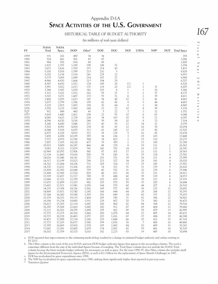
167
Fi
sc
al
Y
ea
r
20
15
A
ct
iv
it
ie
sAppendix D-1A
spaCe aCTiviTies of The u.s. governmenT
HISTORICAL TABLE OF BUDGET AUTHORITY
(in millions of real-year dollars)
FYNASA
TotalNASA Space DODa Otherb DOEc DOC DOI USDA NSFd DOT Total Space
1959 331 261 490 34 34 7851960 524 462 561 43 43 1,0661961 964 926 814 68 68 1,8081962 1,825 1,797 1,298 199 148 51 3,2941963 3,673 3,626 1,550 257 214 43 5,4331964 5,100 5,016 1,599 213 210 3 6,8281965 5,250 5,138 1,574 241 229 12 6,9531966 5,175 5,065 1,689 214 187 27 6,9681967 4,966 4,830 1,664 213 184 29 6,7071968 4,587 4,430 1,922 174 145 28 0.2 1 6,5261969 3,991 3,822 2,013 170 118 20 0.2 1 31 6,0051970 3,746 3,547 1,678 141 103 8 1 1 28 5,3661971 3,311 3,101 1,512 162 95 27 2 1 37 4,7751972 3,307 3,071 1,407 133 55 31 6 2 39 4,6111973 3,406 3,093 1,623 147 54 40 10 2 41 4,8631974 3,037 2,759 1,766 158 42 60 9 3 44 4,6831975 3,229 2,915 1,892 158 30 64 8 2 54 4,9651976 3,550 3,225 1,983 168 23 72 10 4 59 5,376TQ* 932 849 460 43 5 22 3 1 12 1,3521977 3,818 3,440 2,412 194 22 91 10 6 65 6,0461978 4,060 3,623 2,738 226 34 103 10 8 71 6,5871979 4,596 4,030 3,036 248 59 98 10 8 73 7,3141980 5,240 4,680 3,848 231 40 93 12 14 72 8,7591981 5,518 4,992 4,828 234 41 87 12 16 78 10,0541982 6,044 5,528 6,679 313 61 145 12 15 80 12,5201983 6,875 6,328 9,019 327 39 178 5 20 85 15,6741984 7,458 6,858 10,195 395 34 236 3 19 103 17,4481985 7,573 6,925 12,768 584 34 423 2 15 110 20,2771986 7,807 7,165 14,126 477 35 309 2 23 108 21,7681987 10,923 9,809 16,287 466 48 278 8 19 112 1 26,5621988 9,062 8,322 17,679 741 241 352 14 18 115 1 26,7421989 10,969 10,097 17,906 560 97 301 17 21 121 3 28,5631990 12,324 11,460 15,616 506 79 243 31 25 124 4 27,5821991 14,016 13,046 14,181 772 251 251 29 26 211 4 27,9991992 14,317 13,199 15,023 798 223 327 34 29 181 4 29,0201993 14,310 13,064 14,106 731 165 324 33 25 180 4 27,9011994 14,570 13,022 13,166 632 74 312 31 31 179 5 26,8201995 13,854 12,543 10,644 759 60 352 31 32 278 6 23,9461996 13,884 12,569 11,514 828 46 472 36 37 231 6 24,9111997 13,709 12,457 11,727 789 35 448 42 39 219 6 24,9731998 13,648 12,321 12,359 839 103 435 43 39 213 6 25,5191999 13,653 12,459 13,203 982 105 575 59 37 200 6 26,6442000 13,601 12,521 12,941 1,056 164 575 60 44 207 6 26,5182001 14,230 13,304 14,326 1,062 145 577 60 36 232 12 28,6922002 14,868 13,871 15,740 1,180 166 644 64 28 266 12 30,7912003 15,364 14,360 19,388 1,305 191 649 74 42 337 12 35,0532004 15,379 14,322 19,115 1,464 209 745 71 61 366 12 34,9012005 16,198 15,234 19,690 1,551 229 807 70 73 360 12 36,4752006 16,623 15,765 22,114 1,647 245 860 82 84 364 12 39,5262007 16,285 15,568 22,418 1,680 200 912 87 65 404 12 39,6662008 17,117 16,502 24,795 1,698 195 862 90 59 479 13 42,9952009 17,775 17,275 26,528 1,868 200 1,078 64 27 485 14 45,6712010 18,725 18,228 26,463 2,057 203 1,261 67 27 484 15 46,7482011 18,432 17,898 27,234 2,186 229 1,444 66 20 412 15 47,3182012 17,773 17,203 26,677 2,580 199 1,876 76 7 406 16 46,4602013 17,395 16,865 10,818 2,578 185 1,865 84 20 409 15 30,2612014 17,647 17,081 10,400 2,839 174 2,087 82 19 461 16 30,3202015 18,010 17,359 10,325 3,010 182 2,223 83 19 485 18 30,694
a. DOD reported that improvements to the estimating methodology resulted in a change in estimated budget authority and outlays starting in FY 2013.
b. The Other column is the total of the non-NASA and non-DOD budget authority figures that appear in the succeeding columns. The total is sometimes different from the sum of the individual figures because of rounding. The Total Space column does not include the NASA Total column because the latter includes budget authority for aeronautics as well as space. For the years 1989–97, this Other column also includes small figures for the Environmental Protection Agency (EPA), as well as $2.1 billion for the replacement of Space Shuttle Challenger in 1987.
c. DOE has recalculated its space expenditures since 1998.d. The NSF has recalculated its space expenditures since 1980, making them significantly higher than reported in previous years.* Transition Quarter

168
Ae
ro
na
ut
ic
s
an
d
Sp
ac
e
Re
po
rt
o
f
th
e
Pr
es
id
en
tAppendix D-1B
spaCe aCTiviTies of The u.s. governmenT
HISTORICAL TABLE OF BUDGET AUTHORITY
(in millions of inflation-adjusted FY 2015 dollars)
FYInflation
FactorsNASA
TotalNASA Space DODa Otherb DOEc DOC DOI USDA NSFd DOT Total Space
1959 6.391 2,116 1,668 3,132 217 217 5,0171960 6.295 3,298 2,908 3,531 271 271 6,7101961 6.208 5,984 5,749 5,053 422 422 11,2241962 6.124 11,175 11,004 7,948 1,219 906 312 20,1711963 6.062 22,265 21,980 9,396 1,558 1,297 261 32,9331964 5.988 30,538 30,035 9,575 1,275 1,257 18 40,8851965 5.916 31,057 30,395 9,311 1,426 1,355 71 41,1321966 5.814 30,087 29,447 9,820 1,244 1,087 157 40,5111967 5.691 28,264 27,490 9,471 1,212 1,047 165 38,1721968 5.523 25,333 24,466 10,615 962 801 155 1 6 36,0421969 5.340 21,312 20,409 10,749 910 630 107 1 5 166 32,0681970 5.105 19,125 18,109 8,567 720 526 41 5 5 143 27,3951971 4.844 16,040 15,023 7,325 785 460 131 10 5 179 23,1321972 4.611 15,248 14,160 6,488 615 254 143 28 9 182 21,2631973 4.401 14,989 13,611 7,142 648 238 176 44 9 182 21,4021974 4.219 12,812 11,639 7,450 667 177 253 38 13 186 19,7561975 3.939 12,718 11,482 7,452 621 118 252 32 8 212 19,5551976 3.571 12,675 11,515 7,080 601 82 257 36 14 212 19,196TQ* 3.339 3,112 2,835 1,536 144 17 73 10 3 40 4,5141977 3.242 12,377 11,152 7,819 627 71 295 32 19 209 19,5981978 3.115 12,646 11,285 8,528 704 106 321 31 25 221 20,5161979 2.918 13,411 11,759 8,859 724 172 286 29 23 213 21,3421980 2.701 14,155 12,642 10,395 624 108 251 32 38 195 23,6611981 2.485 13,710 12,403 11,996 582 102 216 30 40 194 24,9811982 2.263 13,680 12,512 15,118 708 138 328 27 34 180 28,3381983 2.118 14,561 13,403 19,102 693 83 377 11 42 180 33,1971984 2.029 15,129 13,912 20,681 801 69 479 6 39 208 35,3931985 1.959 14,838 13,569 25,018 1,144 67 829 4 29 215 39,7301986 1.896 14,806 13,588 26,790 904 66 586 4 44 204 41,2821987 1.854 20,253 18,188 30,199 864 89 515 15 35 207 2 49,2501988 1.814 16,436 15,094 32,065 1,344 437 638 25 33 209 2 48,5031989 1.757 19,274 17,742 31,463 984 170 529 30 37 213 5 50,1891990 1.690 20,825 19,365 26,388 855 133 411 52 42 209 7 46,6081991 1.631 22,855 21,274 23,124 1,259 409 409 47 42 344 7 45,6571992 1.575 22,547 20,786 23,659 1,256 351 515 54 46 285 6 45,7011993 1.537 21,997 20,082 21,684 1,123 254 498 51 38 276 6 42,8891994 1.502 21,877 19,553 19,769 950 111 468 47 47 269 8 40,2721995 1.469 20,358 18,432 15,641 1,115 88 517 46 47 408 9 35,1881996 1.439 19,978 18,086 16,568 1,191 66 679 52 53 332 9 35,8461997 1.413 19,366 17,597 16,566 1,115 49 633 59 55 310 8 35,2781998 1.388 18,945 17,103 17,156 1,165 143 604 60 54 296 8 35,4241999 1.371 18,721 17,084 18,104 1,347 144 788 81 51 274 8 36,5352000 1.354 18,416 16,954 17,523 1,429 222 779 81 60 280 8 35,9062001 1.327 18,878 17,649 19,005 1,409 192 765 80 48 308 16 38,0632002 1.295 19,259 17,967 20,388 1,528 215 834 83 36 345 16 39,8842003 1.275 19,586 18,307 24,716 1,664 243 827 94 54 430 15 44,6872004 1.251 19,238 17,916 23,911 1,831 261 932 89 76 458 15 43,6592005 1.221 19,773 18,596 24,035 1,893 280 985 85 89 439 15 44,5252006 1.184 19,674 18,658 26,173 1,949 290 1,018 97 99 431 14 46,7802007 1.146 18,667 17,845 25,697 1,926 229 1,045 100 75 463 14 45,4672008 1.116 19,104 18,417 27,673 1,895 218 962 100 66 535 15 47,9852009 1.093 19,437 18,890 29,008 2,042 219 1,179 70 29 530 15 49,9402010 1.081 20,238 19,701 28,601 2,223 219 1,363 72 29 523 16 50,5252011 1.071 19,749 19,177 29,181 2,342 245 1,547 71 21 441 16 50,7002012 1.051 18,679 18,080 28,036 2,711 209 1,972 80 7 427 17 48,8272013 1.033 17,967 17,419 10,818 2,663 191 1,926 87 21 422 15 31,2562014 1.015 17,647 17,081 10,400 2,839 174 2,087 82 19 461 16 30,7812015 1.000 18,010 17,359 10,325 3,010 182 2,223 83 19 485 18 30,694
a. DOD reported that improvements to the estimating methodology resulted in a change in estimated budget authority and outlays starting in FY 2013.b. The Other column is the total of the non-NASA and non-DOD budget authority figures that appear in the succeeding columns. The total is
sometimes different from the sum of the individual figures because of rounding. The Total Space column does not include the NASA Total column because the latter includes budget authority for aeronautics as well as space. For the years 1989–97, this Other column also includes small figures for the Environmental Protection Agency (EPA), as well as $2.1 billion for the replacement of Space Shuttle Challenger in 1987.
c. The DOE has recalculated its space expenditures since 1998.d. The NSF has recalculated its space expenditures since 1980, making them significantly higher than reported in previous years.* Transition Quarter

169
Fi
sc
al
Y
ea
r
20
15
A
ct
iv
it
ie
sAppendix D-2
federal spaCe aCTiviTies budgeT
(in millions of dollars by fiscal year)
Federal Agencies
Budget Authority Budget Outlays
2013 actual1
2014 actual
2015 actual
2016 est.
2013 actual
2014 actual
2015 actual
2016 est.
NASA2 16,865.2 17,080.5 17,359 18,645 16,989 16,558.7 17,697.4 18,346
DOD3, 4 10,818 10,400 10,325 10,333 10,299 9,600 15,895 12,581
DOE 185 174 182 187 183 174 198 204
DOC5 1,864.8 2,087.1 2,223.1 2,349.4 1,130.5 1,167.3 1,300.3 1,387.5
DOI6 84 82 83 87 81 81 82 87
USDA 19.6 19.3 18.9 18.8 17 18.7 17.3 18.7
DOT 15 16 17.6 21.8 15 16 17.6 21.8
NSF7 409 461 485.2 507.7 387 391 444.6 452.8
1. FY 2013 figures incorporate the effect of sequestration.2. The FY 2015 estimate is based on the prior year’s Outlays versus Budget Authority.3. Does not include Department of Defense (DOD) or Office of the Director of National Intelligence (ODNI) intelligence programs. DOD FY 2014
and FY 2015 figures for Budget Authority and Outlays are estimated at the time of preparing this report. Improvements to the estimating methodol-ogy resulted in a change in estimated Budget Authority and Outlays starting in FY 2013.
4. At the time of preparing this report, DOD submitted estimates as billions of dollars, so the figures are rounded to the nearest hundred million.5. The Budget Outlays columns reflect dollars “costed” in a fiscal year specific to that same fiscal year’s appropriated dollars.6. The numbers for FY 2014 Actual and Outlays are estimates for both satellite and aerial funding.7. “Actual” = actual obligations.

170
Ae
ro
na
ut
ic
s
an
d
Sp
ac
e
Re
po
rt
o
f
th
e
Pr
es
id
en
tAppendix D-3
federal aeronauTiCs aCTiviTies budgeT
(in millions of dollars by fiscal year)
Federal Agencies
Budget Authority Budget Outlays
2013 actual1
2014 actual
2015 actual
2016 est.
2013 actual
2014 actual
2015 actual
2016 est.
NASA2 529.5 566 651 640 558.4 538.7 578.3 587
USDA 33.1 34.4 26.7 26.8 30.2 32.6 26.7 26.7
DOD3 82,730 75,500 50,800 57,600 91,120 75,700 42,885 58,697
DOI4 29 31 31 36 28 30 31 36
DOT 2,758 2,744 2,741.8 3,004.9 2,990 2,851 2,761.1 2,895.8
1. FY 2013 figures incorporate the effect of sequestration.2. The FY 2015 estimate is based on the prior year’s Outlays versus Budget Authority.3. DOD FY 2014 and FY 2015 figures for Budget Authority and Outlays are estimated at the time of preparing this report. Improvements to the esti-
mating methodology resulted in a change in estimated Budget Authority and Outlays starting in FY 2013.4. At the time of preparing this report, DOD submitted estimates as billions of dollars, so the figures are rounded to the nearest hundred million.5. The numbers for FY 2014 Actual and Outlays are estimates for both satellite and aerial funding.

171
Fi
sc
al
Y
ea
r
20
15
A
ct
iv
it
ie
s
aCronyms
3D-MAT 3-Dimensional Multifunctional Ablative Thermal Protection Systems
A
AAFEX Alternative Aviation Fuel ExperimentABoVE Arctic-Boreal Vulnerability ExperimentABS Asia Broadcast SatelliteACCESS Alternative Fuel Effects on Contrails and Cruise EmissionsACE Advanced Composition ExplorerACEC Area of Critical Environmental ConcernACES Atomic Clock Ensemble in SpaceACT Atacama Cosmology TelescopeACTPol ACT PolarimeterADP Acoustic Doppler ProfilerADS-B Automatic Dependent Surveillance–BroadcastAE Archive ExplorerAEFS Advanced Electronic Flight StripsAEHF Advanced Extremely High FrequencyAES Advanced Exploration SystemsAFIT Air Force Institute of TechnologyAFOTEC Air Force Operational Test and Evaluation CenterAFRL Air Force Research LaboratoryAFSPC Air Force Space CommandAFTA Astrophysics Focused Telescope AssetsAGS Atmospheric and Geospace SciencesAIA Atmospheric Imaging AssemblyAIR-Spec airborne infrared spectrometerAPXS Alpha Particle X-ray SpectrometerALMA Atacama Large Millimeter/submillimeter ArrayAMC Additive Manufacturing ConsortiumAMISR Advanced Modular Incoherent-Scatter RadarAMPERE Active Magnetosphere and Planetary Electrodynamics Response ExperimentAMS Autonomous Modular Sensor; Alpha Magnetic SpectrometerANWR Arapaho National Wildlife RefugeAO Arecibo ObservatoryAPL Applied Physics LaboratoryARAIM Advanced Receiver Autonomous Integrity MonitoringARM Asteroid Redirect Mission; Atmospheric Radiation Measurement Climate Research FacilityARMD Aeronautics Research Mission DirectorateARSET Applied Remote Sensing TrainingARTCC air route traffic control centerAS Atmosphere SectionASB Agricultural Statistics BoardASBU Aviation System Block UpgradeASDE-X Airport Surface Detection Equipment–Model XASR Atmospheric System ResearchASRG Advanced Stirling Radioisotope GeneratorASSC Airport Surface Surveillance Capability SystemAST Office of Commercial Space Transportation; Division of Astronomical Sciences

172
Ae
ro
na
ut
ic
s
an
d
Sp
ac
e
Re
po
rt
o
f
th
e
Pr
es
id
en
t
ASTAR Airborne Spacing for Terminal Arrival RoutesASU Group on the Sector Understanding on Export Credits for Civil Aircraft (also called Aircraft
Sector Understanding)ATST Advanced Technology Solar TelescopeATV Automated Transfer VehicleAUVSI Association for Unmanned Vehicle Systems InternationalAWiFS Advanced Wide Field Sensor
B
BAA Broad Agency AnnouncementBANWR Buenos Aires National Wildlife RefugeBaPSF Basic Plasma Science FacilityBEAM Bigelow Expandable Activity ModuleBIA Bureau of Indian AffairsBICEP Background Imaging of Cosmic Extragalactic PolarizationBIS Bureau of Industry and SecurityBLM Bureau of Land ManagementBNL Brookhaven National LaboratoryBOR Bureau of ReclamationBRICSat Ballistic Reinforced Communication Satellite
C
C2V2 Common Communications for Visiting VehiclesCA cooperative agreementCAL Cold Atom LaboratoryCALET CALorimetric Electron TelescopeCARVE Carbon in Arctic Reservoirs Vulnerability ExperimentCAS close air supportCATS Cloud-Aerosol Transport SystemCCAFS Cape Canaveral Air Force StationCCMC Community Coordinated Modeling CenterCCS Counter Communications SystemCCSDS Consultative Committee for Space Data SystemsCCtCap Commercial Crew Transportation CapabilitiesCD-3 Critical Decision–3CDD Capabilities Development DocumentCDL Cropland Data LayerCDR Critical Design ReviewCEDAR Coupling, Energetics, and Dynamics of Atmospheric RegionsCEPS Center for Earth and Planetary StudiesCfA Center for AstrophysicsCH4 methaneCHAMP CHAllenging Mini-satellite PayloadCIR color infraredCLU Common Land UnitCMB cosmic microwave backgroundCNES Centre Nationale d’Études SpatialesC/NOFS Communications/Navigation Outage Forecasting SystemCO2 carbon dioxideCOE CST Center of Excellence for Commercial Space TransportationCOSMIC Constellation Observing System for Meteorology, Ionosphere, and ClimateCOSMO-SkyMed COnstellation of small Satellites for the Mediterranean basin ObservationCOSPAR U.N. Committee on Space Research

173
Fi
sc
al
Y
ea
r
20
15
A
ct
iv
it
ie
s
COSPAS-SARSAT Search and Rescue Satellite-Aided TrackingCPGS Conventional Prompt Global StrikeCPT Command Post TerminalCREAM Cosmic Ray Energetics and MassCRP Commercialization Readiness ProgramCRSSP Commercial Remote Sensing Space PolicyCS Commercial ServiceCSA cooperative support agreementCSLI CubeSat Launch InitiativeCSP Cold Spray ProcessCubeSat cube-shaped satelliteCYGNSS Cyclone Global Navigation Satellite System
D
DAA Detect-and-AvoidDASC Deep Space Atomic ClockDASI Degree Angular Scale InterferometerData Comm Data CommunicationsDKAO Dakotas Area OfficeDKIST Daniel K. Inouye Solar TelescopeDLR German Aerospace CenterDMC Disaster Monitoring ConstellationDNN Defense Nuclear NonproliferationDOC Department of CommerceDOD Department of DefenseDOE Department of EnergyDOI Department of the InteriorDOS Department of StateDPR Dual-frequency Precipitation RadarDRS Disturbance Reduction SystemDSCOVR Deep Space Climate ObservatoryDSN Deep Space NetworkDVE-M Degraded Visual Environment MitigationDWH Deepwater Horizon
E
EAWS Early Access Web ServicesEBIS Electron Beam Ion SourceECLIF Emissions and Climate Impacts of Alternative FuelsECMWF European Centre for Medium-Range Weather ForecastsEDL Entry, Descent, and LandingEDSN Edison Demonstration of SmallSat NetworksEELV Evolved Expendable Launch VehicleEFSTS Electronic Flight Strip Transfer SystemEFT-1 Exploration Flight Test–1EGS Exploration Ground SystemsEIS Environmental Impact AssessmentELSO Equivalent Lateral Spacing OperationsEM-1 Exploration Mission–1EMC Evolvable Mars CampaignEOS Earth Observing SystemEPA Environmental Protection AgencyEPS Enhanced Polar System

174
Ae
ro
na
ut
ic
s
an
d
Sp
ac
e
Re
po
rt
o
f
th
e
Pr
es
id
en
t
ERAM En Route Automation ModernizationERAU Embry-Riddle Aeronautical UniversityERCDM Eastern Range Command Destruct ModernizationEROS Earth Resources Observation and Science; Earth Resources Observation SystemsESA European Space AgencyESD Earth Science DivisionESI Exploration Systems IntegrationETM Enhanced Thematic MapperEU European UnionEUMETSAT European Organisation for the Exploitation of Meteorological SatellitesEUV extreme ultravioleteV electronvoltEVA extravehicular activityEVE EUV Variability ExperimentEVI-3 Earth Venture Instrument–3EVM-2 Earth Venture Mission–2Ex-Im Export-Import
F
FAA Federal Aviation AdministrationFAB-T Family of Advanced Beyond Line of Sight TerminalsFACO Final Assembly and Check OutFAS Foreign Agricultural ServiceFAS/OGA Foreign Agricultural Service Office of Global AnalysisFCC Federal Communications CommissionFDSS Faculty Development in Space SciencesFES Office of Fusion Energy SciencesFGST Fermi Gamma-ray Space TelescopeFIREBIRD Focused Investigations of Relativistic Electron Burst Intensity, Range, and DynamicsFOALS Fuel Optimal and Accurate Landing System Test FlightsFOC Full Operational CapabilityFRAME Fundamental Rotorcraft Acoustic Modeling for ExperimentsFSA Farm Service AgencyFTI Federal Telecommunications InfrastructureFWS Fish and Wildlife Service
G
Gal/Xgal U/LDB Galactic/Extragalactic Ultra-Long Duration BalloonGaN gallium nitrideGAO Government Accountability OfficeGBD Global Burst DetectorGBSD Ground Based Strategic DeterrentGBU Guided Bomb UnitGCD Game Changing DevelopmentGEARRSAT Globalstar Experiment And Risk Reduction Satellite Flight ExperimentGEDI Global Ecosystem Dynamics InvestigationGEM Geospace Environment ModelingGEO Geosynchronous Earth Orbit; Directorate for GeosciencesGEODSS Ground-based Electro Optical Deep Space SurveillanceGF Geospace FacilitiesGIS Geographic Information SystemsGLAM Global Agricultural Monitoring

175
Fi
sc
al
Y
ea
r
20
15
A
ct
iv
it
ie
s
GLBA Glacier Bay National Park and PreserveGLOBE Global Learning and Observations to Benefit the EnvironmentGMI GPM Microwave ImagerGNSS Global Navigation Satellite SystemGOES Geostationary Operational Environmental SatelliteGOES-R Geostationary Operational Environmental Satellite–RGOLD Global-scale Observations of the Limb and DiskGONG Global Oscillations Network GroupGPHS General Purpose Heat SourceGPIM Green Propellant Infusion MissionGPM Global Precipitation MeasurementGPR ground penetrating radarGPS Global Positioning SystemGPS/MET GPS/MeteorologyGPSRO GPS radio occultationGRACE Gravity Recovery and Climate ExperimentGRACE-FO Gravity Recovery and Climate Experiment Follow-OnGRC Glenn Research CenterG-REALM Global Reservoir and Lake MonitorGS Geospace SectionGSDO Ground Systems Development and OperationsGSFC Goddard Space Flight CenterGT-1 Ground TournamentGUSTO Gal/Xgal U/LDB Spectroscopic–Stratospheric Terahertz Observatory
H
HCT Hall Current ThrusterHEAT High Elevation Antarctic TerahertzHEEET Heatshield for Extreme Entry Environment TechnologyHEO Highly Elliptical OrbitHEOMD Human Exploration and Operations Mission DirectorateHEP Office of High Energy PhysicsHiRISE High Resolution Imaging Science ExperimentHIWC High Ice Water ContentHOPE Hands-On Project ExperienceHPD Heliophysics DivisionHRP Human Research ProgramHRS Human Robotic SystemsHTV H-II Transfer VehicleHX Heat Exchanger
I
I&M Inventory and MonitoringICAO International Civil Aviation OrganizationICBM intercontinental ballistic missileICE-Cap Integrated Communications Extension CapabilityICG International Committee on GNSSICNO IceCube Neutrino ObservatoryICON Ionospheric Connection ExplorerIDEX International Defense Exhibition and ConferenceIDIQ2 indefinite-delivery, indefinite-quantityIFAR International Forum for Aviation Research

176
Ae
ro
na
ut
ic
s
an
d
Sp
ac
e
Re
po
rt
o
f
th
e
Pr
es
id
en
t
IfSAR Interferometric Synthetic Aperture RadarInSight Interior Exploration Using Seismic Investigations, Geodesy and Heat TransportIOC Initial Operational CapabilityION Institute of NavigationIPAD International Production Assessment DivisionIPCC Internet Protocol Companion ContractIRAC Infrared Array CameraIRIS Interface Region Imaging SpectrographISECG International Space Exploration Coordination GroupISEF2 International Space Exploration ForumISRO Indian Space Research OrganisationISS International Space StationISS-RapidScat International Space Station–Rapid ScatterometerIST Integrated Systems TestITA International Trade AdministrationITU International Telecommunication UnionIXPE Imaging X-ray Polarimetry Explorer
J
JASD Joint Agency Satellite DivisionJason Joint Altimetry Satellite Oceanography NetworkJAXA Japan Aerospace Exploration AgencyJCTD Joint Capability Technology DemonstrationJMR Joint Multi-RoleJMS JSpOC Mission SystemJPL Jet Propulsion LaboratoryJPSS Joint Polar Satellite SystemJSC Johnson Space CenterJSF Joint Strike FighterJSpOC Joint Space Operations CenterJUICE Jupiter Icy Moons ExplorerJWST James Webb Space Telescope
K
KDP Key Decision PointKSC Kennedy Space CenterKUS Kennedy Uplink Station
L
LAAD Latin America Aerospace and DefenceLANL Los Alamos National LaboratoryLAPD Large Plasma DeviceLAT Large Area TelescopeLCH4 liquid methaneLCMS Landscape Change Monitoring SystemLCRD Laser Communication Relay DemonstrationLCS Launch Communications SystemLDSD Low Density Supersonic Deceleratorlidar light identification detection and rangingLISA Laser Interferometer Space AntennaLLNL Lawrence Livermore National Laboratory

177
Fi
sc
al
Y
ea
r
20
15
A
ct
iv
it
ie
s
LORRI Long Range Reconnaissance ImagerLOX liquid oxygenLRO Lunar Reconnaissance OrbiterLSC Legal SubcommitteeLSP Launch Services ProgramLSST Large Synoptic Survey TelescopeLST Land Surface TemperatureLTS Working Group on Long-Term Sustainability of Outer Space ActivitiesLunar CATALYST Lunar Cargo Transportation and Landing by Soft Touchdown
M
M&S modeling and simulationMAIAC Multi-Angle Implementation of Atmospheric CorrectionMARS Mid-Atlantic Regional SpaceportMARSIS Mars Advanced Radar for Subsurface and Ionosphere SoundingMARSOC Marine Special Operations CommandMAVEN Mars Atmosphere and Volatile EvolutionMDA Missile Defense AgencyMEDA Mars Environmental Dynamics AnalyzerMEDLI Mars Entry, Descent, and Landing InstrumentationMEN Modernization Eastern Range NetworkMEP Manufacturing Extension PartnershipMER Mars Exploration RoverMESSENGER MErcury Surface, Space ENvironment, GEochemistry, and RangingMetOp Meteorological Operational Satellite ProgramMETOP-A/GRAS Meteorological Operational satellite programme–A/Global navigation satellite system
Receiver for Atmospheric SoundingMEU Marine Expeditionary UnitsMIT Massachusetts Institute of TechnologyMMRTG Multi-Mission Radioisotope Thermoelectric GeneratorMMS Magnetospheric MultiscaleMOA Memorandum of AgreementMOBY Marine Optical BuoyMODIS Moderate Resolution Imaging SpectroradiometerMOPS Minimum Operational Performance StandardsMOT&E Multi-Service Operational Test and EvaluationMOU Memorandum of UnderstandingMOXIE Mars Oxygen In Situ Resource Utilization ExperimentMPE Mission Planning ElementMPS Mathematics and Physical SciencesMRLC Multi-Resolution Land Characteristics ConsortiumMRO Mars Reconnaissance OrbiterMRP Mineral Resources ProgramMRX Magnetic Reconnection ExperimentMSFC Marshall Space Flight CenterMSIP Mid-Scale Innovations ProgramMSL Mars Science LaboratoryMTBS Monitoring Trends in Burn SeverityMUOS Mobile User Objective System
N
NAICS North American Industry Classification System

178
Ae
ro
na
ut
ic
s
an
d
Sp
ac
e
Re
po
rt
o
f
th
e
Pr
es
id
en
t
NAIP National Agriculture Imagery ProgramNAS National Airspace SystemNASA National Aeronautics and Space AdministrationNASM National Air and Space MuseumNASS National Agricultural Statistics ServiceNATCA National Air Traffic Controllers AssociationNBR normalized burned area ratioNCAR National Center for Atmospheric ResearchNCEP National Centers for Environmental PredictionNDVI Normalized Difference Vegetation IndexNE Office of Nuclear EnergyNEA Near-Earth AsteroidNEN Near Earth NetworkNEO near-Earth objectNERSC National Energy Research Supercomputing CenterNextGen Next Generation Air Transportation SystemNextSTEP Next Space Technology Exploration PartnershipsNFS National Forest SystemNGEE Next Generation Ecosystem ExperimentNGO nongovernmental organizationNHD National Hydrography DatasetNIAC NASA Innovative Advanced ConceptsNICER Neutron star Composition and Interior ExplorerNIR near-infraredNISAR NASA–ISRO Synthetic Aperture RadarNIST National Institute of Standards and TechnologyNISTAR NIST Advanced RadiometerNLCD National Land Cover DatabaseNMAMLP New Mexico Abandoned Mine Land ProgramNNSA National Nuclear Security AdministrationNOAA National Oceanic and Atmospheric AdministrationNOAO National Optical Astronomy ObservatoryNOC National Operations CenterNPOESS National Polar-Orbiting Operational Environmental Satellite SystemNPS National Park ServiceNRAO National Radio Astronomy ObservatoryNRCS Natural Resources Conservation ServiceNRA NASA Research AnnouncementNRL Naval Research LaboratoryNSF National Science FoundationNSO National Solar ObservatoryNSPO National Space OrganizationNSRL NASA Space Radiation LaboratoryNSS national security spaceNSTC National Science and Technology CouncilNSWS National Space Weather StrategyNTC National Training CenterNTP Nuclear Thermal PropulsionNuDets space nuclear detonationsNWP numerical weather prediction
O
OCO-2 Orbiting Carbon Observatory 2ODNI Office of the Director of National Intelligence

179
Fi
sc
al
Y
ea
r
20
15
A
ct
iv
it
ie
s
OECD Organization for Economic Cooperation and DevelopmentOFII Office of Finance and Insurance IndustriesOIB Operation IceBridgeOIG Office of Inspector GeneralOLI Operational Land ImagerOMB Office of Management and BudgetOPIR Overhead Persistent InfraredORS Operationally Responsive SpaceOSD Office of the Secretary of DefenseOSMRE Office of Surface Mining Reclamation and EnforcementOSP-3 Orbital/Suborbital Program–3OSTP Office of Science and Technology PolicyOTM Office of Transportation and MachineryOTV Orbital Test VehicleOVERFLOW OVERset grid FLOW solver
P
PACE Pre-Aerosol, Clouds, and ocean EcosystemPBN Performance Based NavigationPBS Plum Brook StationPCAS Persistent Close Air SupportPCM Phase Change MaterialPCM HX Phase Change Material Heat ExchangerPDL Ponce De LeonPDR Preliminary Design ReviewPECAN Plains Elevated Convection at NightPLR Division of Polar ProgramsPNT Positioning, Navigation, and TimingPOES Polar-orbiting Operational Environmental SatellitesPOLARBEAR Polarization of Background RadiationPolSAR Polarimetric synthetic aperture radarPPPL Princeton Plasma Physics LaboratoryPRAXyS Polarimeter for Relativistic Astrophysical X-ray SourcesPRS Public Regulated ServicePsat Parkinson SatellitePSD Planetary Science Division; production, supply, and distributionPu plutonium
Q
QZSS Quasi-Zenith Satellite System
R
R&D Research and DevelopmentRapidScat Rapid ScatterometerREDDI-2014 Research, Development, Demonstration, and Infusion 2014RERP Reliability Enhancement and Re-engining ProgramRHIC Relativistic Heavy Ion ColliderRHU radioisotope heater unitRNAV Area NavigationRNP Required Navigation PerformanceRO radio occultationROD Record of Decision

180
Ae
ro
na
ut
ic
s
an
d
Sp
ac
e
Re
po
rt
o
f
th
e
Pr
es
id
en
t
ROSES Research Opportunities in Space and Earth SciencesRp refined petroleumRP-1 liquid keroseneRPS radioisotope power systemRPT Rocket Propulsion TestRRM-P2 Robotic Refueling Mission Phase 2RSAC Remote Sensing Applications CenterRSCC Remote Sensing Coordinating CommitteeRSIWG Remote Sensing Interagency Working GroupRTCA-SC228 Radio Technical Commission for Aeronautics–Special Committee 228RTG Radioisotope Thermoelectric GeneratorRTK-GPS Real-Time Kinematic Global Positioning SystemRV recreational vehicle
S
S&CD Strategic and Commerce DialogueSABRS Space and Atmospheric Burst Reporting SystemSAC-C Satélite de Aplicaciones CientíficSAM Sample Analysis at MarsSAME Smoke Aerosol Measurement ExperimentSAO Smithsonian Astrophysical ObservatorySAR Synthetic Aperture RadarSATCOM Satellite CommunicationsSBIR Small Business Innovation ResearchSBIRS Space Based Infrared SystemSBSS Space Based Space Surveillance Follow-OnSC Office of ScienceSCaN Space Communications and NavigationS-CANDELS Spitzer-Cosmic Assembly Near-infrared Deep Extragalactic Legacy SurveySDB Small Diameter BombSDO Solar Dynamics ObservatorySEP Solar Electric PropulsionSfM Structure from MotionSGSS Space Network Ground Segment SustainmentSHARAD Shallow Subsurface RadarSHINE Solar, Heliosphere, and INterplanetary EnvironmentSIA Satellite Imagery ArchiveSIAD Supersonic Inflatable Aerodynamic DeceleratorSIR Systems Integration ReviewSLAC Stanford Linear Accelerator CenterSLEP Service Life Extension ProgramSLS Space Launch SystemSM Service ModuleSM-6 Standard Missile–6SMAP Soil Moisture Active PassiveSMC Space and Missile Systems CenterSMCRA Surface Mining Control and Reclamation ActSMD Science Mission DirectorateSN Space NetworkSNL Sandia National LaboratoriesSNSPD superconducting nanowire single-photon detectorSOC Space Optical ClockSOFEX Special Operations Forces Exhibition and ConferenceSOFIA Stratospheric Observatory for Infrared Astronomy

181
Fi
sc
al
Y
ea
r
20
15
A
ct
iv
it
ie
s
SP-9 Service Pack 9SpaceX Space Exploration Technologies CorporationSPAWAR Space and Naval Warfare Systems CommandSPB super-pressure balloonSPD supersonic particle depositionSPHEREx Spectrophotometer for the History of the Universe, Epoch of Reionization, and Ices ExplorerSPP Solar Probe PlusSPT South Pole TelescopeSPTpol SPT polarization-sensitiveSPUD Small Polarimeter Upgrade for DASISQUID Superconducting Quantum Interference DevicessRLV suborbital reusable launch vehicleSSA Space Situational AwarenessSSC Stennis Space CenterSSDP Space Security and Defense ProgramSST Space Surveillance TelescopeSSTI Small Spacecraft Technology InitiativeSSTP Small Spacecraft Technology ProgramStareWAI Staring Wide Area ImagerSTB SCaN TestbedSTDDS SWIM Terminal Data Distribution SystemSTE Special Test EquipmentSTEM science, technology, engineering, and mathematicsSTIM Space Transportation Infrastructure MatchingSTMD Space Technology Mission DirectorateSTP Space Test ProgramSTSC Scientific and Technical SubcommitteeSTTR Small Technology Transfer ResearchSuomi NPP Suomi National Polar-orbiting PartnershipSURF Synchrotron Ultraviolet Radiation FacilitySVT Surface Visualization ToolSWIM System Wide Information ManagementSWORM Space Weather Operations, Research, and MitigationSWPC Space Weather Prediction CenterSWR Space Weather ResearchSwRI Southwest Research InstituteSXS Soft X-ray SpectrometerSZ Sunyaev-Zel’dovich
T
TAP Traffic Aware PlannerTCAS Traffic alert and Collision Avoidance SystemTCC Tree Canopy CoverTCCON Total Column Carbon Observing NetworkTD Technology DemonstratorTDRSS Tracking and Data Relay Satellite SystemTES transition-edge sensor; Terrestrial Ecosystem ScienceTESNAR TEchnical training in Support of Native American RelationsTESS Transiting Exoplanet Survey SatelliteTeV teraelectronvoltTFDM Terminal Flight Data ManagerTFMS Traffic Flow Management SystemTIN triangulated irregular networkTM Thematic Mapper

182
Ae
ro
na
ut
ic
s
an
d
Sp
ac
e
Re
po
rt
o
f
th
e
Pr
es
id
en
t
TMAS Thermal Mapping Airborne SimulatorTMRR Technology Maturation and Risk ReductionTOPEX Ocean Topography ExperimentTPS Thermal Protection SystemsTRACON Terminal Radar Approach ControlsTRL Technology Readiness LevelTRMM Tropical Rainfall Measuring MissionTSAS Terminal Sequencing and SpacingTWG Technical Working Group
U
UAF University of Alaska FairbanksUAS Unmanned Aircraft SystemsUAVSAR Uninhabited Aerial Vehicle Synthetic Aperture RadarUCAR University Corporation for Atmospheric ResearchUCC Unified Combatant CommanderUHF Ultra-High FrequencyULA United Launch AllianceUSAF United States Air ForceUSDA U.S. Department of AgricultureUSFS United States Forest ServiceUSGS United States Geological SurveyUSIP Undergraduate Student Instrument ProjectUSNDS U.S. NuDet Detection SystemUTM UAS Traffic Management
V
VAC Vertical Assembly CenterVAFB Vandenberg Air Force BaseVCLS Venture Class Launch ServiceVIIRS Visible Infrared Imaging Radiometer SuiteVIPR Vehicle Integrated Propulsion ResearchVTOL Vertical Take-Off and Landing
W
WASDE World Agricultural Supply and Demand EstimatesWCDMA Wideband Code Division Multiple AccessWFIRST Wide-Field Infrared Survey TelescopeWGS Wideband Global SATCOMWGSC Western Geographic Science CenterWRCDM Western Range Command Destruct ModernizationWSGF Weather System Gap FillerWSTF White Sands Test Facility
X
XRT X-Ray Telescope
Y
Yb ytterbium

NP-2016-03-2136-HQ