agrarian landscape transition... · web viewthus, the area experienced a decline in general...
TRANSCRIPT

Agrarian Landscape Transition in the Flint Hills of Kansas: Legacies and Resilience
Gerad Middendorf, Derrick Cline and Leonard Bloomquist
Kansas State University
Introduction
The Flint Hills of east-central Kansas contain the largest remaining area of unplowed
tallgrass prairie in North America (about 1.6 million ha). What remains today is a small fraction
of the estimated pre-European extent of the tallgrass prairie, which stretched over substantial
portions of what is now Illinois, northern Missouri, Iowa, southern Minnesota, and the eastern
edges of the Dakotas, Nebraska and Kansas. Before European immigration into the area, the
region was home to various American Indian tribes, migrating buffalo and other large ungulates
that fed off the abundant grasses. The American Indians depended on the buffalo as a means of
sustenance, and recognized that management of the grasses ensured their return in the spring.
The prairie has persisted in the Flint Hills for both biophysical and socioeconomic reasons, and
has been one of the key elements in the development of the region. In addition to being steeply
sloped in some places, much of the Flint Hills uplands has a layer of cherty limestone near the
surface. The shallow and rocky soils precluded plowing by early Euro-American settlers and
their successors. Additionally, since the arrival of cattle in significant numbers in the 1860s-
1870s, two key range management practices (burning and grazing) have helped to maintain the
structure and function of the tallgrass ecosystem. Yet, the land use regimes have undergone
change since Euro-American arrival, thus the human signature on the land is by no means a static
one. This chapter documents the salient landscape transitions in the region during the past 150
1

years, and how these transitions have co-evolved with changes in the socioeconomic context.
To accomplish this we examine changes in the political economy of the region from early
settlement to the present, and link these transitions with changes in the agrarian landscape.
Those changes include: (1) the transition from American Indian to Euro-American land use
patterns; (2) the expansion of the agricultural economy in the late nineteenth and early twentieth
centuries; (3) drought and depression during the inter-war years; (4) agricultural intensification
of the post-WWII period; and (5) a set of current issues we discuss under the rubric of
conservation, including urban edge development, fire suppression, invasive species and the
current institutional context with which contemporary land use decisions are made.
Our approach begins with the recognition that ecosystems and social systems have
conventionally been conceptualized separately from each other, even though there has long been
recognition of their interconnectedness. Humans are increasingly recognized as being part of
virtually all ecosystems – in most cases for a very long time – and thus it is now less tenable to
attempt to conceptualize them separately. Indeed, there is increasing evidence that the tallgrass
prairie of the Flint Hills was long co-evolving with those peoples that had migrated over the
Bering Straits and southward into the Great Plains (Reichman 1987). Conventional accounts
have at times either portrayed these lands as generally underutilized by humans before European
arrival, or alternatively as kept in equilibrium by “ecologically minded” American Indians.
Viewing this environment as a social ecosystem allows for the recognition that American Indians
and Euro-Americans brought different experiences, worldviews and land use practices and
therefore altered their environment in variant ways, creating different signatures on the land. At
the same time the biophysical elements of the environment shape society by providing
2

opportunities, resources and limitations, all of which are perceived differently depending on the
mental models of the humans interacting with those elements.
Scholars have conceptualized the study of society and environment in various ways.
Marx had a profound understanding of capitalist systems engaging with the material world for
production, at the same time that production processes created the material conditions that
shaped the consciousness of laborers. Weber famously emphasized the importance of
understanding the predominant worldview as a way to shed light on how societies view and
engage the material world. While it is not our purpose here to exhaustively review the recent
theoretical developments in this area, we recognize that scholars from various disciplines have
grappled with this issue in recent years. Bell (2004) has advanced the notion of ecological
dialogue, which emphasizes the permanent, iterative dialogue that takes place between the
material (biophysical, economy, technology) and the ideational (culture, worldview, values, etc.),
resulting in the continuous and mutual re-shaping of both. Worster (2003) has emphasized the
cultural element of the human-environment equation, arguing, for example, that it was not a
process of humans learning to adapt to the environment, but rather the “economic culture” of
entrepreneurialism and opportunism that drove landowners to plow up millions of acres of
grasslands in the 1910s and 1920s to sew in wheat. Cronon (1983) shows the mutual
determination of environment and culture, and the different ways that humans live within and
belong to ecosystems. Noorgaard (1994) frames societies and environments as co-evolving
systems in which the co-evolutionary process involves changing relations between components
of those systems (e.g., values, organization, technology, knowledge, environment), and in which
the systems themselves are in a constant process of change.
3

Scholars who have studied various aspects of the Flint Hills and the surrounding area
have of course brought varying perspectives. For example, Malin (1942) and Wibking (1963)
draw on the notion of human adaptation to their biophysical environment. For Malin (1984) the
human-environment dialogue was one in which newcomers to an ecosystem (e.g., settlers) went
through an early exploitative stage in which they “experimented” with the environment, cause
initial ecological disturbance, but then move into a less destructive stage as their knowledge,
tools, practices “improved” with experience. Their engagement in the economy would guide
progress toward geographic adaptation. Kollmorgen (1969) argued that a variety of geographic
misconceptions on the part of “American woodsmen” of the frontier era led them to attempt to
impose a small plot grain cropping system on western grasslands – as opposed to extensive
ranching – leading to destruction of forage.
Wibking’s (1963) geography of the cattle industry in the Flint Hills is manifestly a story
of an industry adapting to optimize its relationship with the environment. Similarly, Wood
(1980), writing from the perspective of the beef industry, describes the history of cattle in this
region as a linear, uninterrupted march of progress, in which shrewd, pioneering risk-takers
invest in pure-bred cattle, make their fortunes and bring the environment under their financial
domain. The two narratives above are accounts of rational humans using reason to “adapt” to
their environments while overcoming any biophysical barriers or environmental damage.
Worster (2003), on the other hand, saw agricultural capitalism and the culture of
entrepreneurialism as the force driving environmental maladaption in the Great Plains.
In this chapter, we approach the human-environment relationship as an ecological
dialogue, which includes both biophysical and social elements in constant interaction with each
4

other. They mutually shape each other, in a sense co-evolving, though as Worster (2003)
suggests, co-evolution is not a natural, apolitical process; rather it is driven by human interests as
much as biophysical factors. Two of the salient themes in this narrative are legacy and
resilience. The role of legacy in this case study involves transition which incorporates
contradictory elements. Big Bluestem and other tallgrasses and native grasses are the central
legacy of the Flint Hills uplands. They are central not only to the prairie ecosystem of the
region, but also to the agrarian and other human systems that have developed there. The grasses
were the main source of food for native ungulates (primarily Bos bison), which in turn were the
center of the hunting and gathering societies of Indian tribes that lived in the region. Similarly,
the tallgrass prairie proved to be a fertile ecological base for the ranching systems established by
the Euro-American settlers who displaced the Indians.
The social legacies of the agrarian and other human systems established in the Flint Hills
have had complex relationships with the region’s tallgrass prairie ecosystem. Of particular
concern is the extent to which human practices have sustained or threatened the viability of the
region’s ecosystem. From this perspective, most human systems established in the Flint Hills
have had contradictory relationships with its tallgrass ecosystem. For example, although the
livelihood of Indian tribes in the region depended on sustaining the bison, Sherow (1992)
contends High Plains Indians had severely depleted the bison herds prior to the massive hunts by
Euro-Americans, thus playing a role in the extirpation of bison. On the other hand, Euro-
American ranchers, who have adopted sustainable practices such as spring burnings that benefit
the tallgrass ecosystem, have also adopted agricultural practices such as double stocking that, if
not done prudently, could threaten the viability of the ecosystem.
5

Humans’ contradictory relationships with the tallgrass ecosystem developed in the
context of the region’s incorporation into the world system. The introduction of horses into the
High Plains by European colonists had helped make American Indians more efficient hunters.
More importantly, American Indians were hunting beyond their subsistence needs as they had
become increasingly dependent on trade of bison products to Euro-Americans (Sherow 1992).
Similarly, the beef cattle industry developed by Euro-Americans was dependent on urban
markets in Chicago and elsewhere (Cronon 1992). Because their income was largely dependent
on the number of cattle they could bring to the market, ranchers adopted double stocking and
other practices designed to maximize the number of cattle produced from the tallgrass
ecosystem. Research on the long-term ecological impact of over-grazing suggests, however, that
this practice reduces biological diversity in the tallgrass ecosystem (Hoch 2000).
More recently, there has been a trend of urban citizens moving into exurban and rural
areas for a more “natural” living experience (Hoch 2000). This urban-rural migration, however,
ends up fragmenting prairie by suppressing the application of fire, and eventually leads to a
transformation of the landscape from one defined by grass species to one dominated by woody
species (Briggs, Hoch and Johnson 2002). Building a home in the rural Flint Hills may be
aesthetically appealing to some, but it appears that these new residents, who may be unfamiliar
with the cultural and biophysical legacies of the region, are contributing to prairie fragmentation.
A common theme throughout this chapter is the idea of legacy as an enduring quality to maintain
the features of the tallgrass prairie. Conflict arises when this legacy is challenged by elements
which stand in contradiction to the goals of landscape conservation.
Another theme that emerges in this case study is the resiliency of the tallgrass prairie. At
6

various points in the past 150 years, this social ecosystem has exhibited remarkable resilience in
episodes of both drought and over-grazing. Moreover, at times when portions of the tallgrass
prairie had been assumed dead, it proved also to have recuperative abilities when precipitation
levels increased, and/or when grazing pressure was reduced. This resilience of the bluestem
pastures, as part of a social ecosystem, also has implications for stability in some social patterns.
This chapter provides an historical narrative aimed at highlighting the key transitions in the past
150 years. We begin with a discussion of the characteristics of the study area. To an extent, the
following description emphasizes the biophysical characteristics of this landscape, though we
recognize that it is also a social landscape, which has long been co-evolving with human
systems.
Description of the Region
Study Area
We have defined a local study area which comprises those counties in Kansas that
geologists and others have identified as exhibiting characteristics of the Flint Hills. While the
Flint Hills unsurprisingly do not conform to county lines, the region is roughly two counties
wide, running north-south from near the Kansas-Nebraska border in the north to the Kansas-
Oklahoma border in the south.1 The reason for focusing on these core counties is because the
Flint Hills contains the largest remaining contiguous tract of unplowed tallgrass prairie (Knapp
and Seastedt 1998) – the ecosystem of primary interest in this case study. Nested within the
1 ? The Flint Hills do extend into a part of northeastern Oklahoma and are known there as the “Red Hills.”
Because of data and space limitations, and because the major portion of the Flint Hills is in Kansas, we focus only
on the Kansas portion here.
7

study area in southern Riley County, is Konza Prairie, a 3,487 hectare native tallgrass prairie
preserve owned by The Nature Conservancy and Kansas State University (KSU). It is operated
as a field research station by the KSU Division of Biology, and is concerned with long-term
ecological research, education, and prairie conservation. Some of the data and research used in
this case study is drawn from the work of researchers in the Konza Long-Term Ecological
Research (LTER) program. Figure one shows the eastern third of the state of Kansas, with our
study area highlighted by the inclusion of its hydrological characteristics. The county names are
also provided, and will be referenced throughout this chapter. Konza prairie is indicated by the
star on the map, and the gray areas of varying size are towns and cities. In the northeast corner
of the state is the Kansas City
metro area, and in the south
central part of the state near our
study area is Wichita.
The Flint Hills
encompass over 50,000 km2,
covering a considerable portion
of the eastern third of Kansas,
from near the Kansas-Nebraska
border on the northern edge to
northeastern Oklahoma on the
southern edge. The range of
hills is about twenty miles
8
wide, running from Riley County in the north to Cowley and Chautauqua counties in the south.
The upland terrain is relatively steep-sloped and overlain by shallow, chert-bearing limestone
soils unsuitable for cultivation. The Flint Hills generally have a local relief of 350 feet, with
maximum local change in elevation of about 1500 feet. It is not uncommon to find relief of 500
feet running ten to fifteen miles (Schoewe 1949). The largest flow of water in the region is the
Kansas River in the north. Other rivers and streams that drain the uplands are the Cottonwood,
Verdigris, Elk, Big Caney, Neosho, Marais des Cygnes, and Big and Little Blue Rivers
(Schoewe 1949). The larger of these river systems contain relatively flat and fertile bottomland
that generally lacks the shallow limestone on the surface.
Topographically, the Flint Hills are in contrast to the adjacent physiographic regions (see
Figure two). To the east are the Osage Cuestas, a region of gently rolling hills, with some
escarpments as well as flatlands. The “highly dissected east-facing escarpment” of the Flint
Hills uplands has been used by geographers as the delineation between the Flint Hills and the
Osage Cuestas (Schoewe 1949: 286). To the northeast is the Glaciated Region, the only place in
Kansas that the glaciers reached (the northeast corner of the state). As in other glaciated areas,
when the glaciers retreated they left behind rocks, soil and also a fine silt called loess, the latter
providing the basis for the formation of fertile soils in the region. To the west lie the Smoky
Hills, another region of gently rolling hills, but increasingly dry towards the west. The eastern
and central Smoky Hills are capped with sandstone and limestone respectively. The land cover
in this region is primarily mixed grass prairie, transitioning to the short grass prairies in the high
plains of western Kansas and eastern Colorado (Kuchler 1974). Much of the mixed grass prairie
in this region is grazed by cattle, though a significant amount has been plowed for row crop
9

agriculture. Finally, to the southwest of the Flint Hills are the Wellington-McPherson and
Arkansas River Lowlands. Much of this region is a flood plain originally created by the
Arkansas River, which has its origins in the Rocky Mountains. The river has created flatlands,
and deposited sand and other sediments in the region. When placed in juxtaposition with these
adjacent physiographic regions of eastern and central Kansas, the Flint Hills stand out in the
landscape for their stream-dissected hills, sharper reliefs and escarpments, and bench and slope
topography.
Oviatt has described the Flint Hills region as an “erosional landscape” that was formed
over “millions of years of exposure to weathering and to stripping by streams tributary to the
Kansas River” (1998: 35). The basic topographic characteristics of the Flint Hills – eroded,
stream-dissected hills – are the result of millions of years of erosion of bedrock layers with
10

different levels of resistance to the fluvial processes. The less resistant mudstone layers eroded
relatively faster than the limestone layers, leaving the latter less eroded and nearer the surface.
This is in contrast to the glacial processes that produced the tallgrass prairie region of the upper
Midwest US. By the time the “Kansan” ice sheet had reached it southwestern limit (20 to 30 km
northeast of Konza Prairie), the Flint Hills region had already attained the basic topographic
characteristics evident in the modern landscape (Oviatt 1998). While this topography was
sculpted to a substantial degree by fluvial processes over a long, geologic time scale, this is not
to say that the modern landscape is static. Oviatt (1998) concludes that the superficial erosional
processes in the Flint Hills are dynamic, with the rates and extent of erosion depending on
climate, fire and grazing regimes, as well as the time scale of interest. On the shortest time
scales (decades to years) the main issue is erosion and fill in stream channels and steeply sloped
hillsides.
Land Cover: Climate, Fire and Grazing
“There were wild flowers, hundreds of kinds of wild flowers, blooming in their
place and season. There were elk and shaggy bison, and prairie chickens
booming out their mating call on brisk April mornings. Great trees hugged the
stream channels and floated like islands on distant horizons. And there was grass
in abundance, dozens of kinds of grass. Eight feet tall on favored sites, belt high
in most places, it was green and bronze and wine and gold, rippling and shining in
the sunlight. It’s almost gone now, that shining, swirling landscape. Other prairie
survives . . . . But the tallgrass prairie, the king of prairies, became the corn belt.
11

Became Chicago, became Des Moines, became home for 25 million people. As
the homesteaders’ steel plows sliced through its matted roots, it all but vanished in
a ringing, tearing sound” (Farney 1980: 38, in National Geographic).
The predominant land cover of the Flint Hills uplands is tallgrass prairie (Kuchler 1974).
Tallgrass prairie once dominated the United States Midwest (see Figure three), extending from
Illinois, Iowa and Minnesota, up to southern Manitoba, down along the eastern edge of the
12

Dakotas into Nebraska, Kansas, Oklahoma and portions of eastern Texas (Risser 1981). During
the nineteenth century Europeans found the soil beneath the grasslands extremely fertile for
agricultural production. Currently, less than one percent of native tallgrass remains –
approximately 1.6 million hectares – most of which is in the Flint Hills (Knapp and Seastedt
1998: 4). Compiled satellite imagery of the study region (approximate area of Flint Hills region
is boxed) results in Figure four, which represents the land cover of the area.2 The Flint Hills area
is distinguishable by the high presence of grassland, with minimal cropland. As the figure
demonstrates, the cropland is primarily found in the bottomlands near the rivers of the region.
Where the hillslopes are dissected by streams, in upland riparian areas, woody species such as
red cedar are found in some abundance. Various tree species are also common as wind breaks
for agricultural crops. The flatter bottomlands of the larger streams and rivers have mostly been
plowed for row crop production. On this map the Wichita metro area (bottom left) and the
capital city Topeka (upper right) are also visible. What is apparent from this figure is that the
Flint Hills region is predominately grassland. The native bluestem pastures have survived in the
Flint Hills because of the inability of early settlers to plow the sod of the uplands, or because of
the marginal nature of upland cropping in areas they were able to plow. Limestone at or near the
surface precluded cultivation, and played a key role in the social and ecological legacy of the
region.
There are two main varieties of native bluestem: little bluestem (Andropogon scoparius)
and big bluestem (Andropogon furcatus). The latter can reach a height of over three meters in
2 ? Due to variations in the collection of satellite images, some are from 1988, while others are from 1990.
13
14

(Reichman 1987). The growing season for the bluestem is approximately 180 days, from late
April to late October. Peak growth is during May and June, after which the grasses begin to die
off in early July when precipitation drops off and temperatures increase.
The bluestem is the predominant species of the area for a number of reasons (Reichman
1987). First, the limestone surface of the area allows for the percolation of water which the roots
of the bluestem can reach, often more than twelve feet below the surface. Second, the above
ground biomass from previous seasons decomposes to provide nutrients for growth in subsequent
seasons. Likewise, the storage of rhizomes under the surface helps to stimulate new growth.
Third, the bluestem grows in high density and towers over other varieties of grass, allowing it to
crowd out competing species. Finally, there are three key processes that regulate and sustain the
tallgrass prairie – variable continental climate, periodic fire, and ungulate grazing. Since these
elements are so fundamental to the structure and function of the tallgrass ecosystem, let us
briefly consider each of them in turn.
Climate.3 The climate of the Flint Hills is considered temperate, mid-continental (Borchert
1950). The Flint Hills of eastern Kansas receive greater precipitation than places farther west
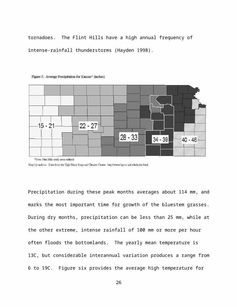
due to air masses bringing moisture directly northward from the Gulf of Mexico. Figure five
provides the average amounts of precipitation for the state of Kansas. There is a substantial
gradient in precipitation as one moves east-west through the state. At Konza, precipitation totals
exhibit considerable temporal variability, with an average annual precipitation of 835 mm, of
3 ? The data on precipitation and temperature in this section are drawn in part from:
http://www.konza.ksu.edu/ . These data refer to conditions at Konza Prairie.
15

which about 75% occurs during the growing season (about 180 days). Mean snowfall for
January is 150 mm with an annual total of 521 mm. Intense thunderstorms during the spring and
early summer can bring a multitude of meteorological phenomena, including lightening, hail,
heavy rains, strong winds, and tornadoes. The Flint Hills have a high annual frequency of
intense-rainfall thunderstorms (Hayden 1998).
Precipitation during these peak months averages about 114 mm, and marks the most important
time for growth of the bluestem grasses. During dry months, precipitation can be less than 25
mm, while at the other extreme, intense rainfall of 100 mm or more per hour often floods the
bottomlands. The yearly mean temperature is 13C, but considerable interannual variation
produces a range from 6 to 19C. Figure six provides the average high temperature for each
month, as well as the average amount of precipitation. These data are for Manhattan, but
16

generally reflect conditions at Konza and throughout the Flint Hills. June through August are the
warmest months, with a mean July temperature of 27C (range 20 to 33C). December through
February are the coldest months, with a January mean temperature of -3C (range -9 to 3C).
What is important in understanding regional climate patterns is that certain biomes persist
essentially as a reflection of the general climatic conditions, or at least it can be argued that the
climate is a strong determinant of biome-scale patterns of vegetation (Hayden 1998: 21).
Fire. Fire is an essential element in the legacy of the tallgrass ecosystem (Borchert 1950;
Ohlenbusch and Hartnett 2001; Hoch 2000; Reichman 1987; Owensby et al. 1973; Aldous
1934). Whether through lightening strikes or planned burning regimes, fire eliminates debris and
competitor species (Pyne 1984). Fire can naturally occur on the prairie during the spring and
summer months when lightening strikes ignite dry grasses. American Indians were the first to
17
regularly burn the prairie for many reasons, but among those reasons they found that burned
areas grew much greener and attracted buffalo (Aldous 1934; Pyne 1984; Sauer 1975; Unrau
1971).
The early adoption of regular burning by settlers was mixed (Hoy 1989). Some early
settlers who profited from the growing cattle trade in the late nineteenth century acquired
techniques for controlled burning from local American Indians. However, without roads or other
boundaries for containment, burning often got out of control, causing problems for non-
practicing neighbors. While some opposed to prairie fires believed that it would turn the land
infertile, others had a view that the tallgrass landscape was inferior to areas east, wanting to
replicate in Kansas the more forested environment they had previously lived in. Over time
though, widespread regular burning was adopted by nearly all ranchers in the Flint Hills.
Eventually, the practice was supported by KSU research, though it remained controversial
(Aldous 1934). Prescribed burning continues in the Flint Hills, starting anywhere from mid-
March and lasting through late-April. Although not all ranchers and pasturemen burn every acre
of land every year, most practice some regular routine of burning at intervals of one to four
years. A continuing legacy of prescribed burning for the management of the tallgrass prairie is
essential, and factors affecting its continuation will undoubtedly have effects on the structure and
function of the regional ecosystem. Among the reported benefits of prescribed burning are
improvements in grazing distributions, reduction in litter, the recycling of nutrients, and the
control of woody species (Ohlenbusch and Hartnett 2001). Indeed, the elimination of woody
species is a major goal of prescribed burning (Owensby et al. 1973).
18

Grazing. Grazing by ungulates is the third essential element in the tallgrass prairie. Before the
near extirpation of the plains buffalo (Bos bison) in the nineteenth century, that species played a
keystone role in the Great Plains (Knapp et al. 1999). With a population numbering into the tens
of millions, the plains buffalo fulfilled a major component of sustenance for most Plains Indians,
including the Kansa tribe – indigenous to our study area (Unrau 1971). During the Euro-
American settlement period and extension of railroads, the population of bison was reduced to
mere thousands, and in their place domesticated cattle were brought in and adapted well to the
prairie grasses (Malin 1942).
At Konza Prairie, watersheds are divided into experimental plots for the purpose of
investigation on two levels: burn frequency and grazing. Bison were reintroduced in 1987 under
low management conditions in order to better understand their role in the ecosystem. Since that
time researchers have found that interactions between fire and grazing by bison are important
elements to the composition and spatial heterogeneity of vegetation in the tallgrass prairie
(Vinton et al. 1993). Researchers have found that compared to ungrazed areas, plots grazed by
bison have a reduction in the dominance of C4 grasses4 which allows for more subdominant C3
shrubs and forbs, resulting in richer species diversity and community heterogeneity (Knapp et al.
1999). Likewise, scientists have found a preference by bison to recently burned areas (Coppedge
and Shaw 1998; Vinton et al. 1993) – confirmation of what American Indians understood
hundreds of years ago.
Although grazing was naturally accomplished through the life cycle of bison and other
4 ? C4 and C3 refer to the pathway of carbon fixation in plants. C4 plants typically grow faster in response to
the warm summer temperatures of the Flint Hills than do C3 plants and may out compete the latter. C3 plants are
much more common (from Allaby 1998).
19

animals like antelope, very few buffalo and antelope remain on the prairie today, having been
replaced by domestic cattle. Since Euro-American settlement of the Flint Hills, owners and
operators of the region have replicated the natural disturbance elements of the prairie through
agricultural practices (burning and grazing) geared towards cattle ranching. Those in the area
often have a favorable impression of the land they work, as evident in the comments of one
rancher whose family has lived in the Flint Hills for over one hundred years:
“Our grassland is truly amazing...in global terms I would say it’s the finest
grassland in the world, certainly for its time for a ninety day period...the
consistency in gains, dry years, wet years–it doesn’t matter. You don’t have to
worry about running out of grass and water is not very much an issue, the
consistency of gains in the cattle is just extraordinary, its year after year, just
extraordinary. Like all production goes, you’ve got to do a lot of little things
right, but if you do those things right, you’ll have pretty good results. The Flint
Hills is just spectacularly successful from that standpoint” (interview by authors).
The three essential natural elements of the tallgrass prairie: climate, fire, and grazing protect the
grassland by eliminating the threat of succession to a landscape dominated by wooded species.
Both American Indians and Euro-Americans adapted practices involving fire and grazing, thus
engaging in close interactions and processes that simultaneously shaped both their societies and
the ecosystem. To better understand these interactions we now turn to an examination of the
land use history of the Flint Hills region.
20

We begin with the American Indian period, focusing primarily on the Kansa Indians who
claimed the area as home for two centuries. This is followed by the Euro-American settlement
period, an important time frame in which the major land ownership and use patterns that would
prevail for much of the twentieth century were established. In turn, this is followed by a section
on the golden age of ranching – the generally prosperous first two decades of the twentieth
century bolstered by demand generated by WWI, and marked by increased profitability and
investment in ranching and beef production. Following WWI was a two-decade inter-war
period, marked most dramatically by economic depression and drought, and having unique
impacts on land use in the Flint Hills. The last two sections deal with the agricultural
intensification of the post-WWII period, and a set of current conservation-related issues. Let us
turn first to the land use patterns of the Kansa Indians.
American Indian Period: Land Use Patterns of the Kansa Indians
Historians believe the Kansa (a.k.a., the Konza or Kaw) traditionally identified
themselves as “people of the Southwind.” French explorers Marquette and Joliet were the first
Europeans to make reference to the Kansa (in 1673), placing them in an area west of the
Mississippi River (Unrau, 1991). Sharing a Dhegiha Siouan heritage with the Osage, Quapaw,
Omaha and Pawnee, the Kansa had migrated from possibly as far east as present day Virginia
and North Carolina. Their first known settlement in the Flint Hills region was in the northeastern
corner of what is now the State of Kansas, near the mouth of the Kansas River.
The Kansa were a semi-nomadic tribe that raised crops in the bottomlands. Inhabiting
the forest-fringe, the Kansa subsisted on a mix of food crops in combination with animal protein
21

from hunting the prairies to the west. Among other crops, the Kansa planted corn, squash, and
beans in small plots. The most important animal protein in their diet derived from bison meat,
which was supplemented by elk and deer. A documented expedition to the Kansa camp in 1819
found the tribe’s diet consisted heavily of corn products and soup with beans seasoned with
buffalo meat (Parrish 1956).
The bison hunt was a tradition undertaken twice a year in Kansa society. During this
time the tribe would leave their permanent settlements on the river bottomlands to traverse the
upland prairies to the west in search of bison herds. The Kansa hunted buffalo throughout the
tallgrass of the Flint Hills for over two hundred years until their forced removal in 1873. The
hunting expedition as well as the preparations concerned with its success was well-entrenched in
Kansa culture. The tribe was organized patriarchally and maintained strong ties of fraternity
throughout its social structure. Below the tribe level existed fifteen to sixteen gentes – titles to
denote ceremonial responsibilities and sacred rites. Among these gentes were the “Thunder
People” who were bestowed permission to burn the prairie for ceremonial purposes (Unrau
1971). The burns had two purposes in the context of Kansa culture: as a call for rain, and to
attract bison to the succulent grasses that emerged after a burn. Thus, the Kansa’s reasons for
burning may have been framed in terms of culture and sustenance; in effect the practice helped to
preserve the tallgrass ecosystem by perpetuating two key elements of that system – fire and
grazing.
Unfortunately, the Kansa endured a troubled existence in the region before they were
eventually forced out by Euro-Americans. Unrau (1971: 25) succinctly summarizes their
experience:
22

. . . [T]he Kansas were forced to live and exist mainly as a survival culture.
Starting in the seventeenth century and continuing for nearly two hundred years,
they encountered a superior number of alien people and difficult conditions that
militated against any natural increase in population. A refinement of their
traditional way of life was virtually impossible. By the time they had experienced
their final forced removal to Indian Territory in 1873, the Kansas had been
reduced to less than half their original number; meanwhile, their culture had been
so radically modified as to be almost unrecognizable.
Their troubles stemmed from encounters with other Indian tribes as well as Europeans.
The Osage had claimed lands near the southern boundaries of the Flint Hills, thus putting them in
potential competition with the Kansa to their north. The Osage were more numerous than the
Kansa in the eighteenth century, totaling around 6500 people in 1750 (Unrau 1991: 34). In
contrast, the Kansa numbered less than 5000 people and experienced a precipitous decline
throughout the century, totaling only 1500 by 1806 (Unrau 1971: 25). One reason for the decline
in the Kansa population was its prolonged conflicts with the Osage in the 1790s. Fear of the
more numerous Osage to the south and east and European encroachments from the north
prompted the Kansa to abandon their village at the mouth of the Kansas River and move west to
where the Big Blue River joins the Kansas River – just east of present day Manhattan (Unrau
1971). Establishment of the Blue Earth village placed the Kansa in closer proximity to another
enemy tribe (the Pawnee), resulting in additional conflict and another move to near present-day
Topeka (Unrau 1971). The intertribal conflict between the Kansa and Pawnee was fueled by
23
their competing claims for the land and the bison that grazed on it.
As noted above, the French were the first Europeans to come into contact with the Kansa
(and Osage). The French set out to befriend the two tribes by opening trade with them. The
Indians provided animal pelts and rival Indian slaves that the French desired, while the Indians
received guns, ammunition, and alcohol – not to mention cholera and smallpox (Unrau 1971).
Smallpox in particular took a heavy toll on the Kansa and Osage, whose immune systems were
ill-prepared to combat the European diseases. The ravaging effects of disease contributed greatly
to the decline of the Kansa and Osage populations, as was true for most American Indian tribes
(Snipp 1989).
Contacts with Europeans increased exponentially after the Louisiana Purchase, whereby
the French ceded control over the land occupied by the Kansa, Osage and Pawnee to the US.
Zebulon Pike’s expedition met with the members of both the Osage and Kansa tribes in 1806
while he was making his way to the headwaters of the Arkansas River. The Kansa also met with
military commander Stephen Long in 1819, near the mouth of the Kansas River (Parrish 1956).
Neither explorer was favorably impressed with the agrarian landscape of the region. Pike
predicted that US citizens would “leave the prairies incapable of cultivation to the wandering and
uncivilized aborigines” (quoted in Blackmar 1912: 784). The report of Long’s expedition noted
the “manifest resemblance to the deserts of Siberia” (Blackmar 1912: 784). The authenticity of
the latter report is questionable, however, because Long did not travel deep into the region.
Moreover, the report of his expedition was actually produced by a writer on the East coast who
revised Long’s notes to emphasize the unfitness of the land without having direct knowledge of
it (Unrau 1991: 47-48).
24

Despite these negative images of the Kansa landscape, a growing number of Euro-
Americans traveled through Kansas on their way to Santa Fe. In 1821 Mexico claimed
independence from Spain and opened up trade with the US through Santa Fe. Traders began
moving goods via the Santa Fe Trail, a journey that took them through the Flint Hills. In 1825
the US government established a treaty with the Kansa, whereby the tribe relinquished claim to
all lands in Missouri and some land in Kansas to the US (Unrau 1971). In addition, the US
government sought to change Kansa culture by discouraging hunting and trapping while
promoting agriculture, in hopes of establishing a more sedentary lifestyle and a Euro-American
land use pattern among the tribe’s members. Along with several hundred cattle, the tribe was
given hogs, poultry and agricultural implements (Parrish 1956). To assist in their transformation,
a blacksmith and agriculturalist were commissioned to live among them, and formal education
was offered to their children. An Indian Agency was established and Daniel Morgan Boone, son
of the frontiersman, became the government farmer for the Kansa tribe (Petrowsky 1968).
Religious missionaries also became involved, seeking to convert the Kansa to Christians (Unrau
1971). These attempts to induce cultural change among the Kansa were largely unsuccessful,
however. As Unrau (1971: 152) writes:
“Agent Richard Cummins reported in 1836 that 282 acres on four separate farms had
been planted; 300 acres were under cultivation by 1838, and ‘a few women were
beginning to use the plough.’ A ‘considerable amount’ of corn was raised the following
year, but most of the surplus cured in preparation for the fall hunt was given away to
friendly tribes to the east. By this time many of the Kansa were ill, while others were
25
preparing for the anticipated encounter with the Pawnees. Yet Cummins remained
optimistic. Like the Methodists, he apparently believed that a few families, with their
small plots of corn, pumpkins, and cabbage, were ‘gaining in agricultural pursuits’ and
would set an example for others. Then in late 1840 came the surprise victory over the
Pawnees. The heady atmosphere surrounding this significant event constituted a
powerful deterrent to agrarian enterprise, and whatever the extent of interest in the
yeoman’s life that may have survived the victory of celebrations, it was virtually
obliterated by the spectacular flood of 1844.”
The conflict with the Pawnee occurred primarily because the land that had been ceded to
the Kansa in their treaty with the US government was part of the traditional land of the Pawnee.
Furthermore, the two tribes were competing for declining numbers of bison and trapping animals
(Unrau 1991: 45). The declines in the populations of these animals resulted from the hunting
practices of Indian tribes themselves, although Euro-Americans played at least an indirect role
through the increased dependence of Indians on the European goods they received in exchange
for the bison and other furs they were trading (Sherow 1992). The Kansa and Pawnee
consequently began to hunt beyond what their subsistence needs required, in order to have furs
they could trade for European commodities.
The increased movement of Euro-Americans through the Kansas territory also increased
Kansa members’ exposure to European diseases, which contributed to the death of thousands of
them (Unrau 1971: 25-27). A smallpox outbreak in 1839 took the lives of hundreds of Kansa
members. And a severe cholera outbreak took place in 1849, a result of poor sanitation on the
26

Santa Fe Trail and other trade routes that passed through the region.
During this period the US government renegotiated its treaty with the Kansa. The result
was the Mission Creek Treaty of 1846, which included an agreement of the Kansa tribal leaders
to move all of their (twenty miles square) settlements to a reservation, near the newly formed
village of Council Grove. They also relinquished the Kansa tribe’s rights to the two million
acres they had been granted in 1825, receiving a payment of approximately ten cents an acre
(Unrau 1971: 161). The new treaty stated the Kansa tribe would have use of the Council Grove
site forever, despite its placement on a strategic juncture of the Santa Fe Trail. In this case
“forever” lasted for less than thirty years, with the Kansa forcibly moved to Indian Territory in
present day Oklahoma in 1873.
A key reason for the short-lived promise of the US government was the Kansas/Nebraska
Act of 1854, which established Kansas as a US territory, opening its land to claims by US
citizens. Although the land made available to them was not supposed to include Indian
reservation land, squatters quickly moved in to establish residence on land purportedly reserved
for Indian tribes. A census taken in 1855 found thirty Euro-American families had established
illegal claims on the Kansa reservation (Unrau 1991: 70). The next five years would see the
population of the Kansas Territory grow from 8500 to almost 100,000 (Unrau 1971: 70). This
massive in-migration was driven in part by the slavery issue, as both proponents and opponents
of slavery moved to the Kansas Territory to influence its political position on the slavery issue
(Miner 2002). The State of Kansas was officially recognized as a free state on January 29, 1861
– just months before the beginning of the Civil War. It also harkened the beginning of the end
for the Kansa Indians in the state that bears their name.
27

In sum, the Kansa and other Indians of the region did indeed leave a signature on the
landscape. Their culture was local resource dependent, and their practices were adaptive.
Perhaps most importantly, the practice of burning the prairie was embedded in their culture, for
both ceremonial and practical reasons. The Kansa learned over time that burning mattered, and
they used fire strategically. This practice meant that part of the Kansa legacy in the Flint Hills
was to perpetuate the structure and function of the tallgrass prairie, in part by mitigating against
succession to woody species. Moreover, their relatively small population– and declining after
European contact – suggests two important things: (1) that their cropping systems were not
extensive, and that (2) although bison provided a major dietary source of protein, the small
Kansa population relative to the reported size of buffalo herds meant that their bison harvest was
probably sustainable, holding other factors constant. Moreover, the fact that they were semi-
nomadic meant that their impact on the land would have been spatially and temporally dispersed.
This would change with European contact, which brought pressure on the Kansa to end their
semi-nomadic lifestyle and to over-harvest bison as their dependence on trade with Europeans
increased.
Euro-American Settlement to 1900
Key Legislation
Social policy was key in laying the foundation – and to some extent driving – the
agricultural development of the Flint Hills during the second half of the 19th century. Three bills
passed the US Congress in 1862, each contributing to the agricultural transformation of the
newly incorporated frontier. The Homestead Act provided 160 acres of land to private
28

individuals, allowing them to secure title to the land after five consecutive years of improvement.
The Homestead Act was intended to encourage the population of the plains, which it did. After
1862, the number of settlers in the region grew rapidly.
Also in 1862, the Pacific Railroad Act allotted large amounts of land to railroad
companies for infrastructure development. Land grants consisted of every alternate section of
land within a broad swath of land that spanned ten sections on each side of a proposed railway
line. In 1863 the Atchison, Topeka and Santa Fe (ATSF) Railroad received one such grant that
extended from the Missouri River to the Colorado state line (Bryant 1974). By 1870
construction of the ATSF rail line had reached Emporia in the eastern Flint Hills. The ATSF
lines that would eventually run throughout the Flint Hills were important developments in
enabling the movement of cattle through and from the region. Greater exposure to the region
through expanding rail service during the period 1870-1880 precipitated a three-fold increase in
population (see Fig. 7), and over a four-fold increase in the number of farms in the region (see
Fig. 8).
Finally, the legislative foundation of the land-grant college complex was formed by the
Morrill Acts of 1962 and 1890, the Hatch Act of 1887, and the Smith-Lever Act of 1914 – for
teaching, research, and extension, respectively. In the mid-nineteenth century there was
significant demand among the public as well as educators for government-supported colleges
which would serve the needs of the “common man” (Kerr 1987). The notion was that, in
contrast to “elitist” universities of the East which focused on teaching the classics, these
“people’s universities” would be practical and democratic and would offer a vocational
education focused on the needs of the rural population. The Morrill Land-Grant College Act of
29
1862 granted public lands to each state, which were to then be sold, and the proceeds used to
establish a trust fund with which to support the college to instruct its citizens in “such branches
of learning as are related to agriculture and the mechanic arts...” (US Congress 1862). For our
purposes here – to understand how social organization and policy would drive land use patterns –
the key is to point out the rationale behind the land grant system, which was that once settlers
arrived they would be provided institutional support in order to be productive on the land.
Kansas State Agricultural College was established in Manhattan in 1863 as the state’s land-grant
institution. Later the Smith-Lever Act would provide funding for county extension agents who
were charged with transferring science based information to agriculturalists and their families.
General Farming Period (1854-1880)
Following Wibking (1963) the historical development of the Flint Hills can be divided
into the period of American Indian influence (pre-1855, discussed above), the General Farming
Period (1854-1880) and a post-1880s ranching period, each of which is characterized by a
different land utilization emphasis. The General Farming Period begins just after Kansas is
organized into a territory in 1854, after which settlers (from areas such as Ohio and Indiana)
begin to move in rapidly, typically settling in the bottomlands along rivers first, then in the
uplands which could be purchased from railroads. The 1860 US population census shows that
eight of the twelve counties in our study region were populated in that year. The total population
at that time was 10,707, and the number of farms was 1,448 (US Census 1860). These new
settlers practiced “Ohio style” farming, reproducing agricultural techniques on lands that
resembled conditions with which they were familiar. This meant cropping corn in the
30
bottomlands and small grains in the uplands, as well as some hay for cattle. Additionally, many
had some livestock such as cattle, hogs and sheep. According to Wibking (1963) this was a
period in which settlers “experimented” with the land in order to ascertain what crops, tools and
practices would prove successful.
A new wave of immigrants settled the area after 1870, some establishing operations in
the uplands where land was more plentiful. However, cropping small grains in the uplands
proved to be difficult. Isern (1985) argues that upland farmers succeeded not from their attempts
at cash cropping, but through their limited grazing and social ties with bottomland farmers. The
passage of herd laws in some Flint Hills counties established bans on transitory cattle. One of
the challenges of the time was keeping free-range livestock from destroying fields and gardens.
Prior to the introduction of barbed wire, farmers relied on board or stone fences, or had to
maintain hedge. These options were either time consuming or costly to establish and maintain.
Growing adequate hedges could take several years and timber in the uplands for fencing was
scarce.
After herd laws were enacted, there was a perception that the uplands would always be
publicly available for cattle. An example is an advertisement for land in Chase County from
1874:
“For young men with small means and willing hands, Chase County is paradise.
Here you can have the great unsettled commons for stock to range upon that costs
you nothing except a little looking after. Why not come to it, own a few stock
and help graze it down, and thus make wealth out of that which is now, every fall,
31

committed to the destructive element known as prairie fire” (quoted in Miner
2002: 139).
Two points worthy of note in this text are the notion of converting grass to wealth (indicative of
world view), and the assumption of fire as destructive to the prairie. These free range areas
would disappear only ten years hence, after barbed wire made fencing pastures cheap and
efficient. By 1880 general farming had declined significantly in the region, and began to give
way to large scale ranching. One explanation of the decline in significance of the (bottomland
and upland) small farm was that many small farmers did not want or were not able to acquire
large tracts of upland area. The uplands were not viewed as important because of their lower
value for cropping, and because it was often assumed they would remain open range. Moreover,
the purchase of large tracts of upland pasture required capital, some of which came in with new
settlers (Paul 1998). Those with the capital were able to accumulate large amounts of pasture
grass through their ability to acquire land from the railroads. Once barbed wire became
available, the free range was fenced in, and small farmers had neither room to expand, nor access
to grazing land (Wibking 1963).
The final blow for small farmers were droughts in the 1880s, which forced many of them
to sell to expanding ranchers, who were accumulating land in bottomlands and uplands and
combining them into larger holdings (Wibking 1963). Yet, despite the decline in small farms,
over the next ten years the region as a whole grew in population by nearly fourfold. By 1870 the
number of inhabitants had grown to 43,918, and the number of farms to 4,941. The 1880 census
recorded 147,569 people and 19,911 farms. Thus, in spite of the transition away from general
32
farming and toward ranching as the predominant land use pattern, the region as a whole was
growing rapidly (see Fig. 7). Moreover, it is clear that the numbers of people and farms were
now well beyond the levels of the Kansa Indians. This means the landscape was undergoing
change as more bottomland was broken out for crops, and upland prairie quickly moved toward
private enclosure, and was patterned according to the rectangular, checkerboard imprint of the
Homestead Act, delineated by the paths of barbed wire fencing.
Figure 7: Population in the Flint Hills (1860-2000)
0
50,000
100,000
150,000
200,000
250,000
300,000
1860
1880
1900
1920
1940
1960
1980
2000
Num
ber
of In
habi
tant
s
UrbanRuralDeep RuralTotal
Source: US Census
Loss of the Buffalo and the Proliferation of Cattle
During this same period, the slaughter of migrating buffalo herds in the plains of Kansas
and other prairie states was well underway. Although the conventional history of buffalo decline
33

tends to emphasize railroad expansion, profit-taking and sport shooting, Sherow (1992) argues
that American Indians by this time were hunting well beyond their sustenance requirements and
that the plains buffalo herds were already in significant decline. Certainly, the hunting
expeditions led by the railroads to make way for oncoming rail, cattle, farms and towns
accelerated the decline of the species. Killing the buffalo proved financially successful for
railroads. Buffalo skeletons were converted into fertilizer (100 skeletons per ton of fertilizer),
which was sold to farmers (Bryant 1974). Between 1872 and 1874, the ATSF profited from
shipping “459,453 buffalo hides, 2,250,400 pounds of buffalo meat and over 10 million pounds
of bones” (Bryant 1974:33). Clearly, the loss of buffalo was a blow to the Plains Indians. Tribes
lost a means of sustenance, and the primary natural capital that sustained their culture. The
Kansa made their last buffalo hunt in 1873, the same year they accepted a 100,000 acre
reservation in north central Indian Territory, in present day northeastern Oklahoma (Unrau
1971).
The precipitous decline of buffalo herds and the concomitant rise of available
transportation networks allowed for a rapid transformation of the region towards agriculture
focused on the cattle industry. Growth of the Kansas City cattle market would accelerate in 1855
when the Missouri legislature enacted a ban on Texas cattle during the summer months.
Ranchers in that state were concerned about Texas Fever, a disease spread by ticks carried on
Texas cattle. The Longhorn breed was immune, but domesticated English stock was extremely
susceptible to the deadly disease. Thousands of cattle died in Missouri and within a few years
Kansas farmers began losing thousands of head as well. The first Kansas quarantine law was
enacted in 1859, to enforce a ban on Texas, Arkansas, and Indian stock between June and
34

November. The quarantine laws and onset of the Civil War brought an end to the cattle drives at
least temporarily because by the end of the war millions of wild Longhorns were roaming the
open Texas landscape (Gard 1954). In the following years Texas cowboys rounded up their
herds and were ready to drive them to market. The remaining question was the route by which
they would drive cattle to market in order to avoid encountering opposition. A revision to the
Kansas quarantine laws in 1867 provided a loophole. Under certain circumstances that
guaranteed reimbursement for death of local cattle, Texas drovers were allowed to enter Kansas
from the southwest. The Union Pacific had built west of St. Louis and Kansas City which made
the drive north shorter and hopefully more profitable. Malin (1942) notes that although
quarantine laws prevented Texas cattle from traveling through the Flint Hills, drovers continually
ignored the laws.
In 1871 over 600,000 cattle arrived in Abilene overland, many of them were then shipped
by rail to destinations east (Bryant 1974). The increase in the number of cattle driven north was
accelerated by market prices in the east. Texas cattle were worth three times more in Chicago
and St. Louis, and five to ten times more in New York, as compared to their worth in Texas
(Gard 1954). The northward drives were possible through changes in the quarantine laws,
westward expansion of rail service, and the realization by citizens of the local economic growth
precipitated by the cattle trade.
The route commonly traversed by longhorns and cowboys north through Indian Territory
and into north-central Kansas was known as the Chisholm Trail. Inside Kansas, the trail pointed
north on the west side of the quarantine line. The Flint Hills region was east of this area, but
nonetheless saw a flurry of activity associated with the trail. Destinations for cattle varied, but
35

included stock raising, finishing facilities and slaughterhouses. Nor were all cattle that arrived
immediately sold. The ticks that spread Texas Fever were not a factor in the winter, and because
quarantine laws did not apply between November and April some cattle were wintered on local
pastures, which included Flint Hills bluestem. This wintering process would continue in the
Flint Hills in the years to come, despite the end of Abilene as a cattle nexus in 1872.
The Texas cattle drives would establish a culture wherein the Flint Hills were recognized
as an important region for the grazing of transient cattle. As mentioned above, during the
settlement and general farming period the uplands were perceived as less valuable because of
their incompatibility with the immigrants’ farming practices, and the new settlers’ limited
grazing requirements. Over time however, the upland bluestem pastures were recognized for
their potential as grazing lands because of their high-nutrient grasses and resiliency – something
that American Indians had long known. Settlers found that the bluestem pastures were resilient
to periods of extreme drought, allowing them to graze cattle in the Flint Hills when it would not
be possible elsewhere (Wood 1980). The Flint Hills region became a transitory point for cattle
brought from Texas and other southwestern states. Cattle would be driven to the Flint Hills for
finishing. The combination of rich upland grasses, fertile bottomlands for grains, sufficient rain
and railroads provided the key elements for the development of an agricultural economy in the
region that was geared to cattle production.
Barbed Wire and Enclosure: The Establishment of the Predominant Land Use Patterns
A major transition period in the agrarian landscape of the Flint Hills was the rapid
enclosure of the upland tallgrass prairie. The grasslands were transformed from a commons
36

grazing area to large tracts of privately held, fenced land in a span of a few years. This was
made possible by the rapid diffusion of barbed wire in the 1880s (Niles-Beattie 1996). This late
nineteenth century transference of public grazing land to private owners in the Flint Hills
signaled a growing distinction along the lines of geography, land use and ownership. The
availability of cheap and low-maintenance barbed wire fencing precluded the need for herd laws
and common areas and allowed for the settlement and eventual grazing of upland prairie pasture.
Before 1882 Chase County was essentially unfenced and bottomland farmers grazed the uplands
with ease and little cost. Just two years later all grassland in the county was enclosed with
barbed wire and nearly four million acres within the bluestem region became cattle country
(Hilton 1929).
The growth of the cattle industry in the Flint Hills following the enclosure movement
took two general directions. First, was the continuance of the transitory cattle system which now
relied on rail for cattle in-shipments, rather than overland trail routes. Ranchers who owned
cattle in the southwest could ship them north to finish on bluestem pastures during the spring and
summer, and then ship them on to market. The Flint Hills served as the final finishing grounds
for cattle to fatten on the protein-rich native grasses. This increased profits by avoiding weight
loss incurred during shipment to market.
The second development was the breeding of fine stock year-round – purebreds which
were brought in by immigrant settlers (Wood 1980). Cattle inventories (other than milk cows)
for the Flint Hills after 1860 show a remarkable increase from just 5,781 in 1860 to more than
231,000 in 1880. After the introduction of barbed wire in the 1880s, the cattle inventory
increased to 545,673 in the 1890 census (see Fig. 8). Taking into account the number of farms in
37

Figure 8: Total Farms and Average Farm Size in Flint Hills
0
5000
10000
15000
20000
25000
30000
1860
1870
1880
1890
1900
1910
1920
1925
1930
1935
1940
1945
1950
1954
1959
1964
1969
1974
1978
1982
1987
1992
1997
2002
Tot
al F
arm
s
0
100
200
300
400
500
600
700
800
900
Ave
rage
Siz
e
Farms
Average Size(Acres)
Census of Agriculture
each county illustrates the heterogeneity between the twelve counties in relation to cattle
inventories and geographic characteristics. For instance, Cowley County in the southern Flint
Hills has the least amount of upland grass (6%) according to government surveys, and
correspondingly the lowest ratio of cattle to farms in 1890 (14:1). On the other hand, Chase
County leads the region in upland grass (88%) and had an average of 66:1 cattle to farm ratio in
1890. This ratio is more than double the next closest county, as all others in the region range
from approximately 16:1 - 32:1. This example illustrates the land use distinctions that grew from
Flint Hills geography. The large tracts of unspoiled upland prairie turned into pastures for a
growing cattle business.
In all this rapid development there was little chance for the upland farmer who faced
adversity with the local climate, geography, and the rising price of land. Many small farmers
38

who believed grazing lands would always be available, or those unable to buy pastureland either
“made individual accommodations” (Isern 1985:264), or were “forced to sell out” (Malin
1942:12). The new settlers succeeded with cattle on the uplands, and the end result was a clear
distinction: the bottomlands were extensively used for cropping, while the uplands were prairie
pastureland.
The terms of ownership also developed geographic distinctions: the bottomlands were
typically smaller and owner-operated, while the uplands were distinguished by large urban-
owned leased arrangements. This preference for grasslands by absentee-owners is
understandable given the simplicity of the agreements, compared to those concerning cropland.
Pastureland required little care and was resilient to most disturbances. Given this, according to
Kollmorgen and Simonett (1965: 278) “many of the absentee urban owners find no urgent
reason to visit their holdings for periods of years.”
Settlement to 1900: An Overview
From the Euro-American settler’s point of view, the latter decades of the nineteenth
century were generally a boom period for the Flint Hills. The human population increase in the
region was dramatic between 1860 and 1900, growing from about 11,000 in 1860 to nearly
200,000 in 1900. Throughout most of this period both urban and rural populations were growing
(see Fig. 7). Similarly, the number of farms in the region increased dramatically, from about
1,500 farms in 1860 to over 25,000 in 1900. Accordingly, the acres of land in farms expanded
from about 250,000 acres in 1860 to more than 6.2 million acres in 1900. And, as would be
expected from our discussion of the demise of the small farmer and the establishment of larger
39

ranching operations, the average farm size also increased steadily, from an average of about 158
acres in 1880 to 256 acres in 1900 (see Fig. 8).
The patterns of agriculture in the region can be subdivided into a General Farming Period
(1885-1880s) and a post-1880s ranching period. This can be further refined to identify four eras
of agriculture in the region: (1) general subsistence farming (general farming), (2) farming
focused on corn for cattle feed, (3) raising of fine-stock, and (4) the maturing and grazing of
transient cattle (Malin 1942). Corn and wheat were two key crops during the period 1860-1900,
though some hay, oats and other minor crops were also grown. Figure nine shows the acres of
corn and wheat harvested. In 1880 nearly 500,000 acres of corn were harvested, compared to
210,000 acres of wheat. The year 1890 proved to be a remarkable year for corn, as more than
1.1 million acres were harvested, yielding over 45 million bushels. In contrast, less than one
tenth of the acreage in wheat was harvested. Improvements in farming techniques and wheat
varieties during the period would make that crop more desirable after 1900. Early settlers
attempted to plant wheat in the spring (as they had done in areas east), but discovered that the
Kansas environment was more conducive to winter wheat.
The expansion of corn acreage can be attributed to the growth of the population and
number of farms planting corn for human consumption, but corn was also grown extensively as
feed for cattle during the winter months. The number of cattle in the region was also growing
rapidly, from about 6,000 in 1860 to more than half a million head in 1900 (see Fig. 9).5 Thus,
the area experienced a decline in general farming, an increase in farming focused on corn for
5 This enumeration of cattle generally occurs before transitory cattle arrive to the region, and so the cattle number
reflects herds that have been raised in the area (enumeration usually occurs April 1st-15th, while transitory cattle
usually arrive shortly after that time).
40

cattle feed, the raising of fine, registered stock (especially among the larger ranchers), and the
grazing of transient cattle during the summer months (the predominant land use pattern in the
central Flint Hills). Many operations engaged in more than one of these activities at the same
time; for instance, many ranchers also had some cropland to raise hay and grains for stock during
the winter.
By 1900, the Flint Hills had become best known for its nutrient-rich grasses, and the
grazing of transient cattle was established as a major business of the region. The transient cattle
system was deceptively simple. In April and May, as the bluestem pastures begin to green up,
cattle were shipped in and set out on the pastures to graze. The length of the grazing season is
41

determined by the protein levels of the grass, which begins to drop off by July. During the
grazing season – in the herds of the late nineteenth century – cattle would put on 200-300 pounds
on grass alone. The original longhorns from the southwest were less efficient at converting grass
to body weight. In the 1890s ranchers began the process of herd improvement by bringing in
purebreds from England and Scotland – Shorthorns, Angus and Herefords. Over time the herds
were bred for more efficient and rapid weight gain, laying on meat faster than unimproved herds
thus saving feeding costs. Purebreds would mature in three years at 1,500-1,700 pounds, which
is 500-600 pounds more than their “unimproved” counterparts at the same age (Wood 1980).
This of course meant more profitability for ranchers, and the possibility of increasing beef
production without necessarily increasing land holdings. As Wood (1980: 42) notes, “. . . this
blooded stock had begun to work its magic on the range as more and better beef was being
produced in a shorter period of time from fewer cattle and on fewer acres of land.”
Thus a rather stable and resilient land use pattern became established in the Flint Hills –
summer grazing of transient cattle plus over wintering on grains and hay produced on the
cropland. In contrast, the Kansas counties east of the Flint Hills, towards Missouri, could be
regarded generally as a corn-hog economy (what Malin refers to as mixed farming). West of the
Flint Hills transitioned into Kansas’ central wheat belt; it had less rain, less corn and emphasized
winter wheat production. The stability of the grazing system of the Flint Hills has been noted by
scholars. Cropping systems are more vulnerable to periods of drought, whereas the Flint Hills
grasses helped to stabilize the beef industry in Kansas and the Southwest in times of severe
drought (Wood 1980). Indeed, prolonged droughts drove the concentration of cattle in the Flint
Hills. This is because the limestone soils hold water and the bluestem’s deep root system allow
42
it to reach that water in exceptionally dry periods. In turn, during drought periods, this allows
herds to survive on the tallgrass where other grazing areas (e.g., shortgrass prairie) would not
sustain them. As a long-time rancher near Council Grove put it some years ago, “Flint rock
pastures absorb the rainfall in the spring and then give it back in the heat of the summer” (quoted
in Wood 1980: 9).
Cattle raising in Kansas by the end of the 19th century had largely completed its transition
from a frontier institution to a ranching industry. Key in this transformation was (1) social
policy that encouraged settlement, provided technical assistance and eventually allowed those
with capital to accumulate large tracts of grassland; (2) the diffusion of barbed wire and the
concomitant enclosure of the free range for private ownership and accumulation of wealth; (3)
the breeding of cattle that would more efficiently and more rapidly convert the grasses into meat.
In effect, the system was one in which the protein of the grasses flowed from the grasslands into
the cattle, which converted it into animal protein. It then flowed to the urban packers in the form
of live cattle, which were then processed into marketable cuts of meat, and distributed into a
network of expanding urban markets. Through retailers it then made its way to primarily
Midwestern and Eastern consumers, though there was already some export of beef to Europe by
the turn of the century. In other terms, the wealth of the grasslands initiated in the bluestem
pastures and flowed to the urban packers to be accumulated there by the national packers and
retailers. This basic pattern of land use in the Flint Hills would remain relatively stable over the
next century.
Golden Age of Ranching, 1900-1920
43
The first two decades of the twentieth century are often regarded as a “Golden Age” of
American agriculture, and this was generally the case for agriculturalists in the Flint Hills as
well. Increased demand for feed grains, forages and beef pushed prices and land values up,
increasing the equity and borrowing capacity of farmers and ranchers in the region. The advent
of World War I further drove demand, as exports of wheat and beef to Europe increased. This is
evidenced in the rapid expansion of acres devoted to wheat production, which expanded more
than threefold, from 167,000 acres harvested in 1900 to about 606,000 acres harvested in 1920
(see Fig. 9). Though corn acreage harvested dropped precipitously through this period, there
were still more acres devoted to corn throughout most of the period, with wheat surpassing corn
in acres harvested by 1920. In 1920 there were nearly a million acres harvested of these two
important crops combined. Increased demand from a growing US population and the World War
helped to drive this trend.
Higher crop prices also meant that cattle feed for over-wintering had become more
expensive. Given that the prices of beef were also on the rise, there was also upward pressure on
land values, and the price of both renting and purchasing pasture was increasing. The cost of
renting grass (pasture) increased from $1.00 per head for six months of grazing to as high as $20
per head by 1918, reflecting higher beef prices (Wood 1980). Over the same period the price to
purchase pasture went from about $3.25 an acre to roughly $48 an acre (estimated from Wood
1980). Yet, pasture was in great demand. Even though per capita beef consumption in the US
was on the decline in this period (see Fig. 10), a growing overall US population plus increased
demand from Europe meant that overall demand for beef was increasing. Figure nine shows that
the Flint Hills cattle inventory decreased during the first two decades of the century, but these
44

data are collected before the in-shipment of transient cattle and thus only reflect local cow/calf
herds. Malin (1942) estimated the number of transient cattle grazed in the Flint Hills to be
between 213,000-319,000 annually in the early 1900s, and somewhat higher during the war
years. Thus, while it is difficult from the data to determine the trend in overall cattle inventory in
this period, other factors were also important.
The acres of land in farms had expanded rapidly from 1860 (about 255,000 acres) to 1900
(about 6.2 million acres). However, the 1900 figure is the peak for land in farms, which then
declines by 1920 (about 5.5 million acres), and remains rather stable through 1950. Thus, there
were no more acres being entered into farms after 1900. Moreover, the acres devoted to wheat
were increasing, which means that some of the new wheat acreage was corn acreage being
converted to wheat, and some of it was grazing land being converted to wheat. Wood (1980)
notes concern at the time over the expansion of grains and the concomitant loss of grazing land.
Finally, the number of farms in the region peaked in 1900 at about 25,000 (Fig. 8), at which
point it began a century-long decline. From 1900 to 1920 the number of farms in the region
decreased from 25,228 to 21,243, or almost 4,000 farms. Average farm size had already begun
increasing by 1880, and also increased slightly in this period, from about 256 acres in 1900 to
270 acres in 1920.
Along with the decline in farm numbers was a net decline in the rural population. The
total population in the Flint Hills had peaked in 1890 then remained at a plateau from 1890 to
1910. By 1900 the total population for the twelve county region stood at about 194,000 (Fig. 7),
and remained stable through 1910, after which it jumped to about 221,000. Much of this
increase is made up by the increase in urban population between 1910 and 1920, in part due to
45

higher urban wages relative to rural. The rural population during this same period was relatively
flat, with a slight decline in the deep rural population (i.e., non-metro and non-adjacent to a
metro county).
In sum, the first two decades of the twentieth century were relatively prosperous for local
agriculture. Less land in farms, increasing prices and costs of production, along with rural
population decline all pressed the agricultural industry to push for increases in productivity.
Some of this increased production was accomplished through improved feeds (e.g., alfalfa meal),
better mix rations, and the continued efforts in breeding to improve beef herds, such that cattle
would become more efficient grazers, adding weight more quickly than their predecessors. Land
use patterns remained relatively stable, though some grass and cropland was converted to wheat
in response to rising wheat prices in part due to the demand created by WWI.
Depression and Droughts: The Inter-war Years
The story of land use in the Flint Hills during the inter-war period is part of the larger
narrative of landscape change in the larger region of the Great Plains. During the 1910s and
1920s in the Great Plains – lands west of the Flint Hills – there occurred a “critical assault on the
grasslands” that Worster (2003) and others have called the “Great Plow-up.” Combined with
prolonged droughts and depression during the 1920s and 1930s, the breaking of millions of acres
of sod would help to produce traumatic ecological and social consequences for the Great Plains.
As mentioned above, WWI had created substantial demand for American wheat as
Europe turned to the US to meet its grain needs. And, by now American farmers and rural areas
were well integrated into an international economy, responding to demand and prices in markets
46

outside the US. In addition to gains through varietal improvements, one of the primary means
for increasing wheat production was to bring more land under tillage. Between 1914 and 1919,
11 million acres of native grasslands were plowed up in Kansas, Colorado, Nebraska, Oklahoma
and Texas (Worster 2003: 324). The tilling of this newly broken land continued through the
1920s, as low cattle prices provided further incentive to increase land in wheat and reduce
emphasis on cattle, and as farmers became further integrated into the international economy.
Thus, when the severe and prolonged droughts of the 1930s hit the Great Plains, it meant that
large expanses of open, flat croplands were exposed with little or no vegetative cover, thereby
providing the conditions for the dramatic Dust Bowl storms of the 1930s.
The conditions in the Great Plains had implications for land use in the Flint Hills. For
one, much of the mixed and short grasses of western Kansas and other plains states had been
converted to cropland, thereby reducing the supply of grass and forages in the west. Moreover,
the droughts also meant that the remaining mixed- and shortgrass prairie could no longer support
large numbers of cattle because of its compromised condition. Thus, during the drought years,
cattle were pushed into the Flint Hills from western Kansas and other adjacent areas of the Great
Plains. Ranchers shipped them into the region to save herds, especially if they had valuable
breeding stock they wanted to save (Wood 1980). Many less valuable drought stricken cattle
were simply sent to market or butchered locally to minimize losses and reduce suffering. In spite
of the prolonged droughts there was pasture available in the Flint Hills, because of the relatively
greater precipitation and the deep and extensive root system of the bluestem grasses, and its
ability to access water well below the surface. The tallgrass prairie ecosystem was thus more
resilient than other grasslands and cropland in periods of severe and prolonged drought.
47

The cattle inventory in the Flint Hills does generally show an increase from 1920 to 1940,
especially marked in the first decade of that period (see Fig. 9). Indeed, there were also drought
years in the 1950s, and cattle inventories in the region continued to increase steadily throughout
the 1960s. In addition to the year around herds, however, are the transient cattle. Data on the
number of transient cattle grazed annually in the region are both difficult to ascertain and
variable. Malin noted that between 263,000 and 278,000 were grazed annually between 1925
and 1929 (cited in Wood 1980: 80). And the Kansas Stockman, a trade journal, put the number
at 233,000 per year between 1928 and 1937 (cited in Wood 1980: 202). The heavy use of the
Flint Hills pastures during the drought years led in turn to great concern about overgrazing and
the depletion of rangelands in the region.
Professor A. E. Aldous of Kansas State College (a KSU precursor) observed that pastures
in the region had significantly reduced capacity. He noted in May of 1935 that at the turn of the
century, grazing capacity in the Flint Hills pastures was about three acres per head, or about “. . .
thirty to forty per cent greater than they have at present,” (Aldous 1935: 3). In the same article
he noted that some bluestem pastures in the Manhattan vicinity were reduced by 40% to as much
as 70% of their normal stand. Moreover, he documented other serious signs of pasture
degradation, including deep ditches cut from increased run-off “. . . due to close cropping of
vegetation,” and his survey found abundant weed invasions in the Manhattan area. He also
expressed some optimism, however, because examination of samples of bluestem grass roots
showed that some of the root system was alive when the plant had appeared dead.
Anderson (1940), an agronomist for the Kansas Agricultural Experiment Station, also
showed that the grazing capacity of bluestem pastures had been depleted by overgrazing and
48

drought. His data showed that in 1900 bluestem pastures could be stocked at a rate of about two
acres of grass per head (mature cow or steer) per grazing season. By 1933, the same animal
needed an average of five acres of grass, and seven acres by 1940, ten acres on some severely
depleted pastures (Anderson 1940: 5). He also pointed out that pastures weakened by over-
grazing and drought also become susceptible to weed invasions. Both Aldous (1933, 1935) and
Anderson (1940) argued for deferred grazing strategies as a way to utilize forage without
injuring the pasture. The general thrust of the idea was protection of the pasture. Grazing would
be deferred for about six weeks, allowing enough early spring growth to enable the grass to
withstand close grazing for the remainder of the season.
There is little doubt that range depletion and the attendant soil erosion were major
concerns at the time. An entire 1946 Report of the Kansas State Board of Agriculture was
devoted to the topic of “Soil Conservation in Kansas.” It contained articles addressing the issue
both in cropland as well as range and pasture lands. In the report, Anderson reviews the damage
of the 1930s, noting that, “Many [pastures], once thought to be destroyed, now have a cover of
grass nearly equal to that before the dry years” (1946: 93), both confirming the degradation
during the 1930s, but also suggesting that with time, resumed precipitation and conservation
measures (deferred grazing, burning when grass crowns were wet to minimize burn damage,
etc.), pastures could recover from severe depletion. Debate continued about how much of the
range depletion could be attributed to over-grazing and how much attributed to drought. Some
(e.g., Malin 1942; Wood 1980) tended to dismiss the argument that it was land use practices (i.e.,
over-grazing managed by ranchers and pasturemen), and emphasized that the bluestem pastures
would recover with increased precipitation. Others, such as the Kansas State College
49

researchers, were clear about the negative impacts of over-grazing, and argued for ameliorative
strategies. These debates notwithstanding, the notion of resilience and the restorative ability of
the bluestem pastures is an important theme in the environmental history of the Flint Hills.
The agricultural economy was generally depressed during this period, though beef
producers generally fared better than those who relied heavily on crops. The relative resilience
of the bluestem pastures to drought no doubt provided some economic resilience to the region as
well. While some in western Kansas became wealthy during the wheat boom of the war period,
this also created conditions of overproduction post war, and wheat prices tumbled during the
1920s. The depression forced many operators out of business, a fact reflected in the loss of
nearly one thousand farms in the Flint Hills between 1920 and 1925. Interestingly, however, the
number of farms increases somewhat between 1925 and 1935 – back up to 22,000 – before
resuming its century-long decline. This ten year cessation of the decline in farm numbers may
well be linked to the resilience provided by the relatively drought resistant bluestem pastures.
Average farm size grew gradually during this period – from 270 to 325 acres – then surged after
1940, more than doubling in four decades. Many ranchers and ranch-farm operations took the
opportunity to expand their operations as smaller ranchers were forced out of business (Wood
1980).
WWII and post-War Growth
Transitions in the Flint Hills during the post-war period were linked to the rapid structural
changes in the commercial feedlot and meatpacking industries, which in turn were shaped by
larger structural changes in the political economy of the post-war (Fordist) agrifood system.
50

Some of the salient features of this system were: (1) increasingly capital-intensive and large
scale production, leading eventually to chronic surpluses; (2) mass consumption of standardized,
processed food commodities, increasingly manufactured and packaged for transportability and
durability; (3) a shift in focus from nationally produced and distributed commodities to
increasingly standardized, globally integrated production and distribution (Friedmann 1991;
Sanderson 1986); (4) increased competition driving the search for ways to reduce production
costs (e.g., new technologies, improved transportation, political pressure for commodity support
programs, lower labor costs, new markets, etc.); (5) downward pressure on the price of bulk
commodities due to increased supply; and (6) economic expansion and the rise in wages in the
US after WWII. Related to this last point is the near doubling of per capita beef consumption in
the US, from about 43 pounds in 1940 to more than 84 pounds per capita in 1970 (see Fig. 10).
Figure 10: Per Capita US Beef Consumption and Flint Hills Cattle Inventory
0
20
40
60
80
100
1910 1920 1930 1940 1950 1960 1970 1980 1990 2000
Lbs Beef/PersonCattle (10,000s)
Source: USDA
51

Key developments in terms of land use in the Flint Hills were the growth of cattle feeding in
the post war period, followed by the rapid growth and westward movement of the large feed lot
system after the 1950s, which was in turn followed by the movement of the large meatpacking
plants – historically located near urban rail hubs and stockyards – to the rural areas of beef
production in western Kansas and surrounding high plains areas in eastern Colorado, western
Nebraska, the Oklahoma panhandle and northern Texas. Through mid-century there had been
feeding operations in the Flint Hills, though they remained relatively small. There were
concentrations of cattle in Chase and Lyon counties, for example, due in part to feeding
operations in Strong City and Emporia respectively. However, the number of cattle fattened on
grain in Chase County dropped off to about 11,000 head by 1974, and remained below 10,000
thereafter. The overall number of cattle fed in the twelve Flint Hills counties that were marketed
increased somewhat in the period 1975-1985, from about 134,000 to 208,000. In contrast,
however, over roughly the same time period (1974-1987), a single county in western Kansas
(Finney) increased its number of cattle fattened on grain from 174,000 head to 455,000 head.
Data on the spatial distribution of the cattle inventory of the state also confirms a dramatic
relative shift towards the western Kansas feedlots between 1940 and 1975.
Still, by 1960, 75% of the cattle feeding in Kansas was done by smaller feeding operations of
less than 1,000 head (Wood 1980). The dramatic development of the large commercial feedlots
(over 1,000 head) comes after 1960. The table below shows the percentage of cattle fed in
Kansas in large commercial feedlots over the subsequent fifteen year period.
Percent Cattle Fed in Large Commercial Feedlots in Kansas1960 26.7%
52

1965 57.5%
1975 87.6%
Source: data from Wood (1980: 286)
Likewise, the number of large commercial feedlots grew from only seven in 1952 to 140 in
1974 (Wood 1980). While there remained some feeding operations in the Flint Hills, their
numbers declined after 1960 as it became increasingly difficult to compete with the larger
feedlots in western Kansas and the high plains region. There are a number of reasons why, in the
post 1960 period, feedlot development was concentrated in western Kansas. Among these were:
(1) the strategic location of large feedlots near the source of cattle production, which reduced
shrinkage and bruising incurred during long distance shipping; (2) much of the area is situated
over the Ogallala Aquifer, providing water for cattle and feed crops; and (3) the drier conditions
relative to eastern Kansas reduce the difficulties in managing the large amounts of animal waste.
A key factor in the development of the large commercial feedlots was irrigation. The number of
acres irrigated in Kansas increased dramatically during the post war years. In 1945 there were
100,000 acres irrigated, which then expanded ninefold to 900,000 acres irrigated by the mid-
1950s. About 90% of this acreage was in the twenty counties in the southwest corner of the state
(Wood 1980). By the 1970s, irrigated acres were over 2 million, and reached about 2.7 million
acres in 1997 (Census of Agriculture). This expansion of irrigation was part of the post war
development of the livestock-grain complex, in which large scale animal feeding and finishing
developed in tandem with the expansion of the production of inexpensive grains for feedlot
systems. Irrigated grain production was supported by demand from the rapid development of the
large feedlots. In the 1970s pre-farm crisis period of elevated land values and higher commodity
53
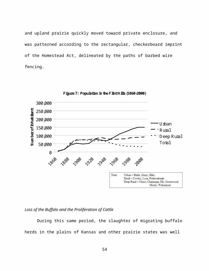
prices, US farmers were encouraged by the Department of Agriculture and lending institutions to
plant “fence row to fence row” to take advantage of the higher prices. Increased demand for
both grains and beef meant that prices for these commodities rose to all-time highs.
The meatpacking industry was also undergoing structural change beginning in the 1960s.
They followed the feedlots in their migration to rural areas of the Great Plains, often for similar
reasons that had led the feedlots to locate there. In their case, new low cost competitors began to
emerge, building one-level, high-tech plants in rural areas close to beef and pork production.
These areas were attractive to meatpackers for a number of important reasons: (1) close
proximity to where many cattle were being finished in large feedlots; (2) close proximity to a
water source, as meat processing is water-intensive; (3) it allowed them to move away from
urban-based, unionized labor, towards communities facing decline and in dire need of job
creation. This meant that workers, either unemployed or dispossessed by the farm crisis, would
work for wages reduced from $15 to under $9 an hour (Stull, Broadway and Griffith 1995). In
the 1970s and 1980s Iowa Beef Packers (IBP) built a number of plants in the High Plains, and
eventually began recruiting from a much broader labor force, most substantially from immigrant
populations.
Interestingly, the cattle inventory in the Flint Hills – as measured before the spring in-
shipments – nearly doubled over the period from 1940 to 1970, from about 460,000 to more than
860,000. This inventory dipped between 1970 and 1990, but was on the rise again in 2000.
Though we are not arguing a direct causal relationship, it does appear that the cattle inventory in
the Flint Hills tracks closely with the trends in per capita beef consumption in the US (see Fig.
10). Thus, it is not the case that the Flint Hills, as a grazing and cattle producing region, no
54

longer has significance in the beef industry; rather it seems that this particular landscape has
developed a niche role in the industry, primarily by focusing on its uniqueness vis-à-vis the
bluestem tallgrasses. The increase in the year-around cattle inventory (i.e., usually local cattle),
suggests that the region has developed the primary roles of (1) cow-calf operations that produce
young cattle, grazed then sold to feedlots, often outside the region; (2) breeding herds designed
to produce animals for sale to others interested in improving their herd stock. In both cases, it is
the weight gains that cattle achieve on the bluestem pastures that are the basic element of the
agricultural economy of the region.
Some feedlot operations gained a foothold in the region around 1960, though the number
of these dwindled as they were uncompetitive with areas west. Moreover, Wood (1980) points
out that the greater precipitation and frequent flooding in the Flint Hills led to substantial manure
spills and large fish kills in the Neosho and Cottonwood Rivers in the 1960s. This, he suggests,
is one of the main reasons for the relatively larger feedlot development in western Kansas and
the high plains.
Wibking’s (1963) general characterization of land use in the Flint Hills can probably be
said to generally have held through the post war era, with some modifications. The southern
third of the Flint Hills emphasizes cow herd production, having greater numbers of over-winter
cattle and relatively less transient cattle. The center third, which includes the large absentee-
owned pastures of Chase County, emphasizes transient grazing with a focus now on producing
young cattle destined for feedlot finishing. The northern third, where there is a fair amount of
bottomland along the Kansas River, emphasizes livestock-farm operations.
In terms of cropping, corn production declined throughout the post war period – no doubt
55

due to the difficulty of competing with massive grain operations in the corn belt as well as
greatly expanded irrigated corn over the high plains aquifer – though some is still grown for local
feeding operations. Wheat is still grown in the region as a cash crop, though acres harvested of
wheat have been in decline since 1980. In 1940, soybean production began to appear in the data.
The acres of soybeans harvested increased steadily to 2000, at which point is was the most
harvested crop in the Flint Hills, slightly above wheat and well above corn in terms of acres
harvested. In the post war period, soybeans have become a major crop globally for their oil and
meal. They are important in the livestock-grain complex and as a cash crop. Corn acres
harvested bottomed out in 1980 and recovered somewhat since then. The increasing presence of
corn in recent years is likely attributable to its role in cropping rotations with soybeans (see Fig.
8).
The most interesting population dynamic in the Flint Hills post 1940 is the contrary
trends in population in urban counties and those we identify as deep rural counties. Figure seven
illustrates the population dynamics of the twelve counties in our study region. As is apparent,
the region as a whole has generally experienced a population increase over the study period.
Yet, a county by county review shows that the increase of population is due to increases in just
three counties. Nine of the twelve counties have experienced some population decline since
1900. This population decline in rural counties is countered by relatively larger population
increases in urban counties. Nine counties are represented by the rural aggregation: Chase,
Chautauqua, Cowley, Elk, Greenwood, Lyon, Morris, Pottawatomie, and Wabaunsee. This line
flattens out after 1890, and then the rural areas begin a slow, steady population decline that
continues to the present. Just three counties are represented by the urban line: Butler, Geary and
56

Riley. These three counties are differentiated from the others because of the presence of the
cities of Manhattan in Riley County, Junction City in Geary County, and the close proximity of
Wichita to Butler County. Junction City and Manhattan are both regional trade and employment
centers, including the Fort Riley military base and KSU respectively. And although the city of
Wichita is just outside the edge of the study region, its growth is affecting development patterns
in the adjacent Flint Hills. It is also the largest metropolitan area near the study region, and is the
largest city in Kansas with a population of over 300,000 in 2000.
As is evident in Figure 7, the growth in urban counties occurs primarily after WWII. And
after 1970, the population of the three urban counties outnumbers that of the other nine
combined, as the urban areas are developing as regional trade centers and metropolitan areas,
while the deep rural areas continue to experience population decline. Population increases in the
urban counties are of special interest to conservationists because of the impact that those social
dynamics have on the landscape. In the next section we look at key conservation issues of
current importance in the region and examine the impact of social dynamics on the legacy of the
tallgrass prairie.
Conservation
Conservation in the Flint Hills has first and foremost taken the shape of land preservation
through scientific research on the tallgrass prairie. This effort has been led in the region by
researchers at Konza Prairie, a 3,487 ha. area of unplowed tallgrass prairie near Manhattan in
southern Riley and adjacent Geary Counties. Konza was established in 1971 through purchase
of the land by The Nature Conservancy, with funding assistance coming from philanthropist
57

Katherine Ordway of New York City. In 1981 Konza became a founding member in the
National Science Foundation’s (NSF) Long Term Ecological Research (LTER) network. The
LTER was formed to “enhance scientific understandings of ecological phenomena and processes
operating over broad spatial scales, as well as long-time scales” (Konza LTER 2004). Although
there are nature trails for the public, access is limited because of its primary role as a research
area – operated in conjunction with KSU. Buffalo were reintroduced at Konza in 1987, and
research is designed to assess the relative roles of climate, fire, and grazing. The experimental
design favors examination over long periods as is evidenced in the design for studying the effects
of prescribed burning. Indeed, while some watersheds are burned annually, others are burned at
intervals of up to 20 years. Combined with grazing, the landscape at Konza has taken on the
appearance of a matrix of experimental plots defined at the watershed level.
Preservation in the form described above was made possible through the private purchase
of land for scientific purposes. The public purchase of a substantial area of tallgrass prairie in
the Flint Hills has not been as easy, and after nearly seventy years of struggle, only recently
(1996) did the Tallgrass Prairie Preserve become part of the National Park system. Beginning as
early as the 1930s, calls were made for the integration of prairie lands into the National Park
Service. The prairie landscape, specifically the tallgrass prairie, was one of the last landscape
examples added to the public holdings. In 1961, Secretary of Interior Stewart Udall visited a
proposed site for a national park in Pottawatomie County in the northern Flint Hills, but the
delegation was unsuccessful in securing the land. The next year President Kennedy called for
the creation of a national park in the tallgrass prairie, but due to political opposition, primarily
from cattlemen, the bill never emerged from subcommittee. Its reintroduction in 1973 was met
58

with more support but also failed to move past the heavy opposition, primarily from ranchers
(Miner 2002).
It was also in 1973 that a group called “Save the Tallgrass Prairie” (STP) was
incorporated and committed to the task of lobbying for the creation of the national park. STP
commonly cited the loss of tallgrass prairie as the result of “powerlines, pipelines, drilling for oil,
reservoirs, roads, and expanding cities” (STP Special Collections). In response, the group
believed that the creation of a national park would preserve the landscape for the enjoyment and
education of the public. Whereas STP was strictly a lobby group, the Tallgrass Prairie
Foundation (TPF) was a group formed in 1976 that took on the larger goals of conservation
beyond legislation. Together, these two groups helped push for protection of the tallgrass prairie
by mobilizing citizens and articulating to the public at large the need for preserving the prairie.
A 1975 Wall Street Journal article assessed the prairie restoration movement across the Plains
states and commented on the increasing desire of Americans to “search for authentic, enduring
things” to possibly “ward off future shock” (Farney 1975). Clearly, the prairie restoration
movement gathered momentum in the 1970s.
Meanwhile, opposition was itself organizing in the form of the Kansas Grassroots
Association (KGA). The KGA opposed government intervention in the protection of the
tallgrass citing two general arguments: (1) ranchers have taken care of the land through
management, and (2) the National Park Service would not be able to do as good of a job as
ranchers. Opponents also argued that a national park would attract tourism and elicit an
unnecessary wave of prairie degradation in the form of hotels, recreational vehicles, and the like.
The KGA itself comprised mostly ranchers and local citizens of the Flint Hills, while the STP
59

and TPF were largely individuals from outside the area. Ranchers in the KGA believed they
were doing everything they could do to preserve the land, which included management strategies
of grazing and prescribed burning dating back several generations. Ranchers wanted to preserve
the legacy of cattle ranching in the area, and fought for its inclusion into the park design.
Overall, opponents distrusted the government and focused their argument on a central message:
“Keep private land in private hands.” This sentiment still echoes in the region, and remains on a
billboard adjacent to Highway 177 in the heart of the Flint Hills.
Proponents for the national park attested that the ranchers were not doing everything in
their control to preserve the land, arguing that year-long stocking, which was increasing at the
time, was resulting in overgrazing in the area. A compromise came between the two groups
when in 1994 the National Park Trust, a private organization, purchased the Z-Bar/Spring Hill
Ranch of northern Chase County, in the heart of the Flint Hills. Two years later the land was
incorporated to the National Park Service, to form the Tallgrass Prairie National Preserve. The
compromise was accepted by ranchers and farmers in Kansas who, according to a Wichita
newspaper “would rather invite the ghost of Karl Marx to dinner than see even a single acre of
private land go to the federal government” (in Miner 2002: 374). Although the land was now
part of the park service and available to the public, over 98% of it would remain in private hands.
Of the 10,894 acres, only 180 were allowed under the legislation to be transferred as the property
of the US (National Park Service website). The rest would remain under the watch of the
National Park Trust. The Tallgrass Prairie National Preserve – a public/private partnership –
sees its mission as being “. . . dedicated to preserving and enhancing a nationally significant
remnant of the tallgrass prairie ecosystem and the processes that sustain it” (National Park
60

Service website). This includes education guides on the site that incorporate both topics of the
natural prairie and the role of cattle ranching. The compromise in the form of the national park
as a government operated but privately owned entity has succeeded in offering to the public an
opportunity to experience and understand the legacy of the tallgrass prairie.
Thus, conservation in the Flint Hills has taken on the short-term goal of preserving land
in both the form of a publicly available national park, and in the shape of a university-run
research station. Scientists are also concerned about the long term effects of biodiversity loss
through landscape transformation by competitor species. The tallgrass legacy is currently
threatened by the advance of two species: sericea lespedeza – a legume that has invasive
characteristics (Fechter 2000) – and red cedar, a woody species that expands in grassland prairie
after suppression of fire (Hoch 2000). The former is example of invasion by a non-native
species, while the latter species is native to the region. Combined, the two species currently
represent serious threats to the tallgrass region. The following section will provide evidence of
how these ecological transformations are the result of social choices, and will conclude by
emphasizing how social decisions in the future will shape the course of this region.
Red Cedar Encroachment
Woody species, such as the red cedar (Juniperus virginiana), have been substantially
increasing in population in the Flint Hills since around 1970 (Owensby et al. 1973). The
majority of this increase has occurred in the northern counties of Riley, Geary and Pottawatomie.
Researchers have shown that the increase in woody species is a result of disruption in the
application of fire, which is in turn related to the social effects of land fragmentation caused by
61

population growth (Hoch 2000). We showed earlier that most of the population growth in the
Flint Hills has occurred in the more urbanized counties, a phenomenon that Hoch (2000)
identified as a predictor for woody species growth. His analysis found a strong relationship (r2
= .81) between population change after 1970 and woody species growth during the period. Hoch
traced several explanations of the increase in woody species, and found that while the
suppression of fire was the primary determinant, a gradual increase in housing starts around
Manhattan was resulting in fragmentation. Fragmentation around the urban fringe appeared in
the form of a matrix of rangeland and housing development, which made prescribed burning
more difficult and risky, and likewise, provided a seed bank of competitor species closer to
native prairie. Studies have consistently shown that woody species dramatically increase on
plots that are unburned, compared to regularly burned areas (Hoch 2000; Knight et al., 1994;
Bragg and Hulbert, 1976).
Early research in woody species invasions in the tallgrass prairie recognized the benefits
of regular fire and grazing on the reduction of competitor species and the resulting maintenance
of biodiversity (Owensby et al. 1973; Bragg and Hulbert 1976). In recent analysis, Hoch (2000)
found that overgrazed areas were susceptible to woody invasion due to a reduction in fuel.
Overgrazed areas lack adequate dry biomass that can sustain a large enough fire to suspend
woody growth. So even if fire remains a part of rangeland management, it may not be sufficient
to protect the tallgrass. If an area has been overgrazed as a result of an excessive stocking rate,
burning that pasture in the subsequent season may not result in the suppression of woody species.
Thus, in order to prevent woody invasion, responsible grazing through rotation must allow an
accumulation of biomass for the eventual application of fire.
62

As indicated above, woody species threaten the Flint Hills area by transforming the
prairie into forest. Estimates are that with thirty years of fire suppression the prairie can develop
a closed canopy (Hoch 2000). Species richness declines as woody species increase and the
productivity of herbaceous species is reduced. The fibrous root system of the red cedar species,
compared to the deep central taproot of other species, gives the species a competitive advantage
on the uplands of the hills that are characterized by shallow, rocky soils. Hoch (2000) concludes
by explaining that the transformation to a red cedar forest is not a transitory stage, but represents
a climax community.
Sericea Lespedeza
We turn now to the history of another invasive species in the region, sericea lespedeza
(Lespedeza cuneata), a.k.a. Chinese bush-clover. Sericea lespedeza is a perennial legume, native
to Asia, that was first planted in the US by the North Carolina Agriculture Experiment Station in
1896 (Ohlenbusch and Bidwell 2001). Twenty years passed, however, before the species was
recognized as beneficial for agricultural production. After it was planted in 1924 at the
Arlington Experiment facility in Virginia, sericea became recognized as having benefits for
erosion control, hay production, wildlife cover, and wildlife food. A characteristic that set
sericea apart from similar species was that it was able to thrive in damaged areas. Sericea was
planted beginning in the 1930s, in areas of Southeast Kansas, primarily on strip-mined land. The
characteristics of mined soil make it highly susceptible to erosion, and pose difficulties in
regenerating cover. Sericea establishes itself very well in such conditions, and although it
usually needs more than thirty inches of precipitation annually, it has drought adaptive
63

characteristics (Ohlenbusch and Bidwell 2001).
For this reason it has been extensively used, not just in Kansas, but throughout the
southeastern US. Sericea has been used as land cover on strip-mined land, highway right-of-
ways, and on land in numerous state and federal reservoirs. In the 1950s sericea was spread to
prevent soil erosion, and was unintentionally spread through the Conservation Reserve Program
(CRP) after the 1985 Farm Bill. A 1980 USDA farmer’s bulletin on the benefits of planting
sericea lespedeza recognized not just its potential as “good ground cover” but found that it makes
“very good hay and pasture” (Guernsey 1980: 1). The planting of sericea lespedeza continues
throughout several states of the country, but in Kansas it has become viewed as invasive.
Sericea lespedeza threatens native species in Kansas, primarily in the Flint Hills, an area
of ecological importance to conservationists because of the pronounced presence of native
tallgrass prairie pasture (Eddy et al. 2003). Over time, sericea has spread unfettered into sections
of native pastureland and currently threatens not just the ecological integrity of the land, but the
economic livelihood of those living there. As the Flint Hills is home to hundreds of thousands of
head of cattle each season, the profitability of operators in the area very much depends on the
quality of grass.
Sericea directly threatens native species in several ways (Ohlenbusch and Bidwell 2001;
Eddy et al., 2003). First, established stands of sericea grow over competing plants and pose a
photosynthetic drain. Second, sericea plants can develop root structures that extend well over
four feet in length which makes it a competitor for water resources. Third, each sericea plant can
produce over one thousand seeds in a given year, and those seeds can survive up to thirty years
before germinating. Fourth, sericea is generally avoided by grazing cattle because of the high
64
presence of tannins in its leaves, making it bitter to the cattle’s palate. And finally, sericea is a
non-native species to the North American continent and therefore lacks natural enemies in the
tallgrass prairie. Rangeland managers are just now beginning to recognize the serious impacts
that sericea could have on species diversity throughout the Flint Hills, and are looking to
researchers for methods of abating its spread.
Sericea lespedeza became listed as a county option noxious weed by the Kansas
Legislature in 1988, and as a statewide noxious weed in 2000 (Ohlenbusch and Bidwell 2001).
These legislative actions at the state level allocate assistance for controlling sericea, and create
efforts for protecting seed distribution through inspection. Kansas State University through its
cooperative extension agencies, and with the help of other universities throughout the region has
been involved in providing information to grassland managers about the technical elements of
sericea, as well as how to control the spread of the species. Control methods developed include
herbicide treatments (Obermeyer et al. 2001), biological treatment using webworms (Eddy et al.
2003), and a mixture of integrated control (Dudley 1998). Controlling the spread of sericea
should be a priority in rangeland management regimes according to Fechter (2000). Fechter
evaluates the economic impacts of ecological disturbances, and finds that land which had been
managed for sericea had almost a 300% greater land value than pastures that went unmanaged
(Fechter 2000).
Efforts against invasive species cannot expect to be eradicating, but should instead focus
on management. There is agreement among scientists that sericea is a species that will persist,
and only through diligent control will its threat diminish (Fechter 2000; Obermeyer et al. 2001).
Biological alternatives to herbicides are judged as safer, yet caution has been voiced regarding
65

over-reliance on biological controls, given the possibility of introducing further invasive species
(Edwards 1998). Goat-herding is another alternative that has shown success in the reduction of
sericea lespedeza, although its widespread adoption in the Flint Hills is not expected because of
the reliance of the region on cattle grazing (Dvorak 1998).
The threat of sericea lespedeza has propelled those interested in conservation into action
to protect the diversity of native species in the region. Terms for controlling sericea lespedeza
have, in the past few years, made their way into lease agreements between landowners and
pasturemen. Sericea affects the decisions of those taking care of the land by affecting both the
grazing and fire elements of the tallgrass ecosystem. Grazing is obviously affected because of
the diminished diversity of native grasses due to competition from the foreign lespedeza species.
Indeed, the domination of sericea lespedeza has the potential for transforming the prairie
ecosystem. Fire regimes are also affected by sericea lespedeza, as scientists have found some
evidence to suggest that burning in the late spring may diminish the ability of sericea to produce
seeds. On the other hand, the same evidence suggests that an early to mid-spring burn, a time
when nearly all Flint Hills pastures are currently burned, may actually enable the species to
advance (Eddy et al. 2003). The survival of the tallgrass, in face of the challenges of sericea
lespedeza, depends upon the work of range managers, legislators, scientists and owners to
negotiate a plan for controlling and preventing further outbreaks of invasive species.
Conclusions
Over the past 200 years, the human-ecosystem dialogue in the tallgrass prairie of the Flint
Hills has been a continuous, iterative process of the mutual shaping of both the societies that
66

have inhabited the region, as well as the ecosystem itself. American Indians managed both the
grasses and the bison through their burning and hunting practices, which contributed to the
perpetuation of the tallgrasses by preventing succession to woody species and encouraging bison
grazing. In turn, the tallgrasses and bison were embedded in the culture and practices of the
Kansa Indians. With Euro-American arrival and expansion the Kansa Indians were more deeply
incorporated into extra-regional trade networks, leading to the eventual over-harvest of buffalo.
Additionally, buffalo herds declined as a result of expansionist US policy, which led to the
exposure of buffalo to short-term, extractive profit-taking in the harvest and trade of hides.
Thus, as the ecosystem was altered with the loss of buffalo, so too was society altered. The
Kansa lost tribal lands as a result of the social organization, institutions and policies of the US
government, and the elimination of buffalo meant that key components of their cultural system
(symbolic practices, protein source, etc.) were also lost. Continuation of Kansa Indian society in
a form significantly similar to that of pre-European contact would be impossible after the 1860s.
The Euro-American settlement period was one of dramatic transition for the social-
ecosystem of the region. American Indian influence on the land declined precipitously, as the
Euro-American settler population boomed during the late 19th century. Dramatic population
increase meant many more farms, more cattle, and increased agricultural production. While the
Kansa Indians had cropped in the bottomlands, their numbers paled in comparison to settler
numbers. Thus, much more bottomland was plowed for cropping. Farmers attempted cropping
in the uplands, but found it exceedingly difficult to subsist as an upland farmer. In a sense, the
upland tallgrass ecosystem resisted human attempts to shape it in the image of eastern croplands.
This resistance essentially forced a reorganization of the spatial patterns of social development
67

inherent in the Homestead Act. That reorganization toward larger farm and ranch sizes included,
most saliently, the development of a ranching system in which cattle – as many as 700,000 in
1900 – were fattened on the upland tallgrasses, putting on 200-300 pounds in a season.
Trends in the patterns of human use and organization of land holdings were enabled and
advanced by the social organization, institutions, and policies of the US government. The
Homestead, Pacific Railroad and other acts were essentially a blueprint to guide westward
expansion, and were of course informed by the world view, experiences, values and economic
culture of the dominant group in US society at the time – primarily white Anglo-Saxon
Protestants. It was a blueprint which was assumed could be superimposed on any lands
encountered in the newly acquired West. It was further assumed that where biophysical systems
did not cooperate, any obstacles could be overcome through new technologies, tools and
techniques, depending on the requirements of resource extraction. Biophysical limits or setbacks
in terms of ecological disturbances would be temporary, as the application of reason, science,
and market forces would resolve problems of production and accumulation.
Yet, as ecosystems are also part of the dialogue, they resist their own transformation, to a
point. In some cases, for example in grasslands that have been plowed and continuously
cropped, the transformation is dramatic. The tallgrasses of the Flint Hills appeared to exhibit
remarkable resilience in periods of overgrazing and drought. Especially during the droughts of
the 1930s, when cattle were moved into the region from drier grasslands, and when they were
heavily overgrazed as a result, the grasses were able to recuperate even when some thought they
had been irreversibly depleted. This resilience also enabled production, employment, and
markets, to continue in periods when it was not possible in other areas. The notion of resilience
68

and the restorative ability of the bluestem pastures is thus an important theme in the narrative of
this environment.
Changes in the extra-regional context can also drive change in the “local” social-
ecosystem. World Wars I and II both drove demand and production in the Flint Hills.
Moreover, the emergence of the grain-livestock complex in the post WWII period, in which feed
lots and meat packers moved to areas over the high plains aquifer, also increased the competitive
pressure on the tallgrass prairie. In an era of irrigated, overproduced and thus relatively low cost
feed grains, and expensive pasture lease costs, grass feeding appears comparatively expensive.
Beef cattle are now much younger at slaughter, resulting from efforts to fatten them more
quickly. From the dominant economic viewpoint, cattle are seen as a commodity in which one
invests capital, and does not realize a return on that investment until the commodity is sold. If
this can be accomplished in eighteen months as opposed to two to three years, the return can be
realized more quickly. Following this rationale, the sooner cattle can be grain-fed in a feedlot,
the more beneficial for the investor. Thus, while grass-feeding still plays a role in the beef
industry, it is now a more specialized role, in contrast to the traditional, general grass-fattening
over one or more grazing seasons.
Finally, while it seems clear that the tallgrass prairie exhibits remarkable resilience and
recuperative abilities in conditions of drought and over-grazing, it is not yet clear if those same
characteristics will provide defenses to invasive species. In the case of red cedar, fire
suppression near urban edges is a social choice related to urban development patterns, profit
motives, human understanding of ecosystem processes and aesthetic sensibilities. Whether
policy makers will understand and be able to effectively address this issue through urban
69
planning boards and public policy remains to be seen. In the case of sericea lespedeza,
researchers, ranchers, landowners and others have now recognized it as a major threat to the
tallgrass prairie, and are mobilizing institutional resources to address it. That the approach to
sericea is now viewed as one of permanent management – as opposed to eradication – is a vivid
example of social-ecosystem dialogue.
References
Aldous, A. E. 1933. “Bluestem Pastures.” In the Twenty-Eighth Biennial Report of the Board
of the Kansas State Board of Agriculture (To The Legislature of the State for the Years
1931 and 1932), 184-191.
Aldous, A.E. 1934. “Effect of Burning on Bluestem Pastures.” Kansas State University.
Technical Bulletin #88. November 1934.
Aldous, A. E. 1935. “The Kansas Pasture Situation.” The Kansas Stockman 19(16): 3, 14.
Allaby, Michael. 1998. A Dictionary of Ecology. New York: Oxford University Press.
Anderson, Kling. 1940. “Deferred Grazing of Bluestem Pastures.” October, 1940 Bulletin 291;
Agricultural Experiment Station; Kansas State College of Agriculture and Applied
Science, Manhattan, Kansas.
Anderson, Kling. 1946. “Range and Pasture.” Report of the Kansas State Board of Agriculture,
Soil Conservation in Kansas. Vol. LXV (271): 92-117.
Bell, Michael. 2004. An Invitation to Environmental Sociology. Thousand Oaks: Pine Forge.
Blackmar, F. 1912. Kansas: A Cyclopedia of State History. Chicago: Standard Publishing.
Borchert, John R. 1950. “The Climate of the Central North American Grassland.” Annals of the
70

Association of American Geographers 40(1): 1-39.
Bragg, T. and L.C. Hulbert. 1976. “Woody Plant Invasion of Unburned Kansas Bluestem
Prairie.” Journal of Range Management 29(1): 19-24.
Briggs, John M., Greg A. Hoch and Loretta C. Johnson. 2002. “Assessing the Rate,
Mechanisms, and Consequences of the Conversion of Tallgrass Prairie to Juniperus
virginiana Forest.” Ecosystems 5: 578–586.
Bryant, K. 1974. History of the Atchison, Topeka and Santa Fe. New York: Macmillan.
Burns, L. 1989. A History of the Osage People. Fallbrook, CA: Ciga Press.
Coppedge, B.R., Shaw, J.H. 1998. “Bison Grazing Patterns on Seasonally Burned Tallgrass
Prairie.” Journal of Range Management 51 (May): 258-264.
Cronon, William. 1983. Changes in the Land: Indians, Colonists, and the Ecology of New
England. New York: Hill and Wang.
Cronon, William. 1992. Nature’s Metropolis: Chicago and the Great West. New York: W.W.
Norton.
Dudley, D. 1998. “Integrated Control of Sericea Lespedeza in Kansas.” Master’s Thesis,
Kansas State University.
Dvorak, J. 1998. “In fields overrun by weeds, goats gobble up the problem.” The Kansas City
Star. September 8. 1998: A1.
Edwards, K. 1998. “A Critique of the General Approach to Invasive Plant Species.” In
Starfinger, U., Edwards, K., Kowarik, I., and Williamson, M. (eds.), Plant Invasions:
Ecological Mechanisms and Human Responses. Backhuys: Leiden, Netherlands, 85-94.
Eddy, T., Davidson, J., Obermeyer, B. 2003. “Invasion Dynamics and Biological Control
71

Prospects for Sericea Lespedeza in Kansas.” Great Plains Research 13 (Fall): 217-230.
Farney, D. 1975. “Trying to Restore a Sea of Grass.” Wall Street Journal June 6, 1975.
Farney, D. 1980. “The Tallgrass Prairie: Can It Be Saved?” National Geographic 157: 37-61.
Fechter, R. 2000. “The Economic Impacts of Control of Sericea Lespedeza in the Kansas Flint
Hills.” Master’s Thesis, Kansas State University.
Flores, D. 1998. “Bison Ecology and Bison Diplomacy in the Southern Plains from 1800 to
1850.” In James Sherow (ed.), A Sense of the American West. Albuquerque: University
of New Mexico Press.
Friedmann, Harriet. 1991. “Changes in the International Division of Labor: Agri-food
Complexes and Export Agriculture.” In William H. Friedland, Lawrence Busch,
Frederick H. Buttel, and Alan P. Rudy (eds.), Towards a New Political Economy of
Agriculture. Boulder, Colorado: Westview Press, 65-93.
Gard, W. 1954. The Chisholm Trail. Norman, OK: University of Oklahoma Press.
Gille, F. 1999. Encyclopedia of Kansas Indians: Tribes, Nations, and People of the Plains.
Volume One. Michigan: Sommerset Publishers.
Guernsey, W. 1980. “Sericea Lespedeza: Its Use and Management.” USDA Farmer’s Bulletin
No. 2245.
Haucke, F. 1952. Kansas Historical Quarterly. Vol. 20.
Hayden, Bruce P. 1998. “Regional Climate and the Distribution of Tallgrass Prairie.” In Alan
K. Knapp, John M. Briggs, David C. Hartnett, and Scott L. Collins (eds.), Grassland
Dynamics: Long-Term Ecological Research in Tallgrass Prairie. New York: Oxford,
19-34.
72
Hickey, J. V. and C. E. Webb (1987). “The Transition from Farming to Ranching in the Kansas
Flint Hills.” Great Plains Quarterly 7: 244-255.
Hilton, H. F. 1929. “The Bluestem Limestone Pastures of Kansas.” Topeka, KS: Kansas State
Board of Agriculture.
Hoch, G. 2000. “Patterns and Mechanisms of Eastern Red Cedar Expansion into Tallgrass
Prairie in the Flint Hills, KS.” Master’s Thesis, Kansas State University.
Hoy, J. 1989. “Controlled Pasture Burning in the Folklife of the Kansas Flint Hills.” Great
Plains Quarterly 9(4): 231-238.
Hoy, J. 1995. Cowboys and Kansas: Stories from the Tallgrass Prairie. Norman, OK:
University of Oklahoma Press.
Isern, T. 1985. “Farmers, Ranchers, and Stockmen of the Flint Hills.” Western Historical
Quarterly 16(3): 253-264.
Kansas City Star. 1969. “The Flint Hills Would Still Make a Great Prairie Park Site.”
3/24/1969.
Kerr, Norwood Allen. 1987. The Legacy: A Centennial History of the State Agricultural
Experiment Stations, 1887-1987. Columbia, MO: Missouri Agricultural Experiment
Station, University of Missouri-Columbia.
Knapp, A.K., Blair, J.M., Briggs, J.M., Collins, S.L., Hartnett, D.C., Johnson, L.C. and Towne,
E.G. 1999. “The Keystone Role of Bison in North American Tallgrass Prairie.”
Bioscience 49(1): 39-50.
Knapp, A. K. and T. R. Seastedt. 1998. “Introduction: Grasslands, Konza Prairie, and Long-
Term Ecological Research. Grassland Dynamics: Long-Term Ecological Research in
73

Tallgrass Prairie.” In Alan K. Knapp, John M. Briggs, David C. Hartnett, and Scott L.
Collins (eds.), Grassland Dynamics: Long-Term Ecological Research in Tallgrass
Prairie. New York: Oxford, 3-15.
Knight, C.L., Briggs, J.M., and Nellis, M.D. 1994. “Expansion of Gallery Forest on Konza
Prairie Research Natural Area, Kansas, USA”. Landscape Ecology 9(2): 117-125.
Kollmorgen, Walter M. 1969. “The Woodsman’s Assaults on the Domain of the Cattleman.”
Annals of the Association of American Geographers 59(2): 215-239.
Kollmorgen, W. and D. Simonett 1965. “Grazing Operations in the Flint Hills-Bluestem
Pastures of Chase County, Kansas.” Annals of the Association of American Geographers
55(2): 260-290.
Konza LTER. 2004. www.konza.ksu.edu/general/knzlter.html Accessed 10/7/2004.
Kuchler, A. W. 1974. “A New Vegetation Map of Kansas.” Ecology 55(3): 586-604.
Malin, James C. 1942. “An Introduction to the History of the Bluestem-Pasture Region of
Kansas.” Kansas Historical Quarterly 11(1): 3-28.
Malin, James C. 1984. History and Ecology: Studies of the Grassland. Lincoln: University of
Nebraska Press.
Miner, Craig. 2002. Kansas: The History of the Sunflower State 1854-2000. Lawrence:
University of Kansas Press.
National Park Service, Tallgrass Prairie. http://www.nps.gov/tapr/ Accessed (June 28, 2006).
Niles-Beattie, A. 1996. Pioneers of the Flint Hills: From the Earliest Times to 1900. Hillsboro,
KS: Hearth Publishing.
74

Norgaard, Richard B. 1994. Development Betrayed: The End of Progress and a Coevolutionary
Revisioning of the Future. London: Routledge.
Obermeyer, B., J. et al. 2001. “Sericea Lespedeza and Herbicides: Cost Effective Controls.”
KSU Agriculture Experiment Station, Manhattan, KS.
Ohlenbusch, P. D. and T. Bidwell. 2001. “Sericea Lespedeza: History, Characteristics, and
Identification.” KSU Agriculture Experiment Station, Manhattan, KS.
Ohlenbusch, P.D. and Hartnett, D.C. 2001. “Prescribed Burning as a Management Practice”
Kansas State University Agriculture Experiment Station and Cooperative Extension,
Publication L-815.
Oviatt, Charles G. (Jack). 1998. “Geomorphology of Konza Prairie.” In Alan K. Knapp, John M.
Briggs, David C. Hartnett, and Scott L. Collins (eds.), Grassland Dynamics: Long-Term
Ecological Research in Tallgrass Prairie. New York: Oxford, 35-47.
Owensby, C.E., Blan, K.R., Eaton, B.J., and Russ, O.G. 1973. “Evaluation of Eastern Redcedar
Infestations in the Northern Kansas Flint Hills.” Journal of Range Management 26(4):
256-260.
Parrish, F.L. 1956. “Kansas Agriculture.” In J.D. Bright (ed.), Kansas: The First Century.
New York: Lewis Hist Publishers.
Paul, R. 1998. The Far West and the Great Plains in Transition: 1859-1900. Norman, OK:
University of Oklahoma Press.
Petrowsky, C.L. 1968. “Kansas Agriculture Before 1900.” Ph.D Diss., University of
Oklahoma.
Pyne, S.J. 1984. Introduction to Wildland Fire: Fire Management in the United States. New
75

York: Wiley-Interscience.
Reichman, O. J. 1987. Konza Prairie: A Tallgrass Natural History. Lawrence, KS: University
Press of Kansas.
Risser, Paul G. 1981. The True Prairie Ecosystem. New York: Academic Press.
Sanderson, Steven E. 1986. “The Emergence of the ‘World Steer’: Internationalization and
Foreign Domination in Latin American Cattle Production.” In F. La Mond Tullis and W.
Ladd Hollist (eds.), Food, the State, and International Political Economy. Lincoln, NE:
University of Nebraska Press.
Sauer, Carl O. 1975. “Man’s Dominance by Use of Fire.” Geoscience and Man 10:1-13.
Save the Tallgrass Prairie Collection. Special Collections, Hale Library. Kansas State
University: Manhattan, KS.
Schoewe, W. H. 1949. “The Geography of Kansas.” Transactions of the Kansas Academy of
Science 52(3): 261-333.
Schoewe, W. H. and J. C. Frye. 1953. “The Basis for Physiographic Subdivision of Kansas.”
Transactions of the Kansas Academy of Science 56(2): 246-252.
Self, H. 1978. Environment and Man in Kansas: A Geographical Analysis. Lawrence: Regents
Press of Kansas.
Sherow, James E. 1992. “Workings of Geodialectics: High Plains Indians and Their Horses in
the Region of the Arkansas Valley, 1800-1870.” Environmental History Review 16: 61-
84.
Snipp, M. 1989. American Indians: The First of This Land. New York: Russell Sage.
76

Stull, Donald D., Michael J. Broadway, and David Craig Griffith. 1995. Any Way You Cut It:
Meat Processing and Small-Town America. Lawrence, KS: University Press of Kansas.
Tallgrass Legacy Alliance. 2004. www.r6.fws.gov/pfw/kansas/ks7.htm Accessed 10/7/2004.
Unrau, W. 1971. The Kansa Indians: A History of the Wind People, 1673-1873. Norman, OK:
University of Oklahoma Press.
Unrau, W. 1991. Indians of Kansas: The Euro-American Invasion and Conquest of Indian
Kansas. Topeka: Kansas State Historical Society.
U.S. Census 1860.
U.S. Congress. 1862. “An Act Donating Public Lands to the Several States and Territories
Which May Provide Colleges For the Benefit of Agriculture and the Mechanic Arts.”
U.S. Statutes 12: 503.
Vandergriff, J. 1973. The Indians of Kansas. Emporia, KS: Heritage of Kansas Publication.
Vinton, M.A., Hartnett, D.C., Finck, E.J. and Briggs, J.M. 1993. “Interactive Effects of Fire,
Bison Grazing and Plant Community Composition in Tallgrass Prairie.” American
Midland Naturalist 129: 10-18.
Wibking, Robert Kenton. 1963. “Geography of the Cattle Industry in the Flint Hills of Kansas.”
Ph.D. Diss., University of Nebraska.
Wood, Charles L. 1980. The Kansas Beef Industry. Lawrence: Regents Press of Kansas.
Worster, Donald. 2003. “The Dirty Thirties: A Study in Agricultural Capitalism.” In Rita
Napier (ed.), Kansas and the West: New Perspectives. Lawrence: University Press of
Kansas, 318-333.
77