air: the medium for weather & climatecas.umkc.edu/geosciences/geopaths/pdfs/geopaths lesson...
TRANSCRIPT

Air: The Medium for Weather & Climate
A very mature storm system actively spinning off funnel clouds and tornadoes

2
Lesson 1 Air Pressure
Exploration Phase: Examine the diagram below. Suppose you placed a jar over a lit candle in a pan of water. What do you think would happen? Write your predictions below.
After you have completed your predictions, perform the above experiment. Write your observations below.

3
If you were careful with your observations you noticed that several things occurred. Two questions that might come to mind are (1) What caused the flame to go out, and (2)What caused the water to rise? What are some possible reasons for each of these observations? Carefully repeat the experiment several times only after you have provided several reasons for the phenomenon. Write additional observations below. Reasons Additional Observations

4
Consider the following hypotheses... Hypothesis 1 If oxygen is being used and thereby decreasing the
volume of air in the jar,
Experiment and we compare the water rise with 1 candle and 3 candles,
Expected Outcome then the water level should be the same for both 1 candle and 3 candles because the amount of oxygen remains constant.
In other words, Oxygen is being used thereby decreasing the volume of air in the jar, then increasing the number of candles should not increase the level of the water. Explain why this statement is or is not true.

5
Suppose that when oxygen is being used, carbon dioxide is being produced, thereby maintaining the amount of air in the jar and the heat/cool process is causing water to rise… Hypothesis 2 If the heat from the candles causes the air to expand,
pushing air out, and the air cools after the candle goes out causing a partial vacuum, allowing water to be pushed back in
Experiment and we compare the water rise with 1 candle and 3 candles,
Expected Outcome then the water level should rise higher with 3 candles

6
than 1 candle because of the greater amount of heat produced.
In other words when the jar is placed over the candle the temperature of the air increases causing the air to expand. Air moves out of the jar which decreases the pressure inside the jar. Water moves into the jar because the pressure in the jar is less than the pressure outside the jar. If this true, what would happen if you increased the number of candles? Explain.
Perform the above experiment. Record your results below.

7
Do the results of your experiment support the first or second hypothesis? Explain.

8
CONCEPT INTRODUCTION The water moved into the jar because of a change in air pressure. Scientists use the molecular theory of gases to explain air pressure, which assumes that air is composed of moving particles that have weight and can bounce into objects (such as water) and push them out of the way. Explain the exploration activity using the terms air pressure and particles of air.
A common misconception is that water is sucked up into the jar. The molecular theory of gases implies that suction does not exist. Particles can not pull they can only push. The water was pushed into the jar by the higher pressure moving particles on the outside of the jar rather than being sucked upward by some nonexistent force inside the jar. Therefore, science does not "SUCK" (a joke). Suck is a common word in our vocabulary that helps us explain common everyday events. Suck is not a scientific term, it is a common everyday term. Explain, using scientific terms, how one removes water from a cup using a straw.
9
APPLICATION 1 Use the same set up as in exploration minus the candles. With a syringe and piece of tubing fill the jar with water while leaving the neck of the jar in the pan of water. Explain how you filled the jar using scientific terms.

10
APPLICATION 2 Fill a glass completely with water. Cover the glass firmly with the palm of your hand and quickly turn the glass upside down as illustrated below. Remove the palm of your hand carefully from below the cardboard and record your observation.
Force pushing down
Force pushing up
Repeat the experiment with the glass half full of water. Did you obtain the same result? Now replace the cardboard with a piece of aluminum sheet metal, fill the glass completely with water and repeat the experiment. Do the experiment a fourth time but with the glass half full of water and record your observations.

11
Thinking Activity:
1. There are two forces acting on the index card; one pushes up and one pushes down (see the arrows in the above diagram).
a. What is producing the force that is pushing down on the card?
b. What is producing the force that is pushing up on the card?
c. How do you explain the “mystery” of the water remaining in place inside the inverted glass?
d. Why was the result for the experiment was different the fourth time when the glass was filled halfway and a piece of aluminum was used instead of cardboard?
12
Terms: Combustion, oxygen, carbon dioxide, heat, pressure, expansion, contraction, vacuum, temperature, air pressure, air particles, molecular theory, molecules, sunction, cardboard, aluminum sheet metal,

13
Teacher Notes:
Explanation: An increase in volume obtained from the bulge in the cardboard causes the necessary pressure drop in the glass and allows water to remain in the glass. The experiment works just as well when the glass is full, half full, or almost empty. But if the cardboard is replaced with a piece of aluminum sheet metal, the water will remain in the glass only when the glass is full. This is caused by the difference in flexibility between the cardboard and the aluminum sheet. The cardboard bulges more easily than the aluminum sheet and thus causes a greater change in the volume of air in the glass. When an aluminum sheet is used, the increase in air volume is caused by the slight descent of the water from the glass.

14
Lesson 2
Air Pressure and Altitude
Exploration:
Activitiy 1: Using a hammer and nail, make three holes of the same size in the side of a tall tin can. You can also use a 1 liter plastic soda bottle if you have a drill to make holes in the side of the plastic bottle. Punch a hole near the top, another hole in the middle, and a third one near the bottom of the can. Pour water from a faucet into the can or bottle and keep it full while the water is running out through the holes as show in the diagram below.
Q1. What did you observe?
Q2. Explain your observation using the concept of pressure.
15
Activity 2: Using a hammer and nail, punch 3 or 4 evenly spaced holes around the base of a tin can or plastic soda bottle. Fill the can with water over the a sink and leave the faucet running as shown in the diagram below.
Q1. What did you observe?
Q2. Explain your observation using the concept of pressure.
Activity 3: Insert a small metal or glass tube into a stopper and connect one-end of a rubber tubing to the glass or metal tube. Make sure the connection is air tight. Next, fill a flask about a quarter way with water and cork the flask with the stopper. Connect the other end of the rubber tubing to a hand operated vacuum pump. Make sure that the connection is air tight. Place the flask on hot plate and bring the water to boil. Carefully remove the flask from the hot plate just when the water starts boiling and set it on a pad on your lab table for about a minute. Begin to operate the hand vacuum as vigorously as you can and watch what happens to the water in the flask. Record your observations.

16
Teacher Notes: Q1. What does your experiment teach us about the relationship between temperature and air pressure? Concept Introduction: A critically important aspect of air pressure is its systematic decrease with
altitude. As we drive up into the mountains or take off in an airplane, our ears
usually pop several times. This popping happens as our ears adjust to the lower air
pressures at higher elevations. Our ears also pop when we drive down a
mountainside or descend toward the airport in an airplane--our ears are adjusting
to the higher air pressures at lower elevations. You have to be at sea level to
experience an air pressure of 14.2 pounds per square inch. Those who live “a mile
high” (at around 5300 ft), experience an air pressure of only about 13 pounds per
square inch. The higher pressure at lower levels of the atmosphere occurs partly
because air is quite easy to compress. We do it every time we pump air into a
bicycle tire. When we raise the handle, we let in fresh air. When we push the
handle down, we squeeze that air, forcing it into the tire. As we repeat the
process, we squeeze more and more air into the same amount of space (the inside

17
of the tire). Liquids, such as the oceans, do not compact as much with increasing
pressure. Gases, on the other hand, are perfectly “compressible.” This means that,
the harder you squeeze them, the smaller and denser they get. REMEMBER: it is
NOT the individual molecules that are expanding and contracting--it is the
distances between them that are getting larger and smaller. This is true no matter
what is causing the expansion/contraction (temperature or pressure changes).
Application Phase: Combine one teaspoon of baking soda in a beaker or flask with about 100 ml of vinegar to produce carbon dioxide. Stand 3 or 4 short birthday cake candles in a line inside a narrow cardboard trough. Seal one end of the cardboard trough and tilt it at an angle of about 30 – 45 degrees. Use matches to light the candles and carefully pour the carbon dioxide from the flask into the trough. Observe and record what happens.
Q1. What do you was responsible for extinguishing the candles? Q2. Now imagine a similar line up lit candles in front of the freezer or fridge. What do you think will happen to the candle when the freezer or fridge door is opened? Explain your answer

18

19
Terms: Pressure, altitude, boiling point, heat, vacuum pump, temperature, carbon dioxide, baking soda, vinegar, combustion,

20
Teacher Notes: Water boils at 100° C at sea level (that would be 212° F). The boiling point drops about 1° C for every 165 meters of elevation (1° F for every 889 feet). This means that the higher you are, the cooler the water is when it boils, so that is why you have to take longer to cook food at higher elevations (and a pressure cooker helps you cook faster).
Combining baking soda and vinegar creates a chemical reaction that produces carbon dioxide gas (CO2). Unlike oxygen gas (O2), CO2 is not readily combusted by the flame. It is also heavier than the other gasses which make up our atmosphere. Nitrogen gas (N2 - ~75% of the atmosphere) has an atomic weight of 30; O2 - a weight of 32 (~20% of air). CO2 has a weight of 44 (C = 12 a.m.u + (2 O = 2X16 a.m.u) = 44). It thus sinks to the bottom of your jar when evolved from the vinegar/baking soda mixture. If enough is created, it will reach the level of the flame. When the candle can no longer continue combusting its material with oxygen, it goes out.

21
Lesson 3
Air Pressure & Air Movement
Exploration Phase:
Activity 1:
Equipment: 2 tubes of clear plastic about 3 feet long 2 caps for the tubes 2 ring stands 2 test tube clamps for ring stands 1 pkg of incense sticks (for smoke source) 2 glass beakers
1. Assemble the equipment as indicated in the diagram below.
2. Put caps on top of the tubes. Light incense and fill the tubes with smoke from the bottom by tilting tubes and inserting stick 3-4 inches up the column.

22
3. Tilt the smoke-filled tubes and gently place the glass beaker under them. Fill one beaker with ice and fill the other with hot water as shown in Figure below.
4. Record your observations for about 5 to 10 minutes. Caps may be taken off after five minutes to and observe what happens to the smoke.
Questions
Q1. Does the smoke behave air would? Compare the movement of the air in the tubes.
Q2. Did you observe that the air in one tube sank and the air in the other rose? Use the concept of atmospheric pressure to explain the two air motions.

23
Q3. After this exploration activity, what else can you say about how any cooled air and any warmed (hot) air should move? Use your observations to support your answer.
Activity 2:
Equipment: 1 ¾ inch diameter tube of clear plastic about 3-4 feet long 2 caps for the tubes 2 ring stands 2 test tube clamps for ring stands 1 pkg of incense sticks (for smoke source) 1 propane cylinder (or similar source of flame)
1. Set up the tube such that is lies horizontal and clamped to the test tube stands. Put caps on one end of the tube.
2. Light incense and fill one side of the tube with smoke by inserting the incense stick 3-4 inches into the tube. Remove the stick after a reasonable amount of smoke accumulates and place the send cap on the open end of the tube.
3. Carefully ignite a flame using the propane cylinder and move it close to the opposite end of the tube. Gently heat the air in the tube for about 5 minutes. Observe and record what happens.

24
Q1. Using what you've learned from this experiment, explain what causes the wind to blow. Q2. Why do you think that we sometimes have gentle breezes and sometimes have
gale-force winds?

25
Concept Introduction:
Air pressure is not the same everywhere. It varies from place to place and
that variation is gradual, not abrupt. For example, if the air pressure is 1007 mb in
one place and 990 mb in another, the air pressure will not suddenly jump from 990
mb to 1007 mb in one spot. Rather, there will be a more-or-less gradual change in
pressure, called a pressure gradient, between the two places (See the diagram
below). The air pressure gradient is analogous to the slope of the ground between a
hilltop and a valley bottom.
990 mb
A
B
A Hilltop
Valley
slope
1007 feet
B
990 feet
Analogy to the ground surface
Air Pressure Gradient
1007 mb1006 mb
1005 mb1004 mb
1003 mb1002 mb
1001 mb1000 mb
999 mb998 mb
997 mb996 mb
995 mb994 mb
993 mb992 mb
991 mb
..
..
..
..
..
.. .
..
.
Whenever there is a pressure gradient between two locations, air tries to
move in such a way as to equalize the pressure. For example, the air inside a fully
inflated bicycle tire has a pressure of 65–100 pounds per square inch (depending on
the type of tire). At sea level, the air surrounding this tire has a pressure of only
about 14.2 pounds per square inch. Thus there is a significant difference in air

26
pressure inside and outside of the tire. This difference can be maintained only as
long as the tire has no leaks. But if you pop a tire on your bicycle, allowing air to
flow in and out of the tire, air will rush out of the tire until the air pressure inside
the tire is the same as the air pressure outside the tire. Similarly, when you blow
up a balloon and pinch the opening closed, the air pressure inside of the balloon is
higher than the air pressure outside of the balloon. As soon as you let go of the
opening, air rushes out of the balloon until the pressure inside the balloon is the
same as the pressure outside. Similarly, a vacuum-packed can, such as a can of
coffee grounds or tennis balls, has almost no air inside of it and therefore the air
pressure inside the can is extremely low. As soon as you open the can, air suddenly
rushes inside the can until the air pressure inside the can is the same as the air
pressure outside the can.
In summary, air tends to flow from a region of high pressure to a region of
low pressure. This is an incredibly important principle in meteorology. It is THE
explanation for why the wind blows--much more on this later. Whenever there is a
pressure difference between one location and another, we call the force that
tends to move the air from the region of high pressure to the region of low
pressure the pressure gradient force. The steeper the pressure gradient (i.e. the
more rapidly air pressure changes with distance), the stronger the pressure
gradient force and the faster the air will flow. This is analogous to the slope of a
ski hill. The steeper the slope of the hill, the faster your snow board or skis will
carry you down it. Earth's atmosphere is made of four layers. We will concentrate on just the first two lowest layers.
(1) The troposphere is the lowermost layer of the atmosphere; it is where we live and where most interesting “weather” (clouds, wind, storms, etc.) occurs.
(2) The stratosphere is immediately above the troposphere; it contains the ozone layer.
27
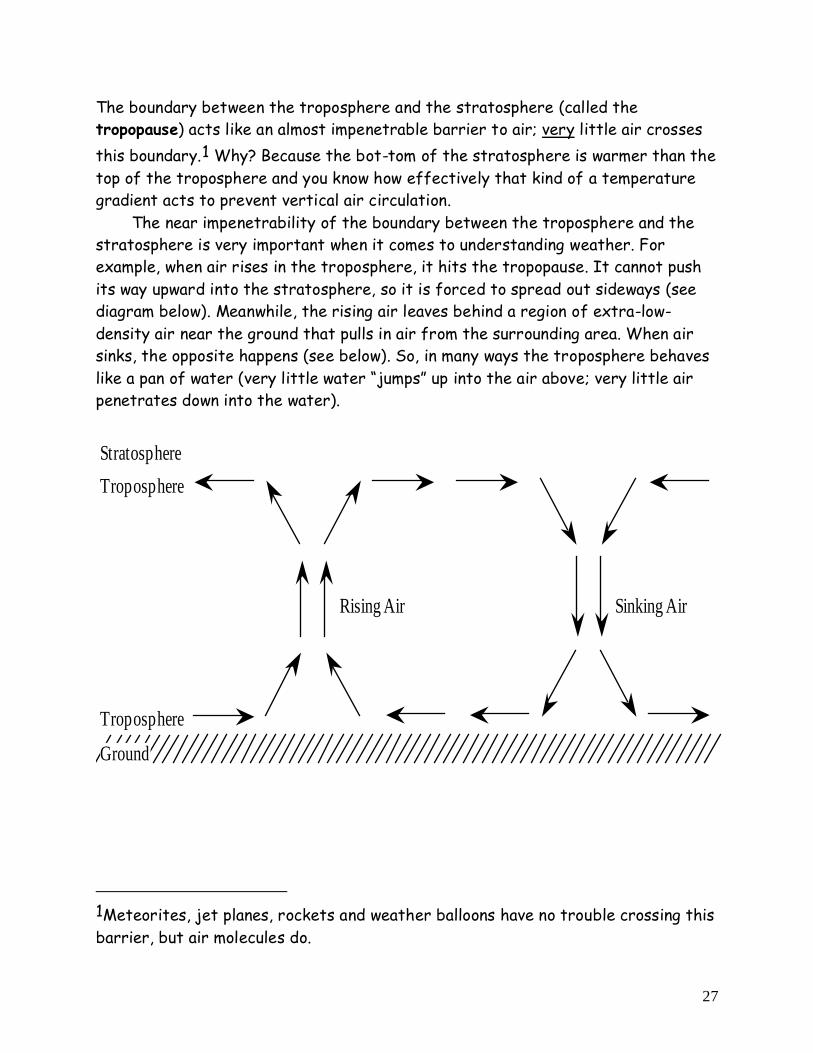
The boundary between the troposphere and the stratosphere (called the tropopause) acts like an almost impenetrable barrier to air; very little air crosses this boundary.1 Why? Because the bot-tom of the stratosphere is warmer than the top of the troposphere and you know how effectively that kind of a temperature gradient acts to prevent vertical air circulation. The near impenetrability of the boundary between the troposphere and the stratosphere is very important when it comes to understanding weather. For example, when air rises in the troposphere, it hits the tropopause. It cannot push its way upward into the stratosphere, so it is forced to spread out sideways (see diagram below). Meanwhile, the rising air leaves behind a region of extra-low-density air near the ground that pulls in air from the surrounding area. When air sinks, the opposite happens (see below). So, in many ways the troposphere behaves like a pan of water (very little water “jumps” up into the air above; very little air penetrates down into the water).
StratosphereTroposphere
Rising Air Sinking Air
Troposphere
Ground
1Meteorites, jet planes, rockets and weather balloons have no trouble crossing this barrier, but air molecules do.

28
Application Phase:
In this activity, we model the air movements that occur when air is cold in one place (for example, at the poles) and hot in another (for example, at the equator). We use water to represent air in the lower part of the atmosphere (i.e. the troposphere) because it's easier to observe the motion of water than it is to observe the motion of air. Keep in mind, however, what each part of the model represents:
Part of Model Real Thing That it Represents
Bottom of cake pan The Earth's surface
Water in the cake pan The lowermost layer of the atmosphere (the troposphere)
Air above the cake pan The stratosphere (the layer of the atmosphere directly above the troposphere)
Bag of ice Cold ground near the north (or south) pole
Candles Warm ground near the equator
Materials: large rectangular clear glass cake pan (15x10x2) red and blue food coloring 2 eye droppers 3 small candles (the kind that are used to keep food warm) box of matches three Styrofoam cups ice gallon-size Ziploc bag red and blue colored pencils
Activity 1. Fill the cake pan with water. 2. Place the three Styrofoam cups, upside down on the lab table, forming a
triangle that the cake pan can rest on and remain stable. Place the cake pan on the three cups.

29
3. Light the candles and place them in a line underneath one end of the cake pan. This end of the cake pan represents the warm equatorial regions of the earth.
4. Put some ice in the large Ziploc bag and place the bag of ice in the cake pan on the side opposite the candle. This end of the cake pan represents the cold polar regions of the earth. The set up should look like the diagram below.
Bag of Ice
CandlesCupCup Cup
Questions 1. On the diagram above, use arrows to show any (invisible) motion of the water
that you think may be occurring, due to the temperature differences across the cake pan.
2. Explain why you think the water is moving this way. More Activity 5. After the cake pan has rested undisturbed for a few minutes, place several
drops of blue food coloring in a line along the bag of ice, near where it touches the water (see diagram below).

30
6. Carefully place several drops of red food coloring into the water in a line along the BOTTOM of the cake pan directly above the candles (see diagram below).
7. Watch the motion of the colored water and answer the following questions. More Questions 3. On the diagram below, use arrows and colored pencils to show the motion of the
red and blue water in the cake pan.
4. Did the motion you observed match your predictions (Question #1 above)? If not, explain why the motion that you DID observe occurred. 5. What can you conclude about the density of the water near the candle as
compared to the density of the water near the ice? Where is the water more dense? Why?

31
For questions 6–13 below, imagine that you are a tiny water-breathing person, usually walking around on the bottom of the cake pan but sometimes “flying” up in the water in an airplane.
6. As you fly around in the “air” (the water in the cake pan), near the top of the troposphere, where do you feel the highest water pressure, near the ice or near the candle? Why? Hint: remember the recent lecture on wind.
7. On the diagram of the cake pan (previous page), place an “H” where the
pressure aloft (i.e. near the top of the water) is highest and an “L” where the pressure aloft (i.e. near the top of the water) is lowest.
8. As you walk around on the “ground” (the bottom of the cake pan), where do you feel the highest water pressure, near the ice or near the candle? Why?2
9. On the diagram of the cake pan (previous page), place an “H” where the surface
pressure (i.e. at the “ground”) is highest and an “L” where the surface pressure (i.e. at the “ground”) is lowest. 10. When you “fly” (in an airplane) up to the upper part of the water “atmosphere” near the center of the cake pan, which way do you feel the “wind” blow? (circle your answer)
2In water as well as in air, the pressure you experience is proportional to the weight of the water or air above you. In other words, it is proportional to the number of molecules of air or water above you.

32
from the pole (ice) to the equator (candle) / from the equator (candle) to the pole (ice)
11. When you stand on the “ground,” at the center of the cake pan, which way do you feel the “wind” blow ? (i.e. which way is water flowing?). Circle your answer.
from the pole (ice) to the equator (candle) / from the equator (candle) to the pole (ice)
12. When you stand on the “ground”, near the “equator,” do you feel much wind? Why or why not? (Hint: remember that “wind” is defined as a horizontal flow of air)
13. When you stand on the “ground”, near the “pole,” do you feel much wind? Why or why not?
Questions 14–18 below ask you to apply what you've learned from the behavior of the water in the cake pan experiment to an analysis of the behavior of the air in the upper part of the troposphere.
14. Where the air is rising, the ALOFT air pressure is higher / lower than it is at the same level wherever air is not rising.
15. Where the air is sinking, the ALOFT air pressure is higher / lower than it is at the same level wherever air is not sinking.
16. ALOFT, the polar regions are characterized by relatively high / low atmospheric pressure.
17. ALOFT, the equator is characterized by relatively high / low atmospheric pressure.
18. Winds ALOFT tend to blow from the pole to the equator / from the equator to the pole.

33
Questions 19–23 below ask you to apply what you've learned from the behavior of the water in the cake pan experiment to an analysis of the behavior of the air in the troposphere as experienced by people living on the Earth's surface.
19. Where the air is rising, the SURFACE air pressure is higher / lower than it is where air is not rising.
20. Where the air is sinking, the SURFACE air pressure is higher / lower than it is where air is not sinking.
21. The polar regions are characterized by relatively high / low SURFACE atmospheric pressure.
22. The equator is characterized by relatively high / low SURFACE atmospheric pressure.
23. Winds near the ground tend to blow from the pole to the equator / from the equator to the pole.
24. On the model earth below, use arrows to show the air movement (i.e. atmospheric convection) that you think would result from the contrast in air temperatures between the equator and the poles. To keep things simple, show the air movement just on the outside “edges” of the earth--where the “people” are shown. Mark each region of low pressure with an “L” and each region of high pressure with an “H.”
Equator
30°N
60°N
60°S
30°S
North Pole
South Pole

34
Note: This is a useful model, but it is not correct. Here are the reasons why: First, as air flows aloft from the equator toward the pole, it loses a lot of heat. By
the time it gets near 30° N and 30° S latitude, a great deal of that air has cooled enough that it becomes too dense to stay aloft--thus it sinks there--most doesn't make it all the way to the pole.
Second, Earth rotates on its axis, modifying the direction that the wind blows (at least from the perspective of any one place on earth.
See the Teacher Notes (below) for the correct and full description of global winds.
Note: This activity and the accompanying questions were originally developed by Dr. Ann Bykerk-Kauffman at California State University, Chico.

35
Terms: air movement, pressure, pressure change, pressure gradient, temperature, sinking, rising, high pressure, low pressure, troposphere, stratosphere, density, global winds, convection, wind, plus five more of your own terms.

36
Teacher Notes:
What are the global wind patterns? The equator receives the Sun's direct rays. Here, air is heated and rises, leaving low pressure areas behind. Moving to about thirty degrees north and south of the equator, the warm air from the equator begins to cool and sink. Between thirty degrees latitude and the equator, most of the cooling sinking air moves back to the equator. The rest of the air flows toward the poles.
What are the trade winds? The trade winds are just air movements toward the equator. They are warm, steady breezes that blow almost continuously. The Coriolis Effect makes the trade winds appear to be curving to the west, whether they are traveling to the equator from the south or north. What are the doldrums? The doldrums is an area of calm weather. The trade winds coming from the south and the north meet near the equator. These converging trade winds produce general upward winds as they are heated, so there are no steady surface winds.

37
What are the prevailing westerlies? Between thirty and sixty degrees latitude, the winds that move toward the poles appear to curve to the east. Because winds are named from the direction in which they originate, these winds are called prevailing westerlies. Prevailing westerlies in the Northern Hemisphere are responsible for many of the weather movements across the United States and Canada. What are the polar easterlies? At about sixty degrees latitude in both hemispheres, the prevailing westerlies join with the polar easterlies to reduce upward motion. The polar easterlies form when the atmosphere over the poles cools. This cool air then sinks and spreads over the surface. As the air flows away from the poles, it is turned to the west by the Coriolis effect. Again, because these winds begin in the east, they are called easterlies.
What is a sea breeze? On a warm summer day along the coast, this differential heating of land and sea leads to the development of local winds called sea breezes. As air above the land surface is heated by radiation from the Sun, it expands and begins to rise, being lighter than the surrounding air. To replace the rising air, cooler air is drawn in from above the surface of the sea. This is the sea breeze, and can offer a pleasant cooling influence on hot summer afternoons.

38
What is a land breeze? A land breeze occurs at night when the land cools faster than the sea. In this case, it is air above the warmer surface water that is heated and rises, pulling in air from the cooler land surface.
Cool Internet Sites about Weather:
http://www.hpc.ncep.noaa.gov/ (Current weather maps)
http://www.goes.noaa.gov/ (Current satellite images with links to archives of old images)
http://www.hpc.ncep.noaa.gov/dwm/dwm.shtml (Daily weather maps for the recent past)
http://cirrus.sprl.umich.edu/wxnet/maps.html (Univ. of Michigan weather site; Weather Channel weather maps, jet stream analyses, etc.)
http://www.nws.noaa.gov/ (The National Weather service web site, local forecasts. technical information)
www.globe.gov Weather Data collected by K-12 schools around the world is on the GLOBE website: